Appendix C. Traffic Study
|
|
|
- Samuel Pierce
- 5 years ago
- Views:
Transcription
1 Appendix C Traffic Study
2
3 TABLE OF CONTENTS SECTION Executive Summary PAGE 1.0 Introduction Scope of Work Study Area Project Description Site Access Pedestrian Circulation Existing Conditions Existing Street System Existing Traffic Volumes Existing Public Transit Existing Bicycle Master Plan Existing Intersection Conditions Intersection Capacity Utilization Method of Analysis Highway Capacity Manual Method of Analysis (Unsignalized Intersections) Level of Service Criteria Existing Level of Service Results Traffic Forecasting Methodology Project Traffic Characteristics Project Traffic Generation Project Traffic Distribution and Assignment Existing Plus Project Traffic Conditions Future Traffic Conditions Ambient Traffic Growth Cumulative Projects Traffic Characteristics Year 2018 Traffic Volumes Traffic Impact Analysis Methodology Impact Criteria and Thresholds City of Long Beach Traffic Impact Analysis Scenarios Peak Hour Intersection Capacity Analysis Existing Plus Project Traffic Conditions Existing Traffic Conditions Existing Plus Project Traffic Conditions Year 2018 Traffic Conditions i Salvation Army Long Beach Citadel Expansion Project, Long Beach
4 TABLE OF CONTENTS (CONTINUED) SECTION PAGE Year 2018 Cumulative Traffic Conditions Year 2018 Cumulative Plus Project Conditions Site Access And Internal Circulation Evaluation Site Access Internal Circulation Recommended Improvements Project Specific Improvements Existing Plus Project Traffic Conditions Year 2018 Cumulative Plus Project Traffic Conditions Congestion Management Program Compliance Assessment Traffic Impact Review Freeways Intersections Transit Impact Review APPENDIX APPENDICES A. Scope of Work B. Existing Traffic Count Data C. Intersection Level of Service Calculation Worksheets D. Project Driveway Level of Service Calculation Worksheets ii Salvation Army Long Beach Citadel Expansion Project, Long Beach
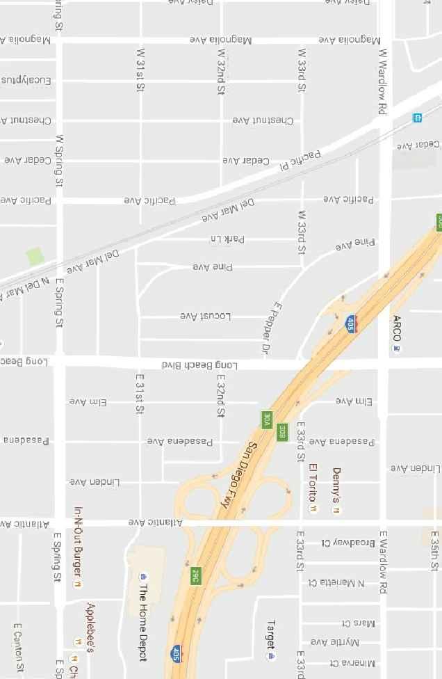
5 LIST OF FIGURES SECTION FIGURE # FOLLOWING PAGE 1-1 Vicinity Map Existing Aerial Site Plan Proposed Site Plan Existing Roadway Conditions and Intersection Controls Existing AM Peak Hour Traffic Volumes Existing PM Peak Hour Traffic Volumes Long Beach Transit Map Los Angeles County Metropolitan Transportation Authority Map Transit Stop Locations Long Beach Bikeway Facilities Project Trip Distribution Pattern AM Peak Hour Project Traffic Volumes PM Peak Hour Project Traffic Volumes Existing Plus Project AM Peak Hour Traffic Volumes Existing Plus Project PM Peak Hour Traffic Volumes Location of Cumulative Projects AM Peak Hour Cumulative Project Traffic Volumes PM Peak Hour Cumulative Project Traffic Volumes Year 2018 Cumulative AM Peak Hour Traffic Volumes Year 2018 Cumulative PM Peak Hour Traffic Volumes Year 2018 Cumulative Plus Project AM Peak Hour Traffic Volumes Year 2018 Cumulative Plus Project PM Peak Hour Traffic Volumes Recommended Traffic Improvements iii Salvation Army Long Beach Citadel Expansion Project, Long Beach
6 LIST OF TABLES SECTION TABLE # PAGE(S) 2-1 Existing Development Summary Proposed Development Summary Level of Service Criteria For Signalized Intersections Level of Service Criteria For Unsignalized Intersections Existing (Year 2016) Peak Hour Intersection Capacity Analysis Project Trip Generation Forecast Location and Description of Cumulative Projects Cumulative Projects Traffic Generation Forecast Existing Plus Project Peak Hour Intersection Capacity Analysis Summary Year 2018 Cumulative Plus Project Peak Hour Intersection Capacity Analysis Summary Peak Hour Levels of Service Summary at the Project Driveways iv Salvation Army Long Beach Citadel Expansion Project, Long Beach
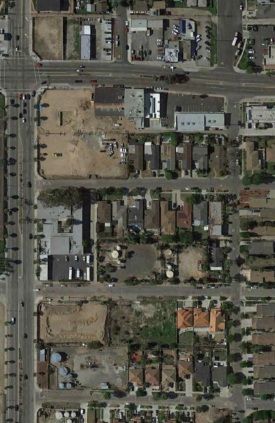
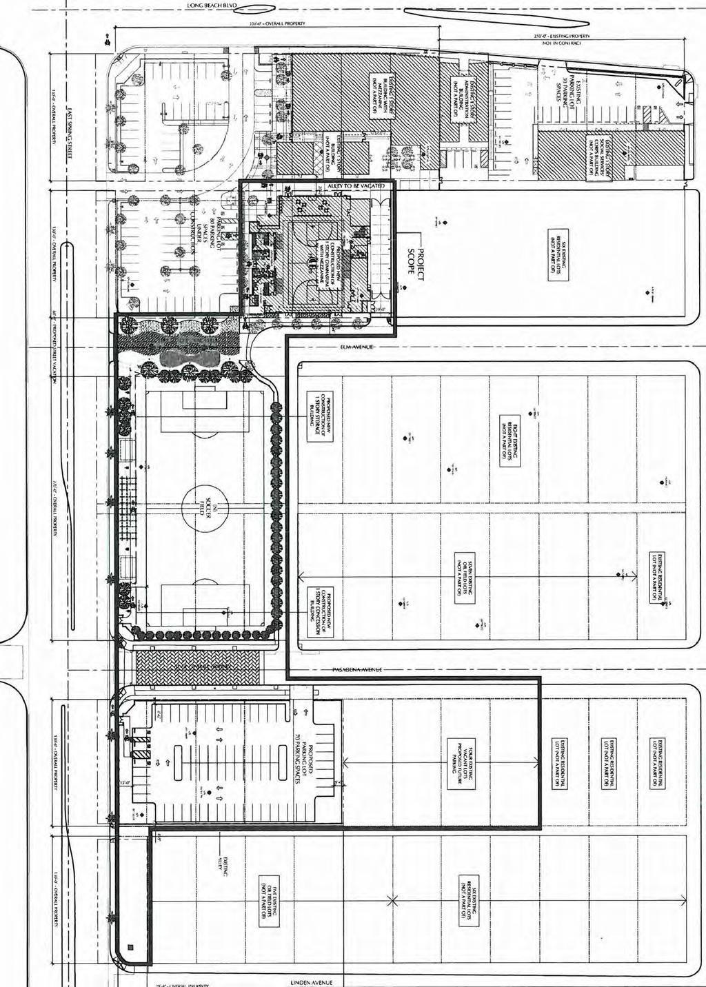
7 EXECUTIVE SUMMARY Project Description The project site is L-shaped and consists of several parcels of land that are generally located north of Spring Street, east of Long Beach Boulevard, south of 31 st Street and west of Pasadena Avenue in the City of Long Beach, California. Existing development at the Salvation Army Long Beach Citadel Property consists of four (4) buildings with a total floor area of 59,765 square-feet (SF), one of which includes a new Community Center/Chapel that is now under construction, an administrative office building, a social services building, and the current Chapel. It is our understanding that the new Community Center/Chapel, which will be located at 3012 Long Beach Boulevard, will replace the current Chapel, which is located at 455 Spring Street. The proposed Project includes modification and expansion of the current property into a campus-like setting within an overall building area of existing and new floor area totaling 61,307 SF. The proposed Project includes the construction of a new gymnasium with a total floor area of 21,958 SF, a new 2,650 SF lobby/multi-purpose room to be constructed adjacent to the Community Center/Chapel now under construction. The Project also includes construction of one (1) full size Soccer Field in place of the existing 23,066 SF Chapel/Community Center located at 455 Spring Street. In addition to the above-identified improvements, the proposed Project also includes the vacation of an existing alley between 31 st Street and Spring Street, bordering the Community Center / Chapel and the proposed Gym property to allow for the development of a pedestrian promenade to link the two buildings, and the proposed vacation of Elm Avenue, adjacent to the soccer field site just north of Spring Street, to form a cul-de-sac. The project also includes construction of a new 70-space surface parking lot on the northeast corner of Pasadena Avenue and Spring Street. From the above Project description, the traffic impact analysis report will analyze the impacts associated with 24,608 SF of new square footage (i.e. 21,958 SF new gymnasium and 2,650 SF new lobby/multipurpose) and one (1) soccer field. The proposed Project is expected to be completed and fully operational by the Year Vehicular access to the campus will be provided via existing site driveways on both Long Beach Boulevard and Spring Street and a proposed driveway located on Pasadena Avenue. The existing driveways on Long Beach Boulevard and Spring Street are referred to as Project Driveway No. 1 and Project Driveway No. 2, respectively. The proposed driveway on Pasadena Avenue is referred to as Project Driveway No. 3. v Salvation Army Long Beach Citadel Expansion Project, Long Beach
8 The proposed Project is forecast to generate approximately 903 daily trips, with 52 trips (34 inbound, 18 outbound) produced in the AM peak hour and 85 trips (45 inbound, 40 outbound) produced in the PM peak hour on a typical weekday. Study Area The thirty (30) key study intersections selected for evaluation in this report provide local access within the project study area. They consist of the following: 1) 31 st Street at Long Beach Boulevard 2) Spring Street at Long Beach Boulevard 3) Spring Street at Pacific Avenue 4) Spring Street at Elm Avenue 5) Spring Street at Pasadena Avenue 6) Spring Street at Atlantic Avenue Cumulative Projects Description The nine (9) cumulative projects are expected to generate a combined total of 2,922 daily trips, 199 AM peak hour trips (63 inbound and 136 outbound) and 231 PM peak hour trips (138 inbound and 93 outbound) on a typical weekday. Traffic Impact Analysis Existing Traffic Conditions Two (2) of the six (6) key study intersections currently operate at an unacceptable service level during the AM and/or PM peak hours. The remaining four (4) key study intersections currently operate at an acceptable service level during the AM and PM peak hours. The locations projected to operate at an adverse LOS are as follows: AM Peak Hour PM Peak Hour Key Intersection ICU/HCM LOS ICU/HCM LOS 1. Long Beach Boulevard at 31 st Street s/v F 5. Pasadena Avenue at Spring Street 45.3 s/v E 62.0 s/v F Existing With Project Traffic Conditions The proposed Project will significantly impact one (1) of the six (6) key study intersections, when compared to the LOS standards and significant impact criteria specified in this report. Although the intersection of Long Beach Boulevard/31 st Street is forecast to operate at unacceptable LOS F during the PM peak hour, the delay value with project traffic is less than the delay value for existing traffic conditions. The remaining key study intersections vi Salvation Army Long Beach Citadel Expansion Project, Long Beach
9 currently operate and are forecast to continue to operate at an acceptable service level during the AM and PM peak hours with the addition of Project generated traffic to existing traffic. The intersection impacted under existing plus project traffic conditions is as follows: AM Peak Hour PM Peak Hour Key Intersection ICU/HCM LOS ICU/HCM LOS 5. Pasadena Avenue at Spring Street 39.0 s/v E 70.5 s/v F The implementation of improvements at the impacted key study intersection completely offsets the impact of project traffic and the impacted key study intersection is forecast to operate at an acceptable LOS during the AM and PM peak hours. Year 2018 Cumulative Traffic Conditions An analysis of future (Year 2018) cumulative traffic conditions indicates that the addition of ambient traffic growth and cumulative projects traffic will adversely impact three (3) of the six (6) key study intersections. The remaining three (3) key study intersections are forecast to continue to operate at acceptable levels of service during the AM and PM peak hours with the addition of ambient traffic growth and cumulative projects traffic. The locations projected to operate at an adverse LOS are as follows: AM Peak Hour PM Peak Hour Key Intersection ICU/HCM LOS ICU/HCM LOS 1. Long Beach Boulevard at 31 st Street s/v F 5. Pasadena Avenue at Spring Street 48.2 s/v E 71.9 s/v F 6. Atlantic Avenue at Spring Street E Year 2018 Cumulative Plus Project Traffic Conditions The proposed Project will significantly impact one (1) of the six (6) key study intersections, when compared to the LOS standards and significant impact criteria specified in this report. Although the intersection of Long Beach Boulevard/31 st Street is forecast to operate at unacceptable LOS F during the PM peak hour, the delay value with project traffic is less than the delay value for cumulative traffic conditions. Further, although the intersection of Atlantic Avenue/Spring Street is forecast to operate at unacceptable LOS E during the PM peak hour with the addition of project traffic, the proposed Project is expected to add less than the allowable threshold to the ICU value. The remaining key study intersections are forecast to continue to operate at an acceptable LOS with the addition of project generated traffic in the Year The intersection impacted under Year 2018 plus project traffic conditions is as follows: vii Salvation Army Long Beach Citadel Expansion Project, Long Beach
10 AM Peak Hour PM Peak Hour Key Intersection ICU/HCM LOS ICU/HCM LOS 5. Pasadena Avenue at Spring Street 41.9 s/v E 82.4 s/v F The implementation of improvements at the impacted key study intersection completely offsets the impact of project traffic and the impacted key study intersection is forecast to operate at an acceptable LOS during the AM and PM peak hours. Site Access Evaluation Vehicular access to the campus will be provided via existing site driveways on both Long Beach Boulevard and Spring Street and a proposed driveway located on Pasadena Avenue. The existing driveways on Long Beach Boulevard and Spring Street are referred to as Project Driveway No. 1 and Project Driveway No. 2, respectively. The proposed driveway on Pasadena Avenue is referred to as Project Driveway No. 3. The project driveways are forecast to operate at acceptable LOS B or better during the AM and PM peak hours for existing plus project traffic conditions and Year 2018 plus project traffic conditions. As such, project access will be adequate. Motorists entering and exiting the Project site will be able to do so comfortably, safely, and without undue congestion. The on-site circulation layout of the proposed Project as illustrated in Figure 2-2 on an overall basis is adequate. Curb return radii have been confirmed and are generally adequate for small service/delivery (FedEx, UPS) trucks and trash trucks Project Specific Improvements The following improvements will be constructed by the proposed Project: The proposed Project also includes the vacation of an existing alley between 31 st Street and Spring Street, bordering the Community Center / Chapel and the proposed Gym property to allow for the development of a pedestrian promenade to link the two buildings. The proposed Project also includes the proposed vacation of Elm Avenue, adjacent to the soccer field site just north of Spring Street, to form a cul-de-sac. viii Salvation Army Long Beach Citadel Expansion Project, Long Beach
11 Recommended Improvements Existing Plus Project Traffic Conditions The proposed Project will significantly impact one (1) of the six (6) key study intersections under the Existing Plus Project traffic scenario. The following are improvements recommended to mitigate the existing plus project traffic impacts: No. 5 Pasadena Avenue at Spring Street: Install a two-phase traffic signal. The installation of this improvement is subject to the approval of the City of Long Beach. It should be noted that this key study intersection satisfies the peak hour signal warrant under existing traffic conditions (i.e. Warrant #3 described in the current California Manual on Uniform Traffic Control Devices (MUTCD). Year 2018 Cumulative Plus Project Traffic Conditions The proposed Project will significantly impact one (1) of the six (6) key study intersections under the Year 2018 Plus Project traffic scenario. The following are improvements recommended to mitigate the Year 2018 plus project traffic impacts: No. 5 Pasadena Avenue at Spring Street: Install a two-phase traffic signal. The installation of this improvement is subject to the approval of the City of Long Beach. It should be noted that this key study intersection satisfies the peak hour signal warrant under existing traffic conditions (i.e. Warrant #3 described in the current California Manual on Uniform Traffic Control Devices (MUTCD). Congestion Management Program Compliance Assessment No significant impacts are expected to occur on the Los Angeles County Congestion Management Program roadway network (i.e. arterial monitoring intersection locations or freeway monitoring locations) due to the development and full occupancy of the proposed Project. ix Salvation Army Long Beach Citadel Expansion Project, Long Beach
12 1.0 INTRODUCTION TRAFFIC IMPACT ANALYSIS SALVATION ARMY LONG BEACH CITADEL EXPANSION PROJECT Long Beach, California December 9, 2016 This Traffic Impact Analysis report addresses the potential traffic impacts and circulation needs associated with the proposed Salvation Army Long Beach Citadel Expansion Project (hereinafter referred to as Project). The proposed Project includes modification and expansion of the current property into a campus-like setting within an overall building area of existing and new floor area totaling 61,307 SF. In addition to the above-identified improvements, the proposed Project also includes the vacation of an existing alley between 31 st Street and Spring Street, and the proposed vacation of Elm Avenue, just north of Spring Street, to form a cul-de-sac. The project site is L- shaped and consists of several parcels of land that are generally located north of Spring Street, east of Long Beach Boulevard, and south of 31 st Street and west of Pasadena Avenue in the City of Long Beach, California. 1.1 Scope of Work This report documents the findings and recommendations of a traffic impact analysis, conducted by Linscott, Law & Greenspan, Engineers (LLG) to determine the potential impacts associated with the proposed Project. The traffic analysis evaluates the existing operating conditions at six (6) key study intersections within the project vicinity, estimates the trip generation potential of the proposed Project, and forecasts future operating conditions without and with the Project. Where necessary, intersection improvements/mitigation measures are identified to offset the impact of the proposed Project. This traffic report satisfies the traffic impact requirements of the City of Long Beach and is consistent with the requirements and procedures outlined in the most current Congestion Management Program (CMP) for Los Angeles County. The Scope of Work for this traffic study, which is included in Appendix A, was developed in conjunction with City of Long Beach Engineering Division staff. The Project site has been visited and an inventory of adjacent area roadways and intersections was performed. Existing peak hour traffic information has been collected at the six (6) key study locations on a typical weekday for use in the preparation of intersection level of service calculations. Information concerning cumulative projects (planned and/or approved) in the vicinity of the project has been researched at the City of Long Beach and the City of Signal Hill. Based on our research, nine (9) cumulative projects were considered in the cumulative traffic analysis for this project. Of this total, five (5) cumulative projects are located in the City of Long Beach and four (4) cumulative projects are located in the City of Signal Hill. 1 Salvation Army Long Beach Citadel Expansion Project, Long Beach
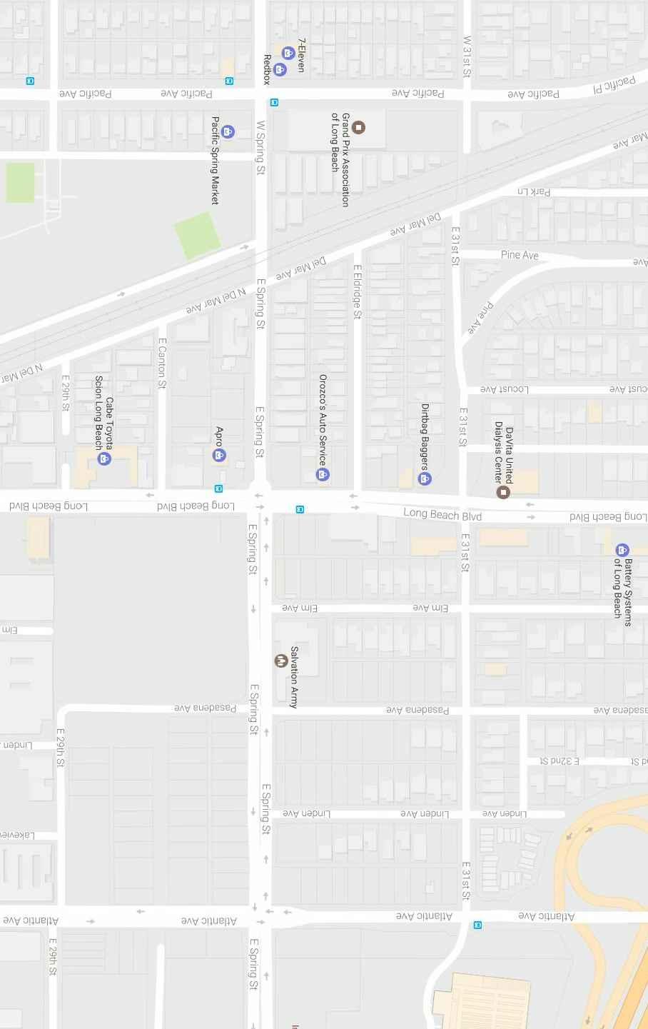
13 Based on City of Long Beach requirements, this traffic report analyzes existing and future (nearterm) weekday AM and PM peak hour traffic conditions for existing and Year 2018 traffic conditions without and with the proposed Project. Peak hour traffic forecasts for the Year 2018 horizon year have been projected by increasing existing traffic volumes by an annual growth rate of one percent (1.0%) per year and adding traffic volumes generated by nine (9) cumulative projects. 1.2 Study Area The thirty (30) key study intersections selected for evaluation in this report provide local access within the project study area. They consist of the following: 1) 31 st Street at Long Beach Boulevard 2) Spring Street at Long Beach Boulevard 3) Spring Street at Pacific Avenue 4) Spring Street at Elm Avenue 5) Spring Street at Pasadena Avenue 6) Spring Street at Atlantic Avenue Figure 1-1 presents a Vicinity Map, which illustrates the general location of the project and depicts the study locations and surrounding street system. The Volume-Capacity (V/C) and Level of Service (LOS) investigations at these key locations were used to evaluate the potential traffic-related impacts associated with the proposed Project. Included in this traffic study report are: Existing traffic counts, Estimated project traffic generation/distribution/assignment, Estimated cumulative project traffic generation/distribution/assignment, AM and PM peak hour capacity analyses for existing conditions, AM and PM peak hour capacity analyses for existing plus project conditions, AM and PM peak hour capacity analyses for future (Year 2018) conditions without and with project traffic, Site Access and Internal Circulation Evaluation, Recommended Improvements, and Congestion Management Program Compliance Assessment. 2 Salvation Army Long Beach Citadel Expansion Project, Long Beach
14
15 2.0 PROJECT DESCRIPTION The project site is L-shaped and consists of several parcels of land that are generally located north of Spring Street, east of Long Beach Boulevard, and south of 31 st Street and west of Pasadena Avenue in the City of Long Beach, California. Existing development at the Salvation Army Long Beach Citadel Property, as identified below in Table 2-1, consists of four (4) buildings with a total floor area of 59,765 square-feet (SF), one of which includes a new Community Center/Chapel that is now under construction, an administrative office building, a social services building, and the current Chapel. It is our understanding that the new Community Center/Chapel, which will be located at 3012 Long Beach Boulevard, will replace the current Chapel, which is located at 455 Spring Street. Figure 2-1 presents an aerial depiction of the project site. Existing Development TABLE 2-1 EXISTING DEVELOPMENT SUMMARY Square-footage SF) Community Center / Chapel (under construction) 26,584 SF Administrative Offices 3,560 SF Social Services 6,555 SF Current Chapel / Community Center 23,066 SF Total Existing Floor Area 59,765 SF Figure 2-2 presents the proposed site plan for the proposed Project, prepared by Kardent Design. As shown in Table 2-2, the proposed Project includes modification and expansion of the current property into a campus-like setting within an overall building area of existing and new floor area totaling 61,307 SF. The proposed Project includes the construction of a new gymnasium with a total floor area of 21,958 SF, a new 2,650 SF lobby/multi-purpose room to be constructed adjacent to the Community Center/Chapel now under construction. The Project also includes construction of one (1) full size Soccer Field in place of the existing 23,066 SF Chapel/Community Center located at 455 Spring Street. Proposed Development TABLE 2-2 PROPOSED DEVELOPMENT SUMMARY Square-footage SF) Community Center / Chapel (under construction) 26,584 SF New Lobby/Multi-purpose room +2,650 SF Administrative Offices 3,560 SF Social Services 6,555 SF Demolish Current Chapel / Community Center -23,066 SF New Gymnasium +21,958 SF Total Proposed Floor Area 61,307 SF 3 Salvation Army Long Beach Citadel Expansion Project, Long Beach
16 In addition to the above-identified improvements, the proposed Project also includes the vacation of an existing alley between 31 st Street and Spring Street, bordering the Community Center / Chapel and the proposed Gym property to allow for the development of a pedestrian promenade to link the two buildings, and the proposed vacation of Elm Avenue, adjacent to the soccer field site just north of Spring Street, to form a cul-de-sac. The project also includes construction of a new 70-space surface parking lot on the northeast corner of Pasadena Avenue and Spring Street. From the above Project description, the traffic impact analysis report will analyze the impacts associated with 24,608 SF of new square footage (i.e. 21,958 SF new gymnasium and 2,650 SF new lobby/multipurpose) and one (1) soccer field. The proposed Project is expected to be completed and fully operational by the Year Site Access As shown in Figure 2-2, vehicular access to the campus will be provided via existing site driveways on both Long Beach Boulevard and Spring Street and a proposed driveway located on Pasadena Avenue. The existing driveways on Long Beach Boulevard and Spring Street are referred to as Project Driveway No. 1 and Project Driveway No. 2, respectively. The proposed driveway on Pasadena Avenue is referred to as Project Driveway No Pedestrian Circulation Pedestrian circulation would be provided via existing public sidewalks along Spring Street and Long Beach Boulevard within the vicinity of the project frontage, which will connect to the project s internal walkways. The Project will protect the existing sidewalk along project frontage and if necessary repair or reconstruct sidewalks along the project frontage per the City s request. The existing sidewalk system within the project vicinity provides direct connectivity to the adjacent existing residential community, commercial development and public transit along Long Beach Boulevard. 4 Salvation Army Long Beach Citadel Expansion Project, Long Beach
17
18
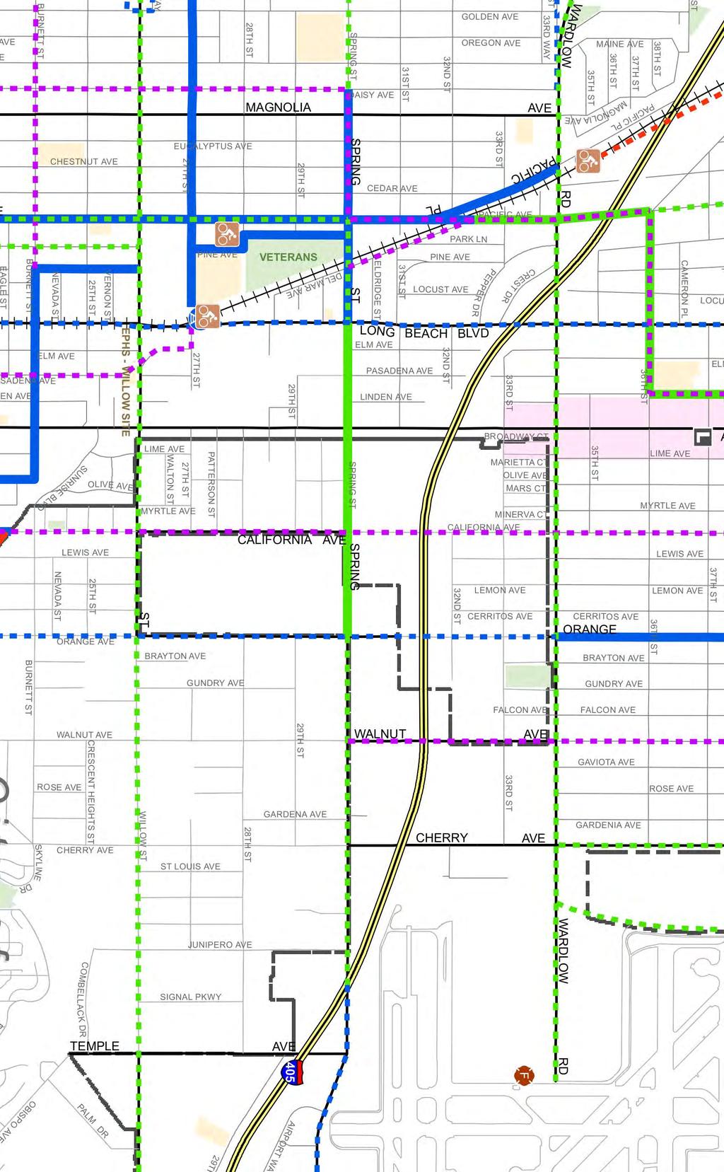
19 3.0 EXISTING CONDITIONS 3.1 Existing Street System The principal local network of streets serving the project site includes 31 st Street, Spring Street, Long Beach Boulevard and Pasadena Avenue. The following discussion provides a brief synopsis of these key area streets. The descriptions are based on an inventory of existing roadway conditions. 31 st Street is a two-lane, undivided roadway oriented in the east-west direction. Parking is permitted on both sides of the roadway within the vicinity of the project. The prima face speed limit is 25 miles per hour (mph). Spring Street is a two-lane, divided roadway west of Long Beach Boulevard, and a four-lane divided roadway east of Long Beach Boulevard, oriented in the east-west direction. Parking is permitted on both sides of the roadway west of Long Beach Boulevard, but parking is not permitted on either side of the roadway east of Long Beach Boulevard. The posted speed limit on Spring Street is 30 mph. Long Beach Boulevard is a four-lane, divided roadway oriented in the north-south direction. Parking is permitted on both sides of the roadway within the vicinity of the project. The posted speed limit on Long Beach Boulevard is 35 mph. Pasadena Avenue is a two-lane, undivided roadway oriented in the north-south direction. Parking is permitted on both sides of the roadway within the vicinity of the project. The prima face speed limit is 25 mph. Figure 3-1 presents an inventory of the existing roadway conditions for the arterials and intersections evaluated in this report. The number of travel lanes and intersection controls for the key area intersections are identified. 3.2 Existing Traffic Volumes Six (6) key study intersections have been identified as the locations at which to evaluate existing and future traffic operating conditions. Some portion of potential project-related traffic will pass through each of these intersections, and their analysis will reveal the expected impact associated with the proposed Project. Existing weekday peak hour traffic volumes for the six (6) key study intersections evaluated in this report were obtained from manual turning movement counts conducted by Transportation Studies, Inc. in September Figures 3-2 and 3-3 illustrate the existing weekday AM and PM peak hour traffic volumes at the six (6) key study intersections evaluated in this report, respectively. Appendix B contains the detailed peak hour count sheets for the key intersections evaluated in this report. 5 Salvation Army Long Beach Citadel Expansion Project, Long Beach
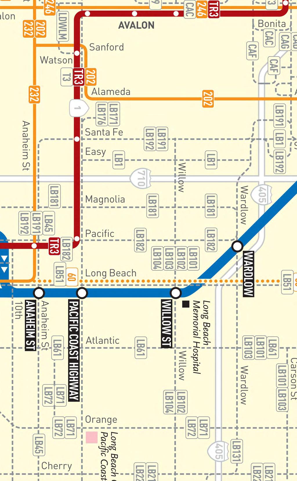
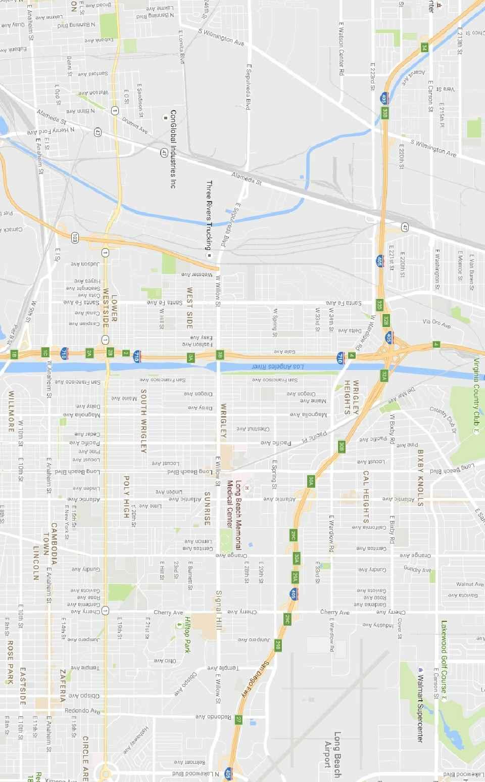
20 3.3 Existing Public Transit The Los Angeles County Metropolitan Transportation Authority and Long Beach Transit (LBT) provide public transit services in the vicinity of the proposed Project. In the vicinity of the Project, LBT Route 51, LBT Route 52, LA Metro Blue Line, and LA Metro Line 60 currently serve Long Beach Boulevard, LBT Routes 61, 101, and 103 currently serve Atlantic Avenue, LBT Route 131 currently serves Wardlow Road, and LBT Route 182 currently serves Pacific Avenue. Figure 3-4 graphically illustrates the transit routes of Long Beach Transit within the vicinity of the Project site. Figure 3-5 graphically illustrates the transit routes of the Los Angeles Country Metropolitan Transportation Authority within the vicinity of the Project site. Figure 3-6 identifies the location of the existing LBT bus stops in proximity to the Project site. 3.4 Existing Bicycle Master Plan The City of Long Beach promotes bicycling as a means of mobility and a way in which to improve the quality of life within its community. The Bicycle Master Plan recognizes the needs of bicycle users and aims to create a complete and safe bicycle network throughout the City. The City of Long Beach Bicycle Facilities in the vicinity of the Project site (existing and proposed) is shown on Figure Existing Intersection Conditions Existing AM and PM peak hour operating conditions for the key signalized study intersections were evaluated using the Intersection Capacity Utilization (ICU) methodology for signalized intersections Intersection Capacity Utilization (ICU) Method of Analysis In conformance with City of Long Beach and LA County CMP requirements, existing weekday peak hour operating conditions for the key signalized study intersections were evaluated using the Intersection Capacity Utilization (ICU) method. The ICU technique is intended for signalized intersection analysis and estimates the volume to capacity (V/C) relationship for an intersection based on the individual V/C ratios for key conflicting traffic movements. The ICU numerical value represents the percent signal (green) time, and thus capacity, required by existing and/or future traffic. It should be noted that the ICU methodology assumes uniform traffic distribution per intersection approach lane and optimal signal timing. Per LA County CMP requirements, the ICU calculations use a lane capacity of 1,600 vehicles per hour (vph) for left-turn, through, and right-turn lanes, and dual left turn capacity of 2,880 vph. A clearance interval is also added to each Level of Service calculation. Per City of Long Beach requirements, a clearance adjustment factor of 0.10 was added to each Level of Service calculation. The ICU value translates to a Level of Service (LOS) estimate, which is a relative measure of the intersection performance. The six qualitative categories of Level of Service have been defined along with the corresponding ICU value range and are shown in Table 3-1. The ICU value is the sum of the critical volume to capacity ratios at an intersection; it is not intended to be indicative of the LOS of each of the individual turning movements. 6 Salvation Army Long Beach Citadel Expansion Project, Long Beach
21 3.5.2 Highway Capacity Manual (HCM) Method of Analysis (Unsignalized Intersections) The HCM unsignalized methodology for stop-controlled intersections was utilized for the analysis of the unsignalized intersections and project driveways. This methodology estimates the average control delay for each of the subject movements and determines the level of service for each movement. For all-way stop controlled intersections, the overall average control delay measured in seconds per vehicle, and level of service is then calculated for the entire intersection. For one-way and two-way stop-controlled (minor street stop-controlled) intersections, this methodology estimates the worst side street delay, measured in seconds per vehicle and determines the level of service for that approach. The HCM control delay value translates to a Level of Service (LOS) estimate, which is a relative measure of the intersection performance. The six qualitative categories of Level of Service have been defined along with the corresponding HCM control delay value range, as shown in Table Level of Service Criteria According to the City of Long Beach, LOS D is the minimum acceptable condition that should be maintained during the peak commute hours, or the current LOS if the existing LOS is worse than LOS D (i.e. LOS E of F). 3.6 Existing Level of Service Results Table 3-3 summarizes the existing peak hour service level calculations for the six (6) key study intersections based on existing traffic volumes and current street geometrics. Review of Table 3-3 indicates that two (2) of the six (6) key study intersections currently operate at an unacceptable service level during the AM and/or PM peak hours. The remaining four (4) key study intersections currently operate at an acceptable service level during the AM and PM peak hours. The locations projected to operate at an adverse LOS are as follows: AM Peak Hour PM Peak Hour Key Intersection ICU/HCM LOS ICU/HCM LOS 1. Long Beach Boulevard at 31 st Street s/v F 5. Pasadena Avenue at Spring Street 45.3 s/v E 62.0 s/v F Appendix C contains the detailed peak hour level of service worksheets for the key intersections evaluated in this report. 7 Salvation Army Long Beach Citadel Expansion Project, Long Beach
22
23
24
25
26
27
28
29 TABLE 3-1 LEVEL OF SERVICE CRITERIA FOR SIGNALIZED INTERSECTIONS Level of Service (LOS) Intersection Capacity Utilization Value (V/C) Level of Service Description A B C D E F > EXCELLENT. No vehicle waits longer than one red light, and no approach phase is fully used. VERY GOOD. An occasional approach phase is fully utilized; many drivers begin to feel somewhat restricted within groups of vehicles. GOOD. Occasionally drivers may have to wait through more than one red light; backups may develop behind turning vehicles. FAIR. Delays may be substantial during portions of the rush hours, but enough lower volume periods occur to permit clearing of developing lines, preventing excessive backups. POOR. Represents the most vehicles intersection approaches can accommodate; may be long lines of waiting vehicles through several signal cycles. FAILURE. Backups from nearby locations or on cross streets may restrict or prevent movement of vehicles out of the intersection approaches. Potentially very long delays with continuously increasing queue lengths. 8 Salvation Army Long Beach Citadel Expansion Project, Long Beach
30 TABLE 3-2 LEVEL OF SERVICE CRITERIA FOR UNSIGNALIZED INTERSECTIONS 1 Level of Service (LOS) Highway Capacity Manual Delay Value (sec/veh) Level of Service Description A 10.0 Little or no delay B > 10.0 and 15.0 Short traffic delays C > 15.0 and 25.0 Average traffic delays D > 25.0 and 35.0 Long traffic delays E > 35.0 and 50.0 Very long traffic delays F > 50.0 Severe congestion 1 Source: Highway Capacity Manual 2010, Chapter 19 (Unsignalized Intersections). 9 Salvation Army Long Beach Citadel Expansion Project, Long Beach
31 TABLE 3-3 EXISTING (YEAR 2016) PEAK HOUR INTERSECTION CAPACITY ANALYSIS Time Control Key Intersections Period Type ICU/HCM LOS Long Beach Boulevard at AM Two-Way 31.5 s/v D 31 st Street PM Stop 74.3 s/v F Long Beach Boulevard at AM 3 Traffic C Spring Street PM Signal D Pacific Avenue at AM 2 Traffic C Spring Street PM Signal C Elm Avenue at AM One-Way 11.0 s/v B Spring Street PM Stop 11.7 s/v B Pasadena Avenue at AM Two-Way 45.3 s/v E Spring Street PM Stop 62.0 s/v F Atlantic Avenue at AM 6 Traffic C Spring Street PM Signal D Notes: ICU = Intersection Capacity Utilization s/v = seconds per vehicle (delay) LOS = Level of Service, please refer to Tables 3-1 and 3-2 for the LOS definitions = Phase 10 Salvation Army Long Beach Citadel Expansion Project, Long Beach
32 4.0 TRAFFIC FORECASTING METHODOLOGY In order to estimate the traffic impact characteristics of the proposed Project, a multi-step process has been utilized. The first step is traffic generation, which estimates the total arriving and departing traffic on a peak hour and daily basis. The traffic generation potential is forecast by applying the appropriate vehicle trip generation equations or rates to the project development tabulation. The second step of the forecasting process is traffic distribution, which identifies the origins and destinations of inbound and outbound project traffic. These origins and destinations are typically based on demographics and existing/expected future travel patterns in the study area. The third step is traffic assignment, which involves the allocation of project traffic to study area streets and intersections. Traffic assignment is typically based on minimization of travel time, which may or may not involve the shortest route, depending on prevailing operating conditions and travel speeds. Traffic distribution patterns are indicated by general percentage orientation, while traffic assignment allocates specific volume forecasts to individual roadway links and intersection turning movements throughout the study area. With the forecasting process complete and project traffic assignments developed, the impact of the project is isolated by comparing operational (LOS) conditions at selected key intersections using expected future traffic volumes with and without forecast project traffic. The need for site-specific and/or cumulative local area traffic improvements can then be evaluated. 11 Salvation Army Long Beach Citadel Expansion Project, Long Beach
33 5.0 PROJECT TRAFFIC CHARACTERISTICS 5.1 Project Traffic Generation Traffic generation is expressed in vehicle trip ends, defined as one-way vehicular movements, either entering or exiting the generating land use. Generation equations and/or rates used in the traffic forecasting procedure are found in the 9 th Edition of Trip Generation, published by the Institute of Transportation Engineers (ITE) [Washington D.C., 2012]. Table 5-1 summarizes the trip generation rates used in forecasting the vehicular trips generated by the proposed Project and also presents the project s forecast peak hour and daily traffic volumes. As shown, the trip generation potential of the proposed Project was estimated using ITE Land Use 448: Soccer Complex trip rates and ITE Land Use 495: Recreational Community Center trip rates. Review of Table 5-1 indicates that the proposed Project is forecast to generate approximately 903 daily trips, with 52 trips (34 inbound, 18 outbound) produced in the AM peak hour and 85 trips (45 inbound, 40 outbound) produced in the PM peak hour on a typical weekday. 5.2 Project Traffic Distribution and Assignment Figure 5-1 illustrates the general, directional traffic distribution pattern for the proposed Project. Project traffic volumes both entering and exiting the project site have been distributed and assigned to the adjacent street system based on the following considerations: location of site access points in relation to the surrounding street system, the site's proximity to major traffic carriers and regional access routes, physical characteristics of the circulation system such as lane channelization and presence of traffic signals that affect travel patterns, and ingress/egress availability at the project site. It should be noted that 5.0% of the traffic associated with the proposed Project was assumed to be non-auto based trips (i.e. transit, bike, walk, etc.). The anticipated AM and PM peak hour traffic volumes associated with the proposed Project are presented in Figures 5-2 and 5-3, respectively. The traffic volume assignments presented in Figures 5-2 and 5-3 reflect the traffic distribution characteristics shown in Figure 5-1 and the traffic generation forecast presented in Table Salvation Army Long Beach Citadel Expansion Project, Long Beach
34 5.3 Existing Plus Project Traffic Conditions The existing plus project traffic conditions have been generated based upon existing conditions and the estimated project traffic. These forecast traffic conditions have been prepared pursuant to the California Environmental Quality Act (CEQA) guidelines, which require that the potential impacts of a Project be evaluated upon the circulation system as it currently exists. This traffic volume scenario and the related intersection capacity analyses will identify the roadway improvements necessary to mitigate the direct traffic impacts of the Project, if any. Figures 5-4 and 5-5 present projected AM and PM peak hour traffic volumes at the six (6) key study intersections with the addition of the trips generated by the proposed Project to existing traffic volumes, respectively. It should be noted that the traffic volumes shown in Figures 5-4 and 5-5 include the re-routed traffic associated with the vacation of Elm Avenue, north of Spring Street and the construction of a cul-de-sac on Elm Avenue, north of the project site. 13 Salvation Army Long Beach Citadel Expansion Project, Long Beach
35 ITE Land Use Code / Project Description Generation Rates: TABLE 5-1 PROJECT TRIP GENERATION FORECAST 2 Daily 2-Way AM Peak Hour PM Peak Hour Enter Exit Total Enter Exit Total ITE 448: Soccer Complex (TE/Field) % 43% % 33% ITE 495: Recreational Community Center (TE/1000 SF) Generation Forecast: % 34% % 51% 2.74 Proposed Project Soccer Field (1 Field) Proposed Project Recreation Community Center (24,608 SF) Total Project Trip Generation Notes: TE/Field = Trip end per field TE/1000 SF = Trip end per 1000 SF of development 2 Source: Trip Generation, 9th Edition, Institute of Transportation Engineers, (ITE) [Washington, D.C. (2012)]. 14 Salvation Army Long Beach Citadel Expansion Project, Long Beach
36
37
38
39
40
41 6.0 FUTURE TRAFFIC CONDITIONS 6.1 Ambient Traffic Growth Cumulative traffic growth estimates have been calculated using an ambient growth factor. The ambient traffic growth factor is intended to include unknown and future cumulative projects in the study area, as well as account for regular growth in traffic volumes due to the development of projects outside the study area. The future growth in traffic volumes has been calculated at one percent (1.0%) per year. Applied to existing Year 2016 traffic volumes results in a two percent (2.0%) increase of growth in existing volumes to horizon year Please note that the recommended ambient growth factor is generally consistent with the background traffic growth estimates contained in the most current Congestion Management Program for Los Angeles County. It should be further noted that the 1.0% per year ambient growth factor was approved by City of Long Beach staff. 6.2 Cumulative Projects Traffic Characteristics The City of Long Beach identified five (5) cumulative projects and the City of Signal Hill identified four (4) cumulative projects within the Project study area. Cumulative projects, as defined by Section of the CEQA Guidelines, are closely related past, present and reasonably foreseeable probable future projects. The Traffic Impact Analysis assumes that all of these cumulative projects will be developed and operational when the proposed Project is operational. This is the most conservative, worst-case approach, since the exact timing of each cumulative project is uncertain. In addition, impacts for these cumulative projects would likely be, or have been, subject to mitigation measures, which could reduce potential impacts. Under this analysis, however, those mitigation measures are not considered. With this information, the potential impact of the proposed Project can be evaluated within the context of the cumulative impact of all ongoing development. These nine (9) cumulative projects have been included as part of the cumulative background setting. Table 6-1 provides the location and a brief description for each of the nine (9) cumulative projects. Figure 6-1 graphically illustrates the location of the cumulative projects. These cumulative projects are expected to generate vehicular traffic, which may affect the operating conditions of the key study intersections. Table 6-2 presents the development totals and resultant trip generation for the nine (9) cumulative projects. As shown in Table 6-2, the nine (9) cumulative projects are expected to generate a combined total of 2,922 daily trips, 199 AM peak hour trips (63 inbound and 136 outbound) and 231 PM peak hour trips (138 inbound and 93 outbound) on a typical weekday. The AM and PM peak hour traffic volumes associated with the nine (9) cumulative projects are presented in Figures 6-2 and 6-3 respectively. 15 Salvation Army Long Beach Citadel Expansion Project, Long Beach
42 TABLE 6-1 LOCATION AND DESCRIPTION OF CUMULATIVE PROJECTS 3 No. Cumulative Project Location Description City of Long Beach E. Carson Street 2250 E. Carson Street 1,850 SF fast-food with drive-thru E. Willow Street Apartments E. Willow Street 23 DU apartments Long Beach Boulevard Retail 2441 Long Beach Boulevard 6,974 square-feet of retail Locust Avenue Apartments 1836 Locust Avenue 37 DU affordable housing Long Beach Boulevard 1795 Long Beach Boulevard 101 DU apartments and 2,667 SF retail City of Signal Hill 6. Far West Industries N/E corner of Walnut Avenue at Crescent Heights Street 25 DU single-family homes 7. Meta Housing 1500 E. Hill Street 72 DU apartments Olive Avenue 3355 Olive Avenue 3,991 SF warehouse and 2,299 SF office building Walnut Avenue 2355 Walnut Avenue 9,976 SF warehouse and office building 3 Source: City of Long Beach and Signal Hill Planning Departments. 16 Salvation Army Long Beach Citadel Expansion Project, Long Beach
43 TABLE 6-2 CUMULATIVE PROJECTS TRAFFIC GENERATION FORECAST 4 Cumulative Project Description Daily 2-way AM Peak Hour PM Peak Hour In Out Total In Out Total E. Carson Street E. Willow Street Apartments Long Beach Boulevard Retail Locust Avenue Apartments Long Beach Boulevard Far West Industries Meta Housing Olive Avenue Walnut Avenue Total Cumulative Projects Trip Generation Potential 2, Source: Trip Generation, 9 th Edition, Institute of Transportation Engineers (ITE) [Washington, D.C. (2012)]. 17 Salvation Army Long Beach Citadel Expansion Project, Long Beach
44 6.3 Year 2018 Traffic Volumes Figures 6-4 and 6-5 present future AM and PM peak hour cumulative traffic volumes at the six (6) key study intersections for the Year 2018, respectively. Please note that the cumulative traffic volumes represent the accumulation of existing traffic, ambient growth traffic and cumulative projects traffic. Figures 6-6 and 6-7 illustrate Year 2018 forecast AM and PM peak hour traffic volumes with the inclusion of the trips generated by the proposed Project, respectively. It should be noted that the traffic volumes shown in Figures 6-6 and 6-7 include the re-routed traffic associated with the vacation of Elm Avenue, north of Spring Street and the construction of a cul-de-sac on Elm Avenue, north of the project site. 18 Salvation Army Long Beach Citadel Expansion Project, Long Beach
45
46
47
48
49
50
51
52 7.0 TRAFFIC IMPACT ANALYSIS METHODOLOGY 7.1 Impact Criteria and Thresholds The potential impact of the added project traffic volumes generated by the proposed Project during the weekday peak hours was evaluated based on analysis of future operating conditions at the six (6) key study intersections, without, then with, the proposed Project. The previously discussed capacity analysis procedures were utilized to investigate the future volume-to-capacity relationships and service level characteristics at each study intersection. The significance of the potential impacts of the project at each key intersection was then evaluated using the following traffic impact criteria City of Long Beach Impacts to local and regional transportation systems are considered significant if: An unacceptable peak hour Level of Service (LOS) (i.e. LOS E or F) at any of the key intersections is projected. The City of Long Beach considers LOS D (ICU = ) to be the minimum acceptable LOS for all intersections. For the City of Long Beach, the current LOS, if worse than LOS D (i.e. LOS E or F), should also be maintained; and The project increases traffic demand at the study intersection by 2% of capacity (ICU increase 0.020), causing or worsening LOS E or F (ICU > 0.901). At unsignalized intersections, an impact is considered to be significant if the project causes an intersection operating at LOS D or better to degrade to LOS E or F, and the traffic signal warrant analysis determines that a traffic signal is justified. 7.2 Traffic Impact Analysis Scenarios The following scenarios are those for which volume/capacity calculations have been performed using the ICU/HCM methodologies: A. Existing Traffic Conditions; B. Existing Plus Project Traffic Conditions; C. Scenario (B) with Improvements, if necessary; D. Year 2018 Cumulative Traffic Conditions; E. Year 2018 Cumulative Plus Project Traffic Conditions; and F. Scenario (E) with Improvements, if necessary. 19 Salvation Army Long Beach Citadel Expansion Project, Long Beach
53 8.0 PEAK HOUR INTERSECTION CAPACITY ANALYSIS 8.1 Existing Plus Project Traffic Conditions Table 8-1 summarizes the peak hour Level of Service results at the six (6) key study intersections for existing plus project traffic conditions. The first column (1) of ICU/LOS and HCM/LOS values in Table 8-1 presents a summary of existing AM and PM peak hour traffic conditions (which were also presented in Table 3-3). The second column (2) lists existing plus project traffic conditions with current intersection geometry/lane configurations. The third column (3) shows the increase in ICU/HCM value due to the added peak hour project trips, inclusive of existing re-routed traffic associated with the vacation of Elm Avenue, north of Spring Street, and indicates whether the traffic associated with the Project will have a significant impact based on the significant impact criteria defined in this report. The fourth column (4) indicates the anticipated level of service with recommended improvements, if any Existing Traffic Conditions As previously presented in Table 3-3, two (2) of the six (6) key study intersections currently operate at an unacceptable service level during the AM and/or PM peak hours. The remaining four (4) key study intersections currently operate at an acceptable service level during the AM and PM peak hours. The locations projected to operate at an adverse LOS are as follows: AM Peak Hour PM Peak Hour Key Intersection ICU/HCM LOS ICU/HCM LOS 1. Long Beach Boulevard at 31 st Street s/v F 5. Pasadena Avenue at Spring Street 45.3 s/v E 62.0 s/v F Existing Plus Project Traffic Conditions Review of Columns 2 and 3 of Table 8-1 indicates that traffic associated with the proposed Project will significantly impact one (1) of the six (6) key study intersections, when compared to the LOS standards and significant impact criteria specified in this report. Although the intersection of Long Beach Boulevard/31 st Street is forecast to operate at unacceptable LOS F during the PM peak hour, the delay value with project traffic is less than the delay value for existing traffic conditions. The remaining key study intersections currently operate and are forecast to continue to operate at an acceptable service level during the AM and PM peak hours with the addition of Project generated traffic to existing traffic. The intersection impacted under existing plus project traffic conditions is as follows: AM Peak Hour PM Peak Hour Key Intersection ICU/HCM LOS ICU/HCM LOS 5. Pasadena Avenue at Spring Street 39.0 s/v E 70.5 s/v F As shown in column 4, the implementation of improvements at the impacted key study intersection completely offsets the impact of project traffic and the impacted key study intersection is forecast to operate at an acceptable LOS during the AM and PM peak hours. 20 Salvation Army Long Beach Citadel Expansion Project, Long Beach
Traffic Impact Analysis 5742 BEACH BOULEVARD MIXED USE PROJECT
 Traffic Impact Analysis 5742 BEACH BOULEVARD MIXED USE PROJECT CITY OF BUENA PARK Prepared by Project No. 14139 000 April 17 th, 2015 DKS Associates Jeffrey Heald, P.E. Rohit Itadkar, T.E. 2677 North Main
EXECUTIVE SUMMARY. The following is an outline of the traffic analysis performed by Hales Engineering for the traffic conditions of this project.
 EXECUTIVE SUMMARY This study addresses the traffic impacts associated with the proposed Shopko redevelopment located in Sugarhouse, Utah. The Shopko redevelopment project is located between 1300 East and
TRANSPORTATION STUDY FOR THE 8899 BEVERLY BOULEVARD PROJECT
 DRAFT TRANSPORTATION STUDY FOR THE 8899 BEVERLY BOULEVARD PROJECT WEST HOLLYWOOD, CALIFORNIA NOVEMBER 2013 PREPARED FOR BEVERLY BOULEVARD ASSOCIATION PREPARED BY DRAFT TRANSPORTATION STUDY FOR THE 8899
King Soopers #116 Thornton, Colorado
 Traffic Impact Study King Soopers #116 Thornton, Colorado Prepared for: Galloway & Company, Inc. T R A F F I C I M P A C T S T U D Y King Soopers #116 Thornton, Colorado Prepared for Galloway & Company
2.0 Development Driveways. Movin Out June 2017
 Movin Out June 2017 1.0 Introduction The proposed Movin Out development is a mixed use development in the northeast quadrant of the intersection of West Broadway and Fayette Avenue in the City of Madison.
APPENDIX B Traffic Analysis
 APPENDIX B Traffic Analysis Rim of the World Unified School District Reconfiguration Prepared for: Rim of the World School District 27315 North Bay Road, Blue Jay, CA 92317 Prepared by: 400 Oceangate,
Traffic Impact Analysis. Alliance Cole Avenue Residential Site Dallas, Texas. Kimley-Horn and Associates, Inc. Dallas, Texas.
 Traffic Impact Analysis Alliance Cole Avenue Residential Site Dallas, Texas February 15, 2018 Kimley-Horn and Associates, Inc. Dallas, Texas Project #064524900 Registered Firm F-928 Traffic Impact Analysis
TABLE OF CONTENTS SECTION PAGE. Executive Summary... xii
 TABLE OF CONTENTS SECTION PAGE Executive Summary... xii 1.0 Introduction... 1 1.1 Study Area... 2 1.2 Traffic Impact Analysis Scenarios... 4 1.3 Study Area - City of Orange... 4 2.0 Project Description
APPENDIX C1 TRAFFIC ANALYSIS DESIGN YEAR TRAFFIC ANALYSIS
 APPENDIX C1 TRAFFIC ANALYSIS DESIGN YEAR TRAFFIC ANALYSIS DESIGN YEAR TRAFFIC ANALYSIS February 2018 Highway & Bridge Project PIN 6754.12 Route 13 Connector Road Chemung County February 2018 Appendix
Date: February 7, 2017 John Doyle, Z-Best Products Robert Del Rio. T.E. Z-Best Traffic Operations and Site Access Analysis
 Memorandum Date: February 7, 07 To: From: Subject: John Doyle, Z-Best Products Robert Del Rio. T.E. Z-Best Traffic Operations and Site Access Analysis Introduction Hexagon Transportation Consultants, Inc.
TRAFFIC IMPACT ANALYSIS
 TRAFFIC IMPACT ANALYSIS Emerald Isle Commercial Development Prepared by SEPI Engineering & Construction Prepared for Ark Consulting Group, PLLC March 2016 I. Executive Summary A. Site Location The Emerald
LAWRENCE TRANSIT CENTER LOCATION ANALYSIS 9 TH STREET & ROCKLEDGE ROAD / 21 ST STREET & IOWA STREET LAWRENCE, KANSAS
 LAWRENCE TRANSIT CENTER LOCATION ANALYSIS 9 TH STREET & ROCKLEDGE ROAD / 21 ST STREET & IOWA STREET LAWRENCE, KANSAS TRAFFIC IMPACT STUDY FEBRUARY 214 OA Project No. 213-542 TABLE OF CONTENTS 1. INTRODUCTION...
2. Valley Circle Boulevard/Andora Avenue/Baden Avenue and Lassen Street
 IV.J TRANSPORTATION 1. INTRODUCTION This section presents an overview of the existing traffic and circulation system in and surrounding the project site. This section also discusses the potential impacts
TALMONT TOWNHOMES MADISON KENNETH SPA TRAFFIC IMPACT STUDY. Sacramento, CA. Prepared For: MBK Homes. Prepared By:
 TALMONT TOWNHOMES MADISON KENNETH SPA TRAFFIC IMPACT STUDY Sacramento, CA Prepared For: MBK Homes Prepared By: KD Anderson & Associates 3853 Taylor Road, Suite G Loomis, California 95650 (916) 660-1555
Traffic Impact Statement (TIS)
") Traffic Impact Statement (TIS) Vincentian PUDA Collier County, FL 10/18/2013 Prepared for: Global Properties of Naples Prepared by: Trebilcock Consulting Solutions, PA 2614 Tamiami Trail N, Suite 615 1205
Traffic Impact Statement (TIS) Vincentian PUDA Collier County, FL 10/18/2013 Prepared for: Global Properties of Naples Prepared by: Trebilcock Consulting Solutions, PA 2614 Tamiami Trail N, Suite 615 1205
MILLERSVILLE PARK TRAFFIC IMPACT ANALYSIS ANNE ARUNDEL COUNTY, MARYLAND
 MILLERSVILLE PARK TRAFFIC IMPACT ANALYSIS ANNE ARUNDEL COUNTY, MARYLAND Prepared for: Department of Public Works Anne Arundel County Prepared by: URS Corporation 4 North Park Drive, Suite 3 Hunt Valley,
Escondido Marriott Hotel and Mixed-Use Condominium Project TRAFFIC IMPACT ANALYSIS REPORT
 Escondido Marriott Hotel and Mixed-Use Condominium Project TRAFFIC IMPACT ANALYSIS REPORT Prepared for Phelps Program Management 420 Sixth Avenue, Greeley, CO 80632 Prepared by 5050 Avenida Encinas, Suite
THE CORNERSTONE APARTMENTS TRAFFIC IMPACT STUDY R&M PROJECT NO
 THE CORNERSTONE APARTMENTS SITUATED AT N/E/C OF STAUDERMAN AVENUE AND FOREST AVENUE VILLAGE OF LYNBROOK NASSAU COUNTY, NEW YORK TRAFFIC IMPACT STUDY R&M PROJECT NO. 2018-089 September 2018 50 Elm Street,
Traffic Engineering Study
 Traffic Engineering Study Bellaire Boulevard Prepared For: International Management District Technical Services, Inc. Texas Registered Engineering Firm F-3580 November 2009 Executive Summary has been requested
Appendix C. Traffic Impact Study
 Appendix C Traffic Impact Study TRAFFIC STUDY FOR THE EAGLE ROCK AGGREGATE TERMINAL Prepared by: FEHR & PEERS 201 Santa Monica Blvd. Suite 500 Santa Monica, CA 90401-2213 T. (310) 458-9916 F. (310) 394-7663
INDUSTRIAL DEVELOPMENT
 INDUSTRIAL DEVELOPMENT Traffic Impact Study Plainfield, Illinois August 2018 Prepared for: Seefried Industrial Properties, Inc. TABLE OF CONTENTS Executive Summary 2 Introduction 3 Existing Conditions
Traffic Impact Analysis for 2171 Rosecrans Avenue
 Traffic Impact Analysis for 2171 Rosecrans Avenue Prepared for: Continental Development Corporation Revised May 2016 LA16-2831 Prepared by: Fehr & Peers 600 Wilshire Blvd, Suite 1050 Los Angeles, CA 90017
LOTUS RANCH TRAFFIC IMPACT ANALYSIS. LLG Ref Senior Transportation Engineer & Charlene Sadiarin Transportation Engineer II
 TRAFFIC IMPACT ANALYSIS LOTUS RANCH El Centro, California July 31, 2015February 12, 2016 LLG Ref. 3-14-2392 Prepared by: KC Yellapu, P.E Senior Transportation Engineer & Charlene Sadiarin Transportation
Transportation & Traffic Engineering
 Transportation & Traffic Engineering 1) Project Description This report presents a summary of findings for a Traffic Impact Analysis (TIA) performed by A+ Engineering, Inc. for the Hill Country Family
TRAFFIC IMPACT ANALYSIS FOR. McDONALD S RESTAURANT IN CARMICAEL Sacramento County, CA. Prepared For:
 TRAFFIC IMPACT ANALYSIS FOR McDONALD S RESTAURANT IN CARMICAEL Sacramento County, CA Prepared For: McDonald s USA, LLC Pacific Sierra Region 2999 Oak Road, Suite 900 Walnut Creek, CA 94597 Prepared By:
Traffic Impact Study Speedway Gas Station Redevelopment
 Traffic Impact Study Speedway Gas Station Redevelopment Warrenville, Illinois Prepared For: Prepared By: April 11, 2018 Table of Contents 1. Introduction... 1 2. Existing Conditions... 4 Site Location...
CHAPTER 9: VEHICULAR ACCESS CONTROL Introduction and Goals Administration Standards
 9.00 Introduction and Goals 9.01 Administration 9.02 Standards 9.1 9.00 INTRODUCTION AND GOALS City streets serve two purposes that are often in conflict moving traffic and accessing property. The higher
Appendix Q Traffic Study
 Appendices Appendix Q Traffic Study Crummer Site Subdivision Draft EIR City of Malibu Appendices This page intentionally left blank. The Planning Center April 2013 TRAFFIC IMPACT ANALYSIS Photo z here
King County Metro. Columbia Street Transit Priority Improvements Alternative Analysis. Downtown Southend Transit Study. May 2014.
 King County Metro Columbia Street Transit Priority Improvements Alternative Analysis Downtown Southend Transit Study May 2014 Parametrix Table of Contents Introduction... 1 Methodology... 1 Study Area...
Traffic Impact Study for the proposed. Town of Allegany, New York. August Project No Prepared For:
 Appendix B SRF Traffic Study (Revised November 2005) Draft Environmental Impact Statement University Commons Town of Allegany, Cattaraugus County, NY December 2005 Traffic Impact Study for the proposed
The key roadways in the project vicinity are described below. Exhibit displays the existing number of lanes on the study roadways.
 4.2 TRAFFIC AND CIRCULATION This section presents the key assumptions, methods, and results of analysis for the transportation and circulation impacts of the proposed project. This section is based on
Oakbrook Village Plaza City of Laguna Hills
 Oakbrook Village Plaza City of Laguna Hills Traffic Impact Analysis Prepared by: HDR Engineering 3230 El Camino Real, Suite 200 Irvine, CA 92602 October 2012 Revision 3 D-1 Oakbrook Village Plaza Laguna
Alpine Highway to North County Boulevard Connector Study
 Alpine Highway to North County Boulevard Connector Study prepared by Avenue Consultants March 16, 2017 North County Boulevard Connector Study March 16, 2017 Table of Contents 1 Summary of Findings... 1
TRAFFIC PARKING ANALYSIS
 TRAFFIC PARKING ANALYSIS NAPA FLEA MARKET COUNTY OF NAPA Prepared for: Tom Harding Napa-Vallejo Flea Market 33 Kelly Road American Canyon, CA 9453 Prepared by: 166 Olympic Boulevard, Suite 21 Walnut Creek,
Access Management Standards
 Access Management Standards This section replaces Access Control Standards on Page number 300-4 of the Engineering Standards passed February 11, 2002 and is an abridged version of the Access Management
ZINFANDEL LANE / SILVERADO TRAIL INTERSECTION TRAFFIC ANALYSIS
 ZINFANDEL LANE / SILVERADO TRAIL INTERSECTION TRAFFIC ANALYSIS UPDATED TRAFFIC STUDY FOR THE PROPOSED RAYMOND VINEYARDS WINERY USE PERMIT MODIFICATION #P11-00156 AUGUST 5, 2014 PREPARED BY: OMNI-MEANS,
Traffic Impact Study for Proposed Olive Boulevard Development
 Traffic Impact Study for Proposed 11330 Olive Boulevard Development Creve Coeur, Missouri July 7, 2017 Prepared For: 11330 Olive Boulevard Development 11330 Olive Boulevard Creve Coeur, Missouri 63141
APPENDIX J LAKE WOHLFORD DAM REPLACEMENT PROJECT TRAFFIC IMPACT ANALYSIS (DAM REPLACEMENT) Lake Wohlford Dam Replacement Project EIR
 Lake Wohlford Dam Replacement Project EIR") APPENDIX J LAKE WOHLFORD DAM REPLACEMENT PROJECT TRAFFIC IMPACT ANALYSIS (DAM REPLACEMENT) Replacement Project EIR Appendices TRAFFIC IMPACT ANALYSIS LAKE WOHLFORD DAM Escondido, California December 19,
APPENDIX J LAKE WOHLFORD DAM REPLACEMENT PROJECT TRAFFIC IMPACT ANALYSIS (DAM REPLACEMENT) Replacement Project EIR Appendices TRAFFIC IMPACT ANALYSIS LAKE WOHLFORD DAM Escondido, California December 19,
TIMBERVINE TRANSPORTATION IMPACT STUDY FORT COLLINS, COLORADO JANUARY Prepared for:
 TIMBERVINE TRANSPORTATION IMPACT STUDY FORT COLLINS, COLORADO JANUARY 2014 Prepared for: Hartford Companies 1218 W. Ash Street Suite A Windsor, Co 80550 Prepared by: DELICH ASSOCIATES 2272 Glen Haven Drive
BARRHAVEN FELLOWSHIP CRC 3058 JOCKVALE ROAD OTTAWA, ONTARIO TRANSPORTATION BRIEF. Prepared for:
 BARRHAVEN FELLOWSHIP CRC 3058 JOCKVALE ROAD OTTAWA, ONTARIO TRANSPORTATION BRIEF Prepared for: Barrhaven Fellowship CRC 3058 Jockvale Road Ottawa, ON K2J 2W7 December 7, 2016 116-649 Report_1.doc D. J.
Vanier Parkway and Presland Road Residential Development Transportation Impact Study
 Vanier Parkway and Presland Road Residential Development Transportation Impact Study Final Report (Revised) March 2011 Submitted to: Groupe Lépine Ottawa Project No. 09-1613 Submitted by: Groupe Lépine
Proposed location of Camp Parkway Commerce Center. Vicinity map of Camp Parkway Commerce Center Southampton County, VA
 Proposed location of Camp Parkway Commerce Center Vicinity map of Camp Parkway Commerce Center Southampton County, VA Camp Parkway Commerce Center is a proposed distribution and industrial center to be
TECHNICAL MEMORANDUM. Part A: Introduction
 TECHNICAL MEMORANDUM To: David J. Decker Decker Properties, Inc. 5950 Seminole Centre Ct. Suite 200 Madison, Wisconsin 53711 608-663-1218 Fax: 608-663-1226 www.klengineering.com From: Mike Scarmon, P.E.,
The major roadways in the study area are State Route 166 and State Route 33, which are shown on Figure 1-1 and described below:
 3.5 TRAFFIC AND CIRCULATION 3.5.1 Existing Conditions 3.5.1.1 Street Network DRAFT ENVIRONMENTAL IMPACT REPORT The major roadways in the study area are State Route 166 and State Route 33, which are shown
Volume 1 Traffic Impact Analysis Turtle Creek Boulevard Dallas, Texas. Kimley-Horn and Associates, Inc. Dallas, Texas.
 Volume 1 Traffic Impact Analysis 2727 Dallas, Texas June 18, 2018 Kimley-Horn and Associates, Inc. Dallas, Texas Project #064523000 Registered Firm F-928 Traffic Impact Analysis 2727 Dallas, Texas Prepared
TRAFFIC SIGNAL DESIGN REPORT KING OF PRUSSIA ROAD & RAIDER ROAD RADNOR TOWNSHIP PENNSYLVANIA
 TRAFFIC SIGNAL DESIGN REPORT KING OF PRUSSIA ROAD & RAIDER ROAD RADNOR TOWNSHIP PENNSYLVANIA PREPARED FOR: UNIVERSITY OF PENNSYLVANIA HEALTH SYSTEM 34 CIVIC CENTER BOULEVARD PHILADELPHIA, PA 1987 (61)
West Hills Shopping Centre Lowe s Expansion Traffic Impact Study
 West Hills Shopping Centre Lowe s Expansion Traffic Impact Study Prepared for: Armel Corporation January 2015 Paradigm Transportation Solutions Ltd. 22 King Street South, Suite 300 Waterloo ON N2J 1N8
MERIVALE PRIORITY SQUARE 2852 MERIVALE ROAD CITY OF OTTAWA TRANSPORTATION BRIEF. Prepared for: ONT Inc. 25 Winding Way Nepean, Ontario K2C 3H1
 MERIVALE PRIORITY SQUARE 2852 MERIVALE ROAD CITY OF OTTAWA TRANSPORTATION BRIEF Prepared for: 2190986ONT Inc. 25 Winding Way Nepean, Ontario K2C 3H1 October 6, 2010 110-502 Report_1.doc D. J. Halpenny
RE: A Traffic Impact Statement for a proposed development on Quinpool Road
 James J. Copeland, P.Eng. GRIFFIN transportation group inc. 30 Bonny View Drive Fall River, NS B2T 1R2 May 31, 2018 Ellen O Hara, P.Eng. Project Engineer DesignPoint Engineering & Surveying Ltd. 200 Waterfront
Table Existing Traffic Conditions for Arterial Segments along Construction Access Route. Daily
 5.8 TRAFFIC, ACCESS, AND CIRCULATION This section describes existing traffic conditions in the project area; summarizes applicable regulations; and analyzes the potential traffic, access, and circulation
Clean Harbors Canada, Inc.
 Clean Harbors Canada, Inc. Proposed Lambton Landfill Expansion Environmental Assessment Terms of Reference Transportation Assessment St. Clair Township, Ontario September 2009 itrans Consulting Inc. 260
MINERVA PARK SITE TRAFFIC IMPACT STUDY M/I HOMES. September 2, 2015
 5500 New Albany Road Columbus, Ohio 43054 Phone: 614.775.4500 Fax: 614.775.4800 Toll Free: 1-888-775-EMHT emht.com 2015-1008 MINERVA PARK SITE TRAFFIC IMPACT STUDY M/I HOMES September 2, 2015 Engineers
Traffic Impact Analysis West Street Garden Plots Improvements and DuPage River Park Garden Plots Development Naperville, Illinois
 Traffic Impact Analysis West Street Garden Plots Improvements and DuPage River Park Garden Plots Development Naperville, Illinois Submitted by April 9, 2009 Introduction Kenig, Lindgren, O Hara, Aboona,
APPENDIX VMT Evaluation
 APPENDIX 2.7-2 VMT Evaluation MEMORANDUM To: From: Mr. Jonathan Frankel New Urban West, Incorporated Chris Mendiara LLG, Engineers Date: May 19, 2017 LLG Ref: 3-16-2614 Subject: Villages VMT Evaluation
Section 5.8 Transportation and Traffic
 Section 5.8 Transportation and Traffic 5.8 TRANSPORTATION AND TRAFFIC Generous This Section is based on the Topgolf Specific Plan Traffic Impact Analysis (RK Engineering Group, Inc., October 31, 2016);
LCPS Valley Service Center
 Traffic Impact Study LCPS Valley Service Center Loudoun County, Virginia November 4, 2015 Prepared For: Loudoun County Public Schools 21000 Education Court Ashburn, VA 20148 Prepared by: 1140 Connecticut
HUMC/Mountainside Hospital Redevelopment Plan
 Traffic and Parking Analysis HUMC/Mountainside Hospital Redevelopment Plan in Glen Ridge Borough and Montclair Township PREPARED FOR H2M 119 Cherry Hill Road, Suite 110 Parsippany, NJ 07054 862.207.5900
IV. ENVIRONMENTAL IMPACT ANALYSIS J. TRANSPORTATION AND TRAFFIC
 IV. ENVIRONMENTAL IMPACT ANALYSIS J. TRANSPORTATION AND TRAFFIC This Section summarizes the information provided in the Traffic Study for the Santa Monica College Bundy Campus Master Plan (Traffic Study),
Traffic Feasibility Study
 Traffic Feasibility Study Town Center South Robbinsville Township, Mercer County, New Jersey December 19, 2017 Prepared For Robbinsville Township Department of Community Development 2298 Route 33 Robbinsville,
TRAFFIC IMPACT STUDY FOR SONIC DRIVE-IN RESTAURANT. Vallejo, CA. Prepared For:
 TRAFFIC IMPACT STUDY FOR SONIC DRIVE-IN RESTAURANT Vallejo, CA Prepared For: ELITE DRIVE-INS, INC. 2190 Meridian Park Blvd, Suite G Concord, CA 94520 Prepared By: KD Anderson & Associates 3853 Taylor Road,
Table of Contents. Traffic Impact Analysis Capital One Building at Schilling Place
 Traffic Impact Analysis Capital One Building at Schilling Place Table of Contents Executive Summary... 1 1. Introduction... 4 2. Project Description... 4 3. Background Information... 4 4. Study Scope...
APPENDIX D- TRAFFIC STUDY
 APPENDIX D- TRAFFIC STUDY TRANSPORTATION IMPACT ANALYSIS IMPERIAL COUNTY OFFICE OF EDUCATION County of Imperial, California March 06, 2018 LLG Ref. 3-17-2831 Prepared by: Jose R. Nunez Transportation Planner
5.9 TRANSPORTATION AND TRAFFIC
 5.9 TRANSPORTATION AND TRAFFIC This section evaluates transportation- and traffic-related impacts that have the potential to result from the construction and operation of the Project. Information and analysis
Table of Contents INTRODUCTION... 3 PROJECT STUDY AREA Figure 1 Vicinity Map Study Area... 4 EXISTING CONDITIONS... 5 TRAFFIC OPERATIONS...
 Crosshaven Drive Corridor Study City of Vestavia Hills, Alabama Table of Contents INTRODUCTION... 3 PROJECT STUDY AREA... 3 Figure 1 Vicinity Map Study Area... 4 EXISTING CONDITIONS... 5 TRAFFIC OPERATIONS...
3.8 TRANSPORTATION, CIRCULATION AND PARKING
 3.8 TRANSPORTATION, CIRCULATION AND PARKING This section provides an overview of traffic, circulation and parking impacts and evaluates the construction and operational impacts associated with the Proposed
Appendix H TRAFFIC IMPACT ANALYSIS
 Appendix H TRAFFIC IMPACT ANALYSIS Teichert Boca Quarry Expansion Traffic Impact Analysis Prepared for Teichert Aggregates Prepared by TRANSPORTATION CONSULTANTS, INC. LSC Transportation Consultants, Inc.
1. INTRODUCTION 2. PROJECT DESCRIPTION CUBES SELF-STORAGE MILL CREEK TRIP GENERATION COMPARISON
 CUBES SELF-STORAGE MILL CREEK TRIP GENERATION COMPARISON 1. INTRODUCTION This report summarizes traffic impacts of the proposed CUBES Self-Storage Mill Creek project in comparison to the traffic currently
Downtown One Way Street Conversion Technical Feasibility Report
 Downtown One Way Street Conversion Technical Feasibility Report As part of the City s Transportation Master Plan, this report reviews the technical feasibility of the proposed conversion of the current
Appendix G Traffic and Parking Report
 Appendix G Traffic and Parking Report TABLE OF CONTENTS SECTION PAGE Executive Summary... v 1.0 Introduction... 1 1.1 Study Area... 3 2.0 Project Description... 4 2.1 Site Location... 4 2.2 Existing Project
Diablo Vista Pumping Plant Replacement
 Diablo Vista Pumping Plant Replacement Traffic Study PHA Transportation Consultants 12-05-359 October 2012 Diablo Vista Pumping Plant Replacement Traffic Study For EBMUD October 2012 PHA Transportation
Section 5.0 Traffic Information
 Section 5.0 Traffic Information 10.0 TRANSPORTATION MDM Transportation Consultants, Inc. (MDM) has prepared an evaluation of transportation impacts for the proposed evaluation for the expansion of the
APPENDIX E. Traffic Analysis Report
 APPENDIX E Traffic Analysis Report THIS PAGE INTENTIONALLY BLANK EAGLE RIVER TRAFFIC MITIGATION PHASE I OLD GLENN HIGHWAY/EAGLE RIVER ROAD INTERSECTION IMPROVEMENTS TRAFFIC ANALYSIS Eagle River, Alaska
L1TILE BEARS DAY CARE TRANSPORTATION IMPACT STUDY FORT COLLINS, COLORADO MAY Prepared for:
 L1TILE BEARS DAY CARE TRANSPORTATION IMPACT STUDY FORT COLLINS, COLORADO MAY 2012 Prepared for: Hillside Construction, Inc. 216 Hemlock Street, Suite B Fort Collins, CO 80534 Prepared by: DELICH ASSOCIATES
TRAFFIC IMPACT ANALYSIS RIZZO CONFERENCE CENTER EXPANSION FINAL REPORT
 TRAFFIC IMPACT ANALYSIS RIZZO CONFERENCE CENTER EXPANSION Chapel Hill, North Carolina FINAL REPORT Prepared for: The Town of Chapel Hill, NC Prepared by: Architects-Engineers-Planners, Inc. December 2010
NEWCASTLE MIDDLE SCHOOL Traffic Impact Analysis
 Gibson Traffic Consultants 2802 Wetmore Avenue Suite 220 Everett, WA 98201 425.339.8266 NEWCASTLE MIDDLE SCHOOL Traffic Impact Analysis Prepared for: Renton School District Jurisdiction: City of Newcastle
STAFF REPORT # CHANGE OF ZONING
 STAFF REPORT #17-2000-0007 CHANGE OF ZONING PLANNING COMMISSION MEETING DATE: November 16, 2017 (Applicant Provided Materials / Traffic Study = Blue) 1. APPLICATION: A public hearing for an application
7359 WISCONSIN AVENUE MONTGOMERY COUNTY, MARYLAND
 7359 WISCONSIN MONTGOMERY COUNTY, MARYLAND September 1, 2017 7359 Wisconsin Avenue September 2017 7359 WISCONSIN Local Area Transportation Review Montgomery County, Maryland September 1, 2017 Prepared
Craig Scheffler, P.E., PTOE HNTB North Carolina, P.C. HNTB Project File: Subject
 TECHNICAL MEMORANDUM To Kumar Neppalli Traffic Engineering Manager Town of Chapel Hill From Craig Scheffler, P.E., PTOE HNTB North Carolina, P.C. Cc HNTB Project File: 38435 Subject Obey Creek TIS 2022
Parks and Transportation System Development Charge Methodology
 City of Sandy Parks and Transportation System Development Charge Methodology March, 2016 Background In order to implement a City Council goal the City of Sandy engaged FCS Group in January of 2015 to update
IV. ENVIRONMENTAL IMPACT ANALYSIS K.2. PARKING
 IV. ENVIRONMENTAL IMPACT ANALYSIS K.2. PARKING ENVIRONMENTAL SETTING The following analysis summarizes the findings and conclusions of the Traffic Analysis (Traffic Study), prepared by The Mobility Group,
IV. ENVIRONMENTAL IMPACT ANALYSIS M. TRANSPORTATION AND TRAFFIC
 IV. ENVIRONMENTAL IMPACT ANALYSIS M. TRANSPORTATION AND TRAFFIC INTRODUCTION This section of the (Draft EIR) addresses the subject of traffic and transportation with respect to the proposed (Project or
TRAFFIC IMPACT ANALYSIS SAFARI HIGHLANDS RANCH
 TRAFFIC IMPACT ANALYSIS SAFARI HIGHLANDS RANCH, California November 11, 2016 LLG Ref. 3-14-2334 EXECUTIVE SUMMARY The Project proposes the development of 550 luxury residential dwelling units, public trails,
LOTUS RANCH TRAFFIC IMPACT ANALYSIS. LLG Ref Senior Transportation Engineer & Charlene Sadiarin Transportation Engineer II
 TRAFFIC IMPACT ANALYSIS LOTUS RANCH El Centro, California April 26, 2016 LLG Ref. 3-14-2392 Prepared by: KC Yellapu, P.E Senior Transportation Engineer & Charlene Sadiarin Transportation Engineer II Under
TABLE OF CONTENTS 1.0 INTRODUCTION AND SUMMARY Purpose of Report and Study Objectives... 2
 TABLE OF CONTENTS 1.0 INTRODUCTION AND SUMMARY 1 1.1 Purpose of Report and Study Objectives... 2 1.2 Executive Summary... 3 1.2.1 Site Location and Study Area... 3 1.2.2 Development Description... 3 1.2.3
Lacey Gateway Residential Phase 1
 Lacey Gateway Residential Phase Transportation Impact Study April 23, 203 Prepared for: Gateway 850 LLC 5 Lake Bellevue Drive Suite 02 Bellevue, WA 98005 Prepared by: TENW Transportation Engineering West
APPENDIX C-2. Traffic Study Supplemental Analysis Memo
 APPENDIX C-2 Traffic Study Supplemental Analysis Memo The Mobility Group Transportation Strategies & Solutions Memorandum To: From: Subject: Tomas Carranza, LADOT Matthew Simons Traffic Review - Revised
IV. ENVIRONMENTAL IMPACT ANALYSIS L. TRANSPORTATION/TRAFFIC
 IV. ENVIRONMENTAL IMPACT ANALYSIS L. TRANSPORTATION/TRAFFIC INTRODUCTION The following section summarizes the information provided in the traffic report entitled Traffic Impact Analysis for a Proposed
ENVIRONMENTAL IMPACT ANALYSIS D. TRANSPORTATION AND CIRCULATION 1. INTRODUCTION
 IV. ENVIRONMENTAL IMPACT ANALYSIS 1. INTRODUCTION This section is based on a traffic and parking impact study that was prepared for the proposed CSMC West Tower Project by Linscott, Law & Greenspan, Engineers,
IV. ENVIRONMENTAL IMPACT ANALYSIS N. TRANSPORTATION AND TRAFFIC
 IV. ENVIRONMENTAL IMPACT ANALYSIS N. TRANSPORTATION AND TRAFFIC The following section summarizes the information provided in the traffic report entitled Traffic Impact Analysis for a Proposed Residential
4.14 TRANSPORTATION AND CIRCULATION
 4.14 TRANSPORTATION AND CIRCULATION 4.14.1 Summary Table 4.14-1 summarizes the identified environmental impacts, proposed mitigation measures, and residual impacts of the proposed project with regard to
TRAFFIC IMPACT ANALYSIS WESTMINSTER SEMINARY. Escondido, California June 25, LLG Ref Transportation Engineer II
 TRAFFIC IMPACT ANALYSIS WESTMINSTER SEMINARY Escondido, California June 25, 2015 LLG Ref. 3-15-2420 Prepared by: Pedram Massoudi Transportation Engineer II Under the Supervision of: John Boarman, P.E.
Subarea Study. Manning Avenue (CSAH 15) Corridor Management and Safety Improvement Project. Final Version 1. Washington County.
 Corridor Management and Safety Improvement Project. Final Version 1. Washington County.") Subarea Study Manning Avenue (CSAH 15) Corridor Management and Safety Improvement Project Final Version 1 Washington County June 12, 214 SRF No. 138141 Table of Contents Introduction... 1 Forecast Methodology
Subarea Study Manning Avenue (CSAH 15) Corridor Management and Safety Improvement Project Final Version 1 Washington County June 12, 214 SRF No. 138141 Table of Contents Introduction... 1 Forecast Methodology
MONTEREY BAY AQUARIUM RESEARCH INSTITUTE (MBARI) MASTER PLAN UPDATE MOSS LANDING, CALIFORNIA
 MASTER PLAN UPDATE MOSS LANDING, CALIFORNIA") MONTEREY BAY AQUARIUM RESEARCH INSTITUTE (MBARI) MASTER PLAN UPDATE MOSS LANDING, CALIFORNIA TRAFFIC IMPACT ANALYSIS Administrative Draft Report Prepared For Monterey Bay Aquarium Research Institute Moss
MONTEREY BAY AQUARIUM RESEARCH INSTITUTE (MBARI) MASTER PLAN UPDATE MOSS LANDING, CALIFORNIA TRAFFIC IMPACT ANALYSIS Administrative Draft Report Prepared For Monterey Bay Aquarium Research Institute Moss
TRAFFIC DATA. Existing Derousse Ave./River Rd. AM LOS Analysis Existing Derousse Ave./River Rd. PM LOS Analysis
 Appendix E NJ TRANSIT Pennsauken Junction Transit Center and Park & Ride RiverLINE and Atlantic City Line Pennsauken Township, Camden County, New Jersey TRAFFIC DATA Background Traffic Information for
TRAFFIC IMPACT ANALYSIS 661 BEAR VALLEY. Escondido, California September 1, LLG Ref
 TRAFFIC IMPACT ANALYSIS 661 BEAR VALLEY Escondido, California September 1, 2015 LLG Ref. 3-13-2299 EXECUTIVE SUMMARY The Project (Project) proposes the development of 55 residential dwelling units on 40.88
Appendix C-5: Proposed Refinements Rail Operations and Maintenance Facility (ROMF) Traffic Impact Analysis. Durham-Orange Light Rail Transit Project
 Traffic Impact Analysis. Durham-Orange Light Rail Transit Project") Appendix C-5: Proposed Refinements Rail Operations and Maintenance Facility (ROMF) Traffic Impact Analysis Durham-Orange Light Rail Transit Project July 25, 218 ROMF Transportation Impact Analysis Version
Appendix C-5: Proposed Refinements Rail Operations and Maintenance Facility (ROMF) Traffic Impact Analysis Durham-Orange Light Rail Transit Project July 25, 218 ROMF Transportation Impact Analysis Version
IV. ENVIRONMENTAL IMPACT ANALYSIS C. TRAFFIC CIRCULATION AND PARKING
 IV. ENVIRONMENTAL IMPACT ANALYSIS C. TRAFFIC CIRCULATION AND PARKING 1. INTRODUCTION This section is based on the technical report Traffic Impact Study Health Sciences Campus Project, City of Los Angeles,
Appendix J Traffic Impact Study
 MRI May 2012 Appendix J Traffic Impact Study Level 2 Traffic Assessment Limited Impact Review Appendix J [This page was left blank intentionally.] www.sgm-inc.com Figure 1. Site Driveway and Trail Crossing
MEMO VIA . Ms. Amy Roth DPS Director, City of Three Rivers. To:
 MEMO To: Ms. Amy Roth DPS Director, City of Three Rivers VIA EMAIL From: Michael J. Labadie, PE Julie M. Kroll, PE, PTOE Brandon Hayes, PE, P.Eng. Fleis & VandenBrink Date: January 5, 2017 Re: Proposed
Appendix E TRAFFIC IMPACT ANALYSIS
 Appendix E TRAFFIC IMPACT ANALYSIS HENRY MAYO NEWHALL MEMORIAL HOSPITAL MASTER PLAN Traffic Impact Analysis MAY 2008 HENRY MAYO NEWHALL MEMORIAL HOSPITAL MASTER PLAN TRAFFIC IMPACT ANALYSIS Prepared by: