Traffic Impact Statement (TIS)
|
|
|
- Buck Neil Tyler
- 6 years ago
- Views:
Transcription
 289 3143 Phone: (239) 566 9551 Email: ntrebilcock@trebilcock.")
1 Traffic Impact Statement (TIS) Vincentian PUDA Collier County, FL 10/18/2013 Prepared for: Global Properties of Naples Prepared by: Trebilcock Consulting Solutions, PA 2614 Tamiami Trail N, Suite Piper Boulevard, Suite 202 Naples, FL Naples, FL Phone: (239) Phone: (239)
2 Statement of Certification I certify that this Traffic Analysis has been prepared by me or under my immediate supervision and that I have experience and training in the field of Traffic and Transportation Engineering. Norman J. Trebilcock, AICP, P.E. FL Registration No Trebilcock Consulting Solutions, PA 2375 Tamiami Trail N, Suite 207 Naples, FL Company Cert. of Auth. No
3 Table of Contents Page Project Description 4 5 Trip Generation 6 8 Trip Distribution and Assignment 9 11 Background Traffic Existing and Future Roadway Network 14 Project Impacts to Area Roadway Network Roadway Link Analysis Intersection/ Project Accesses Turn Lanes Analysis Improvement Analysis 19 Mitigation of Impact 19 Appendix A: Project Methodology Meeting Notes (5 Sheets) Appendix B: Project Master Site Plan (1 Sheet) Appendix C: Trip Generation Calculations (3 Sheets) Appendix D: Internal Pass By Capture Exhibits (5 Sheets) Appendix E: Turning Movements Exhibits (2 Sheets) 3

4 Project Description The Vincentian project is an existing approved Planned Unit Development (PUD) Collier County Ord and has a total site area of approximately 30.0 acres. The project site is located in east Naples, at the southwest corner of the intersection of Southwest Blvd. and Tamiami Trail East (US 41), and lies in Section 32, Township 50S, Range 26E, Collier County, Florida. Refer to Fig. 1 Project Location Map, which follows and Appendix B Project Master Site Plan. Fig. 1 Project Location Map The existing approved Vincentian PUD consists of three (3) uses: Retail Shopping Center 57,500 sf; Office General Office 57,500 sf; Residential Single Family Detached Housing 40 dwelling units. 4
5 The proposed Vincentian PUD amendment (PUDA) will continue to be developed as a mixed use commercial project as follows: Scenario 1 Retail Shopping Center 190,000sf; Office General Office 57,500sf; Lodging Hotel 100 rooms; and Scenario 2 to consist of a single use of Retail Shopping Center 250,000sf. Vincentian PUDA TIS provides a highest and best use scenario with respect to the project s trip generation. The development programs are illustrated in the Table 1. Table 1 Existing Approved Development Program Development Program Existing Approved PUD Proposed PUDA Scenario 1 Proposed PUDA Scenario 2 Land Use ITE Land Use Code Total Size Build Out Year Shopping Center ,500 sf N/A General Office ,500 sf N/A SF Residential units N/A Shopping Center ,000 sf 2018 General Office ,000 sf 2018 Hotel rooms 2018 Shopping Center ,000 sf 2018 The internal site circulation system proposes to connect to Southwest Blvd. and Tamiami Trail East. Refer to Appendix B Project Master Site Plan. 5
6 Trip Generation The project s site trip generation is based on the Institute of Transportation Engineers (ITE) Trip Generation Manual, 9 th Edition. The software program Otiss Online Traffic Impact Study Software (Version ) is used to create the raw unadjusted trip generation for the project. The ITE rates (land use: hotel) and equations (land uses: shopping center, general office and single family residential) were used to generate the project trips. Trip reductions have been applied per ITE and Collier County guidance: internal capture trips up to 20%, and pass by trips up to 25% for shopping center use. The proposed total project trip generation is illustrated in Table 2A Scenario 1 (mixed use) and Table 2B Scenario 2 (single use). The mixed use scenario (Scenario 1) reveals more intensive PM peak hour 2 way values (PM Total to adjacent streets 851 trips). Table 2C shows the trip generation for the existing approved mixed use project. Table 2D illustrates the net new proposed trips, and is determined as the difference between most intense proposed scenario (Table 2A Scenario I) and approved existing project (Table 2C). More details of the trip generation calculations can be found in Appendix C Trip Generation Calculations. The internal capture accounts for a reduction in external traffic because of the interaction between the multiple land uses in a site. Per Collier County TIS Guidelines and Procedures, the internal capture trips should be reasonable and should not exceed 20% of the total project trips. For this project, the software program Otiss was used to generate the internal capture trips. The Otiss process follows the trip balancing approach as recommended in the ITE Trip Generation Manual, 9 th Edition Volume 1: User s Guide and Handbook, Chapter 7 procedure for estimating multi use trip generation internal capture aka triangle method. The resulting internal capture rates are below the county limits. The detailed results of the internal capture and pass by calculations can be found in Appendix D Internal/ Pass by Capture Exhibits. 6
7 The pass by trips account for traffic that is already on the external roadway network and stops at the project on the way to a primary trip destination. Per Collier County TIS Guidelines and Procedures, the pass by capture for shopping centers (LUC 820) should not exceed 25% for the peak hour. The daily capture rate is assumed to be 10% lower than the peak hour rate. Table 2A Proposed Scenario 1 Trip Generation Average Weekday 24 Hour Two Way Volume AM Pk Hour PM Pk Hour Land Use Size Enter Exit Enter Exit Shopping Center 190,000sf 10, General Office 57,500sf Hotel 100 occ. rooms Total Driveway 12, Internal Capture* Total External Pass By Trips** Total to adjacent streets Notes: * Internal Capture up to 20% max; ** Pass By Trips up to 25% for shopping center. Table 2B Proposed Scenario 2 Trip Generation Average Weekday 24 Hour Two Way Volume AM Pk Hour PM Pk Hour Land Use Size Enter Exit Enter Exit Shopping Center 250,000sf 12, Pass By Trips* Total to adjacent streets Notes: * Pass By Trips up to 25%. 7
8 Table 2C Existing Approved Project Trip Generation Average Weekday 24 Hour Two Way Volume AM Pk Hour PM Pk Hour Land Use Size Enter Exit Enter Exit Shopping Center 57,500 sf General Office 57,500 sf SF Residential 40 units Total Driveway 6, Internal Capture* Total External Pass By Trips** Total to adjacent streets Notes: * Internal Capture up to 20% max; ** Pass By Trips up to 25% for shopping center. Table 2D Net New Proposed Project Trip Generation Average Weekday PM Pk Hour Development Enter Exit Total Proposed Scenario 1 Development Existing Approved Development Net New Difference The net new proposed trip generation shown in Table 2D reveals a net increase in the PM peak hour volumes, proposed conditions versus existing approved conditions. The Table 2D values are what will be used for the trip distribution and assignment in the roadway link analysis. The Table 2A Scenario 1 Total external values (PM Enter 500 and PM Exit 634) are to be used for the operational intersection/ site access turn lanes analysis. 8
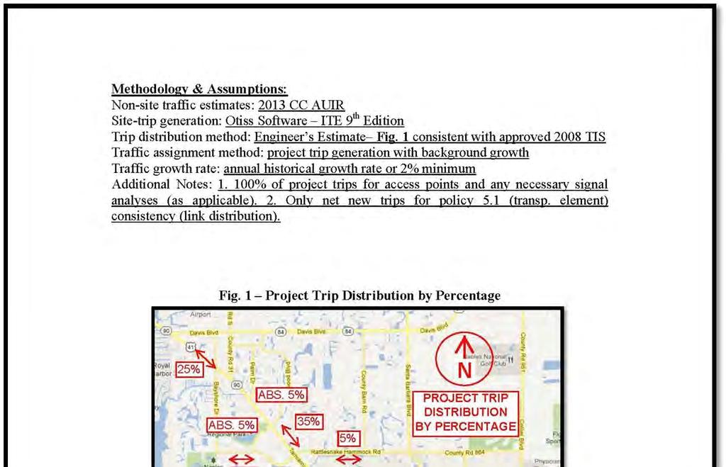
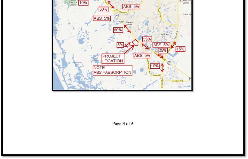
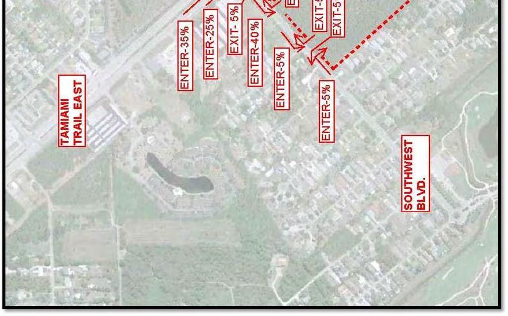
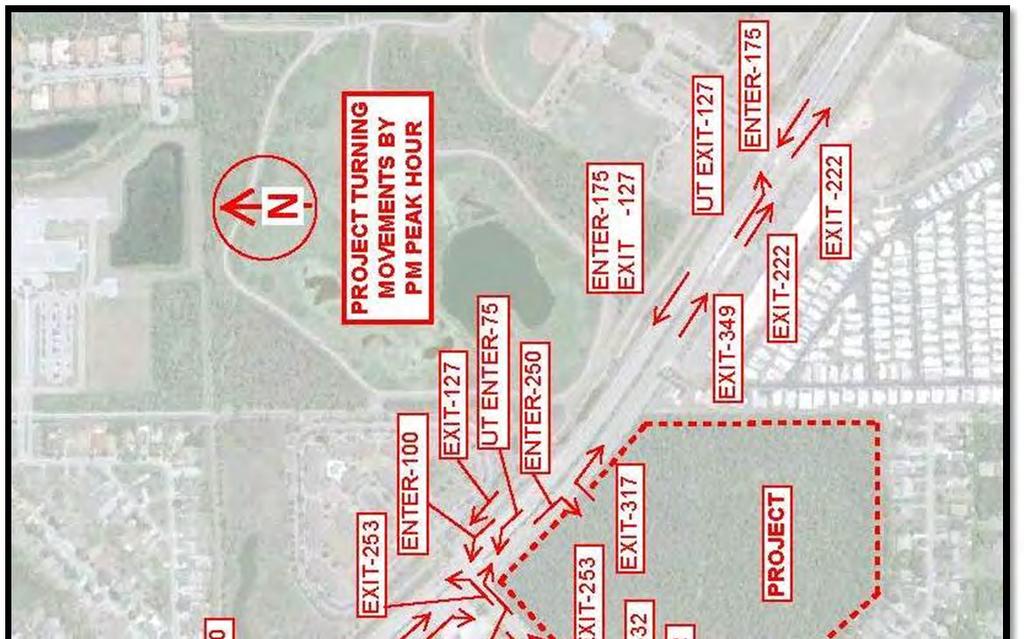
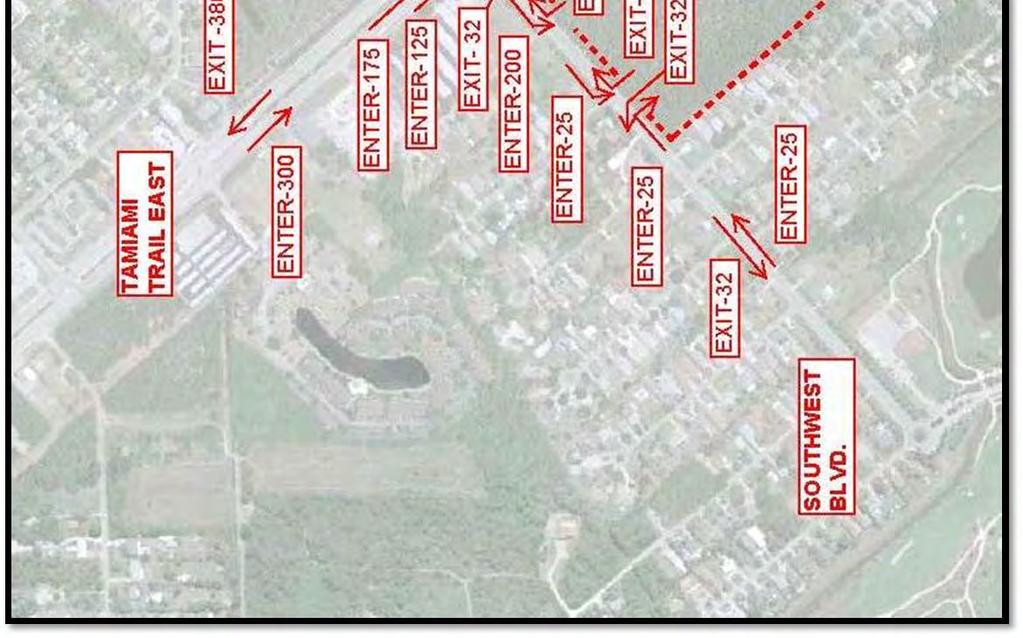
9 Trip Distribution and Assignment The traffic generated by the development was assigned to the adjacent roadways using the knowledge of the area, previously submitted study data and as coordinated with Collier County Transportation Planning Staff. The net new proposed site generated trip distribution is shown in Table 3 Project Traffic Distribution for PM Peak Hour, Peak Direction and is graphically depicted on the next page Fig. 2 Project Distribution By Percentage and Fig. 3 Project Distribution By PM Peak Hour. Refer to Appendix B Project Master Site Plan. Table 3 Project Traffic Distribution for PM Peak Hour, Peak Direction Roadway Link CC AUIR Link ID # Roadway Link Location Distribution of Project Traffic PM Peak Hr Project Traffic Volume Enter US Airport Rd. to Rattlesnake Hammock Rd. 35% US Rattlesnake Hammock Rd. to St. Andrews Blvd. 50% US St. Andrews Blvd. to Project 60% US Project to Triangle Blvd. 35% US Triangle Blvd. to Collier Blvd. 25% Thomasson Dr Bayshore Dr. to US 41 10% Rattlesnake US 41 to Charlemagne 72.0 Hammock Rd. Blvd. 5% 9 10 Southwest Blvd.* N/A Corso Bello Dr. to Project 5% 9 10 Collier Blvd Rattlesnake Hammock Rd. to US 41 15% Collier Blvd US 41 to Wal Mart Driveway 10% Notes: * Not a CC AUIR monitored roadway facility. Exit 9

10 Fig. 2 Project Distribution By Percentage 10

11 Fig. 3 Project Distribution By PM Peak Hour 11
12 Background Traffic Average background traffic growth rates were estimated for the segments of the roadway network in the study area using the Transportation Planning Staff Guidance of a minimum 2% growth rate, or the historical rate derived from Collier County annual traffic counts (estimated from 2008 thru 2012), whichever is greater. Another way to derive the background traffic is to use the 2013 AUIR volume plus the trip bank volume. For this project, the controlling (highest) volume is the AUIR volume plus the trip bank volume. Table 4 Background Traffic without Project, illustrates the application of projected growth rates to generate the projected background (without project) peak hour peak direction traffic volume for the year 2018 see next page. 12
13 Roadway Link CC AUIR Link ID # US US US US US Thomasson Dr. Rattlesnake Hammock Rd. Southwest Blvd.* Table 4 Background Traffic without Project ( ) Roadway Link Location Airport Rd. to Rattlesnake Hammock Rd. Rattlesnake Hammock Rd. to St. Andrews Blvd. St. Andrews Blvd. to Project Project to Triangle Blvd. Triangle Blvd. to Collier Blvd. Bayshore Dr. to US AUIR Peak Hr, Peak Dir Background Traffic Vol (trips/hr) Projected Traffic Annual Growth Rate (%/yr) Trip Bank Growth Factor 2018 Projected Peak Hr, Peak Dir Background Traffic Volume w/out Project (trips/hr) 2,170 (SB) 2.0% ,490 1,980 (SB) 3.0% ,557 1,980 (SB) 3.0% ,557 1,980 (SB) 3.0% ,557 1,310 (SB) 2.0% , (EB) 2.0% US 41 to Charlemagne Blvd. 1,630 (WB) 3.0% ,790 N/A Corso Bello Dr. to Project N/A N/A N/A N/A N/A Collier Blvd Rattlesnake Hammock Rd. to US 41 1,420 (NB) 2.0% ,926 Collier Blvd US 41 to Wal Mart Driveway 1,820 (NB) 2.0% ,543 Table Note: Growth Rate = from 2008 to 2012 CC traffic count data, or 2%, whichever is greater. Growth Factor = (1+Annual Growth Rate) ^ Projected Volume = 2013 AUIR Volume x Growth Factor, or 2013 AUIR + Trip Bank, whichever is greater. N/A = not applicable, not available. Note* Not a CC AUIR monitored roadway facility. 13
14 Existing and Future Roadway Network The existing roadway conditions are extracted from the 2012 Annual Update and Inventory Report (AUIR) and the 2018 roadway conditions are based on the current FDOT and Collier County 5 Year Work Program. The roadways evaluated are anticipated to remain the same thru The existing and future roadway conditions are illustrated in Table 5 Existing and Future Roadway Conditions. Roadway Link Table 5 Existing and Future Roadway Conditions CC AUIR Link ID # Roadway Link Location Exist Roadway Exist Min LOS Std Exist Peak Dir, Peak Hr Capacity Volume Future 2018 Roadway US Airport Rd. to Rattlesnake Hammock Rd. 6D E 2,900 6D US Rattlesnake Hammock Rd. to St. Andrews Blvd. 6D E 3,000 6D US St. Andrews Blvd. to Project 6D E 3,000 6D US Project to Triangle Blvd. 6D E 3,000 6D US Triangle Blvd. to Collier Blvd. 6D E 3,000 6D Thomasson Dr Bayshore Dr. to US 41 2U D 800 2U Rattlesnake US 41 to Charlemagne 72.0 Hammock Rd. Blvd. 4D D 1,800 4D Southwest Corso Bello Dr. to Project N/A Blvd.* 2U N/A 800 2U Collier Blvd Rattlesnake Hammock Rd. to US 41 6D E 3,200 6D Collier Blvd US 41 to Wal Mart Driveway 6D E 2,500 6D Table Notes: 2U = 2 lane undivided roadway; 4D, 6D =4 lane, 6 lane divided roadway, respectively; LOS = Level of Service. N/A = not applicable, not available. Note* Not a CC AUIR monitored roadway facility. Southwest Blvd. road service volume is assumed similar to Shadowlawn Dr. CC AUIR ID #
15 Project Impacts to Area Roadway Network Roadway Link Analysis The Collier County Transportation Planning Services developed Level of Service (LOS) volumes for the roadway links impacted by the project were evaluated to determine the project impacts to the area roadway network in the future (2018). The Collier County Transportation Planning Services guidelines have determined that a project will be considered to have a significant and adverse impact if both the percentage volume capacity exceeds 2% of the capacity for the link adjacent to the project; 3% for other links and if the roadway is projected to operate below the adopted LOS standard. The project PM peak hour volumes are added to the network volumes to coincide with the network peak time and peak direction. Table 6 Roadway Link Level of Service illustrates the LOS impacts of the project on the roadway network closest to the project. None of the adjacent links are projected to be operating below the adopted level of service with, or without the project. Although the percentage volume capacity exceeds County thresholds for some of the roadway links, the roadway facilities are projected to operate within the adopted LOS and therefore in an effective and efficient manner. Based on these criteria, this project creates significant, but not adverse impacts to the area roadway network. 15
16 Table 6 Roadway Link Level of Service (LOS) With Project in the Year 2018 Roadway Link CC AUIR Link ID # US US US US US Thomasson Dr Roadway Link Location Airport Rd. to Rattlesnake Hammock Rd. Rattlesnake Hammock Rd. to St. Andrews Blvd. St. Andrews Blvd. to Project Project to Triangle Blvd. Triangle Blvd. to Collier Blvd. Bayshore Dr. to US Peak Dir, Peak Hr Cap. Vol. CC Link Peak Dir (Project Vol Added) 2018 Peak Dir, Peak Hr Vol. w/ Project % Vol. Cap. Impact By Project Min LOS exceeded without Project? Yes/No Min LOS exceeded with Project? Yes/No 2, , % No No 3, , % No No 3, , % No No 3, , % No No 3, , % No No % No No Rattlesnake Hammock Rd. Southwest Blvd.* 72.0 N/A Collier Blvd Collier Blvd US 41 to Charlemagne Blvd. Corso Bello Dr. to Project Rattlesnake Hammock Rd. to US 41 US 41 to Wal Mart Driveway 1, , % No No N/A 1.3% No No 3, , % No No 2, , % No No Table Notes: N/A = not applicable, not available. Note* Not a CC AUIR monitored roadway facility. Southwest Blvd. road capacity is assumed similar to Shadowlawn Dr. CC AUIR ID #
17 Intersection/ Project Accesses Turn Lane Analysis The Vincentian PUDA project proposes 3 accesses as follows: two access points off of Southwest Blvd. Entrances #1 & #2 full movement accesses, and one access point off of US41 Tamiami Trail East Entrance #3 right in / right out access. Refer to Appendix B Project Master Site Plan. Tamiami Trail East (US 41) is under Florida Department of Transportation (FDOT) and Collier County jurisdiction and it is currently a north south six lane two way urban arterial roadway and has a posted legal speed limit of 55 mph in the vicinity of project. Based on FDOT Index 301 (design speed of 55mph), the minimum turn lane length is 350ft (which includes a 50 ft taper) plus required queue. Southwest Boulevard is a two lane west east undivided local roadway under Collier County jurisdiction and has a posted legal speed of 25mph in the vicinity of project. Based on FDOT Index 301 (design speed of 35 mph), the minimum turn lane length is 145ft (which includes a 50ft taper) plus required queue. Project accesses were evaluated for turn lane warrants based on Collier County Right Of Way Ordinance # : a) two lane roadways 40vph for right turn lane/20vph for left turn lane; b) multi lane divided roadways turn lanes shall always be provided. US 41 St. Southwest Blvd. Unsignalized Intersection The intersection of Southwest Blvd. and US41 is located in the proximity of the project. There is no operating traffic control signal at the intersection at this time, but it is under design by others. EB Southwest Blvd. approach provides one left turn lane and one through/rightturn lane (+/ 320ft). Eastbound exiting volume may warrant a double left turn lane, if combined with future background traffic. 17
18 SB US41 approach provides one right turn lane (+/ 475ft) and one left turn lane (+/ 350ft). NB US41 approach has one right turn lane (+/ 550ft) and one left turn lane. The existing turn lanes on US 41 serving the intersection will accommodate the operational needs of the project for both deceleration and stacking. Refer to Appendix E Turning Movements Exhibits. This intersection may require modifications, which will be determined at the time of final development order review. Project Accesses Turn Lanes Minimum turn lane lengths required at project build out conditions were analyzed based on number of turning vehicles in an average of 1 minute period (for right turns) and 2 minute period (for left turn), within the peak hour traffic. The minimum queue/vehicle considered is 25ft. A more detailed evaluation of the turn lanes for project access points would be implemented at the time of proposed development plan design and permitting, as applicable. Entrance #1 EB Southwest Blvd. EB Right Turn Lane The project is expected to generate 25 right turns during the PM peak hour. Therefore, an exclusive right turn is not warranted. WB Left Turn Lane The project is expected to generate 25 left turns during the PM peak hour. Therefore, an exclusive left turn is warranted and it is recommended to be 170ft in length, at the minimum. Entrance #2 EB Southwest Blvd. WB Left Turn Lane The project is expected to generate 200 left turns during the PM peak hour. Therefore, an exclusive left turn is warranted and it is recommended to be 320ft in length, at the minimum. 18
19 Entrance #3 SB US 41 SB Right Turn Lane The project is expected to generate 250 right turns during the PM peak hour. Therefore, an exclusive right turn is warranted and it is recommended to be 475ft in length, at the minimum. Improvement Analysis The project impacts to the Collier County roadway network are significant but are not adverse. Based on the link analysis and trip distribution, the proposed project is a significant traffic generator to this location. Empirically, the project is estimated to create a significant delay at Southwest Blvd. and US41 intersection that may warrant modifying the turn lane configuration geometry (additional turn lane) and/or installation of operating control signals that would improve service level. The recommended offsite improvements will be permitted and approved through the development order process. Mitigation of Impact The developer will provide appropriate mitigation and commitments as listed in the revised Planned Unit Development (PUD) document, in order to aid transportation improvements, as applicable. 19
20 Appendix A: Initial Meeting Checklist (Methodology Meeting) (5 Sheets) 20
21 21
22 22
23 23
24 24
25 25
26 Appendix B: Project Master Site Plan (1 Sheet) 26
27 27
28 Appendix C: ITE Trip Generation Calculations (9 th Edition) (3 Sheets) 28
29 29
30 30
31 31
32 Appendix D: Internal Pass by Capture Exhibits (5 Sheets) 32
33 33
34 34
35 35
36 36
37 37
38 Appendix E: Turning Movements Exhibits (2 Sheets) 38
39 39
40 40
Proposed location of Camp Parkway Commerce Center. Vicinity map of Camp Parkway Commerce Center Southampton County, VA
 Proposed location of Camp Parkway Commerce Center Vicinity map of Camp Parkway Commerce Center Southampton County, VA Camp Parkway Commerce Center is a proposed distribution and industrial center to be
EXECUTIVE SUMMARY. The following is an outline of the traffic analysis performed by Hales Engineering for the traffic conditions of this project.
 EXECUTIVE SUMMARY This study addresses the traffic impacts associated with the proposed Shopko redevelopment located in Sugarhouse, Utah. The Shopko redevelopment project is located between 1300 East and
Wilson Blvd Center CPUD Amendment (Wilson Blvd & Golden Gate Blvd, Collier County, Florida)
") JMB TRANSPORTATiaN ENGINEERING, inc TRAFFIC/TRANSPDRTATION ENGINEERING &. PLANNING SERVICES TRAFFIC IMPACT STATEMENT For Wilson Blvd Center CPUD Amendment (Wilson Blvd & Golden Gate Blvd, Collier County,
JMB TRANSPORTATiaN ENGINEERING, inc TRAFFIC/TRANSPDRTATION ENGINEERING &. PLANNING SERVICES TRAFFIC IMPACT STATEMENT For Wilson Blvd Center CPUD Amendment (Wilson Blvd & Golden Gate Blvd, Collier County,
APPENDIX C1 TRAFFIC ANALYSIS DESIGN YEAR TRAFFIC ANALYSIS
 APPENDIX C1 TRAFFIC ANALYSIS DESIGN YEAR TRAFFIC ANALYSIS DESIGN YEAR TRAFFIC ANALYSIS February 2018 Highway & Bridge Project PIN 6754.12 Route 13 Connector Road Chemung County February 2018 Appendix
Craig Scheffler, P.E., PTOE HNTB North Carolina, P.C. HNTB Project File: Subject
 TECHNICAL MEMORANDUM To Kumar Neppalli Traffic Engineering Manager Town of Chapel Hill From Craig Scheffler, P.E., PTOE HNTB North Carolina, P.C. Cc HNTB Project File: 38435 Subject Obey Creek TIS 2022
Traffic Impact Analysis. Alliance Cole Avenue Residential Site Dallas, Texas. Kimley-Horn and Associates, Inc. Dallas, Texas.
 Traffic Impact Analysis Alliance Cole Avenue Residential Site Dallas, Texas February 15, 2018 Kimley-Horn and Associates, Inc. Dallas, Texas Project #064524900 Registered Firm F-928 Traffic Impact Analysis
Volume 1 Traffic Impact Analysis Turtle Creek Boulevard Dallas, Texas. Kimley-Horn and Associates, Inc. Dallas, Texas.
 Volume 1 Traffic Impact Analysis 2727 Dallas, Texas June 18, 2018 Kimley-Horn and Associates, Inc. Dallas, Texas Project #064523000 Registered Firm F-928 Traffic Impact Analysis 2727 Dallas, Texas Prepared
MILLERSVILLE PARK TRAFFIC IMPACT ANALYSIS ANNE ARUNDEL COUNTY, MARYLAND
 MILLERSVILLE PARK TRAFFIC IMPACT ANALYSIS ANNE ARUNDEL COUNTY, MARYLAND Prepared for: Department of Public Works Anne Arundel County Prepared by: URS Corporation 4 North Park Drive, Suite 3 Hunt Valley,
2.0 Development Driveways. Movin Out June 2017
 Movin Out June 2017 1.0 Introduction The proposed Movin Out development is a mixed use development in the northeast quadrant of the intersection of West Broadway and Fayette Avenue in the City of Madison.
LAWRENCE TRANSIT CENTER LOCATION ANALYSIS 9 TH STREET & ROCKLEDGE ROAD / 21 ST STREET & IOWA STREET LAWRENCE, KANSAS
 LAWRENCE TRANSIT CENTER LOCATION ANALYSIS 9 TH STREET & ROCKLEDGE ROAD / 21 ST STREET & IOWA STREET LAWRENCE, KANSAS TRAFFIC IMPACT STUDY FEBRUARY 214 OA Project No. 213-542 TABLE OF CONTENTS 1. INTRODUCTION...
 Traffic Analysis For Approved Uses within the St. Lucie West DRI Aldi Port St. Lucie, FL Prepared for: Bohler Engineering, LLC 1000 Corporate Drive Suite 250 Fort Lauderdale, FL 33334 Prepared by: 10795
King Soopers #116 Thornton, Colorado
 Traffic Impact Study King Soopers #116 Thornton, Colorado Prepared for: Galloway & Company, Inc. T R A F F I C I M P A C T S T U D Y King Soopers #116 Thornton, Colorado Prepared for Galloway & Company
TRAFFIC SIGNAL DESIGN REPORT KING OF PRUSSIA ROAD & RAIDER ROAD RADNOR TOWNSHIP PENNSYLVANIA
 TRAFFIC SIGNAL DESIGN REPORT KING OF PRUSSIA ROAD & RAIDER ROAD RADNOR TOWNSHIP PENNSYLVANIA PREPARED FOR: UNIVERSITY OF PENNSYLVANIA HEALTH SYSTEM 34 CIVIC CENTER BOULEVARD PHILADELPHIA, PA 1987 (61)
Traffic Feasibility Study
 Traffic Feasibility Study Town Center South Robbinsville Township, Mercer County, New Jersey December 19, 2017 Prepared For Robbinsville Township Department of Community Development 2298 Route 33 Robbinsville,
Per Revised Concept Plan Residential Condo/Townhouse. Proposed Land Use per TIS
 January 2, 2018 Mr. Paul DeBotton Marple Associates, L.P. 1604 Walnut Street, 4 th Floor Philadelphia, PA 19103 RE: Langford Run Road Traffic Analysis Proposed Mid County Shopping Center Marple Township,
TIMBERVINE TRANSPORTATION IMPACT STUDY FORT COLLINS, COLORADO JANUARY Prepared for:
 TIMBERVINE TRANSPORTATION IMPACT STUDY FORT COLLINS, COLORADO JANUARY 2014 Prepared for: Hartford Companies 1218 W. Ash Street Suite A Windsor, Co 80550 Prepared by: DELICH ASSOCIATES 2272 Glen Haven Drive
TRAFFIC IMPACT ANALYSIS
 TRAFFIC IMPACT ANALYSIS Emerald Isle Commercial Development Prepared by SEPI Engineering & Construction Prepared for Ark Consulting Group, PLLC March 2016 I. Executive Summary A. Site Location The Emerald
MEMO VIA . Ms. Amy Roth DPS Director, City of Three Rivers. To:
 MEMO To: Ms. Amy Roth DPS Director, City of Three Rivers VIA EMAIL From: Michael J. Labadie, PE Julie M. Kroll, PE, PTOE Brandon Hayes, PE, P.Eng. Fleis & VandenBrink Date: January 5, 2017 Re: Proposed
Appendix C. Traffic Study
 Appendix C Traffic Study TABLE OF CONTENTS SECTION Executive Summary PAGE 1.0 Introduction... 1 1.1 Scope of Work... 1 1.2 Study Area... 2 2.0 Project Description... 3 2.1 Site Access... 4 2.2 Pedestrian
Escondido Marriott Hotel and Mixed-Use Condominium Project TRAFFIC IMPACT ANALYSIS REPORT
 Escondido Marriott Hotel and Mixed-Use Condominium Project TRAFFIC IMPACT ANALYSIS REPORT Prepared for Phelps Program Management 420 Sixth Avenue, Greeley, CO 80632 Prepared by 5050 Avenida Encinas, Suite
Traffic Impact Analysis 5742 BEACH BOULEVARD MIXED USE PROJECT
 Traffic Impact Analysis 5742 BEACH BOULEVARD MIXED USE PROJECT CITY OF BUENA PARK Prepared by Project No. 14139 000 April 17 th, 2015 DKS Associates Jeffrey Heald, P.E. Rohit Itadkar, T.E. 2677 North Main
Appendix C-5: Proposed Refinements Rail Operations and Maintenance Facility (ROMF) Traffic Impact Analysis. Durham-Orange Light Rail Transit Project
 Traffic Impact Analysis. Durham-Orange Light Rail Transit Project") Appendix C-5: Proposed Refinements Rail Operations and Maintenance Facility (ROMF) Traffic Impact Analysis Durham-Orange Light Rail Transit Project July 25, 218 ROMF Transportation Impact Analysis Version
Appendix C-5: Proposed Refinements Rail Operations and Maintenance Facility (ROMF) Traffic Impact Analysis Durham-Orange Light Rail Transit Project July 25, 218 ROMF Transportation Impact Analysis Version
DEVELOPMENT PROPERTY 1627 MAXIME STREET CITY OF OTTAWA TRANSPORTATION OVERVIEW. Prepared for: Subhas Bhargava. July 9, Overview_1.
 DEVELOPMENT PROPERTY 1627 MAXIME STREET CITY OF OTTAWA TRANSPORTATION OVERVIEW Prepared for: Subhas Bhargava July 9, 2015 115-620 Overview_1.doc D. J. Halpenny & Associates Ltd. Consulting Transportation
Proposed Inn at Bellefield Traffic Impact Assessment
 Proposed Inn at Bellefield Traffic Impact Assessment Town of Hyde Park Dutchess County, New York Prepared for: T-Rex Hyde Park Owner LLC 500 Mamroneck Avenue, Suite 300 Harrison, NY 10528 June 21, 2017
Shoppes at Pine Meadow BPUD DeBary, Florida. Traffic Impact Analysis
 Shoppes at Pine Meadow BPUD DeBary, Florida Traffic Impact Analysis Prepared for: CPH, Inc. By: Lassiter Transportation Group, Inc. Revised October 2015 Table of Contents Introduction... 1 Study Procedures...
Lacey Gateway Residential Phase 1
 Lacey Gateway Residential Phase Transportation Impact Study April 23, 203 Prepared for: Gateway 850 LLC 5 Lake Bellevue Drive Suite 02 Bellevue, WA 98005 Prepared by: TENW Transportation Engineering West
Transportation & Traffic Engineering
 Transportation & Traffic Engineering 1) Project Description This report presents a summary of findings for a Traffic Impact Analysis (TIA) performed by A+ Engineering, Inc. for the Hill Country Family
Oakbrook Village Plaza City of Laguna Hills
 Oakbrook Village Plaza City of Laguna Hills Traffic Impact Analysis Prepared by: HDR Engineering 3230 El Camino Real, Suite 200 Irvine, CA 92602 October 2012 Revision 3 D-1 Oakbrook Village Plaza Laguna
Appendix Q Traffic Study
 Appendices Appendix Q Traffic Study Crummer Site Subdivision Draft EIR City of Malibu Appendices This page intentionally left blank. The Planning Center April 2013 TRAFFIC IMPACT ANALYSIS Photo z here
Bennett Pit. Traffic Impact Study. J&T Consulting, Inc. Weld County, Colorado. March 3, 2017
 Bennett Pit Traffic Impact Study J&T Consulting, Inc. Weld County, Colorado March 3, 217 Prepared By: Sustainable Traffic Solutions, Inc. http://www.sustainabletrafficsolutions.com/ Joseph L. Henderson,
IV. REVISIONS TO THE DRAFT IS/MND
 IV. REVISIONS TO THE DRAFT IS/MND 1. REVISIONS TO THE DRAFT IS/MND This section presents corrections and clarifications that have been made to the text of the Draft IS/MND. These changes include revisions
Table 1 - Land Use Comparisons - Proposed King s Wharf Development. Retail (SF) Office (SF) 354 6,000 10, Land Uses 1
 Office (SF) 354 6,000 10, Land Uses 1") Ref. No. 171-6694 Phase 2 November 23, 217 Mr. David Quilichini, Vice President Fares & Co. Developments Inc. 31 Place Keelson Sales Centre DARTMOUTH NS B2Y C1 Sent Via Email to David@faresinc.com RE:
Ref. No. 171-6694 Phase 2 November 23, 217 Mr. David Quilichini, Vice President Fares & Co. Developments Inc. 31 Place Keelson Sales Centre DARTMOUTH NS B2Y C1 Sent Via Email to David@faresinc.com RE:
Clean Harbors Canada, Inc.
 Clean Harbors Canada, Inc. Proposed Lambton Landfill Expansion Environmental Assessment Terms of Reference Transportation Assessment St. Clair Township, Ontario September 2009 itrans Consulting Inc. 260
INTERSECTION CONTROL EVALUATION
 INTERSECTION CONTROL EVALUATION Trunk Highway 22 and CSAH 21 (E Hill Street/Shanaska Creek Road) Kasota, Le Sueur County, Minnesota November 2018 Trunk Highway 22 and Le Sueur CSAH 21 (E Hill Street/Shanaska
105 Toronto Street South, Markdale Transportation Impact Study. Paradigm Transportation Solutions Limited
 105 Toronto Street South, Markdale Transportation Impact Study Paradigm Transportation Solutions Limited December 2016 Project Summary Project Number 162060 December 2016 Client Zelinka Priamo Ltd 318
L1TILE BEARS DAY CARE TRANSPORTATION IMPACT STUDY FORT COLLINS, COLORADO MAY Prepared for:
 L1TILE BEARS DAY CARE TRANSPORTATION IMPACT STUDY FORT COLLINS, COLORADO MAY 2012 Prepared for: Hillside Construction, Inc. 216 Hemlock Street, Suite B Fort Collins, CO 80534 Prepared by: DELICH ASSOCIATES
TRAFFIC IMPACT STUDY DERRY GREEN CORPORATE BUSINESS PARK MILTON SECONDARY PLAN MODIFICATION
 TRAFFIC IMPACT STUDY DERRY GREEN CORPORATE BUSINESS PARK MILTON SECONDARY PLAN MODIFICATION TRAFFIC IMPACT STUDY DERRY GREEN CORPORATE BUSINESS PARK MILTON SECONDARY PLAN MODIFICATION DECEMBER 24 UPDATED
GASOLINE SERVICE STATION 1618, 1622 ROGER STEVENS DRIVE OTTAWA, ONTARIO TRANSPORTATION IMPACT ASSESSMENT. Prepared for:
 GASOLINE SERVICE STATION 1618, 1622 ROGER STEVENS DRIVE OTTAWA, ONTARIO TRANSPORTATION IMPACT ASSESSMENT Prepared for: Invecta Development (Ottawa) Corporation 758 Shanks Height Milton, ON L9T 7P7 May
BARRHAVEN FELLOWSHIP CRC 3058 JOCKVALE ROAD OTTAWA, ONTARIO TRANSPORTATION BRIEF. Prepared for:
 BARRHAVEN FELLOWSHIP CRC 3058 JOCKVALE ROAD OTTAWA, ONTARIO TRANSPORTATION BRIEF Prepared for: Barrhaven Fellowship CRC 3058 Jockvale Road Ottawa, ON K2J 2W7 December 7, 2016 116-649 Report_1.doc D. J.
Traffic Impact Study for the proposed. Town of Allegany, New York. August Project No Prepared For:
 Appendix B SRF Traffic Study (Revised November 2005) Draft Environmental Impact Statement University Commons Town of Allegany, Cattaraugus County, NY December 2005 Traffic Impact Study for the proposed
4.14 TRANSPORTATION AND CIRCULATION
 4.14 TRANSPORTATION AND CIRCULATION 4.14.1 Summary Table 4.14-1 summarizes the identified environmental impacts, proposed mitigation measures, and residual impacts of the proposed project with regard to
DELICETO, LLC PALM BEACH COUNTY, FL
 COMPREHENSIVE PLAN AMENDMENT TRAFFIC ANALYSIS DELICETO, LLC PALM BEACH COUNTY, FL PREPARED FOR: DELICETO, LLC Project #042787007 April 18, 2018 Revised May 29, 2018 CA 00000696 Kimley-Horn and Associates,
MERIVALE PRIORITY SQUARE 2852 MERIVALE ROAD CITY OF OTTAWA TRANSPORTATION BRIEF. Prepared for: ONT Inc. 25 Winding Way Nepean, Ontario K2C 3H1
 MERIVALE PRIORITY SQUARE 2852 MERIVALE ROAD CITY OF OTTAWA TRANSPORTATION BRIEF Prepared for: 2190986ONT Inc. 25 Winding Way Nepean, Ontario K2C 3H1 October 6, 2010 110-502 Report_1.doc D. J. Halpenny
TECHNICAL MEMORANDUM. Part A: Introduction
 TECHNICAL MEMORANDUM To: David J. Decker Decker Properties, Inc. 5950 Seminole Centre Ct. Suite 200 Madison, Wisconsin 53711 608-663-1218 Fax: 608-663-1226 www.klengineering.com From: Mike Scarmon, P.E.,
RTE. 1 at RTE. 637 & RTE. 639
 INTERSECTION SAFETY STUDY Prepared for: Virginia Department of Transportation Central Region Operations Traffic Engineering (UPC #81378, TO 12-092) DAVENPORT Project Number: 13-368 / /2014 RTE. 1 at RTE.
TRAFFIC IMPACT ANALYSIS FOR. McDONALD S RESTAURANT IN CARMICAEL Sacramento County, CA. Prepared For:
 TRAFFIC IMPACT ANALYSIS FOR McDONALD S RESTAURANT IN CARMICAEL Sacramento County, CA Prepared For: McDonald s USA, LLC Pacific Sierra Region 2999 Oak Road, Suite 900 Walnut Creek, CA 94597 Prepared By:
RICHMOND OAKS HEALTH CENTRE 6265 PERTH STREET OTTAWA, ONTARIO TRANSPORTATION BRIEF. Prepared for: Guycoki (Eastern) Limited.
 Limited.") RICHMOND OAKS HEALTH CENTRE 6265 PERTH STREET OTTAWA, ONTARIO TRANSPORTATION BRIEF Prepared for: Guycoki (Eastern) Limited June 16, 2016 116-638 Brief_1.doc D. J. Halpenny & Associates Ltd. Consulting
RICHMOND OAKS HEALTH CENTRE 6265 PERTH STREET OTTAWA, ONTARIO TRANSPORTATION BRIEF Prepared for: Guycoki (Eastern) Limited June 16, 2016 116-638 Brief_1.doc D. J. Halpenny & Associates Ltd. Consulting
Section 5.0 Traffic Information
 Section 5.0 Traffic Information 10.0 TRANSPORTATION MDM Transportation Consultants, Inc. (MDM) has prepared an evaluation of transportation impacts for the proposed evaluation for the expansion of the
Mineola Village Green
 Traffic Impact Analysis Report Mineola Village Green 199 2 nd Street Mineola, New York Prepared for Mineola Metro LLC c/o Lalezarian Properties 1999 Marcus Avenue, Suite 310 Lake Success, NY 11042 Prepared
Traffic Impact Study for Proposed Olive Boulevard Development
 Traffic Impact Study for Proposed 11330 Olive Boulevard Development Creve Coeur, Missouri July 7, 2017 Prepared For: 11330 Olive Boulevard Development 11330 Olive Boulevard Creve Coeur, Missouri 63141
Parks and Transportation System Development Charge Methodology
 City of Sandy Parks and Transportation System Development Charge Methodology March, 2016 Background In order to implement a City Council goal the City of Sandy engaged FCS Group in January of 2015 to update
TRAFFIC IMPACT STUDY FOR SONIC DRIVE-IN RESTAURANT. Vallejo, CA. Prepared For:
 TRAFFIC IMPACT STUDY FOR SONIC DRIVE-IN RESTAURANT Vallejo, CA Prepared For: ELITE DRIVE-INS, INC. 2190 Meridian Park Blvd, Suite G Concord, CA 94520 Prepared By: KD Anderson & Associates 3853 Taylor Road,
Clearlake Road (State Road 501) Project Development & Environment (PD&E) Study
 Project Development & Environment (PD&E) Study") Clearlake Road (State Road 501) Project Development & Environment (PD&E) Study FROM MICHIGAN AVENUE TO INDUSTRY ROAD BREVARD COUNTY, FLORIDA Financial Project ID No: 433605-1-22-01 Federal Aid Project
Clearlake Road (State Road 501) Project Development & Environment (PD&E) Study FROM MICHIGAN AVENUE TO INDUSTRY ROAD BREVARD COUNTY, FLORIDA Financial Project ID No: 433605-1-22-01 Federal Aid Project
One Harbor Point Residential
 Residential Gig Harbor, WA Transportation Impact Analysis January 23, 2017 Prepared for: Neil Walter Company PO Box 2181 Tacoma, WA 98401 Prepared by: TENW Transportation Engineering NorthWest 11400 SE
Traffic Impact Study Morgan Road Commerce Park Pasco County, Florida
 Traffic Impact Study Morgan Road Commerce Park Pasco County, Florida Summary Report June 2008 Prepared by: 12909 N 56 th Street # 201 Tampa, FL 33617 Ph: (813) 988-3180 Fax: (813) 343-6854 Morgan Road
Appendix J Traffic Impact Study
 MRI May 2012 Appendix J Traffic Impact Study Level 2 Traffic Assessment Limited Impact Review Appendix J [This page was left blank intentionally.] www.sgm-inc.com Figure 1. Site Driveway and Trail Crossing
ZINFANDEL LANE / SILVERADO TRAIL INTERSECTION TRAFFIC ANALYSIS
 ZINFANDEL LANE / SILVERADO TRAIL INTERSECTION TRAFFIC ANALYSIS UPDATED TRAFFIC STUDY FOR THE PROPOSED RAYMOND VINEYARDS WINERY USE PERMIT MODIFICATION #P11-00156 AUGUST 5, 2014 PREPARED BY: OMNI-MEANS,
Traffic Impact Analysis Update
 Willow Bend Traffic Impact Analysis Update TABLE OF CONTENTS Page I. INTRODUCTION -------------------------------------------------------------------------------------------- 1 II. EXISTING CONDITIONS
Traffic Impact Study Proposed Residential Development (Watson Parkway North - Starwood Drive Node, City of Guelph)
") Traffic Impact Study Proposed Residential Development (Watson Parkway North - Starwood Drive Node, City of Guelph) Prepared By: 332 Lorne Avenue East Stratford ON N5A 6S4 Prepared for: Paul Kemper, President
Traffic Impact Study Proposed Residential Development (Watson Parkway North - Starwood Drive Node, City of Guelph) Prepared By: 332 Lorne Avenue East Stratford ON N5A 6S4 Prepared for: Paul Kemper, President
TALMONT TOWNHOMES MADISON KENNETH SPA TRAFFIC IMPACT STUDY. Sacramento, CA. Prepared For: MBK Homes. Prepared By:
 TALMONT TOWNHOMES MADISON KENNETH SPA TRAFFIC IMPACT STUDY Sacramento, CA Prepared For: MBK Homes Prepared By: KD Anderson & Associates 3853 Taylor Road, Suite G Loomis, California 95650 (916) 660-1555
TABLE OF CONTENTS EXECUTIVE SUMMARY...1 INTRODUCTION...3 PROJECTED FUTURE GROWTH...3 ROADWAY IMPROVEMENT PROJECTS...4 POTENTIAL FUNDING SOURCES...
 Transportation Impact Fee Study September 2014 TABLE OF CONTENTS EXECUTIVE SUMMARY...1 INTRODUCTION...3 PROJECTED FUTURE GROWTH...3 ROADWAY IMPROVEMENT PROJECTS......4 POTENTIAL FUNDING SOURCES...7 PROPOSED
APPENDIX B Traffic Analysis
 APPENDIX B Traffic Analysis Rim of the World Unified School District Reconfiguration Prepared for: Rim of the World School District 27315 North Bay Road, Blue Jay, CA 92317 Prepared by: 400 Oceangate,
April 7, Mr. Blake Shutler Compass Homes Development LLC Summit Homes Construction, LLC PO Box 6539 Dillon, CO 80435
 Compass Homes Development LLC Summit Homes Construction, LLC PO Box 6539 Dillon, CO 80435 Re: Trip Generation Comparison West Hills Townhomes Keystone, Colorado FHU Reference No. 116388-01 Dear Mr. Shutler:
Table of Contents. Traffic Impact Analysis Capital One Building at Schilling Place
 Traffic Impact Analysis Capital One Building at Schilling Place Table of Contents Executive Summary... 1 1. Introduction... 4 2. Project Description... 4 3. Background Information... 4 4. Study Scope...
Alpine Highway to North County Boulevard Connector Study
 Alpine Highway to North County Boulevard Connector Study prepared by Avenue Consultants March 16, 2017 North County Boulevard Connector Study March 16, 2017 Table of Contents 1 Summary of Findings... 1
APPENDIX E. Traffic Analysis Report
 APPENDIX E Traffic Analysis Report THIS PAGE INTENTIONALLY BLANK EAGLE RIVER TRAFFIC MITIGATION PHASE I OLD GLENN HIGHWAY/EAGLE RIVER ROAD INTERSECTION IMPROVEMENTS TRAFFIC ANALYSIS Eagle River, Alaska
V. DEVELOPMENT OF CONCEPTS
 Martin Luther King, Jr. Drive Extension FINAL Feasibility Study Page 9 V. DEVELOPMENT OF CONCEPTS Throughout the study process several alternative alignments were developed and eliminated. Initial discussion
The major roadways in the study area are State Route 166 and State Route 33, which are shown on Figure 1-1 and described below:
 3.5 TRAFFIC AND CIRCULATION 3.5.1 Existing Conditions 3.5.1.1 Street Network DRAFT ENVIRONMENTAL IMPACT REPORT The major roadways in the study area are State Route 166 and State Route 33, which are shown
Proposed Hotel and Restaurant Development
 Traffic Impact Study Proposed Hotel and Restaurant Development Marbledale Road Tuckahoe, NY PREPARED FOR BILLWIN DEVELOPMENT AFFILIATES, LLC 365 WHITE PLAINS ROAD EASTCHESTER, NY. 10709 PREPARED BY Engineering
4/2/18 MP NORTHPOINT MALL GENERAL GROWTH PROPERTIES
 PHOTOGRAPH OF PIONEER PLACE, PORTLAND, OREGON APPLICATION FOR MASTER PLAN AMENDMENT CITY OF ALPHARETTA, GEORGIA Photograph of Pioneer Place, Portland, Oregon, showing exterior of a leasable office use
Traffic Impact Analysis for 2171 Rosecrans Avenue
 Traffic Impact Analysis for 2171 Rosecrans Avenue Prepared for: Continental Development Corporation Revised May 2016 LA16-2831 Prepared by: Fehr & Peers 600 Wilshire Blvd, Suite 1050 Los Angeles, CA 90017
Interstate Operations Study: Fargo-Moorhead Metropolitan Area Simulation Results
 NDSU Dept #2880 PO Box 6050 Fargo, ND 58108-6050 Tel 701-231-8058 Fax 701-231-6265 www.ugpti.org www.atacenter.org Interstate Operations Study: Fargo-Moorhead Metropolitan Area 2025 Simulation Results
STAFF REPORT # CHANGE OF ZONING
 STAFF REPORT #17-2000-0007 CHANGE OF ZONING PLANNING COMMISSION MEETING DATE: November 16, 2017 (Applicant Provided Materials / Traffic Study = Blue) 1. APPLICATION: A public hearing for an application
MINERVA PARK SITE TRAFFIC IMPACT STUDY M/I HOMES. September 2, 2015
 5500 New Albany Road Columbus, Ohio 43054 Phone: 614.775.4500 Fax: 614.775.4800 Toll Free: 1-888-775-EMHT emht.com 2015-1008 MINERVA PARK SITE TRAFFIC IMPACT STUDY M/I HOMES September 2, 2015 Engineers
Traffic Engineering Study
 Traffic Engineering Study Bellaire Boulevard Prepared For: International Management District Technical Services, Inc. Texas Registered Engineering Firm F-3580 November 2009 Executive Summary has been requested
December 5, Red Bank Planning Board Municipal Building 90 Monmouth Street Red Bank, NJ 07701
 Dynamic Traffic, LLC www.dynamic-traffic.com 1904 Main Street Lake Como, NJ 07719 T. 732.681.0760 December 5, 2016 Red Bank Planning Board Municipal Building 90 Monmouth Street Red Bank, NJ 07701 Re: Traffic
1. INTRODUCTION 2. PROJECT DESCRIPTION CUBES SELF-STORAGE MILL CREEK TRIP GENERATION COMPARISON
 CUBES SELF-STORAGE MILL CREEK TRIP GENERATION COMPARISON 1. INTRODUCTION This report summarizes traffic impacts of the proposed CUBES Self-Storage Mill Creek project in comparison to the traffic currently
INTERCHANGE OPERTIONS STUDY Interstate 77 / Wallings Road Interchange
 INTERCHANGE OPERTIONS STUDY Interstate 77 / Wallings Road Interchange City of Broadview Heights, Cuyahoga County, Ohio Prepared For: City of Broadview Heights Department of Engineering 9543 Broadview Road
Table 1: Existing Trip Generation A.M. Peak Hour P.M. Peak Hour Land Use ITE Code Intensity Daily Total In Out Total In Out
 October 24, 218 Mr. Justin D. Bridges, AIA, LEED AP Davidson A+E 431 Indian Creek Parkway Overland Park, KS 6627 RE: Dear Mr. Bridges, Trip Generation Overland Park, Kansas As requested, Priority Engineers,
Date: February 7, 2017 John Doyle, Z-Best Products Robert Del Rio. T.E. Z-Best Traffic Operations and Site Access Analysis
 Memorandum Date: February 7, 07 To: From: Subject: John Doyle, Z-Best Products Robert Del Rio. T.E. Z-Best Traffic Operations and Site Access Analysis Introduction Hexagon Transportation Consultants, Inc.
June 21, Mr. Jeff Mark The Landhuis Company 212 North Wahsatch Avenue, Suite 301. Colorado Springs, CO 80903
 LSC TRANSPORTATION CONSULTANTS, INC. 545 East Pikes Peak Avenue, Suite 210 Colorado Springs, CO 80903 (719) 633-2868 FAX (719) 633-5430 E-mail: lsc@lsctrans.com Website: http://www.lsctrans.com June 21,
Traffic Impact Study Speedway Gas Station Redevelopment
 Traffic Impact Study Speedway Gas Station Redevelopment Warrenville, Illinois Prepared For: Prepared By: April 11, 2018 Table of Contents 1. Introduction... 1 2. Existing Conditions... 4 Site Location...
MEMORANDUM. Project Description. Operational Trip Generation. Construction Trip Generation. Date: August 12, 2014 TG: To: From: Subject:
 MEMORANDUM Date: August 12, 2014 TG: 13329.01 To: From: Subject: Jeremy Krout EPD Solutions Inc. Rafik Albert EPD Solutions Inc. Rawad Hani Transpo Group AP North Lake Solar Project Traffic Scoping The
Shirk Road at State Route 198 Interchange Analysis Tulare County, California
 Shirk Road at State Route 198 Interchange Analysis Tulare County, California DRAFT REPORT Prepared By Tulare County Association of Governments (TCAG) April 2013 Table of Contents Introduction:... 3 Project
INDUSTRIAL DEVELOPMENT
 INDUSTRIAL DEVELOPMENT Traffic Impact Study Plainfield, Illinois August 2018 Prepared for: Seefried Industrial Properties, Inc. TABLE OF CONTENTS Executive Summary 2 Introduction 3 Existing Conditions
TRANSPORTATION STUDY FOR THE 8899 BEVERLY BOULEVARD PROJECT
 DRAFT TRANSPORTATION STUDY FOR THE 8899 BEVERLY BOULEVARD PROJECT WEST HOLLYWOOD, CALIFORNIA NOVEMBER 2013 PREPARED FOR BEVERLY BOULEVARD ASSOCIATION PREPARED BY DRAFT TRANSPORTATION STUDY FOR THE 8899
LOTUS RANCH TRAFFIC IMPACT ANALYSIS. LLG Ref Senior Transportation Engineer & Charlene Sadiarin Transportation Engineer II
 TRAFFIC IMPACT ANALYSIS LOTUS RANCH El Centro, California July 31, 2015February 12, 2016 LLG Ref. 3-14-2392 Prepared by: KC Yellapu, P.E Senior Transportation Engineer & Charlene Sadiarin Transportation
Proposed CVS/pharmacy
 Traffic Impact and Access Study Proposed CVS/pharmacy West Main Street (Route 1) at Hull Street Clinton, Connecticut PREPARED FOR Arista Development LLC 520 Providence Highway, Suite 9 Norwood, Massachusetts
Quantitative analyses of weekday a.m. and p.m. commuter hour conditions have been conducted for the following five scenarios:
 6.1 TRANSPORTATION AND CIRCULATION 6.1.1 INTRODUCTION This section of the EIR presents the results of TJKM s traffic impact analysis of the proposed Greenbriar Development. The analysis includes consideration
Access Management Standards
 Access Management Standards This section replaces Access Control Standards on Page number 300-4 of the Engineering Standards passed February 11, 2002 and is an abridged version of the Access Management
Interstate Operations Study: Fargo-Moorhead Metropolitan Area Simulation Output
 NDSU Dept #2880 PO Box 6050 Fargo, ND 58108-6050 Tel 701-231-8058 Fax 701-231-6265 www.ugpti.org www.atacenter.org Interstate Operations Study: Fargo-Moorhead Metropolitan Area 2015 Simulation Output Technical
TABLE OF CONTENTS SECTION PAGE. Executive Summary... xii
 TABLE OF CONTENTS SECTION PAGE Executive Summary... xii 1.0 Introduction... 1 1.1 Study Area... 2 1.2 Traffic Impact Analysis Scenarios... 4 1.3 Study Area - City of Orange... 4 2.0 Project Description
APPENDIX C-2. Traffic Study Supplemental Analysis Memo
 APPENDIX C-2 Traffic Study Supplemental Analysis Memo The Mobility Group Transportation Strategies & Solutions Memorandum To: From: Subject: Tomas Carranza, LADOT Matthew Simons Traffic Review - Revised
PROJECT: Wilkinson Road Corridor Improvement Traffic Management Planning Project SUBJECT: Traffic Analysis
 TECHNICAL MEMORANDUM DATE: September 10, 2014 PROJECT 5861.03 NO: PROJECT: Wilkinson Road Corridor Improvement Traffic Management Planning Project SUBJECT: Traffic Analysis TO: Steve Holroyd - District
Figure 1 Map of intersection of SR 44 (Ravenna Rd) and Butternut Rd
 and Butternut Rd") Abbreviated Study District: 12 County: Geauga Route: SR 44 Section: 1.58 GEA 44 1.58 213 HSP # 47 (Rural Intersection) Prepared April 23, 215 By Bryan Emery Existing Conditions This study contains the
Abbreviated Study District: 12 County: Geauga Route: SR 44 Section: 1.58 GEA 44 1.58 213 HSP # 47 (Rural Intersection) Prepared April 23, 215 By Bryan Emery Existing Conditions This study contains the
TRAFFIC PARKING ANALYSIS
 TRAFFIC PARKING ANALYSIS NAPA FLEA MARKET COUNTY OF NAPA Prepared for: Tom Harding Napa-Vallejo Flea Market 33 Kelly Road American Canyon, CA 9453 Prepared by: 166 Olympic Boulevard, Suite 21 Walnut Creek,
West Hills Shopping Centre Lowe s Expansion Traffic Impact Study
 West Hills Shopping Centre Lowe s Expansion Traffic Impact Study Prepared for: Armel Corporation January 2015 Paradigm Transportation Solutions Ltd. 22 King Street South, Suite 300 Waterloo ON N2J 1N8
Volume 2 Appendix Turtle Creek Boulevard Dallas, Texas. Kimley-Horn and Associates, Inc. Dallas, Texas. June 18, 2018
 Volume 2 Appendix 2727 Turtle Creek Boulevard Dallas, Texas June 18, 2018 Kimley-Horn and Associates, Inc. Dallas, Texas Project #064523000 Registered Firm F-928 Maple Avenue Drive 1 Fairmount Street Gillespie
Roundabout Feasibility Study SR 44 at Grand Avenue TABLE OF CONTENTS
 Roundabout Feasibility Study SR 44 at Grand Avenue TABLE OF CONTENTS Introduction and Executive Summary... 1 Existing Conditions... 3 Intersection Volume Conditions... 5 Intersection Operations... 9 Safety
CHAPTER 9: VEHICULAR ACCESS CONTROL Introduction and Goals Administration Standards
 9.00 Introduction and Goals 9.01 Administration 9.02 Standards 9.1 9.00 INTRODUCTION AND GOALS City streets serve two purposes that are often in conflict moving traffic and accessing property. The higher