Mineola Village Green
|
|
|
- Lawrence Douglas
- 5 years ago
- Views:
Transcription
1
2 Traffic Impact Analysis Report Mineola Village Green nd Street Mineola, New York Prepared for Mineola Metro LLC c/o Lalezarian Properties 1999 Marcus Avenue, Suite 310 Lake Success, NY Prepared by 100 Motor Parkway, Suite 135 Hauppauge, New York (631) October 2014
3 Table of Contents 1.0 Introduction... 1 Project Description... 1 Study Methodology Existing Conditions... 4 Roadways and Intersection Conditions... 4 Old Country Road... 4 Mineola Boulevard / Franklin Avenue nd Street... 5 Main Street... 5 Station Plaza North... 5 Intersections Description... 8 Old Country Road at Mineola Boulevard /Franklin Avenue... 8 Mineola Boulevard at 2 nd Street... 9 Main Street at 2 nd Street Main Street at Station Plaza North Existing Traffic Volume Data Accident History Future Conditions No Build Condition Background Traffic Growth Other Planned Developments Build Condition Project-Generated Traffic Volumes Transit -Oriented Development Trip Distribution and Assignment Traffic Operations Analysis Level of Service and Delay Criteria Software Level of Service Analysis Analysis Results Parking Off-Street Parking On-Street Parking Impacts Conclusions List of Figures Figure 1 - Location Map... 2 Figure 2 - Key Intersections... 7 Figure 3 - Existing - AM Peak Figure 4 - Existing - PM Peak Figure 5 - Site Generated Traffic - AM Peak... 28
4 Figure 6 - Site Generated Traffic - PM Peak Figure 7 - Site Generated Traffic Saturday Midday Peak Figure 8 - Build - AM Peak Figure 9 - Build - PM Peak Figure 10 - Build Saturday Midday Peak List of Tables Table 1 Accident Data Summary Table 2 Trip Generation Projections Table 3 Signalized Intersections Level of Service AM Peak Hour Table 4 Signalized Intersections Level of Service PM Peak Hour Table 5 Signalized Intersections Level of Service Saturday Midday Peak Hour Table 6 - Unsignalized Intersections Level of Service AM Peak Hour Table 7 - Unsignalized Intersections Level of Service PM Peak Hour Table 8 - Unsignalized Intersections Level of Service Saturday Midday Peak Hour Table 9 Table of Off-street Parking Requirements Appendices Appendix A: Appendix B: Appendix C: Manual Turning Movement Counts LOS Definitions Synchro Level of Service Analysis Worksheets
5 1.0 Introduction This study summarizes the comprehensive evaluation of the potential traffic impacts associated with the proposed mixed-use development of residential and retail space in Mineola, New York. The purpose of this study is to determine if there are any significant traffic impacts due to the proposed project and to evaluate and propose mitigation measures, if required. This report presents the findings of the traffic study and summarizes the data collection process, traffic analysis procedures, and study conclusions. Based on the results of the study, more completely described herein, it has been concluded that the development of subject project will not have a significant impact on the study intersections or roadway network. Project Description Mineola Metro LLC., is proposing to build the mixed-use Mineola Village Green consisting of 296 apartments, approximately 6,975 square feet of retail space and 6,975 square feet of restaurant space on a 1.51±-acre site located between Station Plaza North and 2 nd Street, in the Incorporated Village of Mineola, Nassau County, New York. The proposed development would be served by three access points on 2 nd street and two access points on Station Plaza North. On 2 nd street a pick-up and drop-off loop is proposed along the site frontage that would operate in a counter-clockwise direction. In addition, a second access is proposed near the eastern site boundary to serve a small (10 spaces) parking area for a proposed valet service. Two one-way site driveways would be provided on Station Plaza North; the westerly to allow for entry into the proposed parking garage and the easterly to provide egress from the garage. The project location is depicted in Figure 1 on the following page. Introduction 1

6
7 Study Methodology The following describes the methodology used in this traffic study: The project site plan and related documents were reviewed to obtain an understanding of the project scope and layout. A review was made of the adjacent roadway system and the key intersections that might be significantly impacted by the proposed project were identified. Field inventories were made to observe the number and direction of travel lanes at the key intersections, along with signal timing, phasing and cycle lengths. Accident data for the most recent three-year period for the study area was obtained, tabulated and summarized. Turning movement counts were collected at the key intersections using Miovision cameras during weekday a.m. and p.m. peak periods and midday peak period on a typical Saturday. The existing traffic volumes at the key intersections were expanded to the future No- Build year (assumed to be 2017). Any other significant other planned developments in the vicinity of the project were identified and the traffic associated with those developments was included in No-Build analysis. The traffic generated by the proposed mixed-use development was projected based on recognized traffic engineering standards. The site-generated volumes were distributed along the adjacent roadway network and were added to the No-Build volumes to produce the proposed Build volumes. Capacity analyses were performed for the key intersections for the Existing, No-Build and future Build conditions. The results of the analyses for the Existing, No-Build, and Build conditions were compared to assess any significant traffic impacts due to the proposed project. The site access points were evaluated. The adequacy of the proposed parking was evaluated and the site layout was reviewed. The need for traffic mitigation measures was evaluated. Introduction 3
8 2.0 Existing Conditions Evaluation of the transportation impacts associated with the proposed mixed-use development requires a thorough understanding of the current transportation system in the project study area. Existing transportation conditions include roadway geometry, traffic control devices, peak-hour traffic volumes, and roadway operating characteristics. An inventory of available information on local roadways and traffic control in the vicinity of the project sites was compiled. The following sections present a summary of this information. Roadways and Intersection Conditions The principal roadways and intersections in the project area are described below. The descriptions of the roadways and key intersections include the geometric conditions and traffic control characteristics. Roadways Old Country Road Old Country Road is a major Nassau County arterial road that runs in an east-west direction. It runs east from Herricks Road and Rockaway Avenue until it merges with Jericho Turnpike (NYS Route 25) in Huntington. The segment included in this study provides two travel lanes in each direction. The posted speed limit along Old Country Road in the study area is 30 miles per hour (mph), and metered on-street parking is permitted on some segments on the north side. The New York State Department of Transportation (NYSDOT) forecast for 2012 puts the annual average daily traffic (AADT) on the segment of Old Country Road under study at approximately 32,500 vehicles per day. Existing Conditions 4
9 Mineola Boulevard / Franklin Avenue Mineola Boulevard/Franklin Avenue is a north-south Nassau County road that begins at Hillside Avenue (NYS Route 25B) as Mineola Boulevard and runs south to Old Country Road. South of Old Country Road to its merge with Peninsula Boulevard it is designated a Franklin Avenue. Mineola Boulevard runs along the west side of the project site and it generally provides one travel lane in each direction. No parking is permitted on Mineola Boulevard/Franklin Avenue in the vicinity of the project area. The posted speed limit along Mineola Boulevard in the study area is 30 mph. The NYSDOT forecast for 2012 puts the AADT on the segment of Mineola Boulevard under study at approximately 21,500 vehicles per day. 2nd Street 2nd Street in the study area runs east from Winthrop-University Hospital until it dead ends just east of Senate Street. The segment of 2 nd street adjacent to the site is a Nassau County Roadway. Parking is permitted on both sides of the roadway adjacent to the site. The posted speed limit along 2nd Street in the study area is 30 mph. The NYSDOT forecast for 2012 puts the AADT on the segment of 2nd Street under study at approximately 16,500 vehicles per day. Main Street Main Street is a north-south road that runs south from Harrison Avenue to Old Country Road. Between Old Country Road and 1 st Street to the north, Main Street is a Nassau County Roadway. Main Street is located to the east of the project site and it provides one travel lane in each direction north of 3 rd Street. One lane of northbound only travel is provided between Old Country Road and 3 rd Street. Metered on-street parking is available on both sides of Main Street north of the LIRR tracks. The posted speed limit along Main Street in the study area is 30 mph. The NYSDOT forecast for 2012 puts the AADT on the segment of Main Street under study at approximately 6,600 vehicles per day. Station Plaza North Station Plaza North is a local road along the north side of the LIRR tracks and provides access to the Mineola LIRR Station, connecting 3 rd Avenue to Main Street. The segment west of Main Street is one-way and allows westbound traffic only. It is recommended this segment would be converted to a two-way road to facilitate the development. This roadway east of Main Street is not a through street but provides access to a parking lot and allows two-way traffic. Parking is permitted on both sides of the roadway on the segment adjacent to the project site. There is no posted speed limit on Station Plaza North. Existing Conditions 5
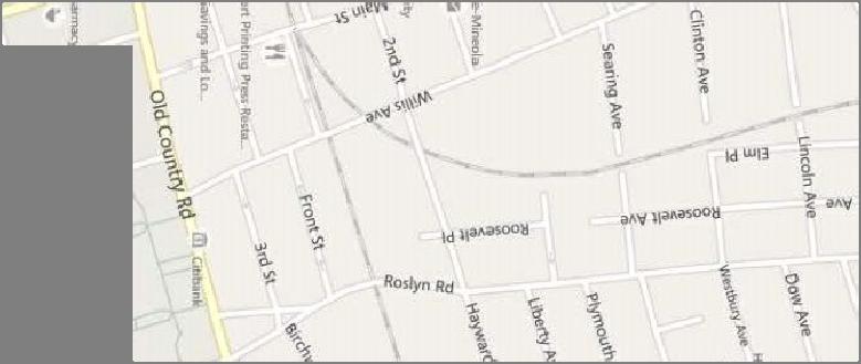
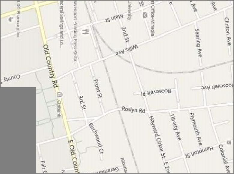
10 Study Area Intersections To determine the potential traffic impacts of the proposed development, the following four key study area intersections were analyzed under the Existing, No Build, and Build Conditions: Old Country Road at Mineola Boulevard /Franklin Avenue Mineola Boulevard at 2 nd Street Main Street at 2 nd Street Main Street at Station Plaza North These intersections are shown in Figure 2. Existing Conditions 6

11

12 Intersections Description Old Country Road at Mineola Boulevard /Franklin Avenue The intersection of Old Country Road (east-west) and Franklin Avenue/Mineola Boulevard (northsouth) is four-legged signalized intersection. The eastbound and westbound approaches provide an exclusive left-turn lane, two through lanes and an exclusive right-turn lane. The northbound approach provides an exclusive left-turn lane, a through and an exclusive right-turn lane. The southbound approach provides an exclusive left-turn lane, a through lane, and a shared through/right-turn lane. The intersection is controlled by a multiphase signal with the following phasing: Protected East-West left turns East-West through with permitted left turns Protected North-South left turns with East-West right-turn overlaps North-South movement with permitted left turns Existing Conditions 8
 traffic.")
13 Mineola Boulevard at 2 nd Street The intersection of 2 nd Street (east-west) and Mineola Boulevard (north-south) is a fivelegged signalized intersection with four active approaches. Parallel to the northbound approach just west of the intersection is the Mineola Boulevard Extension that allows only entering (southbound) traffic. The eastbound approach provides an exclusive left-turn lane and a shared through and right-turn lane. The westbound approach provides a shared leftturn/through/right-turn lane. The northbound approach provides one left-turn lane, one through lane, and one shared through/right-turn lane. The southbound approach provides one left-turn lane and one shared through/right-turn lane. The intersection is controlled by a multiphase signal with the following phasing: Protected northbound left turn and through North-South movements with permitted left turns East-West movements with permitted left turns Existing Conditions 9

14 Main Street at 2 nd Street The intersection of 2 nd Street (east-west) and Main Street (north-south) is a four-legged unsignalized intersection. Each approach provides a shared left-turn/through/right-turn lane. The approaches are controlled by all-way stop. Existing Conditions 10

15 Main Street at Station Plaza North The intersection of Station Plaza North (east-west) and Main Street (north-south) is a fourlegged unsignalized intersection with three active approaches. Eastbound traffic on Station Plaza North is not permitted. Each active approach provides a single left-turn/through/rightturn lane. The westbound approach is stop controlled. Existing Traffic Volume Data Intersection turning movement counts at the key intersections were collected using Miovision cameras on a typical weekday during the AM and PM peak hours. The counts were performed on Thursday, September 11 and Tuesday, October 21, 2014 during the a.m. peak period from 7:00 a.m. to 9:00 a.m. and during the p.m. peak period from 4:00 p.m. to 6:00 p.m. as well as on Saturdays September 13, 2014 and October 18, 2014 from 11:00 a.m. to 2:00 p.m. These time periods typically reflect the heaviest traffic flows coinciding with commuter and shopping activities. Summaries of the turning movement counts are provided in Appendix A The existing peak hour weekday a.m., p.m. and Saturday midday traffic volumes are shown in Figures 3, 4 and 5, respectively. Existing Conditions 11
16
17
18
19 Accident History Accident data from NYSDOT Accident Location Information System (ALIS) records for the most recent available three-year period were requested. Accident Verbal Description Reports (VDRs) for the period January 1, 2011 through December 31, 2013 were obtained and tabulated for the following roadway segments: Segment of Mineola Boulevard - From Old Country Road to 2 nd Street Segment of 2 nd Street From Mineola Boulevard to Main Street Segment of Main Street From 2 nd Street to Station Plaza North Segment of Station Plaza North From Mineola Boulevard to Main Street Table 1 below provides a summary of the most recent history of the intersections and nonintersection accidents. Table 1 Accident Data Summary Accident Severity Accident Type Intersection/Segment Fatality Injury Property Damage Only Non-Reportable Rear End Overtaking Right Angle Left Turn Right Turn Fixed Object Head On Pedestrian Parked Vehicle Backing Other/ Unknown Old Country Road & Mineola Boulevard/Franklin Avenue Mineola Boulevard & 2nd Street Mineola Boulevard - Non Intersection Accidents Main Street & 2nd Street Main Street & Station Plaza North Station Plaza North - No Intersection Accidents At Old Country Road & Mineola Boulevard/Franklin Avenue, during the three-year study period a total of 62 accidents were reported to have occurred. There were no fatalities, 15 accidents resulted in personal injury, 25 accidents resulted in property-damage only and 22 accidents were classified as non-reportable. The accident types with the highest incident rates were rear-end collisions (29 accidents 47%) and overtaking (16 accidents 26%). There was one accident that involved a pedestrian and there were 6 accidents that were classified as other/unknown type. Existing Conditions 15
20 At Mineola Boulevard & 2 nd Street, a total of 44 accidents were reported to have occurred. There were no fatalities, 13 accidents resulted in personal injury, 12 accidents resulted in property-damage only and 19 accidents were classified as non-reportable. The accident types with the highest incident rates were overtaking (15 accidents 34%) and rear-end collisions (10 accidents 23%) and. There were six accidents that involved pedestrians. Non-intersection accidents on Mineola Boulevard, a total of 3 accidents were reported to have occurred. There were no fatalities, 2 accidents resulted in personal injury, and one accident resulted in property-damage only. Two accidents were rear-end collisions and third was a collision with a fixed object. At Main Street & 2 nd Street, a total of 5 accidents were reported to have occurred. There were no fatalities, one accident resulted in personal injury, one accident resulted in propertydamage only and 3 accidents were classified as non-reportable. The accident types with the highest incident rates were collision with parked vehicles (2 accidents 40%). There was one accident that involved a pedestrian and one that was classified as other/unknown type. At Main Street & Station Plaza North, a total of 8 accidents were reported to have occurred. There were no fatalities, 2 accidents resulted in personal injury, 5 accidents resulted in property-damage only and one accident was classified as non-reportable. The accident types with the highest incident rates were collision with fixed objects (2 accidents 25%). There were 3 accidents that was classified as other/unknown type. On Station Plaza North, one accident was reported, a right-angle collision that was classified and non-reportable. Existing Conditions 16
21 3.0 Future Conditions An analysis of future conditions, both with and without the proposed expansion ( Build and No-Build conditions, respectively), was performed to evaluate the effect of the proposed development on future traffic in the area. The No-Build condition represents the future traffic conditions that can be expected to occur, whether the proposed development is constructed or not. The No-Build condition serves as a comparison to the Build condition, which represents expected future traffic conditions resulting from both project- and non-project-generated traffic. Traffic volumes in the study area were projected to the year 2017, reflecting the year when the project is expected to be completed. No Build Condition No-Build traffic volumes include all existing traffic, additional traffic volume due to background traffic growth, and any new traffic due to other planned developments in the area. Background Traffic Growth To account for increases in general population and background growth not related to the proposed project, an annual growth factor was applied to existing traffic volumes. Based on the NYSDOT Long Island Transportation Plan (LITP), the growth rate anticipated is 0.6% per year. Therefore, a total growth rate of 1.8% was applied to the existing traffic data to develop the background traffic based on the anticipated Build year in three years or Future Conditions
22 Other Planned Developments In addition to the three-year expansion of existing traffic volumes to 2017, expected traffic from future planned developments in the vicinity of the proposed project was included to develop traffic volumes under the No-Build condition in Three other planned developments (OPD) were identified that may have a measurable impact on traffic operations in the vicinity of the proposed project. They were: The Winston, a 275-unit residential apartment complex located on the north side of Old Country Road between Main Street and Willis Avenue. It is estimated that this development is likely to add 146 trips (29 entering and 117 exiting) during the a.m. peak hour, 177 trips (115 entering and 62 exiting) during p.m. peak hour and 149 trips (74 entering and 75 exiting) during Saturday midday peak hour. 250 Old Country Road, a 315-unit rental apartment development located on the northside of Old Country Road between 4 th Avenue and 3 rd Avenue. It is estimated that this development is likely to add 113 trips (19 entering and 94 exiting) during the a.m. peak hour and 134 trips (90 entering and 44 exiting) during p.m. peak hour and 122 trips (66 entering and 56 exiting) during the Saturday midday peak hour. Winthrop Hospital Research Building, located a block east of the main campus of Winthrop University Hospital, this building is likely to generate 45 trips (all entering) during a.m. peak hours and 45 trips (all exiting) during p.m. peak hour. To obtain the 2017 No-Build traffic volumes at the study intersections, the trips anticipated to be generated by the other planned developments in the area were added to the existing traffic volumes plus background traffic growth. The other planned development traffic volumes for the weekday a.m., p.m. and Saturday midday peak hours are shown in Figure 6. The No-Build volumes for the a.m., p.m. and Saturday midday peak hours are shown in Figures 7, 8 and 9, respectively. 18 Future Conditions
23
24
25
26

27 Build Condition To estimate the traffic impact of the proposed development, it is necessary to determine the traffic volumes expected to be generated by the proposed project. Project-Generated Traffic Volumes To estimate the project-generated traffic for the proposed mixed-use development, a review was undertaken of available trip generation data sources, including the reference published by the Institute of Transportation Engineers (ITE), Trip Generation, 9 th Edition. This widely utilized reference source contains trip generation rates for the uses, including Mid-rise Apartments (Land Use Code #222), Retail Space (Land Use Code #820), and Quality Restaurant (Land Use Code #931). Transit -Oriented Development The proposed apartment building is characterized as a transit-oriented development (TOD) based on its proximity to mass transit. The development is located a short distance from the Mineola Long Island Rail Road (LIRR) station and Mineola Intermodal Center, as shown in Figure A below. Site Mineola Intermodal Center Fig A: Proximity of LIRR Station and Intermodal Center to the Site 23 Future Conditions
28 Located on the Oyster Bay, Port Jefferson and Ronkonkoma branches of LIRR, the Mineola LIRR Station is well served by train service. The LIRR operates 24-hours-a-day, 7-days-aweek, including all holidays, with service intervals varying by destination and time of day. The frequency of the service is good, with convenient connections to reach New York City and parts of Nassau, Suffolk and Queens Counties. The development is also well served by bus service. The Nassau Inter-County Express or NICE (formerly MTA Long Island Bus) offers bus service to the Mineola Intermodal Center, which is a short distance from the proposed development on 3 rd Street, as shown in Figure A. The NICE services have convenient connections to destinations throughout Nassau, Suffolk and Queens Counties. The proximity of the development to mass transit will significantly reduce vehicle trips, as many people will use the train and bus services for their commute to and from work. The available studies on TODs show a reduction in vehicle trips by as much as 50% compared to non-tod developments. In order to take a conservative approach, this study assumes, due to proximity to mass transit, a reduction in trip generation for the residential portion of the development of only a 25% during a.m. and p.m. peak periods and 15% reduction during Saturday midday peak period. The site of the proposed mixed-use development is currently occupied by commercial uses. The traffic currently being generated by these uses will be eliminated with the sites redevelopment. No credit was taken for these trips resulting in a high-side conservative estimate of impacts in this study. Table 2 shows the anticipated site trip generation adjusted to account for the effect of TOD. 24 Future Conditions
29 Table 2 Trip Generation Projections Project Component Component Size AM Peak PM Peak Saturday Midday Peak 1 APARTMENTS ITE # 222 Mid-Rise Apartments with 296 Units TOD Credit 2 RETAIL SPACE ITE # 820 Shopping Center RESTAURANT ITE # 931 Quality Restaurant 6,975 SF 6,975 SF Rate = 0.23 Rate = 0.29 Rate = 0.49 Entering Exiting Entering Exiting Entering Exiting 31% 69% 58% 42% 54% 46% Total = 67 Total = 87 Total = 146 Rate = 0.96 Rate = 3.71 Rate = 4.82 Entering Exiting Entering Exiting Entering Exiting 62% 38% 48% 52% 52% 48% Total = 7 Total = 26 Total = 34 Rate = 0.81 Rate = 7.49 Rate = Entering Exiting Entering Exiting Entering Exiting 50% 50% 67% 33% 59% 41% Total = 6 Total = 53 Total = 76 AM Peak Hour Trips PM Peak Hour Trips Sat Peak Hour Trips TOTALS Entering Exiting Entering Exiting Entering Exiting LUC # 221 Low-rise Apartments was used to estimate the Saturday peak hour demand since no data was available under LUC#222 Mid-rise Apartments 2 The trip generation rates for apartments were adjusted down by 25% for the weekday peak hours and 15% for the Saturday peak hour to account for the effect of TOD Trip Distribution and Assignment It is noted that, to support the establishment of an efficient site exit on Station Plaza North, it is proposed to convert the segment of Station Plaza North east of the site exit to two-way operation. Without the conversion of a segment of this roadway to two-way operation, all vehicles exiting the site would be forced to travel west, through the immediate area surrounding the railroad station. With the two-way operation on the eastern segment, motorists leaving the site will have the ability avoid this area. The trips generated by the proposed mixed-use development were distributed to the adjacent roadways based on the layout of the adjacent roadway network, likely destinations and the location of the site driveways. The trip distribution percentages, shown in Figure 10, were then applied to the site generated traffic and assigned to the local roadway network. The resulting site generated traffic volumes for the weekday a.m., p.m. and Saturday midday peak hours are shown in Figures 11, 12 and 13, respectively. 25 Future Conditions
30 To determine the 2017 Build traffic volumes, the site generated trips were added to the No- Build traffic volumes at the key intersections. The resulting 2017 Build traffic volumes for the weekday a.m., p.m. and Saturday midday peak hours are shown in Figures 14, 15 and 16, respectively. 26 Future Conditions
31
32
33
34
35
36
37
38 4.0 Traffic Operations Analysis To assess quality of traffic flow in the area, roadway capacity analyses were conducted with respect to the Existing condition and No-Build and future Build conditions. These capacity analyses provide an indication of the adequacy of the roadway facilities to serve the anticipated traffic demands. Level of Service and Delay Criteria The evaluation criteria used to analyze area intersections in this traffic study are based on the 2000 Highway Capacity Manual (HCM). The term level of service (LOS) is used to denote the different operating conditions that occur at an intersection under various traffic volume loads. It is a qualitative measure that considers a number of factors including roadway geometry, speed, travel delay, and freedom to maneuver. LOS provides an index to the operational qualities of a roadway segment or an intersection. LOS designations range from A to F, with LOS A representing the best operating conditions and LOS F representing the worst operating conditions (see Appendix B for specific LOS definitions). Software The capacity analyses were conducted using the traffic analysis and simulation software Synchro, version 8, a computer program developed by Trafficware Ltd. Synchro is a complete software package for modeling and optimizing traffic signal timing. Synchro adheres to and implements the guidelines and methods set forth in the 2000 Highway Capacity Manual, Chapters 16 and 17. This analysis methodology was used to evaluate the ability of an intersection or roadway to efficiently handle the number of vehicles using the facility. Synchro was used to model and analyze the Existing, No-Build and Build conditions at the key intersections. For simulating the model, its companion traffic simulation software, SimTraffic, also developed by Trafficware, was used. SimTraffic is a traffic simulation and animation software program that includes vehicle and driver performance characteristics as developed by the Federal Highway Administration (FHWA). 34 Traffic Operations Analysis
39 Level of Service Analysis Level of Service (LOS) analyses were conducted for the Existing, No-Build and Build conditions for each of the key intersections. Analysis Results The results of the capacity analyses for each of the signalized study intersections for the weekday a.m., p.m. and Saturday midday peak hours are summarized in Tables 3, 4 and 5, respectively, The results of the capacity analyses for each of the unsignalized study intersections for the weekday a.m., p.m. and Saturday midday peak hours are summarized in Tables 6, 7 and 8, respectively. It is noted that in order to support the establishment of an efficient site exit on Station Plaza North, it is proposed to convert the segment of Station Plaza North east of the site exit to twoway operation. Without the conversion of a segment of this roadway to two-way operation, all vehicles exiting the site would be forced to travel west, through the immediate area surrounding the railroad station. With the two-way operation on the eastern segment, motorists leaving the site have the ability to avoid this area. The results presented in Tables 6, 7 and 8 therefore indicate an eastbound approach to this intersection in the Build Condition. This approach is proposed to be STOP controlled. It is also noted that due to the width of the roadway, this change would result in a loss of 6 on-street parking stalls. See the Parking Section of this report for additional details regarding impacts to on-street parking. The detailed capacity analysis worksheets are contained in Appendix C. 35 Traffic Operations Analysis
40 Table 3 Signalized Intersections Level of Service AM Peak Hour Intersection Movement Lane Group Existing 2014 No-Build 2017 Build 2017 Mitigation Delay LOS Delay LOS Delay LOS Delay LOS Old Country Road & Mineola Boulevard / Franklin Avenue Mineola Boulevard & 2nd Street EB WB NB SB EB WB NB SB L 25.4 C 41.1 D 43.5 D T 34.3 C 37.2 D 37.2 D R 16.7 B 17.5 B 17.5 B Approach 29.6 C 34.0 C 34.4 C L 31.1 C 38.9 D 38.7 D T 35.5 D 41.9 D 42.2 D R 17.8 B 19.4 B 19.5 B Approach 31.1 C 36.8 D 37.0 D L 38.7 D 41.1 D 42.4 D TR 43.0 D 43.7 D 43.7 D Approach 41.8 D 43.1 D 43.3 D L 32.8 C 34.2 C 34.6 C TR 35.9 D 35.6 D 35.9 D Approach 35.1 D 35.3 D 35.6 D Overall 34.1 C 37.4 D 37.7 D L 25.2 C 25.0 C 25.1 C 24.9 C TR 45.4 D 45.9 D 45.7 D 45.9 D Approach 42.7 D 43.1 D 42.9 D 43.1 D LTR/LT 65.5 E 72.5 E 84.5 F 68.5 E R 2.1 A Approach 65.5 E 72.5 E 84.5 F 52.4 D L 18.7 B 34.0 C 35.5 D 34.7 C TR 10.2 B 10.6 B 10.6 B 10.6 B Approach 11.8 B 15.5 B 15.8 B 15.6 B L 18.1 B 19.0 B 19.3 B 19.3 B TR 36.6 D 43.4 D 43.7 D 43.7 D Approach 36.0 D 42.4 D 42.6 D 42.6 D Overall 29.6 C 33.5 C 34.9 C 32.2 C 36 Traffic Operations Analysis
41 Table 4 Signalized Intersections Level of Service PM Peak Hour Intersection Movement Lane Group Existing 2014 No-Build 2017 Build 2017 Mitigation Delay LOS Delay LOS Delay LOS Delay LOS Old Country Road & Mineola Boulevard / Franklin Avenue Mineola Boulevard & 2nd Street EB WB NB SB EB WB NB SB L 48.2 D 64.3 E 66.5 E T 46.2 D 55.8 E 56.4 E R 23.9 C 24.0 C 23.9 C Approach 40.8 D 49.4 D 50.3 D L 63.8 E 71.0 E 70.1 E T 41.7 D 48.1 D 52.4 D R 20.3 C 20.6 C 21.1 C Approach 42.2 D 47.6 D 50.0 D L 26.7 C 31.3 C 31.9 C TR 47.1 D 50.4 D 50.6 D Approach 43.1 D 46.4 D 46.7 D L 40.9 D 43.9 D 44.2 D TR 34.6 C 35.8 D 36.1 D Approach 36.1 D 37.8 D 38.1 D Overall 40.9 D 46.1 D 47.2 D L 26.7 C 25.4 C 25.6 C 25.2 C TR 44.4 D 46.0 D 46.0 D 46.0 D Approach 41.6 D 42.9 D 42.9 D 42.9 D LTR/LT 52.5 D 57.6 E 72.2 E 62.4 E R 4.7 A Approach 52.5 D 57.6 E 72.2 E 41.4 D L 13.4 B 22.3 C 23.0 C 23.0 C TR 11.7 B 13.1 B 13.2 B 13.2 B Approach 11.9 B 14.2 B 14.3 B 14.3 B L 21.5 C 28.1 C 34.6 C 34.6 C TR 30.4 C 38.9 D 39.4 D 39.4 D Approach 29.8 C 37.9 D 38.8 D 38.8 D Overall 23.9 C 28.2 C 29.8 C 27.7 C 37 Traffic Operations Analysis
42 Table 5 Signalized Intersections Level of Service Saturday Midday Peak Hour Intersection Movement Lane Group Existing 2014 No-Build 2017 Build 2017 Mitigation Delay LOS Delay LOS Delay LOS Delay LOS Old Country Road & Mineola Boulevard / Franklin Avenue Mineola Boulevard & 2nd Street EB WB NB SB EB WB NB SB L 18.5 B 20.1 C 21.4 C T 38.2 D 42.9 D 44.0 D R 20.3 C 20.8 C 20.9 C Approach 32.3 C 35.7 D 36.3 D L 37.0 D 45.2 D 47.9 D T 27.8 C 30.1 C 31.3 C R 13.4 B 14.3 B 15.0 B Approach 27.6 C 31.1 C 32.6 C L 22.2 C 23.3 C 23.6 C TR 33.9 C 34.5 C 34.9 C Approach 31.8 C 32.4 C 32.7 C L 46.8 D 49.3 D 49.7 D TR 32.6 C 33.3 C 33.4 C Approach 37.2 D 38.5 D 38.6 D Overall 31.7 C 34.0 C 34.8 C L 31.8 C 31.6 C 28.9 C 30.8 C TR 43.3 D 43.1 D 36.8 D 45.0 D Approach 41.3 D 41.1 D 35.4 D 42.5 D LTR/LT 61.3 E 62.2 E 55.8 E 55.7 E R 6.8 A Approach 61.3 E 62.2 E 55.8 E 39.2 D L 6.1 A 6.3 A 7.7 A 7.1 A TR 6.1 A 6.3 A 7.5 A 7.0 A Approach 6.1 A 6.3 A 7.5 A 7.0 A L 11.5 B 11.7 B 15.0 B 14.3 B TR 15.9 B 16.4 B 19.8 B 20.8 C Approach 15.7 B 16.2 B 19.3 B 20.2 C Overall 20.0 B 20.3 C 20.9 C 20.1 C Tables 3, 4 and 5 show that the two signalized intersections of Old Country Road and Mineola Boulevard/ Franklin Avenue and Mineola Boulevard and 2 nd Street are projected to operate with a change in overall intersection delay of less than 2.5 seconds and with no change in overall level of service from the No-Build to Build condition during the three time periods analyzed. However, in the weekday a.m. peak hour the westbound approach to Mineola Boulevard on 2 nd Street changes from LOS E to LOS F with an increase in delay of 12 seconds. Methods of mitigating this increase in delay were explored. Restriping of the existing pavement width on this approach to provide a separate right-turn lane will not only restore the No-Build LOS but improve the LOS of the entire westbound approach to a level better than the No-Build condition in all three peak time periods studied. However, this will necessitate the elimination of two parking spaces on the north side of 2 nd Street closest to the 38 Traffic Operations Analysis
43 intersection. With this mitigation, the effect of the traffic due to the development of the site as proposed does not have a significant impact on the intersections operations. See the Parking Section of this report for additional details regarding impacts to on-street parking. Table 6 - Unsignalized Intersections Level of Service AM Peak Hour Intersection Critical Approach/ Movement Existing 2014 No Build 2017 Build 2017 Delay LOS Delay LOS Delay LOS Main Street & 2nd Street Main Street & Station Plaza North EB 9.4 A 9.6 A 10.0 A WB 9.7 A 9.9 A 10.3 B NB 8.6 A 8.7 A 9.3 A SB 9.3 A 9.5 A 9.7 A Overall 9.4 A 9.6 A 9.9 A EB 11.1 B WB 9.2 A 9.5 A 11.7 B Table 7 - Unsignalized Intersections Level of Service PM Peak Hour Intersection Critical Approach/ Movement Existing 2014 No Build 2016 Build 2016 Delay LOS Delay LOS Delay LOS Main Street & 2nd Street Main Street & Station Plaza North EB 19.0 C 21.9 C 32.3 D WB 11.9 B 12.7 B 14.8 B NB 10.7 B 11.1 B 13.5 B SB 16.9 C 19.0 C 23.1 C Overall 16.2 C 18.2 C 23.8 C EB 12.0 B WB 9.1 A 9.2 A 11.6 B Table 8 - Unsignalized Intersections Level of Service Saturday Midday Peak Hour Intersection Critical Approach/ Movement Existing 2014 No Build 2016 Build 2016 Delay LOS Delay LOS Delay LOS Main Street & 2nd Street Main Street & Station Plaza North EB 9.3 A 9.4 A 11.4 B WB 9.3 A 9.4 A 11.4 B NB 8.4 A 8.4 A 10.7 B SB 8.8 A 8.8 A 9.9 A Overall 9.1 A 9.2 A 11.0 B EB 12.5 B WB 8.8 A 9.0 A 12.3 B 39 Traffic Operations Analysis
44 Tables 6, 7 and 8 show that the two unsignalized intersections of Main Street and 2 nd Street and Main Street and Station Plaza North are projected to operate at acceptable levels of service (LOS D or better) in the Build Condition. 40 Traffic Operations Analysis
45 5.0 Parking Off-Street Parking The off-street parking required is set forth in the Village of Mineola s Zoning Code, which stipulates requirements for the proposed uses, as detailed in requirements for the B-2 District. Table 9 below summarizes the parking requirements for the development and its associated proposed unit breakdown. Table 9 Table of Off-street Parking Requirements Use Requirements per Zoning Code Size / No. of Units Required Off-Street Parking Spaces Proposed Parking B-2 Business 1 Space per 250 SF 6,975 SF 1 Space/ 250SF x 6,975 SF = 28 Spaces 22 B-2 Restaurant 1 Spaces per 200 SF or (1/3 dining seats + ½ bars seats + 1/3 employees) 6,975 SF 1 Spaces/ 200 SF x 6,975 SF = 35 Spaces 22 B-2 Residential 2 Spaces for per Unit 296 Units 2 Spaces/ Units x 296 Units = 592 Spaces 444 (296 units x 1.5 spaces per unit) Total Required The off-street parking proposed for the development includes 488 spaces and is comprised of 478 spaces in a parking garage (accessed via Station Plaza North) and 10 spaces provide along the east side of the property which will be used by the proposed valet operation associated with the restaurant. As such, the proposed site plan falls short of code requirements by 167 space. Based on the foregoing, relaxation for the number of parking spaces is required. However, it is the case that strict interpretation of code requirements often results in the provision of parking far beyond actual demands for certain land uses. This is the case with both retail and 41 Parking
46 residential development. In this particular case, the TOD nature of the development will have a significant effect on actual parking demand for the residential component of the project. Based upon research included in the Effects of TOD on Housing Parking and Travel, 1 TODs, such as the one proposed, create an actual parking demand that is closer to one parking space per unit (or 296 spaces), rather than the 1.5 parking spaces that have been permitted by the Village. This research specifically shows that the residents of TODs have substantially reduced household car ownership. Further, the building s unit mix and the site s location onehalf block from the LIRR Mineola train station and several blocks from Intermodal Center, and its location in the downtown, near a major hospital and government center, which are both substantial employers in the community, strengthens the case for reduced car ownership (and thus less parking demand) in this specific location. Based on known characteristics of the parking requirements for TODs the actual peak demand for residential parking will be close to 296 spaces, resulting in a balance of 192 spaces for the retail and restaurant uses. This balance exceeds even the code requirements for those components. Therefore, the off-street parking proposed for the development will be sufficient to serve the proposed uses. On-Street Parking Impacts As noted previously, the proposed site plan includes an exit drive on Station Plaza North, west of its intersection with Main Street. In order to improve circulation in the vicinity of the site and eliminate the need for all site exiting traffic to travel west into the immediate area of the train station, it is proposed to convert a segment of Station Plaza North from one-way westbound to two-way operation. The segment to be converted is approximately 175 feet in length, from the proposed site exit drive to Main Street. Station Plaza North in the vicinity of the project site currently provides on-street metered parking on both sides of the roadway and the curb-to-curb width is approximately 30 feet. Given this width, the roadway in its current form is too narrow for two-way traffic. As such, the conversion of the approximately 175 foot segment of Station Plaza North will require the elimination of 6 parking stalls. It is recommended that parking be eliminated on the south side of the roadway as accessing parking on the south side east of the proposed driveway could only be done by motorists exiting the parking garage in the eastbound direction. As 5 of these stalls are Handicap Permit stalls, it is recommended that an equivalent number of stalls west of this point on the south side of Station Plaza North be converted to Handicap Permit stalls. The elimination of parking on one side of this segment of Station Plaza North will allow sufficient width for the proposed two-way operation. In addition, as discussed previously, the provision of a separate westbound right-turn lane on the 2 nd Street approach to Mineola Boulevard would eliminate a LOS F on this approach in the Build Condition during the weekday a.m. peak period. In order to establish this lane, which will otherwise fit within the existing pavement width, two parking spaces on the north side of 2 nd Street closest to Mineola Boulevard would need to be eliminated. 1 Arrington, G.B. and Robert Cervero. Effects of TOD on Housing, Parking and Travel (TCRP Report 128). Transit Cooperative Research Program of the Transportation Research Board of the National Academies, Washington, D.C., Parking
47 6.0 Conclusions Based on the results of the analyses conducted for the purpose of this report, we have arrived at the following conclusions: The proposed mixed-use development represents TOD given its composition and proximity to major public transportation hubs. As a TOD it will generate lower levels of automobile traffic and parking demands than a similar development in other areas. The proposed mixed-use development is expected to generate 80 trips during the weekday a.m. peak hour (28 entering and 52 exiting), 166 trips during the weekday p.m. peak hour (98 entering and 68 exiting) and 256 trips during the Saturday midday peak hour (142 entering and 114 exiting). The traffic generated by the proposed development can be accommodated by the adjacent roadway network with the proposed access plan and mitigation identified in this report. To support the establishment of an efficient site exit on Station Plaza North, it is proposed to convert the segment of Station Plaza North east of the site exit to two-way operation. This will allow for exiting traffic from the site to leave without being required to travel west into the immediate area of the train station. The site of the proposed mixed-use development is currently occupied by commercial uses. The traffic currently being generated by these uses will be eliminated with the sites redevelopment. No credit was taken for these trips resulting in a high-side conservative estimate of impacts in this study. The proposed site plan for the development provides 488 parking stalls composed of 478 stalls within the parking garage and 10 on-grade stalls located at the east side of the property that will be utilized by a valet operation associated with the proposed retail/restaurant. Although the proposed site plan falls short of the Village s parking code requirements for the components within the B-2 zone, the parking to be provided will be sufficient to serve the actual expected demand based on the uses and the fact that the proposed constitutes TOD. The traffic associated with the proposed apartment development is not expected to result in any significant change in the frequency or severity of accidents within the project area. 43 Conclusions
48 Based on this study, the development of the proposed TOD will not result in significant adverse traffic impacts in the vicinity of the site, given the proposed mitigation identified herein is implemented. \\nylidata\projects\ Mineola Metro LLC\reports\29292_TIS_Draft_ docx 44 Conclusions
49 Appendix A Description Turning Movement Counts Appendix A
50 TRAFFIC VOLUME DATA OLD COUNTRY ROAD & MINEOLA BOULEVARD MINEOLA, NY Date Collected: 9/11/2014 (Thursday) Start Time Eastbound Westbound Northbound Southbound Cum. TOTAL Left Thru Right Total Left Thru Right Total Left Thru Right Total Left Thru Right Total Hourly 7:00 AM :15 AM :30 AM :45 AM ,000 3,703 8:00 AM ,831 8:15 AM ,860 8:30 AM ,839 8:45 AM ,010 3,849 Peak Hour 7:30 AM to 8:30 AM , ,860 PHF HV% 7% 5% 5% 3% N Mineola Blvd 1, , Old Country Road Franklin Avenue Old Country Road AM PEAK HOUR DATA Time: 7:30 AM to 8:30 AM Village Green, Mineola 10/30/2014
51 TRAFFIC VOLUME DATA OLD COUNTRY ROAD & MINEOLA BOULEVARD MINEOLA, NY Date Collected: 9/11/2014 (Thursday) Start Time Eastbound Westbound Northbound Southbound Cum. TOTAL Left Thru Right Total Left Thru Right Total Left Thru Right Total Left Thru Right Total Hourly 4:00 PM ,034 4:15 PM ,014 4:30 PM :45 PM ,063 4,089 5:00 PM ,027 4,082 5:15 PM ,068 4,136 5:30 PM ,062 4,220 5:45 PM ,064 4,221 Peak Hour 5:00 PM to 6:00 PM , , , ,221 PHF HV% 4% 2% 3% 2% N 764 1, Mineola Blvd 979 1, ,278 1,029 Old Country Road Franklin Avenue ,109 1,011 Old Country Road AM PEAK HOUR DATA Time: 5:00 PM to 6:00 PM Village Green, Mineola 10/30/2014
52 TRAFFIC VOLUME DATA OLD COUNTRY ROAD & MINEOLA BOULEVARD MINEOLA, NY Date Collected: 9/13/2014 (Saturday) Start Time Eastbound Westbound Northbound Southbound Cum. TOTAL Left Thru Right Total Left Thru Right Total Left Thru Right Total Left Thru Right Total Hourly 11:00 AM :15 AM :30 AM :45 AM ,030 12:00 PM ,188 12:15 PM ,335 12:30 PM ,438 12:45 PM ,515 1:00 PM ,474 1:15 PM ,436 1:30 PM ,294 1:45 PM ,207 Peak Hour 12:00 PM to 1:00 PM , ,515 PHF HV% 4% 2% 3% 2% N Mineola Blvd ,109 1, Old Country Road Franklin Avenue Old Country Road SATURDAY PEAK HOUR DATA Time: 12:00 PM to 1:00 PM Village Green, Mineola 10/30/2014
53 TRAFFIC VOLUME DATA MINEOLA BOULEVARD & 2ND STREET MINEOLA, NY ESCHBACHER VHB Date Collected: 9/11/2014 (Thursday) Start Time Eastbound Westbound Northbound Southbound Cum. TOTAL Left Thru Right Hard Rt Total Hard Lt Bear Lt Thru Right Total Hard Lt Left Thru Right Total Left Thru Bear Rt Right Total Hourly 7:00 AM :15 AM :30 AM :45 AM ,924 8:00 AM ,021 8:15 AM ,023 8:30 AM ,988 8:45 AM ,932 Peak Hour 7:30 AM to 8:30 AM ,023 PHF HV% 2% 2% 4% 4% N Mineola Blvd nd Street Mineola Blvd 2nd Street AM PEAK HOUR DATA Time: 7:30 AM to 8:30 AM AM 29292_TMC_Mineola_2nd 10/30/2014
54 TRAFFIC VOLUME DATA MINEOLA BOULEVARD & 2ND STREET MINEOLA, NY ESCHBACHER VHB Date Collected: 9/11/2014 (Thursday) Start Time Eastbound Westbound Northbound Southbound Cum. TOTAL Left Thru Right Hard Rt Total Hard Lt Bear Lt Thru Right Total Hard Lt Left Thru Right Total Left Thru Bear Rt Right Total Hourly 4:00 PM :15 PM :30 PM :45 PM ,178 5:00 PM ,271 5:15 PM ,316 5:30 PM ,355 5:45 PM ,253 Peak Hour 4:45 PM to 5:45 PM , ,355 PHF HV% 3% 2% 2% 3% N Mineola Blvd nd Street , Mineola Blvd 2nd Street AM PEAK HOUR DATA Time: 4:45 PM to 5:45 PM PM 29292_TMC_Mineola_2nd 10/30/2014
THE CORNERSTONE APARTMENTS TRAFFIC IMPACT STUDY R&M PROJECT NO
 THE CORNERSTONE APARTMENTS SITUATED AT N/E/C OF STAUDERMAN AVENUE AND FOREST AVENUE VILLAGE OF LYNBROOK NASSAU COUNTY, NEW YORK TRAFFIC IMPACT STUDY R&M PROJECT NO. 2018-089 September 2018 50 Elm Street,
APPENDIX C1 TRAFFIC ANALYSIS DESIGN YEAR TRAFFIC ANALYSIS
 APPENDIX C1 TRAFFIC ANALYSIS DESIGN YEAR TRAFFIC ANALYSIS DESIGN YEAR TRAFFIC ANALYSIS February 2018 Highway & Bridge Project PIN 6754.12 Route 13 Connector Road Chemung County February 2018 Appendix
EXECUTIVE SUMMARY. The following is an outline of the traffic analysis performed by Hales Engineering for the traffic conditions of this project.
 EXECUTIVE SUMMARY This study addresses the traffic impacts associated with the proposed Shopko redevelopment located in Sugarhouse, Utah. The Shopko redevelopment project is located between 1300 East and
Traffic Impact Study for the proposed. Town of Allegany, New York. August Project No Prepared For:
 Appendix B SRF Traffic Study (Revised November 2005) Draft Environmental Impact Statement University Commons Town of Allegany, Cattaraugus County, NY December 2005 Traffic Impact Study for the proposed
Proposed Inn at Bellefield Traffic Impact Assessment
 Proposed Inn at Bellefield Traffic Impact Assessment Town of Hyde Park Dutchess County, New York Prepared for: T-Rex Hyde Park Owner LLC 500 Mamroneck Avenue, Suite 300 Harrison, NY 10528 June 21, 2017
King Soopers #116 Thornton, Colorado
 Traffic Impact Study King Soopers #116 Thornton, Colorado Prepared for: Galloway & Company, Inc. T R A F F I C I M P A C T S T U D Y King Soopers #116 Thornton, Colorado Prepared for Galloway & Company
Traffic Feasibility Study
 Traffic Feasibility Study Town Center South Robbinsville Township, Mercer County, New Jersey December 19, 2017 Prepared For Robbinsville Township Department of Community Development 2298 Route 33 Robbinsville,
MEMO VIA . Ms. Amy Roth DPS Director, City of Three Rivers. To:
 MEMO To: Ms. Amy Roth DPS Director, City of Three Rivers VIA EMAIL From: Michael J. Labadie, PE Julie M. Kroll, PE, PTOE Brandon Hayes, PE, P.Eng. Fleis & VandenBrink Date: January 5, 2017 Re: Proposed
LAWRENCE TRANSIT CENTER LOCATION ANALYSIS 9 TH STREET & ROCKLEDGE ROAD / 21 ST STREET & IOWA STREET LAWRENCE, KANSAS
 LAWRENCE TRANSIT CENTER LOCATION ANALYSIS 9 TH STREET & ROCKLEDGE ROAD / 21 ST STREET & IOWA STREET LAWRENCE, KANSAS TRAFFIC IMPACT STUDY FEBRUARY 214 OA Project No. 213-542 TABLE OF CONTENTS 1. INTRODUCTION...
Proposed location of Camp Parkway Commerce Center. Vicinity map of Camp Parkway Commerce Center Southampton County, VA
 Proposed location of Camp Parkway Commerce Center Vicinity map of Camp Parkway Commerce Center Southampton County, VA Camp Parkway Commerce Center is a proposed distribution and industrial center to be
Traffic Engineering Study
 Traffic Engineering Study Bellaire Boulevard Prepared For: International Management District Technical Services, Inc. Texas Registered Engineering Firm F-3580 November 2009 Executive Summary has been requested
Traffic Impact Study Speedway Gas Station Redevelopment
 Traffic Impact Study Speedway Gas Station Redevelopment Warrenville, Illinois Prepared For: Prepared By: April 11, 2018 Table of Contents 1. Introduction... 1 2. Existing Conditions... 4 Site Location...
MILLERSVILLE PARK TRAFFIC IMPACT ANALYSIS ANNE ARUNDEL COUNTY, MARYLAND
 MILLERSVILLE PARK TRAFFIC IMPACT ANALYSIS ANNE ARUNDEL COUNTY, MARYLAND Prepared for: Department of Public Works Anne Arundel County Prepared by: URS Corporation 4 North Park Drive, Suite 3 Hunt Valley,
TIMBERVINE TRANSPORTATION IMPACT STUDY FORT COLLINS, COLORADO JANUARY Prepared for:
 TIMBERVINE TRANSPORTATION IMPACT STUDY FORT COLLINS, COLORADO JANUARY 2014 Prepared for: Hartford Companies 1218 W. Ash Street Suite A Windsor, Co 80550 Prepared by: DELICH ASSOCIATES 2272 Glen Haven Drive
Traffic Impact Statement (TIS)
") Traffic Impact Statement (TIS) Vincentian PUDA Collier County, FL 10/18/2013 Prepared for: Global Properties of Naples Prepared by: Trebilcock Consulting Solutions, PA 2614 Tamiami Trail N, Suite 615 1205
Traffic Impact Statement (TIS) Vincentian PUDA Collier County, FL 10/18/2013 Prepared for: Global Properties of Naples Prepared by: Trebilcock Consulting Solutions, PA 2614 Tamiami Trail N, Suite 615 1205
Proposed Hotel and Restaurant Development
 Traffic Impact Study Proposed Hotel and Restaurant Development Marbledale Road Tuckahoe, NY PREPARED FOR BILLWIN DEVELOPMENT AFFILIATES, LLC 365 WHITE PLAINS ROAD EASTCHESTER, NY. 10709 PREPARED BY Engineering
Transportation & Traffic Engineering
 Transportation & Traffic Engineering 1) Project Description This report presents a summary of findings for a Traffic Impact Analysis (TIA) performed by A+ Engineering, Inc. for the Hill Country Family
Proposed CVS/pharmacy
 Traffic Impact and Access Study Proposed CVS/pharmacy West Main Street (Route 1) at Hull Street Clinton, Connecticut PREPARED FOR Arista Development LLC 520 Providence Highway, Suite 9 Norwood, Massachusetts
RICHMOND OAKS HEALTH CENTRE 6265 PERTH STREET OTTAWA, ONTARIO TRANSPORTATION BRIEF. Prepared for: Guycoki (Eastern) Limited.
 Limited.") RICHMOND OAKS HEALTH CENTRE 6265 PERTH STREET OTTAWA, ONTARIO TRANSPORTATION BRIEF Prepared for: Guycoki (Eastern) Limited June 16, 2016 116-638 Brief_1.doc D. J. Halpenny & Associates Ltd. Consulting
RICHMOND OAKS HEALTH CENTRE 6265 PERTH STREET OTTAWA, ONTARIO TRANSPORTATION BRIEF Prepared for: Guycoki (Eastern) Limited June 16, 2016 116-638 Brief_1.doc D. J. Halpenny & Associates Ltd. Consulting
MERIVALE PRIORITY SQUARE 2852 MERIVALE ROAD CITY OF OTTAWA TRANSPORTATION BRIEF. Prepared for: ONT Inc. 25 Winding Way Nepean, Ontario K2C 3H1
 MERIVALE PRIORITY SQUARE 2852 MERIVALE ROAD CITY OF OTTAWA TRANSPORTATION BRIEF Prepared for: 2190986ONT Inc. 25 Winding Way Nepean, Ontario K2C 3H1 October 6, 2010 110-502 Report_1.doc D. J. Halpenny
2.0 Development Driveways. Movin Out June 2017
 Movin Out June 2017 1.0 Introduction The proposed Movin Out development is a mixed use development in the northeast quadrant of the intersection of West Broadway and Fayette Avenue in the City of Madison.
Lacey Gateway Residential Phase 1
 Lacey Gateway Residential Phase Transportation Impact Study April 23, 203 Prepared for: Gateway 850 LLC 5 Lake Bellevue Drive Suite 02 Bellevue, WA 98005 Prepared by: TENW Transportation Engineering West
Craig Scheffler, P.E., PTOE HNTB North Carolina, P.C. HNTB Project File: Subject
 TECHNICAL MEMORANDUM To Kumar Neppalli Traffic Engineering Manager Town of Chapel Hill From Craig Scheffler, P.E., PTOE HNTB North Carolina, P.C. Cc HNTB Project File: 38435 Subject Obey Creek TIS 2022
Construction Realty Co.
 MEMORANDUM TO: FROM : Jeff Pickus Construction Realty Co. Luay R. Aboona, PE Principal 9575 West Higgins Road, Suite 400 Rosemont, Illinois 60018 p: 847-518-9990 f: 847-518-9987 DATE: May 22, 2014 SUBJECT:
APPENDIX E. Traffic Analysis Report
 APPENDIX E Traffic Analysis Report THIS PAGE INTENTIONALLY BLANK EAGLE RIVER TRAFFIC MITIGATION PHASE I OLD GLENN HIGHWAY/EAGLE RIVER ROAD INTERSECTION IMPROVEMENTS TRAFFIC ANALYSIS Eagle River, Alaska
TRAFFIC SIGNAL DESIGN REPORT KING OF PRUSSIA ROAD & RAIDER ROAD RADNOR TOWNSHIP PENNSYLVANIA
 TRAFFIC SIGNAL DESIGN REPORT KING OF PRUSSIA ROAD & RAIDER ROAD RADNOR TOWNSHIP PENNSYLVANIA PREPARED FOR: UNIVERSITY OF PENNSYLVANIA HEALTH SYSTEM 34 CIVIC CENTER BOULEVARD PHILADELPHIA, PA 1987 (61)
DEVELOPMENT PROPERTY 1627 MAXIME STREET CITY OF OTTAWA TRANSPORTATION OVERVIEW. Prepared for: Subhas Bhargava. July 9, Overview_1.
 DEVELOPMENT PROPERTY 1627 MAXIME STREET CITY OF OTTAWA TRANSPORTATION OVERVIEW Prepared for: Subhas Bhargava July 9, 2015 115-620 Overview_1.doc D. J. Halpenny & Associates Ltd. Consulting Transportation
TRAFFIC IMPACT ANALYSIS FOR. McDONALD S RESTAURANT IN CARMICAEL Sacramento County, CA. Prepared For:
 TRAFFIC IMPACT ANALYSIS FOR McDONALD S RESTAURANT IN CARMICAEL Sacramento County, CA Prepared For: McDonald s USA, LLC Pacific Sierra Region 2999 Oak Road, Suite 900 Walnut Creek, CA 94597 Prepared By:
Traffic Impact Analysis West Street Garden Plots Improvements and DuPage River Park Garden Plots Development Naperville, Illinois
 Traffic Impact Analysis West Street Garden Plots Improvements and DuPage River Park Garden Plots Development Naperville, Illinois Submitted by April 9, 2009 Introduction Kenig, Lindgren, O Hara, Aboona,
December 5, Red Bank Planning Board Municipal Building 90 Monmouth Street Red Bank, NJ 07701
 Dynamic Traffic, LLC www.dynamic-traffic.com 1904 Main Street Lake Como, NJ 07719 T. 732.681.0760 December 5, 2016 Red Bank Planning Board Municipal Building 90 Monmouth Street Red Bank, NJ 07701 Re: Traffic
GASOLINE SERVICE STATION 1618, 1622 ROGER STEVENS DRIVE OTTAWA, ONTARIO TRANSPORTATION IMPACT ASSESSMENT. Prepared for:
 GASOLINE SERVICE STATION 1618, 1622 ROGER STEVENS DRIVE OTTAWA, ONTARIO TRANSPORTATION IMPACT ASSESSMENT Prepared for: Invecta Development (Ottawa) Corporation 758 Shanks Height Milton, ON L9T 7P7 May
BARRHAVEN FELLOWSHIP CRC 3058 JOCKVALE ROAD OTTAWA, ONTARIO TRANSPORTATION BRIEF. Prepared for:
 BARRHAVEN FELLOWSHIP CRC 3058 JOCKVALE ROAD OTTAWA, ONTARIO TRANSPORTATION BRIEF Prepared for: Barrhaven Fellowship CRC 3058 Jockvale Road Ottawa, ON K2J 2W7 December 7, 2016 116-649 Report_1.doc D. J.
West Hills Shopping Centre Lowe s Expansion Traffic Impact Study
 West Hills Shopping Centre Lowe s Expansion Traffic Impact Study Prepared for: Armel Corporation January 2015 Paradigm Transportation Solutions Ltd. 22 King Street South, Suite 300 Waterloo ON N2J 1N8
Table 1 - Land Use Comparisons - Proposed King s Wharf Development. Retail (SF) Office (SF) 354 6,000 10, Land Uses 1
 Office (SF) 354 6,000 10, Land Uses 1") Ref. No. 171-6694 Phase 2 November 23, 217 Mr. David Quilichini, Vice President Fares & Co. Developments Inc. 31 Place Keelson Sales Centre DARTMOUTH NS B2Y C1 Sent Via Email to David@faresinc.com RE:
Ref. No. 171-6694 Phase 2 November 23, 217 Mr. David Quilichini, Vice President Fares & Co. Developments Inc. 31 Place Keelson Sales Centre DARTMOUTH NS B2Y C1 Sent Via Email to David@faresinc.com RE:
L1TILE BEARS DAY CARE TRANSPORTATION IMPACT STUDY FORT COLLINS, COLORADO MAY Prepared for:
 L1TILE BEARS DAY CARE TRANSPORTATION IMPACT STUDY FORT COLLINS, COLORADO MAY 2012 Prepared for: Hillside Construction, Inc. 216 Hemlock Street, Suite B Fort Collins, CO 80534 Prepared by: DELICH ASSOCIATES
Escondido Marriott Hotel and Mixed-Use Condominium Project TRAFFIC IMPACT ANALYSIS REPORT
 Escondido Marriott Hotel and Mixed-Use Condominium Project TRAFFIC IMPACT ANALYSIS REPORT Prepared for Phelps Program Management 420 Sixth Avenue, Greeley, CO 80632 Prepared by 5050 Avenida Encinas, Suite
Downtown One Way Street Conversion Technical Feasibility Report
 Downtown One Way Street Conversion Technical Feasibility Report As part of the City s Transportation Master Plan, this report reviews the technical feasibility of the proposed conversion of the current
Volume 1 Traffic Impact Analysis Turtle Creek Boulevard Dallas, Texas. Kimley-Horn and Associates, Inc. Dallas, Texas.
 Volume 1 Traffic Impact Analysis 2727 Dallas, Texas June 18, 2018 Kimley-Horn and Associates, Inc. Dallas, Texas Project #064523000 Registered Firm F-928 Traffic Impact Analysis 2727 Dallas, Texas Prepared
HUMC/Mountainside Hospital Redevelopment Plan
 Traffic and Parking Analysis HUMC/Mountainside Hospital Redevelopment Plan in Glen Ridge Borough and Montclair Township PREPARED FOR H2M 119 Cherry Hill Road, Suite 110 Parsippany, NJ 07054 862.207.5900
Traffic Impact Analysis. Alliance Cole Avenue Residential Site Dallas, Texas. Kimley-Horn and Associates, Inc. Dallas, Texas.
 Traffic Impact Analysis Alliance Cole Avenue Residential Site Dallas, Texas February 15, 2018 Kimley-Horn and Associates, Inc. Dallas, Texas Project #064524900 Registered Firm F-928 Traffic Impact Analysis
NEWCASTLE MIDDLE SCHOOL Traffic Impact Analysis
 Gibson Traffic Consultants 2802 Wetmore Avenue Suite 220 Everett, WA 98201 425.339.8266 NEWCASTLE MIDDLE SCHOOL Traffic Impact Analysis Prepared for: Renton School District Jurisdiction: City of Newcastle
Oakbrook Village Plaza City of Laguna Hills
 Oakbrook Village Plaza City of Laguna Hills Traffic Impact Analysis Prepared by: HDR Engineering 3230 El Camino Real, Suite 200 Irvine, CA 92602 October 2012 Revision 3 D-1 Oakbrook Village Plaza Laguna
Appendix J Traffic Impact Study
 MRI May 2012 Appendix J Traffic Impact Study Level 2 Traffic Assessment Limited Impact Review Appendix J [This page was left blank intentionally.] www.sgm-inc.com Figure 1. Site Driveway and Trail Crossing
MINERVA PARK SITE TRAFFIC IMPACT STUDY M/I HOMES. September 2, 2015
 5500 New Albany Road Columbus, Ohio 43054 Phone: 614.775.4500 Fax: 614.775.4800 Toll Free: 1-888-775-EMHT emht.com 2015-1008 MINERVA PARK SITE TRAFFIC IMPACT STUDY M/I HOMES September 2, 2015 Engineers
INDUSTRIAL DEVELOPMENT
 INDUSTRIAL DEVELOPMENT Traffic Impact Study Plainfield, Illinois August 2018 Prepared for: Seefried Industrial Properties, Inc. TABLE OF CONTENTS Executive Summary 2 Introduction 3 Existing Conditions
TRANSPORTATION REVIEW
 TRANSPORTATION REVIEW - PROPOSED MIX OF LAND USES IS CONSISTENT WITH THE CITY S UNDER THE GRANVILLE BRIDGE POLICIES THAT AIM TO MEET NEIGHBOURING RESIDENTS SHOPPING NEEDS AND REDUCE RELIANCE ON AUTOMOBILE
Appendix C-5: Proposed Refinements Rail Operations and Maintenance Facility (ROMF) Traffic Impact Analysis. Durham-Orange Light Rail Transit Project
 Traffic Impact Analysis. Durham-Orange Light Rail Transit Project") Appendix C-5: Proposed Refinements Rail Operations and Maintenance Facility (ROMF) Traffic Impact Analysis Durham-Orange Light Rail Transit Project July 25, 218 ROMF Transportation Impact Analysis Version
Appendix C-5: Proposed Refinements Rail Operations and Maintenance Facility (ROMF) Traffic Impact Analysis Durham-Orange Light Rail Transit Project July 25, 218 ROMF Transportation Impact Analysis Version
TRAFFIC IMPACT STUDY DERRY GREEN CORPORATE BUSINESS PARK MILTON SECONDARY PLAN MODIFICATION
 TRAFFIC IMPACT STUDY DERRY GREEN CORPORATE BUSINESS PARK MILTON SECONDARY PLAN MODIFICATION TRAFFIC IMPACT STUDY DERRY GREEN CORPORATE BUSINESS PARK MILTON SECONDARY PLAN MODIFICATION DECEMBER 24 UPDATED
TRANSPORTATION STUDY FOR THE 8899 BEVERLY BOULEVARD PROJECT
 DRAFT TRANSPORTATION STUDY FOR THE 8899 BEVERLY BOULEVARD PROJECT WEST HOLLYWOOD, CALIFORNIA NOVEMBER 2013 PREPARED FOR BEVERLY BOULEVARD ASSOCIATION PREPARED BY DRAFT TRANSPORTATION STUDY FOR THE 8899
King County Metro. Columbia Street Transit Priority Improvements Alternative Analysis. Downtown Southend Transit Study. May 2014.
 King County Metro Columbia Street Transit Priority Improvements Alternative Analysis Downtown Southend Transit Study May 2014 Parametrix Table of Contents Introduction... 1 Methodology... 1 Study Area...
Table of Contents INTRODUCTION... 3 PROJECT STUDY AREA Figure 1 Vicinity Map Study Area... 4 EXISTING CONDITIONS... 5 TRAFFIC OPERATIONS...
 Crosshaven Drive Corridor Study City of Vestavia Hills, Alabama Table of Contents INTRODUCTION... 3 PROJECT STUDY AREA... 3 Figure 1 Vicinity Map Study Area... 4 EXISTING CONDITIONS... 5 TRAFFIC OPERATIONS...
Table of Contents. Traffic Impact Analysis Capital One Building at Schilling Place
 Traffic Impact Analysis Capital One Building at Schilling Place Table of Contents Executive Summary... 1 1. Introduction... 4 2. Project Description... 4 3. Background Information... 4 4. Study Scope...
TRAFFIC IMPACT ANALYSIS
 TRAFFIC IMPACT ANALYSIS Emerald Isle Commercial Development Prepared by SEPI Engineering & Construction Prepared for Ark Consulting Group, PLLC March 2016 I. Executive Summary A. Site Location The Emerald
Appendix H: Construction Impacts H-2 Transportation
 Appendix H: Construction Impacts H-2 Transportation \ AECOM 71 W. 23 rd Street New York, NY 10010 www.aecom.com 212 366 6200 tel 212 366 6214 fax Memorandum To CC Subject Robert Conway Donald Tone Construction
BERKELEY DOWNTOWN AREA PLAN PROGRAM ENVIRONMENTAL IMPACT REPORT TRAFFIC IMPACT ANALYSIS
 BERKELEY DOWNTOWN AREA PLAN PROGRAM ENVIRONMENTAL IMPACT REPORT TRAFFIC IMPACT ANALYSIS Prepared for: City of Berkeley Prepared by: REVISED JANUARY 9, 2009 Berkeley Downtown Area Plan Program EIR Traffic
Appendix C. Traffic Study
 Appendix C Traffic Study TABLE OF CONTENTS SECTION Executive Summary PAGE 1.0 Introduction... 1 1.1 Scope of Work... 1 1.2 Study Area... 2 2.0 Project Description... 3 2.1 Site Access... 4 2.2 Pedestrian
Traffic Impact Analysis 5742 BEACH BOULEVARD MIXED USE PROJECT
 Traffic Impact Analysis 5742 BEACH BOULEVARD MIXED USE PROJECT CITY OF BUENA PARK Prepared by Project No. 14139 000 April 17 th, 2015 DKS Associates Jeffrey Heald, P.E. Rohit Itadkar, T.E. 2677 North Main
Section 5.0 Traffic Information
 Section 5.0 Traffic Information 10.0 TRANSPORTATION MDM Transportation Consultants, Inc. (MDM) has prepared an evaluation of transportation impacts for the proposed evaluation for the expansion of the
Trafalgar Road & Lower Base Line Transportation Study Ontario Inc.
 Trafalgar Road & Lower Base Line Transportation Study 1255723 Ontario Inc. Trafalgar Road & Lower Base Line Transportation Study 1255723 Ontario Inc. 1465 Pickering Parkway Suite 200 Pickering ON L1V 7G7
Table 8-1: Service Frequencies for All Short-List Alternatives by Day of Week and Time of Day Frequency Day of Week Time of Day Time Period
 8. Operating Plans The following Section presents the operating plans for the Short-List Alternatives. The modern streetcar operating plans are presented for Alternatives 2 and 3, followed by bus rapid
Vanier Parkway and Presland Road Residential Development Transportation Impact Study
 Vanier Parkway and Presland Road Residential Development Transportation Impact Study Final Report (Revised) March 2011 Submitted to: Groupe Lépine Ottawa Project No. 09-1613 Submitted by: Groupe Lépine
Bennett Pit. Traffic Impact Study. J&T Consulting, Inc. Weld County, Colorado. March 3, 2017
 Bennett Pit Traffic Impact Study J&T Consulting, Inc. Weld County, Colorado March 3, 217 Prepared By: Sustainable Traffic Solutions, Inc. http://www.sustainabletrafficsolutions.com/ Joseph L. Henderson,
Date: February 7, 2017 John Doyle, Z-Best Products Robert Del Rio. T.E. Z-Best Traffic Operations and Site Access Analysis
 Memorandum Date: February 7, 07 To: From: Subject: John Doyle, Z-Best Products Robert Del Rio. T.E. Z-Best Traffic Operations and Site Access Analysis Introduction Hexagon Transportation Consultants, Inc.
Transportation Land Development Environmental S e r v i c e s
 Transportation Land Development Environmental S e r v i c e s Memorandum To: Ms. Kristin E. Kassner Planning Director Town Hall Annex 25 Center Street Burlington, MA 01803 Date: September 23, 2013 Project
Clean Harbors Canada, Inc.
 Clean Harbors Canada, Inc. Proposed Lambton Landfill Expansion Environmental Assessment Terms of Reference Transportation Assessment St. Clair Township, Ontario September 2009 itrans Consulting Inc. 260
Traffic Impact Study Hudson Street Parking Garage MC Project No.: A Table of Contents
 Traffic Impact Study Hudson Street Parking Garage MC Project No.: 15001714A Table of Contents Table of Contents I. INTRODUCTION... 1 II. EXISTING CONDITIONS... 4 III. 2015 EXISTING TRAFFIC CONDITIONS...
4.14 TRANSPORTATION AND CIRCULATION
 4.14 TRANSPORTATION AND CIRCULATION 4.14.1 Summary Table 4.14-1 summarizes the identified environmental impacts, proposed mitigation measures, and residual impacts of the proposed project with regard to
TRAFFIC IMPACT STUDY FOR SONIC DRIVE-IN RESTAURANT. Vallejo, CA. Prepared For:
 TRAFFIC IMPACT STUDY FOR SONIC DRIVE-IN RESTAURANT Vallejo, CA Prepared For: ELITE DRIVE-INS, INC. 2190 Meridian Park Blvd, Suite G Concord, CA 94520 Prepared By: KD Anderson & Associates 3853 Taylor Road,
TRAFFIC DATA. Existing Derousse Ave./River Rd. AM LOS Analysis Existing Derousse Ave./River Rd. PM LOS Analysis
 Appendix E NJ TRANSIT Pennsauken Junction Transit Center and Park & Ride RiverLINE and Atlantic City Line Pennsauken Township, Camden County, New Jersey TRAFFIC DATA Background Traffic Information for
Traffic Impact Study for Proposed Olive Boulevard Development
 Traffic Impact Study for Proposed 11330 Olive Boulevard Development Creve Coeur, Missouri July 7, 2017 Prepared For: 11330 Olive Boulevard Development 11330 Olive Boulevard Creve Coeur, Missouri 63141
TABLE OF CONTENTS 1.0 INTRODUCTION AND SUMMARY Purpose of Report and Study Objectives... 2
 TABLE OF CONTENTS 1.0 INTRODUCTION AND SUMMARY 1 1.1 Purpose of Report and Study Objectives... 2 1.2 Executive Summary... 3 1.2.1 Site Location and Study Area... 3 1.2.2 Development Description... 3 1.2.3
IV. ENVIRONMENTAL IMPACT ANALYSIS K.2. PARKING
 IV. ENVIRONMENTAL IMPACT ANALYSIS K.2. PARKING ENVIRONMENTAL SETTING The following analysis summarizes the findings and conclusions of the Traffic Analysis (Traffic Study), prepared by The Mobility Group,
Downtown Lee s Summit Parking Study
 Downtown Lee s Summit Parking Study As part of the Downtown Lee s Summit Master Plan, a downtown parking and traffic study was completed by TranSystems Corporation in November 2003. The parking analysis
V. DEVELOPMENT OF CONCEPTS
 Martin Luther King, Jr. Drive Extension FINAL Feasibility Study Page 9 V. DEVELOPMENT OF CONCEPTS Throughout the study process several alternative alignments were developed and eliminated. Initial discussion
Alpine Highway to North County Boulevard Connector Study
 Alpine Highway to North County Boulevard Connector Study prepared by Avenue Consultants March 16, 2017 North County Boulevard Connector Study March 16, 2017 Table of Contents 1 Summary of Findings... 1
One Harbor Point Residential
 Residential Gig Harbor, WA Transportation Impact Analysis January 23, 2017 Prepared for: Neil Walter Company PO Box 2181 Tacoma, WA 98401 Prepared by: TENW Transportation Engineering NorthWest 11400 SE
The major roadways in the study area are State Route 166 and State Route 33, which are shown on Figure 1-1 and described below:
 3.5 TRAFFIC AND CIRCULATION 3.5.1 Existing Conditions 3.5.1.1 Street Network DRAFT ENVIRONMENTAL IMPACT REPORT The major roadways in the study area are State Route 166 and State Route 33, which are shown
RTE. 1 at RTE. 637 & RTE. 639
 INTERSECTION SAFETY STUDY Prepared for: Virginia Department of Transportation Central Region Operations Traffic Engineering (UPC #81378, TO 12-092) DAVENPORT Project Number: 13-368 / /2014 RTE. 1 at RTE.
RE: A Traffic Impact Statement for a proposed development on Quinpool Road
 James J. Copeland, P.Eng. GRIFFIN transportation group inc. 30 Bonny View Drive Fall River, NS B2T 1R2 May 31, 2018 Ellen O Hara, P.Eng. Project Engineer DesignPoint Engineering & Surveying Ltd. 200 Waterfront
Citizens Committee for Facilities
 Citizens Committee for Facilities AGENDA Thursday, December 11, 2014 City Council Chambers 305 3 rd Avenue East -Twin Falls, Idaho 11:30 A.M. AGENDA ITEMS Purpose By 1. Discussion and possible action on
Prepared For: Toronto Transit Commission 1138 Bathurst Street Toronto, Ontario M5R 3H2. Prepared By:
 TRAFFIC IMPACT STUDY FOR THE TTC MCNICOLL BUS GARAGE CITY OF TORONTO Prepared For: Toronto Transit Commission 1138 Bathurst Street Toronto, Ontario M5R 3H2 Prepared By: Canada Inc. 4th Floor, 3 Leek Crescent
Traffic, Transportation & Civil Engineering Ali R. Khorasani, P.E. P.O. Box 804, Spencer, MA 01562, Tel: (508)
") Associates Traffic, Transportation & Civil Engineering Ali R. Khorasani, P.E. P.O. Box 804, Spencer, MA 01562, Tel: (508) 885-5121 Ms. Teri Ford, Associate 800 Boylston Street, Suite 1570 Boston, MA July
Associates Traffic, Transportation & Civil Engineering Ali R. Khorasani, P.E. P.O. Box 804, Spencer, MA 01562, Tel: (508) 885-5121 Ms. Teri Ford, Associate 800 Boylston Street, Suite 1570 Boston, MA July
Traffic Impact Analysis Update
 Willow Bend Traffic Impact Analysis Update TABLE OF CONTENTS Page I. INTRODUCTION -------------------------------------------------------------------------------------------- 1 II. EXISTING CONDITIONS
INTERSECTION ANALYSIS PARK AVENUE AND BRADDOCK ROAD (FROSTBURG, MD) FOR LENHART TRAFFIC CONSULTING, INC.
 FOR LENHART TRAFFIC CONSULTING, INC.") INTERSECTION ANALYSIS FOR PARK AVENUE AND BRADDOCK ROAD (FROSTBURG, MD) Prepared for: City of Frostburg, Maryland & Allegany County Commissioners Prepared by: LENHART TRAFFIC CONSULTING, INC. TRAFFIC ENGINEERING
INTERSECTION ANALYSIS FOR PARK AVENUE AND BRADDOCK ROAD (FROSTBURG, MD) Prepared for: City of Frostburg, Maryland & Allegany County Commissioners Prepared by: LENHART TRAFFIC CONSULTING, INC. TRAFFIC ENGINEERING
7359 WISCONSIN AVENUE MONTGOMERY COUNTY, MARYLAND
 7359 WISCONSIN MONTGOMERY COUNTY, MARYLAND September 1, 2017 7359 Wisconsin Avenue September 2017 7359 WISCONSIN Local Area Transportation Review Montgomery County, Maryland September 1, 2017 Prepared
INTERSECTION CONTROL EVALUATION
 INTERSECTION CONTROL EVALUATION Trunk Highway 22 and CSAH 21 (E Hill Street/Shanaska Creek Road) Kasota, Le Sueur County, Minnesota November 2018 Trunk Highway 22 and Le Sueur CSAH 21 (E Hill Street/Shanaska
Planned Development Application 1450 Sherman Avenue Evanston, IL TRAFFIC CIRCULATION IMPACT STUDY
 Planned Development Application 1450 Sherman Avenue Evanston, IL 60201 14 TRAFFIC CIRCULATION IMPACT STUDY Traffic Impact Study 1454 Sherman Mixed-Use Development Evanston, Illinois Prepared for Prepared
13.1. INTRODUCTION AND SUMMARY OF FINDINGS
 Chapter 13: Traffic and Transportation 13.1. INTRODUCTION ND SUMMRY OF FINDINGS This Chapter assesses the potential traffic and transportation impacts of the Proposed Project and the Proposed Project s
CHAPTER 9: VEHICULAR ACCESS CONTROL Introduction and Goals Administration Standards
 9.00 Introduction and Goals 9.01 Administration 9.02 Standards 9.1 9.00 INTRODUCTION AND GOALS City streets serve two purposes that are often in conflict moving traffic and accessing property. The higher
TRAFFIC IMPACT ANALYSIS SHORTBREAD LOFTS 2009 MODIFICATION Chapel Hill, North Carolina
 TRAFFIC IMPACT ANALYSIS SHORTBREAD LOFTS 2009 MODIFICATION Chapel Hill, North Carolina Prepared for: The Town of Chapel Hill, NC Prepared by: Architects-Engineers-Planners, Inc. November 2009 Traffic Impact
BROWARD BOULEVARD CORRIDOR TRANSIT STUDY
 BROWARD BOULEVARD CORRIDOR TRANSIT STUDY FM # 42802411201 EXECUTIVE SUMMARY July 2012 GOBROWARD Broward Boulevard Corridor Transit Study FM # 42802411201 Executive Summary Prepared For: Ms. Khalilah Ffrench,
TRAFFIC PARKING ANALYSIS
 TRAFFIC PARKING ANALYSIS NAPA FLEA MARKET COUNTY OF NAPA Prepared for: Tom Harding Napa-Vallejo Flea Market 33 Kelly Road American Canyon, CA 9453 Prepared by: 166 Olympic Boulevard, Suite 21 Walnut Creek,
TRAFFIC IMPACT STUDY. USD #497 Warehouse and Bus Site
 TRAFFIC IMPACT STUDY for USD #497 Warehouse and Bus Site Prepared by: Jason Hoskinson, PE, PTOE BG Project No. 16-12L July 8, 216 145 Wakarusa Drive Lawrence, Kansas 6649 T: 785.749.4474 F: 785.749.734
Shirk Road at State Route 198 Interchange Analysis Tulare County, California
 Shirk Road at State Route 198 Interchange Analysis Tulare County, California DRAFT REPORT Prepared By Tulare County Association of Governments (TCAG) April 2013 Table of Contents Introduction:... 3 Project
TALMONT TOWNHOMES MADISON KENNETH SPA TRAFFIC IMPACT STUDY. Sacramento, CA. Prepared For: MBK Homes. Prepared By:
 TALMONT TOWNHOMES MADISON KENNETH SPA TRAFFIC IMPACT STUDY Sacramento, CA Prepared For: MBK Homes Prepared By: KD Anderson & Associates 3853 Taylor Road, Suite G Loomis, California 95650 (916) 660-1555
TECHNICAL MEMORANDUM. Part A: Introduction
 TECHNICAL MEMORANDUM To: David J. Decker Decker Properties, Inc. 5950 Seminole Centre Ct. Suite 200 Madison, Wisconsin 53711 608-663-1218 Fax: 608-663-1226 www.klengineering.com From: Mike Scarmon, P.E.,
Existing Traffic Conditions
 May 14, 2014 Ms. Lorraine Weiss City of San Mateo 330 West 20 th Avenue San Mateo, CA 94403 Subject: Traffic Operational Study for the Proposed Tilton Avenue Residential Development in San Mateo, California
APPENDIX B Traffic Analysis
 APPENDIX B Traffic Analysis Rim of the World Unified School District Reconfiguration Prepared for: Rim of the World School District 27315 North Bay Road, Blue Jay, CA 92317 Prepared by: 400 Oceangate,
Heartland Town Square
 Attachment TRA- Assignment of Other Developments Hamlet of Brentwood Town of Islip Suffolk County, New York Prepared by: 0 Joshua s Path Suite 00 Hauppauge, New York.. May 0 Planned Development Project
LCPS Valley Service Center
 Traffic Impact Study LCPS Valley Service Center Loudoun County, Virginia November 4, 2015 Prepared For: Loudoun County Public Schools 21000 Education Court Ashburn, VA 20148 Prepared by: 1140 Connecticut