MINERVA PARK SITE TRAFFIC IMPACT STUDY M/I HOMES. September 2, 2015
|
|
|
- Godfrey Lindsey
- 6 years ago
- Views:
Transcription


1 5500 New Albany Road Columbus, Ohio Phone: Fax: Toll Free: EMHT emht.com MINERVA PARK SITE TRAFFIC IMPACT STUDY M/I HOMES September 2, 2015 Engineers Surveyors Planners Scientists
2
3 TABLE OF CONTENTS 1.0 INTRODUCTION EXISTING CONDITIONS DATA COLLECTED STUDY PROCEDURES Traffic Volume Projections Trip Generation Trip Distribution FINDINGS OF ANALYSES Turn Lane Warrants Signal Warrant Analysis Intersection Capacity Analysis SR 161 at Farview Drive SR 161 at Ponderosa Drive SR 3 at Minerva Lake Road Cleveland Avenue at Minerva Lake Road Cleveland Avenue at Maplewood Drive Ponderosa Drive at Northland Plaza Drive Farview Drive at Northland Plaza Drive Minerva Lake Road at East Shore Drive CONCLUSIONS AND RECOMMENDATIONS...11 TABLES TABLE 1: Street Network Characteristics... 4 TABLE 2: Trip Generation... 6 TABLE 3: Capacity Analysis Summary... 8 FIGURES FIGURE 1: Site Location Map... 3 FIGURE 2: Expected Site Trip Distribution... 7
4 APPENDICES APPENDIX A: APPENDIX B: APPENDIX C: APPENDIX D: APPENDIX E: APPENDIX F: APPENDIX G: Correspondence (Scope Memo) Site Plan/ Growth Rate Data Traffic Volume Assignment & Calculations Turn Lane Warrants Signal Warrant Worksheets Capacity Analysis Reports Turn Lane Sizing Calculations

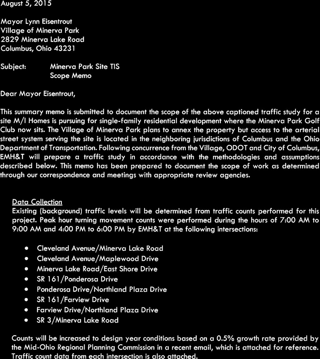
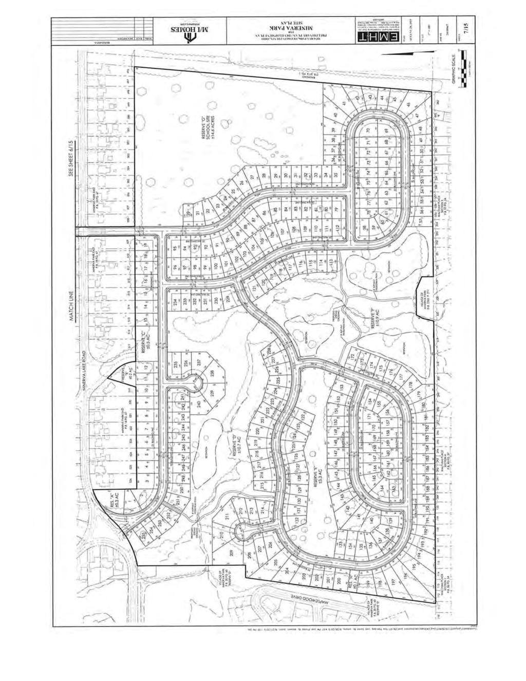
5 1.0 INTRODUCTION This study has been prepared to identify the transportation impact of developing a single family residential community known as the Minerva Park in Minerva Park, Ohio. The site will be located in the current Minerva Lake Golf course in Minerva Park. The project site is planned to include single family dwelling units with a maximum number of total units not to exceed 258 lots. The actual lot count is expected to be slightly lower. Additionally, a new elementary school to replace the existing Hawthorne Elementary in the Westerville school district is planned in the northeast quadrant of the site. Two access drives are planned to connect to Minerva Lake Road. At the time this study was prepared, a third access connection to Maplewood Drive was being considered. To accommodate the possibility of this third access point, the study provides analyses both with and without the connection to Maplewood Drive. One access drive on Minerva Lake Road is expected to connect to Farview Drive and a second drive on Minerva Lake Road is expected to be located in the middle of the triangle island where East Shore Drive connects with Minerva Lake Road. The potential connection to Maplewood Drive is also included in the analyses. Figure 1 below illustrates the site location. A memorandum summarizing the scope of the traffic study was reviewed and accepted by ODOT, City of Columbus and Minerva Park, which was dated August 5, 2015, and is included in Appendix A for reference. A site plan is included in Appendix B. FIGURE 1: Site Location Map 2.0 EXISTING CONDITIONS Existing conditions for each roadway are identified in Table 1 below, which indicates the Street network characteristics for the surrounding area. The site currently serves as the Minerva Lake Golf Course that is located on the south side of Minerva Lake Road between SR 3 (Westerville Road) Minerva Park Traffic Impact Study emht.com 3
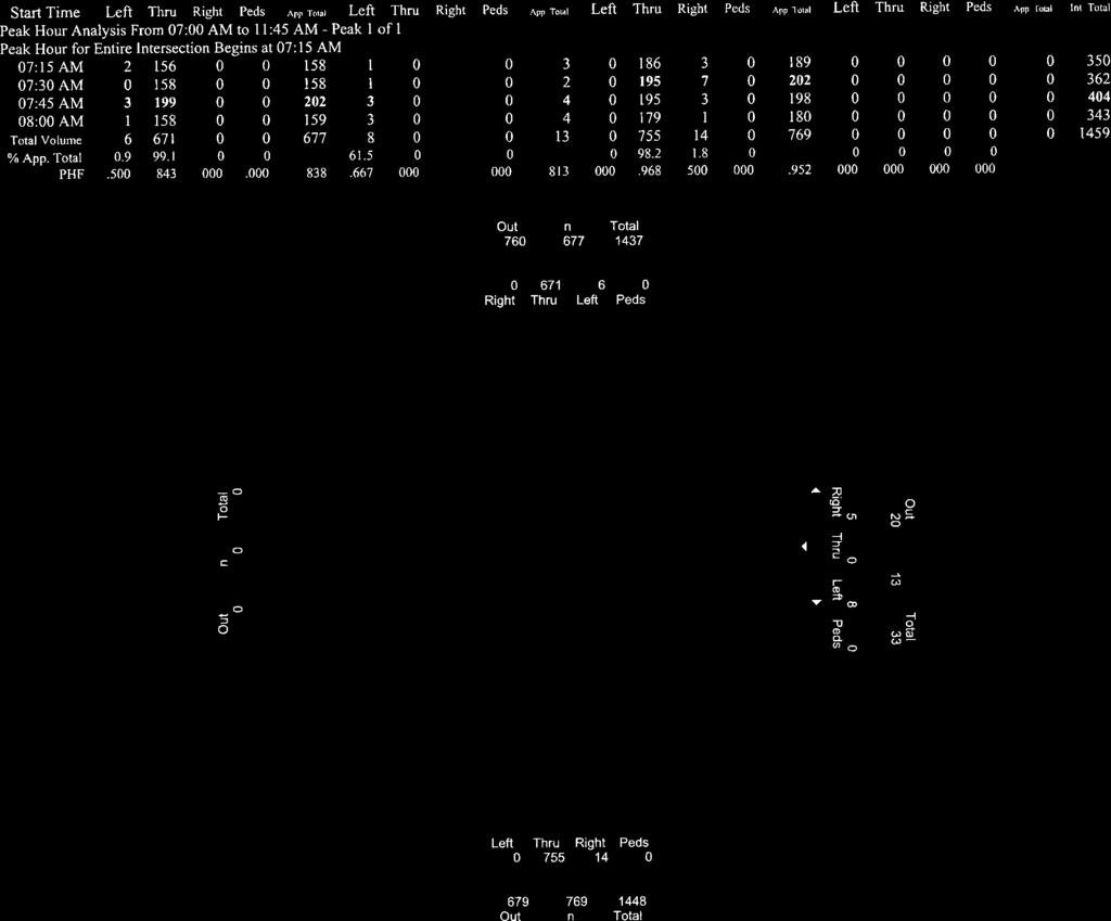
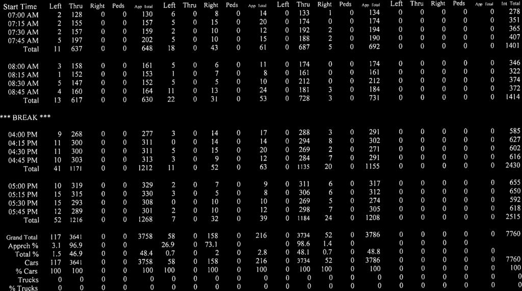
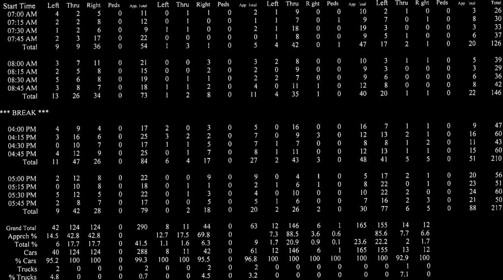
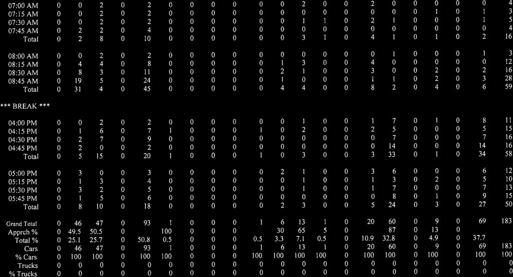
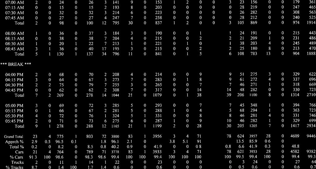
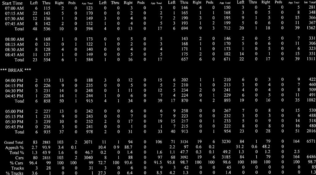
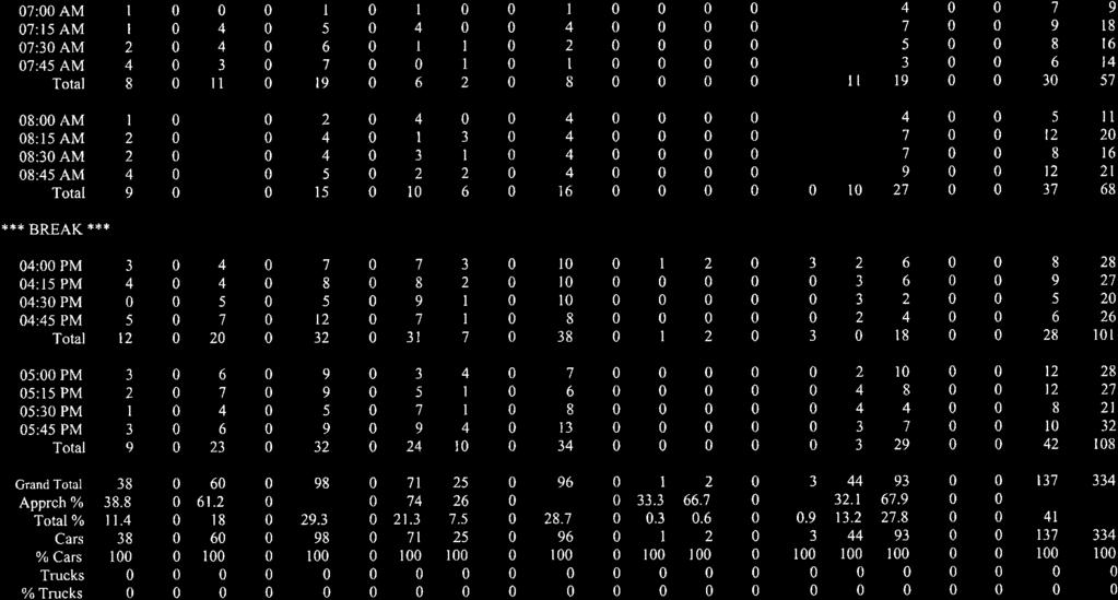
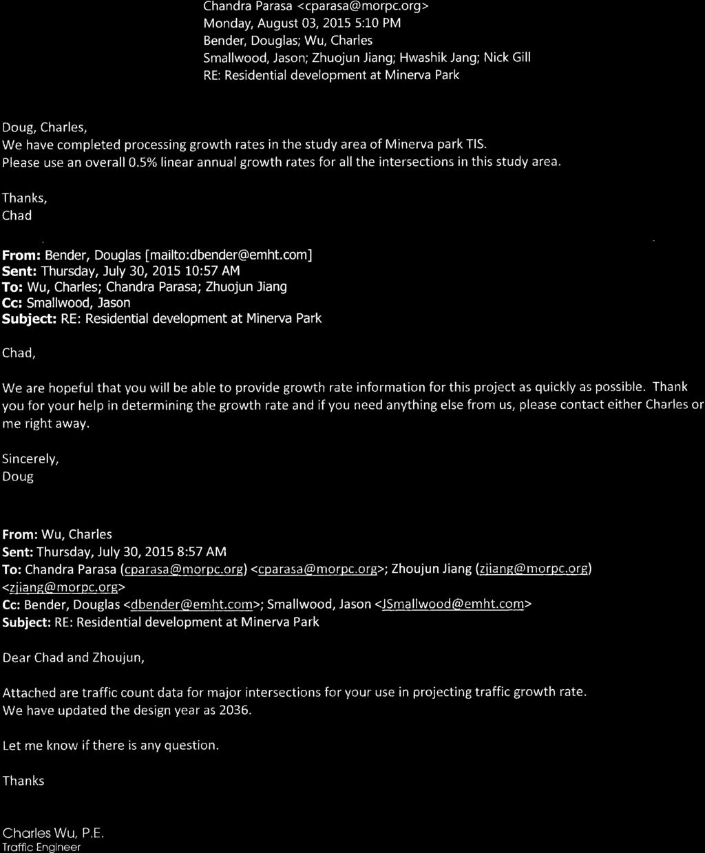
6 and Cleveland Avenue. Access to the site is provided by Minerva Lake Road, a local street serving the surrounding subdivision. TABLE 1: Street Network Characteristics Street Name Cardinal Direction Posted Speed Limit SR-161 East/West 50 mph Westerville Road North/South 45 mph Cleveland Avenue North/South 35 mph Northland Plaza Drive East/West 25 mph Minerva Lake Road East/West 25 mph Ponderosa Drive North/South 25 mph Farview Drive North/South 25 mph East Shore Drive North/South 25 mph 3.0 DATA COLLECTED Existing (background) traffic levels are determined from traffic counts performed for this project. Peak hour turning movement counts were performed in July when school was not in session from 7-9 AM and from 4-6 PM by EMH&T personnel at the following intersections: SR 161/Ponderosa Drive SR 161/Farview Drive SR 3/Minerva Lake Road Cleveland Avenue/Minerva Lake Road Cleveland Avenue/Maplewood Drive Ponderosa Drive/Northland Plaza Drive Farview Drive/Northland Plaza Drive Minerva Lake Road/East Shore Drive Counts were increased to design year conditions based on a 0.5% growth rate for each roadway provided by the Mid-Ohio Regional Planning Commission (MORPC). The MORPC growth rate data and traffic count data at each intersection are included in Appendix B for reference. 4.0 STUDY PROCEDURES The impact of proposed development on the adjacent street network was determined by combining the estimated site-generated trips from the planned Minerva Park residential site with background traffic, as well as potential traffic from a possible new middle school to provide Build traffic volumes for each horizon year. Though it is not currently proposed, Westerville Schools has considered the old Hawthorne school site for a middle school site on the current school grounds. Since no current plans exist but there is the potential for a separate middle school, traffic for a future middle school was estimated and analyzed separately in this report. Background traffic refers to non-site generated traffic volumes and was forecast for both the opening year 2016 and each horizon year as a starting point at each intersection. Morning and afternoon peak hour conditions were analyzed to determine the development impact. Analyses were performed at the intersections listed above. Minerva Park Traffic Impact Study emht.com 4
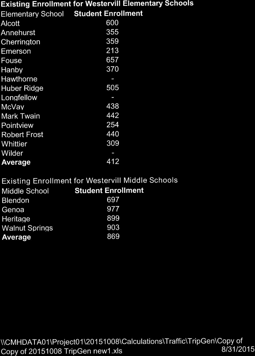
7 4.1 Traffic Volume Projections Detailed traffic volume calculations are attached for reference illustrating the development of 2016, 2026 (Cleveland Avenue and local street connections) and 2036 (SR 161 and SR 3 intersections) background and full build traffic volumes. The separate horizon years are due to multiple review agencies having differing requirements for their respective intersections. City of Columbus intersections along Cleveland Avenue, as well as the local village street connections, used a ten year study horizon resulting in a 2026 Horizon Year. The SR 161 and SR 3 intersections are under ODOT jurisdiction requiring a twenty year study horizon, resulting in a 2036 Horizon Year. Future traffic volumes were calculated based on the best available information for each intersection within the study area. Current year (2015) traffic counts were taken at each intersection being analyzed for this study area. Future background traffic volumes for each intersection were estimated by expanding 2015 counted traffic using the application of an area growth rates of 0.5% that was provided by the Mid-Ohio Regional Planning Commission (MORPC). Detailed traffic calculations for background traffic levels are attached for reference. Traffic for the existing Minerva Lake Golf Course was estimated using ITE trip generation rates to determine appropriate weekday peak hour traffic levels. Traffic for the golf course were then removed from each study area intersection based on the same distribution used for site traffic. The golf course traffic removal data is illustrated on the attached trip assignment sheets. To estimate the Build condition for each analysis year, site-generated traffic was determined and added to the background (No Build) condition for each respective year. With an elementary school site planned within the proposed development, reuse or replacement of the existing school site may be a possibility in the future. However, there are no current plans for the redevelopment of this site. All analyses presented within, in conjunction with this site are for reference only and have only been provided to establish long range planning goals. Any impacts from this school redevelopment are not associated with the proposed development. To provide for a conservative estimate for long range planning, this study analyzed the redevelopment of this site as a middle school. Existing attendance data was used to forecast trip ends based on an average sized Westerville middle school. Supporting data has been included. 4.2 Trip Generation Site generated trip ends will be forecast using data and methodology contained in Trip Generation 9 th Edition (Institute of Transportation Engineers, 2012). Morning and afternoon peak hour traffic volumes were estimated using trip generation rates for Land Use Code 210 (Single Family- Detached Housing) and for Land Use Code 520 (Elementary School). The number of students were based on the current average enrollment of all Westerville City Elementary Schools. Golf course traffic was estimated and removed from the total. Separate trip generation data was prepared for a potential middle school at the Hawthorne Elementary site using Land Use Code 522 (Middle School). The site is expected to generate 338 external trips in the morning peak hour and 256 Minerva Park Traffic Impact Study emht.com 5
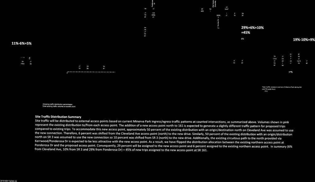
8 external trips in the afternoon peak hour. Detailed trip generation calculations are shown in Table 2 below: TABLE 2: Trip Generation Land Use Square Feet ITE Time ITE Total Trips Trips or Units Code Period Formula Trips Entering Exiting Single Family - Detached ADT Ln(T)=0.92Ln(x) ,512 1,256 1,256 units AM Peak T=0.70(x) PM Peak Ln(T)=0.90Ln(x) Golf Course ADT Average Rate = Holes AM Peak Average Rate = PM Peak Average Rate = Elementary School ADT Average Rate = Students AM Peak Average Rate = PM Peak Average Rate = ADT 2,400 1,200 1,200 TOTAL AM Peak Hour PM Peak Hour Middle School ADT Average Rate = , (Not part of proposed site) Students AM Peak Average Rate = PM Peak Average Rate = Trip Distribution Site generated traffic volumes were assigned to the adjacent street network based on the suggested/expected trip distribution that was included for review in the August 5, 2015 memo that summarized the study methodology. This distribution is illustrated in Figure 2 below. All trips will be assigned to the adjacent street network via existing roadways and a realigned Farview Road to the adjacent street network. Site generated traffic is expected to use local residential streets to reach the assigned gateways that serve as destination/origins when assigning peak hour site traffic. In the opening year, it is assumed that the realigned Farview Drive will be available to serve the new site on opening day. By the Horizon Year, the potential for a new middle school site was included in the 2026 and later Horizon Year analyses. All golf course traffic and all elementary school traffic have been assumed to have an origin/destination external to the surrounding neighborhood. While this traffic pattern is unlikely, the number of internal neighborhood trips associated with the planned elementary school is expected to be greater than internal trips associated with the golf course. The result of this assumption, should provide for a slightly conservative perspective for the analyses presented within. Minerva Park Traffic Impact Study emht.com 6
 and horizon year (2026/2036) volumes were used to analyze the street system with combinations of background traffic and site generated traffic volumes.")
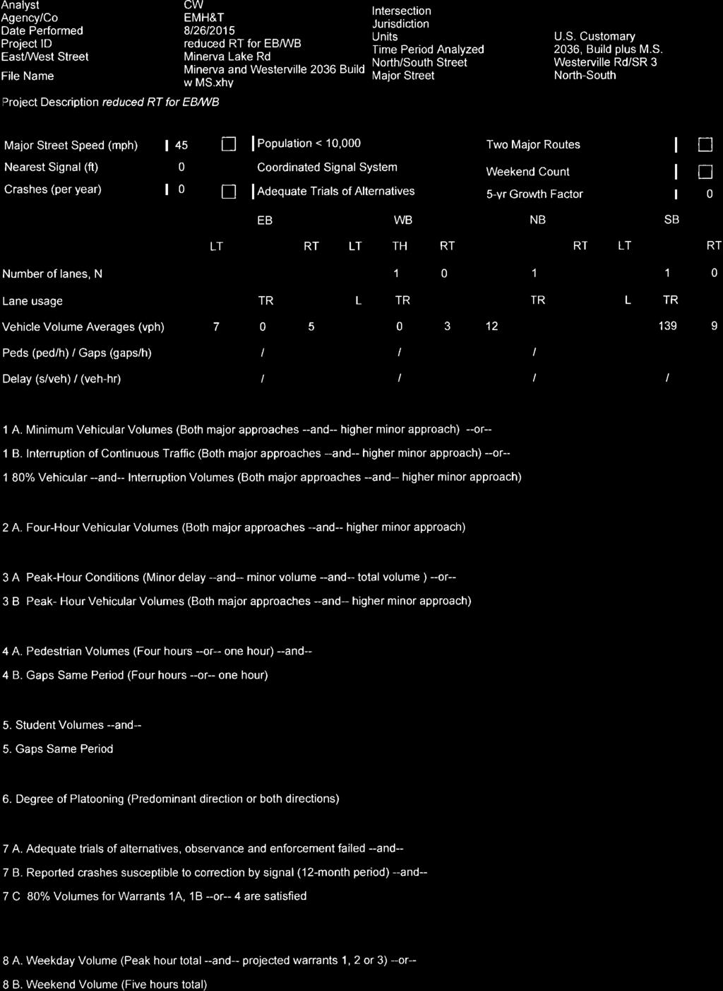
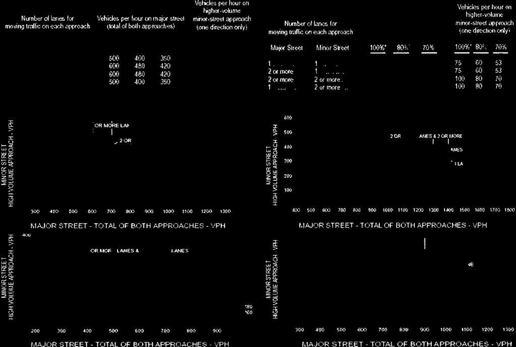
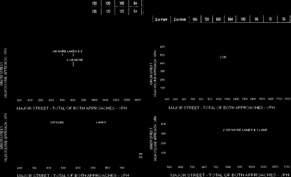
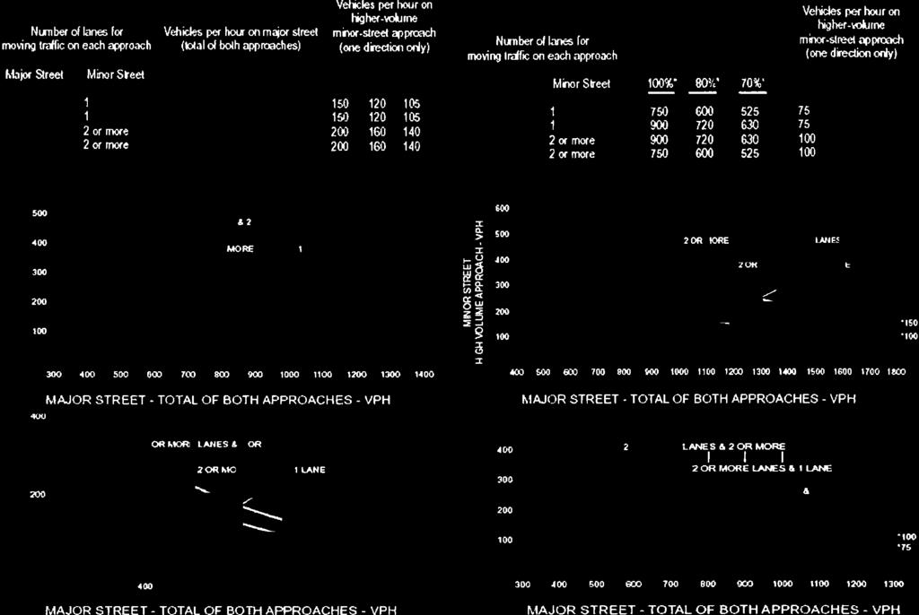
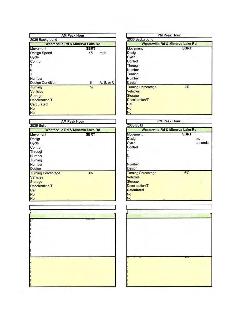
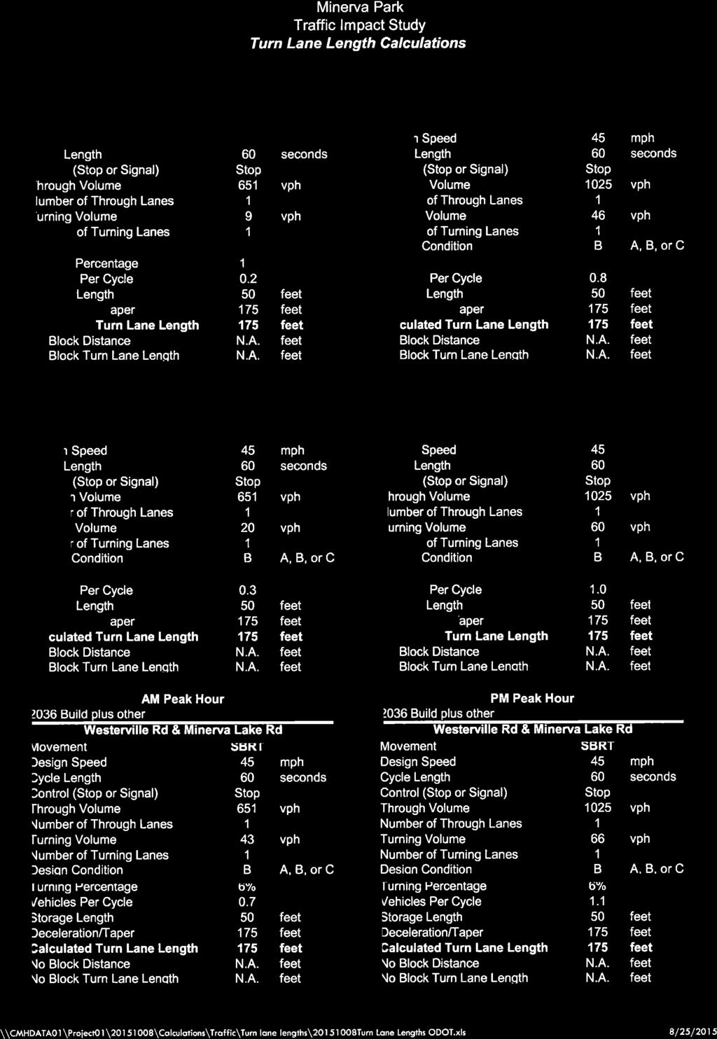
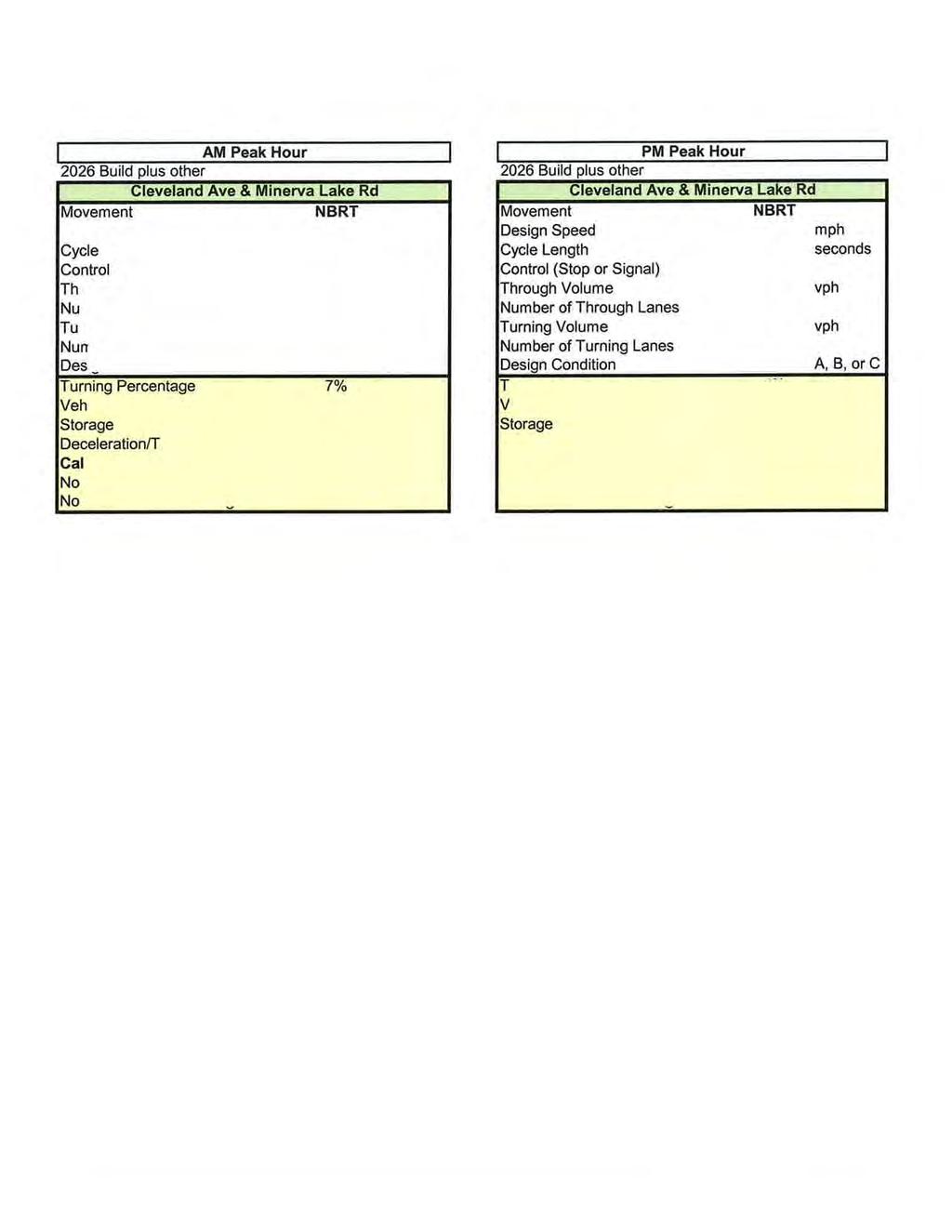
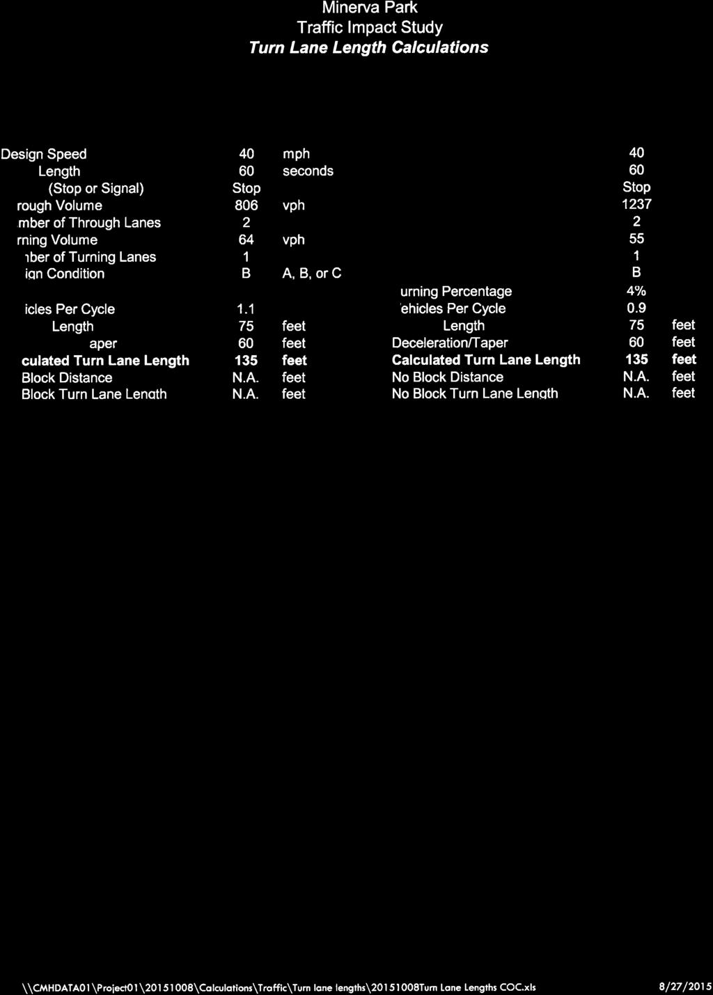
9 FIGURE 2: Expected Site Trip Distribution Volume assignment plates illustrating site traffic used to develop peak hour traffic volumes for the study area are included in Appendix C for reference. 5.0 FINDINGS OF ANALYSES Opening year (2016) and horizon year (2026/2036) volumes were used to analyze the street system with combinations of background traffic and site generated traffic volumes. Turn lane warrant criteria was reviewed and capacity analyses were completed to determine if any improvements are needed to mitigate site related traffic impacts. 5.1 Turn Lane Warrants Right turn lane warrants were evaluated pursuant to the requirements set forth in the Location and Design Manual, (Ohio Department of Transportation, 2015). At the State Route 3/Minerva Lake Road intersection, background traffic in the projected 2016 PM Peak conditions is expected to warrant a southbound right turn lane on SR 3, which should be 175 feet in length including taper. This turn lane is warranted without the addition of site related traffic and should not be considered a site improvement. Based on projected 2026 Build traffic volumes plus traffic from the potential middle school, a northbound right turn lane is expected to meet warrant thresholds at the Cleveland Avenue/Minerva Lake Road intersection. All analyses associated with potential middle school traffic are for long range planning only and are in no way associated with the planned development. Installation of this tune lane is not recommended at this time. Turn lane warrant results at each location are included in Appendix D for reference. Minerva Park Traffic Impact Study emht.com 7
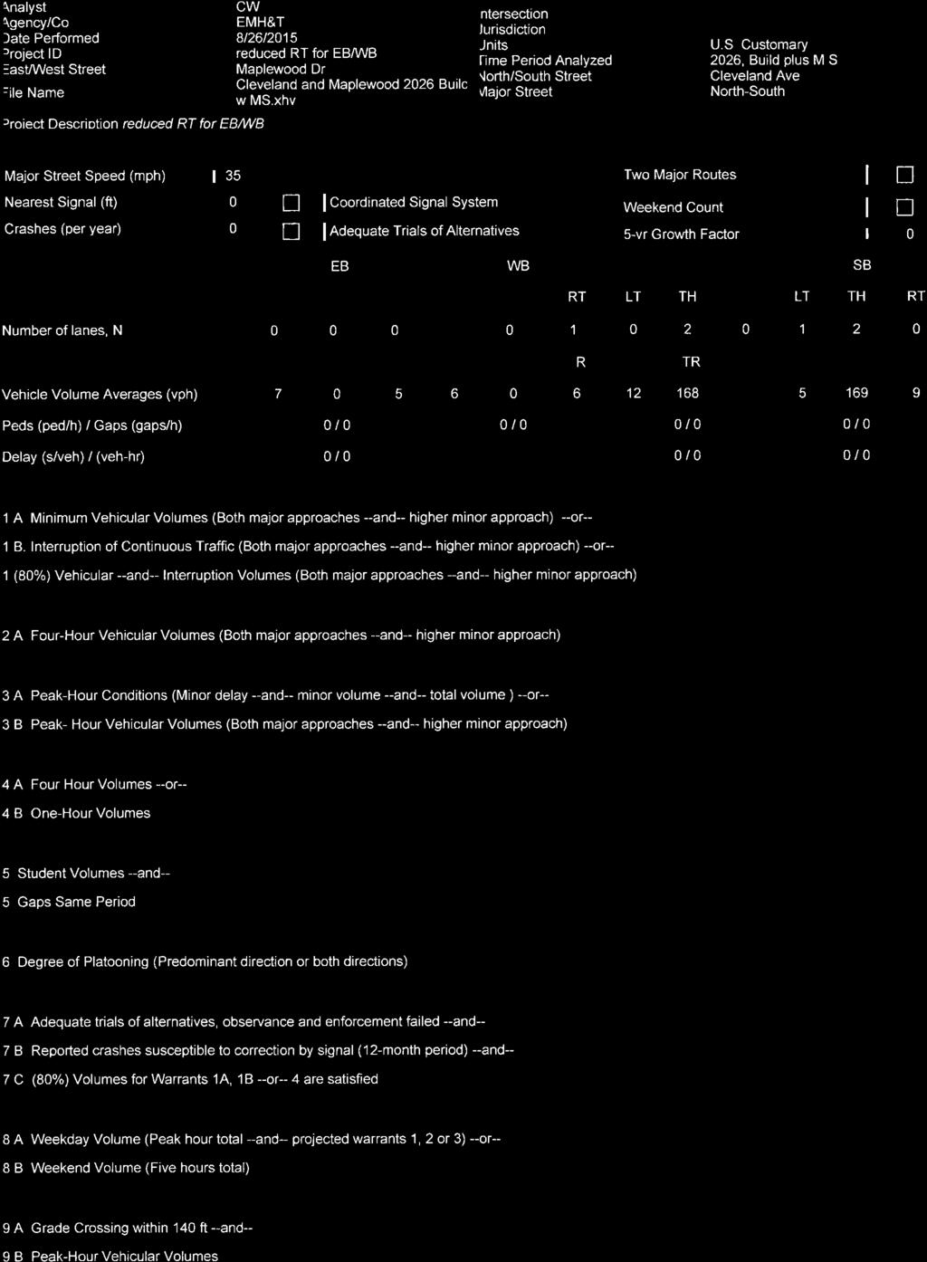
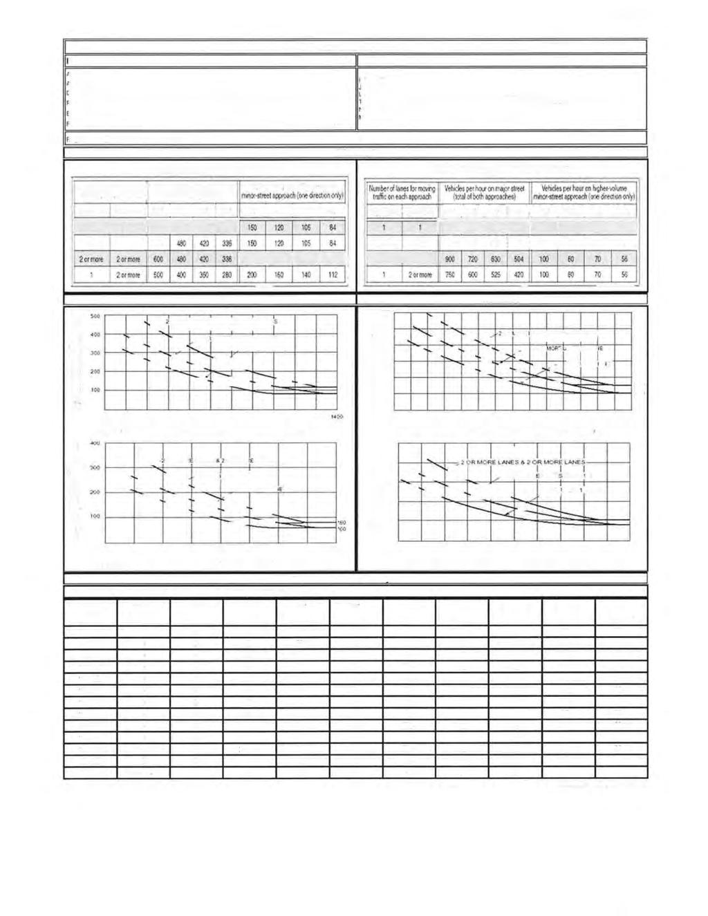
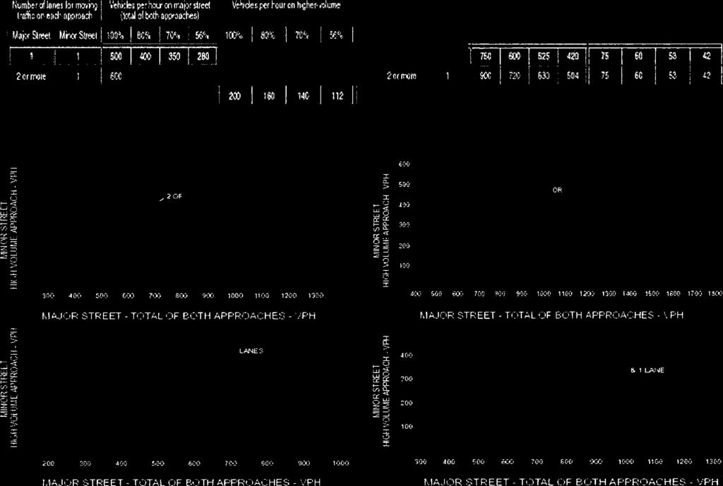
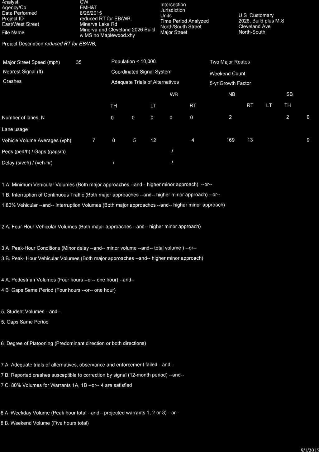
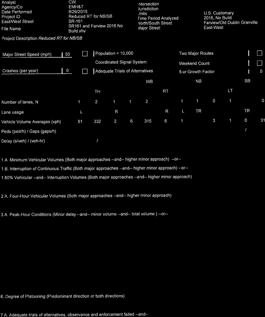
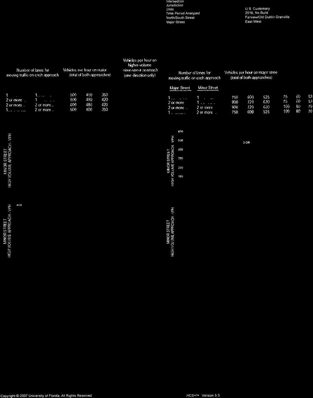
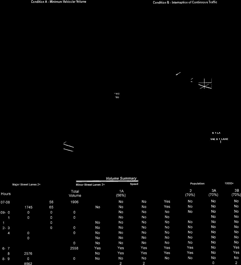
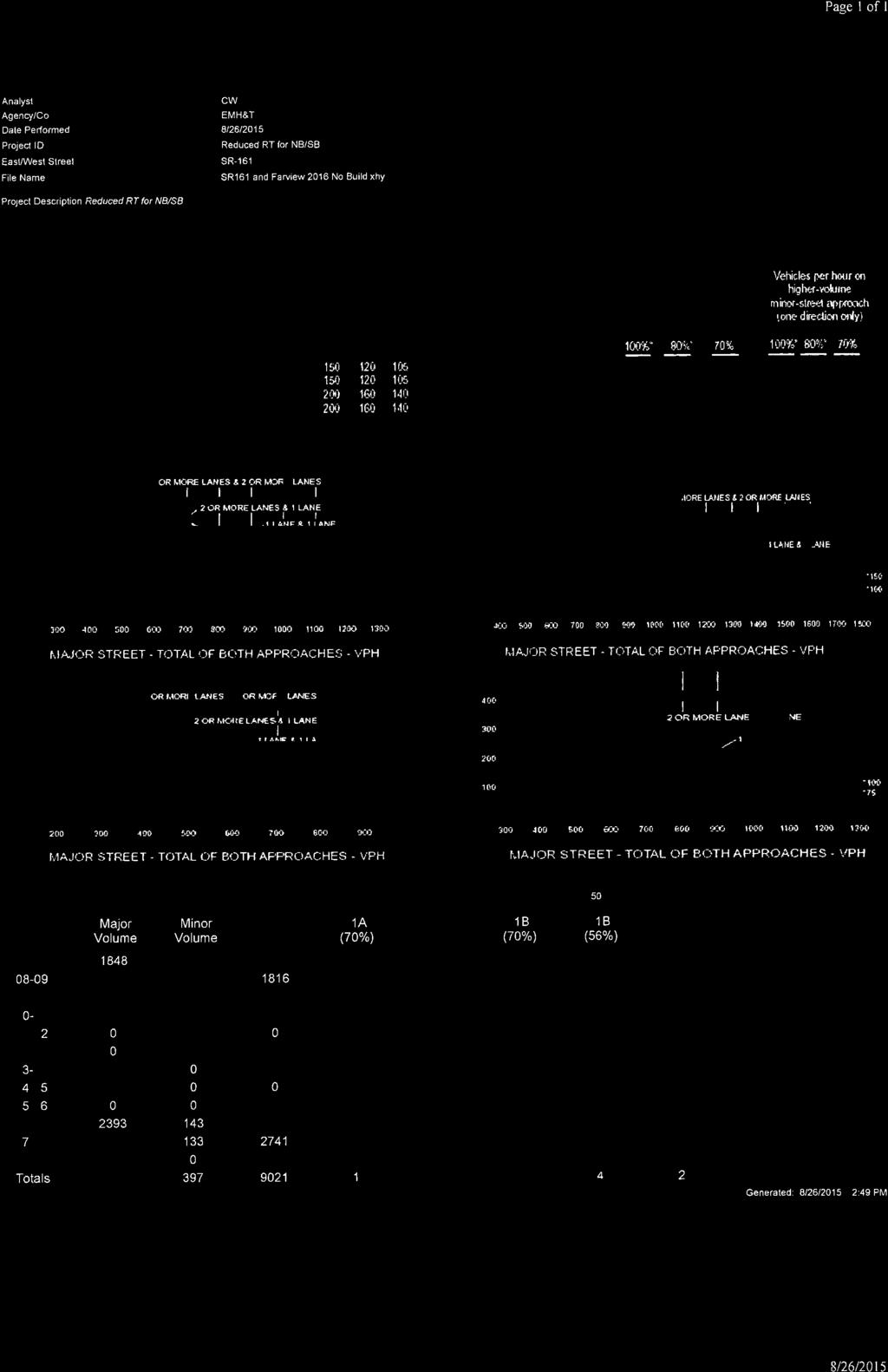
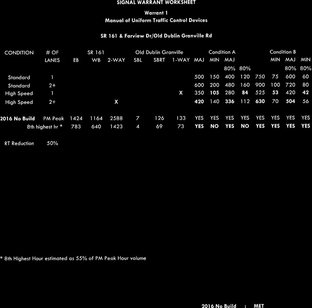
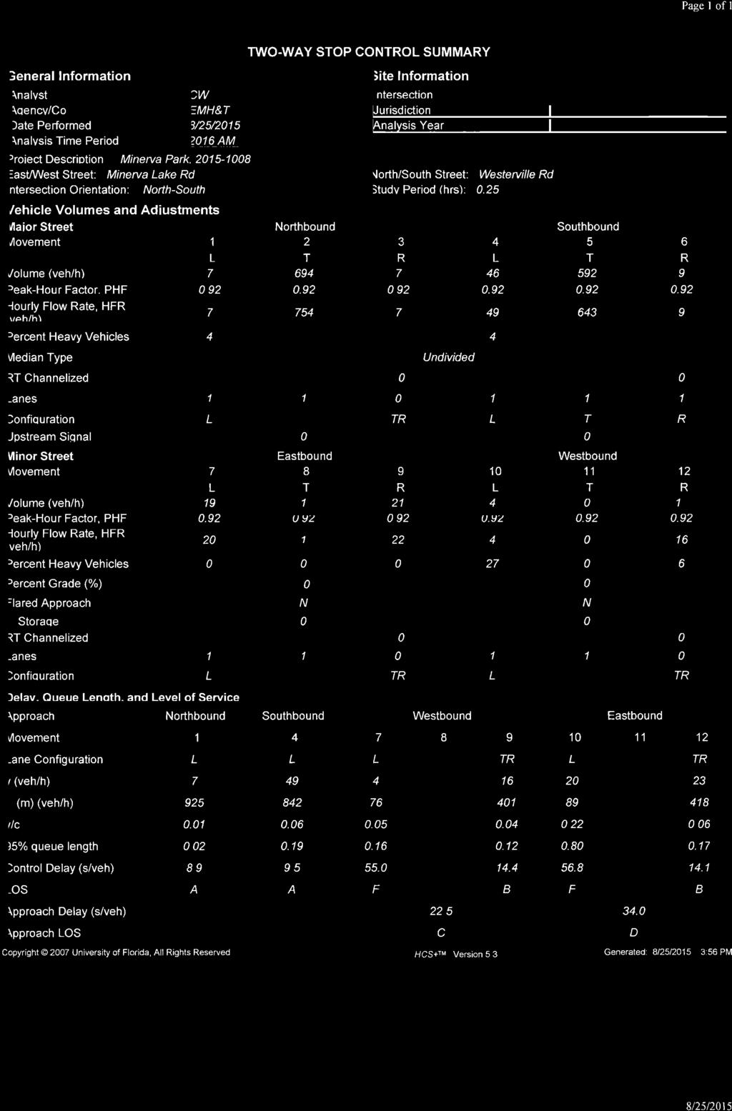
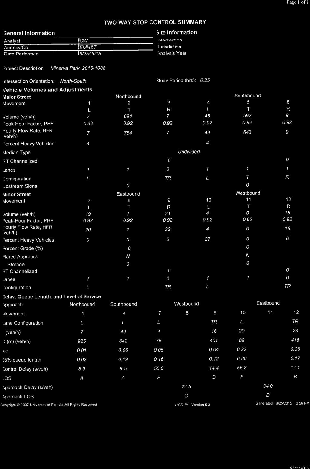
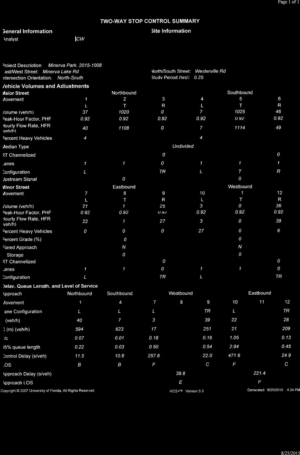
10 5.2 Signal Warrant Analysis Traffic signal warrants were completed by comparing estimated volumes, including estimated eight high hour, to minimum volume thresholds established by the Ohio Manual of Uniform Traffic Control Devices 4C (Ohio Department of Transportation, 2012) (OMUTCD). Signal warrant worksheets are included in Appendix E for reference. Traffic signal warrants were evaluated for the SR 3/Minerva Lake Road intersection and the SR 161/Farview Drive intersection under 2016 No Build and Build conditions. A traffic signal was found to be warranted based on an estimation of 2016 background traffic levels at the SR 161/Farview Drive intersection, meeting the Warrant 1, Condition B for the estimated eight high hour as well as Warrant 3, Peak Hour criteria. No traffic signal is expected to be warranted at the SR 3/Minerva Lake Road under either 2016 Background or Build traffic conditions. Additionally, peak hour signal warrants were evaluated on Cleveland Avenue at Minerva Lake Road and at Maplewood Drive, which were not predicted to warrant a traffic signal if the Maplewood Drive connection is maintained. If the Maplewood Drive connection is eliminated, the Cleveland Avenue/Minerva Lake Road intersection is still not expected to meet a signal warrant. As a result, four hour and eight hour conditions were not evaluated. 5.3 Intersection Capacity Analysis Highway Capacity Software and Synchro were used to evaluate operational characteristics of the study area intersections. Intersections are graded using a level of service designation. Levels of Service (LOS) are expressed in terms of letter grades with LOS A representing the highest quality traffic flow and minimal delay, and LOS F representing poor traffic operations and significant delay. LOS D or better for each approach at an intersection is desirable. Capacity results are summarized and in Table 3 for reference. Output reports of capacity analysis are attached in Appendix E for reference. Minerva Park Traffic Impact Study emht.com 2
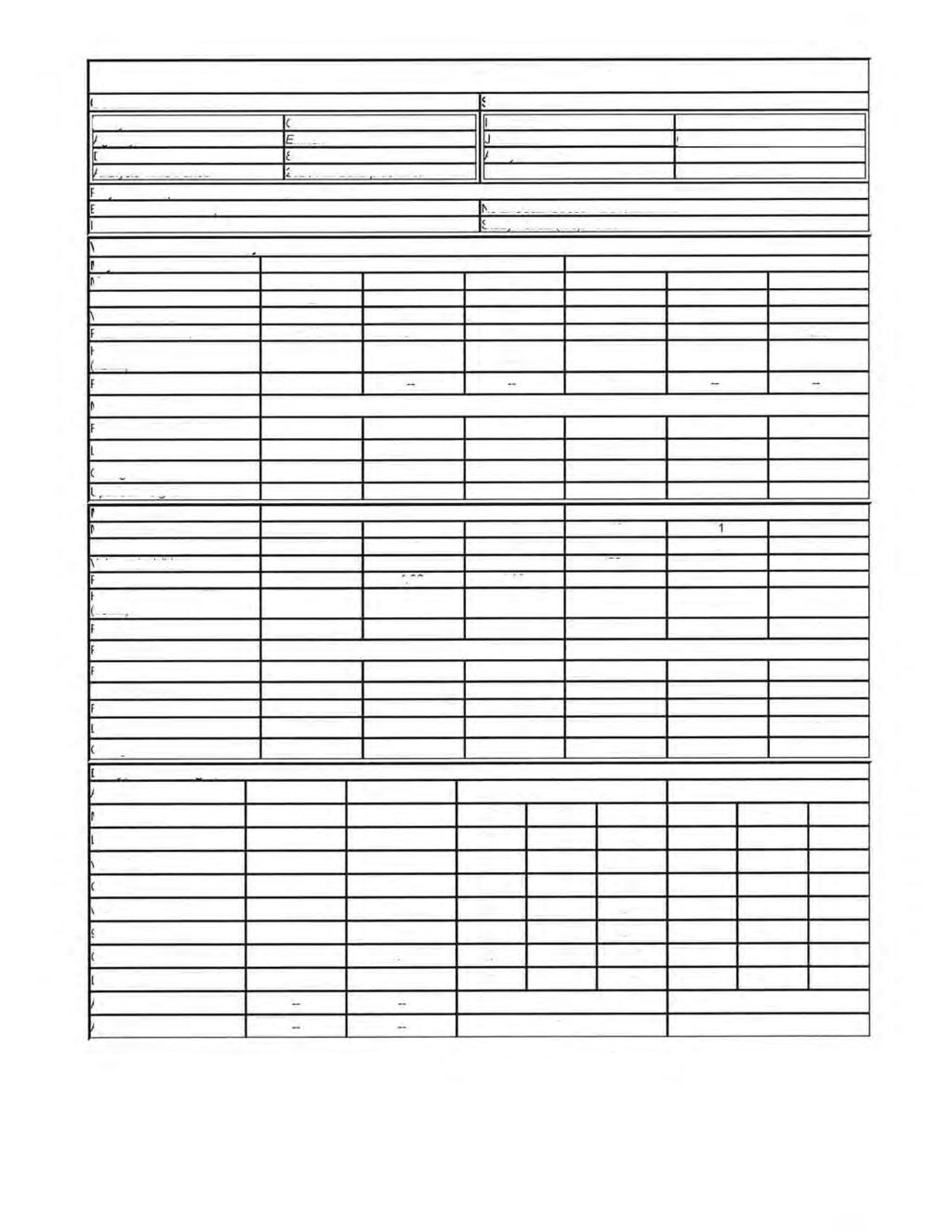
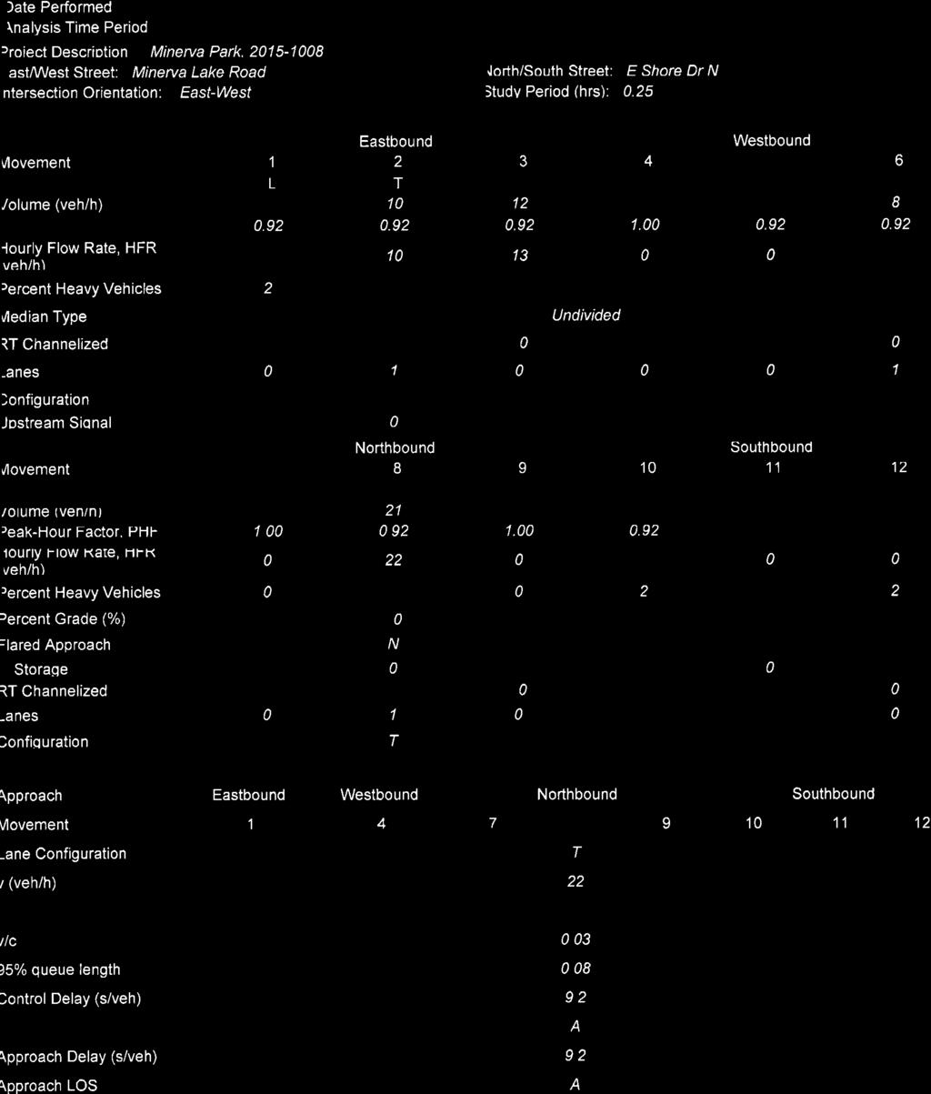
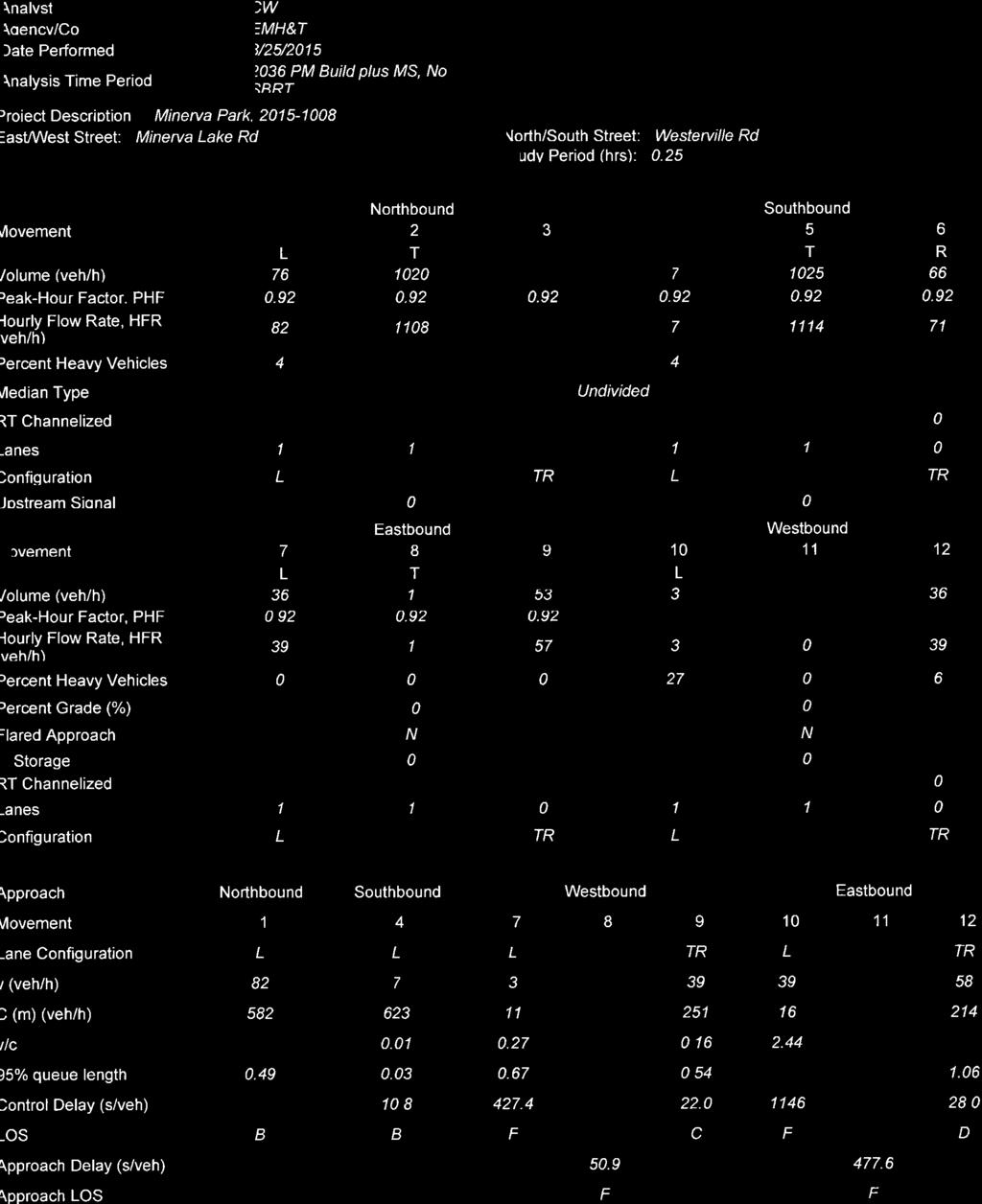
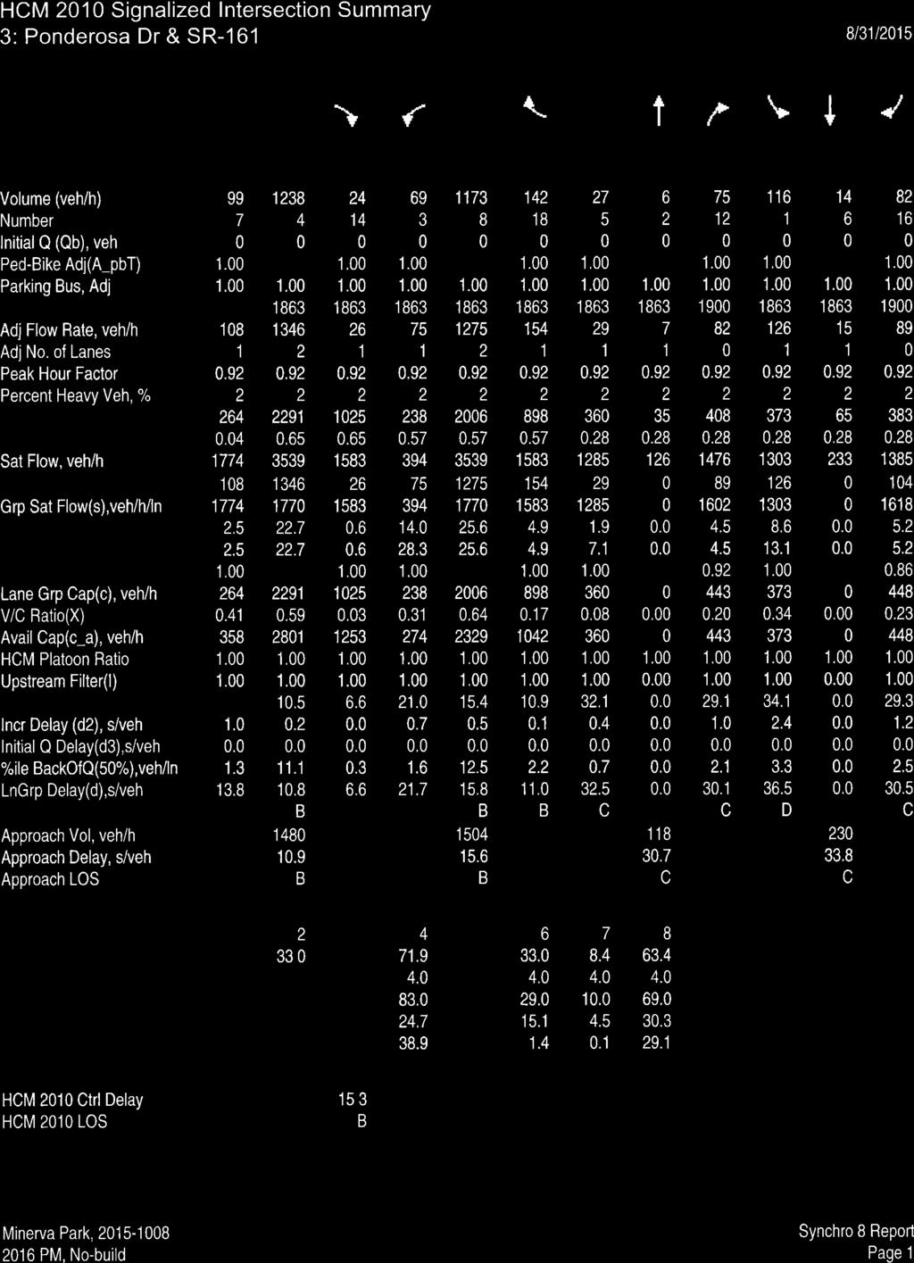
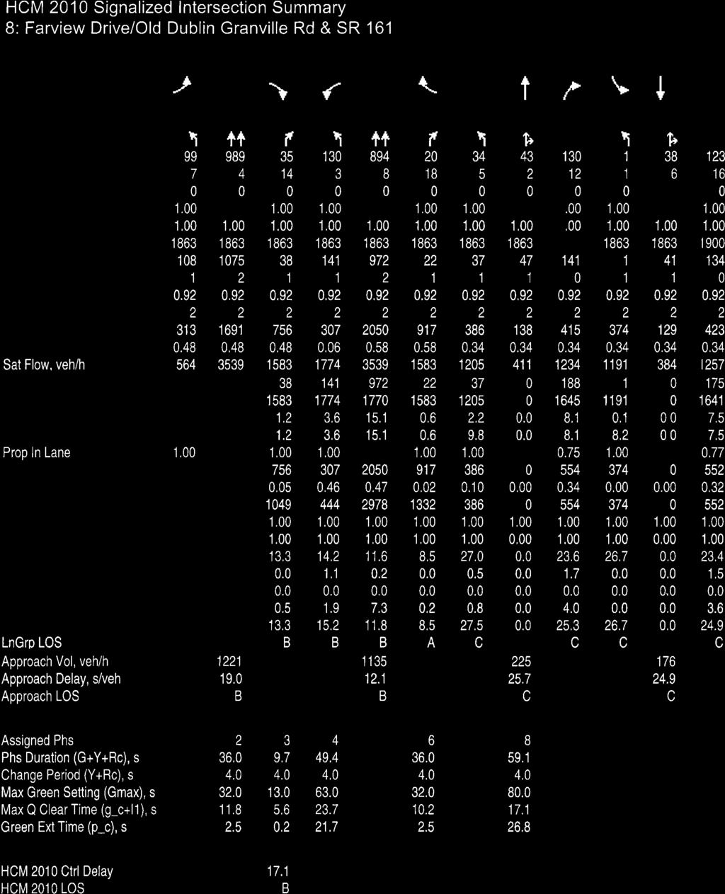
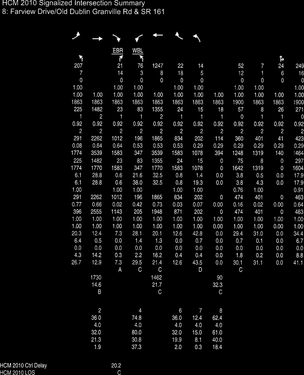
11 Time Period Year Scenario Conditions AM Peak Hour PM Peak Hour AM Peak Hour PM Peak Hour Cleveland Avenue/Minerva Lake Road TABLE 3: Capacity Analysis Summary WBLT No Build Ex. Condition C/ C/ A/9.5 - Build Ex. Condition C/ C/ A/9.6 - Build w/o Maplewood Ex. Condition D/ D/ A/9.7 - No Build Ex. Condition C/ C/ A/9.7 - Build Ex. Condition D/ D/ A/9.8 - Build w/o Maplewood Ex. Condition E/ E/ A/9.9 - Build w/ M.S. Add a warranted NBRT D/ E/ A/ Build w/ M.S. w/o Maplewood WBTH Add a warranted NBRT F/ F/ B/ No Build Ex. Condition F/ F/ B/ Build Ex. Condition F/ F/ B/ Build w/o Maplewood Ex. Condition F/ F/ B/ No Build Ex. Condition F/ F/ B/ Build Ex. Condition F/ F/ B/ Build w/o Maplewood Ex. Condition F/ F/ B/ Build w/ M.S. Add a warranted NBRT F/ F/ B/ Build w/ M.S. w/o Maplewood Cleveland Avenue/Maplewood Drive Add a warranted NBRT F/ F/ B/ No Build Ex. Condition D/ B/ A/9.4 - Build Ex. Condition E/ B/ A/9.5 - No Build Ex. Condition D/ B/ A/9.6 - Build Ex. Condition E/ B/ A/9.7 - Build w/ M.S. Ex. Condition E/ B/ A/9.9 - No Build Ex. Condition F/ B/ B/ Build Ex. Condition F/ B/ B/ No Build Ex. Condition F/ B/ B/ Build Ex. Condition F/ B/ B/ Build w/ M.S. Ex. Condition F/ B/ B/ Minerva Lake Road/E Shore Drive North AM Peak Hour 2026 Build w/ M.S. Ex. Condition A/ PM Peak Hour 2026 Build w/ M.S. Ex. Condition A/ Minerva Lake Road/E Shore Drive East AM Peak Hour 2026 Build w/ M.S. Ex. Condition A/9.4 - PM Peak Hour 2026 Build w/ M.S. Ex. Condition A/8.9 - Minerva Lake Road/E Shore Drive West AM Peak Hour 2026 Build w/ M.S. Ex. Condition A/9.2 A/9.2 PM Peak Hour 2026 Build w/ M.S. Ex. Condition A/8.8 A/8.8 X/X = Overall LOS / Average Delay Per Vehicle WBRT NBTH SBLT SBRT Minerva Park Traffic Impact Study emht.com 8
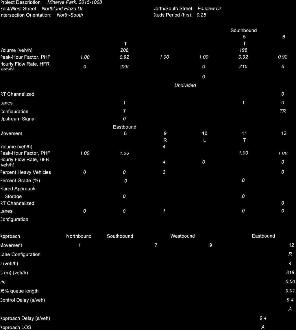
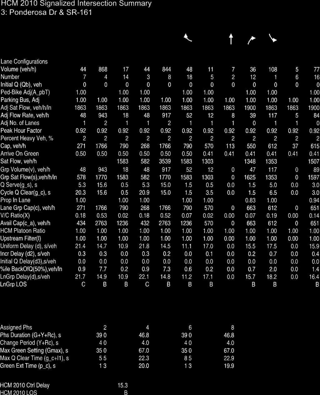
12 TABLE 3: Capacity Analysis Summary (cont d) Time Period Year Scenario Conditions EBLT EBTH EBRT WBLT WBTH WBRT NBLT NBTH NBRT SBLT SBTH SBRT TOTAL Minerva Lake Road/Site Drive AM Peak Hour 2026 Build w/ M.S. Ex. Condition A/7.4 A/7.4 - A/9.4 - A/ PM Peak Hour 2026 Build w/ M.S. Ex. Condition A/7.3 A/7.3 - A/9.0 - A/ Minerva Lake Road/Farview Drive AM Peak Hour 2026 Build w/ M.S. Ex. Condition A/8.94 A/8.94 A/8.94 A/8.44 A/8.44 A/8.44 A/8.71 A/8.71 A/8.71 A/8.93 A/8.93 A/8.93 A/8.76 PM Peak Hour 2026 Build w/ M.S. Ex. Condition A/8.02 A/8.02 A/8.02 A/8.4 A/8.4 A/8.4 A/7.79 A/7.79 A/7.79 A/8.21 A/8.21 A/8.21 A/8.17 Westerville Road/Minerva Lake Road AM Peak Hour PM Peak Hour No Build Ex. Condition F/57.6 B/14.2 B/14.2 F/55.0 B/14.4 B/14.4 A/ A/ No Build Add a SBRT F/56.8 B/14.1 B/14.1 F/55.0 B/14.4 B/14.4 A/ A/ Build Ex. Condition F/89.8 B/14.4 B/14.4 F/70.4 B/14.4 B/14.4 A/ A/ Build Add a SBRT F/89.8 B/14.3 B/14.3 F/70.4 B/14.4 B/14.4 A/ A/ No Build Ex. Condition F/74.5 C/15.3 C/15.3 F/69.2 C/15.4 C/15.4 A/ A/ No Build Add a SBRT F/74.5 C/15.2 C/15.2 F/69.2 C/15.4 C/15.4 A/ A/ Build Ex. Condition F/134.2 C/15.5 C/15.5 F/90.6 C/15.4 C/15.4 A/ A/ Build Add a SBRT F/130.6 C/15.3 C/15.3 F/90.6 C/15.4 C/15.4 A/ A/ Build w/ M.S. Ex. Condition F/333.6 C/16.9 C/16.9 F/133.0 C/15.4 C/15.4 A/ A/ Build w/ M.S. Add a SBRT F/310.7 C/16.4 C/16.4 F/133.0 C/15.4 C/15.4 A/ A/ No Build Ex. Condition F/287.7 C/19.1 C/19.1 F/167.7 C/19.5 C/19.5 B/ B/ No Build Add a SBRT F/287.7 C/18.5 C/18.5 F/167.7 C/19.5 C/19.5 B/ B/ Build Ex. Condition F/539.2 C/20.2 C/20.2 F/214.5 C/19.5 C/19.5 B/ B/ Build Add a SBRT F/477.1 C/19.4 C/19.4 F/214.5 C/19.5 C/19.5 B/ B/ No Build Ex. Condition F/506.8 D/25.7 D/25.7 F/257.6 C/22.0 C/22.0 B/ B/ No Build Add a SBRT F/471.6 C/24.9 C/24.9 F/257.6 C/22.0 C/22.0 B/ B/ Build Ex. Condition F/883.0 D/26.6 D/26.6 F/351.2 C/22.0 C/22.0 B/ B/ Build Add a SBRT F/816.6 D/25.5 D/25.5 F/351.2 C/22.0 C/22.0 B/ B/ Build w/ M.S. Ex. Condition F/ D/28.0 D/28.0 F/417.4 C/22.0 C/22.0 B/ B/ Build w/ M.S. Add a SBRT F/1059 D/26.3 D/26.3 F/427.4 C/22.0 C/22.0 B/ B/ Northland Plaza Drive/Ponderosa Drive AM Peak Hour 2026 Build w/ M.S. Ex. Condition A/9.4 A/9.4 A/9.4 A/8.9 A/8.9 A/8.9 A/7.4 A/7.4 A/7.4 A/7.3 A/7.3 A/7.3 - PM Peak Hour 2026 Build w/ M.S. Ex. Condition B/10.5 B/10.5 B/10.5 A/8.8 A/8.8 A/8.8 A/7.4 A/7.4 A/7.4 A/7.3 A/7.3 A/7.3 - Northland Plaza Drive/Farview Drive AM Peak Hour 2026 Build w/ M.S. Ex. Condition - - A/ PM Peak Hour 2026 Build w/ M.S. Ex. Condition - - A/ SR-161/Ponderosa Drive AM Peak Hour PM Peak Hour 2016 No Build Ex. Condition C/21.3 B/15.1 B/11.0 C/22.2 B/14.7 B/11.3 B/16.7 B/15.4 B/15.4 B/17.8 B/16.0 B/16.0 B/ Build w/ M.S. Ex. Condition B/13.4 B/13.5 A/9.5 C/20.8 B/17.9 B/13.3 C/20.6 B/18.9 B/18.9 C/22.0 B/19.6 B/19.6 B/ No Build Ex. Condition B/15.2 B/12.2 A/7.5 C/24.6 B/17.4 B/12.2 C/33.7 C/31.1 C/31.1 D/37.6 C/31.5 C/31.5 B/ Build w/ M.S. Ex. Condition B/17.0 B/12.6 A/7.2 C/27.7 B/18.0 B/11.7 D/37.1 D/35.2 D/35.2 D/43.8 C/34.5 C/34.5 B/17.7 SR-161/Farview Drive/Old Dublin Granville Road AM Peak Hour 2016 No Build Ex. Condition B/ B/ F/95.0 B/11.3 B/11.3 F/75.6 B/12.7 B/ Build Ex. Condition B/ B/ F/497.4 F/228.1 F/228.1 F F/69.6 F/ Build w/ M.S. Ex. Condition B/ B/ F F/1238 F/1238 F F/1057 F/ Build w/ M.S. Traffic Signal C/20.4 B/19.0 B/13.3 B/15.2 B/11.8 A/8.5 C/27.5 C/25.3 C/25.3 C/26.7 C/24.9 C/24.9 B/ No Build Ex. Condition C/ B/ F/ F/ Build Ex. Condition C/ B/ F F/1867 F/1867 F F/2736 F/ AM Peak Hour 2036 Build w/ M.S. Ex. Condition C/ C/ F F/2983 F/2983 F F/3901 F/ Build w/ M.S. Traffic Signal C/26.7 B/12.9 A/7.3 C/29.5 C/21.4 B/12.6 D/43.5 C/30.1 C/30.1 C/31.1 D/41.1 D/41.1 C/20.2 X/X = Overall LOS / Average Delay Per Vehicle Minerva Park Traffic Impact Study emht.com 9
13 5.3.1 SR 161 at Farview Drive Capacity analyses indicate the SR 161/Fairview Dr. intersection experiences a poor level of service under stop-sign control, for the sidestreet approaches, under 2016 Background conditions. If signalized, as discussed above, the intersection is expected to operate as acceptable levels of service through the design year 2036 with or without the addition of site generated traffic or future middle school traffic SR 161 at Ponderosa Drive The SR 161/Ponderosa Drive intersection is expected to operate acceptably in the 2016 and 2036 Background and Build conditions without any improvements. Predicted 2036 results include the potential addition of traffic from the potential middle school site. No improvements are recommended at this intersection SR 3 at Minerva Lake Road The State Route 3/Minerva Lake Road intersection is predicted to operate at acceptable levels of service for SR 3 traffic through the design year with or without site generated traffic volumes. As commonly found at stop controlled approaches, left turning traffic experiences poor levels of service during peak periods. The addition of site generated traffic volumes increases this side street delay without affecting SR 3 LOS. This intersection is not expected to meet signal warrants. The street network within the Minerva Park neighborhood provide unique access flexibility to the surrounding arterial street system. With direct access to SR 3, Cleveland Ave and SR 161, exiting traffic has the ability to make a right turn at one of the multiple access points and travel to any destination without significantly increasing travel time. Traffic volume assignment presented within only represents one scenario and actual travel patterns are expected to vary. With multiple access points providing the ability to make a right turn and the possibility of an additional signalized intersection at SR 161, side street improvements at this location are not recommended Cleveland Avenue at Minerva Lake Road The Cleveland Avenue/Minerva Lake Road intersection is expected to operate acceptably for Cleveland Avenue traffic through the design year 2026 with or without site generated traffic. Westbound side street traffic currently operates at a poor level of service during afternoon peak conditions and will worsen slightly with the addition of minimal westbound site generated trips in the peak hours. With the planned connection to SR 161 and using the local street network flexibility discussed above in 5.3.3, no side street improvements are recommended at this location since sidestreet delay here could be alleviated by motorists travelling to SR 161 for ease of exiting Cleveland Avenue at Maplewood Drive The Cleveland Avenue/ Maplewood Drive intersection is expected to operate acceptably for Cleveland Avenue through the 2026 Build conditions with the Maplewood Drive connection. Westbound side street traffic is predicted to experience a failed level of service during the afternoon peak hour with or without the addition of site generated traffic volumes. The few additional westbound site trips in the afternoon peak combined with the local street network flexibility discussed above in 5.3.3, no side street improvements are recommended at this location. Minerva Park Traffic Impact Study emht.com 10
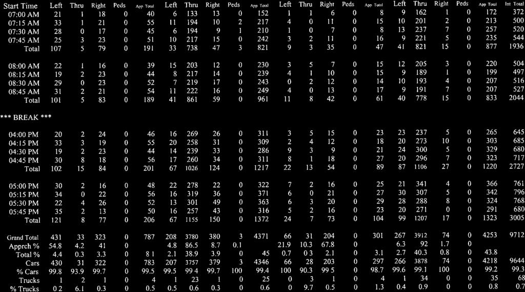
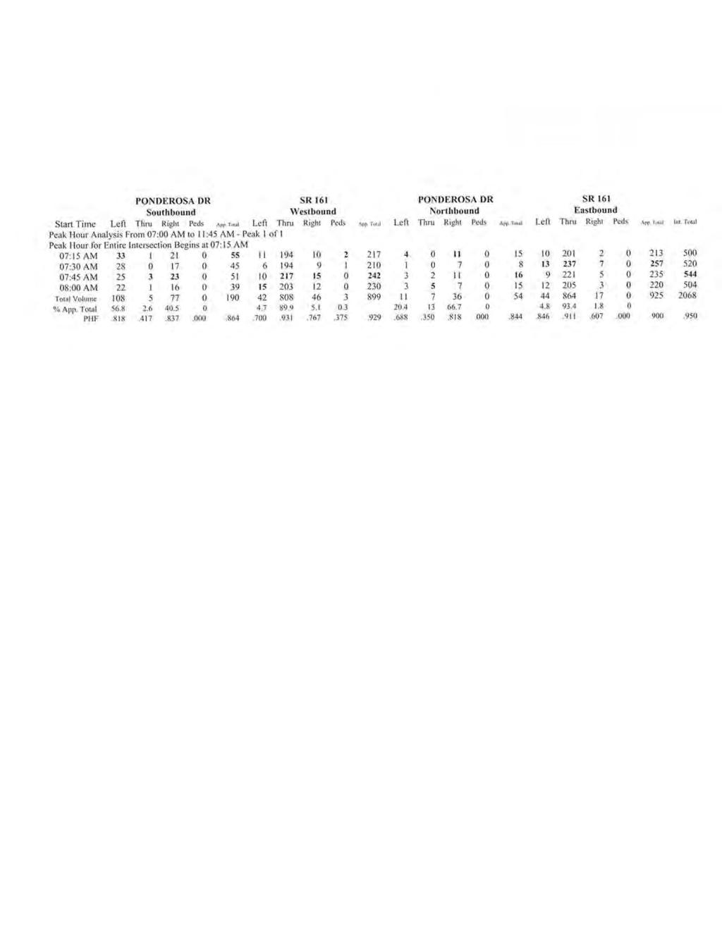
14 5.3.6 Ponderosa Drive/Northland Plaza Drive This intersection is expected to operate acceptably in the 2016 and 2036 Background and Build conditions with existing conditions in place. No improvements are recommended at this intersection Farview Drive/Northland Plaza Drive The Ohio Department of Transportation has indicated that the intersection of Farview Drive/Northland Plaza Drive and SR 161/Farview Drive has operational restrictions due to their close proximity and mitigation measures must be investigated with the extension of Farview Drive. The primary restriction is the lack of vehicle storage for northbound traffic and the ability to accommodate westbound left turning traffic from Northland Plaza. In an effort to simplify intersection geometry and provide provisions for northbound vehicle queues, we recommend Northland Plaza Drive be limited to right-in, right-out only. Capacity analyses furnished within are based on this right-in, right-out operation and forecast acceptable levels of service through the design hear Minerva Lake Road/East Shore Drive This intersection is expected to operate acceptably in the 2016 and 2036 Background and Build conditions with existing conditions in place. No improvements are recommended at this intersection. 6.0 CONCLUSION AND RECOMMENDATIONS The unique access characteristics of the Minerva Park neighborhood provide flexibility with access routes both to and from the neighborhood. This flexibility assists with accommodating narrow peak hour bands of increased demand from both existing and site related traffic volumes. Offsite improvements as summarized below are based on the detailed analyses presented herein. Background Improvements: 1. Turn lane warrant analyses indicate that existing/counted southbound right volume volumes meet warrant thresholds at the SR 3/Minerva Park Drive intersection. This warrant is satisfied without trips generated from the proposed development and should not be considered a site related improvement. 2. Consider signalization of the SR 161/Farview Drive intersection. Warrant analyses presented within suggest that signalization may be warranted with existing traffic volumes. Prior to signalization a more detailed analysis should be conducted to justify signalization. Warrant thresholds appear to be satisfied with background traffic and this signalization should not be considered a primary site related improvement. However, with the addition of the Farview Drive roadway extension, an increased number of trip ends are expected on the southern leg of this intersection. A site related contribution proportional to the percentage of site traffic forecast for this location could be considered. Site Related Improvements: 1. With the addition of Farview Drive, and the expected increase in northbound traffic, the intersection of Northland Plaza Drive/Farview Drive should be restricted to right-in, rightout for westbound traffic. This improvement should be correlated with the Farview Drive roadway extension. Minerva Park Traffic Impact Study emht.com 11


15
16

17

18


19
20
21
22
23
24
25
26
27
28
29
30
31
32
33
34
35
36
37

38
39
40
41

42
43
44
45

46
47
48
49
50
51
52
53
54
55
56
57
58
59
60
61
62
63
64
65
66
67
68
69
70
71
72
73
74
75
76
77
78
79
80
81
82
83
84
85
86
87
88
89
90
91
92
93
94
95
96
97
98
99
100
101
102
103
104
105
106
107
108
109
110
111
112
113
114

115
116
117
118
119
120
121
122
123
124
125
126
127
128
129
130
131
132
133
134
135
136
137
138
139
140
141
142
143
144
145
146
147
148
149
150
151
152
153
154
155
156

157
158
159
160
161
162
163
164
165
166
167
168

169
170
171
172
173
174
175
176
177
178
179
180
181
182
183
184
185
186
187

188
189
190
191
192
193
194
195
196

197
198
199
King Soopers #116 Thornton, Colorado
 Traffic Impact Study King Soopers #116 Thornton, Colorado Prepared for: Galloway & Company, Inc. T R A F F I C I M P A C T S T U D Y King Soopers #116 Thornton, Colorado Prepared for Galloway & Company
LAWRENCE TRANSIT CENTER LOCATION ANALYSIS 9 TH STREET & ROCKLEDGE ROAD / 21 ST STREET & IOWA STREET LAWRENCE, KANSAS
 LAWRENCE TRANSIT CENTER LOCATION ANALYSIS 9 TH STREET & ROCKLEDGE ROAD / 21 ST STREET & IOWA STREET LAWRENCE, KANSAS TRAFFIC IMPACT STUDY FEBRUARY 214 OA Project No. 213-542 TABLE OF CONTENTS 1. INTRODUCTION...
TIMBERVINE TRANSPORTATION IMPACT STUDY FORT COLLINS, COLORADO JANUARY Prepared for:
 TIMBERVINE TRANSPORTATION IMPACT STUDY FORT COLLINS, COLORADO JANUARY 2014 Prepared for: Hartford Companies 1218 W. Ash Street Suite A Windsor, Co 80550 Prepared by: DELICH ASSOCIATES 2272 Glen Haven Drive
Transportation & Traffic Engineering
 Transportation & Traffic Engineering 1) Project Description This report presents a summary of findings for a Traffic Impact Analysis (TIA) performed by A+ Engineering, Inc. for the Hill Country Family
EXECUTIVE SUMMARY. The following is an outline of the traffic analysis performed by Hales Engineering for the traffic conditions of this project.
 EXECUTIVE SUMMARY This study addresses the traffic impacts associated with the proposed Shopko redevelopment located in Sugarhouse, Utah. The Shopko redevelopment project is located between 1300 East and
APPENDIX C1 TRAFFIC ANALYSIS DESIGN YEAR TRAFFIC ANALYSIS
 APPENDIX C1 TRAFFIC ANALYSIS DESIGN YEAR TRAFFIC ANALYSIS DESIGN YEAR TRAFFIC ANALYSIS February 2018 Highway & Bridge Project PIN 6754.12 Route 13 Connector Road Chemung County February 2018 Appendix
2.0 Development Driveways. Movin Out June 2017
 Movin Out June 2017 1.0 Introduction The proposed Movin Out development is a mixed use development in the northeast quadrant of the intersection of West Broadway and Fayette Avenue in the City of Madison.
TRAFFIC IMPACT ANALYSIS
 TRAFFIC IMPACT ANALYSIS Emerald Isle Commercial Development Prepared by SEPI Engineering & Construction Prepared for Ark Consulting Group, PLLC March 2016 I. Executive Summary A. Site Location The Emerald
INDUSTRIAL DEVELOPMENT
 INDUSTRIAL DEVELOPMENT Traffic Impact Study Plainfield, Illinois August 2018 Prepared for: Seefried Industrial Properties, Inc. TABLE OF CONTENTS Executive Summary 2 Introduction 3 Existing Conditions
Oakbrook Village Plaza City of Laguna Hills
 Oakbrook Village Plaza City of Laguna Hills Traffic Impact Analysis Prepared by: HDR Engineering 3230 El Camino Real, Suite 200 Irvine, CA 92602 October 2012 Revision 3 D-1 Oakbrook Village Plaza Laguna
Traffic Impact Analysis West Street Garden Plots Improvements and DuPage River Park Garden Plots Development Naperville, Illinois
 Traffic Impact Analysis West Street Garden Plots Improvements and DuPage River Park Garden Plots Development Naperville, Illinois Submitted by April 9, 2009 Introduction Kenig, Lindgren, O Hara, Aboona,
Appendix 5. Haymeadow Interim Traffic Analysis
 Appendix 5 Haymeadow Interim Traffic Analysis 20 MEMORANDUM To: From: Rick Pylman Gary Brooks Bill Fox Date: September 15, 2016 Project: Subject: Haymeadow Evaluation of interim access configuration Currently
Proposed location of Camp Parkway Commerce Center. Vicinity map of Camp Parkway Commerce Center Southampton County, VA
 Proposed location of Camp Parkway Commerce Center Vicinity map of Camp Parkway Commerce Center Southampton County, VA Camp Parkway Commerce Center is a proposed distribution and industrial center to be
MEMO VIA . Ms. Amy Roth DPS Director, City of Three Rivers. To:
 MEMO To: Ms. Amy Roth DPS Director, City of Three Rivers VIA EMAIL From: Michael J. Labadie, PE Julie M. Kroll, PE, PTOE Brandon Hayes, PE, P.Eng. Fleis & VandenBrink Date: January 5, 2017 Re: Proposed
Craig Scheffler, P.E., PTOE HNTB North Carolina, P.C. HNTB Project File: Subject
 TECHNICAL MEMORANDUM To Kumar Neppalli Traffic Engineering Manager Town of Chapel Hill From Craig Scheffler, P.E., PTOE HNTB North Carolina, P.C. Cc HNTB Project File: 38435 Subject Obey Creek TIS 2022
Traffic Engineering Study
 Traffic Engineering Study Bellaire Boulevard Prepared For: International Management District Technical Services, Inc. Texas Registered Engineering Firm F-3580 November 2009 Executive Summary has been requested
APPENDIX B Traffic Analysis
 APPENDIX B Traffic Analysis Rim of the World Unified School District Reconfiguration Prepared for: Rim of the World School District 27315 North Bay Road, Blue Jay, CA 92317 Prepared by: 400 Oceangate,
L1TILE BEARS DAY CARE TRANSPORTATION IMPACT STUDY FORT COLLINS, COLORADO MAY Prepared for:
 L1TILE BEARS DAY CARE TRANSPORTATION IMPACT STUDY FORT COLLINS, COLORADO MAY 2012 Prepared for: Hillside Construction, Inc. 216 Hemlock Street, Suite B Fort Collins, CO 80534 Prepared by: DELICH ASSOCIATES
Traffic Impact Study Speedway Gas Station Redevelopment
 Traffic Impact Study Speedway Gas Station Redevelopment Warrenville, Illinois Prepared For: Prepared By: April 11, 2018 Table of Contents 1. Introduction... 1 2. Existing Conditions... 4 Site Location...
Traffic Impact Analysis. Alliance Cole Avenue Residential Site Dallas, Texas. Kimley-Horn and Associates, Inc. Dallas, Texas.
 Traffic Impact Analysis Alliance Cole Avenue Residential Site Dallas, Texas February 15, 2018 Kimley-Horn and Associates, Inc. Dallas, Texas Project #064524900 Registered Firm F-928 Traffic Impact Analysis
RTE. 1 at RTE. 637 & RTE. 639
 INTERSECTION SAFETY STUDY Prepared for: Virginia Department of Transportation Central Region Operations Traffic Engineering (UPC #81378, TO 12-092) DAVENPORT Project Number: 13-368 / /2014 RTE. 1 at RTE.
TRAFFIC SIGNAL DESIGN REPORT KING OF PRUSSIA ROAD & RAIDER ROAD RADNOR TOWNSHIP PENNSYLVANIA
 TRAFFIC SIGNAL DESIGN REPORT KING OF PRUSSIA ROAD & RAIDER ROAD RADNOR TOWNSHIP PENNSYLVANIA PREPARED FOR: UNIVERSITY OF PENNSYLVANIA HEALTH SYSTEM 34 CIVIC CENTER BOULEVARD PHILADELPHIA, PA 1987 (61)
Parks and Transportation System Development Charge Methodology
 City of Sandy Parks and Transportation System Development Charge Methodology March, 2016 Background In order to implement a City Council goal the City of Sandy engaged FCS Group in January of 2015 to update
Bennett Pit. Traffic Impact Study. J&T Consulting, Inc. Weld County, Colorado. March 3, 2017
 Bennett Pit Traffic Impact Study J&T Consulting, Inc. Weld County, Colorado March 3, 217 Prepared By: Sustainable Traffic Solutions, Inc. http://www.sustainabletrafficsolutions.com/ Joseph L. Henderson,
TRANSPORTATION STUDY FOR THE 8899 BEVERLY BOULEVARD PROJECT
 DRAFT TRANSPORTATION STUDY FOR THE 8899 BEVERLY BOULEVARD PROJECT WEST HOLLYWOOD, CALIFORNIA NOVEMBER 2013 PREPARED FOR BEVERLY BOULEVARD ASSOCIATION PREPARED BY DRAFT TRANSPORTATION STUDY FOR THE 8899
V. DEVELOPMENT OF CONCEPTS
 Martin Luther King, Jr. Drive Extension FINAL Feasibility Study Page 9 V. DEVELOPMENT OF CONCEPTS Throughout the study process several alternative alignments were developed and eliminated. Initial discussion
Construction Realty Co.
 MEMORANDUM TO: FROM : Jeff Pickus Construction Realty Co. Luay R. Aboona, PE Principal 9575 West Higgins Road, Suite 400 Rosemont, Illinois 60018 p: 847-518-9990 f: 847-518-9987 DATE: May 22, 2014 SUBJECT:
Date: February 7, 2017 John Doyle, Z-Best Products Robert Del Rio. T.E. Z-Best Traffic Operations and Site Access Analysis
 Memorandum Date: February 7, 07 To: From: Subject: John Doyle, Z-Best Products Robert Del Rio. T.E. Z-Best Traffic Operations and Site Access Analysis Introduction Hexagon Transportation Consultants, Inc.
April 7, Mr. Blake Shutler Compass Homes Development LLC Summit Homes Construction, LLC PO Box 6539 Dillon, CO 80435
 Compass Homes Development LLC Summit Homes Construction, LLC PO Box 6539 Dillon, CO 80435 Re: Trip Generation Comparison West Hills Townhomes Keystone, Colorado FHU Reference No. 116388-01 Dear Mr. Shutler:
105 Toronto Street South, Markdale Transportation Impact Study. Paradigm Transportation Solutions Limited
 105 Toronto Street South, Markdale Transportation Impact Study Paradigm Transportation Solutions Limited December 2016 Project Summary Project Number 162060 December 2016 Client Zelinka Priamo Ltd 318
Traffic Impact Study for Proposed Olive Boulevard Development
 Traffic Impact Study for Proposed 11330 Olive Boulevard Development Creve Coeur, Missouri July 7, 2017 Prepared For: 11330 Olive Boulevard Development 11330 Olive Boulevard Creve Coeur, Missouri 63141
Escondido Marriott Hotel and Mixed-Use Condominium Project TRAFFIC IMPACT ANALYSIS REPORT
 Escondido Marriott Hotel and Mixed-Use Condominium Project TRAFFIC IMPACT ANALYSIS REPORT Prepared for Phelps Program Management 420 Sixth Avenue, Greeley, CO 80632 Prepared by 5050 Avenida Encinas, Suite
INTERSECTION ANALYSIS PARK AVENUE AND BRADDOCK ROAD (FROSTBURG, MD) FOR LENHART TRAFFIC CONSULTING, INC.
 FOR LENHART TRAFFIC CONSULTING, INC.") INTERSECTION ANALYSIS FOR PARK AVENUE AND BRADDOCK ROAD (FROSTBURG, MD) Prepared for: City of Frostburg, Maryland & Allegany County Commissioners Prepared by: LENHART TRAFFIC CONSULTING, INC. TRAFFIC ENGINEERING
INTERSECTION ANALYSIS FOR PARK AVENUE AND BRADDOCK ROAD (FROSTBURG, MD) Prepared for: City of Frostburg, Maryland & Allegany County Commissioners Prepared by: LENHART TRAFFIC CONSULTING, INC. TRAFFIC ENGINEERING
NEWCASTLE MIDDLE SCHOOL Traffic Impact Analysis
 Gibson Traffic Consultants 2802 Wetmore Avenue Suite 220 Everett, WA 98201 425.339.8266 NEWCASTLE MIDDLE SCHOOL Traffic Impact Analysis Prepared for: Renton School District Jurisdiction: City of Newcastle
King County Metro. Columbia Street Transit Priority Improvements Alternative Analysis. Downtown Southend Transit Study. May 2014.
 King County Metro Columbia Street Transit Priority Improvements Alternative Analysis Downtown Southend Transit Study May 2014 Parametrix Table of Contents Introduction... 1 Methodology... 1 Study Area...
TABLE OF CONTENTS 1.0 INTRODUCTION AND SUMMARY Purpose of Report and Study Objectives... 2
 TABLE OF CONTENTS 1.0 INTRODUCTION AND SUMMARY 1 1.1 Purpose of Report and Study Objectives... 2 1.2 Executive Summary... 3 1.2.1 Site Location and Study Area... 3 1.2.2 Development Description... 3 1.2.3
THE CORNERSTONE APARTMENTS TRAFFIC IMPACT STUDY R&M PROJECT NO
 THE CORNERSTONE APARTMENTS SITUATED AT N/E/C OF STAUDERMAN AVENUE AND FOREST AVENUE VILLAGE OF LYNBROOK NASSAU COUNTY, NEW YORK TRAFFIC IMPACT STUDY R&M PROJECT NO. 2018-089 September 2018 50 Elm Street,
Alpine Highway to North County Boulevard Connector Study
 Alpine Highway to North County Boulevard Connector Study prepared by Avenue Consultants March 16, 2017 North County Boulevard Connector Study March 16, 2017 Table of Contents 1 Summary of Findings... 1
Traffic Impact Study for the proposed. Town of Allegany, New York. August Project No Prepared For:
 Appendix B SRF Traffic Study (Revised November 2005) Draft Environmental Impact Statement University Commons Town of Allegany, Cattaraugus County, NY December 2005 Traffic Impact Study for the proposed
Traffic Impact Statement (TIS)
") Traffic Impact Statement (TIS) Vincentian PUDA Collier County, FL 10/18/2013 Prepared for: Global Properties of Naples Prepared by: Trebilcock Consulting Solutions, PA 2614 Tamiami Trail N, Suite 615 1205
Traffic Impact Statement (TIS) Vincentian PUDA Collier County, FL 10/18/2013 Prepared for: Global Properties of Naples Prepared by: Trebilcock Consulting Solutions, PA 2614 Tamiami Trail N, Suite 615 1205
TALMONT TOWNHOMES MADISON KENNETH SPA TRAFFIC IMPACT STUDY. Sacramento, CA. Prepared For: MBK Homes. Prepared By:
 TALMONT TOWNHOMES MADISON KENNETH SPA TRAFFIC IMPACT STUDY Sacramento, CA Prepared For: MBK Homes Prepared By: KD Anderson & Associates 3853 Taylor Road, Suite G Loomis, California 95650 (916) 660-1555
Transit City Etobicoke - Finch West LRT
 Delcan Corporation Transit City Etobicoke - Finch West LRT APPENDIX D Microsimulation Traffic Modeling Report March 2010 March 2010 Appendix D CONTENTS 1.0 STUDY CONTEXT... 2 Figure 1 Study Limits... 2
Traffic Impact Analysis 5742 BEACH BOULEVARD MIXED USE PROJECT
 Traffic Impact Analysis 5742 BEACH BOULEVARD MIXED USE PROJECT CITY OF BUENA PARK Prepared by Project No. 14139 000 April 17 th, 2015 DKS Associates Jeffrey Heald, P.E. Rohit Itadkar, T.E. 2677 North Main
Appendix C-5: Proposed Refinements Rail Operations and Maintenance Facility (ROMF) Traffic Impact Analysis. Durham-Orange Light Rail Transit Project
 Traffic Impact Analysis. Durham-Orange Light Rail Transit Project") Appendix C-5: Proposed Refinements Rail Operations and Maintenance Facility (ROMF) Traffic Impact Analysis Durham-Orange Light Rail Transit Project July 25, 218 ROMF Transportation Impact Analysis Version
Appendix C-5: Proposed Refinements Rail Operations and Maintenance Facility (ROMF) Traffic Impact Analysis Durham-Orange Light Rail Transit Project July 25, 218 ROMF Transportation Impact Analysis Version
DRAFT TRANSPORTATION IMPACT STUDY CASTILIAN REDEVELOPMENT PROJECT
 DRAFT TRANSPORTATION IMPACT STUDY CASTILIAN REDEVELOPMENT PROJECT Prepared for: Submitted by: 299 Lava Ridge Ct. Suite 2 Roseville, CA. 95661 June 212 TABLE OF CONTENTS 1. Introduction... 1 Project Location
Vanier Parkway and Presland Road Residential Development Transportation Impact Study
 Vanier Parkway and Presland Road Residential Development Transportation Impact Study Final Report (Revised) March 2011 Submitted to: Groupe Lépine Ottawa Project No. 09-1613 Submitted by: Groupe Lépine
DEVELOPMENT PROPERTY 1627 MAXIME STREET CITY OF OTTAWA TRANSPORTATION OVERVIEW. Prepared for: Subhas Bhargava. July 9, Overview_1.
 DEVELOPMENT PROPERTY 1627 MAXIME STREET CITY OF OTTAWA TRANSPORTATION OVERVIEW Prepared for: Subhas Bhargava July 9, 2015 115-620 Overview_1.doc D. J. Halpenny & Associates Ltd. Consulting Transportation
TRAFFIC IMPACT STUDY. USD #497 Warehouse and Bus Site
 TRAFFIC IMPACT STUDY for USD #497 Warehouse and Bus Site Prepared by: Jason Hoskinson, PE, PTOE BG Project No. 16-12L July 8, 216 145 Wakarusa Drive Lawrence, Kansas 6649 T: 785.749.4474 F: 785.749.734
MILLERSVILLE PARK TRAFFIC IMPACT ANALYSIS ANNE ARUNDEL COUNTY, MARYLAND
 MILLERSVILLE PARK TRAFFIC IMPACT ANALYSIS ANNE ARUNDEL COUNTY, MARYLAND Prepared for: Department of Public Works Anne Arundel County Prepared by: URS Corporation 4 North Park Drive, Suite 3 Hunt Valley,
Table of Contents INTRODUCTION... 3 PROJECT STUDY AREA Figure 1 Vicinity Map Study Area... 4 EXISTING CONDITIONS... 5 TRAFFIC OPERATIONS...
 Crosshaven Drive Corridor Study City of Vestavia Hills, Alabama Table of Contents INTRODUCTION... 3 PROJECT STUDY AREA... 3 Figure 1 Vicinity Map Study Area... 4 EXISTING CONDITIONS... 5 TRAFFIC OPERATIONS...
TRAFFIC DATA. Existing Derousse Ave./River Rd. AM LOS Analysis Existing Derousse Ave./River Rd. PM LOS Analysis
 Appendix E NJ TRANSIT Pennsauken Junction Transit Center and Park & Ride RiverLINE and Atlantic City Line Pennsauken Township, Camden County, New Jersey TRAFFIC DATA Background Traffic Information for
Appendix C. Traffic Study
 Appendix C Traffic Study TABLE OF CONTENTS SECTION Executive Summary PAGE 1.0 Introduction... 1 1.1 Scope of Work... 1 1.2 Study Area... 2 2.0 Project Description... 3 2.1 Site Access... 4 2.2 Pedestrian
West Hills Shopping Centre Lowe s Expansion Traffic Impact Study
 West Hills Shopping Centre Lowe s Expansion Traffic Impact Study Prepared for: Armel Corporation January 2015 Paradigm Transportation Solutions Ltd. 22 King Street South, Suite 300 Waterloo ON N2J 1N8
Volume 1 Traffic Impact Analysis Turtle Creek Boulevard Dallas, Texas. Kimley-Horn and Associates, Inc. Dallas, Texas.
 Volume 1 Traffic Impact Analysis 2727 Dallas, Texas June 18, 2018 Kimley-Horn and Associates, Inc. Dallas, Texas Project #064523000 Registered Firm F-928 Traffic Impact Analysis 2727 Dallas, Texas Prepared
TECHNICAL MEMORANDUM. Part A: Introduction
 TECHNICAL MEMORANDUM To: David J. Decker Decker Properties, Inc. 5950 Seminole Centre Ct. Suite 200 Madison, Wisconsin 53711 608-663-1218 Fax: 608-663-1226 www.klengineering.com From: Mike Scarmon, P.E.,
Lacey Gateway Residential Phase 1
 Lacey Gateway Residential Phase Transportation Impact Study April 23, 203 Prepared for: Gateway 850 LLC 5 Lake Bellevue Drive Suite 02 Bellevue, WA 98005 Prepared by: TENW Transportation Engineering West
Proposed Hotel and Restaurant Development
 Traffic Impact Study Proposed Hotel and Restaurant Development Marbledale Road Tuckahoe, NY PREPARED FOR BILLWIN DEVELOPMENT AFFILIATES, LLC 365 WHITE PLAINS ROAD EASTCHESTER, NY. 10709 PREPARED BY Engineering
Appendix Q Traffic Study
 Appendices Appendix Q Traffic Study Crummer Site Subdivision Draft EIR City of Malibu Appendices This page intentionally left blank. The Planning Center April 2013 TRAFFIC IMPACT ANALYSIS Photo z here
Interstate Operations Study: Fargo-Moorhead Metropolitan Area Simulation Output
 NDSU Dept #2880 PO Box 6050 Fargo, ND 58108-6050 Tel 701-231-8058 Fax 701-231-6265 www.ugpti.org www.atacenter.org Interstate Operations Study: Fargo-Moorhead Metropolitan Area 2015 Simulation Output Technical
Mineola Village Green
 Traffic Impact Analysis Report Mineola Village Green 199 2 nd Street Mineola, New York Prepared for Mineola Metro LLC c/o Lalezarian Properties 1999 Marcus Avenue, Suite 310 Lake Success, NY 11042 Prepared
TRANSPORTATION TECHNICAL REPORT
 TRANSPORTATION TECHNICAL REPORT for Sunrise Elementary School Replacement PREPARED FOR: Puyallup School District PREPARED BY: 6544 NE 61 st Street, Seattle, WA 98115 ph: (26) 523-3939 fx: (26) 523-4949
TRAFFIC IMPACT STUDY DERRY GREEN CORPORATE BUSINESS PARK MILTON SECONDARY PLAN MODIFICATION
 TRAFFIC IMPACT STUDY DERRY GREEN CORPORATE BUSINESS PARK MILTON SECONDARY PLAN MODIFICATION TRAFFIC IMPACT STUDY DERRY GREEN CORPORATE BUSINESS PARK MILTON SECONDARY PLAN MODIFICATION DECEMBER 24 UPDATED
BARRHAVEN FELLOWSHIP CRC 3058 JOCKVALE ROAD OTTAWA, ONTARIO TRANSPORTATION BRIEF. Prepared for:
 BARRHAVEN FELLOWSHIP CRC 3058 JOCKVALE ROAD OTTAWA, ONTARIO TRANSPORTATION BRIEF Prepared for: Barrhaven Fellowship CRC 3058 Jockvale Road Ottawa, ON K2J 2W7 December 7, 2016 116-649 Report_1.doc D. J.
APPENDIX C-2. Traffic Study Supplemental Analysis Memo
 APPENDIX C-2 Traffic Study Supplemental Analysis Memo The Mobility Group Transportation Strategies & Solutions Memorandum To: From: Subject: Tomas Carranza, LADOT Matthew Simons Traffic Review - Revised
4131 Chain Bridge Road
 Traffic Impact Study 4131 Chain Bridge Road City of Fairfax, VA 05/04/16 May 4, 2016 Prepared for: Paradigm 1415 North Taft Street Suite 100 Arlington, VA 22201 This report is printed on environmentally
STAFF REPORT # CHANGE OF ZONING
 STAFF REPORT #17-2000-0007 CHANGE OF ZONING PLANNING COMMISSION MEETING DATE: November 16, 2017 (Applicant Provided Materials / Traffic Study = Blue) 1. APPLICATION: A public hearing for an application
Traffic Feasibility Study
 Traffic Feasibility Study Town Center South Robbinsville Township, Mercer County, New Jersey December 19, 2017 Prepared For Robbinsville Township Department of Community Development 2298 Route 33 Robbinsville,
APPENDIX E. Traffic Analysis Report
 APPENDIX E Traffic Analysis Report THIS PAGE INTENTIONALLY BLANK EAGLE RIVER TRAFFIC MITIGATION PHASE I OLD GLENN HIGHWAY/EAGLE RIVER ROAD INTERSECTION IMPROVEMENTS TRAFFIC ANALYSIS Eagle River, Alaska
Town of Londonderry, New Hampshire NH Route 28 Western Segment Traffic Impact Fee Methodology
 Town of Londonderry, New Hampshire NH Route 28 Western Segment Traffic Impact Fee Methodology Prepared by the Londonderry Community Development Department Planning & Economic Development Division Based
Clean Harbors Canada, Inc.
 Clean Harbors Canada, Inc. Proposed Lambton Landfill Expansion Environmental Assessment Terms of Reference Transportation Assessment St. Clair Township, Ontario September 2009 itrans Consulting Inc. 260
PROJECT: Wilkinson Road Corridor Improvement Traffic Management Planning Project SUBJECT: Traffic Analysis
 TECHNICAL MEMORANDUM DATE: September 10, 2014 PROJECT 5861.03 NO: PROJECT: Wilkinson Road Corridor Improvement Traffic Management Planning Project SUBJECT: Traffic Analysis TO: Steve Holroyd - District
VOA Vista Drive Residential housing Development TIA Project #13915 TABLE OF CONTENTS
 VOA Vista Drive Residential housing Development TIA Project #13915 TABLE OF CONTENTS Executive Summary... 2 Project Background... 2 Conditions... 2 Findings... 3 Recommendations... 4 Introduction... 6
LCPS Valley Service Center
 Traffic Impact Study LCPS Valley Service Center Loudoun County, Virginia November 4, 2015 Prepared For: Loudoun County Public Schools 21000 Education Court Ashburn, VA 20148 Prepared by: 1140 Connecticut
Trip Generation Study: Provo Assisted Living Facility Land Use Code: 254
 Trip Generation Study: Provo Assisted Living Facility Land Use Code: 254 Introduction The Brigham Young University Institute of Transportation Engineers (BYU ITE) student chapter completed a trip generation
4.14 TRANSPORTATION AND CIRCULATION
 4.14 TRANSPORTATION AND CIRCULATION 4.14.1 Summary Table 4.14-1 summarizes the identified environmental impacts, proposed mitigation measures, and residual impacts of the proposed project with regard to
Major Widening/New Roadway
 Revised Evaluation s Major Widening/New Roadway This page provides a summary of any revisions made to the draft scores presented at the October th Attributable Funds Committee meeting. The information
CHAPTER 9: VEHICULAR ACCESS CONTROL Introduction and Goals Administration Standards
 9.00 Introduction and Goals 9.01 Administration 9.02 Standards 9.1 9.00 INTRODUCTION AND GOALS City streets serve two purposes that are often in conflict moving traffic and accessing property. The higher
December 5, Red Bank Planning Board Municipal Building 90 Monmouth Street Red Bank, NJ 07701
 Dynamic Traffic, LLC www.dynamic-traffic.com 1904 Main Street Lake Como, NJ 07719 T. 732.681.0760 December 5, 2016 Red Bank Planning Board Municipal Building 90 Monmouth Street Red Bank, NJ 07701 Re: Traffic
Proposed Inn at Bellefield Traffic Impact Assessment
 Proposed Inn at Bellefield Traffic Impact Assessment Town of Hyde Park Dutchess County, New York Prepared for: T-Rex Hyde Park Owner LLC 500 Mamroneck Avenue, Suite 300 Harrison, NY 10528 June 21, 2017
Subarea Study. Manning Avenue (CSAH 15) Corridor Management and Safety Improvement Project. Final Version 1. Washington County.
 Corridor Management and Safety Improvement Project. Final Version 1. Washington County.") Subarea Study Manning Avenue (CSAH 15) Corridor Management and Safety Improvement Project Final Version 1 Washington County June 12, 214 SRF No. 138141 Table of Contents Introduction... 1 Forecast Methodology
Subarea Study Manning Avenue (CSAH 15) Corridor Management and Safety Improvement Project Final Version 1 Washington County June 12, 214 SRF No. 138141 Table of Contents Introduction... 1 Forecast Methodology
Trafalgar Road & Lower Base Line Transportation Study Ontario Inc.
 Trafalgar Road & Lower Base Line Transportation Study 1255723 Ontario Inc. Trafalgar Road & Lower Base Line Transportation Study 1255723 Ontario Inc. 1465 Pickering Parkway Suite 200 Pickering ON L1V 7G7
MERIVALE PRIORITY SQUARE 2852 MERIVALE ROAD CITY OF OTTAWA TRANSPORTATION BRIEF. Prepared for: ONT Inc. 25 Winding Way Nepean, Ontario K2C 3H1
 MERIVALE PRIORITY SQUARE 2852 MERIVALE ROAD CITY OF OTTAWA TRANSPORTATION BRIEF Prepared for: 2190986ONT Inc. 25 Winding Way Nepean, Ontario K2C 3H1 October 6, 2010 110-502 Report_1.doc D. J. Halpenny
ARVADA TRIANGLE REDEVELOPMENT TRAFFIC IMPACT ANALYSIS
 ARVADA TRIANGLE REDEVELOPMENT TRAFFIC IMPACT ANALYSIS Prepared for: Arvada Urban Renewal Authority 5601 Olde Wadsworth Boulevard, Suite 210 Arvada, Colorado 80002 (720) 898-7062 Prepared by: Felsburg Holt
Table Existing Traffic Conditions for Arterial Segments along Construction Access Route. Daily
 5.8 TRAFFIC, ACCESS, AND CIRCULATION This section describes existing traffic conditions in the project area; summarizes applicable regulations; and analyzes the potential traffic, access, and circulation
Traffic Impact Analysis for 2171 Rosecrans Avenue
 Traffic Impact Analysis for 2171 Rosecrans Avenue Prepared for: Continental Development Corporation Revised May 2016 LA16-2831 Prepared by: Fehr & Peers 600 Wilshire Blvd, Suite 1050 Los Angeles, CA 90017
The major roadways in the study area are State Route 166 and State Route 33, which are shown on Figure 1-1 and described below:
 3.5 TRAFFIC AND CIRCULATION 3.5.1 Existing Conditions 3.5.1.1 Street Network DRAFT ENVIRONMENTAL IMPACT REPORT The major roadways in the study area are State Route 166 and State Route 33, which are shown
APPENDIX J LAKE WOHLFORD DAM REPLACEMENT PROJECT TRAFFIC IMPACT ANALYSIS (DAM REPLACEMENT) Lake Wohlford Dam Replacement Project EIR
 Lake Wohlford Dam Replacement Project EIR") APPENDIX J LAKE WOHLFORD DAM REPLACEMENT PROJECT TRAFFIC IMPACT ANALYSIS (DAM REPLACEMENT) Replacement Project EIR Appendices TRAFFIC IMPACT ANALYSIS LAKE WOHLFORD DAM Escondido, California December 19,
APPENDIX J LAKE WOHLFORD DAM REPLACEMENT PROJECT TRAFFIC IMPACT ANALYSIS (DAM REPLACEMENT) Replacement Project EIR Appendices TRAFFIC IMPACT ANALYSIS LAKE WOHLFORD DAM Escondido, California December 19,
Memorandum. To: Sue Polka, City Engineer, City of Arden Hills. From: Sean Delmore, PE, PTOE. Date: June 21, 2017
 Memorandum engineering planning environmental construction 701 Xenia Avenue South Suite 300 Minneapolis, MN 55416 Tel: 763-541-4800 Fax: 763-541-1700 To: Sue Polka, City Engineer, City of Arden Hills From:
Appendix J Traffic Impact Study
 MRI May 2012 Appendix J Traffic Impact Study Level 2 Traffic Assessment Limited Impact Review Appendix J [This page was left blank intentionally.] www.sgm-inc.com Figure 1. Site Driveway and Trail Crossing
County State Aid Highway 32 (Cliff Road) and Dodd Road Intersection Study
 and Dodd Road Intersection Study") County State Aid Highway 32 (Cliff Road) and Dodd Road Intersection Study City of Eagan, Dakota County, Minnesota Date: March 2012 Project No. 14957.000 444 Cedar Street, Suite 1500 Saint Paul, MN 55101
County State Aid Highway 32 (Cliff Road) and Dodd Road Intersection Study City of Eagan, Dakota County, Minnesota Date: March 2012 Project No. 14957.000 444 Cedar Street, Suite 1500 Saint Paul, MN 55101
Section 5.0 Traffic Information
 Section 5.0 Traffic Information 10.0 TRANSPORTATION MDM Transportation Consultants, Inc. (MDM) has prepared an evaluation of transportation impacts for the proposed evaluation for the expansion of the
TRAFFIC IMPACT ANALYSIS RIZZO CONFERENCE CENTER EXPANSION FINAL REPORT
 TRAFFIC IMPACT ANALYSIS RIZZO CONFERENCE CENTER EXPANSION Chapel Hill, North Carolina FINAL REPORT Prepared for: The Town of Chapel Hill, NC Prepared by: Architects-Engineers-Planners, Inc. December 2010
Draft Report: West Berkeley Bowl Project
 Draft Report: West Berkeley Bowl Project July 2004 Prepared for: The City of Berkeley 1031-1925 F EHR & PEERS TRANSPORTATION CONSULTANTS 3685 Mt. Diablo Blvd. #301 Lafayette, CA 94549 925-284-3200 Fax:
Traffic Impact Analysis Update
 Willow Bend Traffic Impact Analysis Update TABLE OF CONTENTS Page I. INTRODUCTION -------------------------------------------------------------------------------------------- 1 II. EXISTING CONDITIONS
LOTUS RANCH TRAFFIC IMPACT ANALYSIS. LLG Ref Senior Transportation Engineer & Charlene Sadiarin Transportation Engineer II
 TRAFFIC IMPACT ANALYSIS LOTUS RANCH El Centro, California July 31, 2015February 12, 2016 LLG Ref. 3-14-2392 Prepared by: KC Yellapu, P.E Senior Transportation Engineer & Charlene Sadiarin Transportation
Re: Addendum No. 4 Transportation Overview 146 Mountshannon Drive Ottawa, Ontario
 April 18 th, 2017 Mr. Kevin Yemm Vice President, Land Development Richraft Group of Companies 2280 St. Laurent Boulevard, Suite 201 Ottawa, Ontario (Tel: 613.739.7111 / e-mail: keviny@richcraft.com) Re:
Figure 1 Map of intersection of SR 44 (Ravenna Rd) and Butternut Rd
 and Butternut Rd") Abbreviated Study District: 12 County: Geauga Route: SR 44 Section: 1.58 GEA 44 1.58 213 HSP # 47 (Rural Intersection) Prepared April 23, 215 By Bryan Emery Existing Conditions This study contains the
Abbreviated Study District: 12 County: Geauga Route: SR 44 Section: 1.58 GEA 44 1.58 213 HSP # 47 (Rural Intersection) Prepared April 23, 215 By Bryan Emery Existing Conditions This study contains the
144&176 John St. and 200 John St. & 588 Charlotte St. Hotel and Residential Subdivision Development
 Solmar Development Corp. 144&176 John St. and 2 John St. & 588 Charlotte St. Hotel and Residential Subdivision Development TRANSPORTATION IMPACT STUDY 18145 November 217 LEA Consulting Ltd. Consulting
Salvini Consulting Inc. 459 Deer Ridge Drive Kitchener, ON N2P 0A November 8, 2017 Revised December 20, 2017
 Salvini Consulting Inc. 459 Deer Ridge Drive Kitchener, ON N2P 0A7 519-591-0426 November 8, 2017 Revised December 20, 2017 Laurie Wills, PEng Deputy Director of Public Works Town of Cobourg 740 Division
Appendix H TRAFFIC IMPACT ANALYSIS
 Appendix H TRAFFIC IMPACT ANALYSIS Teichert Boca Quarry Expansion Traffic Impact Analysis Prepared for Teichert Aggregates Prepared by TRANSPORTATION CONSULTANTS, INC. LSC Transportation Consultants, Inc.