TRAFFIC SIGNAL DESIGN REPORT KING OF PRUSSIA ROAD & RAIDER ROAD RADNOR TOWNSHIP PENNSYLVANIA
|
|
|
- Osborne Norris
- 5 years ago
- Views:
Transcription

222-3 UPHS157 APRIL 218 James P. Markham, P.E. PENNA. REG. P.E. NO.")
1 TRAFFIC SIGNAL DESIGN REPORT KING OF PRUSSIA ROAD & RAIDER ROAD RADNOR TOWNSHIP PENNSYLVANIA PREPARED FOR: UNIVERSITY OF PENNSYLVANIA HEALTH SYSTEM 34 CIVIC CENTER BOULEVARD PHILADELPHIA, PA 1987 (61) PREPARED BY: PENNONI 31 MARKET STREET, SUITE 2 PHILADELPHIA, PA 1914 (215)222-3 UPHS157 APRIL 218 James P. Markham, P.E. PENNA. REG. P.E. NO. PE61283
2 Traffic Signal Design Report King of Prussia Road & Raider Road UPHS154 TABLE OF CONTENTS Page PROJECT DESCRIPTION... 2 ROADWAY FACILITIES... 2 APPROACHES... 2 EXISTING TRAFFIC VOLUMES... 2 TRIP GENERATION & 225 PROJECTED TRAFFIC VOLUMES... 4 PEDESTRIAN & ADA ACCOMMODATIONS... 4 TRAFFIC SIGNAL... 7 TRAFFIC SIGNAL WARRANT ANALYSIS... 7 TURN LANE WARRANT ANALYSIS... 7 TIMING & PHASING... 7
3 Traffic Signal Design Report King of Prussia Road & Raider Road UPHS154 Project Description The proposed University of Pennsylvania Health System site is a mixed-use site located at 145 King of Prussia Road. The proposed mixed-use development will be composed of a 25, square foot mixed medical use building with 271 patient positions, a 15, square foot general office building, and a 12-room hotel. The site is bound by King of Prussia Road to the west, Septa s regional rail line to the east, Lancaster Avenue to the south and the Septa Radnor Station driveway to the north. Access to the site will be provided through 3 full access driveways. The primary site driveway will be a full access driveway located on King of Prussia Drive across from Raider Road. A second driveway will be located on the north side of the site and accessed via the existing SEPTA driveway on King of Prussia Drive. The third site driveway provides access to loading areas and is located at the southern corner of the site on King of Prussia Road approximately 5 north of Lancaster Avenue (SR 3). The proposed facility is anticipated to be constructed and occupied in 22. Roadway Facilities Approaches King of Prussia Road is a north-south oriented local roadway and designated two-way. Within the project area, from Lancaster Avenue to Radnor Chester Road, King of Prussia Road has one lane in each direction with a two-way center left turn lane. The posted speed limit on Roosevelt Boulevard is 35 mph. King of Prussia Road will be widened between Lancaster Avenue and Raider Road to provide two northbound lanes. At the intersection with Raider Road left turn lanes will be added in each direction and the northbound outer lane will be a right turn only lane. Raider Road is an east-west oriented local roadway. Within the study area, Raider Road is 3 wide with one lane of traffic in each direction with sidewalk on the southern side. The speed limit on Raider Road is not posted but is assumed to be 25 mph Site Driveway at King of Prussia and Raider Road will be a full access driveway. The site driveway will provide two exiting lanes (left and thru/right optional turning) and one entering lane. Existing Traffic Volumes Turning movement counts, including heavy vehicles and pedestrian counts, were conducted on Tuesday November 15, 215, between the hours of 7: - 9: A.M. and 4:-6: P.M. at the following intersections: 1. King of Prussia Road & Matsonford Road (SR 138) November 18, King of Prussia Road & Radnor Chester Road (SR 121) April 27, King of Prussia Road & Existing Northern Site Driveway April 27, King of Prussia Road & Existing Raider Road/Site Driveway November 18, King of Prussia Road & Existing Southern Site Driveway April 27, Lancaster Avenue (SR 3) & King of Prussia Road / I-476 NB Off Ramp November 18, Lancaster Avenue (SR 3) & I-476 SB On/Off Ramps September 15, Lancaster Avenue (SR 3) & I-476 NB On Ramp Hillside Circle November 18, Lancaster Avenue (SR 3) & Radnor Chester Road (SR 121) April 27, 216 A gap study was also performed for the existing site driveways on April 27, 216 between the hours of 7: 9: A.M. and 4: 6: P.M. The existing AM and PM peak hour traffic volumes are shown on FIGURE 1. The count data, including pedestrian volumes, and gap study data are provided in APPENDIX A. Trip Generation The traffic volumes for the hotel and general office components of the proposed site were estimated based on information contained in the Institute of Transportation Engineers (ITE) publication Trip Generation (9 th Edition, 212). The ITE Trip 1
4 PENN MEDICINE Pennoni Associates Inc. Consulting Engineers UPHS 154 FIGURE 1 EXISTING 216 WEEKDAY PEAK HOUR TRAFFIC VOLUMES NORTHERN DRIVEWAY (EXIT ONLY) SEPTA DRIVEWAY I-476 NB ON RAMP HILLSIDE CIRCUIT I-476 NB OFF RAMP I-476 SB OFF RAMP RADNOR CHESTER ROAD (SR 121) MATSONFORD ROAD (SR 138) 2 RADNOR CHESTER ROAD (SR 121) KING OF PRUSSIA ROAD LANCASTER AVENUE (SR 3) RAIDER ROAD DRIVEWAY (ENTRANCE ONLY) SOUTHERN DRIVEWAY
5 Traffic Signal Design Report King of Prussia Road & Raider Road UPHS154 Generation Manual defines a trip as a single or one-direction vehicle movement with either the origin or the destination (exiting or entering) inside a study site. The traffic volumes for the hotel and office portions of the site proposed site were estimated based on information contained in the Institute of Transportation Engineers (ITE) publication Trip Generation (9 th Edition, 212). The expected trip generation for the site is based upon the following ITE Land Use Codes utilizing the square footage of the building as the independent variable: 31 Hotel 71 General Office The Institute of Transportation Engineers Trip Generation Manual, 9 th Edition states: A medical-dental office building is a facility that provides diagnoses and outpatient care on a routine basis but is unable to provide prolonged in-house medical and surgical care. One or more private physicians or dentists generally operate this type of facility. The AM and PM ITE Trip Generation Rate for a medical-dental office are derived based on 64 studies, of which 63 had buildings with a gross floor area of less than 7, SF. The proposed Penn Medicine mixed medical use portion of the development will have a gross floor area of 25, SF, more than triple the size of 9% of the facilities used by ITE to derive trip generation data. Also, unlike private physician practices used to generate the ITE rates, the proposed Penn Medicine mixed medical use facility will include several treatment facilities that are uncommon in a typical medical office and that occupy are larger portion of the gross square floor area of the building, while not accommodating a larger number of patients. These facilities include ambulatory operating rooms, endoscopy rooms, chemotherapy treatment areas, radiological imaging rooms and radiation oncology treatment areas. Therefore, the proposed facility is very different from those used to derive ITE trip generation data. It is for these reasons that the ITE trip generation is not appropriate to use for the proposed Penn Medicine building and a trip generation rate was developed based on an evaluation of three existing mixed medical use facilities for the peak hour of the adjacent street which, based on traffic counts, is 7:15-8:15 AM and 5: 6: PM. The following existing mixed medical use facilities were evaluated to develop trip generation rates: 171, square foot facility at 25 King of Prussia Rd in Radnor PA 83, square foot facility at 11 Chesterbrook Blvd. in Berwyn PA 154,826 square foot facility at 915 Old Fern Hill Road in West Chester, PA Based on driveway counts and data regarding the number of patient positions at each facility average weekday, AM and PM trip generation rates and entry/exit distributions were developed and approved by Radnor Township. The following are the developed trip generation rates for a mixed medical use facility and the rates used for the general office and hotel land uses: Table 1 Trip Generation Rates Land Use Code Unit of Measure Weekday Trips AM Trips PM Trips Rate % In % Out Rate % In % Out Rate % In % Out Medical Mixed Use* Patient Positions % 5% % 23% % 71% * Trip generation calculated using calculated trip rates for Medical Mixed Use based on observations of similar facilities Land Use Code Unit of Measure Weekday Trips AM Trips PM Trips Rate % In % Out Rate % In % Out Rate % In % Out General Office KSF % 5% % 12% % 83% 3
6 Traffic Signal Design Report King of Prussia Road & Raider Road UPHS154 Land Use Code Unit of Measure Weekday Trips AM Trips PM Trips Rate % In % Out Rate % In % Out Rate % In % Out Hotel Rooms % 5%.53 59% 41%.6 51% 49% The proposed development is a mixed-use site and internal trips were calculated using the methodology outlined in the ITE Trip Generation Handbook. The trip calculations result in a total of 731 (577 entering and 154 exiting) and 583 (158 entering and 425 exiting) new trips generated to the site during the morning and afternoon peak hours, respectively. TABLE 2 summarizes the calculated peak hour trips to/from the proposed development during the weekday morning and weekday afternoon peak hours. Table 2 Proposed Site Trip Generation Land Use Code Size Unit of Measure Weekday Trips AM Trips PM Trips In Out Total In Out Total In Out Total 25, SF Medical Mixed Use* Patient Positions 2,442 2,442 4, (271 PP) General Office Building (ITE Land Use 71) 15, SF 1, SF GFA , Hotel (ITE Land Use 31) 75, SF (12 rooms) Rooms Total 3,759 3,759 7, The trip generation calculations and the Letter to Radnor Township outlining the development of the trip generation rates for the mixed medical use facility are provided in APPENDIX B. 22 & 225 Projected Traffic Volumes The trip distribution of the University of Pennsylvania Health Systems medical-dental office, general office building, and hotel were based on the proposed location along King of Prussia Road and the existing traffic patterns on the surrounding roadway network. The proposed site will have 3 driveways along King of Prussia Road with the primary driveway located across from Raider Road. The estimated distribution of the site traffic is: To/From the north on King of Prussia Road northbound 25% To/From south on King of Prussia Road southbound 75% To account for general traffic growth in the area, an annual background growth rate is applied to existing traffic volumes on the study area roadways generating 22 and 225 base traffic volumes. An annual background growth rate of.38% per year has been previously established by PennDOT s Bureau of Planning and Research for urban, non-interstate roadways in the study area. The traffic volumes generated by the proposed development were added to the 22 and 225 base traffic volumes to provide the 22 and 225 build traffic volumes. The peak hour traffic volumes are illustrated in Figures 2 and 3 and traffic volumes development tables are provided in APPENDIX C. Pedestrian & ADA Accommodations Crosswalks will be placed at the intersection of King of Prussia Road and Raider Road/Site Driveway along with ADA ramps on each end of the crosswalk. 4
7 Pennoni Associates Inc. Consulting Engineers RADNOR CHESTER ROAD (SR 121) PENN MEDICINE KING OF PRUSSIA ROAD UPHS 154 FIGURE 2 22 BUILD WEEKDAY PEAK HOUR TRAFFIC VOLUMES I-476 NB ON RAMP HILLSIDE CIRCUIT I-476 NB OFF RAMP I-476 SB OFF RAMP RADNOR CHESTER ROAD (SR 121) MATSONFORD ROAD (SR 138) LANCASTER AVENUE (SR 3) RAIDER ROAD DRIVEWAY (RIGHT IN/RIGHT OUT) SOUTHERN DRIVEWAY SEPTA DRIVEWAY 5
8 PENN MEDICINE Pennoni Associates Inc. Consulting Engineers UPHS 154 FIGURE BUILD WEEKDAY PEAK HOUR TRAFFIC VOLUMES I-476 NB ON RAMP HILLSIDE CIRCUIT I-476 NB OFF RAMP I-476 SB OFF RAMP RADNOR CHESTER ROAD (SR 121) MATSONFORD ROAD (SR 138) 6 RADNOR CHESTER ROAD (SR 121) KING OF PRUSSIA ROAD LANCASTER AVENUE (SR 3) RAIDER ROAD DRIVEWAY (ENTRANCE ONLY) SOUTHERN DRIVEWAY
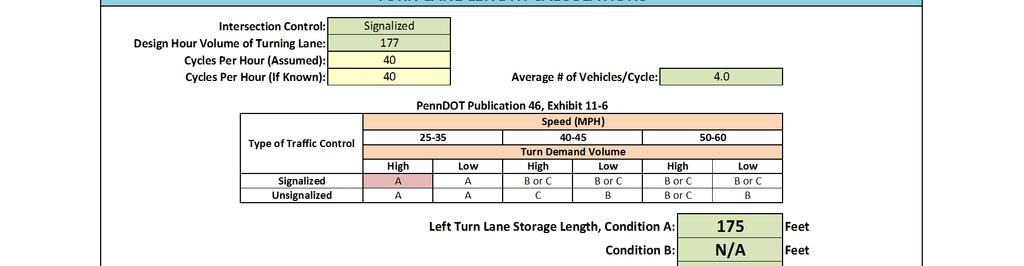
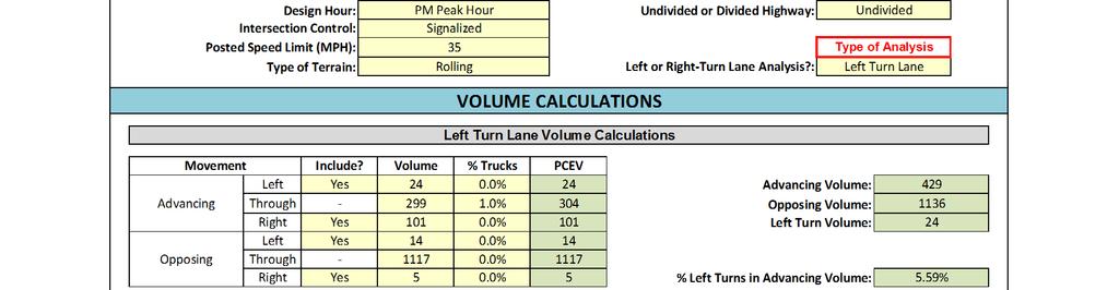
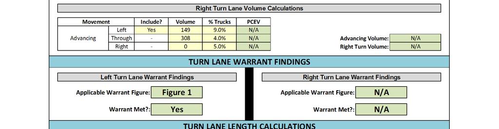
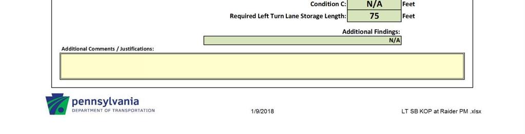
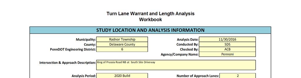
9 Traffic Signal Design Report King of Prussia Road & Raider Road UPHS154 Traffic Signal Traffic Signal Warrant Analysis Signal warrant analyses were conducted for the intersections of King of Prussia Road and Raider Road/Site Driveway using the warrants set forth in FHWA s Manual on Uniform Traffic Control Devices (MUTCD), 29 Edition. Based on the MUTCD requirements for intersections warranting a signal, MUTCD Warrants 2 and 3 are applicable to the intersections King of Prussia Road and Raider Road/Site Driveway. King of Prussia Road and Raider Road/Site Driveway Warrant 2 Four Hour Vehicular Volume is met if four plotted points representing vehicles per hour on the major and minor street approaches fall above the appropriate curve on Figure 4C-1 of the MUTCD. For the intersection of King of Prussia Road and Raider Road/Site Driveway, an Urban 2 or more major lanes and 1 minor lane curve is used for the Warrant 2 analysis. As illustrated on Table 4C-1 provided in APPENDIX D, four of the plotted points exceed the four-hour warrant curve using the combination of manual count data and trip generation data. Therefore, for the purposes of this analysis, Warrant 2 is satisfied. Warrant 3 Peak Hour Vehicular Volume is met if four plotted points representing vehicles per hour on the major and minor street approaches fall above the appropriate curve on Figure 4C-3 of the MUTCD. For the intersection of King of Prussia Road and Raider Road/Site Driveway, an Urban 2 major lanes and 1 minor lane curve is used for the Warrant 3 analysis. As illustrated on Table 4C-3 provided in APPENDIX D, four of the plotted points exceed the peak hour warrant curve using the combination of manual count data and trip generation data. Therefore, for the purposes of this analysis, Warrant 3 is satisfied. Turn Lane Warrant Analysis An analysis was conducted at King of Prussia Road and Raider Road/Site Driveway to determine whether a left or right turn lanes on King of Prussia Road are warranted in accordance with PennDOT Publication 46. Based on the standard worksheets in the Chapter 11 Appendix of PennDOT Publication 46, the following turn lanes at site driveways are warranted during both the AM and PM peak periods: Left turn lane from SB King of Prussia Road into the Site Driveway. Left turn lane from NB King of Prussia Road into Raider Road. Right turn lane from NB King of Prussia Road into the Site Driveway. The detailed turn lane warrant analyses are provided in APPENDIX E. Timing & Phasing Change & Clearance Intervals Vehicular and pedestrian clearances were calculated for the proposed signal at the full access driveway based on PennDOT policies. The results of the calculations are provided in APPENDIX F. Left Turn Phasing Left turn signalization warrants were performed for the northbound and southbound left turns from King of Prussia Road at Raider Road. The results indicate that neither the northbound or southbound left turns meet warrants for protected/permitted or protected/prohibited phasing based on calculated conflict. However, there is insufficient sight distance for permitted left turns into the site from the southbound left turn lane. The southbound left turn into the proposed site will be provided a protected/prohibited left turn phase. The northbound left turn movement will utilize the same protected left turn phase and be permitted during the King of Prussia through phase. The warrant worksheet and sight distance evaluation are provided in APPENDIX G. Traffic Signal Phasing The traffic signal will operate as a fully actuated traffic signal with a 9 second background and be coordinated with the existing signal system north of the site on King of Prussia Road. The full details on phases and timings are provided on the proposed signal plans provided in APPENDIX H and the 22 Opening Year and 225 Horizon Year Synchro analyses in APPENDIX I. 7
10 Traffic Signal Design Report King of Prussia Road & Raider Road UPHS154 APPENDICES KING OF PRUSSIA ROAD & RAIDER ROAD RADNOR TOWNSHIP PENNSYLVANIA APPENDIX A TRAFFIC COUNT DATA
11 Study Name King of Prussia Rd/Septa Driveway Start Date 4/27/216 Start Time 7: AM Northbound Left from Major Critical Gaps (4.1 sec) Follow-up Gaps (2.2 sec) Total Gaps 7: AM :15 AM :3 AM :45 AM : AM :15 AM :3 AM :45 AM : AM 4: PM :15 PM :3 PM :45 PM : PM :15 PM :3 PM :45 PM : PM AM Peak PM Peak
12 Study Name King of Prussia Rd/Septa Driveway Start Date 4/27/216 Start Time 7: AM Southbound Left from Major Critical Gaps (4.1 sec) Follow-up Gaps (2.2 sec) Total Gaps 7: AM :15 AM :3 AM :45 AM : AM :15 AM :3 AM :45 AM : AM 4: PM :15 PM :3 PM :45 PM : PM :15 PM :3 PM :45 PM : PM AM Peak PM Peak
13 Study Name King of Prussia Rd/Septa Driveway Start Date 4/27/216 Start Time 7: AM Eastbound Right from Minor Critical Gaps (6.2 sec) Follow-up Gaps (3.3 sec) Total Gaps 7: AM :15 AM :3 AM :45 AM : AM :15 AM :3 AM :45 AM : AM 4: PM :15 PM :3 PM :45 PM : PM :15 PM :3 PM :45 PM : PM AM Peak PM Peak
14 Study Name King of Prussia Rd/Septa Driveway Start Date 4/27/216 Start Time 7: AM Westbound Right from Minor Critical Gaps (6.2 sec) Follow-up Gaps (3.3 sec) Total Gaps 7: AM :15 AM :3 AM :45 AM : AM :15 AM :3 AM :45 AM : AM 4: PM :15 PM :3 PM :45 PM : PM :15 PM :3 PM :45 PM : PM AM Peak PM Peak
15 Study Name King of Prussia Rd/Septa Driveway Start Date 4/27/216 Start Time 7: AM Through Traffic on Minor Critical Gaps (6.5 sec) Follow-up Gaps (4. sec) Total Gaps 7: AM :15 AM :3 AM :45 AM : AM :15 AM :3 AM :45 AM : AM 4: PM :15 PM :3 PM :45 PM : PM :15 PM :3 PM :45 PM : PM AM Peak PM Peak
16 Study Name King of Prussia Rd/Septa Driveway Start Date 4/27/216 Start Time 7: AM Left from Minor Critical Gaps (7.1 sec) Follow-up Gaps (3.5 sec) Total Gaps 7: AM :15 AM :3 AM :45 AM : AM :15 AM :3 AM :45 AM : AM 4: PM :15 PM :3 PM :45 PM : PM :15 PM :3 PM :45 PM : PM AM Peak PM Peak
17 Study Name King of Prussia Rd South Driveway Gap Start Date 4/27/216 Start Time 7: AM Northbound Left from Major Critical Gaps (4.1 sec) Follow-up Gaps (2.2 sec) Total Gaps 7: AM :15 AM :3 AM :45 AM : AM :15 AM :3 AM :45 AM : AM 4: PM :15 PM :3 PM :45 PM : PM :15 PM :3 PM :45 PM : PM AM Peak PM Peak
18 Study Name King of Prussia Rd South Driveway Gap Start Date 4/27/216 Start Time 7: AM Southbound Left from Major Critical Gaps (4.1 sec) Follow-up Gaps (2.2 sec) Total Gaps 7: AM :15 AM :3 AM :45 AM : AM :15 AM :3 AM :45 AM : AM 4: PM :15 PM :3 PM :45 PM : PM :15 PM :3 PM :45 PM : PM AM Peak PM Peak
19 Study Name King of Prussia Rd South Driveway Gap Start Date 4/27/216 Start Time 7: AM Eastbound Right from Minor Critical Gaps (6.2 sec) Follow-up Gaps (3.3 sec) Total Gaps 7: AM :15 AM :3 AM :45 AM : AM :15 AM :3 AM :45 AM : AM 4: PM :15 PM :3 PM :45 PM : PM :15 PM :3 PM :45 PM : PM AM Peak PM Peak
20 Study Name King of Prussia Rd South Driveway Gap Start Date 4/27/216 Start Time 7: AM Westbound Right from Minor Critical Gaps (6.2 sec) Follow-up Gaps (3.3 sec) Total Gaps 7: AM :15 AM :3 AM :45 AM : AM :15 AM :3 AM :45 AM : AM 4: PM :15 PM :3 PM :45 PM : PM :15 PM :3 PM :45 PM : PM AM Peak PM Peak
21 Study Name King of Prussia Rd South Driveway Gap Start Date 4/27/216 Start Time 7: AM Through Traffic on Minor Critical Gaps (6.5 sec) Follow-up Gaps (4. sec) Total Gaps 7: AM :15 AM :3 AM :45 AM : AM :15 AM :3 AM :45 AM : AM 4: PM :15 PM :3 PM :45 PM : PM :15 PM :3 PM :45 PM : PM AM Peak PM Peak
22 Study Name King of Prussia Rd South Driveway Gap Start Date 4/27/216 Start Time 7: AM Left from Minor Critical Gaps (7.1 sec) Follow-up Gaps (3.5 sec) Total Gaps 7: AM :15 AM :3 AM :45 AM : AM :15 AM :3 AM :45 AM : AM 4: PM :15 PM :3 PM :45 PM : PM :15 PM :3 PM :45 PM : PM AM Peak PM Peak
23 Montgomery County, PA King of Prussia Rd/Driveway Thursday, September 8, 216 Location: , Baker Rd Coatesville, Pennsylvania, United States Serving Transportation Professionals Since 1995 Count Name: King of Prussia Rd / Driveway Site Code: Start Date: 9/8/216 Page No: 1 Start Time Turning Movement Data King of Prussia Rd Driveway King of Prussia Rd Southbound Westbound Northbound Thru Left U-Turn Peds App. Total Right Left U-Turn Peds App. Total Right Thru U-Turn Peds 7: AM :15 AM :3 AM :45 AM Hourly Total : AM :15 AM :3 AM :45 AM Hourly Total : AM *** BREAK *** Hourly Total 4: PM :15 PM :3 PM :45 PM Hourly Total : PM :15 PM :3 PM :45 PM Hourly Total : PM Grand Total Approach % Total % Lights % Lights Buses % Buses Trucks % Trucks Bicycles on Crosswalk % Bicycles on Crosswalk Pedestrians % Pedestrians App. Total Int. Total
24 Montgomery County, PA King of Prussia Rd/Driveway Thursday, September 8, 216 Location: , Baker Rd Coatesville, Pennsylvania, United States Serving Transportation Professionals Since 1995 Count Name: King of Prussia Rd / Driveway Site Code: Start Date: 9/8/216 Page No: 2 King of Prussia Rd [SB] T L U P Out R 9/8/216 7: AM Ending At 9/8/216 6:15 PM Lights Buses Trucks Bicycles on Crosswalk Pedestrians L U P In Total Driveway [WB] U T R P King of Prussia Rd [NB] Turning Movement Data Plot
25 Montgomery County, PA King of Prussia Rd/Driveway Thursday, September 8, 216 Location: , Baker Rd Coatesville, Pennsylvania, United States Serving Transportation Professionals Since 1995 Count Name: King of Prussia Rd / Driveway Site Code: Start Date: 9/8/216 Page No: 3 Start Time Turning Movement Peak Hour Data (7:15 AM) King of Prussia Rd Driveway King of Prussia Rd Southbound Westbound Northbound Thru Left U-Turn Peds App. Total Right Left U-Turn Peds App. Total Right Thru U-Turn Peds 7:15 AM :3 AM :45 AM : AM Total Approach % Total % PHF Lights % Lights Buses % Buses Trucks % Trucks Bicycles on Crosswalk % Bicycles on Crosswalk Pedestrians % Pedestrians App. Total Int. Total
26 Montgomery County, PA King of Prussia Rd/Driveway Thursday, September 8, 216 Location: , Baker Rd Coatesville, Pennsylvania, United States Serving Transportation Professionals Since 1995 Count Name: King of Prussia Rd / Driveway Site Code: Start Date: 9/8/216 Page No: 4 King of Prussia Rd [SB] T L U P Peak Hour Data 9/8/216 7:15 AM Ending At 9/8/216 8:15 AM Lights Buses Trucks Bicycles on Crosswalk Pedestrians R L U P Out In Total Driveway [WB] U T R P King of Prussia Rd [NB] Turning Movement Peak Hour Data Plot (7:15 AM)
27 Montgomery County, PA King of Prussia Rd/Driveway Thursday, September 8, 216 Location: , Baker Rd Coatesville, Pennsylvania, United States Serving Transportation Professionals Since 1995 Count Name: King of Prussia Rd / Driveway Site Code: Start Date: 9/8/216 Page No: 5 Start Time Turning Movement Peak Hour Data (5: PM) King of Prussia Rd Driveway King of Prussia Rd Southbound Westbound Northbound Thru Left U-Turn Peds App. Total Right Left U-Turn Peds App. Total Right Thru U-Turn Peds 5: PM :15 PM :3 PM :45 PM Total Approach % Total % PHF Lights % Lights Buses % Buses Trucks % Trucks Bicycles on Crosswalk % Bicycles on Crosswalk Pedestrians % Pedestrians App. Total Int. Total
28 Montgomery County, PA King of Prussia Rd/Driveway Thursday, September 8, 216 Location: , Baker Rd Coatesville, Pennsylvania, United States Serving Transportation Professionals Since 1995 Count Name: King of Prussia Rd / Driveway Site Code: Start Date: 9/8/216 Page No: 6 King of Prussia Rd [SB] T L U P Peak Hour Data 9/8/216 5: PM Ending At 9/8/216 6: PM Lights Buses Trucks Bicycles on Crosswalk Pedestrians R L U P Out In Total Driveway [WB] U T R P King of Prussia Rd [NB] Turning Movement Peak Hour Data Plot (5: PM)
29 Montgomery County, PA King of Prussia Rd Northern Driveway Wednesday, April 27, 216 Location: , Baker Rd Coatesville, Pennsylvania, United States Serving Transportation Professionals Since 1995 Count Name: King of Prussia Rd/North Driveway Site Code: Start Date: 4/27/216 Page No: 1 Combined Direction Start Time Total 7: AM :15 AM :3 AM :45 AM : AM :15 AM :3 AM :45 AM : AM 4: PM :15 PM :3 PM :45 PM : PM :15 PM :3 PM :45 PM : PM Total Total %
30 Montgomery County, PA King of Prussia Rd Northern Driveway Wednesday, April 27, 216 Location: , Baker Rd Coatesville, Pennsylvania, United States Serving Transportation Professionals Since 1995 Count Name: King of Prussia Rd/North Driveway Site Code: Start Date: 4/27/216 Page No: 2 Southbound (Southbound) Start Time Total 7: AM :15 AM :3 AM :45 AM : AM :15 AM :3 AM :45 AM : AM 4: PM :15 PM :3 PM :45 PM : PM :15 PM :3 PM :45 PM : PM Total Total %
31 Montgomery County, PA King of Prussia Rd Northern Driveway Wednesday, April 27, 216 Location: , Baker Rd Coatesville, Pennsylvania, United States Serving Transportation Professionals Since 1995 Count Name: King of Prussia Rd/North Driveway Site Code: Start Date: 4/27/216 Page No: 3 Northbound (Northbound) Start Time Total 7: AM :15 AM :3 AM :45 AM : AM :15 AM :3 AM :45 AM : AM 4: PM :15 PM :3 PM :45 PM : PM :15 PM :3 PM :45 PM : PM Total Total %

32 Montgomery County, PA King of Prussia Rd Northern Driveway Wednesday, April 27, 216 Location: , Baker Rd Coatesville, Pennsylvania, United States Serving Transportation Professionals Since 1995 Count Name: King of Prussia Rd/North Driveway Site Code: Start Date: 4/27/216 Page No: 4
33 Montgomery County, PA King of Prussia Rd South Driveway Wednesday, April 27, 216 Location: , Baker Rd Coatesville, Pennsylvania, United States Serving Transportation Professionals Since 1995 Count Name: King of Prussia Rd South Driveway Gap Site Code: Start Date: 4/27/216 Page No: 1 Combined Direction Start Time Total 7: AM :15 AM :3 AM :45 AM : AM :15 AM :3 AM :45 AM : AM 4: PM :15 PM :3 PM :45 PM : PM :15 PM :3 PM :45 PM : PM Total Total %
34 Montgomery County, PA King of Prussia Rd South Driveway Wednesday, April 27, 216 Location: , Baker Rd Coatesville, Pennsylvania, United States Serving Transportation Professionals Since 1995 Count Name: King of Prussia Rd South Driveway Gap Site Code: Start Date: 4/27/216 Page No: 2 Southbound (Southbound) Start Time Total 7: AM :15 AM :3 AM :45 AM : AM :15 AM :3 AM :45 AM : AM 4: PM :15 PM :3 PM :45 PM : PM :15 PM :3 PM :45 PM : PM Total Total %
35 Montgomery County, PA King of Prussia Rd South Driveway Wednesday, April 27, 216 Location: , Baker Rd Coatesville, Pennsylvania, United States Serving Transportation Professionals Since 1995 Count Name: King of Prussia Rd South Driveway Gap Site Code: Start Date: 4/27/216 Page No: 3 Northbound (Northbound) Start Time Total 7: AM :15 AM :3 AM :45 AM : AM :15 AM :3 AM :45 AM : AM 4: PM :15 PM :3 PM :45 PM : PM :15 PM :3 PM :45 PM : PM Total Total %
36 Montgomery County, PA King of Prussia Rd South Driveway Wednesday, April 27, 216 Location: , Baker Rd Coatesville, Pennsylvania, United States Serving Transportation Professionals Since 1995 Count Name: King of Prussia Rd South Driveway Gap Site Code: Start Date: 4/27/216 Page No: 4
37 Montgomery County, PA Radnor-Chester Rd-King of Prussia Rd Wednesday, April 27, 216 Location: , Baker Rd Coatesville, Pennsylvania, United States Serving Transportation Professionals Since 1995 Count Name: Radnor Chester Rd/King of Prussia Rd Site Code: Start Date: 4/27/216 Page No: 1 Start Time Righ t Turning Movement Data Parking Lot Entrance King of Prussia Road Radnor Chester Road King of Prussia Road Southbound Westbound Northbound Eastbound Righ t on Red Thru Left U- Turn Ped s App. Total Righ t Righ t on Red Thru Left U- Turn Ped s App. Total Righ t Righ t on Red Thru Left U- Turn 7: AM :15 AM :3 AM :45 AM Hourly Total : AM :15 AM :3 AM :45 AM Hourly Total : AM *** BREAK *** Hourly Total : PM :15 PM :3 PM :45 PM Hourly Total : PM :15 PM :3 PM :45 PM Hourly Total : PM Grand Total Approach % Total % Lights % Lights Other Vehicles % Other Vehicles Bicycles on Crosswalk % Bicycles on Crosswalk Pedestrian s % Pedestrian s Ped s App. Total Righ t Thru Left U- Turn Ped s App. Total Int. Total
38 Montgomery County, PA Radnor-Chester Rd-King of Prussia Rd Wednesday, April 27, 216 Location: , Baker Rd Coatesville, Pennsylvania, United States Serving Transportation Professionals Since 1995 Count Name: Radnor Chester Rd/King of Prussia Rd Site Code: Start Date: 4/27/216 Page No: 2 Parking Lot Entrance [SB] R T L U P U R King of Prussia Road [EB] Total In Out L T R 4/27/216 7: AM Ending At 4/27/216 6:15 PM Lights Other Vehicles Bicycles on Crosswalk Pedestrians T L U Out In Total King of Prussia Road [WB] 1 1 P P U L T R P Radnor Chester Road Turning Movement Data Plot
39 Montgomery County, PA Radnor-Chester Rd-King of Prussia Rd Wednesday, April 27, 216 Location: , Baker Rd Coatesville, Pennsylvania, United States Serving Transportation Professionals Since 1995 Count Name: Radnor Chester Rd/King of Prussia Rd Site Code: Start Date: 4/27/216 Page No: 3 Start Time Righ t Turning Movement Peak Hour Data (7:3 AM) Parking Lot Entrance King of Prussia Road Radnor Chester Road King of Prussia Road Southbound Westbound Northbound Eastbound Righ t on Red Thru Left U- Turn Ped s App. Total Righ t Righ t on Red Thru Left U- Turn Ped s App. Total Righ t Righ t on Red Thru Left U- Turn 7:3 AM :45 AM : AM :15 AM Total Approach % Total % PHF Lights % Lights Other Vehicles % Other Vehicles Bicycles on Crosswalk % Bicycles on Crosswalk Pedestrian s % Pedestrian s Ped s App. Total Righ t Thru Left U- Turn Ped s App. Total Int. Total
40 Montgomery County, PA Radnor-Chester Rd-King of Prussia Rd Wednesday, April 27, 216 Location: , Baker Rd Coatesville, Pennsylvania, United States Serving Transportation Professionals Since 1995 Count Name: Radnor Chester Rd/King of Prussia Rd Site Code: Start Date: 4/27/216 Page No: 4 Parking Lot Entrance [SB] R T L U P U R King of Prussia Road [EB] Total In Out L T R Peak Hour Data 4/27/216 7:3 AM Ending At 4/27/216 8:3 AM Lights Other Vehicles Bicycles on Crosswalk Pedestrians T L U Out In Total King of Prussia Road [WB] P P U L T R P Radnor Chester Road Turning Movement Peak Hour Data Plot (7:3 AM)
41 Montgomery County, PA Radnor-Chester Rd-King of Prussia Rd Wednesday, April 27, 216 Location: , Baker Rd Coatesville, Pennsylvania, United States Serving Transportation Professionals Since 1995 Count Name: Radnor Chester Rd/King of Prussia Rd Site Code: Start Date: 4/27/216 Page No: 5 Start Time Righ t Turning Movement Peak Hour Data (4:45 PM) Parking Lot Entrance King of Prussia Road Radnor Chester Road King of Prussia Road Southbound Westbound Northbound Eastbound Righ t on Red Thru Left U- Turn Ped s App. Total Righ t Righ t on Red Thru Left U- Turn Ped s App. Total Righ t Righ t on Red Thru Left U- Turn 4:45 PM : PM :15 PM :3 PM Total Approach % Total % PHF Lights % Lights Other Vehicles % Other Vehicles Bicycles on Crosswalk % Bicycles on Crosswalk Pedestrian s % Pedestrian s Ped s App. Total Righ t Thru Left U- Turn Ped s App. Total Int. Total
42 Montgomery County, PA Radnor-Chester Rd-King of Prussia Rd Wednesday, April 27, 216 Location: , Baker Rd Coatesville, Pennsylvania, United States Serving Transportation Professionals Since 1995 Count Name: Radnor Chester Rd/King of Prussia Rd Site Code: Start Date: 4/27/216 Page No: 6 Parking Lot Entrance [SB] R T L U P U 1 1 R King of Prussia Road [EB] Total In Out T R 8 8 L Peak Hour Data 4/27/216 4:45 PM Ending At 4/27/216 5:45 PM Lights Other Vehicles Bicycles on Crosswalk Pedestrians T L U Out In Total King of Prussia Road [WB] 1 1 P P U L T R P Radnor Chester Road Turning Movement Peak Hour Data Plot (4:45 PM)
43 Montgomery County, PA Radnor-Chester Rd/Lancaster Ave Wednesday, April 27, 216 Location: , Baker Rd Coatesville, Pennsylvania, United States Serving Transportation Professionals Since 1995 Count Name: Radnor Chester Rd/Lancaster Ave Site Code: Start Date: 4/27/216 Page No: 1 Start Time Righ t Turning Movement Data Radnor Chester Road Lancaster Avenue Radnor Chester Road Lancaster Avenue Southbound Westbound Northbound Eastbound Righ t on Red Thru Left U- Turn Ped s App. Tota l Righ t Righ t on Red Thru Left U- Turn Ped s App. Tota l Righ t Righ t on Red Thru Left U- Turn Ped s App. Tota l Righ t Righ t on Red Thru Left U- Turn 7: AM :15 AM :3 AM :45 AM Hourly Total : AM :15 AM :3 AM :45 AM Hourly Total : AM *** BREAK *** Hourly Total : PM :15 PM :3 PM :45 PM Hourly Total : PM :15 PM :3 PM :45 PM Hourly Total : PM Grand Total Approach % Total % Lights % Lights Other Vehicles % Other Vehicles Bicycles on Crosswalk % Bicycles on Crosswalk Pedestrian s % Pedestrian s Ped s App. Tota l Int. Tota l
44 Montgomery County, PA Radnor-Chester Rd/Lancaster Ave Wednesday, April 27, 216 Location: , Baker Rd Coatesville, Pennsylvania, United States Serving Transportation Professionals Since 1995 Count Name: Radnor Chester Rd/Lancaster Ave Site Code: Start Date: 4/27/216 Page No: 2 Radnor Chester Road R T L U P 2 2 U R Lancaster Avenue [EB] Total In Out L T R 4/27/216 7: AM Ending At 4/27/216 6:15 PM Lights Other Vehicles Bicycles on Crosswalk Pedestrians T L U Out In Total Lancaster Avenue [WB] 1 1 P 1 1 P U L T R P Radnor Chester Road Turning Movement Data Plot
45 Montgomery County, PA Radnor-Chester Rd/Lancaster Ave Wednesday, April 27, 216 Location: , Baker Rd Coatesville, Pennsylvania, United States Serving Transportation Professionals Since 1995 Count Name: Radnor Chester Rd/Lancaster Ave Site Code: Start Date: 4/27/216 Page No: 3 Start Time Righ t Turning Movement Peak Hour Data (7:3 AM) Radnor Chester Road Lancaster Avenue Radnor Chester Road Lancaster Avenue Southbound Westbound Northbound Eastbound Righ t on Red Thru Left U- Turn Ped s App. Tota l Righ t Righ t on Red Thru Left U- Turn Ped s App. Tota l Righ t Righ t on Red Thru Left U- Turn Ped s App. Tota l Righ t Righ t on Red Thru Left U- Turn 7:3 AM :45 AM : AM :15 AM Total Approach % Total % PHF Lights % Lights Other Vehicles % Other Vehicles Bicycles on Crosswalk % Bicycles on Crosswalk Pedestrian s % Pedestrian s Ped s App. Tota l Int. Tota l
46 Montgomery County, PA Radnor-Chester Rd/Lancaster Ave Wednesday, April 27, 216 Location: , Baker Rd Coatesville, Pennsylvania, United States Serving Transportation Professionals Since 1995 Count Name: Radnor Chester Rd/Lancaster Ave Site Code: Start Date: 4/27/216 Page No: 4 Radnor Chester Road R T L U P U R Lancaster Avenue [EB] Total In Out L T R Peak Hour Data 4/27/216 7:3 AM Ending At 4/27/216 8:3 AM Lights Other Vehicles Bicycles on Crosswalk Pedestrians T L U Out In Total Lancaster Avenue [WB] P P U L T R P Radnor Chester Road Turning Movement Peak Hour Data Plot (7:3 AM)
47 Montgomery County, PA Radnor-Chester Rd/Lancaster Ave Wednesday, April 27, 216 Location: , Baker Rd Coatesville, Pennsylvania, United States Serving Transportation Professionals Since 1995 Count Name: Radnor Chester Rd/Lancaster Ave Site Code: Start Date: 4/27/216 Page No: 5 Start Time Righ t Turning Movement Peak Hour Data (4:45 PM) Radnor Chester Road Lancaster Avenue Radnor Chester Road Lancaster Avenue Southbound Westbound Northbound Eastbound Righ t on Red Thru Left U- Turn Ped s App. Tota l Righ t Righ t on Red Thru Left U- Turn Ped s App. Tota l Righ t Righ t on Red Thru Left U- Turn Ped s App. Tota l Righ t Righ t on Red Thru Left U- Turn 4:45 PM : PM :15 PM :3 PM Total Approach % Total % PHF Lights % Lights Other Vehicles % Other Vehicles Bicycles on Crosswalk % Bicycles on Crosswalk Pedestrian s % Pedestrian s Ped s App. Tota l Int. Tota l
48 Montgomery County, PA Radnor-Chester Rd/Lancaster Ave Wednesday, April 27, 216 Location: , Baker Rd Coatesville, Pennsylvania, United States Serving Transportation Professionals Since 1995 Count Name: Radnor Chester Rd/Lancaster Ave Site Code: Start Date: 4/27/216 Page No: 6 Radnor Chester Road R T L U P 1 1 U R Lancaster Avenue [EB] Total In Out L T R Peak Hour Data 4/27/216 4:45 PM Ending At 4/27/216 5:45 PM Lights Other Vehicles Bicycles on Crosswalk Pedestrians T L U Out In Total Lancaster Avenue [WB] P 3 3 P U L T R P Radnor Chester Road Turning Movement Peak Hour Data Plot (4:45 PM)
49 Pennoni Associates Location: Montgomery County, PA Intersection: K of P Rd/Raider Rd Date: Wednesday, November 18, 215 Counter: PB File Name : SS Site Code : Start Date : 11/18/215 Page No : 1 Groups Printed- Cars - Heavy Vehicles King of Prussia Road Northbound King of Prussia Road Southbound Raider Road Eastbound Driveway Westbound Start Time Left Thru Right Peds App. Total Left Thru Right Peds App. Total Left Thru Right Peds App. Total Left Thru Right Peds App. Total Int. Total 7: AM :15 AM :3 AM :45 AM Total : AM :15 AM :3 AM :45 AM Total : PM :15 PM :3 PM :45 PM Total : PM :15 PM :3 PM :45 PM Total Grand Total Apprch % Total % Cars % Cars Heavy Vehicles % Heavy Vehicles
50 Pennoni Associates Location: Montgomery County, PA Intersection: K of P Rd/Raider Rd Date: Wednesday, November 18, 215 Counter: PB File Name : SS Site Code : Start Date : 11/18/215 Page No : 2 King of Prussia Road Right Thru Left Peds Raider Road Left Thru Right 2 Peds North 11/18/215 7: AM 11/18/215 5:45 PM Cars Heavy Vehicles Right Thru Left Peds Driveway Left Thru Right Peds King of Prussia Road
51 Pennoni Associates Location: Montgomery County, PA Intersection: K of P Rd/Raider Rd Date: Wednesday, November 18, 215 Counter: PB File Name : SS Site Code : Start Date : 11/18/215 Page No : 3 King of Prussia Road Northbound King of Prussia Road Southbound Raider Road Eastbound Driveway Westbound Start Time Left Thru Right Peds App. Total Left Thru Right Peds App. Total Left Thru Right Peds App. Total Left Thru Right Peds App. Total Int. Total Peak Hour Analysis From 7:15 AM to 8: AM - Peak 1 of 1 Peak Hour for Entire Intersection Begins at 7:15 AM 7:15 AM :3 AM :45 AM : AM Total Volume % App. Total PHF Cars % Cars Heavy Vehicles % Heavy Vehicles King of Prussia Road Right Thru Left Peds Peak Hour Data Total Raider Road Out In Left Thru Right 8 8 Peds North Peak Hour Begins at 7:15 AM Cars Heavy Vehicles Right Thru Left Peds Driveway Left Thru Right Peds King of Prussia Road
52 Pennoni Associates Location: Montgomery County, PA Intersection: K of P Rd/Raider Rd Date: Wednesday, November 18, 215 Counter: PB File Name : SS Site Code : Start Date : 11/18/215 Page No : 4 King of Prussia Road Northbound King of Prussia Road Southbound Raider Road Eastbound Driveway Westbound Start Time Left Thru Right Peds App. Total Left Thru Right Peds App. Total Left Thru Right Peds App. Total Left Thru Right Peds App. Total Int. Total Peak Hour Analysis From 5: PM to 5:45 PM - Peak 1 of 1 Peak Hour for Entire Intersection Begins at 5: PM 5: PM :15 PM :3 PM :45 PM Total Volume % App. Total PHF Cars % Cars Heavy Vehicles % Heavy Vehicles King of Prussia Road Right Thru Left Peds Peak Hour Data Total Raider Road Out In Left Thru 4 4 Right 3 3 Peds North Peak Hour Begins at 5: PM Cars Heavy Vehicles Right Thru Left Peds Driveway Left Thru Right Peds King of Prussia Road
53 Pennoni Associates Location: Montgomery County, PA Intersection: K of P Rd/Matson Ford Rd Date: Wednesday, November 18, 215 Tech: RZ File Name : SS Site Code : Start Date : 11/18/215 Page No : 1 Groups Printed- Cars - Heavy Vehicles - RTOR KING OF PRUSSIA RD Northbound KING OF PRUSSIA RD Southbound Parking lot Dr. Eastbound MATSON FORD RD Westbound Start Time Left Thru Right Peds App. Total Left Thru Right Peds App. Total Left Thru Right Peds App. Total Left Thru Right Peds App. Total Int. Total 7: AM :15 AM :3 AM :45 AM Total : AM :15 AM :3 AM :45 AM Total *** BREAK *** 4: PM :15 PM :3 PM :45 PM Total : PM :15 PM :3 PM :45 PM Total Grand Total Apprch % Total % Cars % Cars Heavy Vehicles % Heavy Vehicles RTOR % RTOR
54 Pennoni Associates Location: Montgomery County, PA Intersection: K of P Rd/Matson Ford Rd Date: Wednesday, November 18, 215 Tech: RZ File Name : SS Site Code : Start Date : 11/18/215 Page No : 2 KING OF PRUSSIA RD Right Thru Left Peds Parking lot Dr Left 9 9 Thru Right Peds 2 2 North 11/18/215 7: AM 11/18/215 5:45 PM Cars Heavy Vehicles RTOR Right Thru Left Peds MATSON FORD RD Left Thru Right Peds KING OF PRUSSIA RD
55 Pennoni Associates Location: Montgomery County, PA Intersection: K of P Rd/Matson Ford Rd Date: Wednesday, November 18, 215 Tech: RZ File Name : SS Site Code : Start Date : 11/18/215 Page No : 3 KING OF PRUSSIA RD Northbound KING OF PRUSSIA RD Southbound Parking lot Dr. Eastbound MATSON FORD RD Westbound Start Time Left Thru Right Peds App. Total Left Thru Right Peds App. Total Left Thru Right Peds App. Total Left Thru Right Peds App. Total Int. Total Peak Hour Analysis From 7:15 AM to 8: AM - Peak 1 of 1 Peak Hour for Entire Intersection Begins at 7:15 AM 7:15 AM :3 AM :45 AM : AM Total Volume % App. Total PHF Cars % Cars Heavy Vehicles % Heavy Vehicles RTOR % RTOR
56 Pennoni Associates Location: Montgomery County, PA Intersection: K of P Rd/Matson Ford Rd Date: Wednesday, November 18, 215 Tech: RZ File Name : SS Site Code : Start Date : 11/18/215 Page No : 4 KING OF PRUSSIA RD Northbound KING OF PRUSSIA RD Southbound Parking lot Dr. Eastbound MATSON FORD RD Westbound Start Time Left Thru Right Peds App. Total Left Thru Right Peds App. Total Left Thru Right Peds App. Total Left Thru Right Peds App. Total Int. Total Peak Hour Analysis From 5: PM to 5:45 PM - Peak 1 of 1 Peak Hour for Entire Intersection Begins at 5: PM 5: PM :15 PM :3 PM :45 PM Total Volume % App. Total PHF Cars % Cars Heavy Vehicles % Heavy Vehicles.2.1. RTOR % RTOR KING OF PRUSSIA RD Right Thru Left Peds Peak Hour Data Parking lot Dr Left 4 4 Thru 9 9 Right 2 2 Peds North Peak Hour Begins at 5: PM Cars Heavy Vehicles RTOR Right Thru Left Peds MATSON FORD RD Left 7 7 Thru Right Peds KING OF PRUSSIA RD
57 Pennoni Associates Location: Montgomery County, PA Intersection: I476 NB Ramp/Route 3 Date: Wednesday, November 18, 215 Counter: ET/JT File Name : SS Site Code : Start Date : 11/18/215 Page No : 1 Groups Printed- Cars - Heavy Vehicles Hillside Circle Northbound I-476 NB on Ramp Southbound Route 3 Eastbound Route 3 Westbound Start Time Left Thru Right Peds App. Total Left Thru Right Peds App. Total Left Thru Right Peds App. Total Left Thru Right Peds App. Total Int. Total 7: AM :15 AM :3 AM :45 AM Total : AM :15 AM :3 AM :45 AM Total *** BREAK *** 4: PM :15 PM :3 PM :45 PM Total : PM :15 PM :3 PM :45 PM Total Grand Total Apprch % Total % Cars % Cars Heavy Vehicles % Heavy Vehicles
58 Pennoni Associates Location: Montgomery County, PA Intersection: I476 NB Ramp/Route 3 Date: Wednesday, November 18, 215 Counter: ET/JT File Name : SS Site Code : Start Date : 11/18/215 Page No : 2 I-476 NB on Ramp Right Thru Left Peds Route Left Thru 25 Right Peds North 11/18/215 7: AM 11/18/215 5:45 PM Cars Heavy Vehicles Right Thru Left Peds Route 3 Left Thru 4 4 Right 7 7 Peds Hillside Circle
59 Pennoni Associates Location: Montgomery County, PA Intersection: I476 NB Ramp/Route 3 Date: Wednesday, November 18, 215 Counter: ET/JT File Name : SS Site Code : Start Date : 11/18/215 Page No : 3 Hillside Circle Northbound I-476 NB on Ramp Southbound Route 3 Eastbound Route 3 Westbound Start Time Left Thru Right Peds App. Total Left Thru Right Peds App. Total Left Thru Right Peds App. Total Left Thru Right Peds App. Total Int. Total Peak Hour Analysis From 7:15 AM to 8: AM - Peak 1 of 1 Peak Hour for Entire Intersection Begins at 7:15 AM 7:15 AM :3 AM :45 AM : AM Total Volume % App. Total PHF I-476 NB on Ramp Right Thru Left 2 Peds Peak Hour Data Route Left 156 Thru 4 Right Peds North Peak Hour Begins at 7:15 AM Cars Heavy Vehicles Right Thru Left Peds Route 3 Left 6 Thru 2 Right 2 Peds Hillside Circle
60 Pennoni Associates Location: Montgomery County, PA Intersection: I476 NB Ramp/Route 3 Date: Wednesday, November 18, 215 Counter: ET/JT File Name : SS Site Code : Start Date : 11/18/215 Page No : 4 Hillside Circle Northbound I-476 NB on Ramp Southbound Route 3 Eastbound Route 3 Westbound Start Time Left Thru Right Peds App. Total Left Thru Right Peds App. Total Left Thru Right Peds App. Total Left Thru Right Peds App. Total Int. Total Peak Hour Analysis From 5: PM to 5:45 PM - Peak 1 of 1 Peak Hour for Entire Intersection Begins at 5: PM 5: PM 27 5:15 PM :3 PM :45 PM Total Volume % App. Total PHF I-476 NB on Ramp Right Thru Left 2 Peds Peak Hour Data Route Left 1647 Thru 14 Right Peds North Peak Hour Begins at 5: PM Cars Heavy Vehicles Right Thru Left Peds Route 3 Left 3 Thru 1 Right 2 Peds Hillside Circle
61 Pennoni Associates Location: Montgomery County, PA Intersection: K of P Rd/North Driveway Date: Wednesday, November 18, 215 Counter: ACB File Name : ss Site Code : Start Date : 11/18/215 Page No : 1 King of Prussia Road Northbound Groups Printed- Cars - Heavy Vehicles King of Prussia Road Southbound North Driveway Westbound Eastbo und Start Time Left Thru Right Peds App. Total Left Thru Right Peds App. Total App. Total Left Thru Right Peds App. Total Int. Total 7: AM :15 AM :3 AM :45 AM Total : AM :15 AM :3 AM :45 AM Total : PM :15 PM :3 PM :45 PM Total : PM :15 PM :3 PM :45 PM Total Grand Total Apprch % 1 1 Total % Cars % Cars Heavy Vehicles % Heavy Vehicles
62 Pennoni Associates Location: Montgomery County, PA Intersection: K of P Rd/North Driveway Date: Wednesday, November 18, 215 Counter: ACB File Name : ss Site Code : Start Date : 11/18/215 Page No : 2 King of Prussia Road Right Thru Left Peds North 11/18/215 7: AM 11/18/215 5:45 PM Cars Heavy Vehicles Right Thru Left Peds North Driveway Left Thru Right Peds King of Prussia Road
63 Pennoni Associates Location: Montgomery County, PA Intersection: K of P Rd/North Driveway Date: Wednesday, November 18, 215 Counter: ACB File Name : ss Site Code : Start Date : 11/18/215 Page No : 3 King of Prussia Road Northbound King of Prussia Road Southbound North Driveway Westbound Eastbo und Start Time Left Thru Right Peds App. Total Left Thru Right Peds App. Total App. Total Left Thru Right Peds App. Total Int. Total Peak Hour Analysis From 7:15 AM to 8: AM - Peak 1 of 1 Peak Hour for Entire Intersection Begins at 7:15 AM 7:15 AM :3 AM :45 AM : AM Total Volume % App. Total 1 1 PHF Cars % Cars Heavy Vehicles % Heavy Vehicles King of Prussia Road Right Thru Left Peds Peak Hour Data North Peak Hour Begins at 7:15 AM Cars Heavy Vehicles Right Thru Left Peds North Driveway Left Thru Right Peds King of Prussia Road
64 Pennoni Associates Location: Montgomery County, PA Intersection: K of P Rd/North Driveway Date: Wednesday, November 18, 215 Counter: ACB File Name : ss Site Code : Start Date : 11/18/215 Page No : 4 King of Prussia Road Northbound King of Prussia Road Southbound Eastbo und North Driveway Westbound Start Time Left Thru Righ Peds App. Total t Left Thru Right Peds App. Total App. Total Left Thru Right Peds App. Total Int. Total Peak Hour Analysis From 5: PM to 5:45 PM - Peak 1 of 1 Peak Hour for Entire Intersection Begins at 5: PM 5: PM :15 PM :3 PM :45 PM Total Volume % App. Total 1 1 PHF Cars % Cars Heavy Vehicles % Heavy Vehicles
65 Pennoni Associates Location: Montgomery County, PA South Driveway Date: Wednesday, November 18, 215 Counter: PG File Name : SS Site Code : Start Date : 11/18/215 Page No : 1 King of Prussia Road Northbound Groups Printed- Cars - Heavy Vehicles King of Prussia Road Southbound South Driveway Westbound Eastbo und Start Time Left Thru Right Peds App. Total Left Thru Right Peds App. Total App. Total Left Thru Right Peds App. Total Int. Total 7: AM :15 AM :3 AM :45 AM Total : AM :15 AM :3 AM :45 AM Total : PM :15 PM :3 PM :45 PM Total : PM :15 PM :3 PM :45 PM Total Grand Total Apprch % 1 1 Total % Cars % Cars Heavy Vehicles % Heavy Vehicles
66 Pennoni Associates Location: Montgomery County, PA South Driveway Date: Wednesday, November 18, 215 Counter: PG File Name : SS Site Code : Start Date : 11/18/215 Page No : 2 King of Prussia Road Right Thru Left Peds North 11/18/215 7: AM 11/18/215 5:45 PM Cars Heavy Vehicles Right Thru Left Peds South Driveway Left Thru Right Peds King of Prussia Road
67 Pennoni Associates Location: Montgomery County, PA South Driveway Date: Wednesday, November 18, 215 Counter: PG File Name : SS Site Code : Start Date : 11/18/215 Page No : 3 King of Prussia Road Northbound King of Prussia Road Southbound South Driveway Westbound Eastbo und Start Time Left Thru Right Peds App. Total Left Thru Right Peds App. Total App. Total Left Thru Right Peds App. Total Int. Total Peak Hour Analysis From 7:15 AM to 8: AM - Peak 1 of 1 Peak Hour for Entire Intersection Begins at 7:15 AM 7:15 AM :3 AM :45 AM : AM Total Volume % App. Total 1 1 PHF Cars % Cars Heavy Vehicles % Heavy Vehicles
68 Pennoni Associates Location: Montgomery County, PA South Driveway Date: Wednesday, November 18, 215 Counter: PG File Name : SS Site Code : Start Date : 11/18/215 Page No : 4 King of Prussia Road Northbound King of Prussia Road Southbound Eastbo und South Driveway Westbound Start Time Left Thru Righ t Peds App. Total Left Thru Right Peds App. Total App. Total Left Thru Right Peds App. Total Int. Total Peak Hour Analysis From 5: PM to 5:45 PM - Peak 1 of 1 Peak Hour for Entire Intersection Begins at 5: PM 5: PM :15 PM :3 PM :45 PM Total Volume % App. Total 1 1 PHF Cars % Cars Heavy Vehicles % Heavy Vehicles King of Prussia Road Right Thru Left Peds Peak Hour Data North Peak Hour Begins at 5: PM Cars Heavy Vehicles Right Thru Left Peds South Driveway Left Thru Right Peds King of Prussia Road
69 Pennoni Associates Location: Montgomery County, PA Intersection: 476NB Off/Rt. 3/ KOP Rd. Date: Tuesday, November 24, 215 Counter: ET / JT File Name : SS Site Code : Start Date : 11/24/215 Page No : 1 Groups Printed- Cars - Heavy Vehicles - RTOR I-476 NB Off Ramp Northbound King of Prussia Road Southbound Route 3 Eastbound Route 3 Westbound Start Time Left Thru Right Peds App. Total Left Thru Right Peds App. Total Left Thru Right Peds App. Total Left Thru Right Peds App. Total Int. Total 7: AM :15 AM :3 AM :45 AM Total : AM :15 AM :3 AM :45 AM Total *** BREAK *** 4: PM :15 PM :3 PM :45 PM Total : PM :15 PM :3 PM :45 PM Total Grand Total Cars % Cars Heavy Vehicles % Heavy Vehicles RTOR % RTOR
70 Pennoni Associates Location: Montgomery County, PA Intersection: 476NB Off/Rt. 3/ KOP Rd. Date: Tuesday, November 24, 215 Counter: ET / JT File Name : SS Site Code : Start Date : 11/24/215 Page No : 2 King of Prussia Road Right 7 7 Thru Left Peds Route Left Thru Right Peds North 11/24/215 7: AM 11/24/215 5:45 PM Cars Heavy Vehicles RTOR Right Thru Left Peds Route 3 Left Thru Right Peds I-476 NB Off Ramp
71 Pennoni Associates Location: Montgomery County, PA Intersection: 476NB Off/Rt. 3/ KOP Rd. Date: Tuesday, November 24, 215 Counter: ET / JT File Name : SS Site Code : Start Date : 11/24/215 Page No : 3 I-476 NB Off Ramp Northbound King of Prussia Road Southbound Route 3 Eastbound Route 3 Westbound Start Time Left Thru Right Peds App. Total Left Thru Right Peds App. Total Left Thru Right Peds App. Total Left Thru Right Peds App. Total Int. Total Peak Hour Analysis From 7:15 AM to 8: AM - Peak 1 of 1 Peak Hour for Entire Intersection Begins at 7:15 AM 7:15 AM :3 AM :45 AM : AM Total Volume % App. Total PHF Cars % Cars Heavy Vehicles % Heavy Vehicles RTOR % RTOR King of Prussia Road Right Thru Left Peds Peak Hour Data Route Left Thru Right Peds North Peak Hour Begins at 7:15 AM Cars Heavy Vehicles RTOR Right Thru Left Peds Route 3 Left Thru Right Peds I-476 NB Off Ramp
72 Pennoni Associates Location: Montgomery County, PA Intersection: 476NB Off/Rt. 3/ KOP Rd. Date: Tuesday, November 24, 215 Counter: ET / JT File Name : SS Site Code : Start Date : 11/24/215 Page No : 4 I-476 NB Off Ramp Northbound King of Prussia Road Southbound Route 3 Eastbound Route 3 Westbound Start Time Left Thru Right Peds App. Total Left Thru Right Peds App. Total Left Thru Right Peds App. Total Left Thru Right Peds App. Total Int. Total Peak Hour Analysis From 5: PM to 5:45 PM - Peak 1 of 1 Peak Hour for Entire Intersection Begins at 5: PM 5: PM :15 PM :3 PM :45 PM Total Volume % App. Total PHF Cars % Cars Heavy Vehicles % Heavy Vehicles RTOR % RTOR King of Prussia Road Right Thru Left Peds Peak Hour Data Route Left Thru Right Peds North Peak Hour Begins at 5: PM Cars Heavy Vehicles RTOR Right Thru Left Peds Route 3 Left Thru Right Peds I-476 NB Off Ramp
73 Montgomery County, PA US 3/I476 SB Ramps Thursday, September 8, 216 Location: , Baker Rd Coatesville, Pennsylvania, United States Serving Transportation Professionals Since 1995 Count Name: US 3 / I-476 Sb Ramps Site Code: Start Date: 9/8/216 Page No: 1 Start Time Turning Movement Data US 3 I-476 Sb Ramps US 3 Westbound Northbound Eastbound Thru Left U-Turn Peds App. Total Right Right on Red Left U-Turn Peds App. Total Right Right on Red Thru U-Turn Peds 7: AM :15 AM :3 AM :45 AM Hourly Total : AM :15 AM :3 AM :45 AM Hourly Total : AM *** BREAK *** Hourly Total 4: PM :15 PM :3 PM :45 PM Hourly Total : PM :15 PM :3 PM :45 PM Hourly Total Grand Total Approach % Total % Lights % Lights Buses % Buses Trucks % Trucks Bicycles on Crosswalk % Bicycles on Crosswalk Pedestrians % Pedestrians App. Total Int. Total
74 Montgomery County, PA US 3/I476 SB Ramps Thursday, September 8, 216 Location: , Baker Rd Coatesville, Pennsylvania, United States Serving Transportation Professionals Since 1995 Count Name: US 3 / I-476 Sb Ramps Site Code: Start Date: 9/8/216 Page No: 2 US 3 [EB] T R U P 9/8/216 7: AM Ending At 9/8/216 6: PM Lights Buses Trucks Bicycles on Crosswalk Pedestrians T L U P Out In Total US 3 [WB] U L R P I-476 Sb Ramps [NB] Turning Movement Data Plot
75 Montgomery County, PA US 3/I476 SB Ramps Thursday, September 8, 216 Location: , Baker Rd Coatesville, Pennsylvania, United States Serving Transportation Professionals Since 1995 Count Name: US 3 / I-476 Sb Ramps Site Code: Start Date: 9/8/216 Page No: 3 Start Time Turning Movement Peak Hour Data (7:45 AM) US 3 I-476 Sb Ramps US 3 Westbound Northbound Eastbound Thru Left U-Turn Peds App. Total Right Right on Red Left U-Turn Peds App. Total Right Right on Red Thru U-Turn Peds 7:45 AM : AM :15 AM :3 AM Total Approach % Total % PHF Lights % Lights Buses % Buses Trucks % Trucks Bicycles on Crosswalk % Bicycles on Crosswalk Pedestrians % Pedestrians App. Total Int. Total
76 Montgomery County, PA US 3/I476 SB Ramps Thursday, September 8, 216 Location: , Baker Rd Coatesville, Pennsylvania, United States Serving Transportation Professionals Since 1995 Count Name: US 3 / I-476 Sb Ramps Site Code: Start Date: 9/8/216 Page No: 4 Total U Peak Hour Data T Out US 3 [EB] In Out T R P 9/8/216 7:45 AM Ending At 9/8/216 8:45 AM Lights Buses Trucks Bicycles on Crosswalk Pedestrians L U P In Total US 3 [WB] U L R P I-476 Sb Ramps [NB] Turning Movement Peak Hour Data Plot (7:45 AM)
77 Montgomery County, PA US 3/I476 SB Ramps Thursday, September 8, 216 Location: , Baker Rd Coatesville, Pennsylvania, United States Serving Transportation Professionals Since 1995 Count Name: US 3 / I-476 Sb Ramps Site Code: Start Date: 9/8/216 Page No: 5 Start Time Turning Movement Peak Hour Data (5: PM) US 3 I-476 Sb Ramps US 3 Westbound Northbound Eastbound Thru Left U-Turn Peds App. Total Right Right on Red Left U-Turn Peds App. Total Right Right on Red Thru U-Turn Peds 5: PM :15 PM :3 PM :45 PM Total Approach % Total % PHF Lights % Lights Buses % Buses Trucks % Trucks Bicycles on Crosswalk % Bicycles on Crosswalk Pedestrians % Pedestrians App. Total Int. Total
78 Montgomery County, PA US 3/I476 SB Ramps Thursday, September 8, 216 Location: , Baker Rd Coatesville, Pennsylvania, United States Serving Transportation Professionals Since 1995 Count Name: US 3 / I-476 Sb Ramps Site Code: Start Date: 9/8/216 Page No: 6 Total U Peak Hour Data T Out US 3 [EB] In Out T R P 9/8/216 5: PM Ending At 9/8/216 6: PM Lights Buses Trucks Bicycles on Crosswalk Pedestrians L U P In Total US 3 [WB] U L R P I-476 Sb Ramps [NB] Turning Movement Peak Hour Data Plot (5: PM)
79 Traffic Signal Design Report King of Prussia Road & Raider Road UPHS154 APPENDICES KING OF PRUSSIA ROAD & RAIDER ROAD RADNOR TOWNSHIP PENNSYLVANIA APPENDIX B TRIP GENERATION
80 The following is a description of the development of a trip generation rate for the proposed Penn Medicine mixed use medical facility at 145 King of Prussia Road. The development of the trip rate is based on the trips generated by the existing facilities. The Institute of Transportation Engineers Trip Generation Manual, 9 th Edition describes a medical-dental office building as follows: A medical-dental office building is a facility that provides diagnoses and outpatient care on a routine basis but is unable to provide prolonged in-house medical and surgical care. One or more private physicians or dentists generally operate this type of facility. For the AM Peak of the adjacent roadway, the Trip Generation Rate was derived based on 23 studies. For 22 of the 23 studies, the gross floor area of the buildings was less than 7, SF. For the PM Peak of the adjacent roadway, the Trip Generation Rate was derived based on 43 studies. For 41 of the 43 studies, the gross floor area of the buildings was less than 7, SF. The proposed Penn Medicine facility for 145 King of Prussia Road has a gross floor area of 25, SF, more than triple the size of 9% of the facilities used by ITE to derive trip generation data. Therefore, the proposed facility is very different from those used to derive ITE trip generation data. Furthermore, unlike private physician practices, the proposed Penn Medicine facility will include a number of treatment facilities that are uncommon in a typical medical office and that occupy are larger portion of the gross square floor area of the building, while not accommodating a larger number of patients. These facilities include ambulatory operating rooms, endoscopy rooms, chemotherapy treatment areas, radiological imaging rooms and radiation oncology treatment areas. It is for these reasons, that the ITE trip generation is not appropriate to use for the proposed Penn Medicine site at 145 King of Prussia Road. Proposed Trip Generation for 145 King of Prussia. The following is a proposal for the development of a trip generation rate for the proposed 25, SF Penn Medicine mixed medical facility at 145 King of Prussia Road. The development of the trip rate is based on the trips generated by three existing ambulatory care facilities and it is for the peak hour of the adjacent street (King of Prussia Road) which, based on traffic counts, is 7:15-8:15 AM and 5: 6: PM. EXISTING RADNOR PENN MEDICINE Penn currently operates an existing 171, square foot ambulatory care facility at 25 King of Prussia Road. The facility has 2 parking structures and multiple surface lots that provide 317 parking spaces. The facility also leases 41 parking spaces in the adjacent Radnor Court parking lot and there are 195 spaces available for employee parking at the lot located at 145 King of Prussia Road (near the Septa station). Traffic counts were performed at the parking lot driveways to
81 record the entry and exit trips generated by the existing Penn Medicine facility and develop a trip generation rate. The east side of the parking lot at 145 King of Prussia Road is also utilized by Septa employees and by commuters accessing the adjacent Septa station. In addition to the driveway counts, we counted the number of vehicles that parked near King of Prussia Road, and those that parked near the SEPTA facility. Based on these observations of the occupancy of the lot and the location of parked vehicles it is estimated that approximately 53% of the vehicles utilizing the lot are employees of the Penn Medicine mixed use facility. The following is a summary of trip data collected through driveway counts: RADNOR PENN MEDICINE DRIVEWAY COUNTS Location AM PEAK PM PEAK DAILY IN OUT IN OUT IN OUT On-Site Parking ,134 2,134 Off-Site Parking Total ,293 2,293 The existing Penn Medicine ambulatory care facility is 171, SF with 165 exam or treatment rooms. For the purpose of this exercise, each exam room and each treatment room regardless of type will be considered a patient position. The top two floors (approximately 46,7 SF) of the existing Radnor Penn Medicine facility are general office. The trip generation for the office portion of the existing facility was calculated using the ITE Trip Generation Manual. RADNOR PENN MEDICINE OFFICE TRIPS Land Use Size Daily Trips Peak Hour Trips Inbound Outbound Total Office (71) 46.7 ksf (AM) 9(AM) 73 12(PM) 58(PM) 7 The trips associated with the ambulatory care portion of the Radnor Penn Medicine facility were calculated using the driveway data and subtracting the calculated trips generated by the office portion of the development: Total trips at Radnor (driveway + offsite) - ITE trip generation for office portion = Trips associated with medical practice (TAMP) RADNOR PENN MEDICINE MEDICAL MIXED USE TRIPS Location AM PEAK PM PEAK DAILY IN OUT IN OUT IN OUT Total recorded trips ,293 2,293 Office Trips (ITE) Remaining Trips (TAMP) ,35 2,36
82 The trips generation rate for the ambulatory care portion of the Radnor Penn Medicine facility was calculated for the independent variable patient positions using the trips associated with medical practice (TAMP) and dividing by the number of patient positions: TAMP/ patient positions = Trip generation rate per patient position Average Daily Average Peak Land Use Size Trips Rate Hour Trip Rate Medical/Mixed Use 189 Patient Positions (.68 in/.32 out) (.37 in/.63 out) Driveway counts were also conducted at the Valley Forge Penn Medicine ambulatory care facility located at 11 Chesterbrook Blvd. in Berwyn PA. The Valley Forge Penn Medical Center has 149 exam or treatment rooms (patient positions) and all of the trips generated by the site are related to the medical uses. The recorded driveway trips are summarized below: VALLY FORGE PENN MEDICINE DRIVEWAY COUNTS AM PM Location AM PEAK PM PEAK DAILY IN OUT IN OUT IN OUT Valley Forge Penn Medicine The trip generation rates for the Valley Forge Penn Medicine ambulatory care facility was calculated using the collected driveway data for the independent variable patient position using the driveway data: VALLEY FORGE PENN MEDICINE TRIPS Average Daily Peak Hour Land Use Size Trips Rate Trip Rate AM Medical/Mixed Use 149 Patient Positions (.92 in/.8 out) (.2 in/.8 out) Driveway counts were also conducted at the Fern Hill Medical Campus located at 915 Old Fern Hill Road in West Chester, PA. Fern Hill Medical Campus is 154,826 SF with 239 patient positions and all of the trips generated by the site are related to the medical uses. The recorded driveway trips are summarized below: PM
83 FERN HILL MEDICAL CAMPUS DRIVEWAY COUNTS Location AM PEAK PM PEAK DAILY IN OUT IN OUT IN OUT Fern Hill Medical Campus The trip generation rates for the ambulatory care facility mixed use/medical portion of the Fern Hill Medical Campus ambulatory care facility was calculated using the collected driveway data for the independent variable patient positions using the driveway data: FERN HILL MEDICAL CAMPUS MIXED USE TRIPS Independent Variable Patient Positions Average Daily Peak Hour Land Use Size Trips Rate Trip Rate AM Medical/Mixed Use 223 positions (.79 in/.21 out) (.27 in/.73 out) The following is a comparison of the trip generation rates calculated for the Radnor Penn Medicine ambulatory care facility, the Valley Forge Penn Medicine ambulatory care facility, The Fern Hill ambulatory care facility and the average of the three: COMPARISON OF CALCULATED TRIP RATES FOR MEDICAL MIXED USE (Trips/Patient Position) Avg. Daily Peak Hour Location Trip Rate Trips Rates AM PM Radnor (124,3 SF/ 189 PP) (.68 in/.32 out) (.37 in/.63 out) Valley Forge (88,3 SF/ 149 PP) (.92 in/.8 out) (.2 in/.8 out) Fern Hill (154,826 SF/ 223 PP) (.79 in/.21 out) (.27 in/.73 out) Average (.5 in/.5 out) (.77 in/.23 out) (.29 in/.71 out) PROPOSED PENN MEDICINE MEDICAL MIXED USE PM The proposed 47, SF Penn Medicine development at 145 King of Prussia Road will have a 25, SF building dedicated to mixed medical use with 271 patient positions. The following is a comparison of the trips generated by the 25, SF medical portion of the site using patient positions as an independent variable:
84 Method (Land Use) Size AM Rate AM Trips PM Rate PM Trips Calculated - Medical Use 271 Patient Pos (Trips/Patient Position) (Average Rate)
85 Trip Generation Calculations Using Developed rates for Mixed Medical Use Land Use Code Size Unit of Measure Weekday Trips AM Trips PM Trips In Out Total In Out Total In Out Total 25, SF Medical Mixed Use* Patient Positions 2,442 2,442 4, (271 PP) General Office Building (ITE Land Use 71) 15, SF 1, SF GFA , Hotel (ITE Land Use 31) 75, SF (12 rooms) Rooms Total 3,759 3,759 7, * Trip generation calculated using calculated trip rates for Medical Mixed Use based on observations of similar facilities
86 Traffic Signal Design Report King of Prussia Road & Raider Road UPHS154 APPENDICES KING OF PRUSSIA ROAD & RAIDER ROAD RADNOR TOWNSHIP PENNSYLVANIA APPENDIX C 22 & 225 VOLUME DEVELOPMENT WORKSHEETS
87 Volume Development Table University of Pennsylvania Health Systems Weekday AM Existing Site Trips New Trips AM AM Traffic Volumes Count in 73 out in 154 out Total mvmt mvmt no Data base % vol % vol Base Base No Build No Build % vol % vol Trips Build Build King of Prussia Road (N/S) eb left and eb thru 2 Parking Drive/ eb right Matsonford Road (E/W) wb left wb thru wb right nb left nb thru nb right sb left sb thru sb right King of Prussia Road (E/W) eb left and eb thru Radnor Chester Road (N/S) eb right wb left wb thru wb right nb left nb thru nb right sb left sb thru sb right King of Prussia Road (N/S) wb left and wb right Septa Driveway (W) nb thru nb right sb left sb thru King of Prussia Road (N/S) wb left and wb right N. Driveway (Exit Only) nb thru sb thru King of Prussia Road (N/S) eb left and eb thru 2 Raider Road(E/W) eb right wb left wb right nb left nb thru nb right sb left sb thru sb right King of Prussia Road (N/S) wb left and wb right Southern Driveway (E/W) nb thru nb right sb left sb thru /12/218
88 Volume Development Table University of Pennsylvania Health Systems Weekday AM Existing Site Trips New Trips AM AM Traffic Volumes Count in 73 out in 154 out Total mvmt mvmt no Data base % vol % vol Base Base No Build No Build % vol % vol Trips Build Build Lancaster Avenue (E/W) eb left and eb thru I-476 NB Off Ramps/ wb thru King of Prussia Road (N/S) wb right nb left nb thru nb right sb left sb right Lancaster Avenue (E/W) eb thru and eb right I-476 SB Off Ramps (N/S) wb left wb thru nb left nb right Lancaster Avenue (E/W) eb left and eb thru I-476 NB On Ramp/ eb right Hillside Circuit (N/S) wb left wb thru wb right nb left nb thru nb right Lancaster Avenue (E/W) eb left and eb thru Radnor Chester Road (N/S) eb right wb left wb thru wb right nb left nb thru nb right sb left sb thru sb right /12/218
89 Volume Development Table University of Pennsylvania Health Systems Weekday PM Existing Site Trips New Trips PM PM Traffic Volumes Count in 462 out in 425 out Total mvmt mvmt no Data base % vol % vol Base Base No Build No Build % vol % vol Trips Build Build King of Prussia Road (N/S) eb left and eb thru Parking Drive/ eb right Matsonford Road (E/W) wb left wb thru wb right nb left nb thru nb right sb left sb thru sb right King of Prussia Road (E/W) eb left and eb thru Radnor Chester Road (N/S) eb right wb left wb thru wb right nb left nb thru nb right sb left sb thru sb right King of Prussia Road (N/S) wb left and wb right Septa Driveway (W) nb thru nb right sb left sb thru King of Prussia Road (N/S) wb left and wb right N. Driveway (Exit Only) nb thru sb thru King of Prussia Road (N/S) eb left and eb thru 2 Raider Road(E/W) eb right wb left wb right nb left nb thru nb right sb left sb thru sb right King of Prussia Road (N/S) wb left and wb right Southern Driveway (E/W) nb thru nb right sb left sb thru /12/218
90 Volume Development Table University of Pennsylvania Health Systems Weekday PM Existing Site Trips New Trips PM PM Traffic Volumes Count in 462 out in 425 out Total mvmt mvmt no Data base % vol % vol Base Base No Build No Build % vol % vol Trips Build Build Lancaster Avenue (E/W) eb left and eb thru I-476 NB Off Ramps/ wb thru King of Prussia Road (N/S) wb right nb left nb thru nb right sb left sb right Lancaster Avenue (E/W) eb thru and eb right I-476 SB Off Ramps (N/S) wb left wb thru nb left nb right Lancaster Avenue (E/W) eb left and eb thru I-476 NB On Ramp/ eb right Hillside Circuit (N/S) wb left wb thru wb right nb left nb thru nb right Lancaster Avenue (E/W) eb left and eb thru Radnor Chester Road (N/S) eb right wb left wb thru wb right nb left nb thru nb right sb left sb thru sb right /12/218
91 Traffic Signal Design Report King of Prussia Road & Raider Road UPHS154 APPENDICES KING OF PRUSSIA ROAD & RAIDER ROAD RADNOR TOWNSHIP PENNSYLVANIA APPENDIX D TRAFFIC SIGNAL WARRANTS
92 TRAFFIC SIGNAL WARRANT ANALYSIS TRAFFIC VOLUMES SUMMARIES King of Prussia & Raider Manual Count Manual Traffic Counts KOP Rd NB Left/Thru KOP Rd SB Thru/Right Raider Rd EB Left/Right Start Time 7: AM 1, : AM 1, : PM : PM 292 1,38 48 Mixed Use Weekday Trips Land Use : Variable: AM PM WEEKDAY Entering Exiting Total Entering Exiting Total Entering Exiting Total Mixed Use Weekday Trips 475, SF ,759 3,759 7,518 Start Time 7: AM 8: AM 4: PM 5: PM Mixed Use Entering Trips Est. % Daily Entering Trips 11.4% % % % 119 Mixed Use Exiting Trips Est. % Daily Exiting Trips 2.4% % % % 319 For the purposes of this evalutaion, the 8 AM and 4 PM hours were the peak hours for the AM and PM peak periods respectively. For 7-8 AM and 5-6 PM, a 25% reduction was taken from the peak period trips to obtain these trips for entering and exiting vehicles. King of Prussia Rd NB Left/Thru (Existing) King of Prussia Rd NB Right 1 (Proposed) King of Prussia Rd King of Prussia Rd Site NB Thru 2 (Proposed) King of Prussia Rd SB Thru/Right (Existing) King of Prussia SB left 3 (Proposed) King of Prussia Site SB Thru 4 (Proposed) Site Driveway/Raider Rd Raider Road Site Driveway 5 Start Time 7: AM 1, : AM 1, : PM : PM , Aprox. 64% of entering site trips 2 Aprox. 1 % of entering trips + 1% of exiting trips 3 Aprox. 9% of entering site trips 4 Aprox. 1 % of entering trips + 1% of exiting trips 5 Aprox. 78 % of exiting trips King of Prussia Rd & Site Driveway/Raider Road Warrant Volumes Major Street King of King of Prussia Rd Prussia Rd NB SB Left/Thru/Right Left/Thru/Rig ht Raider Road Minor Streets Site Driveway Peak Hr Warrant Met 4 Hr Warrant Start Time Minor Street Major Street Met 7: AM 1, ,76 Y Y 8: AM 1, ,92 Y Y 4: PM ,34 Y Y 5: PM 383 1, ,465 Y Y
93 Page Edition Figure 4C-1. Warrant 2, Four-Hour Vehicular Volume MAJOR STREET TOTAL OF BOTH APPROACHES VEHICLES PER HOUR (VPH) *Note: 115 vph applies as the lower threshold volume for a minor-street approach with two or more lanes and 8 vph applies as the lower threshold volume for a minor-street approach with one lane. 115* 8* 5 2 OR MORE LANES & 2 OR MORE LANES MINOR STREET HIGHER- VOLUME APPROACH - VPH OR MORE LANES & 1 LANE 1 LANE & 1 LANE
94 29 Edition Page MAJOR STREET TOTAL OF BOTH APPROACHES VEHICLES PER HOUR (VPH) *Note: 15 vph applies as the lower threshold volume for a minor-street approach with two or more lanes and 1 vph applies as the lower threshold volume for a minor-street approach with one lane. 6 Figure 4C-3. Warrant 3, Peak Hour MINOR STREET HIGHER- VOLUME APPROACH - VPH OR MORE LANES & 2 OR MORE LANES 2 OR MORE LANES & 1 LANE 1 LANE & 1 LANE 15* 1 1*
95 Traffic Signal Design Report King of Prussia Road & Raider Road UPHS154 APPENDICES KING OF PRUSSIA ROAD & RAIDER ROAD RADNOR TOWNSHIP PENNSYLVANIA APPENDIX E TURN LANE WARRANT ANALYSIS WORKSHEETS
96
97 Figure 1. Warrant for left turn lanes on two-lane roadways (speeds to 35 mph, unsignalized and signalized intersections) (L = % Left Turns in Advancing Volume) Left Turn Lane Warranted 165, 416 Left Turn Lane Not Warranted 4%3%2%15% 1% 5% 4% 3% 2% 1% Advancing Volume (VPH) Volume Data Point 1.7% Opposing Volume (VPH)
98
99 Figure 1. Warrant for left turn lanes on two-lane roadways (speeds to 35 mph, unsignalized and signalized intersections) (L = % Left Turns in Advancing Volume) 429, 1136 Left Turn Lane Warranted Left Turn Lane Not Warranted 4%3%2%15% 1% 5% 4% 3% 2% 1% Advancing Volume (VPH) Volume Data Point 5.6% Opposing Volume (VPH)
100
101 Figure 9. Warrant for right turn lanes on two-lane roadways (4 mph or lower speeds, unsignalized and signalized intersections) Right Turn Lane Warranted Right Turn Lane Not Warranted Advancing Volume including Right Turns (VPH) Volume Data Point Right Turning Traffic (VPH)
102
103 Figure 1. Warrant for left turn lanes on two-lane roadways (speeds to 35 mph, unsignalized and signalized intersections) (L = % Left Turns in Advancing Volume) Left Turn Lane Warranted 12, 433 Left Turn Lane Not Warranted 4%3%2%15% 1% 5% 4% 3% 2% 1% Advancing Volume (VPH) Volume Data Point 5.3% Opposing Volume (VPH)
104
105 Figure 1. Warrant for left turn lanes on two-lane roadways (speeds to 35 mph, unsignalized and signalized intersections) (L = % Left Turns in Advancing Volume) 416, 165 Left Turn Lane Warranted Left Turn Lane Not Warranted 4%3%2%15% 1% 5% 4% 3% 2% 1% Advancing Volume (VPH) Volume Data Point 12.5% Opposing Volume (VPH)
106
107 Figure 1. Warrant for left turn lanes on two-lane roadways (speeds to 35 mph, unsignalized and signalized intersections) (L = % Left Turns in Advancing Volume) Left Turn Lane Warranted 1152, 427 Left Turn Lane Not Warranted 4%3%2%15% 1% 5% 4% 3% 2% 1% Advancing Volume (VPH) Volume Data Point 1.2% Opposing Volume (VPH)
108
109 Figure 7. Warrant for left turn lanes on four-lane, undivided highways (unsignalized and signalized intersections) (L = % Left Turns in Advancing Volume) Volume Data Point Left Turn Lane Warranted Left Turn Lane Not Warranted 5% 5% 3% 2% 1% 2% 15% 1%, Advancing Volume (VPH) Opposing Volume (VPH)
110
111 Figure 1. Warrant for left turn lanes on two-lane roadways (speeds to 35 mph, unsignalized and signalized intersections) (L = % Left Turns in Advancing Volume) Left Turn Lane Warranted 1427, 428 Left Turn Lane Not Warranted 4%3%2%15% 1% 5% 4% 3% 2% 1% Advancing Volume (VPH) Volume Data Point.1% Opposing Volume (VPH)
112
113 Figure 9. Warrant for right turn lanes on two-lane roadways (4 mph or lower speeds, unsignalized and signalized intersections) 1134, 116 Right Turn Lane Warranted Right Turn Lane Not Warranted Advancing Volume including Right Turns (VPH) Volume Data Point Right Turning Traffic (VPH)
114
115 Figure 9. Warrant for right turn lanes on two-lane roadways (4 mph or lower speeds, unsignalized and signalized intersections) Right Turn Lane Warranted Right Turn Lane Not Warranted 433, Advancing Volume including Right Turns (VPH) Volume Data Point Right Turning Traffic (VPH)
116
117 Figure 9. Warrant for right turn lanes on two-lane roadways (4 mph or lower speeds, unsignalized and signalized intersections) Right Turn Lane Warranted Right Turn Lane Not Warranted Advancing Volume including Right Turns (VPH) Volume Data Point Right Turning Traffic (VPH)
118
119 Figure 9. Warrant for right turn lanes on two-lane roadways (4 mph or lower speeds, unsignalized and signalized intersections) 429, 11 Right Turn Lane Warranted Right Turn Lane Not Warranted Advancing Volume including Right Turns (VPH) Volume Data Point Right Turning Traffic (VPH)
120
121 Figure 11. Warrant for right turn lanes on four-lane roadways (4 mph or lower speeds, unsignalized and signalized intersections) Right Turn Lane Warranted Right Turn Lane Not Warranted 1654, Advancing Volume including Right Turns (VPH) Volume Data Point Right Turning Traffic (VPH)
122
Lacey Gateway Residential Phase 1
 Lacey Gateway Residential Phase Transportation Impact Study April 23, 203 Prepared for: Gateway 850 LLC 5 Lake Bellevue Drive Suite 02 Bellevue, WA 98005 Prepared by: TENW Transportation Engineering West
Per Revised Concept Plan Residential Condo/Townhouse. Proposed Land Use per TIS
 January 2, 2018 Mr. Paul DeBotton Marple Associates, L.P. 1604 Walnut Street, 4 th Floor Philadelphia, PA 19103 RE: Langford Run Road Traffic Analysis Proposed Mid County Shopping Center Marple Township,
2.0 Development Driveways. Movin Out June 2017
 Movin Out June 2017 1.0 Introduction The proposed Movin Out development is a mixed use development in the northeast quadrant of the intersection of West Broadway and Fayette Avenue in the City of Madison.
MEMO VIA . Ms. Amy Roth DPS Director, City of Three Rivers. To:
 MEMO To: Ms. Amy Roth DPS Director, City of Three Rivers VIA EMAIL From: Michael J. Labadie, PE Julie M. Kroll, PE, PTOE Brandon Hayes, PE, P.Eng. Fleis & VandenBrink Date: January 5, 2017 Re: Proposed
King Soopers #116 Thornton, Colorado
 Traffic Impact Study King Soopers #116 Thornton, Colorado Prepared for: Galloway & Company, Inc. T R A F F I C I M P A C T S T U D Y King Soopers #116 Thornton, Colorado Prepared for Galloway & Company
LAWRENCE TRANSIT CENTER LOCATION ANALYSIS 9 TH STREET & ROCKLEDGE ROAD / 21 ST STREET & IOWA STREET LAWRENCE, KANSAS
 LAWRENCE TRANSIT CENTER LOCATION ANALYSIS 9 TH STREET & ROCKLEDGE ROAD / 21 ST STREET & IOWA STREET LAWRENCE, KANSAS TRAFFIC IMPACT STUDY FEBRUARY 214 OA Project No. 213-542 TABLE OF CONTENTS 1. INTRODUCTION...
Proposed location of Camp Parkway Commerce Center. Vicinity map of Camp Parkway Commerce Center Southampton County, VA
 Proposed location of Camp Parkway Commerce Center Vicinity map of Camp Parkway Commerce Center Southampton County, VA Camp Parkway Commerce Center is a proposed distribution and industrial center to be
Bennett Pit. Traffic Impact Study. J&T Consulting, Inc. Weld County, Colorado. March 3, 2017
 Bennett Pit Traffic Impact Study J&T Consulting, Inc. Weld County, Colorado March 3, 217 Prepared By: Sustainable Traffic Solutions, Inc. http://www.sustainabletrafficsolutions.com/ Joseph L. Henderson,
Traffic Feasibility Study
 Traffic Feasibility Study Town Center South Robbinsville Township, Mercer County, New Jersey December 19, 2017 Prepared For Robbinsville Township Department of Community Development 2298 Route 33 Robbinsville,
APPENDIX C1 TRAFFIC ANALYSIS DESIGN YEAR TRAFFIC ANALYSIS
 APPENDIX C1 TRAFFIC ANALYSIS DESIGN YEAR TRAFFIC ANALYSIS DESIGN YEAR TRAFFIC ANALYSIS February 2018 Highway & Bridge Project PIN 6754.12 Route 13 Connector Road Chemung County February 2018 Appendix
Memorandum. To: Sue Polka, City Engineer, City of Arden Hills. From: Sean Delmore, PE, PTOE. Date: June 21, 2017
 Memorandum engineering planning environmental construction 701 Xenia Avenue South Suite 300 Minneapolis, MN 55416 Tel: 763-541-4800 Fax: 763-541-1700 To: Sue Polka, City Engineer, City of Arden Hills From:
TRAFFIC IMPACT ANALYSIS FOR. McDONALD S RESTAURANT IN CARMICAEL Sacramento County, CA. Prepared For:
 TRAFFIC IMPACT ANALYSIS FOR McDONALD S RESTAURANT IN CARMICAEL Sacramento County, CA Prepared For: McDonald s USA, LLC Pacific Sierra Region 2999 Oak Road, Suite 900 Walnut Creek, CA 94597 Prepared By:
Traffic Impact Statement (TIS)
") Traffic Impact Statement (TIS) Vincentian PUDA Collier County, FL 10/18/2013 Prepared for: Global Properties of Naples Prepared by: Trebilcock Consulting Solutions, PA 2614 Tamiami Trail N, Suite 615 1205
Traffic Impact Statement (TIS) Vincentian PUDA Collier County, FL 10/18/2013 Prepared for: Global Properties of Naples Prepared by: Trebilcock Consulting Solutions, PA 2614 Tamiami Trail N, Suite 615 1205
Sugarland Crossing Gwinnett County, Georgia
 Sugarland Crossing Gwinnett County, Georgia S IGNAL W ARRANT A NALYSIS For the Intersection of: Sugarloaf Parkway / Richards Middle School Driveway / Sugarland Crossing Main Site Driveway Prepared for:
Appendix C-5: Proposed Refinements Rail Operations and Maintenance Facility (ROMF) Traffic Impact Analysis. Durham-Orange Light Rail Transit Project
 Traffic Impact Analysis. Durham-Orange Light Rail Transit Project") Appendix C-5: Proposed Refinements Rail Operations and Maintenance Facility (ROMF) Traffic Impact Analysis Durham-Orange Light Rail Transit Project July 25, 218 ROMF Transportation Impact Analysis Version
Appendix C-5: Proposed Refinements Rail Operations and Maintenance Facility (ROMF) Traffic Impact Analysis Durham-Orange Light Rail Transit Project July 25, 218 ROMF Transportation Impact Analysis Version
Figure 1 Map of intersection of SR 44 (Ravenna Rd) and Butternut Rd
 and Butternut Rd") Abbreviated Study District: 12 County: Geauga Route: SR 44 Section: 1.58 GEA 44 1.58 213 HSP # 47 (Rural Intersection) Prepared April 23, 215 By Bryan Emery Existing Conditions This study contains the
Abbreviated Study District: 12 County: Geauga Route: SR 44 Section: 1.58 GEA 44 1.58 213 HSP # 47 (Rural Intersection) Prepared April 23, 215 By Bryan Emery Existing Conditions This study contains the
Proposed Inn at Bellefield Traffic Impact Assessment
 Proposed Inn at Bellefield Traffic Impact Assessment Town of Hyde Park Dutchess County, New York Prepared for: T-Rex Hyde Park Owner LLC 500 Mamroneck Avenue, Suite 300 Harrison, NY 10528 June 21, 2017
INTERSECTION ANALYSIS PARK AVENUE AND BRADDOCK ROAD (FROSTBURG, MD) FOR LENHART TRAFFIC CONSULTING, INC.
 FOR LENHART TRAFFIC CONSULTING, INC.") INTERSECTION ANALYSIS FOR PARK AVENUE AND BRADDOCK ROAD (FROSTBURG, MD) Prepared for: City of Frostburg, Maryland & Allegany County Commissioners Prepared by: LENHART TRAFFIC CONSULTING, INC. TRAFFIC ENGINEERING
INTERSECTION ANALYSIS FOR PARK AVENUE AND BRADDOCK ROAD (FROSTBURG, MD) Prepared for: City of Frostburg, Maryland & Allegany County Commissioners Prepared by: LENHART TRAFFIC CONSULTING, INC. TRAFFIC ENGINEERING
December 5, Red Bank Planning Board Municipal Building 90 Monmouth Street Red Bank, NJ 07701
 Dynamic Traffic, LLC www.dynamic-traffic.com 1904 Main Street Lake Como, NJ 07719 T. 732.681.0760 December 5, 2016 Red Bank Planning Board Municipal Building 90 Monmouth Street Red Bank, NJ 07701 Re: Traffic
TRAFFIC IMPACT ANALYSIS
 TRAFFIC IMPACT ANALYSIS Emerald Isle Commercial Development Prepared by SEPI Engineering & Construction Prepared for Ark Consulting Group, PLLC March 2016 I. Executive Summary A. Site Location The Emerald
MILLERSVILLE PARK TRAFFIC IMPACT ANALYSIS ANNE ARUNDEL COUNTY, MARYLAND
 MILLERSVILLE PARK TRAFFIC IMPACT ANALYSIS ANNE ARUNDEL COUNTY, MARYLAND Prepared for: Department of Public Works Anne Arundel County Prepared by: URS Corporation 4 North Park Drive, Suite 3 Hunt Valley,
Traffic Impact Study Speedway Gas Station Redevelopment
 Traffic Impact Study Speedway Gas Station Redevelopment Warrenville, Illinois Prepared For: Prepared By: April 11, 2018 Table of Contents 1. Introduction... 1 2. Existing Conditions... 4 Site Location...
Traffic Engineering Study
 Traffic Engineering Study Bellaire Boulevard Prepared For: International Management District Technical Services, Inc. Texas Registered Engineering Firm F-3580 November 2009 Executive Summary has been requested
MERIVALE PRIORITY SQUARE 2852 MERIVALE ROAD CITY OF OTTAWA TRANSPORTATION BRIEF. Prepared for: ONT Inc. 25 Winding Way Nepean, Ontario K2C 3H1
 MERIVALE PRIORITY SQUARE 2852 MERIVALE ROAD CITY OF OTTAWA TRANSPORTATION BRIEF Prepared for: 2190986ONT Inc. 25 Winding Way Nepean, Ontario K2C 3H1 October 6, 2010 110-502 Report_1.doc D. J. Halpenny
Corridor Analysis. For COUNTY LINE ROAD (S.R. 1001) CORRIDOR. located in. File No March 2019
 CORRIDOR. located in. File No March 2019") Corridor Analysis For COUNTY LINE ROAD (S.R. 1001) CORRIDOR located in Radnor Township Delaware County Lower Merion Township Montgomery County File No. 16-11060-02 March 2019 Prepared For: Radnor Township
Corridor Analysis For COUNTY LINE ROAD (S.R. 1001) CORRIDOR located in Radnor Township Delaware County Lower Merion Township Montgomery County File No. 16-11060-02 March 2019 Prepared For: Radnor Township
King Street & Wyman Road Transportation Impact Study & Transportation Demand Management. Paradigm Transportation Solutions Limited
 King Street & Wyman Road Transportation Impact Study & Transportation Demand Management Paradigm Transportation Solutions Limited April 28 Project Summary Project Number 822 April 28 Client RISE Commercial
RICHMOND OAKS HEALTH CENTRE 6265 PERTH STREET OTTAWA, ONTARIO TRANSPORTATION BRIEF. Prepared for: Guycoki (Eastern) Limited.
 Limited.") RICHMOND OAKS HEALTH CENTRE 6265 PERTH STREET OTTAWA, ONTARIO TRANSPORTATION BRIEF Prepared for: Guycoki (Eastern) Limited June 16, 2016 116-638 Brief_1.doc D. J. Halpenny & Associates Ltd. Consulting
RICHMOND OAKS HEALTH CENTRE 6265 PERTH STREET OTTAWA, ONTARIO TRANSPORTATION BRIEF Prepared for: Guycoki (Eastern) Limited June 16, 2016 116-638 Brief_1.doc D. J. Halpenny & Associates Ltd. Consulting
TIMBERVINE TRANSPORTATION IMPACT STUDY FORT COLLINS, COLORADO JANUARY Prepared for:
 TIMBERVINE TRANSPORTATION IMPACT STUDY FORT COLLINS, COLORADO JANUARY 2014 Prepared for: Hartford Companies 1218 W. Ash Street Suite A Windsor, Co 80550 Prepared by: DELICH ASSOCIATES 2272 Glen Haven Drive
Trip Generation Study: Provo Assisted Living Facility Land Use Code: 254
 Trip Generation Study: Provo Assisted Living Facility Land Use Code: 254 Introduction The Brigham Young University Institute of Transportation Engineers (BYU ITE) student chapter completed a trip generation
TRAFFIC IMPACT ANALYSIS FOR THE 630/650 SOUTH STREET RETAIL DEVELOPMENT WRENTHAM, MASSACHUSETTS
 PARE PROJECT NO. 17120.00 REPORT TRAFFIC IMPACT ANALYSIS FOR THE 630/650 SOUTH STREET RETAIL DEVELOPMENT WRENTHAM, MASSACHUSETTS SUBMITTED TO: GEORGETOWN CAPITAL MANAGEMENT PO BOX 369 GEORGETOWN, MA 01833
Traffic Impact Study for the proposed. Town of Allegany, New York. August Project No Prepared For:
 Appendix B SRF Traffic Study (Revised November 2005) Draft Environmental Impact Statement University Commons Town of Allegany, Cattaraugus County, NY December 2005 Traffic Impact Study for the proposed
V. DEVELOPMENT OF CONCEPTS
 Martin Luther King, Jr. Drive Extension FINAL Feasibility Study Page 9 V. DEVELOPMENT OF CONCEPTS Throughout the study process several alternative alignments were developed and eliminated. Initial discussion
County State Aid Highway 32 (Cliff Road) and Dodd Road Intersection Study
 and Dodd Road Intersection Study") County State Aid Highway 32 (Cliff Road) and Dodd Road Intersection Study City of Eagan, Dakota County, Minnesota Date: March 2012 Project No. 14957.000 444 Cedar Street, Suite 1500 Saint Paul, MN 55101
County State Aid Highway 32 (Cliff Road) and Dodd Road Intersection Study City of Eagan, Dakota County, Minnesota Date: March 2012 Project No. 14957.000 444 Cedar Street, Suite 1500 Saint Paul, MN 55101
Appendix J Traffic Impact Study
 MRI May 2012 Appendix J Traffic Impact Study Level 2 Traffic Assessment Limited Impact Review Appendix J [This page was left blank intentionally.] www.sgm-inc.com Figure 1. Site Driveway and Trail Crossing
Traffic Impact Analysis Update
 Willow Bend Traffic Impact Analysis Update TABLE OF CONTENTS Page I. INTRODUCTION -------------------------------------------------------------------------------------------- 1 II. EXISTING CONDITIONS
TRAFFIC DATA. Existing Derousse Ave./River Rd. AM LOS Analysis Existing Derousse Ave./River Rd. PM LOS Analysis
 Appendix E NJ TRANSIT Pennsauken Junction Transit Center and Park & Ride RiverLINE and Atlantic City Line Pennsauken Township, Camden County, New Jersey TRAFFIC DATA Background Traffic Information for
EXECUTIVE SUMMARY. The following is an outline of the traffic analysis performed by Hales Engineering for the traffic conditions of this project.
 EXECUTIVE SUMMARY This study addresses the traffic impacts associated with the proposed Shopko redevelopment located in Sugarhouse, Utah. The Shopko redevelopment project is located between 1300 East and
Section 5.0 Traffic Information
 Section 5.0 Traffic Information 10.0 TRANSPORTATION MDM Transportation Consultants, Inc. (MDM) has prepared an evaluation of transportation impacts for the proposed evaluation for the expansion of the
Table of Contents. Traffic Impact Analysis Capital One Building at Schilling Place
 Traffic Impact Analysis Capital One Building at Schilling Place Table of Contents Executive Summary... 1 1. Introduction... 4 2. Project Description... 4 3. Background Information... 4 4. Study Scope...
TRAFFIC IMPACT STUDY. USD #497 Warehouse and Bus Site
 TRAFFIC IMPACT STUDY for USD #497 Warehouse and Bus Site Prepared by: Jason Hoskinson, PE, PTOE BG Project No. 16-12L July 8, 216 145 Wakarusa Drive Lawrence, Kansas 6649 T: 785.749.4474 F: 785.749.734
HUMC/Mountainside Hospital Redevelopment Plan
 Traffic and Parking Analysis HUMC/Mountainside Hospital Redevelopment Plan in Glen Ridge Borough and Montclair Township PREPARED FOR H2M 119 Cherry Hill Road, Suite 110 Parsippany, NJ 07054 862.207.5900
Traffic Impact Analysis West Street Garden Plots Improvements and DuPage River Park Garden Plots Development Naperville, Illinois
 Traffic Impact Analysis West Street Garden Plots Improvements and DuPage River Park Garden Plots Development Naperville, Illinois Submitted by April 9, 2009 Introduction Kenig, Lindgren, O Hara, Aboona,
Letter of Transmittal
 Letter of Transmittal To: Chris Lovell City of Richmond Hill Date: 5/2/6 Job 2582 Re: Richmond Hill-South Bryan County Transportation STudy WE ARE SENDING YOU THE FOLLOWING ITEMS ( attached) ( under separate
Traffic Impact Analysis. Alliance Cole Avenue Residential Site Dallas, Texas. Kimley-Horn and Associates, Inc. Dallas, Texas.
 Traffic Impact Analysis Alliance Cole Avenue Residential Site Dallas, Texas February 15, 2018 Kimley-Horn and Associates, Inc. Dallas, Texas Project #064524900 Registered Firm F-928 Traffic Impact Analysis
TRAFFIC IMPACT STUDY DERRY GREEN CORPORATE BUSINESS PARK MILTON SECONDARY PLAN MODIFICATION
 TRAFFIC IMPACT STUDY DERRY GREEN CORPORATE BUSINESS PARK MILTON SECONDARY PLAN MODIFICATION TRAFFIC IMPACT STUDY DERRY GREEN CORPORATE BUSINESS PARK MILTON SECONDARY PLAN MODIFICATION DECEMBER 24 UPDATED
Table of Contents INTRODUCTION... 3 PROJECT STUDY AREA Figure 1 Vicinity Map Study Area... 4 EXISTING CONDITIONS... 5 TRAFFIC OPERATIONS...
 Crosshaven Drive Corridor Study City of Vestavia Hills, Alabama Table of Contents INTRODUCTION... 3 PROJECT STUDY AREA... 3 Figure 1 Vicinity Map Study Area... 4 EXISTING CONDITIONS... 5 TRAFFIC OPERATIONS...
TRAFFIC IMPACT ANALYSIS. for MILTON SQUARE
 TRAFFIC IMPACT ANALYSIS for MILTON SQUARE US Route 7 Milton, Vermont March 5, 2008 LAMOUREUX & DICKINSON 14 Morse Drive Essex Junction, Vermont 05452 (802) 878-4450 Traffic Impact Assessment EXECUTIVE
DEVELOPMENT PROPERTY 1627 MAXIME STREET CITY OF OTTAWA TRANSPORTATION OVERVIEW. Prepared for: Subhas Bhargava. July 9, Overview_1.
 DEVELOPMENT PROPERTY 1627 MAXIME STREET CITY OF OTTAWA TRANSPORTATION OVERVIEW Prepared for: Subhas Bhargava July 9, 2015 115-620 Overview_1.doc D. J. Halpenny & Associates Ltd. Consulting Transportation
County State Aid Highway 30 (Diffley Road) and Dodd Road Intersection Study
 and Dodd Road Intersection Study") County State Aid Highway 30 (Diffley Road) and Dodd Road Intersection Study City of Eagan, Dakota County, Minnesota Date: March 2012 Project No. 14957.000 444 Cedar Street, Suite 1500 Saint Paul, MN 55101
County State Aid Highway 30 (Diffley Road) and Dodd Road Intersection Study City of Eagan, Dakota County, Minnesota Date: March 2012 Project No. 14957.000 444 Cedar Street, Suite 1500 Saint Paul, MN 55101
LCPS Valley Service Center
 Traffic Impact Study LCPS Valley Service Center Loudoun County, Virginia November 4, 2015 Prepared For: Loudoun County Public Schools 21000 Education Court Ashburn, VA 20148 Prepared by: 1140 Connecticut
King County Metro. Columbia Street Transit Priority Improvements Alternative Analysis. Downtown Southend Transit Study. May 2014.
 King County Metro Columbia Street Transit Priority Improvements Alternative Analysis Downtown Southend Transit Study May 2014 Parametrix Table of Contents Introduction... 1 Methodology... 1 Study Area...
Escondido Marriott Hotel and Mixed-Use Condominium Project TRAFFIC IMPACT ANALYSIS REPORT
 Escondido Marriott Hotel and Mixed-Use Condominium Project TRAFFIC IMPACT ANALYSIS REPORT Prepared for Phelps Program Management 420 Sixth Avenue, Greeley, CO 80632 Prepared by 5050 Avenida Encinas, Suite
Clean Harbors Canada, Inc.
 Clean Harbors Canada, Inc. Proposed Lambton Landfill Expansion Environmental Assessment Terms of Reference Transportation Assessment St. Clair Township, Ontario September 2009 itrans Consulting Inc. 260
Table 1 - Land Use Comparisons - Proposed King s Wharf Development. Retail (SF) Office (SF) 354 6,000 10, Land Uses 1
 Office (SF) 354 6,000 10, Land Uses 1") Ref. No. 171-6694 Phase 2 November 23, 217 Mr. David Quilichini, Vice President Fares & Co. Developments Inc. 31 Place Keelson Sales Centre DARTMOUTH NS B2Y C1 Sent Via Email to David@faresinc.com RE:
Ref. No. 171-6694 Phase 2 November 23, 217 Mr. David Quilichini, Vice President Fares & Co. Developments Inc. 31 Place Keelson Sales Centre DARTMOUTH NS B2Y C1 Sent Via Email to David@faresinc.com RE:
Oakbrook Village Plaza City of Laguna Hills
 Oakbrook Village Plaza City of Laguna Hills Traffic Impact Analysis Prepared by: HDR Engineering 3230 El Camino Real, Suite 200 Irvine, CA 92602 October 2012 Revision 3 D-1 Oakbrook Village Plaza Laguna
Ryan Coyne, PE City Engineer City of Rye 1051 Boston Post Road Rye, NY Boston Post Road Realignment and Roundabout Design Report
 March 6, 2015 Ryan Coyne, PE City Engineer City of Rye 1051 Boston Post Road Rye, NY 10580 RE: JMC Project 14108 Boston Post Road Roundabout Boston Post Road and Parsons Street City of Rye, NY Dear Ryan:
MINERVA PARK SITE TRAFFIC IMPACT STUDY M/I HOMES. September 2, 2015
 5500 New Albany Road Columbus, Ohio 43054 Phone: 614.775.4500 Fax: 614.775.4800 Toll Free: 1-888-775-EMHT emht.com 2015-1008 MINERVA PARK SITE TRAFFIC IMPACT STUDY M/I HOMES September 2, 2015 Engineers
Transportation & Traffic Engineering
 Transportation & Traffic Engineering 1) Project Description This report presents a summary of findings for a Traffic Impact Analysis (TIA) performed by A+ Engineering, Inc. for the Hill Country Family
Mineola Village Green
 Traffic Impact Analysis Report Mineola Village Green 199 2 nd Street Mineola, New York Prepared for Mineola Metro LLC c/o Lalezarian Properties 1999 Marcus Avenue, Suite 310 Lake Success, NY 11042 Prepared
TRANSPORTATION TECHNICAL REPORT
 TRANSPORTATION TECHNICAL REPORT for Sunrise Elementary School Replacement PREPARED FOR: Puyallup School District PREPARED BY: 6544 NE 61 st Street, Seattle, WA 98115 ph: (26) 523-3939 fx: (26) 523-4949
Craig Scheffler, P.E., PTOE HNTB North Carolina, P.C. HNTB Project File: Subject
 TECHNICAL MEMORANDUM To Kumar Neppalli Traffic Engineering Manager Town of Chapel Hill From Craig Scheffler, P.E., PTOE HNTB North Carolina, P.C. Cc HNTB Project File: 38435 Subject Obey Creek TIS 2022
L1TILE BEARS DAY CARE TRANSPORTATION IMPACT STUDY FORT COLLINS, COLORADO MAY Prepared for:
 L1TILE BEARS DAY CARE TRANSPORTATION IMPACT STUDY FORT COLLINS, COLORADO MAY 2012 Prepared for: Hillside Construction, Inc. 216 Hemlock Street, Suite B Fort Collins, CO 80534 Prepared by: DELICH ASSOCIATES
Traffic Impact Study for Proposed Olive Boulevard Development
 Traffic Impact Study for Proposed 11330 Olive Boulevard Development Creve Coeur, Missouri July 7, 2017 Prepared For: 11330 Olive Boulevard Development 11330 Olive Boulevard Creve Coeur, Missouri 63141
BARRHAVEN FELLOWSHIP CRC 3058 JOCKVALE ROAD OTTAWA, ONTARIO TRANSPORTATION BRIEF. Prepared for:
 BARRHAVEN FELLOWSHIP CRC 3058 JOCKVALE ROAD OTTAWA, ONTARIO TRANSPORTATION BRIEF Prepared for: Barrhaven Fellowship CRC 3058 Jockvale Road Ottawa, ON K2J 2W7 December 7, 2016 116-649 Report_1.doc D. J.
Traffic Analysis for Bon Air Bridge Mitigation Magnolia Storm Water Quality Project
 Memo To: Paul DiDonato, ATI Architects and Engineers From: David Parisi, PE and Ashley Tam, EIT Date: February 23, 216 Subject: Traffic Analysis for Bon Air Bridge Mitigation Magnolia Storm Water Quality
West Hills Shopping Centre Lowe s Expansion Traffic Impact Study
 West Hills Shopping Centre Lowe s Expansion Traffic Impact Study Prepared for: Armel Corporation January 2015 Paradigm Transportation Solutions Ltd. 22 King Street South, Suite 300 Waterloo ON N2J 1N8
Kansas City Missouri Public Works 414 East 12th Street Kansas City, Mo
 Page No : 1 Groups Printed- Unshifted Southbound Westbound Northbound Eastbound Start Time Peds App. Total Peds App. Total Peds App. Total Peds App. Total Exclu. Total Inclu. Total Int. Total 07:00 AM
886 March Road McDonald's Transportation Study
 McDonald's Restaurants of Canada Limited March 2013 886 March Road McDonald's Transportation Study Submitted by: HDR Corporation 100 York Boulevard, Suite 300 Richmond Hill, ON L4B 1J8 (905) 882-4100 www.hdrinc.com
TRAFFIC IMPACT DATA. Dillons #98 On-Site Relocation
 TRAFFIC IMPACT DATA For Dillons #98 On-Site Relocation COMMERCIAL DEVELOPMENT 1740 Massachusetts Street Lawrence, KS Revised April 6, 2011 Prepared by: Pickering Firm, Inc. Introduction The project site
ARVADA TRIANGLE REDEVELOPMENT TRAFFIC IMPACT ANALYSIS
 ARVADA TRIANGLE REDEVELOPMENT TRAFFIC IMPACT ANALYSIS Prepared for: Arvada Urban Renewal Authority 5601 Olde Wadsworth Boulevard, Suite 210 Arvada, Colorado 80002 (720) 898-7062 Prepared by: Felsburg Holt
Existing Traffic Conditions
 May 14, 2014 Ms. Lorraine Weiss City of San Mateo 330 West 20 th Avenue San Mateo, CA 94403 Subject: Traffic Operational Study for the Proposed Tilton Avenue Residential Development in San Mateo, California
TABLE OF CONTENTS 1.0 INTRODUCTION AND SUMMARY Purpose of Report and Study Objectives... 2
 TABLE OF CONTENTS 1.0 INTRODUCTION AND SUMMARY 1 1.1 Purpose of Report and Study Objectives... 2 1.2 Executive Summary... 3 1.2.1 Site Location and Study Area... 3 1.2.2 Development Description... 3 1.2.3
TRAFFIC IMPACT STUDY FOR ST. JOSEPH'S ELEMENTARY SCHOOL ADDITION
 CATHOLIC DISTRICT SCHOOL BOARD OF EASTERN ONTARIO P.O. 61992 TRAFFIC IMPACT STUDY FOR ST. JOSEPH'S ELEMENTARY SCHOOL ADDITION SEPTEMBER 5, 218 TRAFFIC IMPACT STUDY FOR ST. JOSEPH'S ELEMENTARY SCHOOL ADDITION
INTERSECTION CONTROL EVALUATION
 INTERSECTION CONTROL EVALUATION Trunk Highway 22 and CSAH 21 (E Hill Street/Shanaska Creek Road) Kasota, Le Sueur County, Minnesota November 2018 Trunk Highway 22 and Le Sueur CSAH 21 (E Hill Street/Shanaska
LATSON INTERCHANGE DEVELOPMENT TRAFFIC STUDIES. Genoa Township, Livingston County, MI
 LATSON INTERCHANGE DEVELOPMENT TRAFFIC STUDIES Genoa Township, Livingston County, MI DRAFT TRAFFIC STUDY FOR I-96 AT LATSON RD INTERCHANGE Livingston County CS 47065 JN 101622C Submitted to: Michigan Department
IMPROVEMENT CONCEPTS
 IMPROVEMENT CONCEPTS for the South Novato Transit Hub Study Prepared by: January 11, 2010 DKS Associates With Wilbur Smith Associates IMPROVEMENT CONCEPTS Chapter 1: Introduction 1. INTRODUCTION The strategic
Roundabout Feasibility Study SR 44 at Grand Avenue TABLE OF CONTENTS
 Roundabout Feasibility Study SR 44 at Grand Avenue TABLE OF CONTENTS Introduction and Executive Summary... 1 Existing Conditions... 3 Intersection Volume Conditions... 5 Intersection Operations... 9 Safety
1. INTRODUCTION 2. PROJECT DESCRIPTION CUBES SELF-STORAGE MILL CREEK TRIP GENERATION COMPARISON
 CUBES SELF-STORAGE MILL CREEK TRIP GENERATION COMPARISON 1. INTRODUCTION This report summarizes traffic impacts of the proposed CUBES Self-Storage Mill Creek project in comparison to the traffic currently
RTE. 1 at RTE. 637 & RTE. 639
 INTERSECTION SAFETY STUDY Prepared for: Virginia Department of Transportation Central Region Operations Traffic Engineering (UPC #81378, TO 12-092) DAVENPORT Project Number: 13-368 / /2014 RTE. 1 at RTE.
Traffic Impact Study Hudson Street Parking Garage MC Project No.: A Table of Contents
 Traffic Impact Study Hudson Street Parking Garage MC Project No.: 15001714A Table of Contents Table of Contents I. INTRODUCTION... 1 II. EXISTING CONDITIONS... 4 III. 2015 EXISTING TRAFFIC CONDITIONS...
Proposed Hotel and Restaurant Development
 Traffic Impact Study Proposed Hotel and Restaurant Development Marbledale Road Tuckahoe, NY PREPARED FOR BILLWIN DEVELOPMENT AFFILIATES, LLC 365 WHITE PLAINS ROAD EASTCHESTER, NY. 10709 PREPARED BY Engineering
One Harbor Point Residential
 Residential Gig Harbor, WA Transportation Impact Analysis January 23, 2017 Prepared for: Neil Walter Company PO Box 2181 Tacoma, WA 98401 Prepared by: TENW Transportation Engineering NorthWest 11400 SE
Volume 2 Appendix Turtle Creek Boulevard Dallas, Texas. Kimley-Horn and Associates, Inc. Dallas, Texas. June 18, 2018
 Volume 2 Appendix 2727 Turtle Creek Boulevard Dallas, Texas June 18, 2018 Kimley-Horn and Associates, Inc. Dallas, Texas Project #064523000 Registered Firm F-928 Maple Avenue Drive 1 Fairmount Street Gillespie
ZINFANDEL LANE / SILVERADO TRAIL INTERSECTION TRAFFIC ANALYSIS
 ZINFANDEL LANE / SILVERADO TRAIL INTERSECTION TRAFFIC ANALYSIS UPDATED TRAFFIC STUDY FOR THE PROPOSED RAYMOND VINEYARDS WINERY USE PERMIT MODIFICATION #P11-00156 AUGUST 5, 2014 PREPARED BY: OMNI-MEANS,
November 7, Mr. Francis J. Hanney District Traffic Services Manager PennDOT District Geerdes Boulevard King of Prussia, PA 19406
 November 7, 216 Mr. Francis J. Hanney District Traffic Services Manager PennDOT District 6 7 Geerdes Boulevard King of Prussia, PA 1946 McMAHON ASSOCIATES, INC. 84 Springdale Drive Exton, PA 19341 p 61
INTERCHANGE OPERTIONS STUDY Interstate 77 / Wallings Road Interchange
 INTERCHANGE OPERTIONS STUDY Interstate 77 / Wallings Road Interchange City of Broadview Heights, Cuyahoga County, Ohio Prepared For: City of Broadview Heights Department of Engineering 9543 Broadview Road
Transportation Land Development Environmental S e r v i c e s
 Transportation Land Development Environmental S e r v i c e s Memorandum To: Ms. Kristin E. Kassner Planning Director Town Hall Annex 25 Center Street Burlington, MA 01803 Date: September 23, 2013 Project
Shirk Road at State Route 198 Interchange Analysis Tulare County, California
 Shirk Road at State Route 198 Interchange Analysis Tulare County, California DRAFT REPORT Prepared By Tulare County Association of Governments (TCAG) April 2013 Table of Contents Introduction:... 3 Project
Traffic Impact Analysis 5742 BEACH BOULEVARD MIXED USE PROJECT
 Traffic Impact Analysis 5742 BEACH BOULEVARD MIXED USE PROJECT CITY OF BUENA PARK Prepared by Project No. 14139 000 April 17 th, 2015 DKS Associates Jeffrey Heald, P.E. Rohit Itadkar, T.E. 2677 North Main
Functional Design Report
 Presented to: City of Beverly MassDOT Highway Division Rte 128 Exit 19 Interchange Improvements Project Beverly, MA Functional Design Report May 30, 2014 Submitted by: Jacobs 343 Congress Street Boston,
Lakeside Terrace Development
 Lakeside Terrace Development City of Barrie, County of Simcoe Traffic Brief for: Type of Document: Final Report Project Number: JDE 1617 Date Submitted: April 29 th, 216 4/29/16 John Northcote, P.Eng.
THE CORNERSTONE APARTMENTS TRAFFIC IMPACT STUDY R&M PROJECT NO
 THE CORNERSTONE APARTMENTS SITUATED AT N/E/C OF STAUDERMAN AVENUE AND FOREST AVENUE VILLAGE OF LYNBROOK NASSAU COUNTY, NEW YORK TRAFFIC IMPACT STUDY R&M PROJECT NO. 2018-089 September 2018 50 Elm Street,
ANDERSON PROPERTY SITE ANALYSIS
 ANDERSON PROPERTY SITE ANALYSIS Introduction The Montgomery County Department of Transportation (MCDOT) initiated a feasibility study in the fall of 2012 to evaluate the need for transit service expansion
Ingraham High School Parking and Traffic Analysis
 Parking and Traffic Analysis Seattle, WA Prepared for: URS Corporation 1501 4th Avenue, Suite 1400 Seattle, WA 98101-1616 Mirai Transportation Planning & Engineering 11410 NE 122nd Way, Suite 320 Kirkland,
 Traffic Analysis For Approved Uses within the St. Lucie West DRI Aldi Port St. Lucie, FL Prepared for: Bohler Engineering, LLC 1000 Corporate Drive Suite 250 Fort Lauderdale, FL 33334 Prepared by: 10795
Attachment F Transportation Technical Memorandum
 Attachment F Transportation Technical Memorandum Sounder Yard and Shops Facility Project Transportation Technical Memorandum March 25, 216 Prepared for: Sound Transit Prepared by: Parsons Brinckerhoff
Traffic Impact Study Proposed Residential Development (Watson Parkway North - Starwood Drive Node, City of Guelph)
") Traffic Impact Study Proposed Residential Development (Watson Parkway North - Starwood Drive Node, City of Guelph) Prepared By: 332 Lorne Avenue East Stratford ON N5A 6S4 Prepared for: Paul Kemper, President
Traffic Impact Study Proposed Residential Development (Watson Parkway North - Starwood Drive Node, City of Guelph) Prepared By: 332 Lorne Avenue East Stratford ON N5A 6S4 Prepared for: Paul Kemper, President
4131 Chain Bridge Road
 Traffic Impact Study 4131 Chain Bridge Road City of Fairfax, VA 05/04/16 May 4, 2016 Prepared for: Paradigm 1415 North Taft Street Suite 100 Arlington, VA 22201 This report is printed on environmentally
NEWCASTLE MIDDLE SCHOOL Traffic Impact Analysis
 Gibson Traffic Consultants 2802 Wetmore Avenue Suite 220 Everett, WA 98201 425.339.8266 NEWCASTLE MIDDLE SCHOOL Traffic Impact Analysis Prepared for: Renton School District Jurisdiction: City of Newcastle
Paisley & Whitelaw - Paisley Park OPA / ZBA for Mixed Density Residential Use
 Paisley & Whitelaw - Paisley Park OPA / ZBA for Mixed Density Residential Use Transportation Impact Study City of Guelph Prepared for: Armel Corporation August 2018 Table of Contents 1 Introduction...