TRANSPORTATION STUDY FOR THE 8899 BEVERLY BOULEVARD PROJECT
|
|
|
- Cordelia Richards
- 5 years ago
- Views:
Transcription


1 DRAFT TRANSPORTATION STUDY FOR THE 8899 BEVERLY BOULEVARD PROJECT WEST HOLLYWOOD, CALIFORNIA NOVEMBER 2013 PREPARED FOR BEVERLY BOULEVARD ASSOCIATION PREPARED BY
2 DRAFT TRANSPORTATION STUDY FOR THE 8899 BEVERLY BOULEVARD PROJECT WEST HOLLYWOOD, CALIFORNIA November 2013 Prepared for: BEVERLY BOULEVARD ASSOCIATION Prepared by: GIBSON TRANSPORTATION CONSULTING, INC. 523 W. 6 th Street, Suite 1234 Los Angeles, California (213) Ref: J1241
3 Table of Contents 1. Introduction... 1 Project Location... 1 Project Description... 1 Study Scope and Methodology... 2 Organization of Report Existing Conditions... 9 Study Area... 9 Existing Street System Existing Transit System Existing Traffic Volumes and Levels of Service Future without Project Conditions Future without Project Traffic Projections Intersection Operations Project Traffic Project Traffic Volumes Existing with Project Conditions Existing with Project Intersection Operations Future with Project Conditions Future with Project (Year 2015) Intersection Operations Traffic Impact Analysis Existing with Project Conditions (Year 2013) Future with Project Conditions (Year 2015) Street Segment Analysis Street Segment Traffic Volumes Summary of Street Segment Analysis Congestion Management Program Analysis CMP Analysis CMP Significant Traffic Impact Criteria CMP Freeway Analysis CMP Arterial Monitoring Station Analysis Regional Transit Impact Analysis Construction Impact Analysis Existing Building Rosewood Avenue Townhomes Construction Management Plan... 59
4 Table of Contents, cont. 11. Parking Analysis Parking Supply Code Requirements Shared Parking Demand Analysis Summary and Conclusions References Appendix A: Appendix B: Appendix C: Appendix D: Intersection Lane Configurations Traffic Counts Intersection Level of Service Worksheets Related Projects
5 List of Figures NO. 1 Site Plan Study Area and Analyzed Locations Existing Transit Service Existing Conditions (Year 2013) Intersection Peak Hour Traffic Volumes Related Project-Only Intersection Peak Hour Traffic Volumes Future without Project Conditions (Year 2015) Intersection Peak Hour Traffic Volumes Existing Use Trip Distribution Project Trip Distribution: Beverly Boulevard Access Mixed-Use Project Trip Distribution: Rosewood Avenue Access Townhomes Existing Use Only Intersection Peak Hour Traffic Volumes Project-Only Intersection Peak Hour Traffic Volumes Beverly Boulevard Access Mixed-Use Project-Only Intersection Peak Hour Traffic Volumes Rosewood Avenue Access Townhomes Net New Intersection Peak Hour Traffic Volumes Existing with Project Conditions (Year 2013) Intersection Peak Hour Traffic Volumes Future with Project Conditions (Year 2015) Intersection Peak Hour Traffic Volumes Street Segment Average Daily Traffic Volumes Weekday Month-by-Month Estimated Parking Demand Weekend Month-by-Month Estimated Parking Demand Peak Month Daily Parking Demand by Hour... 71
6 List of Tables NO. 1 Levels of Service Definitions for Signalized and Unsignalized Intersections Existing Transit Service Existing Conditions (Year 2013) Intersection Peak Hour Levels of Service Future without Project Conditions (Year 2015) Intersection Peak Hour Levels of Service Trip Generation Existing with Project Conditions (Year 2013) Intersection Peak Hour Levels of Service Future with Project Conditions (Year 2015) Intersection Peak Hour Levels of Service Street Segment Analysis Existing with Project Conditions (Year 2013) Street Segment Analysis Future with Project Conditions (Year 2015) Existing with Construction Conditions (Year 2013) Existing Building Intersection Peak Hour Levels of Service Existing with Construction Conditions (Year 2013) Rosewood Avenue Townhomes Intersection Peak Hour Levels of Service Parking Code Analysis Shared Parking Demand Summary Peak Month Shared Parking Demand Summary Summary of Valet Assist Needs... 75
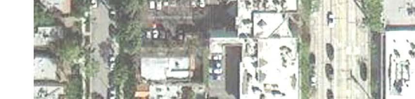
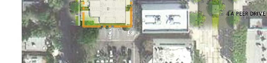
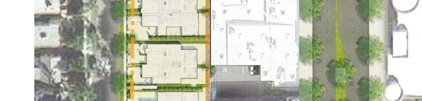
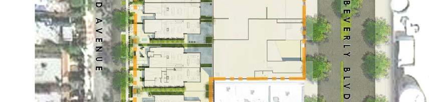
7 Chapter 1 Introduction The transportation analysis described in this study has been prepared for the 8899 Beverly Boulevard Project (Project) proposed by Beverly Boulevard Association. The report identifies the assumptions, describes the methodologies, and summarizes the findings of the study, which was conducted as part of the Draft Environmental Impact Report (DEIR) for the Project. The methodology and assumptions used in this analysis were established in conjunction with the City of West Hollywood. PROJECT LOCATION The Project Site is located at 8899 Beverly Boulevard and Rosewood Avenue in the City of West Hollywood. The 1.73-acre Project Site is comprised of 17 legal lots, including five lots located on the north side of Beverly Boulevard between Almont Drive and Robertson Boulevard and 12 lots on the south side of Rosewood Avenue between Almont Drive and Robertson Boulevard. The Project Site is bound by Rosewood Avenue to the north, Beverly Boulevard to the south, and adjacent commercial properties to the east and west. Access to the existing parking facilities that serve the Project Site is provided via two driveways along Beverly Boulevard. The Project Site lies within an urbanized area consisting of residential, retail, and commercial uses. PROJECT DESCRIPTION The Project includes an adaptive reuse of an existing 10-story retail/commercial office building (Existing Building), as well as a development of new residential uses on an existing surface parking facility fronting Rosewood Avenue, which currently serves the Existing Building. The reuse of the Existing Building would include 56 condominium units, eight affordable housing units, approximately 4,394 square feet (sf) of restaurant uses, 19,875 sf of retail uses, and 10,562 sf of office uses. The new development on the existing surface parking facility would include 13 1
8 townhomes and four affordable apartment units. Figure 1 illustrates the site plan of the proposed project. The Existing Building currently contains 64,502 sf of office uses, 21,249 sf of retail uses, and 3,879 sf of restaurant uses. Nearly all of the current tenants of the Existing Building are subject to leases that will have expired and will likely relocate elsewhere prior to the start of construction. Site Access and Circulation The Project would provide primary vehicular access on Beverly Boulevard. The Existing Building is currently served by two existing driveways on Beverly Boulevard that provide access to a basement garage on Level 1, a second level of structured parking on Level 3, and a surface parking lot fronting Rosewood Avenue that is accessed through the garage. As part of the Project, the existing driveways will consolidate into one driveway that will provide access to the subterranean parking area. Parking would be valet-assisted and served by parking attendants who would staff the garages 24 hours a day, seven days a week, to minimize traffic queuing on Beverly Boulevard. The parking garage would have control gates and garage doors to provide extra security. Access to the 13 townhomes would be provided via individual driveways along Rosewood Avenue, for a total of 13 curb-cuts. STUDY SCOPE AND METHODOLOGY This traffic study has been prepared in accordance with City of West Hollywood guidelines, adopted policies, procedures, and standards, and provides a comprehensive analysis of the potential traffic impacts associated with the Project. The scope for the traffic analysis was developed in consultation with the City, in coordination with adjacent jurisdictions, and in consideration of input received during the public scoping process. The assumptions and technical 2
9 3
10 methodologies were identified as part of the study approach, which was reviewed and approved by the City. As described in more detail below, the study analyzed the potential Project-generated traffic impacts on the street system surrounding the Project Site as compared to Existing Conditions (Year 2013) and Future Conditions (Year 2015). Intersection traffic impacts for the Project were evaluated for typical weekday morning (7:00 AM to 9:00 AM) and afternoon (4:00 PM to 6:00 PM) peak periods. The analysis of future year traffic forecasts was conducted for full buildout of the Project and is based on projected conditions in year 2015 both with and without the addition of the Project s traffic. Accordingly, the following traffic scenarios were developed and analyzed as part of this study: Existing Conditions (Year 2013) The analysis of existing traffic conditions provides a basis for the assessment of existing and future traffic conditions with the addition of Project traffic. The Existing Conditions analysis includes a description of key area streets and highways, traffic volumes and current operating conditions, and transit service in the Project Site vicinity. Intersection turning movement counts for typical weekday morning (7:00 AM to 9:00 AM) and afternoon (4:00 PM to 6:00 PM) peak periods were collected in September Fieldwork (lane configurations and signal phasing) for the analyzed intersections was collected in August Existing with Project Conditions (Year 2013) This scenario projects the potential intersection operating conditions that could be expected if the Project were built given the existing street system and traffic volumes. In this scenario, the Project-generated traffic is added to the Existing Conditions (Year 2013) traffic volumes. Future without Project Conditions (Year 2015) This scenario projects the potential intersection operating conditions that could be expected as a result of regional growth and related project traffic in the vicinity of the Project Site by year This analysis provides the baseline conditions by which Project impacts are evaluated in the future at full buildout. Future with Project Conditions (Year 2015) This scenario projects the potential intersection operating conditions that could be expected if the Project were built in the projected buildout year (2015) by adding the Project traffic to the Future without Project Conditions (Year 2015) traffic volumes. 4
11 Intersection Capacity Analyses Intersection capacity has been analyzed using the methods prescribed by the City of West Hollywood. In accordance with the City of West Hollywood policy, the intersection capacity analysis was conducted using the Synchro software to implement the 2000 Highway Capacity Manual, Transportation Research Board, 2000 (HCM) signalized and unsignalized methodologies. The HCM signalized methodology calculates the average delay, in seconds, for each vehicle passing through the intersections, while the HCM unsignalized methodology calculates the control delay, in seconds, for the movement with the worst level of service (LOS) at each intersection. Table 1 presents a description of the LOS categories, which range from excellent, nearly freeflow traffic at LOS A, to stop-and-go conditions at LOS F, for both signalized and unsignalized intersections. 5
12 TABLE 1 LEVEL OF SERVICE DEFINITIONS FOR SIGNALIZED AND UNSIGNALIZED INTERSECTIONS Level of Service Signalized Intersection Delay (sec) Unsignalized Intersection Delay (sec) A B C D Definition EXCELLENT. No vehicle waits longer than one red light and no approach phase is fully used. VERY GOOD. An occasional approach phase is fully utilized; many drivers begin to feel somewhat restricted within groups of vehicles. GOOD. Occasionally drivers may have to wait through more than one red light; backups may develop behind turning vehicles. FAIR. Delays may be substantial during portions of the rush hours, but enough lower volume periods occur to permit clearing of developing lines, preventing excessive backups. E F > 80.0 > 50.0 POOR. Represents the most vehicles intersection approaches can accommodate; may be long lines of waiting vehicles through several signal cycles. FAILURE. Backups from nearby locations or on cross streets may restrict or prevent movement of vehicles out of the intersection approaches. Tremendous delays with continuously increasing queue lengths. Source Highway Capacity Manual 2000, Transportation Research Board,
13 Significant Impact Criteria The City of West Hollywood has adopted a sliding scale for determining significant traffic impacts to intersections. The West Hollywood significant impact criteria are based on a minimum allowable increase in delay attributable to a project as the overall LOS of the intersection decreases: Intersection Conditions with Project Traffic Level of Service Intersection Delay (seconds) Project-Related Increase of Delay (seconds) Signalized Intersection of Two Commercial Corridors D E or F > Other Signalized Intersection D E or F > Four-Way Stop-Controlled Intersection D E or F > Unsignalized (Two-Way/One-Way Stop-Controlled) Intersection D, E or F > The City of West Hollywood has also developed a similar sliding scale to identify significant impacts on residential street segments. The criterion is based on the allowable increase in average daily traffic (ADT): Average Daily Traffic (ADT) Project-Related Increase in ADT > 2,000 12% 2,001-3,000 10% 3,001-6,749 8% 6, % 7
14 Congestion Management Program Analysis An analysis also was conducted according to Los Angeles County (County) Congestion Management Program (CMP) guidelines. The CMP is a State-mandated program that serves as the monitoring and analytical basis for transportation funding decisions in the County made through the Regional Transportation Improvement Program (RTIP) and State Transportation Improvement Program (STIP) processes. The CMP requires that a Traffic Impact Analysis (TIA) be performed for all CMP arterial monitoring intersections where a project would add 50 or more trips during either the morning or afternoon weekday peak hours and all mainline freeway monitoring locations where a project would add 150 or more trips (in either direction) during the morning or afternoon weekday peak hours. Additionally, it requires a review of potential impacts to the regional transit system. ORGANIZATION OF REPORT This report is divided into 12 chapters, including this introduction. Chapter 2 describes the existing circulation system, traffic volumes, and traffic conditions in the Study Area. Chapter 3 forecasts and analyzes future base operating conditions without Project traffic. Chapter 4 describes the procedure used to forecast Project traffic volumes and distribution through the Study Area. Chapter 5 presents the intersection operating conditions associated with construction of the Project on top of Existing Conditions (Year 2013). Chapter 6 presents the intersection operating conditions associated with construction of the Project on top of Future without Project Conditions (Year 2015). Chapter 7 assesses the significant traffic impacts associated with the Project on top of existing and future conditions before any mitigation. Chapter 8 presents the street segment analysis. Chapter 9 analyzes traffic impacts under the requirements of the CMP. Chapter 10 presents an assessment of potential impacts associated with Project construction. Chapter 11 presents an analysis of the Project s proposed parking. Chapter 12 summarizes the analyses and study conclusions. The aforementioned additional analyses, as well as details of the technical analyses, are included in the appendices. 8
15 Chapter 2 Existing Conditions A comprehensive data collection effort was undertaken to develop a detailed description of existing conditions in the Project Study Area. The existing conditions analysis relevant to this study includes an assessment of the existing street system, an analysis of traffic volumes and current operating conditions, and an analysis of the existing public transit service. STUDY AREA The Study Area generally includes a geographic area approximately one-quarter mile (northsouth) by approximately one-quarter mile (east-west). This Study Area was established in consultation with the City of West Hollywood and by reviewing the existing intersection/corridor operations, Project peak hour vehicle trip generation, the anticipated distribution of Project vehicular trips, and the potential impacts of Project traffic. A traffic analysis study area generally comprises those locations with the greatest potential to experience significant traffic impacts due to the Project as defined by the lead agency. In the traffic engineering practice, a study area generally includes those intersections that are: 1. Immediately adjacent or in close proximity to the project site 2. In the vicinity of the project site that are documented to have current or projected future adverse operational issues 3. In the vicinity of the project site that are forecast to experience a relatively greater percentage of project-related vehicular turning movements (e.g., at freeway ramp intersections) The Project Study Area was designed to ensure that all potentially significantly impacted intersections, prior to any mitigation, were analyzed, and the boundary of the Study Area was extended, as necessary, to confirm that there were no significant impacts at or outside the boundary of the Study Area by reviewing the Project traffic s travel patterns. 9
16 The intersections selected for analysis are consistent with the above criteria. The study locations were also selected based on the Project vehicle trip generation, the anticipated distribution of the Project trips, existing intersection/corridor operations, and travel routes/patterns to and from the Project. Several additional study locations were considered, including Doheny Drive at Maple Drive, Doheny Drive at Burton Way, Oakhurst Drive between Burton Way and Beverly Boulevard, Wetherly Drive between Wilshire Boulevard and Burton Way, among others. These intersections and street segments, among others, were not selected for analysis as they did not meet the criteria listed above. The study locations not included accommodated little, if any, Project-related traffic volumes/vehicular turning movements, were located a farther distance from the Project Site, have relatively lower traffic volumes on the side street and minor approach to the intersections, and no documented existing or projected future adverse operational issues. A total of four intersections, one signalized and three unsignalized, and one street segment in the Study Area were identified during the scoping process for detailed analysis in the traffic study. Figure 2 illustrates the location of the Project Site in relation to the surrounding street system, the four study intersections, and one study street segment. The four intersections selected for evaluation are: 1. Rosewood Avenue & Almont Drive (four-way stop-controlled) 2. Beverly Boulevard & Almont Drive (two-way stop-controlled) 3. Rosewood Avenue & Robertson Boulevard (two-way stop-controlled) 4. Beverly Boulevard & Robertson Boulevard (signalized) The street segment of Rosewood Avenue between Almont Drive and Robertson Boulevard was also selected for evaluation. 10
17 11
18 EXISTING STREET SYSTEM The existing street system in the Study Area consists of a regional roadway system including arterials, secondary/collector and local streets. The arterials, secondary/collectors, and selected local streets in the Study Area offer sub-regional and local access and circulation opportunities. These transportation facilities generally provide two to four travel lanes and generally allow parking on either side of the street. Typically, the speed limits range between 25 and 35 miles per hour (mph) on the arterials, secondary/collector, and local streets. Roadway Descriptions Primary regional access to the Project site is provided by the Santa Monica Freeway (I-10), which generally runs in the east-west direction south of the Study Area and the San Diego Freeway (I- 405), which generally runs in the north-south direction west of the Study Area. I-10 is located approximately three miles to the south of the Site, with access provided via interchanges at Robertson Boulevard and La Cienega Boulevard. I-405 is located approximately four miles to the west of the Site, with access provided via interchanges at Santa Monica Boulevard. The major arterials providing regional and sub-regional access to the Project Site include Beverly Boulevard and Robertson Boulevard. The street classifications were designated as defined in West Hollywood General Plan 2035 (City of West Hollywood, 2011). The following is a brief description of the major streets in the Study Area: Beverly Boulevard Beverly Boulevard is a designated Arterial that runs in the east-west direction and is located adjacent to the south side of the Project Site. It provides four travel lanes, two in each direction, and left-turn lanes at intersections. It provides both local and regional access to the Project Site. Daytime two-hour metered parking is generally available on both sides of the street within the Study Area. The posted speed limit is 35 mph. Robertson Boulevard Robertson Boulevard is a designated Secondary/Collector Street that runs in the north-south direction and is located east of the Project Site. It provides two travel lanes, one in each direction, and left turns at signalized intersections. It provides both local and sub-regional access to the Project Site. Daytime two-hour metered parking is generally available on both sides of the street within the Study Area. The posted speed limit is 30 mph. 12
19 Rosewood Avenue Rosewood Avenue is a designated Local Street that runs in the east-west direction and is located adjacent to the north side of the Project Site. It provides two travel lanes, one in each direction. It provides local access to the Project Site. Daytime two-hour curbside parking is generally permitted on weekdays and Saturdays on both sides of the street within the Study Area. Vehicles with permits are exempt from parking restrictions within the permit parking district. The posted speed limit is 25 mph with speed bumps to further control speed. Almont Drive Almont Drive is a designated Local Street that runs in the north-south direction and is located west of the Project Site. It provides two travel lanes, two in each direction. It provides limited local access to the Project Site. Daytime two-hour curbside parking is generally available on weekdays on both sides of the street within the Study Area. Vehicles with permits are exempt from parking restrictions within the permit parking district. The posted speed limit is 25 mph. The existing lane configurations at the analyzed intersections are provided in Appendix A. EXISTING TRANSIT SYSTEM The Project area is served by bus lines operated by the Los Angeles County Metropolitan Transportation Authority (Metro) and the West Hollywood Cityline service. Bus transit service in the Project vicinity is available along the following streets: Beverly Boulevard San Vicente Boulevard Robertson Boulevard Santa Monica Boulevard La Cienega Boulevard Figure 3 illustrates the existing transit service in the Study Area. Table 2 summarizes the various transit lines operating in the Study Area for each of the service providers in the region, the type of service (peak vs. off-peak, express vs. local), and frequency of service. The following provides a brief description of the bus lines providing service in Project vicinity: 13
20 14
21 Provider, Route, and Service Area TABLE 2 EXISTING TRANSIT SERVICE Metro NB/EB SB/WB NB/EB SB/WB 10 Downtown Los Angeles - West Hollywood via Temple St & Melrose Ave Local 4:00 AM - 1:00 AM Downtown Los Angeles - Beverly Hills via Beverly Blvd Local 24-Hour West Hollywood - Downtown Los Angeles - Indiana Station via San Vicente Bl, Pico Bl & E 1st St Local 9:00 AM - 4:30 AM Beverly Center - Culver City via Robertson Blvd Local 5:30 AM - 6:30 PM West Hollywood - Downtown Los Angeles - Indiana Station via San Vicente Bl, Pico Bl & E 1st St Limited 5:30 AM - 7:00 PM West Hollywood CityLine NB/EB SB/WB NB/EB SB/WB Orange Robertson Bl to La Brea Ave (Eastbound) Local 9:00 AM - 6:00 PM Blue La Brea Ave to Robertson Blvd (Westbound) Local 9:00 AM - 6:00 PM Notes Metro: Los Angeles County Metropolitan Transportation Authority West Hollywood Cityline Bus: City of West Hollywood AM Peak from 6-10 AM PM Peak from 3-7 PM Service Type Hours of Operation Average Headway (minutes) AM Peak Period PM Peak Period 15
22 Metro Local Line 10 Line 10 travels north-south on San Vicente Boulevard in the vicinity of the Project Site with average headways of 18 minutes during the morning peak hours and 15 minutes during the afternoon peak hours. The line travels from downtown Los Angeles to West Hollywood and provides service to Pershing Square and Civic Center/Grand Park. Metro Local Line 14 Line 14 travels east-west on Beverly Boulevard directly south of the Project Site with average headways of eight minutes during the morning and afternoon peak hours. The line travels from downtown Los Angeles to West Hollywood and provides service to Koreatown. Metro Local Line 30 Line 30 travels north-south on San Vicente Boulevard in the vicinity of the Project Site with average headways of 33 minutes during the morning peak hours and 20 minutes during the afternoon peak hours. The line travels from West Hollywood to East Los Angeles and provides service to Civic Center/Grand Park and Little Tokyo/Arts District. Metro Local Line 220 Line 220 travels north-south on Robertson Boulevard and San Vicente Boulevard and east-west on Beverly Boulevard in the vicinity of the Project Site with average headways of 60 minutes during the morning and afternoon peak hours. The line travels from West Hollywood to Culver City and provides service to the Cedars-Sinai Medical Center and the Beverly Center. Metro Local Line 330 Line 5 travels north-south on San Vicente Boulevard in the vicinity of the Project Site with average headways of 25 minutes during the morning peak hours and 37 minutes during the afternoon peak hours. The line travels from West Hollywood to Downtown Los Angeles and provides service to Union Station. West Hollywood Cityline Blue Route Cityline Blue Route travels north-south on San Vicente Boulevard in the vicinity of the Project Site with average headways of 30 minutes during the morning and afternoon peak hours. The line serves the City of West Hollywood. West Hollywood Cityline Orange Route Cityline Orange Route travels north-south on San Vicente Boulevard in the vicinity of the Project Site with average headways of 30 minutes during the morning and afternoon peak hours. The line serves the City of West Hollywood. EXISTING TRAFFIC VOLUMES AND LEVELS OF SERVICE This section presents the existing peak hour turning movement traffic volumes for the intersections analyzed in the study, describes the methodology used to assess the traffic conditions at each intersection, and analyzes the resulting operating conditions at each intersection indicating delay and LOS. 16
23 Existing Traffic Volumes Intersection turning movement counts during the typical weekday morning (7:00 AM to 9:00 AM) and afternoon (4:00 PM to 6:00 PM) commuter peak periods were conducted at the four study intersections in September Public and private schools were in session at the time the traffic counts were conducted. The existing intersection traffic volumes can be found in Figure 4. The summary data worksheets of turning movement counts at the study intersections are available in Appendix B. The traffic volumes illustrated in Figure 4 were analyzed to determine the existing operating conditions at the analyzed intersections. Existing Intersection Levels of Service Table 3 summarizes the existing weekday morning and afternoon peak hour delay and the corresponding LOS for each of the study intersections. As shown in Table 3, all four study intersections operate at LOS D or better during both the morning and afternoon peak hours under Existing conditions. The LOS calculation worksheets are provided in Appendix C. 17
24 18
25 TABLE 3 EXISTING CONDITIONS (YEAR 2013) INTERSECTION PEAK HOUR LEVELS OF SERVICE No Intersection Peak Hour Delay (sec) Existing 1. Almont Drive & A.M. 7.3 A [a] Rosewood Avenue P.M. 7.4 A 2. Almont Drive & A.M. 0.7 A [a] Beverly Boulevard P.M. 0.8 A 3. Robertson Boulevard & A.M. 1.3 A [a] Rosewood Avenue P.M. 1.8 A 4. Robertson Boulevard & A.M D [b] Beverly Boulevard (signalized) P.M C LOS Notes [a] [b] Unsignalized location analyzed with HCM Unsignalized methodology. Signalized location analyzed with HCM Signalized methodology. 19
26 Chapter 3 Future without Project Conditions In accordance with California Environmental Quality Act (CEQA) requirements, the Project s TIA considers the effects of the Project in relation to other developments either proposed, approved, or under construction in the Study Area. These development proposals and the methodologies used in projecting future traffic conditions without the Project are discussed in this section. The Future Year 2015 roadway network conditions are also discussed in this Chapter in terms of anticipated supply, demand, and operations (system performance). The Analyzed Year 2015 was selected to coincide with the projected full buildout of the Project. FUTURE WITHOUT PROJECT TRAFFIC PROJECTIONS The Future without Project traffic projections reflect growth in traffic over existing conditions from two sources. The first source is the ambient growth in traffic, which reflects increases in traffic due to regional growth and development outside the Study Area. The second source is growth due to traffic generated by projects which are proposed, approved, or under construction within and in the vicinity of the Study Area (collectively, the Related Projects), listed in Table 4. Ambient Traffic Growth Existing traffic is expected to increase as a result of regional growth and development. Based on historic trends, an ambient growth factor of 1.0% per year was used to adjust the existing traffic volumes to reflect the effects of regional growth and development by the year The total adjustment applied over the two-year period to full buildout of the Project (Year 2015) was therefore 2.0%. 20
27 TABLE 4 FUTURE WITHOUT PROJECT CONDITIONS (YEAR 2015) INTERSECTION PEAK HOUR LEVELS OF SERVICE No Intersection Peak Hour Future withot Project Delay (sec) 1. Almont Drive & A.M. 7.2 A [a] Rosewood Avenue P.M. 7.4 A 2. Almont Drive & A.M. 0.7 A [a] Beverly Boulevard P.M. 0.8 A 3. Robertson Boulevard & A.M. 1.6 A [a] Rosewood Avenue P.M. 2.2 A 4. Robertson Boulevard & A.M E [b] Beverly Boulevard (signalized) P.M D LOS Notes [a] [b] Unsignalized location analyzed with HCM Unsignalized methodology. Signalized location analyzed with HCM Signalized methodology. 21
28 Related Projects In accordance with CEQA requirements, this study considered the effects of the Project in relation to other developments either proposed, approved, or under construction in the Study Area and expected to be implemented prior to the buildout date of the Project. Information about Related Projects was obtained from the City of West Hollywood, City of Beverly Hills, and City of Los Angeles in year 2013, as well as from recent published reports for other developments. A summary of the related projects information is provided in Appendix D. The trips associated with these Related Projects have been accounted for in the future traffic forecasts through the following three-step process. Trip Generation. Trip generation estimates for the Related Projects were either provided by the respective city or calculated using a combination of previous study findings and the trip generation rates contained in Trip Generation, 9 th Edition (Institute of Transportation Engineers [ITE], 2012). These projections are conservative in that they do not in every case provide credit for either the existing uses to be removed or the likely use of non-motorized travel modes (mass transit, bicycling, walking, etc.) Trip Distribution. The geographic distribution of the traffic generated by the Related Projects is dependent on several factors. These factors include the type and density of the proposed land uses, the geographic distribution of population from which the employees/residents and potential patrons of the Related Projects are drawn, and the location of these projects in relation to the surrounding street system. Trip Assignment. The trip generation estimates for the Related Projects were assigned to the local street system using the trip distribution pattern described above and illustrated in Figure 5. These volumes were then added to the existing traffic volumes after adjustment for ambient growth through the assumed buildout year of The resulting Future without Project intersection traffic volumes are illustrated in Figure 6. 22
29 23
30 24
31 INTERSECTION OPERATIONS This section presents the methodology and results of the intersection operations for the Future without Project conditions that are defined by the traffic volumes, intersection lane configurations, and roadways that would exist in the year The projected Future without Project (Year 2015) intersection operating conditions for the weekday morning and afternoon peak hours are shown in Table 4. As shown, three of the four study intersections are projected to operate at LOS A during both the morning and afternoon peak hours. The remaining intersection (Robertson Boulevard & Beverly Boulevard) is projected to operate at LOS E during the morning peak hour and LOS D during the afternoon peak hour. 25
32 Chapter 4 Project Traffic A trip generation estimate, trip distribution pattern and trip assignment were prepared for the Project. These components form the basis of the Project s traffic impact analysis. PROJECT TRAFFIC VOLUMES The first step of the forecasting process is trip generation, which estimates the total arriving and departing trips generated by the Project on a peak hour and daily basis by applying the appropriate vehicle trip generation equations, or rates, to the size of Project development. For the purposes of this Project, trips were also generated for the existing facility at the Site to allow for comparison with the proposed Project. The second step of the forecasting process is trip distribution, which identifies the origins and destinations of inbound and outbound Project trips. These origins and destinations are typically based on demographics and existing/anticipated travel patterns in the Study Area. Localized routes of travel through the Study Area are developed based on existing traffic patterns and relative travel times on various corridors. The third step of the forecasting process is traffic assignment. This involves applying the traffic generated by the Project (the trip generation) to the intersections and street segments in the Study Area according to the projected trip distribution patterns. These traffic volumes can then be added to existing or future background conditions to represent traffic volumes once the Project is complete. With the forecasting process complete and Project traffic assignments developed, the impact of the proposed Project is isolated by comparing operational (i.e., LOS) conditions at the study intersections using expected future traffic volumes without and with forecast Project traffic. The 26
33 need for site-specific and/or cumulative local area traffic improvements may then be evaluated and the significance of the Project s impacts identified. Project Trip Generation The trip generation rates from Trip Generation, 9 th Edition for Land Use Code 220 (Apartment), Land Use Code 230 (Residential Condominium/Town Home), Land Use Code 710 (General Office Building), Land Use Code 826 (Specialty Retail), and Land Use Code 931 (Quality Restaurant) were used to develop the Project trip generation estimates. As described, the Project would include an adaptive reuse of the Existing Building, as well as a development of new residential uses on an existing surface parking facility fronting Rosewood Avenue, which currently serves the Existing Building. The reuse of the Existing Building would include 56 condominium units, eight affordable housing units, approximately 4,394 sf of restaurant uses, 19,875 sf of retail uses, and 10,562 sf of office uses. The new development on the existing surface parking facility would include 13 townhomes and four affordable apartment units. The trip generation forecast shown in Table 5 reflects the Project and the removal of the existing retail/commercial/office building. As shown in Table 5, the Project is estimated to generate 1,873 daily trips, with 53 morning peak hour trips (20 inbound, 33 outbound) and 146 afternoon peak hour trips (78 inbound, 68 outbound). The existing uses of the Project Site generate approximately 2,002 daily trips, with 101 morning peak hour trips (89 inbound, 12 outbound) and 183 afternoon peak hour trips (61 inbound, 122 outbound). Therefore, the Project is anticipated to result in a net reduction of trips with a total decrease of 129 daily trips, including a net reduction of 48 trips during the morning peak hour (net reduction of 69 inbound trips, 21 outbound trips) and a net reduction of 37 trips during the afternoon peak hour (17 inbound trips, net reduction of 54 outbound trips). 27
34 TABLE 5 TRIP GENERATION Land Use Size Daily Trip Generation Rates [a] AM Peak Hour PM Peak Hour Inbound Outbound Total Inbound Outbound Total Apartment (ITE 220) per du % 80% % 35% 0.62 Residential Condominium/Townhouse (ITE 230) per du % 83% % 33% 0.52 General Office Building (ITE 710) per 1,000 sf % 12% % 83% 1.49 Specialty Retail (ITE 826) per 1,000 sf N/A N/A N/A 44% 56% 2.71 Quality Restaurant (ITE 931) per 1,000 sf % 45% % 33% 7.49 Land Use Size Daily Trip Generation Estimates AM Peak Hour PM Peak Hour Inbound Outbound Total Inbound Outbound Total Proposed Project Apartment 12 du Condominium 56 du Townhomes 13 du Office 10,562 sf Retail [b] 19,875 sf 881 Nom Nom Nom Restaurant [b] 4,394 sf 395 Nom Nom Nom Total Project Trips 1, Existing Use Office 64,502 sf (711) (89) (12) (101) (16) (80) (96) Retail 21,249 sf (942) Nom Nom Nom (26) (32) (58) Resturant 3,879 sf (349) Nom Nom Nom (19) (10) (29) Less Existing Use (2,002) (89) (12) (101) (61) (122) (183) Total Net New Trips (129) (69) 21 (48) 17 (54) (37) Notes du: dwelling units sf: square feet Nom.: nominal amount of trips [a] Source: Trip Generation, 9th Edition, Insititute of Transportation Engineers, [b] The Retail and Restaurant components are assumed to not operate during the commuter morning peak hours, and therefore will generate a nominal amount of trips during the morning peak hour. 28
35 Project Trip Distribution The traffic volumes of both the existing uses and the Project entering and exiting the Project Site have been distributed and assigned to the local street system based on demographics and existing/anticipated travel patterns in the Study Area. Localized routes of travel through the Study Area were developed based on existing traffic patterns and relative travel times on various corridors and the level of accessibility of the route to and from the Project Site. The Project trip distribution was developed to reflect the primary access on Beverly Boulevard and the townhome access on Rosewood Avenue. The general distribution pattern was reviewed and approved by the City of West Hollywood. Project Trip Assignment Traffic volumes for both the existing uses and the Project were assigned to the surrounding street system based on the following general distribution pattern: approximately 20% of the traffic was assigned to/from the north, 15% was assigned to/from the east, 35% was assigned to/from the south, and 30% was assigned to/from the west. The trip distribution of the existing uses is illustrated in Figure 7. The trip distribution of the Project traffic that utilizes the Beverly Boulevard driveway is illustrated in Figure 8, and the trip distribution of the Project traffic that utilizes the townhome driveways on Rosewood Avenue is illustrated in Figure 9. The trip distribution patterns were applied to the trip generation estimates to develop the Project-only traffic assignments. Figure 10 illustrates the traffic volumes of the existing uses through the study intersections, Figure 11 illustrates the Project-only volumes that utilize the Beverly Boulevard driveway through the study intersections, and Figure 12 illustrates the Project-only volumes that utilize the Rosewood Avenue driveway through the study intersections. As previously mentioned, the Project is expected to generate fewer trips than the existing uses; therefore, the Project results in an overall net reduction of trips. The net Project trips is illustrated in Figure 13 29
36 30
37 31
38 32
39 33
40 34
41 35
42 36
43 Chapter 5 Existing with Project Conditions This Chapter describes the results of the analysis of intersection operating conditions associated with the Project construction on top of Existing Conditions. The analysis year of 2013 corresponds with the Existing Conditions data and analysis presented in Chapter 2. Within this Chapter, the Existing with Project conditions are presented for the four study intersections. The results of these analyses form the basis of the intersection impact analysis presented in Chapter 7. EXISTING WITH PROJECT INTERSECTION OPERATIONS The Existing with Project conditions are defined by the traffic volumes, roadways, and intersection configurations that currently exist in the year The Project-only traffic volumes described in Chapter 4 and shown in Figure 13 were added to the Existing traffic volumes shown in Figure 4 to obtain the Existing with Project peak hour traffic volumes, shown in Figure 14. None of the ambient or Related Project traffic growth described in Chapter 3 was accounted for in this analysis since this analysis looks at the existing condition of the Study Area as of year The study intersections were analyzed using the methodologies described in Chapter 2. The Existing with Project intersection operating conditions for typical weekday morning and afternoon peak hours are shown in Table 6. As shown, under the Existing with Project conditions, all four study intersections are projected to operate at LOS D or better during both the morning and afternoon peak hours. Detailed LOS worksheets are provided in Appendix C. 37
44 38
45 TABLE 6 EXISTING WITH PROJECT CONDITIONS (YEAR 2013) INTERSECTION PEAK HOUR LEVELS OF SERVICE No Intersection Peak Hour Delay (sec) Existing LOS Existing with Project 1. Almont Drive & A.M. 7.3 A 7.2 A -0.1 NO [a] Rosewood Avenue P.M. 7.4 A 7.4 A 0.0 NO 2. Almont Drive & A.M. 0.7 A 0.7 A 0.0 NO [a] Beverly Boulevard P.M. 0.8 A 0.9 A 0.1 NO 3. Robertson Boulevard & A.M. 1.3 A 1.4 A 0.1 NO [a] Rosewood Avenue P.M. 1.8 A 1.9 A 0.1 NO 4. Robertson Boulevard & A.M D 42.5 D -2.6 NO [b] Beverly Boulevard P.M C 30.1 C -2.1 NO Delay (sec) LOS Change in Delay (sec) Impact Notes [a] [b] Unsignalized location analyzed with HCM Unsignalized methodology. Signalized location analyzed with HCM Signalized methodology. 39
46 Chapter 6 Future with Project Conditions This chapter describes the results of the analysis of intersection operating conditions associated with the Project construction on top of the future environment. The analysis year of 2015 corresponds to the projected full buildout year of the Project. All future background traffic growth and transportation system improvements described in Chapter 3 are assumed in this analysis. Within this chapter, the Future with Project conditions is presented for the four study intersections. The results of these analyses form the basis of the intersection impact analysis presented in Chapter 7. FUTURE WITH PROJECT (YEAR 2015) INTERSECTION OPERATIONS The Future with Project (Year 2015) conditions are defined by the traffic volumes, roadways, and intersection configurations that would exist in the year 2015 following full development of the Project. The Project-only traffic volumes described in Chapter 4 and shown in Figure 13 were added to the Future without Project (Year 2015) traffic volumes shown in Figure 6 to obtain the Future with Project (Year 2015) peak hour traffic volumes, shown in Figure 15. The study intersections were analyzed using the methodologies described in Chapter 2. The Future with Project (Year 2015) intersection operating conditions for typical weekday morning and afternoon peak hours are shown in Table 7. As shown, under the Future with Project (year 2015) conditions, three of the four study intersections are projected to operate at LOS A during both the morning and afternoon peak hours. The remaining intersection (Robertson Boulevard & Beverly Boulevard) is projected to operate at LOS E during the morning peak hour and LOS D during the afternoon peak hour. Detailed LOS worksheets are provided in Appendix C. 40
47 41
48 TABLE 7 FUTURE WITH PROJECT CONDITIONS (YEAR 2015) INTERSECTION PEAK HOUR LEVELS OF SERVICE No Intersection Peak Hour Future without Project Delay (sec) LOS Future with Project 1. Almont Drive & A.M. 7.2 A 7.2 A 0.0 NO [a] Rosewood Avenue P.M. 7.4 A 7.4 A 0.0 NO 2. Almont Drive & A.M. 0.7 A 0.7 A 0.0 NO [a] Beverly Boulevard P.M. 0.8 A 0.9 A 0.1 NO 3. Robertson Boulevard & A.M. 1.6 A 1.7 A 0.1 NO [a] Rosewood Avenue P.M. 2.2 A 2.3 A 0.1 NO 4. Robertson Boulevard & A.M E 59.9 E -2.5 NO [b] Beverly Boulevard P.M D 41.6 D -2.3 NO Delay (sec) LOS Change in Delay (sec) Impact Notes [a] [b] Unsignalized location analyzed with HCM Unsignalized methodology. Signalized location analyzed with HCM Signalized methodology. 42
49 Chapter 7 Traffic Impact Analysis This chapter describes the results of the intersection impact analysis for the proposed Project, before any mitigation, under both Existing (Year 2013) and Future (Year 2015) conditions. The analysis under Existing conditions was conducted in response to the case Sunnyvale West Neighborhood Association v. City of Sunnyvale City Council (Court of Appeals of California, 6 th District, December 16, 2010). Both analyses measured significant intersection impacts according to the impact criteria specified by the City of West Hollywood. Under both Existing and Future conditions, intersection impacts were assessed for the Project s impacts as compared to traffic conditions as they exist without the Project (Year 2013) or as they would exist in the future without the Project (Year 2015). The previously discussed significance criteria and thresholds outlined in Chapter 1 were used to determine the significance of a traffic impact caused by the Project on the study intersections. EXISTING WITH PROJECT CONDITIONS (YEAR 2013) The Existing with Project (Year 2013) conditions from Table 6 in Chapter 5 were compared to the Existing (Year 2013) conditions from Table 3 in Chapter 2. This analysis assesses the impacts of the Project as compared to the Existing (Year 2013) environment without development of the Project. Any significant impacts of the Project will be considered the total number of impacts identified for the Project alone on the Existing (Year 2013) environment. Based on the City s significance criteria described in Chapter 1, the Project is not anticipated to result in any significant impacts under the Existing with Project (Year 2013) conditions. Therefore, mitigation measures are not recommended or required. 43
50 FUTURE WITH PROJECT CONDITIONS (YEAR 2015) The Future with Project (Year 2015) conditions from Table 7 in Chapter 6 were compared to the Future without Project (Year 2015) conditions from Table 4 in Chapter 3. This analysis assesses the impacts of the Project as compared to the Future (Year 2015) environment without development of the Project. Any significant impacts of the Project will be considered the total number of impacts identified for the Project alone on the Future (Year 2015) environment. Based on the City s significance criteria described in Chapter 1, the Project is not anticipated to result in any significant impacts under the Future with Project (Year 2015) conditions. Therefore, mitigation measures are not recommended or required. 44
51 Chapter 8 Street Segment Analysis The study street segment was analyzed based on the direction of the City of West Hollywood. STREET SEGMENT TRAFFIC VOLUMES Street segment ADT counts during the typical weekday were conducted on Rosewood Avenue between Almont Drive and Robertson Boulevard over a 24-hour period (from midnight to midnight) on Tuesday, September 10, Future without Project street segment volumes were estimated by applying an ambient growth factor to the anticipated year of project buildout and the addition of Related Project traffic to the Existing street segment traffic volumes. Project traffic volumes were added to the Existing and Future without Project ADT volumes to estimate the Existing with Project and Future with Project ADT volumes. It should be noted that no reductions were considered for the existing Rosewood Avenue trips associated with the existing office tenants and commercial patrons who would be removed as part of the Project. Thus, the analysis is conservative. ADT volumes under all conditions may be found in Figure 16. The summary data worksheets of the study street segment ADT volumes are available in Appendix B. SUMMARY OF STREET SEGMENT ANALYSIS The analysis of the study street segments are provided in Tables 8 and 9 for Existing with Project and Future with Project conditions, respectively. As shown, application of the City of West Hollywood significant impact criteria to the Existing with Project and Future with Project scenario 45
Traffic Impact Analysis 5742 BEACH BOULEVARD MIXED USE PROJECT
 Traffic Impact Analysis 5742 BEACH BOULEVARD MIXED USE PROJECT CITY OF BUENA PARK Prepared by Project No. 14139 000 April 17 th, 2015 DKS Associates Jeffrey Heald, P.E. Rohit Itadkar, T.E. 2677 North Main
IV. Environmental Impact Analysis J. Traffic, Access, and Parking
 IV. Environmental Impact Analysis J. Traffic, Access, and Parking 1. Introduction This section of the Draft EIR analyzes the proposed Project s potential impacts on traffic, access, and parking. This section
APPENDIX B Traffic Analysis
 APPENDIX B Traffic Analysis Rim of the World Unified School District Reconfiguration Prepared for: Rim of the World School District 27315 North Bay Road, Blue Jay, CA 92317 Prepared by: 400 Oceangate,
Escondido Marriott Hotel and Mixed-Use Condominium Project TRAFFIC IMPACT ANALYSIS REPORT
 Escondido Marriott Hotel and Mixed-Use Condominium Project TRAFFIC IMPACT ANALYSIS REPORT Prepared for Phelps Program Management 420 Sixth Avenue, Greeley, CO 80632 Prepared by 5050 Avenida Encinas, Suite
EXECUTIVE SUMMARY. The following is an outline of the traffic analysis performed by Hales Engineering for the traffic conditions of this project.
 EXECUTIVE SUMMARY This study addresses the traffic impacts associated with the proposed Shopko redevelopment located in Sugarhouse, Utah. The Shopko redevelopment project is located between 1300 East and
IV. ENVIRONMENTAL IMPACT ANALYSIS J. TRANSPORTATION AND TRAFFIC
 IV. ENVIRONMENTAL IMPACT ANALYSIS J. TRANSPORTATION AND TRAFFIC This Section summarizes the information provided in the Traffic Study for the Santa Monica College Bundy Campus Master Plan (Traffic Study),
IV. ENVIRONMENTAL IMPACT ANALYSIS M. TRANSPORTATION AND TRAFFIC
 IV. ENVIRONMENTAL IMPACT ANALYSIS M. TRANSPORTATION AND TRAFFIC INTRODUCTION This section of the (Draft EIR) addresses the subject of traffic and transportation with respect to the proposed (Project or
TABLE OF CONTENTS SECTION PAGE. Executive Summary... xii
 TABLE OF CONTENTS SECTION PAGE Executive Summary... xii 1.0 Introduction... 1 1.1 Study Area... 2 1.2 Traffic Impact Analysis Scenarios... 4 1.3 Study Area - City of Orange... 4 2.0 Project Description
APPENDIX C-2. Traffic Study Supplemental Analysis Memo
 APPENDIX C-2 Traffic Study Supplemental Analysis Memo The Mobility Group Transportation Strategies & Solutions Memorandum To: From: Subject: Tomas Carranza, LADOT Matthew Simons Traffic Review - Revised
King Soopers #116 Thornton, Colorado
 Traffic Impact Study King Soopers #116 Thornton, Colorado Prepared for: Galloway & Company, Inc. T R A F F I C I M P A C T S T U D Y King Soopers #116 Thornton, Colorado Prepared for Galloway & Company
IV. ENVIRONMENTAL IMPACT ANALYSIS B. TRAFFIC AND CIRCULATION
 IV. ENVIRONMENTAL IMPACT ANALYSIS B. TRAFFIC AND CIRCULATION 1. INTRODUCTION This section is based on the technical report, Traffic Study for 10131 Constellation Boulevard Residential Project, prepared
IV. ENVIRONMENTAL IMPACT ANALYSIS N. TRANSPORTATION AND TRAFFIC
 IV. ENVIRONMENTAL IMPACT ANALYSIS N. TRANSPORTATION AND TRAFFIC The following section summarizes the information provided in the traffic report entitled Traffic Impact Analysis for a Proposed Residential
Appendix Q Traffic Study
 Appendices Appendix Q Traffic Study Crummer Site Subdivision Draft EIR City of Malibu Appendices This page intentionally left blank. The Planning Center April 2013 TRAFFIC IMPACT ANALYSIS Photo z here
King County Metro. Columbia Street Transit Priority Improvements Alternative Analysis. Downtown Southend Transit Study. May 2014.
 King County Metro Columbia Street Transit Priority Improvements Alternative Analysis Downtown Southend Transit Study May 2014 Parametrix Table of Contents Introduction... 1 Methodology... 1 Study Area...
Appendix C. Traffic Study
 Appendix C Traffic Study TABLE OF CONTENTS SECTION Executive Summary PAGE 1.0 Introduction... 1 1.1 Scope of Work... 1 1.2 Study Area... 2 2.0 Project Description... 3 2.1 Site Access... 4 2.2 Pedestrian
Alpine Highway to North County Boulevard Connector Study
 Alpine Highway to North County Boulevard Connector Study prepared by Avenue Consultants March 16, 2017 North County Boulevard Connector Study March 16, 2017 Table of Contents 1 Summary of Findings... 1
TRAFFIC IMPACT ANALYSIS
 TRAFFIC IMPACT ANALYSIS Emerald Isle Commercial Development Prepared by SEPI Engineering & Construction Prepared for Ark Consulting Group, PLLC March 2016 I. Executive Summary A. Site Location The Emerald
TRANSPORTATION 1. INTRODUCTION
 IV.F TRANSPORTATION 1. INTRODUCTION This section evaluates potential impacts associated with Project-related traffic, circulation, and access. The analysis summarizes the findings of the traffic study
Oakbrook Village Plaza City of Laguna Hills
 Oakbrook Village Plaza City of Laguna Hills Traffic Impact Analysis Prepared by: HDR Engineering 3230 El Camino Real, Suite 200 Irvine, CA 92602 October 2012 Revision 3 D-1 Oakbrook Village Plaza Laguna
Table Existing Traffic Conditions for Arterial Segments along Construction Access Route. Daily
 5.8 TRAFFIC, ACCESS, AND CIRCULATION This section describes existing traffic conditions in the project area; summarizes applicable regulations; and analyzes the potential traffic, access, and circulation
2. Valley Circle Boulevard/Andora Avenue/Baden Avenue and Lassen Street
 IV.J TRANSPORTATION 1. INTRODUCTION This section presents an overview of the existing traffic and circulation system in and surrounding the project site. This section also discusses the potential impacts
LAWRENCE TRANSIT CENTER LOCATION ANALYSIS 9 TH STREET & ROCKLEDGE ROAD / 21 ST STREET & IOWA STREET LAWRENCE, KANSAS
 LAWRENCE TRANSIT CENTER LOCATION ANALYSIS 9 TH STREET & ROCKLEDGE ROAD / 21 ST STREET & IOWA STREET LAWRENCE, KANSAS TRAFFIC IMPACT STUDY FEBRUARY 214 OA Project No. 213-542 TABLE OF CONTENTS 1. INTRODUCTION...
IV. ENVIRONMENTAL IMPACT ANALYSIS K.2. PARKING
 IV. ENVIRONMENTAL IMPACT ANALYSIS K.2. PARKING ENVIRONMENTAL SETTING The following analysis summarizes the findings and conclusions of the Traffic Analysis (Traffic Study), prepared by The Mobility Group,
ENVIRONMENTAL IMPACT ANALYSIS D. TRANSPORTATION AND CIRCULATION 1. INTRODUCTION
 IV. ENVIRONMENTAL IMPACT ANALYSIS 1. INTRODUCTION This section is based on a traffic and parking impact study that was prepared for the proposed CSMC West Tower Project by Linscott, Law & Greenspan, Engineers,
4.4 Transportation and Circulation
 4.4.1 Introduction This section evaluates the potential for construction traffic and operational impacts to result from implementation of the proposed project. This includes the potential for the project
Traffic Impact Analysis for 2171 Rosecrans Avenue
 Traffic Impact Analysis for 2171 Rosecrans Avenue Prepared for: Continental Development Corporation Revised May 2016 LA16-2831 Prepared by: Fehr & Peers 600 Wilshire Blvd, Suite 1050 Los Angeles, CA 90017
Traffic Impact Study Speedway Gas Station Redevelopment
 Traffic Impact Study Speedway Gas Station Redevelopment Warrenville, Illinois Prepared For: Prepared By: April 11, 2018 Table of Contents 1. Introduction... 1 2. Existing Conditions... 4 Site Location...
RE: A Traffic Impact Statement for a proposed development on Quinpool Road
 James J. Copeland, P.Eng. GRIFFIN transportation group inc. 30 Bonny View Drive Fall River, NS B2T 1R2 May 31, 2018 Ellen O Hara, P.Eng. Project Engineer DesignPoint Engineering & Surveying Ltd. 200 Waterfront
Transportation & Traffic Engineering
 Transportation & Traffic Engineering 1) Project Description This report presents a summary of findings for a Traffic Impact Analysis (TIA) performed by A+ Engineering, Inc. for the Hill Country Family
MEMO VIA . Ms. Amy Roth DPS Director, City of Three Rivers. To:
 MEMO To: Ms. Amy Roth DPS Director, City of Three Rivers VIA EMAIL From: Michael J. Labadie, PE Julie M. Kroll, PE, PTOE Brandon Hayes, PE, P.Eng. Fleis & VandenBrink Date: January 5, 2017 Re: Proposed
Traffic Impact Statement (TIS)
") Traffic Impact Statement (TIS) Vincentian PUDA Collier County, FL 10/18/2013 Prepared for: Global Properties of Naples Prepared by: Trebilcock Consulting Solutions, PA 2614 Tamiami Trail N, Suite 615 1205
Traffic Impact Statement (TIS) Vincentian PUDA Collier County, FL 10/18/2013 Prepared for: Global Properties of Naples Prepared by: Trebilcock Consulting Solutions, PA 2614 Tamiami Trail N, Suite 615 1205
MINERVA PARK SITE TRAFFIC IMPACT STUDY M/I HOMES. September 2, 2015
 5500 New Albany Road Columbus, Ohio 43054 Phone: 614.775.4500 Fax: 614.775.4800 Toll Free: 1-888-775-EMHT emht.com 2015-1008 MINERVA PARK SITE TRAFFIC IMPACT STUDY M/I HOMES September 2, 2015 Engineers
2.0 Development Driveways. Movin Out June 2017
 Movin Out June 2017 1.0 Introduction The proposed Movin Out development is a mixed use development in the northeast quadrant of the intersection of West Broadway and Fayette Avenue in the City of Madison.
Clean Harbors Canada, Inc.
 Clean Harbors Canada, Inc. Proposed Lambton Landfill Expansion Environmental Assessment Terms of Reference Transportation Assessment St. Clair Township, Ontario September 2009 itrans Consulting Inc. 260
NEWCASTLE MIDDLE SCHOOL Traffic Impact Analysis
 Gibson Traffic Consultants 2802 Wetmore Avenue Suite 220 Everett, WA 98201 425.339.8266 NEWCASTLE MIDDLE SCHOOL Traffic Impact Analysis Prepared for: Renton School District Jurisdiction: City of Newcastle
IV. ENVIRONMENTAL IMPACT ANALYSIS L. TRANSPORTATION/TRAFFIC
 IV. ENVIRONMENTAL IMPACT ANALYSIS L. TRANSPORTATION/TRAFFIC INTRODUCTION The following section summarizes the information provided in the traffic report entitled Traffic Impact Analysis for a Proposed
APPENDIX C1 TRAFFIC ANALYSIS DESIGN YEAR TRAFFIC ANALYSIS
 APPENDIX C1 TRAFFIC ANALYSIS DESIGN YEAR TRAFFIC ANALYSIS DESIGN YEAR TRAFFIC ANALYSIS February 2018 Highway & Bridge Project PIN 6754.12 Route 13 Connector Road Chemung County February 2018 Appendix
Traffic Impact Study for Proposed Olive Boulevard Development
 Traffic Impact Study for Proposed 11330 Olive Boulevard Development Creve Coeur, Missouri July 7, 2017 Prepared For: 11330 Olive Boulevard Development 11330 Olive Boulevard Creve Coeur, Missouri 63141
4.14 TRANSPORTATION AND CIRCULATION
 4.14 TRANSPORTATION AND CIRCULATION 4.14.1 Summary Table 4.14-1 summarizes the identified environmental impacts, proposed mitigation measures, and residual impacts of the proposed project with regard to
Volume 1 Traffic Impact Analysis Turtle Creek Boulevard Dallas, Texas. Kimley-Horn and Associates, Inc. Dallas, Texas.
 Volume 1 Traffic Impact Analysis 2727 Dallas, Texas June 18, 2018 Kimley-Horn and Associates, Inc. Dallas, Texas Project #064523000 Registered Firm F-928 Traffic Impact Analysis 2727 Dallas, Texas Prepared
The major roadways in the study area are State Route 166 and State Route 33, which are shown on Figure 1-1 and described below:
 3.5 TRAFFIC AND CIRCULATION 3.5.1 Existing Conditions 3.5.1.1 Street Network DRAFT ENVIRONMENTAL IMPACT REPORT The major roadways in the study area are State Route 166 and State Route 33, which are shown
Date: February 7, 2017 John Doyle, Z-Best Products Robert Del Rio. T.E. Z-Best Traffic Operations and Site Access Analysis
 Memorandum Date: February 7, 07 To: From: Subject: John Doyle, Z-Best Products Robert Del Rio. T.E. Z-Best Traffic Operations and Site Access Analysis Introduction Hexagon Transportation Consultants, Inc.
Appendix C. Traffic Impact Study
 Appendix C Traffic Impact Study TRAFFIC STUDY FOR THE EAGLE ROCK AGGREGATE TERMINAL Prepared by: FEHR & PEERS 201 Santa Monica Blvd. Suite 500 Santa Monica, CA 90401-2213 T. (310) 458-9916 F. (310) 394-7663
Traffic Engineering Study
 Traffic Engineering Study Bellaire Boulevard Prepared For: International Management District Technical Services, Inc. Texas Registered Engineering Firm F-3580 November 2009 Executive Summary has been requested
West Hills Shopping Centre Lowe s Expansion Traffic Impact Study
 West Hills Shopping Centre Lowe s Expansion Traffic Impact Study Prepared for: Armel Corporation January 2015 Paradigm Transportation Solutions Ltd. 22 King Street South, Suite 300 Waterloo ON N2J 1N8
Section 3.12 Traffic and Transportation
 Section. Traffic and Transportation SECTION SUMMARY This section describes existing ground transportation within the Port and surrounding area associated with implementation of the proposed Project. An
TIMBERVINE TRANSPORTATION IMPACT STUDY FORT COLLINS, COLORADO JANUARY Prepared for:
 TIMBERVINE TRANSPORTATION IMPACT STUDY FORT COLLINS, COLORADO JANUARY 2014 Prepared for: Hartford Companies 1218 W. Ash Street Suite A Windsor, Co 80550 Prepared by: DELICH ASSOCIATES 2272 Glen Haven Drive
Traffic Impact Analysis West Street Garden Plots Improvements and DuPage River Park Garden Plots Development Naperville, Illinois
 Traffic Impact Analysis West Street Garden Plots Improvements and DuPage River Park Garden Plots Development Naperville, Illinois Submitted by April 9, 2009 Introduction Kenig, Lindgren, O Hara, Aboona,
TABLE OF CONTENTS 1.0 INTRODUCTION AND SUMMARY Purpose of Report and Study Objectives... 2
 TABLE OF CONTENTS 1.0 INTRODUCTION AND SUMMARY 1 1.1 Purpose of Report and Study Objectives... 2 1.2 Executive Summary... 3 1.2.1 Site Location and Study Area... 3 1.2.2 Development Description... 3 1.2.3
Craig Scheffler, P.E., PTOE HNTB North Carolina, P.C. HNTB Project File: Subject
 TECHNICAL MEMORANDUM To Kumar Neppalli Traffic Engineering Manager Town of Chapel Hill From Craig Scheffler, P.E., PTOE HNTB North Carolina, P.C. Cc HNTB Project File: 38435 Subject Obey Creek TIS 2022
THE CORNERSTONE APARTMENTS TRAFFIC IMPACT STUDY R&M PROJECT NO
 THE CORNERSTONE APARTMENTS SITUATED AT N/E/C OF STAUDERMAN AVENUE AND FOREST AVENUE VILLAGE OF LYNBROOK NASSAU COUNTY, NEW YORK TRAFFIC IMPACT STUDY R&M PROJECT NO. 2018-089 September 2018 50 Elm Street,
BROWARD BOULEVARD CORRIDOR TRANSIT STUDY
 BROWARD BOULEVARD CORRIDOR TRANSIT STUDY FM # 42802411201 EXECUTIVE SUMMARY July 2012 GOBROWARD Broward Boulevard Corridor Transit Study FM # 42802411201 Executive Summary Prepared For: Ms. Khalilah Ffrench,
Table of Contents INTRODUCTION... 3 PROJECT STUDY AREA Figure 1 Vicinity Map Study Area... 4 EXISTING CONDITIONS... 5 TRAFFIC OPERATIONS...
 Crosshaven Drive Corridor Study City of Vestavia Hills, Alabama Table of Contents INTRODUCTION... 3 PROJECT STUDY AREA... 3 Figure 1 Vicinity Map Study Area... 4 EXISTING CONDITIONS... 5 TRAFFIC OPERATIONS...
Appendix G Traffic and Parking Report
 Appendix G Traffic and Parking Report TABLE OF CONTENTS SECTION PAGE Executive Summary... v 1.0 Introduction... 1 1.1 Study Area... 3 2.0 Project Description... 4 2.1 Site Location... 4 2.2 Existing Project
Traffic Impact Analysis. Alliance Cole Avenue Residential Site Dallas, Texas. Kimley-Horn and Associates, Inc. Dallas, Texas.
 Traffic Impact Analysis Alliance Cole Avenue Residential Site Dallas, Texas February 15, 2018 Kimley-Horn and Associates, Inc. Dallas, Texas Project #064524900 Registered Firm F-928 Traffic Impact Analysis
Lacey Gateway Residential Phase 1
 Lacey Gateway Residential Phase Transportation Impact Study April 23, 203 Prepared for: Gateway 850 LLC 5 Lake Bellevue Drive Suite 02 Bellevue, WA 98005 Prepared by: TENW Transportation Engineering West
Quantitative analyses of weekday a.m. and p.m. commuter hour conditions have been conducted for the following five scenarios:
 6.1 TRANSPORTATION AND CIRCULATION 6.1.1 INTRODUCTION This section of the EIR presents the results of TJKM s traffic impact analysis of the proposed Greenbriar Development. The analysis includes consideration
Draft Report: West Berkeley Bowl Project
 Draft Report: West Berkeley Bowl Project July 2004 Prepared for: The City of Berkeley 1031-1925 F EHR & PEERS TRANSPORTATION CONSULTANTS 3685 Mt. Diablo Blvd. #301 Lafayette, CA 94549 925-284-3200 Fax:
TRAFFIC SIGNAL DESIGN REPORT KING OF PRUSSIA ROAD & RAIDER ROAD RADNOR TOWNSHIP PENNSYLVANIA
 TRAFFIC SIGNAL DESIGN REPORT KING OF PRUSSIA ROAD & RAIDER ROAD RADNOR TOWNSHIP PENNSYLVANIA PREPARED FOR: UNIVERSITY OF PENNSYLVANIA HEALTH SYSTEM 34 CIVIC CENTER BOULEVARD PHILADELPHIA, PA 1987 (61)
TALMONT TOWNHOMES MADISON KENNETH SPA TRAFFIC IMPACT STUDY. Sacramento, CA. Prepared For: MBK Homes. Prepared By:
 TALMONT TOWNHOMES MADISON KENNETH SPA TRAFFIC IMPACT STUDY Sacramento, CA Prepared For: MBK Homes Prepared By: KD Anderson & Associates 3853 Taylor Road, Suite G Loomis, California 95650 (916) 660-1555
INDUSTRIAL DEVELOPMENT
 INDUSTRIAL DEVELOPMENT Traffic Impact Study Plainfield, Illinois August 2018 Prepared for: Seefried Industrial Properties, Inc. TABLE OF CONTENTS Executive Summary 2 Introduction 3 Existing Conditions
Section 5.8 Transportation and Traffic
 Section 5.8 Transportation and Traffic 5.8 TRANSPORTATION AND TRAFFIC Generous This Section is based on the Topgolf Specific Plan Traffic Impact Analysis (RK Engineering Group, Inc., October 31, 2016);
Diablo Vista Pumping Plant Replacement
 Diablo Vista Pumping Plant Replacement Traffic Study PHA Transportation Consultants 12-05-359 October 2012 Diablo Vista Pumping Plant Replacement Traffic Study For EBMUD October 2012 PHA Transportation
4.7 Construction Surface Transportation
 4.7 Construction Surface Transportation 4.7.1 Introduction The traffic analysis presented in this section addresses the construction traffic impacts specific to the proposed Project. The construction traffic
Proposed location of Camp Parkway Commerce Center. Vicinity map of Camp Parkway Commerce Center Southampton County, VA
 Proposed location of Camp Parkway Commerce Center Vicinity map of Camp Parkway Commerce Center Southampton County, VA Camp Parkway Commerce Center is a proposed distribution and industrial center to be
Vanier Parkway and Presland Road Residential Development Transportation Impact Study
 Vanier Parkway and Presland Road Residential Development Transportation Impact Study Final Report (Revised) March 2011 Submitted to: Groupe Lépine Ottawa Project No. 09-1613 Submitted by: Groupe Lépine
Appendix B Traffic Impact Analysis, Asphalt Plant No. 1 Replacement and Modernization
 Appendix B Traffic Impact Analysis, Asphalt Plant No. 1 Replacement and Modernization REPORT Traffic Impact Analysis, Asphalt Plant No. 1 Replacement and Modernization Prepared for City of Los Angeles
Appendix B Traffic Impact Analysis, Asphalt Plant No. 1 Replacement and Modernization
 Appendix B Traffic Impact Analysis, Asphalt Plant No. 1 Replacement and Modernization DRAFT REPORT Traffic Impact Analysis, Asphalt Plant No. 1 Replacement and Modernization Prepared for City of Los Angeles
TRAFFIC IMPACT ANALYSIS. for MILTON SQUARE
 TRAFFIC IMPACT ANALYSIS for MILTON SQUARE US Route 7 Milton, Vermont March 5, 2008 LAMOUREUX & DICKINSON 14 Morse Drive Essex Junction, Vermont 05452 (802) 878-4450 Traffic Impact Assessment EXECUTIVE
Table of Contents. Traffic Impact Analysis Capital One Building at Schilling Place
 Traffic Impact Analysis Capital One Building at Schilling Place Table of Contents Executive Summary... 1 1. Introduction... 4 2. Project Description... 4 3. Background Information... 4 4. Study Scope...
MILLERSVILLE PARK TRAFFIC IMPACT ANALYSIS ANNE ARUNDEL COUNTY, MARYLAND
 MILLERSVILLE PARK TRAFFIC IMPACT ANALYSIS ANNE ARUNDEL COUNTY, MARYLAND Prepared for: Department of Public Works Anne Arundel County Prepared by: URS Corporation 4 North Park Drive, Suite 3 Hunt Valley,
West Rosslyn Development
 Traffic Impact Study and Transportation Management Plan West Rosslyn Development Arlington County, VA Revised: January 11, 2017 May 10, 2016 Prepared for: Penzance 2400 N Street, NW, Suite 600 Washington,
Project Scoping Report Appendix B Project Web Site. APPENDIX B Project Web Site
 Project Scoping Report Appendix B Project Web Site APPENDIX B Project Web Site WESTSIDE EXTENSION TRANSIT CORRIDOR STUDY February 4, 2008 News and Info of 1 http://metro.net/projects_programs/westside/news_info.htm#topofpage
The key roadways in the project vicinity are described below. Exhibit displays the existing number of lanes on the study roadways.
 4.2 TRAFFIC AND CIRCULATION This section presents the key assumptions, methods, and results of analysis for the transportation and circulation impacts of the proposed project. This section is based on
Executive Summary. Draft Environmental Impact Statement/Environmental Impact Report ES-1
 Executive Summary Introduction The Eastside Transit Corridor Phase 2 Project is a vital public transit infrastructure investment that would provide a transit connection to the existing Metro Gold Line
TRAFFIC IMPACT ANALYSIS SAFARI HIGHLANDS RANCH
 TRAFFIC IMPACT ANALYSIS SAFARI HIGHLANDS RANCH, California November 11, 2016 LLG Ref. 3-14-2334 EXECUTIVE SUMMARY The Project proposes the development of 550 luxury residential dwelling units, public trails,
CHAPTER 9: VEHICULAR ACCESS CONTROL Introduction and Goals Administration Standards
 9.00 Introduction and Goals 9.01 Administration 9.02 Standards 9.1 9.00 INTRODUCTION AND GOALS City streets serve two purposes that are often in conflict moving traffic and accessing property. The higher
7359 WISCONSIN AVENUE MONTGOMERY COUNTY, MARYLAND
 7359 WISCONSIN MONTGOMERY COUNTY, MARYLAND September 1, 2017 7359 Wisconsin Avenue September 2017 7359 WISCONSIN Local Area Transportation Review Montgomery County, Maryland September 1, 2017 Prepared
Appendix C-5: Proposed Refinements Rail Operations and Maintenance Facility (ROMF) Traffic Impact Analysis. Durham-Orange Light Rail Transit Project
 Traffic Impact Analysis. Durham-Orange Light Rail Transit Project") Appendix C-5: Proposed Refinements Rail Operations and Maintenance Facility (ROMF) Traffic Impact Analysis Durham-Orange Light Rail Transit Project July 25, 218 ROMF Transportation Impact Analysis Version
Appendix C-5: Proposed Refinements Rail Operations and Maintenance Facility (ROMF) Traffic Impact Analysis Durham-Orange Light Rail Transit Project July 25, 218 ROMF Transportation Impact Analysis Version
APPENDIX VMT Evaluation
 APPENDIX 2.7-2 VMT Evaluation MEMORANDUM To: From: Mr. Jonathan Frankel New Urban West, Incorporated Chris Mendiara LLG, Engineers Date: May 19, 2017 LLG Ref: 3-16-2614 Subject: Villages VMT Evaluation
Trip Generation & Parking Occupancy Data Collection: Grocery Stores Student Chapter of Institute of Transportation Engineers at UCLA Spring 2014
 Trip Generation & Parking Occupancy Data Collection: Grocery Stores Student Chapter of Institute of Transportation Engineers at UCLA Spring 2014 Page 1 Introduction The UCLA Institute of Transportation
MONTEREY BAY AQUARIUM RESEARCH INSTITUTE (MBARI) MASTER PLAN UPDATE MOSS LANDING, CALIFORNIA
 MASTER PLAN UPDATE MOSS LANDING, CALIFORNIA") MONTEREY BAY AQUARIUM RESEARCH INSTITUTE (MBARI) MASTER PLAN UPDATE MOSS LANDING, CALIFORNIA TRAFFIC IMPACT ANALYSIS Administrative Draft Report Prepared For Monterey Bay Aquarium Research Institute Moss
MONTEREY BAY AQUARIUM RESEARCH INSTITUTE (MBARI) MASTER PLAN UPDATE MOSS LANDING, CALIFORNIA TRAFFIC IMPACT ANALYSIS Administrative Draft Report Prepared For Monterey Bay Aquarium Research Institute Moss
IRSCH REEN Hirsch/Green Transportation Consulting, Inc.
 IRSCH REEN Hirsch/Green Transportation Consulting, Inc. February 6, 2013 Mr. David Weil Director of Finance St. Matthew s Parish School 1031 Bienveneda Avenue Pacific Palisades, California 90272 RE: Trip
Subarea Study. Manning Avenue (CSAH 15) Corridor Management and Safety Improvement Project. Final Version 1. Washington County.
 Corridor Management and Safety Improvement Project. Final Version 1. Washington County.") Subarea Study Manning Avenue (CSAH 15) Corridor Management and Safety Improvement Project Final Version 1 Washington County June 12, 214 SRF No. 138141 Table of Contents Introduction... 1 Forecast Methodology
Subarea Study Manning Avenue (CSAH 15) Corridor Management and Safety Improvement Project Final Version 1 Washington County June 12, 214 SRF No. 138141 Table of Contents Introduction... 1 Forecast Methodology
Revised Report. Traffic Study for Safeway Fuel Center at Washington Square Shopping Center. In The City of Petaluma.
 Revised Report Traffic Study for Safeway Fuel Center at Washington Square Shopping Center In The Pleasanton Fresno Sacramento Santa Rosa TJKM www.tjkm.com Revised Report Traffic Study for Safeway Fuel
TRAFFIC IMPACT ANALYSIS FOR. McDONALD S RESTAURANT IN CARMICAEL Sacramento County, CA. Prepared For:
 TRAFFIC IMPACT ANALYSIS FOR McDONALD S RESTAURANT IN CARMICAEL Sacramento County, CA Prepared For: McDonald s USA, LLC Pacific Sierra Region 2999 Oak Road, Suite 900 Walnut Creek, CA 94597 Prepared By:
APPENDIX J LAKE WOHLFORD DAM REPLACEMENT PROJECT TRAFFIC IMPACT ANALYSIS (DAM REPLACEMENT) Lake Wohlford Dam Replacement Project EIR
 Lake Wohlford Dam Replacement Project EIR") APPENDIX J LAKE WOHLFORD DAM REPLACEMENT PROJECT TRAFFIC IMPACT ANALYSIS (DAM REPLACEMENT) Replacement Project EIR Appendices TRAFFIC IMPACT ANALYSIS LAKE WOHLFORD DAM Escondido, California December 19,
APPENDIX J LAKE WOHLFORD DAM REPLACEMENT PROJECT TRAFFIC IMPACT ANALYSIS (DAM REPLACEMENT) Replacement Project EIR Appendices TRAFFIC IMPACT ANALYSIS LAKE WOHLFORD DAM Escondido, California December 19,
4.1 Traffic, Circulation, and Parking
 4.1 Traffic, This section describes the existing transportation and parking conditions within and adjacent to the project area. A traffic report describing the potential impacts of the proposed project
APPENDIX E. Traffic Analysis Report
 APPENDIX E Traffic Analysis Report THIS PAGE INTENTIONALLY BLANK EAGLE RIVER TRAFFIC MITIGATION PHASE I OLD GLENN HIGHWAY/EAGLE RIVER ROAD INTERSECTION IMPROVEMENTS TRAFFIC ANALYSIS Eagle River, Alaska
TRAFFIC PARKING ANALYSIS
 TRAFFIC PARKING ANALYSIS NAPA FLEA MARKET COUNTY OF NAPA Prepared for: Tom Harding Napa-Vallejo Flea Market 33 Kelly Road American Canyon, CA 9453 Prepared by: 166 Olympic Boulevard, Suite 21 Walnut Creek,
V. ENVIRONMENTAL IMPACT ANALYSIS F. TRANSPORTATION/CIRCULATION
 V. ENVIRONMENTAL IMPACT ANALYSIS F. TRANSPORTATION/CIRCULATION The following Section presents a summary of the Traffic Study for the Proposed Civic Center/Metlox Development Project in the City of Manhattan
appendix 4: Parking Management Study, Phase II
 appendix 4: Parking Management Study, Phase II A4-1 A4-2 Eastlake Parking Management Study Final Phase 2 Report Future Parking Demand & Supply January 6, 2017 Submitted by Denver Corp Center III 7900 E.
Section 5.0 Traffic Information
 Section 5.0 Traffic Information 10.0 TRANSPORTATION MDM Transportation Consultants, Inc. (MDM) has prepared an evaluation of transportation impacts for the proposed evaluation for the expansion of the
700 University Avenue Mixed-Use Development. Traffic Impact Analysis
 700 University Avenue Mixed-Use Development Traffic Impact Analysis January 20, 2006 Prepared by 700 UNIVERSITY AVENUE MIXED- USE DEVELOPMENT TRAFFIC IMPACT STUDY Table of Contents 1.0 Executive Summary...
HUMC/Mountainside Hospital Redevelopment Plan
 Traffic and Parking Analysis HUMC/Mountainside Hospital Redevelopment Plan in Glen Ridge Borough and Montclair Township PREPARED FOR H2M 119 Cherry Hill Road, Suite 110 Parsippany, NJ 07054 862.207.5900
BERKELEY DOWNTOWN AREA PLAN PROGRAM ENVIRONMENTAL IMPACT REPORT TRAFFIC IMPACT ANALYSIS
 BERKELEY DOWNTOWN AREA PLAN PROGRAM ENVIRONMENTAL IMPACT REPORT TRAFFIC IMPACT ANALYSIS Prepared for: City of Berkeley Prepared by: REVISED JANUARY 9, 2009 Berkeley Downtown Area Plan Program EIR Traffic
2.4 Build Alternatives
 Table 2-1. Future Transit Network Changes between No Build and TSM Alternatives Operator Route Group No. Route ID and Description Peak Headway (min) No Build Off-peak Headway (min) Peak Headway (min) TSM
Madison BRT Transit Corridor Study Proposed BRT Operations Plans
 Madison BRT Transit Corridor Study Proposed BRT Operations Plans This paper presents a description of the proposed BRT operations plan for use in the Madison BRT Transit Corridor Study. The objective is
4.7 Construction Surface Transportation
 4.7.1 Introduction The traffic analysis presented in this section addresses the construction traffic impacts specific to the proposed Project. The construction traffic impacts were analyzed for both the
3.8 TRANSPORTATION, CIRCULATION AND PARKING
 3.8 TRANSPORTATION, CIRCULATION AND PARKING This section provides an overview of traffic, circulation and parking impacts and evaluates the construction and operational impacts associated with the Proposed