Clean Harbors Canada, Inc.
|
|
|
- Ambrose Burke
- 5 years ago
- Views:
Transcription


1
2 Clean Harbors Canada, Inc. Proposed Lambton Landfill Expansion Environmental Assessment Terms of Reference Transportation Assessment St. Clair Township, Ontario September 2009 itrans Consulting Inc. 260 Holiday Inn Drive Suite 23, Building A Cambridge, ON N3C 4E8 Tel: (519) Fax: (519) Project # 4411
3 Clean Harbors Canada, Inc. Proposed Lambton Landfill Expansion Environmental Assessment Terms of Reference Transportation Assessment itrans Project Team Principal Project Manager Technical Team Chris Philp, P.Eng. Darren Hardenbrook, Dipl.T. Hongtao Gao, P.Eng. Sharon G. Cranston, B.A.Sc. September 2009 itrans Project # 4411
4 Clean Harbors Canada, Inc. Proposed Lambton Landfill Expansion Environmental Assessment Terms of Reference Transportation Assessment TABLE OF CONTENTS 1. Introduction Purpose and Scope Study Methodology Intersection Operations Methodology Existing Conditions Study Area Road Network Study Area Intersections Existing Traffic Volumes Existing Lambton Landfill Truck Traffic Existing Intersection Operations Year Horizon Traffic Conditions Future Background Traffic Growth Future Lambton Landfill Truck Traffic year Horizon Intersection Operations Waste Intake Sensitivity Analysis High Volume Waste Intake Site Trip Distribution High Volume Site Traffic Projections High Volume Traffic Assessment Summary and Conclusions Appendices A. Level of Service Definitions B. Existing Traffic Conditions C. 25-Year Horizon Traffic Conditions D. Waste Intake Sensitivity Analysis Traffic Conditions September 2009 i itrans Project # 4411
5 Clean Harbors Canada, Inc. Proposed Lambton Landfill Expansion Environmental Assessment Terms of Reference Transportation Assessment Tables Table 1: Traffic Count Dates and Sources... 9 Table 2: 2009 Existing Unsignalized Intersection Operations Table 3: 2009 Existing Signalized Intersection Operations Table 4: 25-Year Horizon Unsignalized Intersection Operations Table 5: 25-Year Horizon Signalized Intersection Operations Table 6: Historical Monthly Truck Volume Variation Table 7: Historical Day-of-Week Truck Volume Variation Table 8: High Volume Traffic Unsignalized Intersection Operations Table 9: High Volume Traffic Signalized Intersection Operations Exhibits Exhibit 1: Site Location... 2 Exhibit 2: Approved Haul Routes... 4 Exhibit 3: Existing Road Network... 8 Exhibit 4: Existing Lambton Landfill Truck Traffic Exhibit 5: Existing Traffic Volumes Exhibit 6: 25-Year Horizon Traffic Volumes Exhibit 7: High Volume Waste Intake Additional Truck Traffic Exhibit 8: High Volume Waste Intake Additional Site Traffic Exhibit 9: High Volume Waste Intake Total Traffic September 2009 ii itrans Project # 4411
6 Clean Harbors Canada, Inc. Proposed Lambton Landfill Expansion Environmental Assessment Terms of Reference Transportation Assessment 1. INTRODUCTION The 121-hectare is owned and operated by Clean Harbors Canada, Inc. and is located at 4090 Telfer Road in Lambton County. The facility is bounded by Petrolia Line to the north, Telfer Road to the west and agricultural lands to the south and east. The location of the is illustrated in Exhibit 1. The was initially opened in 1962 as a landfill. Currently in addition to the secure landfill disposal facilities, the site contains offices, an analytical laboratory, a transportation terminal, and also operates a high-temperature liquid incinerator. Clean Harbors has initiated an Environmental Assessment (EA) process to examine the possibility of continuing the operations of the Lambton landfill for a further 25 years with an average annual landfill waste receipt of 170,000 tonnes per annum. As part of this process, Clean Harbors has retained itrans Consulting Inc. (itrans) to undertake a transportation assessment to examine the current and forecasted impact of the traffic generated by the landfill operations on the study area road network. The projected traffic volumes and access arrangements will not vary between the two alternatives proposed for consideration in the Environmental Assessment. Therefore, this assessment can be considered to be common to both alternatives. 1.1 Purpose and Scope The purpose of this assessment is to assess the traffic impacts of the Lambton landfill operations of the facility on the study area road network intersections during the weekday AM and PM peak hours of operation; identify future road network deficiencies; and where necessary, recommend road network improvements to accommodate the future traffic associated with the ongoing operation of the Lambton landfill. The traffic assessment contained herein has been completed for both the existing traffic conditions inclusive of: the landfill operations; the incinerator; the laboratory; the transportation terminal and the supporting employee traffic (herein referred to as Lambton Facility traffic), and for a forecast 25-year time horizon. Through discussions with Clean Harbors, it has been forecast that the 2009 intake for the Lambton landfill will be in the order of 180,000 tonnes; slightly higher than the projected average annual intake of 170,000 tonnes over the next 25 years being considered for the environmental assessment process. As such, the assessment of the existing conditions, inclusive of the Lambton landfill traffic, is considered to be representative of future traffic volumes. September itrans Project # 4411

7 Clean Harbors Canada, Inc. Not To Scale September 2009 * * - Study Limit - Site Location Proposed Lambton Landfill Expansion Environmental Assessment Terms of Reference Transportation Assessment Exhibit 1 Site Location itrans Project # 4411
8 Clean Harbors Canada, Inc. Proposed Lambton Landfill Expansion Environmental Assessment Terms of Reference Transportation Assessment Although the continued operation of the Lambton landfill is not anticipated to increase the current site generated traffic volumes, a high-volume waste-intake sensitivity analysis has been completed as part of this assessment. The high-volume waste-intake analysis takes into account the potential for a significant increase in the waste-intake to the facility over a period of time to determine what; if any, impacts the Lambton landfill site traffic at the higher level of waste intake would have on the operations of the study area intersections. Historical waste receipts for the Lambton landfill from 1986 to 2006 were reviewed to identify the historical peak annual intake of the landfill operations. The maximum annual waste intake of the landfill operations occurred in 1999 with approximately 380,000 tonnes of waste intake. As such, the sensitivity analysis has projected the peak hour Lambton landfill truck volumes that are commensurate with an annual intake of 380,000 tonnes to determine the relative traffic impacts associated with the annual fluctuations of waste intake at the Lambton landfill. It should be noted the sensitivity analysis has been undertaken for annual intake estimates that are over 220 percent (224%) higher than the estimated average annual intake and therefore should be considered as a worst-case scenario. The approved haul routes between Highway 402 and the are illustrated in Exhibit Study Methodology The study methodology for the transportation assessment for the continued operation of the Lambton landfill is as follows: A site meeting was held with all consultants for the environmental assessment process to discuss the requirements of the study and data available. A site visit was undertaken to familiarize staff with the study area road network including the approved haul routes and study area intersections between Highway 402 and the. A video log of the study area road network and detailed information about the study area intersections was recorded. Existing traffic counts were obtained from the Ministry of Transportation of Ontario (MTO) and Lambton County. Where current traffic data was not available, updated weekday AM and PM peak period turning movement counts were undertaken by Pyramid Traffic Information Services (Pyramid Traffic) on behalf of itrans. In order to complete the high-volume waste intake traffic assessment, the existing Lambton landfill traffic volumes needed to be isolated from the other site traffic (i.e. incinerator traffic) so that growth rates could be applied to the landfill traffic volumes to reflect an increase in annual waste intake. This was accomplished by recording the liquid transports (destined to the incinerator) and the non-liquid transports (to the landfill) at the intersection of Petrolia Line at Telfer Road. Existing intersection operations were analyzed to determine the baseline conditions. September itrans Project # 4411
9 Clean Harbors Canada, Inc. Proposed Lambton Landfill Expansion Environmental Assessment Terms of Reference Transportation Assessment Highway 402 Mandaumin Road Modeland Road London Line Confederation Street Plank Road Churchill Line Highway 40 Petrolia Line Legend Haul Route 1 Haul Route 2 Not To Scale September 2009 Kimball Road Telfer Road Exhibit 2 Approved Haul Routes itrans Project # 4411
10 Clean Harbors Canada, Inc. Proposed Lambton Landfill Expansion Environmental Assessment Terms of Reference Transportation Assessment Annual growth rates determined through discussion with the County of Lambton were applied to the existing traffic volumes (inclusive of the existing Lambton landfill truck traffic) to forecast the 25-year horizon traffic volumes at the study area intersections. Forecasted future intersection operations were analyzed to identify the projected study area road network deficiencies, if any. Historical Lambton landfill truck volumes and landfill waste receipt volumes were analyzed to determine annual, monthly, and day-of-week variations and trends. Distribution of the Lambton landfill truck traffic onto the study area road network was derived based on the observed turning movements at the intersection of Petrolia Line at Telfer Road and carried through the study area road network using first principles based on the approved haul routes to/from Highway 402. A waste intake sensitivity analysis was completed to account for the potential for annual fluctuations in the waste intake of the landfill operations. The sensitivity analysis utilized an annual intake equal to the historical maximum annual intake of 380,000 tonnes, an increase of more than 220 percent of the projected average annual waste intake. The sensitivity analysis of the study area intersection operations can be considered a conservative projection based on peak year, peak month, and peak day-of-week trends to determine a worst-case scenario. Recommendations where necessary to accommodate the future Lambton landfill traffic volumes on the study area road network have been identified. 1.3 Intersection Operations Methodology Intersection operations at the study area intersections noted in Section 2 of this report were assessed using the software program Synchro 6, Traffic Signal Coordination Software ( Synchro 6 ), which employs methodology from the Highway Capacity Manual (HCM 2000) published by the Transportation Research Board National Research Council. Synchro 6 can analyze both signalized and unsignalized intersections in a road corridor or network, taking into account the spacing, interaction, queues, and operations between intersections. The signalized intersection analysis considers two separate measures of performance: The capacity of the intersection movements, which is based on a volume to capacity ratio; and The level of service, indicated by a letter, which is based on the control delay per vehicle for the various movements through the intersection and overall. The unsignalized intersection analysis considers two separate measures of performance: The capacity of the critical intersection movements, which is based on a volume to capacity ratio; and The level of service for the critical movements, indicated by a letter, which is based on the average control delay per vehicle for the various critical movements within the intersection. September itrans Project # 4411
11 Clean Harbors Canada, Inc. Proposed Lambton Landfill Expansion Environmental Assessment Terms of Reference Transportation Assessment 2. EXISTING CONDITIONS As previously noted, the 2009 estimated landfill waste intake is 180,000 tonnes, slightly higher than the projected 25-year average annual intake of 170,000 tonnes being assessed as part of this environmental assessment process. Thus, current conditions are representative of projected annual average waste receipts 2.1 Study Area Road Network The Clean Harbors is located in the southeast corner of the intersection of Petrolia Line at Telfer Road. Access to the facility is via Telfer Road. A summary of the study area road network is as follows: Highway 402 is a four-lane divided highway under jurisdiction of MTO. The posted speed limit is 100 km/h; however, in the westbound direction, the speed limit on Highway 402 is reduced to 80 km/h east of the Airport Road interchange with a further speed reduction to 70 km/h east of the Highway 40/Modeland Road interchange to account for the approaching international border and the potential for traffic queues on the mainline highway. Modeland Road/Highway 40 is a provincial highway with a posted speed limit of 80 km/h under the jurisdiction of MTO. It is a four lane divided highway from Highway 402 to London Line. South of London Line, the highway narrows to a two-lane undivided cross-section. Kimball Road is a two-lane undivided road with a rural cross-section and a posted speed limit of 90 km/h under the jurisdiction of the County of Lambton. There are approximately 1-metre gravel shoulders and drainage ditches on both sides of the road. Mandaumin Road is a two-lane undivided road with a rural cross-section and a posted speed limit of 90 km/h under the jurisdiction of the County of Lambton. The speed limit is reduced to 50 km/h through the residential community of Mandaumin. There are gravel shoulders and drainage ditches on both sides of the road. Plank Road is a two-lane undivided road with a rural cross-section and a posted speed limit of 60 km/h in the vicinity of Modeland Road and Kimball Road under the jurisdiction of the County of Lambton. Southeast of the intersection of Plank Road at Kimball Road/Churchill Line the speed limit increases to 90 km/h. There are gravel shoulders and drainage ditches on both sides of the road. Petrolia Line is a two-lane undivided road with a rural cross-section and a posted speed limit of 90 km/h under the jurisdiction of the County of Lambton. There are gravel shoulders and drainage ditches on both sides of the road. September itrans Project # 4411
12 Clean Harbors Canada, Inc. Proposed Lambton Landfill Expansion Environmental Assessment Terms of Reference Transportation Assessment Telfer Road is a two-lane municipal road under the jurisdiction of St. Clair Township. North of Petrolia Line, Telfer Road has a gravel surface with a posted speed limit of 80 km/h. A paved portion of Telfer Road extends from Petrolia Line to south of the Clean Harbors entrances. South of the Clean Harbors entrances, Telfer Road reverts back to a gravel surface. The road has a rural cross-section throughout and drainage ditches on both sides of the road. 2.2 Study Area Intersections The unsignalized study area intersections assessed are: Highway 402 Westbound exit ramp at Modeland Road Highway 402 Eastbound exit ramp at Highway 40 Highway 402 Westbound exit ramp at Mandaumin Road Highway 402 Eastbound exit ramp at Mandaumin Road Petrolia Line at Kimball Road Petrolia Line at Telfer Road Petrolia Line at Mandaumin Road Telfer Road at Clean Harbors site access driveway Mandaumin Road at London Line Mandaumin Road at Churchill Line The signalized study area intersections assessed are: Highway 40 at Plank Road Highway 40 at Confederation Street/Confederation Line Kimball Road/Churchill Line at Plank Road The study area road network and existing lane configurations at the above-noted study area intersections are illustrated in Exhibit Existing Traffic Volumes Turning movement counts for the weekday AM and PM peak periods at the study area intersections were obtained from MTO and Lambton County. For intersections where current turning movement count data was not available, weekday AM and PM peak period counts were completed by Pyramid Traffic on behalf of itrans. The traffic count dates and sources for the study area intersections are summarized in Table 1. September itrans Project # 4411
13 Clean Harbors Canada, Inc. Proposed Lambton Landfill Expansion Environmental Assessment Terms of Reference Transportation Assessment Highway 402 Mandaumin Road Modeland Road London Line Confederation Street Plank Road Churchill Line Highway 40 Petrolia Line Legend Signalized Intersection Stop Controlled Intersection 12 (34) Right Turn Through Left Turn Not To Scale September 2009 Weekday AM(PM) Peak Hour Traffic Volumes Kimball Road Telfer Road Exhibit 3 Existing Road Network itrans Project # 4411
14 Clean Harbors Canada, Inc. Proposed Lambton Landfill Expansion Environmental Assessment Terms of Reference Transportation Assessment Table 1: Traffic Count Dates and Sources Intersection Date Source Modeland Road at Highway 402 Westbound November 2007 MTO Highway 40 at Highway 402 Eastbound November 2007 MTO Highway 402 Westbound at Mandaumin Road October 2005 MTO Highway 402 Eastbound at Mandaumin Road October 2005 MTO Petrolia Line at Kimball Road February 2009 Lambton Petrolia Line at Telfer Road April 2009 Pyramid Petrolia Line at Mandaumin Road February 2009 Lambton Telfer Road at Clean Harbors Site Access April 2009 Pyramid Mandaumin Road at London Line April 2009 Pyramid Mandaumin Road at Churchill Line April 2009 Pyramid Highway 40 at Plank Road April 2009 Pyramid Highway 40 at Confederation Street / Confederation Line April 2009 Pyramid Kimball Road / Churchill Line at Plank Road April 2009 Pyramid 2.4 Existing Lambton Landfill Truck Traffic On Monday, April 6, 2009, Pyramid Traffic completed turning movement counts at the intersection of Telfer Road at Petrolia Line to determine the peak hour turning movements at the intersection along with the truck traffic distribution to/from Highway 402 along the approved haul routes to the east and west of the site. itrans obtained from Clean Harbors the daily intake log for Monday, April 6, 2009 to determine the total Lambton landfill truck traffic for the day. Based upon the review of the daily intake log, it was determined that a total of 39 Lambton landfill trucks entered the facility on April 6, 2009 and 30 Lambton landfill trucks exited the site. During the weekday AM peak hour, a total of 2 trucks, or 5 percent of the daily inbound Lambton landfill truck traffic entered the site and 1 truck, or 3 percent of the daily outbound Lambton landfill truck traffic exited the site. During the weekday PM peak hour, a total of 8 trucks or 21 percent of the daily inbound Lambton landfill truck traffic entered the site and 6 trucks or 20 percent of the daily outbound Lambton landfill truck traffic exited the site. For the purposes of this assessment, it has been assumed that Lambton landfill trucks arriving and departing the utilized the approved haul routes. Therefore, observed inbound and outbound Lambton landfill truck movements recorded at the intersection of Petrolia Line at Telfer Road have been tracked through the study area intersections based on the approved haul routes. The resulting existing site generated weekday AM and PM peak hour Lambton landfill truck traffic volumes are illustrated in Exhibit 4. September itrans Project # 4411
15 Clean Harbors Canada, Inc. Proposed Lambton Landfill Expansion Environmental Assessment Terms of Reference Transportation Assessment (4) 1 Highway 402 (4) 1 Mandaumin Road Modeland Road 1 (4) (3) 1 (3) 0 London Line Confederation Street Plank Road Highway 40 1 (3) (8) 2 Churchill Line 2 (8) 2 (8) (3) 1 (3) 1 (3) 0 (3) 0 2 (8) (3) 1 1 (3) Petrolia Line (8) 2 (3) 0 12 (34) Not To Scale September 2009 Legend Signalized Intersection Stop Controlled Intersection Right Turn Through Left Turn Weekday AM(PM) Peak Hour Traffic Volumes Kimball Road 2 (8) Telfer Road (3) 1 (3) 0 1 (6) Exhibit 4 Existing Lambton Landfill Truck Traffic itrans Project # 4411
16 Clean Harbors Canada, Inc. Proposed Lambton Landfill Expansion Environmental Assessment Terms of Reference Transportation Assessment 2.5 Existing Intersection Operations To develop the 2009 baseline traffic condition it was necessary to grow the traffic counts completed in previous years to the base year Through discussions with the County of Lambton, a simple growth rate of 0.5% per annum was applied to all individual movements at intersections to form the 2009 baseline traffic conditions for assessment. The resulting existing traffic volumes at the study area intersections are illustrated in Exhibit 5. Based on the traffic volumes identified in Exhibit 5 and existing signal timing plans obtained from MTO and Lambton County, the existing traffic conditions at the study area intersections are summarized in Table 2 for the unsignalized intersection operations and Table 3 for signalized intersection operations. Level of Service definitions for both signalized and unsignalized intersection operations can be found in Appendix A, while detailed Synchro output reports of the analysis are provided in Appendix B of this report. Table 2: 2009 Existing Unsignalized Intersection Operations Intersection & Movement Weekday AM Peak Hour Weekday PM Peak Hour LOS v/c LOS v/c Highway 402 Westbound at Modeland Northbound left B 0.19 A 0.21 Northbound through A 0.09 A 0.21 Southbound through A 0.20 A 0.15 Highway 402 Eastbound at Highway 40 Northbound through A 0.12 A 0.23 Southbound left A 0.06 A 0.07 Southbound through A 0.28 A 0.19 Highway 402 Westbound at Mandaumin Westbound left-right C 0.07 B 0.10 Northbound through A 0.04 A 0.24 Northbound right A 0.02 A 0.02 Southbound left-through A 0.18 A 0.08 Highway 402 Eastbound at Mandaumin Eastbound left-right B 0.12 B 0.39 Northbound left through A 0.00 A 0.01 Southbound through A 0.09 A 0.05 Southbound right A 0.03 A 0.00 Petrolia Line at Kimball Road Eastbound left-through-right A 0.01 A 0.01 Westbound left-through-right A 0.00 A 0.00 Northbound left-through-right B 0.30 B 0.12 Southbound left-through-right B 0.14 B 0.20 Petrolia Line at Telfer Road Eastbound left-through-right A 0.00 A 0.00 Westbound left-through-right A 0.01 A 0.00 Northbound left-through-right A 0.01 B 0.04 Southbound left-through-right B 0.01 A 0.00 Petrolia Line at Mandaumin Road Eastbound left-through-right A 0.01 A 0.03 Westbound left-through-right A 0.00 A 0.01 Northbound left-through-right B 0.12 B 0.10 Southbound left-through-right B 0.16 C 0.19 LOS Level of Service v/c volume to capacity ratio September itrans Project # 4411
17 Clean Harbors Canada, Inc. Proposed Lambton Landfill Expansion Environmental Assessment Terms of Reference Transportation Assessment 64 (16) 636 (456) 161 (67) 253 (84) 4 (32) 15 (14) Modeland Road (191) 140 (644) 271 Highway 402 Confederation Street 870 (604) 63 (51) 193 (109) 339 (377) 51 (119) (710) 387 (335) (84) 265 (91) 75 (22) (210) 46 (30) (13) 76 (30) 12 (17) (32) 15 (167) 67 (28) 6 (13) 5 (175) 74 (12) 16 (64) 32 (19) 10 7 (12) 119 (73) 8 (10) London Line Plank Road Highway 40 (190) 80 (211) 88 (141) 93 (97) 26 (287) 88 (25) (31) 283 (163) 140 (241) (9) 112 (438) 312 (74) 23 (14) 24 (305) 135 (132) (7) 144 (81) (380) 69 (36) (195) 293 (98) 175 (31) (123) 17 (341) 92 (165) (34) 43 (14) 2 (3) (128) 145 (31) 10 (7) 4 9 (5) 434 (131) 3 (0) 32 (6) 69 (49) 9 (8) (15) 4 (84) 24 (11) 2 Mandaumin Road (1) 4 (64) 44 (21) 4 12 (13) 107 (26) 17 (4) Churchill Line 14 (16) 61 (95) 9 (12) 15 (8) 125 (74) 2 (5) 1 (1) 3 (2) 141 (45) 9 (0) 42 (19) 12 (17) 24 (38) 25 (28) 325 (140) 3 (6) Petrolia Line Legend Signalized Intersection Stop Controlled Intersection (13) 11 (114) 73 (12) 7 (10) 10 (31) 159 (7) 3 (1) 0 (149) 36 (10) 8 20 (12) (13) 2 (5) 1 (9) 2 5 (27) (32) 9 (305) 110 (34) 2 (8) 29 (21) 15 (9) 3 12 (34) Right Turn Through Left Turn Not To Scale September 2009 Weekday AM(PM) Peak Hour Traffic Volumes Kimball Road Telfer Road Exhibit 5 Existing Traffic Volumes itrans Project # 4411
18 Clean Harbors Canada, Inc. Proposed Lambton Landfill Expansion Environmental Assessment Terms of Reference Transportation Assessment Table 2: 2009 Existing Unsignalized Intersection Operations Con t Intersection & Movement Weekday AM Peak Hour Weekday PM Peak Hour LOS v/c LOS v/c Telfer Road at Site Access Westbound left-right A 0.01 A 0.03 Northbound through-right A 0.00 A 0.00 Southbound left-through A 0.01 A 0.01 Mandaumin Road at London Line Eastbound left-through-right A 0.01 A 0.02 Westbound left-through-right A 0.01 A 0.01 Northbound left-through-right B 0.10 B 0.18 Southbound left-through-right B 0.18 B 0.12 Mandaumin Road at Churchill Line Eastbound left-through-right A 0.00 A 0.01 Westbound left-through-right A 0.01 A 0.00 Northbound left-through-right B 0.08 B 0.13 Southbound left-through-right B 0.16 B 0.10 LOS Level of Service v/c volume to capacity ratio Under the existing traffic conditions, the individual movements of the unsignalized intersections are operating with level of service C or better during the weekday AM and PM peak hours. All individual movements at these intersections are operating with a volume to capacity ratio of 0.39 or lower during the weekday AM and PM peak periods. Table 3: 2009 Existing Signalized Intersection Operations Intersection & Movement Weekday AM Peak Hour Weekday PM Peak Hour LOS v/c LOS v/c Highway 40 at Plank Road Overall C C Eastbound left C 0.17 C 0.22 Eastbound through and right D 0.39 D 0.71 Westbound left C 0.37 C 0.18 Westbound through D 0.65 C 0.25 Westbound right A 0.45 A 0.39 Northbound left B 0.06 C 0.04 Northbound through B 0.19 C 0.43 Northbound right A 0.04 A 0.19 Southbound left B 0.22 B 0.54 Southbound through-right B 0.40 B 0.23 Highway 40 at Confederation Street / Confederation Line Overall B B Eastbound left C 0.29 C 0.50 Eastbound through C 0.16 C 0.35 Eastbound right A 0.18 A 0.24 Westbound left D 0.26 C 0.09 Westbound through-right C 0.41 B 0.22 Northbound left B 0.27 B 0.27 Northbound through B 0.33 B 0.46 Northbound right A 0.03 A 0.08 Southbound left B 0.11 C 0.35 Southbound through C 0.42 C 0.49 Southbound right A 0.24 A 0.15 September itrans Project # 4411
19 Clean Harbors Canada, Inc. Proposed Lambton Landfill Expansion Environmental Assessment Terms of Reference Transportation Assessment Table Existing Signalized Intersection Operations Con t Intersection & Movement Weekday AM Peak Hour Weekday PM Peak Hour LOS v/c LOS v/c Kimball Road / Churchill Line at Plank Road Overall B B Eastbound left B 0.10 B 0.27 Eastbound through-right A 0.27 B 0.74 Westbound left A 0.01 A 0.00 Westbound through-right B 0.66 B 0.20 Northbound left-through-right B 0.30 B 0.29 Southbound left-through A 0.06 A 0.02 Southbound right A 0.21 A 0.06 LOS Level of Service v/c volume to capacity ratio Under the existing traffic conditions, the individual movements of the signalized intersections are operating with level of service C or better during the weekday AM and PM peak hours. All individual movements at these intersections are operating with a volume to capacity ratio of 0.74 or lower during the weekday AM and PM peak periods. Summary: Based on the assessment of the 2009 existing operations at the study area intersections, the existing study area intersections provide sufficient capacity to accommodate the Lambton landfill traffic volumes without significant impacts to the operations of these intersections. September itrans Project # 4411
20 Clean Harbors Canada, Inc. Proposed Lambton Landfill Expansion Environmental Assessment Terms of Reference Transportation Assessment YEAR HORIZON TRAFFIC CONDITIONS 3.1 Future Background Traffic Growth In order to assess the 25-year horizon intersection operations, the background traffic growth that is anticipated on the study area road network must be calculated. This growth in traffic is representative of traffic-generating development over the next 25 years that can be reasonably expected although is not presently known. In discussions with Lambton County staff, it was agreed that a simple growth rate of 0.5% per annum was appropriate for a 25 year horizon. This equates to a 12.5% increase in traffic volumes at all study area intersections with the exception of traffic movements to/from Telfer Road (at Petrolia Line). For the purposes of this assessment, it has been assumed that all traffic on the south approach of Telfer Road is traffic and as such, will not increase over this time period. 3.2 Future Lambton Landfill Truck Traffic Given that the Lambton landfill is currently in operation and the current annual waste intake is representative of the forecasted ongoing annual intake of waste, there is not anticipated to be any additional Lambton landfill traffic on the study area intersections beyond that which has been observed during the 2009 turning movement counts. As such, no additional site traffic has been forecast for the 25-year horizon conditions year Horizon Intersection Operations The resulting 25-year horizon traffic volumes at the study area intersections are shown in Exhibit 6. The 25-year horizon traffic operations at the study area intersections were analyzed based on the traffic volumes illustrated in Exhibit 6 and with the existing road network as shown in Exhibit 3. The existing signal timings have been adjusted where necessary to optimize intersection operations at the study area intersections. The 25-year horizon traffic conditions at the study area intersections are summarized in Table 4 for unsignalized intersection operations and in Table 5 for signalized intersection operations. Level of Service definitions for both signalized and unsignalized intersection operations can be found in Appendix A, while detailed Synchro output reports are provided in Appendix C of this report. September itrans Project # 4411
21 Clean Harbors Canada, Inc. Proposed Lambton Landfill Expansion Environmental Assessment Terms of Reference Transportation Assessment 72 (18) 716 (512) 181 (76) 285 (94) 5 (36) 17 (16) Highway 402 Confederation Street Plank Road Highway 40 Modeland Road 978 (679) 70 (57) (215) 158 (725) 305 (214) 90 (237) 99 (159) 105 (109) 29 (323) 99 (28) (123) 381 (424) 57 (134) 98 (35) 318 (183) 158 (271) (799) 435 (377) 84 (111) 126 (493) 351 (83) 26 (16) 27 (343) 152 (149) (95) 298 (102) 84 (25) 290 (219) 330 (110) 197 (35) (138) 19 (384) 104 (186) (38) 48 (16) 2 (3) (144) 163 (35) 11 (8) 5 10 (6) 488 (147) 3 (0) (236) 52 (33) 44 (17) 5 (95) 27 (12) 2 30 (15) 86 (34) 14 (19) (36) 17 (188) 75 (32) 7 36 (7) 78 (55) 10 (9) Mandaumin Road (15) 6 (197) 84 (14) 18 (72) 36 (21) 11 (1) 5 (72) 50 (24) 5 48 (8) 162 (91) (428) 78 (40) 37 8 (14) 134 (82) 9 (11) 14 (15) 120 (29) 19 (5) London Line Churchill Line 16 (18) 69 (107) 10 (14) 17 (9) 141 (83) 2 (6) 1 (1) 3 (2) 159 (51) 1 47 (21) 14 (19) 27 (43) 28 (32) 366 (158) 3 (7) Petrolia Line Legend Signalized Intersection Stop Controlled Intersection (15) 12 (128) 82 (14) 8 (11) 11 (60) 179 (8) 3 (1) 0 (168) 41 (11) 9 20 (12) (13) 2 (5) 1 (9) 2 5 (27) (36) 10 (343) 124 (38) 2 (9) 33 (24) 17 (10) 3 12 (34) Right Turn Through Left Turn Not To Scale September 2009 Weekday AM(PM) Peak Hour Traffic Volumes Kimball Road Telfer Road Exhibit 6 25-Year Horizon Traffic Volumes itrans Project # 4411
22 Clean Harbors Canada, Inc. Proposed Lambton Landfill Expansion Environmental Assessment Terms of Reference Transportation Assessment Table 4: 25-Year Horizon Unsignalized Intersection Operations Intersection & Movement Weekday AM Peak Hour Weekday PM Peak Hour LOS v/c LOS v/c Highway 402 Westbound at Modeland Northbound left B 0.23 B 0.26 Northbound through A 0.10 A 0.24 Southbound through A 0.23 A 0.17 Highway 402 Eastbound at Highway 40 Northbound through A 0.14 A 0.26 Southbound left A 0.07 B 0.08 Southbound through A 0.31 A 0.22 Highway 402 Westbound at Mandaumin Westbound left-right C 0.09 B 0.13 Northbound through A 0.05 A 0.28 Northbound right A 0.02 A 0.03 Southbound left-through A 0.20 A 0.10 Highway 402 Eastbound at Mandaumin Eastbound left-right B 0.14 C 0.48 Northbound left through A 0.00 A 0.01 Southbound through A 0.10 A 0.06 Southbound right A 0.03 A 0.01 Petrolia Line at Kimball Road Eastbound left-through-right A 0.01 A 0.01 Westbound left-through-right A 0.00 A 0.00 Northbound left-through-right B 0.35 B 0.15 Southbound left-through-right B 0.17 B 0.25 Petrolia Line at Telfer Road Eastbound left-through-right A 0.00 A 0.00 Westbound left-through-right A 0.01 A 0.00 Northbound left-through-right A 0.01 B 0.04 Southbound left-through-right B 0.01 A 0.00 Petrolia Line at Mandaumin Road Eastbound left-through-right A 0.01 A 0.03 Westbound left-through-right A 0.00 A 0.01 Northbound left-through-right C 0.15 C 0.12 Southbound left-through-right B 0.19 C 0.25 Telfer Road at Site Access Westbound left-right A 0.01 A 0.03 Northbound through-right A 0.00 A 0.00 Southbound left-through A 0.01 A 0.01 Mandaumin Road at London Line Eastbound left-through-right A 0.01 A 0.03 Westbound left-through-right A 0.01 A 0.01 Northbound left-through-right B 0.12 B 0.23 Southbound left-through-right B 0.22 B 0.16 Mandaumin Road at Churchill Line Eastbound left-through-right A 0.00 A 0.01 Westbound left-through-right A 0.01 A 0.00 Northbound left-through-right B 0.10 B 0.15 Southbound left-through-right B 0.19 B 0.11 LOS Level of Service v/c volume to capacity ratio September itrans Project # 4411
23 Clean Harbors Canada, Inc. Proposed Lambton Landfill Expansion Environmental Assessment Terms of Reference Transportation Assessment Under the existing traffic conditions, the individual movements of the unsignalized intersections are operating with level of service C or better during the weekday AM and PM peak hours. All individual movements at these intersections are operating with a volume to capacity ratio of 0.48 or lower during the weekday AM and PM peak periods. Table 5: 25-Year Horizon Signalized Intersection Operations Intersection & Movement Weekday AM Peak Hour Weekday PM Peak Hour LOS v/c LOS v/c Highway 40 at Plank Road Overall C C Eastbound left C 0.20 C 0.25 Eastbound through and right C 0.40 D 0.75 Westbound left C 0.40 C 0.23 Westbound through D 0.66 C 0.26 Westbound right A 0.46 A 0.40 Northbound left C 0.07 C 0.04 Northbound through C 0.23 C 0.54 Northbound right A 0.05 A 0.23 Southbound left B 0.27 C 0.68 Southbound through-right B 0.47 B 0.27 Highway 40 at Confederation Street / Confederation Line Overall C C Eastbound left C 0.33 C 0.59 Eastbound through C 0.17 C 0.40 Eastbound right A 0.19 A 0.27 Westbound left D 0.29 C 0.10 Westbound through-right C 0.46 B 0.25 Northbound left B 0.33 B 0.34 Northbound through B 0.38 B 0.53 Northbound right A 0.03 A 0.10 Southbound left B 0.14 C 0.48 Southbound through C 0.50 C 0.56 Southbound right A 0.27 A 0.17 Kimball Road / Churchill Line at Plank Road Overall B B Eastbound left A 0.10 B 0.28 Eastbound through-right A 0.28 B 0.75 Westbound left A 0.01 A 0.00 Westbound through-right B 0.68 A 0.21 Northbound left-through-right B 0.37 B 0.38 Southbound left-through B 0.08 B 0.03 Southbound right A 0.25 A 0.08 LOS Level of Service v/c volume to capacity ratio Under the 25-year horizon traffic conditions, the individual movements of the signalized intersections will operate with level of service C or better during the weekday AM and PM peak hours. All individual movements at these intersections will operate with a volume to capacity ratio of 0.75 or lower during the weekday AM and PM peak periods. September itrans Project # 4411
24 Clean Harbors Canada, Inc. Proposed Lambton Landfill Expansion Environmental Assessment Terms of Reference Transportation Assessment Summary: Based on the assessment of the 25-year horizon traffic conditions, the study area intersections will provide sufficient capacity to accommodate the Lambton landfill traffic volumes without significant impacts to the operations of these intersections. September itrans Project # 4411
25 Clean Harbors Canada, Inc. Proposed Lambton Landfill Expansion Environmental Assessment Terms of Reference Transportation Assessment 4. WASTE INTAKE SENSITIVITY ANALYSIS As previously noted, the 2009 estimated landfill waste intake is 180,000 tonnes, slightly higher than the projected 25-year average annual intake of 170,000 tonnes being assessed as part of this environmental assessment process. Thus, current conditions are representative of projected annual average waste receipts. Nevertheless, a sensitivity analysis has been completed to assess the impact of annual variations of waste intake to the landfill and to determine whether this increased Lambton landfill traffic could be accommodated on the existing road network over the next 25 years, should it occur. In order to assess the potential impacts on the study area intersections associated with increased activities to the landfill, it is necessary to establish a reasonable upper limit of intake that could potentially be accepted by the facility. Based upon a review of the historical landfill waste receipts at the facility during the 20-year period of 1987 to 2006, the average annual landfill waste receipt is approximately 170,000 (170,282) tonnes although there have been significant variations in the annual landfill waste receipts through this 20-year period. During a three-year period from 1998 to 2000, the landfill waste receipts of the site were significantly increased with 1999 being the peak year of annual intake with approximately 380,000 tonnes. For the purposes of assessing the transportation impacts associated with a high volume intake scenario, an annual intake of 380,000 tonnes has been utilized. Furthermore, utilizing historical waste receipts of the facility, a monthly intake adjustment and a daily intake adjustment was applied to the weekday AM and PM peak hour Lambton landfill truck traffic collected at the intersection of Petrolia Line at Telfer Road on Monday, April 6, The resulting peak hour site traffic can be considered a conservative projection based on the peak year, peak month, and peak day-of-week waste intake trends to determine a worst-case scenario of the potential impacts of Lambton landfill traffic on the study area intersections. The results of this assessment scenario are detailed herein. 4.1 High Volume Waste Intake Site Trip Distribution The high volume waste intake Lambton landfill truck traffic distribution has been developed using the existing directional movements observed at the intersection of Telfer Road at Petrolia Line. This location provided opportunity to isolate the Lambton landfill truck traffic from other truck traffic on the study area road network as it is reasonable to assume that the truck movements to and from the south approach of Telfer Road were associated with the. Furthermore, observations at this location were able to further categorize the truck traffic as being Lambton landfill truck traffic or incinerator truck traffic as the incinerator-related truck traffic use liquid container trucks. For the inbound daily Lambton landfill truck traffic distribution, it is evident that the majority of haulers respect Clean Harbors request that inbound loaded trucks utilize Highway 40 as 95 percent of all inbound trips are from the west. The outbound daily Lambton landfill truck traffic distribution, based on the 8-hour observed turning movement September itrans Project # 4411
26 Clean Harbors Canada, Inc. Proposed Lambton Landfill Expansion Environmental Assessment Terms of Reference Transportation Assessment counts at the intersection of Telfer Road at Petrolia Line, is 54 percent of outbound trips to the west and 46 percent of outbound trips to the east. 4.2 High Volume Site Traffic Projections Turning movement counts at the intersection of Petrolia Line at Telfer Road were undertaken on Monday April 6, 2009 to capture the Lambton landfill traffic to the. The Lambton landfill truck traffic was distinguishable from the incinerator truck traffic as incinerator-related trucks are liquid container trucks. For the purposes of this assessment, all non-liquid container trucks observed were considered to be associated with the landfill operations of the facility. Based on the annual landfill truck volumes between 1987 and 1992, and the annual waste intake of the landfill during this same period, an average waste per truck was established to be approximately 19 tonnes per truck. A review of the daily waste receipts for the facility between January 2007 and March 2009 calculates the average waste per truck to be tonnes and the average waste per truck during the traffic data collection on April 6, 2009 was calculated to be tonnes. Based on the data provided and through discussions with Clean Harbors, it was determined that the historical average of tonnes per truck would be representative of the long-term operations for the landfill. The high volume annual waste intake of 380,000 tonnes is 211 percent more than the projected landfill waste receipts of 180,000 tonnes for 2009, and 224 percent more than the annual landfill waste receipts of 170,000 tonnes proposed for the next 25 years. For conservative purposes, an adjustment factor of 2.24 was applied to the April 6, 2009 peak hour Lambton landfill truck turning movements to and from Telfer Road to represent the increased traffic associated with the high volume waste intake. A review of the Lambton landfill daily truck volumes between January 2007 and March 2009 indicates that the landfill has two peak months of operation, those being April and October. A summary of the monthly variation of the truck volumes is summarized in Table 6. Since the field data collected for this assessment was obtained in April 2009, no adjustment factor needs to be applied to the represent peak month conditions. September itrans Project # 4411
27 Clean Harbors Canada, Inc. Proposed Lambton Landfill Expansion Environmental Assessment Terms of Reference Transportation Assessment Table 6: Historical Monthly Truck Volume Variation Month Percent of Annual Truck Volume January 9.1% February 7.2% March 8.1% April 9.2% May 7.9% June 7.9% July 8.6% August 8.1% September 8.3% October 9.2% November 7.8% December 8.7% Additionally, the data was reviewed to determine the day of week waste intake variations and is summarized in Table 7. An adjustment factor of 1.24 was applied to the Monday peak hour turning movement counts to and from Telfer Road to represent peak day of the week operations. To be conservative, it was also assumed that the peak hour employee traffic would increase proportionately to the peak hour Lambton landfill truck traffic. Table 7: Historical Day-of-Week Truck Volume Variation Day of Week Percent of Weekly Truck Volume Sunday 0% Monday 17% Tuesday 20% Wednesday 21% Thursday 21% Friday 20% Saturday 2% The resulting high volume waste intake Lambton landfill truck traffic is illustrated in Exhibit 7 and the projected additional employee traffic associated with the high volume waste intake scenario is illustrated in Exhibit High Volume Traffic Assessment The high volume waste intake traffic operations at the study area intersections were analyzed based on the high traffic volumes shown in Exhibit 9, and with the existing road network as shown in Exhibit 3. The existing signal timings have been adjusted where necessary to optimize intersection operations. The high volume waste intake traffic conditions at the study area intersections are summarized in Table 8 and in Table 9 for signalized intersection operations. Level of Service definitions for both signalized and unsignalized intersection operations can be found in Appendix A, while detailed Synchro output reports are provided in Appendix D of this report. September itrans Project # 4411
28 Clean Harbors Canada, Inc. Proposed Lambton Landfill Expansion Environmental Assessment Terms of Reference Transportation Assessment 1 (0) Highway 402 Modeland Road (1) 0 London Line Confederation Street (4) 1 0 (1) (5) 1 3 (12) (5) 1 (0) 3 (5) 1 1 (6) (4) 1 Plank Road Highway 40 3 (12) 1 (5) (12) 3 (5) 1 0 (1) Mandaumin Road 1 (0) (5) 1 (5) 1 Churchill Line 3 (12) 1 (5) 0 (1) 0 (1) Petrolia Line Legend Signalized Intersection (12) 3 (5) 1 (5) 1 (5) 1 12 (34) Right Turn Through Left Turn Not To Scale September 2009 Stop Controlled Intersection Weekday AM(PM) Peak Hour Traffic Volumes Kimball Road 3 (13) Exhibit 7 High Volume Waste Intake Additional Truck Traffic itrans Telfer Road 2 (10) Project # 4411
29 Clean Harbors Canada, Inc. Proposed Lambton Landfill Expansion Environmental Assessment Terms of Reference Transportation Assessment 2 (0) Highway 402 Confederation Street Modeland Road (2) 6 (19) 4 (3) 0 London Line 21 (5) 8 (2) (12) 2 (12) 2 (22) 4 11 (3) (19) 4 Plank Road Highway (5) 4 (22) (2) 8 (3) 14 2 (10) (12) 2 8 (2) Mandaumin Road 2 (0) (12) 2 (12) 2 Churchill Line 14 (3) 2 (12) 8 (2) 8 (2) 8 (2) Petrolia Line Legend Signalized Intersection (3) 14 (5) 12 (0) 10 (5) 12 (12) 2 12 (34) Right Turn Through Left Turn Not To Scale September 2009 Stop Controlled Intersection Weekday AM(PM) Peak Hour Traffic Volumes Kimball Road 29 (7) Exhibit 8 High Volume Waste Intake Additional Site Traffic itrans Telfer Road 6 (34) Project # 4411
30 Clean Harbors Canada, Inc. Proposed Lambton Landfill Expansion Environmental Assessment Terms of Reference Transportation Assessment 72 (18) 716 (512) 181 (76) 285 (94) 5 (36) 17 (16) Highway 402 Confederation Street Plank Road Highway 40 Modeland Road 978 (679) 70 (57) (215) 158 (725) 305 (214) 90 (237) 99 (159) 105 (109) 29 (323) 99 (28) (123) 381 (424) 57 (134) 98 (35) 318 (183) 158 (271) (799) 435 (377) 84 (111) 126 (493) 351 (83) 26 (16) 27 (343) 152 (149) (95) 298 (102) 84 (25) 290 (219) 330 (110) 197 (35) (138) 19 (384) 104 (186) (38) 48 (16) 2 (3) (144) 163 (35) 11 (8) 5 10 (6) 488 (147) 3 (0) (236) 52 (33) 44 (17) 5 (95) 27 (12) 2 30 (15) 86 (34) 14 (19) (36) 17 (188) 75 (32) 7 36 (7) 78 (55) 10 (9) Mandaumin Road (15) 6 (197) 84 (14) 18 (72) 36 (21) (8) 162 (91) (428) 78 (40) 37 (1) 5 (72) 50 (24) 5 8 (14) 134 (82) 9 (11) 14 (15) 120 (29) 19 (5) London Line Churchill Line 16 (18) 69 (107) 10 (14) 17 (9) 141 (83) 2 (6) 1 (1) 3 (2) 159 (51) 1 47 (21) 14 (19) 27 (43) 28 (32) 366 (158) 3 (7) Petrolia Line 12 (34) Not To Scale September 2009 Legend Signalized Intersection Stop Controlled Intersection Right Turn Through Left Turn Weekday AM(PM) Peak Hour Traffic Volumes (15) 12 (128) 82 (14) 8 Kimball Road (11) 11 (60) 179 (8) 3 (1) 0 (168) 41 (11) 9 20 (12) Exhibit 9 High Volume Waste Intake Total Traffic itrans Telfer Road (13) 2 (5) 1 (9) 2 5 (27) (36) 10 (343) 124 (38) 2 (9) 33 (24) 17 (10) 3 Project # 4411
31 Clean Harbors Canada, Inc. Proposed Lambton Landfill Expansion Environmental Assessment Terms of Reference Transportation Assessment Table 8: High Volume Traffic Unsignalized Intersection Operations Intersection & Movement Weekday AM Peak Hour Weekday PM Peak Hour LOS v/c LOS v/c Highway 402 Westbound at Modeland Northbound left B 0.23 B 0.27 Northbound through A 0.10 A 0.23 Southbound through A 0.23 A 0.16 Highway 402 Eastbound at Highway 40 Northbound through A 0.14 A 0.26 Southbound left A 0.07 B 0.08 Southbound through A 0.32 A 0.22 Highway 402 Westbound at Mandaumin Westbound left-right C 0.10 B 0.12 Northbound through A 0.05 A 0.27 Northbound right A 0.03 A 0.04 Southbound left-through A 0.20 A 0.09 Highway 402 Eastbound at Mandaumin Eastbound left-right B 0.15 C 0.48 Northbound left through A 0.00 A 0.01 Southbound through A 0.11 A 0.06 Southbound right A 0.03 A 0.01 Petrolia Line at Kimball Road Eastbound left-through-right A 0.01 A 0.01 Westbound left-through-right A 0.00 A 0.00 Northbound left-through-right B 0.35 B 0.15 Southbound left-through-right B 0.21 B 0.28 Petrolia Line at Telfer Road Eastbound left-through-right A 0.00 A 0.00 Westbound left-through-right A 0.01 A 0.00 Northbound left-through-right B 0.02 B 0.11 Southbound left-through-right B 0.02 B 0.01 Petrolia Line at Mandaumin Road Eastbound left-through-right A 0.01 A 0.04 Westbound left-through-right A 0.00 A 0.01 Northbound left-through-right C 0.16 C 0.13 Southbound left-through-right B 0.21 C 0.25 Telfer Road at Site Access Westbound left-right A 0.01 A 0.07 Northbound through-right A 0.00 A 0.00 Southbound left-through A 0.04 A 0.03 Mandaumin Road at London Line Eastbound left-through-right A 0.01 A 0.03 Westbound left-through-right A 0.01 A 0.01 Northbound left-through-right B 0.12 B 0.26 Southbound left-through-right B 0.23 B 0.16 Mandaumin Road at Churchill Line Eastbound left-through-right A 0.00 A 0.01 Westbound left-through-right A 0.01 A 0.00 Northbound left-through-right B 0.10 B 0.17 Southbound left-through-right B 0.20 B 0.12 LOS Level of Service v/c volume to capacity ratio Under the high volume traffic conditions, the individual movements of the unsignalized intersections will operate with level of service C or better during the weekday AM and PM September itrans Project # 4411
32 Clean Harbors Canada, Inc. Proposed Lambton Landfill Expansion Environmental Assessment Terms of Reference Transportation Assessment peak hours and individual movements at these intersections will operate with a volume to capacity ratio of 0.48 or lower during the weekday AM and PM peak hours. Table 9: High Volume Traffic Signalized Intersection Operations Intersection & Movement Weekday AM Peak Hour Weekday PM Peak Hour LOS v/c LOS v/c Highway 40 at Plank Road Overall C C Eastbound left C 0.20 C 0.24 Eastbound through and right C 0.40 D 0.74 Westbound left C 0.40 C 0.22 Westbound through D 0.66 C 0.25 Westbound right A 0.46 A 0.43 Northbound left C 0.07 C 0.04 Northbound through C 0.23 C 0.53 Northbound right A 0.05 A 0.22 Southbound left B 0.31 C 0.69 Southbound through-right B 0.47 B 0.26 Highway 40 at Confederation Street / Confederation Line Overall C C Eastbound left C 0.33 C 0.58 Eastbound through C 0.17 C 0.39 Eastbound right A 0.19 A 0.27 Westbound left D 0.29 C 0.10 Westbound through-right C 0.46 B 0.24 Northbound left B 0.35 B 0.34 Northbound through B 0.39 B 0.55 Northbound right A 0.03 A 0.10 Southbound left B 0.14 C 0.49 Southbound through C 0.53 C 0.57 Southbound right A 0.27 A 0.17 Kimball Road / Churchill Line at Plank Road Overall B B Eastbound left A 0.10 B 0.28 Eastbound through-right A 0.31 B 0.76 Westbound left A 0.01 A 0.00 Westbound through-right B 0.68 A 0.22 Northbound left-through-right B 0.38 B 0.41 Southbound left-through B 0.08 B 0.03 Southbound right A 0.25 A 0.08 LOS Level of Service v/c volume to capacity ratio Under the high volume waste intake traffic conditions, the individual movements of the signalized intersections will operate with level of service C or better during the weekday AM and PM peak hours. All individual movements at these intersections will operate with a volume to capacity ratio of 0.76 or lower during the weekday AM and PM peak hours. September itrans Project # 4411
33 Clean Harbors Canada, Inc. Proposed Lambton Landfill Expansion Environmental Assessment Terms of Reference Transportation Assessment Summary: Based on the assessment of the high volume waste intake traffic conditions, the study area intersections will continue to provide sufficient capacity to accommodate the weekday AM and PM Lambton landfill traffic peak hour volumes without significant impacts to the operations of these intersections. September itrans Project # 4411
34 Clean Harbors Canada, Inc. Proposed Lambton Landfill Expansion Environmental Assessment Terms of Reference Transportation Assessment 5. SUMMARY AND CONCLUSIONS Clean Harbors has initiated an Environmental Assessment (EA) process to examine the possibility of continuing the operations of the Lambton landfill for a further 25 years with an average annual landfill waste receipt of 170,000 tonnes per annum. The 121-hectare is owned and operated by Clean Harbors Canada, Inc. and is located at 4090 Telfer Road in Lambton County. The facility is bounded by Petrolia Line to the north, Telfer Road to the west and agricultural lands to the south and east. The projected traffic volumes and access arrangements will not vary between the two alternatives proposed for consideration in the Environmental Assessment. Therefore, this assessment can be considered to be common to both alternatives. Based on the assessment completed herein, the existing study area road network and intersections have sufficient reserve capacity to accommodate the projected growth in background traffic along with the truck traffic associated with the continued operation of the landfill operations at the. Furthermore, the existing study area road network and intersections have sufficient reserve capacity to accommodate the additional Lambton landfill truck volumes associated with the High Volume Waste Intake scenario, equivalent to an annual waste intake of 380,000 tonnes, should it occur. September itrans Project # 4411
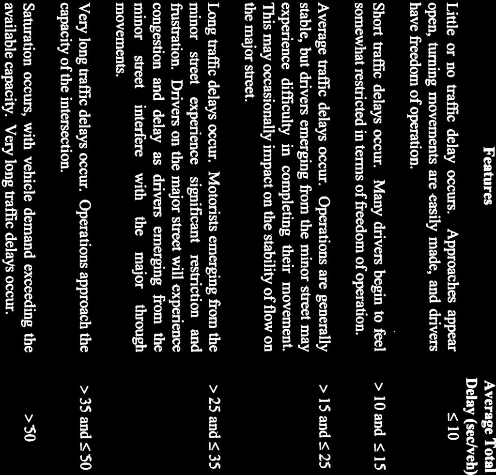
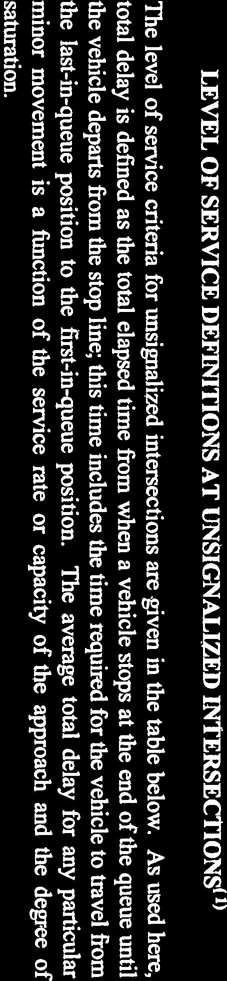
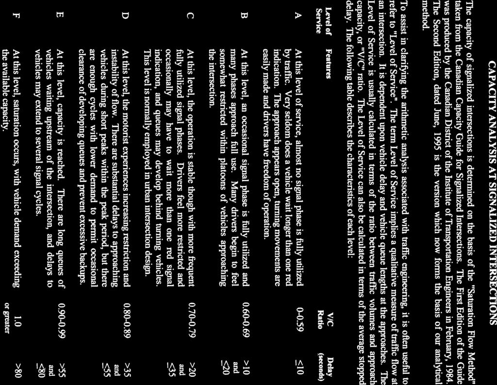
35 Appendix A Level of Service Definitions

36
37
MILLERSVILLE PARK TRAFFIC IMPACT ANALYSIS ANNE ARUNDEL COUNTY, MARYLAND
 MILLERSVILLE PARK TRAFFIC IMPACT ANALYSIS ANNE ARUNDEL COUNTY, MARYLAND Prepared for: Department of Public Works Anne Arundel County Prepared by: URS Corporation 4 North Park Drive, Suite 3 Hunt Valley,
LAWRENCE TRANSIT CENTER LOCATION ANALYSIS 9 TH STREET & ROCKLEDGE ROAD / 21 ST STREET & IOWA STREET LAWRENCE, KANSAS
 LAWRENCE TRANSIT CENTER LOCATION ANALYSIS 9 TH STREET & ROCKLEDGE ROAD / 21 ST STREET & IOWA STREET LAWRENCE, KANSAS TRAFFIC IMPACT STUDY FEBRUARY 214 OA Project No. 213-542 TABLE OF CONTENTS 1. INTRODUCTION...
West Hills Shopping Centre Lowe s Expansion Traffic Impact Study
 West Hills Shopping Centre Lowe s Expansion Traffic Impact Study Prepared for: Armel Corporation January 2015 Paradigm Transportation Solutions Ltd. 22 King Street South, Suite 300 Waterloo ON N2J 1N8
Date: February 7, 2017 John Doyle, Z-Best Products Robert Del Rio. T.E. Z-Best Traffic Operations and Site Access Analysis
 Memorandum Date: February 7, 07 To: From: Subject: John Doyle, Z-Best Products Robert Del Rio. T.E. Z-Best Traffic Operations and Site Access Analysis Introduction Hexagon Transportation Consultants, Inc.
Trafalgar Road & Lower Base Line Transportation Study Ontario Inc.
 Trafalgar Road & Lower Base Line Transportation Study 1255723 Ontario Inc. Trafalgar Road & Lower Base Line Transportation Study 1255723 Ontario Inc. 1465 Pickering Parkway Suite 200 Pickering ON L1V 7G7
TRAFFIC IMPACT ANALYSIS
 TRAFFIC IMPACT ANALYSIS Emerald Isle Commercial Development Prepared by SEPI Engineering & Construction Prepared for Ark Consulting Group, PLLC March 2016 I. Executive Summary A. Site Location The Emerald
105 Toronto Street South, Markdale Transportation Impact Study. Paradigm Transportation Solutions Limited
 105 Toronto Street South, Markdale Transportation Impact Study Paradigm Transportation Solutions Limited December 2016 Project Summary Project Number 162060 December 2016 Client Zelinka Priamo Ltd 318
MEMO VIA . Ms. Amy Roth DPS Director, City of Three Rivers. To:
 MEMO To: Ms. Amy Roth DPS Director, City of Three Rivers VIA EMAIL From: Michael J. Labadie, PE Julie M. Kroll, PE, PTOE Brandon Hayes, PE, P.Eng. Fleis & VandenBrink Date: January 5, 2017 Re: Proposed
BARRHAVEN FELLOWSHIP CRC 3058 JOCKVALE ROAD OTTAWA, ONTARIO TRANSPORTATION BRIEF. Prepared for:
 BARRHAVEN FELLOWSHIP CRC 3058 JOCKVALE ROAD OTTAWA, ONTARIO TRANSPORTATION BRIEF Prepared for: Barrhaven Fellowship CRC 3058 Jockvale Road Ottawa, ON K2J 2W7 December 7, 2016 116-649 Report_1.doc D. J.
TRAFFIC IMPACT STUDY VICDOM BROCK ROAD PIT EXPANSION
 TRAFFIC IMPACT STUDY VICDOM BROCK ROAD PIT EXPANSION TOWNSHIP OF UXBRIDGE P/N 05-1993 June 2011 Revised -August 2011 Prepared by: Skelton, Brumwell & Associates Inc. 93 Bell Farm Road, Suite 107 Barrie,
Transportation & Traffic Engineering
 Transportation & Traffic Engineering 1) Project Description This report presents a summary of findings for a Traffic Impact Analysis (TIA) performed by A+ Engineering, Inc. for the Hill Country Family
INDUSTRIAL DEVELOPMENT
 INDUSTRIAL DEVELOPMENT Traffic Impact Study Plainfield, Illinois August 2018 Prepared for: Seefried Industrial Properties, Inc. TABLE OF CONTENTS Executive Summary 2 Introduction 3 Existing Conditions
PROJECT: Wilkinson Road Corridor Improvement Traffic Management Planning Project SUBJECT: Traffic Analysis
 TECHNICAL MEMORANDUM DATE: September 10, 2014 PROJECT 5861.03 NO: PROJECT: Wilkinson Road Corridor Improvement Traffic Management Planning Project SUBJECT: Traffic Analysis TO: Steve Holroyd - District
TRAFFIC IMPACT STUDY DERRY GREEN CORPORATE BUSINESS PARK MILTON SECONDARY PLAN MODIFICATION
 TRAFFIC IMPACT STUDY DERRY GREEN CORPORATE BUSINESS PARK MILTON SECONDARY PLAN MODIFICATION TRAFFIC IMPACT STUDY DERRY GREEN CORPORATE BUSINESS PARK MILTON SECONDARY PLAN MODIFICATION DECEMBER 24 UPDATED
APPENDIX C1 TRAFFIC ANALYSIS DESIGN YEAR TRAFFIC ANALYSIS
 APPENDIX C1 TRAFFIC ANALYSIS DESIGN YEAR TRAFFIC ANALYSIS DESIGN YEAR TRAFFIC ANALYSIS February 2018 Highway & Bridge Project PIN 6754.12 Route 13 Connector Road Chemung County February 2018 Appendix
EXECUTIVE SUMMARY. The following is an outline of the traffic analysis performed by Hales Engineering for the traffic conditions of this project.
 EXECUTIVE SUMMARY This study addresses the traffic impacts associated with the proposed Shopko redevelopment located in Sugarhouse, Utah. The Shopko redevelopment project is located between 1300 East and
Prepared For: Toronto Transit Commission 1138 Bathurst Street Toronto, Ontario M5R 3H2. Prepared By:
 TRAFFIC IMPACT STUDY FOR THE TTC MCNICOLL BUS GARAGE CITY OF TORONTO Prepared For: Toronto Transit Commission 1138 Bathurst Street Toronto, Ontario M5R 3H2 Prepared By: Canada Inc. 4th Floor, 3 Leek Crescent
King Soopers #116 Thornton, Colorado
 Traffic Impact Study King Soopers #116 Thornton, Colorado Prepared for: Galloway & Company, Inc. T R A F F I C I M P A C T S T U D Y King Soopers #116 Thornton, Colorado Prepared for Galloway & Company
Proposed Pit Development
 July 5, 2017 via email: sam@greenwoodconst.ca CCTA File 114239 Sam Greenwood Greenwood Aggregates 205467 County Road 109 Amaranth, ON L9W 0V1 Re: Proposed Violet Hill Gravel Pit, Town of Mono Traffic Review
Traffic Impact Study Speedway Gas Station Redevelopment
 Traffic Impact Study Speedway Gas Station Redevelopment Warrenville, Illinois Prepared For: Prepared By: April 11, 2018 Table of Contents 1. Introduction... 1 2. Existing Conditions... 4 Site Location...
Section 5.0 Traffic Information
 Section 5.0 Traffic Information 10.0 TRANSPORTATION MDM Transportation Consultants, Inc. (MDM) has prepared an evaluation of transportation impacts for the proposed evaluation for the expansion of the
Appendix H TRAFFIC IMPACT ANALYSIS
 Appendix H TRAFFIC IMPACT ANALYSIS Teichert Boca Quarry Expansion Traffic Impact Analysis Prepared for Teichert Aggregates Prepared by TRANSPORTATION CONSULTANTS, INC. LSC Transportation Consultants, Inc.
HIGHWAY 28 FUNCTIONAL DESIGN
 HIGHWAY 28 FUNCTIONAL DESIGN PUBLIC OPEN HOUSE #1 WEDNESDAY, MARCH 12, 2014 Stantec Presenters: Brad Vander Heyden, Project Engineer Neal Cormack, Project Manager Dave Parker, Project Engineer Beth Thola,
886 March Road McDonald's Transportation Study
 McDonald's Restaurants of Canada Limited March 2013 886 March Road McDonald's Transportation Study Submitted by: HDR Corporation 100 York Boulevard, Suite 300 Richmond Hill, ON L4B 1J8 (905) 882-4100 www.hdrinc.com
Bennett Pit. Traffic Impact Study. J&T Consulting, Inc. Weld County, Colorado. March 3, 2017
 Bennett Pit Traffic Impact Study J&T Consulting, Inc. Weld County, Colorado March 3, 217 Prepared By: Sustainable Traffic Solutions, Inc. http://www.sustainabletrafficsolutions.com/ Joseph L. Henderson,
To: File From: Adrian Soo, P. Eng. Markham, ON File: Date: August 18, 2015
 Memo To: From: Adrian Soo, P. Eng. Markham, ON : 165620021 Date: Reference: E.C. Row Expressway, Dominion Boulevard Interchange, Dougall Avenue Interchange, and Howard 1. Review of Interchange Geometry
830 Main Street Halifax Regional Municipality
 830 Main Street Halifax Regional Municipality Traffic Impact Statement Final Report Prepared by: GRIFFIN transportation group inc. 30 Bonny View Drive Fall River, NS B2T 1R2 www.griffininc.ca Prepared
Table of Contents INTRODUCTION... 3 PROJECT STUDY AREA Figure 1 Vicinity Map Study Area... 4 EXISTING CONDITIONS... 5 TRAFFIC OPERATIONS...
 Crosshaven Drive Corridor Study City of Vestavia Hills, Alabama Table of Contents INTRODUCTION... 3 PROJECT STUDY AREA... 3 Figure 1 Vicinity Map Study Area... 4 EXISTING CONDITIONS... 5 TRAFFIC OPERATIONS...
LCPS Valley Service Center
 Traffic Impact Study LCPS Valley Service Center Loudoun County, Virginia November 4, 2015 Prepared For: Loudoun County Public Schools 21000 Education Court Ashburn, VA 20148 Prepared by: 1140 Connecticut
Traffic Impact Analysis. Alliance Cole Avenue Residential Site Dallas, Texas. Kimley-Horn and Associates, Inc. Dallas, Texas.
 Traffic Impact Analysis Alliance Cole Avenue Residential Site Dallas, Texas February 15, 2018 Kimley-Horn and Associates, Inc. Dallas, Texas Project #064524900 Registered Firm F-928 Traffic Impact Analysis
RE: A Traffic Impact Statement for a proposed development on Quinpool Road
 James J. Copeland, P.Eng. GRIFFIN transportation group inc. 30 Bonny View Drive Fall River, NS B2T 1R2 May 31, 2018 Ellen O Hara, P.Eng. Project Engineer DesignPoint Engineering & Surveying Ltd. 200 Waterfront
Traffic Impact Study Proposed Residential Development (Watson Parkway North - Starwood Drive Node, City of Guelph)
") Traffic Impact Study Proposed Residential Development (Watson Parkway North - Starwood Drive Node, City of Guelph) Prepared By: 332 Lorne Avenue East Stratford ON N5A 6S4 Prepared for: Paul Kemper, President
Traffic Impact Study Proposed Residential Development (Watson Parkway North - Starwood Drive Node, City of Guelph) Prepared By: 332 Lorne Avenue East Stratford ON N5A 6S4 Prepared for: Paul Kemper, President
Traffic Feasibility Study
 Traffic Feasibility Study Town Center South Robbinsville Township, Mercer County, New Jersey December 19, 2017 Prepared For Robbinsville Township Department of Community Development 2298 Route 33 Robbinsville,
Re: Addendum No. 4 Transportation Overview 146 Mountshannon Drive Ottawa, Ontario
 April 18 th, 2017 Mr. Kevin Yemm Vice President, Land Development Richraft Group of Companies 2280 St. Laurent Boulevard, Suite 201 Ottawa, Ontario (Tel: 613.739.7111 / e-mail: keviny@richcraft.com) Re:
Proposed location of Camp Parkway Commerce Center. Vicinity map of Camp Parkway Commerce Center Southampton County, VA
 Proposed location of Camp Parkway Commerce Center Vicinity map of Camp Parkway Commerce Center Southampton County, VA Camp Parkway Commerce Center is a proposed distribution and industrial center to be
Vanier Parkway and Presland Road Residential Development Transportation Impact Study
 Vanier Parkway and Presland Road Residential Development Transportation Impact Study Final Report (Revised) March 2011 Submitted to: Groupe Lépine Ottawa Project No. 09-1613 Submitted by: Groupe Lépine
Airport Road Improvements
 Airport Road Improvements October 2015 ENVIRONMENTAL STUDY REPORT Airport Road from 1.0 km north of Mayfield to 0.6 km north of King Street Town of Caledon D TRAFFIC STUDY & ROUNDABOUT EVALUATIONS Airport
Traffic Impact Statement (TIS)
") Traffic Impact Statement (TIS) Vincentian PUDA Collier County, FL 10/18/2013 Prepared for: Global Properties of Naples Prepared by: Trebilcock Consulting Solutions, PA 2614 Tamiami Trail N, Suite 615 1205
Traffic Impact Statement (TIS) Vincentian PUDA Collier County, FL 10/18/2013 Prepared for: Global Properties of Naples Prepared by: Trebilcock Consulting Solutions, PA 2614 Tamiami Trail N, Suite 615 1205
MERIVALE PRIORITY SQUARE 2852 MERIVALE ROAD CITY OF OTTAWA TRANSPORTATION BRIEF. Prepared for: ONT Inc. 25 Winding Way Nepean, Ontario K2C 3H1
 MERIVALE PRIORITY SQUARE 2852 MERIVALE ROAD CITY OF OTTAWA TRANSPORTATION BRIEF Prepared for: 2190986ONT Inc. 25 Winding Way Nepean, Ontario K2C 3H1 October 6, 2010 110-502 Report_1.doc D. J. Halpenny
The major roadways in the study area are State Route 166 and State Route 33, which are shown on Figure 1-1 and described below:
 3.5 TRAFFIC AND CIRCULATION 3.5.1 Existing Conditions 3.5.1.1 Street Network DRAFT ENVIRONMENTAL IMPACT REPORT The major roadways in the study area are State Route 166 and State Route 33, which are shown
TRANSPORTATION IMPACT STUDY ALCONA SOUTH SECONDARY PLAN SLEEPING LION DEVELOPMENT TOWN OF INNISFIL
 TRANSPORTATION IMPACT STUDY ALCONA SOUTH SECONDARY PLAN SLEEPING LION DEVELOPMENT TOWN OF INNISFIL Prepared For: 1602850 Ontario Ltd. 2800 Highway 7 Vaughan, Ontario L4K 1W8 Prepared By: URS Canada Inc.
2405 Mer Bleue Orleans, (Ottawa), ON Community Transportation Study Mattamy Homes. Prepared By: Stantec Consulting Ltd. Version 2
, ON Community Transportation Study Mattamy Homes. Prepared By: Stantec Consulting Ltd. Version 2") 2405 Mer Bleue Orleans, (Ottawa), ON Community Transportation Study Mattamy Homes Prepared By: Stantec Consulting Ltd. Version 2 April 2014 Stantec Consulting Ltd. 400-1331 Clyde Avenue, Ottawa ON K2C
2405 Mer Bleue Orleans, (Ottawa), ON Community Transportation Study Mattamy Homes Prepared By: Stantec Consulting Ltd. Version 2 April 2014 Stantec Consulting Ltd. 400-1331 Clyde Avenue, Ottawa ON K2C
Appendix J Traffic Impact Study
 MRI May 2012 Appendix J Traffic Impact Study Level 2 Traffic Assessment Limited Impact Review Appendix J [This page was left blank intentionally.] www.sgm-inc.com Figure 1. Site Driveway and Trail Crossing
TRAFFIC SIGNAL DESIGN REPORT KING OF PRUSSIA ROAD & RAIDER ROAD RADNOR TOWNSHIP PENNSYLVANIA
 TRAFFIC SIGNAL DESIGN REPORT KING OF PRUSSIA ROAD & RAIDER ROAD RADNOR TOWNSHIP PENNSYLVANIA PREPARED FOR: UNIVERSITY OF PENNSYLVANIA HEALTH SYSTEM 34 CIVIC CENTER BOULEVARD PHILADELPHIA, PA 1987 (61)
Environmental Assessment Derry Road and Argentia Road Intersection
 Air and Noise Study Environmental Assessment Derry Road and Argentia Road Intersection Project 11-4295 City of Mississauga, Region of Peel October 17, 2014 1 Region of Peel Environmental Assessment for
Traffic Impact Analysis West Street Garden Plots Improvements and DuPage River Park Garden Plots Development Naperville, Illinois
 Traffic Impact Analysis West Street Garden Plots Improvements and DuPage River Park Garden Plots Development Naperville, Illinois Submitted by April 9, 2009 Introduction Kenig, Lindgren, O Hara, Aboona,
Traffic Engineering Study
 Traffic Engineering Study Bellaire Boulevard Prepared For: International Management District Technical Services, Inc. Texas Registered Engineering Firm F-3580 November 2009 Executive Summary has been requested
APPENDIX B Traffic Analysis
 APPENDIX B Traffic Analysis Rim of the World Unified School District Reconfiguration Prepared for: Rim of the World School District 27315 North Bay Road, Blue Jay, CA 92317 Prepared by: 400 Oceangate,
Proposed Commercial Service at Paine Field Traffic Impact Analysis
 Gibson Traffic Consultants 80 Wetmore Avenue Suite 0 Everett, WA 980.9.86 Prepared for: Federal Aviation Administration July 0 GTC #09-07 TABLE OF CONTENTS. EXECUTIVE SUMMARY.... PROJECT IDENTIFICATION....
144&176 John St. and 200 John St. & 588 Charlotte St. Hotel and Residential Subdivision Development
 Solmar Development Corp. 144&176 John St. and 2 John St. & 588 Charlotte St. Hotel and Residential Subdivision Development TRANSPORTATION IMPACT STUDY 18145 November 217 LEA Consulting Ltd. Consulting
RICHMOND OAKS HEALTH CENTRE 6265 PERTH STREET OTTAWA, ONTARIO TRANSPORTATION BRIEF. Prepared for: Guycoki (Eastern) Limited.
 Limited.") RICHMOND OAKS HEALTH CENTRE 6265 PERTH STREET OTTAWA, ONTARIO TRANSPORTATION BRIEF Prepared for: Guycoki (Eastern) Limited June 16, 2016 116-638 Brief_1.doc D. J. Halpenny & Associates Ltd. Consulting
RICHMOND OAKS HEALTH CENTRE 6265 PERTH STREET OTTAWA, ONTARIO TRANSPORTATION BRIEF Prepared for: Guycoki (Eastern) Limited June 16, 2016 116-638 Brief_1.doc D. J. Halpenny & Associates Ltd. Consulting
TRAFFIC PARKING ANALYSIS
 TRAFFIC PARKING ANALYSIS NAPA FLEA MARKET COUNTY OF NAPA Prepared for: Tom Harding Napa-Vallejo Flea Market 33 Kelly Road American Canyon, CA 9453 Prepared by: 166 Olympic Boulevard, Suite 21 Walnut Creek,
Lakeside Terrace Development
 Lakeside Terrace Development City of Barrie, County of Simcoe Traffic Brief for: Type of Document: Final Report Project Number: JDE 1617 Date Submitted: April 29 th, 216 4/29/16 John Northcote, P.Eng.
DEVELOPMENT PROPERTY 1627 MAXIME STREET CITY OF OTTAWA TRANSPORTATION OVERVIEW. Prepared for: Subhas Bhargava. July 9, Overview_1.
 DEVELOPMENT PROPERTY 1627 MAXIME STREET CITY OF OTTAWA TRANSPORTATION OVERVIEW Prepared for: Subhas Bhargava July 9, 2015 115-620 Overview_1.doc D. J. Halpenny & Associates Ltd. Consulting Transportation
Creditview Road Schedule C Class Environmental Assessment Traffic Operations Analysis Final Report
 Capability City of Mississauga Creditview Road Schedule C Class Environmental Assessment Traffic Operations Analysis Final Report Prepared by: AECOM 5080 Commerce Boulevard 905 238 0007 tel Mississauga,
The key roadways in the project vicinity are described below. Exhibit displays the existing number of lanes on the study roadways.
 4.2 TRAFFIC AND CIRCULATION This section presents the key assumptions, methods, and results of analysis for the transportation and circulation impacts of the proposed project. This section is based on
NEWCASTLE MIDDLE SCHOOL Traffic Impact Analysis
 Gibson Traffic Consultants 2802 Wetmore Avenue Suite 220 Everett, WA 98201 425.339.8266 NEWCASTLE MIDDLE SCHOOL Traffic Impact Analysis Prepared for: Renton School District Jurisdiction: City of Newcastle
FLAMBOROUGH QUARRY HAUL ROUTE STUDY HAUL ROUTE VIBRATION REPORT. itrans Consulting Inc 100 York Boulevard Richmond Hill, Ontario L4B 1J8
 FINAL REPORT FLAMBOROUGH QUARRY HAUL ROUTE STUDY HAUL ROUTE VIBRATION REPORT Project Number: #W08-5107A August 28, 2008 SUBMITTED TO: Tara Erwin itrans Consulting Inc 100 York Boulevard Richmond Hill,
HUMC/Mountainside Hospital Redevelopment Plan
 Traffic and Parking Analysis HUMC/Mountainside Hospital Redevelopment Plan in Glen Ridge Borough and Montclair Township PREPARED FOR H2M 119 Cherry Hill Road, Suite 110 Parsippany, NJ 07054 862.207.5900
APPENDIX E. Traffic Analysis Report
 APPENDIX E Traffic Analysis Report THIS PAGE INTENTIONALLY BLANK EAGLE RIVER TRAFFIC MITIGATION PHASE I OLD GLENN HIGHWAY/EAGLE RIVER ROAD INTERSECTION IMPROVEMENTS TRAFFIC ANALYSIS Eagle River, Alaska
King County Metro. Columbia Street Transit Priority Improvements Alternative Analysis. Downtown Southend Transit Study. May 2014.
 King County Metro Columbia Street Transit Priority Improvements Alternative Analysis Downtown Southend Transit Study May 2014 Parametrix Table of Contents Introduction... 1 Methodology... 1 Study Area...
GASOLINE SERVICE STATION 1618, 1622 ROGER STEVENS DRIVE OTTAWA, ONTARIO TRANSPORTATION IMPACT ASSESSMENT. Prepared for:
 GASOLINE SERVICE STATION 1618, 1622 ROGER STEVENS DRIVE OTTAWA, ONTARIO TRANSPORTATION IMPACT ASSESSMENT Prepared for: Invecta Development (Ottawa) Corporation 758 Shanks Height Milton, ON L9T 7P7 May
Appendix C-5: Proposed Refinements Rail Operations and Maintenance Facility (ROMF) Traffic Impact Analysis. Durham-Orange Light Rail Transit Project
 Traffic Impact Analysis. Durham-Orange Light Rail Transit Project") Appendix C-5: Proposed Refinements Rail Operations and Maintenance Facility (ROMF) Traffic Impact Analysis Durham-Orange Light Rail Transit Project July 25, 218 ROMF Transportation Impact Analysis Version
Appendix C-5: Proposed Refinements Rail Operations and Maintenance Facility (ROMF) Traffic Impact Analysis Durham-Orange Light Rail Transit Project July 25, 218 ROMF Transportation Impact Analysis Version
THE CORNERSTONE APARTMENTS TRAFFIC IMPACT STUDY R&M PROJECT NO
 THE CORNERSTONE APARTMENTS SITUATED AT N/E/C OF STAUDERMAN AVENUE AND FOREST AVENUE VILLAGE OF LYNBROOK NASSAU COUNTY, NEW YORK TRAFFIC IMPACT STUDY R&M PROJECT NO. 2018-089 September 2018 50 Elm Street,
RESPONSE TO TRAFFIC IMPACT STUDY COMMENTS
 RESPONSE TO TRAFFIC IMPACT STUDY COMMENTS Proposed Gas Station 40 Arthur Street (Highway 26), Town of the Blue Mountains (Thornbury), County of Grey, Ontario AUGUST 2013 August 27, 2013 MR. REG RUSSWURM
Escondido Marriott Hotel and Mixed-Use Condominium Project TRAFFIC IMPACT ANALYSIS REPORT
 Escondido Marriott Hotel and Mixed-Use Condominium Project TRAFFIC IMPACT ANALYSIS REPORT Prepared for Phelps Program Management 420 Sixth Avenue, Greeley, CO 80632 Prepared by 5050 Avenida Encinas, Suite
Traffic Impact Analysis 5742 BEACH BOULEVARD MIXED USE PROJECT
 Traffic Impact Analysis 5742 BEACH BOULEVARD MIXED USE PROJECT CITY OF BUENA PARK Prepared by Project No. 14139 000 April 17 th, 2015 DKS Associates Jeffrey Heald, P.E. Rohit Itadkar, T.E. 2677 North Main
TRAFFIC IMPACT STUDY FOR SONIC DRIVE-IN RESTAURANT. Vallejo, CA. Prepared For:
 TRAFFIC IMPACT STUDY FOR SONIC DRIVE-IN RESTAURANT Vallejo, CA Prepared For: ELITE DRIVE-INS, INC. 2190 Meridian Park Blvd, Suite G Concord, CA 94520 Prepared By: KD Anderson & Associates 3853 Taylor Road,
TRAFFIC IMPACT STUDY FOR ST. JOSEPH'S ELEMENTARY SCHOOL ADDITION
 CATHOLIC DISTRICT SCHOOL BOARD OF EASTERN ONTARIO P.O. 61992 TRAFFIC IMPACT STUDY FOR ST. JOSEPH'S ELEMENTARY SCHOOL ADDITION SEPTEMBER 5, 218 TRAFFIC IMPACT STUDY FOR ST. JOSEPH'S ELEMENTARY SCHOOL ADDITION
Shirk Road at State Route 198 Interchange Analysis Tulare County, California
 Shirk Road at State Route 198 Interchange Analysis Tulare County, California DRAFT REPORT Prepared By Tulare County Association of Governments (TCAG) April 2013 Table of Contents Introduction:... 3 Project
Volume 1 Traffic Impact Analysis Turtle Creek Boulevard Dallas, Texas. Kimley-Horn and Associates, Inc. Dallas, Texas.
 Volume 1 Traffic Impact Analysis 2727 Dallas, Texas June 18, 2018 Kimley-Horn and Associates, Inc. Dallas, Texas Project #064523000 Registered Firm F-928 Traffic Impact Analysis 2727 Dallas, Texas Prepared
TIMBERVINE TRANSPORTATION IMPACT STUDY FORT COLLINS, COLORADO JANUARY Prepared for:
 TIMBERVINE TRANSPORTATION IMPACT STUDY FORT COLLINS, COLORADO JANUARY 2014 Prepared for: Hartford Companies 1218 W. Ash Street Suite A Windsor, Co 80550 Prepared by: DELICH ASSOCIATES 2272 Glen Haven Drive
TRAFFIC AND TRANSPORTATION TECHNICAL MEMORANDUM
 TRAFFIC AND TRANSPORTATION TECHNICAL MEMORANDUM for ENVIRONMENTAL ASSESSMENT US 460 Bypass Interchange and Southgate Drive Relocation State Project No.: 0460-150-204, P101, R201, C501, B601; UPC 99425
Alpine Highway to North County Boulevard Connector Study
 Alpine Highway to North County Boulevard Connector Study prepared by Avenue Consultants March 16, 2017 North County Boulevard Connector Study March 16, 2017 Table of Contents 1 Summary of Findings... 1
Traffic Impact Study for Proposed Olive Boulevard Development
 Traffic Impact Study for Proposed 11330 Olive Boulevard Development Creve Coeur, Missouri July 7, 2017 Prepared For: 11330 Olive Boulevard Development 11330 Olive Boulevard Creve Coeur, Missouri 63141
Appendix Q Traffic Study
 Appendices Appendix Q Traffic Study Crummer Site Subdivision Draft EIR City of Malibu Appendices This page intentionally left blank. The Planning Center April 2013 TRAFFIC IMPACT ANALYSIS Photo z here
2.0 Development Driveways. Movin Out June 2017
 Movin Out June 2017 1.0 Introduction The proposed Movin Out development is a mixed use development in the northeast quadrant of the intersection of West Broadway and Fayette Avenue in the City of Madison.
IRSCH REEN Hirsch/Green Transportation Consulting, Inc.
 IRSCH REEN Hirsch/Green Transportation Consulting, Inc. February 6, 2013 Mr. David Weil Director of Finance St. Matthew s Parish School 1031 Bienveneda Avenue Pacific Palisades, California 90272 RE: Trip
Expansion Projects Description
 Expansion Projects Description The Turnpike expansion program was authorized by the Florida Legislature in 1990 to meet the State s backlog of needed highway facilities. The Legislature set environmental
V. DEVELOPMENT OF CONCEPTS
 Martin Luther King, Jr. Drive Extension FINAL Feasibility Study Page 9 V. DEVELOPMENT OF CONCEPTS Throughout the study process several alternative alignments were developed and eliminated. Initial discussion
RTE. 1 at RTE. 637 & RTE. 639
 INTERSECTION SAFETY STUDY Prepared for: Virginia Department of Transportation Central Region Operations Traffic Engineering (UPC #81378, TO 12-092) DAVENPORT Project Number: 13-368 / /2014 RTE. 1 at RTE.
Appendix C. Traffic Study
 Appendix C Traffic Study TABLE OF CONTENTS SECTION Executive Summary PAGE 1.0 Introduction... 1 1.1 Scope of Work... 1 1.2 Study Area... 2 2.0 Project Description... 3 2.1 Site Access... 4 2.2 Pedestrian
Ce document est aussi disponible en français
 Ministry of Community Safety and Correctional Services August 2005 Ce document est aussi disponible en français What Is A Community Safety Zone? C ommunity Safety Zones are sections of roadways where public
Downtown Lee s Summit Parking Study
 Downtown Lee s Summit Parking Study As part of the Downtown Lee s Summit Master Plan, a downtown parking and traffic study was completed by TranSystems Corporation in November 2003. The parking analysis
APPENDIX G TRAFFIC STUDY TECHNICAL MEMORANDUM
 APPENDIX G TRAFFIC STUDY TECHNICAL MEMORANDUM TECHNICAL MEMORANDUM To: From: Date: Subject: Jerry Flores - AECOM Brian A. Marchetti, AICP September 9, 5 DRAFT Traffic Study LABOE Channel 5 Studio Relocation
Proposed Inn at Bellefield Traffic Impact Assessment
 Proposed Inn at Bellefield Traffic Impact Assessment Town of Hyde Park Dutchess County, New York Prepared for: T-Rex Hyde Park Owner LLC 500 Mamroneck Avenue, Suite 300 Harrison, NY 10528 June 21, 2017
April 7, Mr. Blake Shutler Compass Homes Development LLC Summit Homes Construction, LLC PO Box 6539 Dillon, CO 80435
 Compass Homes Development LLC Summit Homes Construction, LLC PO Box 6539 Dillon, CO 80435 Re: Trip Generation Comparison West Hills Townhomes Keystone, Colorado FHU Reference No. 116388-01 Dear Mr. Shutler:
Public Meeting: Metropolitan Washington Airports Authority (MWAA) TNC (Transportation Network Company) Lot on S. Eads Street
 TNC (Transportation Network Company) Lot on S. Eads Street") Public Meeting: Metropolitan Washington Airports Authority (MWAA) TNC (Transportation Network Company) Lot on S. Eads Street Department of Environmental Services, Transportation Division Sept. 27, 2018
Public Meeting: Metropolitan Washington Airports Authority (MWAA) TNC (Transportation Network Company) Lot on S. Eads Street Department of Environmental Services, Transportation Division Sept. 27, 2018
Transit City Etobicoke - Finch West LRT
 Delcan Corporation Transit City Etobicoke - Finch West LRT APPENDIX D Microsimulation Traffic Modeling Report March 2010 March 2010 Appendix D CONTENTS 1.0 STUDY CONTEXT... 2 Figure 1 Study Limits... 2
MEMORANDUM. Figure 1. Roundabout Interchange under Alternative D
 MEMORANDUM Date: To: Liz Diamond, Dokken Engineering From: Subject: Dave Stanek, Fehr & Peers Western Placerville Interchanges 2045 Analysis RS08-2639 Fehr & Peers has completed a transportation analysis
Attachment F Transportation Technical Memorandum
 Attachment F Transportation Technical Memorandum Sounder Yard and Shops Facility Project Transportation Technical Memorandum March 25, 216 Prepared for: Sound Transit Prepared by: Parsons Brinckerhoff
King Street & Wyman Road Transportation Impact Study & Transportation Demand Management. Paradigm Transportation Solutions Limited
 King Street & Wyman Road Transportation Impact Study & Transportation Demand Management Paradigm Transportation Solutions Limited April 28 Project Summary Project Number 822 April 28 Client RISE Commercial
DRAFT TRANSPORTATION IMPACT STUDY CASTILIAN REDEVELOPMENT PROJECT
 DRAFT TRANSPORTATION IMPACT STUDY CASTILIAN REDEVELOPMENT PROJECT Prepared for: Submitted by: 299 Lava Ridge Ct. Suite 2 Roseville, CA. 95661 June 212 TABLE OF CONTENTS 1. Introduction... 1 Project Location
Lacey Gateway Residential Phase 1
 Lacey Gateway Residential Phase Transportation Impact Study April 23, 203 Prepared for: Gateway 850 LLC 5 Lake Bellevue Drive Suite 02 Bellevue, WA 98005 Prepared by: TENW Transportation Engineering West
APPENDIX J LAKE WOHLFORD DAM REPLACEMENT PROJECT TRAFFIC IMPACT ANALYSIS (DAM REPLACEMENT) Lake Wohlford Dam Replacement Project EIR
 Lake Wohlford Dam Replacement Project EIR") APPENDIX J LAKE WOHLFORD DAM REPLACEMENT PROJECT TRAFFIC IMPACT ANALYSIS (DAM REPLACEMENT) Replacement Project EIR Appendices TRAFFIC IMPACT ANALYSIS LAKE WOHLFORD DAM Escondido, California December 19,
APPENDIX J LAKE WOHLFORD DAM REPLACEMENT PROJECT TRAFFIC IMPACT ANALYSIS (DAM REPLACEMENT) Replacement Project EIR Appendices TRAFFIC IMPACT ANALYSIS LAKE WOHLFORD DAM Escondido, California December 19,
New Jersey Turnpike Authority Interchange 6 to 9 Widening Program
 New Jersey Turnpike Authority Interchange 6 to 9 Widening Program Tuesday, September 18, 2007 Public Hearings: Time: 5:00 PM - 8:00 PM Wednesday, September 19, 2007 Senior Center 3 Municipal Drive Bordentown,
APPENDIX C-2. Traffic Study Supplemental Analysis Memo
 APPENDIX C-2 Traffic Study Supplemental Analysis Memo The Mobility Group Transportation Strategies & Solutions Memorandum To: From: Subject: Tomas Carranza, LADOT Matthew Simons Traffic Review - Revised
TRAFFIC IMPACT ASSESSMENT PART OF AN ENVIRONMENTAL IMPACT ASSESSMENT FOR THE KEBRAFIELD ROODEPOORT COLLIERY IN THE PULLEN S HOPE AREA
 TRAFFIC IMPACT ASSESSMENT PART OF AN ENVIRONMENTAL IMPACT ASSESSMENT FOR THE KEBRAFIELD ROODEPOORT COLLIERY IN THE PULLEN S HOPE AREA 20 March 2014 Report prepared by: Corli Havenga Transportation Engineers
TRAFFIC IMPACT STUDY 3171 LAKESHORE ROAD WEST RESIDENTIAL DEVELOPMENT TOWN OF OAKVILLE, REGIONAL MUNICIPALITY OF HALTON
 TRAFFIC IMPACT STUDY 3171 LAKESHORE ROAD WEST RESIDENTIAL DEVELOPMENT TOWN OF OAKVILLE, REGIONAL MUNICIPALITY OF HALTON PREPARED FOR: VOGUE WYCLIFFE (OAKVILLE) LIMITED PREPARED BY: C.F. CROZIER & ASSOCIATES
Craig Scheffler, P.E., PTOE HNTB North Carolina, P.C. HNTB Project File: Subject
 TECHNICAL MEMORANDUM To Kumar Neppalli Traffic Engineering Manager Town of Chapel Hill From Craig Scheffler, P.E., PTOE HNTB North Carolina, P.C. Cc HNTB Project File: 38435 Subject Obey Creek TIS 2022