Proposed location of Camp Parkway Commerce Center. Vicinity map of Camp Parkway Commerce Center Southampton County, VA
|
|
|
- Allan Barton
- 5 years ago
- Views:
Transcription
1
2
3 Proposed location of Camp Parkway Commerce Center Vicinity map of Camp Parkway Commerce Center Southampton County, VA
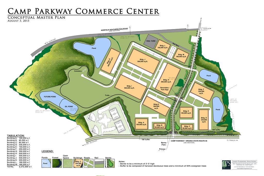
4 Camp Parkway Commerce Center is a proposed distribution and industrial center to be located off of Delaware Road in Southampton County, VA. Intermodal Engineering, P.C. was retained by Hampton Roads Development, LLC to perform a Traffic Impact Analysis in accordance with 24-VAC (Virginia Department of Transportation Chapter 527 criteria) for the rezoning for Camp Parkway Commerce Center to determine the impacts of the development on the existing road system. The traffic impact analysis includes both existing conditions and impacts of the development on the adjacent roadway, as well as identifies any potential traffic modifications to minimize these impacts and provide adequate access to the development. PROJECT DESCRIPTION Camp Parkway Commerce Center is a proposed distribution and industrial center to be located off of both sides of Delaware Road just north of Camp Parkway (US 58 Bus) in Southampton County, VA. The proposed site is approximately 439 acres that is currently zoned as follows: 147 acres A-2 and 292 acres R- 1. It is proposed to be rezoned to M-1 Limited Industrial to allow for the commerce center. The ultimate plan is to develop 3,272,000 sf of building space. It is anticipated 1
5 that 70% the site would be used primarily for the storage and/or consolidation of manufactured goods prior to their distribution to retail locations or other warehouses and 30% would be industrial use space. Access to the development is proposed at two access points along Delaware Road. EXISTING ROADWAY NETWORK The existing major roadways adjacent to the site is as follows: 1) Delaware Road is a two-lane undivided rural roadway with an unposted speed limit. In the vicinity of the site, it runs north to the Hunterdale Road and south to US 58. 2) Camp Parkway (US 58 Bus) is a four-lane divided minor arterial roadway with a 55 mph speed limit. In the vicinity of the site, it runs east into Franklin and west then south to US 58. Its intersection with US 58 is unsignalized and the southbound movement has a free right with an acceleration lane to westbound US 58. Present traffic demand in the study area was determined from a review of traffic count data. Manual traffic counts were conducted by Intermodal Engineering, P.C. from 7am to 9am and 4pm to 6pm on a typical weekday during the week of March 10, 2014 at the intersections of Camp Parkway and Delaware Road and of US 58 and Camp Parkway. Additional traffic count data was conducted the week of January 5, 2015 which included Camp Parkway and Village Drive (Riverdale Elementary School) and the mid-day hours 2
6 at US 58 and Camp Parkway. These traffic volumes are indicated on Figures 1 and 2. Automatic 24-hour traffic counts were also conducted by Intermodal Engineering, P.C. during the week of March 24, 2014 and indicate the following existing two-way through volumes in the vicinity of the site: Delaware Road - N of Camp Pkwy Camp Pkwy b/t Delaware & US 58 1,500 vpd 4,000 vpd While these volumes provide a measure of activity on the area road system, it is also important to evaluate how well that system can accommodate those volumes. A comparison of the amount of delay experienced by vehicles is commonly used and determines the levels of service at intersections. The delay for these intersections was studied under existing conditions utilizing SYNCHRO software. The results of the analysis indicate the following levels of service: EXISTING CONDITIONS Unsignalized - AM PM Camp Pkwy/Delaware EB Lt A ( 7.6s) A ( 7.7s) WB Lt A ( 7.7s) A ( 7.6s) NB B (12.1s) B (12.5s) SB B (10.7s) B (11.2s) US 58/Camp Pkwy EB Lt A ( 8.2s) A ( 8.6s) SB C (17.3s) C (21.3s) Camp Pkwy/Village EB Lt A ( 7.9s) A ( 7.7s) SB B (10.7s) B (10.3s) 3
7 Camp Parkway Commerce Center 7/29/2015 Delaware Rd drwy Village Dr Camp Pkwy US Rt Figure 1 AM EXISTING
8 11 15 Southampton Distribution Center 7/29/2015 Delaware Rd 5 drvwy Village Dr Camp Pkwy US Rt Figure 2 PM EXISTING
9 As can be seen, the intersections function acceptably under existing conditions and no traffic control improvements are needed FUTURE CONDITIONS (No Build) Full build-out for the Camp Parkway Commerce Center is to construct over 25 years. The road system was reviewed for the no build condition of the Camp Parkway Commerce Park in the year The background growth rate of 2%/year, or rather 50% for the 25 years, was applied to existing traffic counts. The future traffic volumes are shown on Figures 3 and 4. Then using the future traffic volumes, the studied intersections were again analyzed utilizing SYNCHRO. The results of this analysis indicate the following level of service and corresponding approach delay in seconds: 2040 FUTURE CONDITIONS (no build) Unsignalized - AM PM Camp Pkwy/Delaware EB Lt A ( 7.8s) A ( 7.9s) WB Lt A ( 8.0s) A ( 7.8s) NB C (16.4s) C (16.8s) SB B (13.2s) B (14.2s) US 58/Camp Pkwy EB Lt A ( 9.1s) A ( 9.8s) SB D (30.3s) E (45.3s) Camp Pkwy/Village EB Lt A ( 8.2s) A ( 7.9s) SB B (12.3s) B (11.4s) With the increase in traffic due to future growth to 2040, all the intersection approaches operate acceptable except the 4
10 Camp Parkway Commerce Center 7/29/2015 Delaware Rd drwy Village Dr Camp Pkwy US Rt Figure 3 AM 2040 FUTURE
11 11 15 Camp Parkway Commerce Center 7/29/2015 Delaware Rd 5 drvwy Village Dr Camp Pkwy US Rt Figure 4 PM 2040 FUTURE
12 southbound approach at US 58 and Camp Parkway drops to an unacceptable LOS D in the morning peak hour and LOS E in the afternoon peak hour. While the potential for signalization exists, however, it is noted that the median is approximately 42 feet wide, so the southbound left turning vehicles do not cross both directions of US 58 at one time, so the level of service is actually better than the analysis would indicate FUTURE w/camp PARKWAY COMMERCE CENTER (Build-out) Generation The 25-year development plan for Camp Parkway Commerce Center is to construct an ultimate built-out total of 3,272,000 sf of space of which 70% the site would be used primarily for the storage and/or consolidation of manufactured goods prior to their distribution to retail locations or other warehouses and 30% would be industrial use space. Trips were then generated based upon the Trip Generation: An Informational Report (Institute of Transportation Engineers, 9 th Edition, 2012) for 70% to be High-Cube Warehouse/Distribution Center and of the 30% industrial use space, the generations were based on one-third General Light Industrial and two-thirds Industrial Park. The trip generations are as follows: High Cube Warehousing: 2,290,400 sf TOTAL IN OUT Weekday Total 3,848 vpd 1,924 vpd 1,924 vpd Weekday AM Peak Hour 295 vph 204 vph 91 vph Weekday PM Peak Hour 317 vph 98 vph 219 vph 5
13 Light Industrial: 327,200 sf TOTAL IN OUT Weekday Total 2,342 vpd 1,171 vpd 1,171 vpd Weekday AM Peak Hour 297 vph 261 vph 36 vph Weekday PM Peak Hour 312 vph 37 vph 272 vph Industrial Park: 654,400 sf TOTAL IN OUT Weekday Total 3,944 vpd 1,972 vpd 1,972 vpd Weekday AM Peak Hour 417 vph 342 vph 75 vph Weekday PM Peak Hour 541 vph 114 vph 427 vph The total for Camp Parkway Commerce Center: Camp Pkwy. Comm Park BUILD-OUT TOTAL: TOTAL IN OUT Weekday Total 10,134 vpd 5,067 vpd 5,067 vpd Weekday AM Peak Hour 1,008 vph 806 vph 202 vph Weekday PM Peak Hour 1,168 vph 249 vph 919 vph The truck trips were generated based on the weighted averages given under Land Use 152. TRUCK GENERATION Build-out: TOTAL IN OUT Weekday Total 2,094 vpd 1,047 vpd 1,047 vpd Weekday AM Peak Hour 98 vph 68 vph 30 vph Weekday PM Peak Hour 131 vph 41 vph 90 vph TRUCK % Build-out: Weekday Total 36.1% Weekday AM Peak Hour 21.4% Weekday PM Peak Hour 27.3% 6
14 By-Right Trip Generation Comparison Currently, 292 acres are zoned R-1, which means that single family houses could be built on this portion of the property byright. It is estimated that 475 houses could reasonably be developed. The following is a trip generation comparison of Camp Parkway Commerce Center with the by-right houses: 2040 CAMP PKWY COMM CTR TOTAL TOTAL IN OUT Weekday Total 10,134 vpd 5,067 vpd 5,067 vpd Weekday AM Peak Hour 1,008 vph 806 vph 202 vph Weekday PM Peak Hour 1,168 vph 249 vph 919 vph Single Family Detached houses TOTAL IN OUT Weekday Total 4,404 vpd 2,202 vpd 2,202 vpd Weekday AM Peak Hour 342 vph 86 vph 257 vph Weekday PM Peak Hour 427 vph 269 vph 158 vph DIFFERENTIAL w/475 houses TOTAL IN OUT Weekday Total 5,730 vpd 2,865 vpd 2,865 vpd Weekday AM Peak Hour 666 vph 721 vph -55 vph Weekday PM Peak Hour 741 vph -20 vph 761 vph While weekday overall trips have increased, it is noted that there is a decrease in the outbound trips in the morning and inbound trips in the evening. In addition, a comparison was done assuming the 147 acres of A-2 were developed as residential. It is estimated that 225 additional houses could reasonably be developed on the remaining property, for a total of 700 houses. The following is a trip 7
15 generation comparison of Camp Parkway Commerce Center with the entire 439 acres developed as residential: 2040 CAMP PKWY COMM CTR TOTAL TOTAL IN OUT Weekday Total 10,134 vpd 5,067 vpd 5,067 vpd Weekday AM Peak Hour 1,008 vph 806 vph 202 vph Weekday PM Peak Hour 1,168 vph 249 vph 919 vph Single Family Detached houses TOTAL IN OUT Weekday Total 6,292 vpd 3,146 vpd 3,146 vpd Weekday AM Peak Hour 500 vph 125 vph 375 vph Weekday PM Peak Hour 605 vph 381 vph 224 vph DIFFERENTIAL w/700 houses TOTAL IN OUT Weekday Total 3,842 vpd 1,921 vpd 1,921 vpd Weekday AM Peak Hour 509 vph 681 vph -173 vph Weekday PM Peak Hour 563 vph -132 vph 695 vph Again, while weekday overall trips have increased, it is noted that there is an even greater decrease in the outbound trips in the morning and inbound trips in the evening. Distribution Trips from the proposed Camp Parkway Commerce Center were distributed to the existing roadway system based on discussions with representatives of Hampton Roads Development, LLC and Franklin Southampton Economic Development Inc. on the anticipated direction of travel of truck movements and of the employees. The following is the distribution assumptions: 8
16 AM PM From the N on Delaware Rd: 4% 4% From the S on Delaware Rd: 1% 1% From the E on Camp Pkwy: 20% 20% From the E on US Rt 58: 30% 29% From the W on US Rt 58: 45% 46% To the N on Delaware Rd: 4% 4% To the S on Delaware Rd: 1% 1% To the E on Camp Pkwy: 20% 20% To the E on US Rt 58: 30% 37% To the W on US Rt 58: 45% 38% For the distribution to the accesses, it is assumed based on the size of the sections that: - 80% would be oriented to the west side and 20% would be oriented to the east side. - For traffic entering the site, 2/3 would utilize the first access they come to and 1/3 would utilize the second access. - For traffic exiting the site, 2/3 would utilize the access closest to their destination and 1/3 the other access. Furthermore, truck traffic would primarily be oriented to come from and depart to US 58 via Camp Parkway to the west. Traffic using Camp Parkway to the east as well as Delaware Road to access the site, would primarily be employees going to and from the site rather than truck traffic. These generated and distributed volumes are shown on Figures 5 and 6. Then the generated volumes were combined with future
17 Camp Parkway Commerce Center 7/30/2015 W2 access Camp Pkwy Comm Ctr W E2 access Camp Pkwy Comm Ctr E W1 access E1 access Camp Pkwy 605 Delaware Rd US Rt 58 Figure 5 AM 2040 BUILD-OUT DISTRIBUTION
18 1 4 5 Camp Parkway Commerce Center 7/30/2015 W2 access Camp Pkwy Comm Ctr W E2 access Camp Pkwy Comm Ctr E W1 access E1 access Camp Pkwy 187 Delaware Rd US Rt 58 Figure 6 PM 2040 BUILD-OUT DISTRIBUTION
19 traffic data and are shown on Figure 7 and 8. Capacity Analysis Using the trips generated by Camp Parkway Commerce Center added to the future traffic counts, the studied intersections along with both accesses to the site were analyzed utilizing SYNCHRO. Because of the large volume of northbound left turns on Delaware Road, it is assumed that a northbound left turn lane into the W1/E1 access would be installed with the development of the Camp Parkway Commerce Center. All other turn lanes will be vetted by capacity need or turn lane review. The following indicates the results of this capacity analysis: 2040 FUTURE w/camp PARKWAY COMMERCE CTR Unsignalized - AM PM Camp Pkwy/Delaware EB Lt B (12.7s) A ( 8.7s) WB Lt A ( 8.0s) A ( 7.8s) NB F ( n/a ) F ( n/a ) SB F ( n/a ) F ( n/a ) US 58/Camp Pkwy EB Lt B ( 12.3s) B (10.8s) SB F ( n/a ) F ( n/a ) Camp Pkwy/Village EB Lt A ( 8.7s) B (10.7s) SB C (18.0s) D (26.5s) Delaware/W1/E1 NB Lt A ( 9.4s) A ( 8.6s) SB Lt A ( 8.3s) A ( 7.8s) EB B (11.6s) D (29.6s) WB F ( n/a ) F ( n/a ) Delaware/W2/E2 NB Lt A ( 8.3s) A ( 7.6s) SB Lt A ( 7.5s) A ( 7.6s) EB B (10.5s) B (10.5s) WB C (19.5s) C (15.5s) 10
20 Camp Parkway Commerce Center 7/30/2015 W2 access E2 access 1 10 Camp Pkwy Comm Ctr W Camp Pkwy Comm Ctr E W1 access E1 access Camp Pkwy Delaware Rd drvwy Village Dr US Rt Figure 7 AM 2040 w/camp Pkwy Commerce Center
21 Camp Parkway Commerce Center 7/30/2015 W2 access E2 access 5 44 Camp Pkwy Comm Ctr W Camp Pkwy Comm Ctr E W1 access E1 access Camp Pkwy Delaware Rd drvwy Village Dr US Rt Figure 8 PM 2040 w/camp Pkwy Commerce Center
22 Under the 2040 traffic conditions with the addition of the full build-out Camp Parkway Commerce Center, there is further degradation of level of service for the southbound left at US 58 and Camp Parkway. Now, both the morning and afternoon peak hours are LOS F. As mentioned previously, additional traffic control measures may be needed, such as signalization, and further evaluation will be conducted later in this report. In addition, there is a significant drop in the levels of service at Camp Parkway and Delaware Road and it is now operating at an unacceptable LOS F for the northbound and southbound approach in the morning the afternoon. Consequently, additional traffic control measures will be needed, such as signalization, and further evaluation will be conducted later in this report. In addition, it is noted that both the eastbound and westbound movement out of W1 and E1 accesses operate at LOS F. Consequently, additional traffic control measures will be needed, such as signalization, and further evaluation will be conducted later in this report. SIGNAL WARRANT STUDY (2040) Due to an existing deficiency in the level of service at the intersection of US 58 and Camp Parkway and at Camp Parkway and Delaware Road, a review of traffic signal warrants was performed for the full build-out of Camp Parkway Commerce Park in
23 The decision to install a traffic signal should never be taken lightly. It should only be placed if there is a definitive benefit by providing improved right-of-way control and operation and enhancing overall safety of the intersection. Consequently, the Manual of Uniform Traffic Control Devices(MUTCD) for Streets and Highways, provides national standards to justify the installation of a traffic signal. Camp Parkway and Delaware Road Warrant 1A - Minimum Vehicular Volume was the warrant deemed appropriate to be applied to the intersection of Camp Parkway and Delaware Road. Since the speed limit is 55 mph which is in excess of 45 mph, so the 70% reduction of the warrant does apply. Also it was assumed that the southbound approach would be widened to have a separate right turn lane and a left/thru lane. The 8-hour conditions of Warrant 1A of the Manual of Uniform Traffic Control Devices (MUTCD) for 2 or more lanes on the main street and 2 lanes on the side street requires the following traffic volume criteria be met or exceeded for each of any eight hours of an average day: Major Street(combined approaches): Minor Street: 420 vph 140 vph The 8-hour signal warrant analysis was made such that the minor street exit needs to exceed 140 vph and the major street two-way volume needs to exceed 420 vph for each of any 8 hours. 12
24 The signal warrant analysis was performed for the full build-out condition. Assumptions for the warrant analysis: - Existing counts were factored up for the growth rate: 50% for There would be two southbound lanes on Delaware Road, most likely a left/through lane and a right turn only lane. - Outbound trips from Camp Parkway Commerce Center oriented to eastbound and westbound Camp Parkway and southbound Delaware Road were added to the factored southbound volume on Delaware Road, distributed hourly based on Figure 1 - Hourly Variation of Total Trips under Land Use 152, to derive the minor street volume. - Inbound trips from Camp Parkway Commerce Center from eastbound and westbound Camp Parkway, distributed hourly based on Figure 1 - Hourly Variation of Total Trips under Land Use 152, were added to the factored traffic on Camp Parkway to derive the major street volume. A summary of this analysis is shown on Table 1 on the following pages. Under the full build-out condition in 2040, eleven hours meet the warrant, which is in excess of the required eight hours. Consequently, signalization would be needed in the full build-out condition. Capacity analysis of Camp Parkway and Delaware Avenue indicates that in addition to signalization the following improvements are also needed: 13
25 - Eastbound dual left turns on Camp Parkway at Delaware Road. - Southbound dual right turns on Delaware Road at Camp Parkway. With signalization and these improvements, the following levels of service are achieved: 2040 FUTURE w/camp PARKWAY COMMERCE CTR w/signalization & turn lanes Signalized - AM PM Camp Pkwy/Delaware B (19.0s) B (18.7s) EB B (16.8s) B (17.1s) WB C (24.5s) C (21.2s) NB C (35.0s) C (34.8s) SB B (15.4s) B (17.7s) This signal should be a six-phase operation with eastbound and westbound protected-only left turn phases on Camp Parkway and split phase operation on Delaware Road. While signalization enhances level of serve, VDOT Chapter 527 requires review of alternatives to a traffic signal, such as a round-a-bout. While from a capacity stand point, a round-a-bout may work at this intersection, it is noted that a double-lane round-a-bout to handle trucks would require an inscribed circle diameter of feet. Since the right of way of Camp Parkway at Delaware Road is 150 feet, there is insufficient right-of-way to be able to feasibly construct a round-a-bout. 14
26 US 58 and Camp Parkway Warrant 1B - Interruption of Continuous Traffic was the warrant deemed appropriate to be applied to the US 58 and Camp Parkway intersection. Since the speed limit on US 58 is in excess of 45 mph, the 70% reduction of the warrant does apply. The 8-hour conditions of Warrant 1B of the Manual of Uniform Traffic Control Devices (MUTCD) for 2 or more lanes on the main street and 1 lane on the side street requires the following traffic volume criteria be met or exceeded for each of any eight hours of an average day: Major Street(combined approaches): Minor Street: 630 vph 53 vph The 8-hour signal warrant analysis was made such that the minor street exit needs to exceed 53 vph and the major street two-way volume needs to exceed 630 vph for each of any 8 hours. The signal warrant analysis was performed for the full build-out condition. Assumptions for the warrant analysis: - Because the southbound rights have a free right turn lane to westbound US 58, only the southbound lefts are considered in the warrant review. - Existing counts were factored up for the growth rate: 50% for Outbound trips from Camp Parkway Commerce Center oriented to eastbound US 58 were added to the factored southbound left on Camp Parkway, distributed hourly based on Figure 1 - Hourly Variation of Total Trips under Land Use 152, 15
27 to derive the minor street volume. - Inbound trips from Camp Parkway Commerce Center from eastbound and westbound US 58, distributed hourly based on Figure 1 - Hourly Variation of Total Trips under Land Use 152, were added to the factored traffic on US 58 to derive the major street volume. A summary of this analysis is shown on Tables 2 on the following page. Under the full build-out condition in 2040, eleven hours meet the warrant, which is in excess of the required eight hours. Consequently, signalization would be needed in the full build-out condition. Due to the high volume of eastbound left turns on US 58 (660 vph in the AM peak hour and 321 vph in the PM peak hour), dual left turns would be warranted under VDOT standards. With signalization and dual eastbound left turns, the following levels of service are achieved: 2040 FUTURE w/camp PARKWAY COMMERCE CTR w/signalization & turn lanes Signalized - AM PM US 58/Camp Pkwy B (12.2s) B (14.9s) EB B (10.5s) B (12.0s) WB B (13.6s) B (15.9s) SB C (22.2s) C (21.3s) This signal should be a three-phase operation with eastbound protected-only left turn phases on Camp Parkway. While signalization enhances level of serve, VDOT Chapter 527 requires review of alternatives to a traffic signal, such as a 16
28 round-a-bout. While from a capacity stand point, a round-a-bout may work at this intersection, however, it is noted that a double-lane round-a-bout to handle trucks would require an inscribed circle diameter of feet. Since the right of way of US 58 and Camp Parkway is not within the confines of Camp Parkway Commerce Center, there is insufficient right-of-way to be able to feasibly construct a round-a-bout. Delaware Road and W1 Access/E1 Access Warrant 1A - Minimum Vehicular Volume was the warrant deemed appropriate to be applied to the intersection of Delaware Road and W1 Access/E1 Access. Currently, the speed limit on Delaware Road is 55 mph, however, it is proposed to lower the speed limit to 45mph. As long as the speed limit remains 40 mph or higher, the 70% reduction of the warrant does apply. Since the higher volume is on the W1 access, that approach was reviewed under the signal warrant criteria. The 8-hour conditions of Warrant 1A of the Manual of Uniform Traffic Control Devices (MUTCD) for 1 lane on the main street and 2 lane or more lanes on the side street requires the following traffic volume criteria be met or exceeded for each of any eight hours of an average day: Major Street(combined approaches): Minor Street: 350 vph 140 vph 17
29 The 8-hour signal warrant analysis was made such that the minor street exit needs to exceed 140 vph and the major street two-way volume needs to exceed 350 vph for each of any 8 hours. The signal warrant analysis was performed for the full build-out condition. Assumptions for the warrant analysis: - Existing counts were factored up for the growth rate: 50% for There would be at least two eastbound lanes on W1 access and traffic on this approach would be distributed hourly based on the previously determined Hourly Variation of Total Trips under Land Use 152, to derive the minor street volume. - Inbound trips to Camp Parkway Commerce Center were added to the factored Delaware Road traffic volumes, distributed hourly based the Hourly Variation of Total Trips the major street volume. A summary of this analysis is shown on Table 3 on the following pages. Under the full build-out condition in 2040, only three out of eight needed hours meet the warrant, which does not meet warrant for a traffic signal. There are two additional hours that are close. Even considering these close hours, five out of eight needed hours meet the warrant, which again does not meet warrant for a traffic signal, but starts to indicate that the signal may be warranted. Given the warrants are borderline of this project, further review of the warrants are needed. 18
30 Because of the nature of this type of development, there is the potential for spikes in traffic. Consequently, Warrant 4 - Four- Hour Vehicular Volume Warrant was reviewed. A review of Figure 4C-2 for the Four-Hour Warrant is indicated below. Given the volume of traffic on Delaware Road, the major street, the minor street minimum volume was determined from Figure 4C-2 and compared with the projected volume from Delaware Road. Delaware Rd & W1 Access Four-Hour Warrant Review Delaware TOTAL w/cpcc W1 access outbound Minor St minimum vol needed to meet warrant Warrant Met? 7a-8a YES 8a-9a no 9a no 10a-11a no 11a-12p no 12p-1p no 1p-2p no 2p-3p no 3p-4p YES 4p-5p YES 5p-6p YES 6p-7p no As can be seen, the full build-out condition in 2040, eleven hours meet the warrant, which is in excess of the required eight hours. Consequently, signalization would be needed in the full build-out condition. 19
31 Capacity analysis of Delaware Avenue and W1/E1 access indicates that in addition to signalization the following improvements are also needed: - Eastbound dual right turns on W1 access at Delaware Road. - Northbound left turn lane on Delaware Road at W1 access. With signalization and these improvements, the following levels of service are achieved: 2040 FUTURE w/camp PARKWAY COMMERCE CTR w/signalization & turn lanes Signalized - AM PM Delaware/W1/E1 A ( 8.8s) B (18.0s) EB C (23.9s) B (17.0s) WB C (34.7s) C (20.0s) NB A ( 9.7s) C (34.4s) SB B (13.2s) B (16.8s This signal should be a four-phase operation with northbound protected/permissive left turn phase on Delaware Road and split phase operation on W1 access and E1 access FUTURE CONDITIONS (No Build) Since Camp Parkway Commerce Park is a large development that will occur over a 25 years, an interim period was reviewed at a point prior to the traffic signals being warranted to determine a threshold for improvements. For the interim build period, a 15- year partial build out period, to the year 2030, was reviewed. Again background growth rate of 2%/year, or rather 30% for the 15 years, was applied to existing traffic counts. The future 20
32 traffic volumes are shown on Figures 9 and 10. Then using the future traffic volumes, the studied intersections were again analyzed utilizing SYNCHRO. The results of this analysis indicate the following level of service and corresponding approach delay in seconds: 2030 FUTURE CONDITIONS (no build) Unsignalized - AM PM Camp Pkwy/Delaware EB Lt A ( 7.7s) A ( 7.8s) WB Lt A ( 7.9s) A ( 7.7s) NB B (14.3s) B (14.8s) SB B (11.9s) B (12.8s) US 58/Camp Pkwy EB Lt A ( 8.7s) A ( 9.2s) SB C (23.6s) D (32.4s) Camp Pkwy/Village EB Lt A ( 8.1s) A ( 7.8s) SB B (11.6s) B (10.8s) With the increase in traffic due to future growth to 2030, all the intersection approaches operate acceptable except the southbound approach at US 58 and Camp Parkway drops to an LOS D in the afternoon peak hour. While the potential for signalization exists, however, it is noted that the median is approximately 42 feet wide, so the southbound left turning vehicles do not cross both directions of US 58 at one time, so the level of service is actually better than the analysis would indicate FUTURE w/camp PARKWAY COMMERCE CENTER (Interim Build) Generation With further analysis of the signal warrant analysis at Camp Parkway and Delaware Road, it was able to be determined that a 21
33 Camp Parkway Commerce Center 7/30/ Delaware Rd drwy Village Dr Camp Pkwy US Rt Figure 9 AM FUTURE 2030 (no build)
34 11 15 Camp Parkway Commerce Center 7/30/2015 Delaware Rd 5 drvwy Village Dr Camp Pkwy US Rt Figure 10 PM FUTURE 2030 (no build)
35 threshold of 1,941 vpd total exiting trips, or rather 3,882 vpd total all trips, as a point below which the traffic signal would not be warranted. In order to forecast future traffic conditions upon the completion of the interim phase of the development, it is necessary to determine the amount of new traffic which will be generated by the interim build condition. The following are several combinations of development that achieve this threshold using the planned land uses for the site: Using just High-Cube Warehouse/Distribution Center: High Cube Warehsng: 2,290,400 sf TOTAL IN OUT Weekday Total 3,848 vpd 1,924 vpd 1,924 vpd Weekday AM Peak Hour 295 vph 204 vph 91 vph Weekday PM Peak Hour 317 vph 98 vph 219 vph Using just General Light Industrial: Light Industrial: 533,000 sf TOTAL IN OUT Weekday Total 3,880 vpd 1,940 vpd 1,940 vpd Weekday AM Peak Hour 540 vph 475 vph 65 vph Weekday PM Peak Hour 605 vph 73 vph 532 vph Using just Industrial Park: Industrial Park: 640,000 sf TOTAL IN OUT Weekday Total 3,872 vpd 1,936 vpd 1,936 vpd Weekday AM Peak Hour 409 vph 336 vph 74 vph Weekday PM Peak Hour 530 vph 111 vph 418 vph 22
36 Using the same mix percentages, as used in full build-out condition: High Cube Warehousing: 840,000 sf TOTAL IN OUT Weekday Total 1,412 vpd 706 vpd 706 vpd Weekday AM Peak Hour 92 vph 63 vph 29 vph Weekday PM Peak Hour 114 vph 35 vph 79 vph Light Industrial: 120,000 sf TOTAL IN OUT Weekday Total 794 vpd 397 vpd 397 vpd Weekday AM Peak Hour 52 vph 46 vph 6 vph Weekday PM Peak Hour 14 vph 2 vph 13 vph Industrial Park: 200,000 sf TOTAL IN OUT Weekday Total 1,676 vpd 838 vpd 838 vpd Weekday AM Peak Hour 163 vph 134 vph 29 vph Weekday PM Peak Hour 186 vph 39 vph 147 vph The 2030 interim total for Camp Parkway Commerce Center: Camp Pkwy Comm Park 2030 INTERIM TOTAL: TOTAL IN OUT Weekday Total 3,882 vpd 1,941 vpd 1,941 vpd Weekday AM Peak Hour 308 vph 244 vph 64 vph Weekday PM Peak Hour 315 vph 76 vph 239 vph The mixed condition was used for further evaluation in the report. 23
37 Distribution The generated trips were distributed based on the same assumptions as used for 2040 condition and these volumes are shown on Figures 11 and 12. Then the generated volumes were combined with future traffic volumes and are shown on Figure 13 and 14. Capacity Analysis Using the trips generated by Camp Parkway Commerce Center added to the future 2030 traffic data, the studied intersections along with both accesses to the site were analyzed utilizing SYNCHRO. Again, it was assumed that a northbound left turn lane into the W1/E1 access would be installed with the development of the Camp Parkway Commerce Center. All other turn lanes will be determined by capacity need or turn lane review. All other turn lanes will be determined by capacity need or turn lane review. The following indicates the results of this capacity analysis: 2030 FUTURE w/camp PARKWAY COMMERCE CTR Unsignalized - AM PM Camp Pkwy/Delaware EB Lt A ( 8.1s) A ( 8.0s) WB Lt A ( 7.8s) A ( 7.7s) NB D (28.1s) C (18.5s) SB C (15.0s) C (14.2s) US 58/Camp Pkwy EB Lt B (11.6s) A ( 9.4s) SB E (42.8s) F (123.7s) Camp Pkwy/Village EB Lt A ( 8.2s) A ( 8.3s) SB B (12.8s) B (12.9s) 24
38 1 4 5 Camp Parkway Commerce Center 7/30/2015 W2 access Camp Pkwy Comm Ctr W E2 access Camp Pkwy Comm Ctr E W1 access E1 access Camp Pkwy 183 Delaware Rd US Rt 58 Figure 11 AM 2030 DISTRIBUTION
39 1 1 1 Camp Parkway Commerce Center 7/30/2015 W2 access Camp Pkwy Comm Ctr W E2 access Camp Pkwy Comm Ctr E W1 access E1 access Camp Pkwy 57 Delaware Rd US Rt 58 Figure 12 PM 2030 DISTRIBUTION
40 Camp Parkway Commerce Center 11/18/2015 W2 access E2 access 1 3 Southampton Dis. Ctr W Southampton Dis. Ctr E W1 access E1 access Camp Pkwy Delaware Rd drvwy Village Dr US Rt Figure 13 AM 2030 w/camp Pkwy Commerce Ctr
41 Camp Parkway Commerce Center 11/18/2015 W2 access E2 access 2 12 Southampton Dis. Ctr W Southampton Dis. Ctr E W1 access E1 access Camp Pkwy Delaware Rd drvwy Village Dr US Rt Figure 14 PM 2030 w/camp Pkwy Commerce Ctr
42 Delaware/W1/E1 NB Lt A ( 8.0s) A ( 7.7s) SB Lt A ( 7.6s) A ( 0.0s) EB A ( 9.7s) A ( 9.9s) WB B (15.4s) B (13.8s) Delaware/W2/E2 NB Lt A ( 7.7s) A ( 7.4s) SB Lt A ( 7.4s) A ( 7.5s) EB A ( 9.4s) A ( 9.1s) WB B (11.2s) B (10.7s) Under the 2030 traffic conditions with the addition of the interim build of Camp Parkway Commerce Center, there is a degradation of level of service for the southbound left at US 58 and Camp Parkway. The morning falls to LOS E and the afternoon further degrades to LOS F. Additional traffic control measures may be needed, such as signalization, and will be evaluated further later in this report. SIGNAL WARRANT STUDY (2030) The traffic signal warrants were reviewed for the interim phase based on the same warrants used in the 2040 build-out condition. Camp Parkway and Delaware Road A summary of the warrant analysis for US 58 and Camp Parkway is shown on Table 4 on the following page. Under the interim build condition in 2030, five out of eight hours meets the warrant and, as such, a traffic signal would not be warranted. However, at this point there is a capacity issue on the southbound approach and signalization would be needed beyond this point. 25
43 US 58 and Camp Parkway A summary of the warrant analysis for US 58 and Camp Parkway is shown on Table 5 on the following page. Under the interim build condition in 2030, only two out of eight hours meets the warrant and, as such, a traffic signal would not be warranted. It is noted that the median is approximately 42 feet wide, so the southbound left turning vehicles do not cross both directions of US 58 at one time, so the level of service is actually better than the analysis would indicate. TURN LANE ANALYSIS While highway capacity analysis gives an indication of traffic flow, a review of turn lane requirements at the proposed entrances to the development is needed to determine what, if any, improvements may be needed in accordance with VDOT standards. Because of the large scope and long timeline for buildout of Camp Parkway Commerce Center, the signal warrant analysis threshold 3,882 vph was used as a breakpoint for the improvements and to develop beyond this point, a new traffic study should be performed to determine if the site is developing as projected and the background growth rate utilized was appropriate. CAMP PARKWAY AND DELAWARE ROAD Right Turn Lane Review The need for a right turn lane was reviewed utilizing VDOT Access Management Design Standards, Figure A summary of 26
44 this review is presented below: Camp Parkway & Delaware Road WB Right Turn Review WB Rts Adjd Rts Appch Vol Meet Criteria? 2030 AM Peak 53 vph n/a vph 222 vph taper 2030 PM Peak 23 vph n/a vph 202 vph no 2040 AM Peak 166 vph n/a vph 361 vph 200 lane 2040 PM Peak 59 vph n/a vph 266 vph taper Based on VDOT Standards, a westbound right turn taper would be needed on Camp Parkway at Delaware Road with interim build condition and a westbound right turn lane would be needed in the build-out condition at the intersection of Camp Parkway & Delaware Road. The westbound right turn taper for the 2030 interim condition should be 200 feet and the westbound right turn lane for the 2040 build-out condition should be 200 foot turn lane with a 200 foot taper. The timing of implementation for the taper and for the right turn lane was also reviewed. It was determined that right turn taper should be implemented when right turns exceed 30 vph. When including existing traffic, this threshold will be exceeded when the trips for the morning peak hour exceed 188 vph and translates to daily trip generation of 1,875 vpd. It was further determined that a right turn lane should be implemented when right turns exceed 90 vph. This threshold will be exceeded when the trips for the morning peak hour exceed 563 vph and translate to daily 27
45 trip generation of 5,625 vpd. However, since the turn lane improvement occurs after the 2030 condition, this should be reviewed again when the 3,882 vph threshold, as determined by the signal warrant analysis, is to be exceeded. Left Turn Lane Review Currently, there exists a short eastbound left turn on Camp Parkway which is approximately a 60 foot turn lane with a 65 foot taper. The length of this left turn lane was reviewed utilizing VDOT Access Management Design Standards, Figure 3-3 for four-lane highways. A summary of this review is presented below: Camp Parkway & Delaware Road EB Left Turn Review EB Lts Adv Vol. % Lts Opp. Vol Meet Criteria? 2030 AM Peak 218 vph 481 vph 45% 222 vph 150 lane 2030 PM Peak 139 vph 360 vph 39% 202 vph 100 lane 2040 AM Peak 646 vph 951 vph 68% 361 vph Dual lanes 2040 PM Peak 282 vph 538 vph 52% 266 vph 200 lane Based on VDOT Standards, a minimum of 150 foot eastbound left turn lane with a 200 foot taper on Camp Parkway at Delaware Road would be required under the 2030 interim condition. However, due to the large amount of trucks that are anticipated, a longer turn lane should be considered. Based on the assumption that 1/8 of the vehicles would be of a type that is twice the size of a car 28
46 and that 1/8 of the vehicles would be of a type that is four times the size of a car, then these left turn lanes should be: 2030 Condition: 150ft*{(¾*1)+(⅛*2)+( ⅛*4)} = 225 feet Because the existing turn lane is substandard, the lengthening of the turn lane should be implemented at initial development. Under the 2040 build-out condition, dual left turn lanes would be needed and the intersection would be signalized, as determined by the capacity analysis. Based on the queue report, the dual left turn lanes should be a minimum of 200 feet each with a 200 foot taper. Since this improvement occurs after the 2030 condition, this should be reviewed again when the 3,882 vph threshold, as determined by the signal warrant analysis, is to be exceeded. US 58 AND CAMP PARKWAY Right Turn Lane Review Currently, there exists a westbound right turn free ramp which helps facilitate traffic exiting from US 58, but whether there should be a longer right turn deceleration space will be reviewed as a need for a right turn lane utilizing VDOT Access Management Design Standards, Figure A summary of this review is presented below: 29
47 US 58 & Camp Parkway WB Right Turn Review WB Rts Adjd Rts Appch Vol Meet Criteria? 2030 AM Peak 82 vph n/a vph 412 vph taper 2030 PM Peak 31 vph n/a vph 509 vph taper 2040 AM Peak 253 vph n/a vph 634 vph turn lane 2040 PM Peak 83 vph n/a vph 635 vph taper Based on VDOT Standards, with interim build, a 200 foot taper would be needed at the intersection of US 58 and Camp Parkway. However, currently there is free right turn ramp and this will suffice better than a taper to assist traffic to adequately maneuver off of Route 58 with minimal decrease in speed. With the ultimate build-out this ramp should be extended another 200 feet on westbound Route 58. Since this improvement occurs after the 2030 condition, this should be reviewed again when the 3,882 vph threshold, as determined by the signal warrant analysis, is to be exceeded. Left Turn Lane Review Currently, there exists a 150 foot eastbound left turn lane with a 200 foot taper on US 58. The length of this left turn lane was reviewed utilizing VDOT Access Management Design Standards, Table 3-3 for four-lane highways. A summary of this review is presented below: 30
48 US 58 & Camp Parkway EB Left Turn Review % Meet EB Lts Adv Vol. Lts Opp. Vol Criteria? 2030 AM Peak 315 vph 624 vph 50% 412 vph 300 lane 2030 PM Peak 213 vph 808 vph 26% 509 vph 200 lane 2040 AM Peak 600 vph 957 vph 63% 634 vph Dual lefts 2040 PM Peak 321 vph 1008 vph 32% 635 vph 300 lane Based on VDOT Standards, a minimum of 300 foot eastbound left turn lane with a 200 foot taper would be needed for the interim condition in Again, due to the large amount of trucks that are anticipated, a longer turn lane should be considered. Based on the assumption that 1/8 of the vehicles would be of a type that is twice the size of a car and that 1/8 of the vehicles would be of a type that is four times the size of a car, then these left turn lanes should be: 2030 Condition: 300ft*{(¾*1)+(⅛*2)+( ⅛*4)} = 450 feet Because the existing turn lane is substandard, the lengthening of the turn lane should be implemented at initial development. Under the 2040 build-out condition, dual left turn lanes would be needed and the intersection would be signalized, as determined by the capacity analysis. Based on the queue report, the dual left turn lanes should be a minimum of 160 feet each with a 200 foot taper. Since this improvement occurs after the 2030 condition, this should be reviewed again when the 3,882 vph threshold, as determined by the signal warrant analysis, is to be exceeded. 31
49 CAMP PARKWAY COMMERCE CENTER ENTRANCES Delaware Road It is noted that currently there is no speed limit posted on Delaware Road. In Virginia, that would indicate a speed limit of 55 mph for this type of road. Because this development will change the characteristics of the roadway by adding entrances and turning truck traffic, a speed limit of no more than 45 mph should be posted along Delaware Road from Camp Parkway to the Norfolk Southern railroad tracks for safety reasons. In order to achieve this, the Southampton Board of Supervisors and VDOT would need to approve this change. This change could certainly be conditional upon the actual construction of the site. Consequently, the following analysis shows the turn lane lengths for both the existing 55 mph speed limit as well as the proposed 45 mph speed limit for the left turn lanes. Right Turn Lane Review The need for a northbound right turn lane on Delaware Road at the entrances was reviewed utilizing VDOT Access Management Design Standards, Figure It is noted that any right turn volume less than 20 vph requires no treatment, so only the northbound entrances were reviewed. A summary of the review of the northbound right turn lanes is presented below: 32
50 Delaware Rd & W1/E1 Entrance NB Right Turn Review 55 mph NB Rts Adjd Rts Appch Vol Meet Criteria? 2030 AM Peak 12 vph n/a vph 175 vph no 2030 PM Peak 11 vph n/a vph 158 vph no 2040 AM Peak 116 vph n/a vph 439 vph 200 lane 2040 PM Peak 36 vph n/a vph 255 vph no 45 mph NB Rts Adjd Rts Appch Vol Meet Criteria? 2030 AM Peak 12 vph n/a vph 175 vph no 2030 PM Peak 11 vph n/a vph 158 vph no 2040 AM Peak 116 vph 96 vph 439 vph 100 lane 2040 PM Peak 36 vph n/a vph 255 vph no Delaware Rd & W2/E2 Entrance NB Right Turn Review 55 mph & 45 mph NB Rts Adjd Rts Appch Vol Meet Criteria? 2030 AM Peak 12 vph n/a vph 150 vph no 2030 PM Peak 4 vph n/a vph 150 vph no 2040 AM Peak 39 vph n/a vph 326 vph Taper 2040 PM Peak 12 vph n/a vph 231 vph no Based on VDOT Standards, under 2030 interim build condition, no northbound right turn treatment would be needed at either entrance from of Delaware Road. However, under 2040 build-out condition, a right turn lane would be need at the E1 entrance and 33
51 a 200 foot right turn taper at the E2 entrance. The right turn lane at E1 should be 200 feet with 200 foot taper, however, if the speed limit is reduced it would need only be 100 feet with 200 foot taper would be needed. Since this improvement occurs after the 2030 condition, this should be reviewed again when the 3,882 vph threshold, as determined by the signal warrant analysis, is to be exceeded. Left Turn Lane Review The need for a northbound left turn lane on Delaware Road at the entrances was reviewed utilizing VDOT Access Management Design Standards. A summary of the review of the northbound left turn lanes is presented below: Delaware Rd & W1/E1 Entrance Left Turn Review 55 mph: Tables 3-19 & 3-21 Adv % Meet NB Lts Vol. Lts Opp. Vol Criteria? 2030 AM Peak 125 vph 300 vph 42% 193 vph 200 lane 2030 PM Peak 39 vph 197 vph 20% 143 vph no 2040 AM Peak 413 vph 736 vph 56% 269 vph 200 lane 2040 PM Peak 127 vph 346 vph 37% 386 vph 200 lane 34
52 45 mph: 3-13 & 3-15 Adv % Meet NB Lts Vol. Lts Opp. Vol Criteria? 2030 AM Peak 125 vph 300 vph 42% 193 vph 100 lane* 2030 PM Peak 39 vph 197 vph 20% 143 vph no 2040 AM Peak 413 vph 736 vph 56% 269 vph 100 lane* 2040 PM Peak 127 vph 346 vph 37% 386 vph 100 lane* *due to large amount of trucks 200 still should be utilized Delaware Rd & W2/E2 Entrance Left Turn Review 55 mph: Tables 3-18 & 3-21 Adv NB Lts Vol. % Lts Opp. Vol Meet Criteria? 2030 AM Peak 62 vph 150 vph 41% 180 vph no 2030 PM Peak 19 vph 150 vph 13% 72 vph no 2040 AM Peak 206 vph 326 vph 63% 229 vph 200 lane 2040 PM Peak 64 vph 231 vph 28% 113 vph no 45 mph: 3-12 & 3-15 Adv NB Lts Vol. % Lts Opp. Vol Meet Criteria? 2030 AM Peak 62 vph 150 vph 41% 180 vph no 2030 PM Peak 19 vph 150 vph 13% 72 vph no 2040 AM Peak 206 vph 326 vph 63% 229 vph 100 lane 2040 PM Peak 64 vph 231 vph 28% 113 vph no At the W1/E1 entrance, a 200 foot northbound left turn lane with a 200 foot taper is needed at the W1/E1 entrance with 2030 interim build and the existing 55 mph speed limit. However, 35
53 even if speed limit is reduced to 45 mph, due to the large amount of trucks a 200 foot turn lane with a 200 foot taper should be considered even for the interim 2030 condition. The timing of implementation of the left turn lane at the W1/E1 entrance was also reviewed. Under the 55 mph condition, it was determined that a left turn taper should be implemented when right turns exceed 80 vph. When including existing traffic, this threshold will be exceeded when the trips for the morning peak hour exceed 195 vph and translates to daily trip generation of 1,950 vpd. Under the 45 mph condition, it was determined that left turn taper should be implemented when left turns exceed 110 vph. When including existing traffic, this threshold will be exceeded when the trips for the morning peak hour exceed 269 vph and translate to daily trip generation of 2,688 vpd. At the W2/E2 entrance, no left turn lane is needed under the 2030 interim condition, but one is needed in the 2040 buildout condition. This northbound left turn lane should be 200 feet with a 200 foot taper, however, if the speed limit is reduced it would need only be 100 feet with 200 foot taper would be needed. Since this improvement occurs after the 2030 condition, this should be reviewed again when the 3,882 vph threshold, as determined by the signal warrant analysis, is to be exceeded. 36
54 The ultimate levels of service with all improvements: 2040 FUTURE w/camp PARKWAY COMMERCE CTR Signalized - AM PM Camp Pkwy/Delaware B (18.6s) B (18.0s) EB B (16.7s) B (17.0s) WB C (22.9s) C (20.0s) NB C (34.8s) C (34.4s) SB B (15.3s) B (16.8s) US 58/Camp Pkwy B (12.2s) B (14.9s) EB B (10.5s) B (12.0s) WB B (13.6s) B (15.9s) SB C (22.2s) C (21.3s) Delaware/W1/E1 A ( 8.8s) B (18.0s) EB C (23.9s) B (17.0s) WB C (34.7s) C (20.0s) NB A ( 9.7s) C (34.4s) SB B (13.2s) B (16.8s) Unsignalized - Delaware/W2/E2 NB Lt A ( 8.3s) A ( 7.6s) SB Lt A ( 7.5s) A ( 7.6s) EB B (10.5s) B (10.5s) WB C (19.3s) C (15.4s) 2030 FUTURE w/camp PARKWAY COMMERCE CTR Unsignalized - AM PM Camp Pkwy/Delaware EB Lt A ( 8.1s) A ( 8.0s) WB Lt A ( 7.8s) A ( 7.7s) NB D (28.1s) C (18.5s) SB C (15.0s) C (14.2s) US 58/Camp Pkwy EB Lt B (11.6s) A ( 9.4s) SB E (42.8s) F (123.7s) Delaware/W1/E1 NB Lt A ( 8.0s) A ( 7.7s) SB Lt A ( 7.6s) A ( 0.0s) EB A ( 9.7s) A ( 9.9s) WB B (15.4s) B (13.8s) Delaware/W2/E2 NB Lt A ( 7.7s) A ( 7.4s) SB Lt A ( 7.4s) A ( 7.5s) EB A ( 9.4s) A ( 9.1s) WB B (11.2s) B (10.7s) 37
55 SUMMARY OF IMPROVEMENTS & TIMING OF IMPLEMENTATION Based on this analysis, the following improvements, as listed below and highlighted on the following diagrams, are needed with the development of Camp Parkway Commerce Center: 2040 Build-Out Improvements Camp Parkway and Delaware Road 1) Potential for signalization as development occurs. If signalized, the signal should be a six-phase operation with eastbound and westbound protected-only left turn phases on Camp Parkway and split phase operation on Delaware Road. 2) Construct three southbound lanes on Delaware Road: a left/through lane and dual right turn lanes. 3) Construct dual eastbound left turn lanes on Camp Parkway. These turn lanes should be a minimum of 200 feet each with 200 foot taper. 4) Construct a 200 foot westbound right turn lane with a 200 foot taper on Camp Parkway at Delaware Road. US 58 and Camp Parkway 1) Potential for signalization as development occurs. If signalized, the signal should be a three-phase operation with eastbound protected-only left turn phases on Camp Parkway. 2) Construct dual eastbound left turn lanes on Camp Parkway. These turn lanes should be a minimum of 160 feet with 200 foot taper. 3) Extend the westbound right turn ramp on US feet. 38
56 Delaware Road and W1/E1 Access 1) Submit a request to Southampton County to reduce the speed limit on Delaware Road to 45mph or less due to the development along Delaware Road. 2) Construct a 200 foot northbound right turn with a 200 foot taper. However, if the speed limit is reduced to 45 mph, this turn lane need only be 100 feet. 3) Construct a 200 foot northbound left turn lane with a 200 foot taper on Delaware Road. 4) Construct dual eastbound right turn lanes on the west side access such that the outside right turn lane would be a free right turn lane. 5) Potential for signalization as development occurs. If signalized, the signal should be a three-phase operation with eastbound protected-only left turn phases on Camp Parkway. This signal should be a fourphase operation with northbound protected/permissive left turn phase on Delaware Road and split phase operation on W1 access and E1 access. Delaware Road and W2/E2 Access 1) Construct a 200 foot northbound left turn lane with a 200 foot taper on Delaware Road. However, if the speed limit is reduced to 45 mph, this turn lane need only be 100 feet Interim Build Improvements Camp Parkway and Delaware Road 1) Construct two southbound lanes on Delaware Road: a left/through lane and a right turn lane. 39
57 2) Extend eastbound left turn lane on Camp Parkway. This turn lanes should be a minimum of 225 feet with 200 foot taper. 3) Construct a 200 foot westbound right turn lane with a 200 foot taper on Camp Parkway at Delaware Road. 4) Reevaluate signalization potential to construct beyond the threshold of 3,882 vpd total all trips for the site. US 58 and Camp Parkway 1) Reevaluate signalization potential to construct beyond the threshold of 3,882 vpd trips for the site. Delaware Road and W1/E1 Access 1) Submit a request to Southampton County to reduce the speed limit on Delaware Road to 45mph or less due to the development along Delaware Road. 2) Construct a 200 foot northbound left turn lane with a 200 foot taper on Delaware Road. Even if the speed limit is reduced, this turn lane should be 200 feet. Timing of Implementation Because of the large scope and long timeline for the buildout of Camp Parkway Commerce Center, the signal warrant analysis threshold of 3,882 vph was used as a breakpoint for the improvements and to develop beyond this point, a new traffic study should be performed to determine if the site is developing as projected and the background growth rate utilized was appropriate. This applies to not only the turn lane analyses, but also any improvements that were derived from the capacity analysis at the 2040 Condition. The following table indicates when improvements should be implemented or if they should be reviewed at the threshold point. 40
58 Camp Parkway Commerce Center Proposed Traffic Improvements Implementation RECOMMENDED IMPROVEMENTS WHEN (PerThreshold) Camp Parkway & Delaware Road Construct WB Taper vs Right Turn Lane on Camp Parkway onto Delaware Road Extend existing EB Left Turn Lane on Camp Parkway onto Delaware Road Construct Second EB Left Turn Lane on Camp Parkway onto Delaware Road Second SB Lane on Delaware Road Third SB Lane on Delaware Road Traffic Signal WB RT; taper (vph) WB RT; turn lane (vph) At initial development WB RT; taper threshold (vpd) AM: 188 vph; 1,875 vpd Review at 3,882 vpd threshold At initial development Review at 3,882 vpd threshold Review at 3,882 vpd threshold WB RT; turn lane threshold (vpd) AM: 563 vph; 5,625 vpd U.S. 58 & Camp Parkway Extend existing EB Left Turn Lane on US 58 onto Camp Parkway Extend existing EB Left Turn Lane on US 58 onto Camp Parkway Construct Second EB Left Turn Lane on Camp Parkway onto U.S. 58 Traffic Signal Review at 3,882 vpd threshold At initial development Review at 3,882 vpd threshold Review at 3,882 vpd threshold Delaware Road and W1/E1 Access Lower speed limit to 45 mph Construct NB Right Turn Lane w/ Taper on Delaware Road onto E1 Access Construct NB Left Turn Lane on Delaware Road onto W1 Access Construct Dual EB Right Turn Lanes on W1 onto Delaware Road Traffic Signal At initial development Review at 3,882 vpd threshold NB LT; 55 mph (vph) NB LT; 45 mph (vph) Review at 3,882 vpd threshold Review after 3,882 vpd threshold NB LT; NB LT; 45 mph thresh 55 mph thresh (vpd) AM: 195 vph; AM: 269 vph; 1,950 vpd 2,688 vpd Delaware Road and W2/E2 Access Construct NB Taper on Delaware Rd at E2 Access Construct NB Left Turn Lane on Delaware Road onto W2 Access Review at 3,882 vpd threshold Review at 3,882 vpd threshold
59 APPENDIX: TRAFFIC COUNTS CAPACITY ANALYSES
60 INTERMODAL ENGINEERING, P.C E. Stratford Road Virginia Beach, VA Southampton Distribution Center AM Counted: 3/11/2014 PM Counted: 3/11/2014 File Name : Southampton31401 Camp Pkwy Delaware Site Code : Start Date : 3/11/2014 Page No : 1 Groups Printed- Unshifted Delaware Rd Southbound Camp Pkwy Westbound Delaware Rd Northbound Camp Pkwy Eastbound Start Time Left Thru Right Truck Left Thru Right Truck Left Thru Right Truck Left Thru Right Truck Exclu. Total Inclu. Total Int. Total 07:00 AM :15 AM :30 AM :45 AM Total :00 AM :15 AM :30 AM :45 AM Total :00 PM :15 PM :30 PM :45 PM Total :00 PM :15 PM :30 PM :45 PM Total :00 PM :15 PM :30 PM :45 PM Total Grand Total Apprch % Total %
61 INTERMODAL ENGINEERING, P.C E. Stratford Road Virginia Beach, VA Southampton Distribution Center AM Counted: 3/11/2014 PM Counted: 3/11/2014 File Name : Southampton31401 Camp Pkwy Delaware Site Code : Start Date : 3/11/2014 Page No : 2 Delaware Rd Southbound Camp Pkwy Westbound Delaware Rd Northbound Camp Pkwy Eastbound Start Time Left Thru Right App. Total Left Thru Right App. Total Left Thru Right App. Total Left Thru Right App. Total Int. Total Peak Hour Analysis From 07:00 AM to 11:45 AM - Peak 1 of 1 Peak Hour for Entire Intersection Begins at 07:30 AM 07:30 AM :45 AM :00 AM :15 AM Total Volume % App. Total PHF Peak Hour Analysis From 12:00 PM to 05:45 PM - Peak 1 of 1 Peak Hour for Entire Intersection Begins at 03:00 PM 03:00 PM :15 PM :30 PM :45 PM Total Volume % App. Total PHF
62 INTERMODAL ENGINEERING, P.C E. Stratford Road Virginia Beach, VA Southampton Distribution Center AM Counted: 3/13/2014 Mid Counted: 1/8/2015 PM Counted: 3/12/2014 File Name : southampton31402 rt 58 camp pkwy Site Code : Start Date : 3/12/2014 Page No : 1 Groups Printed- All Vehicles Camp Pkwy Southbound Route 58 Westbound Northbound Route 58 Eastbound Start Time Left Thru Right Truck Left Thru Right Truck Left Thru Right Truck Left Thru Right Truck Exclu. Total Inclu. Total Int. Total 07:00 AM :15 AM :30 AM :45 AM Total :00 AM :15 AM :30 AM :45 AM Total :00 AM :15 AM :30 AM :45 AM Total :00 AM :15 AM :30 AM :45 AM Total :00 AM :15 AM :30 AM :45 AM Total :00 PM :15 PM :30 PM :45 PM Total :00 PM :15 PM :30 PM :45 PM Total :00 PM :15 PM :30 PM :45 PM Total :00 PM :15 PM :30 PM :45 PM Total :00 PM :15 PM :30 PM :45 PM Total
63 INTERMODAL ENGINEERING, P.C E. Stratford Road Virginia Beach, VA Southampton Distribution Center AM Counted: 3/13/2014 Mid Counted: 1/8/2015 PM Counted: 3/12/2014 File Name : southampton31402 rt 58 camp pkwy Site Code : Start Date : 3/12/2014 Page No : 2 Groups Printed- All Vehicles Camp Pkwy Southbound Route 58 Westbound Northbound Route 58 Eastbound Start Time Left Thru Right Truck Left Thru Right Truck Left Thru Right Truck Left Thru Right Truck Exclu. Total Inclu. Total Int. Total 05:00 PM :15 PM :30 PM :45 PM Total Grand Total Apprch % Total % Camp Pkwy Southbound Route 58 Westbound Northbound Route 58 Eastbound Start Time Left Thru Right App. Total Left Thru Right App. Total Left Thru Right App. Total Left Thru Right App. Total Int. Total Peak Hour Analysis From 07:00 AM to 08:45 AM - Peak 1 of 1 Peak Hour for Entire Intersection Begins at 07:30 AM 07:30 AM :45 AM :00 AM :15 AM Total Volume % App. Total PHF Peak Hour Analysis From 03:00 PM to 05:45 PM - Peak 1 of 1 Peak Hour for Entire Intersection Begins at 03:15 PM 03:15 PM :30 PM :45 PM :00 PM Total Volume % App. Total PHF
64 INTERMODAL ENGINEERING, P.C E. Stratford Road Virginia Beach, VA Southampton Distribution Center AM Counted: 1/11/2015 PM Counted: 1/8/2015 File Name : Southampton11503 Camp Pkwy & School Site Code : Start Date : 1/8/2015 Page No : 1 Groups Printed- Unshifted Village Southbound Camp Pkwy Westbound Church drvy Northbound Camp Pkwy Eastbound Start Time Left Thru Right Trks Left Thru Right Trks Left Thru Right Trks Left Thru Right Trks Exclu. Total Inclu. Total Int. Total 07:00 AM :15 AM :30 AM :45 AM Total :00 AM :15 AM :30 AM :45 AM Total :00 PM :15 PM :30 PM :45 PM Total :00 PM :15 PM :30 PM :45 PM Total Grand Total Apprch % Total % Village Southbound Camp Pkwy Westbound Church drvy Northbound Camp Pkwy Eastbound Start Time Left Thru Right App. Total Left Thru Right App. Total Left Thru Right App. Total Left Thru Right App. Total Int. Total Peak Hour Analysis From 07:30 AM to 11:45 AM - Peak 1 of 1 Peak Hour for Entire Intersection Begins at 07:30 AM 07:30 AM :45 AM :00 AM :15 AM Total Volume % App. Total PHF Peak Hour Analysis From 12:00 PM to 04:45 PM - Peak 1 of 1 Peak Hour for Entire Intersection Begins at 03:00 PM 03:00 PM :15 PM :30 PM :45 PM Total Volume % App. Total PHF
65 Southampton Distribution Center INTERMODAL ENGINEERING, P.C E. Stratford Road Virginia Beach, VA Page 1 Site Code: EB OUT EB Camp Pkwy W of Delaware Rd EB In, EB Out Start Cars & 2 Axle 2 Axle 3 Axle 4 Axle <5 Axl 5 Axle >6 Axl <6 Axl 6 Axle >6 Axl Not Time Bikes Trailers Long Buses 6 Tire Single Single Double Double Double Multi Multi Multi Classed Total 03/11/14 * * * * * * * * * * * * * * * 01:00 * * * * * * * * * * * * * * * 02:00 * * * * * * * * * * * * * * * 03:00 * * * * * * * * * * * * * * * 04:00 * * * * * * * * * * * * * * * 05:00 * * * * * * * * * * * * * * * 06:00 * * * * * * * * * * * * * * * 07:00 * * * * * * * * * * * * * * * 08:00 * * * * * * * * * * * * * * * 09:00 * * * * * * * * * * * * * * * 10: : PM : : : : : : : : : : : Total Percent 0.3% 69.3% 23.2% 1.3% 4.7% 0.1% 0.0% 0.4% 0.5% 0.0% 0.0% 0.0% 0.0% 0.0% AM Peak 10:00 11:00 11:00 11:00 10:00 10:00 11:00 Vol PM Peak 15:00 15:00 17:00 15:00 16:00 15:00 13:00 Vol
66 Southampton Distribution Center INTERMODAL ENGINEERING, P.C E. Stratford Road Virginia Beach, VA Page 2 Site Code: EB OUT EB Camp Pkwy W of Delaware Rd EB In, EB Out Start Cars & 2 Axle 2 Axle 3 Axle 4 Axle <5 Axl 5 Axle >6 Axl <6 Axl 6 Axle >6 Axl Not Time Bikes Trailers Long Buses 6 Tire Single Single Double Double Double Multi Multi Multi Classed Total 03/12/ : : : : : : : : : : : PM : : : : : : : : : : : Total Percent 0.0% 68.2% 23.2% 1.4% 6.1% 0.3% 0.1% 0.3% 0.3% 0.0% 0.0% 0.0% 0.0% 0.0% AM Peak 08:00 08:00 08:00 11:00 10:00 11:00 10:00 03:00 Vol PM Peak 15:00 13:00 13:00 13:00 16:00 12:00 15:00 13:00 13:00 Vol
67 Southampton Distribution Center INTERMODAL ENGINEERING, P.C E. Stratford Road Virginia Beach, VA Page 3 Site Code: EB OUT EB Camp Pkwy W of Delaware Rd EB In, EB Out Start Cars & 2 Axle 2 Axle 3 Axle 4 Axle <5 Axl 5 Axle >6 Axl <6 Axl 6 Axle >6 Axl Not Time Bikes Trailers Long Buses 6 Tire Single Single Double Double Double Multi Multi Multi Classed Total 03/13/ : : : : : : : : :00 * * * * * * * * * * * * * * * 10:00 * * * * * * * * * * * * * * * 11:00 * * * * * * * * * * * * * * * 12 PM * * * * * * * * * * * * * * * 13:00 * * * * * * * * * * * * * * * 14:00 * * * * * * * * * * * * * * * 15:00 * * * * * * * * * * * * * * * 16:00 * * * * * * * * * * * * * * * 17:00 * * * * * * * * * * * * * * * 18:00 * * * * * * * * * * * * * * * 19:00 * * * * * * * * * * * * * * * 20:00 * * * * * * * * * * * * * * * 21:00 * * * * * * * * * * * * * * * 22:00 * * * * * * * * * * * * * * * 23:00 * * * * * * * * * * * * * * * Total Percent 0.0% 71.1% 20.1% 2.5% 5.9% 0.0% 0.0% 0.2% 0.2% 0.0% 0.0% 0.0% 0.0% 0.0% AM Peak 08:00 07:00 08:00 08:00 00:00 08:00 Vol PM Peak Vol. Grand Total Percent 0.1% 68.9% 22.9% 1.5% 5.6% 0.2% 0.0% 0.3% 0.4% 0.0% 0.0% 0.0% 0.0% 0.0%
68 Southampton Distribution Center INTERMODAL ENGINEERING, P.C E. Stratford Road Virginia Beach, VA Page 1 Site Code: WB OUT WB Camp Pkwy W of Delaware Ave WB In, WB Out Start Cars & 2 Axle 2 Axle 3 Axle 4 Axle <5 Axl 5 Axle >6 Axl <6 Axl 6 Axle >6 Axl Not Time Bikes Trailers Long Buses 6 Tire Single Single Double Double Double Multi Multi Multi Classed Total 03/11/14 * * * * * * * * * * * * * * * 01:00 * * * * * * * * * * * * * * * 02:00 * * * * * * * * * * * * * * * 03:00 * * * * * * * * * * * * * * * 04:00 * * * * * * * * * * * * * * * 05:00 * * * * * * * * * * * * * * * 06:00 * * * * * * * * * * * * * * * 07:00 * * * * * * * * * * * * * * * 08:00 * * * * * * * * * * * * * * * 09:00 * * * * * * * * * * * * * * * 10: : PM : : : : : : : : : : : Total Percent 0.3% 67.3% 25.8% 2.0% 3.8% 0.2% 0.0% 0.5% 0.2% 0.0% 0.0% 0.0% 0.0% 0.0% AM Peak 11:00 11:00 10:00 11:00 11:00 10:00 Vol PM Peak 13:00 15:00 15:00 14:00 15:00 13:00 13:00 Vol
69 Southampton Distribution Center INTERMODAL ENGINEERING, P.C E. Stratford Road Virginia Beach, VA Page 2 Site Code: WB OUT WB Camp Pkwy W of Delaware Ave WB In, WB Out Start Cars & 2 Axle 2 Axle 3 Axle 4 Axle <5 Axl 5 Axle >6 Axl <6 Axl 6 Axle >6 Axl Not Time Bikes Trailers Long Buses 6 Tire Single Single Double Double Double Multi Multi Multi Classed Total 03/12/ : : : : : : : : : : : PM : : : : : : : : : : : Total Percent 0.1% 67.8% 24.5% 1.8% 4.8% 0.6% 0.0% 0.2% 0.2% 0.1% 0.0% 0.0% 0.0% 0.0% AM Peak 06:00 07:00 07:00 07:00 08:00 11:00 08:00 01:00 05:00 Vol PM Peak 17:00 12:00 12:00 15:00 12:00 12:00 21:00 Vol
70 Southampton Distribution Center INTERMODAL ENGINEERING, P.C E. Stratford Road Virginia Beach, VA Page 3 Site Code: WB OUT WB Camp Pkwy W of Delaware Ave WB In, WB Out Start Cars & 2 Axle 2 Axle 3 Axle 4 Axle <5 Axl 5 Axle >6 Axl <6 Axl 6 Axle >6 Axl Not Time Bikes Trailers Long Buses 6 Tire Single Single Double Double Double Multi Multi Multi Classed Total 03/13/ : : : : : : : : :00 * * * * * * * * * * * * * * * 10:00 * * * * * * * * * * * * * * * 11:00 * * * * * * * * * * * * * * * 12 PM * * * * * * * * * * * * * * * 13:00 * * * * * * * * * * * * * * * 14:00 * * * * * * * * * * * * * * * 15:00 * * * * * * * * * * * * * * * 16:00 * * * * * * * * * * * * * * * 17:00 * * * * * * * * * * * * * * * 18:00 * * * * * * * * * * * * * * * 19:00 * * * * * * * * * * * * * * * 20:00 * * * * * * * * * * * * * * * 21:00 * * * * * * * * * * * * * * * 22:00 * * * * * * * * * * * * * * * 23:00 * * * * * * * * * * * * * * * Total Percent 0.0% 69.6% 21.5% 3.4% 4.3% 0.6% 0.0% 0.6% 0.0% 0.0% 0.0% 0.0% 0.0% 0.0% AM Peak 07:00 07:00 07:00 06:00 06:00 01:00 Vol PM Peak Vol. Grand Total Percent 0.1% 67.9% 24.6% 2.1% 4.4% 0.4% 0.0% 0.3% 0.2% 0.0% 0.0% 0.0% 0.0% 0.0%
71 Southampton Distribution Center INTERMODAL ENGINEERING, P.C E. Stratford Road Virginia Beach, VA Page 1 Site Code: NB Delaware Rd N of Camp Pkwy Start Cars & 2 Axle 2 Axle 3 Axle 4 Axle <5 Axl 5 Axle >6 Axl <6 Axl 6 Axle >6 Axl Not Time Bikes Trailers Long Buses 6 Tire Single Single Double Double Double Multi Multi Multi Classed Total 03/11/14 * * * * * * * * * * * * * * * 01:00 * * * * * * * * * * * * * * * 02:00 * * * * * * * * * * * * * * * 03:00 * * * * * * * * * * * * * * * 04:00 * * * * * * * * * * * * * * * 05:00 * * * * * * * * * * * * * * * 06:00 * * * * * * * * * * * * * * * 07:00 * * * * * * * * * * * * * * * 08:00 * * * * * * * * * * * * * * * 09:00 * * * * * * * * * * * * * * * 10: : PM : : : : : : : : : : : Total Percent 0.6% 66.4% 24.1% 2.3% 4.7% 0.0% 0.0% 1.3% 0.6% 0.0% 0.0% 0.0% 0.0% 0.0% AM Peak 11:00 11:00 11:00 11:00 Vol PM Peak 13:00 15:00 15:00 14:00 16:00 13:00 13:00 Vol
72 Southampton Distribution Center INTERMODAL ENGINEERING, P.C E. Stratford Road Virginia Beach, VA Page 2 Site Code: NB Delaware Rd N of Camp Pkwy Start Cars & 2 Axle 2 Axle 3 Axle 4 Axle <5 Axl 5 Axle >6 Axl <6 Axl 6 Axle >6 Axl Not Time Bikes Trailers Long Buses 6 Tire Single Single Double Double Double Multi Multi Multi Classed Total 03/12/ : : : : : : : : : : : PM : : : : : : : : : : : Total Percent 0.6% 68.3% 21.4% 3.0% 4.7% 1.0% 0.0% 0.6% 0.1% 0.1% 0.0% 0.0% 0.0% 0.0% AM Peak 07:00 07:00 07:00 09:00 05:00 08:00 01:00 05:00 Vol PM Peak 13:00 17:00 16:00 12:00 14:00 15:00 12:00 Vol
73 Southampton Distribution Center INTERMODAL ENGINEERING, P.C E. Stratford Road Virginia Beach, VA Page 3 Site Code: NB Delaware Rd N of Camp Pkwy Start Cars & 2 Axle 2 Axle 3 Axle 4 Axle <5 Axl 5 Axle >6 Axl <6 Axl 6 Axle >6 Axl Not Time Bikes Trailers Long Buses 6 Tire Single Single Double Double Double Multi Multi Multi Classed Total 03/13/ : : : : : : : : : :00 * * * * * * * * * * * * * * * 11:00 * * * * * * * * * * * * * * * 12 PM * * * * * * * * * * * * * * * 13:00 * * * * * * * * * * * * * * * 14:00 * * * * * * * * * * * * * * * 15:00 * * * * * * * * * * * * * * * 16:00 * * * * * * * * * * * * * * * 17:00 * * * * * * * * * * * * * * * 18:00 * * * * * * * * * * * * * * * 19:00 * * * * * * * * * * * * * * * 20:00 * * * * * * * * * * * * * * * 21:00 * * * * * * * * * * * * * * * 22:00 * * * * * * * * * * * * * * * 23:00 * * * * * * * * * * * * * * * Total Percent 0.0% 68.4% 20.7% 3.3% 5.2% 1.2% 0.0% 0.6% 0.6% 0.0% 0.0% 0.0% 0.0% 0.0% AM Peak 08:00 07:00 07:00 08:00 06:00 05:00 03:00 Vol PM Peak Vol. Grand Total Percent 0.5% 67.7% 22.1% 2.9% 4.8% 0.8% 0.0% 0.8% 0.4% 0.1% 0.0% 0.0% 0.0% 0.0%
74 Southampton Distribution Center INTERMODAL ENGINEERING, P.C E. Stratford Road Virginia Beach, VA Page 4 Site Code: SB Delaware Rd N of Camp Pkwy Start Cars & 2 Axle 2 Axle 3 Axle 4 Axle <5 Axl 5 Axle >6 Axl <6 Axl 6 Axle >6 Axl Not Time Bikes Trailers Long Buses 6 Tire Single Single Double Double Double Multi Multi Multi Classed Total 03/11/14 * * * * * * * * * * * * * * * 01:00 * * * * * * * * * * * * * * * 02:00 * * * * * * * * * * * * * * * 03:00 * * * * * * * * * * * * * * * 04:00 * * * * * * * * * * * * * * * 05:00 * * * * * * * * * * * * * * * 06:00 * * * * * * * * * * * * * * * 07:00 * * * * * * * * * * * * * * * 08:00 * * * * * * * * * * * * * * * 09:00 * * * * * * * * * * * * * * * 10: : PM : : : : : : : : : : : Total Percent 0.0% 62.4% 29.5% 1.6% 4.6% 0.2% 0.0% 0.9% 0.9% 0.0% 0.0% 0.0% 0.0% 0.0% AM Peak 11:00 11:00 10:00 10:00 11:00 Vol PM Peak 15:00 15:00 15:00 13:00 16:00 12:00 13:00 Vol
75 Southampton Distribution Center INTERMODAL ENGINEERING, P.C E. Stratford Road Virginia Beach, VA Page 5 Site Code: SB Delaware Rd N of Camp Pkwy Start Cars & 2 Axle 2 Axle 3 Axle 4 Axle <5 Axl 5 Axle >6 Axl <6 Axl 6 Axle >6 Axl Not Time Bikes Trailers Long Buses 6 Tire Single Single Double Double Double Multi Multi Multi Classed Total 03/12/ : : : : : : : : : : : PM : : : : : : : : : : : Total Percent 0.1% 63.1% 26.6% 3.2% 4.9% 0.6% 0.3% 0.7% 0.4% 0.0% 0.0% 0.0% 0.0% 0.0% AM Peak 08:00 07:00 07:00 08:00 08:00 08:00 09:00 Vol PM Peak 14:00 13:00 16:00 13:00 17:00 13:00 15:00 17:00 16:00 Vol
76 Southampton Distribution Center INTERMODAL ENGINEERING, P.C E. Stratford Road Virginia Beach, VA Page 6 Site Code: SB Delaware Rd N of Camp Pkwy Start Cars & 2 Axle 2 Axle 3 Axle 4 Axle <5 Axl 5 Axle >6 Axl <6 Axl 6 Axle >6 Axl Not Time Bikes Trailers Long Buses 6 Tire Single Single Double Double Double Multi Multi Multi Classed Total 03/13/ : : : : : : : : : :00 * * * * * * * * * * * * * * * 11:00 * * * * * * * * * * * * * * * 12 PM * * * * * * * * * * * * * * * 13:00 * * * * * * * * * * * * * * * 14:00 * * * * * * * * * * * * * * * 15:00 * * * * * * * * * * * * * * * 16:00 * * * * * * * * * * * * * * * 17:00 * * * * * * * * * * * * * * * 18:00 * * * * * * * * * * * * * * * 19:00 * * * * * * * * * * * * * * * 20:00 * * * * * * * * * * * * * * * 21:00 * * * * * * * * * * * * * * * 22:00 * * * * * * * * * * * * * * * 23:00 * * * * * * * * * * * * * * * Total Percent 0.6% 59.5% 19.6% 7.0% 7.0% 3.8% 1.9% 0.0% 0.6% 0.0% 0.0% 0.0% 0.0% 0.0% AM Peak 08:00 08:00 08:00 08:00 08:00 08:00 08:00 09:00 Vol PM Peak Vol. Grand Total Percent 0.1% 62.4% 27.0% 3.0% 5.0% 0.8% 0.4% 0.7% 0.6% 0.0% 0.0% 0.0% 0.0% 0.0%
77
78 F-38 Warrants for Left Turn Storage Lanes on Four-Lane Highways At-Grade, Unsignalized intersections S=Storage Length Required FIGURE 3-3 WARRANTS FOR LEFT TURN STORAGE LANES ON FOUR-LANE HIGHWAYS Figure 3-3 was derived from Highway Research Report No When the Average Running Speed on an existing facility is available, the corresponding Design Speed may be obtained from IIM LD For plan detail requirements when curb and/or gutter are used, see VDOT s Road Design Manual, Section 2E-3. Left-turn lanes should also be established on two-lane highways where traffic volumes are high enough to warrant them.
79 F-56 NO TURN LANES OR TAPERS REQUIRED Appropriate Radius required at all Intersections and Entrances (Commercial or Private). LEGEND PHV- - Peak Hour Volume (also Design Hourly Volume equivalent) Adjustment for Right Turns If PHV is not known use formula: PHV = ADT x K x D K = the percent of AADT occurring in the peak hour D = the percent of traffic in the peak direction of flow Note: An average of 11% for K x D will suffice. FIGURE 3-24 GUIDELINES FOR RIGHT TURN TREATMENT (4-LANE HIGHWAY)
80 F-55 NO TURN LANES OR TAPERS REQUIRED Appropriate Radius required at all Intersections and Entrances (Commercial or Private). LEGEND PHV - Peak Hour Volume (also Design Hourly Volume equivalent) Adjustment for Right Turns For posted speeds at or under 45 mph, PHV right turns > 40, and PHV total < 300. Adjusted right turns = PHV Right Turns - 20 If PHV is not known use formula: PHV = ADT x K x D K = the percent of AADT occurring in the peak hour D = the percent of traffic in the peak direction of flow Note: An average of 11% for K x D will suffice. FIGURE 3-23 GUIDELINES FOR RIGHT TURN TREATMENT (2-LANE HIGHWAY)
 L = 15% FIGURE")
 L = 20% FIGURE")
81 F-48 At-Grade, Unsignalized Intersections L = % Left Turns in VA S = Storage Length Required V = 60 mph (Design Speed) L = 15% FIGURE 3-18 At-Grade, Unsignalized Intersections L = % Left Turns in VA S = Storage Length Required V = 60 mph (Design Speed) L = 20% FIGURE 3-19
82 F-49 At-Grade, Unsignalized Intersections L = % Left Turns in VA S = Storage Length Required V = 60 mph (Design Speed) L = 30% FIGURE 3-20 At-Grade, Unsignalized Intersections L = % Left Turns in VA S = Storage Length Required V = 60 mph (Design Speed) L = 40% FIGURE 3-21
83 F-45 At-Grade, Unsignalized Intersections L = % Left Turns in VA S = Storage Length Required V = 50 mph (Design Speed) L = 15% FIGURE 3-12 At-Grade, Unsignalized Intersections L = % Left Turns in VA S = Storage Length Required V = 50 mph (Design Speed) L = 20% FIGURE 3-13
 L = 30% FIGURE")
 L = 40% FIGURE")
84 F-46 At-Grade, Unsignalized Intersections L = % Left Turns in VA S = Storage Length Required V = 50 mph (Design Speed) L = 30% FIGURE 3-14 At-Grade, Unsignalized Intersections L = % Left Turns in VA S = Storage Length Required V = 50 mph (Design Speed) L = 40% FIGURE 3-15
Traffic Impact Statement (TIS)
") Traffic Impact Statement (TIS) Vincentian PUDA Collier County, FL 10/18/2013 Prepared for: Global Properties of Naples Prepared by: Trebilcock Consulting Solutions, PA 2614 Tamiami Trail N, Suite 615 1205
Traffic Impact Statement (TIS) Vincentian PUDA Collier County, FL 10/18/2013 Prepared for: Global Properties of Naples Prepared by: Trebilcock Consulting Solutions, PA 2614 Tamiami Trail N, Suite 615 1205
TIMBERVINE TRANSPORTATION IMPACT STUDY FORT COLLINS, COLORADO JANUARY Prepared for:
 TIMBERVINE TRANSPORTATION IMPACT STUDY FORT COLLINS, COLORADO JANUARY 2014 Prepared for: Hartford Companies 1218 W. Ash Street Suite A Windsor, Co 80550 Prepared by: DELICH ASSOCIATES 2272 Glen Haven Drive
LAWRENCE TRANSIT CENTER LOCATION ANALYSIS 9 TH STREET & ROCKLEDGE ROAD / 21 ST STREET & IOWA STREET LAWRENCE, KANSAS
 LAWRENCE TRANSIT CENTER LOCATION ANALYSIS 9 TH STREET & ROCKLEDGE ROAD / 21 ST STREET & IOWA STREET LAWRENCE, KANSAS TRAFFIC IMPACT STUDY FEBRUARY 214 OA Project No. 213-542 TABLE OF CONTENTS 1. INTRODUCTION...
Craig Scheffler, P.E., PTOE HNTB North Carolina, P.C. HNTB Project File: Subject
 TECHNICAL MEMORANDUM To Kumar Neppalli Traffic Engineering Manager Town of Chapel Hill From Craig Scheffler, P.E., PTOE HNTB North Carolina, P.C. Cc HNTB Project File: 38435 Subject Obey Creek TIS 2022
King Soopers #116 Thornton, Colorado
 Traffic Impact Study King Soopers #116 Thornton, Colorado Prepared for: Galloway & Company, Inc. T R A F F I C I M P A C T S T U D Y King Soopers #116 Thornton, Colorado Prepared for Galloway & Company
Date: February 7, 2017 John Doyle, Z-Best Products Robert Del Rio. T.E. Z-Best Traffic Operations and Site Access Analysis
 Memorandum Date: February 7, 07 To: From: Subject: John Doyle, Z-Best Products Robert Del Rio. T.E. Z-Best Traffic Operations and Site Access Analysis Introduction Hexagon Transportation Consultants, Inc.
RTE. 1 at RTE. 637 & RTE. 639
 INTERSECTION SAFETY STUDY Prepared for: Virginia Department of Transportation Central Region Operations Traffic Engineering (UPC #81378, TO 12-092) DAVENPORT Project Number: 13-368 / /2014 RTE. 1 at RTE.
DEVELOPMENT PROPERTY 1627 MAXIME STREET CITY OF OTTAWA TRANSPORTATION OVERVIEW. Prepared for: Subhas Bhargava. July 9, Overview_1.
 DEVELOPMENT PROPERTY 1627 MAXIME STREET CITY OF OTTAWA TRANSPORTATION OVERVIEW Prepared for: Subhas Bhargava July 9, 2015 115-620 Overview_1.doc D. J. Halpenny & Associates Ltd. Consulting Transportation
APPENDIX C1 TRAFFIC ANALYSIS DESIGN YEAR TRAFFIC ANALYSIS
 APPENDIX C1 TRAFFIC ANALYSIS DESIGN YEAR TRAFFIC ANALYSIS DESIGN YEAR TRAFFIC ANALYSIS February 2018 Highway & Bridge Project PIN 6754.12 Route 13 Connector Road Chemung County February 2018 Appendix
April 7, Mr. Blake Shutler Compass Homes Development LLC Summit Homes Construction, LLC PO Box 6539 Dillon, CO 80435
 Compass Homes Development LLC Summit Homes Construction, LLC PO Box 6539 Dillon, CO 80435 Re: Trip Generation Comparison West Hills Townhomes Keystone, Colorado FHU Reference No. 116388-01 Dear Mr. Shutler:
Bennett Pit. Traffic Impact Study. J&T Consulting, Inc. Weld County, Colorado. March 3, 2017
 Bennett Pit Traffic Impact Study J&T Consulting, Inc. Weld County, Colorado March 3, 217 Prepared By: Sustainable Traffic Solutions, Inc. http://www.sustainabletrafficsolutions.com/ Joseph L. Henderson,
TRAFFIC SIGNAL DESIGN REPORT KING OF PRUSSIA ROAD & RAIDER ROAD RADNOR TOWNSHIP PENNSYLVANIA
 TRAFFIC SIGNAL DESIGN REPORT KING OF PRUSSIA ROAD & RAIDER ROAD RADNOR TOWNSHIP PENNSYLVANIA PREPARED FOR: UNIVERSITY OF PENNSYLVANIA HEALTH SYSTEM 34 CIVIC CENTER BOULEVARD PHILADELPHIA, PA 1987 (61)
TRAFFIC IMPACT STUDY DERRY GREEN CORPORATE BUSINESS PARK MILTON SECONDARY PLAN MODIFICATION
 TRAFFIC IMPACT STUDY DERRY GREEN CORPORATE BUSINESS PARK MILTON SECONDARY PLAN MODIFICATION TRAFFIC IMPACT STUDY DERRY GREEN CORPORATE BUSINESS PARK MILTON SECONDARY PLAN MODIFICATION DECEMBER 24 UPDATED
BARRHAVEN FELLOWSHIP CRC 3058 JOCKVALE ROAD OTTAWA, ONTARIO TRANSPORTATION BRIEF. Prepared for:
 BARRHAVEN FELLOWSHIP CRC 3058 JOCKVALE ROAD OTTAWA, ONTARIO TRANSPORTATION BRIEF Prepared for: Barrhaven Fellowship CRC 3058 Jockvale Road Ottawa, ON K2J 2W7 December 7, 2016 116-649 Report_1.doc D. J.
TRAFFIC IMPACT ANALYSIS
 TRAFFIC IMPACT ANALYSIS Emerald Isle Commercial Development Prepared by SEPI Engineering & Construction Prepared for Ark Consulting Group, PLLC March 2016 I. Executive Summary A. Site Location The Emerald
MERIVALE PRIORITY SQUARE 2852 MERIVALE ROAD CITY OF OTTAWA TRANSPORTATION BRIEF. Prepared for: ONT Inc. 25 Winding Way Nepean, Ontario K2C 3H1
 MERIVALE PRIORITY SQUARE 2852 MERIVALE ROAD CITY OF OTTAWA TRANSPORTATION BRIEF Prepared for: 2190986ONT Inc. 25 Winding Way Nepean, Ontario K2C 3H1 October 6, 2010 110-502 Report_1.doc D. J. Halpenny
Traffic Impact Analysis. Alliance Cole Avenue Residential Site Dallas, Texas. Kimley-Horn and Associates, Inc. Dallas, Texas.
 Traffic Impact Analysis Alliance Cole Avenue Residential Site Dallas, Texas February 15, 2018 Kimley-Horn and Associates, Inc. Dallas, Texas Project #064524900 Registered Firm F-928 Traffic Impact Analysis
Transportation & Traffic Engineering
 Transportation & Traffic Engineering 1) Project Description This report presents a summary of findings for a Traffic Impact Analysis (TIA) performed by A+ Engineering, Inc. for the Hill Country Family
EXECUTIVE SUMMARY. The following is an outline of the traffic analysis performed by Hales Engineering for the traffic conditions of this project.
 EXECUTIVE SUMMARY This study addresses the traffic impacts associated with the proposed Shopko redevelopment located in Sugarhouse, Utah. The Shopko redevelopment project is located between 1300 East and
MEMO VIA . Ms. Amy Roth DPS Director, City of Three Rivers. To:
 MEMO To: Ms. Amy Roth DPS Director, City of Three Rivers VIA EMAIL From: Michael J. Labadie, PE Julie M. Kroll, PE, PTOE Brandon Hayes, PE, P.Eng. Fleis & VandenBrink Date: January 5, 2017 Re: Proposed
Traffic Impact Analysis Update
 Willow Bend Traffic Impact Analysis Update TABLE OF CONTENTS Page I. INTRODUCTION -------------------------------------------------------------------------------------------- 1 II. EXISTING CONDITIONS
RICHMOND OAKS HEALTH CENTRE 6265 PERTH STREET OTTAWA, ONTARIO TRANSPORTATION BRIEF. Prepared for: Guycoki (Eastern) Limited.
 Limited.") RICHMOND OAKS HEALTH CENTRE 6265 PERTH STREET OTTAWA, ONTARIO TRANSPORTATION BRIEF Prepared for: Guycoki (Eastern) Limited June 16, 2016 116-638 Brief_1.doc D. J. Halpenny & Associates Ltd. Consulting
RICHMOND OAKS HEALTH CENTRE 6265 PERTH STREET OTTAWA, ONTARIO TRANSPORTATION BRIEF Prepared for: Guycoki (Eastern) Limited June 16, 2016 116-638 Brief_1.doc D. J. Halpenny & Associates Ltd. Consulting
MILLERSVILLE PARK TRAFFIC IMPACT ANALYSIS ANNE ARUNDEL COUNTY, MARYLAND
 MILLERSVILLE PARK TRAFFIC IMPACT ANALYSIS ANNE ARUNDEL COUNTY, MARYLAND Prepared for: Department of Public Works Anne Arundel County Prepared by: URS Corporation 4 North Park Drive, Suite 3 Hunt Valley,
Section 5.0 Traffic Information
 Section 5.0 Traffic Information 10.0 TRANSPORTATION MDM Transportation Consultants, Inc. (MDM) has prepared an evaluation of transportation impacts for the proposed evaluation for the expansion of the
Sugarland Crossing Gwinnett County, Georgia
 Sugarland Crossing Gwinnett County, Georgia S IGNAL W ARRANT A NALYSIS For the Intersection of: Sugarloaf Parkway / Richards Middle School Driveway / Sugarland Crossing Main Site Driveway Prepared for:
TRAFFIC IMPACT STUDY. USD #497 Warehouse and Bus Site
 TRAFFIC IMPACT STUDY for USD #497 Warehouse and Bus Site Prepared by: Jason Hoskinson, PE, PTOE BG Project No. 16-12L July 8, 216 145 Wakarusa Drive Lawrence, Kansas 6649 T: 785.749.4474 F: 785.749.734
LCPS Valley Service Center
 Traffic Impact Study LCPS Valley Service Center Loudoun County, Virginia November 4, 2015 Prepared For: Loudoun County Public Schools 21000 Education Court Ashburn, VA 20148 Prepared by: 1140 Connecticut
INDUSTRIAL DEVELOPMENT
 INDUSTRIAL DEVELOPMENT Traffic Impact Study Plainfield, Illinois August 2018 Prepared for: Seefried Industrial Properties, Inc. TABLE OF CONTENTS Executive Summary 2 Introduction 3 Existing Conditions
V. DEVELOPMENT OF CONCEPTS
 Martin Luther King, Jr. Drive Extension FINAL Feasibility Study Page 9 V. DEVELOPMENT OF CONCEPTS Throughout the study process several alternative alignments were developed and eliminated. Initial discussion
Appendix J Traffic Impact Study
 MRI May 2012 Appendix J Traffic Impact Study Level 2 Traffic Assessment Limited Impact Review Appendix J [This page was left blank intentionally.] www.sgm-inc.com Figure 1. Site Driveway and Trail Crossing
Clean Harbors Canada, Inc.
 Clean Harbors Canada, Inc. Proposed Lambton Landfill Expansion Environmental Assessment Terms of Reference Transportation Assessment St. Clair Township, Ontario September 2009 itrans Consulting Inc. 260
MINERVA PARK SITE TRAFFIC IMPACT STUDY M/I HOMES. September 2, 2015
 5500 New Albany Road Columbus, Ohio 43054 Phone: 614.775.4500 Fax: 614.775.4800 Toll Free: 1-888-775-EMHT emht.com 2015-1008 MINERVA PARK SITE TRAFFIC IMPACT STUDY M/I HOMES September 2, 2015 Engineers
TRAFFIC PARKING ANALYSIS
 TRAFFIC PARKING ANALYSIS NAPA FLEA MARKET COUNTY OF NAPA Prepared for: Tom Harding Napa-Vallejo Flea Market 33 Kelly Road American Canyon, CA 9453 Prepared by: 166 Olympic Boulevard, Suite 21 Walnut Creek,
L1TILE BEARS DAY CARE TRANSPORTATION IMPACT STUDY FORT COLLINS, COLORADO MAY Prepared for:
 L1TILE BEARS DAY CARE TRANSPORTATION IMPACT STUDY FORT COLLINS, COLORADO MAY 2012 Prepared for: Hillside Construction, Inc. 216 Hemlock Street, Suite B Fort Collins, CO 80534 Prepared by: DELICH ASSOCIATES
Lacey Gateway Residential Phase 1
 Lacey Gateway Residential Phase Transportation Impact Study April 23, 203 Prepared for: Gateway 850 LLC 5 Lake Bellevue Drive Suite 02 Bellevue, WA 98005 Prepared by: TENW Transportation Engineering West
Proposed Inn at Bellefield Traffic Impact Assessment
 Proposed Inn at Bellefield Traffic Impact Assessment Town of Hyde Park Dutchess County, New York Prepared for: T-Rex Hyde Park Owner LLC 500 Mamroneck Avenue, Suite 300 Harrison, NY 10528 June 21, 2017
Table of Contents INTRODUCTION... 3 PROJECT STUDY AREA Figure 1 Vicinity Map Study Area... 4 EXISTING CONDITIONS... 5 TRAFFIC OPERATIONS...
 Crosshaven Drive Corridor Study City of Vestavia Hills, Alabama Table of Contents INTRODUCTION... 3 PROJECT STUDY AREA... 3 Figure 1 Vicinity Map Study Area... 4 EXISTING CONDITIONS... 5 TRAFFIC OPERATIONS...
Transit City Etobicoke - Finch West LRT
 Delcan Corporation Transit City Etobicoke - Finch West LRT APPENDIX D Microsimulation Traffic Modeling Report March 2010 March 2010 Appendix D CONTENTS 1.0 STUDY CONTEXT... 2 Figure 1 Study Limits... 2
Traffic Impact Study for the proposed. Town of Allegany, New York. August Project No Prepared For:
 Appendix B SRF Traffic Study (Revised November 2005) Draft Environmental Impact Statement University Commons Town of Allegany, Cattaraugus County, NY December 2005 Traffic Impact Study for the proposed
TRAFFIC IMPACT ANALYSIS FOR. McDONALD S RESTAURANT IN CARMICAEL Sacramento County, CA. Prepared For:
 TRAFFIC IMPACT ANALYSIS FOR McDONALD S RESTAURANT IN CARMICAEL Sacramento County, CA Prepared For: McDonald s USA, LLC Pacific Sierra Region 2999 Oak Road, Suite 900 Walnut Creek, CA 94597 Prepared By:
1. INTRODUCTION 2. PROJECT DESCRIPTION CUBES SELF-STORAGE MILL CREEK TRIP GENERATION COMPARISON
 CUBES SELF-STORAGE MILL CREEK TRIP GENERATION COMPARISON 1. INTRODUCTION This report summarizes traffic impacts of the proposed CUBES Self-Storage Mill Creek project in comparison to the traffic currently
Shirk Road at State Route 198 Interchange Analysis Tulare County, California
 Shirk Road at State Route 198 Interchange Analysis Tulare County, California DRAFT REPORT Prepared By Tulare County Association of Governments (TCAG) April 2013 Table of Contents Introduction:... 3 Project
Volume 1 Traffic Impact Analysis Turtle Creek Boulevard Dallas, Texas. Kimley-Horn and Associates, Inc. Dallas, Texas.
 Volume 1 Traffic Impact Analysis 2727 Dallas, Texas June 18, 2018 Kimley-Horn and Associates, Inc. Dallas, Texas Project #064523000 Registered Firm F-928 Traffic Impact Analysis 2727 Dallas, Texas Prepared
TRAFFIC IMPACT STUDY FOR SONIC DRIVE-IN RESTAURANT. Vallejo, CA. Prepared For:
 TRAFFIC IMPACT STUDY FOR SONIC DRIVE-IN RESTAURANT Vallejo, CA Prepared For: ELITE DRIVE-INS, INC. 2190 Meridian Park Blvd, Suite G Concord, CA 94520 Prepared By: KD Anderson & Associates 3853 Taylor Road,
Quantitative analyses of weekday a.m. and p.m. commuter hour conditions have been conducted for the following five scenarios:
 6.1 TRANSPORTATION AND CIRCULATION 6.1.1 INTRODUCTION This section of the EIR presents the results of TJKM s traffic impact analysis of the proposed Greenbriar Development. The analysis includes consideration
Oakbrook Village Plaza City of Laguna Hills
 Oakbrook Village Plaza City of Laguna Hills Traffic Impact Analysis Prepared by: HDR Engineering 3230 El Camino Real, Suite 200 Irvine, CA 92602 October 2012 Revision 3 D-1 Oakbrook Village Plaza Laguna
Appendix C-5: Proposed Refinements Rail Operations and Maintenance Facility (ROMF) Traffic Impact Analysis. Durham-Orange Light Rail Transit Project
 Traffic Impact Analysis. Durham-Orange Light Rail Transit Project") Appendix C-5: Proposed Refinements Rail Operations and Maintenance Facility (ROMF) Traffic Impact Analysis Durham-Orange Light Rail Transit Project July 25, 218 ROMF Transportation Impact Analysis Version
Appendix C-5: Proposed Refinements Rail Operations and Maintenance Facility (ROMF) Traffic Impact Analysis Durham-Orange Light Rail Transit Project July 25, 218 ROMF Transportation Impact Analysis Version
County State Aid Highway 30 (Diffley Road) and Dodd Road Intersection Study
 and Dodd Road Intersection Study") County State Aid Highway 30 (Diffley Road) and Dodd Road Intersection Study City of Eagan, Dakota County, Minnesota Date: March 2012 Project No. 14957.000 444 Cedar Street, Suite 1500 Saint Paul, MN 55101
County State Aid Highway 30 (Diffley Road) and Dodd Road Intersection Study City of Eagan, Dakota County, Minnesota Date: March 2012 Project No. 14957.000 444 Cedar Street, Suite 1500 Saint Paul, MN 55101
Traffic Feasibility Study
 Traffic Feasibility Study Town Center South Robbinsville Township, Mercer County, New Jersey December 19, 2017 Prepared For Robbinsville Township Department of Community Development 2298 Route 33 Robbinsville,
Traffic Impact Study Speedway Gas Station Redevelopment
 Traffic Impact Study Speedway Gas Station Redevelopment Warrenville, Illinois Prepared For: Prepared By: April 11, 2018 Table of Contents 1. Introduction... 1 2. Existing Conditions... 4 Site Location...
TRANSPORTATION TECHNICAL REPORT
 TRANSPORTATION TECHNICAL REPORT for Sunrise Elementary School Replacement PREPARED FOR: Puyallup School District PREPARED BY: 6544 NE 61 st Street, Seattle, WA 98115 ph: (26) 523-3939 fx: (26) 523-4949
2.0 Development Driveways. Movin Out June 2017
 Movin Out June 2017 1.0 Introduction The proposed Movin Out development is a mixed use development in the northeast quadrant of the intersection of West Broadway and Fayette Avenue in the City of Madison.
INTERSECTION CONTROL EVALUATION
 INTERSECTION CONTROL EVALUATION Trunk Highway 22 and CSAH 21 (E Hill Street/Shanaska Creek Road) Kasota, Le Sueur County, Minnesota November 2018 Trunk Highway 22 and Le Sueur CSAH 21 (E Hill Street/Shanaska
County State Aid Highway 32 (Cliff Road) and Dodd Road Intersection Study
 and Dodd Road Intersection Study") County State Aid Highway 32 (Cliff Road) and Dodd Road Intersection Study City of Eagan, Dakota County, Minnesota Date: March 2012 Project No. 14957.000 444 Cedar Street, Suite 1500 Saint Paul, MN 55101
County State Aid Highway 32 (Cliff Road) and Dodd Road Intersection Study City of Eagan, Dakota County, Minnesota Date: March 2012 Project No. 14957.000 444 Cedar Street, Suite 1500 Saint Paul, MN 55101
Traffic Engineering Study
 Traffic Engineering Study Bellaire Boulevard Prepared For: International Management District Technical Services, Inc. Texas Registered Engineering Firm F-3580 November 2009 Executive Summary has been requested
GASOLINE SERVICE STATION 1618, 1622 ROGER STEVENS DRIVE OTTAWA, ONTARIO TRANSPORTATION IMPACT ASSESSMENT. Prepared for:
 GASOLINE SERVICE STATION 1618, 1622 ROGER STEVENS DRIVE OTTAWA, ONTARIO TRANSPORTATION IMPACT ASSESSMENT Prepared for: Invecta Development (Ottawa) Corporation 758 Shanks Height Milton, ON L9T 7P7 May
Traffic Impact Analysis 5742 BEACH BOULEVARD MIXED USE PROJECT
 Traffic Impact Analysis 5742 BEACH BOULEVARD MIXED USE PROJECT CITY OF BUENA PARK Prepared by Project No. 14139 000 April 17 th, 2015 DKS Associates Jeffrey Heald, P.E. Rohit Itadkar, T.E. 2677 North Main
Table of Contents. Traffic Impact Analysis Capital One Building at Schilling Place
 Traffic Impact Analysis Capital One Building at Schilling Place Table of Contents Executive Summary... 1 1. Introduction... 4 2. Project Description... 4 3. Background Information... 4 4. Study Scope...
Regional Transportation System The regional transportation system is discussed in Chapter 5, Section 5.7.
 6.7 TRAFFIC 6.7.1 Affected Environment Regional Transportation System The regional transportation system is discussed in Chapter 5, Section 5.7. Local Transportation System The proposed Dillingham Trail
TALMONT TOWNHOMES MADISON KENNETH SPA TRAFFIC IMPACT STUDY. Sacramento, CA. Prepared For: MBK Homes. Prepared By:
 TALMONT TOWNHOMES MADISON KENNETH SPA TRAFFIC IMPACT STUDY Sacramento, CA Prepared For: MBK Homes Prepared By: KD Anderson & Associates 3853 Taylor Road, Suite G Loomis, California 95650 (916) 660-1555
June 21, Mr. Jeff Mark The Landhuis Company 212 North Wahsatch Avenue, Suite 301. Colorado Springs, CO 80903
 LSC TRANSPORTATION CONSULTANTS, INC. 545 East Pikes Peak Avenue, Suite 210 Colorado Springs, CO 80903 (719) 633-2868 FAX (719) 633-5430 E-mail: lsc@lsctrans.com Website: http://www.lsctrans.com June 21,
Table 1 - Land Use Comparisons - Proposed King s Wharf Development. Retail (SF) Office (SF) 354 6,000 10, Land Uses 1
 Office (SF) 354 6,000 10, Land Uses 1") Ref. No. 171-6694 Phase 2 November 23, 217 Mr. David Quilichini, Vice President Fares & Co. Developments Inc. 31 Place Keelson Sales Centre DARTMOUTH NS B2Y C1 Sent Via Email to David@faresinc.com RE:
Ref. No. 171-6694 Phase 2 November 23, 217 Mr. David Quilichini, Vice President Fares & Co. Developments Inc. 31 Place Keelson Sales Centre DARTMOUTH NS B2Y C1 Sent Via Email to David@faresinc.com RE:
Mineola Village Green
 Traffic Impact Analysis Report Mineola Village Green 199 2 nd Street Mineola, New York Prepared for Mineola Metro LLC c/o Lalezarian Properties 1999 Marcus Avenue, Suite 310 Lake Success, NY 11042 Prepared
Appendix 5. Haymeadow Interim Traffic Analysis
 Appendix 5 Haymeadow Interim Traffic Analysis 20 MEMORANDUM To: From: Rick Pylman Gary Brooks Bill Fox Date: September 15, 2016 Project: Subject: Haymeadow Evaluation of interim access configuration Currently
Per Revised Concept Plan Residential Condo/Townhouse. Proposed Land Use per TIS
 January 2, 2018 Mr. Paul DeBotton Marple Associates, L.P. 1604 Walnut Street, 4 th Floor Philadelphia, PA 19103 RE: Langford Run Road Traffic Analysis Proposed Mid County Shopping Center Marple Township,
Escondido Marriott Hotel and Mixed-Use Condominium Project TRAFFIC IMPACT ANALYSIS REPORT
 Escondido Marriott Hotel and Mixed-Use Condominium Project TRAFFIC IMPACT ANALYSIS REPORT Prepared for Phelps Program Management 420 Sixth Avenue, Greeley, CO 80632 Prepared by 5050 Avenida Encinas, Suite
BERKELEY DOWNTOWN AREA PLAN PROGRAM ENVIRONMENTAL IMPACT REPORT TRAFFIC IMPACT ANALYSIS
 BERKELEY DOWNTOWN AREA PLAN PROGRAM ENVIRONMENTAL IMPACT REPORT TRAFFIC IMPACT ANALYSIS Prepared for: City of Berkeley Prepared by: REVISED JANUARY 9, 2009 Berkeley Downtown Area Plan Program EIR Traffic
West Hills Shopping Centre Lowe s Expansion Traffic Impact Study
 West Hills Shopping Centre Lowe s Expansion Traffic Impact Study Prepared for: Armel Corporation January 2015 Paradigm Transportation Solutions Ltd. 22 King Street South, Suite 300 Waterloo ON N2J 1N8
Appendix C. Traffic Study
 Appendix C Traffic Study TABLE OF CONTENTS SECTION Executive Summary PAGE 1.0 Introduction... 1 1.1 Scope of Work... 1 1.2 Study Area... 2 2.0 Project Description... 3 2.1 Site Access... 4 2.2 Pedestrian
Regional Transportation System The regional transportation system is discussed in Chapter 5, Section 5.7.
 6.7 TRAFFIC 6.7.1 Affected Environment Regional Transportation System The regional transportation system is discussed in Chapter 5, Section 5.7. Local Transportation System The proposed Dillingham Trail
TRAFFIC DATA. Existing Derousse Ave./River Rd. AM LOS Analysis Existing Derousse Ave./River Rd. PM LOS Analysis
 Appendix E NJ TRANSIT Pennsauken Junction Transit Center and Park & Ride RiverLINE and Atlantic City Line Pennsauken Township, Camden County, New Jersey TRAFFIC DATA Background Traffic Information for
LATSON INTERCHANGE DEVELOPMENT TRAFFIC STUDIES. Genoa Township, Livingston County, MI
 LATSON INTERCHANGE DEVELOPMENT TRAFFIC STUDIES Genoa Township, Livingston County, MI DRAFT TRAFFIC STUDY FOR I-96 AT LATSON RD INTERCHANGE Livingston County CS 47065 JN 101622C Submitted to: Michigan Department
Alpine Highway to North County Boulevard Connector Study
 Alpine Highway to North County Boulevard Connector Study prepared by Avenue Consultants March 16, 2017 North County Boulevard Connector Study March 16, 2017 Table of Contents 1 Summary of Findings... 1
NEWCASTLE MIDDLE SCHOOL Traffic Impact Analysis
 Gibson Traffic Consultants 2802 Wetmore Avenue Suite 220 Everett, WA 98201 425.339.8266 NEWCASTLE MIDDLE SCHOOL Traffic Impact Analysis Prepared for: Renton School District Jurisdiction: City of Newcastle
D R A F T TRAFFIC IMPACT ANALYSIS FOR. DARK HORSE GOLF RESORT EXPANSION Nevada County, CA. Prepared For:
 D R A F T TRAFFIC IMPACT ANALYSIS FOR DARK HORSE GOLF RESORT EXPANSION Nevada County, CA Prepared For: ASIAN PACIFIC GROUP 18000 Van Karman Avenue, Suite 500 Irvine, CA 92612 Prepared By: KD Anderson &
D & B COMMERCIAL TRAFFIC IMPACT ANALYSIS
 D & B COMMERCIAL TRAFFIC IMPACT ANALYSIS TABLE OF CONTENTS I. Introduction...3 II. Project Description...3 III. Existing Conditions...3 IV. Future Traffic Conditions...8 V. Conclusions and Mitigation...14
Downtown One Way Street Conversion Technical Feasibility Report
 Downtown One Way Street Conversion Technical Feasibility Report As part of the City s Transportation Master Plan, this report reviews the technical feasibility of the proposed conversion of the current
TRAFFIC IMPACT STUDY FOR
 TRAFFIC IMPACT STUDY FOR YUBA CROSSINGS MIXED USE DEVELOPMENT Yuba City, CA Prepared For: Yuba Crossings LLC 1825 Del Paso Blvd Sacramento, CA 95815 Prepared By: KDAnderson & Associates, Inc. 3853 Taylor
HIGHWAY 28 FUNCTIONAL DESIGN
 HIGHWAY 28 FUNCTIONAL DESIGN PUBLIC OPEN HOUSE #1 WEDNESDAY, MARCH 12, 2014 Stantec Presenters: Brad Vander Heyden, Project Engineer Neal Cormack, Project Manager Dave Parker, Project Engineer Beth Thola,
Letter of Transmittal
 Letter of Transmittal To: Chris Lovell City of Richmond Hill Date: 5/2/6 Job 2582 Re: Richmond Hill-South Bryan County Transportation STudy WE ARE SENDING YOU THE FOLLOWING ITEMS ( attached) ( under separate
TRAFFIC IMPACT ANALYSIS RIZZO CONFERENCE CENTER EXPANSION FINAL REPORT
 TRAFFIC IMPACT ANALYSIS RIZZO CONFERENCE CENTER EXPANSION Chapel Hill, North Carolina FINAL REPORT Prepared for: The Town of Chapel Hill, NC Prepared by: Architects-Engineers-Planners, Inc. December 2010
Proposed CVS/pharmacy
 Traffic Impact and Access Study Proposed CVS/pharmacy West Main Street (Route 1) at Hull Street Clinton, Connecticut PREPARED FOR Arista Development LLC 520 Providence Highway, Suite 9 Norwood, Massachusetts
King County Metro. Columbia Street Transit Priority Improvements Alternative Analysis. Downtown Southend Transit Study. May 2014.
 King County Metro Columbia Street Transit Priority Improvements Alternative Analysis Downtown Southend Transit Study May 2014 Parametrix Table of Contents Introduction... 1 Methodology... 1 Study Area...
ZINFANDEL LANE / SILVERADO TRAIL INTERSECTION TRAFFIC ANALYSIS
 ZINFANDEL LANE / SILVERADO TRAIL INTERSECTION TRAFFIC ANALYSIS UPDATED TRAFFIC STUDY FOR THE PROPOSED RAYMOND VINEYARDS WINERY USE PERMIT MODIFICATION #P11-00156 AUGUST 5, 2014 PREPARED BY: OMNI-MEANS,
APPENDIX E. Traffic Analysis Report
 APPENDIX E Traffic Analysis Report THIS PAGE INTENTIONALLY BLANK EAGLE RIVER TRAFFIC MITIGATION PHASE I OLD GLENN HIGHWAY/EAGLE RIVER ROAD INTERSECTION IMPROVEMENTS TRAFFIC ANALYSIS Eagle River, Alaska
TECHNICAL MEMORANDUM. Part A: Introduction
 TECHNICAL MEMORANDUM To: David J. Decker Decker Properties, Inc. 5950 Seminole Centre Ct. Suite 200 Madison, Wisconsin 53711 608-663-1218 Fax: 608-663-1226 www.klengineering.com From: Mike Scarmon, P.E.,
Traffic Impact Study for Proposed Olive Boulevard Development
 Traffic Impact Study for Proposed 11330 Olive Boulevard Development Creve Coeur, Missouri July 7, 2017 Prepared For: 11330 Olive Boulevard Development 11330 Olive Boulevard Creve Coeur, Missouri 63141
Vanier Parkway and Presland Road Residential Development Transportation Impact Study
 Vanier Parkway and Presland Road Residential Development Transportation Impact Study Final Report (Revised) March 2011 Submitted to: Groupe Lépine Ottawa Project No. 09-1613 Submitted by: Groupe Lépine
Re: Addendum No. 4 Transportation Overview 146 Mountshannon Drive Ottawa, Ontario
 April 18 th, 2017 Mr. Kevin Yemm Vice President, Land Development Richraft Group of Companies 2280 St. Laurent Boulevard, Suite 201 Ottawa, Ontario (Tel: 613.739.7111 / e-mail: keviny@richcraft.com) Re:
APPENDIX B Traffic Analysis
 APPENDIX B Traffic Analysis Rim of the World Unified School District Reconfiguration Prepared for: Rim of the World School District 27315 North Bay Road, Blue Jay, CA 92317 Prepared by: 400 Oceangate,
Figure 1 Map of intersection of SR 44 (Ravenna Rd) and Butternut Rd
 and Butternut Rd") Abbreviated Study District: 12 County: Geauga Route: SR 44 Section: 1.58 GEA 44 1.58 213 HSP # 47 (Rural Intersection) Prepared April 23, 215 By Bryan Emery Existing Conditions This study contains the
Abbreviated Study District: 12 County: Geauga Route: SR 44 Section: 1.58 GEA 44 1.58 213 HSP # 47 (Rural Intersection) Prepared April 23, 215 By Bryan Emery Existing Conditions This study contains the
VOA Vista Drive Residential housing Development TIA Project #13915 TABLE OF CONTENTS
 VOA Vista Drive Residential housing Development TIA Project #13915 TABLE OF CONTENTS Executive Summary... 2 Project Background... 2 Conditions... 2 Findings... 3 Recommendations... 4 Introduction... 6
TRAFFIC IMPACT ANALYSIS SHORTBREAD LOFTS 2009 MODIFICATION Chapel Hill, North Carolina
 TRAFFIC IMPACT ANALYSIS SHORTBREAD LOFTS 2009 MODIFICATION Chapel Hill, North Carolina Prepared for: The Town of Chapel Hill, NC Prepared by: Architects-Engineers-Planners, Inc. November 2009 Traffic Impact
MEMO. McCORMICK RANKIN CORPORATION. File Mark VanderSluis, Keyur Shah DATE: October 26, 2009 COPIES: OUR FILE: TO: FROM: Jack Thompson
 McCORMICK RANKIN CORPORATION 2655 North Sheridan Way Mississauga, Ontario, L5K 2P8 Tel: (95)823-85 Fax: (95) 823-853 E-mail: mrc@mrc.ca Website: www.mrc.ca MEMO TO: FROM: File Mark VanderSluis, Keyur Shah
West Rosslyn Development
 Traffic Impact Study and Transportation Management Plan West Rosslyn Development Arlington County, VA Revised: January 11, 2017 May 10, 2016 Prepared for: Penzance 2400 N Street, NW, Suite 600 Washington,
4131 Chain Bridge Road
 Traffic Impact Study 4131 Chain Bridge Road City of Fairfax, VA 05/04/16 May 4, 2016 Prepared for: Paradigm 1415 North Taft Street Suite 100 Arlington, VA 22201 This report is printed on environmentally
Traffic Impact Study Proposed Residential Development (Watson Parkway North - Starwood Drive Node, City of Guelph)
") Traffic Impact Study Proposed Residential Development (Watson Parkway North - Starwood Drive Node, City of Guelph) Prepared By: 332 Lorne Avenue East Stratford ON N5A 6S4 Prepared for: Paul Kemper, President
Traffic Impact Study Proposed Residential Development (Watson Parkway North - Starwood Drive Node, City of Guelph) Prepared By: 332 Lorne Avenue East Stratford ON N5A 6S4 Prepared for: Paul Kemper, President
Traffic Impact Analysis West Street Garden Plots Improvements and DuPage River Park Garden Plots Development Naperville, Illinois
 Traffic Impact Analysis West Street Garden Plots Improvements and DuPage River Park Garden Plots Development Naperville, Illinois Submitted by April 9, 2009 Introduction Kenig, Lindgren, O Hara, Aboona,
INTERCHANGE OPERTIONS STUDY Interstate 77 / Wallings Road Interchange
 INTERCHANGE OPERTIONS STUDY Interstate 77 / Wallings Road Interchange City of Broadview Heights, Cuyahoga County, Ohio Prepared For: City of Broadview Heights Department of Engineering 9543 Broadview Road
CastleGlenn Consultants Inc.
 CastleGlenn Consultants Inc. Engineers, Project Managers & Planners March 11 th, 2013 Domenic Idone, P. Eng Planning Manager R.W. Tomlinson Ltd. 5597 Power Road Ottawa, Ontario K1G 3N4 Dear Mr. Idone: