County State Aid Highway 32 (Cliff Road) and Dodd Road Intersection Study
|
|
|
- Spencer Atkinson
- 5 years ago
- Views:
Transcription
1 County State Aid Highway 32 (Cliff Road) and Dodd Road Intersection Study City of Eagan, Dakota County, Minnesota Date: March 2012 Project No Cedar Street, Suite 1500 Saint Paul, MN (651) (651) Fax
2
3 County State Aid Highway 32 (Cliff Road) and Dodd Road Intersection Study City of Eagan, Dakota County, Minnesota TABLE OF CONTENTS A. Purpose... 1 B. Description of Location... 1 C. Traffic Volumes... 1 D. Existing Conditions... 5 E. Analysis of Alternatives... 7 F. Pedestrian/Bicycle Considerations...12 G. Recommended Alternative...12 List of Figures Figure 1 Project Location... 2 Figure 2 Existing Traffic Volumes... 3 Figure Projected Volumes... 4 List of Tables Table 1 CSAH 32 and Dodd Road Existing Warrant Analysis Summary... 6 Table 2 CSAH 32 and Dodd Road Crash Rate Comparison... 6 Table 3 CSAH 32 and Dodd Road Existing Operations Analysis... 7 Table 4 CSAH 32 and Dodd Road Warrant Analysis Summary... 7 Table 5 Crash Expectations by Traffic Control Type for the CSAH 32 and Dodd Road Intersection... 9 Table 6 CSAH 32 and Dodd Road Operations Analyses with Existing Traffic Control Table 7 CSAH 32 and Dodd Road Operations Analyses with Different Traffic Control Appendix Intersection Observations Traffic Counts Warrant Analyses Collision Diagram Traffic Analyses ii
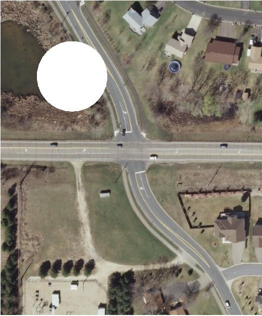
4 County State Aid Highway 32 (Cliff Road) and Dodd Road Intersection Study City of Eagan, Dakota County, Minnesota A. Purpose The Dakota County Transportation Department, along with the City of Eagan, has determined that the intersection of County State Aid Highway (CSAH) 32 (Cliff Road) and Dodd Road be assessed to determine the need and timeline of intersection traffic control and/or geometric improvement. In addition, residential complaints have been received in regard to the traffic operations at this location. The most common complaints have been in regard to making right turns from CSAH 32 onto Dodd Road and making left turns from Dodd Road onto CSAH 32. Specifically, motorists on CSAH 32 do not anticipate or feel unjustifiably slowed down by other drivers on CSAH 32 turning right onto Dodd Road. This often results in tail-gating making the turning drivers feel uncomfortable or the through vehicle uses the left turn lane to quickly move around the turning vehicle. Conversely on Dodd Road, drivers turning left onto CSAH 32 feel the wait time for an appropriate gap in traffic on CSAH 32 to complete their turning movement is too long. The high peak period volumes at this intersection combined with the citizen complaints make it a candidate to be reviewed for proper control and capacity. Consistent with the goals and strategies of the Dakota County Transportation Plan, this study examines the intersection to determine: The existing and projected operations under the current characteristics and traffic control The need for improved geometry or traffic control, either now or in the future B. Description of Location The intersection of CSAH 32 and Dodd Road is located in the City of Eagan, Dakota County. The intersection is approximately 1/2 mile west of the CSAH 32 and TH 3 intersection. Figure 1 shows the location of this intersection. C. Traffic Volumes Intersection turning movement counts and hourly approach counts were collected by the County on two separate occasions: July 6 8, 2011, and September 28 30, The September counts were taken due to the potential of seasonal fluctuations in traffic volumes at this location. After comparing the two counts, three hours of the September count (6 a.m. to 9 a.m.) were used in place of those hours in the July count. This composite represents a conservative approach of analysis, capturing the highest volumes from each count. The full data from each count is provided in the Appendix. See Figure 2 for the existing peak hour and daily counts for this study intersection. Projected daily traffic for the year 2030 was also provided by the County, except for the south leg of the intersection. The City of Eagan provided the expected growth rate for that approach. Using the ratio of expected traffic increase from existing to 2030, the projected peak hour volumes for year 2030 were also determined. Figure 3 shows the projected 2030 volumes for this study intersection. 1
5 2
6 3
7 4
8 D. Existing Conditions CSAH 32 is an east-west, two-lane, undivided roadway designated as an A Minor Arterial. The posted speed limit is 50 mph. Dodd Road is a north-south, two-lane, undivided roadway. It is designated as a Minor Collector by the City. The posted speed limit is 40 mph to the north of CSAH 32 and 30 mph to the south of CSAH 32. At the intersection of these two roadways, Dodd Road is under stop sign control with CSAH 32 traffic able to proceed without stopping. Each approach to the intersection provides one exclusive left-turn lane and one combined through/right-turn lane. A trail is provided on the east and west sides of Dodd Road to the north of CSAH 32 and on the west side to the south of CSAH 32. Although not marked, crossings are generally expected on the north and west sides of the intersection. ADA-compliant ramps are provided on the north side of the intersection where the trails reach the roadways. The intersection is primarily surrounded by residences. Dakota County Lebanon Hills Regional Park is located in the southwest quadrant of the intersection. Operations at the intersection were observed on September 27, 2011, during evening peak period and on September 28, 2011, during the morning peak period. The key observations include: Vehicles on CSAH 32 arrived in bunches, resulting in a range of delay to motorists stopped on Dodd Road from zero seconds to over one minute depending on when they arrived. Pedestrian/bicycle wait time to cross CSAH 32 similarly varied depending upon when they arrived at the intersection. The left-turn lane was often used as a right-turn bypass lane by motorists on CSAH 32. The complete intersection observations are provided in the Appendix. In addition to observations of the intersection, the existing volumes, safety, and operations are reviewed below. The review of volumes uses information from the Minnesota Manual on Uniform Traffic Control Devices outlines thresholds when it may be appropriate for a traffic control device at an intersection. The criteria, also called warrants, are applicable for all-way stop control and traffic signal control. Generally, one or more warrants must be satisfied before all-way stop or traffic signal control is considered, although meeting one or more warrants does not in itself require installation of a traffic control device. For this analysis, the major roadway is CSAH 32 and the minor roadway is Dodd Road. Two or more lanes are assumed for every approach. The posted speed of 50 mph on CSAH 32 results in a 70 percent reduction in warrant volume thresholds. Dakota County uses the method of 100 percent reduction to right-turning volume from the side street, reflecting ease of this movement in comparison with the through and left-turning movements. So, all right-turning volume on Dodd Road has been removed for the analysis. 5
9 The traffic signal warrants were first examined using existing traffic and the results are shown in Table 1. No volume warrants were satisfied under these conditions. The full warrant analysis is provided in the Appendix. Table 1: CSAH 32 and Dodd Road Existing Warrant Analysis Summary Warrant Existing Volumes Warrant 1 8-Hour Volume No (4 of 8 hrs) Warrant 2 4-Hour Volume No (1 of 4 hrs) Warrant 3 Peak Hour Volume No (0 of 1 hr) Note: Yes or No indicates whether the warrant is satisfied or not. The parentheses indicate how many of the required hours are met. Crashes for the years 2008 to 2010 were provided by the County and examined. The crash diagram for the intersection is provided in the Appendix. Seven State reported crashes occurred at this intersection during the three study years. Table 2 presents the crash rate for this intersection. The average side-street stop control intersection crash rates for Mn/DOT Metro District and the state are presented for comparison. In addition to the average rates, the critical crash rate is presented. This is a statistically adjusted crash rate designed to account for the random nature of crashes. A crash rate above the calculated critical crash rate identifies the intersection as potentially hazardous, with a statistically significant higher rate of crashes. The critical crash rate shown is calculated to a 90 percent confidence level. Table 2: CSAH 32 and Dodd Road Crash Rate Comparison Crash Rate CSAH 32 and Dodd Road 0.59/MEV Intersection Benchmarks Metro District: Urban Rural 0.20/MEV 0.20/MEV State: Urban Rural 0.24/MEV 0.29/MEV Critical Crash Rate 0.41/MEV Note: MEV stands for Million Entering Vehicles Finally, the study intersection was analyzed with the existing peak hour volumes and characteristics. The Synchro/SimTraffic software package was used for this analysis and provided results in terms of levels of service (LOS), delay times, and expected vehicle queues. LOS is a qualitative measurement designed as a report card assessment of traffic operations. LOS A represents the best operations with little to no delay, while LOS F represents the worst operations with excessive congestion. Generally, an intersection LOS D is considered acceptable. Table 3 shows the results of the existing peak hour analysis. 6
10 Existing Volumes AM Peak Hour PM Peak Hour Table 3: CSAH 32 and Dodd Road Existing Operations Analysis Overall Intersection Worst Individual Movement Results LOS Delay (sec.) App. LOS Delay (sec.) Ave. Queue (ft) 95 %ile Queue (ft) 1 A A NBL SBL B C %ile Queue represents a distance that vehicle stacking is at or below 95 percent of the time. The traffic model was calibrated to reflect actual observed conditions. As shown, the intersection currently operates at an acceptable level of service. It is important to note that the delay times are an average. Individual motorists will have delays above or below this time. The full results are provided in the Appendix. E. Analysis of Alternatives The analysis of alternatives takes into consideration several elements including traffic volumes, overall intersection operations, geometrics, and safety. Methods used to evaluate these include analysis of warrants, crash data, and vehicle delay. Warrant Analysis As mentioned earlier, warrants are available for all-way stop control and traffic signal control. Currently, no warrants exist for the installation of roundabouts, which can be considered both a traffic control device and a roadway feature. However, the Minnesota Department of Transportation (Mn/DOT) states in its Intersection Control Evaluation procedures that roundabouts are considered warranted if traffic volumes meet the criteria for either all-way stop or traffic signal control. Using an assumption of straight-line growth from existing to projected 2030 volumes, the warrants were reexamined to determine what year each volume warrant would be satisfied. Table 4 shows the results of these analyses along with the earlier results using the existing volumes for comparison. Table 4: CSAH 32 and Dodd Road Warrant Analysis Summary Existing Projected 2016 Projected 2019 Volumes Volumes Volumes Projected 2023 Volumes Warrant Warrant 1 8-Hour Volume No (4 of 8 hrs) No (5 of 8 hrs) No (6 of 8 hrs) Yes (8 of 8 hrs) Warrant 2 4-Hour Volume No (1 of 4 hrs) No (3 of 4 hrs) Yes (4 of 4 hrs) Yes (5 of 8 hrs) Warrant 3 Peak Hour Volume No (0 of 1 hr) Yes (1 of 1 hr) Yes (1 of 1 hr) Yes (2 of 1 hr) Note: Yes or No indicates whether the warrant is satisfied or not. The parentheses indicate how many of the required hours are met. Based on the above assumptions and analyses, the intersection of CSAH 32 and Dodd Road will not begin to meet the volume warrants until 2016, with the Eight-Hour Warrant not satisfied until
11 Although not meeting warrants does not necessarily exclude a change in traffic control, it does suggest that the current intersection control is adequate for the existing volumes. The full warrant analyses for projected years 2016, 2019, and 2023 are provided in the Appendix. Safety Analysis A safety analysis generally consists of presenting past crash history and future crash potential. As mentioned, seven State reported crashes occurred at this intersection during the three year study period. Table 2 previously presented the crash rate for this intersection and several benchmark comparisons. That table shows that the crash rate is higher than the expected average and the calculated critical crash rate for this type of intersection. This indicates a potential issue that could be correctable. Examining the crashes, the most common type of crash (four of the seven crashes) was a right-angle crash between a southbound vehicle and a westbound vehicle. Two of those four crashes occurred when the southbound vehicle was unable to stop due to ice and snow. Another was the result of a driver losing control of their vehicle. A further review of the sight distance for a southbound vehicle looking to the east found it to be acceptable. Based upon site observations and the review of sight lines, no site characteristics that could lead to these crashes were found and, therefore, no engineering solutions are readily apparent. Therefore, the number of crashes in 2009 appears to be an anomaly due to factors other than intersection design. The crashes at the intersection should continue to be monitored to confirm this conclusion. The potential future crashes for different types of traffic control were examined using several different methods: The actual crash and severity rates from years 2008 to 2010, as presented earlier. The Mn/DOT State Aid Green Sheets, which present average crash and severity rates for different types of intersections within the Metro area. The Federal Highway Administration s (FHWA) Reduction Factors as presented in Desktop Reference for Crash Reduction Factors. National Cooperative Highway Research Program (NCHRP) Report 572, which presents intersection-level safety prediction models for roundabouts. Using these different methods, the projected crashes for each type of traffic control can be examined. Table 5 shows this information for the study intersection. 8
12 Table 5: Crash Expectations by Traffic Control Type for the CSAH 32 and Dodd Road Intersection Scenario Existing* Fatal A Injury B Injury C Injury Property Damage Total Crash Rate Severity Rate Existing Volumes Volumes Mn/DOT Averages** 2030 No Build (Side Street Stop) Signal Option Roundabout Option FHWA Reduction Factors*** 2030 Signal Option (range) NCHRP 572**** 2030 Roundabout Option * Crash Rate and Severity Rate based on actual crash data from years 2008 to ** Mn/DOT Averages reflect the Mn/DOT Metro average Crash and Severity Rates. *** FHWA Reduction Factors reflect changes in the existing crashes from the Desktop Reference for Crash Reduction Factors. **** NCHRP Report 572, Intersection-level safety prediction models. As shown, side street stop control should have the lowest number of crashes based on the average for the Metro area. Between traffic signal and roundabout control, the expected results switch depending upon which criteria are used. However, in general, roundabouts would be expected to have fewer and less severe crashes. Operational Analysis The study intersection analysis results using the existing peak hour volumes and characteristics were shown previously in this report. As shown, the intersection currently operates at an acceptable level of service. Another analysis was then accomplished examining the existing geometry and traffic control with future volumes. Three timeframes were sought: the year an individual movement is expected to have a poor LOS, the year the intersection as a whole is expected to have a poor LOS, and the expected operations at year As with the warrant analysis, a straight-line growth from existing to 2030 projected volumes was assumed. Table 6 shows the results of these analyses with the existing results for comparison purposes. 9
13 Table 6: CSAH 32 and Dodd Road Operations Analyses with Existing Traffic Control Overall Intersection Worst Individual Movement Existing Volumes AM Peak Hour PM Peak Hour Proj Volumes AM Peak Hour PM Peak Hour Proj Volumes AM Peak Hour PM Peak Hour Proj Volumes AM Peak Hour PM Peak Hour LOS A A A A B D Results Delay (sec.) App. LOS NBL SBL NBL SBT NBT SBT B C C E E F Delay (sec.) Ave. Queue (ft) %ile Queue (ft) B F NBT SBT E F , %ile Queue represents a distance that vehicle stacking is at or below 95 percent of the time. As shown, traffic operations are expected to be satisfactory until year 2023, when individual movements on Dodd Road begin to experience higher than desired delays. In projected year 2029, the poor operations on Dodd Road are to cause the entire intersection to have a LOS D in the p.m. peak hour. Considering that the traffic on CSAH 32 does not stop, the side street delays are extremely high in this case. Projected year 2030 is similar to 2029, except that the delays continue to increase. The full results of these analyses are provided in the Appendix. A final analysis was undertaken examining appropriate different types of intersection traffic control and geometrics for the intersection. For this study, two different scenarios were reviewed: Traffic signal control assuming three lanes on every approach: one left-turn lane, one through lane, and one right-turn lane Roundabout control assuming single lane entry, a circulating lane, and an exit lane for every direction Noticeably missing from the above list is all-way stop sign control. The majority of traffic during the existing and projected year peak hours is on CSAH 32 (approximately 74 percent of existing traffic). With this heavily unbalanced traffic flow between CSAH 32 and Dodd Road, adding all-way stop sign control would result in a large delay to most traffic on CSAH 32. During nonpeak times, most traffic is again on CSAH 32 and would be delayed, with little or no traffic on Dodd Road. Studies have shown that many drivers feel the need to increase speed to make up time after a stop they feel is not warranted or unnecessary. These same studies have suggested that, over time, drivers conclude that traffic from the side street is never present, resulting in a failure to come to a complete stop and potentially increasing the risk of crashes at an intersection. This behavior can 10
14 also breed disobedience at other all-way stop controlled locations. Given the unbalanced traffic flows, expected increases in delay on CSAH 32, and potential safety issues, allway stop control was not appropriate for this intersection and was not evaluated further. Similarly, adding right-turn lanes to the intersection without a change in traffic control would not be expected to significantly improve traffic operations. The right-turn movement is generally easier to make and has less delay compared with through or leftturn movements. The added lanes would also require drivers at the stop signs on Dodd Road to track more vehicles, counterintuitively adding delay to some movements. Therefore, a simple improvement in geometry was not evaluated further in this study. The traffic signal control scenario was examined using Synchro/SimTraffic for each peak hour analysis. For the roundabout scenario, the software RODEL was used. Table 7 shows the results of these analyses. Table 7: CSAH 32 and Dodd Road Operations Analyses with Different Traffic Control Overall Intersection Worst Individual Movement Existing Control Existing Volumes AM Peak Hour PM Peak Hour Proj Volumes AM Peak Hour PM Peak Hour Traf. Signal Control Existing Volumes AM Peak Hour PM Peak Hour Proj Volumes AM Peak Hour PM Peak Hour Roundabout Control Existing Volumes AM Peak Hour PM Peak Hour Proj Volumes AM Peak Hour PM Peak Hour LOS A A B F B B B B A A A A Results Delay (sec.) App. LOS NBL SBL NBT SBT WBT WBL WBT SBL WB EB WB EB B C E F B B C C A A A B Delay (sec.) Ave. Queue (ft) As shown, either traffic signal or roundabout control would provide improved traffic operations for minor movements, but overall LOS would decrease in some cases because traffic on CSAH 32 would now be required to stop instead of having free flow movements. The roundabout would provide slightly better results in comparison with traffic signal control. However, the eastbound approach during the PM peak hour with projected 2030 volumes is approaching capacity. If traffic volumes were to continue to grow beyond 2030, another eastbound through lane would likely be necessary %ile Queue (ft) ,
15 F. Pedestrian/Bicycle Considerations As detailed earlier, trails are provided to the north and south of this study intersection. Although unmarked, pedestrians could cross on any of the four options. If crossing eastwest, vehicles are under stop control and should be stopped for pedestrians or bicyclists to cross. North-south crossings are more challenging as vehicles are not required to stop by the traffic control. Pedestrians and bicyclists need to wait for an appropriate gap in traffic on CSAH 32, like other vehicles on Dodd Road. Based on counts of the intersection and observations, pedestrian and bicycle movements through the intersection are light. Of the traffic counts and observations of the intersection, a maximum of 14 individual crossings were recorded in one hour. Of those, only five were across CSAH 32. The land use around the intersection suggests that these crossings are likely to remain relatively minor into the future, as only recreational crossings between residences or to/from the regional park are expected. Of the crossings that do occur, crash data suggests that they occur relatively safely, with no pedestrian/bicycle and vehicle collisions in the three years examined. Observations also suggest that acceptable crossing gaps do occur frequently during the peak periods, although a pedestrian or bicyclist may have some delay waiting for that gap. Based on today s conditions, additional crossing improvements do not appear warranted. However, it should be noted that the trail ramp on the south side of the intersection should be reconstructed to the most current ADA design guidelines, including truncated domes, at the time of a road or trail improvement project. If traffic control is changed in the future, both traffic signal and roundabout control offer benefits to pedestrian and bicycle crossings. Under traffic signal control, all crossings would have positive guidance as to when a pedestrian or bicyclist has the right-of-way to cross. Specific guidelines for the traffic signal timing would also allow for sufficient time for the crossing movement. Using roundabout control for the intersection, crosswalks would be set back from the intersection, and pedestrians and bicyclists would need to wait for appropriate gaps in traffic. Roundabouts do reduce driving speeds and pedestrians and bicyclists would be required to cross only one lane at a time. The location of the crosswalk farther back from the intersection and the presence of a refuge splitter island would allow pedestrians and bicyclists to focus on traffic from one direction only, further reducing vehicular exposure and improving safety. G. Recommended Alternative Present Based on this analysis, presented in detail in this report, the existing traffic control at the intersection of CSAH 32 (Cliff Road) and Dodd Road is appropriate for today s traffic and into the near future with assumed traffic growth. Operations are acceptable during the peak travel time periods and no signal warrants are satisfied. Although the existing crash rate is higher than expected, no specific intersection design issues were identified by the crash data and site reviews. 12
16 Future Traffic signal warrants are not currently satisfied, and the peak hour volume warrant is not expected to be met until at least year The most substantial volume warrants, Four-Hour and Eight-Hour, are not expected to be met until year 2019 or later. The intersection should continue to be reviewed, both crashes and operations. With traffic volume growth and/or safety issues as defined by the crash record, the traffic control may need to be changed in the future. The Eight Hour Vehicular Volume Warrant, the warrant most used to justify a traffic signal by Dakota County practices, is not expected to be met until at least year When it has been determined by the County that a change is needed, two alternatives for improvement should be considered: roundabout control or traffic signal control. Each would be expected to provide satisfactory traffic operations into the future and to maintain or improve the safety of the operations. Roundabout control would have less delay with fewer anticipated crashes as compared to traffic signal control. Both options would improve pedestrian/bicycle movements at the intersection. A reevaluation at the time of need could further explore the differences between traffic signal and roundabout control, including off-peak operations and benefit-cost analyses. Trail ramps to the intersection crossings should be reconstructed to the most current ADA design guidelines with an associated trail or roadway improvement project. 13
17 APPENDIX Intersection Observations
18 444 Cedar Street, Suite 1500 Saint Paul, MN Intersection Observations CSAH 32 (Cliff Road) and Dodd Road Eagan, Dakota County, MN (651) (651) Fax Tuesday, September 27, 2011, 4:40 p.m. to 5:15 p.m. Overcast with periodic light rain Side-street stop control on Dodd Road (CSAH 32 able to proceed without stopping) General Vehicles arrived in bunches, particularly on the eastbound and westbound directions Side street delay varied greatly from no delay to approximately 62 seconds Eastbound and westbound volumes were clearly heavier than the side street Southbound volumes heavier than northbound volumes Pedestrians/bicyclists crossing ability depended upon arrival time Left turn lane often used as a right turn by-pass lane, eastbound and westbound Maximum Queues Northbound Left 1 vehicle Northbound Thru/Right 2 vehicles Eastbound Left 2 vehicles Eastbound Thru/Right 6 vehicles Southbound Left 2 vehicles Southbound Thru/Right 3 vehicles Westbound Left 3 vehicles Westbound Thru/Right 2 vehicles Pedestrian/Bicycle Crossings Bicycle on east crossing, south to north Bicycle in southbound thru lane (25 seconds delay) Gaps in Eastbound and Westbound Traffic 8 seconds, 17 seconds, 20 seconds, 30 seconds, 31 seconds, 68 seconds Sight Distance to East Timed from when a vehicle s headlights are seen to when it reaches the intersection 9.9, 8.4, 9.3, 10.6, 8.5, 9.2, 10.4, 10.0, 8.7, 9.2 (seconds)
19 444 Cedar Street, Suite 1500 Saint Paul, MN Intersection Observations CSAH 32 (Cliff Road) and Dodd Road Eagan, Dakota County, MN (651) (651) Fax Wednesday, September 28, 2011, 7:10 a.m. to 7:45 a.m. Sunny and clear Side-street stop control on Dodd Road (CSAH 32 able to proceed without stopping) General Vehicles arrived in bunches, particularly on the eastbound and westbound directions Side street delay varied greatly from no delay to approximately 46 seconds Eastbound and westbound volumes were clearly heavier than the side street Southbound volumes appeared only slightly heavier than northbound volumes Left turn lane often used as a right turn by-pass lane, eastbound and westbound Maximum Queues Northbound Left 3 vehicles Northbound Thru/Right 4 vehicles Eastbound Left 2 vehicles Eastbound Thru/Right 2 vehicles Southbound Left none Southbound Thru/Right 4 vehicles Westbound Left 3 vehicles Westbound Thru/Right 2 vehicles Pedestrian/Bicycle Crossings Ped on west crossing, north to south Gaps in Eastbound and Westbound Traffic 16 seconds, 20 seconds, 21 seconds, 26 seconds, 28 seconds, 52 seconds, 56 seconds Sight Distance to East Timed from when a vehicle s headlights are seen to when it reaches the intersection 9.0, 9.6, 10.3, 9.5, 8.3, 7.9, 8.8, 8.4, 8.5, 9.9 (seconds)
20 APPENDIX Traffic Counts
21
22
23
24
25
26
27
28
29
30
31
32
33
34
35
36
37 APPENDIX Warrant Analyses
38 Traffic Signal Warrant Analysis - Cliff Road (CSAH 32) and Dodd Road Count Date: July 2011 TKDA Project No.: Major Street Approaches: Minor Street Approaches: Eastbound: Cliff Road (CSAH 32) Northbound: Dodd Road Number of Lanes: 2+ Number of Lanes: 2 Approach Speed: 50 Approach Speed: 30 Total App. Vehicles: 5,312 Total App. Vehicles: 1,215 Rt Turn Percentage: 100% Rt Turn Percentage: 0% Westbound: Cliff Road (CSAH 32) Southbound: Dodd Road Number of Lanes: 2+ Number of Lanes: 2 Approach Speed: 50 Approach Speed: 40 Total App. Vehicles: 4,191 Total App. Vehicles: 941 Rt Turn Percentage: 100% Rt Turn Percentage: 0% Analysis of Warrant 1: 8-Hour Volumes Hour Major Minor Street Begin (Total) Volume Direction Rank 12 AM 64 9 NB 20 1 AM 26 3 SB 23 2 AM 25 3 NB 22 3 AM 41 2 SB 24 4 AM 47 6 NB 21 5 AM NB 19 6 AM NB 5 7AM NB 1 8 AM NB 14 9 AM NB AM NB AM NB 8 12 PM NB 7 1 PM NB 10 2 PM NB 13 3 PM NB 8 4 PM SB 3 5 PM SB 2 6 PM NB 4 7 PM NB 6 8 PM NB 10 9 PM NB PM NB PM NB 18 Condition A Meets Criteria? Major St Major St Major St Major St Major St Major St Major St Major St Major St Major St Major St Major St Major St Major St Condition B Meets Criteria? Minor St - - -BOTH- - - Major St - - -BOTH BOTH BOTH- - - Minor St Condition A+B Meets Criteria? B ONLY B ONLY Condition A is the Minimum Vehicular Volume Warrant. Condition B is the Interruption of Continuous Traffic Warrant. Condition A+B is the combination of Conditions A and B at 80%. Existing Traffic Page 1 of 4
39 Traffic Signal Warrant Analysis - Cliff Road (CSAH 32) and Dodd Road Traffic Signal Warrant Summary: TKDA Project No.: Warrant 1 - Eight Hour Vehicular Volume Condition A: Not satisfied. Required values reached for 0 hours. Eight hours required. Criteria - Major Street 420 Minor Street 140 Condition B: Not satisfied. Required values reached for 4 hours. Eight hours required. Criteria - Major Street 630 Minor Street 70 Condition A+B: Not satisfied. Required values reached for 0 hours. Requires volumes to meet 80 percent of requirement of A and of B for eight hours, not necessary the same eight hours. Criteria - Major Street Minor Street Warrant 2 - Four Hour Vehicular Volume Not satisfied. Required values reached for 1 hour. Four hours required. See chart for criteria. Warrant 3 - Peak Hour Vehicular Volume Condition A: Minor street delay requirement not met. Criteria - Total Approach Volume: Minor Street High Side Volume: Minor Street High Side Delay: 5 vehicle-hours Condition B: Not satisfied. Required values reached for 0 hours. One hour required. See chart for criteria. Warrant 4 - Pedestrian Volume Not examined. Criteria - Pedestrian volume crossing the major street is at least 100 per hour for any 4 hours or at least 190 during any one hour. Warrant 5 - School Crossing Not examined. Criteria - At least 20 students crossing during the highest crossing hour. - Consider implementing other measures, such as warning signs and flashers, school speed zones, school crossing guards, or a grade-separated crossing. - Do not apply at locations where distance to nearest signal is less than 300 feet. Warrant 6 - Coordinated Signal System Not examined Criteria - Adjacent traffic control signals do not provide the necessary degree of platooning. - Proposed and adjacent traffic control signals will collectively provide a progressive operation. - Warrant should not be used where resultant spacing of traffic control signals would be less than 1,000 feet. Existing Traffic Page 2 of 4
40 Traffic Signal Warrant Analysis - Cliff Road (CSAH 32) and Dodd Road Traffic Signal Warrant Summary (cont.): TKDA Project No.: Warrant 7 - Crash Experience Crash requirements not met. Criteria - 5 or more correctable crashes, and - Vehicular volumes meeting 80 percent of Warrant 1 condition A or B, or. - Pedestrian volumes meeting 80 percent of Warrant 4 conditions. Warrant 8 - Roadway Network Not examined. Criteria - Total existing entering volume of at least 1,000 vehicles per hour during the peak hour of a typical weekday. - 5-year projected traffic volumes that meet one or more of Warrants 1, 2, and 3 during an average weekday. - Common intersection of two or more major routes. Multiway Stop Warrant Summary Warrant Condition A - Traffic Signal Warrant Traffic signal warrants are not met. Criteria - One or more traffic signal warrants are satisfied. - Multiway stop may be used as an interim control before traffic signal installation if this warrant is met. Warrant Condition B - Crash Experience Not satisfied. Criteria - 5 or more correctable crashes in a twelve month period. Warrant Condition C - Intersection Volume & Delay Delay and volume criteria not satisfied. Criteria - Average delay to minor street vehicular traffic of at least 21 seconds per vehicle during the highest hour. - Total volume from the major approaches of at least 210 vehicles per hour and total volume from the minor approaches of at least 140 vehicles per hour for any 8 hours of an average day. Warrant Condition D - Combination Volume, Crash Experience, & Delay Volume, crash, and delay criteria not satisfied. Criteria - 4 or more correctable crashes in a twelve month period. - Average delay to minor street vehicular traffic of at least 24 seconds per vehicle during the highest hour. - Total volume from the major approaches of at least 240 vehicles per hour and total volume from the minor approaches of at least 160 vehicles per hour for any 8 hours of an average day. Existing Traffic Page 3 of 4
41 Traffic Signal Warrant Analysis - Cliff Road (CSAH 32) and Dodd Road Traffic Signal Warrant Graphs: 600 TKDA Project No.: Figure 4C-2 Warrant 2 - Four-Hour Vehicular Volume Warrant Threshold Minor Street Volume (High Approach Only) Intersection Volumes Major Street Volume (Both Approaches) 600 Figure 4C-4 Warrant 3 - Peak-Hour Vehicular Volume Warrant Threshold Minor Street Volume (High Approach Only) Major Street Volume (Both Approaches) Intersection Volumes Existing Traffic Page 4 of 4
42 Traffic Signal Warrant Analysis - Cliff Road (CSAH 32) and Dodd Road TKDA Project No.: Major Street Approaches: Minor Street Approaches: Eastbound: Cliff Road (CSAH 32) Northbound: Dodd Road Number of Lanes: 2+ Number of Lanes: 2 Approach Speed: 50 Approach Speed: 30 Total App. Vehicles: 5,855 Total App. Vehicles: 1,503 Rt Turn Percentage: 100% Rt Turn Percentage: 0% Westbound: Cliff Road (CSAH 32) Southbound: Dodd Road Number of Lanes: 2+ Number of Lanes: 2 Approach Speed: 50 Approach Speed: 40 Total App. Vehicles: 4,745 Total App. Vehicles: 1,329 Rt Turn Percentage: 100% Rt Turn Percentage: 0% Analysis of Warrant 1: 8-Hour Volumes Hour Major Minor Street Begin (Total) Volume Direction Rank 12 AM NB 20 1 AM 35 6 SB 22 2 AM 35 5 NB 24 3 AM 55 6 SB 22 4 AM 55 9 NB 21 5 AM NB 19 6 AM NB 5 Condition A Meets Criteria? Condition B Meets Criteria? Condition A+B Meets Criteria? 7AM NB 1 Major St - - -BOTH- - - Minor St - - -BOTH A A+B B AM NB 13 Major St 9 AM NB 12 Major St 10 AM NB 13 Major St 11 AM NB 9 Major St Minor St 12 PM NB 8 Major St Minor St 1 PM SB 10 Major St Minor St 2 PM NB 13 Major St 3 PM SB 7 Major St - - -BOTH PM SB 3 Major St - - -BOTH- - - B ONLY 5 PM SB 2 Major St - - -BOTH- - - B ONLY 6 PM NB 4 Major St - - -BOTH- - - B ONLY 7 PM NB 6 Major St Minor St 8 PM SB 11 Major St Minor St 9 PM NB PM NB PM NB 18 Condition A is the Minimum Vehicular Volume Warrant. Condition B is the Interruption of Continuous Traffic Warrant. Condition A+B is the combination of Conditions A and B at 80%. Proj. Year 2016 Page 1 of 4
43 Traffic Signal Warrant Analysis - Cliff Road (CSAH 32) and Dodd Road Traffic Signal Warrant Summary: TKDA Project No.: Warrant 1 - Eight Hour Vehicular Volume Condition A: Not satisfied. Required values reached for 1 hour. Eight hours required. Criteria - Major Street 420 Minor Street 140 Condition B: Not satisfied. Required values reached for 5 hours. Eight hours required. Criteria - Major Street 630 Minor Street 70 Condition A+B: Not satisfied. Required values reached for 1 hour. Requires volumes to meet 80 percent of requirement of A and of B for eight hours, not necessary the same eight hours. Criteria - Major Street Minor Street Warrant 2 - Four Hour Vehicular Volume Not satisfied. Required values reached for 3 hours. Four hours required. See chart for criteria. Warrant 3 - Peak Hour Vehicular Volume Condition A: Not examined. Criteria - Total Approach Volume: Minor Street High Side Volume: Minor Street High Side Delay: 5 vehicle-hours Condition B: Satisfied. Required values reached for 1 hour. One hour required. See chart for criteria. Warrant 4 - Pedestrian Volume Not examined. Criteria - Pedestrian volume crossing the major street is at least 100 per hour for any 4 hours or at least 190 during any one hour. Warrant 5 - School Crossing Not examined. Criteria - At least 20 students crossing during the highest crossing hour. - Consider implementing other measures, such as warning signs and flashers, school speed zones, school crossing guards, or a grade-separated crossing. - Do not apply at locations where distance to nearest signal is less than 300 feet. Warrant 6 - Coordinated Signal System Not examined Criteria - Adjacent traffic control signals do not provide the necessary degree of platooning. - Proposed and adjacent traffic control signals will collectively provide a progressive operation. - Warrant should not be used where resultant spacing of traffic control signals would be less than 1,000 feet. Proj. Year 2016 Page 2 of 4
44 Traffic Signal Warrant Analysis - Cliff Road (CSAH 32) and Dodd Road Traffic Signal Warrant Summary (cont.): TKDA Project No.: Warrant 7 - Crash Experience Not examined. Criteria - 5 or more correctable crashes, and - Vehicular volumes meeting 80 percent of Warrant 1 condition A or B, or. - Pedestrian volumes meeting 80 percent of Warrant 4 conditions. Warrant 8 - Roadway Network Not examined. Criteria - Total existing entering volume of at least 1,000 vehicles per hour during the peak hour of a typical weekday. - 5-year projected traffic volumes that meet one or more of Warrants 1, 2, and 3 during an average weekday. - Common intersection of two or more major routes. Proj. Year 2016 Page 3 of 4
45 Traffic Signal Warrant Analysis - Cliff Road (CSAH 32) and Dodd Road Traffic Signal Warrant Graphs: 600 TKDA Project No.: Figure 4C-2 Warrant 2 - Four-Hour Vehicular Volume Warrant Threshold Minor Street Volume (High Approach Only) Intersection Volumes Major Street Volume (Both Approaches) 600 Figure 4C-4 Warrant 3 - Peak-Hour Vehicular Volume Warrant Threshold Minor Street Volume (High Approach Only) Major Street Volume (Both Approaches) Intersection Volumes Proj. Year 2016 Page 4 of 4
46 Traffic Signal Warrant Analysis - Cliff Road (CSAH 32) and Dodd Road TKDA Project No.: Major Street Approaches: Minor Street Approaches: Eastbound: Cliff Road (CSAH 32) Northbound: Dodd Road Number of Lanes: 2+ Number of Lanes: 2 Approach Speed: 50 Approach Speed: 30 Total App. Vehicles: 6,090 Total App. Vehicles: 1,628 Rt Turn Percentage: 100% Rt Turn Percentage: 0% Westbound: Cliff Road (CSAH 32) Southbound: Dodd Road Number of Lanes: 2+ Number of Lanes: 2 Approach Speed: 50 Approach Speed: 40 Total App. Vehicles: 5,015 Total App. Vehicles: 1,544 Rt Turn Percentage: 100% Rt Turn Percentage: 0% Analysis of Warrant 1: 8-Hour Volumes Hour Major Minor Street Begin (Total) Volume Direction Rank 12 AM NB 20 1 AM 35 6 SB 22 2 AM 35 5 NB 24 3 AM 55 6 SB 22 4 AM 60 9 NB 21 5 AM NB 19 6 AM NB 5 Condition A Meets Criteria? Condition B Meets Criteria? Condition A+B Meets Criteria? 7AM NB 1 Major St - - -BOTH- - - Minor St - - -BOTH A A+B B AM NB 14 Major St 9 AM SB 12 Major St Minor St 10 AM NB 14 Major St 11 AM NB 8 Major St Minor St 12 PM NB 8 Major St - - -BOTH PM SB 10 Major St Minor St 2 PM SB 12 Major St Minor St 3 PM SB 6 Major St - - -BOTH- - - B ONLY 4 PM SB BOTH BOTH- - - B ONLY 5 PM SB BOTH BOTH- - - B ONLY 6 PM NB 4 Major St - - -BOTH- - - B ONLY 7 PM NB 7 Major St Minor St 8 PM SB 11 Major St Minor St 9 PM NB 16 Major St 10 PM SB PM NB 18 Condition A is the Minimum Vehicular Volume Warrant. Condition B is the Interruption of Continuous Traffic Warrant. Condition A+B is the combination of Conditions A and B at 80%. Proj. Year 2019 Page 1 of 4
47 Traffic Signal Warrant Analysis - Cliff Road (CSAH 32) and Dodd Road Traffic Signal Warrant Summary: TKDA Project No.: Warrant 1 - Eight Hour Vehicular Volume Condition A: Not satisfied. Required values reached for 3 hours. Eight hours required. Criteria - Major Street 420 Minor Street 140 Condition B: Not satisfied. Required values reached for 6 hours. Eight hours required. Criteria - Major Street 630 Minor Street 70 Condition A+B: Not satisfied. Required values reached for 1 hour. Requires volumes to meet 80 percent of requirement of A and of B for eight hours, not necessary the same eight hours. Criteria - Major Street Minor Street Warrant 2 - Four Hour Vehicular Volume Satisfied. Required values reached for 4 hours. Four hours required. See chart for criteria. Warrant 3 - Peak Hour Vehicular Volume Condition A: Not examined. Criteria - Total Approach Volume: Minor Street High Side Volume: Minor Street High Side Delay: 5 vehicle-hours Condition B: Satisfied. Required values reached for 1 hour. One hour required. See chart for criteria. Warrant 4 - Pedestrian Volume Not examined. Criteria - Pedestrian volume crossing the major street is at least 100 per hour for any 4 hours or at least 190 during any one hour. Warrant 5 - School Crossing Not examined. Criteria - At least 20 students crossing during the highest crossing hour. - Consider implementing other measures, such as warning signs and flashers, school speed zones, school crossing guards, or a grade-separated crossing. - Do not apply at locations where distance to nearest signal is less than 300 feet. Warrant 6 - Coordinated Signal System Not examined Criteria - Adjacent traffic control signals do not provide the necessary degree of platooning. - Proposed and adjacent traffic control signals will collectively provide a progressive operation. - Warrant should not be used where resultant spacing of traffic control signals would be less than 1,000 feet. Proj. Year 2019 Page 2 of 4
48 Traffic Signal Warrant Analysis - Cliff Road (CSAH 32) and Dodd Road Traffic Signal Warrant Summary (cont.): TKDA Project No.: Warrant 7 - Crash Experience Not examined. Criteria - 5 or more correctable crashes, and - Vehicular volumes meeting 80 percent of Warrant 1 condition A or B, or. - Pedestrian volumes meeting 80 percent of Warrant 4 conditions. Warrant 8 - Roadway Network Not examined. Criteria - Total existing entering volume of at least 1,000 vehicles per hour during the peak hour of a typical weekday. - 5-year projected traffic volumes that meet one or more of Warrants 1, 2, and 3 during an average weekday. - Common intersection of two or more major routes. Proj. Year 2019 Page 3 of 4
49 Traffic Signal Warrant Analysis - Cliff Road (CSAH 32) and Dodd Road Traffic Signal Warrant Graphs: 600 TKDA Project No.: Figure 4C-2 Warrant 2 - Four-Hour Vehicular Volume Warrant Threshold Minor Street Volume (High Approach Only) Intersection Volumes Major Street Volume (Both Approaches) 600 Figure 4C-4 Warrant 3 - Peak-Hour Vehicular Volume Warrant Threshold Minor Street Volume (High Approach Only) Major Street Volume (Both Approaches) Intersection Volumes Proj. Year 2019 Page 4 of 4
50 Traffic Signal Warrant Analysis - Cliff Road (CSAH 32) and Dodd Road TKDA Project No.: Major Street Approaches: Minor Street Approaches: Eastbound: Cliff Road (CSAH 32) Northbound: Dodd Road Number of Lanes: 2+ Number of Lanes: 2 Approach Speed: 50 Approach Speed: 30 Total App. Vehicles: 6,445 Total App. Vehicles: 1,808 Rt Turn Percentage: 100% Rt Turn Percentage: 0% Westbound: Cliff Road (CSAH 32) Southbound: Dodd Road Number of Lanes: 2+ Number of Lanes: 2 Approach Speed: 50 Approach Speed: 40 Total App. Vehicles: 5,390 Total App. Vehicles: 1,915 Rt Turn Percentage: 100% Rt Turn Percentage: 0% Analysis of Warrant 1: 8-Hour Volumes Hour Major Minor Street Begin (Total) Volume Direction Rank 12 AM SB 20 1 AM 35 6 SB 22 2 AM 35 6 SB 22 3 AM 55 6 SB 22 4 AM 65 9 NB 21 5 AM NB 19 6 AM NB 6 Condition A Meets Criteria? Condition B Meets Criteria? Condition A+B Meets Criteria? 7AM NB 2 Major St - - -BOTH- - - Minor St - - -BOTH A A+B B AM SB 14 Major St Minor St 9 AM SB 13 Major St Minor St 10 AM SB 14 Major St Minor St 11 AM NB 10 Major St Minor St 12 PM NB 10 Major St - - -BOTH PM SB 8 Major St - - -BOTH PM SB 12 Major St - - -BOTH PM SB 5 Major St - - -BOTH- - - B ONLY 4 PM SB BOTH BOTH A + B PM SB BOTH BOTH A + B PM SB BOTH BOTH- - - B ONLY 7 PM NB 7 Major St Minor St 8 PM SB 9 Major St Minor St 9 PM NB 16 Major St 10 PM SB PM NB 18 Condition A is the Minimum Vehicular Volume Warrant. Condition B is the Interruption of Continuous Traffic Warrant. Condition A+B is the combination of Conditions A and B at 80%. Proj. Year 2023 Page 1 of 4
51 Traffic Signal Warrant Analysis - Cliff Road (CSAH 32) and Dodd Road Traffic Signal Warrant Summary: TKDA Project No.: Warrant 1 - Eight Hour Vehicular Volume Condition A: Not satisfied. Required values reached for 4 hours. Eight hours required. Criteria - Major Street 420 Minor Street 140 Condition B: Satisfied. Required values reached for 8 hours. Eight hours required. Criteria - Major Street 630 Minor Street 70 Condition A+B: Not satisfied. Required values reached for 3 hours. Requires volumes to meet 80 percent of requirement of A and of B for eight hours, not necessary the same eight hours. Criteria - Major Street Minor Street Warrant 2 - Four Hour Vehicular Volume Satisfied. Required values reached for 5 hours. Four hours required. See chart for criteria. Warrant 3 - Peak Hour Vehicular Volume Condition A: Not examined. Criteria - Total Approach Volume: Minor Street High Side Volume: Minor Street High Side Delay: 5 vehicle-hours Condition B: Satisfied. Required values reached for 2 hours. One hour required. See chart for criteria. Warrant 4 - Pedestrian Volume Not examined. Criteria - Pedestrian volume crossing the major street is at least 100 per hour for any 4 hours or at least 190 during any one hour. Warrant 5 - School Crossing Not examined. Criteria - At least 20 students crossing during the highest crossing hour. - Consider implementing other measures, such as warning signs and flashers, school speed zones, school crossing guards, or a grade-separated crossing. - Do not apply at locations where distance to nearest signal is less than 300 feet. Warrant 6 - Coordinated Signal System Not examined Criteria - Adjacent traffic control signals do not provide the necessary degree of platooning. - Proposed and adjacent traffic control signals will collectively provide a progressive operation. - Warrant should not be used where resultant spacing of traffic control signals would be less than 1,000 feet. Proj. Year 2023 Page 2 of 4
52 Traffic Signal Warrant Analysis - Cliff Road (CSAH 32) and Dodd Road Traffic Signal Warrant Summary (cont.): TKDA Project No.: Warrant 7 - Crash Experience Not examined. Criteria - 5 or more correctable crashes, and - Vehicular volumes meeting 80 percent of Warrant 1 condition A or B, or. - Pedestrian volumes meeting 80 percent of Warrant 4 conditions. Warrant 8 - Roadway Network Not examined. Criteria - Total existing entering volume of at least 1,000 vehicles per hour during the peak hour of a typical weekday. - 5-year projected traffic volumes that meet one or more of Warrants 1, 2, and 3 during an average weekday. - Common intersection of two or more major routes. Proj. Year 2023 Page 3 of 4
County State Aid Highway 30 (Diffley Road) and Dodd Road Intersection Study
 and Dodd Road Intersection Study") County State Aid Highway 30 (Diffley Road) and Dodd Road Intersection Study City of Eagan, Dakota County, Minnesota Date: March 2012 Project No. 14957.000 444 Cedar Street, Suite 1500 Saint Paul, MN 55101
County State Aid Highway 30 (Diffley Road) and Dodd Road Intersection Study City of Eagan, Dakota County, Minnesota Date: March 2012 Project No. 14957.000 444 Cedar Street, Suite 1500 Saint Paul, MN 55101
Bennett Pit. Traffic Impact Study. J&T Consulting, Inc. Weld County, Colorado. March 3, 2017
 Bennett Pit Traffic Impact Study J&T Consulting, Inc. Weld County, Colorado March 3, 217 Prepared By: Sustainable Traffic Solutions, Inc. http://www.sustainabletrafficsolutions.com/ Joseph L. Henderson,
Memorandum. To: Sue Polka, City Engineer, City of Arden Hills. From: Sean Delmore, PE, PTOE. Date: June 21, 2017
 Memorandum engineering planning environmental construction 701 Xenia Avenue South Suite 300 Minneapolis, MN 55416 Tel: 763-541-4800 Fax: 763-541-1700 To: Sue Polka, City Engineer, City of Arden Hills From:
LAWRENCE TRANSIT CENTER LOCATION ANALYSIS 9 TH STREET & ROCKLEDGE ROAD / 21 ST STREET & IOWA STREET LAWRENCE, KANSAS
 LAWRENCE TRANSIT CENTER LOCATION ANALYSIS 9 TH STREET & ROCKLEDGE ROAD / 21 ST STREET & IOWA STREET LAWRENCE, KANSAS TRAFFIC IMPACT STUDY FEBRUARY 214 OA Project No. 213-542 TABLE OF CONTENTS 1. INTRODUCTION...
Alpine Highway to North County Boulevard Connector Study
 Alpine Highway to North County Boulevard Connector Study prepared by Avenue Consultants March 16, 2017 North County Boulevard Connector Study March 16, 2017 Table of Contents 1 Summary of Findings... 1
INTERSECTION CONTROL EVALUATION
 INTERSECTION CONTROL EVALUATION Trunk Highway 22 and CSAH 21 (E Hill Street/Shanaska Creek Road) Kasota, Le Sueur County, Minnesota November 2018 Trunk Highway 22 and Le Sueur CSAH 21 (E Hill Street/Shanaska
TIMBERVINE TRANSPORTATION IMPACT STUDY FORT COLLINS, COLORADO JANUARY Prepared for:
 TIMBERVINE TRANSPORTATION IMPACT STUDY FORT COLLINS, COLORADO JANUARY 2014 Prepared for: Hartford Companies 1218 W. Ash Street Suite A Windsor, Co 80550 Prepared by: DELICH ASSOCIATES 2272 Glen Haven Drive
APPENDIX C1 TRAFFIC ANALYSIS DESIGN YEAR TRAFFIC ANALYSIS
 APPENDIX C1 TRAFFIC ANALYSIS DESIGN YEAR TRAFFIC ANALYSIS DESIGN YEAR TRAFFIC ANALYSIS February 2018 Highway & Bridge Project PIN 6754.12 Route 13 Connector Road Chemung County February 2018 Appendix
Proposed location of Camp Parkway Commerce Center. Vicinity map of Camp Parkway Commerce Center Southampton County, VA
 Proposed location of Camp Parkway Commerce Center Vicinity map of Camp Parkway Commerce Center Southampton County, VA Camp Parkway Commerce Center is a proposed distribution and industrial center to be
EXECUTIVE SUMMARY. The following is an outline of the traffic analysis performed by Hales Engineering for the traffic conditions of this project.
 EXECUTIVE SUMMARY This study addresses the traffic impacts associated with the proposed Shopko redevelopment located in Sugarhouse, Utah. The Shopko redevelopment project is located between 1300 East and
Intersection Control Evaluation
 Intersection Control Evaluation Stoltzman Road at Pleasant Street in Mankato, Blue Earth County, Minnesota Mankato/North Mankato Area Planning Organization October 2017 SRF No. 10279 Table of Contents
Downtown One Way Street Conversion Technical Feasibility Report
 Downtown One Way Street Conversion Technical Feasibility Report As part of the City s Transportation Master Plan, this report reviews the technical feasibility of the proposed conversion of the current
Figure 1 Map of intersection of SR 44 (Ravenna Rd) and Butternut Rd
 and Butternut Rd") Abbreviated Study District: 12 County: Geauga Route: SR 44 Section: 1.58 GEA 44 1.58 213 HSP # 47 (Rural Intersection) Prepared April 23, 215 By Bryan Emery Existing Conditions This study contains the
Abbreviated Study District: 12 County: Geauga Route: SR 44 Section: 1.58 GEA 44 1.58 213 HSP # 47 (Rural Intersection) Prepared April 23, 215 By Bryan Emery Existing Conditions This study contains the
TRAFFIC IMPACT ANALYSIS
 TRAFFIC IMPACT ANALYSIS Emerald Isle Commercial Development Prepared by SEPI Engineering & Construction Prepared for Ark Consulting Group, PLLC March 2016 I. Executive Summary A. Site Location The Emerald
LATSON INTERCHANGE DEVELOPMENT TRAFFIC STUDIES. Genoa Township, Livingston County, MI
 LATSON INTERCHANGE DEVELOPMENT TRAFFIC STUDIES Genoa Township, Livingston County, MI DRAFT TRAFFIC STUDY FOR I-96 AT LATSON RD INTERCHANGE Livingston County CS 47065 JN 101622C Submitted to: Michigan Department
RTE. 1 at RTE. 637 & RTE. 639
 INTERSECTION SAFETY STUDY Prepared for: Virginia Department of Transportation Central Region Operations Traffic Engineering (UPC #81378, TO 12-092) DAVENPORT Project Number: 13-368 / /2014 RTE. 1 at RTE.
TRAFFIC SIGNAL DESIGN REPORT KING OF PRUSSIA ROAD & RAIDER ROAD RADNOR TOWNSHIP PENNSYLVANIA
 TRAFFIC SIGNAL DESIGN REPORT KING OF PRUSSIA ROAD & RAIDER ROAD RADNOR TOWNSHIP PENNSYLVANIA PREPARED FOR: UNIVERSITY OF PENNSYLVANIA HEALTH SYSTEM 34 CIVIC CENTER BOULEVARD PHILADELPHIA, PA 1987 (61)
Traffic Engineering Study
 Traffic Engineering Study Bellaire Boulevard Prepared For: International Management District Technical Services, Inc. Texas Registered Engineering Firm F-3580 November 2009 Executive Summary has been requested
King County Metro. Columbia Street Transit Priority Improvements Alternative Analysis. Downtown Southend Transit Study. May 2014.
 King County Metro Columbia Street Transit Priority Improvements Alternative Analysis Downtown Southend Transit Study May 2014 Parametrix Table of Contents Introduction... 1 Methodology... 1 Study Area...
L1TILE BEARS DAY CARE TRANSPORTATION IMPACT STUDY FORT COLLINS, COLORADO MAY Prepared for:
 L1TILE BEARS DAY CARE TRANSPORTATION IMPACT STUDY FORT COLLINS, COLORADO MAY 2012 Prepared for: Hillside Construction, Inc. 216 Hemlock Street, Suite B Fort Collins, CO 80534 Prepared by: DELICH ASSOCIATES
Traffic Impact Analysis. Alliance Cole Avenue Residential Site Dallas, Texas. Kimley-Horn and Associates, Inc. Dallas, Texas.
 Traffic Impact Analysis Alliance Cole Avenue Residential Site Dallas, Texas February 15, 2018 Kimley-Horn and Associates, Inc. Dallas, Texas Project #064524900 Registered Firm F-928 Traffic Impact Analysis
INTERSECTION ANALYSIS PARK AVENUE AND BRADDOCK ROAD (FROSTBURG, MD) FOR LENHART TRAFFIC CONSULTING, INC.
 FOR LENHART TRAFFIC CONSULTING, INC.") INTERSECTION ANALYSIS FOR PARK AVENUE AND BRADDOCK ROAD (FROSTBURG, MD) Prepared for: City of Frostburg, Maryland & Allegany County Commissioners Prepared by: LENHART TRAFFIC CONSULTING, INC. TRAFFIC ENGINEERING
INTERSECTION ANALYSIS FOR PARK AVENUE AND BRADDOCK ROAD (FROSTBURG, MD) Prepared for: City of Frostburg, Maryland & Allegany County Commissioners Prepared by: LENHART TRAFFIC CONSULTING, INC. TRAFFIC ENGINEERING
Roundabout Feasibility Study SR 44 at Grand Avenue TABLE OF CONTENTS
 Roundabout Feasibility Study SR 44 at Grand Avenue TABLE OF CONTENTS Introduction and Executive Summary... 1 Existing Conditions... 3 Intersection Volume Conditions... 5 Intersection Operations... 9 Safety
Winnetka Avenue Bike Lanes Traffic Impact Analysis
 Winnetka Avenue Bike Lanes Traffic Impact Analysis January 4, 2019 Prepared by City of Los Angeles Department of Transportation Active Transportation Division Winnetka Ave Bike Lanes Traffic Impact Analysis
Appendix C-5: Proposed Refinements Rail Operations and Maintenance Facility (ROMF) Traffic Impact Analysis. Durham-Orange Light Rail Transit Project
 Traffic Impact Analysis. Durham-Orange Light Rail Transit Project") Appendix C-5: Proposed Refinements Rail Operations and Maintenance Facility (ROMF) Traffic Impact Analysis Durham-Orange Light Rail Transit Project July 25, 218 ROMF Transportation Impact Analysis Version
Appendix C-5: Proposed Refinements Rail Operations and Maintenance Facility (ROMF) Traffic Impact Analysis Durham-Orange Light Rail Transit Project July 25, 218 ROMF Transportation Impact Analysis Version
BARRHAVEN FELLOWSHIP CRC 3058 JOCKVALE ROAD OTTAWA, ONTARIO TRANSPORTATION BRIEF. Prepared for:
 BARRHAVEN FELLOWSHIP CRC 3058 JOCKVALE ROAD OTTAWA, ONTARIO TRANSPORTATION BRIEF Prepared for: Barrhaven Fellowship CRC 3058 Jockvale Road Ottawa, ON K2J 2W7 December 7, 2016 116-649 Report_1.doc D. J.
INDUSTRIAL DEVELOPMENT
 INDUSTRIAL DEVELOPMENT Traffic Impact Study Plainfield, Illinois August 2018 Prepared for: Seefried Industrial Properties, Inc. TABLE OF CONTENTS Executive Summary 2 Introduction 3 Existing Conditions
MERIVALE PRIORITY SQUARE 2852 MERIVALE ROAD CITY OF OTTAWA TRANSPORTATION BRIEF. Prepared for: ONT Inc. 25 Winding Way Nepean, Ontario K2C 3H1
 MERIVALE PRIORITY SQUARE 2852 MERIVALE ROAD CITY OF OTTAWA TRANSPORTATION BRIEF Prepared for: 2190986ONT Inc. 25 Winding Way Nepean, Ontario K2C 3H1 October 6, 2010 110-502 Report_1.doc D. J. Halpenny
Traffic Impact Analysis West Street Garden Plots Improvements and DuPage River Park Garden Plots Development Naperville, Illinois
 Traffic Impact Analysis West Street Garden Plots Improvements and DuPage River Park Garden Plots Development Naperville, Illinois Submitted by April 9, 2009 Introduction Kenig, Lindgren, O Hara, Aboona,
Craig Scheffler, P.E., PTOE HNTB North Carolina, P.C. HNTB Project File: Subject
 TECHNICAL MEMORANDUM To Kumar Neppalli Traffic Engineering Manager Town of Chapel Hill From Craig Scheffler, P.E., PTOE HNTB North Carolina, P.C. Cc HNTB Project File: 38435 Subject Obey Creek TIS 2022
DEVELOPMENT PROPERTY 1627 MAXIME STREET CITY OF OTTAWA TRANSPORTATION OVERVIEW. Prepared for: Subhas Bhargava. July 9, Overview_1.
 DEVELOPMENT PROPERTY 1627 MAXIME STREET CITY OF OTTAWA TRANSPORTATION OVERVIEW Prepared for: Subhas Bhargava July 9, 2015 115-620 Overview_1.doc D. J. Halpenny & Associates Ltd. Consulting Transportation
Section 5.0 Traffic Information
 Section 5.0 Traffic Information 10.0 TRANSPORTATION MDM Transportation Consultants, Inc. (MDM) has prepared an evaluation of transportation impacts for the proposed evaluation for the expansion of the
Oakbrook Village Plaza City of Laguna Hills
 Oakbrook Village Plaza City of Laguna Hills Traffic Impact Analysis Prepared by: HDR Engineering 3230 El Camino Real, Suite 200 Irvine, CA 92602 October 2012 Revision 3 D-1 Oakbrook Village Plaza Laguna
Date: February 7, 2017 John Doyle, Z-Best Products Robert Del Rio. T.E. Z-Best Traffic Operations and Site Access Analysis
 Memorandum Date: February 7, 07 To: From: Subject: John Doyle, Z-Best Products Robert Del Rio. T.E. Z-Best Traffic Operations and Site Access Analysis Introduction Hexagon Transportation Consultants, Inc.
Interstate Operations Study: Fargo-Moorhead Metropolitan Area Simulation Results
 NDSU Dept #2880 PO Box 6050 Fargo, ND 58108-6050 Tel 701-231-8058 Fax 701-231-6265 www.ugpti.org www.atacenter.org Interstate Operations Study: Fargo-Moorhead Metropolitan Area 2025 Simulation Results
King Soopers #116 Thornton, Colorado
 Traffic Impact Study King Soopers #116 Thornton, Colorado Prepared for: Galloway & Company, Inc. T R A F F I C I M P A C T S T U D Y King Soopers #116 Thornton, Colorado Prepared for Galloway & Company
Traffic Impact Study Speedway Gas Station Redevelopment
 Traffic Impact Study Speedway Gas Station Redevelopment Warrenville, Illinois Prepared For: Prepared By: April 11, 2018 Table of Contents 1. Introduction... 1 2. Existing Conditions... 4 Site Location...
Table 1 - Land Use Comparisons - Proposed King s Wharf Development. Retail (SF) Office (SF) 354 6,000 10, Land Uses 1
 Office (SF) 354 6,000 10, Land Uses 1") Ref. No. 171-6694 Phase 2 November 23, 217 Mr. David Quilichini, Vice President Fares & Co. Developments Inc. 31 Place Keelson Sales Centre DARTMOUTH NS B2Y C1 Sent Via Email to David@faresinc.com RE:
Ref. No. 171-6694 Phase 2 November 23, 217 Mr. David Quilichini, Vice President Fares & Co. Developments Inc. 31 Place Keelson Sales Centre DARTMOUTH NS B2Y C1 Sent Via Email to David@faresinc.com RE:
RICHMOND OAKS HEALTH CENTRE 6265 PERTH STREET OTTAWA, ONTARIO TRANSPORTATION BRIEF. Prepared for: Guycoki (Eastern) Limited.
 Limited.") RICHMOND OAKS HEALTH CENTRE 6265 PERTH STREET OTTAWA, ONTARIO TRANSPORTATION BRIEF Prepared for: Guycoki (Eastern) Limited June 16, 2016 116-638 Brief_1.doc D. J. Halpenny & Associates Ltd. Consulting
RICHMOND OAKS HEALTH CENTRE 6265 PERTH STREET OTTAWA, ONTARIO TRANSPORTATION BRIEF Prepared for: Guycoki (Eastern) Limited June 16, 2016 116-638 Brief_1.doc D. J. Halpenny & Associates Ltd. Consulting
MILLERSVILLE PARK TRAFFIC IMPACT ANALYSIS ANNE ARUNDEL COUNTY, MARYLAND
 MILLERSVILLE PARK TRAFFIC IMPACT ANALYSIS ANNE ARUNDEL COUNTY, MARYLAND Prepared for: Department of Public Works Anne Arundel County Prepared by: URS Corporation 4 North Park Drive, Suite 3 Hunt Valley,
MEMO VIA . Ms. Amy Roth DPS Director, City of Three Rivers. To:
 MEMO To: Ms. Amy Roth DPS Director, City of Three Rivers VIA EMAIL From: Michael J. Labadie, PE Julie M. Kroll, PE, PTOE Brandon Hayes, PE, P.Eng. Fleis & VandenBrink Date: January 5, 2017 Re: Proposed
APPENDIX E. Traffic Analysis Report
 APPENDIX E Traffic Analysis Report THIS PAGE INTENTIONALLY BLANK EAGLE RIVER TRAFFIC MITIGATION PHASE I OLD GLENN HIGHWAY/EAGLE RIVER ROAD INTERSECTION IMPROVEMENTS TRAFFIC ANALYSIS Eagle River, Alaska
Sugarland Crossing Gwinnett County, Georgia
 Sugarland Crossing Gwinnett County, Georgia S IGNAL W ARRANT A NALYSIS For the Intersection of: Sugarloaf Parkway / Richards Middle School Driveway / Sugarland Crossing Main Site Driveway Prepared for:
TRAFFIC IMPACT STUDY DERRY GREEN CORPORATE BUSINESS PARK MILTON SECONDARY PLAN MODIFICATION
 TRAFFIC IMPACT STUDY DERRY GREEN CORPORATE BUSINESS PARK MILTON SECONDARY PLAN MODIFICATION TRAFFIC IMPACT STUDY DERRY GREEN CORPORATE BUSINESS PARK MILTON SECONDARY PLAN MODIFICATION DECEMBER 24 UPDATED
To: File From: Adrian Soo, P. Eng. Markham, ON File: Date: August 18, 2015
 Memo To: From: Adrian Soo, P. Eng. Markham, ON : 165620021 Date: Reference: E.C. Row Expressway, Dominion Boulevard Interchange, Dougall Avenue Interchange, and Howard 1. Review of Interchange Geometry
Transit City Etobicoke - Finch West LRT
 Delcan Corporation Transit City Etobicoke - Finch West LRT APPENDIX D Microsimulation Traffic Modeling Report March 2010 March 2010 Appendix D CONTENTS 1.0 STUDY CONTEXT... 2 Figure 1 Study Limits... 2
Transportation & Traffic Engineering
 Transportation & Traffic Engineering 1) Project Description This report presents a summary of findings for a Traffic Impact Analysis (TIA) performed by A+ Engineering, Inc. for the Hill Country Family
MINERVA PARK SITE TRAFFIC IMPACT STUDY M/I HOMES. September 2, 2015
 5500 New Albany Road Columbus, Ohio 43054 Phone: 614.775.4500 Fax: 614.775.4800 Toll Free: 1-888-775-EMHT emht.com 2015-1008 MINERVA PARK SITE TRAFFIC IMPACT STUDY M/I HOMES September 2, 2015 Engineers
ZINFANDEL LANE / SILVERADO TRAIL INTERSECTION TRAFFIC ANALYSIS
 ZINFANDEL LANE / SILVERADO TRAIL INTERSECTION TRAFFIC ANALYSIS UPDATED TRAFFIC STUDY FOR THE PROPOSED RAYMOND VINEYARDS WINERY USE PERMIT MODIFICATION #P11-00156 AUGUST 5, 2014 PREPARED BY: OMNI-MEANS,
Table of Contents INTRODUCTION... 3 PROJECT STUDY AREA Figure 1 Vicinity Map Study Area... 4 EXISTING CONDITIONS... 5 TRAFFIC OPERATIONS...
 Crosshaven Drive Corridor Study City of Vestavia Hills, Alabama Table of Contents INTRODUCTION... 3 PROJECT STUDY AREA... 3 Figure 1 Vicinity Map Study Area... 4 EXISTING CONDITIONS... 5 TRAFFIC OPERATIONS...
TRAFFIC AND TRANSPORTATION TECHNICAL MEMORANDUM
 TRAFFIC AND TRANSPORTATION TECHNICAL MEMORANDUM for ENVIRONMENTAL ASSESSMENT US 460 Bypass Interchange and Southgate Drive Relocation State Project No.: 0460-150-204, P101, R201, C501, B601; UPC 99425
Traffic Impact Analysis Update
 Willow Bend Traffic Impact Analysis Update TABLE OF CONTENTS Page I. INTRODUCTION -------------------------------------------------------------------------------------------- 1 II. EXISTING CONDITIONS
TRAFFIC IMPACT STUDY. USD #497 Warehouse and Bus Site
 TRAFFIC IMPACT STUDY for USD #497 Warehouse and Bus Site Prepared by: Jason Hoskinson, PE, PTOE BG Project No. 16-12L July 8, 216 145 Wakarusa Drive Lawrence, Kansas 6649 T: 785.749.4474 F: 785.749.734
Interstate Operations Study: Fargo-Moorhead Metropolitan Area Simulation Output
 NDSU Dept #2880 PO Box 6050 Fargo, ND 58108-6050 Tel 701-231-8058 Fax 701-231-6265 www.ugpti.org www.atacenter.org Interstate Operations Study: Fargo-Moorhead Metropolitan Area 2015 Simulation Output Technical
Memorandum. 1 Short List Analysis Background. James Hinkamp and Tony Coe, City of Lafayette Steering Committee
 To Copies James Hinkamp and Tony Coe, City of Lafayette Steering Committee Date August 26, 2016 Reference number 243381 From Mike Iswalt, Vanessa Peers, Will Baumgardner File reference 4-05 Subject Lafayette
APPENDIX B Traffic Analysis
 APPENDIX B Traffic Analysis Rim of the World Unified School District Reconfiguration Prepared for: Rim of the World School District 27315 North Bay Road, Blue Jay, CA 92317 Prepared by: 400 Oceangate,
TRAFFIC DATA. Existing Derousse Ave./River Rd. AM LOS Analysis Existing Derousse Ave./River Rd. PM LOS Analysis
 Appendix E NJ TRANSIT Pennsauken Junction Transit Center and Park & Ride RiverLINE and Atlantic City Line Pennsauken Township, Camden County, New Jersey TRAFFIC DATA Background Traffic Information for
Traffic Impact Study Hudson Street Parking Garage MC Project No.: A Table of Contents
 Traffic Impact Study Hudson Street Parking Garage MC Project No.: 15001714A Table of Contents Table of Contents I. INTRODUCTION... 1 II. EXISTING CONDITIONS... 4 III. 2015 EXISTING TRAFFIC CONDITIONS...
Traffic Impact Statement (TIS)
") Traffic Impact Statement (TIS) Vincentian PUDA Collier County, FL 10/18/2013 Prepared for: Global Properties of Naples Prepared by: Trebilcock Consulting Solutions, PA 2614 Tamiami Trail N, Suite 615 1205
Traffic Impact Statement (TIS) Vincentian PUDA Collier County, FL 10/18/2013 Prepared for: Global Properties of Naples Prepared by: Trebilcock Consulting Solutions, PA 2614 Tamiami Trail N, Suite 615 1205
One Harbor Point Residential
 Residential Gig Harbor, WA Transportation Impact Analysis January 23, 2017 Prepared for: Neil Walter Company PO Box 2181 Tacoma, WA 98401 Prepared by: TENW Transportation Engineering NorthWest 11400 SE
Traffic Impact Study for the proposed. Town of Allegany, New York. August Project No Prepared For:
 Appendix B SRF Traffic Study (Revised November 2005) Draft Environmental Impact Statement University Commons Town of Allegany, Cattaraugus County, NY December 2005 Traffic Impact Study for the proposed
Open House. Highway212. Meetings. Corridor Access Management, Safety & Phasing Plan. 5:30 to 6:30 p.m. - Southwest Corridor Transportation Coalition
 Welcome Meetings 5:30 to 6:30 p.m. - Southwest Corridor Transportation Coalition 6:30 to 8:00 p.m. - Open House Why is Highway 212 Project Important? Important Arterial Route Local Support Highway 212
Proposed Inn at Bellefield Traffic Impact Assessment
 Proposed Inn at Bellefield Traffic Impact Assessment Town of Hyde Park Dutchess County, New York Prepared for: T-Rex Hyde Park Owner LLC 500 Mamroneck Avenue, Suite 300 Harrison, NY 10528 June 21, 2017
PROJECT: Wilkinson Road Corridor Improvement Traffic Management Planning Project SUBJECT: Traffic Analysis
 TECHNICAL MEMORANDUM DATE: September 10, 2014 PROJECT 5861.03 NO: PROJECT: Wilkinson Road Corridor Improvement Traffic Management Planning Project SUBJECT: Traffic Analysis TO: Steve Holroyd - District
Southern Windsor County 2016 Traffic Count Program Summary April 2017
 Southern Windsor County 2016 Traffic Count Program Summary April 2017 The Southern Windsor County Regional Planning Commission (the RPC ) has been monitoring traffic at 19 locations throughout the southern
Volume 1 Traffic Impact Analysis Turtle Creek Boulevard Dallas, Texas. Kimley-Horn and Associates, Inc. Dallas, Texas.
 Volume 1 Traffic Impact Analysis 2727 Dallas, Texas June 18, 2018 Kimley-Horn and Associates, Inc. Dallas, Texas Project #064523000 Registered Firm F-928 Traffic Impact Analysis 2727 Dallas, Texas Prepared
V. DEVELOPMENT OF CONCEPTS
 Martin Luther King, Jr. Drive Extension FINAL Feasibility Study Page 9 V. DEVELOPMENT OF CONCEPTS Throughout the study process several alternative alignments were developed and eliminated. Initial discussion
June 21, Mr. Jeff Mark The Landhuis Company 212 North Wahsatch Avenue, Suite 301. Colorado Springs, CO 80903
 LSC TRANSPORTATION CONSULTANTS, INC. 545 East Pikes Peak Avenue, Suite 210 Colorado Springs, CO 80903 (719) 633-2868 FAX (719) 633-5430 E-mail: lsc@lsctrans.com Website: http://www.lsctrans.com June 21,
TALMONT TOWNHOMES MADISON KENNETH SPA TRAFFIC IMPACT STUDY. Sacramento, CA. Prepared For: MBK Homes. Prepared By:
 TALMONT TOWNHOMES MADISON KENNETH SPA TRAFFIC IMPACT STUDY Sacramento, CA Prepared For: MBK Homes Prepared By: KD Anderson & Associates 3853 Taylor Road, Suite G Loomis, California 95650 (916) 660-1555
SR 104/Paradise Bay-Shine Road Intersection Safety Improvements Intersection Control Evaluation
 SR 104/Paradise Bay-Shine Road Intersection Safety Improvements Intersection Control Evaluation Background and Project Needs SR 104 is functionally classified as a rural-principal arterial. It is a limited
Letter of Transmittal
 Letter of Transmittal To: Chris Lovell City of Richmond Hill Date: 5/2/6 Job 2582 Re: Richmond Hill-South Bryan County Transportation STudy WE ARE SENDING YOU THE FOLLOWING ITEMS ( attached) ( under separate
Subarea Study. Manning Avenue (CSAH 15) Corridor Management and Safety Improvement Project. Final Version 1. Washington County.
 Corridor Management and Safety Improvement Project. Final Version 1. Washington County.") Subarea Study Manning Avenue (CSAH 15) Corridor Management and Safety Improvement Project Final Version 1 Washington County June 12, 214 SRF No. 138141 Table of Contents Introduction... 1 Forecast Methodology
Subarea Study Manning Avenue (CSAH 15) Corridor Management and Safety Improvement Project Final Version 1 Washington County June 12, 214 SRF No. 138141 Table of Contents Introduction... 1 Forecast Methodology
MEMORANDUM. Figure 1. Roundabout Interchange under Alternative D
 MEMORANDUM Date: To: Liz Diamond, Dokken Engineering From: Subject: Dave Stanek, Fehr & Peers Western Placerville Interchanges 2045 Analysis RS08-2639 Fehr & Peers has completed a transportation analysis
RESPONSE TO TRAFFIC IMPACT STUDY COMMENTS
 RESPONSE TO TRAFFIC IMPACT STUDY COMMENTS Proposed Gas Station 40 Arthur Street (Highway 26), Town of the Blue Mountains (Thornbury), County of Grey, Ontario AUGUST 2013 August 27, 2013 MR. REG RUSSWURM
Proposed CVS/pharmacy
 Traffic Impact and Access Study Proposed CVS/pharmacy West Main Street (Route 1) at Hull Street Clinton, Connecticut PREPARED FOR Arista Development LLC 520 Providence Highway, Suite 9 Norwood, Massachusetts
Ryan Coyne, PE City Engineer City of Rye 1051 Boston Post Road Rye, NY Boston Post Road Realignment and Roundabout Design Report
 March 6, 2015 Ryan Coyne, PE City Engineer City of Rye 1051 Boston Post Road Rye, NY 10580 RE: JMC Project 14108 Boston Post Road Roundabout Boston Post Road and Parsons Street City of Rye, NY Dear Ryan:
Lacey Gateway Residential Phase 1
 Lacey Gateway Residential Phase Transportation Impact Study April 23, 203 Prepared for: Gateway 850 LLC 5 Lake Bellevue Drive Suite 02 Bellevue, WA 98005 Prepared by: TENW Transportation Engineering West
Traffic Impact Study Morgan Road Commerce Park Pasco County, Florida
 Traffic Impact Study Morgan Road Commerce Park Pasco County, Florida Summary Report June 2008 Prepared by: 12909 N 56 th Street # 201 Tampa, FL 33617 Ph: (813) 988-3180 Fax: (813) 343-6854 Morgan Road
VOA Vista Drive Residential housing Development TIA Project #13915 TABLE OF CONTENTS
 VOA Vista Drive Residential housing Development TIA Project #13915 TABLE OF CONTENTS Executive Summary... 2 Project Background... 2 Conditions... 2 Findings... 3 Recommendations... 4 Introduction... 6
City of Pacific Grove
 Regional Study Utilizing Caltrans Intersection Evaluation Section 7: City of Pacific Grove s: FIRST STREET AT CENTRAL AVENUE Transportation Agency for Monterey County Prepared by Transportation Agency
TRAFFIC IMPACT ANALYSIS FOR. McDONALD S RESTAURANT IN CARMICAEL Sacramento County, CA. Prepared For:
 TRAFFIC IMPACT ANALYSIS FOR McDONALD S RESTAURANT IN CARMICAEL Sacramento County, CA Prepared For: McDonald s USA, LLC Pacific Sierra Region 2999 Oak Road, Suite 900 Walnut Creek, CA 94597 Prepared By:
Appendix J Traffic Impact Study
 MRI May 2012 Appendix J Traffic Impact Study Level 2 Traffic Assessment Limited Impact Review Appendix J [This page was left blank intentionally.] www.sgm-inc.com Figure 1. Site Driveway and Trail Crossing
GASOLINE SERVICE STATION 1618, 1622 ROGER STEVENS DRIVE OTTAWA, ONTARIO TRANSPORTATION IMPACT ASSESSMENT. Prepared for:
 GASOLINE SERVICE STATION 1618, 1622 ROGER STEVENS DRIVE OTTAWA, ONTARIO TRANSPORTATION IMPACT ASSESSMENT Prepared for: Invecta Development (Ottawa) Corporation 758 Shanks Height Milton, ON L9T 7P7 May
April 7, Mr. Blake Shutler Compass Homes Development LLC Summit Homes Construction, LLC PO Box 6539 Dillon, CO 80435
 Compass Homes Development LLC Summit Homes Construction, LLC PO Box 6539 Dillon, CO 80435 Re: Trip Generation Comparison West Hills Townhomes Keystone, Colorado FHU Reference No. 116388-01 Dear Mr. Shutler:
 Traffic Analysis For Approved Uses within the St. Lucie West DRI Aldi Port St. Lucie, FL Prepared for: Bohler Engineering, LLC 1000 Corporate Drive Suite 250 Fort Lauderdale, FL 33334 Prepared by: 10795
Table of Contents. Traffic Impact Analysis Capital One Building at Schilling Place
 Traffic Impact Analysis Capital One Building at Schilling Place Table of Contents Executive Summary... 1 1. Introduction... 4 2. Project Description... 4 3. Background Information... 4 4. Study Scope...
Evaluation Considerations and Geometric Nuances of Reduced Conflict U-Turn Intersections (RCUTs)
") Evaluation Considerations and Geometric Nuances of Reduced Conflict U-Turn Intersections (RCUTs) 26 th Annual Transportation Research Conference Saint Paul RiverCentre May 20, 2015 Presentation Outline
Evaluation Considerations and Geometric Nuances of Reduced Conflict U-Turn Intersections (RCUTs) 26 th Annual Transportation Research Conference Saint Paul RiverCentre May 20, 2015 Presentation Outline
TRAFFIC IMPACT STUDY DERRY GREEN CORPORATE BUSINESS PARK MILTON SECONDARY PLAN MODIFICATION
 TRAFFIC IMPACT STUDY DERRY GREEN CORPORATE BUSINESS PARK MILTON SECONDARY PLAN MODIFICATION TRAFFIC IMPACT STUDY DERRY GREEN CORPORATE BUSINESS PARK MILTON SECONDARY PLAN MODIFICATION DECEMBER 2014 UPDATED
FREQUENTLY ASKED QUESTIONS
 THE PROJECT Last updated on 9/8/16 FREQUENTLY ASKED QUESTIONS What s happening on Highway 169? The Minnesota Department of Transportation (MnDOT) is planning to rebuild and repair the infrastructure on
City of Marina. Regional Roundabout Study Utilizing Caltrans Intersection Control Evaluation Section 4: Transportation Agency for Monterey County
 Regional Roundabout Study Utilizing Caltrans Intersection Control Evaluation Section 4: City of Marina Study Intersections: RESERVATION ROAD AT BEACH ROAD RESERVATION ROAD AT DEFOREST ROAD CARDOZA AVENUE
Craigieburn Employment Precinct North and English Street
 Craigieburn Employment Precinct North and English Street METROPOLITAN PLANNING AUTHORITY Intersection Analyses 7 February 2014 Intersection Analyses Craigieburn Employment Precinct North and English Street
Shirk Road at State Route 198 Interchange Analysis Tulare County, California
 Shirk Road at State Route 198 Interchange Analysis Tulare County, California DRAFT REPORT Prepared By Tulare County Association of Governments (TCAG) April 2013 Table of Contents Introduction:... 3 Project
AVERAGE DELAY PER VEHICLE EXISTING CONDITIONS AND NO BUILD ALTERNATIVE
 AVERAGE DELAY PER VEHICLE EXISTING CONDITIONS AND NO BUILD ALTERNATIVE EXISTING CONDITIONS (1) NO BUILD ALTERNATIVE () Compared to existing conditions Peak Hour/Train Scenario No Train 1 With Train No
Appendix H: Construction Impacts H-2 Transportation
 Appendix H: Construction Impacts H-2 Transportation \ AECOM 71 W. 23 rd Street New York, NY 10010 www.aecom.com 212 366 6200 tel 212 366 6214 fax Memorandum To CC Subject Robert Conway Donald Tone Construction
Traffic Analysis for Bon Air Bridge Mitigation Magnolia Storm Water Quality Project
 Memo To: Paul DiDonato, ATI Architects and Engineers From: David Parisi, PE and Ashley Tam, EIT Date: February 23, 216 Subject: Traffic Analysis for Bon Air Bridge Mitigation Magnolia Storm Water Quality
FREQUENTLY ASKED QUESTIONS
 THE PROJECT Last updated on 2/19/16 FREQUENTLY ASKED QUESTIONS What s happening on Highway 169? The Minnesota Department of Transportation (MnDOT) is planning to rebuild and repair the infrastructure on
Vanier Parkway and Presland Road Residential Development Transportation Impact Study
 Vanier Parkway and Presland Road Residential Development Transportation Impact Study Final Report (Revised) March 2011 Submitted to: Groupe Lépine Ottawa Project No. 09-1613 Submitted by: Groupe Lépine
TRAFFIC PARKING ANALYSIS
 TRAFFIC PARKING ANALYSIS NAPA FLEA MARKET COUNTY OF NAPA Prepared for: Tom Harding Napa-Vallejo Flea Market 33 Kelly Road American Canyon, CA 9453 Prepared by: 166 Olympic Boulevard, Suite 21 Walnut Creek,
MEMO. McCORMICK RANKIN CORPORATION. File FROM: Keyur Shah DATE: February 1, 2010 COPIES: OUR FILE: SUBJECT: TO:
 McCORMICK RANKIN CORPORATION 2655 North Sheridan Way Mississauga, Ontario, L5K 2P8 Tel: (905)823-8500 Fax: (905) 823-8503 E-mail: mrc@mrc.ca Website: www.mrc.ca MEMO TO: File FROM: Keyur Shah DATE: February
Project Advisory Committee
 Meredith US 3/NH 25 Improvements Transportation Planning Study Project Advisory Committee March 18, 2008 Meredith US 3/NH 25 Improvements Transportation Planning Study Meeting Agenda Welcome Traffic Model