|
|
|
- Jocelin Howard
- 5 years ago
- Views:
Transcription
1
2
3
4
5
6
7
8
9
10
11
12
13
14
15
16
17
18
19
20
21
22
23
24
25
26
27
28
29
30
31
32
33
34
35
36
37
38
39
40
41
42
43
44
45
46
47
48
49
50
51
52
53
54
55
56
57
58
59
60
61
62 Traffic Analysis For Approved Uses within the St. Lucie West DRI Aldi Port St. Lucie, FL Prepared for: Bohler Engineering, LLC 1000 Corporate Drive Suite 250 Fort Lauderdale, FL Prepared by: SW Civic Lane Port St. Lucie, FL (772) December 2013 MacKenzie Engineering and Planning, Inc. CA Shaun G. MacKenzie P.E. PE Number 61751
63 TABLE OF CONTENTS TABLE OF CONTENTS... i APPENDICES... i LIST OF TABLES... i LIST OF FIGURES... ii INTRODUCTION... 1 CURRENT DATA... 3 TRIP GENERATION... 4 TRAFFIC DISTRIBUTION... 5 ACCESS... 5 AVAILABLE DRI USES... 7 INTERSECTION ANALYSIS... 7 CONCLUSION... 8 APPENDICES... 9 APPENDICES Volume Development Spread Sheets Pre-Development Intersection Analysis Post Development Intersection Analysis LIST OF TABLES Table 1. Proposed Trip Generation... 4 Table 2. Intersection Level of Service Page i
64 LIST OF FIGURES Figure 1. Site Location Map... 1 Figure 2. Concept Plan... 2 Figure 3. Driveway Trips Page ii

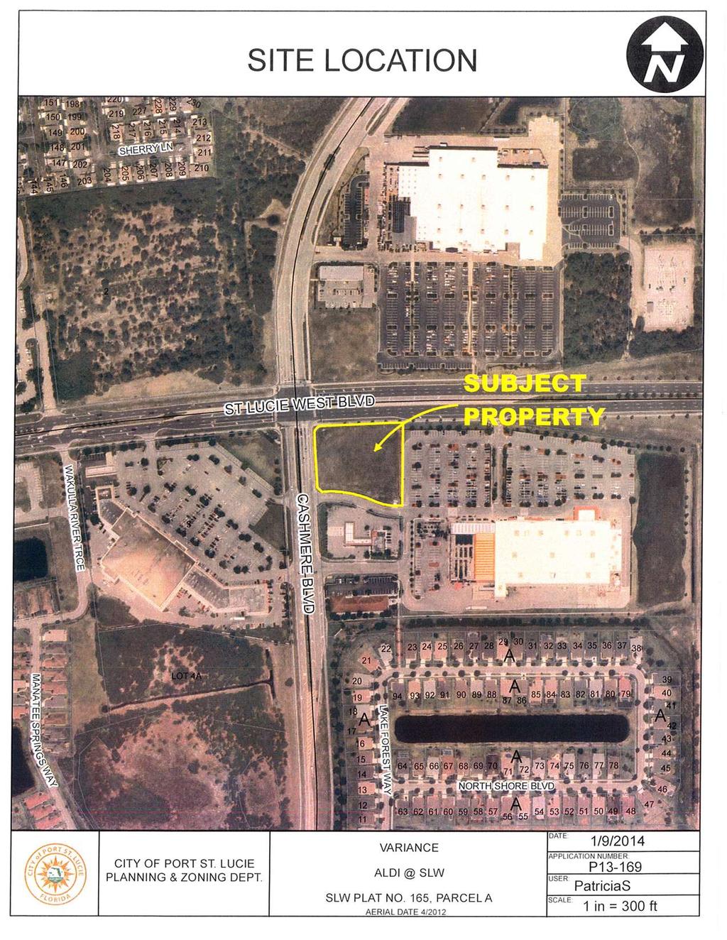
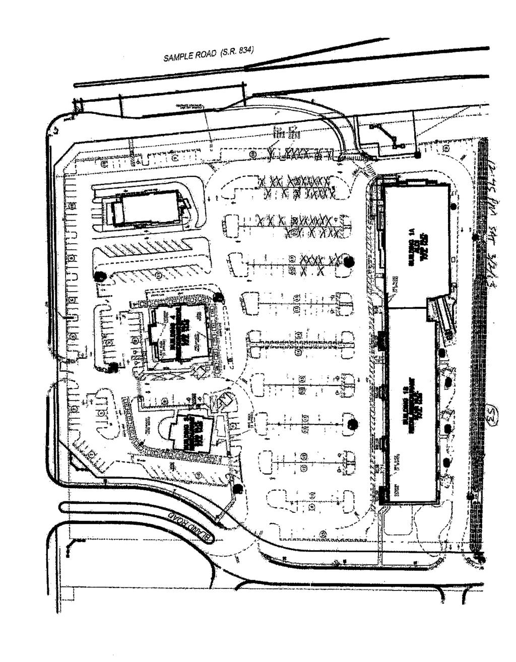
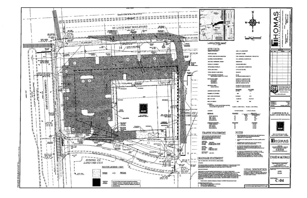
65 INTRODUCTION An Aldi grocery store is proposed at the southeast corner of Cashmere Boulevard and St. Lucie West Boulevard in Port St. Lucie, Florida. Figure 1 illustrates the site location. Aldi is proposing a 16,305 square foot store. A concept plan for the store is shown in Figure 2. The proceeding analysis will review the proposed site with respect to traffic capacity. Figure 1. Site Location Map ALDI Page 1

66 Figure 2. Concept Plan Page 2
67 CURRENT DATA The information contained below was used to develop the foregoing traffic analysis. Trip Generation, 9 th Edition (ITE report) City, State and County Traffic Data MacKenzie Engineering Traffic Data St. Lucie MPO Page 3
68 TRIP GENERATION Trip Generation The trip generation was projected based on the Institute of Transportation Engineers (ITE) report Trip Generation, 9 th Edition. Table 1 displays the proposed uses and the resulting trip generation. Table 1. Proposed Trip Generation Aldi Trip Generation Land Use Intensity Daily AM Peak Hour PM Peak Hour Trips Total In Out Total In Out Proposed Site Traffic Supermarket SF 1, Subtotal 1, Pass-By Traffic* Supermarket 36.0% Subtotal NET PROPOSED TRIPS 1, Total Proposed Driveway Volumes 1, NET CHANGE IN TRIPS (FOR THE PURPOSES OF CONCURRENCY) 1, NET CHANGE IN DRIVEWAY VOLUMES 1, Note: Trip generation was calculated using the following data: Pass-by AM Peak Hour PM Peak Hour Land Use ITE Code Unit Daily Rate Rate in/out Rate in/out Equation Supermarket SF % 62/ /49 Ln(T) = 0.74 Ln(X) Internal Capture Internal capture is 0 because the project is a single use. Pass-by Capture A 36 percent pass-by capture rate was applied to the trip generation using ITE s report Trip Generation Handbook, Second Edition, Land-Use 850 (Supermarket) Page 4
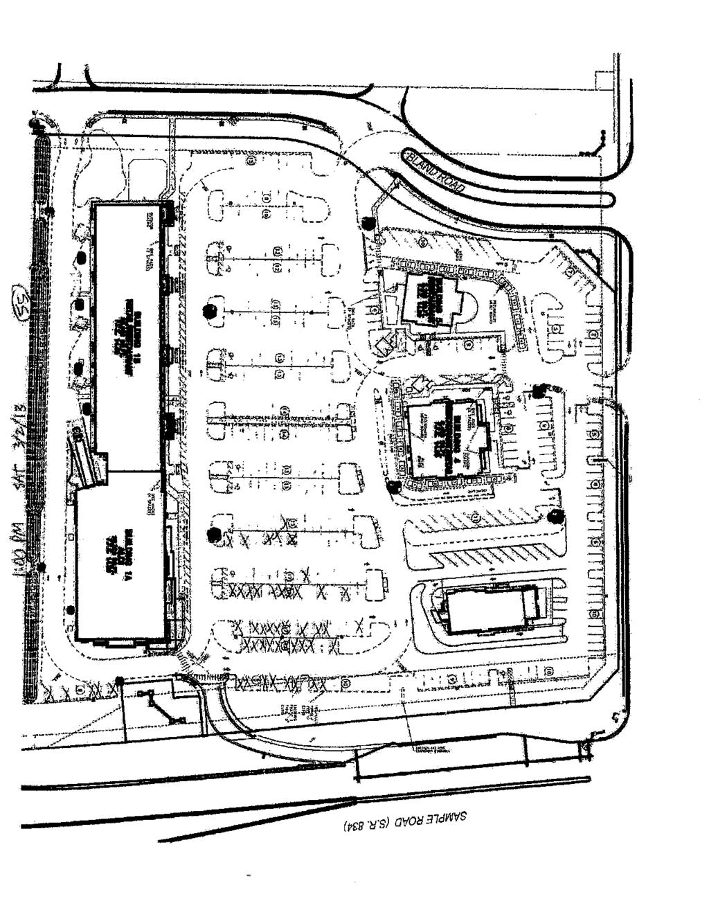
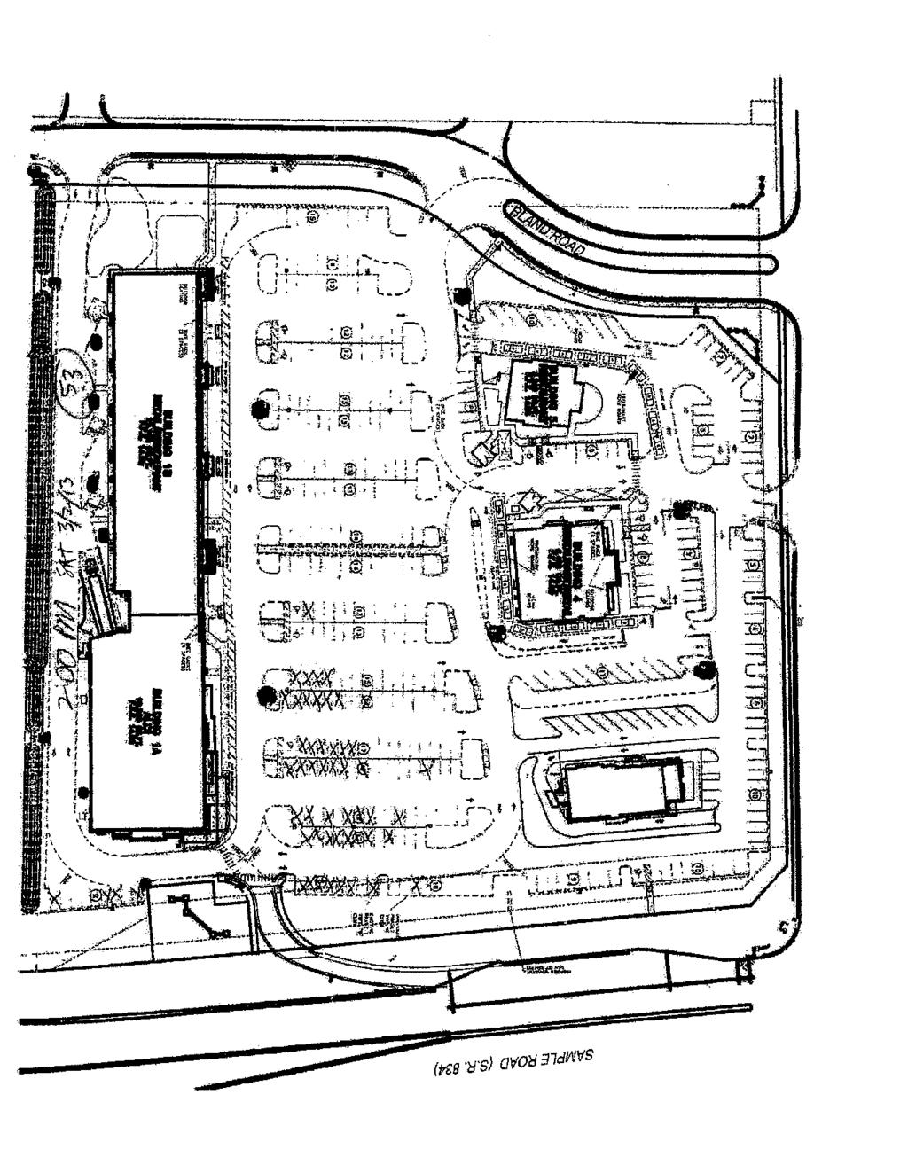
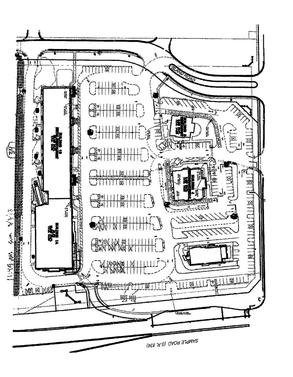
69 TRAFFIC DISTRIBUTION Traffic distribution and assignment was determined using engineering judgment, trip lengths based on the uses and from a review of the roadway network. The overall distribution is summarized by general directions and is depicted below: NORTH - 25 percent SOUTH - 25 percent EAST - 25 percent WEST - 25 percent ACCESS The proposed Project site has two points of access. The accesses are as follows: Existing Cashmere Boulevard Right-in/right-out Proposed St. Lucie West Boulevard Right-in/right-out Access to the site is proposed via two access driveways, both are right-in/right-out driveways. The primary entrance into the Home Depot center on Cashmere Boulevard contains a southbound leftturn lane and a northbound right-turn lane. A site plan is attached within Appendix D. Figure 2 displays the proposed access and projected driveway volumes Page 5
70 Figure 3. Driveway Trips RIGHT-IN / RIGHT-OUT 45.0% (47) % 0% 0 0 RIGHT-IN / RIGHT-OUT (20) (5) 0.0% 20.0% 5.0% (67) (5) % (50) 50% 0 0 0% RIGHT-IN / RIGHT- OUT 7 (21) 20% 580 (71) 18 FULL ACCESS 30% (31) 0 0 0% 10 5 (25) 25% 7 2 (21) (5) 20% 5% PROJECT DRIVEWAY TRIPS 498 AM Peak Hour PM Peak Hour Daily (61) Total In Out Total In Out 17 1, Aldi PROPOSED PROJECT DRIVEWAY TRAFFIC 1667 (204) 23 Total daily driveway trips PM peak hour driveway trips AM peak hour directional driveway trips Page 6
71 AVAILABLE DRI USES Adequate entitlements exist within the DRI for development of this proposal. All transportation conditions related to this development have been satisfied based on a review of Resolution 10-R47; therefore transportation improvements associated with this property have been satisfied by the St. Lucie West DRI. INTERSECTION ANALYSIS Two intersections will primarily be affected by the development, St. Lucie West Boulevard & Cashmere Boulevard and Cashmere Boulevard & Home Depot driveway. In order to provide a conservative analysis, we projected traffic volumes for the currently vacant Albertsons shopping center and added those into the pre-development condition. Both intersections were analyzed using Synchro 8 traffic analysis software. Intersection St. Lucie West Blvd & Cashmere Boulevard Cashmere Blvd & Home Depot Driveway * Major Street / Minor Street Table 2. Intersection Level of Service Pre- Development LOS D (45.0 sec/veh) A/C* Post Development LOS D (45.3 sec/veh) A/C* Both intersections are projected to operate acceptably in 2015 with the project and with a store generating trips equivalent to Albertsons on the west side of Cashmere Boulevard Page 7
72 CONCLUSION An Aldi grocery store is proposed at the southeast corner of Cashmere Boulevard and St. Lucie West Boulevard in Port St. Lucie, Florida. Aldi is proposing a 16,305 square foot store. The project is vested for concurrency since it is within the approved St. Lucie West DRI and the St. Lucie West DRI has satisfied all of its transportation obligations. The intersections of St. Lucie West Boulevard & Cashmere Boulevard and Cashmere Boulevard & Home Depot driveway are projected to operate acceptably in 2015 with the project and with a store generating trips equivalent to Albertsons on the west side of Cashmere Boulevard Page 8
73 APPENDICES
74
75 Aldi Trip Generation for Vacant Shopping Center at SW Corner of Cashmere & SLW Blvd Land Use Intensity Daily AM Peak Hour PM Peak Hour Trips Total In Out Total In Out Existing Site Traffic Gen. Commercial SF 3, Subtotal 3, Pass-By Traffic Gen. Commercial 51.7% 1, Subtotal 1, NET EXISTING TRIPS 1, Proposed Site Traffic Gen. Commercial SF 6, Subtotal 6, Pass-By Traffic Gen. Commercial 39.4% 2, Subtotal 2, NET PROPOSED TRIPS 4, Total Proposed Driveway Volumes 6, NET CHANGE IN TRIPS (FOR THE PURPOSES OF CONCURRENCY) 2, NET CHANGE IN DRIVEWAY VOLUMES 3, Note: Trip generation was calculated using the following data: Pass-by AM Peak Hour PM Peak Hour Land Use ITE Code Unit Daily Rate Rate in/out Rate in/out Equation Gen. Commercial SF Ln(T) = 0.65 Ln(X) Ln(T)=-0.29 Ln(T) = 0.61 Ln(T) = 0.67 Ln(X) 62/38 48/52 Ln(X)+5 Ln(X) c:\users\cad\documents\jobs - share drive\009 - bohler\002 - aldi\[aldi traffic.xlsx]tgen (2) Copyright 2013, MacKenzie Engineering and Planning, Inc.
76 Aldi PM PEAK HOUR TURNING MOVEMENTS EXHIBIT 4 Cashmere Boulevard & St. Lucie West ebu ebl ebt ebr wbu wbl wbt wbr nbu nbl nbt nbr sbu sbl sbt sbr totals 4:00 PM 4:15 PM :15 PM 4:30 PM :30 PM 4:45 PM :45 PM 5:00 PM :00 PM 5:15 PM :15 PM 5:30 PM :30 PM 5:45 PM :45 PM 6:00 PM :00 PM 5:00 PM :15 PM 5:15 PM :30 PM 5:30 PM :45 PM 5:45 PM :00 PM 6:00 PM 4067 ebu ebl ebt ebr wbu wbl wbt wbr nbu nbl nbt nbr sbu sbl sbt sbr ebu ebl ebt ebr wbu wbl wbt wbr nbu nbl nbt nbr sbu sbl sbt sbr nbu nbl nbt nbr sbu sbl sbt sbr ebu ebl ebt ebr wbu wbl wbt wbr ebu ebl ebt ebr wbu wbl wbt wbr nbu nbl nbt nbr sbu sbl sbt sbr 10/3/ Count Taken: 10/3/2013 Buildout year: 2014 Growth Rate: 1.00% Seasonal Factor: 1.11 ebu ebl ebt ebr wbu wbl wbt wbr nbu nbl nbt nbr sbu sbl sbt sbr % 0% 0% 0% Diversion* Committed Pre W/Committed Pre W/ Div Project Post Project Traffic Assignment In In In In Out Out In In 0% 0% 15% 10% 15% 10% 0% 0% 0% 25% 25% 0% 0% 15% 10% 0% Intersections
77 Aldi PM PEAK HOUR TURNING MOVEMENTS EXHIBIT 4 Cashmere Boulevard & Cashmere Corners ebu ebl ebt ebr wbu wbl wbt wbr nbu nbl nbt nbr sbu sbl sbt sbr totals 5:15 PM 5:30 PM :30 PM 5:45 PM :45 PM 6:00 PM :00 PM 6:15 PM :15 PM 6:30 PM :30 PM 6:45 PM :45 PM 7:00 PM :00 PM 7:15 PM :15 PM 6:15 PM :30 PM 6:30 PM 673 5:45 PM 6:45 PM 453 6:00 PM 7:00 PM 188 6:15 PM 7:15 PM 0 ebu ebl ebt ebr wbu wbl wbt wbr nbu nbl nbt nbr sbu sbl sbt sbr ebu ebl ebt ebr wbu wbl wbt wbr nbu nbl nbt nbr sbu sbl sbt sbr nbu nbl nbt nbr sbu sbl sbt sbr ebu ebl ebt ebr wbu wbl wbt wbr ebu ebl ebt ebr wbu wbl wbt wbr nbu nbl nbt nbr sbu sbl sbt sbr 10/3/ Count Taken: 10/3/2013 Buildout year: 2014 Growth Rate: 1.00% Seasonal Factor: 1.11 ebu ebl ebt ebr wbu wbl wbt wbr nbu nbl nbt nbr sbu sbl sbt sbr % 0% 0% 0% Diversion* Committed Pre W/Committed Pre W/ Div Project Post Project Traffic Assignment In In In In Out Out In In 0% 0% 15% 10% 15% 10% 0% 0% 0% 25% 25% 0% 0% 15% 10% 0% Intersections
78 Lanes, Volumes, Timings 2014 Pre 3: Cashmere Blvd & St. Lucie West Blvd Timing Plan: PM Lane Group EBU EBL EBT EBR WBU WBL WBT WBR NBL NBT NBR SBL Lane Configurations Volume (vph) Ideal Flow (vphpl) Storage Length (ft) Storage Lanes Taper Length (ft) Lane Util. Factor Ped Bike Factor 0.91 Frt Flt Protected Satd. Flow (prot) Flt Permitted Satd. Flow (perm) Right Turn on Red Yes Yes Yes Satd. Flow (RTOR) Link Speed (mph) Link Distance (ft) Travel Time (s) Confl. Peds. (#/hr) 180 Peak Hour Factor Adj. Flow (vph) Shared Lane Traffic (%) Lane Group Flow (vph) Enter Blocked Intersection No No No No No No No No No No No No Lane Alignment R NA Left Left Right R NA Left Left Right Left Left Right Left Median Width(ft) Link Offset(ft) Crosswalk Width(ft) Two way Left Turn Lane Headway Factor Turning Speed (mph) Number of Detectors Detector Template Left Left Thru Right Left Left Thru Right Left Thru Right Left Leading Detector (ft) Trailing Detector (ft) Detector 1 Position(ft) Detector 1 Size(ft) Detector 1 Type Cl+Ex Cl+Ex Cl+Ex Cl+Ex Cl+Ex Cl+Ex Cl+Ex Cl+Ex Cl+Ex Cl+Ex Cl+Ex Cl+Ex Detector 1 Channel Detector 1 Extend (s) Detector 1 Queue (s) Detector 1 Delay (s) Detector 2 Position(ft) Detector 2 Size(ft) Detector 2 Type Cl+Ex Cl+Ex Cl+Ex Detector 2 Channel Detector 2 Extend (s) Turn Type Prot Prot NA Perm Prot Prot NA Perm Prot NA Perm Prot Protected Phases /4/ :00 pm Synchro 8 Light Report Page 1
79 Lanes, Volumes, Timings 2014 Pre 3: Cashmere Blvd & St. Lucie West Blvd Timing Plan: PM Lane Group SBT SBR Lane Configurations Volume (vph) Ideal Flow (vphpl) Storage Length (ft) 365 Storage Lanes 1 Taper Length (ft) Lane Util. Factor Ped Bike Factor Frt Flt Protected Satd. Flow (prot) Flt Permitted Satd. Flow (perm) Right Turn on Red Yes Satd. Flow (RTOR) 141 Link Speed (mph) 30 Link Distance (ft) 1268 Travel Time (s) 28.8 Confl. Peds. (#/hr) Peak Hour Factor Adj. Flow (vph) Shared Lane Traffic (%) Lane Group Flow (vph) Enter Blocked Intersection No No Lane Alignment Left Right Median Width(ft) 30 Link Offset(ft) 0 Crosswalk Width(ft) 16 Two way Left Turn Lane Headway Factor Turning Speed (mph) 9 Number of Detectors 2 1 Detector Template Thru Right Leading Detector (ft) Trailing Detector (ft) 0 0 Detector 1 Position(ft) 0 0 Detector 1 Size(ft) 6 20 Detector 1 Type Cl+Ex Cl+Ex Detector 1 Channel Detector 1 Extend (s) Detector 1 Queue (s) Detector 1 Delay (s) Detector 2 Position(ft) 94 Detector 2 Size(ft) 6 Detector 2 Type Cl+Ex Detector 2 Channel Detector 2 Extend (s) 0.0 Turn Type NA Perm Protected Phases 4 12/4/ :00 pm Synchro 8 Light Report Page 2
80 Lanes, Volumes, Timings 2014 Pre 3: Cashmere Blvd & St. Lucie West Blvd Timing Plan: PM Lane Group EBU EBL EBT EBR WBU WBL WBT WBR NBL NBT NBR SBL Permitted Phases Detector Phase Switch Phase Minimum Initial (s) Minimum Split (s) Total Split (s) Total Split (%) 12.2% 12.2% 51.3% 51.3% 13.3% 13.3% 52.5% 52.5% 21.0% 17.3% 17.3% 18.1% Maximum Green (s) Yellow Time (s) All-Red Time (s) Lost Time Adjust (s) Total Lost Time (s) Lead/Lag Lead Lead Lag Lag Lead Lead Lag Lag Lead Lag Lag Lead Lead-Lag Optimize? Yes Yes Yes Yes Yes Yes Yes Yes Yes Yes Yes Yes Vehicle Extension (s) Recall Mode None None C-Max C-Max None None C-Max C-Max None None None None Walk Time (s) Flash Dont Walk (s) Pedestrian Calls (#/hr) Act Effct Green (s) Actuated g/c Ratio v/c Ratio Control Delay Queue Delay Total Delay LOS E D A F C A F E D F Approach Delay Approach LOS D C E Intersection Summary Area Type: Other Cycle Length: 150 Actuated Cycle Length: 150 Offset: 0 (0%), Referenced to phase 2:EBT and 6:WBT, Start of Green Natural Cycle: 110 Control Type: Actuated-Coordinated Maximum v/c Ratio: 0.88 Intersection Signal Delay: 45.0 Intersection LOS: D Intersection Capacity Utilization 84.9% ICU Level of Service E Analysis Period (min) 15 Splits and Phases: 3: Cashmere Blvd & St. Lucie West Blvd 12/4/ :00 pm Synchro 8 Light Report Page 3
81 Lanes, Volumes, Timings 2014 Pre 3: Cashmere Blvd & St. Lucie West Blvd Timing Plan: PM Lane Group SBT SBR Permitted Phases 4 Detector Phase 4 4 Switch Phase Minimum Initial (s) Minimum Split (s) Total Split (s) Total Split (%) 14.3% 14.3% Maximum Green (s) Yellow Time (s) All-Red Time (s) Lost Time Adjust (s) Total Lost Time (s) Lead/Lag Lag Lag Lead-Lag Optimize? Yes Yes Vehicle Extension (s) Recall Mode None None Walk Time (s) Flash Dont Walk (s) Pedestrian Calls (#/hr) 0 0 Act Effct Green (s) Actuated g/c Ratio v/c Ratio Control Delay Queue Delay Total Delay LOS E B Approach Delay 68.1 Approach LOS E Intersection Summary 12/4/ :00 pm Synchro 8 Light Report Page 4
82 Lanes, Volumes, Timings 2014 Pre 6: Cashmere Blvd & Cashmere Corners Timing Plan: PM Lane Group EBL EBT EBR WBL WBT WBR NBL NBT NBR SBL SBT SBR Lane Configurations Volume (vph) Ideal Flow (vphpl) Storage Length (ft) Storage Lanes Taper Length (ft) Lane Util. Factor Frt Flt Protected Satd. Flow (prot) Flt Permitted Satd. Flow (perm) Link Speed (mph) Link Distance (ft) Travel Time (s) Peak Hour Factor Adj. Flow (vph) Shared Lane Traffic (%) Lane Group Flow (vph) Enter Blocked Intersection No No No No No No No No No No No No Lane Alignment Left Left Right Left Left Right Left Left Right Left Left Right Median Width(ft) Link Offset(ft) Crosswalk Width(ft) Two way Left Turn Lane Headway Factor Turning Speed (mph) Sign Control Stop Stop Free Free Intersection Summary Area Type: Other Control Type: Unsignalized Intersection Capacity Utilization 33.5% Analysis Period (min) 15 ICU Level of Service A 12/4/ :00 pm Synchro 8 Light Report Page 6
83 HCM 2010 TWSC 2014 Pre 6: Cashmere Blvd & Cashmere Corners Timing Plan: PM Intersection Intersection Delay, s/veh 2.9 Movement EBL EBT EBR WBL WBT WBR NBL NBT NBR SBL SBT SBR Vol, veh/h Conflicting Peds, #/hr Sign Control Stop Stop Stop Stop Stop Stop Free Free Free Free Free Free RT Channelized - - None - - None - - None - - None Storage Length Veh in Median Storage, # Grade, % Peak Hour Factor Heavy Vehicles, % Mvmt Flow Major/Minor Minor2 Minor1 Major1 Major2 Conflicting Flow All Stage Stage Follow-up Headway Pot Capacity-1 Maneuver Stage Stage Time blocked-platoon, % Mov Capacity-1 Maneuver Mov Capacity-2 Maneuver Stage Stage Approach EB WB NB SB HCM Control Delay, s HCM LOS B B Minor Lane / Major Mvmt NBL NBT NBR EBLn1 EBLn2 WBLn1 WBLn2 SBL SBT SBR Capacity (veh/h) HCM Lane V/C Ratio HCM Control Delay (s) HCM Lane LOS A C B C B A HCM 95th %tile Q(veh) Notes ~ : Volume Exceeds Capacity; $ : Delay Exceeds 300 Seconds; Error : Computation Not Defined 12/4/ :00 pm Synchro 8 Light Report Page 7
84 Lanes, Volumes, Timings 2014 Post 3: Cashmere Blvd & St. Lucie West Blvd Timing Plan: PM Lane Group EBU EBL EBT EBR WBU WBL WBT WBR NBL NBT NBR SBL Lane Configurations Volume (vph) Ideal Flow (vphpl) Storage Length (ft) Storage Lanes Taper Length (ft) Lane Util. Factor Ped Bike Factor 0.90 Frt Flt Protected Satd. Flow (prot) Flt Permitted Satd. Flow (perm) Right Turn on Red Yes Yes Yes Satd. Flow (RTOR) Link Speed (mph) Link Distance (ft) Travel Time (s) Confl. Peds. (#/hr) 180 Peak Hour Factor Adj. Flow (vph) Shared Lane Traffic (%) Lane Group Flow (vph) Enter Blocked Intersection No No No No No No No No No No No No Lane Alignment R NA Left Left Right R NA Left Left Right Left Left Right Left Median Width(ft) Link Offset(ft) Crosswalk Width(ft) Two way Left Turn Lane Headway Factor Turning Speed (mph) Number of Detectors Detector Template Left Left Thru Right Left Left Thru Right Left Thru Right Left Leading Detector (ft) Trailing Detector (ft) Detector 1 Position(ft) Detector 1 Size(ft) Detector 1 Type Cl+Ex Cl+Ex Cl+Ex Cl+Ex Cl+Ex Cl+Ex Cl+Ex Cl+Ex Cl+Ex Cl+Ex Cl+Ex Cl+Ex Detector 1 Channel Detector 1 Extend (s) Detector 1 Queue (s) Detector 1 Delay (s) Detector 2 Position(ft) Detector 2 Size(ft) Detector 2 Type Cl+Ex Cl+Ex Cl+Ex Detector 2 Channel Detector 2 Extend (s) Turn Type Prot Prot NA Perm Prot Prot NA Perm Prot NA Perm Prot Protected Phases /4/ :00 pm Synchro 8 Light Report Page 1
85 Lanes, Volumes, Timings 2014 Post 3: Cashmere Blvd & St. Lucie West Blvd Timing Plan: PM Lane Group SBT SBR Lane Configurations Volume (vph) Ideal Flow (vphpl) Storage Length (ft) 365 Storage Lanes 1 Taper Length (ft) Lane Util. Factor Ped Bike Factor Frt Flt Protected Satd. Flow (prot) Flt Permitted Satd. Flow (perm) Right Turn on Red Yes Satd. Flow (RTOR) 137 Link Speed (mph) 30 Link Distance (ft) 1268 Travel Time (s) 28.8 Confl. Peds. (#/hr) Peak Hour Factor Adj. Flow (vph) Shared Lane Traffic (%) Lane Group Flow (vph) Enter Blocked Intersection No No Lane Alignment Left Right Median Width(ft) 30 Link Offset(ft) 0 Crosswalk Width(ft) 16 Two way Left Turn Lane Headway Factor Turning Speed (mph) 9 Number of Detectors 2 1 Detector Template Thru Right Leading Detector (ft) Trailing Detector (ft) 0 0 Detector 1 Position(ft) 0 0 Detector 1 Size(ft) 6 20 Detector 1 Type Cl+Ex Cl+Ex Detector 1 Channel Detector 1 Extend (s) Detector 1 Queue (s) Detector 1 Delay (s) Detector 2 Position(ft) 94 Detector 2 Size(ft) 6 Detector 2 Type Cl+Ex Detector 2 Channel Detector 2 Extend (s) 0.0 Turn Type NA Perm Protected Phases 4 12/4/ :00 pm Synchro 8 Light Report Page 2
86 Lanes, Volumes, Timings 2014 Post 3: Cashmere Blvd & St. Lucie West Blvd Timing Plan: PM Lane Group EBU EBL EBT EBR WBU WBL WBT WBR NBL NBT NBR SBL Permitted Phases Detector Phase Switch Phase Minimum Initial (s) Minimum Split (s) Total Split (s) Total Split (%) 12.1% 12.1% 50.4% 50.4% 13.7% 13.7% 52.0% 52.0% 21.6% 17.9% 17.9% 18.0% Maximum Green (s) Yellow Time (s) All-Red Time (s) Lost Time Adjust (s) Total Lost Time (s) Lead/Lag Lead Lead Lag Lag Lead Lead Lag Lag Lead Lag Lag Lead Lead-Lag Optimize? Yes Yes Yes Yes Yes Yes Yes Yes Yes Yes Yes Yes Vehicle Extension (s) Recall Mode None None C-Max C-Max None None C-Max C-Max None None None None Walk Time (s) Flash Dont Walk (s) Pedestrian Calls (#/hr) Act Effct Green (s) Actuated g/c Ratio v/c Ratio Control Delay Queue Delay Total Delay LOS E D A F C A F E C F Approach Delay Approach LOS D C E Intersection Summary Area Type: Other Cycle Length: 150 Actuated Cycle Length: 150 Offset: 0 (0%), Referenced to phase 2:EBT and 6:WBT, Start of Green Natural Cycle: 110 Control Type: Actuated-Coordinated Maximum v/c Ratio: 0.88 Intersection Signal Delay: 45.3 Intersection LOS: D Intersection Capacity Utilization 86.0% ICU Level of Service E Analysis Period (min) 15 Splits and Phases: 3: Cashmere Blvd & St. Lucie West Blvd 12/4/ :00 pm Synchro 8 Light Report Page 3
87 Lanes, Volumes, Timings 2014 Post 3: Cashmere Blvd & St. Lucie West Blvd Timing Plan: PM Lane Group SBT SBR Permitted Phases 4 Detector Phase 4 4 Switch Phase Minimum Initial (s) Minimum Split (s) Total Split (s) Total Split (%) 14.3% 14.3% Maximum Green (s) Yellow Time (s) All-Red Time (s) Lost Time Adjust (s) Total Lost Time (s) Lead/Lag Lag Lag Lead-Lag Optimize? Yes Yes Vehicle Extension (s) Recall Mode None None Walk Time (s) Flash Dont Walk (s) Pedestrian Calls (#/hr) 0 0 Act Effct Green (s) Actuated g/c Ratio v/c Ratio Control Delay Queue Delay Total Delay LOS E B Approach Delay 68.3 Approach LOS E Intersection Summary 12/4/ :00 pm Synchro 8 Light Report Page 4
88 Lanes, Volumes, Timings 2014 Post 6: Cashmere Blvd & Cashmere Corners Timing Plan: PM Lane Group EBL EBT EBR WBL WBT WBR NBL NBT NBR SBL SBT SBR Lane Configurations Volume (vph) Ideal Flow (vphpl) Storage Length (ft) Storage Lanes Taper Length (ft) Lane Util. Factor Frt Flt Protected Satd. Flow (prot) Flt Permitted Satd. Flow (perm) Link Speed (mph) Link Distance (ft) Travel Time (s) Peak Hour Factor Adj. Flow (vph) Shared Lane Traffic (%) Lane Group Flow (vph) Enter Blocked Intersection No No No No No No No No No No No No Lane Alignment Left Left Right Left Left Right Left Left Right Left Left Right Median Width(ft) Link Offset(ft) Crosswalk Width(ft) Two way Left Turn Lane Headway Factor Turning Speed (mph) Sign Control Stop Stop Free Free Intersection Summary Area Type: Other Control Type: Unsignalized Intersection Capacity Utilization 36.1% Analysis Period (min) 15 ICU Level of Service A 12/4/ :00 pm Synchro 8 Light Report Page 6
89 HCM 2010 TWSC 2014 Post 6: Cashmere Blvd & Cashmere Corners Timing Plan: PM Intersection Intersection Delay, s/veh 3.5 Movement EBL EBT EBR WBL WBT WBR NBL NBT NBR SBL SBT SBR Vol, veh/h Conflicting Peds, #/hr Sign Control Stop Stop Stop Stop Stop Stop Free Free Free Free Free Free RT Channelized - - None - - None - - None - - None Storage Length Veh in Median Storage, # Grade, % Peak Hour Factor Heavy Vehicles, % Mvmt Flow Major/Minor Minor2 Minor1 Major1 Major2 Conflicting Flow All Stage Stage Follow-up Headway Pot Capacity-1 Maneuver Stage Stage Time blocked-platoon, % Mov Capacity-1 Maneuver Mov Capacity-2 Maneuver Stage Stage Approach EB WB NB SB HCM Control Delay, s HCM LOS C C Minor Lane / Major Mvmt NBL NBT NBR EBLn1 EBLn2 WBLn1 WBLn2 SBL SBT SBR Capacity (veh/h) HCM Lane V/C Ratio HCM Control Delay (s) HCM Lane LOS A C B C B A HCM 95th %tile Q(veh) Notes ~ : Volume Exceeds Capacity; $ : Delay Exceeds 300 Seconds; Error : Computation Not Defined 12/4/ :00 pm Synchro 8 Light Report Page 7
90
91
APPENDICES. APPENDIX D Synchro Level of Service Output Sheets
 APPENDICES APPENDIX D Synchro Level of Service Output Sheets Lanes, Volumes, Timings NO BUILD 2016 PM 8: 10th St & Thain Rd 10/05/2016 Lane Group NBL NBT NBR SBL SBT SBR SEL SET SER NWL NWT NWR
LOST LAKE CORRIDOR REVIEW
 LOST LAKE CORRIDOR REVIEW Prepared for: Prepared by: Broadview Developments Inc. c/o Westbrook Consulting Watt Consulting Group Our File: 2064.B01 Date: October 31, 2016 TABLE OF CONTENTS 1.0 INTRODUCTION...
Weaver Road Senior Housing Traffic Impact Analysis
 Gibson Traffic Consultants, Inc. 2813 Rockefeller Avenue Suite B Everett, WA 9821 425.339.8266 Weaver Road Senior Housing Traffic Impact Analysis Jurisdiction: City of Snohomish January 218 GTC #17-37
Traffic Impact Study Morgan Road Commerce Park Pasco County, Florida
 Traffic Impact Study Morgan Road Commerce Park Pasco County, Florida Summary Report June 2008 Prepared by: 12909 N 56 th Street # 201 Tampa, FL 33617 Ph: (813) 988-3180 Fax: (813) 343-6854 Morgan Road
Provide an overview of the development proposal including projected site traffic volumes;
 December 19, 2013 File: 163600935 Attention: Troy Elliott Carl Elliott Limited 15-1831 Robertson Road PO Box 11117 Nepean, Ontario K1H 7T8 Dear Mr. Elliott, Reference: 2235 and 2265 Robertson Road Transportation
Final Technical Report US 17 Corridor Study Update (Market Street Road Diet)
") Market Street Road Diet Wilmington, NC 2016 Final Technical Report US 17 Corridor Study Update (Market Street Road Diet) Wilmington, NC Parsons Brinckerhoff January 2016 FINAL TECHNICAL REPORT US 17 Corridor
Market Street Road Diet Wilmington, NC 2016 Final Technical Report US 17 Corridor Study Update (Market Street Road Diet) Wilmington, NC Parsons Brinckerhoff January 2016 FINAL TECHNICAL REPORT US 17 Corridor
Bennett Pit. Traffic Impact Study. J&T Consulting, Inc. Weld County, Colorado. March 3, 2017
 Bennett Pit Traffic Impact Study J&T Consulting, Inc. Weld County, Colorado March 3, 217 Prepared By: Sustainable Traffic Solutions, Inc. http://www.sustainabletrafficsolutions.com/ Joseph L. Henderson,
Proposed Office Building Traffic Impact Study Chicago Avenue Evanston, Illinois
 Proposed Office Building Traffic Impact Study 1714-1720 Chicago Avenue Evanston, Illinois Prepared For: HOLABIRD & ROOT, LLC Prepared by: Eriksson Engineering Associates, Ltd. 145 Commerce Drive, Ste A,
MEMORANDUM November 19, 2012
 COUNCIL OF GOVERNMENTS CENTRAL NAUGATUCK VALLEY 60 NORTH MAIN ST 3RD Floor WATERBURY, CT 06702-1403 (203)757-0535 Web Site: www.cogcnv.org E-Mail: cogcnv@cogcnv.org November 19, 2012 MEMORANDUM 111912
Date: December 20, Project #:
 To: Craig Rottenberg Long s Jewelers 60A South Avenue Burlington, MA 01803 From: Patrick Dunford, P.E. Senior Project Manager Date: December 20, 2018 Project #: 14416.00 Re: Burlington Mall Proposed Long
One Harbor Point Residential
 Residential Gig Harbor, WA Transportation Impact Analysis January 23, 2017 Prepared for: Neil Walter Company PO Box 2181 Tacoma, WA 98401 Prepared by: TENW Transportation Engineering NorthWest 11400 SE
10 th Street Residences Development Traffic Impact Analysis
 Gibson Traffic Consultants, Inc. 2813 Rockefeller Avenue Suite B Everett, WA 98201 425.339.8266 10 th Street Residences Development Traffic Impact Analysis Jurisdiction: City of Snohomish September 2018
KUM & GO 6400 WESTOWN PARKWAY WEST DES MOINES, IOWA 50266
 KUM & GO #300 PECOS STREET & 88 TH AVENUE THORNTON, COLORADO TRAFFIC IMPACT STUDY REVISION 1 PREPARED FOR KUM & GO 6400 WESTOWN PARKWAY WEST DES MOINES, IOWA 50266 JANUARY 23, 2014 OA PROJECT NO. 013-1721
Sweetwater Landing Traffic Impact Analysis
 Gibson Traffic Consultants, Inc. 8 Rockefeller Avenue Suite B Everett, WA 98 45.9.8 Sweetwater Landing Traffic Impact Analysis Jurisdiction: City of Snohomish February 8 GTC #7-87 Sweetwater Landing Traffic
Rockingham Ridge Plaza Commercial Development Halifax Regional Municipality
 Rockingham Ridge Plaza Commercial Development Halifax Regional Municipality Traffic Impact Study Final Draft Report Prepared by: GRIFFIN transportation group inc. 30 Bonny View Drive Fall River, NS B2T
June 21, Mr. Jeff Mark The Landhuis Company 212 North Wahsatch Avenue, Suite 301. Colorado Springs, CO 80903
 LSC TRANSPORTATION CONSULTANTS, INC. 545 East Pikes Peak Avenue, Suite 210 Colorado Springs, CO 80903 (719) 633-2868 FAX (719) 633-5430 E-mail: lsc@lsctrans.com Website: http://www.lsctrans.com June 21,
Traffic Impact Study. Eastern Springs. A Proposed Development in Manorville, NY. April Haas Group Inc Transportation Planners and Engineers
 Traffic Impact Study For Eastern Springs A Proposed Development in Manorville, NY April 2018 Haas Group Inc Transportation Planners and Engineers Table of Contents 1) Executive Summary... 2 2) Study Purpose...
886 March Road McDonald's Transportation Study
 McDonald's Restaurants of Canada Limited March 2013 886 March Road McDonald's Transportation Study Submitted by: HDR Corporation 100 York Boulevard, Suite 300 Richmond Hill, ON L4B 1J8 (905) 882-4100 www.hdrinc.com
Barrhaven Honda Dealership. Dealership Drive, Ottawa, ON. Transportation Brief
 Barrhaven Honda Dealership Dealership Drive, Ottawa, ON Transportation Brief Prepared By: NOVATECH Suite 200, 240 Michael Cowpland Drive Ottawa, Ontario K2M 1P6 September, 2015 File: 115136 Ref: R-2015-152
HCM Unsignalized Intersection Capacity Analysis 6: Brian Street & LC 111 5/26/2009
 6: Brian Street & LC 111 5/26/2009 Movement EBL EBR NBL NBT SBT SBR Volume (veh/h) 116 20 8 405 137 56 Sign Control Stop Free Free Grade 0% 0% 0% Peak Hour Factor 0.81 0.81 0.67 0.67 0.89 0.89 Hourly flow
Traffic Impact Study Proposed Commercial Development Ballwin, Missouri. Technical Memorandum for Traffic Impact Study
 Traffic Impact Study Proposed Commercial Development Ballwin, Missouri Technical Memorandum for Traffic Impact Study Crawford, Bunte, Brammeier May 1, 2009 MEMORANDUM Date: April 24, 2009 To: From: Subject:
MEMORANDUM. Date: November 4, Cheryl Burrell, Pebble Beach Company. Rob Rees, P.E. Inclusionary Housing Transportation Analysis WC
 MEMORANDUM Date: November 4, 2013 To: From: Subject: Cheryl Burrell, Pebble Beach Company Rob Rees, P.E. Inclusionary Housing Transportation Analysis As requested, Fehr & Peers is providing clarification
JRL consulting. March Hartland Developments Limited 1993 Hammonds Plains Road Hammonds Plains, NS B4B 1P3
 March 2015 Prepared for Hartland Developments Limited 1993 Hammonds Plains Road Hammonds Plains, NS B4B 1P3 JRL consulting JRL consulting TABLE OF CONTENTS 1 INTRODUCTION... 2 1.1 BACKGROUND... 2 2 EXISTING
Traffic Impact Analysis Update
 Willow Bend Traffic Impact Analysis Update TABLE OF CONTENTS Page I. INTRODUCTION -------------------------------------------------------------------------------------------- 1 II. EXISTING CONDITIONS
MEMO. McCORMICK RANKIN CORPORATION. File FROM: Keyur Shah DATE: February 1, 2010 COPIES: OUR FILE: SUBJECT: TO:
 McCORMICK RANKIN CORPORATION 2655 North Sheridan Way Mississauga, Ontario, L5K 2P8 Tel: (905)823-8500 Fax: (905) 823-8503 E-mail: mrc@mrc.ca Website: www.mrc.ca MEMO TO: File FROM: Keyur Shah DATE: February
Traffic Impact Analysis Farmington Center Village
 Traffic Impact Analysis Farmington Center Village Route 4 (Farmington Avenue) Farmington, Connecticut Prepared for: The Town of Farmington, CT Prepared By: BL Companies Meriden, Connecticut December 2016
Sugarland Crossing Gwinnett County, Georgia
 Sugarland Crossing Gwinnett County, Georgia S IGNAL W ARRANT A NALYSIS For the Intersection of: Sugarloaf Parkway / Richards Middle School Driveway / Sugarland Crossing Main Site Driveway Prepared for:
APPENDICES. No Cumulative Impact Project Alternative Traffic Analysis Memorandum (May 2016)
") APPENDICES Appendix T No Cumulative Impact Project Alternative Traffic Analysis Memorandum (May 2016) 661 Bear Valley Parkway EIR March 2017 APPENDICES This page intentionally left blank 661 Bear Valley
APPENDICES Appendix T No Cumulative Impact Project Alternative Traffic Analysis Memorandum (May 2016) 661 Bear Valley Parkway EIR March 2017 APPENDICES This page intentionally left blank 661 Bear Valley
Table 1 - Land Use Comparisons - Proposed King s Wharf Development. Retail (SF) Office (SF) 354 6,000 10, Land Uses 1
 Office (SF) 354 6,000 10, Land Uses 1") Ref. No. 171-6694 Phase 2 November 23, 217 Mr. David Quilichini, Vice President Fares & Co. Developments Inc. 31 Place Keelson Sales Centre DARTMOUTH NS B2Y C1 Sent Via Email to David@faresinc.com RE:
Ref. No. 171-6694 Phase 2 November 23, 217 Mr. David Quilichini, Vice President Fares & Co. Developments Inc. 31 Place Keelson Sales Centre DARTMOUTH NS B2Y C1 Sent Via Email to David@faresinc.com RE:
Aldridge Transportation Consultants, LLC Advanced Transportation Planning and Traffic Engineering
 Aldridge Transportation Consultants, LLC Advanced Transportation Planning and Traffic Engineering John M.W. Aldridge, PE, PTOE, AICP 1082 Chimney Rock Road Colorado Registered Professional Engineer Highlands
C. iv) Analysis/Results
 Analysis/Results") The Pettengill Road project is located outside the borders of the model in an external zone. As a result, inserting all Pettengill Road trip generation assumptions into the NRPC model and running a new
The Pettengill Road project is located outside the borders of the model in an external zone. As a result, inserting all Pettengill Road trip generation assumptions into the NRPC model and running a new
Village of Richmond Transportation Brief
 Village of Richmond Transportation Brief GENIVAR Project Number 111-18482-00 June 21 st, 2011 www.genivar.com GENIVAR 15 Fitzgerald Road, Suite 100 Ottawa, Ontario, CANADA K2H 9G1 Telephone: 613-829-2800
April Salvation Army Barrhaven Church 102 Bill Leathem Drive Transportation Brief
 April 26 Salvation Army Barrhaven Church 2 Bill Leathem Drive Transportation Brief Salvation Army Barrhaven Church 2 Bill Leathem Drive Transportation Brief prepared for: The Salvation Army 2 Overlea Blvd.
Wellings Communities Holding Inc and Extendicare (Canada) Inc Hazeldean Road. Transportation Impact Study. Ottawa, Ontario. Project ID
 Inc Hazeldean Road. Transportation Impact Study. Ottawa, Ontario. Project ID") Wellings Communities Holding Inc and Extendicare (Canada) Inc. 5731 Hazeldean Road Transportation Impact Study Ottawa, Ontario Project ID 160401195 Prepared by: Stantec Consulting Ltd. March 2016 WELLINGS
Wellings Communities Holding Inc and Extendicare (Canada) Inc. 5731 Hazeldean Road Transportation Impact Study Ottawa, Ontario Project ID 160401195 Prepared by: Stantec Consulting Ltd. March 2016 WELLINGS
Aldridge Transportation Consultants, LLC Advanced Transportation Planning and Traffic Engineering
 Aldridge Transportation Consultants, LLC Advanced Transportation Planning and Traffic Engineering John M.W. Aldridge, PE, PTOE, AICP 1082 Chimney Rock Road Colorado Registered Professional Engineer Highlands
Paisley & Whitelaw - Paisley Park OPA / ZBA for Mixed Density Residential Use
 Paisley & Whitelaw - Paisley Park OPA / ZBA for Mixed Density Residential Use Transportation Impact Study City of Guelph Prepared for: Armel Corporation August 2018 Table of Contents 1 Introduction...
DIVISION STREET PLAT TRAFFIC IMPACT ANALYSIS
 DIVISION STREET PLAT TRAFFIC IMPACT ANALYSIS TABLE OF CONTENTS 1. Introduction...3 2. Project Description...3 3. Existing Conditions...3 4. Forecast Traffic Demand and Analysis...12 5. Conclusions and
Salvini Consulting Inc. 459 Deer Ridge Drive Kitchener, ON N2P 0A November 8, 2017 Revised December 20, 2017
 Salvini Consulting Inc. 459 Deer Ridge Drive Kitchener, ON N2P 0A7 519-591-0426 November 8, 2017 Revised December 20, 2017 Laurie Wills, PEng Deputy Director of Public Works Town of Cobourg 740 Division
BUCKLEY ANNEX REDEVELOPMENT PLAN TRANSPORTATION ANALYSIS ADDENDUM
 BUCKLEY ANNEX REDEVELOPMENT PLAN TRANSPORTATION ANALYSIS ADDENDUM Prepared for: City and County of Denver Prepared by: Contact: Brian Bern, P.E., PTOE 303.572.0200 On Behalf of: Lowry Redevelopment Authority
TRANSPORTATION ANALYSIS. Wawa US 441 and Morningside Drive. Prepared for: Brightwork Real Estate, Inc.
 TRANSPORTATION ANALYSIS Wawa US 441 and Morningside Drive Prepared for: Brightwork Real Estate, Inc. TABLE OF CONTENTS Introduction... 1 Project Description... 1 Estimated Daily Project Traffic... 3 Estimated
APPENDIX G. Traffic Data
 APPENDIX G Traffic Data HCM Signalized Intersection Capacity Analysis 2: Duanesburg Road & I-88 Ramps 10/7/2004 Movement EBL EBT EBR WBL WBT WBR NBL NBT NBR SBL SBT SBR Lane Configurations Ideal Flow (vphpl)
L1TILE BEARS DAY CARE TRANSPORTATION IMPACT STUDY FORT COLLINS, COLORADO MAY Prepared for:
 L1TILE BEARS DAY CARE TRANSPORTATION IMPACT STUDY FORT COLLINS, COLORADO MAY 2012 Prepared for: Hillside Construction, Inc. 216 Hemlock Street, Suite B Fort Collins, CO 80534 Prepared by: DELICH ASSOCIATES
D & B COMMERCIAL TRAFFIC IMPACT ANALYSIS
 D & B COMMERCIAL TRAFFIC IMPACT ANALYSIS TABLE OF CONTENTS I. Introduction...3 II. Project Description...3 III. Existing Conditions...3 IV. Future Traffic Conditions...8 V. Conclusions and Mitigation...14
TRAFFIC IMPACT STUDY DERRY GREEN CORPORATE BUSINESS PARK MILTON SECONDARY PLAN MODIFICATION
 TRAFFIC IMPACT STUDY DERRY GREEN CORPORATE BUSINESS PARK MILTON SECONDARY PLAN MODIFICATION TRAFFIC IMPACT STUDY DERRY GREEN CORPORATE BUSINESS PARK MILTON SECONDARY PLAN MODIFICATION DECEMBER 2014 UPDATED
Traffic Impact Study Hudson Street Parking Garage MC Project No.: A Table of Contents
 Traffic Impact Study Hudson Street Parking Garage MC Project No.: 15001714A Table of Contents Table of Contents I. INTRODUCTION... 1 II. EXISTING CONDITIONS... 4 III. 2015 EXISTING TRAFFIC CONDITIONS...
Intersection LOS Delay (Sec) LOS Delay (Sec.) US 3/ Hawthorne Drive N B 16.1 B 17.5
 LOS Delay (Sec.) US 3/ Hawthorne Drive N B 16.1 B 17.5") Intersection No- LOS Delay (Sec) LOS Delay (Sec.) US 3/ Hawthorne Drive N B 16.1 B 17.5 Ü Intersection No- LOS Delay (Sec) LOS Delay (Sec.) US 3/ Hawthorne Drive S C 32.6 D 43.0 Intersection No- LOS Delay
Intersection No- LOS Delay (Sec) LOS Delay (Sec.) US 3/ Hawthorne Drive N B 16.1 B 17.5 Ü Intersection No- LOS Delay (Sec) LOS Delay (Sec.) US 3/ Hawthorne Drive S C 32.6 D 43.0 Intersection No- LOS Delay
Re: Residential Development - Ogilvie/Cummings Transportation Overview
 1223 Michael Street, Suite 100, Ottawa, ON K1J 7T2 Tel: 613.738.4160 Fax: 613.739.7105 www.delcan.com March 28, 2012 OUR REF: TO3088TOY Barry J. Hobin & Architects 63 Pamilla Street Ottawa, ON K1S 3K7
Ref. No Task 3. April 28, Mr. Cesar Saleh, P. Eng. VP Planning and Design W.M. Fares Group th
 Ref. No. 151-00564 Task 3 April 28, 2015 Mr. Cesar Saleh, P. Eng. VP Planning and Design W.M. Fares Group th 3480 Joseph Howe Drive, 5 Floor HALIFAX NS B3L 4H7 Sent via Email to ceasr.saleh@wmfares.com
LATSON INTERCHANGE DEVELOPMENT TRAFFIC STUDIES. Genoa Township, Livingston County, MI
 LATSON INTERCHANGE DEVELOPMENT TRAFFIC STUDIES Genoa Township, Livingston County, MI DRAFT TRAFFIC STUDY FOR I-96 AT LATSON RD INTERCHANGE Livingston County CS 47065 JN 101622C Submitted to: Michigan Department
Parking/Traffic Assessment Study
 Brock Road Industrial Mall 985 Brock Road South City of Pickering Parking/Traffic Assessment Study Prepared by: Tranplan Associates, Toronto Toronto 416-670-2005 Sudbury 705-522-0272 Peterborough 705-874-3638
(A) Project Manager, Infrastructure Approvals
 Project Manager, Infrastructure Approvals") February 14th, 2014 BY E-MAIL: wally.dubyk@ottawa.ca City of Ottawa Planning and Growth Management Branch 110 Laurier Ave. W., 4 th Floor, Ottawa, Ontario K1P 1J1 Attention: Wally Dubyk, C.E.T (A) Project
February 14th, 2014 BY E-MAIL: wally.dubyk@ottawa.ca City of Ottawa Planning and Growth Management Branch 110 Laurier Ave. W., 4 th Floor, Ottawa, Ontario K1P 1J1 Attention: Wally Dubyk, C.E.T (A) Project
MURRIETA APARTMENTS TRAFFIC IMPACT ANALYSIS CITY OF MURRIETA, CALIFORNIA
 MURRIETA APARTMENTS TRAFFIC IMPACT ANALYSIS CITY OF MURRIETA, CALIFORNIA SEPTEMBER 20, 2012 Prepared for: Golden Eagle Multi-Family Properties, LLC 6201 Oak Canyon Rd., Suite 250 Irvine, CA 92618 Prepared
Re: Cyrville Road Car Dealership
 1223 Michael Street, Suite 100, Ottawa, ON K1J 7T2 Tel: 613.738.4160 Fax: 613.739.7105 www.delcan.com February 25, 2013 OUR REF: TO3098TOE Mark Motors of Ottawa 611 Montreal Road Ottawa, ON K1K 0T8 Attention:
TECHNICAL MEMORANDUM
 TECHNICAL MEMORANDUM TO: Merrimack Valley Metropolitan Planning Organization FROM: James Terlizzi, P.E., Transportation Planning Engineer DATE: March 6, 2017 SUBJECT: Further analysis of the recommendations
APPENDIX A LEVEL OF SERVICE CONCEPTS, ANALYSIS METHODOLOGIES,STANDARDS OF SIGNIFICANCE
 APPENDIX A LEVEL OF SERVICE CONCEPTS, ANALYSIS METHODOLOGIES,STANDARDS OF SIGNIFICANCE Roadway Segment Level of Service Definitions LOS V/C Congestion/Delay Traffic Description (Used for surface streets,
JOHNSON RANCH RAPID CITY, SOUTH DAKOTA TRAFFIC IMPACT ANALYSIS
 JOHNSON RANCH RAPID CITY, SOUTH DAKOTA TRAFFIC IMPACT ANALYSIS Prepared for: KTM Design Solutions 528 Kansas City Street, Suite 1 Rapid City, SD 57701 Prepared by: Felsburg Holt & Ullevig 6300 South Syracuse
TECHNICAL MEMORANDUM Upper Broadway Road Diet Summary of Findings
 TECHNICAL MEMORANDUM Summary of Findings Date: June 17, 2014 Project #: 17121.15 To: Si Lau, P.E.; City of Oakland, CA From: Erin Ferguson, P.E.; Aaron Elias, P.E.; Daphne Dethier; and Mark Bowman, P.E.;
Memorandum. Megan Costa, SOCPA Sam Gordon, Town of DeWitt Jeanie Gleisner, CNYRPDB Meghan Vitale DATE: April 20, 2017
 TO: FROM: Megan Costa, SOCPA Sam Gordon, Town of DeWitt Jeanie Gleisner, CNYRPDB Meghan Vitale DATE: April 20, 2017 RE: Syracuse Metropolitan Transportation Council 100 Clinton Square 126 N. Salina Street,
ARVADA TRIANGLE REDEVELOPMENT TRAFFIC IMPACT ANALYSIS
 ARVADA TRIANGLE REDEVELOPMENT TRAFFIC IMPACT ANALYSIS Prepared for: Arvada Urban Renewal Authority 5601 Olde Wadsworth Boulevard, Suite 210 Arvada, Colorado 80002 (720) 898-7062 Prepared by: Felsburg Holt
Ryan Coyne, PE City Engineer City of Rye 1051 Boston Post Road Rye, NY Boston Post Road Realignment and Roundabout Design Report
 March 6, 2015 Ryan Coyne, PE City Engineer City of Rye 1051 Boston Post Road Rye, NY 10580 RE: JMC Project 14108 Boston Post Road Roundabout Boston Post Road and Parsons Street City of Rye, NY Dear Ryan:
Proposed Pit Development
 July 5, 2017 via email: sam@greenwoodconst.ca CCTA File 114239 Sam Greenwood Greenwood Aggregates 205467 County Road 109 Amaranth, ON L9W 0V1 Re: Proposed Violet Hill Gravel Pit, Town of Mono Traffic Review
Half Moon Bay North Apartment Block Transportation Impact Assessment. Full Report. March 15, Prepared for: Mattamy Homes.
 Half Moon Bay North Apartment Block Transportation Impact Assessment Full Report March 15, 2018 Prepared for: Mattamy Homes Prepared by: Stantec Consulting Ltd. Table of Contents 1.0 SCREENING... 1 1.1
RESPONSE TO TRAFFIC IMPACT STUDY COMMENTS
 RESPONSE TO TRAFFIC IMPACT STUDY COMMENTS Proposed Gas Station 40 Arthur Street (Highway 26), Town of the Blue Mountains (Thornbury), County of Grey, Ontario AUGUST 2013 August 27, 2013 MR. REG RUSSWURM
Addendum to Traffic Impact Analysis for Port Marigny Site Mandeville, LA
 Addendum to Traffic Impact Analysis for Port Marigny Site Mandeville, LA (St. Tammany Parish Mandeville, LA) Prepared For The Pittman Companies Michael N Pittman, MD 328 East Boston St Covington, LA 70433
TRAFFIC AND TRANSPORTATION TECHNICAL MEMORANDUM
 TRAFFIC AND TRANSPORTATION TECHNICAL MEMORANDUM for ENVIRONMENTAL ASSESSMENT US 460 Bypass Interchange and Southgate Drive Relocation State Project No.: 0460-150-204, P101, R201, C501, B601; UPC 99425
ZINFANDEL LANE / SILVERADO TRAIL INTERSECTION TRAFFIC ANALYSIS
 ZINFANDEL LANE / SILVERADO TRAIL INTERSECTION TRAFFIC ANALYSIS UPDATED TRAFFIC STUDY FOR THE PROPOSED RAYMOND VINEYARDS WINERY USE PERMIT MODIFICATION #P11-00156 AUGUST 5, 2014 PREPARED BY: OMNI-MEANS,
Zachary Bugg, PhD, Diego Arguea, PE, and Phill Worth University of Oregon North Campus Conditional Use Permit Application Transportation Assessment
 MEMORANDUM Date: June 22, 2018 Project #: 21562 To: Colin McArthur, AICP From: Project: Subject: Zachary Bugg, PhD, Diego Arguea, PE, and Phill Worth University of Oregon North Campus Conditional Use Permit
STANDARD LIMITATIONS
 STANDARD LIMITATIONS This report was prepared by MMM Group (MMM) for the account of Spire Construction Inc. (the Client). The disclosure of any information contained in this report is the sole responsibility
Interstate 80 Corridor Study
 Interstate 80 Corridor Study Final Technical Memorandum 5: Traffic Volumes, Accident Locations and Operational Deficiencies West Verdi (SR 425) Interchange to West McCarran Boulevard (SR 651) and East
MMM Group Limited. Communities. Transportation. Buildings. Infrastructure
 MMM Group Limited Traffic Study CASA MIA Community Care Facility Vancouver, BC Communities Transportation Buildings Infrastructure February 2013 5011001-033 STANDARD LIMITATIONS This report was prepared
MEMORANDUM BOSTON REGION METROPOLITAN PLANNING ORGANIZATION. DATE March 1, 2012
 BOSTON REGION METROPOLITAN PLANNING ORGANIZATION State Transportation Building Ten Park Plaza, Suite 2150 Boston, MA 02116-3968 Tel. (617) 973-7100 Fax (617) 973-8855 TTY (617) 973-7089 www.bostonmpo.org
830 Main Street Halifax Regional Municipality
 830 Main Street Halifax Regional Municipality Traffic Impact Statement Final Report Prepared by: GRIFFIN transportation group inc. 30 Bonny View Drive Fall River, NS B2T 1R2 www.griffininc.ca Prepared
Appendix B: Traffic Reports
 Appendix B: Traffic Reports 407 TRANSITWAY - KENNEDY ROAD TO BROCK ROAD MINISTRY OF TRANSPORTATION - CENTRAL REGION Report Markham Road Station Traffic Study Prepared for Ministry of Transportation, Ontario
Oakbrook Village Plaza City of Laguna Hills
 Oakbrook Village Plaza City of Laguna Hills Traffic Impact Analysis Prepared by: HDR Engineering 3230 El Camino Real, Suite 200 Irvine, CA 92602 October 2012 Revision 3 D-1 Oakbrook Village Plaza Laguna
Wellington Street West
 Transportation Brief prepared for: 185 Davenport Road Suite 300 Toronto, ON M5R 1J1 prepared by: 1223 Michael Street Suite 100 Ottawa, ON K1J 7T2 November 5, 2013 TO3131TOH Transportation Brief November
1140 Wellington Street West Transportation Brief
 1140 Wellington Street West Transportation Brief October 2013 Study 1140 Wellington Type Street West October 2013 Study Transportation Name Brief February 2011 TB Check List TIS / TB/ CTS Check List prepared
1012 & 1024 McGarry Terrace
 December 217 112 & 124 McGarry Terrace Transportation Impact Study 112 & 124 McGarry Terrace Transportation Impact Study prepared for: Lépine Corporation 32 March Road Kanata, ON K2K 2E3 prepared by: 1223
267 O Connor Street Residential Development
 M a y 2014 267 O Connor Street Residential Development Transportation Brief Google 2014 Bing 2014 Prepared for: MASTERCRAFT STARWOOD Prepared by: Study 267 O'Connor Type Street May 2014 Study Residential
LEMON FLATS SECOND ACCESS
 LEMON FLATS SECOND ACCESS RECONNAISSANCE STUDY SEPTEMBER 2007 APPENDIX A Synchro Analysis Worksheets HCM Signalized Intersection Capacity Analysis 2005 - Background 3: Anka Street & Lemon Flats Second
Alpine Highway to North County Boulevard Connector Study
 Alpine Highway to North County Boulevard Connector Study prepared by Avenue Consultants March 16, 2017 North County Boulevard Connector Study March 16, 2017 Table of Contents 1 Summary of Findings... 1
Prescott Plaza Traffic Impact Analysis APPENDIX 1.1: APPROVED TRAFFIC STUDY SCOPING AGREEMENT TIA Report.docx
 Prescott Plaza Traffic Impact Analysis APPENDIX 1.1: APPROVED TRAFFIC STUDY SCOPING AGREEMENT 11897-05 TIA Report.docx Prescott Plaza Traffic Impact Analysis This page is intentionally left blank 11897-05
700 Hunt Club Road. Transportation Impact Study - Addendum #1. Submitted by:
 700 Hunt Club Road Transportation Impact Study - Addendum #1 Submitted by: 14 June 2013 1223 Michael Street, Suite 100, Ottawa, ON K1J 7T2 Tel: 613.738.4160 Fax: 613.739.7105 www.delcan.com 14 June 2013
Critical Movement* Delay (sec/veh) Critical Movement* LOS 8 a.m. 9 a.m. B 25.2 C. 3 p.m. 4 p.m. B 17.3 B
 Critical Movement* LOS 8 a.m. 9 a.m. B 25.2 C. 3 p.m. 4 p.m. B 17.3 B") Memorandum DATE: AUGUST 1, 2013 TO: PAUL TILTON, P.E., SANDWICH DPW DIRECTOR/TOWN ENGINEER FROM: LEV MALAKHOFF, SR. TRANSPORTATION ENGINEER RE: ROUTE 130/QUAKER MEETINGHOUSE ROAD INTERSECTION Paul: Per
Memorandum DATE: AUGUST 1, 2013 TO: PAUL TILTON, P.E., SANDWICH DPW DIRECTOR/TOWN ENGINEER FROM: LEV MALAKHOFF, SR. TRANSPORTATION ENGINEER RE: ROUTE 130/QUAKER MEETINGHOUSE ROAD INTERSECTION Paul: Per
Appendix H: Construction Impacts H-2 Transportation
 Appendix H: Construction Impacts H-2 Transportation \ AECOM 71 W. 23 rd Street New York, NY 10010 www.aecom.com 212 366 6200 tel 212 366 6214 fax Memorandum To CC Subject Robert Conway Donald Tone Construction
FIRGROVE ELEMENTARY TRAFFIC IMPACT ANALYSIS
 1 FIRGROVE ELEMENTARY TRAFFIC IMPACT ANALYSIS TABLE OF CONTENTS I. Introduction... 3 II. Project Description... 3 III. Existing Conditions... 6 IV. Future Traffic Demand... 10 V. Conclusions and Mitigation...
CitiGate Retail Development
 CitiGate Retail Development Transportation Impact Study prepared for: Trinity Development Group Inc. Sun Life Financial Centre, East Tower 3250 Bloor Street West, Suite 1000 Toronto, ON M8X 2X9 prepared
Winnetka Avenue Bike Lanes Traffic Impact Analysis
 Winnetka Avenue Bike Lanes Traffic Impact Analysis January 4, 2019 Prepared by City of Los Angeles Department of Transportation Active Transportation Division Winnetka Ave Bike Lanes Traffic Impact Analysis
MEMO. McCORMICK RANKIN CORPORATION. File Mark VanderSluis, Keyur Shah DATE: October 26, 2009 COPIES: OUR FILE: TO: FROM: Jack Thompson
 McCORMICK RANKIN CORPORATION 2655 North Sheridan Way Mississauga, Ontario, L5K 2P8 Tel: (95)823-85 Fax: (95) 823-853 E-mail: mrc@mrc.ca Website: www.mrc.ca MEMO TO: FROM: File Mark VanderSluis, Keyur Shah
MEDICAL COUNCIL OF CANADA 1021 THOMAS SPRATT PLACE TRANSPORTATION BRIEF
 MEDICAL COUNCIL OF CANADA 121 THOMAS SPRATT PLACE TRANSPORTATION BRIEF Prepared By: NOVATECH Suite 2, 24 Michael Cowpland Drive Ottawa, Ontario K2M 1P6 November 214 Novatech File: 113212 Reference No.
INTERCHANGE OPERTIONS STUDY Interstate 77 / Wallings Road Interchange
 INTERCHANGE OPERTIONS STUDY Interstate 77 / Wallings Road Interchange City of Broadview Heights, Cuyahoga County, Ohio Prepared For: City of Broadview Heights Department of Engineering 9543 Broadview Road
SR 104/Paradise Bay-Shine Road Intersection Safety Improvements Intersection Control Evaluation
 SR 104/Paradise Bay-Shine Road Intersection Safety Improvements Intersection Control Evaluation Background and Project Needs SR 104 is functionally classified as a rural-principal arterial. It is a limited
Traffic Impact Statement (TIS)
") Traffic Impact Statement (TIS) Vincentian PUDA Collier County, FL 10/18/2013 Prepared for: Global Properties of Naples Prepared by: Trebilcock Consulting Solutions, PA 2614 Tamiami Trail N, Suite 615 1205
Traffic Impact Statement (TIS) Vincentian PUDA Collier County, FL 10/18/2013 Prepared for: Global Properties of Naples Prepared by: Trebilcock Consulting Solutions, PA 2614 Tamiami Trail N, Suite 615 1205
Traffic Impact Study. Residences at Bancroft Block 14, Lot 2 Borough of Haddonfield, Camden County, New Jersey
 Traffic Impact Study Residences at Bancroft Block 14, Lot 2 April 30, 2018 REVISED: JANUARY 17, 2019 Prepared For 2 Hopkins Lane, LLC 2701 Renaissance Boulevard King of Prussia, PA 19406 Prepared By Maser
Tijuana River Valley Regional Park Campground and Education Center
 Tijuana River Valley Regional Park Campground and Education Center Draft Report September 2018 Prepared for: County of San Diego 5500 Overland Avenue, Suite 410 San Diego, CA 92123 Prepared by: 3900 Fifth
Proposed Hotel and Restaurant Development
 Traffic Impact Study Proposed Hotel and Restaurant Development Marbledale Road Tuckahoe, NY PREPARED FOR BILLWIN DEVELOPMENT AFFILIATES, LLC 365 WHITE PLAINS ROAD EASTCHESTER, NY. 10709 PREPARED BY Engineering
1 st Street Intersection Study
 TRAFFIC ENGINEERING ASSISTANCE PROGRAM 1 st Street Intersection Study Prepared for: City of Independence In Cooperation With: Iowa Department of Transportation & Iowa Department of Public Safety Governor
City of Fairfax, Virginia City Council Work Session
 City of Fairfax, Virginia City Council Work Session Agenda Item # City Council Meeting 8g 9/29/2015 TO: FROM: SUBJECT: ISSUE(S): SUMMARY: Honorable Mayor and Members of City Council Robert Sisson, City
Appendix E: Emission Reduction Calculations
 Derr Road and Home Road Conversion Feasibility Study Springfield, OH Appendix E: Emission Reduction Calculations Derr Road and Home Road Conversion Feasibility Study Springfield, OH Emission Reduction
Lakeside Terrace Development
 Lakeside Terrace Development City of Barrie, County of Simcoe Traffic Brief for: Type of Document: Final Report Project Number: JDE 1617 Date Submitted: April 29 th, 216 4/29/16 John Northcote, P.Eng.
TRAFFIC IMPACT ANALYSIS FOR. RESIDENCE INN PROJECT Davis, CA. Prepared For: JACKSON PROPERTIES 155 Cadillac Drive, Suite 100 Sacramento, CA 95825
 TRAFFIC IMPACT ANALYSIS FOR RESIDENCE INN PROJECT Davis, CA Prepared For: JACKSON PROPERTIES 155 Cadillac Drive, Suite 100 Sacramento, CA 95825 Prepared By: KD Anderson & Associates, Inc. 3853 Taylor Road,