TRAFFIC IMPACT STUDY DERRY GREEN CORPORATE BUSINESS PARK MILTON SECONDARY PLAN MODIFICATION
|
|
|
- August Baldwin
- 5 years ago
- Views:
Transcription
1 TRAFFIC IMPACT STUDY DERRY GREEN CORPORATE BUSINESS PARK MILTON SECONDARY PLAN MODIFICATION

2 TRAFFIC IMPACT STUDY DERRY GREEN CORPORATE BUSINESS PARK MILTON SECONDARY PLAN MODIFICATION DECEMBER 2014 UPDATED SEPTEMBER 2015 Prepared by Dan Cherepacha, P.Eng. READ, VOORHEES & ASSOCIATES TORONTO, ONTARIO Read, Voorhees & Associates Limited, 2 Duncan Mill Road, Toronto, Ontario M3B 1Z4 Tel: / Fax: / readvoorhees@rva.ca
3 TABLE OF CONTENTS Page 1. INTRODUCTION PROPOSED DEVELOPMENT EXISTING CONDITIONS Roadways Existing Traffic Existing Traffic Operations James Snow Parkway and Derry Road James Snow Parkway and Waldie Road James Snow Parkway and Trudeau Drive James Snow Parkway and Main Street Derry Road and Fifth Line Derry Road and Sixth Line Transit SECONDARY PLAN TRAFFIC FORECASTS Secondary Plan Traffic Generation Traffic Assignment to Current Secondary Plan Road System Traffic Assignment to Modified Secondary Plan Road System TRAFFIC OPERATIONS ANALYSIS Secondary Plan Road System James Snow Parkway and Derry Road James Snow Parkway and Waldie Road James Snow Parkway and Trudeau Drive James Snow Parkway and Main Street Main Street and Fifth Line Derry Road and Fifth Line Derry Road and Collector Derry Road and Sixth Line Fifth Line and North Collector Fifth Line and South Collector South Collector and Collector Unsignalized Intersections CONCLUSION... 15
4 LIST OF TABLES Page TABLE 1. SIGNALIZED INTERSECTION ANALYSIS, EXISTING VOLUMES... 5 TABLE 2. SECONDARY PLAN TRIP GENERATION AM PEAK HOUR... 8 TABLE 3. SECONDARY PLAN TRIP GENERATION PM PEAK HOUR... 9 TABLE 4. SIGNALIZED INTERSECTION ANALYSIS, FUTURE SECONDARY PLAN LIST OF FIGURES FIGURE 1. FIGURE 2. FIGURE 3. FIGURE 4. FIGURE 5. FIGURE 6. FIGURE 7. FIGURE 8. DERRY GREEN SECONDARY PLAN DERRY GREEN CONCEPT DEVELOPMENT PLAN ORLANDO CONCEPT PLAN MENKES CONCEPT PLAN EXISTING TRAFFIC TRAFFIC ZONES CURRENT SECONDARY PLAN TRAFFIC MODIFIED SECONDARY PLAN TRAFFIC
5 TRAFFIC IMPACT STUDY DERRY GREEN CORPORATE BUSINESS PARK MILTON SECONDARY PLAN MODIFICATION 1. INTRODUCTION Milton has approved the Secondary Plan for Derry Green Corporate Business Park (Business Park), which is located between James Snow Parkway and Sixth Line, and runs south from Highway 401 to an NHS area below Louis St Laurent Avenue. Figure 1 shows the approved Secondary Plan. In the section between the CP railway and Derry Road the Secondary Plan includes two east-west collector roads. For purposes of this report the two roads are referred to as the North Collector and the South Collector. Orlando Development Corporation (Orlando) and Menkes Milton Industrial Inc. (Menkes) have assembled two large tracts of land immediately south of the CP rail line. These locations are shown on Figure 1. Orlando and Menkes propose to eliminate the North Collector road which passes through the middle of these two tracts, except for sections of public road that maintain access intersections on James Snow Parkway and on Fifth Line respectively. Internal circulation within the large blocks will be provided by private roadways and driving aisles. Therefore as provided for in Section C c of the Secondary Plan, Orlando and Menkes are proposing a modification to the road network that would remove the North Collector road from the Secondary Plan, and that would realign the South Collector road about 150 metres to the north along property lines of the existing parcels of land within the Business Park. Read Voorhees and Associates has been retained to provide a Traffic Impact Study (TIS) that evaluates the proposed road system and justifies the alternative road network. An initial TIS dated December 2014 was prepared and submitted. Comments have been received from the Town, and this update responds to the requested modifications in study area and analysis. The study area consists of the lands bounded by Main Street to the north, James Snow Parkway to the west, Derry Road to the south, and Sixth Line to the east. The changes to the Derry Green Corporate Business Park road system are to the North and South Collector roads between the CPR and Derry Road as described above. All other components of the road system will remain as shown in the Secondary Plan and are not affected by the proposed modifications. The traffic analysis is an evaluation of the changes in traffic volume resulting from the removal of the North Collector road, and the ability of the revised road system to accommodate the traffic generated by the Business Park. Read, Voorhees & Associates
6 Traffic Impact Study Proposed Derry Green Corporate Business Park SP Roads Modification 2 2. PROPOSED DEVELOPMENT Figure 2 shows a proposed development concept plan for the Business Park from the CP rail line to the south limit of the Secondary Plan. Figure 2 shows the above noted collector road modifications, with the North Collector road removed and a relocated South Collector road running from James Snow Parkway to Sixth Line. The South Collector road is moved 150 metres north and will be mid-way between Derry Road and the CP rail line. The North and South Collector roads in the current Secondary Plan are two lane roadways in a 26 metre right-of-way. In the modified plan the South Collector road remains as a two lane roadway within a 26 metre right-of-way. In both plans additional left turn lanes are assumed to be available at main intersections. The lands within the study area are currently vacant for the most part, or in agricultural use. Orlando has assembled the parcel bounded by the CPR, James Snow Parkway, the proposed realigned South Collector road, and Fifth Line. Menkes has assembled a similarly sized parcel bounded by the CPR, Fifth Line, the proposed realigned South Collector road, and the Putzer block to the east which consists of the remaining lands over to Sixth Line. These larger parcels have been assembled to permit development of one or more warehouse buildings with large floor areas of up to 1 million sq. ft. Circulation within these large warehouse campuses will be provided by private internal roads and driveways, which replaces the function of the North Collector road. The Orlando concept site plan is shown in Figure 3, and has a total building floor area of 2.47 million square feet. The Menkes concept site plan is shown in Figure 4, and the area north of the drainage channel has a total building floor area of 1.04 million square feet. The smaller area south of the drainage channel does not yet show a building plan but using the same ratio of building to ground area this block would have approximately 255,000 square feet. For the traffic analysis the Menkes block is assumed to have a building area of about 1.34 million square feet. The proposed South Collector road shown in Figure 2 intersects James Snow Parkway at an intersection opposite Waldie Avenue, the same location as the South Collector road does in the current version of the Secondary Plan. The proposed collector road then runs adjacent to an existing woodlot which will remain in place, up to the property line between the Orlando/Menkes blocks and the lands to the south. This is a relocation of approximately 150 metres. The South Collector road continues across the Putzer lands to Sixth Line. The alignment of the South Collector road is along existing property lines in the Secondary Plan rather than running through parcels, and thus facilitates implementation and development planning for the lands within the Business Park. At a more detailed level it is noted that while the common practice would be to centre the road right-of-way on the property lines, the South Collector road is located entirely to the south of the Orlando and Menkes block boundaries. This is proposed in order to avoid an Read, Voorhees & Associates
7 Traffic Impact Study Proposed Derry Green Corporate Business Park SP Roads Modification 3 existing building on a hold-out property on the east side of Fifth Line at the south-west corner of the Menkes block. Orlando and Menkes propose to pay for half of the cost of construction of the South Collector road, and to pay the landowners to the south for half of the right-of-way. Fifth Line and Sixth Line will remain in place as north-south arterial roads. Also a new northsouth Collector Road 1 that is located about mid-way between Fifth Line and Sixth Line in the existing Secondary Plan will continue to be part of the planned road system. The South Collector intersects these north-south roadways to form the major road system within this portion of the Derry Green Corporate Business Park. It is noted that the alignment of Collector Road 1 may become the alignment of a north-south Regional Road that is the subject of a future EA Study. The Orlando parcel will have access to James Snow Parkway by way of a public road at the west end of their site, and will also have access to the South Collector when it is constructed at a driveway near the east end of the site. The Menkes parcel will have a public road into the area north of the drainage channel providing access to Fifth Line, and will also have access to the South Collector when it is constructed at a driveway on the east half of the site. The internal road system for the Menkes area south of the drainage channel is not yet laid out, but access can be a driveway to Fifth Line or a driveway to the South Collector road, or to both. As the parcels south of the South Collector down to Derry Road are developed, local roads can be constructed as necessary to provide access to the existing parcels or to larger assembled parcels. This would be the same process as presently contemplated in the Secondary Plan. 3. EXISTING CONDITIONS 3.1 Roadways James Snow Parkway is a four lane arterial that provides north-south service in Milton, and has an interchange with Highway 401 to the north. Separate left turn lanes are provided at intersections. Posted speed is 70 km/h. Derry Road is a four lane arterial south of the CP rail line that provides east-west service across Milton. Separate left and right turn lanes are provided at major intersections. Posted speed is 60 km/h. Main Street is an arterial north of the CP rail line that provides east-west service across Milton as far as Fifth Line. Main Street is a four lane road west of James Snow Parkway, and a two Read, Voorhees & Associates
8 Traffic Impact Study Proposed Derry Green Corporate Business Park SP Roads Modification 4 lane road from James Snow Parkway to Fifth Line. Separate left and right turn lanes are provided at major intersections. Posted speed is 60 km/h. Fifth Line and Sixth Line are two lane minor arterials that provide north-south service in Milton. They run from south of Derry Road up to Steeles Avenue. An EA Study has been completed and approved for Fifth Line (Derry Road to Highway 401)/Main Street (James Snow Parkway to Fifth Line). The recommended improvement is to widen Fifth Line to four through lanes plus turning lanes at major intersections, and a grade separation of the road at the CP rail crossing. Similarly it is recommended that Main Street from James Snow Parkway to Fifth Line be widened to four lanes to accommodate anticipated future development. Traffic signals are located along James Snow Parkway at Derry Road, at Waldie Avenue, at Trudeau Drive and at Main Street. Signals are also located on Derry Road at Fifth Line, and at Sixth Line. The intersection at Main Street and Fifth Line is unsignalized, with Stop sign control on Main Street. 3.2 Existing Traffic Figure 5 shows the existing traffic volumes in the a.m. and p.m. peak hours at the main intersections in the study area. Volumes are from the most recent counts carried out by Halton Region, Town of Milton or Read Voorhees. The intersection at James Snow Parkway and Trudeau Drive has just recently been opened. This was counted by Read Voorhees in September, along with the intersection to the south at James Snow Parkway and Waldie Road to determine if some traffic transferred to the new intersection. The counts are as follows: James Snow Pkwy and Derry Road June 2013 Halton Region James Snow Pkwy and Waldie Road Sept 2015 Read Voorhees James Snow Pkwy and Trudeau Drive Sept 2015 Read Voorhees James Snow Pkwy and Main Street Apr 2015 Halton Region Derry Road and Fifth Line Nov 2014 Halton Region Derry Road and Sixth Line Sept 2014 Halton Region Main Street and Fifth Line Nov 2014 Milton Sixth Line at North Town Limit Sept 2014 Milton Read, Voorhees & Associates
9 Traffic Impact Study Proposed Derry Green Corporate Business Park SP Roads Modification Existing Traffic Operations The signalized intersections have been analyzed using the Synchro program. Since all of the traffic signals are on Regional roads, the parameters as specified by Halton in their Guidelines have been used. Table 1 shows the v/c ratios for the signalized intersections in the study area for existing conditions. Table 1. Signalized Intersection Analysis, Existing Volumes Scenario Intersection / Condition Existing Traffic Future Secondary Plan Traffic A.M. Peak Hour Delay (sec) LOS v/c ratio James Snow & Derry 46.6 D 1.01 EB thru 44.7 D 1.00 NB right 97.5 F 1.02 James Snow & Waldie 13.8 B 0.49 James Snow & Trudeau 12.1 B 0.49 James Snow & Main 86.1 F 1.05 EB left 175 F 1.28 NB thru 105 F 1.13 SB left 138 F 1.13 Derry & Fifth 39.3 D 1.02 EB thru 40.4 D 1.02 SB left 101 F 1.03 Derry & Sixth 36.6 D 0.90 EB thru 43.0 D 1.04 Delay (sec) LOS v/c ratio Future Revised Secondary Plan Traffic Delay (sec) LOS v/c ratio P.M. Peak Hour Delay (sec) LOS v/c ratio James Snow & Derry 50.9 D 1.01 WB thru 54.1 D 1.02 SB right 98.7 F 1.01 James Snow & Waldie 5.2 A 0.36 James Snow & Trudeau 5.9 A 0.36 James Snow & Main 59.0 E 0.94 WB thru 98.1 F 1.07 SB right 87.8 F 1.06 Derry & Fifth 23.3 C 0.93 WB thru 22.6 C 0.93 Derry & Sixth 14.6 B 0.83 WB thru 14.1 B 0.87 Delay (sec) LOS v/c ratio Delay (sec) LOS v/c ratio Read, Voorhees & Associates
10 Traffic Impact Study Proposed Derry Green Corporate Business Park SP Roads Modification James Snow Parkway and Derry Road There are two eastbound left turn lanes at the intersection to accommodate the left turn movement. The signalized intersection is currently operating at level of service D in the a.m. peak hour and at level D in the p.m. peak hour, with v/c ratios of 1.01 and 1.01 respectively. The peak directional flow in the a.m. peak hour is eastbound and in the p.m. peak hour is westbound. There is a heavy northbound right turn volume in the a.m. peak hour and a heavy southbound right turn in the p.m. peak hour James Snow Parkway and Waldie Road Waldie Road is a collector road serving the residential area on the west side of James Snow Parkway. The signalized intersection is currently operating at level of service B in the a.m. peak hour and at level A in the p.m. peak hour. The v/c ratios are 0.49 and 0.36 in the a.m. and p.m. respectively James Snow Parkway and Trudeau Drive Trudeau Drive is also a collector road serving the residential area on the west side of James Snow Parkway. The intersection has just recently been opened to traffic, and appears to have diverted some traffic from Waldie Road to this route. The signalized intersection is currently operating at level of service B in the a.m. peak hour and at level A in the p.m. peak hour. The v/c ratios are 0.49 and 0.36 in the a.m. and p.m. respectively James Snow Parkway and Main Street There are two eastbound left turn lanes at this intersection to accommodate the very heavy left turn movement. The signalized intersection is currently operating at level of service F in the a.m. peak hour and at level E in the p.m. peak hour, with v/c ratios of 1.05 and 0.94 in the a.m. and p.m. respectively. The peak directional flow in the a.m. peak hour is eastbound and in the p.m. peak hour is westbound. There is a heavy northbound right turn volume in the a.m. peak hour and a heavy southbound right turn in the p.m. peak hour Derry Road and Fifth Line The peak directional flow on Derry Road is quite pronounced, heavily eastbound in the a.m. peak hour and heavily westbound in the p.m. peak hour. There is a significant southbound left turn volume in the a.m. peak hour and a westbound right turn volume in the p.m. peak hour. Read, Voorhees & Associates
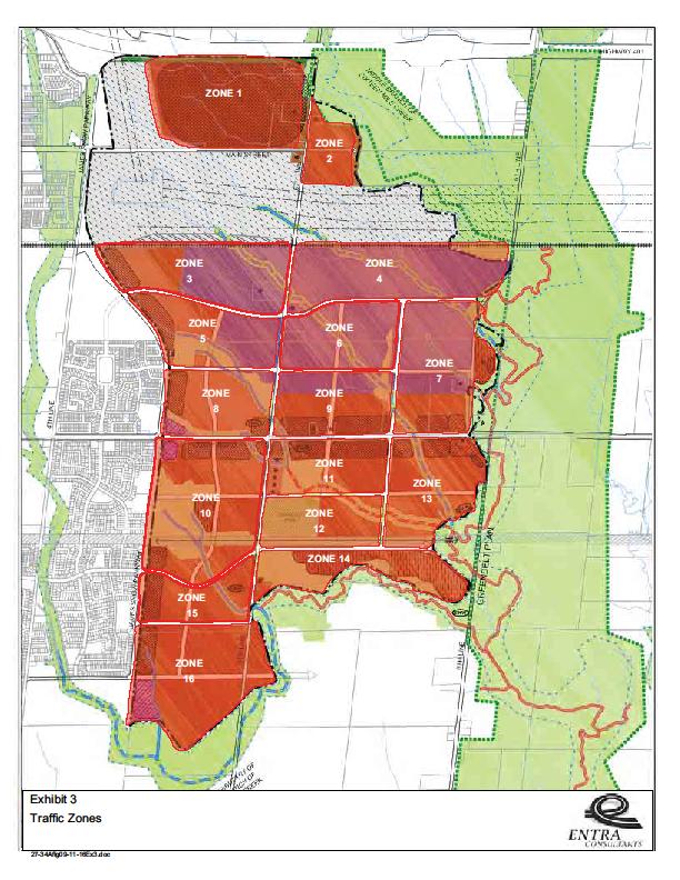
11 Traffic Impact Study Proposed Derry Green Corporate Business Park SP Roads Modification 7 The signalized intersection is currently operating at level of service D in the a.m. peak hour and at level C in the p.m. peak hour. The v/c ratios are 1.02 and 0.93 in the a.m. and p.m. respectively Derry Road and Sixth Line As at Fifth Line, the peak directional flow on Derry Road is eastbound in the a.m. peak hour and westbound in the p.m. peak hour. There is not a significant volume to or from Sixth Line. The signalized intersection is currently operating at level of service D in the a.m. peak hour and at level B in the p.m. peak hour. The v/c ratios are 0.90 and 0.87 in the a.m. and p.m. respectively. 3.4 Transit Transit service is not currently provided to this area since the lands are not yet developed. It is assumed that the Milton Transit services will be extended as the Business Park develops and demand is generated. 4. SECONDARY PLAN TRAFFIC FORECASTS 4.1 Secondary Plan Traffic Generation Reports by Entra Consultants titled Transportation Options Assessment dated May 2008, and Transportation Strategy Report Final dated December 2010, evaluated several options for land use and road systems in the Secondary Plan area. The Entra traffic study has forecast traffic for the entire Secondary Plan area. The Fifth Line/Main Street EA Study has also used the Entra Secondary Plan traffic forecast report as the basis for its evaluations. Figure 6 shows the 16 traffic zones used for representation of future development in the Derry Green Corporate Business Park, with zones 3, 4, 5, 6 and 7 being the ones affected or partially affected by the proposed collector road modifications. Figure 6 shows the changes in zone boundaries that have been made for evaluation of the Orlando/Menkes OPA proposal. Zone 3 and part of zone 5 cover the Orlando lands. Therefore Zone 5 has been divided to separate the Orlando lands and the remaining lands to the south. Part of zone 4 and part of zone 6 cover the Menkes lands. Therefore zones 4 and 6 have also been divided into east/west and north/south segments respectively to be consistent with the Menkes land boundary. Zone 7 has been divided into two segments, north and south of the proposed South Collector road realignment. Read, Voorhees & Associates
12 Traffic Impact Study Proposed Derry Green Corporate Business Park SP Roads Modification 8 Table 1 shows the initial Entra trip generation totals for each zone for the a.m. peak hour, and shows the revised zonal trip generation totals that are consistent with the Orlando and Menkes boundaries. Table 2 shows the same traffic generation data for the p.m. peak hour The total traffic generation for the Secondary Plan remains the same, but with the new zones now representing the Orlando site, the Menkes site, and the remaining segments of the study area between the CP rail line and Derry Road. Traffic generation totals north and south of the proposed South Collector road location are similar, with slightly more traffic generated north of the roadway. TABLE 2. SECONDARY PLAN TRIP GENERATION AM PEAK HOUR ENTRA ANALYSIS READ VOORHEES ANALYSIS COMMENTS ZONE IN OUT ZONE IN OUT Orlando a Menkes 4b Putzer north a Orlando 5b a Menkes 6b a Putzer north 7b TOTAL Orlando (3 + 5a) Menkes (4a + 6a) Putzer north (4b + 7a) Total north side of proposed South Collector road Total south side of proposed South Collector road TOTAL Read, Voorhees & Associates
13 Traffic Impact Study Proposed Derry Green Corporate Business Park SP Roads Modification 9 TABLE 3. SECONDARY PLAN TRIP GENERATION PM PEAK HOUR ENTRA READ VOORHEES COMMENTS ZONE IN OUT ZONE IN OUT Orlando a Menkes 4b Putzer north a Orlando 5b a Menkes 6b a Putzer north 7b TOTAL Orlando (3 + 5a) Menkes (4a + 6a) Putzer north (4b + 7a) Total north side of proposed South Collector road Total south side of proposed South Collector road TOTAL Traffic Assignment to Current Secondary Plan Road System The Entra report documented traffic assignment to the proposed road system for the p.m. peak hour volumes at screen lines that were located north of the CP rail line, north of Derry Road, and east of James Snow Parkway. Data for the a.m. peak hour was not analyzed. Figure 7 shows the p.m. peak hour traffic forecast for the current Secondary Plan road system with the two North Collector and South Collector roads that run between James Snow Parkway and Sixth Line. Read, Voorhees & Associates
14 Traffic Impact Study Proposed Derry Green Corporate Business Park SP Roads Modification 10 Zone 3, and the north portion of zone 5 which is assumed would access the North Collector road, are estimated to be generating a total of 476 outbound trips. The screen line assignments shows that in the p.m. peak hour 238 trips were exiting from the North Collector to James Snow Parkway, and 93 trips were entering at that connection with James Snow Parkway This is exactly half of the zonal trip generation, and the other half would be using the intersection at the east end of the zone at Fifth Line. The net volumes would include any trips coming and going to properties east of Fifth Line. This section of the North Collector road was calculated in the Entra report to be operating with a v/c ratio of 0.40, well below its full capacity. The Entra assignment of traffic to and from James Snow Parkway at the South Collector road shows that in the p.m. peak hour 476 trips were exiting from the South Collector to James Snow Parkway, and 173 trips were entering the development area at that connection to James Snow Parkway. These trips included the traffic generated on the lands south of the Orlando property, and any trips coming across from east of Fifth Line south of the Menkes property. Traffic from zones 5 to 9 south of the Orlando and Menkes sites will use Derry Road and the South Collector for travel east and west. Fifth Line, Sixth Line, and Collector Road 1 will provide access to Derry Road and beyond, and Fifth Line and Sixth Line will provide access north to Main Street and beyond. Traffic will access Derry Road at Fifth Line, Sixth Line and Collector Road 1, with the volumes indicated in the Entra report at the screen line north of Derry Road. Volumes are also shown at two other access intersections on Derry Road, one west of Fifth Line and one east of Fifth Line. These would be minor collector roads that service the zones immediately north of Derry Road. The volumes at these two intersections with Derry Road are minor and are not shown on Figure Traffic Assignment to Modified Secondary Plan Road System Figure 8 shows the p.m. peak hour traffic forecast for the modified Secondary Plan road system with the North Collector road replaced by the access roads into the Orlando and Menkes blocks. The South Collector road still intersects James Snow Parkway opposite Waldie Road and runs between James Snow Parkway and Sixth Line, but is shifted about 150 metres north of the conceptual alignment in the Secondary Plan. As noted earlier, the North Collector road in the current Secondary Plan passes through the middle of the Orlando and Menkes properties. This collector road function will be replaced by the access roads connecting to James Snow Parkway and to Fifth Line, and internal circulation roads within the two large parcels. The Orlando parcel will have access to James Snow Parkway by way of a public road at the west end of the site, and will later have access to the South Collector road when it is constructed at a driveway near the east end of the site. The Menkes parcel will have access to Fifth Line by way of a public road at the west end of the site. Menkes will also later have Read, Voorhees & Associates
15 Traffic Impact Study Proposed Derry Green Corporate Business Park SP Roads Modification 11 access to the South Collector road when it is constructed at a driveway on the east half of the site. For the south-west corner of the site, south of the drainage channel, there will be a driveway connection to Fifth line or alternatively a driveway connection to the South Collector road. The Orlando site as shown in Table 2 is estimated to generate the same 476 outbound trips in the p.m. peak hour as in the current Secondary Plan. About three-quarters of this traffic, or 357 trips, is expected to use the intersection with James Snow Parkway. One-quarter of site traffic, about 119 trips, is expected to use the connection to the South Collector road which provides another access to James Snow Parkway as well as access east to Fifth Line and to Sixth Line, and then down to Derry Road. However, as an analysis of maximum assignment to James Snow Parkway all of the Orlando traffic has been allocated to the James Snow Parkway intersection. This adds 131 outbound trips to James Snow Parkway south toward Derry Road, and 95 trips north toward Main Street. The additional inbound volumes are 51 trips from the south and 37 trips from the north. Similar to the Orlando analysis, as an analysis of maximum assignment to Fifth Line the Menkes site traffic is all assigned to the intersection with Fifth Line without any allowance on the South Collector driveway. This intersection is located about where the North Collector road would intersect Fifth Line. In the p.m. peak hour this volume is a total of 152 inbound trips and 372 outbound trips. The Menkes site intersection with Fifth Line will be a T intersection since the previous North Collector link on the west side is eliminated on the Orlando side of Fifth Line. Therefore the north-south volumes on Fifth Line will be about the same as in the current Secondary Plan, the added traffic from the Menkes block replacing the reassigned traffic from the Orlando block. The North Collector road intersection at Sixth Line can be replaced by a public local road or a private driveway that provides access to the Putzer block. Access to the Putzer block can also be provided at the north end of Collector Road 1 which is maintained in the street system from Derry Road to the realigned South Collector. The South Collector road alignment continuing east from James Snow Parkway is about 150 metres further north, but can be accessed by development in the same manner as was proposed for the current Secondary Plan street system. This would be by direct driveway access or with local roads. Therefore the volume of traffic on the South Collector road accessing James Snow Parkway at Waldie Avenue will be about the same volume as was assigned to the South Collector road for the current plan. The traffic assignments on Fifth Line, on Sixth Line and on Collector Road 1 at Derry Road will remain the same as in the current Secondary Plan. The assignment on Sixth Line to and from the north is the same as for the current Secondary Plan. Read, Voorhees & Associates
16 Traffic Impact Study Proposed Derry Green Corporate Business Park SP Roads Modification TRAFFIC OPERATIONS ANALYSIS 5.1 Secondary Plan Road System The Entra traffic analysis concluded that development of the full Business Park will require, in addition to the existing and planned road system, the addition of one lane in each direction on three major roadways; Fifth Line from Derry Road to Highway 401, James Snow Parkway from Derry Road to Highway 401, and Derry Road from James Snow Parkway to Sixth Line. These improvements are added to the noted roads for evaluation of traffic operations for the Secondary Plan at build out. The Fifth Line EA Study has been completed and confirmed the design of a four lane arterial road, including a grade separation at the CP rail line. Four lanes on Main Street from James Snow Parkway to Fifth Line is also approved in the EA Study. Table 4 shows the v/c ratios for the signalized intersections in the study area for the Current Secondary Plan road system and for the Modified Secondary Plan road system upon full development of the area. All other intersections within the Business Park can operate as unsignalized intersections. Table 4. Signalized Intersection Analysis, Future Secondary Plan Scenario Intersection / Condition Existing Traffic Current Secondary Plan Future Traffic Modified Secondary Plan Future Traffic P.M. Peak Hour Delay (sec) LOS v/c ratio Delay (sec) LOS v/c ratio Delay (sec) LOS v/c ratio James Snow & Derry 50.9 D E E 0.89 WB thru 54.1 D D D 0.98 SB right 98.7 F F F 1.00 SB left 60.6 E F F 1.04 James Snow & Waldie 5.2 A B B 0.83 James Snow & Trudeau 5.9 A B C 0.68 James Snow & Main 59.0 E D D 0.96 WB thru 98.1 F E E 0.96 SB right 87.8 F E E 1.03 Main & Fifth C C 0.44 Derry & Fifth 23.3 C C C 0.82 WB thru 22.6 C C C 0.94 Derry & Collector A A 0.77 Derry & Sixth 14.6 B B B 0.78 WB thru 14.1 B B B 0.77 North Coll & Fifth (Menkes) B B 0.43 South Coll & Fifth B B 0.51 South Coll & Collector C B 0.11 Read, Voorhees & Associates
17 Traffic Impact Study Proposed Derry Green Corporate Business Park SP Roads Modification James Snow Parkway and Derry Road The widening of both James Snow Parkway and Derry Road to six lanes will accommodate the future traffic that has been forecast for this intersection. Although overall average vehicle delay increases with the future volumes, and level of service moves into level E, the v/c ratio for the current secondary plan volumes in the p.m. peak hour is The increase in traffic on James Snow Parkway as forecast for the modified plan increases the v/c ratio to 0.89 but level of service remains at level E. The future v/c ratios are an improvement over the current v/c ratio of James Snow Parkway and Waldie Road The signalized intersection level of service in the p.m. peak hour will change from the existing level A to level B for the current secondary plan, as well as for the modified plan. The future v/c ratios are 0.71 and 0.83 respectively. The intersection will continue to operate at a good level of service with the modified plan James Snow Parkway and Trudeau Drive With the current secondary plan traffic assignment the intersection will operate in the p.m. peak hour at level of service B and a v/c ratio of With the conservative forecast of all site traffic using this intersection in the modified plan the level of service in the p.m. peak hour changes to level C and the v/c ratio increases to This is good operation and the increase in traffic is easily accommodated at the intersection James Snow Parkway and Main Street The additional two through lanes on James Snow Parkway will improve capacity and reduce average vehicle delay compared to present conditions. The intersection operation improves to level of service D in the p.m. peak hour, with a v/c ratio of The increase in through traffic in the modified plan does not change level of service from level D, and the v/c ratio increases slightly to Main Street and Fifth Line Both Main Street and Fifth Line will be widened to four lanes, and with the increase in traffic due to the Business Park development the intersection at Fifth Line and Main Street will be signalized. For the current secondary plan volumes the intersection will operate level of service C, and with a v/c ratio of There is essentially no change in volumes with the modified secondary plan and the intersection operation remains at level C and a v/c ratio of Read, Voorhees & Associates
18 Traffic Impact Study Proposed Derry Green Corporate Business Park SP Roads Modification Derry Road and Fifth Line The widening of Derry Road to six lanes and widening of Fifth Line to four lanes will accommodate the future volumes along Derry Road and the additional traffic from the Business Park. For the current secondary plan the intersection will operate at level of service C in the p.m. peak hour and with a v/c ratio of There is no change with the modified secondary plan, with operation at level C with the same v/c ratio of Derry Road and Collector 1 The new intersection on Derry Road at Collector 1 will operate at very good level of service. The volumes in and out of the Business Park are relatively low. The intersection will operate at level of service A in the p.m. peak hour and with a v/c ratio of There is no change in volumes with the modified plan, and operation remains at level A with the same v/c ratio of Derry Road and Sixth Line Volumes are the same at Derry Road and Sixth Line for the current and modified secondary plans. Widening Derry Road to six lanes will maintain future conditions at about the same level as existing conditions. The intersection will continue operating at level of service B in the p.m. peak hour, with a v/c ratio of Fifth Line and North Collector The intersection on Fifth Line at the North Collector in the current secondary plan will operate at level of service B and a v/c ratio of In the modified plan this intersection is the access point for the Menkes block. Although the volumes for the Menkes block increase since it has been assumed that all site traffic will use this access, the intersection becomes a T intersection due to there being no leg on the west side as the roadway does not extend through the Orlando block. The Menkes access intersection will operate at level of service B in the p.m. peak hour and with a v/c ratio of This is essentially the same conditions as for the current secondary plan intersection at the North Collector road. Read, Voorhees & Associates
19 Traffic Impact Study Proposed Derry Green Corporate Business Park SP Roads Modification Fifth Line and South Collector The intersection on Fifth Line at the South Collector in the current secondary plan will operate at level of service B and a v/c ratio of In the modified plan this intersection carries essentially the same traffic, but is just relocated 150 metres to the north. The volumes are identical and the intersection will operate at level of service B in the p.m. peak hour and with a v/c ratio of South Collector and Collector 1 The intersection at the South Collector and Collector 1 will operate at good level of service. The volumes in and out of the Business Park are the same in both the current and modified secondary plans. The intersection will operate in the p.m. peak hour and with a v/c ratio of The intersection has been analyzed as a signalized intersection, but could also operate as an unsignalized intersection Unsignalized Intersections As noted above the intersection at the South Collector Road and Collector 1 could probably operate as an unsignalized intersection. This also applies to several other intersection within the Business Park. The intersection on Sixth Line at the South Collector has been assumed to be unsignalized, with Stop sign control on the South Collector and through traffic movement on Sixth Line. This condition is also appropriate at the Sixth Line intersection with the North Collector road. In the modified secondary plan the North Collector road at Sixth line would become an access road to the Putzer lands. 6. CONCLUSION Orlando and Menkes have assembled two large tracts of land immediately south of the CP rail line as shown on Figure 1. The North Collector road in the current Secondary Plan passes through the middle of these two tracts, and therefore Orlando and Menkes are proposing a modification to the road system that would remove the North Collector road from the Secondary Plan, and that would realign the South Collector road. Site access roads and internal circulation drives for the Orlando and Menkes lands would replace the function of the North Collector road. Removal of the North Collector road that crosses the Orlando and Menkes properties will not result in any noticeable change in the traffic volumes assigned to the remainder of the Business Read, Voorhees & Associates
20 Traffic Impact Study Proposed Derry Green Corporate Business Park SP Roads Modification 16 Park road system. Some additional traffic will use James Snow Parkway, but all other roads will carry about the same volumes of traffic. The North and South Collector roads in the current Secondary Plan are two lane roadways in a 26 metre right-of-way. In the modified plan the South Collector road remains as a two lane roadway within a 26 metre right-of-way. In both plans additional left turn lanes are assumed to be available at main intersections. The Orlando lands will have access at the signalized intersection at James Snow Parkway and Trudeau Drive. Traffic to and from the Menkes site will access Fifth Line at an intersection about in the same location as the North Collector road would be located. The remainder of the Secondary Plan properties will continue to use Fifth Line, Sixth Line, new Collector Road 1, and a relocated South Collector road to access the existing arterial road system consisting of James Snow Parkway, Derry Road, and Main Street. In terms of capacity requirements, intersection operation will be almost the same with the revised road system as with the proposed secondary plan system. Therefore the proposed road system with removal of the North Collector road will accommodate the future development of the Derry Green Business Park. It is noted that the Secondary Plan traffic analysis concluded that full development of the Derry Green Business Park will require, in addition to the existing and planned road system, the addition of one lane in each direction on Fifth Line from Derry Road to Highway 401, on James Snow Parkway from Derry Road to Highway 401, and on Derry Road from James Snow Parkway to Sixth Line. These improvements have been included for evaluation of traffic operations for the Secondary Plan at build out. The Fifth Line EA Study has been completed and confirmed the design of a four lane arterial road, including a grade separation at the CP rail line. Four lanes on Main Street from James Snow Parkway to Fifth Line is also approved in the EA Study. Read, Voorhees & Associates
21
22 X:\Drawings\ \ September\Derry Green DCP Oct 8 15.dwg DERRY GREEN CORPORATE BUSINESS PARK DEVELOPMENT CONCEPT PLAN Legend Business Park Area Channel Arterial Road Industrial Area SWM Pond Collector Road Prestige Office Area Community Park Derry Green Boundary Natural Heritage System Union Gas Pipeline - All areas are approximate Scale 1:5000 (24 x 36) October 8, 2015 Woodlot Greenbelt Notes *Preliminary Development Concept Plan for Discussion Purposes Only. Subject to Agency Approvals. GLEN SCHNARR & ASSOCIATES INC.
23
24
25
26
27
28
29 APPENDIX A SYNCHRO OUTPUT
30 EXISTING 3: DERRY & JAMES SNOW AM PEAK HOUR Movement EBL EBT EBR WBL WBT WBR NBL NBT NBR SBL SBT SBR Volume (vph) Ideal Flow (vphpl) Total Lost time (s) Lane Util. Factor Frt Flt Protected Satd. Flow (prot) Flt Permitted Satd. Flow (perm) Peak-hour factor, PHF Adj. Flow (vph) RTOR Reduction (vph) Lane Group Flow (vph) Heavy Vehicles (%) 0% 2% 2% 2% 11% 20% 7% 3% 2% 13% 5% 3% Turn Type Prot Perm Perm Perm Perm Perm pm+pt Perm Protected Phases Permitted Phases Actuated Green, G (s) Effective Green, g (s) Actuated g/c Ratio Clearance Time (s) Vehicle Extension (s) Lane Grp Cap (vph) v/s Ratio Prot 0.10 c c v/s Ratio Perm c v/c Ratio Uniform Delay, d Progression Factor Incremental Delay, d Delay (s) Level of Service E D B E C C D D F E C C Approach Delay (s) Approach LOS D C E D HCM Average Control Delay 46.6 HCM Level of Service D HCM Volume to Capacity ratio 1.01 Actuated Cycle Length (s) Sum of lost time (s) 20.0 Intersection Capacity Utilization 105.3% ICU Level of Service G
31 EXISTING 17: WALDIE & JAMES SNOW AM PEAK HOUR Movement EBL EBT EBR WBL WBT WBR NBL NBT NBR SBL SBT SBR Volume (vph) Ideal Flow (vphpl) Total Lost time (s) Lane Util. Factor Frpb, ped/bikes Flpb, ped/bikes Frt Flt Protected Satd. Flow (prot) Flt Permitted Satd. Flow (perm) Peak-hour factor, PHF Adj. Flow (vph) RTOR Reduction (vph) Lane Group Flow (vph) Confl. Peds. (#/hr) 4 4 Heavy Vehicles (%) 0% 0% 1% 2% 2% 2% 0% 5% 2% 2% 5% 0% Turn Type custom custom Perm Protected Phases 2 6 Permitted Phases Actuated Green, G (s) Effective Green, g (s) Actuated g/c Ratio Clearance Time (s) Vehicle Extension (s) Lane Grp Cap (vph) v/s Ratio Prot 0.19 c0.28 v/s Ratio Perm c v/c Ratio Uniform Delay, d Progression Factor Incremental Delay, d Delay (s) Level of Service D C A A A Approach Delay (s) Approach LOS D A A A HCM Average Control Delay 13.8 HCM Level of Service B HCM Volume to Capacity ratio 0.49 Actuated Cycle Length (s) Sum of lost time (s) 14.0 Intersection Capacity Utilization 46.8% ICU Level of Service A
32 EXISTING 20: TRUDEAU & JAMES SNOW AM PEAK HOUR Movement EBL EBT EBR WBL WBT WBR NBL NBT NBR SBL SBT SBR Volume (vph) Ideal Flow (vphpl) Total Lost time (s) Lane Util. Factor Frpb, ped/bikes Flpb, ped/bikes Frt Flt Protected Satd. Flow (prot) Flt Permitted Satd. Flow (perm) Peak-hour factor, PHF Adj. Flow (vph) RTOR Reduction (vph) Lane Group Flow (vph) Confl. Peds. (#/hr) 3 3 Heavy Vehicles (%) 0% 0% 2% 2% 2% 2% 0% 4% 2% 2% 5% 0% Turn Type custom custom Perm Protected Phases 2 6 Permitted Phases Actuated Green, G (s) Effective Green, g (s) Actuated g/c Ratio Clearance Time (s) Vehicle Extension (s) Lane Grp Cap (vph) v/s Ratio Prot 0.26 c0.28 v/s Ratio Perm c v/c Ratio Uniform Delay, d Progression Factor Incremental Delay, d Delay (s) Level of Service D C A A A Approach Delay (s) Approach LOS D A A A HCM Average Control Delay 12.1 HCM Level of Service B HCM Volume to Capacity ratio 0.49 Actuated Cycle Length (s) Sum of lost time (s) 14.0 Intersection Capacity Utilization 46.7% ICU Level of Service A
33 EXISTING 6: MAIN & JAMES SNOW AM PEAK HOUR Movement EBL EBT EBR WBL WBT WBR NBL NBT NBR SBL SBT SBR Volume (vph) Ideal Flow (vphpl) Total Lost time (s) Lane Util. Factor Frpb, ped/bikes Flpb, ped/bikes Frt Flt Protected Satd. Flow (prot) Flt Permitted Satd. Flow (perm) Peak-hour factor, PHF Adj. Flow (vph) RTOR Reduction (vph) Lane Group Flow (vph) Confl. Peds. (#/hr) Heavy Vehicles (%) 2% 1% 2% 4% 2% 4% 2% 6% 2% 3% 11% 5% Turn Type Prot Perm Perm pm+pt pm+pt Perm Protected Phases Permitted Phases Actuated Green, G (s) Effective Green, g (s) Actuated g/c Ratio Clearance Time (s) Vehicle Extension (s) Lane Grp Cap (vph) v/s Ratio Prot c0.32 c c0.09 c v/s Ratio Perm v/c Ratio Uniform Delay, d Progression Factor Incremental Delay, d Delay (s) Level of Service F C B E D C F F D C Approach Delay (s) Approach LOS F D F D HCM Average Control Delay 86.1 HCM Level of Service F HCM Volume to Capacity ratio 1.05 Actuated Cycle Length (s) Sum of lost time (s) 18.0 Intersection Capacity Utilization 103.5% ICU Level of Service G
34 EXISTING 9: DERRY & FIFTH AM PEAK HOUR Movement EBL EBT EBR WBL WBT WBR NBL NBT NBR SBL SBT SBR Volume (vph) Ideal Flow (vphpl) Total Lost time (s) Lane Util. Factor Frt Flt Protected Satd. Flow (prot) Flt Permitted Satd. Flow (perm) Peak-hour factor, PHF Adj. Flow (vph) RTOR Reduction (vph) Lane Group Flow (vph) Heavy Vehicles (%) 0% 2% 2% 0% 16% 0% 0% 2% 3% 1% 0% 13% Turn Type Perm Perm Perm Perm Protected Phases Permitted Phases Actuated Green, G (s) Effective Green, g (s) Actuated g/c Ratio Clearance Time (s) Vehicle Extension (s) Lane Grp Cap (vph) v/s Ratio Prot c v/s Ratio Perm c0.22 v/c Ratio Uniform Delay, d Progression Factor Incremental Delay, d Delay (s) Level of Service A D B A C C F D Approach Delay (s) Approach LOS D A C E HCM Average Control Delay 39.3 HCM Level of Service D HCM Volume to Capacity ratio 1.02 Actuated Cycle Length (s) Sum of lost time (s) 14.0 Intersection Capacity Utilization 99.5% ICU Level of Service F
TRAFFIC IMPACT STUDY DERRY GREEN CORPORATE BUSINESS PARK MILTON SECONDARY PLAN MODIFICATION
 TRAFFIC IMPACT STUDY DERRY GREEN CORPORATE BUSINESS PARK MILTON SECONDARY PLAN MODIFICATION TRAFFIC IMPACT STUDY DERRY GREEN CORPORATE BUSINESS PARK MILTON SECONDARY PLAN MODIFICATION DECEMBER 24 UPDATED
886 March Road McDonald's Transportation Study
 McDonald's Restaurants of Canada Limited March 2013 886 March Road McDonald's Transportation Study Submitted by: HDR Corporation 100 York Boulevard, Suite 300 Richmond Hill, ON L4B 1J8 (905) 882-4100 www.hdrinc.com
Provide an overview of the development proposal including projected site traffic volumes;
 December 19, 2013 File: 163600935 Attention: Troy Elliott Carl Elliott Limited 15-1831 Robertson Road PO Box 11117 Nepean, Ontario K1H 7T8 Dear Mr. Elliott, Reference: 2235 and 2265 Robertson Road Transportation
APPENDIX G. Traffic Data
 APPENDIX G Traffic Data HCM Signalized Intersection Capacity Analysis 2: Duanesburg Road & I-88 Ramps 10/7/2004 Movement EBL EBT EBR WBL WBT WBR NBL NBT NBR SBL SBT SBR Lane Configurations Ideal Flow (vphpl)
HCM Unsignalized Intersection Capacity Analysis 6: Brian Street & LC 111 5/26/2009
 6: Brian Street & LC 111 5/26/2009 Movement EBL EBR NBL NBT SBT SBR Volume (veh/h) 116 20 8 405 137 56 Sign Control Stop Free Free Grade 0% 0% 0% Peak Hour Factor 0.81 0.81 0.67 0.67 0.89 0.89 Hourly flow
TRAFFIC AND TRANSPORTATION TECHNICAL MEMORANDUM
 TRAFFIC AND TRANSPORTATION TECHNICAL MEMORANDUM for ENVIRONMENTAL ASSESSMENT US 460 Bypass Interchange and Southgate Drive Relocation State Project No.: 0460-150-204, P101, R201, C501, B601; UPC 99425
Village of Richmond Transportation Brief
 Village of Richmond Transportation Brief GENIVAR Project Number 111-18482-00 June 21 st, 2011 www.genivar.com GENIVAR 15 Fitzgerald Road, Suite 100 Ottawa, Ontario, CANADA K2H 9G1 Telephone: 613-829-2800
Appendix B: Traffic Reports
 Appendix B: Traffic Reports 407 TRANSITWAY - KENNEDY ROAD TO BROCK ROAD MINISTRY OF TRANSPORTATION - CENTRAL REGION Report Markham Road Station Traffic Study Prepared for Ministry of Transportation, Ontario
ARVADA TRIANGLE REDEVELOPMENT TRAFFIC IMPACT ANALYSIS
 ARVADA TRIANGLE REDEVELOPMENT TRAFFIC IMPACT ANALYSIS Prepared for: Arvada Urban Renewal Authority 5601 Olde Wadsworth Boulevard, Suite 210 Arvada, Colorado 80002 (720) 898-7062 Prepared by: Felsburg Holt
Table 1 - Land Use Comparisons - Proposed King s Wharf Development. Retail (SF) Office (SF) 354 6,000 10, Land Uses 1
 Office (SF) 354 6,000 10, Land Uses 1") Ref. No. 171-6694 Phase 2 November 23, 217 Mr. David Quilichini, Vice President Fares & Co. Developments Inc. 31 Place Keelson Sales Centre DARTMOUTH NS B2Y C1 Sent Via Email to David@faresinc.com RE:
Ref. No. 171-6694 Phase 2 November 23, 217 Mr. David Quilichini, Vice President Fares & Co. Developments Inc. 31 Place Keelson Sales Centre DARTMOUTH NS B2Y C1 Sent Via Email to David@faresinc.com RE:
 Traffic Analysis For Approved Uses within the St. Lucie West DRI Aldi Port St. Lucie, FL Prepared for: Bohler Engineering, LLC 1000 Corporate Drive Suite 250 Fort Lauderdale, FL 33334 Prepared by: 10795
LATSON INTERCHANGE DEVELOPMENT TRAFFIC STUDIES. Genoa Township, Livingston County, MI
 LATSON INTERCHANGE DEVELOPMENT TRAFFIC STUDIES Genoa Township, Livingston County, MI DRAFT TRAFFIC STUDY FOR I-96 AT LATSON RD INTERCHANGE Livingston County CS 47065 JN 101622C Submitted to: Michigan Department
(A) Project Manager, Infrastructure Approvals
 Project Manager, Infrastructure Approvals") February 14th, 2014 BY E-MAIL: wally.dubyk@ottawa.ca City of Ottawa Planning and Growth Management Branch 110 Laurier Ave. W., 4 th Floor, Ottawa, Ontario K1P 1J1 Attention: Wally Dubyk, C.E.T (A) Project
February 14th, 2014 BY E-MAIL: wally.dubyk@ottawa.ca City of Ottawa Planning and Growth Management Branch 110 Laurier Ave. W., 4 th Floor, Ottawa, Ontario K1P 1J1 Attention: Wally Dubyk, C.E.T (A) Project
Sugarland Crossing Gwinnett County, Georgia
 Sugarland Crossing Gwinnett County, Georgia S IGNAL W ARRANT A NALYSIS For the Intersection of: Sugarloaf Parkway / Richards Middle School Driveway / Sugarland Crossing Main Site Driveway Prepared for:
KUM & GO 6400 WESTOWN PARKWAY WEST DES MOINES, IOWA 50266
 KUM & GO #300 PECOS STREET & 88 TH AVENUE THORNTON, COLORADO TRAFFIC IMPACT STUDY REVISION 1 PREPARED FOR KUM & GO 6400 WESTOWN PARKWAY WEST DES MOINES, IOWA 50266 JANUARY 23, 2014 OA PROJECT NO. 013-1721
MEMO. McCORMICK RANKIN CORPORATION. File FROM: Keyur Shah DATE: February 1, 2010 COPIES: OUR FILE: SUBJECT: TO:
 McCORMICK RANKIN CORPORATION 2655 North Sheridan Way Mississauga, Ontario, L5K 2P8 Tel: (905)823-8500 Fax: (905) 823-8503 E-mail: mrc@mrc.ca Website: www.mrc.ca MEMO TO: File FROM: Keyur Shah DATE: February
RESPONSE TO TRAFFIC IMPACT STUDY COMMENTS
 RESPONSE TO TRAFFIC IMPACT STUDY COMMENTS Proposed Gas Station 40 Arthur Street (Highway 26), Town of the Blue Mountains (Thornbury), County of Grey, Ontario AUGUST 2013 August 27, 2013 MR. REG RUSSWURM
Paisley & Whitelaw - Paisley Park OPA / ZBA for Mixed Density Residential Use
 Paisley & Whitelaw - Paisley Park OPA / ZBA for Mixed Density Residential Use Transportation Impact Study City of Guelph Prepared for: Armel Corporation August 2018 Table of Contents 1 Introduction...
MURRIETA APARTMENTS TRAFFIC IMPACT ANALYSIS CITY OF MURRIETA, CALIFORNIA
 MURRIETA APARTMENTS TRAFFIC IMPACT ANALYSIS CITY OF MURRIETA, CALIFORNIA SEPTEMBER 20, 2012 Prepared for: Golden Eagle Multi-Family Properties, LLC 6201 Oak Canyon Rd., Suite 250 Irvine, CA 92618 Prepared
Traffic Impact Analysis Farmington Center Village
 Traffic Impact Analysis Farmington Center Village Route 4 (Farmington Avenue) Farmington, Connecticut Prepared for: The Town of Farmington, CT Prepared By: BL Companies Meriden, Connecticut December 2016
Ref. No Task 3. April 28, Mr. Cesar Saleh, P. Eng. VP Planning and Design W.M. Fares Group th
 Ref. No. 151-00564 Task 3 April 28, 2015 Mr. Cesar Saleh, P. Eng. VP Planning and Design W.M. Fares Group th 3480 Joseph Howe Drive, 5 Floor HALIFAX NS B3L 4H7 Sent via Email to ceasr.saleh@wmfares.com
Traffic Impact Study Morgan Road Commerce Park Pasco County, Florida
 Traffic Impact Study Morgan Road Commerce Park Pasco County, Florida Summary Report June 2008 Prepared by: 12909 N 56 th Street # 201 Tampa, FL 33617 Ph: (813) 988-3180 Fax: (813) 343-6854 Morgan Road
Weaver Road Senior Housing Traffic Impact Analysis
 Gibson Traffic Consultants, Inc. 2813 Rockefeller Avenue Suite B Everett, WA 9821 425.339.8266 Weaver Road Senior Housing Traffic Impact Analysis Jurisdiction: City of Snohomish January 218 GTC #17-37
ZINFANDEL LANE / SILVERADO TRAIL INTERSECTION TRAFFIC ANALYSIS
 ZINFANDEL LANE / SILVERADO TRAIL INTERSECTION TRAFFIC ANALYSIS UPDATED TRAFFIC STUDY FOR THE PROPOSED RAYMOND VINEYARDS WINERY USE PERMIT MODIFICATION #P11-00156 AUGUST 5, 2014 PREPARED BY: OMNI-MEANS,
Wellings Communities Holding Inc and Extendicare (Canada) Inc Hazeldean Road. Transportation Impact Study. Ottawa, Ontario. Project ID
 Inc Hazeldean Road. Transportation Impact Study. Ottawa, Ontario. Project ID") Wellings Communities Holding Inc and Extendicare (Canada) Inc. 5731 Hazeldean Road Transportation Impact Study Ottawa, Ontario Project ID 160401195 Prepared by: Stantec Consulting Ltd. March 2016 WELLINGS
Wellings Communities Holding Inc and Extendicare (Canada) Inc. 5731 Hazeldean Road Transportation Impact Study Ottawa, Ontario Project ID 160401195 Prepared by: Stantec Consulting Ltd. March 2016 WELLINGS
Proposed Office Building Traffic Impact Study Chicago Avenue Evanston, Illinois
 Proposed Office Building Traffic Impact Study 1714-1720 Chicago Avenue Evanston, Illinois Prepared For: HOLABIRD & ROOT, LLC Prepared by: Eriksson Engineering Associates, Ltd. 145 Commerce Drive, Ste A,
L1TILE BEARS DAY CARE TRANSPORTATION IMPACT STUDY FORT COLLINS, COLORADO MAY Prepared for:
 L1TILE BEARS DAY CARE TRANSPORTATION IMPACT STUDY FORT COLLINS, COLORADO MAY 2012 Prepared for: Hillside Construction, Inc. 216 Hemlock Street, Suite B Fort Collins, CO 80534 Prepared by: DELICH ASSOCIATES
Traffic Impact Study. Eastern Springs. A Proposed Development in Manorville, NY. April Haas Group Inc Transportation Planners and Engineers
 Traffic Impact Study For Eastern Springs A Proposed Development in Manorville, NY April 2018 Haas Group Inc Transportation Planners and Engineers Table of Contents 1) Executive Summary... 2 2) Study Purpose...
Zachary Bugg, PhD, Diego Arguea, PE, and Phill Worth University of Oregon North Campus Conditional Use Permit Application Transportation Assessment
 MEMORANDUM Date: June 22, 2018 Project #: 21562 To: Colin McArthur, AICP From: Project: Subject: Zachary Bugg, PhD, Diego Arguea, PE, and Phill Worth University of Oregon North Campus Conditional Use Permit
Barrhaven Honda Dealership. Dealership Drive, Ottawa, ON. Transportation Brief
 Barrhaven Honda Dealership Dealership Drive, Ottawa, ON Transportation Brief Prepared By: NOVATECH Suite 200, 240 Michael Cowpland Drive Ottawa, Ontario K2M 1P6 September, 2015 File: 115136 Ref: R-2015-152
Re: Cyrville Road Car Dealership
 1223 Michael Street, Suite 100, Ottawa, ON K1J 7T2 Tel: 613.738.4160 Fax: 613.739.7105 www.delcan.com February 25, 2013 OUR REF: TO3098TOE Mark Motors of Ottawa 611 Montreal Road Ottawa, ON K1K 0T8 Attention:
Traffic Impact Study Hudson Street Parking Garage MC Project No.: A Table of Contents
 Traffic Impact Study Hudson Street Parking Garage MC Project No.: 15001714A Table of Contents Table of Contents I. INTRODUCTION... 1 II. EXISTING CONDITIONS... 4 III. 2015 EXISTING TRAFFIC CONDITIONS...
Bennett Pit. Traffic Impact Study. J&T Consulting, Inc. Weld County, Colorado. March 3, 2017
 Bennett Pit Traffic Impact Study J&T Consulting, Inc. Weld County, Colorado March 3, 217 Prepared By: Sustainable Traffic Solutions, Inc. http://www.sustainabletrafficsolutions.com/ Joseph L. Henderson,
One Harbor Point Residential
 Residential Gig Harbor, WA Transportation Impact Analysis January 23, 2017 Prepared for: Neil Walter Company PO Box 2181 Tacoma, WA 98401 Prepared by: TENW Transportation Engineering NorthWest 11400 SE
Proposed Hotel and Restaurant Development
 Traffic Impact Study Proposed Hotel and Restaurant Development Marbledale Road Tuckahoe, NY PREPARED FOR BILLWIN DEVELOPMENT AFFILIATES, LLC 365 WHITE PLAINS ROAD EASTCHESTER, NY. 10709 PREPARED BY Engineering
TECHNICAL MEMORANDUM Upper Broadway Road Diet Summary of Findings
 TECHNICAL MEMORANDUM Summary of Findings Date: June 17, 2014 Project #: 17121.15 To: Si Lau, P.E.; City of Oakland, CA From: Erin Ferguson, P.E.; Aaron Elias, P.E.; Daphne Dethier; and Mark Bowman, P.E.;
LOST LAKE CORRIDOR REVIEW
 LOST LAKE CORRIDOR REVIEW Prepared for: Prepared by: Broadview Developments Inc. c/o Westbrook Consulting Watt Consulting Group Our File: 2064.B01 Date: October 31, 2016 TABLE OF CONTENTS 1.0 INTRODUCTION...
Traffic Impact Study Proposed Commercial Development Ballwin, Missouri. Technical Memorandum for Traffic Impact Study
 Traffic Impact Study Proposed Commercial Development Ballwin, Missouri Technical Memorandum for Traffic Impact Study Crawford, Bunte, Brammeier May 1, 2009 MEMORANDUM Date: April 24, 2009 To: From: Subject:
Final Technical Report US 17 Corridor Study Update (Market Street Road Diet)
") Market Street Road Diet Wilmington, NC 2016 Final Technical Report US 17 Corridor Study Update (Market Street Road Diet) Wilmington, NC Parsons Brinckerhoff January 2016 FINAL TECHNICAL REPORT US 17 Corridor
Market Street Road Diet Wilmington, NC 2016 Final Technical Report US 17 Corridor Study Update (Market Street Road Diet) Wilmington, NC Parsons Brinckerhoff January 2016 FINAL TECHNICAL REPORT US 17 Corridor
Rockingham Ridge Plaza Commercial Development Halifax Regional Municipality
 Rockingham Ridge Plaza Commercial Development Halifax Regional Municipality Traffic Impact Study Final Draft Report Prepared by: GRIFFIN transportation group inc. 30 Bonny View Drive Fall River, NS B2T
Re: Residential Development - Ogilvie/Cummings Transportation Overview
 1223 Michael Street, Suite 100, Ottawa, ON K1J 7T2 Tel: 613.738.4160 Fax: 613.739.7105 www.delcan.com March 28, 2012 OUR REF: TO3088TOY Barry J. Hobin & Architects 63 Pamilla Street Ottawa, ON K1S 3K7
LAWRENCE TRANSIT CENTER LOCATION ANALYSIS 9 TH STREET & ROCKLEDGE ROAD / 21 ST STREET & IOWA STREET LAWRENCE, KANSAS
 LAWRENCE TRANSIT CENTER LOCATION ANALYSIS 9 TH STREET & ROCKLEDGE ROAD / 21 ST STREET & IOWA STREET LAWRENCE, KANSAS TRAFFIC IMPACT STUDY FEBRUARY 214 OA Project No. 213-542 TABLE OF CONTENTS 1. INTRODUCTION...
MERIVALE PRIORITY SQUARE 2852 MERIVALE ROAD CITY OF OTTAWA TRANSPORTATION BRIEF. Prepared for: ONT Inc. 25 Winding Way Nepean, Ontario K2C 3H1
 MERIVALE PRIORITY SQUARE 2852 MERIVALE ROAD CITY OF OTTAWA TRANSPORTATION BRIEF Prepared for: 2190986ONT Inc. 25 Winding Way Nepean, Ontario K2C 3H1 October 6, 2010 110-502 Report_1.doc D. J. Halpenny
Appendix H: Construction Impacts H-2 Transportation
 Appendix H: Construction Impacts H-2 Transportation \ AECOM 71 W. 23 rd Street New York, NY 10010 www.aecom.com 212 366 6200 tel 212 366 6214 fax Memorandum To CC Subject Robert Conway Donald Tone Construction
APPENDICES. APPENDIX D Synchro Level of Service Output Sheets
 APPENDICES APPENDIX D Synchro Level of Service Output Sheets Lanes, Volumes, Timings NO BUILD 2016 PM 8: 10th St & Thain Rd 10/05/2016 Lane Group NBL NBT NBR SBL SBT SBR SEL SET SER NWL NWT NWR
MEMO. McCORMICK RANKIN CORPORATION. File Mark VanderSluis, Keyur Shah DATE: October 26, 2009 COPIES: OUR FILE: TO: FROM: Jack Thompson
 McCORMICK RANKIN CORPORATION 2655 North Sheridan Way Mississauga, Ontario, L5K 2P8 Tel: (95)823-85 Fax: (95) 823-853 E-mail: mrc@mrc.ca Website: www.mrc.ca MEMO TO: FROM: File Mark VanderSluis, Keyur Shah
Appendix A City of Sammamish Town Center Sub-Area Plan FEIS September 2007
 Appendix A City of Sammamish Town Center Sub-Area Plan FEIS September 2007 5309 Shilshole Avenue NW Suite 200 Seattle, WA 98107 206.789.9658 phone 206.789.9684 fax www.adolfson.com Memorandum date March
Traffic Impact Analysis Update
 Willow Bend Traffic Impact Analysis Update TABLE OF CONTENTS Page I. INTRODUCTION -------------------------------------------------------------------------------------------- 1 II. EXISTING CONDITIONS
Oakbrook Village Plaza City of Laguna Hills
 Oakbrook Village Plaza City of Laguna Hills Traffic Impact Analysis Prepared by: HDR Engineering 3230 El Camino Real, Suite 200 Irvine, CA 92602 October 2012 Revision 3 D-1 Oakbrook Village Plaza Laguna
June 21, Mr. Jeff Mark The Landhuis Company 212 North Wahsatch Avenue, Suite 301. Colorado Springs, CO 80903
 LSC TRANSPORTATION CONSULTANTS, INC. 545 East Pikes Peak Avenue, Suite 210 Colorado Springs, CO 80903 (719) 633-2868 FAX (719) 633-5430 E-mail: lsc@lsctrans.com Website: http://www.lsctrans.com June 21,
10 th Street Residences Development Traffic Impact Analysis
 Gibson Traffic Consultants, Inc. 2813 Rockefeller Avenue Suite B Everett, WA 98201 425.339.8266 10 th Street Residences Development Traffic Impact Analysis Jurisdiction: City of Snohomish September 2018
Downtown One Way Street Conversion Technical Feasibility Report
 Downtown One Way Street Conversion Technical Feasibility Report As part of the City s Transportation Master Plan, this report reviews the technical feasibility of the proposed conversion of the current
JRL consulting. March Hartland Developments Limited 1993 Hammonds Plains Road Hammonds Plains, NS B4B 1P3
 March 2015 Prepared for Hartland Developments Limited 1993 Hammonds Plains Road Hammonds Plains, NS B4B 1P3 JRL consulting JRL consulting TABLE OF CONTENTS 1 INTRODUCTION... 2 1.1 BACKGROUND... 2 2 EXISTING
Salvini Consulting Inc. 459 Deer Ridge Drive Kitchener, ON N2P 0A November 8, 2017 Revised December 20, 2017
 Salvini Consulting Inc. 459 Deer Ridge Drive Kitchener, ON N2P 0A7 519-591-0426 November 8, 2017 Revised December 20, 2017 Laurie Wills, PEng Deputy Director of Public Works Town of Cobourg 740 Division
STANDARD LIMITATIONS
 STANDARD LIMITATIONS This report was prepared by MMM Group (MMM) for the account of Spire Construction Inc. (the Client). The disclosure of any information contained in this report is the sole responsibility
Sweetwater Landing Traffic Impact Analysis
 Gibson Traffic Consultants, Inc. 8 Rockefeller Avenue Suite B Everett, WA 98 45.9.8 Sweetwater Landing Traffic Impact Analysis Jurisdiction: City of Snohomish February 8 GTC #7-87 Sweetwater Landing Traffic
MEMORANDUM. Date: November 4, Cheryl Burrell, Pebble Beach Company. Rob Rees, P.E. Inclusionary Housing Transportation Analysis WC
 MEMORANDUM Date: November 4, 2013 To: From: Subject: Cheryl Burrell, Pebble Beach Company Rob Rees, P.E. Inclusionary Housing Transportation Analysis As requested, Fehr & Peers is providing clarification
April Salvation Army Barrhaven Church 102 Bill Leathem Drive Transportation Brief
 April 26 Salvation Army Barrhaven Church 2 Bill Leathem Drive Transportation Brief Salvation Army Barrhaven Church 2 Bill Leathem Drive Transportation Brief prepared for: The Salvation Army 2 Overlea Blvd.
Interstate 80 Corridor Study
 Interstate 80 Corridor Study Final Technical Memorandum 5: Traffic Volumes, Accident Locations and Operational Deficiencies West Verdi (SR 425) Interchange to West McCarran Boulevard (SR 651) and East
Parking/Traffic Assessment Study
 Brock Road Industrial Mall 985 Brock Road South City of Pickering Parking/Traffic Assessment Study Prepared by: Tranplan Associates, Toronto Toronto 416-670-2005 Sudbury 705-522-0272 Peterborough 705-874-3638
West Hills Shopping Centre Lowe s Expansion Traffic Impact Study
 West Hills Shopping Centre Lowe s Expansion Traffic Impact Study Prepared for: Armel Corporation January 2015 Paradigm Transportation Solutions Ltd. 22 King Street South, Suite 300 Waterloo ON N2J 1N8
Minto Mahogany Stage 2
 Minto Mahogany Stage 2 Transportation Impact Study prepared for: Minto Developments Inc 200-180 Kent Street Ottawa, ON K1P 0B6 prepared by: 1223 Michael Street Suite 100 Ottawa, ON K1J 7T2 June 27, 2017
Alpine Highway to North County Boulevard Connector Study
 Alpine Highway to North County Boulevard Connector Study prepared by Avenue Consultants March 16, 2017 North County Boulevard Connector Study March 16, 2017 Table of Contents 1 Summary of Findings... 1
Proposed Pit Development
 July 5, 2017 via email: sam@greenwoodconst.ca CCTA File 114239 Sam Greenwood Greenwood Aggregates 205467 County Road 109 Amaranth, ON L9W 0V1 Re: Proposed Violet Hill Gravel Pit, Town of Mono Traffic Review
Re: Addendum No. 4 Transportation Overview 146 Mountshannon Drive Ottawa, Ontario
 April 18 th, 2017 Mr. Kevin Yemm Vice President, Land Development Richraft Group of Companies 2280 St. Laurent Boulevard, Suite 201 Ottawa, Ontario (Tel: 613.739.7111 / e-mail: keviny@richcraft.com) Re:
MEMORANDUM November 19, 2012
 COUNCIL OF GOVERNMENTS CENTRAL NAUGATUCK VALLEY 60 NORTH MAIN ST 3RD Floor WATERBURY, CT 06702-1403 (203)757-0535 Web Site: www.cogcnv.org E-Mail: cogcnv@cogcnv.org November 19, 2012 MEMORANDUM 111912
TRAFFIC DATA. Existing Derousse Ave./River Rd. AM LOS Analysis Existing Derousse Ave./River Rd. PM LOS Analysis
 Appendix E NJ TRANSIT Pennsauken Junction Transit Center and Park & Ride RiverLINE and Atlantic City Line Pennsauken Township, Camden County, New Jersey TRAFFIC DATA Background Traffic Information for
LEMON FLATS SECOND ACCESS
 LEMON FLATS SECOND ACCESS RECONNAISSANCE STUDY SEPTEMBER 2007 APPENDIX A Synchro Analysis Worksheets HCM Signalized Intersection Capacity Analysis 2005 - Background 3: Anka Street & Lemon Flats Second
C. iv) Analysis/Results
 Analysis/Results") The Pettengill Road project is located outside the borders of the model in an external zone. As a result, inserting all Pettengill Road trip generation assumptions into the NRPC model and running a new
The Pettengill Road project is located outside the borders of the model in an external zone. As a result, inserting all Pettengill Road trip generation assumptions into the NRPC model and running a new
Trafalgar Road & Lower Base Line Transportation Study Ontario Inc.
 Trafalgar Road & Lower Base Line Transportation Study 1255723 Ontario Inc. Trafalgar Road & Lower Base Line Transportation Study 1255723 Ontario Inc. 1465 Pickering Parkway Suite 200 Pickering ON L1V 7G7
INTERCHANGE OPERTIONS STUDY Interstate 77 / Wallings Road Interchange
 INTERCHANGE OPERTIONS STUDY Interstate 77 / Wallings Road Interchange City of Broadview Heights, Cuyahoga County, Ohio Prepared For: City of Broadview Heights Department of Engineering 9543 Broadview Road
BARRHAVEN FELLOWSHIP CRC 3058 JOCKVALE ROAD OTTAWA, ONTARIO TRANSPORTATION BRIEF. Prepared for:
 BARRHAVEN FELLOWSHIP CRC 3058 JOCKVALE ROAD OTTAWA, ONTARIO TRANSPORTATION BRIEF Prepared for: Barrhaven Fellowship CRC 3058 Jockvale Road Ottawa, ON K2J 2W7 December 7, 2016 116-649 Report_1.doc D. J.
1012 & 1024 McGarry Terrace
 December 217 112 & 124 McGarry Terrace Transportation Impact Study 112 & 124 McGarry Terrace Transportation Impact Study prepared for: Lépine Corporation 32 March Road Kanata, ON K2K 2E3 prepared by: 1223
Aldridge Transportation Consultants, LLC Advanced Transportation Planning and Traffic Engineering
 Aldridge Transportation Consultants, LLC Advanced Transportation Planning and Traffic Engineering John M.W. Aldridge, PE, PTOE, AICP 1082 Chimney Rock Road Colorado Registered Professional Engineer Highlands
D & B COMMERCIAL TRAFFIC IMPACT ANALYSIS
 D & B COMMERCIAL TRAFFIC IMPACT ANALYSIS TABLE OF CONTENTS I. Introduction...3 II. Project Description...3 III. Existing Conditions...3 IV. Future Traffic Conditions...8 V. Conclusions and Mitigation...14
MMM Group Limited. Communities. Transportation. Buildings. Infrastructure
 MMM Group Limited Traffic Study CASA MIA Community Care Facility Vancouver, BC Communities Transportation Buildings Infrastructure February 2013 5011001-033 STANDARD LIMITATIONS This report was prepared
Craig Scheffler, P.E., PTOE HNTB North Carolina, P.C. HNTB Project File: Subject
 TECHNICAL MEMORANDUM To Kumar Neppalli Traffic Engineering Manager Town of Chapel Hill From Craig Scheffler, P.E., PTOE HNTB North Carolina, P.C. Cc HNTB Project File: 38435 Subject Obey Creek TIS 2022
APPENDIX C1 TRAFFIC ANALYSIS DESIGN YEAR TRAFFIC ANALYSIS
 APPENDIX C1 TRAFFIC ANALYSIS DESIGN YEAR TRAFFIC ANALYSIS DESIGN YEAR TRAFFIC ANALYSIS February 2018 Highway & Bridge Project PIN 6754.12 Route 13 Connector Road Chemung County February 2018 Appendix
Volume 1 Traffic Impact Analysis Turtle Creek Boulevard Dallas, Texas. Kimley-Horn and Associates, Inc. Dallas, Texas.
 Volume 1 Traffic Impact Analysis 2727 Dallas, Texas June 18, 2018 Kimley-Horn and Associates, Inc. Dallas, Texas Project #064523000 Registered Firm F-928 Traffic Impact Analysis 2727 Dallas, Texas Prepared
APPENDIX A LEVEL OF SERVICE CONCEPTS, ANALYSIS METHODOLOGIES,STANDARDS OF SIGNIFICANCE
 APPENDIX A LEVEL OF SERVICE CONCEPTS, ANALYSIS METHODOLOGIES,STANDARDS OF SIGNIFICANCE Roadway Segment Level of Service Definitions LOS V/C Congestion/Delay Traffic Description (Used for surface streets,
Date: December 20, Project #:
 To: Craig Rottenberg Long s Jewelers 60A South Avenue Burlington, MA 01803 From: Patrick Dunford, P.E. Senior Project Manager Date: December 20, 2018 Project #: 14416.00 Re: Burlington Mall Proposed Long
DEVELOPMENT PROPERTY 1627 MAXIME STREET CITY OF OTTAWA TRANSPORTATION OVERVIEW. Prepared for: Subhas Bhargava. July 9, Overview_1.
 DEVELOPMENT PROPERTY 1627 MAXIME STREET CITY OF OTTAWA TRANSPORTATION OVERVIEW Prepared for: Subhas Bhargava July 9, 2015 115-620 Overview_1.doc D. J. Halpenny & Associates Ltd. Consulting Transportation
Quantitative analyses of weekday a.m. and p.m. commuter hour conditions have been conducted for the following five scenarios:
 6.1 TRANSPORTATION AND CIRCULATION 6.1.1 INTRODUCTION This section of the EIR presents the results of TJKM s traffic impact analysis of the proposed Greenbriar Development. The analysis includes consideration
Lakeside Terrace Development
 Lakeside Terrace Development City of Barrie, County of Simcoe Traffic Brief for: Type of Document: Final Report Project Number: JDE 1617 Date Submitted: April 29 th, 216 4/29/16 John Northcote, P.Eng.
MEMO VIA . Ms. Amy Roth DPS Director, City of Three Rivers. To:
 MEMO To: Ms. Amy Roth DPS Director, City of Three Rivers VIA EMAIL From: Michael J. Labadie, PE Julie M. Kroll, PE, PTOE Brandon Hayes, PE, P.Eng. Fleis & VandenBrink Date: January 5, 2017 Re: Proposed
6111 and 6141 Hazeldean Road Stittsville, Ontario. Proposed Residential Development Transportation Impact Study
 6111 and 6141 Hazeldean Road Stittsville, Ontario Proposed Residential Development Transportation Impact Study Presented to: Ms. Erin O Connor Land Development Manager Minto Communities 200-180 Kent Street
IV. REVISIONS TO THE DRAFT IS/MND
 IV. REVISIONS TO THE DRAFT IS/MND 1. REVISIONS TO THE DRAFT IS/MND This section presents corrections and clarifications that have been made to the text of the Draft IS/MND. These changes include revisions
RICHMOND OAKS HEALTH CENTRE 6265 PERTH STREET OTTAWA, ONTARIO TRANSPORTATION BRIEF. Prepared for: Guycoki (Eastern) Limited.
 Limited.") RICHMOND OAKS HEALTH CENTRE 6265 PERTH STREET OTTAWA, ONTARIO TRANSPORTATION BRIEF Prepared for: Guycoki (Eastern) Limited June 16, 2016 116-638 Brief_1.doc D. J. Halpenny & Associates Ltd. Consulting
RICHMOND OAKS HEALTH CENTRE 6265 PERTH STREET OTTAWA, ONTARIO TRANSPORTATION BRIEF Prepared for: Guycoki (Eastern) Limited June 16, 2016 116-638 Brief_1.doc D. J. Halpenny & Associates Ltd. Consulting
Traffic Impact Analysis. Alliance Cole Avenue Residential Site Dallas, Texas. Kimley-Horn and Associates, Inc. Dallas, Texas.
 Traffic Impact Analysis Alliance Cole Avenue Residential Site Dallas, Texas February 15, 2018 Kimley-Horn and Associates, Inc. Dallas, Texas Project #064524900 Registered Firm F-928 Traffic Impact Analysis
BUCKLEY ANNEX REDEVELOPMENT PLAN TRANSPORTATION ANALYSIS ADDENDUM
 BUCKLEY ANNEX REDEVELOPMENT PLAN TRANSPORTATION ANALYSIS ADDENDUM Prepared for: City and County of Denver Prepared by: Contact: Brian Bern, P.E., PTOE 303.572.0200 On Behalf of: Lowry Redevelopment Authority
MEMORANDUM BOSTON REGION METROPOLITAN PLANNING ORGANIZATION. DATE March 1, 2012
 BOSTON REGION METROPOLITAN PLANNING ORGANIZATION State Transportation Building Ten Park Plaza, Suite 2150 Boston, MA 02116-3968 Tel. (617) 973-7100 Fax (617) 973-8855 TTY (617) 973-7089 www.bostonmpo.org
Prepared For: Toronto Transit Commission 1138 Bathurst Street Toronto, Ontario M5R 3H2. Prepared By:
 TRAFFIC IMPACT STUDY FOR THE TTC MCNICOLL BUS GARAGE CITY OF TORONTO Prepared For: Toronto Transit Commission 1138 Bathurst Street Toronto, Ontario M5R 3H2 Prepared By: Canada Inc. 4th Floor, 3 Leek Crescent
Proposed location of Camp Parkway Commerce Center. Vicinity map of Camp Parkway Commerce Center Southampton County, VA
 Proposed location of Camp Parkway Commerce Center Vicinity map of Camp Parkway Commerce Center Southampton County, VA Camp Parkway Commerce Center is a proposed distribution and industrial center to be
INTERSECTION ANALYSIS PARK AVENUE AND BRADDOCK ROAD (FROSTBURG, MD) FOR LENHART TRAFFIC CONSULTING, INC.
 FOR LENHART TRAFFIC CONSULTING, INC.") INTERSECTION ANALYSIS FOR PARK AVENUE AND BRADDOCK ROAD (FROSTBURG, MD) Prepared for: City of Frostburg, Maryland & Allegany County Commissioners Prepared by: LENHART TRAFFIC CONSULTING, INC. TRAFFIC ENGINEERING
INTERSECTION ANALYSIS FOR PARK AVENUE AND BRADDOCK ROAD (FROSTBURG, MD) Prepared for: City of Frostburg, Maryland & Allegany County Commissioners Prepared by: LENHART TRAFFIC CONSULTING, INC. TRAFFIC ENGINEERING
EXECUTIVE SUMMARY. The following is an outline of the traffic analysis performed by Hales Engineering for the traffic conditions of this project.
 EXECUTIVE SUMMARY This study addresses the traffic impacts associated with the proposed Shopko redevelopment located in Sugarhouse, Utah. The Shopko redevelopment project is located between 1300 East and
Wellington Street West
 Transportation Brief prepared for: 185 Davenport Road Suite 300 Toronto, ON M5R 1J1 prepared by: 1223 Michael Street Suite 100 Ottawa, ON K1J 7T2 November 5, 2013 TO3131TOH Transportation Brief November
830 Main Street Halifax Regional Municipality
 830 Main Street Halifax Regional Municipality Traffic Impact Statement Final Report Prepared by: GRIFFIN transportation group inc. 30 Bonny View Drive Fall River, NS B2T 1R2 www.griffininc.ca Prepared
JOHNSON RANCH RAPID CITY, SOUTH DAKOTA TRAFFIC IMPACT ANALYSIS
 JOHNSON RANCH RAPID CITY, SOUTH DAKOTA TRAFFIC IMPACT ANALYSIS Prepared for: KTM Design Solutions 528 Kansas City Street, Suite 1 Rapid City, SD 57701 Prepared by: Felsburg Holt & Ullevig 6300 South Syracuse
Traffic Engineering Study
 Traffic Engineering Study Bellaire Boulevard Prepared For: International Management District Technical Services, Inc. Texas Registered Engineering Firm F-3580 November 2009 Executive Summary has been requested
Lacey Gateway Residential Phase 1
 Lacey Gateway Residential Phase Transportation Impact Study April 23, 203 Prepared for: Gateway 850 LLC 5 Lake Bellevue Drive Suite 02 Bellevue, WA 98005 Prepared by: TENW Transportation Engineering West