Minto Mahogany Stage 2
|
|
|
- Rebecca Manning
- 5 years ago
- Views:
Transcription


1
2 Minto Mahogany Stage 2 Transportation Impact Study prepared for: Minto Developments Inc Kent Street Ottawa, ON K1P 0B6 prepared by: 1223 Michael Street Suite 100 Ottawa, ON K1J 7T2 June 27,
3 Table of Contents 1. INTRODUCTION EXISTING CONDITIONS STUDY AREA ROAD NETWORK PEDESTRIAN/CYCLING NETWORK TRANSIT NETWORK EXISTING STUDY AREA INTERSECTIONS EXISTING INTERSECTION OPERATIONS EXISTING ROAD SAFETY CONDITIONS DEMAND FORECASTING PLANNED STUDY AREA TRANSPORTATION NETWORK CHANGES Manotick Secondary Plan Manotick Main Pedestrian Crossover OTHER AREA DEVELOPMENT Mahogany Phase 1 (Minto) , 5731, and 5721 Manotick Main Street (Regional) BACKGROUND TRAFFIC GROWTH SITE TRIP GENERATION VEHICLE TRAFFIC DISTRIBUTION AND ASSIGNMENT FUTURE TRAFFIC OPERATIONS PROJECTED 2027 CONDITIONS AT FULL SITE DEVELOPMENT PROJECTED 2032 CONDITIONS AT FIVE YEARS BEYOND SITE BUILD-OUT NEIGHBOURHOOD/MANOTICK IMPACTS TRANSPORTATION DEMAND MANAGEMENT SITE PLAN REVIEW FINDINGS AND RECOMMENDATIONS List of Figures Figure 1: Local Context... 1 Figure 2: Proposed Site Plan... 2 Figure 3: Existing Peak Hour Traffic Volumes... 6 Figure 4: 5741, 5731, and 5721 Projected Site-Generated Traffic... 8 Figure 5: Projected 2027 Baseline Traffic Volumes... 9 Figure 6: Projected 2032 Baseline Traffic Volumes Figure 7: New Site Generated Traffic Volumes Figure 8: Total Projected 2027 Peak Hour Traffic Volumes Figure 9: Total Projected 2032 Peak Hour Traffic Volumes List of Tables Minto Mahogany Stage 2 Transportation Impact Study i
4 Table 1: Existing Performance at Study Area Intersections... 6 Table 2: Projected Background 2027 Performance at Study Area Intersections Table 3: Projected Background 2032 Performance at Study Area Intersections Table 4: ITE Trip Generation Rates Table 5: Modified Person Trip Generation Table 6: Phase 2 Modal Site Trip Generation Table 7: Phase 3 Modal Site Trip Generation Table 8: Phase 4 Modal Site Trip Generation Table 9: Phase 5 Modal Site Trip Generation Table 10: Total Site Vehicle Trip Generation Table 11: Projected 2027 Performance at Study Area Intersections Table 12: Projected 2027 Performance (Mitigated) at Study Area Intersections Table 13: Projected 2032 Performance at Study Area Intersections List of Appendices Appendix A Current Peak Hour Traffic Volumes Appendix B SYNCHRO Capacity Analysis: Existing Conditions Appendix C Collision Data and Analysis Appendix D SYNCHRO Capacity Analysis: Background 2027, 2032 Conditions Appendix E SYNCHRO Capacity Analysis: Projected 2027 Conditions Appendix F SYNCHRO Capacity Analysis: Projected 2032 Conditions Minto Mahogany Stage 2 Transportation Impact Study ii

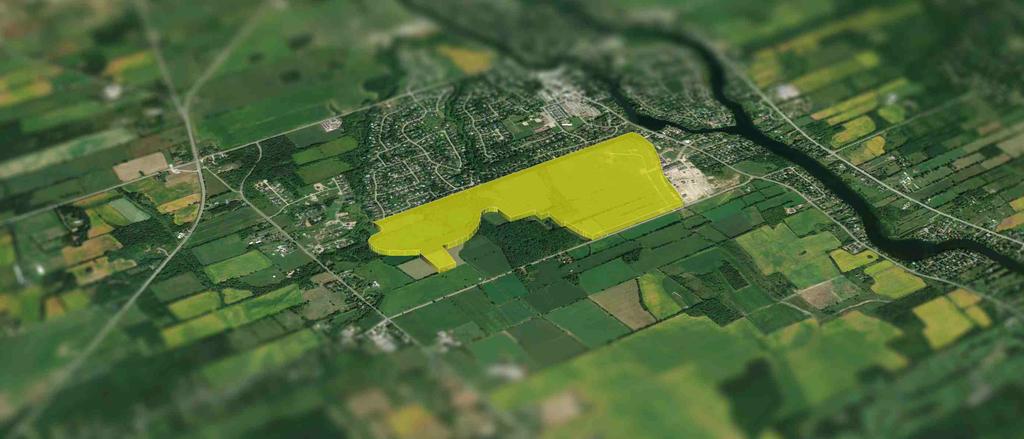
5 Transportation Impact Study 1. INTRODUCTION This study has been prepared in support of a Draft Plan of Subdivision application for Stage 2 of the Mahogany Subdivision by Minto Developments Inc. A Transportation Impact Study is required to satisfy the site plan application. The Stage 2 residential development will consist of 4 Phases: Phase 2 with 99 townhomes and 347 single family homes, Phase 3 with 93 townhomes and 224 single family homes, Phase 4 with 167 single family homes, and Phase 5 with 54 townhomes and 205 single family homes. In total, Stage 2 will include 246 townhomes and 943 single family homes. Phase 1 was previously approved and nearing completion. The proposed site is located north of Century Road, between First Line Road and Rideau Valley Drive North. It is acknowledged that the projected unit numbers may vary slightly as each phase comes online, the total unit count for the Mahogany Community is capped at 1,400 units and will not increase beyond this limit. Figure 1 illustrates the local context of the site and Figure 2 illustrates the proposed Site Plan. Figure 1: Local Context Minto Mahogany Stage 2 Transportation Impact Study 1

6
7 2. EXISTING CONDITIONS 2.1. STUDY AREA ROAD NETWORK Manotick Main Street (Rideau Valley Drive) is a north-south arterial roadway with a two-lane cross-section within the study area. It extends from the south at Roger Stevens Dr through to Prince of Wales Dr where it continues as Jockvale Road. Manotick Main St is urbanized through Manotick to approximately 85m north of Eastman Ave where it transitions into a rural cross-section. The shoulders are generally paved along the rural section, with gravel shoulders generally being provided south of Bridgeport Ave. The posted speed limit is 40 km/h within Manotick and 60 km/h south of Eastman Ave. Bridgeport Avenue is a two-lane, east-west urban collector with an unposted speed of 50 km/h. The road extends from Manotick Main St to Mahogany Creek. Century Road is a two-lane, east-west rural collector with a posted speed of 60 km/h east of Trestle St and 80 km/h to the west. The road extends from Rideau Valley Dr/Manotick Main St to Second Line Rd. Gravel shoulders are provided on either side of the road. Trestle Street is a north-south urban collector roadway with a two-lane cross-section within the study area. It extends from Century Rd northward to Bridgeport Ave. The unposted speed is 50 km/h. Bridge Street is an east-west arterial roadway with a two-lane urban cross-section within the study area. It extends from Manotick Main St to River Rd where it continues as Mitch Owens Road. The posted speed is 40 km/h. First Line Road is a two-lane, north-south rural collector with a posted speed limit of 80 km/h. The road extends from Roger Stevens Road through to Backfield Road and gravel shoulders are provided in both sides of the road PEDESTRIAN/CYCLING NETWORK Sidewalk facilities are provided along both sides of Manotick Main St between Bridge St and Currier St, and a sidewalk on the eastside continues south to approximately 40m north of Eastman Ave. Bridgeport Ave has sidewalks on both sides of the roadway, except for a small link on the south side between Moretto Crt and Trestle St. Bicycle facilities are currently provided in the form of a multi-use pathway (MUP) along Mahogany Creek between Potter Dr and Century Rd and bicycle lanes along Bridge St. Per the City s Cycling Plan, Manotick Main St is classified as a Spine Route and Potter Dr and Century Rd are classified as Local Routes TRANSIT NETWORK Transit service within the vicinity of the site is currently provided by OC Transpo Peak Route #99 which provides peak hour service in the morning and afternoon. Bus stops for Route #99 closest to the development are located along Manotick Main St at Century Rd, approximately 1 kilometer east from the proposed development access on Century Rd. Peak Route #186 and Local Route #305 are located approximately 2 kilometers north of the development which provides access to multiple along the Transitway. Minto Mahogany Stage 2 Transportation Impact Study 3
8 2.4. EXISTING STUDY AREA INTERSECTIONS Century Road/Manotick Main Street/Rideau Valley Drive The Century Rd/Manotick Main St/Rideau Valley Dr intersection is an unsignalized T intersection with a minor -control on the Century Rd. A single lane approach is provided for each leg of this intersection with all movements permitted. Century Road/Trestle Street The Century Rd/Trestle St intersection is an unsignalized T intersection with -control on the minor approach only. A single lane approach is provided for each leg of this intersection with all movements permitted. Century Road/First Line Road The Century Rd/First Line Rd intersection is an unsignalized four-legged intersection with all-way control. A single lane approach is provided for each leg of this intersection with all movements permitted. Exponential stop bars are provided along both approaches of Century Rd. Minto Mahogany Stage 2 Transportation Impact Study 4
9 Manotick Main Street/Bridgeport Avenue/Antochi Lane The Manotick Main St/Bridgeport Ave/Antochi Ln intersection is an unsignalized four-legged intersection with -control on both minor approaches. A single lane approach is provided for each leg of this intersection with all movements permitted. Perpendicular parking stalls are provided for Ottawa Fire Station 94 on the northeast quadrant of the intersection, outside of the paved shoulder. Manotick Main Street/Bridge Street/Maple Avenue The Manotick Main St/Bridge St/Maple Ave is a signalized four-legged intersection. The northbound approach consists of a through lane and a right-turn lane. The northbound left turn is restricted, except for buses. The southbound approach consists of a left-turn lane and a shared through/right-turn lane. The eastbound approach consists of a shared through/right-turn lane and a left-turn lane. The westbound approach consists of a right-turn lane, a through lane and a left-turn lane EXISTING INTERSECTION OPERATIONS Illustrated as Figure 3, are the most recent weekday morning and afternoon peak hour traffic volumes obtained from the City of Ottawa. Peak hour traffic volumes are included as Appendix A. Minto Mahogany Stage 2 Transportation Impact Study 5
10 Figure 3: Existing Peak Hour Traffic Volumes SITE 7(7) 2(3) 26(86) 101(297) First Line 1(2) 23(73) Century 7(7) 2(3) 1(2) 23(73) 3(7) 43(60) Trestle 3(7) 43(60) 57(66) 17(15) 10(10) 241(167) The following Table 1 provides a summary of existing traffic operations at study area intersections based on the SYNCHRO (V9) traffic analysis software. The subject intersection was assessed in terms of the volume-to-capacity (v/c) ratio and the corresponding Level of Service (LoS) for the critical movement(s). The subject intersections as a whole were assessed based on a weighted v/c ratio. The SYNCHRO model output of existing conditions is provided within Appendix B. Table 1: Existing Performance at Study Area Intersections Weekday AM Peak (PM Peak) Intersection Critical Movement Intersection max. v/c LoS or avg. Movement Delay (s) LoS v/c delay (s) Manotick Main/Century (unsignalized) B(B) 11.2(13.4) EBL(EBL) 2.0(1.8) - - Century/Trestle (unsignalized) A(A) 8.7(9.1) SBR(SBR) 1.3(0.9) - - First Line/Century (unsignalized) A(A) 7.2(7.4) EBT(WBT) 7.1(7.4) - - Manotick Main/Bridgeport (unsignalized) B(B) 12.4(14.5) EBL(EBL) 1.1(0.9) - - Manotick Main /Bridge A(A) 0.50(0.54) WBR(SBL) 13.7(20.3) A(A) 0.45(0.46) Notes: Analysis of signalized intersections assumes a PHF of 0.95 and a saturation flow rate of 1800 veh/h/lane. As shown in Table 1, the signalized Manotick Main/Bridge study area intersection as a whole is currently operating at an excellent LoS A during both peak hours, with respect to the City of Ottawa operating standards of LoS D or better (v/c 0.90). Regarding critical movements at study area intersections, they are currently operating at an acceptable LoS B or better during peak hours. Minto Mahogany Stage 2 Transportation Impact Study 6
11 2.6. EXISTING ROAD SAFETY CONDITIONS Collision history for study area roads (2013 to 2015, inclusive) was obtained from the City of Ottawa and most collisions (87%) involved only property damage, indicating low impact speeds, and the remaining 13% involved personal injuries. No incidents were identified as non-reportable, indicating the total damage to a vehicle was less than $1,000. The primary causes of collisions cited by police include; rear end (26%), turning movement (26%), angle (24%), single vehicle (Other) (13%), sideswipe (5%), and approaching and single vehicle (unattended) (3%) type collisions. A standard unit of measure for assessing collisions at an intersection is based on the number collisions per million entering vehicles (MEV). At intersections and road segments within the study area, reported collisions have historically take place at a rate of: 0.95/MEV at the Manotick Main St and Bridge St intersection. 0.25/MEV along Manotick Main St between Bridge and Johnston Clapp Ln. 0.25/MEV along Manotick Main St between Johnston Clapp Ln and Mill St. 0.24/MEV at the Manotick Main St and Tighe St intersection. 0.27/MEV along Manotick Main St between Tighe St and O Grady St. 0.13/MEV at the Manotick Main St and O Grady St intersection. 0.14/MEV along Manotick Main St between Beaverwood Rd and Currier St. 0.14/MEV at the Manotick Main St and Currier St intersection. 0.45/MEV along Manotick Main St between Currier St and Eastman Ave. 0.16/MEV at the Manotick Main St and Island View Dr intersection. 0.16/MEV at the Manotick Main St and Century Rd intersection. Based on the available data, there does not appear to be any prevailing safety issues. The roadways within the study area are noted as being suburban in nature through Manotick (Manotick Main St) or relatively straight and level rural roads (Century Rd), resulting in good sight-lines/visibility and vehicle traction. The source collision data as provided by the City of Ottawa and related analysis is provided as Appendix C. 3. DEMAND FORECASTING 3.1. PLANNED STUDY AREA TRANSPORTATION NETWORK CHANGES MANOTICK SECONDARY PLAN Approved in 2016, the Manotick Secondary Plan outlines the vision for Manotick, to maintain the village atmosphere, historic beginnings, and integration of residential and pedestrian-oriented nature of the area. The planning for the Mahogany development was included in the Secondary Plan, including recommendations for the land use and transportation network. While the land use is in concert with the Secondary Plan, the transportation recommendations to be considered for the Mahogany development include: A pathway along Mahogany Creek, connecting to Potter Dr (existing). Potential cycling route along Manotick Main St and Century Rd. Proposed sidewalk/path along both sides of Bridgeport Ave and connections to Century Rd. Potential combination with cycling connectivity. Proposed sidewalk along the north side of Century Rd. Minto Mahogany Stage 2 Transportation Impact Study 7
12 Proposed sidewalk connection to Potter Dr (adjacent to Wilson Cowan Drain) and Carrison Dr (adjacent to Mud Creek). Consideration of a roundabout at Manotick Main St/Bridgeport Ave, including a gateway feature for Manotick MANOTICK MAIN PEDESTRIAN CROSSOVER In August 2016, a pedestrian crossover was installed on Manotick Main Street at Tighe Street. can safely cross the street at the push of the button, which activates flashing beacons ensuring cars yield to pedestrians. There are currently no other planned crossovers for this area OTHER AREA DEVELOPMENT MAHOGANY PHASE 1 (MINTO) Phase 1 of the Mahogany subdivision is currently undergoing of the final phase of construction, with Phase 1C, located between Manotick Main St and Trestle St, north of Century Rd. Phase 1C will include 57 units, for a total of 221 residential units in all of Phase 1. As part of Phase 1C, a sidewalk will be extended along Century Rd from Manotick Main St to Trestle Rd. The build-out of this Phase will be completed in , 5731, AND 5721 MANOTICK MAIN STREET (REGIONAL) Regional has submitted a Draft Plan of Subdivision and Zoning By-law Amendment for an 82-unit development within the lands encompassing 5741, 5731, and 5721 Manotick Main St. The development site access will be located north of the Century Rd intersection to Manotick Main St and provide a multi-use pathway connection to Kelly Marie Dr. No auxiliary lanes are proposed for the development and the site access will be a minor stop-control. The trip generation from this site, illustrated in Figure 4, will be explicitly included in the background traffic growth, as referenced from the Revised Access Memorandum, dated February 15, Figure 4: 5741, 5731, and 5721 Projected Site-Generated Traffic Minto Mahogany Stage 2 Transportation Impact Study 8
13 3.3. BACKGROUND TRAFFIC GROWTH The background traffic along Manotick Main Street is expected to increase at a constant rate. The anticipated development of the Manotick community will be captured by subsequent transportation impact assessments to determine when various improvements are triggered. Due to the opening of the Vimy Memorial Bridge, a 1% traffic growth rate per annum was assumed for the 2027 and 2032 Horizon years. First Line Road and Century Road were assumed to have 0% growth and any future traffic growth along the road corridor will be generated by the development of the adjacent community. The projected background traffic volumes for the horizon years is illustrated as Figure 5 for 2027 and Figure 6 for Figure 5: Projected 2027 Baseline Traffic Volumes SITE 7(7) 89(259) First Line Trestle 219(135) 50(90) Century 62(52) 37(32) 16(42) 45(137) 48(150) 112(328) 3(7) 54(92) 26(67) 97(93) 111(99) 44(32) 21(42) 266(184) Minto Mahogany Stage 2 Transportation Impact Study 9
14 Figure 6: Projected 2032 Baseline Traffic Volumes SITE First Line Trestle 7(7) 89(259) 219(135) 50(90) Century 62(52) 37(32) 16(42) 45(137) 48(150) 117(345) 3(7) 54(92) 26(67) 97(93) 111(99) 44(32) 21(42) 280(194) The following Table 2 and Table 3 provide a summary of the projected background traffic operations for both the 2027 and 2032 horizon years at study area intersections based on the SYNCHRO (V9) traffic analysis software. The subject intersections were assessed in terms of the volume-to-capacity (v/c) ratio and the corresponding Level of Service (LoS) for the critical movement(s). The subject intersections as a whole were assessed based on a weighted v/c ratio. The SYNCHRO model output of background conditions is provided within Appendix D. Table 2: Projected Background 2027 Performance at Study Area Intersections Weekday AM Peak (PM Peak) Intersection Critical Movement Intersection max. v/c LoS or avg. Movement Delay (s) LoS v/c delay (s) Manotick Main/Century (unsignalized) B(B) 11.5(14.0) EBL(EBL) 0.9(1.9) - - Century/Trestle (unsignalized) A(A) 8.9(9.3) SBR(SBR) 0.9(3.7) - - First Line/Century (unsignalized) A(A) 7.2(7.4) EBT(WBT) 7.1(7.4) - - Manotick Main/Bridgeport (unsignalized) C(C) 15.9(25.0) EBL(EBL) 2.9(4.8) - - Manotick Main /Bridge A(A) 0.50(0.55) WBR(SBL) 14.0(20.4) A(A) 0.45(0.47) Notes: Analysis of signalized intersections assumes a PHF of 0.95 and a saturation flow rate of 1800 veh/h/lane. Minto Mahogany Stage 2 Transportation Impact Study 10
15 Table 3: Projected Background 2032 Performance at Study Area Intersections Weekday AM Peak (PM Peak) Intersection Critical Movement Intersection max. v/c LoS or avg. Movement Delay (s) LoS v/c delay (s) Manotick Main/Century (unsignalized) B(B) 11.7(14.4) EBL(EBL) 1.9(1.8) - - Century/Trestle (unsignalized) A(A) 8.9(9.3) SBR(SBR) 3.7(2.7) - - First Line/Century (unsignalized) A(A) 7.2(7.4) EBT(WBT) 7.1(7.4) - - Manotick Main/Bridgeport (unsignalized) C(D) 16.3(27.0) EBL(EBL) 2.9(5.0) - - Manotick Main /Bridge A(A) 0.50(0.55) WBR(SBL) 14.1(20.4) A(A) 0.45(0.47) Notes: Analysis of signalized intersections assumes a PHF of 0.95 and a saturation flow rate of 1800 veh/h/lane. The background volumes for both the 2027 and 2032 horizons are projected to operate acceptably in both the AM and PM peak hours. It is noted that the build out of Mahogany Phase1 will have over 60 veh/h making the southbound rightturn movement at Manotick Main St/Bridgeport Ave. While not recommended for the background conditions, additional volume will likely trigger the need for a right-turn lane and this will be carried forward into the future horizons analysis SITE TRIP GENERATION Appropriate trip generation rates for the proposed development of approximate 943 single family homes and 246 residential townhome units were obtained from the 9 th Edition of the Institute of Transportation Engineers (ITE) Trip Generation Manual, which are summarized in Table 4. As ITE trip generation surveys only record vehicle trips and typically reflect highly suburban locations (with little to no access by travel modes other than private automobiles), adjustment factors appropriate to the more connected suburban study area context were applied to attain estimates of person trips for the proposed development. This approach is considered appropriate within the industry for more urban developments. Table 4: ITE Trip Generation Rates Land Use Data Source Single Family Homes ITE 210 Townhomes ITE 230 Notes: T = Average Vehicle Trip Ends du = dwelling units AM Peak T=0.75(du) T=0.70(du)+9.74 T=0.44(du) Ln(T)=0.80ln(du)+0.26 Trip Rates PM Peak T=1.00(du) Ln(T)=0.90Ln(du)+0.51 T=0.52(du) Ln(T)=0.82Ln(du)+0.32 To convert ITE vehicle trip rates to person trips, an auto occupancy factor and a non-auto trip factor were applied to the ITE vehicle trip rates. Our review of available literature suggests that a combined factor of approximately 1.3 is considered reasonable to account for typical North American auto occupancy values of approximately 1.15 and combined transit and non-motorized modal shares of less than 10%. As such, the person trip generation for the proposed site is summarized by phase in Table 5. Minto Mahogany Stage 2 Transportation Impact Study 11
16 Land Use Units Table 5: Modified Person Trip Generation AM Peak (Person Trips/h) PM Peak (Person Trips/h) In Out Total In Out Total Single Family Homes (Phase 2) Townhomes (Phase 2) Single Family Homes (Phase 3) Townhomes (Phase 3) Single Family Homes (Phase 4) Single Family Homes (Phase 5) Townhomes (Phase 5) Total Person Trips , ,378 Note: 1.3 factor to account for typical North American auto occupancy values of approximately 1.15 and combined transit and nonmotorized modal shares of less than 10% The person trips for each phase shown in Table 5 for the proposed site were then reduced by modal share values (Table 6, Table 7, Table 8, and Table 9), with the total site-generated vehicle traffic summarized in Table 10. Table 6: Phase 2 Modal Site Trip Generation Mode AM Peak (Person Trips/h) PM Peak (Person Trips/h) Travel Mode Share In Out Total In Out Total Auto Driver 70% Auto Passenger 15% Transit 5% Non-motorized 10% Total Person Trips 100% Travel Mode Total New Auto Trips Mode Share Table 7: Phase 3 Modal Site Trip Generation AM Peak (Person Trips/h) PM Peak (Person Trips/h) In Out Total In Out Total Auto Driver 70% Auto Passenger 15% Transit 5% Non-motorized 10% Total Person Trips 100% Total New Auto Trips Minto Mahogany Stage 2 Transportation Impact Study 12
17 Travel Mode Mode Share Table 8: Phase 4 Modal Site Trip Generation AM Peak (Person Trips/h) PM Peak (Person Trips/h) In Out Total In Out Total Auto Driver 70% Auto Passenger 15% Transit 5% Non-motorized 10% Total Person Trips 100% Travel Mode Total New Auto Trips Mode Share Table 9: Phase 5 Modal Site Trip Generation AM Peak (Person Trips/h) PM Peak (Person Trips/h) In Out Total In Out Total Auto Driver 70% Auto Passenger 15% Transit 5% Non-motorized 10% Total Person Trips 100% Total New Auto Trips Table 10: Total Site Vehicle Trip Generation Phase AM Peak (veh/h) PM Peak (veh/h) In Out Total In Out Total Phase Phase Phase Phase Total New Auto Trips As shown in Table 10, the resulting number of potential new two-way vehicle trips for the proposed development is approximately 761 and 974 veh/h during the weekday morning and afternoon peak hours, respectively VEHICLE TRAFFIC DISTRIBUTION AND ASSIGNMENT Traffic distribution was based on the different types of land uses, existing volume splits at study area intersections and our knowledge of the surrounding area. The resultant distribution is outlined as follows. 5% 35% 15% 45% 100% to/from the south via Rideau Valley Dr to/from the north via Manotick Main St to/from the east via Manotick Main St and Bridge St to/from the west via Century Rd and First Line Rd Based on these distributions, new site-generated trips were assigned to study area intersections, which are illustrated as Figure 7. Minto Mahogany Stage 2 Transportation Impact Study 13
18 Figure 7: New Site Generated Traffic Volumes xx (yy) AM Peak Hour Volumes PM Peak Hour Volumes SITE 87(256) 218(133) 27(17) First Line Access 2 Access 1 136(83) 27(17) Trestle Century 11(32) 109(67) 82(50) 27(17) 11(32) 38(49) 27(17) 27(17) 11(32) 22(64) 22(64) 11(32) 54(160) 43(128) 33(96) 38(49) 11(32) 54(33) 54(33) 27(17) 11(32) 4. FUTURE TRAFFIC OPERATIONS 4.1. PROJECTED 2027 CONDITIONS AT FULL SITE DEVELOPMENT The total projected 2027 volumes associated with the proposed development were derived by superimposing new sitegenerated traffic volumes (Figure 7) onto projected 2027 background traffic volumes (Figure 5). The resulting total projected 2027 volumes are illustrated as Figure 8. The following Table 11 provides a projected performance summary for study area intersections, based on total projected 2032 traffic volumes. The detailed SYNCHRO model output of projected conditions is provided within Appendix E. Minto Mahogany Stage 2 Transportation Impact Study 14
19 Figure 8: Total Projected 2027 Peak Hour Traffic Volumes xx (yy) AM Peak Hour Volumes PM Peak Hour Volumes SITE First Line Access 2 7(7) 89(259) Access 1 Trestle 219(135) 50(90) Century 136(83) 27(17) 11(32) 139(147) 82(50) 27(17) 11(32) 96(157) 62(52) 37(32) 16(42) 45(137) 48(150) 112(328) 3(7) 54(92) 54(160) 88(191) 33(96) 91(124) 26(67) 97(93) 111(99) 44(32) 21(42) 266(184) Table 11: Projected 2027 Performance at Study Area Intersections Weekday AM Peak (PM Peak) Intersection Critical Movement Intersection max. v/c or LoS avg. delay Movement Delay (s) LoS v/c (s) Manotick Main/Century (unsignalized) B(C) 13.0(17.4) EB(EB) 3.7(3.3) - - Century/Trestle (unsignalized) A(B) 9.8(11.0) SB(SB) 4.2(3.7) - - First Line/Century (unsignalized) A(B) 8.5(10.9) SB(SB) 8.3(10.0) - - Manotick Main/Bridgeport (unsignalized) F(F) 75.0(225.6) EB(EB) 24.4(48.5) - - Manotick Main /Bridge B(B) 0.65(0.69) NBT(WBL) 20.7(25.5) A(B) 0.52(0.66) Century Rd/Access 1 (unsignalized) A(B) 9.8(10.6) SB(SB) 3.8(3.1) - - Century Rd/Access 2 (unsignalized) B(B) 10.4(11.1) SB(SB) 4.7(4.1) - - Notes: Analysis of signalized intersections assumes a PHF of 0.95 and a saturation flow rate of 1800 veh/h/lane. As shown in Table 11, with the full build-out of Stage 2+, the Manotick Main/Bridgeport intersection is projected to operate above capacity (LoS F ) during the morning and afternoon peak hour. All other study area intersections as a whole are projected to operate at an acceptable LoS C or better during peak hours. Regarding the critical movements at study area intersections, the eastbound movement (left) at the Manotick Main St/Bridgeport Ave intersection is projected to operate above capacity (LoS F ) during the morning and afternoon peak hour. All other critical movements are projected to operate at an acceptable LoS C or better during the morning and afternoon peak hours with respect to the City of Ottawa operating standards of LoS D or better (v/c 0.90). Minto Mahogany Stage 2 Transportation Impact Study 15
20 The projected traffic volumes at the Manotick Main St/Bridgeport Ave intersection do not trigger a signal warrant, however, operationally, the eastbound approach would benefit from a higher order control at the intersection. A signal is recommended and Table 12 summarizes the projected operations of the Manotick Main St/Bridgeport Ave intersection. The intersection is anticipated to operate as a whole with a LoS B or better during both peak hours and the eastbound approach with a LoS C or better. Table 12: Projected 2027 Performance (Mitigated) at Study Area Intersections Weekday AM Peak (PM Peak) Intersection Critical Movement Intersection max. v/c or LoS avg. delay Movement Delay (s) LoS v/c (s) Manotick Main/Bridgeport C(B) 0.73(0.62) EB(EB) 13.6(10.8) A(B) 0.57(0.61) Notes: Analysis of signalized intersections assumes a PHF of 0.95 and a saturation flow rate of 1800 veh/h/lane. The roundabout screening tool identifies a 44m requirement for a typical single lane urban roundabout, and the diagonal distances between the property quadrants are approximately 41m (Mahogany park to Fire Station No. 94) and 47m (private residential, northwest to southeast quadrants). The additional space requirements between the park and Fire Station No. 94 would impact the Station on-street parking, landscaping, street lighting, hydro poles, and the existing park space. Therefore, a roundabout intersection was not considered as an option for the high order control intersection control at Manotick Main St/Bridgeport Ave PROJECTED 2032 CONDITIONS AT FIVE YEARS BEYOND SITE BUILD-OUT The total projected 2032 volumes associated with the proposed development were derived by superimposing new sitegenerated traffic volumes (Figure 7) onto projected 2032 background traffic volumes (Figure 6). The resulting total projected 2032 volumes are illustrated as Figure 9. The following Table 13 provides a projected performance summary for study area intersections, based on total projected 2032 traffic volumes (5-years beyond full site build-out). The detailed SYNCHRO model output of projected conditions is provided within Appendix E. The Manotick Main St/Bridgeport Ave intersection signalization has been carried forward from the 2027 horizon, including the southbound right-turn lane. No other study area improvements are included in this horizon. Minto Mahogany Stage 2 Transportation Impact Study 16
21 Figure 9: Total Projected 2032 Peak Hour Traffic Volumes xx (yy) AM Peak Hour Volumes PM Peak Hour Volumes SITE First Line Access 2 7(7) 89(259) Access 1 Trestle 219(135) 50(90) Century 136(83) 27(17) 11(32) 139(147) 82(50) 27(17) 11(32) 96(157) 62(52) 37(32) 16(42) 45(137) 48(150) 117(345) 3(7) 54(92) 54(160) 88(191) 33(96) 91(124) 26(67) 97(93) 111(99) 44(32) 21(42) 280(194) Table 13: Projected 2032 Performance at Study Area Intersections Weekday AM Peak (PM Peak) Intersection Critical Movement Intersection max. v/c or LoS avg. delay Movement Delay (s) LoS v/c (s) Manotick Main/Century (unsignalized) A(C) 13.2(18.1) EB(EB) 3.6(3.3) - - Century/Trestle (unsignalized) A(B) 9.8(11.0) SB(SB) 4.2(3.7) - - First Line/Century (unsignalized) A(B) 8.5(10.9) SB(SB) 8.3(10.0) - - Manotick Main/Bridgeport B(B) 0.66(0.63) EB(EB) 11.3(10.9) A(B) 0.60(0.62) Manotick Main /Bridge B(B) 0.66(0.70) NBT(WBL) 20.8(25.6) A(B) 0.52(0.66) Century Rd/Access 1 (unsignalized) A(B) 9.8(10.6) SB(SB) 3.8(3.1) - - Century Rd/Access 2 (unsignalized) B(B) 10.4(11.1) SB(SB) 4.7(4.1) - - Notes: Analysis of signalized intersections assumes a PHF of 0.95 and a saturation flow rate of 1800 veh/h/lane. As shown in Table 13, with the continued 1% traffic growth along Manotick Main Street, the study area intersections as a whole are projected to operate at an acceptable LoS C or better during peak hours. The critical movements are projected to operate at an acceptable LoS C or better during the morning and afternoon peak hours with respect to the City of Ottawa operating standards of LoS D or better (v/c 0.90) NEIGHBOURHOOD/MANOTICK IMPACTS Based on the location of the proposed development, connections to the adjacent road network, and origin-destination demands of the area, it is anticipated that the majority of the site-generated traffic will utilize Century Rd and First Line Minto Mahogany Stage 2 Transportation Impact Study 17
22 Rd. Inevitably, travel demand will utilize the Bridge St crossing to travel north and east. The opening of the Vimy Memorial Crossing has reduced the demand on Bridge St (approximately 25% from 2010 to 2015), and subsequently the Manotick Main St/Bridge St intersection, providing additional capacity for the Mahogany development to gradually build out. Within the Mahogany development, additional traffic will utilize Bridgeport Ave and Trestle St to access the site. While the two-way volume will be approximately 10 cars a minute, the community perception may be that it is becoming unsafe. During construction, a monitoring program is recommended for community concerns along the existing portion of Bridgeport Ave to implement remedial passive traffic calming measures, similar to the recommendations for Stage 2+. With respect to construction traffic for the development, truck routing should be directed to First Line Rd and Century Rd to access the site, avoiding the commercial core and residential areas of Manotick. 5. TRANSPORTATION DEMAND MANAGEMENT Depending on the nature of a development, Transportation Demand Management (TDM) strategies have the potential to be an integral part of a planned development to address and support the City s policies regarding TDM. Several other TDM measures could also be considered, including: Improving the quality and safety of pedestrian facilities, such as enhanced sidewalks/lighting. Promote transit passes and park & ride options within Manotick and to the Riverview Station. Promote appropriate car sharing programs/facilities to reduce auto ownership and attract residents who do not own a vehicle. TDM strategies are important in encouraging active modes of transportation to/from the site, further lessening the reliance on the private automobile. 6. SITE PLAN REVIEW This section provides an overview of site access, parking requirements, pedestrian circulation and transit accessibility. The proposed Site Plan was previously illustrated as Figure 2. Site Access Access to the Mahogany Stage 2+ will be provided through two new site accesses along Century Rd and the existing Bridgeport Ave intersection on Manotick Main St. The intersections along Century Rd will be stop-controlled along the side streets. No auxiliary lanes are recommended for these additional access locations. To accommodate the full build-out of Stage 2+, the Manotick Main St/Bridgeport Ave intersection is recommended to be signalized and a southbound right-turn lane provided. The unconstrained storage length for the southbound right-turn lane is approximately 58m, but consideration will need to be given to the adjacent residential driveways along Manotick Main St as the first driveway is approximately 20m north of Bridgeport Ave. No other auxiliary lanes are recommended for the intersection. Internal Road Network The internal road network for Mahogany is developed upon a frame work of 22.0m collector roads and 18.0m local roadways. The collector roads include Bridgeport Ave, and Access 1 and Access 2, south of Bridgeport Ave. The right-of-way should be able to include 3.3m travel lanes to facilitate transit vehicles, sidewalks on both sides or combination of multi-use pathway and sidewalk, dedicated bike lanes or on-street parking, and the utility/boulevard spacing for lighting and trees. The intersection of Bridgeport Ave/Access 1 is proposed to be a roundabout, facilitating efficient access, calming traffic adjacent to the school site, and providing protected crossing locations for pedestrians and cyclists. Minto Mahogany Stage 2 Transportation Impact Study 18
23 Given the City s recently approved 18.0m cross-section standard, these roadways will match the City typical with onstreet parking and a single sidewalk, with the potential combination of a multi-use pathway on adjacent park, stormwater management pond or school lands. Transit While not currently provided, the opportunity for transit service along Bridgeport Ave can be facilitated with the 22.0m cross-section. Stops should be located on the far side of the intersections and the loop may be facilitated on along Access #1 during Phase 2, and ultimately along Access #2 on Phase 3 proceeds. Pedestrian The pedestrian network will likely include a sidewalk on the local roads and sidewalks on both sides of the collector roads within the development. External connections are planned to Potter Dr, Carrison Dr, and Century Rd. The use of multi-use pathways within the development may also consolidate the active mode facilities and allow for greater connectivity. Cycling The cycling network within Mahogany will be facilitated along the collector road network, and multi-use-pathways at the stormwater management ponds and Mahogany Creek. Should a multi-use pathway be provided along the north side of Bridgeport Ave, between Mahogany Creek and Access 2, a potential cycling loop is feasible with connections to Potter Dr. Parking On-street parking is accommodated along the propose local street network and the potential to be included along the collector roads. If dedicated bike lanes are required, the on-street parking will have to be removed from these roadways. In addition, and transit service provided to the development will limit the areas where parking can be accommodated along the collector roads. Traffic Calming The implementation of passive traffic calming measures are currently being incorporated into new subdivisions with the goal of reducing potential reconstruction costs soon after a new development roads are completed. The nature of these calming measures should primarily be limited to horizontal features. Within the subject lands, curb narrowings should be provided at the local road intersections with Bridgeport Ave, Access #1 and Access #2. The intersection of Bridgeport Ave/Access #2 is recommended to include a full intersection narrowing to compliment the roundabout proposed at Bridgeport Ave/Access #1. On-street parking planned for the development (as discussed above) will also provide additional side friction along the local roads to calm traffic. 7. FINDINGS AND RECOMMENDATIONS Minto Mahogany, located north of Century Rd, between First Line Rd and Manotick Main St, is a residential development that will consist of 943 single family homes and 246 townhomes, for a total of 1,189 units. It was determined that the proposed development will generate 757 new vehicle trips in the morning peak hour and 966 vehicle trips in the afternoon peak hour. Based on the foregoing analysis of the proposed development, the following transportation related conclusions are offered. Existing Conditions The signalized study area intersection adjacent to the site is currently operating as a whole with an overall LoS A or better during the weekday morning and afternoon peak hours. Regarding critical movements at the study area intersection, they are noted as operating at an acceptable LoS C or better during the peak hours. Minto Mahogany Stage 2 Transportation Impact Study 19


 to permit the construction of sidewalks on one side of the roadway.")
24 Based on the available data, there does not appear to be any safety issues at the signalized study area intersections adjacent to the proposed site. Projected Conditions The background growth rate along Manotick Main St was assumed to be 1% per annum for the 2027 and 2032 horizon years. No background growth was assumed for Century Rd and First Line Rd. The proposed development is projected to generate new two-way vehicle volumes of approximately 757 and 966 veh/h during the weekday morning and afternoon peak hours, respectively. At full occupancy (year 2027), the Manotick Main St/Bridgeport Ave intersection eastbound approached is projected to operate at a LoS F during both peak hours. It is recommended that the intersection be signalized upon full buildout and a southbound right-turn lane be provided with a maximum storage length of 58m. The remaining study area intersections as a whole are projected to operate at an acceptable LoS C or better and the critical movements are projected to operate at acceptable levels of service during both peak hours. At 5-years beyond site build-out, study area intersections as a whole are projected to operate at an acceptable LoS C or better. Site Plan The internal road network provides a high level of connectivity within the development and to the adjacent road network. The local roads are sufficiently wide (18.0m) to permit the construction of sidewalks on one side of the roadway. The internal collector roads are sufficiently wide to permit the construction of sidewalks along both sides of the road, or potentially the combination of a sidewalk and multi-use pathway. A multi-use pathway is recommended along the north side of Bridgeport Ave, between Mahogany Creek and Access 2, to facilitate a cycling loop including Potter Dr, Mahogany Creek, Bridgeport Ave and Access 2/Wilson Cowen Drain. Curb narrowings are recommended on the local road approaches to the internal collectors (Bridgeport Ave, Access 1 and Access 2, south of Bridgeport Ave) and a full intersection narrowing is recommended for the intersection of Bridgeport Ave/Access 2. Based on the foregoing, the proposed Minto Mahogany Stage 2+ residential development is recommended from a transportation perspective. Prepared By: Reviewed By: June 27, 2017 Andrew Harte, P.Eng. Transportation Engineer Christopher Gordon, P.Eng. Senior Project Manager Minto Mahogany Stage 2 Transportation Impact Study 20
25 Appendix A
26 E W S N E W S N
27 E W S N
28
29 E W S N E W S N
30 E W S N
31
32 North Leg: Trestle West and East Leg: Century AM Start Time NBL NBT NBR SBL SBT SBR EBL EBT EBR WBL WBT WBR Peak Hour Peak hour: 7:30-8:30 PM Start Time NBL NBT NBR SBL SBT SBR EBL EBT EBR WBL WBT WBR Peak Hour Peak hour: 15:45-16:45 Intersection: Manotick Main & Bridgeport Date: Thursday, Jul 14, 2016 Time: 7:00AM to 9:00AM 15-Minute Total Time NBL NBT NBR SBL SBT SBR EBL EBT EBR WBL WBT WBR 7:00AM - 7:15AM :15AM - 7:30AM :30AM - 7:45AM :45AM - 8:00AM :00AM - 8:15AM :15AM - 8:30AM :30AM - 8:45AM :45AM - 9:00AM Hour Total
33 Intersection: Manotick Main & Bridgeport Date: Thursday, Jul 14, 2016 Time: 4:00PM to 6:00PM 15-Minute Total Time NBL NBT NBR SBL SBT SBR EBL EBT EBR WBL WBT WBR 4:00PM - 4:15PM :15PM - 4:30PM :30PM - 4:45PM :45PM - 5:00PM :00PM - 5:15PM :15PM - 5:30PM :30PM - 5:45PM 4 4 5:45PM - 6:00PM Hour Total
34 Appendix B
35 AM Existing 1: Rideau Valley/Manotick Main & Century 06/27/2017 Movement EBL EBR NBL NBT SBT SBR Traffic Volume (veh/h) Future Volume (Veh/h) Sign Control Stop Free Free Grade 0% 0% 0% Peak Hour Factor Hourly flow rate (vph) vc, conflicting volume vcu, unblocked vol tc, single (s) tf (s) p0 queue free % cm capacity (veh/h) Direction, Lane # EB 1 NB 1 SB 1 Volume Total Volume Left Volume Right csh Volume to Capacity Queue Length 95th (m) Control Delay (s) Lane LOS B A Approach Delay (s) Approach LOS B Average Delay 2.0 Intersection Capacity Utilization 33.0% ICU Level of Service A Page 1 AM Existing 2: Century & Trestle 06/27/2017 Movement EBL EBT WBT WBR SBL SBR Traffic Volume (veh/h) Future Volume (Veh/h) Sign Control Free Free Stop Grade 0% 0% 0% Peak Hour Factor Hourly flow rate (vph) vc, conflicting volume vcu, unblocked vol tc, single (s) tf (s) p0 queue free % cm capacity (veh/h) Direction, Lane # EB 1 WB 1 SB 1 Volume Total Volume Left Volume Right csh Volume to Capacity Queue Length 95th (m) Control Delay (s) Lane LOS A A Approach Delay (s) Approach LOS A Average Delay 1.3 Intersection Capacity Utilization 15.0% ICU Level of Service A Page 2
36 AM Existing 3: 1st Line & Century 06/27/2017 Movement EBL EBT EBR WBL WBT WBR NBL NBT NBR SBL SBT SBR Sign Control Stop Stop Stop Stop Traffic Volume (vph) Future Volume (vph) Peak Hour Factor Hourly flow rate (vph) Direction, Lane # EB 1 WB 1 NB 1 SB 1 Volume Total (vph) Volume Left (vph) Volume Right (vph) Hadj (s) Departure Headway (s) Degree Utilization, x Capacity (veh/h) Control Delay (s) Approach Delay (s) Approach LOS A A A A Delay 7.1 Level of Service A Intersection Capacity Utilization 15.0% ICU Level of Service A Page 3 AM Existing 4: Manotick Main & Bridgeport/Antochi 06/27/2017 Movement EBL EBT EBR WBL WBT WBR NBL NBT NBR SBL SBT SBR Traffic Volume (veh/h) Future Volume (Veh/h) Sign Control Stop Stop Free Free Grade 0% 0% 0% 0% Peak Hour Factor Hourly flow rate (vph) vc, conflicting volume vcu, unblocked vol tc, single (s) tf (s) p0 queue free % cm capacity (veh/h) Direction, Lane # EB 1 WB 1 NB 1 SB 1 Volume Total Volume Left Volume Right csh Volume to Capacity Queue Length 95th (m) Control Delay (s) Lane LOS B A A Approach Delay (s) Approach LOS B A Average Delay 1.1 Intersection Capacity Utilization 28.6% ICU Level of Service A Page 4
37 AM Existing 5: Manotick Main & Maple/Bridge 06/27/2017 Movement EBL EBT EBR WBL WBT WBR NBL NBT NBR SBL SBT SBR Traffic Volume (vph) Future Volume (vph) Ideal Flow (vphpl) Total Lost time (s) Lane Util. Factor Frpb, ped/bikes Flpb, ped/bikes Frt Flt Protected Satd. Flow (prot) Flt Permitted Satd. Flow (perm) Peak-hour factor, PHF Adj. Flow (vph) RTOR Reduction (vph) Lane Group Flow (vph) Confl. Peds. (#/hr) Turn Type Split NA Split NA pm+ov NA pm+ov pm+pt NA Protected Phases Permitted Phases Actuated Green, G (s) Effective Green, g (s) Actuated g/c Ratio Clearance Time (s) Vehicle Extension (s) Lane Grp Cap (vph) v/s Ratio Prot 0.01 c c c v/s Ratio Perm c0.17 v/c Ratio Uniform Delay, d Progression Factor Incremental Delay, d Delay (s) Level of Service C D C C C C B B A Approach Delay (s) Approach LOS D C B B HCM 2000 Control Delay 17.9 HCM 2000 Level of Service B HCM 2000 Volume to Capacity ratio 0.41 Actuated Cycle Length (s) 90.3 Sum of lost time (s) 18.0 Intersection Capacity Utilization 65.6% ICU Level of Service C c Critical Lane Group Page 5 PM Existing 1: Rideau Valley/Manotick Main & Century 06/27/2017 Movement EBL EBR NBL NBT SBT SBR Traffic Volume (veh/h) Future Volume (Veh/h) Sign Control Stop Free Free Grade 0% 0% 0% Peak Hour Factor Hourly flow rate (vph) vc, conflicting volume vcu, unblocked vol tc, single (s) tf (s) p0 queue free % cm capacity (veh/h) Direction, Lane # EB 1 NB 1 SB 1 Volume Total Volume Left Volume Right csh Volume to Capacity Queue Length 95th (m) Control Delay (s) Lane LOS B A Approach Delay (s) Approach LOS B Average Delay 1.8 Intersection Capacity Utilization 33.5% ICU Level of Service A Page 1
38 PM Existing 2: Century & Trestle 06/27/2017 Movement EBL EBT WBT WBR SBL SBR Traffic Volume (veh/h) Future Volume (Veh/h) Sign Control Free Free Stop Grade 0% 0% 0% Peak Hour Factor Hourly flow rate (vph) vc, conflicting volume vcu, unblocked vol tc, single (s) tf (s) p0 queue free % cm capacity (veh/h) Direction, Lane # EB 1 WB 1 SB 1 Volume Total Volume Left Volume Right csh Volume to Capacity Queue Length 95th (m) Control Delay (s) Lane LOS A A Approach Delay (s) Approach LOS A Average Delay 0.9 Intersection Capacity Utilization 19.5% ICU Level of Service A Page 2 PM Existing 3: 1st Line & Century 06/27/2017 Movement EBL EBT EBR WBL WBT WBR NBL NBT NBR SBL SBT SBR Sign Control Stop Stop Stop Stop Traffic Volume (vph) Future Volume (vph) Peak Hour Factor Hourly flow rate (vph) Direction, Lane # EB 1 WB 1 NB 1 SB 1 Volume Total (vph) Volume Left (vph) Volume Right (vph) Hadj (s) Departure Headway (s) Degree Utilization, x Capacity (veh/h) Control Delay (s) Approach Delay (s) Approach LOS A A A A Delay 7.4 Level of Service A Intersection Capacity Utilization 19.5% ICU Level of Service A Page 3
886 March Road McDonald's Transportation Study
 McDonald's Restaurants of Canada Limited March 2013 886 March Road McDonald's Transportation Study Submitted by: HDR Corporation 100 York Boulevard, Suite 300 Richmond Hill, ON L4B 1J8 (905) 882-4100 www.hdrinc.com
April Salvation Army Barrhaven Church 102 Bill Leathem Drive Transportation Brief
 April 26 Salvation Army Barrhaven Church 2 Bill Leathem Drive Transportation Brief Salvation Army Barrhaven Church 2 Bill Leathem Drive Transportation Brief prepared for: The Salvation Army 2 Overlea Blvd.
Village of Richmond Transportation Brief
 Village of Richmond Transportation Brief GENIVAR Project Number 111-18482-00 June 21 st, 2011 www.genivar.com GENIVAR 15 Fitzgerald Road, Suite 100 Ottawa, Ontario, CANADA K2H 9G1 Telephone: 613-829-2800
HCM Unsignalized Intersection Capacity Analysis 6: Brian Street & LC 111 5/26/2009
 6: Brian Street & LC 111 5/26/2009 Movement EBL EBR NBL NBT SBT SBR Volume (veh/h) 116 20 8 405 137 56 Sign Control Stop Free Free Grade 0% 0% 0% Peak Hour Factor 0.81 0.81 0.67 0.67 0.89 0.89 Hourly flow
Re: Residential Development - Ogilvie/Cummings Transportation Overview
 1223 Michael Street, Suite 100, Ottawa, ON K1J 7T2 Tel: 613.738.4160 Fax: 613.739.7105 www.delcan.com March 28, 2012 OUR REF: TO3088TOY Barry J. Hobin & Architects 63 Pamilla Street Ottawa, ON K1S 3K7
Re: Cyrville Road Car Dealership
 1223 Michael Street, Suite 100, Ottawa, ON K1J 7T2 Tel: 613.738.4160 Fax: 613.739.7105 www.delcan.com February 25, 2013 OUR REF: TO3098TOE Mark Motors of Ottawa 611 Montreal Road Ottawa, ON K1K 0T8 Attention:
Provide an overview of the development proposal including projected site traffic volumes;
 December 19, 2013 File: 163600935 Attention: Troy Elliott Carl Elliott Limited 15-1831 Robertson Road PO Box 11117 Nepean, Ontario K1H 7T8 Dear Mr. Elliott, Reference: 2235 and 2265 Robertson Road Transportation
1012 & 1024 McGarry Terrace
 December 217 112 & 124 McGarry Terrace Transportation Impact Study 112 & 124 McGarry Terrace Transportation Impact Study prepared for: Lépine Corporation 32 March Road Kanata, ON K2K 2E3 prepared by: 1223
L1TILE BEARS DAY CARE TRANSPORTATION IMPACT STUDY FORT COLLINS, COLORADO MAY Prepared for:
 L1TILE BEARS DAY CARE TRANSPORTATION IMPACT STUDY FORT COLLINS, COLORADO MAY 2012 Prepared for: Hillside Construction, Inc. 216 Hemlock Street, Suite B Fort Collins, CO 80534 Prepared by: DELICH ASSOCIATES
Barrhaven Honda Dealership. Dealership Drive, Ottawa, ON. Transportation Brief
 Barrhaven Honda Dealership Dealership Drive, Ottawa, ON Transportation Brief Prepared By: NOVATECH Suite 200, 240 Michael Cowpland Drive Ottawa, Ontario K2M 1P6 September, 2015 File: 115136 Ref: R-2015-152
Wellington Street West
 Transportation Brief prepared for: 185 Davenport Road Suite 300 Toronto, ON M5R 1J1 prepared by: 1223 Michael Street Suite 100 Ottawa, ON K1J 7T2 November 5, 2013 TO3131TOH Transportation Brief November
TRAFFIC IMPACT STUDY DERRY GREEN CORPORATE BUSINESS PARK MILTON SECONDARY PLAN MODIFICATION
 TRAFFIC IMPACT STUDY DERRY GREEN CORPORATE BUSINESS PARK MILTON SECONDARY PLAN MODIFICATION TRAFFIC IMPACT STUDY DERRY GREEN CORPORATE BUSINESS PARK MILTON SECONDARY PLAN MODIFICATION DECEMBER 2014 UPDATED
267 O Connor Street Residential Development
 M a y 2014 267 O Connor Street Residential Development Transportation Brief Google 2014 Bing 2014 Prepared for: MASTERCRAFT STARWOOD Prepared by: Study 267 O'Connor Type Street May 2014 Study Residential
ZINFANDEL LANE / SILVERADO TRAIL INTERSECTION TRAFFIC ANALYSIS
 ZINFANDEL LANE / SILVERADO TRAIL INTERSECTION TRAFFIC ANALYSIS UPDATED TRAFFIC STUDY FOR THE PROPOSED RAYMOND VINEYARDS WINERY USE PERMIT MODIFICATION #P11-00156 AUGUST 5, 2014 PREPARED BY: OMNI-MEANS,
(A) Project Manager, Infrastructure Approvals
 Project Manager, Infrastructure Approvals") February 14th, 2014 BY E-MAIL: wally.dubyk@ottawa.ca City of Ottawa Planning and Growth Management Branch 110 Laurier Ave. W., 4 th Floor, Ottawa, Ontario K1P 1J1 Attention: Wally Dubyk, C.E.T (A) Project
February 14th, 2014 BY E-MAIL: wally.dubyk@ottawa.ca City of Ottawa Planning and Growth Management Branch 110 Laurier Ave. W., 4 th Floor, Ottawa, Ontario K1P 1J1 Attention: Wally Dubyk, C.E.T (A) Project
MEMORANDUM. Date: November 4, Cheryl Burrell, Pebble Beach Company. Rob Rees, P.E. Inclusionary Housing Transportation Analysis WC
 MEMORANDUM Date: November 4, 2013 To: From: Subject: Cheryl Burrell, Pebble Beach Company Rob Rees, P.E. Inclusionary Housing Transportation Analysis As requested, Fehr & Peers is providing clarification
 Traffic Analysis For Approved Uses within the St. Lucie West DRI Aldi Port St. Lucie, FL Prepared for: Bohler Engineering, LLC 1000 Corporate Drive Suite 250 Fort Lauderdale, FL 33334 Prepared by: 10795
TRAFFIC AND TRANSPORTATION TECHNICAL MEMORANDUM
 TRAFFIC AND TRANSPORTATION TECHNICAL MEMORANDUM for ENVIRONMENTAL ASSESSMENT US 460 Bypass Interchange and Southgate Drive Relocation State Project No.: 0460-150-204, P101, R201, C501, B601; UPC 99425
Sugarland Crossing Gwinnett County, Georgia
 Sugarland Crossing Gwinnett County, Georgia S IGNAL W ARRANT A NALYSIS For the Intersection of: Sugarloaf Parkway / Richards Middle School Driveway / Sugarland Crossing Main Site Driveway Prepared for:
ARVADA TRIANGLE REDEVELOPMENT TRAFFIC IMPACT ANALYSIS
 ARVADA TRIANGLE REDEVELOPMENT TRAFFIC IMPACT ANALYSIS Prepared for: Arvada Urban Renewal Authority 5601 Olde Wadsworth Boulevard, Suite 210 Arvada, Colorado 80002 (720) 898-7062 Prepared by: Felsburg Holt
1140 Wellington Street West Transportation Brief
 1140 Wellington Street West Transportation Brief October 2013 Study 1140 Wellington Type Street West October 2013 Study Transportation Name Brief February 2011 TB Check List TIS / TB/ CTS Check List prepared
Re: Addendum No. 4 Transportation Overview 146 Mountshannon Drive Ottawa, Ontario
 April 18 th, 2017 Mr. Kevin Yemm Vice President, Land Development Richraft Group of Companies 2280 St. Laurent Boulevard, Suite 201 Ottawa, Ontario (Tel: 613.739.7111 / e-mail: keviny@richcraft.com) Re:
Bennett Pit. Traffic Impact Study. J&T Consulting, Inc. Weld County, Colorado. March 3, 2017
 Bennett Pit Traffic Impact Study J&T Consulting, Inc. Weld County, Colorado March 3, 217 Prepared By: Sustainable Traffic Solutions, Inc. http://www.sustainabletrafficsolutions.com/ Joseph L. Henderson,
Appendix B: Traffic Reports
 Appendix B: Traffic Reports 407 TRANSITWAY - KENNEDY ROAD TO BROCK ROAD MINISTRY OF TRANSPORTATION - CENTRAL REGION Report Markham Road Station Traffic Study Prepared for Ministry of Transportation, Ontario
One Harbor Point Residential
 Residential Gig Harbor, WA Transportation Impact Analysis January 23, 2017 Prepared for: Neil Walter Company PO Box 2181 Tacoma, WA 98401 Prepared by: TENW Transportation Engineering NorthWest 11400 SE
Paisley & Whitelaw - Paisley Park OPA / ZBA for Mixed Density Residential Use
 Paisley & Whitelaw - Paisley Park OPA / ZBA for Mixed Density Residential Use Transportation Impact Study City of Guelph Prepared for: Armel Corporation August 2018 Table of Contents 1 Introduction...
Traffic Impact Study Proposed Commercial Development Ballwin, Missouri. Technical Memorandum for Traffic Impact Study
 Traffic Impact Study Proposed Commercial Development Ballwin, Missouri Technical Memorandum for Traffic Impact Study Crawford, Bunte, Brammeier May 1, 2009 MEMORANDUM Date: April 24, 2009 To: From: Subject:
MURRIETA APARTMENTS TRAFFIC IMPACT ANALYSIS CITY OF MURRIETA, CALIFORNIA
 MURRIETA APARTMENTS TRAFFIC IMPACT ANALYSIS CITY OF MURRIETA, CALIFORNIA SEPTEMBER 20, 2012 Prepared for: Golden Eagle Multi-Family Properties, LLC 6201 Oak Canyon Rd., Suite 250 Irvine, CA 92618 Prepared
Zachary Bugg, PhD, Diego Arguea, PE, and Phill Worth University of Oregon North Campus Conditional Use Permit Application Transportation Assessment
 MEMORANDUM Date: June 22, 2018 Project #: 21562 To: Colin McArthur, AICP From: Project: Subject: Zachary Bugg, PhD, Diego Arguea, PE, and Phill Worth University of Oregon North Campus Conditional Use Permit
KUM & GO 6400 WESTOWN PARKWAY WEST DES MOINES, IOWA 50266
 KUM & GO #300 PECOS STREET & 88 TH AVENUE THORNTON, COLORADO TRAFFIC IMPACT STUDY REVISION 1 PREPARED FOR KUM & GO 6400 WESTOWN PARKWAY WEST DES MOINES, IOWA 50266 JANUARY 23, 2014 OA PROJECT NO. 013-1721
LOST LAKE CORRIDOR REVIEW
 LOST LAKE CORRIDOR REVIEW Prepared for: Prepared by: Broadview Developments Inc. c/o Westbrook Consulting Watt Consulting Group Our File: 2064.B01 Date: October 31, 2016 TABLE OF CONTENTS 1.0 INTRODUCTION...
LATSON INTERCHANGE DEVELOPMENT TRAFFIC STUDIES. Genoa Township, Livingston County, MI
 LATSON INTERCHANGE DEVELOPMENT TRAFFIC STUDIES Genoa Township, Livingston County, MI DRAFT TRAFFIC STUDY FOR I-96 AT LATSON RD INTERCHANGE Livingston County CS 47065 JN 101622C Submitted to: Michigan Department
BARRHAVEN FELLOWSHIP CRC 3058 JOCKVALE ROAD OTTAWA, ONTARIO TRANSPORTATION BRIEF. Prepared for:
 BARRHAVEN FELLOWSHIP CRC 3058 JOCKVALE ROAD OTTAWA, ONTARIO TRANSPORTATION BRIEF Prepared for: Barrhaven Fellowship CRC 3058 Jockvale Road Ottawa, ON K2J 2W7 December 7, 2016 116-649 Report_1.doc D. J.
Traffic Impact Analysis Update
 Willow Bend Traffic Impact Analysis Update TABLE OF CONTENTS Page I. INTRODUCTION -------------------------------------------------------------------------------------------- 1 II. EXISTING CONDITIONS
STANDARD LIMITATIONS
 STANDARD LIMITATIONS This report was prepared by MMM Group (MMM) for the account of Spire Construction Inc. (the Client). The disclosure of any information contained in this report is the sole responsibility
TECHNICAL MEMORANDUM Upper Broadway Road Diet Summary of Findings
 TECHNICAL MEMORANDUM Summary of Findings Date: June 17, 2014 Project #: 17121.15 To: Si Lau, P.E.; City of Oakland, CA From: Erin Ferguson, P.E.; Aaron Elias, P.E.; Daphne Dethier; and Mark Bowman, P.E.;
CitiGate Retail Development
 CitiGate Retail Development Transportation Impact Study prepared for: Trinity Development Group Inc. Sun Life Financial Centre, East Tower 3250 Bloor Street West, Suite 1000 Toronto, ON M8X 2X9 prepared
RESPONSE TO TRAFFIC IMPACT STUDY COMMENTS
 RESPONSE TO TRAFFIC IMPACT STUDY COMMENTS Proposed Gas Station 40 Arthur Street (Highway 26), Town of the Blue Mountains (Thornbury), County of Grey, Ontario AUGUST 2013 August 27, 2013 MR. REG RUSSWURM
Table 1 - Land Use Comparisons - Proposed King s Wharf Development. Retail (SF) Office (SF) 354 6,000 10, Land Uses 1
 Office (SF) 354 6,000 10, Land Uses 1") Ref. No. 171-6694 Phase 2 November 23, 217 Mr. David Quilichini, Vice President Fares & Co. Developments Inc. 31 Place Keelson Sales Centre DARTMOUTH NS B2Y C1 Sent Via Email to David@faresinc.com RE:
Ref. No. 171-6694 Phase 2 November 23, 217 Mr. David Quilichini, Vice President Fares & Co. Developments Inc. 31 Place Keelson Sales Centre DARTMOUTH NS B2Y C1 Sent Via Email to David@faresinc.com RE:
Traffic Impact Study Hudson Street Parking Garage MC Project No.: A Table of Contents
 Traffic Impact Study Hudson Street Parking Garage MC Project No.: 15001714A Table of Contents Table of Contents I. INTRODUCTION... 1 II. EXISTING CONDITIONS... 4 III. 2015 EXISTING TRAFFIC CONDITIONS...
1354 Carling Avenue. Community Transportation Study/ Transportation Impact Study
 354 Carling Avenue Community Transportation Study/ Transportation Impact Study prepared for: Holloway Lodging Corporation 69 Quinpool Road, th Floor Halifax, NS B3K 5J7 prepared by: 223 Michael Street
Weaver Road Senior Housing Traffic Impact Analysis
 Gibson Traffic Consultants, Inc. 2813 Rockefeller Avenue Suite B Everett, WA 9821 425.339.8266 Weaver Road Senior Housing Traffic Impact Analysis Jurisdiction: City of Snohomish January 218 GTC #17-37
APPENDIX G. Traffic Data
 APPENDIX G Traffic Data HCM Signalized Intersection Capacity Analysis 2: Duanesburg Road & I-88 Ramps 10/7/2004 Movement EBL EBT EBR WBL WBT WBR NBL NBT NBR SBL SBT SBR Lane Configurations Ideal Flow (vphpl)
700 Hunt Club Road. Transportation Impact Study - Addendum #1. Submitted by:
 700 Hunt Club Road Transportation Impact Study - Addendum #1 Submitted by: 14 June 2013 1223 Michael Street, Suite 100, Ottawa, ON K1J 7T2 Tel: 613.738.4160 Fax: 613.739.7105 www.delcan.com 14 June 2013
MEMO. McCORMICK RANKIN CORPORATION. File FROM: Keyur Shah DATE: February 1, 2010 COPIES: OUR FILE: SUBJECT: TO:
 McCORMICK RANKIN CORPORATION 2655 North Sheridan Way Mississauga, Ontario, L5K 2P8 Tel: (905)823-8500 Fax: (905) 823-8503 E-mail: mrc@mrc.ca Website: www.mrc.ca MEMO TO: File FROM: Keyur Shah DATE: February
Traffic Impact Analysis Farmington Center Village
 Traffic Impact Analysis Farmington Center Village Route 4 (Farmington Avenue) Farmington, Connecticut Prepared for: The Town of Farmington, CT Prepared By: BL Companies Meriden, Connecticut December 2016
APPENDICES. APPENDIX D Synchro Level of Service Output Sheets
 APPENDICES APPENDIX D Synchro Level of Service Output Sheets Lanes, Volumes, Timings NO BUILD 2016 PM 8: 10th St & Thain Rd 10/05/2016 Lane Group NBL NBT NBR SBL SBT SBR SEL SET SER NWL NWT NWR
Half Moon Bay North Apartment Block Transportation Impact Assessment. Full Report. March 15, Prepared for: Mattamy Homes.
 Half Moon Bay North Apartment Block Transportation Impact Assessment Full Report March 15, 2018 Prepared for: Mattamy Homes Prepared by: Stantec Consulting Ltd. Table of Contents 1.0 SCREENING... 1 1.1
Wellings Communities Holding Inc and Extendicare (Canada) Inc Hazeldean Road. Transportation Impact Study. Ottawa, Ontario. Project ID
 Inc Hazeldean Road. Transportation Impact Study. Ottawa, Ontario. Project ID") Wellings Communities Holding Inc and Extendicare (Canada) Inc. 5731 Hazeldean Road Transportation Impact Study Ottawa, Ontario Project ID 160401195 Prepared by: Stantec Consulting Ltd. March 2016 WELLINGS
Wellings Communities Holding Inc and Extendicare (Canada) Inc. 5731 Hazeldean Road Transportation Impact Study Ottawa, Ontario Project ID 160401195 Prepared by: Stantec Consulting Ltd. March 2016 WELLINGS
Rockingham Ridge Plaza Commercial Development Halifax Regional Municipality
 Rockingham Ridge Plaza Commercial Development Halifax Regional Municipality Traffic Impact Study Final Draft Report Prepared by: GRIFFIN transportation group inc. 30 Bonny View Drive Fall River, NS B2T
770 SOMERSET STREET RESIDENTIAL DEVELOPMENT
 Downtown North York by PFHLai / CC-BY-3. September 217 77 SOMERSET STREET RESIDENTIAL DEVELOPMENT Transportation Impact Assessment 77 Somerset Street Residential Development Transportation Impact Assessment
Ref. No Task 3. April 28, Mr. Cesar Saleh, P. Eng. VP Planning and Design W.M. Fares Group th
 Ref. No. 151-00564 Task 3 April 28, 2015 Mr. Cesar Saleh, P. Eng. VP Planning and Design W.M. Fares Group th 3480 Joseph Howe Drive, 5 Floor HALIFAX NS B3L 4H7 Sent via Email to ceasr.saleh@wmfares.com
Proposed Office Building Traffic Impact Study Chicago Avenue Evanston, Illinois
 Proposed Office Building Traffic Impact Study 1714-1720 Chicago Avenue Evanston, Illinois Prepared For: HOLABIRD & ROOT, LLC Prepared by: Eriksson Engineering Associates, Ltd. 145 Commerce Drive, Ste A,
MMM Group Limited. Communities. Transportation. Buildings. Infrastructure
 MMM Group Limited Traffic Study CASA MIA Community Care Facility Vancouver, BC Communities Transportation Buildings Infrastructure February 2013 5011001-033 STANDARD LIMITATIONS This report was prepared
MERIVALE PRIORITY SQUARE 2852 MERIVALE ROAD CITY OF OTTAWA TRANSPORTATION BRIEF. Prepared for: ONT Inc. 25 Winding Way Nepean, Ontario K2C 3H1
 MERIVALE PRIORITY SQUARE 2852 MERIVALE ROAD CITY OF OTTAWA TRANSPORTATION BRIEF Prepared for: 2190986ONT Inc. 25 Winding Way Nepean, Ontario K2C 3H1 October 6, 2010 110-502 Report_1.doc D. J. Halpenny
Lakeside Terrace Development
 Lakeside Terrace Development City of Barrie, County of Simcoe Traffic Brief for: Type of Document: Final Report Project Number: JDE 1617 Date Submitted: April 29 th, 216 4/29/16 John Northcote, P.Eng.
700 Hunt Club Road. Transportation Impact Study. Submitted by:
 700 Hunt Club Road Transportation Impact Study Submitted by: December 2012 700 Hunt Club Road Transportation Impact Study prepared for: Lone Star Group of Companies 472 Morden Road Unit 101 Oakville, ON
Traffic Impact Study. Eastern Springs. A Proposed Development in Manorville, NY. April Haas Group Inc Transportation Planners and Engineers
 Traffic Impact Study For Eastern Springs A Proposed Development in Manorville, NY April 2018 Haas Group Inc Transportation Planners and Engineers Table of Contents 1) Executive Summary... 2 2) Study Purpose...
RICHMOND OAKS HEALTH CENTRE 6265 PERTH STREET OTTAWA, ONTARIO TRANSPORTATION BRIEF. Prepared for: Guycoki (Eastern) Limited.
 Limited.") RICHMOND OAKS HEALTH CENTRE 6265 PERTH STREET OTTAWA, ONTARIO TRANSPORTATION BRIEF Prepared for: Guycoki (Eastern) Limited June 16, 2016 116-638 Brief_1.doc D. J. Halpenny & Associates Ltd. Consulting
RICHMOND OAKS HEALTH CENTRE 6265 PERTH STREET OTTAWA, ONTARIO TRANSPORTATION BRIEF Prepared for: Guycoki (Eastern) Limited June 16, 2016 116-638 Brief_1.doc D. J. Halpenny & Associates Ltd. Consulting
June 21, Mr. Jeff Mark The Landhuis Company 212 North Wahsatch Avenue, Suite 301. Colorado Springs, CO 80903
 LSC TRANSPORTATION CONSULTANTS, INC. 545 East Pikes Peak Avenue, Suite 210 Colorado Springs, CO 80903 (719) 633-2868 FAX (719) 633-5430 E-mail: lsc@lsctrans.com Website: http://www.lsctrans.com June 21,
CastleGlenn Consultants Inc.
 CastleGlenn Consultants Inc. Engineers, Project Managers & Planners March 11 th, 2013 Domenic Idone, P. Eng Planning Manager R.W. Tomlinson Ltd. 5597 Power Road Ottawa, Ontario K1G 3N4 Dear Mr. Idone:
GASOLINE SERVICE STATION 1618, 1622 ROGER STEVENS DRIVE OTTAWA, ONTARIO TRANSPORTATION IMPACT ASSESSMENT. Prepared for:
 GASOLINE SERVICE STATION 1618, 1622 ROGER STEVENS DRIVE OTTAWA, ONTARIO TRANSPORTATION IMPACT ASSESSMENT Prepared for: Invecta Development (Ottawa) Corporation 758 Shanks Height Milton, ON L9T 7P7 May
TIS / TB/ CTS Check List
 Study Merivale Type Road Central Park Mixed-Use Development May 2011 Study TIS/CTS Name February 2011 CTS/TIS Check List TIS / TB/ CTS Check List prepared for: Ashcroft Homes 18 Antares Drive Ottawa, ON
Sweetwater Landing Traffic Impact Analysis
 Gibson Traffic Consultants, Inc. 8 Rockefeller Avenue Suite B Everett, WA 98 45.9.8 Sweetwater Landing Traffic Impact Analysis Jurisdiction: City of Snohomish February 8 GTC #7-87 Sweetwater Landing Traffic
Re: Sainte-Geneviève Elementary School (2198 Arch Street) Transportation Overview
 Transportation Overview") 2 March 2015 OUR REF: TO3205TOB00 Conseil des écoles catholiques du Centre-Est (CECCE) 4000 rue Labelle Ottawa, Ontario K1J 1A1 Attention: Maguy Eustache Dear Maguy: Re: Sainte-Geneviève Elementary School
2 March 2015 OUR REF: TO3205TOB00 Conseil des écoles catholiques du Centre-Est (CECCE) 4000 rue Labelle Ottawa, Ontario K1J 1A1 Attention: Maguy Eustache Dear Maguy: Re: Sainte-Geneviève Elementary School
10 th Street Residences Development Traffic Impact Analysis
 Gibson Traffic Consultants, Inc. 2813 Rockefeller Avenue Suite B Everett, WA 98201 425.339.8266 10 th Street Residences Development Traffic Impact Analysis Jurisdiction: City of Snohomish September 2018
RE: 3605 Paul Anka Drive Addendum #2 to the December 2012 Traffic Impact Study
 19 May 2015 BY EMAIL: asaggarwal@gmail.com Manor Park Management 231 Brittany Drive, Suite D Ottawa, ON K1K 0R8 Attention: Mr. Anand Aggarwal RE: 3605 Paul Anka Drive Addendum #2 to the December 2012 Traffic
Salvini Consulting Inc. 459 Deer Ridge Drive Kitchener, ON N2P 0A November 8, 2017 Revised December 20, 2017
 Salvini Consulting Inc. 459 Deer Ridge Drive Kitchener, ON N2P 0A7 519-591-0426 November 8, 2017 Revised December 20, 2017 Laurie Wills, PEng Deputy Director of Public Works Town of Cobourg 740 Division
Downtown One Way Street Conversion Technical Feasibility Report
 Downtown One Way Street Conversion Technical Feasibility Report As part of the City s Transportation Master Plan, this report reviews the technical feasibility of the proposed conversion of the current
MEMORANDUM November 19, 2012
 COUNCIL OF GOVERNMENTS CENTRAL NAUGATUCK VALLEY 60 NORTH MAIN ST 3RD Floor WATERBURY, CT 06702-1403 (203)757-0535 Web Site: www.cogcnv.org E-Mail: cogcnv@cogcnv.org November 19, 2012 MEMORANDUM 111912
JRL consulting. March Hartland Developments Limited 1993 Hammonds Plains Road Hammonds Plains, NS B4B 1P3
 March 2015 Prepared for Hartland Developments Limited 1993 Hammonds Plains Road Hammonds Plains, NS B4B 1P3 JRL consulting JRL consulting TABLE OF CONTENTS 1 INTRODUCTION... 2 1.1 BACKGROUND... 2 2 EXISTING
2405 Mer Bleue Orleans, (Ottawa), ON Community Transportation Study Mattamy Homes. Prepared By: Stantec Consulting Ltd. Version 2
, ON Community Transportation Study Mattamy Homes. Prepared By: Stantec Consulting Ltd. Version 2") 2405 Mer Bleue Orleans, (Ottawa), ON Community Transportation Study Mattamy Homes Prepared By: Stantec Consulting Ltd. Version 2 April 2014 Stantec Consulting Ltd. 400-1331 Clyde Avenue, Ottawa ON K2C
2405 Mer Bleue Orleans, (Ottawa), ON Community Transportation Study Mattamy Homes Prepared By: Stantec Consulting Ltd. Version 2 April 2014 Stantec Consulting Ltd. 400-1331 Clyde Avenue, Ottawa ON K2C
Vanier Parkway and Presland Road Residential Development Transportation Impact Study
 Vanier Parkway and Presland Road Residential Development Transportation Impact Study Final Report (Revised) March 2011 Submitted to: Groupe Lépine Ottawa Project No. 09-1613 Submitted by: Groupe Lépine
Ingraham High School Parking and Traffic Analysis
 Parking and Traffic Analysis Seattle, WA Prepared for: URS Corporation 1501 4th Avenue, Suite 1400 Seattle, WA 98101-1616 Mirai Transportation Planning & Engineering 11410 NE 122nd Way, Suite 320 Kirkland,
DEVELOPMENT PROPERTY 1627 MAXIME STREET CITY OF OTTAWA TRANSPORTATION OVERVIEW. Prepared for: Subhas Bhargava. July 9, Overview_1.
 DEVELOPMENT PROPERTY 1627 MAXIME STREET CITY OF OTTAWA TRANSPORTATION OVERVIEW Prepared for: Subhas Bhargava July 9, 2015 115-620 Overview_1.doc D. J. Halpenny & Associates Ltd. Consulting Transportation
Interstate 80 Corridor Study
 Interstate 80 Corridor Study Final Technical Memorandum 5: Traffic Volumes, Accident Locations and Operational Deficiencies West Verdi (SR 425) Interchange to West McCarran Boulevard (SR 651) and East
Final Technical Report US 17 Corridor Study Update (Market Street Road Diet)
") Market Street Road Diet Wilmington, NC 2016 Final Technical Report US 17 Corridor Study Update (Market Street Road Diet) Wilmington, NC Parsons Brinckerhoff January 2016 FINAL TECHNICAL REPORT US 17 Corridor
Market Street Road Diet Wilmington, NC 2016 Final Technical Report US 17 Corridor Study Update (Market Street Road Diet) Wilmington, NC Parsons Brinckerhoff January 2016 FINAL TECHNICAL REPORT US 17 Corridor
MEMO. McCORMICK RANKIN CORPORATION. File Mark VanderSluis, Keyur Shah DATE: October 26, 2009 COPIES: OUR FILE: TO: FROM: Jack Thompson
 McCORMICK RANKIN CORPORATION 2655 North Sheridan Way Mississauga, Ontario, L5K 2P8 Tel: (95)823-85 Fax: (95) 823-853 E-mail: mrc@mrc.ca Website: www.mrc.ca MEMO TO: FROM: File Mark VanderSluis, Keyur Shah
6111 and 6141 Hazeldean Road Stittsville, Ontario. Proposed Residential Development Transportation Impact Study
 6111 and 6141 Hazeldean Road Stittsville, Ontario Proposed Residential Development Transportation Impact Study Presented to: Ms. Erin O Connor Land Development Manager Minto Communities 200-180 Kent Street
MEMO VIA . Ms. Amy Roth DPS Director, City of Three Rivers. To:
 MEMO To: Ms. Amy Roth DPS Director, City of Three Rivers VIA EMAIL From: Michael J. Labadie, PE Julie M. Kroll, PE, PTOE Brandon Hayes, PE, P.Eng. Fleis & VandenBrink Date: January 5, 2017 Re: Proposed
King Soopers #116 Thornton, Colorado
 Traffic Impact Study King Soopers #116 Thornton, Colorado Prepared for: Galloway & Company, Inc. T R A F F I C I M P A C T S T U D Y King Soopers #116 Thornton, Colorado Prepared for Galloway & Company
LEMON FLATS SECOND ACCESS
 LEMON FLATS SECOND ACCESS RECONNAISSANCE STUDY SEPTEMBER 2007 APPENDIX A Synchro Analysis Worksheets HCM Signalized Intersection Capacity Analysis 2005 - Background 3: Anka Street & Lemon Flats Second
Proposed Hotel and Restaurant Development
 Traffic Impact Study Proposed Hotel and Restaurant Development Marbledale Road Tuckahoe, NY PREPARED FOR BILLWIN DEVELOPMENT AFFILIATES, LLC 365 WHITE PLAINS ROAD EASTCHESTER, NY. 10709 PREPARED BY Engineering
Manotick Plaza, Manotick Main Street - Traffic Impact Brief
 March 28 th, 2013 Mr. Nicholas Caragianis Nicholas Caragianis Architect Inc. 137 Pamilla Street Ottawa, ON K1S 3K9 [Tel: 613 237-6801 ext. 222 / Fax: 613 237-8289 / E-mail: nicholas@ncarchitect.ca] Dear
INDUSTRIAL DEVELOPMENT
 INDUSTRIAL DEVELOPMENT Traffic Impact Study Plainfield, Illinois August 2018 Prepared for: Seefried Industrial Properties, Inc. TABLE OF CONTENTS Executive Summary 2 Introduction 3 Existing Conditions
Lacey Gateway Residential Phase 1
 Lacey Gateway Residential Phase Transportation Impact Study April 23, 203 Prepared for: Gateway 850 LLC 5 Lake Bellevue Drive Suite 02 Bellevue, WA 98005 Prepared by: TENW Transportation Engineering West
Traffic Impact Study Morgan Road Commerce Park Pasco County, Florida
 Traffic Impact Study Morgan Road Commerce Park Pasco County, Florida Summary Report June 2008 Prepared by: 12909 N 56 th Street # 201 Tampa, FL 33617 Ph: (813) 988-3180 Fax: (813) 343-6854 Morgan Road
Addendum to Traffic Impact Analysis for Port Marigny Site Mandeville, LA
 Addendum to Traffic Impact Analysis for Port Marigny Site Mandeville, LA (St. Tammany Parish Mandeville, LA) Prepared For The Pittman Companies Michael N Pittman, MD 328 East Boston St Covington, LA 70433
Trim Road, Commercial Development, City of Ottawa
 HARDEN REALTIES July 2016 Trim Road, Commercial Development, City of Ottawa Transportation Impact Study Trim Road, Commercial Development, City of Ottawa Transportation Impact Study prepared for: Harden
INTERSECTION ANALYSIS PARK AVENUE AND BRADDOCK ROAD (FROSTBURG, MD) FOR LENHART TRAFFIC CONSULTING, INC.
 FOR LENHART TRAFFIC CONSULTING, INC.") INTERSECTION ANALYSIS FOR PARK AVENUE AND BRADDOCK ROAD (FROSTBURG, MD) Prepared for: City of Frostburg, Maryland & Allegany County Commissioners Prepared by: LENHART TRAFFIC CONSULTING, INC. TRAFFIC ENGINEERING
INTERSECTION ANALYSIS FOR PARK AVENUE AND BRADDOCK ROAD (FROSTBURG, MD) Prepared for: City of Frostburg, Maryland & Allegany County Commissioners Prepared by: LENHART TRAFFIC CONSULTING, INC. TRAFFIC ENGINEERING
RE: Taggart Retail Site Plan: Kanata West Proposal for Traffic Impact Study: Addendum #2
 1223 Michael Street, Suite 100, Ottawa, Ontario K1J 7T2 Tel: 613.738.4160 Fax: 613.739.7105 www.delcan.com July 9, 2014 OUR REF: TO3073TOK00 BY EMAIL: jparkes@taggart.ca/aturner@taggart.ca Taggart Commercial
830 Main Street Halifax Regional Municipality
 830 Main Street Halifax Regional Municipality Traffic Impact Statement Final Report Prepared by: GRIFFIN transportation group inc. 30 Bonny View Drive Fall River, NS B2T 1R2 www.griffininc.ca Prepared
Oakbrook Village Plaza City of Laguna Hills
 Oakbrook Village Plaza City of Laguna Hills Traffic Impact Analysis Prepared by: HDR Engineering 3230 El Camino Real, Suite 200 Irvine, CA 92602 October 2012 Revision 3 D-1 Oakbrook Village Plaza Laguna
APPENDIX C1 TRAFFIC ANALYSIS DESIGN YEAR TRAFFIC ANALYSIS
 APPENDIX C1 TRAFFIC ANALYSIS DESIGN YEAR TRAFFIC ANALYSIS DESIGN YEAR TRAFFIC ANALYSIS February 2018 Highway & Bridge Project PIN 6754.12 Route 13 Connector Road Chemung County February 2018 Appendix
Proposed location of Camp Parkway Commerce Center. Vicinity map of Camp Parkway Commerce Center Southampton County, VA
 Proposed location of Camp Parkway Commerce Center Vicinity map of Camp Parkway Commerce Center Southampton County, VA Camp Parkway Commerce Center is a proposed distribution and industrial center to be
TIMBERVINE TRANSPORTATION IMPACT STUDY FORT COLLINS, COLORADO JANUARY Prepared for:
 TIMBERVINE TRANSPORTATION IMPACT STUDY FORT COLLINS, COLORADO JANUARY 2014 Prepared for: Hartford Companies 1218 W. Ash Street Suite A Windsor, Co 80550 Prepared by: DELICH ASSOCIATES 2272 Glen Haven Drive
Proposed Pit Development
 July 5, 2017 via email: sam@greenwoodconst.ca CCTA File 114239 Sam Greenwood Greenwood Aggregates 205467 County Road 109 Amaranth, ON L9W 0V1 Re: Proposed Violet Hill Gravel Pit, Town of Mono Traffic Review
JOHNSON RANCH RAPID CITY, SOUTH DAKOTA TRAFFIC IMPACT ANALYSIS
 JOHNSON RANCH RAPID CITY, SOUTH DAKOTA TRAFFIC IMPACT ANALYSIS Prepared for: KTM Design Solutions 528 Kansas City Street, Suite 1 Rapid City, SD 57701 Prepared by: Felsburg Holt & Ullevig 6300 South Syracuse
2.0 Development Driveways. Movin Out June 2017
 Movin Out June 2017 1.0 Introduction The proposed Movin Out development is a mixed use development in the northeast quadrant of the intersection of West Broadway and Fayette Avenue in the City of Madison.
LAWRENCE TRANSIT CENTER LOCATION ANALYSIS 9 TH STREET & ROCKLEDGE ROAD / 21 ST STREET & IOWA STREET LAWRENCE, KANSAS
 LAWRENCE TRANSIT CENTER LOCATION ANALYSIS 9 TH STREET & ROCKLEDGE ROAD / 21 ST STREET & IOWA STREET LAWRENCE, KANSAS TRAFFIC IMPACT STUDY FEBRUARY 214 OA Project No. 213-542 TABLE OF CONTENTS 1. INTRODUCTION...