Wellings Communities Holding Inc and Extendicare (Canada) Inc Hazeldean Road. Transportation Impact Study. Ottawa, Ontario. Project ID
|
|
|
- Kelly Page
- 6 years ago
- Views:
Transcription
 Inc.")

1 Wellings Communities Holding Inc and Extendicare (Canada) Inc Hazeldean Road Transportation Impact Study Ottawa, Ontario Project ID Prepared by: Stantec Consulting Ltd. March 2016
2 WELLINGS COMMUNITIES HOLDING INC AND EXTENDICARE (CANADA) INC HAZELDEAN ROAD TRANSPORTATION IMPACT STUDY MARCH 2016 Table of Contents 1.0 INTRODUCTION STUDY PURPOSE PROPOSED DEVELOPMENT SCOPE OF THE ASSESSMENT EXISTING TRANSPORTATION ENVIRONMENT ROADS AND TRAFFIC CONTROL TRANSIT WALKING AND CYCLING TRAFFIC VOLUMES FUTURE TRANSPORTATION ENVIRONMENT FUTURE NETWORK UPGRADES Road Network Improvements FUTURE BACKGROUND DEVELOPMENTS FUTURE BACKGROUND CONDITIONS SITE TRAFFIC GENERATION Land Use and Trip Generation Rates Conversion of ITE Rates to Person Trips Net New Site Trips Traffic Distribution and Assignment TOTAL FUTURE CONDITIONS ULTIMATE CONDITIONS TRANSPORTATION ASSESSMENT EXISTING CONDITIONS Intersection Operational Analysis FUTURE BACKGROUND CONDITIONS Intersection Operational Analysis TOTAL FUTURE CONDITIONS Intersection Operational Analysis Site Access Configuration ULTIMATE CONDITIONS Intersection Operational Analysis SUMMARY AND CONCLUSIONS... 30
3 WELLINGS COMMUNITIES HOLDING INC AND EXTENDICARE (CANADA) INC HAZELDEAN ROAD TRANSPORTATION IMPACT STUDY MARCH 2016 LIST OF TABLES Table Transportation Master Plan Scheduled Upgrades Table 2 Trips Generated by the Proposed Residential Development Table 3 Traffic Distribution to / from the Kanata and Stittsville District Table Existing Signalized Intersection Operations Table Future Background Intersection Operations Table Total Future Intersection Operations Table Ultimate Intersection Operations LIST OF FIGURES Figure 1 Site Location... 2 Figure 2 Proposed Site Plan... 3 Figure Existing Intersection Control and Lane Configuration... 6 Figure 4 Study Area Transit... 7 Figure 5 Study Area Cycling Routes and Pathways... 8 Figure Existing Traffic Volumes... 9 Figure Future Background Traffic Volumes Figure 8 Site Traffic Volumes Figure Total Future Traffic Volumes Figure Ultimate Traffic Volumes Figure Future Background Intersection Control and Lane Configuration LIST OF APPENDICES Appendix A Appendix B Traffic Data Intersection Performance Worksheets
4 WELLINGS COMMUNITIES HOLDING INC AND EXTENDICARE (CANADA) INC HAZELDEAN ROAD TRANSPORTATION IMPACT STUDY MARCH INTRODUCTION 1.1 STUDY PURPOSE Wellings Communities Holding Inc and Extendicare (Canada) Inc. is preparing a site plan control application for a proposed development in the west end of Ottawa, Ontario. As part of the approvals process a Traffic Impact Study (TIS) is required to support the application. This TIS has been prepared to assess the potential transportation implications of the proposed development and to determine whether transportation improvements are required to support it. 1.2 PROPOSED DEVELOPMENT The proposed development is located in the City of Ottawa s Stittsville community and includes a long term care building, a retirement home, and office / retail space. The proposed site is bound by Hazeldean Road to the south, Poole Creek to the north, and undeveloped / vacant land parcels to the east and west. The proposed long term care building will include 256 suites, the retirement home will include 185 suites, the office space component will include 17,000 ft 2 gross floor area (GFA), and the retail space will include 16,000 ft 2 GFA. The final total number of units and GFA, however, may be subject to minor change as the development approvals process proceeds. The site will be accessed by a proposed new private approach (i.e. a new north leg) at the existing Hazeldean Road at Fringewood Drive intersection and via internal connections with the abutting commercial property to the west. Figure 1 illustrates the location of the subject development. Figure 2 depicts the site plan for the proposed development. 1


")

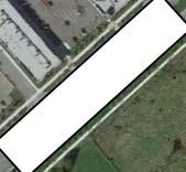
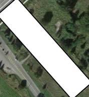
5 WELLINGS COMMUNITIES HOLDING INC AND EXTENDICARE (CANADA) INC HAZELDEAN ROAD TRANSPORTATION IMPACT STUDY MARCH 2016 Figure 1 Site Location Site Location 2
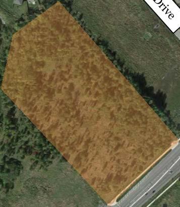
6 WELLINGS COMMUNITIES HOLDING INC AND EXTENDICARE (CANADA) INC HAZELDEAN ROAD TRANSPORTATION IMPACT STUDY MARCH 2016 Figure 2 Proposed Site Plan 3
7 WELLINGS COMMUNITIES HOLDING INC AND EXTENDICARE (CANADA) INC HAZELDEAN ROAD TRANSPORTATION IMPACT STUDY MARCH SCOPE OF THE ASSESSMENT This TIS has been carried out in accordance with the City of Ottawa s 2006 Transportation Impact Assessment (TIA) Guidelines. The scope of the transportation assessment was discussed with City of Ottawa Development Approvals staff and is outlined as follows: Study area intersections include: o o Hazeldean Road at Huntmar Drive / Iber Road; and Hazeldean Road at Fringewood Drive / Proposed Site Access. Study horizons include: o o o o 2016 existing conditions; 2017 future background conditions; 2017 total future conditions (total site build-out); and 2022 total future conditions (5 years beyond build-out). Analysis time periods include the weekday AM and PM peak hours. The methodology used in the TIS includes: The net increase in site traffic from the proposed development will be estimated; Background traffic growth will be accounted for using an annual growth rate of 2% as well as explicitly accounting for the nearby future Huntington Properties development at 5754 Hazeldean Road and the retail development at 20 Cedarow Court; Future background traffic volumes will be combined with the net increase in site traffic volumes to determine total future traffic volumes; Intersection analyses will be performed to determine the operating characteristics of the study area intersections under each study horizon; and Where operational deficiencies are identified mitigation measures will be examined. 4
8 WELLINGS COMMUNITIES HOLDING INC AND EXTENDICARE (CANADA) INC HAZELDEAN ROAD TRANSPORTATION IMPACT STUDY MARCH EXISTING TRANSPORTATION ENVIRONMENT 2.1 ROADS AND TRAFFIC CONTROL The roadways under consideration in the study area are described below: Hazeldean Road Huntmar Drive / Iber Road Fringewood Drive In the vicinity of the study area, Hazeldean Road is a fourlane urban arterial road with a 60 km/h posted speed limit. Sidewalks are provided along both side of Hazeldean Road. Huntmar Drive / Iber Road is a major collector road within the study area. South of Hazeldean Road, Iber Road has a two-lane cross-section and a posted speed limit of 60 km/h. North of Hazeldean Road, Huntmar Drive has a fourlane cross-section and a posted speed limit of 50 km/h. The intersection with Hazeldean Road is signalized and exclusive dual left turn lanes are provided in the eastbound and westbound directions. Fringewood Drive is a two-lane local road with a rural crosssection and a posted speed limit of 40 km/h. The intersection with Hazeldean Road is signalized and dedicated turning lanes are provided in the eastbound and westbound directions. The eastbound left and westbound right turn lanes are already in place in order to accommodate the future developments on the north side of Hazeldean Road (the subject development as well as the proposed development at 20 Cedarow Court). The road classifications noted above are referenced from Map 6 of the City of Ottawa s 2013 Transportation Master Plan. Figure 3 illustrates the 2016 existing intersection control and lane configuration for the study area intersections. 5
 Inc. 2016 Existing Intersection Control 5731 Hazeldean Road and Lane Configuration")
9 Site Access Huntmar Drive Hazeldean Road Fringewood Drive Iber Road Legend: Existing Constructed (Unopened) Wellings Communities Holding Inc Figure 3 and Extendicare (Canada) Inc Existing Intersection Control 5731 Hazeldean Road and Lane Configuration


10 WELLINGS COMMUNITIES HOLDING INC AND EXTENDICARE (CANADA) INC HAZELDEAN ROAD TRANSPORTATION IMPACT STUDY MARCH TRANSIT Transit service is provided throughout the study area via routes 92, 96, 201, 203, and 263. Route 92 and 96 are regular routes that run from Stittsville to St. Laurent station. Route 201 is a Monday only route that runs from Carlingwood Shopping Centre to the Village of Richmond. Route 203 is a Wednesday only route that runs from Carlingwood Shopping Centre to Dunrobin. Route 261 is a peak hour route that runs from Mackenzie King Station to Stittsville. Route 263 is also a peak hour route that runs from Mackenzie King Station to Stittsville. Figure 4 illustrates the study area transit routes. Figure 4 Study Area Transit Site Location (Source: OC Transpo System Map, accessed January 25 th, 2016) 2.3 WALKING AND CYCLING Within the surrounding community sidewalks are provided along the majority of the roads. Hazeldean Road and Huntmar Drive north of Hazeldean Road both currently have sidewalks along both sides of the road. In terms of cycling facilities, Hazeldean Road and Huntmar Drive north of Hazeldean Road both currently have a bicycle lane while Iber Road south of Hazeldean Road has paved shoulders. As 7


 2.")


11 WELLINGS COMMUNITIES HOLDING INC AND EXTENDICARE (CANADA) INC HAZELDEAN ROAD TRANSPORTATION IMPACT STUDY MARCH 2016 outlined in the City s Existing Cycling Network, Fringewood Drive is considered a suggested cycling route. Figure 5 illustrates the study area cycling routes and pathways. Figure 5 Study Area Cycling Routes and Pathways Site Location (Source: City of Ottawa geoottawa, accessed January 25 th, 2016) 2.4 TRAFFIC VOLUMES Traffic counts were provided by the City of Ottawa at the Hazeldean Road at Huntmar Drive / Iber Road intersection. As these traffic counts were collected in 2015, an annual rate of growth of 2% was applied to bring them to 2016 conditions. This background growth rate is consistent with previously completed Transportation Impact Assessments in the area. Traffic counts at the Hazeldean Road at Fringewood Drive intersection were undertaken by Stantec on Tuesday, January 26 th, Figure 6 illustrates 2016 existing AM and PM peak hour traffic volumes at the study area intersections. Appendix A contains the traffic data and is provided for reference. 8

12 AM Peak Hour Site Access Huntmar Drive Hazeldean Road Fringewood Drive Iber Road PM Peak Hour Site Access Huntmar Drive Hazeldean Road Fringewood Drive Iber Road Wellings Communities Holding Inc Figure 6 and Extendicare (Canada) Inc Existing Traffic Volumes 5731 Hazeldean Road
13 WELLINGS COMMUNITIES HOLDING INC AND EXTENDICARE (CANADA) INC HAZELDEAN ROAD TRANSPORTATION IMPACT STUDY MARCH FUTURE TRANSPORTATION ENVIRONMENT 3.1 FUTURE NETWORK UPGRADES Road Network Improvements Numerous transportation roadway improvements in the vicinity of the study area have been identified in the City of Ottawa s 2013 Transportation Master Plan (TMP) and are outlined in Table 1 below. Table Transportation Master Plan Scheduled Upgrades Project Description TMP Phase New two-lane road between Fernbank Road and Abbott Street E Phase 1 ( ) Stittsville North-South Arterial New two-lane road between Palladium Drive and Abbott Street E Phase 2 ( ) Transit signal priority and queue jump lanes at select intersections 2031 Affordable Network Huntmar Drive Widen from two to four lanes between Campeau Drive extension to Cyclone Taylor Boulevard. Widen from two to four lanes between Palladium Drive to Maple Grove Road Phase 3 ( ) Phase 3 ( ) Stittsville Main Street Extension New two-lane road between Palladium Drive and Maple Grove Road Phase 3 ( ) Hazeldean Road Transit signal priority and queue jump lanes between Stittsville Main Street and Eagleson Road 2031 Affordable Network Fernbank Road Widen from two to four lanes between Stittsville Main Street and Terry Fox Drive Beyond 2031 Maple Grove Road Widen from two to four lanes between Terry Fox Drive and Huntmar Drive Beyond 2031 Terry Fox Drive Widen from two to four lanes between Winchester Drive and Eagleson Road Widen from four to six lanes between Campeau Drive and Palladium Drive Beyond 2031 Beyond
14 WELLINGS COMMUNITIES HOLDING INC AND EXTENDICARE (CANADA) INC HAZELDEAN ROAD TRANSPORTATION IMPACT STUDY MARCH 2016 None of the improvements outlined above have a direct impact on the study area intersections assessed as part of this study. 3.2 FUTURE BACKGROUND DEVELOPMENTS Huntington Properties Hazeldean Road Located on the south eastern quadrant of the Hazeldean Road at Fringewood Drive intersection, this proposed development consists of approximately 76,000 ft 2 of retail space, 59,200 ft 2 of office space, 11,500 ft 2 of pharmacy space, and 5,000 ft 2 of medical uses. The Traffic Impact Study (Delcan 2013) that was completed for this development estimated that it will generate approximately 269 auto trips during the AM peak hour and 447 auto trips during the PM peak hour. As this development is not currently constructed, these trips were added to the roadway network as background trips according to the distribution set forth in the aforementioned 2013 TIS. 20 Cedarow Road Located on the north western quadrant of the Hazeldean Road at Fringewood Drive intersection, this proposed development consists of approximately 61,000 ft 2 of retail space. The Traffic Impact Study (Novatech 2009) that was completed for this development estimated that it will generate 327 auto trips during the PM peak hour and 373 auto trips during the Saturday peak hour. Through discussions with City of Ottawa staff, it is noted that this development is expected to be built by 2017, and as such, these trips were added to the roadway network as background trips according to the distribution set forth in the aforementioned 2009 TIS. The 20 Cedarow Road development will share the proposed new north leg of the Hazeldean Road at Fringewood Drive intersection with the subject development FUTURE BACKGROUND CONDITIONS Future background conditions are assessed to determine transportation improvements that may be required to address traffic growth exclusive from improvements that may be required to accommodate traffic generated by the subject development. Any improvements identified to address future background conditions are not attributed to the subject development. To account for future background growth an annual growth rate of 2% was applied to all movements at the study area intersections. This growth rate is consistent with previously completed traffic studies in the area. In addition to the growth rate, the traffic generated by the two future developments were added to the roadway network, as outlined in Section 3.2. Figure 7 illustrates 2017 future background traffic volumes at the study area intersections. An assessment of 2017 future background traffic conditions is outlined in Section

15 AM Peak Hour Site Access Huntmar Drive Hazeldean Road Fringewood Drive Iber Road PM Peak Hour Site Access Huntmar Drive Hazeldean Road Fringewood Drive Iber Road Wellings Communities Holding Inc Figure 7 and Extendicare (Canada) Inc Future Background Traffic 5731 Hazeldean Road Volumes
16 WELLINGS COMMUNITIES HOLDING INC AND EXTENDICARE (CANADA) INC HAZELDEAN ROAD TRANSPORTATION IMPACT STUDY MARCH SITE TRAFFIC GENERATION Land Use and Trip Generation Rates The Institute of Transportation Engineers (ITE) Trip Generation Manual (9 th Edition) was used to estimate traffic generated by the subject site. The ITE land use codes that were used are 254 Assisted Living, 253 Congregate Care Facility, 826 Specialty Retail Center, and 710 General Office Building. Table 2 summarizes the average trip rates obtained from the ITE Trip Generation Manual and the ensuing sections describe the methodology used to convert these trips to person trips across all modes. Table 2 Trips Generated by the Proposed Residential Development Step 1: ITE Trip Generation Rates 1000 s GFA / # Units Morning Peak Hour Afternoon Peak Hour In Out Total In Out Total 254 Assisted Living % 35% % 56% Congregate Care Facility % 41% % 45% Specialty Retail Center 17 N/A N/A N/A 44% 56% General Office Building 16 88% 12% % 83% 1.49 Step 2: Auto Trips Generated 254 Assisted Living Senior Adult Housing Shopping Centre General Office Building Step 3: Conversion From Auto Trips to Person Trips Trip Gen (ITE) Total Development Transit Share 10% Auto Occupancy Step 4: Person Trips by Modal Share Total Person Trips Total Development Auto 60% Passenger 10% Transit 25% Walk / Bike Neg Other 5%
17 WELLINGS COMMUNITIES HOLDING INC AND EXTENDICARE (CANADA) INC HAZELDEAN ROAD TRANSPORTATION IMPACT STUDY MARCH Conversion of ITE Rates to Person Trips The notion of quantifying the volume of person trips expected to be generated by a given development is becoming a commonly accepted practice. It is aimed at quantifying the expected demands across the primary modes of transportation. In order to convert ITE rates to person trips, the rates obtained from the ITE Trip Generation Manual were adjusted to account for an inherent transit modal share and auto occupancy. An assumed transit share of 10% was thought to be inherent within the ITE rates and an auto occupancy rate of 1.1 persons per vehicle was also assumed to be inherent within the ITE rates. Step 3 of Table 2 outlines the conversion from auto trips to person trips Net New Site Trips The person trips were then assigned to the four primary modal shares (i.e. auto, passenger, transit, and active modes) according to local modal share characteristics as documented in the TRANS Committee s 2011 Origin-Destination (O-D) Survey for the Kanata / Stittsville District. The proposed development is anticipated to generate approximately 86 person trips during the AM peak hour and 187 person trips during the PM peak hour. In terms of vehicle trips, the proposed development is anticipated to generate 52 net new auto trips (two-way) during the AM peak hour and 111 net new auto trips (two-way) during the PM peak hour. Step 4 of Table 2 summarizes the expected person trips by modal share Traffic Distribution and Assignment The distribution of traffic to / from the study area was determined through examination of the existing volumes at the study area intersections, previously completed Transportation Impact Assessments within the study area, as well as our knowledge of the surrounding environment. Two distributions were used; one for the retail component and one for the office component. As the majority of the cars generated by the assisted living and congregate care facilities during the roadway peak hours are attributed to staff, these two land uses closely reflect the traffic patterns exhibited by office land uses, and thus were distributed according to the office distribution. Table 3 provides a summary of the estimated distribution of traffic generated by the proposed development. The anticipated site traffic generated by the proposed development was assigned to the boundary road network using a logical pattern of primary roads (i.e. along arterials and collectors). Figure 8 illustrates the anticipated site traffic generated by the proposed development. 14
18 WELLINGS COMMUNITIES HOLDING INC AND EXTENDICARE (CANADA) INC HAZELDEAN ROAD TRANSPORTATION IMPACT STUDY MARCH 2016 Table 3 Traffic Distribution to / from the Kanata and Stittsville District Cardinal Direction Retail Office North 20% 70% East 40% 20% South Neg. Neg. West 40% 10% Total 100% 100% 15
19 AM Peak Hour Site Access in 37 out 15 Huntmar Drive Hazeldean Road 8 Fringewood Drive Iber Road PM Peak Hour Site Access in 46 out 65 Huntmar Drive Hazeldean Road 34 Fringewood Drive Iber Road Wellings Communities Holding Inc Figure 8 and Extendicare (Canada) Inc. Site Traffic Volumes 5731 Hazeldean Road
20 WELLINGS COMMUNITIES HOLDING INC AND EXTENDICARE (CANADA) INC HAZELDEAN ROAD TRANSPORTATION IMPACT STUDY MARCH TOTAL FUTURE CONDITIONS Total future conditions are examined to determine improvements that may be required as a direct result of the development of the site. It is anticipated that by 2017 the development will be fully built and occupied. The 2017 total future traffic volumes were derived by adding the projected site generated trips to future background volumes anticipated for Figure 9 illustrates 2017 total future traffic volumes at the study area intersections during the AM and PM peak hours. An assessment of 2017 total future traffic conditions is outlined in Section
21 AM Peak Hour Site Access Huntmar Drive Hazeldean Road Fringewood Drive Iber Road PM Peak Hour Site Access Huntmar Drive Hazeldean Road Fringewood Drive Iber Road Wellings Communities Holding Inc Figure 9 and Extendicare (Canada) Inc Total Future Traffic 5731 Hazeldean Road Volumes
22 WELLINGS COMMUNITIES HOLDING INC AND EXTENDICARE (CANADA) INC HAZELDEAN ROAD TRANSPORTATION IMPACT STUDY MARCH ULTIMATE CONDITIONS Ultimate conditions for the 2022 horizon were examined to determine if other improvements may be required due to further growth in background traffic volumes 5 years beyond the development of the subject site. The 2022 ultimate traffic volumes were derived by adding five years of background growth to the 2017 total future traffic volumes using the background growth rate assumptions outlined in Section 3.3. Figure 10 illustrates 2022 ultimate traffic volume at the study area intersections during the AM and PM peak hours. An assessment of 2022 ultimate traffic conditions is outlined in Section
23 AM Peak Hour Site Access Huntmar Drive Hazeldean Road Fringewood Drive Iber Road PM Peak Hour Site Access Huntmar Drive Hazeldean Road Fringewood Drive Iber Road Wellings Communities Holding Inc Figure 10 and Extendicare (Canada) Inc Ultimate Traffic Volumes 5731 Hazeldean Road
24 WELLINGS COMMUNITIES HOLDING INC AND EXTENDICARE (CANADA) INC HAZELDEAN ROAD TRANSPORTATION IMPACT STUDY MARCH TRANSPORTATION ASSESSMENT EXISTING CONDITIONS Figure 3 (Section 2.1) illustrates the 2016 existing intersection controls and lane configuration at the study area intersections Intersection Operational Analysis An assessment of the study area intersections was undertaken to determine their operational characteristics. Intersection operations were analyzed using the Highway Capacity Manual 2000 edition (HCM 2000) methodologies and facilitated with Synchro 9.0 TM software. Table 4 provides a summary of 2016 existing intersection operations. Using the City s existing signal timing plans, both signalized intersections operate acceptably; therefore, no improvements are required to supplement existing conditions. Appendix B contains detailed intersection performance worksheets. 21
25 WELLINGS COMMUNITIES HOLDING INC AND EXTENDICARE (CANADA) INC HAZELDEAN ROAD TRANSPORTATION IMPACT STUDY MARCH 2016 Table Existing Signalized Intersection Operations Signalized Intersections Hazeldean Road at Huntmar Drive / Iber Road Hazeldean Road at Fringewood Drive Approach/Movement EB WB NB SB 2016 Existing Conditions LOS V/C 2 Q 3 (m) Left A (A) 0.39 (0.58) 12.5 (24.8) Through / Right A (A) 0.43 (0.52) 66.4 (100.1) Left A (C) 0.51 (0.71) 27.4 (57.9) Through A (C) 0.30 (0.71) 52.9 (#164.6) Right A (A) 0.05 (0.09) 0.0 (9.8) Left A (A) 0.34 (0.44) 22.5 (31.8) Through A (B) 0.52 (0.68) 43.1 (60.5) Right A (A) 0.28 (0.19) 27.0 (22.6) Left B (C) 0.70 (0.72) 39.8 (42.9) Through A (A) 0.48 (0.52) 40.1 (47.7) Right A (A) 0.09 (0.17) 10.0 (21.5) Overall Intersection A (C) 0.53 (0.74) - EB Through / Right A (A) 0.39 (0.38) 57.6 (62.4) WB NB Left A (A) 0.12 (0.29) 1.5 (m5.2) Through A (A) 0.23 (0.50) 6.1 (23.0) Left A (A) 0.31 (0.44) 17.7 (22.6) Right A (A) 0.07 (0.05) 15.9 (13.7) Overall Intersection A (A) 0.39 (0.52) - 1. Table Format: AM (PM) 2. v/c represents the anticipated volume divided by the predicted capacity th Percentile Queue (m) 4. # - 95 th percentile volume exceeds capacity, queue may be longer 5. m - Volume for 95 th percentile queue is metered by upstream signal 22
26 WELLINGS COMMUNITIES HOLDING INC AND EXTENDICARE (CANADA) INC HAZELDEAN ROAD TRANSPORTATION IMPACT STUDY MARCH FUTURE BACKGROUND CONDITIONS Future background conditions for the 2017 horizon were assessed to determine transportation improvements that may be required to address growth in traffic exclusive from improvements that may be required to accommodate traffic generated by the proposed development. The background development assumptions outlined in Section 3.3 were applied to existing traffic volumes to predict 2017 future background traffic volumes. Figure 11 illustrates the 2017 future background intersection control and lane configuration for the study area intersections Intersection Operational Analysis Table 5 summarizes the operational characteristics of the study area intersections under 2017 future background conditions. Network offsets and cycle lengths were optimized for the 2017 future background condition. Both study area intersections are expected to operate acceptably, and as such, no improvements are required to accommodate the projected 2017 future background traffic volumes. Appendix B contains detailed intersection performance worksheets. 23
27 WELLINGS COMMUNITIES HOLDING INC AND EXTENDICARE (CANADA) INC HAZELDEAN ROAD TRANSPORTATION IMPACT STUDY MARCH 2016 Table Future Background Intersection Operations Signalized Intersections Hazeldean Road at Huntmar Drive / Iber Road Hazeldean Road at Fringewood Drive Approach/Movement EB WB NB SB 2017 Future Background LOS V/C Q 2 (m) Left A (B) 0.35 (0.62) 18.8 (45.6) Through / Right A (B) 0.48 (0.61) 31.4 (142.5) Left A (C) 0.50 (0.77) 28.2 (#73.9) Through A (C) 0.37 (0.80) 57.6 (#233.6) Right A (A) 0.04 (0.08) 0.0 (12.4) Left A (A) 0.36 (0.53) 21.2 (42.2) Through A (C) 0.49 (0.75) 43.4 (91.9) Right A (A) 0.20 (0.19) 28.9 (32.1) Left A (C) 0.53 (0.71) 34.8 (#43.8) Through B (A) 0.64 (0.51) 56.4 (62.2) Right A (A) 0.09 (0.17) 7.5 (30.2) Overall Intersection A (D) 0.57 (0.81) - EB WB NB SB Left A (A) 0.00 (0.27) 0.0 (21.3) Through / Right A (A) 0.39 (0.41) 72.2 (90.6) Left A (A) 0.18 (0.40) 8.1 (m42.8) Through A (A) 0.21 (0.50) 24.6 (208.8) Right A (A) 0.00 (0.05) 0.0 (m9.0) Left A (B) 0.46 (0.63) 27.2 (42.8) Through / Right A (A) 0.07 (0.09) 0.0 (19.6) Left A (A) 0.00 (0.60) 0.0 (38.4) Through / Right A (A) 0.00 (0.04) 0.0 (10.1) Overall Intersection A (A) 0.40 (0.55) - 1. Table Format: AM (PM) 2. v/c represents the anticipated volume divided by the predicted capacity th Percentile Queue (m) 4. # - 95 th percentile volume exceeds capacity, queue may be longer 5. m - Volume for 95 th percentile queue is metered by upstream signal 24
28 Site Access Huntmar Drive Hazeldean Road Fringewood Drive Iber Road Wellings Communities Holding Inc Figure 11 and Extendicare (Canada) Inc Future Background Intersection 5731 Hazeldean Road Control and Lane Configuration
29 WELLINGS COMMUNITIES HOLDING INC AND EXTENDICARE (CANADA) INC HAZELDEAN ROAD TRANSPORTATION IMPACT STUDY MARCH TOTAL FUTURE CONDITIONS Total future conditions are assessed to determine transportation improvements that may be required to accommodate traffic generated by the proposed development. The site trip generation, distribution, and assignment assumptions outlined in Section 3.4 were applied to 2017 future background traffic volumes to predict 2017 total future traffic volumes Intersection Operational Analysis Table 6 summarizes the operational characteristics of the study area intersections under 2017 total future conditions. Network offsets and cycle lengths were optimized for the 2017 total future condition. Both study area intersections are expected to operate acceptably, and as such, no improvements are required to accommodate the projected 2017 total future traffic volumes. Appendix B contains detailed intersection performance worksheets Site Access Configuration The recommended lane configuration for the southbound approach to the Hazeldean Road at Fringewood Drive / Site Access intersection includes a three-lane cross-section featuring one inbound lane and two outbound lanes. The two outbound lanes include an exclusive left turn lane and a shared through/right turn lane. The southbound left turn queues (95 th percentile queues) at the site access are anticipated to extend to approximately 60m during the PM peak hour. With the proposed internal access to the subject lands located roughly 68m north of Hazeldean Road, the projected storage demands are not expected to block the internal access. As the southbound approach to this intersection will be a private approach, the taper length of the southbound left turn lane can be reduced from typical standards that would normally be applied to municipal roads. A taper length of 20 to 30 metres would likely be sufficient and this can be confirmed during design. 26
30 WELLINGS COMMUNITIES HOLDING INC AND EXTENDICARE (CANADA) INC HAZELDEAN ROAD TRANSPORTATION IMPACT STUDY MARCH 2016 Table Total Future Intersection Operations Signalized Intersections Hazeldean Road at Huntmar Drive / Iber Road Hazeldean Road at Fringewood Drive / Site Access Approach/Movement EB WB NB SB 2017 Future Background LOS V/C Q 2 (m) Left A (B) 0.36 (0.65) 24.0 (46.7) Through / Right A (B) 0.49 (0.63) 62.6 (#150.1) Left A (C) 0.50 (0.77) 28.2 (#74.4) Through A (D) 0.39 (0.82) 59.7 (#240.8) Right A (A) 0.04 (0.08) 0.0 (12.4) Left A (A) 0.36 (0.53) 21.2 (42.2) Through A (C) 0.49 (0.75) 43.4 (91.9) Right A (A) 0.20 (0.19) 28.9 (32.1) Left A (C) 0.53 (0.71) 34.8 (#43.8) Through B (A) 0.64 (0.51) 56.4 (62.2) Right A (A) 0.10 (0.17) 10.2 (29.3) Overall Intersection A (D) 0.57 (0.82) - EB WB NB SB Left A (A) 0.01 (0.33) 1.9 (28.1) Through / Right A (A) 0.42 (0.43) 71.7 (102.1) Left A (A) 0.19 (0.44) 4.6 (m4.5) Through A (A) 0.22 (0.53) 4.8 (m180.1) Right A (A) 0.02 (0.07) m0.2 (m0.0) Left A (A) 0.46 (0.48) 22.7 (40.2) Through / Right A (A) 0.11 (0.08) 18.9 (18.4) Left A (C) 0.13 (0.72) 8.1 (55.5) Through / Right A (A) 0.04 (0.04) 5.1 (11.6) Overall Intersection A (A) 0.43 (0.60) - 1. Table Format: AM (PM) 2. v/c represents the anticipated volume divided by the predicted capacity th Percentile Queue (m) 4. # - 95 th percentile volume exceeds capacity, queue may be longer 5. m - Volume for 95 th percentile queue is metered by upstream signal 27
31 WELLINGS COMMUNITIES HOLDING INC AND EXTENDICARE (CANADA) INC HAZELDEAN ROAD TRANSPORTATION IMPACT STUDY MARCH ULTIMATE CONDITIONS Ultimate future conditions for the 2022 horizon were examined to determine if other improvements may be required due to growth in background traffic volumes 5 years beyond the anticipated build-out horizon of the site. The difference between 2022 ultimate conditions and 2017 total future conditions is 5 years of additional background growth consistent with the growth assumptions outlined in Section 3.3. As such, any improvements required to accommodate 2022 ultimate conditions are not attributed to the subject development Intersection Operational Analysis Table 7 summarizes the operational characteristics of the study area intersections under 2022 ultimate conditions. Network offsets and cycle lengths were optimized for the 2022 ultimate condition. Both study area intersections are expected to operate acceptably, and as such, no improvements are required to accommodate the projected 2022 ultimate traffic volumes. Appendix B contains detailed intersection operation summaries. 28
32 WELLINGS COMMUNITIES HOLDING INC AND EXTENDICARE (CANADA) INC HAZELDEAN ROAD TRANSPORTATION IMPACT STUDY MARCH 2016 Table Ultimate Intersection Operations Signalized Intersections Hazeldean Road at Huntmar Drive / Iber Road Hazeldean Road at Fringewood Drive / Site Access Approach/Movement EB WB NB SB 2017 Future Background LOS V/C Q 2 (m) Left A (B) 0.39 (0.67) 22.8 (49.8) Through / Right A (C) 0.54 (0.71) 36.6 (#169.4) Left A (C) 0.54 (0.79) 30.9 (#87.7) Through A (E) 0.44 (0.91) 64.4 (#271.5) Right A (A) 0.05 (0.09) 0.0 (15.5) Left A (A) 0.39 (0.57) 22.9 (44.8) Through A (C) 0.50 (0.77) 46.0 (97.8) Right A (A) 0.29 (0.21) 36.3 (34.2) Left A (C) 0.59 (0.79) 38.0 (#54.7) Through B (A) 0.65 (0.53) 58.9 (66.8) Right A (A) 0.11 (0.17) 12.6 (29.2) Overall Intersection B (D) 0.62 (0.89) - EB WB NB SB Left A (A) 0.01 (0.38) 1.9 (31.5) Through / Right A (A) 0.47 (0.48) 82.5 (116.0) Left A (A) 0.22 (0.49) 6.5 (m6.4) Through A (A) 0.25 (0.58) 11.2 (m183.1) Right A (A) 0.02 (0.07) m0.8 (m0.0) Left A (A) 0.42 (0.51) 23.6 (41.7) Through / Right A (A) 0.11 (0.09) 19.5 (19.2) Left A (C) 0.12 (0.72) 8.0 (55.5) Through / Right A (A) 0.03 (0.04) 5.1 (11.6) Overall Intersection A (B) 0.47 (0.64) - 1. Table Format: AM (PM) 2. v/c represents the anticipated volume divided by the predicted capacity th Percentile Queue (m) 4. # - 95 th percentile volume exceeds capacity, queue may be longer 5. m - Volume for 95 th percentile queue is metered by upstream signal 29
33 WELLINGS COMMUNITIES HOLDING INC AND EXTENDICARE (CANADA) INC HAZELDEAN ROAD TRANSPORTATION IMPACT STUDY MARCH SUMMARY AND CONCLUSIONS Proposed Development The proposed development is located in the City of Ottawa s Stittsville community and includes a long term care building, a retirement home, and office / retail space. The proposed site is bound by Hazeldean Road to the south, Poole Creek to the north, and greenspace to the east and west. The proposed long term care building will include 256 suites, the retirement home will include 185 suites, the office space will include 17,000 gross floor area (GFA), and the retail space will include 16,000 GFA. The final total number of units and GFA, however, may be subject to minor change as the development approvals process proceeds. The proposed development is anticipated to generate approximately 86 person trips during the AM peak hour and 187 person trips during the PM peak hour. In terms of vehicle trips, the proposed residential development is anticipated to generate 52 net new auto trips (two-way) during the AM peak hour and 111 net new auto trips (two-way) during the PM peak hour Existing Conditions Operationally, both study area intersections operate satisfactorily, and as such, no improvements are required to supplement existing conditions Future Background Conditions Operationally, both study area intersections are expected to operate satisfactorily under 2017 future background conditions. No improvements are required to accommodate the projected 2017 future background traffic volumes Total Future Conditions Operationally, both study area intersections are expected to operate satisfactorily under 2017 total future conditions. No improvements are required to accommodate the projected 2017 total future traffic volumes. The recommended lane configuration for the southbound approach to the Hazeldean Road at Fringewood Drive / Site Access intersections includes a three-lane cross-section featuring one inbound lane and two outbound lanes. The two outbound lanes include an exclusive left turn lane and a shared through/right turn lane. 30
 at")


 Inc.")
34 WELLINGS COMMUNITIES HOLDING INC AND EXTENDICARE (CANADA) INC HAZELDEAN ROAD TRANSPORTATION IMPACT STUDY MARCH 2016 The southbound left turn queues (95 th percentile queues) at the site access are anticipated to extend to approximately 60m during the PM peak hour. With the proposed internal access to the subject lands located roughly 68m north of Hazeldean Road, the projected storage demands are not expected to block the internal access. As the southbound approach to this intersection will be a private approach, the taper length of the southbound left turn lane can be reduced from typical standards that would normally be applied to municipal roads. A taper length of 20 to 30 metres would likely be sufficient and this can be confirmed during design Ultimate Conditions Operationally, both study area intersections are expected to operate satisfactorily under 2022 ultimate conditions. No improvements are required to accommodate the projected 2022 ultimate traffic volumes. Based on the transportation evaluation and the negligible impacts that have been identified in this Transportation Impact Assessment, Wellings Communities Holding Inc and Extendicare (Canada) Inc. s proposed 5731 Hazeldean Road development should be permitted to proceed from a transportation perspective. STANTEC CONSULTING LTD. ***** Robert Vastag, RPP Project Manager, Senior Transportation Planner Lauren O Grady, B.A.Sc. Transportation Engineering Intern 31
35 WELLINGS COMMUNITIES HOLDING INC AND EXTENDICARE (CANADA) INC HAZELDEAN ROAD TRANSPORTATION IMPACT STUDY MARCH 2016 Appendix A Traffic Data
36 Public Works - Traffic Services Turning Movement Count - Full Study Peak Hour Diagram HAZELDEAN IBER RD Survey Date: Start Time: Thursday, July 23, 2015 WO No: :00 Device: Jamar Technologies, Inc IBER RD N W E Total Heavy Vehicles Cars S 3 HAZELDEAN RD AM Period Peak Hour: :30 09: Cars Heavy Vehicles Total Comments 2016-Jan-25 Page 1 of 3
37 Public Works - Traffic Services Turning Movement Count - Full Study Peak Hour Diagram HAZELDEAN IBER RD Survey Date: Start Time: Thursday, July 23, 2015 WO No: :00 Device: Jamar Technologies, Inc IBER RD N W E Total Heavy Vehicles Cars S 0 HAZELDEAN RD MD Period Peak Hour: :30 12: Cars Heavy Vehicles Total Comments 2016-Jan-25 Page 2 of 3
38 Public Works - Traffic Services Turning Movement Count - Full Study Peak Hour Diagram HAZELDEAN IBER RD Survey Date: Start Time: Thursday, July 23, 2015 WO No: :00 Device: Jamar Technologies, Inc IBER RD N W E Total Heavy Vehicles Cars S 13 HAZELDEAN RD PM Period Peak Hour: :00 17: Cars Heavy Vehicles Total Comments 2016-Jan-25 Page 3 of 3
39 Stantec counts taken on January Hazeldean at Fringewood NBL NBT NBR SBL SBT SBR EBL EBT EBR WBL WBT WBR 8:15 8: :30 8: :45 9: :00 9: :15 9: :30 9: AM Peak Hour :45 4: :00 4: :15 4: :30 4: :45 5: :00 5: PM Peak Hour
40 WELLINGS COMMUNITIES HOLDING INC AND EXTENDICARE (CANADA) INC HAZELDEAN ROAD TRANSPORTATION IMPACT STUDY MARCH 2016 Appendix B Intersection Performance Worksheets
41 WELLINGS COMMUNITIES HOLDING INC AND EXTENDICARE (CANADA) INC HAZELDEAN ROAD TRANSPORTATION IMPACT STUDY MARCH 2016 B EXISTING CONDITIONS
42 Lanes, Volumes, Timings 5731 Hazeldean Road 1: Iber Road/Huntmar Drive & Hazeldean Road 2016 Existing AM Lane Group EBL EBT EBR WBL WBT WBR NBL NBT NBR SBL SBT SBR Lane Configurations Volume (vph) Ideal Flow (vphpl) Storage Length (m) Storage Lanes Taper Length (m) Lane Util. Factor Frt Flt Protected Satd. Flow (prot) Flt Permitted Satd. Flow (perm) Right Turn on Red Yes Yes Yes Yes Satd. Flow (RTOR) Link Speed (k/h) Link Distance (m) Travel Time (s) Peak Hour Factor Adj. Flow (vph) Shared Lane Traffic (%) Lane Group Flow (vph) Enter Blocked Intersection No No No No No No No No No No No No Lane Alignment Left Left Right Left Left Right Left Left Right Left Left Right Median Width(m) Link Offset(m) Crosswalk Width(m) Two way Left Turn Lane Headway Factor Turning Speed (k/h) Number of Detectors Detector Template Left Thru Left Thru Right Left Thru Right Left Thru Right Leading Detector (m) Trailing Detector (m) Detector 1 Position(m) Detector 1 Size(m) Detector 1 Type Cl+Ex Cl+Ex Cl+Ex Cl+Ex Cl+Ex Cl+Ex Cl+Ex Cl+Ex Cl+Ex Cl+Ex Cl+Ex Detector 1 Channel Detector 1 Extend (s) Detector 1 Queue (s) Detector 1 Delay (s) Detector 2 Position(m) Detector 2 Size(m) Detector 2 Type Cl+Ex Cl+Ex Cl+Ex Cl+Ex Detector 2 Channel Detector 2 Extend (s) Turn Type Prot NA Prot NA Perm Perm NA Perm Perm NA Perm Protected Phases Permitted Phases Detector Phase Stantec Consulting Ltd. Page 1 Lanes, Volumes, Timings 5731 Hazeldean Road 1: Iber Road/Huntmar Drive & Hazeldean Road 2016 Existing AM Lane Group ø5 ø13 Lane Configurations Volume (vph) Ideal Flow (vphpl) Storage Length (m) Storage Lanes Taper Length (m) Lane Util. Factor Frt Flt Protected Satd. Flow (prot) Flt Permitted Satd. Flow (perm) Right Turn on Red Satd. Flow (RTOR) Link Speed (k/h) Link Distance (m) Travel Time (s) Peak Hour Factor Adj. Flow (vph) Shared Lane Traffic (%) Lane Group Flow (vph) Enter Blocked Intersection Lane Alignment Median Width(m) Link Offset(m) Crosswalk Width(m) Two way Left Turn Lane Headway Factor Turning Speed (k/h) Number of Detectors Detector Template Leading Detector (m) Trailing Detector (m) Detector 1 Position(m) Detector 1 Size(m) Detector 1 Type Detector 1 Channel Detector 1 Extend (s) Detector 1 Queue (s) Detector 1 Delay (s) Detector 2 Position(m) Detector 2 Size(m) Detector 2 Type Detector 2 Channel Detector 2 Extend (s) Turn Type Protected Phases 5 13 Permitted Phases Detector Phase Stantec Consulting Ltd. Page 2
43 Lanes, Volumes, Timings 5731 Hazeldean Road 1: Iber Road/Huntmar Drive & Hazeldean Road 2016 Existing AM Lane Group EBL EBT EBR WBL WBT WBR NBL NBT NBR SBL SBT SBR Switch Phase Minimum Initial (s) Minimum Split (s) Total Split (s) Total Split (%) 45.5% 14.5% 34.5% 34.5% 40.0% 40.0% 40.0% 40.0% 40.0% 40.0% Maximum Green (s) Yellow Time (s) All-Red Time (s) Lost Time Adjust (s) Total Lost Time (s) Lead/Lag Lag Lead Lag Lag Lead-Lag Optimize? Vehicle Extension (s) Recall Mode C-Min None C-Min C-Min None None None None None None Walk Time (s) Flash Dont Walk (s) Pedestrian Calls (#/hr) Act Effct Green (s) Actuated g/c Ratio v/c Ratio Control Delay Queue Delay Total Delay LOS B B D C A D D B E D A Approach Delay Approach LOS B C C D Area Type: Other Cycle Length: 110 Actuated Cycle Length: 110 Offset: 33 (30%), Referenced to phase 2:EBT and 6:WBT, Start of Green Natural Cycle: 75 Control Type: Actuated-Coordinated Maximum v/c Ratio: 0.70 Intersection Signal Delay: 23.2 Intersection LOS: C Intersection Capacity Utilization 64.3% ICU Level of Service C Analysis Period (min) 15 Splits and Phases: 1: Iber Road/Huntmar Drive & Hazeldean Road Stantec Consulting Ltd. Page 3 Lanes, Volumes, Timings 5731 Hazeldean Road 1: Iber Road/Huntmar Drive & Hazeldean Road 2016 Existing AM Lane Group ø5 ø13 Switch Phase Minimum Initial (s) Minimum Split (s) Total Split (s) Total Split (%) 15% 11% Maximum Green (s) Yellow Time (s) All-Red Time (s) Lost Time Adjust (s) Total Lost Time (s) Lead/Lag Lead Lead-Lag Optimize? Vehicle Extension (s) Recall Mode None None Walk Time (s) Flash Dont Walk (s) Pedestrian Calls (#/hr) Act Effct Green (s) Actuated g/c Ratio v/c Ratio Control Delay Queue Delay Total Delay LOS Approach Delay Approach LOS Stantec Consulting Ltd. Page 4
44 Queues 5731 Hazeldean Road 1: Iber Road/Huntmar Drive & Hazeldean Road 2016 Existing AM Lane Group EBL EBT WBL WBT WBR NBL NBT NBR SBL SBT SBR Lane Group Flow (vph) v/c Ratio Control Delay Queue Delay Total Delay Queue Length 50th (m) Queue Length 95th (m) Internal Link Dist (m) Turn Bay Length (m) Base Capacity (vph) Starvation Cap Reductn Spillback Cap Reductn Storage Cap Reductn Reduced v/c Ratio Stantec Consulting Ltd. Page 5 HCM Signalized Intersection Capacity Analysis 5731 Hazeldean Road 1: Iber Road/Huntmar Drive & Hazeldean Road 2016 Existing AM Movement EBL EBT EBR WBL WBT WBR NBL NBT NBR SBL SBT SBR Lane Configurations Volume (vph) Ideal Flow (vphpl) Total Lost time (s) Lane Util. Factor Frt Flt Protected Satd. Flow (prot) Flt Permitted Satd. Flow (perm) Peak-hour factor, PHF Adj. Flow (vph) RTOR Reduction (vph) Lane Group Flow (vph) Turn Type Prot NA Prot NA Perm Perm NA Perm Perm NA Perm Protected Phases Permitted Phases Actuated Green, G (s) Effective Green, g (s) Actuated g/c Ratio Clearance Time (s) Vehicle Extension (s) Lane Grp Cap (vph) v/s Ratio Prot 0.06 c0.25 c0.05 c v/s Ratio Perm c v/c Ratio Uniform Delay, d Progression Factor Incremental Delay, d Delay (s) Level of Service C B D B B D D D E D D Approach Delay (s) Approach LOS B C D D HCM 2000 Control Delay 28.2 HCM 2000 Level of Service C HCM 2000 Volume to Capacity ratio 0.53 Actuated Cycle Length (s) Sum of lost time (s) 25.5 Intersection Capacity Utilization 64.3% ICU Level of Service C Analysis Period (min) 15 c Critical Lane Group Stantec Consulting Ltd. Page 6
Provide an overview of the development proposal including projected site traffic volumes;
 December 19, 2013 File: 163600935 Attention: Troy Elliott Carl Elliott Limited 15-1831 Robertson Road PO Box 11117 Nepean, Ontario K1H 7T8 Dear Mr. Elliott, Reference: 2235 and 2265 Robertson Road Transportation
Re: Cyrville Road Car Dealership
 1223 Michael Street, Suite 100, Ottawa, ON K1J 7T2 Tel: 613.738.4160 Fax: 613.739.7105 www.delcan.com February 25, 2013 OUR REF: TO3098TOE Mark Motors of Ottawa 611 Montreal Road Ottawa, ON K1K 0T8 Attention:
886 March Road McDonald's Transportation Study
 McDonald's Restaurants of Canada Limited March 2013 886 March Road McDonald's Transportation Study Submitted by: HDR Corporation 100 York Boulevard, Suite 300 Richmond Hill, ON L4B 1J8 (905) 882-4100 www.hdrinc.com
 Traffic Analysis For Approved Uses within the St. Lucie West DRI Aldi Port St. Lucie, FL Prepared for: Bohler Engineering, LLC 1000 Corporate Drive Suite 250 Fort Lauderdale, FL 33334 Prepared by: 10795
Re: Residential Development - Ogilvie/Cummings Transportation Overview
 1223 Michael Street, Suite 100, Ottawa, ON K1J 7T2 Tel: 613.738.4160 Fax: 613.739.7105 www.delcan.com March 28, 2012 OUR REF: TO3088TOY Barry J. Hobin & Architects 63 Pamilla Street Ottawa, ON K1S 3K7
LOST LAKE CORRIDOR REVIEW
 LOST LAKE CORRIDOR REVIEW Prepared for: Prepared by: Broadview Developments Inc. c/o Westbrook Consulting Watt Consulting Group Our File: 2064.B01 Date: October 31, 2016 TABLE OF CONTENTS 1.0 INTRODUCTION...
Village of Richmond Transportation Brief
 Village of Richmond Transportation Brief GENIVAR Project Number 111-18482-00 June 21 st, 2011 www.genivar.com GENIVAR 15 Fitzgerald Road, Suite 100 Ottawa, Ontario, CANADA K2H 9G1 Telephone: 613-829-2800
Barrhaven Honda Dealership. Dealership Drive, Ottawa, ON. Transportation Brief
 Barrhaven Honda Dealership Dealership Drive, Ottawa, ON Transportation Brief Prepared By: NOVATECH Suite 200, 240 Michael Cowpland Drive Ottawa, Ontario K2M 1P6 September, 2015 File: 115136 Ref: R-2015-152
Traffic Impact Analysis Farmington Center Village
 Traffic Impact Analysis Farmington Center Village Route 4 (Farmington Avenue) Farmington, Connecticut Prepared for: The Town of Farmington, CT Prepared By: BL Companies Meriden, Connecticut December 2016
Weaver Road Senior Housing Traffic Impact Analysis
 Gibson Traffic Consultants, Inc. 2813 Rockefeller Avenue Suite B Everett, WA 9821 425.339.8266 Weaver Road Senior Housing Traffic Impact Analysis Jurisdiction: City of Snohomish January 218 GTC #17-37
Table 1 - Land Use Comparisons - Proposed King s Wharf Development. Retail (SF) Office (SF) 354 6,000 10, Land Uses 1
 Office (SF) 354 6,000 10, Land Uses 1") Ref. No. 171-6694 Phase 2 November 23, 217 Mr. David Quilichini, Vice President Fares & Co. Developments Inc. 31 Place Keelson Sales Centre DARTMOUTH NS B2Y C1 Sent Via Email to David@faresinc.com RE:
Ref. No. 171-6694 Phase 2 November 23, 217 Mr. David Quilichini, Vice President Fares & Co. Developments Inc. 31 Place Keelson Sales Centre DARTMOUTH NS B2Y C1 Sent Via Email to David@faresinc.com RE:
Proposed Office Building Traffic Impact Study Chicago Avenue Evanston, Illinois
 Proposed Office Building Traffic Impact Study 1714-1720 Chicago Avenue Evanston, Illinois Prepared For: HOLABIRD & ROOT, LLC Prepared by: Eriksson Engineering Associates, Ltd. 145 Commerce Drive, Ste A,
Salvini Consulting Inc. 459 Deer Ridge Drive Kitchener, ON N2P 0A November 8, 2017 Revised December 20, 2017
 Salvini Consulting Inc. 459 Deer Ridge Drive Kitchener, ON N2P 0A7 519-591-0426 November 8, 2017 Revised December 20, 2017 Laurie Wills, PEng Deputy Director of Public Works Town of Cobourg 740 Division
April Salvation Army Barrhaven Church 102 Bill Leathem Drive Transportation Brief
 April 26 Salvation Army Barrhaven Church 2 Bill Leathem Drive Transportation Brief Salvation Army Barrhaven Church 2 Bill Leathem Drive Transportation Brief prepared for: The Salvation Army 2 Overlea Blvd.
APPENDICES. APPENDIX D Synchro Level of Service Output Sheets
 APPENDICES APPENDIX D Synchro Level of Service Output Sheets Lanes, Volumes, Timings NO BUILD 2016 PM 8: 10th St & Thain Rd 10/05/2016 Lane Group NBL NBT NBR SBL SBT SBR SEL SET SER NWL NWT NWR
Paisley & Whitelaw - Paisley Park OPA / ZBA for Mixed Density Residential Use
 Paisley & Whitelaw - Paisley Park OPA / ZBA for Mixed Density Residential Use Transportation Impact Study City of Guelph Prepared for: Armel Corporation August 2018 Table of Contents 1 Introduction...
Traffic Impact Study Morgan Road Commerce Park Pasco County, Florida
 Traffic Impact Study Morgan Road Commerce Park Pasco County, Florida Summary Report June 2008 Prepared by: 12909 N 56 th Street # 201 Tampa, FL 33617 Ph: (813) 988-3180 Fax: (813) 343-6854 Morgan Road
TRAFFIC IMPACT STUDY DERRY GREEN CORPORATE BUSINESS PARK MILTON SECONDARY PLAN MODIFICATION
 TRAFFIC IMPACT STUDY DERRY GREEN CORPORATE BUSINESS PARK MILTON SECONDARY PLAN MODIFICATION TRAFFIC IMPACT STUDY DERRY GREEN CORPORATE BUSINESS PARK MILTON SECONDARY PLAN MODIFICATION DECEMBER 2014 UPDATED
MEMO. McCORMICK RANKIN CORPORATION. File FROM: Keyur Shah DATE: February 1, 2010 COPIES: OUR FILE: SUBJECT: TO:
 McCORMICK RANKIN CORPORATION 2655 North Sheridan Way Mississauga, Ontario, L5K 2P8 Tel: (905)823-8500 Fax: (905) 823-8503 E-mail: mrc@mrc.ca Website: www.mrc.ca MEMO TO: File FROM: Keyur Shah DATE: February
1012 & 1024 McGarry Terrace
 December 217 112 & 124 McGarry Terrace Transportation Impact Study 112 & 124 McGarry Terrace Transportation Impact Study prepared for: Lépine Corporation 32 March Road Kanata, ON K2K 2E3 prepared by: 1223
Ref. No Task 3. April 28, Mr. Cesar Saleh, P. Eng. VP Planning and Design W.M. Fares Group th
 Ref. No. 151-00564 Task 3 April 28, 2015 Mr. Cesar Saleh, P. Eng. VP Planning and Design W.M. Fares Group th 3480 Joseph Howe Drive, 5 Floor HALIFAX NS B3L 4H7 Sent via Email to ceasr.saleh@wmfares.com
MEMORANDUM November 19, 2012
 COUNCIL OF GOVERNMENTS CENTRAL NAUGATUCK VALLEY 60 NORTH MAIN ST 3RD Floor WATERBURY, CT 06702-1403 (203)757-0535 Web Site: www.cogcnv.org E-Mail: cogcnv@cogcnv.org November 19, 2012 MEMORANDUM 111912
Rockingham Ridge Plaza Commercial Development Halifax Regional Municipality
 Rockingham Ridge Plaza Commercial Development Halifax Regional Municipality Traffic Impact Study Final Draft Report Prepared by: GRIFFIN transportation group inc. 30 Bonny View Drive Fall River, NS B2T
KUM & GO 6400 WESTOWN PARKWAY WEST DES MOINES, IOWA 50266
 KUM & GO #300 PECOS STREET & 88 TH AVENUE THORNTON, COLORADO TRAFFIC IMPACT STUDY REVISION 1 PREPARED FOR KUM & GO 6400 WESTOWN PARKWAY WEST DES MOINES, IOWA 50266 JANUARY 23, 2014 OA PROJECT NO. 013-1721
Bennett Pit. Traffic Impact Study. J&T Consulting, Inc. Weld County, Colorado. March 3, 2017
 Bennett Pit Traffic Impact Study J&T Consulting, Inc. Weld County, Colorado March 3, 217 Prepared By: Sustainable Traffic Solutions, Inc. http://www.sustainabletrafficsolutions.com/ Joseph L. Henderson,
10 th Street Residences Development Traffic Impact Analysis
 Gibson Traffic Consultants, Inc. 2813 Rockefeller Avenue Suite B Everett, WA 98201 425.339.8266 10 th Street Residences Development Traffic Impact Analysis Jurisdiction: City of Snohomish September 2018
Traffic Impact Study. Eastern Springs. A Proposed Development in Manorville, NY. April Haas Group Inc Transportation Planners and Engineers
 Traffic Impact Study For Eastern Springs A Proposed Development in Manorville, NY April 2018 Haas Group Inc Transportation Planners and Engineers Table of Contents 1) Executive Summary... 2 2) Study Purpose...
JRL consulting. March Hartland Developments Limited 1993 Hammonds Plains Road Hammonds Plains, NS B4B 1P3
 March 2015 Prepared for Hartland Developments Limited 1993 Hammonds Plains Road Hammonds Plains, NS B4B 1P3 JRL consulting JRL consulting TABLE OF CONTENTS 1 INTRODUCTION... 2 1.1 BACKGROUND... 2 2 EXISTING
ARVADA TRIANGLE REDEVELOPMENT TRAFFIC IMPACT ANALYSIS
 ARVADA TRIANGLE REDEVELOPMENT TRAFFIC IMPACT ANALYSIS Prepared for: Arvada Urban Renewal Authority 5601 Olde Wadsworth Boulevard, Suite 210 Arvada, Colorado 80002 (720) 898-7062 Prepared by: Felsburg Holt
HCM Unsignalized Intersection Capacity Analysis 6: Brian Street & LC 111 5/26/2009
 6: Brian Street & LC 111 5/26/2009 Movement EBL EBR NBL NBT SBT SBR Volume (veh/h) 116 20 8 405 137 56 Sign Control Stop Free Free Grade 0% 0% 0% Peak Hour Factor 0.81 0.81 0.67 0.67 0.89 0.89 Hourly flow
APPENDIX G. Traffic Data
 APPENDIX G Traffic Data HCM Signalized Intersection Capacity Analysis 2: Duanesburg Road & I-88 Ramps 10/7/2004 Movement EBL EBT EBR WBL WBT WBR NBL NBT NBR SBL SBT SBR Lane Configurations Ideal Flow (vphpl)
Final Technical Report US 17 Corridor Study Update (Market Street Road Diet)
") Market Street Road Diet Wilmington, NC 2016 Final Technical Report US 17 Corridor Study Update (Market Street Road Diet) Wilmington, NC Parsons Brinckerhoff January 2016 FINAL TECHNICAL REPORT US 17 Corridor
Market Street Road Diet Wilmington, NC 2016 Final Technical Report US 17 Corridor Study Update (Market Street Road Diet) Wilmington, NC Parsons Brinckerhoff January 2016 FINAL TECHNICAL REPORT US 17 Corridor
L1TILE BEARS DAY CARE TRANSPORTATION IMPACT STUDY FORT COLLINS, COLORADO MAY Prepared for:
 L1TILE BEARS DAY CARE TRANSPORTATION IMPACT STUDY FORT COLLINS, COLORADO MAY 2012 Prepared for: Hillside Construction, Inc. 216 Hemlock Street, Suite B Fort Collins, CO 80534 Prepared by: DELICH ASSOCIATES
RICHMOND OAKS HEALTH CENTRE 6265 PERTH STREET OTTAWA, ONTARIO TRANSPORTATION BRIEF. Prepared for: Guycoki (Eastern) Limited.
 Limited.") RICHMOND OAKS HEALTH CENTRE 6265 PERTH STREET OTTAWA, ONTARIO TRANSPORTATION BRIEF Prepared for: Guycoki (Eastern) Limited June 16, 2016 116-638 Brief_1.doc D. J. Halpenny & Associates Ltd. Consulting
RICHMOND OAKS HEALTH CENTRE 6265 PERTH STREET OTTAWA, ONTARIO TRANSPORTATION BRIEF Prepared for: Guycoki (Eastern) Limited June 16, 2016 116-638 Brief_1.doc D. J. Halpenny & Associates Ltd. Consulting
MERIVALE PRIORITY SQUARE 2852 MERIVALE ROAD CITY OF OTTAWA TRANSPORTATION BRIEF. Prepared for: ONT Inc. 25 Winding Way Nepean, Ontario K2C 3H1
 MERIVALE PRIORITY SQUARE 2852 MERIVALE ROAD CITY OF OTTAWA TRANSPORTATION BRIEF Prepared for: 2190986ONT Inc. 25 Winding Way Nepean, Ontario K2C 3H1 October 6, 2010 110-502 Report_1.doc D. J. Halpenny
Appendix B: Traffic Reports
 Appendix B: Traffic Reports 407 TRANSITWAY - KENNEDY ROAD TO BROCK ROAD MINISTRY OF TRANSPORTATION - CENTRAL REGION Report Markham Road Station Traffic Study Prepared for Ministry of Transportation, Ontario
Wellington Street West
 Transportation Brief prepared for: 185 Davenport Road Suite 300 Toronto, ON M5R 1J1 prepared by: 1223 Michael Street Suite 100 Ottawa, ON K1J 7T2 November 5, 2013 TO3131TOH Transportation Brief November
Traffic Impact Study Proposed Commercial Development Ballwin, Missouri. Technical Memorandum for Traffic Impact Study
 Traffic Impact Study Proposed Commercial Development Ballwin, Missouri Technical Memorandum for Traffic Impact Study Crawford, Bunte, Brammeier May 1, 2009 MEMORANDUM Date: April 24, 2009 To: From: Subject:
Sweetwater Landing Traffic Impact Analysis
 Gibson Traffic Consultants, Inc. 8 Rockefeller Avenue Suite B Everett, WA 98 45.9.8 Sweetwater Landing Traffic Impact Analysis Jurisdiction: City of Snohomish February 8 GTC #7-87 Sweetwater Landing Traffic
(A) Project Manager, Infrastructure Approvals
 Project Manager, Infrastructure Approvals") February 14th, 2014 BY E-MAIL: wally.dubyk@ottawa.ca City of Ottawa Planning and Growth Management Branch 110 Laurier Ave. W., 4 th Floor, Ottawa, Ontario K1P 1J1 Attention: Wally Dubyk, C.E.T (A) Project
February 14th, 2014 BY E-MAIL: wally.dubyk@ottawa.ca City of Ottawa Planning and Growth Management Branch 110 Laurier Ave. W., 4 th Floor, Ottawa, Ontario K1P 1J1 Attention: Wally Dubyk, C.E.T (A) Project
One Harbor Point Residential
 Residential Gig Harbor, WA Transportation Impact Analysis January 23, 2017 Prepared for: Neil Walter Company PO Box 2181 Tacoma, WA 98401 Prepared by: TENW Transportation Engineering NorthWest 11400 SE
267 O Connor Street Residential Development
 M a y 2014 267 O Connor Street Residential Development Transportation Brief Google 2014 Bing 2014 Prepared for: MASTERCRAFT STARWOOD Prepared by: Study 267 O'Connor Type Street May 2014 Study Residential
Date: December 20, Project #:
 To: Craig Rottenberg Long s Jewelers 60A South Avenue Burlington, MA 01803 From: Patrick Dunford, P.E. Senior Project Manager Date: December 20, 2018 Project #: 14416.00 Re: Burlington Mall Proposed Long
6111 and 6141 Hazeldean Road Stittsville, Ontario. Proposed Residential Development Transportation Impact Study
 6111 and 6141 Hazeldean Road Stittsville, Ontario Proposed Residential Development Transportation Impact Study Presented to: Ms. Erin O Connor Land Development Manager Minto Communities 200-180 Kent Street
TRAFFIC AND TRANSPORTATION TECHNICAL MEMORANDUM
 TRAFFIC AND TRANSPORTATION TECHNICAL MEMORANDUM for ENVIRONMENTAL ASSESSMENT US 460 Bypass Interchange and Southgate Drive Relocation State Project No.: 0460-150-204, P101, R201, C501, B601; UPC 99425
BARRHAVEN FELLOWSHIP CRC 3058 JOCKVALE ROAD OTTAWA, ONTARIO TRANSPORTATION BRIEF. Prepared for:
 BARRHAVEN FELLOWSHIP CRC 3058 JOCKVALE ROAD OTTAWA, ONTARIO TRANSPORTATION BRIEF Prepared for: Barrhaven Fellowship CRC 3058 Jockvale Road Ottawa, ON K2J 2W7 December 7, 2016 116-649 Report_1.doc D. J.
MURRIETA APARTMENTS TRAFFIC IMPACT ANALYSIS CITY OF MURRIETA, CALIFORNIA
 MURRIETA APARTMENTS TRAFFIC IMPACT ANALYSIS CITY OF MURRIETA, CALIFORNIA SEPTEMBER 20, 2012 Prepared for: Golden Eagle Multi-Family Properties, LLC 6201 Oak Canyon Rd., Suite 250 Irvine, CA 92618 Prepared
RE: Taggart Retail Site Plan: Kanata West Proposal for Traffic Impact Study: Addendum #2
 1223 Michael Street, Suite 100, Ottawa, Ontario K1J 7T2 Tel: 613.738.4160 Fax: 613.739.7105 www.delcan.com July 9, 2014 OUR REF: TO3073TOK00 BY EMAIL: jparkes@taggart.ca/aturner@taggart.ca Taggart Commercial
RESPONSE TO TRAFFIC IMPACT STUDY COMMENTS
 RESPONSE TO TRAFFIC IMPACT STUDY COMMENTS Proposed Gas Station 40 Arthur Street (Highway 26), Town of the Blue Mountains (Thornbury), County of Grey, Ontario AUGUST 2013 August 27, 2013 MR. REG RUSSWURM
Sugarland Crossing Gwinnett County, Georgia
 Sugarland Crossing Gwinnett County, Georgia S IGNAL W ARRANT A NALYSIS For the Intersection of: Sugarloaf Parkway / Richards Middle School Driveway / Sugarland Crossing Main Site Driveway Prepared for:
Downtown One Way Street Conversion Technical Feasibility Report
 Downtown One Way Street Conversion Technical Feasibility Report As part of the City s Transportation Master Plan, this report reviews the technical feasibility of the proposed conversion of the current
2405 Mer Bleue Orleans, (Ottawa), ON Community Transportation Study Mattamy Homes. Prepared By: Stantec Consulting Ltd. Version 2
, ON Community Transportation Study Mattamy Homes. Prepared By: Stantec Consulting Ltd. Version 2") 2405 Mer Bleue Orleans, (Ottawa), ON Community Transportation Study Mattamy Homes Prepared By: Stantec Consulting Ltd. Version 2 April 2014 Stantec Consulting Ltd. 400-1331 Clyde Avenue, Ottawa ON K2C
2405 Mer Bleue Orleans, (Ottawa), ON Community Transportation Study Mattamy Homes Prepared By: Stantec Consulting Ltd. Version 2 April 2014 Stantec Consulting Ltd. 400-1331 Clyde Avenue, Ottawa ON K2C
1140 Wellington Street West Transportation Brief
 1140 Wellington Street West Transportation Brief October 2013 Study 1140 Wellington Type Street West October 2013 Study Transportation Name Brief February 2011 TB Check List TIS / TB/ CTS Check List prepared
Half Moon Bay North Apartment Block Transportation Impact Assessment. Full Report. March 15, Prepared for: Mattamy Homes.
 Half Moon Bay North Apartment Block Transportation Impact Assessment Full Report March 15, 2018 Prepared for: Mattamy Homes Prepared by: Stantec Consulting Ltd. Table of Contents 1.0 SCREENING... 1 1.1
STANDARD LIMITATIONS
 STANDARD LIMITATIONS This report was prepared by MMM Group (MMM) for the account of Spire Construction Inc. (the Client). The disclosure of any information contained in this report is the sole responsibility
MEMORANDUM. Date: November 4, Cheryl Burrell, Pebble Beach Company. Rob Rees, P.E. Inclusionary Housing Transportation Analysis WC
 MEMORANDUM Date: November 4, 2013 To: From: Subject: Cheryl Burrell, Pebble Beach Company Rob Rees, P.E. Inclusionary Housing Transportation Analysis As requested, Fehr & Peers is providing clarification
LATSON INTERCHANGE DEVELOPMENT TRAFFIC STUDIES. Genoa Township, Livingston County, MI
 LATSON INTERCHANGE DEVELOPMENT TRAFFIC STUDIES Genoa Township, Livingston County, MI DRAFT TRAFFIC STUDY FOR I-96 AT LATSON RD INTERCHANGE Livingston County CS 47065 JN 101622C Submitted to: Michigan Department
Prepared For: Toronto Transit Commission 1138 Bathurst Street Toronto, Ontario M5R 3H2. Prepared By:
 TRAFFIC IMPACT STUDY FOR THE TTC MCNICOLL BUS GARAGE CITY OF TORONTO Prepared For: Toronto Transit Commission 1138 Bathurst Street Toronto, Ontario M5R 3H2 Prepared By: Canada Inc. 4th Floor, 3 Leek Crescent
TECHNICAL MEMORANDUM Upper Broadway Road Diet Summary of Findings
 TECHNICAL MEMORANDUM Summary of Findings Date: June 17, 2014 Project #: 17121.15 To: Si Lau, P.E.; City of Oakland, CA From: Erin Ferguson, P.E.; Aaron Elias, P.E.; Daphne Dethier; and Mark Bowman, P.E.;
DEVELOPMENT PROPERTY 1627 MAXIME STREET CITY OF OTTAWA TRANSPORTATION OVERVIEW. Prepared for: Subhas Bhargava. July 9, Overview_1.
 DEVELOPMENT PROPERTY 1627 MAXIME STREET CITY OF OTTAWA TRANSPORTATION OVERVIEW Prepared for: Subhas Bhargava July 9, 2015 115-620 Overview_1.doc D. J. Halpenny & Associates Ltd. Consulting Transportation
ZINFANDEL LANE / SILVERADO TRAIL INTERSECTION TRAFFIC ANALYSIS
 ZINFANDEL LANE / SILVERADO TRAIL INTERSECTION TRAFFIC ANALYSIS UPDATED TRAFFIC STUDY FOR THE PROPOSED RAYMOND VINEYARDS WINERY USE PERMIT MODIFICATION #P11-00156 AUGUST 5, 2014 PREPARED BY: OMNI-MEANS,
Alpine Highway to North County Boulevard Connector Study
 Alpine Highway to North County Boulevard Connector Study prepared by Avenue Consultants March 16, 2017 North County Boulevard Connector Study March 16, 2017 Table of Contents 1 Summary of Findings... 1
Parking/Traffic Assessment Study
 Brock Road Industrial Mall 985 Brock Road South City of Pickering Parking/Traffic Assessment Study Prepared by: Tranplan Associates, Toronto Toronto 416-670-2005 Sudbury 705-522-0272 Peterborough 705-874-3638
CitiGate Retail Development
 CitiGate Retail Development Transportation Impact Study prepared for: Trinity Development Group Inc. Sun Life Financial Centre, East Tower 3250 Bloor Street West, Suite 1000 Toronto, ON M8X 2X9 prepared
Lakeside Terrace Development
 Lakeside Terrace Development City of Barrie, County of Simcoe Traffic Brief for: Type of Document: Final Report Project Number: JDE 1617 Date Submitted: April 29 th, 216 4/29/16 John Northcote, P.Eng.
GASOLINE SERVICE STATION 1618, 1622 ROGER STEVENS DRIVE OTTAWA, ONTARIO TRANSPORTATION IMPACT ASSESSMENT. Prepared for:
 GASOLINE SERVICE STATION 1618, 1622 ROGER STEVENS DRIVE OTTAWA, ONTARIO TRANSPORTATION IMPACT ASSESSMENT Prepared for: Invecta Development (Ottawa) Corporation 758 Shanks Height Milton, ON L9T 7P7 May
Proposed Hotel and Restaurant Development
 Traffic Impact Study Proposed Hotel and Restaurant Development Marbledale Road Tuckahoe, NY PREPARED FOR BILLWIN DEVELOPMENT AFFILIATES, LLC 365 WHITE PLAINS ROAD EASTCHESTER, NY. 10709 PREPARED BY Engineering
June 21, Mr. Jeff Mark The Landhuis Company 212 North Wahsatch Avenue, Suite 301. Colorado Springs, CO 80903
 LSC TRANSPORTATION CONSULTANTS, INC. 545 East Pikes Peak Avenue, Suite 210 Colorado Springs, CO 80903 (719) 633-2868 FAX (719) 633-5430 E-mail: lsc@lsctrans.com Website: http://www.lsctrans.com June 21,
Vanier Parkway and Presland Road Residential Development Transportation Impact Study
 Vanier Parkway and Presland Road Residential Development Transportation Impact Study Final Report (Revised) March 2011 Submitted to: Groupe Lépine Ottawa Project No. 09-1613 Submitted by: Groupe Lépine
Traffic Impact Analysis Update
 Willow Bend Traffic Impact Analysis Update TABLE OF CONTENTS Page I. INTRODUCTION -------------------------------------------------------------------------------------------- 1 II. EXISTING CONDITIONS
LAWRENCE TRANSIT CENTER LOCATION ANALYSIS 9 TH STREET & ROCKLEDGE ROAD / 21 ST STREET & IOWA STREET LAWRENCE, KANSAS
 LAWRENCE TRANSIT CENTER LOCATION ANALYSIS 9 TH STREET & ROCKLEDGE ROAD / 21 ST STREET & IOWA STREET LAWRENCE, KANSAS TRAFFIC IMPACT STUDY FEBRUARY 214 OA Project No. 213-542 TABLE OF CONTENTS 1. INTRODUCTION...
Zachary Bugg, PhD, Diego Arguea, PE, and Phill Worth University of Oregon North Campus Conditional Use Permit Application Transportation Assessment
 MEMORANDUM Date: June 22, 2018 Project #: 21562 To: Colin McArthur, AICP From: Project: Subject: Zachary Bugg, PhD, Diego Arguea, PE, and Phill Worth University of Oregon North Campus Conditional Use Permit
West Hills Shopping Centre Lowe s Expansion Traffic Impact Study
 West Hills Shopping Centre Lowe s Expansion Traffic Impact Study Prepared for: Armel Corporation January 2015 Paradigm Transportation Solutions Ltd. 22 King Street South, Suite 300 Waterloo ON N2J 1N8
Traffic Impact Study Hudson Street Parking Garage MC Project No.: A Table of Contents
 Traffic Impact Study Hudson Street Parking Garage MC Project No.: 15001714A Table of Contents Table of Contents I. INTRODUCTION... 1 II. EXISTING CONDITIONS... 4 III. 2015 EXISTING TRAFFIC CONDITIONS...
700 Hunt Club Road. Transportation Impact Study - Addendum #1. Submitted by:
 700 Hunt Club Road Transportation Impact Study - Addendum #1 Submitted by: 14 June 2013 1223 Michael Street, Suite 100, Ottawa, ON K1J 7T2 Tel: 613.738.4160 Fax: 613.739.7105 www.delcan.com 14 June 2013
Oakbrook Village Plaza City of Laguna Hills
 Oakbrook Village Plaza City of Laguna Hills Traffic Impact Analysis Prepared by: HDR Engineering 3230 El Camino Real, Suite 200 Irvine, CA 92602 October 2012 Revision 3 D-1 Oakbrook Village Plaza Laguna
Aldridge Transportation Consultants, LLC Advanced Transportation Planning and Traffic Engineering
 Aldridge Transportation Consultants, LLC Advanced Transportation Planning and Traffic Engineering John M.W. Aldridge, PE, PTOE, AICP 1082 Chimney Rock Road Colorado Registered Professional Engineer Highlands
MEDICAL COUNCIL OF CANADA 1021 THOMAS SPRATT PLACE TRANSPORTATION BRIEF
 MEDICAL COUNCIL OF CANADA 121 THOMAS SPRATT PLACE TRANSPORTATION BRIEF Prepared By: NOVATECH Suite 2, 24 Michael Cowpland Drive Ottawa, Ontario K2M 1P6 November 214 Novatech File: 113212 Reference No.
INTERSECTION ANALYSIS PARK AVENUE AND BRADDOCK ROAD (FROSTBURG, MD) FOR LENHART TRAFFIC CONSULTING, INC.
 FOR LENHART TRAFFIC CONSULTING, INC.") INTERSECTION ANALYSIS FOR PARK AVENUE AND BRADDOCK ROAD (FROSTBURG, MD) Prepared for: City of Frostburg, Maryland & Allegany County Commissioners Prepared by: LENHART TRAFFIC CONSULTING, INC. TRAFFIC ENGINEERING
INTERSECTION ANALYSIS FOR PARK AVENUE AND BRADDOCK ROAD (FROSTBURG, MD) Prepared for: City of Frostburg, Maryland & Allegany County Commissioners Prepared by: LENHART TRAFFIC CONSULTING, INC. TRAFFIC ENGINEERING
Re: Addendum No. 4 Transportation Overview 146 Mountshannon Drive Ottawa, Ontario
 April 18 th, 2017 Mr. Kevin Yemm Vice President, Land Development Richraft Group of Companies 2280 St. Laurent Boulevard, Suite 201 Ottawa, Ontario (Tel: 613.739.7111 / e-mail: keviny@richcraft.com) Re:
TRAFFIC SIGNAL DESIGN REPORT KING OF PRUSSIA ROAD & RAIDER ROAD RADNOR TOWNSHIP PENNSYLVANIA
 TRAFFIC SIGNAL DESIGN REPORT KING OF PRUSSIA ROAD & RAIDER ROAD RADNOR TOWNSHIP PENNSYLVANIA PREPARED FOR: UNIVERSITY OF PENNSYLVANIA HEALTH SYSTEM 34 CIVIC CENTER BOULEVARD PHILADELPHIA, PA 1987 (61)
APPENDIX C1 TRAFFIC ANALYSIS DESIGN YEAR TRAFFIC ANALYSIS
 APPENDIX C1 TRAFFIC ANALYSIS DESIGN YEAR TRAFFIC ANALYSIS DESIGN YEAR TRAFFIC ANALYSIS February 2018 Highway & Bridge Project PIN 6754.12 Route 13 Connector Road Chemung County February 2018 Appendix
Minto Mahogany Stage 2
 Minto Mahogany Stage 2 Transportation Impact Study prepared for: Minto Developments Inc 200-180 Kent Street Ottawa, ON K1P 0B6 prepared by: 1223 Michael Street Suite 100 Ottawa, ON K1J 7T2 June 27, 2017
BUCKLEY ANNEX REDEVELOPMENT PLAN TRANSPORTATION ANALYSIS ADDENDUM
 BUCKLEY ANNEX REDEVELOPMENT PLAN TRANSPORTATION ANALYSIS ADDENDUM Prepared for: City and County of Denver Prepared by: Contact: Brian Bern, P.E., PTOE 303.572.0200 On Behalf of: Lowry Redevelopment Authority
TIMBERVINE TRANSPORTATION IMPACT STUDY FORT COLLINS, COLORADO JANUARY Prepared for:
 TIMBERVINE TRANSPORTATION IMPACT STUDY FORT COLLINS, COLORADO JANUARY 2014 Prepared for: Hartford Companies 1218 W. Ash Street Suite A Windsor, Co 80550 Prepared by: DELICH ASSOCIATES 2272 Glen Haven Drive
Aldridge Transportation Consultants, LLC Advanced Transportation Planning and Traffic Engineering
 Aldridge Transportation Consultants, LLC Advanced Transportation Planning and Traffic Engineering John M.W. Aldridge, PE, PTOE, AICP 1082 Chimney Rock Road Colorado Registered Professional Engineer Highlands
EXECUTIVE SUMMARY. The following is an outline of the traffic analysis performed by Hales Engineering for the traffic conditions of this project.
 EXECUTIVE SUMMARY This study addresses the traffic impacts associated with the proposed Shopko redevelopment located in Sugarhouse, Utah. The Shopko redevelopment project is located between 1300 East and
MEMO VIA . Ms. Amy Roth DPS Director, City of Three Rivers. To:
 MEMO To: Ms. Amy Roth DPS Director, City of Three Rivers VIA EMAIL From: Michael J. Labadie, PE Julie M. Kroll, PE, PTOE Brandon Hayes, PE, P.Eng. Fleis & VandenBrink Date: January 5, 2017 Re: Proposed
Clean Harbors Canada, Inc.
 Clean Harbors Canada, Inc. Proposed Lambton Landfill Expansion Environmental Assessment Terms of Reference Transportation Assessment St. Clair Township, Ontario September 2009 itrans Consulting Inc. 260
MMM Group Limited. Communities. Transportation. Buildings. Infrastructure
 MMM Group Limited Traffic Study CASA MIA Community Care Facility Vancouver, BC Communities Transportation Buildings Infrastructure February 2013 5011001-033 STANDARD LIMITATIONS This report was prepared
2.0 Development Driveways. Movin Out June 2017
 Movin Out June 2017 1.0 Introduction The proposed Movin Out development is a mixed use development in the northeast quadrant of the intersection of West Broadway and Fayette Avenue in the City of Madison.
King Soopers #116 Thornton, Colorado
 Traffic Impact Study King Soopers #116 Thornton, Colorado Prepared for: Galloway & Company, Inc. T R A F F I C I M P A C T S T U D Y King Soopers #116 Thornton, Colorado Prepared for Galloway & Company
MEMO. McCORMICK RANKIN CORPORATION. File Mark VanderSluis, Keyur Shah DATE: October 26, 2009 COPIES: OUR FILE: TO: FROM: Jack Thompson
 McCORMICK RANKIN CORPORATION 2655 North Sheridan Way Mississauga, Ontario, L5K 2P8 Tel: (95)823-85 Fax: (95) 823-853 E-mail: mrc@mrc.ca Website: www.mrc.ca MEMO TO: FROM: File Mark VanderSluis, Keyur Shah
INDUSTRIAL DEVELOPMENT
 INDUSTRIAL DEVELOPMENT Traffic Impact Study Plainfield, Illinois August 2018 Prepared for: Seefried Industrial Properties, Inc. TABLE OF CONTENTS Executive Summary 2 Introduction 3 Existing Conditions
MILLERSVILLE PARK TRAFFIC IMPACT ANALYSIS ANNE ARUNDEL COUNTY, MARYLAND
 MILLERSVILLE PARK TRAFFIC IMPACT ANALYSIS ANNE ARUNDEL COUNTY, MARYLAND Prepared for: Department of Public Works Anne Arundel County Prepared by: URS Corporation 4 North Park Drive, Suite 3 Hunt Valley,
Proposed Pit Development
 July 5, 2017 via email: sam@greenwoodconst.ca CCTA File 114239 Sam Greenwood Greenwood Aggregates 205467 County Road 109 Amaranth, ON L9W 0V1 Re: Proposed Violet Hill Gravel Pit, Town of Mono Traffic Review
105 Toronto Street South, Markdale Transportation Impact Study. Paradigm Transportation Solutions Limited
 105 Toronto Street South, Markdale Transportation Impact Study Paradigm Transportation Solutions Limited December 2016 Project Summary Project Number 162060 December 2016 Client Zelinka Priamo Ltd 318
INTERCHANGE OPERTIONS STUDY Interstate 77 / Wallings Road Interchange
 INTERCHANGE OPERTIONS STUDY Interstate 77 / Wallings Road Interchange City of Broadview Heights, Cuyahoga County, Ohio Prepared For: City of Broadview Heights Department of Engineering 9543 Broadview Road
Ingraham High School Parking and Traffic Analysis
 Parking and Traffic Analysis Seattle, WA Prepared for: URS Corporation 1501 4th Avenue, Suite 1400 Seattle, WA 98101-1616 Mirai Transportation Planning & Engineering 11410 NE 122nd Way, Suite 320 Kirkland,
C. iv) Analysis/Results
 Analysis/Results") The Pettengill Road project is located outside the borders of the model in an external zone. As a result, inserting all Pettengill Road trip generation assumptions into the NRPC model and running a new
The Pettengill Road project is located outside the borders of the model in an external zone. As a result, inserting all Pettengill Road trip generation assumptions into the NRPC model and running a new