Oakbrook Village Plaza City of Laguna Hills
|
|
|
- Steven Bennett
- 5 years ago
- Views:
Transcription
1 Oakbrook Village Plaza City of Laguna Hills Traffic Impact Analysis Prepared by: HDR Engineering 3230 El Camino Real, Suite 200 Irvine, CA October 2012 Revision 3 D-1
2 Oakbrook Village Plaza Laguna Hills Traffic Impact Study TABLE OF CONTENTS Page Introduction... 1 Existing Conditions... 3 Existing Circulation... 4 Existing Intersection Operating Conditions... 8 Existing Intersection Operating Conditions Comparison to Laguna Hills General Plan Mobility Update Future Redevelopment and Recommended Traffic Improvements Proposed Redevelopment Project Project Trip Generation Project Trip Distribution and Assignment Project Intersection Analysis Determination of Significant Impact to Studied Intersections Shared Parking Analysis Conclusion LIST OF FIGURES Page Figure 1: Location Map... 2 Figure 2: Existing Intersection Configurations... 5 Figure 3: Existing Intersection Turning Movement Counts... 6 Figure 4: Phase I of the Redevelopment Project (Source: Fritz Duda Company) Figure 5: Trip Distribution Figure 6: Redevelopment Project Generated Trips Phase I (2013) Figure 7: Redevelopment Project Generated Trips Phase II (2016) Figure 8: Peak Hour Volumes Phase I No Project (2013) Figure 9: Peak Hour Volumes Phase I With Project (2013) Figure 10: Peak Hour Volumes Phase II No Project (2016) Figure 11: Peak Hour Volumes: Phase II No Project (2016) D-2
3 Oakbrook Village Plaza Laguna Hills Traffic Impact Study LIST OF TABLES Page Table 1: Intersection Capacity Utilization (ICU) Level of Service Methodology... 7 Table 2: Highway Capacity Manual 2000 Methodology (HCM 2000)... 8 Table 3: Existing Intersection Operating Conditions... 9 Table 4: Existing Intersection Operating Conditions El Toro Road and Avenida de la Carlota ICU Procedure Table 5: Proposed Redevelopment Project Trip Generation Table 6: Future Intersection Operating Conditions Phase I - No Project Table 7: Future Intersection Operating Conditions Phase I - With Project Table 8: Future Intersection Operating Conditions Phase I El Toro Road and Avenida de la Carlota ICU Procedure Table 9: Future Intersection Operating Conditions Phase II No Project Table 10: Future Intersection Operating Conditions Phase II With Project Table 11: Future Intersection Operating Conditions Phase I El Toro Road and Avenida de la Carlota ICU Procedure APPENDICES Appendix A: Intersection Turning Movement Counts Appendix B: Intersection Analysis: Existing Conditions Appendix C: Signal Warrant Analysis: Main Site Entrance Appendix D: Intersection Analysis: Phase I No Project Appendix E: Intersection Analysis: Phase I With Project Appendix F: Intersection Analysis: Phase II No Project Appendix G: Intersection Analysis: Phase II With Project Appendix H: Shared Use Parking Calculation Tables D-3
4 Oakbrook Village Plaza - Laguna Hills Traffic Impact Study INTRODUCTION This report summarizes the results of a Traffic Impact Study completed for the purpose of analyzing a redevelopment of the Oakbrook Village Plaza (the Redevelopment Project. ) The project is located in the City of Laguna Hills adjacent to the Laguna Hills Mall and Avenida de la Carlota. The existing site location is shown in Figure 1. The purpose of this traffic study is to determine the traffic conditions for the two proposed Phases of the Redevelopment Project and predict any roadway mitigation measures that will be required in response to the proposed changes to this site. The study will also compare intersection operating conditions as a result of the Redevelopment Project to General Plan Update EIR. The criteria and guidelines for this study were derived from City of Laguna Hills Traffic Study Guidelines dated August 31, 2010 and through discussion with staff at the City of Laguna Hills and the Fritz Duda Company. Traffic conditions are evaluated for each of the following scenarios: 1. Existing Conditions (2011) 2. Project Buildout Without Project Conditions - Phase I (2013) 3. Project Buildout With Project Conditions - Phase I (2013) 4. Project Buildout Without Project Conditions - Phase II (2016) 5. Project Buildout With Project Conditions - Phase II (2016) Page 1 of 33 D-4
5 D-5
6 Oakbrook Village Plaza - Laguna Hills Traffic Impact Study EXISTING CONDITIONS Avenida de la Carlota Avenida de la Carlota is a secondary arterial that runs north south along the eastern boundary of the Redevelopment Project. It has 2 lanes in each direction and has a painted median with breaks to serve adjacent properties including the Laguna Hills Mall and Oakbrook Village Plaza. This road provides the primary access to the Redevelopment Project site. Avenida de la Carlota begins at El Toro Road to the north and terminates at Los Alisos Boulevard to the south where it lets into a residential neighborhood. El Toro Road El Toro Road is a major arterial that runs east west to the northwest of Oakbrook Village Project site. It is a six lane divided roadway that serves as a highly trafficked connection to the I-5 Freeway. It shares intersections with Paseo De Valencia, Regional Center Drive, and Avenida de la Carlota in the vicinity of the Redevelopment Project site. Los Alisos Boulevard Los Alisos Boulevard is a major arterial that runs east west to the south of the project site. It is a six lane divided roadway and terminates to west at Paseo de Valencia. Traffic exiting the site and heading south on Avenida de la Carlota will use this roadway on their routes. Paseo De Valencia Paseo De Valencia is a major arterial that runs north south west of the Redevelopment Project site. It is a six lane divided roadway. This roadway serves as connection between the Village Commercial zoned areas around the Redevelopment Project to residential zoned areas to the south. Existing Redevelopment Project Site The existing Oakbrook Village Plaza contains retail and restaurant land uses. It is located adjacent to the Laguna Hills Mall and adjacent to Avenida de la Carlota and the I-5 Freeway. Currently there is 185,956 square feet of retail space including a Trader Joe s grocery store, Marshall s, and Break of Dawn Restaurant. There are three entrances to the site along its eastern boundary from Avenida de la Carlota. Additionally, there are two connectors to the Laguna Hills Mall located on the northern boundary of the site. The site is zoned as Village Commercial according to the City of Laguna Hills General Plan. The site is also subject to the Urban Village Specific Plan. Typical uses for this zoning classification include those associated with large regional Page 3 of 33 D-6
7 Oakbrook Village Plaza - Laguna Hills Traffic Impact Study malls, as well as a medical center, financial institutions, institutional and government uses, auto-related services, community facilities, professional offices, and high density residential uses. EXISTING CIRCULATION To determine existing circulation conditions, turning movement counts were collected in November 2011during the AM peak period (7:00-9:00 AM) and PM peak period (4:00-6:00 PM) at the following fourteen intersections: 1. El Toro Road and Moulton Parkway 2. El Toro Road and Avenida Sevilla 3. El Toro Road and Paseo De Valencia 4. El Toro Road and Regional Center Drive 5. El Toro Road and Avenida de la Carlota 6. Mall Entrance and Avenida de la Carlota 7. Oak Brook Plaza and West Mall Connector 8. Oak Brook Plaza and East Mall Connector 9. North Site Entrance and Avenida de la Carlota 10. Main Site Entrance and Avenida de la Carlota 11. South Site Entrance and Avenida de la Carlota 12. Los Alisos Boulevard and Paseo De Valencia 13. Los Alisos Boulevard and Avenida de la Carlota 14. I-5 Southbound Ramps and Avenida de la Carlota Intersection turning movement counts at the intersection of El Toro Road and Avenida de la Carlota were re-collected in May 2012 to include changes to the northbound striping on Avenida de la Carlota that was completed in the spring of The striping in the northbound direction changed from a left, through, and right turn lane to a leftthrough lane and two right turn lanes. The existing conditions analysis of this intersection will reflect this change in striping and these counts collected in May Counts at the intersection of the I-5 Southbound Ramps and Avenida de la Carlota were added to the study after the first report revision and were also collected in May It should also be noted that counts were collected during periods when public school was in session. Existing intersection configurations of the studied intersections listed above are provided in Figure 2. The existing AM and PM peak period turning movement counts are shown on Figure 3 and are also included in their full form in Appendix A. Additionally, existing signal timings were obtained through the City of Laguna Hills for the nine signalized intersections that were analyzed as part of this study. Page 4 of 33 D-7
8 D-8
9 D-9
10 Oakbrook Village Plaza - Laguna Hills Traffic Impact Study To measure the current operating conditions of the intersections included in the project study area, the Level of Service (LOS) was calculated for each of the identified intersections. LOS provides an insight into how an intersection is functioning and how much extra capacity is available. For signalized intersections, Synchro Modeling Software was used to determine the intersection LOS based on Intersection Capacity Utilization Methodology (ICU). The ICU LOS reports on the amount of reserve capacity or capacity deficit. LOS for signalized intersections is defined as follows using ICU methodology: Table 1: Intersection Capacity Utilization (ICU) Level of Service Methodology Level of Service Volume to Capacity Ratio Description A Excellent operation. All approaches to the intersection appear quite open, turning movements are easily made, and nearly all drivers find freedom of operation. B Very good operation. An occasional approach phase is fully utilized. Many drivers feel somewhat restricted within platoons of vehicles. C Good operation. Major approach phases fully utilized. Most drivers feel somewhat restricted. D Fair operation. Drivers may have to wait through more than one red signal indication. Queues may develop but dissipate rapidly, without excessive delays. E Poor operation. Volumes at or near capacity. Vehicle may wait through several signal cycles. Long queues from upstream intersections. F > 1.00 Forced flow. Represents jammed conditions. Intersection operates below capacity with low volumes. Queues may block upstream intersections. Source: City of Laguna Hills Traffic Study Guidelines For stop-controlled intersections, Highway Capacity Software Version 5.5 (HCS) was used to determine intersection LOS based on Highway Capacity Manual 2000 Methodology (HCM 2000.) HCM is a delay based LOS measure that reports on the average delay experienced by motorists. LOS is defined as follows using HCM 2000 methodology: Page 7 of 33 D-10
11 Oakbrook Village Plaza - Laguna Hills Traffic Impact Study Table 2: Highway Capacity Manual 2000 Methodology (HCM 2000) LOS Description Control Delay per Vehicle (s/veh) A Primarily free flow operations. < 10 B Reasonably unimpeded operations, ability to maneuver only slightly restricted by other vehicles in traffic stream. >10-20 C Stable operations, ability to maneuver and select operating speeds affected by other vehicles in traffic stream. >20-35 D Unstable traffic flow, speed and ability to maneuver restricted. >35-55 E Substantial delays, traffic flow is quite unstable. >55-80 F Extremely slow speeds, with stop and go operations. > 80 Source: Transportation Research Board, Highway Capacity Manual, Special Report No. 209, Washington, D.C., Both modeling methodologies are consistent with requirements set forth in the City of Laguna Hills Traffic Study Guidelines. Existing Intersection Operating Conditions The peak hour turning movement counts and existing signal timing information provided by the City of Laguna Hills were entered into the appropriate modeling platform to establish baseline LOS values for all of the study intersections. The City of Laguna Hills Traffic Study Guidelines states that a LOS of D is its goal for intersection performance. The intersection of Avenida de la Carlota and El Toro Road is part of Orange County s Congestion Management Program (CMP) which specifies a LOS of E as its goal for intersection performance. The results of the existing conditions intersection analysis are summarized below in Table 3. The complete model output files are included in Appendix B. Page 8 of 33 D-11
12 Oakbrook Village Plaza - Laguna Hills Traffic Impact Study Table 3: Existing Intersection Operating Conditions AM PEAK HOUR PM PEAK HOUR Intersection Name Control LOS ICU LOS ICU 1 El Toro Road and Moulton Parkway Signal D E El Toro Road and Avenida Sevilla Signal A B El Toro Road and Paseo De Valencia Signal B C El Toro Road and Regional Center Drive Signal A C El Toro Road and Avenida de la Carlota Signal B F Mall Entrance and Avenida de la Carlota Signal A B Los Alisos Boulevard and Paseo De Valencia Signal B B Los Alisos Boulevard and Avenida de la Carlota Signal A B I-5 Southbound Ramps and Avenida de la Carlota Signal B C AM PEAK PM PEAK Intersection Name Control HOUR HOUR Delay Delay LOS (Sec.) LOS (Sec.) Oak Brook Plaza and West Mall Connector AWSC A 6.9 A 7.6 Oak Brook Plaza and East Mall Connector AWSC A 6.9 A 7.3 North Site Entrance and Avenida de la Carlota 1WSC B 11.8 C 22.5 Main Site Entrance and Avenida de la Carlota 1WSC A 9.8 C 15.3 South Site Entrance and Avenida de la Carlota 1WSC B 12.2 C 20.0 As shown in Table 3, the intersection of El Toro Road and Moulton Parkway operates at a LOS of E during the PM peak period in the existing condition. Also, the intersection of El Toro Road and Avenida de la Carlota operates at a LOS of F in during the PM peak period in the existing condition. All other intersections studied in the existing condition operate at or better then the LOS standard of D in the existing condition during both the AM and PM peak periods. Page 9 of 33 D-12
13 Oakbrook Village Plaza - Laguna Hills Traffic Impact Study Existing Intersection Operating Conditions Comparison to Laguna Hills General Plan Mobility Update The City of Laguna Hills General Plan Mobility Update Traffic Study dated December 8, 2008 uses a different method of ICU capacity utilization to determine intersection LOS. The ICU procedure measures the capacity of an intersection by calculating the amount of capacity utilized by each critical movement at an intersection. The ICU does not predict delay, but can be used to predict how often an intersection will experience congestion. A capacity of 1,700 Vehicles per Hour per Lane (vphpl) and a clearance interval of 0.05 were assumed. The methodology includes a check for right-turn capacity utilization. If insufficient capacity is available, then an adjustment is made to the total capacity utilization value. The ICU capacity utilization methodology uses volume over capacity for each critical movement whereas the Synchro ICU procedure uses cycle length, lost time for each critical movement, and minimum green time for critical movement. The intersection of El Toro Road and Avenida de la Carlota was identified as an intersection of vital importance to local roadway network and for this reason this intersection was analyzed using the ICU capacity utilization procedure to provide an apples to apples comparison of the intersection operations to the LOS values in the General Plan. Using this methodology for the collected existing turning movement volumes at the intersection El Toro Road and Avenida de la Carlota, a V/C of (LOS B) was obtained for the AM peak hour and a V/C of (LOS C) was obtained for the PM peak hour as shown in Table 4. According to the General Plan Mobility Update Traffic Study the existing (2008) V/C values at the intersection of El Toro Road and Avenida de la Carlota is 0.65 in the AM peak hour (LOS B) and 0.87 in the PM peak hour (LOS D.) These V/C values vary between this study and the General Plan Study due to the fact that the turning movement counts collected as part of this study varies from the volumes assumed in the General Plan analysis and due to different lane configurations assumed in the general plan. Page 10 of 33 D-13
14 Oakbrook Village Plaza - Laguna Hills Traffic Impact Study Table 4: Existing Intersection Operating Conditions El Toro Road and Avenida de la Carlota ICU Procedure Existing El Toro Road & Avenida de la Carlota AM PK HOUR PM PK HOUR LANES CAPACITY VOL V/C VOL V/C NBL NBT * * NBR SBL SBT * * SBR EBL EBT * * EBR d WBL * * WBT WBR Right Turn Adjustment Multi * NBR * Clearance Interval * * Assumes N/S Split Phasing & RT overlap for WBR NBR TOTAL CAPACITY UTILIZATION B C *Indicates Critical Approach Page 11 of 33 D-14
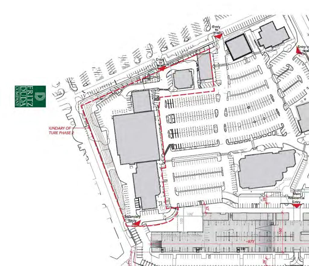
15 Oakbrook Village Plaza - Laguna Hills Traffic Impact Study FUTURE REDEVELOPMENT AND RECOMMENDED TRAFFIC IMPROVEMENTS This section of the study documents the projected traffic impacts and the operational conditions associated with the proposed improvements at the Redevelopment Project site. These conditions were evaluated for two phased build-out scenarios of the Redevelopment Project, Phase I and Phase II. These two phases are described below. Proposed Redevelopment Project Phase I Phase I of the Redevelopment Project would include a decrease in the gross leasable area (GLA) for the retail land use to 132,000 ft 2 and construction of 289 new residential apartment units along the southern boundary of the property. The Phase I improvements are expected to be completed and the site operational by the end of Additionally, the main site entrance located in the middle of the site will be converted from a one-way stop controlled intersection to a signalized intersection. A signal warrant analysis was performed for this intersection and it meets the 8 hour signal warrant as described in the Manual for Uniform Traffic Control Devices (MUTCD.) The calculations for this warrant are included in Appendix C. Figure 4 shows the site plan for Phase I of the Redevelopment Project. Phase II Full Build Out Phase II of the Redevelopment Project further reduces the GLA of retail land use to 125,000 ft 2 and increases the number of residential apartment units to 489 on the site. The Phase II improvements are expected to be completed and the site operational by the end of As mentioned above, the main site entrance located in the middle of the site will have already been converted from a one-way stop controlled intersection to a signalized intersection. Page 12 of 33 D-15
16 D-16
17 Oakbrook Village Plaza - Laguna Hills Traffic Impact Study Project Trip Generation The Institute of Transportation Engineers (ITE) Trip Generation Manual 8 th Edition was used to develop trip generation values for the existing condition and Phase I and Phase II of the Redevelopment Project. ITE Code 220 was used for the proposed apartment development on the site and ITE Code 820 was used for the retail land use on the site. The trip generation calculations are included in Table 5. Phase I For Phase I the changes in land use on the proposed redevelopment site will cause an additional 102 net trip ends during the AM Peak Hour, 2 entering and 100 exiting, and reduce the net number of trip ends by 37 during the PM Peak Hour, 10 entering and -47 exiting. The overall daily weekday change in total trip ends (ADT) for Phase I is a reduction by 325 trip ends when compared to the existing condition. Phase II For Phase II the changes in land use on the proposed redevelopment site will cause an additional 194 trip ends during the AM Peak Hour compared to the existing condition, 18 entering and 186 exiting and increase the number of trip ends by 44 during the PM Peak Hour compared to the existing condition, 67 entering and -23 exiting. The overall daily weekday change in total trip ends (ADT) for Phase II is an increase by 596 trip ends when compared to the existing condition. Project Trip Distribution and Assignment Based on observations of existing circulation patterns obtained by collecting entering and exiting vehicle turning movement counts at the five access to points to the Redevelopment Project Site, a trip distribution was developed for the AM and PM peak hour distribution of new project trips. Based on the installation of a signalized intersection at the main site entrance some project trips were routed from the mall access points on the north of the site to main site entrance. The same distribution assumption was used for both Phase I and Phase II of the Redevelopment Project. This distribution is illustrated in Figure 5. Based on this distribution, the AM and PM peak hour Redevelopment Project trips shown in Table 5 were assigned to the roadway network as shown in Figure 6 for Phase I and Figure 7 for Phase II of the Redevelopment Project. A 1% annual background growth rate was applied to existing turning movement counts to grow existing volumes to anticipated 2013 volumes for the Phase I analysis and 2016 volumes for the Phase II analysis. As mentioned in the introduction, four future scenarios are analyzed. The projected intersection traffic volumes are shown in Figure 8 for Phase I No Project, Figure 9 for Phase I With Project, Figure 10 for Phase II No Project, and Figure 11 for Phase II With Project. Page 14 of 33 D-17
18 Oakbrook Village Plaza - Laguna Hills Traffic Impact Study Trip Generation Table 5: Proposed Redevelopment Project Trip Generation Land Use Type Residential Fitted Trip Gen Curve Equation AM Residential Fitted Trip Gen Curve Equation PM Residential Fitted Trip Gen Curve Weekday Retail Fitted Trip Gen Curve Equation AM Retail Fitted Trip Gen Curve Equation PM Retail Fitted Trip Gen Curve Equation Weekday Restaurant Fitted Trip Gen Curve Equation AM Restaurant Fitted Trip Gen Curve Equation PM Restaurant Fitted Trip Gen Curve Weekday Bank Fitted Trip Gen Curve Equation AM Bank Fitted Trip Gen Curve Equation PM Bank Fitted Trip Gen Curve Equation Weekday Equation ITE CODE T=.49(X) [X= # dwelling units] 220 T=.55(X) [X= # dwelling units] 220 T= 6.06(X) [X= # dwelling units] 220 Ln(T)=.59Ln(X) [X= 1000 ft2 GLA] 820 Ln(T)=.67Ln(X) [X= 1000 ft2 GLA] 820 Ln(T)=.65Ln(X) [X= 1000 ft2 GLA] 820 T= 11.52(X) 932 T= (X) 932 T= (X) 932 T= 12.35(X) 912 T= 25.82(X) 912 T= (X) 912 Existing (2008 Gen Plan) Period Analyzed Residential Trip Gen Retail Trip Gen Total Existing Total Entering Total Exiting 0 Residential Units AM Peak Hour Adjacent Street Traffic AM Peak ,000 ft2 retail PM Peak Hour Adjacent Street Traffic PM Peak ft2 restaurant Weekday ADT ft2 bank Future (2030 Gen Plan) Period Analyzed Residential Trip Gen Retail Trip Gen Total Future Total Entering Total Exiting 0 Residential Units AM Peak Hour Adjacent Street Traffic AM Peak ,000 ft2 retail PM Peak Hour Adjacent Street Traffic PM Peak ft2 restaurant Weekday ADT ft2 bank Phase I Phase II Period Analyzed Residential Trip Gen Retail Trip Gen Total Phase I Existing Future (Gen Plan) Exist Resident Exist Exist Retail Entering Exist Exiting 289 Residential Units AM Peak Hour Adjacent Street Traffic ,200 ft2 retail PM Peak Hour Adjacent Street Traffic ft2 restaurant Weekday ADT ft2 bank Period Analyzed Residential Trip Gen Retail Trip Gen Total Phase II Existing Future (Gen Plan) Exist Resident Exist Exist Retail Entering Exist Exiting 489 Residential Units AM Peak Hour Adjacent Street Traffic ,000 ft2 retail PM Peak Hour Adjacent Street Traffic ft2 restaurant Weekday ADT ft2 bank Notes: AM Peak Hour Adjacent Street Traffic Between 7am - 9am PM Peak Hour Adjacent Street Traffic Between 4pm - 6pm Source: ITE Trip Generation Manual 8th Edition Page 15 of 33 D-18
19 D-19
20 D-20
21 D-21
22 D-22
23 D-23
24 D-24
25 D-25
26 Oakbrook Village Plaza - Laguna Hills Traffic Impact Study Project Intersection Analysis Phase I The existing turning movement counts were grown to 2013 volumes using an assumed background growth rate and the project generated trips were added for the Phase I Project Scenario as shown in Figures 8 and 9. These scenarios were analyzed using Synchro Traffic Analysis Software for the signalized intersections and HCS Traffic Modeling for the stop controlled intersections. It was assumed in the Phase I Project Scenario that the main site entrance located in the middle of the site would be converted from a one-way stop controlled intersection to a signalized intersection. Also, in conjunction with planned improvements at the intersection of El Toro Road and Avenida de la Carlota, an additional left turn lane was added for southbound movements. Existing signal timings were used at the studied intersections except for the new signalized intersection at the main site entrance where standard signal timing and phasing was assumed and for the modified intersection of El Toro Road and Avenida de la Carlota where an additional protected left turn phase was added and the signal timings were optimized. The results for the Phase I intersection analysis without and with the Redevelopment Project are provided below in Tables 6 and 7 and included as Appendix D and Appendix E. Table 6: Future Intersection Operating Conditions Phase I - No Project AM PEAK HOUR PM PEAK HOUR Intersection Name Control LOS V/C LOS V/C 1 El Toro Road and Moulton Parkway Signal E E El Toro Road and Avenida Sevilla Signal A C El Toro Road and Paseo De Valencia Signal B C El Toro Road and Regional Center Drive Signal A C El Toro Road and Avenida de la Carlota Signal B E Mall Entrance and Avenida de la Carlota Signal A B Los Alisos Boulevard and Paseo De Valencia Signal A B Los Alisos Boulevard and Avenida de la Carlota Signal A C I-5 Southbound Ramps and 14 Avenida de la Carlota Signal B B Page 23 of 33 D-26
27 Oakbrook Village Plaza - Laguna Hills Traffic Impact Study Table 6 (continued): Future Intersection Operating Conditions Phase I - No Project AM PEAK PM PEAK Intersection Name Control HOUR HOUR Delay Delay LOS (Sec.) LOS (Sec.) Oak Brook Plaza and West Mall Connector AWSC A 6.9 A 7.6 Oak Brook Plaza and East Mall Connector AWSC A 6.9 A 7.3 North Site Entrance and Avenida de la Carlota 1WSC B 11.9 C 23.6 Main Site Entrance and Avenida de la Carlota 1WSC A 9.8 C 15.6 South Site Entrance and Avenida de la Carlota 1WSC B 12.9 C 20.6 Table 7: Future Intersection Operating Conditions Phase I - With Project AM PEAK HOUR PM PEAK HOUR Intersection Name Control LOS V/C LOS V/C El Toro Road and Moulton 1 Parkway Signal E E El Toro Road and Avenida Sevilla Signal A B El Toro Road and Paseo De 3 Valencia Signal B C El Toro Road and Regional Center 4 Drive Signal A C El Toro Road and Avenida de la 5 Carlota Signal B E Mall Entrance and Avenida de la 6 Carlota Signal A B Main Site Entrance and Avenida 10 de la Carlota Signal A A Los Alisos Boulevard and Paseo 12 De Valencia Signal A B Los Alisos Boulevard and Avenida 13 de la Carlota Signal A C I-5 Southbound Ramps and 14 Avenida de la Carlota Signal B B Page 24 of 33 D-27
28 Oakbrook Village Plaza - Laguna Hills Traffic Impact Study Table 7 (continued): Future Intersection Operating Conditions Phase I - With Project AM PEAK PM PEAK Intersection Name Control HOUR HOUR Delay Delay LOS (Sec.) LOS (Sec.) Oak Brook Plaza and West Mall Connector AWSC A 6.9 A 7.6 Oak Brook Plaza and East Mall Connector AWSC A 7.0 A 7.3 North Site Entrance and Avenida de la Carlota 1WSC B 12.4 C 22.8 South Site Entrance and Avenida de la Carlota 1WSC B 12.6 C 20.4 The Phase I intersections analyzed in both the AM and PM peak periods experience a very minor increase in volume over capacity ratio (V/C) and average delay as a result of the project trips in the Phase I With Project Scenario when compared to the Phase I - No Project Scenario. The PM peak period V/C for the intersection of El Toro Road and Avenida de la Carlota for the project option is less when compared to the no project option due to the reduction in the number of generated trips entering the proposed site for the Phase I improvements. Also, due to the assumption that an additional left turn lane will be added in the southbound direction of Avenida de la Carlota the LOS improves in both the Phase I With Project Scenario and no project scenarios when compared to the existing condition. This assumption also allowed queuing on southbound Avenida de la Carlota between the I-5 Ramps and El Toro Road to clear which improved the operation of the intersection of Avenida de la Carlota and the I-5 Southbound Ramps during the PM peak period when compared to the existing condition. As discussed in the existing conditions that due to importance of the intersection of El Toro Road and Avenida de la Carlota on the local circulation network, the ICU capacity utilization procedure was used to compare the intersection conditions as a result of the construction of the Redevelopment Project to those values in the City of Laguna Hills General Plan Mobility Update Traffic Study. Results of the ICU capacity utilization analysis procedure for Phase I with and without the project are shown in Table 8. This analysis also shows a very minor impact on the operation of the intersection of El Toro Road and Avenida de la Carlota given the Phase I improvements at Oakbrook Village. According to the General Plan Mobility Update Traffic Study the future year (2030) ICU values at the intersection of El Toro Road and Avenida de la Carlota is 0.67 in the AM peak hour (LOS B) and 0.96 in the PM peak hour (LOS E). Page 25 of 33 D-28
29 Oakbrook Village Plaza - Laguna Hills Traffic Impact Study Table 8: Future Intersection Operating Conditions Phase I El Toro Road and Avenida de la Carlota ICU Procedure * indicates critical approach Page 26 of 33 D-29
30 Oakbrook Village Plaza - Laguna Hills Traffic Impact Study Phase II Full Build Out The existing turning movement counts were grown to 2016 volumes using an assumed background growth rate and the project generated trips were added for the Phase II Project Scenario as shown in Figures 10 and 11. These scenarios were analyzed using Synchro Traffic Analysis Software for the signalized intersection and HCS Traffic Modeling for the stop controlled intersections. It was also assumed in the Phase II Project Scenario, that the main site entrance located in the middle would be converted from a one-way stop controlled intersection to a signalized intersection. Also, in conjunction with planned improvements at the intersection of El Toro Road and Avenida de la Carlota, an additional left turn lane is was added for southbound movements. Existing signal timings were used at the studied intersections except for the new signalized intersection at the main site entrance where a standard signal timing and phasing were assumed and for the modified intersection of El Toro Road and Avenida de la Carlota where an additional protected left turn phase was added and the signal timings were optimized. The results for the Phase II intersection analysis without and with the Redevelopment Project are provided below in Tables 9 and 10 and included as Appendix F and Appendix G. Table 9: Future Intersection Operating Conditions Phase II No Project AM PEAK HOUR PM PEAK HOUR Intersection Name Control LOS V/C LOS V/C 1 El Toro Road and Moulton Parkway Signal E E El Toro Road and Avenida Sevilla Signal A C El Toro Road and Paseo De Valencia Signal C D El Toro Road and Regional Center Drive Signal A C El Toro Road and Avenida de la Carlota Signal B E Mall Entrance and Avenida de la Carlota Signal A B Los Alisos Boulevard and Paseo De Valencia Signal A B Los Alisos Boulevard and Avenida de la Carlota Signal A C I-5 Southbound Ramps and Avenida de la Carlota Signal C B Page 27 of 33 D-30
31 Oakbrook Village Plaza - Laguna Hills Traffic Impact Study Table 9: Future Intersection Operating Conditions Phase II No Project (continued) AM PEAK PM PEAK Intersection Name Control HOUR HOUR Delay Delay LOS (Sec.) LOS (Sec.) Oak Brook Plaza and West Mall Connector AWSC A 6.9 A 7.6 Oak Brook Plaza and East Mall Connector AWSC A 6.9 A 7.3 North Site Entrance and Avenida de la Carlota 1WSC B 12.1 D 25.3 Main Site Entrance and Avenida de la Carlota 1WSC A 9.9 B 15.0 South Site Entrance and Avenida de la Carlota 1WSC B 12.1 C 21.5 Table 10: Future Intersection Operating Conditions Phase II With Project AM PEAK HOUR PM PEAK HOUR Intersection Name Control LOS V/C LOS V/C 1 El Toro Road and Moulton Parkway Signal E E El Toro Road and Avenida Sevilla Signal A C El Toro Road and Paseo De Valencia Signal C D El Toro Road and Regional Center Drive Signal A C El Toro Road and Avenida de la Carlota Signal B E Mall Entrance and Avenida de la Carlota Signal A B Main Site Entrance and Avenida de la Carlota Signal A A Los Alisos Boulevard and Paseo De Valencia Signal A B Los Alisos Boulevard and Avenida de la Carlota Signal A C I-5 Southbound Ramps and Avenida de la Carlota Signal C B Page 28 of 33 D-31
32 Oakbrook Village Plaza - Laguna Hills Traffic Impact Study Table 10: Future Intersection Operating Conditions Phase II With Project (continued) AM PEAK PM PEAK Intersection Name Control HOUR HOUR Delay Delay LOS (Sec.) LOS (Sec.) Oak Brook Plaza and West Mall Connector AWSC A 6.9 A 7.7 Oak Brook Plaza and East Mall Connector AWSC A 7.0 A 7.3 North Site Entrance and Avenida de la Carlota 1WSC B 13.1 D 26.7 South Site Entrance and Avenida de la Carlota 1WSC B 12.8 C 21.6 Similar to the Phase I analysis, the Phase II intersections analyzed in both the AM and PM peak periods experience a very minor increase in V/C and average delay as a result of the project trips in the Phase II With Project Scenario when compared to the Phase II - No Project Scenario. Also, due to the assumption that an additional left turn lane will be added in the southbound direction of Avenida de la Carlota the LOS improves in both Phase II With Project and Phase II - No Project Scenarios when compared to the existing condition. As discussed in the existing conditions that due to importance of the intersection of El Toro Road and Avenida de la Carlota on the local circulation network, the ICU capacity utilization procedure was used to compare the intersection conditions with the construction of the Redevelopment Project to those values in the City of Laguna Hills General Plan Mobility Update Traffic Study. Results of the ICU capacity utilization analysis procedure for Phase I with and without the project are shown in Table 11. According to the General Plan Mobility Update Traffic Study the future year (2030) ICU values at the intersection of El Toro Road and Avenida de la Carlota is 0.67 in the AM peak hour (LOS B) and 0.96 in the PM peak hour (LOS E). Page 29 of 33 D-32

33 Oakbrook Village Plaza - Laguna Hills Traffic Impact Study Table 11: Future Intersection Operating Conditions Phase II El Toro Road and Avenida de la Carlota ICU Procedure * indicates critical approach Page 30 of 33 D-33
34 Oakbrook Village Plaza - Laguna Hills Traffic Impact Study Determination of Significant Impact to Studied Intersections The City of Laguna Hills Traffic Study Guidelines defines a significant impact as when an existing intersection is already operating at an ICU or V/C ratio at or below 0.90 and the project causes the level to exceed 0.90 by an impact equal to or greater than Furthermore, if an intersection is already operating at a LOS of E or F, any increase in ICU or V/C ratio equal to or greater than 0.01 would be considered a significant impact by the project. The intersection of Avenida de la Carlota and El Toro Road is part of the Orange County s Congestion Management Program (CMP) which specifies a LOS of E as its goal for intersection performance. Phase I The year 2013 Phase I No Project LOS and V/C values were compared to the Phase I With Project LOS and V/C values. For all of the fourteen of the intersections studied, none of the intersections change from a V/C value less than or equal to 0.90 to a V/C of greater than 0.90 in either the AM or PM peak hour. For the intersection of El Toro Road and Moulton Parkway, which operates at a LOS of E in both the AM and PM peak hours, the change in V/C in the AM peak hour with the addition of the project trips to the intersection is and for the PM peak hour the change in V/C is 0. Likewise, for the intersection of El Toro Road and Avenida de la Carlota which operates at a LOS of E during the PM peak hour, the change in V/C with the addition of the project trips was an improvement in the V/C by For both intersections mentioned, the increase in V/C values is less than the 0.01 V/C change stipulated in the City of Laguna Hills Traffic Study Guidelines for it to be considered a significant impact. Using the ICU capacity utilization procedure consistent with the General Plan Mobility Update the V/C values at the intersection of El Toro Road and Avenida de la Carlota are below the 0.90 threshold for significant impacts in both the Phase I With Project and Phase I No Project scenarios. Therefore, the changes in the V/C values between the project and no project scenarios do not qualify as significant impacts to the operation of the intersection. Using the City of Laguna Hills Traffic Study definition of significant impacts, none of the studied intersections would be subject to any significant impacts caused by the project traffic generated trips as a result of the Phase I improvements. Phase II The year 2016 Phase II No Project Scenario LOS and V/C values were compared to the Phase II With Project LOS and V/C values. For all of the fourteen intersections studied, none of the intersections change from a V/C value less than or equal to 0.90 to a V/C of greater than 0.90 in either the AM or PM peak hour. For the intersection of El Page 31 of 33 D-34
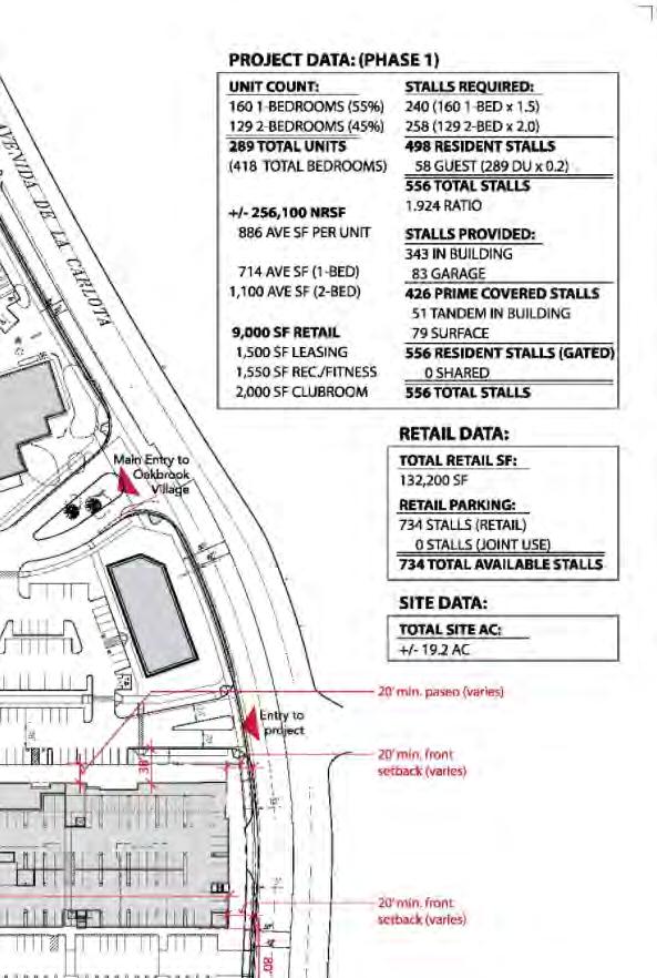
35 Oakbrook Village Plaza - Laguna Hills Traffic Impact Study Toro Road and Moulton Parkway, which operates at a LOS of E in both the AM and PM peak hours, the change in V/C in the AM peak hour with the addition of the project trips to the intersection is and for the PM peak hour the change in V/C is Likewise, for the intersection of El Toro Road and Avenida de la Carlota which operates at a LOS of E during the PM peak hour, the change in V/C with the addition of the project trips to the intersection is All of these values are less than the 0.01 V/C change stipulated in the City of Laguna Hills Traffic Study Guidelines for it to be considered a significant impact. Using the ICU capacity utilization procedure consistent with the General Plan Mobility Update the V/C values at the intersection of El Toro Road and Avenida de la Carlota are below the 0.90 threshold for significant impacts in both the Phase II With Project and Phase II No Project scenarios. Therefore, the changes in the V/C values between the project and no project scenarios do not qualify as significant impacts to the operation of the intersection. Using the City of Laguna Hills Traffic Study Guidelines definition of significant impacts, none of the studied intersections would be subject to any significant impacts caused by the project traffic generated as a result of the Phase II improvements. Shared Parking Analysis With the mixed use nature of the Proposed Redevelopment project, a shared parking analysis was performed to establish the number of parking spaces required for Phase I of the Redevelopment Project based on the land use types. In accordance with The City of Laguna Hills Traffic Study Guidelines, the Urban Land Institute (ULI) Shared Parking Manual was used to perform a shared parking analysis. This methodology analyzes the parking demand for each individual land use type on the property against a parking demand profile based on the time of day to establish the parking requirements. Parking demand requirements were taken from the City of Laguna Hills Urban Village Specific Plan. It was also assumed that parking space requirements for the Break of Dawn Restaurant, which closes at 1:30 PM during the week, would be credited back to the overall site availability after 3:00 PM. The parking requirements were analyzed on Redevelopment Project site from 6:00 AM 12:00 AM. For Phase I of the Redevelopment Project there will be 734 spaces designated to serve the retail land use on the site. In addition, the Redevelopment Project will include 498 residential and 58 guest parking spaces that would be gated off from the retail area and therefore only available to serve the residential land use. The total number of parking spaces for Phase I of the redevelopment project is 1,296. Square footages for each of the individual land uses for Phase I were provided by The Fritz Duda Company. Using the ULI temporal parking demand rates and Urban Village Specific Plan parking Page 32 of 33 D-35
36 Oakbrook Village Plaza - Laguna Hills Traffic Impact Study requirements, the number of available parking spaces was adequate for all analyzed hours. A worksheet showing the Shared Use Parking Calculations is available in Appendix H. Using the parking codes specified in the Laguna Hills Urban Village Specific Plan and no temporal distribution of parking spaces a parking demand of 1,041 spaces would be required the site. A breakdown of this analysis is also included in Appendix H. CONCLUSION The two Phases of the proposed Redevelopment Project at the Oakbrook Village Plaza were analyzed and were determined to not cause significant impacts to the operating conditions of the fourteen intersections analyzed as part of this study. Redevelopment Project generated trips will not cause any intersections to change from a V/C value less than or equal to 0.90 to a V/C of greater than 0.90 in either the AM or PM peak hour in either Phase I or Phase II. For the intersections of El Toro Road and Moulton Parkway and El Toro Road and Avenida de la Carlota which experience a V/C greater then 0.90 in the existing condition, Phase I No Project, and Phase II No Project, the change in V/C caused by the addition of Redevelopment project trips is less then the standard 0.01 and therefore impacts to these intersections are not considered significant. As a result, no mitigations to the intersections studied are recommended as a result of the improvements to the Redevelopment Project site. Additionally, a ULI shared use parking analysis was performed for Phase 1 of the Redevelopment Project. The analysis shows adequate parking on site to serve the land uses on the proposed site during Phase I of the Redevelopment Project. Page 33 of 33 D-36
37 Appendix A Intersection Turning Movement Counts D-37
38 Transportation Studies, Inc Walnut Avenue, Suite H Tustin, CA City: LAGUNA HILLS N-S Direction: MOULTON PARKWAY E-W Direction: EL TORO ROAD File Name : H Site Code : Start Date : 11/10/2011 Page No : 1 *** BREAK *** Groups Printed- Turning Movements MOULTON PARKWAY Southbound EL TORO ROAD Westbound MOULTON PARKWAY Northbound EL TORO ROAD Eastbound Start Time Right Thru Left Right Thru Left Right Thru Left Right Thru Left Int. Total 07:00 AM :15 AM :30 AM :45 AM Total :00 AM :15 AM :30 AM :45 AM Total :00 PM :15 PM :30 PM :45 PM Total :00 PM :15 PM :30 PM :45 PM Total Grand Total Apprch % Total % D-38
39 Transportation Studies, Inc Walnut Avenue, Suite H Tustin, CA City: LAGUNA HILLS N-S Direction: MOULTON PARKWAY E-W Direction: EL TORO ROAD File Name : H Site Code : Start Date : 11/10/2011 Page No : 2 MOULTON PARKWAY Southbound EL TORO ROAD Westbound MOULTON PARKWAY Northbound EL TORO ROAD Eastbound Start Time Right Thru Left App. Total Right Thru Left App. Total Right Thru Left App. Total Right Thru Left App. Total Int. Total Peak Hour Analysis From 07:00 AM to 08:45 AM - Peak 1 of 1 Peak Hour for Entire Intersection Begins at 07:45 AM 07:45 AM :00 AM :15 AM :30 AM Total Volume % App. Total PHF MOULTON PARKWAY Out In Total Right 436 Thru 162 Left Peak Hour Data EL TORO ROAD Out In Total Left 513 Thru 103 Right North Peak Hour Begins at 07:45 AM Turning Movements Right 157 Thru 597 Left 282 Out In Total EL TORO ROAD Left 175 Thru 1331 Right Out In Total MOULTON PARKWAY D-39
40 Transportation Studies, Inc Walnut Avenue, Suite H Tustin, CA City: LAGUNA HILLS N-S Direction: MOULTON PARKWAY E-W Direction: EL TORO ROAD File Name : H Site Code : Start Date : 11/10/2011 Page No : 3 MOULTON PARKWAY Southbound EL TORO ROAD Westbound MOULTON PARKWAY Northbound EL TORO ROAD Eastbound Start Time Right Thru Left App. Total Right Thru Left App. Total Right Thru Left App. Total Right Thru Left App. Total Int. Total Peak Hour Analysis From 04:00 PM to 05:45 PM - Peak 1 of 1 Peak Hour for Entire Intersection Begins at 04:45 PM 04:45 PM :00 PM :15 PM :30 PM Total Volume % App. Total PHF MOULTON PARKWAY Out In Total Right 1622 Thru 287 Left Peak Hour Data EL TORO ROAD Out In Total Left 727 Thru 217 Right North Peak Hour Begins at 04:45 PM Turning Movements Right Thru Left Out In Total EL TORO ROAD Left 182 Thru 567 Right Out In Total MOULTON PARKWAY D-40
41 Transportation Studies, Inc Walnut Avenue, Suite H Tustin, CA City: LAGUNA HILLS N-S Direction: AVENIDA SEVILLA E-W Direction: EL TORO ROAD File Name : H Site Code : Start Date : 11/8/2011 Page No : 1 *** BREAK *** Groups Printed- Turning Movements AVENIDA SEVILLA Southbound EL TORO ROAD Westbound AVENIDA SEVILLA Northbound EL TORO ROAD Eastbound Start Time Right Thru Left Right Thru Left Right Thru Left Right Thru Left Int. Total 07:00 AM :15 AM :30 AM :45 AM Total :00 AM :15 AM :30 AM :45 AM Total :00 PM :15 PM :30 PM :45 PM Total :00 PM :15 PM :30 PM :45 PM Total Grand Total Apprch % Total % D-41
Bennett Pit. Traffic Impact Study. J&T Consulting, Inc. Weld County, Colorado. March 3, 2017
 Bennett Pit Traffic Impact Study J&T Consulting, Inc. Weld County, Colorado March 3, 217 Prepared By: Sustainable Traffic Solutions, Inc. http://www.sustainabletrafficsolutions.com/ Joseph L. Henderson,
Alpine Highway to North County Boulevard Connector Study
 Alpine Highway to North County Boulevard Connector Study prepared by Avenue Consultants March 16, 2017 North County Boulevard Connector Study March 16, 2017 Table of Contents 1 Summary of Findings... 1
King Soopers #116 Thornton, Colorado
 Traffic Impact Study King Soopers #116 Thornton, Colorado Prepared for: Galloway & Company, Inc. T R A F F I C I M P A C T S T U D Y King Soopers #116 Thornton, Colorado Prepared for Galloway & Company
Traffic Impact Analysis 5742 BEACH BOULEVARD MIXED USE PROJECT
 Traffic Impact Analysis 5742 BEACH BOULEVARD MIXED USE PROJECT CITY OF BUENA PARK Prepared by Project No. 14139 000 April 17 th, 2015 DKS Associates Jeffrey Heald, P.E. Rohit Itadkar, T.E. 2677 North Main
KUM & GO 6400 WESTOWN PARKWAY WEST DES MOINES, IOWA 50266
 KUM & GO #300 PECOS STREET & 88 TH AVENUE THORNTON, COLORADO TRAFFIC IMPACT STUDY REVISION 1 PREPARED FOR KUM & GO 6400 WESTOWN PARKWAY WEST DES MOINES, IOWA 50266 JANUARY 23, 2014 OA PROJECT NO. 013-1721
ARVADA TRIANGLE REDEVELOPMENT TRAFFIC IMPACT ANALYSIS
 ARVADA TRIANGLE REDEVELOPMENT TRAFFIC IMPACT ANALYSIS Prepared for: Arvada Urban Renewal Authority 5601 Olde Wadsworth Boulevard, Suite 210 Arvada, Colorado 80002 (720) 898-7062 Prepared by: Felsburg Holt
L1TILE BEARS DAY CARE TRANSPORTATION IMPACT STUDY FORT COLLINS, COLORADO MAY Prepared for:
 L1TILE BEARS DAY CARE TRANSPORTATION IMPACT STUDY FORT COLLINS, COLORADO MAY 2012 Prepared for: Hillside Construction, Inc. 216 Hemlock Street, Suite B Fort Collins, CO 80534 Prepared by: DELICH ASSOCIATES
Traffic Impact Analysis Update
 Willow Bend Traffic Impact Analysis Update TABLE OF CONTENTS Page I. INTRODUCTION -------------------------------------------------------------------------------------------- 1 II. EXISTING CONDITIONS
Table 1 - Land Use Comparisons - Proposed King s Wharf Development. Retail (SF) Office (SF) 354 6,000 10, Land Uses 1
 Office (SF) 354 6,000 10, Land Uses 1") Ref. No. 171-6694 Phase 2 November 23, 217 Mr. David Quilichini, Vice President Fares & Co. Developments Inc. 31 Place Keelson Sales Centre DARTMOUTH NS B2Y C1 Sent Via Email to David@faresinc.com RE:
Ref. No. 171-6694 Phase 2 November 23, 217 Mr. David Quilichini, Vice President Fares & Co. Developments Inc. 31 Place Keelson Sales Centre DARTMOUTH NS B2Y C1 Sent Via Email to David@faresinc.com RE:
D & B COMMERCIAL TRAFFIC IMPACT ANALYSIS
 D & B COMMERCIAL TRAFFIC IMPACT ANALYSIS TABLE OF CONTENTS I. Introduction...3 II. Project Description...3 III. Existing Conditions...3 IV. Future Traffic Conditions...8 V. Conclusions and Mitigation...14
 Traffic Analysis For Approved Uses within the St. Lucie West DRI Aldi Port St. Lucie, FL Prepared for: Bohler Engineering, LLC 1000 Corporate Drive Suite 250 Fort Lauderdale, FL 33334 Prepared by: 10795
MURRIETA APARTMENTS TRAFFIC IMPACT ANALYSIS CITY OF MURRIETA, CALIFORNIA
 MURRIETA APARTMENTS TRAFFIC IMPACT ANALYSIS CITY OF MURRIETA, CALIFORNIA SEPTEMBER 20, 2012 Prepared for: Golden Eagle Multi-Family Properties, LLC 6201 Oak Canyon Rd., Suite 250 Irvine, CA 92618 Prepared
TRAFFIC IMPACT ANALYSIS FOR. McDONALD S RESTAURANT IN CARMICAEL Sacramento County, CA. Prepared For:
 TRAFFIC IMPACT ANALYSIS FOR McDONALD S RESTAURANT IN CARMICAEL Sacramento County, CA Prepared For: McDonald s USA, LLC Pacific Sierra Region 2999 Oak Road, Suite 900 Walnut Creek, CA 94597 Prepared By:
MINERVA PARK SITE TRAFFIC IMPACT STUDY M/I HOMES. September 2, 2015
 5500 New Albany Road Columbus, Ohio 43054 Phone: 614.775.4500 Fax: 614.775.4800 Toll Free: 1-888-775-EMHT emht.com 2015-1008 MINERVA PARK SITE TRAFFIC IMPACT STUDY M/I HOMES September 2, 2015 Engineers
One Harbor Point Residential
 Residential Gig Harbor, WA Transportation Impact Analysis January 23, 2017 Prepared for: Neil Walter Company PO Box 2181 Tacoma, WA 98401 Prepared by: TENW Transportation Engineering NorthWest 11400 SE
APPENDIX C1 TRAFFIC ANALYSIS DESIGN YEAR TRAFFIC ANALYSIS
 APPENDIX C1 TRAFFIC ANALYSIS DESIGN YEAR TRAFFIC ANALYSIS DESIGN YEAR TRAFFIC ANALYSIS February 2018 Highway & Bridge Project PIN 6754.12 Route 13 Connector Road Chemung County February 2018 Appendix
Escondido Marriott Hotel and Mixed-Use Condominium Project TRAFFIC IMPACT ANALYSIS REPORT
 Escondido Marriott Hotel and Mixed-Use Condominium Project TRAFFIC IMPACT ANALYSIS REPORT Prepared for Phelps Program Management 420 Sixth Avenue, Greeley, CO 80632 Prepared by 5050 Avenida Encinas, Suite
886 March Road McDonald's Transportation Study
 McDonald's Restaurants of Canada Limited March 2013 886 March Road McDonald's Transportation Study Submitted by: HDR Corporation 100 York Boulevard, Suite 300 Richmond Hill, ON L4B 1J8 (905) 882-4100 www.hdrinc.com
June 21, Mr. Jeff Mark The Landhuis Company 212 North Wahsatch Avenue, Suite 301. Colorado Springs, CO 80903
 LSC TRANSPORTATION CONSULTANTS, INC. 545 East Pikes Peak Avenue, Suite 210 Colorado Springs, CO 80903 (719) 633-2868 FAX (719) 633-5430 E-mail: lsc@lsctrans.com Website: http://www.lsctrans.com June 21,
EXECUTIVE SUMMARY. The following is an outline of the traffic analysis performed by Hales Engineering for the traffic conditions of this project.
 EXECUTIVE SUMMARY This study addresses the traffic impacts associated with the proposed Shopko redevelopment located in Sugarhouse, Utah. The Shopko redevelopment project is located between 1300 East and
TRAFFIC IMPACT ANALYSIS
 TRAFFIC IMPACT ANALYSIS Emerald Isle Commercial Development Prepared by SEPI Engineering & Construction Prepared for Ark Consulting Group, PLLC March 2016 I. Executive Summary A. Site Location The Emerald
LAWRENCE TRANSIT CENTER LOCATION ANALYSIS 9 TH STREET & ROCKLEDGE ROAD / 21 ST STREET & IOWA STREET LAWRENCE, KANSAS
 LAWRENCE TRANSIT CENTER LOCATION ANALYSIS 9 TH STREET & ROCKLEDGE ROAD / 21 ST STREET & IOWA STREET LAWRENCE, KANSAS TRAFFIC IMPACT STUDY FEBRUARY 214 OA Project No. 213-542 TABLE OF CONTENTS 1. INTRODUCTION...
Sugarland Crossing Gwinnett County, Georgia
 Sugarland Crossing Gwinnett County, Georgia S IGNAL W ARRANT A NALYSIS For the Intersection of: Sugarloaf Parkway / Richards Middle School Driveway / Sugarland Crossing Main Site Driveway Prepared for:
ZINFANDEL LANE / SILVERADO TRAIL INTERSECTION TRAFFIC ANALYSIS
 ZINFANDEL LANE / SILVERADO TRAIL INTERSECTION TRAFFIC ANALYSIS UPDATED TRAFFIC STUDY FOR THE PROPOSED RAYMOND VINEYARDS WINERY USE PERMIT MODIFICATION #P11-00156 AUGUST 5, 2014 PREPARED BY: OMNI-MEANS,
Proposed location of Camp Parkway Commerce Center. Vicinity map of Camp Parkway Commerce Center Southampton County, VA
 Proposed location of Camp Parkway Commerce Center Vicinity map of Camp Parkway Commerce Center Southampton County, VA Camp Parkway Commerce Center is a proposed distribution and industrial center to be
Traffic Impact Analysis. Alliance Cole Avenue Residential Site Dallas, Texas. Kimley-Horn and Associates, Inc. Dallas, Texas.
 Traffic Impact Analysis Alliance Cole Avenue Residential Site Dallas, Texas February 15, 2018 Kimley-Horn and Associates, Inc. Dallas, Texas Project #064524900 Registered Firm F-928 Traffic Impact Analysis
Transportation & Traffic Engineering
 Transportation & Traffic Engineering 1) Project Description This report presents a summary of findings for a Traffic Impact Analysis (TIA) performed by A+ Engineering, Inc. for the Hill Country Family
MEMO. McCORMICK RANKIN CORPORATION. File FROM: Keyur Shah DATE: February 1, 2010 COPIES: OUR FILE: SUBJECT: TO:
 McCORMICK RANKIN CORPORATION 2655 North Sheridan Way Mississauga, Ontario, L5K 2P8 Tel: (905)823-8500 Fax: (905) 823-8503 E-mail: mrc@mrc.ca Website: www.mrc.ca MEMO TO: File FROM: Keyur Shah DATE: February
TRAFFIC SIGNAL DESIGN REPORT KING OF PRUSSIA ROAD & RAIDER ROAD RADNOR TOWNSHIP PENNSYLVANIA
 TRAFFIC SIGNAL DESIGN REPORT KING OF PRUSSIA ROAD & RAIDER ROAD RADNOR TOWNSHIP PENNSYLVANIA PREPARED FOR: UNIVERSITY OF PENNSYLVANIA HEALTH SYSTEM 34 CIVIC CENTER BOULEVARD PHILADELPHIA, PA 1987 (61)
Quantitative analyses of weekday a.m. and p.m. commuter hour conditions have been conducted for the following five scenarios:
 6.1 TRANSPORTATION AND CIRCULATION 6.1.1 INTRODUCTION This section of the EIR presents the results of TJKM s traffic impact analysis of the proposed Greenbriar Development. The analysis includes consideration
Proposed Hotel and Restaurant Development
 Traffic Impact Study Proposed Hotel and Restaurant Development Marbledale Road Tuckahoe, NY PREPARED FOR BILLWIN DEVELOPMENT AFFILIATES, LLC 365 WHITE PLAINS ROAD EASTCHESTER, NY. 10709 PREPARED BY Engineering
MEMORANDUM. Date: November 4, Cheryl Burrell, Pebble Beach Company. Rob Rees, P.E. Inclusionary Housing Transportation Analysis WC
 MEMORANDUM Date: November 4, 2013 To: From: Subject: Cheryl Burrell, Pebble Beach Company Rob Rees, P.E. Inclusionary Housing Transportation Analysis As requested, Fehr & Peers is providing clarification
APPENDIX B Traffic Analysis
 APPENDIX B Traffic Analysis Rim of the World Unified School District Reconfiguration Prepared for: Rim of the World School District 27315 North Bay Road, Blue Jay, CA 92317 Prepared by: 400 Oceangate,
INTERCHANGE OPERTIONS STUDY Interstate 77 / Wallings Road Interchange
 INTERCHANGE OPERTIONS STUDY Interstate 77 / Wallings Road Interchange City of Broadview Heights, Cuyahoga County, Ohio Prepared For: City of Broadview Heights Department of Engineering 9543 Broadview Road
Craig Scheffler, P.E., PTOE HNTB North Carolina, P.C. HNTB Project File: Subject
 TECHNICAL MEMORANDUM To Kumar Neppalli Traffic Engineering Manager Town of Chapel Hill From Craig Scheffler, P.E., PTOE HNTB North Carolina, P.C. Cc HNTB Project File: 38435 Subject Obey Creek TIS 2022
Appendix Q Traffic Study
 Appendices Appendix Q Traffic Study Crummer Site Subdivision Draft EIR City of Malibu Appendices This page intentionally left blank. The Planning Center April 2013 TRAFFIC IMPACT ANALYSIS Photo z here
Lacey Gateway Residential Phase 1
 Lacey Gateway Residential Phase Transportation Impact Study April 23, 203 Prepared for: Gateway 850 LLC 5 Lake Bellevue Drive Suite 02 Bellevue, WA 98005 Prepared by: TENW Transportation Engineering West
RESPONSE TO TRAFFIC IMPACT STUDY COMMENTS
 RESPONSE TO TRAFFIC IMPACT STUDY COMMENTS Proposed Gas Station 40 Arthur Street (Highway 26), Town of the Blue Mountains (Thornbury), County of Grey, Ontario AUGUST 2013 August 27, 2013 MR. REG RUSSWURM
Downtown One Way Street Conversion Technical Feasibility Report
 Downtown One Way Street Conversion Technical Feasibility Report As part of the City s Transportation Master Plan, this report reviews the technical feasibility of the proposed conversion of the current
MEMO VIA . Ms. Amy Roth DPS Director, City of Three Rivers. To:
 MEMO To: Ms. Amy Roth DPS Director, City of Three Rivers VIA EMAIL From: Michael J. Labadie, PE Julie M. Kroll, PE, PTOE Brandon Hayes, PE, P.Eng. Fleis & VandenBrink Date: January 5, 2017 Re: Proposed
Parking/Traffic Assessment Study
 Brock Road Industrial Mall 985 Brock Road South City of Pickering Parking/Traffic Assessment Study Prepared by: Tranplan Associates, Toronto Toronto 416-670-2005 Sudbury 705-522-0272 Peterborough 705-874-3638
Appendix H: Construction Impacts H-2 Transportation
 Appendix H: Construction Impacts H-2 Transportation \ AECOM 71 W. 23 rd Street New York, NY 10010 www.aecom.com 212 366 6200 tel 212 366 6214 fax Memorandum To CC Subject Robert Conway Donald Tone Construction
LATSON INTERCHANGE DEVELOPMENT TRAFFIC STUDIES. Genoa Township, Livingston County, MI
 LATSON INTERCHANGE DEVELOPMENT TRAFFIC STUDIES Genoa Township, Livingston County, MI DRAFT TRAFFIC STUDY FOR I-96 AT LATSON RD INTERCHANGE Livingston County CS 47065 JN 101622C Submitted to: Michigan Department
Weaver Road Senior Housing Traffic Impact Analysis
 Gibson Traffic Consultants, Inc. 2813 Rockefeller Avenue Suite B Everett, WA 9821 425.339.8266 Weaver Road Senior Housing Traffic Impact Analysis Jurisdiction: City of Snohomish January 218 GTC #17-37
Traffic Impact Study Hudson Street Parking Garage MC Project No.: A Table of Contents
 Traffic Impact Study Hudson Street Parking Garage MC Project No.: 15001714A Table of Contents Table of Contents I. INTRODUCTION... 1 II. EXISTING CONDITIONS... 4 III. 2015 EXISTING TRAFFIC CONDITIONS...
MEMO. McCORMICK RANKIN CORPORATION. File Mark VanderSluis, Keyur Shah DATE: October 26, 2009 COPIES: OUR FILE: TO: FROM: Jack Thompson
 McCORMICK RANKIN CORPORATION 2655 North Sheridan Way Mississauga, Ontario, L5K 2P8 Tel: (95)823-85 Fax: (95) 823-853 E-mail: mrc@mrc.ca Website: www.mrc.ca MEMO TO: FROM: File Mark VanderSluis, Keyur Shah
Traffic Impact Study Morgan Road Commerce Park Pasco County, Florida
 Traffic Impact Study Morgan Road Commerce Park Pasco County, Florida Summary Report June 2008 Prepared by: 12909 N 56 th Street # 201 Tampa, FL 33617 Ph: (813) 988-3180 Fax: (813) 343-6854 Morgan Road
APPENDIX C-2. Traffic Study Supplemental Analysis Memo
 APPENDIX C-2 Traffic Study Supplemental Analysis Memo The Mobility Group Transportation Strategies & Solutions Memorandum To: From: Subject: Tomas Carranza, LADOT Matthew Simons Traffic Review - Revised
2.0 Development Driveways. Movin Out June 2017
 Movin Out June 2017 1.0 Introduction The proposed Movin Out development is a mixed use development in the northeast quadrant of the intersection of West Broadway and Fayette Avenue in the City of Madison.
TRAFFIC IMPACT STUDY DERRY GREEN CORPORATE BUSINESS PARK MILTON SECONDARY PLAN MODIFICATION
 TRAFFIC IMPACT STUDY DERRY GREEN CORPORATE BUSINESS PARK MILTON SECONDARY PLAN MODIFICATION TRAFFIC IMPACT STUDY DERRY GREEN CORPORATE BUSINESS PARK MILTON SECONDARY PLAN MODIFICATION DECEMBER 2014 UPDATED
APPENDIX G. Traffic Data
 APPENDIX G Traffic Data HCM Signalized Intersection Capacity Analysis 2: Duanesburg Road & I-88 Ramps 10/7/2004 Movement EBL EBT EBR WBL WBT WBR NBL NBT NBR SBL SBT SBR Lane Configurations Ideal Flow (vphpl)
Provide an overview of the development proposal including projected site traffic volumes;
 December 19, 2013 File: 163600935 Attention: Troy Elliott Carl Elliott Limited 15-1831 Robertson Road PO Box 11117 Nepean, Ontario K1H 7T8 Dear Mr. Elliott, Reference: 2235 and 2265 Robertson Road Transportation
Vanier Parkway and Presland Road Residential Development Transportation Impact Study
 Vanier Parkway and Presland Road Residential Development Transportation Impact Study Final Report (Revised) March 2011 Submitted to: Groupe Lépine Ottawa Project No. 09-1613 Submitted by: Groupe Lépine
Traffic Impact Analysis Farmington Center Village
 Traffic Impact Analysis Farmington Center Village Route 4 (Farmington Avenue) Farmington, Connecticut Prepared for: The Town of Farmington, CT Prepared By: BL Companies Meriden, Connecticut December 2016
Winnetka Avenue Bike Lanes Traffic Impact Analysis
 Winnetka Avenue Bike Lanes Traffic Impact Analysis January 4, 2019 Prepared by City of Los Angeles Department of Transportation Active Transportation Division Winnetka Ave Bike Lanes Traffic Impact Analysis
Ingraham High School Parking and Traffic Analysis
 Parking and Traffic Analysis Seattle, WA Prepared for: URS Corporation 1501 4th Avenue, Suite 1400 Seattle, WA 98101-1616 Mirai Transportation Planning & Engineering 11410 NE 122nd Way, Suite 320 Kirkland,
TRAFFIC AND TRANSPORTATION TECHNICAL MEMORANDUM
 TRAFFIC AND TRANSPORTATION TECHNICAL MEMORANDUM for ENVIRONMENTAL ASSESSMENT US 460 Bypass Interchange and Southgate Drive Relocation State Project No.: 0460-150-204, P101, R201, C501, B601; UPC 99425
Volume 1 Traffic Impact Analysis Turtle Creek Boulevard Dallas, Texas. Kimley-Horn and Associates, Inc. Dallas, Texas.
 Volume 1 Traffic Impact Analysis 2727 Dallas, Texas June 18, 2018 Kimley-Horn and Associates, Inc. Dallas, Texas Project #064523000 Registered Firm F-928 Traffic Impact Analysis 2727 Dallas, Texas Prepared
Traffic Impact Statement (TIS)
") Traffic Impact Statement (TIS) Vincentian PUDA Collier County, FL 10/18/2013 Prepared for: Global Properties of Naples Prepared by: Trebilcock Consulting Solutions, PA 2614 Tamiami Trail N, Suite 615 1205
Traffic Impact Statement (TIS) Vincentian PUDA Collier County, FL 10/18/2013 Prepared for: Global Properties of Naples Prepared by: Trebilcock Consulting Solutions, PA 2614 Tamiami Trail N, Suite 615 1205
Traffic Engineering Study
 Traffic Engineering Study Bellaire Boulevard Prepared For: International Management District Technical Services, Inc. Texas Registered Engineering Firm F-3580 November 2009 Executive Summary has been requested
DIVISION STREET PLAT TRAFFIC IMPACT ANALYSIS
 DIVISION STREET PLAT TRAFFIC IMPACT ANALYSIS TABLE OF CONTENTS 1. Introduction...3 2. Project Description...3 3. Existing Conditions...3 4. Forecast Traffic Demand and Analysis...12 5. Conclusions and
BUCKLEY ANNEX REDEVELOPMENT PLAN TRANSPORTATION ANALYSIS ADDENDUM
 BUCKLEY ANNEX REDEVELOPMENT PLAN TRANSPORTATION ANALYSIS ADDENDUM Prepared for: City and County of Denver Prepared by: Contact: Brian Bern, P.E., PTOE 303.572.0200 On Behalf of: Lowry Redevelopment Authority
TIMBERVINE TRANSPORTATION IMPACT STUDY FORT COLLINS, COLORADO JANUARY Prepared for:
 TIMBERVINE TRANSPORTATION IMPACT STUDY FORT COLLINS, COLORADO JANUARY 2014 Prepared for: Hartford Companies 1218 W. Ash Street Suite A Windsor, Co 80550 Prepared by: DELICH ASSOCIATES 2272 Glen Haven Drive
Traffic Impact Study Speedway Gas Station Redevelopment
 Traffic Impact Study Speedway Gas Station Redevelopment Warrenville, Illinois Prepared For: Prepared By: April 11, 2018 Table of Contents 1. Introduction... 1 2. Existing Conditions... 4 Site Location...
APPENDIX A LEVEL OF SERVICE CONCEPTS, ANALYSIS METHODOLOGIES,STANDARDS OF SIGNIFICANCE
 APPENDIX A LEVEL OF SERVICE CONCEPTS, ANALYSIS METHODOLOGIES,STANDARDS OF SIGNIFICANCE Roadway Segment Level of Service Definitions LOS V/C Congestion/Delay Traffic Description (Used for surface streets,
LOST LAKE CORRIDOR REVIEW
 LOST LAKE CORRIDOR REVIEW Prepared for: Prepared by: Broadview Developments Inc. c/o Westbrook Consulting Watt Consulting Group Our File: 2064.B01 Date: October 31, 2016 TABLE OF CONTENTS 1.0 INTRODUCTION...
County State Aid Highway 30 (Diffley Road) and Dodd Road Intersection Study
 and Dodd Road Intersection Study") County State Aid Highway 30 (Diffley Road) and Dodd Road Intersection Study City of Eagan, Dakota County, Minnesota Date: March 2012 Project No. 14957.000 444 Cedar Street, Suite 1500 Saint Paul, MN 55101
County State Aid Highway 30 (Diffley Road) and Dodd Road Intersection Study City of Eagan, Dakota County, Minnesota Date: March 2012 Project No. 14957.000 444 Cedar Street, Suite 1500 Saint Paul, MN 55101
Appendix C. Traffic Study
 Appendix C Traffic Study TABLE OF CONTENTS SECTION Executive Summary PAGE 1.0 Introduction... 1 1.1 Scope of Work... 1 1.2 Study Area... 2 2.0 Project Description... 3 2.1 Site Access... 4 2.2 Pedestrian
Ref. No Task 3. April 28, Mr. Cesar Saleh, P. Eng. VP Planning and Design W.M. Fares Group th
 Ref. No. 151-00564 Task 3 April 28, 2015 Mr. Cesar Saleh, P. Eng. VP Planning and Design W.M. Fares Group th 3480 Joseph Howe Drive, 5 Floor HALIFAX NS B3L 4H7 Sent via Email to ceasr.saleh@wmfares.com
Traffic Impact Study for the proposed. Town of Allegany, New York. August Project No Prepared For:
 Appendix B SRF Traffic Study (Revised November 2005) Draft Environmental Impact Statement University Commons Town of Allegany, Cattaraugus County, NY December 2005 Traffic Impact Study for the proposed
Re: Residential Development - Ogilvie/Cummings Transportation Overview
 1223 Michael Street, Suite 100, Ottawa, ON K1J 7T2 Tel: 613.738.4160 Fax: 613.739.7105 www.delcan.com March 28, 2012 OUR REF: TO3088TOY Barry J. Hobin & Architects 63 Pamilla Street Ottawa, ON K1S 3K7
December 5, Red Bank Planning Board Municipal Building 90 Monmouth Street Red Bank, NJ 07701
 Dynamic Traffic, LLC www.dynamic-traffic.com 1904 Main Street Lake Como, NJ 07719 T. 732.681.0760 December 5, 2016 Red Bank Planning Board Municipal Building 90 Monmouth Street Red Bank, NJ 07701 Re: Traffic
INDUSTRIAL DEVELOPMENT
 INDUSTRIAL DEVELOPMENT Traffic Impact Study Plainfield, Illinois August 2018 Prepared for: Seefried Industrial Properties, Inc. TABLE OF CONTENTS Executive Summary 2 Introduction 3 Existing Conditions
Appendix 5. Haymeadow Interim Traffic Analysis
 Appendix 5 Haymeadow Interim Traffic Analysis 20 MEMORANDUM To: From: Rick Pylman Gary Brooks Bill Fox Date: September 15, 2016 Project: Subject: Haymeadow Evaluation of interim access configuration Currently
Re: Cyrville Road Car Dealership
 1223 Michael Street, Suite 100, Ottawa, ON K1J 7T2 Tel: 613.738.4160 Fax: 613.739.7105 www.delcan.com February 25, 2013 OUR REF: TO3098TOE Mark Motors of Ottawa 611 Montreal Road Ottawa, ON K1K 0T8 Attention:
West Hills Shopping Centre Lowe s Expansion Traffic Impact Study
 West Hills Shopping Centre Lowe s Expansion Traffic Impact Study Prepared for: Armel Corporation January 2015 Paradigm Transportation Solutions Ltd. 22 King Street South, Suite 300 Waterloo ON N2J 1N8
830 Main Street Halifax Regional Municipality
 830 Main Street Halifax Regional Municipality Traffic Impact Statement Final Report Prepared by: GRIFFIN transportation group inc. 30 Bonny View Drive Fall River, NS B2T 1R2 www.griffininc.ca Prepared
Traffic Impact Study Proposed Commercial Development Ballwin, Missouri. Technical Memorandum for Traffic Impact Study
 Traffic Impact Study Proposed Commercial Development Ballwin, Missouri Technical Memorandum for Traffic Impact Study Crawford, Bunte, Brammeier May 1, 2009 MEMORANDUM Date: April 24, 2009 To: From: Subject:
MERIVALE PRIORITY SQUARE 2852 MERIVALE ROAD CITY OF OTTAWA TRANSPORTATION BRIEF. Prepared for: ONT Inc. 25 Winding Way Nepean, Ontario K2C 3H1
 MERIVALE PRIORITY SQUARE 2852 MERIVALE ROAD CITY OF OTTAWA TRANSPORTATION BRIEF Prepared for: 2190986ONT Inc. 25 Winding Way Nepean, Ontario K2C 3H1 October 6, 2010 110-502 Report_1.doc D. J. Halpenny
TABLE OF CONTENTS SECTION PAGE. Executive Summary... xii
 TABLE OF CONTENTS SECTION PAGE Executive Summary... xii 1.0 Introduction... 1 1.1 Study Area... 2 1.2 Traffic Impact Analysis Scenarios... 4 1.3 Study Area - City of Orange... 4 2.0 Project Description
The major roadways in the study area are State Route 166 and State Route 33, which are shown on Figure 1-1 and described below:
 3.5 TRAFFIC AND CIRCULATION 3.5.1 Existing Conditions 3.5.1.1 Street Network DRAFT ENVIRONMENTAL IMPACT REPORT The major roadways in the study area are State Route 166 and State Route 33, which are shown
TRAFFIC IMPACT STUDY FOR SONIC DRIVE-IN RESTAURANT. Vallejo, CA. Prepared For:
 TRAFFIC IMPACT STUDY FOR SONIC DRIVE-IN RESTAURANT Vallejo, CA Prepared For: ELITE DRIVE-INS, INC. 2190 Meridian Park Blvd, Suite G Concord, CA 94520 Prepared By: KD Anderson & Associates 3853 Taylor Road,
Traffic Impact Analysis West Street Garden Plots Improvements and DuPage River Park Garden Plots Development Naperville, Illinois
 Traffic Impact Analysis West Street Garden Plots Improvements and DuPage River Park Garden Plots Development Naperville, Illinois Submitted by April 9, 2009 Introduction Kenig, Lindgren, O Hara, Aboona,
Shirk Road at State Route 198 Interchange Analysis Tulare County, California
 Shirk Road at State Route 198 Interchange Analysis Tulare County, California DRAFT REPORT Prepared By Tulare County Association of Governments (TCAG) April 2013 Table of Contents Introduction:... 3 Project
Traffic Impact Study. Eastern Springs. A Proposed Development in Manorville, NY. April Haas Group Inc Transportation Planners and Engineers
 Traffic Impact Study For Eastern Springs A Proposed Development in Manorville, NY April 2018 Haas Group Inc Transportation Planners and Engineers Table of Contents 1) Executive Summary... 2 2) Study Purpose...
Appendix J Traffic Impact Study
 MRI May 2012 Appendix J Traffic Impact Study Level 2 Traffic Assessment Limited Impact Review Appendix J [This page was left blank intentionally.] www.sgm-inc.com Figure 1. Site Driveway and Trail Crossing
TRANSPORTATION STUDY FOR THE 8899 BEVERLY BOULEVARD PROJECT
 DRAFT TRANSPORTATION STUDY FOR THE 8899 BEVERLY BOULEVARD PROJECT WEST HOLLYWOOD, CALIFORNIA NOVEMBER 2013 PREPARED FOR BEVERLY BOULEVARD ASSOCIATION PREPARED BY DRAFT TRANSPORTATION STUDY FOR THE 8899
Date: December 20, Project #:
 To: Craig Rottenberg Long s Jewelers 60A South Avenue Burlington, MA 01803 From: Patrick Dunford, P.E. Senior Project Manager Date: December 20, 2018 Project #: 14416.00 Re: Burlington Mall Proposed Long
BARRHAVEN FELLOWSHIP CRC 3058 JOCKVALE ROAD OTTAWA, ONTARIO TRANSPORTATION BRIEF. Prepared for:
 BARRHAVEN FELLOWSHIP CRC 3058 JOCKVALE ROAD OTTAWA, ONTARIO TRANSPORTATION BRIEF Prepared for: Barrhaven Fellowship CRC 3058 Jockvale Road Ottawa, ON K2J 2W7 December 7, 2016 116-649 Report_1.doc D. J.
IV. ENVIRONMENTAL IMPACT ANALYSIS N. TRANSPORTATION AND TRAFFIC
 IV. ENVIRONMENTAL IMPACT ANALYSIS N. TRANSPORTATION AND TRAFFIC The following section summarizes the information provided in the traffic report entitled Traffic Impact Analysis for a Proposed Residential
April 7, Mr. Blake Shutler Compass Homes Development LLC Summit Homes Construction, LLC PO Box 6539 Dillon, CO 80435
 Compass Homes Development LLC Summit Homes Construction, LLC PO Box 6539 Dillon, CO 80435 Re: Trip Generation Comparison West Hills Townhomes Keystone, Colorado FHU Reference No. 116388-01 Dear Mr. Shutler:
DEVELOPMENT PROPERTY 1627 MAXIME STREET CITY OF OTTAWA TRANSPORTATION OVERVIEW. Prepared for: Subhas Bhargava. July 9, Overview_1.
 DEVELOPMENT PROPERTY 1627 MAXIME STREET CITY OF OTTAWA TRANSPORTATION OVERVIEW Prepared for: Subhas Bhargava July 9, 2015 115-620 Overview_1.doc D. J. Halpenny & Associates Ltd. Consulting Transportation
INTERSECTION ANALYSIS PARK AVENUE AND BRADDOCK ROAD (FROSTBURG, MD) FOR LENHART TRAFFIC CONSULTING, INC.
 FOR LENHART TRAFFIC CONSULTING, INC.") INTERSECTION ANALYSIS FOR PARK AVENUE AND BRADDOCK ROAD (FROSTBURG, MD) Prepared for: City of Frostburg, Maryland & Allegany County Commissioners Prepared by: LENHART TRAFFIC CONSULTING, INC. TRAFFIC ENGINEERING
INTERSECTION ANALYSIS FOR PARK AVENUE AND BRADDOCK ROAD (FROSTBURG, MD) Prepared for: City of Frostburg, Maryland & Allegany County Commissioners Prepared by: LENHART TRAFFIC CONSULTING, INC. TRAFFIC ENGINEERING
MILLERSVILLE PARK TRAFFIC IMPACT ANALYSIS ANNE ARUNDEL COUNTY, MARYLAND
 MILLERSVILLE PARK TRAFFIC IMPACT ANALYSIS ANNE ARUNDEL COUNTY, MARYLAND Prepared for: Department of Public Works Anne Arundel County Prepared by: URS Corporation 4 North Park Drive, Suite 3 Hunt Valley,
Table of Contents. Traffic Impact Analysis Capital One Building at Schilling Place
 Traffic Impact Analysis Capital One Building at Schilling Place Table of Contents Executive Summary... 1 1. Introduction... 4 2. Project Description... 4 3. Background Information... 4 4. Study Scope...
TRAFFIC IMPACT STUDY DERRY GREEN CORPORATE BUSINESS PARK MILTON SECONDARY PLAN MODIFICATION
 TRAFFIC IMPACT STUDY DERRY GREEN CORPORATE BUSINESS PARK MILTON SECONDARY PLAN MODIFICATION TRAFFIC IMPACT STUDY DERRY GREEN CORPORATE BUSINESS PARK MILTON SECONDARY PLAN MODIFICATION DECEMBER 24 UPDATED
APPENDIX E. Traffic Analysis Report
 APPENDIX E Traffic Analysis Report THIS PAGE INTENTIONALLY BLANK EAGLE RIVER TRAFFIC MITIGATION PHASE I OLD GLENN HIGHWAY/EAGLE RIVER ROAD INTERSECTION IMPROVEMENTS TRAFFIC ANALYSIS Eagle River, Alaska
Traffic Impact Study for Proposed Olive Boulevard Development
 Traffic Impact Study for Proposed 11330 Olive Boulevard Development Creve Coeur, Missouri July 7, 2017 Prepared For: 11330 Olive Boulevard Development 11330 Olive Boulevard Creve Coeur, Missouri 63141
Bay Terrace Apartments
 Bay Terrace Apartments Traffic Impact Analysis Prepared for: City of San Mateo September 16, 2011 Hexagon Office: 111 W. St. John Street, Suite 850 San Jose, CA 95113 Hexagon Job Number: 10MH08 Phone:
Traffic Analysis for Bon Air Bridge Mitigation Magnolia Storm Water Quality Project
 Memo To: Paul DiDonato, ATI Architects and Engineers From: David Parisi, PE and Ashley Tam, EIT Date: February 23, 216 Subject: Traffic Analysis for Bon Air Bridge Mitigation Magnolia Storm Water Quality