TABLE OF CONTENTS SECTION PAGE. Executive Summary... xii
|
|
|
- Clifton Bailey
- 6 years ago
- Views:
Transcription


1
2 TABLE OF CONTENTS SECTION PAGE Executive Summary... xii 1.0 Introduction Study Area Traffic Impact Analysis Scenarios Study Area - City of Orange Project Description and Location Site Access Analysis Methodology Existing Street Network Existing Traffic Volumes Capacity Analysis Methodologies Intersection Capacity Utilization (ICU) Method of Analysis (Signalized Intersections) Highway Capacity Manual (HCM) Method of Analysis (Unsignalized Intersections) Highway Capacity Manual (HCM) Method of Analysis (Signalized Intersections) Volume to Capacity (V/C) Ratio Method of Analysis (Roadway Segments) Freeway Mainline and Ramp Merge/Diverge Points Freeway Weaving Analysis Impact Criteria and Thresholds Intersections Arterial Segments Caltrans Facilities Traffic Forecasting Methodology Project Traffic Characteristics Project Traffic Generation Forecast Project Traffic Distribution and Assignment Existing Project Traffic Volumes Proposed Project Traffic Volumes Future Traffic Conditions Existing With Project Traffic Volumes Year 2013 Without Project Traffic Volumes Year 2013 With Project Traffic Volumes i N:\3100\ \Report\3123 TIA doc
3 SECTION TABLE OF CONTENTS (CONTINUED) 6.4 Year 2030 Without Project Traffic Volumes Year 2030 With Project Traffic Volumes Existing Conditions Traffic Impact Analysis Existing Conditions Intersection Capacity Analysis Existing Traffic Conditions Existing With Project Traffic Conditions Existing Conditions Roadway Segment Capacity Analysis Existing Traffic Conditions Existing With Project Traffic Conditions Year 2013 Traffic Impact Analysis Year 2013 Intersection Capacity Analysis Year 2013 Without Project Traffic Conditions Year 2013 With Project Traffic Conditions Year 2013 Roadway Segment Capacity Analysis Year 2013 Without Project Traffic Conditions Year 2013 With Project Traffic Conditions Year 2030 Traffic Impact Analysis Year 2030 Intersection Capacity Analysis Year 2030 Without Project Traffic Conditions Year 2030 With Project Traffic Conditions Year 2030 Roadway Segment Capacity Analysis Year 2030 Without Project Traffic Conditions Year 2030 With Project Traffic Conditions Congestion Management Program (CMP) Analysis Existing With Project CMP Intersection Peak Hour Capacity Analysis Existing With Project CMP Roadway Segment Daily Capacity Analysis Year 2013 With Project CMP Intersection Peak Hour Capacity Analysis Year 2013 With Project CMP Roadway Segment Daily Capacity Analysis Year 2030 With Project CMP Intersection Peak Hour Capacity Analysis Year 2030 With Project CMP Roadway Segment Daily Capacity Analysis Year 2013 Caltrans Facilities Analysis (HCM Methodology) Year 2013 Intersection Capacity Analysis Existing Traffic Conditions Year 2013 Without Project Traffic Conditions Year 2013 With Project Traffic Conditions PAGE ii N:\3100\ \Report\3123 TIA doc
4 SECTION TABLE OF CONTENTS (CONTINUED) 11.2 Year 2013 Freeway Ramp Analysis (Merge/Diverge Analysis) Existing Traffic Conditions Year 2013 Without Project Traffic Conditions Year 2013 With Project Traffic Conditions Year 2013 Freeway Ramp Analysis (Weaving Analysis) Existing Traffic Conditions Year 2013 Without Project Traffic Conditions Year 2013 With Project Traffic Conditions Year 2013 Freeway Segment Analysis Existing Traffic Conditions Year 2013 Without Project Traffic Conditions Year 2013 With Project Traffic Conditions Year 2030 Caltrans Facilities Analysis (HCM Methodology) Year 2030 Intersection Capacity Analysis Year 2030 Without Project Traffic Conditions Year 2030 With Project Traffic Conditions Year 2030 Freeway Ramp Analysis (Merge/Diverge Analysis) Year 2030 Without Project Traffic Conditions Year 2030 With Project Traffic Conditions Year 2030 Freeway Ramp Analysis (Weaving Analysis) Year 2030 Without Project Traffic Conditions Year 2030 With Project Traffic Conditions Year 2030 Freeway Segment Analysis Year 2030 Without Project Traffic Conditions Year 2030 With Project Traffic Conditions Site Access and Internal Circulation Analysis Site Access Evaluation Year 2013 With Project Traffic Conditions Driveway Stacking/Storage and Queuing Analysis Year 2013 With Project Traffic Conditions Internal Circulation Evaluation Intersection of Douglass Road and Katella Avenue Operations Analysis (HCM Methodology) Proposed Mitigation And Improvement Strategies Traffic Fee Program Steps for Mitigation Measures PAGE iii N:\3100\ \Report\3123 TIA doc
5 SECTION TABLE OF CONTENTS (CONTINUED) 14.3 Existing With Project Improvements Intersections Improvements Roadway Segments Improvements Year 2013 With Project Improvements Intersections Improvements Roadway Segments Improvements Caltrans Ramp Intersections Improvements Caltrans Ramp Locations Improvements (Merge/Diverge Analysis) Caltrans Ramp Locations Improvements (Weaving Analysis) Caltrans Freeway Segments Improvements Year 2030 With Project Improvements Intersections Improvements Roadway Segments Improvements Caltrans Ramp Intersections Improvements Caltrans Ramp Locations Improvements (Merge/Diverge Analysis) Caltrans Ramp Locations Improvements (Weaving Analysis) Caltrans Freeway Segments Improvements Caltrans Ramps and Freeway Improvements Caltrans Freeway Segments Caltrans Freeway Ramps and Weaving Segments Other Mitigation Measures Project Level Impact Analysis Transportation Fee Program Unavoidable Impacts and Statement of Overriding Considerations City of Orange Improvements Intersections Improvements Roadway Segments Improvements Summary of Conclusions PAGE iv N:\3100\ \Report\3123 TIA doc
6 APPENDICES APPENDIX A. Existing Traffic Count Data A-I Intersection Count Data A-II Roadway Segment Count Data B. Existing Freeway Segment and Ramp Traffic Volumes C. Existing With Project Traffic Volumes C-I Intersection Traffic Volumes C-II Roadway Segment Traffic Volumes C-III Freeway Segment and Ramp Traffic Volumes D. Year 2013 Without Project Traffic Volumes D-I Intersection Traffic Volumes D-II Roadway Segment Traffic Volumes D-III Freeway Segment and Ramp Traffic Volumes E. Year 2030 With Project Traffic Volumes E-I Intersection Traffic Volumes E-II Roadway Segment Traffic Volumes E-III Freeway Segment and Ramp Traffic Volumes F. Existing Traffic Conditions Intersection Level of Service Calculation Worksheets F-I Existing Traffic Conditions G. Existing With Project Traffic Conditions Intersection Level of Service Calculation Worksheets G-I Existing With Project Traffic Conditions G-II Existing With Project With Mitigation Traffic Conditions H. Year 2013 Traffic Conditions Intersection Level of Service Calculation Worksheets H-I Year 2013 Without Project Traffic Conditions H-II Year 2013 With Project Traffic Conditions H-III Year 2013 With Project With Mitigation Traffic Conditions I. Year 2030 Traffic Conditions Intersection Level of Service Calculation Worksheets I-I Year 2030 Without Project Traffic Conditions I-II Year 2030 With Project Traffic Conditions I-III Year 2030 With Project With Mitigation Traffic Conditions v N:\3100\ \Report\3123 TIA doc
7 APPENDICES (CONTINUED) APPENDIX J. Existing Traffic Conditions Intersection Level of Service Calculation Worksheets Caltrans Facilities Analysis (HCM Methodology) J-I Existing Traffic Conditions Caltrans Intersection Analysis (HCM Methodology) K. Existing Traffic Conditions Freeway Ramp Level of Service Calculation Worksheets Caltrans Facilities Analysis (HCM Methodology) K-I Existing Traffic Conditions Caltrans Freeway Ramp Analysis (HCM Methodology) L. Existing Traffic Conditions Freeway Segment Level of Service Calculation Worksheets Caltrans Facilities Analysis (HCM Methodology) L-I Existing Traffic Conditions Caltrans Freeway Segment Analysis (HCM Methodology) M. Year 2013 Traffic Conditions Intersection Level of Service Calculation Worksheets Caltrans Facilities Analysis (HCM Methodology) M-I Year 2013 Without Project Traffic Conditions Caltrans Intersection Analysis (HCM Methodology) M-II Year 2013 With Project Traffic Conditions Caltrans Intersection Analysis (HCM Methodology) M-III Year 2013 With Project With Mitigation Traffic Conditions Caltrans Intersection Analysis (HCM Methodology) N. Year 2013 Traffic Conditions Freeway Ramp Level of Service Calculation Worksheets Caltrans Facilities Analysis (HCM Methodology) N-I Year 2013 Without Project Traffic Conditions Caltrans Freeway Ramp Analysis (HCM Methodology) N-II Year 2013 With Project Traffic Conditions Caltrans Freeway Ramp Analysis (HCM Methodology) N-III Year 2013 With Project With Mitigation Traffic Conditions Caltrans Freeway Ramp Analysis (HCM Methodology) O. Year 2013 Traffic Conditions Freeway Segment Level of Service Calculation Worksheets Caltrans Facilities Analysis (HCM Methodology) O-I Year 2013 Without Project Traffic Conditions Caltrans Freeway Segment Analysis (HCM Methodology) O-II Year 2013 With Project Traffic Conditions Caltrans Freeway Segment Analysis (HCM Methodology) O-III Year 2013 With Project With Mitigation Traffic Conditions Caltrans Freeway Segment Analysis (HCM Methodology) vi N:\3100\ \Report\3123 TIA doc
8 APPENDICES (CONTINUED) APPENDIX P. Year 2030 Traffic Conditions Intersection Level of Service Calculation Worksheets Caltrans Facilities Analysis (HCM Methodology) P-I Year 2030 Without Project Traffic Conditions Caltrans Intersection Analysis (HCM Methodology) P-II Year 2030 With Project Traffic Conditions Caltrans Intersection Analysis (HCM Methodology) P-III Year 2030 With Project With Mitigation Traffic Conditions Caltrans Intersection Analysis (HCM Methodology) Q. Year 2030 Traffic Conditions Freeway Ramp Level of Service Calculation Worksheets Caltrans Facilities Analysis (HCM Methodology) Q-I Year 2030 Without Project Traffic Conditions Caltrans Freeway Ramp Analysis (HCM Methodology) Q-II Year 2030 With Project Traffic Conditions Caltrans Freeway Ramp Analysis (HCM Methodology) Q-III Year 2030 With Project With Mitigation Traffic Conditions Caltrans Freeway Ramp Analysis (HCM Methodology) R. Year 2030 Traffic Conditions Freeway Segment Level of Service Calculation Worksheets Caltrans Facilities Analysis (HCM Methodology) R-I Year 2030 Without Project Traffic Conditions Caltrans Freeway Segment Analysis (HCM Methodology) R-II Year 2030 With Project Traffic Conditions Caltrans Freeway Segment Analysis (HCM Methodology) R-III Year 2030 With Project With Mitigation Traffic Conditions Caltrans Freeway Segment Analysis (HCM Methodology) S. Site Access and Project Driveway Level of Service Calculation Worksheets S-I Year 2013 With Project Traffic Conditions T. Project Related Fair-Share Calculation T-I Intersection Fair-Share Calculation T-II Roadway Segment Fair-Share Calculation T-III Caltrans Ramp Fair-Share Calculation (Merge/Diverge Analysis) T-IV Caltrans Ramp Fair-Share Calculation (Weaving Analysis) T-V Caltrans Freeway Segment Fair-Share Calculation vii N:\3100\ \Report\3123 TIA doc
9 LIST OF FIGURES SECTION FIGURE # FOLLOWING PAGE 1 1 Vicinity Map Regional Map Existing Site Plan Proposed Site Plan Existing Roadway Conditions and Intersection Controls Existing AM Peak Hour Traffic Volumes Existing PM Peak Hour Traffic Volumes Existing Daily Traffic Volumes Existing Project Trip Distribution Pattern Proposed Project Trip Distribution Pattern AM Peak Hour Existing Project Traffic Volumes PM Peak Hour Existing Project Traffic Volumes Daily Existing Project Traffic Volumes AM Peak Hour Proposed Project Traffic Volumes PM Peak Hour Proposed Project Traffic Volumes Daily Proposed Project Traffic Volumes Existing With Project AM Peak Hour Traffic Volumes Existing With Project PM Peak Hour Traffic Volumes Existing With Project Daily Traffic Volumes Year 2013 Without Project AM Peak Hour Traffic Volumes Year 2013 Without Project PM Peak Hour Traffic Volumes Year 2013 Without Project Daily Traffic Volumes Year 2013 With Project AM Peak Hour Traffic Volumes Year 2013 With Project PM Peak Hour Traffic Volumes Year 2013 With Project Daily Traffic Volumes Year 2030 Without Project AM Peak Hour Traffic Volumes Year 2030 Without Project PM Peak Hour Traffic Volumes Year 2030 Without Project Daily Traffic Volumes viii N:\3100\ \Report\3123 TIA doc
10 SECTION FIGURE # LIST OF FIGURES (CONTINUED) FOLLOWING PAGE 6 13 Year 2030 With Project AM Peak Hour Traffic Volumes Year 2030 With Project PM Peak Hour Traffic Volumes Year 2030 With Project Daily Traffic Volumes Existing Vs. Existing With Project Peak Hours Level of Service Results Comparison Year 2013 Without Project Vs. Year 2013 With Project Peak Hours Level of Service Results Comparison Year 2030 Without Project Vs. Year 2013 With Project Peak Hours Level of Service Results Comparison Project Driveway Lane Configurations ix N:\3100\ \Report\3123 TIA doc
11 SECTION-TABLE# LIST OF TABLES 3-1 Level of Service Criteria For Signalized Intersections (ICU Methodology) Level of Service Criteria For Unsignalized Intersections (HCM) Level of Service Criteria For Signalized Intersections (HCM) Daily Roadway Segment Capacities Caltrans Freeway Mainline and Ramp Level of Service Criteria (HCM) Caltrans Freeway Weaving Level of Service Criteria (HCM) Significant Impact Criteria Project Traffic Trip Generation Rates and Forecast Related Projects Summary Existing With Related Projects With Project Peak Hour Intersection Capacity Analysis Summary Existing With Related Projects With Project Roadway Segment Daily Levels of Service Summary Year 2013 Peak Hour Intersection Capacity Analysis Summary Year 2013 Roadway Segment Daily Levels of Service Summary Year 2013 Roadway Segment Peak Hour Levels of Service Summary Year 2030 Peak Hour Intersection Capacity Analysis Summary Year 2030 Roadway Segment Daily Levels of Service Summary Year 2030 Roadway Segment Peak Hour Levels of Service Summary Existing With Related Projects With Project Peak Hour CMP Intersection PAGE Capacity Analysis Summary Existing With Related Projects With Project CMP Roadway Segment Daily Levels of Service Summary Year 2013 Peak Hour CMP Intersection Capacity Analysis Summary Year 2013 CMP Roadway Segment Daily Levels of Service Summary Year 2030 Peak Hour CMP Intersection Capacity Analysis Summary Year 2030 CMP Roadway Segment Daily Levels of Service Summary Year 2030 CMP Roadway Segment Peak Hour Levels of Service Summary x N:\3100\ \Report\3123 TIA doc
12 LIST OF TABLES (CONTINUED) SECTION-TABLE# PAGE 11-1 Year 2013 Peak Hour Intersection Capacity Analysis Summary (Caltrans Facilities Analysis) Year 2013 Peak Hour Freeway Ramp Analysis Summary Merge/Diverge Analysis (Caltrans Facilities Analysis) Year 2013 Peak Hour Freeway Ramp Analysis Summary Weaving Analysis (Caltrans Facilities Analysis) Year 2013 Peak Hour Freeway Segment Capacity Analysis Summary (Caltrans Facilities Analysis) Year 2030 Peak Hour Intersection Capacity Analysis Summary (Caltrans Facilities Analysis) Year 2030 Peak Hour Freeway Ramp Analysis Summary Merge/Diverge Analysis (Caltrans Facilities Analysis) Year 2030 Peak Hour Freeway Ramp Analysis Summary Weaving Analysis (Caltrans Facilities Analysis) Year 2030 Peak Hour Freeway Segment Capacity Analysis Summary (Caltrans Facilities Analysis) Driveway Peak Hour Levels of Service Summary Year 2013 with Project Peak Hour Intersection Capacity Analysis, Improvements And Project Fair-Share Percentage Summary Year 2030 with Project Peak Hour Intersection Capacity Analysis, Improvements And Project Fair-Share Percentage Summary xi N:\3100\ \Report\3123 TIA doc
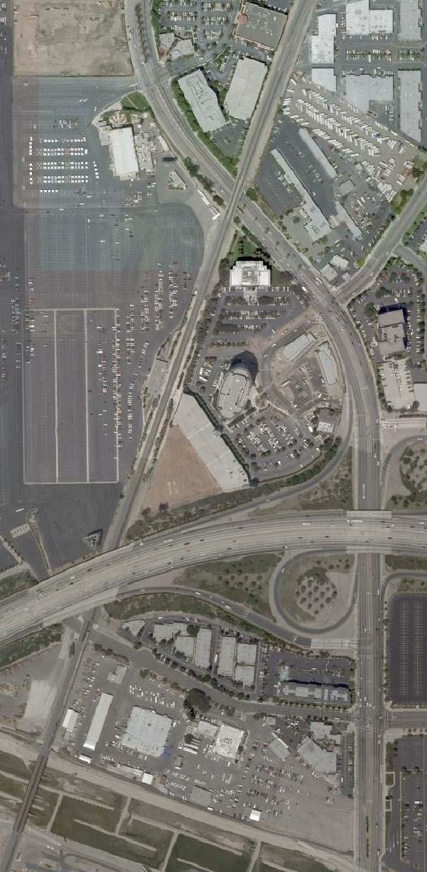
13 EXECUTIVE SUMMARY The proposed Anaheim Regional Transportation Intermodal Center (ARTIC) project is located in the City of Anaheim, California, in an area of the City referred to as the Platinum Triangle. The Project site is bounded by Katella Avenue to the north, the Orange Freeway (SR-57) to the south, the Santa Ana River to the east and Douglass Road to the west, with the Los Angeles to San Diego (LOSSAN) rail corridor bisecting the site. The scope of the Project is to replace and enlarge the existing Anaheim Metrolink/Amtrak station and will include a nominal amount of passenger-oriented retail uses. Construction of ARTIC is estimated to be completed in The Project would provide improvements to convert the site from a former County of Orange maintenance facility to a fully functioning regional transportation facility. Along with the Metrolink Service Expansion Program currently underway, the site would accommodate existing transit services and future services such as Bus Rapid Transit and other rubber-tired fixed route and shuttle services. The proposed ARTIC site includes the acre Orange County Transportation Authority (OCTA) parcel and an adjacent 2.2-acre parcel owned by the City of Anaheim. The proposed Project will replace the existing Metrolink station located to the west of the Project site along the northern edge of the Anaheim Angels Stadium parking area. While there are industrial buildings on the proposed Project site, the buildings are vacant and will be demolished as part of the Project development. This study analyzes the relocation of the existing rail station to the ARTIC site with the facilities necessary to support existing transit services (rail and non-rail), as well as to accommodate future transit services such as the planned OCTA s Metrolink Service Expansion Program (MSEP) currently underway, OCTA s proposed Bravo service and other fixed route services. ARTIC will also include passenger-oriented retail and civic space. A total parking supply of up to 960 parking spaces will be provided within three parking lots, ARTIC North Parking Lot, ARTIC South Parking Lot and the existing Metrolink/Amtrak Parking Lot, with a parking supply of approximately 323 parking spaces, 232 parking spaces and 405 parking spaces, respectively. Access to the Project site and parking lots would be provided via driveways located along Douglass Road, Katella Avenue and at the existing Sportstown access on Katella west of the 57 Freeway. The proposed Project is forecast to generate 4,714 daily trips (one half arriving and one half departing), with 805 trips (642 inbound, 163 outbound) produced in the AM peak hour and 662 trips (144 inbound, 518 outbound) produced in the PM peak hour on a typical weekday. The existing Project (Metrolink Station) generates 1,015 daily trips (one half arriving and one half departing), with 183 trips (119 inbound, 64 outbound) produced in the AM peak hour xii N:\3100\ \Report\3123 TIA doc
14 and 223 trips (86 inbound, 137 outbound) produced in the PM peak hour on a typical weekday. After taking credit for the existing Metrolink land use, the proposed Project is forecast to generate 3,699 net daily trips (one half arriving and one half departing), with 622 net trips (523 inbound, 99 outbound) produced in the AM peak hour and 439 net trips (58 inbound, 381 outbound) produced in the PM peak hour on a typical weekday. The Project study area covers twelve (12) existing key study intersections and seven (7) future Project driveways. The key study intersections and Project driveways are: 1. Manchester Avenue/I-5 Southbound Ramps at Katella Avenue (City of Anaheim) 2. Anaheim Way/I-5 Northbound Ramps at Katella Avenue (City of Anaheim) 3. Lewis Street at Katella Avenue (City of Anaheim) 4. State College Boulevard at Katella Avenue (City of Anaheim) 5. Sportstown at Katella Avenue (City of Anaheim) 6. Howell Avenue at Katella Avenue (City of Anaheim) 7. SR-57 Southbound Ramps at Katella Avenue (City of Anaheim) 8. SR-57 Northbound Ramps at Katella Avenue (City of Anaheim) 9. Douglass Road at Katella Avenue (City of Anaheim) 10. Struck Avenue at Katella Avenue (City of Orange) 11. Main Street at Katella Avenue (City of Orange) 12. Batavia Street at Katella Avenue (City of Orange) 13. Douglass Road at Driveway 1 (Future) 14. Douglass Road at Driveway 2 (Future) 15. Douglass Road at Driveway 3 (Future) 16. Douglass Road at Driveway 4 (Future) 17. Douglass Road at Driveway 5 (Future) 18. Douglass Road at Driveway 6 (Future) 19. Driveway 7 at Katella Avenue (Future) The Project study area covers eight (8) key study roadway segments. The key roadway segments are: 1. Katella Avenue between Manchester Avenue and Anaheim Way (City of Anaheim) 2. Katella Avenue between Anaheim Way and Lewis Street (City of Anaheim) 3. Katella Avenue between Lewis Street and State College Boulevard (City of Anaheim) 4. Katella Avenue between State College Boulevard and Sportstown (City of Anaheim) xiii N:\3100\ \Report\3123 TIA doc
15 Existing Conditions 5. Katella Avenue between Sportstown and Howell Avenue (City of Anaheim) 6. Katella Avenue between Howell Avenue and SR-57 Freeway (City of Anaheim) 7. Katella Avenue between SR-57 Freeway and Main Street (Cities of Anaheim/Orange) 1 8. Katella Avenue between Main Street and Batavia Street (City of Orange) All twelve (12) key study intersections under the Existing peak hour service level calculations based on existing traffic volumes and current street geometry are currently operating at an acceptable LOS B or better. All eight (8) key study roadway segments under Existing service level calculations based on existing daily traffic volumes and current roadway geometry are currently operating at acceptable LOS B or better. Existing With Project Conditions All twelve (12) key study intersections are forecast to operate at acceptable LOS B or better for the Existing With Project traffic conditions when compared to the LOS standards defined in this report. All eight (8) of the key study roadway segments are forecast to operate at acceptable LOS B on a daily basis under Existing With Project traffic conditions based on the LOS impact criteria outlined in this report. Year 2013 With Project Conditions None of the key study intersections under the Year 2013 With Project traffic conditions are significantly impacted by the addition of Project traffic per the impact criteria outlined in this report. None of the key study roadway segments under the Year 2013 With Project traffic conditions are significantly impacted by the addition of Project traffic per the impact criteria outlined in this report. Year 2030 With Project Conditions Two (2) key study intersections will be significantly impacted based on the LOS standards and the significance impact criteria defined in this report. It should be noted that the recommended mitigation measures outlined in this report will offset the impact of the Year 2030 With Project traffic conditions and bring the significantly impacted intersections to acceptable Level of Service. 1 The segment from the SR-57 Freeway to Santa Ana River is in the City of Anaheim and the segment from the Santa Ana River to Main Street is in the City of Orange. Since the roadway segment count was collected in the City of Anaheim, this segment has been analyzed as a City of Anaheim segment. xiv N:\3100\ \Report\3123 TIA doc
16 One (1) study roadway segment is significantly impacted by Year 2030 With Project traffic based on the LOS impact criteria outlined in this report. The segment of Katella Avenue between Manchester Avenue and Anaheim Way will be mitigated by widening Katella Avenue from six (6) to eight (8) lanes. It should be noted that this improvement has been determined to be feasible through the Platinum Triangle Implementation Plan. The recommended mitigation measure will offset the impact of the Year 2030 With Project traffic conditions and bring the significantly impacted roadway segment to an acceptable Level of Service. Orange County Congestion Management Program (CMP) Analysis Existing With Project All four (4) CMP intersections operate at acceptable LOS A for both the Existing and Existing With Project traffic conditions based on the CMP criteria which stipulates maintaining LOS E at all CMP locations. All eight (8) CMP roadway segments operate at acceptable LOS B or better for both the Existing and Existing With Project traffic conditions. Year 2013 Conditions All four (4) CMP intersections operate at acceptable LOS B or better for both the Year 2013 Without Project and Year 2013 With Project traffic conditions. All eight (8) of the CMP roadway segments operate at acceptable LOS E or better for both the Year 2013 Without Project and Year 2013 With Project traffic conditions. Year 2030 Conditions All four (4) CMP intersections operate at acceptable LOS D or better after the implementation of the recommended improvements for both the Year 2030 Without Project and Year 2030 With Project traffic conditions. One (1) CMP roadway segment is significantly impacted. The segment of Katella Avenue between Manchester Avenue and Anaheim Way will be mitigated by widening Katella Avenue from six (6) to eight (8) lanes. It should be noted that this improvement has been determined to be feasible through the Platinum Triangle Implementation Plan. With the implementation of this planned improvement, this roadway segment is forecast to operate at acceptable LOS during the AM and PM peak hours and is consistent with the 2009 Orange County Congestion Management Program (CMP) requirement. xv N:\3100\ \Report\3123 TIA doc
17 Caltrans Facilities Analysis Existing Conditions All Caltrans intersections are currently operating at an acceptable LOS D or better during the AM and PM peak hours. Year 2013 With Project Conditions None of the four (4) Caltrans ramp intersections operate at adverse levels of service with the addition of the Project traffic, when compared to the Caltrans criteria. All four (4) Caltrans ramp intersections are forecast to operate at an acceptable LOS C or better during the AM and PM peak hours under the Year 2013 With Project traffic conditions. None of the four (4) Caltrans ramp locations (Merge/Diverge Analysis) operate at adverse levels of service with the addition of the Project traffic, when compared to the Caltrans criteria. All four (4) Caltrans ramp locations are forecast to operate at an acceptable LOS C or better during the AM and PM peak hours under the Year 2013 With Project traffic conditions. Three (3) of the four (4) Caltrans ramp locations (Weaving Analysis) operate at adverse levels of service with the addition of the Project traffic, when compared to the Caltrans criteria. The remaining one (1) Caltrans ramp location is forecast to operate at an acceptable LOS D or better during the AM and PM peak hours under the Year 2013 With Project traffic conditions. The locations operating at adverse LOS are listed below: Key Freeway Segment 2. SR-57 Southbound between Katella Ave On-Ramp and Orangewood Ave Off-Ramp 3. SR-57 Northbound between Katella Ave On-Ramp and Ball Rd Off-Ramp 4. SR-57 Southbound between Ball Rd On-Ramp and Katella Ave Off-Ramp AM Peak Hour PM Peak Hour Density Density (pc/mi/ln) LOS (pc/mi/ln) LOS E F E E It should be noted that the recommended mitigation measures outlined in this report will offset the impact of the Year 2013 With Project traffic conditions and bring the significantly impacted ramp locations to acceptable Level of Service. Two (2) Caltrans freeway segments operate at adverse levels of service with addition of the Project traffic, when compared to the Caltrans criteria. The remaining two (2) Caltrans freeway segments are forecast to operate at an acceptable LOS D or better during the AM and PM peak hours under the Year 2013 With Project traffic conditions. The locations operating at adverse LOS are listed below: xvi N:\3100\ \Report\3123 TIA doc
18 Key Freeway Segment 3. SR-57 Northbound from Katella Avenue to Ball Road 4. SR-57 Southbound from Ball Road to Katella Avenue AM Peak Hour PM Peak Hour Pk Hr Density Pk Hr Density Volume (pc/mi/ln) LOS Volume (pc/mi/ln) LOS ,380 OVRFL F , E It should be noted that the recommended mitigation measures outlined in this report will offset the impact of the Year 2013 With Project traffic conditions and bring the significantly impacted freeway segments to acceptable Level of Service. Year 2030 With Project Conditions Two (2) Caltrans study intersections will operate at adverse levels of service under the Year 2030 With Project traffic conditions when compared to the Caltrans criteria. The locations operating at an adverse LOS are listed below: AM Peak Hour PM Peak Hour Key Intersection Delay (s/v) LOS Delay (s/v) LOS 1. Manchester Ave/I-5 SB Ramps at Katella Ave 59.0 E 70.9 E 2. Anaheim Way/I-5 NB Ramps at Katella Avenue F It should be noted that the recommended mitigation measures outlined in this report will offset the impacts of the Year 2030 With Project traffic conditions and bring the significantly impacted intersections to acceptable Level of Service. None of the four (4) Caltrans ramp locations (Merge/Diverge Analysis) operate at adverse levels of service with the addition of the Project traffic, when compared to the Caltrans criteria. All four (4) Caltrans ramp locations are forecast to operate at an acceptable LOS D or better during the AM and PM peak hours under the Year 2030 With Project traffic conditions. Three (3) of the four (4) Caltrans ramp locations (Weaving Analysis) operate at adverse levels of service with the addition of the Project traffic, when compared to the Caltrans criteria. The remaining one (1) Caltrans ramp location is forecast to operate at an acceptable LOS D or better during the AM and PM peak hours under the Year 2030 With Project traffic conditions. The locations operating at adverse LOS are listed below: Key Freeway Segment 2. SR-57 Southbound between Katella Ave On-Ramp and Orangewood Ave Off-Ramp AM Peak Hour PM Peak Hour Density Density (pc/mi/ln) LOS (pc/mi/ln) LOS E xvii N:\3100\ \Report\3123 TIA doc
19 3. SR-57 Northbound between Katella Ave On-Ramp and Ball Rd Off-Ramp 4. SR-57 Southbound between Ball Rd On-Ramp and Katella Ave Off-Ramp E E E It should be noted that the recommended mitigation measures outlined in this report will offset the impact of the Year 2030 With Project traffic conditions and bring the significantly impacted ramp locations to acceptable Level of Service. One (1) Caltrans freeway segment operates at an adverse level of service with addition of the Project traffic, when compared to the Caltrans criteria. The remaining three (3) Caltrans freeway segments are forecast to operate at an acceptable LOS D or better during the AM and PM peak hours under the Year 2030 With Project traffic conditions. The locations operating at adverse LOS are listed below: Key Freeway Segment 4. SR-57 Southbound from Ball Road to Katella Avenue AM Peak Hour PM Peak Hour Pk Hr Density Pk Hr Density Volume (pc/mi/ln) LOS Volume (pc/mi/ln) LOS 8, E 8, E It should be noted that the recommended mitigation measures outlined in this report will offset the impact of the Year 2030 With Project traffic conditions and bring the significantly impacted freeway segments to acceptable Level of Service. Site Access & On-Site Circulation All the Project driveways are forecast to operate at an acceptable service level of LOS B or better during the AM and PM peak hours for Year 2013 With Project traffic conditions. As such, Project access will be adequate. Motorists entering and exiting the Project site will be able to do so comfortably, safely and without undue congestion. The maximum number of inbound vehicle queue calculated during the Year 2013 With Project Traffic Conditions occurs on the inbound southbound left-turn movement from Douglass Road into Driveway 3 during the AM peak hour. The queue on Douglass Road is forecast to have a maximum queue of six (6) vehicles. This vehicle queue length translates to 132 feet in queuing (assuming an average car length of 22 feet). The maximum number of outbound vehicle queue calculated during the Year 2013 With Project Traffic Conditions occurs on the outbound westbound right-turn movement from Driveway 2 onto Douglass Road during the PM peak hour. The queue on Driveway 2 is forecast to have a maximum queue of three (3) vehicles. This vehicle queue length translates to 66 feet in queuing (assuming an average car length of 22 feet). All of the other Project driveways are forecast to operate with a maximum queue of one (1) vehicle during the AM and PM peak hours. Based on the Driveway Stacking/Storage and Queuing Analysis, adequate vehicle storage is provided at all of the driveways and review of the proposed site plan indicates that all Project xviii N:\3100\ \Report\3123 TIA doc
20 driveways have sufficient stacking to accommodate the forecast vehicle queues. Based on the above, no changes to the proposed configuration of the Project driveways are necessary. The on-site circulation was evaluated in terms of vehicle-pedestrian conflicts. Based on our review of the preliminary site plan, the overall layout does not create any unsafe vehiclepedestrian conflict points and the driveway throating is sufficient such that access to parking spaces is not impacted by internal vehicle queuing/stacking. Curb return radii have been confirmed and are adequate for passenger cars, buses, shuttles, service/delivery trucks and trash trucks. Project traffic is not anticipated to cause significant queuing/stacking on the Project driveways. The on-site circulation is very good based on our review of the proposed site plan, whereas the alignment, spacing and throating of the Project driveways is adequate. The circulation around the buildings is adequate with sufficient sight distance along the drive aisles. To supplement the operations analysis for the site access evaluation, the intersection of Douglass Road at Katella Avenue has been analyzed using the HCM 2000 Methodology to determine the appropriate northbound approach lane geometry for the Year 2013 Project opening condition. As a result of the HCM analysis, the intersection of Douglass Road at Katella Avenue is recommended to consist of a northbound lane configuration of two NBL turn lanes, one NBTR lane and one NBR turn lane for the Year 2013 Project opening condition. The intersection of Douglass Road at Katella Avenue operates at acceptable LOS D or better based on the HCM 2000 Methodology and the lane configuration mentioned above. Proposed Mitigation and Improvement Strategies Existing With Project Intersection Improvements: Since there were no impacted intersections under the Existing With Project traffic conditions, no improvements have been recommended. Existing With Project Roadway Segments Improvements: Since there were no impacted roadway segments under the Existing With Project traffic conditions, no improvements have been recommended. Year 2013 With Project Intersection Improvements: Since there were no impacted intersections under the Year 2013 With Project traffic conditions, no improvements have been recommended. It should be noted that the intersection of Douglass Road at Katella Avenue assumes a northbound lane configuration of two NBL, one NBTR and one NBR for the with Project scenario as identified in the Project Description of the ARTIC EIR. xix N:\3100\ \Report\3123 TIA doc
21 Year 2013 With Project Roadway Segments Improvements: Since there were no impacted roadway segments under the Year 2013 With Project traffic conditions, no improvements have been recommended. Year 2013 With Project Caltrans Ramp Intersections Improvements: Since there were no impacted ramp intersections under the Year 2013 With Project traffic conditions, no improvements have been recommended. Year 2013 With Project Caltrans Ramp Locations (Merge/Diverge Analysis) Improvements: Since there were no impacted ramp locations based on the merge/diverge analysis under the Year 2013 With Project traffic conditions, no improvements have been recommended. Year 2013 With Project Caltrans Ramp Locations (Weaving Analysis) Improvements: The improvements listed below have been identified to mitigate the traffic impacts at the Caltrans ramp locations significantly impacted by the Year 2013 With Project traffic: SR-57 Southbound between Katella Avenue On-Ramp and Orangewood Avenue Off-Ramp: Add a 6 th lane on this segment of SR-57 Southbound freeway. SR-57 Northbound between Katella Avenue On-Ramp and Ball Road Off- Ramp: Add a 5 th lane on this segment of SR-57 Northbound freeway. This improvement is funded by Measure M and is estimated to be completed in Year SR-57 Southbound between Ball Road On-Ramp and Katella Avenue Off- Ramp: Add a 5 th lane on this segment of SR-57 Southbound freeway. Year 2013 With Project Caltrans Freeway Segments Improvements: The improvements listed below have been identified to mitigate the traffic impacts at the Caltrans freeway segments significantly impacted by the Year 2013 With Project traffic: SR-57 Northbound from Katella Avenue to Ball Road: Add a 5 th lane on this segment of SR-57 Northbound freeway. This improvement is funded by Measure M and is estimated to be completed by Year SR-57 Southbound from Ball Road to Katella Avenue: Add a 5 th lane on this segment of SR-57 Southbound freeway. Year 2030 With Project Intersection Improvements: The improvements listed below have been identified to mitigate the traffic impacts at the intersections significantly impacted by the Year 2030 With Project traffic: xx N:\3100\ \Report\3123 TIA doc
22 Anaheim Way/I-5 Northbound Ramps at Katella Avenue: Widen and/or restripe Katella Avenue to provide a 4 th eastbound through lane and a 5 th westbound through lane. Modify existing traffic signal. Douglass Road at Katella Avenue: Widen and/or re-stripe Douglass Road to provide two left turn lanes, two through lanes, and one right turn lane in both the northbound and southbound directions. Widen and/or re-stripe Katella Avenue to provide a 4 th eastbound through lane and a 4 th westbound through lane. Modify existing traffic signal. Year 2030 With Project Roadway Segments Improvements: The improvements listed below have been identified to mitigate the traffic impacts at this roadway segment significantly impacted by the Year 2030 With Project traffic: Katella Avenue between Manchester Avenue to Anaheim Way: Widen Katella Avenue from six (6) to eight (8) lanes between Manchester Avenue and Anaheim Way. It should be noted that this improvement has been determined to be feasible through the Platinum Triangle Implementation Plan. Year 2030 With Project Caltrans Ramp Intersections Improvements: The improvements listed below have been identified to mitigate the traffic impacts at the Caltrans ramp intersections significantly impacted by the Year 2030 With Project traffic: Manchester Avenue/I-5 Southbound Ramps at Katella Avenue: Widen and/or re-stripe Katella Avenue to construct a pedestrian refuge island on the west leg of intersection with pedestrian buttons. Widen and/or re-stripe Katella Avenue to provide a 4 th eastbound through lane and a 4 th westbound through lane. Modify the existing traffic signal and install eastbound right-turn overlap phase on Katella Avenue. Anaheim Way/I-5 Northbound Ramps at Katella Avenue: Widen and/or restripe Katella Avenue to provide a 4 th eastbound through lane and a 5 th westbound through lane. Modify existing traffic signal. Year 2030 With Project Caltrans Ramp Locations (Merge/Diverge Analysis) Improvements: Since there were no impacted ramp locations based on the merge/diverge analysis under the Year 2030 With Project traffic conditions, no improvements have been recommended. Year 2030 With Project Caltrans Ramp Locations (Weaving Analysis) Improvements: The improvements listed below have been identified to mitigate the traffic impacts at the Caltrans ramp locations significantly impacted by the Year 2030 With Project traffic: SR-57 Southbound between Katella Avenue On-Ramp and Orangewood Avenue Off-Ramp: Add a 6 th lane on this segment of SR-57 Southbound freeway. xxi N:\3100\ \Report\3123 TIA doc
23 SR-57 Northbound between Katella Avenue On-Ramp and Ball Road Off- Ramp: Add a 6 th lane on this segment of SR-57 Northbound freeway. SR-57 Southbound between Ball Road On-Ramp and Katella Avenue Off- Ramp: Add a 5 th lane on this segment of SR-57 Southbound freeway. Year 2030 With Project Caltrans Freeway Segments Improvements: The improvements listed below have been identified to mitigate the traffic impacts at the Caltrans freeway segments significantly impacted by the Year 2030 With Project traffic: SR-57 Southbound from Ball Road to Katella Avenue: Add a 5 th lane on this segment of SR-57 Southbound freeway. Caltrans Ramps and Freeway Improvements: For improvements to the Caltrans facilities, the City of Anaheim, lead agency for this project, will have to decide whether (1) changes, alterations, or mitigation measures are within the responsibility and jurisdiction of another public agency such as Caltrans and not the City of Anaheim. It must determine if such changes have been adopted by such other agency or can and should be adopted by such other agency and/or (2) whether any further mitigation to the impacted State Highway System are feasible, and if not, whether specific overriding economic, legal, social, technological, or other benefits of the project outweigh the unavoidable cumulative traffic impacts caused by the Project. With completion of the improvements described in the mitigation, the significant impacts associated with the proposed Project would be fully mitigated with the exception of the improvements to State highway facilities. However, inasmuch as the primary responsibility for approving and/or completing certain improvements located outside of Anaheim lies with agencies other than the City of Anaheim (i.e., City of Orange and Caltrans); there is the potential that significant impacts may not be fully mitigated if such improvements are not completed for reasons beyond the City of Anaheim s control. Should that occur, the Project s traffic impact would remain significant. The City is committed to working with the City of Orange and Caltrans to identify the most appropriate improvement strategies for their facilities and acknowledges the fair-share cost of improvements to those facilities, however, the City of Orange and Caltrans have full jurisdiction toward implementing the identified improvements under their jurisdiction. Unavoidable Impacts and Statement of Overriding Considerations Although every effort was made through site analyses and aerial imagery evaluation to ensure that all recommended improvements are physically feasible, there are improvements identified in this study that may not be feasible due to high Project cost, the inability to undertake right-of-way acquisitions as a matter of policy to preserve existing businesses, environmental constraints, or jurisdictional considerations. For these improvements, including Caltrans facilities, including freeway ramps, mainline segments, and weaving xxii N:\3100\ \Report\3123 TIA doc
24 segments, a Statement of Overriding Considerations will document why a particular improvement is infeasible as mitigation. With implementation of the improvements presented previously, the significant Project related or cumulative impacts associated with the proposed Project would be fully mitigated. However, inasmuch as the primary responsibility for approving and/or completing certain improvements located outside of Anaheim lies with agencies other than the City of Anaheim (i.e., Caltrans), there is the potential that significant impacts may not be fully mitigated if such improvements are not completed for reasons beyond the City of Anaheim s control (e.g., the City of Anaheim cannot undertake or require improvements outside of Anaheim s jurisdiction or the City cannot construct improvements in the Caltrans right-of-way without Caltrans Approval). Should that occur, the Project s traffic impact would remain significant. City of Orange Improvements As shown in the analysis, no intersections or roadway segments in the City of Orange are impacted by ARTIC; no improvements have been recommended. xxiii N:\3100\ \Report\3123 TIA doc
25 TRAFFIC IMPACT ANALYSIS REPORT ARTIC Anaheim, California July 16, 2010 (Update of the April 29, 2010 Report) 1.0 INTRODUCTION This traffic impact study addresses the potential traffic impacts and circulation needs associated with the proposed Anaheim Regional Transportation Intermodal Center (ARTIC) project (hereinafter referred to as Project) in the City of Anaheim, California, in an area of the City referred to as the Platinum Triangle. The Project site is bounded by Katella Avenue to the north, the Orange Freeway (SR-57) to the south, the Santa Ana River to the east and Douglass Road to the west, with the Los Angeles to San Diego (LOSSAN) rail corridor bisecting the site. The scope of the Project is to replace and enlarge the existing Anaheim Metrolink/Amtrak station and will include a nominal amount of passenger-oriented retail uses. Construction of ARTIC is estimated to be completed in The Project would provide improvements to convert the site from a former County of Orange maintenance facility to a fully functioning regional transportation facility. Along with the Metrolink Service Expansion Program currently underway, the site would accommodate existing transit services and future services such as Bus Rapid Transit and other rubber-tired fixed route and shuttle services. The proposed ARTIC site includes the acre Orange County Transportation Authority (OCTA) parcel and an adjacent 2.2-acre parcel owned by the City of Anaheim. The proposed Project will replace the existing Metrolink station located to the west of the Project site along the northern edge of the Anaheim Angels Stadium parking area. While there are industrial buildings on the proposed Project site, the buildings are vacant and will be demolished as part of the Project development. This study analyzes the relocation of the existing rail station to the ARTIC site with the facilities necessary to support existing transit services (rail and non-rail), as well as to accommodate future transit services such as the planned OCTA s Metrolink Service Expansion Program (MSEP) currently underway, OCTA s proposed Bravo service and other fixed route services. ARTIC will also include passenger-oriented retail and civic space. A total parking supply of up to 960 parking spaces will be provided within three parking lots, ARTIC North Parking Lot, ARTIC South Parking Lot and the existing Metrolink/Amtrak Parking Lot, with a parking supply of approximately 323 parking spaces, 232 parking spaces and 405 parking spaces, respectively. Access to the Project site and parking lots would be provided via driveways located along Douglass Road, Katella Avenue and at the existing Sportstown access on Katella west of the 57 Freeway. This report documents the findings and recommendations of a traffic impact analysis conducted by Linscott, Law & Greenspan, Engineers (LLG) to determine the potential impacts the Project may have on the local and/or regional network in the vicinity of the Project site. The traffic impact 1 N:\3100\ \Report\3123 TIA doc
26 analysis evaluates the existing operating conditions at twelve (12) key study intersections within the Project vicinity, estimates the trip generation potential of the proposed Project and forecasts future (near-term and long-term) operating conditions without and with the proposed Project. It should be noted that seven (7) Project driveways were also analyzed for the near-term with Project scenarios. This traffic impact analysis report satisfies the City of Anaheim Criteria for Preparation of Traffic Impact Studies and is consistent with the requirements and procedures outlined in the 2009 Orange County Congestion Management Program (CMP). The Project site has been visited and an inventory of adjacent area roadways and intersections was performed. Existing (i.e. baseline) peak hours and daily traffic information has been collected at twelve (12) key study intersections and eight (8) key study roadway segments, respectively, on a typical weekday for use in the preparation of intersection and roadway segment level of service calculations. This traffic report analyzes existing (i.e. baseline) and future (near-term and long-term) weekday AM and PM peak hour and daily traffic conditions for Existing (i.e. baseline), Year 2013 and Year 2030 traffic conditions without and with the proposed Project. Peak hour and daily traffic volumes for the Existing, Year 2013 Without Project and Year 2030 With Project traffic conditions were provided by the City of Anaheim. 1.1 Study Area The study intersections listed below are locations that could potentially be impacted by the proposed Project. Twelve (12) existing key study intersections and seven (7) future Project driveways listed below were selected based on location of Project and 51 or more peak hour trips threshold criteria outlined in the City of Anaheim Criteria For Preparation of Traffic Impact Studies as well as discussions with the City of Anaheim staff. The key study intersections are: 1. Manchester Avenue/I-5 Southbound Ramps at Katella Avenue (City of Anaheim) 2. Anaheim Way/I-5 Northbound Ramps at Katella Avenue (City of Anaheim) 3. Lewis Street at Katella Avenue (City of Anaheim) 4. State College Boulevard at Katella Avenue (City of Anaheim) 5. Sportstown at Katella Avenue (City of Anaheim) 6. Howell Avenue at Katella Avenue (City of Anaheim) 7. SR-57 Southbound Ramps at Katella Avenue (City of Anaheim) 8. SR-57 Northbound Ramps at Katella Avenue (City of Anaheim) 9. Douglass Road at Katella Avenue (City of Anaheim) 10. Struck Avenue at Katella Avenue (City of Orange) 11. Main Street at Katella Avenue (City of Orange) 12. Batavia Street at Katella Avenue (City of Orange) 13. Douglass Road at Driveway 1 (Future) 14. Douglass Road at Driveway 2 (Future) 2 N:\3100\ \Report\3123 TIA doc
27 15. Douglass Road at Driveway 3 (Future) 16. Douglass Road at Driveway 4 (Future) 17. Douglass Road at Driveway 5 (Future) 18. Douglass Road at Driveway 6 (Future) 19. Driveway 7 at Katella Avenue (Future) In addition, the study roadway segments listed below are locations that could potentially be impacted by the proposed Project. The eight (8) roadway segments listed below were selected based on the arterial network within the study area: 1. Katella Avenue between Manchester Avenue and Anaheim Way (City of Anaheim) 2. Katella Avenue between Anaheim Way and Lewis Street (City of Anaheim) 3. Katella Avenue between Lewis Street and State College Boulevard (City of Anaheim) 4. Katella Avenue between State College Boulevard and Sportstown (City of Anaheim) 5. Katella Avenue between Sportstown and Howell Avenue (City of Anaheim) 6. Katella Avenue between Howell Avenue and SR-57 Freeway (City of Anaheim) 7. Katella Avenue between SR-57 Freeway and Main Street (Cities of Anaheim/Orange) 2 8. Katella Avenue between Main Street and Batavia Street (City of Orange) Figure 1-1 presents a Vicinity Map, which illustrates the general location of the Project and depicts the study locations and surrounding street system. Figure 1-2 presents a Regional Map, which illustrates the general location of the Project, surrounding cities and the regional freeway system. The ICU/HCM Delay and Level of Service (LOS) calculations at these key locations were used to evaluate the potential traffic-related impacts associated with area growth, related projects and the proposed Project. When necessary, this report recommends intersection improvements that may be required to accommodate future traffic volumes and restore/maintain an acceptable Level of Service and/or addresses the impact of the Project. Included in this Traffic Impact Analysis are: Existing traffic counts, Estimated Project traffic generation/distribution/assignment for the existing and proposed Project, AM and PM peak hours and Daily capacity analyses for existing (i.e. baseline) conditions, AM and PM peak hours and Daily capacity analyses for Existing (i.e. baseline) conditions with Project traffic, 2 The segment from the SR-57 Freeway to Santa Ana River is in the City of Anaheim and the segment from the Santa Ana River to Main Street is in the City of Orange. Since the roadway segment count was collected in the City of Anaheim, this segment has been analyzed as a City of Anaheim segment. 3 N:\3100\ \Report\3123 TIA doc
28 AM and PM peak hours and Daily capacity analyses for near-term (Year 2013) conditions without and with Project traffic, AM and PM peak hours and Daily capacity analyses for long-term (Year 2030) conditions without and with Project traffic, Congestion Management Program (CMP) Analysis, Caltrans Facilities Analysis (HCM Methodology), Site Access and On-Site Circulation Analysis, and Project-Specific Traffic Improvements. 1.2 Traffic Impact Analysis Scenarios The following scenarios are those for which ICU/HCM Delay LOS and V/C calculations have been performed at the key intersections and key roadway segments and for existing, near-term and longterm traffic conditions: A. Existing (i.e. baseline) Traffic Conditions, B. Existing (i.e. baseline) With Projects Traffic Conditions, C. Scenario B with Recommended Improvements, if any, D. Year 2013 Without Project Traffic Conditions, E. Year 2013 With Project Traffic Conditions, F. Scenario E With Recommended Improvements, G. Year 2030 Without Project Traffic Conditions, H. Year 2030 With Project Traffic Conditions, and I. Scenario H With Recommended Improvements. 1.3 Study Area - City of Orange The study area that could potentially be impacted by the proposed Project was selected based on location of Project and 51 or more peak hour trips threshold criteria outlined in the City of Anaheim Criteria For Preparation of Traffic Impact Studies. The City of Orange uses the same methodology to determine intersections to be analyzed in Traffic Impact Studies. The City of Orange sent a letter requesting the analysis of 12 intersections within the City of Orange. In response, this traffic report analyzed all 12 requested intersections to see if they met the minimum peak hour trip threshold. Those City of Orange intersections that were forecast to receive 51 or more peak hour trips from the Project were further scrutinized to determine whether or not the Project-generated traffic created significant impacts in connection with the identified City of Orange intersections. For those City of Orange intersections that were forecast to receive less than 51 peak hour Projectgenerated trips, the report has determined that the Project will not create any significant impacts with respect to those identified City of Orange intersections. 4 N:\3100\ \Report\3123 TIA doc
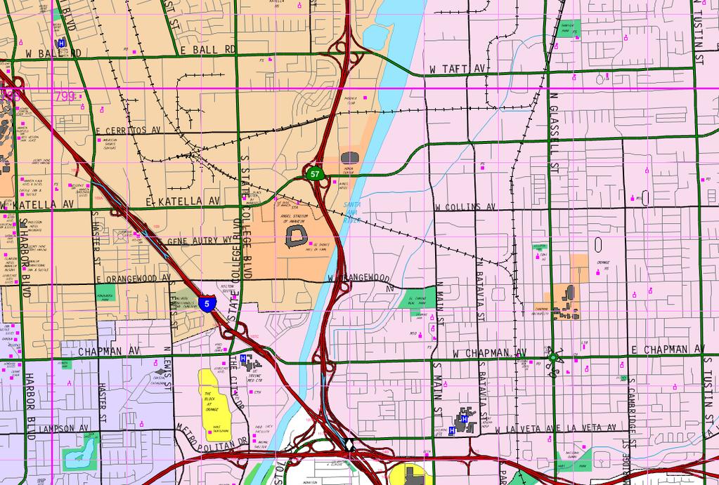
29
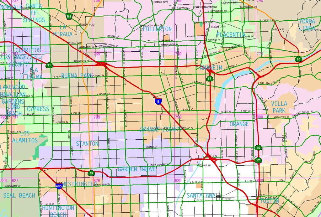
30
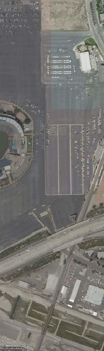
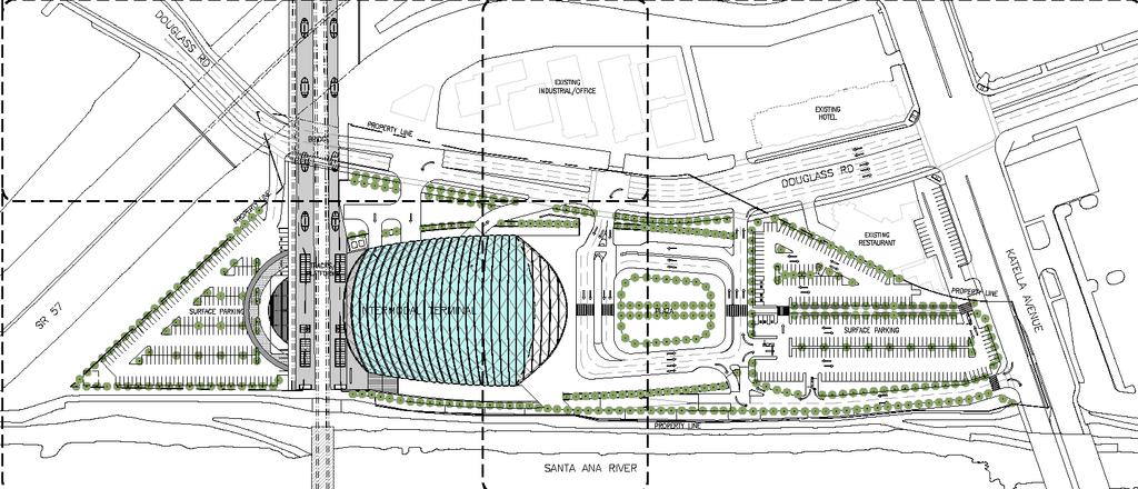
31 2.0 PROJECT DESCRIPTION AND LOCATION This traffic impact study addresses the potential traffic impacts and circulation needs associated with the proposed Anaheim Regional Transportation Intermodal Center (ARTIC) project (hereinafter referred to as Project) in the City of Anaheim, California, in an area of the City referred to as the Platinum Triangle. The Project site is bounded by Katella Avenue to the north, the Orange Freeway (SR-57) to the south, the Santa Ana River to the east and Douglass Road to the west, with the Los Angeles to San Diego (LOSSAN) rail corridor bisecting the site. The scope of the Project is to replace and enlarge the existing Anaheim Metrolink/Amtrak station, and will include a nominal amount of passenger-oriented retail uses. Construction of ARTIC is estimated to be completed in The Project would provide improvements to convert the site from a former County of Orange maintenance facility to a fully functioning regional transportation facility. Along with the Metrolink Service Expansion Program currently underway, the site would accommodate existing transit services and future services such as Bus Rapid Transit and other rubber-tired fixed route and shuttle services. The proposed ARTIC site includes the acre OCTA parcel and an adjacent 2.2-acre parcel owned by the City of Anaheim. The proposed Project will replace the existing Metrolink station located to the west of the Project site along the northern edge of the Anaheim Angels Stadium parking area. While there are industrial buildings on the proposed Project site, the buildings are vacant and will be demolished as part of the Project development. This study analyzes the relocation of the existing rail station to the ARTIC site with the facilities necessary to support existing transit services (rail and non-rail), as well as to accommodate future transit services such as the planned OCTA s Metrolink Service Expansion Program (MSEP) currently underway, OCTA s proposed Bravo service and other fixed route services. ARTIC will also include passenger-oriented retail and civic space. A total parking supply of up to 960 parking spaces will be provided within three parking lots, ARTIC North Parking Lot, ARTIC South Parking Lot and Metrolink/Amtrak Parking Lot, with a parking supply of approximately 323 parking spaces, 232 parking spaces and 405 parking spaces, respectively. Access to the Project site and parking lots would be provided via driveways located along Douglass Road, Katella Avenue and Sportstown. Figure 2-1 presents the existing site plan for the Project. Figure 2-2 presents the proposed site plan for the Project, prepared by Parsons Brinkerhoff. 2.1 Site Access As shown in Figure 2-2, vehicular access to the Project site will be provided via the existing intersection of Sportstown and Katella Avenue as well as via six (6) driveways located on Douglass Road and one (1) driveway located on Katella Avenue. The existing intersection of Sportstown and Katella Avenue is a full-access, signalized intersection that provides access to the Metrolink/Amtrak Parking Lot. Driveway 1 along Douglass Road is a one-way stop-controlled, right-in/right-out only driveway providing access to the ARTIC North 5 N:\3100\ \Report\3123 TIA doc
32 Parking Lot. Driveway 2 along Douglass Road is a right-out only, signalized intersection providing egress from the ARTIC North Parking Lot, Kiss and Ride area and taxi stand. Driveway 3 along Douglass Road is a signalized intersection that provides inbound-only access to the ARTIC North Parking Lot, Kiss and Ride area and taxi stand. It should be noted that the proposed traffic signals at Driveway 2 and Driveway 3 will essentially operate one traffic signal with a common controller. Driveway 4 along Douglass Road is a one-way stop-controlled, right-out only driveway providing egress from the buses and shuttles area. Driveway 5 along Douglass Road is a signalized intersection that provides inbound-only access to the buses and shuttles area. Driveway 6 along Douglass Road is a one-way stop-controlled, full-access driveway providing access to the ARTIC South Parking Lot. Driveway 7 along Katella Avenue is a one-way stop-controlled driveway that provides right-in/rightout only access to the ARTIC North Parking Lot, Kiss and Ride area, taxi stand as well as to the buses and shuttles area. It should be noted that the ARTIC patrons parking in the Sportstown parking lot would access the train platforms through the Stadium Pavilion which will be constructed on the west end of the platforms. 6 N:\3100\ \Report\3123 TIA doc
33
34
Appendix C. Traffic Study
 Appendix C Traffic Study TABLE OF CONTENTS SECTION Executive Summary PAGE 1.0 Introduction... 1 1.1 Scope of Work... 1 1.2 Study Area... 2 2.0 Project Description... 3 2.1 Site Access... 4 2.2 Pedestrian
Traffic Impact Analysis 5742 BEACH BOULEVARD MIXED USE PROJECT
 Traffic Impact Analysis 5742 BEACH BOULEVARD MIXED USE PROJECT CITY OF BUENA PARK Prepared by Project No. 14139 000 April 17 th, 2015 DKS Associates Jeffrey Heald, P.E. Rohit Itadkar, T.E. 2677 North Main
EXECUTIVE SUMMARY. The following is an outline of the traffic analysis performed by Hales Engineering for the traffic conditions of this project.
 EXECUTIVE SUMMARY This study addresses the traffic impacts associated with the proposed Shopko redevelopment located in Sugarhouse, Utah. The Shopko redevelopment project is located between 1300 East and
APPENDIX B Traffic Analysis
 APPENDIX B Traffic Analysis Rim of the World Unified School District Reconfiguration Prepared for: Rim of the World School District 27315 North Bay Road, Blue Jay, CA 92317 Prepared by: 400 Oceangate,
4.14 TRANSPORTATION AND CIRCULATION
 4.14 TRANSPORTATION AND CIRCULATION 4.14.1 Summary Table 4.14-1 summarizes the identified environmental impacts, proposed mitigation measures, and residual impacts of the proposed project with regard to
Appendix Q Traffic Study
 Appendices Appendix Q Traffic Study Crummer Site Subdivision Draft EIR City of Malibu Appendices This page intentionally left blank. The Planning Center April 2013 TRAFFIC IMPACT ANALYSIS Photo z here
Escondido Marriott Hotel and Mixed-Use Condominium Project TRAFFIC IMPACT ANALYSIS REPORT
 Escondido Marriott Hotel and Mixed-Use Condominium Project TRAFFIC IMPACT ANALYSIS REPORT Prepared for Phelps Program Management 420 Sixth Avenue, Greeley, CO 80632 Prepared by 5050 Avenida Encinas, Suite
King County Metro. Columbia Street Transit Priority Improvements Alternative Analysis. Downtown Southend Transit Study. May 2014.
 King County Metro Columbia Street Transit Priority Improvements Alternative Analysis Downtown Southend Transit Study May 2014 Parametrix Table of Contents Introduction... 1 Methodology... 1 Study Area...
LAWRENCE TRANSIT CENTER LOCATION ANALYSIS 9 TH STREET & ROCKLEDGE ROAD / 21 ST STREET & IOWA STREET LAWRENCE, KANSAS
 LAWRENCE TRANSIT CENTER LOCATION ANALYSIS 9 TH STREET & ROCKLEDGE ROAD / 21 ST STREET & IOWA STREET LAWRENCE, KANSAS TRAFFIC IMPACT STUDY FEBRUARY 214 OA Project No. 213-542 TABLE OF CONTENTS 1. INTRODUCTION...
Date: February 7, 2017 John Doyle, Z-Best Products Robert Del Rio. T.E. Z-Best Traffic Operations and Site Access Analysis
 Memorandum Date: February 7, 07 To: From: Subject: John Doyle, Z-Best Products Robert Del Rio. T.E. Z-Best Traffic Operations and Site Access Analysis Introduction Hexagon Transportation Consultants, Inc.
The major roadways in the study area are State Route 166 and State Route 33, which are shown on Figure 1-1 and described below:
 3.5 TRAFFIC AND CIRCULATION 3.5.1 Existing Conditions 3.5.1.1 Street Network DRAFT ENVIRONMENTAL IMPACT REPORT The major roadways in the study area are State Route 166 and State Route 33, which are shown
TRANSPORTATION STUDY FOR THE 8899 BEVERLY BOULEVARD PROJECT
 DRAFT TRANSPORTATION STUDY FOR THE 8899 BEVERLY BOULEVARD PROJECT WEST HOLLYWOOD, CALIFORNIA NOVEMBER 2013 PREPARED FOR BEVERLY BOULEVARD ASSOCIATION PREPARED BY DRAFT TRANSPORTATION STUDY FOR THE 8899
Traffic Impact Statement (TIS)
") Traffic Impact Statement (TIS) Vincentian PUDA Collier County, FL 10/18/2013 Prepared for: Global Properties of Naples Prepared by: Trebilcock Consulting Solutions, PA 2614 Tamiami Trail N, Suite 615 1205
Traffic Impact Statement (TIS) Vincentian PUDA Collier County, FL 10/18/2013 Prepared for: Global Properties of Naples Prepared by: Trebilcock Consulting Solutions, PA 2614 Tamiami Trail N, Suite 615 1205
TRAFFIC IMPACT ANALYSIS FOR. McDONALD S RESTAURANT IN CARMICAEL Sacramento County, CA. Prepared For:
 TRAFFIC IMPACT ANALYSIS FOR McDONALD S RESTAURANT IN CARMICAEL Sacramento County, CA Prepared For: McDonald s USA, LLC Pacific Sierra Region 2999 Oak Road, Suite 900 Walnut Creek, CA 94597 Prepared By:
King Soopers #116 Thornton, Colorado
 Traffic Impact Study King Soopers #116 Thornton, Colorado Prepared for: Galloway & Company, Inc. T R A F F I C I M P A C T S T U D Y King Soopers #116 Thornton, Colorado Prepared for Galloway & Company
2.1.5 Traffic and Circulation. Table Level of Service Criteria for Highway Segment Regulatory Setting Affected Environment
 2.1.5 Traffic and Circulation This section addresses the potential impacts to traffic and circulation associated with construction and long-term operation of the proposed project. The traffic and circulation
TIMBERVINE TRANSPORTATION IMPACT STUDY FORT COLLINS, COLORADO JANUARY Prepared for:
 TIMBERVINE TRANSPORTATION IMPACT STUDY FORT COLLINS, COLORADO JANUARY 2014 Prepared for: Hartford Companies 1218 W. Ash Street Suite A Windsor, Co 80550 Prepared by: DELICH ASSOCIATES 2272 Glen Haven Drive
Traffic Impact Study Speedway Gas Station Redevelopment
 Traffic Impact Study Speedway Gas Station Redevelopment Warrenville, Illinois Prepared For: Prepared By: April 11, 2018 Table of Contents 1. Introduction... 1 2. Existing Conditions... 4 Site Location...
Table Existing Traffic Conditions for Arterial Segments along Construction Access Route. Daily
 5.8 TRAFFIC, ACCESS, AND CIRCULATION This section describes existing traffic conditions in the project area; summarizes applicable regulations; and analyzes the potential traffic, access, and circulation
Oakbrook Village Plaza City of Laguna Hills
 Oakbrook Village Plaza City of Laguna Hills Traffic Impact Analysis Prepared by: HDR Engineering 3230 El Camino Real, Suite 200 Irvine, CA 92602 October 2012 Revision 3 D-1 Oakbrook Village Plaza Laguna
Craig Scheffler, P.E., PTOE HNTB North Carolina, P.C. HNTB Project File: Subject
 TECHNICAL MEMORANDUM To Kumar Neppalli Traffic Engineering Manager Town of Chapel Hill From Craig Scheffler, P.E., PTOE HNTB North Carolina, P.C. Cc HNTB Project File: 38435 Subject Obey Creek TIS 2022
INDUSTRIAL DEVELOPMENT
 INDUSTRIAL DEVELOPMENT Traffic Impact Study Plainfield, Illinois August 2018 Prepared for: Seefried Industrial Properties, Inc. TABLE OF CONTENTS Executive Summary 2 Introduction 3 Existing Conditions
TRAFFIC IMPACT STUDY FOR SONIC DRIVE-IN RESTAURANT. Vallejo, CA. Prepared For:
 TRAFFIC IMPACT STUDY FOR SONIC DRIVE-IN RESTAURANT Vallejo, CA Prepared For: ELITE DRIVE-INS, INC. 2190 Meridian Park Blvd, Suite G Concord, CA 94520 Prepared By: KD Anderson & Associates 3853 Taylor Road,
Quantitative analyses of weekday a.m. and p.m. commuter hour conditions have been conducted for the following five scenarios:
 6.1 TRANSPORTATION AND CIRCULATION 6.1.1 INTRODUCTION This section of the EIR presents the results of TJKM s traffic impact analysis of the proposed Greenbriar Development. The analysis includes consideration
TRAFFIC IMPACT ANALYSIS
 TRAFFIC IMPACT ANALYSIS Emerald Isle Commercial Development Prepared by SEPI Engineering & Construction Prepared for Ark Consulting Group, PLLC March 2016 I. Executive Summary A. Site Location The Emerald
APPENDIX C-2. Traffic Study Supplemental Analysis Memo
 APPENDIX C-2 Traffic Study Supplemental Analysis Memo The Mobility Group Transportation Strategies & Solutions Memorandum To: From: Subject: Tomas Carranza, LADOT Matthew Simons Traffic Review - Revised
MONTEREY BAY AQUARIUM RESEARCH INSTITUTE (MBARI) MASTER PLAN UPDATE MOSS LANDING, CALIFORNIA
 MASTER PLAN UPDATE MOSS LANDING, CALIFORNIA") MONTEREY BAY AQUARIUM RESEARCH INSTITUTE (MBARI) MASTER PLAN UPDATE MOSS LANDING, CALIFORNIA TRAFFIC IMPACT ANALYSIS Administrative Draft Report Prepared For Monterey Bay Aquarium Research Institute Moss
MONTEREY BAY AQUARIUM RESEARCH INSTITUTE (MBARI) MASTER PLAN UPDATE MOSS LANDING, CALIFORNIA TRAFFIC IMPACT ANALYSIS Administrative Draft Report Prepared For Monterey Bay Aquarium Research Institute Moss
APPENDIX C1 TRAFFIC ANALYSIS DESIGN YEAR TRAFFIC ANALYSIS
 APPENDIX C1 TRAFFIC ANALYSIS DESIGN YEAR TRAFFIC ANALYSIS DESIGN YEAR TRAFFIC ANALYSIS February 2018 Highway & Bridge Project PIN 6754.12 Route 13 Connector Road Chemung County February 2018 Appendix
TRAFFIC PARKING ANALYSIS
 TRAFFIC PARKING ANALYSIS NAPA FLEA MARKET COUNTY OF NAPA Prepared for: Tom Harding Napa-Vallejo Flea Market 33 Kelly Road American Canyon, CA 9453 Prepared by: 166 Olympic Boulevard, Suite 21 Walnut Creek,
2. Valley Circle Boulevard/Andora Avenue/Baden Avenue and Lassen Street
 IV.J TRANSPORTATION 1. INTRODUCTION This section presents an overview of the existing traffic and circulation system in and surrounding the project site. This section also discusses the potential impacts
TRAFFIC IMPACT ANALYSIS SAFARI HIGHLANDS RANCH
 TRAFFIC IMPACT ANALYSIS SAFARI HIGHLANDS RANCH, California November 11, 2016 LLG Ref. 3-14-2334 EXECUTIVE SUMMARY The Project proposes the development of 550 luxury residential dwelling units, public trails,
TALMONT TOWNHOMES MADISON KENNETH SPA TRAFFIC IMPACT STUDY. Sacramento, CA. Prepared For: MBK Homes. Prepared By:
 TALMONT TOWNHOMES MADISON KENNETH SPA TRAFFIC IMPACT STUDY Sacramento, CA Prepared For: MBK Homes Prepared By: KD Anderson & Associates 3853 Taylor Road, Suite G Loomis, California 95650 (916) 660-1555
Section 5.8 Transportation and Traffic
 Section 5.8 Transportation and Traffic 5.8 TRANSPORTATION AND TRAFFIC Generous This Section is based on the Topgolf Specific Plan Traffic Impact Analysis (RK Engineering Group, Inc., October 31, 2016);
Lacey Gateway Residential Phase 1
 Lacey Gateway Residential Phase Transportation Impact Study April 23, 203 Prepared for: Gateway 850 LLC 5 Lake Bellevue Drive Suite 02 Bellevue, WA 98005 Prepared by: TENW Transportation Engineering West
Proposed location of Camp Parkway Commerce Center. Vicinity map of Camp Parkway Commerce Center Southampton County, VA
 Proposed location of Camp Parkway Commerce Center Vicinity map of Camp Parkway Commerce Center Southampton County, VA Camp Parkway Commerce Center is a proposed distribution and industrial center to be
Transportation & Traffic Engineering
 Transportation & Traffic Engineering 1) Project Description This report presents a summary of findings for a Traffic Impact Analysis (TIA) performed by A+ Engineering, Inc. for the Hill Country Family
Table of Contents INTRODUCTION... 3 PROJECT STUDY AREA Figure 1 Vicinity Map Study Area... 4 EXISTING CONDITIONS... 5 TRAFFIC OPERATIONS...
 Crosshaven Drive Corridor Study City of Vestavia Hills, Alabama Table of Contents INTRODUCTION... 3 PROJECT STUDY AREA... 3 Figure 1 Vicinity Map Study Area... 4 EXISTING CONDITIONS... 5 TRAFFIC OPERATIONS...
2.0 Development Driveways. Movin Out June 2017
 Movin Out June 2017 1.0 Introduction The proposed Movin Out development is a mixed use development in the northeast quadrant of the intersection of West Broadway and Fayette Avenue in the City of Madison.
MEMO VIA . Ms. Amy Roth DPS Director, City of Three Rivers. To:
 MEMO To: Ms. Amy Roth DPS Director, City of Three Rivers VIA EMAIL From: Michael J. Labadie, PE Julie M. Kroll, PE, PTOE Brandon Hayes, PE, P.Eng. Fleis & VandenBrink Date: January 5, 2017 Re: Proposed
5.9 TRANSPORTATION AND TRAFFIC
 5.9 TRANSPORTATION AND TRAFFIC This section evaluates transportation- and traffic-related impacts that have the potential to result from the construction and operation of the Project. Information and analysis
Appendix C-5: Proposed Refinements Rail Operations and Maintenance Facility (ROMF) Traffic Impact Analysis. Durham-Orange Light Rail Transit Project
 Traffic Impact Analysis. Durham-Orange Light Rail Transit Project") Appendix C-5: Proposed Refinements Rail Operations and Maintenance Facility (ROMF) Traffic Impact Analysis Durham-Orange Light Rail Transit Project July 25, 218 ROMF Transportation Impact Analysis Version
Appendix C-5: Proposed Refinements Rail Operations and Maintenance Facility (ROMF) Traffic Impact Analysis Durham-Orange Light Rail Transit Project July 25, 218 ROMF Transportation Impact Analysis Version
APPENDIX E. Traffic Analysis Report
 APPENDIX E Traffic Analysis Report THIS PAGE INTENTIONALLY BLANK EAGLE RIVER TRAFFIC MITIGATION PHASE I OLD GLENN HIGHWAY/EAGLE RIVER ROAD INTERSECTION IMPROVEMENTS TRAFFIC ANALYSIS Eagle River, Alaska
Revised Report. Traffic Study for Safeway Fuel Center at Washington Square Shopping Center. In The City of Petaluma.
 Revised Report Traffic Study for Safeway Fuel Center at Washington Square Shopping Center In The Pleasanton Fresno Sacramento Santa Rosa TJKM www.tjkm.com Revised Report Traffic Study for Safeway Fuel
Volume 1 Traffic Impact Analysis Turtle Creek Boulevard Dallas, Texas. Kimley-Horn and Associates, Inc. Dallas, Texas.
 Volume 1 Traffic Impact Analysis 2727 Dallas, Texas June 18, 2018 Kimley-Horn and Associates, Inc. Dallas, Texas Project #064523000 Registered Firm F-928 Traffic Impact Analysis 2727 Dallas, Texas Prepared
Traffic Engineering Study
 Traffic Engineering Study Bellaire Boulevard Prepared For: International Management District Technical Services, Inc. Texas Registered Engineering Firm F-3580 November 2009 Executive Summary has been requested
Appendix C. Traffic Impact Study
 Appendix C Traffic Impact Study TRAFFIC STUDY FOR THE EAGLE ROCK AGGREGATE TERMINAL Prepared by: FEHR & PEERS 201 Santa Monica Blvd. Suite 500 Santa Monica, CA 90401-2213 T. (310) 458-9916 F. (310) 394-7663
TRAFFIC IMPACT STUDY DERRY GREEN CORPORATE BUSINESS PARK MILTON SECONDARY PLAN MODIFICATION
 TRAFFIC IMPACT STUDY DERRY GREEN CORPORATE BUSINESS PARK MILTON SECONDARY PLAN MODIFICATION TRAFFIC IMPACT STUDY DERRY GREEN CORPORATE BUSINESS PARK MILTON SECONDARY PLAN MODIFICATION DECEMBER 24 UPDATED
Table of Contents. Traffic Impact Analysis Capital One Building at Schilling Place
 Traffic Impact Analysis Capital One Building at Schilling Place Table of Contents Executive Summary... 1 1. Introduction... 4 2. Project Description... 4 3. Background Information... 4 4. Study Scope...
IV. ENVIRONMENTAL IMPACT ANALYSIS J. TRANSPORTATION AND TRAFFIC
 IV. ENVIRONMENTAL IMPACT ANALYSIS J. TRANSPORTATION AND TRAFFIC This Section summarizes the information provided in the Traffic Study for the Santa Monica College Bundy Campus Master Plan (Traffic Study),
MEMORANDUM. Figure 1. Roundabout Interchange under Alternative D
 MEMORANDUM Date: To: Liz Diamond, Dokken Engineering From: Subject: Dave Stanek, Fehr & Peers Western Placerville Interchanges 2045 Analysis RS08-2639 Fehr & Peers has completed a transportation analysis
PROJECT: Wilkinson Road Corridor Improvement Traffic Management Planning Project SUBJECT: Traffic Analysis
 TECHNICAL MEMORANDUM DATE: September 10, 2014 PROJECT 5861.03 NO: PROJECT: Wilkinson Road Corridor Improvement Traffic Management Planning Project SUBJECT: Traffic Analysis TO: Steve Holroyd - District
Appendix G Traffic and Parking Report
 Appendix G Traffic and Parking Report TABLE OF CONTENTS SECTION PAGE Executive Summary... v 1.0 Introduction... 1 1.1 Study Area... 3 2.0 Project Description... 4 2.1 Site Location... 4 2.2 Existing Project
Traffic Impact Analysis West Street Garden Plots Improvements and DuPage River Park Garden Plots Development Naperville, Illinois
 Traffic Impact Analysis West Street Garden Plots Improvements and DuPage River Park Garden Plots Development Naperville, Illinois Submitted by April 9, 2009 Introduction Kenig, Lindgren, O Hara, Aboona,
West Hills Shopping Centre Lowe s Expansion Traffic Impact Study
 West Hills Shopping Centre Lowe s Expansion Traffic Impact Study Prepared for: Armel Corporation January 2015 Paradigm Transportation Solutions Ltd. 22 King Street South, Suite 300 Waterloo ON N2J 1N8
L1TILE BEARS DAY CARE TRANSPORTATION IMPACT STUDY FORT COLLINS, COLORADO MAY Prepared for:
 L1TILE BEARS DAY CARE TRANSPORTATION IMPACT STUDY FORT COLLINS, COLORADO MAY 2012 Prepared for: Hillside Construction, Inc. 216 Hemlock Street, Suite B Fort Collins, CO 80534 Prepared by: DELICH ASSOCIATES
Traffic Impact Analysis. Alliance Cole Avenue Residential Site Dallas, Texas. Kimley-Horn and Associates, Inc. Dallas, Texas.
 Traffic Impact Analysis Alliance Cole Avenue Residential Site Dallas, Texas February 15, 2018 Kimley-Horn and Associates, Inc. Dallas, Texas Project #064524900 Registered Firm F-928 Traffic Impact Analysis
Interstate Operations Study: Fargo-Moorhead Metropolitan Area Simulation Output
 NDSU Dept #2880 PO Box 6050 Fargo, ND 58108-6050 Tel 701-231-8058 Fax 701-231-6265 www.ugpti.org www.atacenter.org Interstate Operations Study: Fargo-Moorhead Metropolitan Area 2015 Simulation Output Technical
BERKELEY DOWNTOWN AREA PLAN PROGRAM ENVIRONMENTAL IMPACT REPORT TRAFFIC IMPACT ANALYSIS
 BERKELEY DOWNTOWN AREA PLAN PROGRAM ENVIRONMENTAL IMPACT REPORT TRAFFIC IMPACT ANALYSIS Prepared for: City of Berkeley Prepared by: REVISED JANUARY 9, 2009 Berkeley Downtown Area Plan Program EIR Traffic
TRAFFIC IMPACT STUDY FOR
 TRAFFIC IMPACT STUDY FOR YUBA CROSSINGS MIXED USE DEVELOPMENT Yuba City, CA Prepared For: Yuba Crossings LLC 1825 Del Paso Blvd Sacramento, CA 95815 Prepared By: KDAnderson & Associates, Inc. 3853 Taylor
IV. ENVIRONMENTAL IMPACT ANALYSIS B. TRAFFIC AND CIRCULATION
 IV. ENVIRONMENTAL IMPACT ANALYSIS B. TRAFFIC AND CIRCULATION 1. INTRODUCTION This section is based on the technical report, Traffic Study for 10131 Constellation Boulevard Residential Project, prepared
Existing Traffic Conditions
 May 14, 2014 Ms. Lorraine Weiss City of San Mateo 330 West 20 th Avenue San Mateo, CA 94403 Subject: Traffic Operational Study for the Proposed Tilton Avenue Residential Development in San Mateo, California
To: File From: Adrian Soo, P. Eng. Markham, ON File: Date: August 18, 2015
 Memo To: From: Adrian Soo, P. Eng. Markham, ON : 165620021 Date: Reference: E.C. Row Expressway, Dominion Boulevard Interchange, Dougall Avenue Interchange, and Howard 1. Review of Interchange Geometry
LOTUS RANCH TRAFFIC IMPACT ANALYSIS. LLG Ref Senior Transportation Engineer & Charlene Sadiarin Transportation Engineer II
 TRAFFIC IMPACT ANALYSIS LOTUS RANCH El Centro, California July 31, 2015February 12, 2016 LLG Ref. 3-14-2392 Prepared by: KC Yellapu, P.E Senior Transportation Engineer & Charlene Sadiarin Transportation
The key roadways in the project vicinity are described below. Exhibit displays the existing number of lanes on the study roadways.
 4.2 TRAFFIC AND CIRCULATION This section presents the key assumptions, methods, and results of analysis for the transportation and circulation impacts of the proposed project. This section is based on
Perris Apartments Traffic Impact Analysis City of Perris, California
 Perris Apartments Traffic Impact Analysis City of Perris, California Prepared for: JD Pierce Company, Inc. 2222 Martin St., Suite 100 Irvine, CA 92612 Prepared by: TJW ENGINEERING, INC. 540 N. Golden Circle
Traffic Feasibility Study
 Traffic Feasibility Study Town Center South Robbinsville Township, Mercer County, New Jersey December 19, 2017 Prepared For Robbinsville Township Department of Community Development 2298 Route 33 Robbinsville,
Traffic Impact Analysis for 2171 Rosecrans Avenue
 Traffic Impact Analysis for 2171 Rosecrans Avenue Prepared for: Continental Development Corporation Revised May 2016 LA16-2831 Prepared by: Fehr & Peers 600 Wilshire Blvd, Suite 1050 Los Angeles, CA 90017
1.1 Purpose of This Environmental Impact Report EIR Process Use of This Report Report Organization...
 Table of Contents SUMMARY PAGE S.1 Project Location and Project Characteristics... S-1 S.2 Project Objectives... S-9 S.3 Project Approvals... S-11 S.4 Impacts and Mitigation Measures... S-12 S.5 Alternatives...
4.7 Construction Surface Transportation
 4.7 Construction Surface Transportation 4.7.1 Introduction The traffic analysis presented in this section addresses the construction traffic impacts specific to the proposed Project. The construction traffic
700 University Avenue Mixed-Use Development. Traffic Impact Analysis
 700 University Avenue Mixed-Use Development Traffic Impact Analysis January 20, 2006 Prepared by 700 UNIVERSITY AVENUE MIXED- USE DEVELOPMENT TRAFFIC IMPACT STUDY Table of Contents 1.0 Executive Summary...
MINERVA PARK SITE TRAFFIC IMPACT STUDY M/I HOMES. September 2, 2015
 5500 New Albany Road Columbus, Ohio 43054 Phone: 614.775.4500 Fax: 614.775.4800 Toll Free: 1-888-775-EMHT emht.com 2015-1008 MINERVA PARK SITE TRAFFIC IMPACT STUDY M/I HOMES September 2, 2015 Engineers
IV. ENVIRONMENTAL IMPACT ANALYSIS N. TRANSPORTATION AND TRAFFIC
 IV. ENVIRONMENTAL IMPACT ANALYSIS N. TRANSPORTATION AND TRAFFIC The following section summarizes the information provided in the traffic report entitled Traffic Impact Analysis for a Proposed Residential
Appendix B Traffic Impact Analysis, Asphalt Plant No. 1 Replacement and Modernization
 Appendix B Traffic Impact Analysis, Asphalt Plant No. 1 Replacement and Modernization REPORT Traffic Impact Analysis, Asphalt Plant No. 1 Replacement and Modernization Prepared for City of Los Angeles
City of Marina. Regional Roundabout Study Utilizing Caltrans Intersection Control Evaluation Section 4: Transportation Agency for Monterey County
 Regional Roundabout Study Utilizing Caltrans Intersection Control Evaluation Section 4: City of Marina Study Intersections: RESERVATION ROAD AT BEACH ROAD RESERVATION ROAD AT DEFOREST ROAD CARDOZA AVENUE
MADERAS HOTEL TRANSPORTATION IMPACT ANALYSIS. LLG Ref Transportation Planner III & Jorge Cuyuch Transportation Engineer I
 TRANSPORTATION IMPACT ANALYSIS MADERAS HOTEL Poway, California June 21, 2016 LLG Ref. 3-16-2602 Prepared by: Amelia Giacalone Transportation Planner III & Jorge Cuyuch Transportation Engineer I Under the
NEWCASTLE MIDDLE SCHOOL Traffic Impact Analysis
 Gibson Traffic Consultants 2802 Wetmore Avenue Suite 220 Everett, WA 98201 425.339.8266 NEWCASTLE MIDDLE SCHOOL Traffic Impact Analysis Prepared for: Renton School District Jurisdiction: City of Newcastle
INTERCHANGE OPERTIONS STUDY Interstate 77 / Wallings Road Interchange
 INTERCHANGE OPERTIONS STUDY Interstate 77 / Wallings Road Interchange City of Broadview Heights, Cuyahoga County, Ohio Prepared For: City of Broadview Heights Department of Engineering 9543 Broadview Road
Section 5.0 Traffic Information
 Section 5.0 Traffic Information 10.0 TRANSPORTATION MDM Transportation Consultants, Inc. (MDM) has prepared an evaluation of transportation impacts for the proposed evaluation for the expansion of the
Traffic Impact Study for the proposed. Town of Allegany, New York. August Project No Prepared For:
 Appendix B SRF Traffic Study (Revised November 2005) Draft Environmental Impact Statement University Commons Town of Allegany, Cattaraugus County, NY December 2005 Traffic Impact Study for the proposed
Traffic Impact Study for Proposed Olive Boulevard Development
 Traffic Impact Study for Proposed 11330 Olive Boulevard Development Creve Coeur, Missouri July 7, 2017 Prepared For: 11330 Olive Boulevard Development 11330 Olive Boulevard Creve Coeur, Missouri 63141
ZINFANDEL LANE / SILVERADO TRAIL INTERSECTION TRAFFIC ANALYSIS
 ZINFANDEL LANE / SILVERADO TRAIL INTERSECTION TRAFFIC ANALYSIS UPDATED TRAFFIC STUDY FOR THE PROPOSED RAYMOND VINEYARDS WINERY USE PERMIT MODIFICATION #P11-00156 AUGUST 5, 2014 PREPARED BY: OMNI-MEANS,
Clean Harbors Canada, Inc.
 Clean Harbors Canada, Inc. Proposed Lambton Landfill Expansion Environmental Assessment Terms of Reference Transportation Assessment St. Clair Township, Ontario September 2009 itrans Consulting Inc. 260
Section 3.12 Traffic and Transportation
 Section. Traffic and Transportation SECTION SUMMARY This section describes existing ground transportation within the Port and surrounding area associated with implementation of the proposed Project. An
Appendix B Traffic Impact Analysis, Asphalt Plant No. 1 Replacement and Modernization
 Appendix B Traffic Impact Analysis, Asphalt Plant No. 1 Replacement and Modernization DRAFT REPORT Traffic Impact Analysis, Asphalt Plant No. 1 Replacement and Modernization Prepared for City of Los Angeles
Traffic Impact Analysis Update
 Willow Bend Traffic Impact Analysis Update TABLE OF CONTENTS Page I. INTRODUCTION -------------------------------------------------------------------------------------------- 1 II. EXISTING CONDITIONS
TRAFFIC AND TRANSPORTATION TECHNICAL MEMORANDUM
 TRAFFIC AND TRANSPORTATION TECHNICAL MEMORANDUM for ENVIRONMENTAL ASSESSMENT US 460 Bypass Interchange and Southgate Drive Relocation State Project No.: 0460-150-204, P101, R201, C501, B601; UPC 99425
Alpine Highway to North County Boulevard Connector Study
 Alpine Highway to North County Boulevard Connector Study prepared by Avenue Consultants March 16, 2017 North County Boulevard Connector Study March 16, 2017 Table of Contents 1 Summary of Findings... 1
Traffic Impact Study Hudson Street Parking Garage MC Project No.: A Table of Contents
 Traffic Impact Study Hudson Street Parking Garage MC Project No.: 15001714A Table of Contents Table of Contents I. INTRODUCTION... 1 II. EXISTING CONDITIONS... 4 III. 2015 EXISTING TRAFFIC CONDITIONS...
One Harbor Point Residential
 Residential Gig Harbor, WA Transportation Impact Analysis January 23, 2017 Prepared for: Neil Walter Company PO Box 2181 Tacoma, WA 98401 Prepared by: TENW Transportation Engineering NorthWest 11400 SE
Los Angeles Mission College Facilities Master Plan Draft Program Environmental Impact Report 3.13 TRANSPORTATION / TRAFFIC
 3.13 TRANSPORTATION / TRAFFIC As a result of the analysis undertaken in the Initial Study for the Los Angeles Mission College Facilities Master Plan, the (LACCD) determined that the proposed project may
RTE. 1 at RTE. 637 & RTE. 639
 INTERSECTION SAFETY STUDY Prepared for: Virginia Department of Transportation Central Region Operations Traffic Engineering (UPC #81378, TO 12-092) DAVENPORT Project Number: 13-368 / /2014 RTE. 1 at RTE.
Trafalgar Road & Lower Base Line Transportation Study Ontario Inc.
 Trafalgar Road & Lower Base Line Transportation Study 1255723 Ontario Inc. Trafalgar Road & Lower Base Line Transportation Study 1255723 Ontario Inc. 1465 Pickering Parkway Suite 200 Pickering ON L1V 7G7
3.8 TRANSPORTATION, CIRCULATION AND PARKING
 3.8 TRANSPORTATION, CIRCULATION AND PARKING This section provides an overview of traffic, circulation and parking impacts and evaluates the construction and operational impacts associated with the Proposed
Impacts to street segments were analyzed based on procedures detailed in the Highway Capacity Manual for levels of service related to roadways.
 4.7 Transportation and Circulation This report documents the results of a study of the potential traffic impacts created by the Whittier Main Oil Field Development Project. The study is included as Appendix
INTERSECTION ANALYSIS PARK AVENUE AND BRADDOCK ROAD (FROSTBURG, MD) FOR LENHART TRAFFIC CONSULTING, INC.
 FOR LENHART TRAFFIC CONSULTING, INC.") INTERSECTION ANALYSIS FOR PARK AVENUE AND BRADDOCK ROAD (FROSTBURG, MD) Prepared for: City of Frostburg, Maryland & Allegany County Commissioners Prepared by: LENHART TRAFFIC CONSULTING, INC. TRAFFIC ENGINEERING
INTERSECTION ANALYSIS FOR PARK AVENUE AND BRADDOCK ROAD (FROSTBURG, MD) Prepared for: City of Frostburg, Maryland & Allegany County Commissioners Prepared by: LENHART TRAFFIC CONSULTING, INC. TRAFFIC ENGINEERING
1650 South Delaware Street
 65 South Delaware Street Final Transportation Impact Analysis Prepared for: City of San Mateo June 8, 28 Hexagon Transportation Consultants, Inc. Hexagon Office: 4 North Second Street, Suite 4 San Jose,
TRAFFIC IMPACT ANALYSIS. for MILTON SQUARE
 TRAFFIC IMPACT ANALYSIS for MILTON SQUARE US Route 7 Milton, Vermont March 5, 2008 LAMOUREUX & DICKINSON 14 Morse Drive Essex Junction, Vermont 05452 (802) 878-4450 Traffic Impact Assessment EXECUTIVE
Downtown One Way Street Conversion Technical Feasibility Report
 Downtown One Way Street Conversion Technical Feasibility Report As part of the City s Transportation Master Plan, this report reviews the technical feasibility of the proposed conversion of the current
LCPS Valley Service Center
 Traffic Impact Study LCPS Valley Service Center Loudoun County, Virginia November 4, 2015 Prepared For: Loudoun County Public Schools 21000 Education Court Ashburn, VA 20148 Prepared by: 1140 Connecticut
TABLE OF CONTENTS 1.0 INTRODUCTION AND SUMMARY Purpose of Report and Study Objectives... 2
 TABLE OF CONTENTS 1.0 INTRODUCTION AND SUMMARY 1 1.1 Purpose of Report and Study Objectives... 2 1.2 Executive Summary... 3 1.2.1 Site Location and Study Area... 3 1.2.2 Development Description... 3 1.2.3