TRAFFIC IMPACT STUDY FOR
|
|
|
- Madison Daniels
- 5 years ago
- Views:
Transcription
1 TRAFFIC IMPACT STUDY FOR YUBA CROSSINGS MIXED USE DEVELOPMENT Yuba City, CA Prepared For: Yuba Crossings LLC 1825 Del Paso Blvd Sacramento, CA Prepared By: KDAnderson & Associates, Inc Taylor Road, Suite G Loomis, California (916) April 12, Yuba Crossings Mixed Use Transportation Engineers
2 TRAFFIC IMPACT STUDY FOR YUBA CROSSINGS MIXED USE DEVELOPMENT TABLE OF CONTENTS INTRODUCTION / SUMMARY...1 Study Purpose and Project Description...1 Overall Analysis Approach...1 Summary Conclusions...2 EXISTING SETTING...6 Study Area...6 Bicycle and Pedestrian Facilities, Transit...7 Evaluation Methodology...7 Existing Traffic Conditions and Levels of Service...10 PROJECT TRAFFIC IMPACTS...12 Project Characteristics...12 Existing Plus Project Intersection Levels of Service...14 Site Access Evaluation...24 CUMULATIVE IMPACTS...26 Long Term Cumulative Conditions...26 APPENDICES...31
3 TRAFFIC IMPACT ANALYSIS FOR YUBA CROSSINGS MIXED USE DEVELOPMENT INTRODUCTION / SUMMARY Study Purpose and Project Description Location. This traffic impact study presents an analysis of the traffic-related impacts associated with the proposed Yuba Crossings Mixed Use Development on Franklin Road in the City of Yuba City. Figure 1 presents the regional location of the project site on the north side of Franklin Road in the area west of State Route 99 and across the street from an existing shopping center anchored by WinCo Foods. Access. Figure 2 presents the preliminary site plan. Primary access to the site will be provided by a new driveway on Franklin Road roughly midway between Littlejohn Road and the existing signalized intersection serving the WinCo Foods center. Eventually the City of Yuba City may extend Oji Way southerly to Franklin Road along the project s eastern boundary, and at that time secondary access will be created on Oji Way north of Franklin Road. At that time the project access on Franklin Road is expected to be limited to right turns in and out only. Land Use. For the purpose of this analysis, the development anticipated on the site consists of the following: 53 single family residences Live / work units that will include 16 residences and roughly 6,825 sf of retail/office space Mixed use combining up to 36 apartments and 16,250 sf of retail space. Overall Analysis Approach This traffic impact study presents an analysis of traffic operations under the following four (4) scenarios: Existing a.m. and p.m. peak hour conditions Existing Plus Project conditions Year 2035 a.m. and p.m. peak hour conditions without the project Year 2035 Plus Project Study Area Intersections. The quality of traffic flow is typically governed by the operation of intersections along an arterial street system. To quantitatively evaluate traffic conditions and to provide a basis for comparison of operating conditions with and without traffic generated by the Traffic Impact Study for the Yuba Crossings Project Page 1 Yuba City, California (April 12, 2016)
4 proposed project, traffic operations at the following seven (7) study area intersections were evaluated: Franklin Road / Walton Road (signalized), Franklin Road / Neil Drive (side street stop), Franklin Road / Littlejohn Road (side street stop), Franklin Road / existing driveway / project access (side street stop), Franklin Road / WinCo driveway / main project access (signalized), Franklin Road / Onstott Road (side street stop), and Franklin Road / State Route 99 (signalized) Summary Conclusions Trip Generation. The proposed project is projected to generate a total of 1,533 daily external trips with 73 trips in the a.m. peak hour and 114 trips in the p.m. peak hour. Project Impacts. Full build out of the project would not impact existing public road intersections on Franklin Road, but if only access to Franklin Road is available then LOS E conditions are forecast at the project s Franklin Road driveway in the p.m. peak hour. LOS E exceeds the City s LOS D minimum. Mitigation Options. Alternative actions that could be taken to improve the Level of Service at the access on Franklin Road have been identified and evaluated. Limit the amount of development occurring on site until such time as the project site is connected to the Franklin Road / WinCo SC signal. The access would operate at LOS D and meet City standards if Phase 1 included: % of the single family residential development % of the home / work units and their accompanying commercial space % of the mixed use area s apartments This phase would generate 911 external daily trips, with 57 trips in the a.m. peak hour and 77 p.m. peak hour trips. Limit project access to right turns in and out only and require that motorists intended to turn left instead make u-turns at adjoining intersections. This alternative would improve the Level of Service at the driveway but the number of u-turns created on westbound Franklin Road could create conflicts between eastbound and westbound queues in the Two-Way Left Turn Lane. This option is not recommended. Install the portion of Oji Way from the Franklin Road / WinCo SC signal to the project site and modify the traffic signal to operate with this fourth leg. Satisfactory Level of Service would occur. Traffic Impact Study for the Yuba Crossings Project Page 2 Yuba City, California (April 12, 2016)
5 Cumulative Impacts. Under long term conditions left turns will be problematic at the project s access and at other un-signalized locations on Franklin Road, and measures to prohibit left turns will be needed. With the creation of access to the Franklin Road / WinCo SC/ Oji Way signal, the project s cumulative impacts are not significant. Traffic Impact Study for the Yuba Crossings Project Page 3 Yuba City, California (April 12, 2016)
6 N Walton Ave 99 N Walton Ave Alfred Way Anneka Ln Bridge St Neil Dr Joann Way Joy Way Whyler Rd Oji Way W Onstott Rd Cinemark Kean Ave W Onstott Rd Bridge St Gray Ave Franklin Rd Franklin Rd Littlejohn Rd WinCo Foods PROJECT LOCATION 99 Clark Ave S Walton Ave Richland Rd Richland Rd 99 N.T.S. KD Anderson & Associates, Inc. Transportation Engineers LT 4/12/2016 VICINITY MAP figure 1
7 KD Anderson & Associates, Inc. Transportation Engineers LT 4/12/2016 SITE PLAN figure 2
8 EXISTING SETTING Study Area This traffic impact study presents analyses of traffic operating conditions at seven (7) intersections with the area that may be affected by the proposed project. The limits of the study area were identified through discussions with Yuba City staff based on their knowledge of the community and the results of previous traffic studies conducted for development in southern Yuba City. Roadways. The following information is a description of area roadways that provide vehicular access to the project site. These roadways are shown in Figure 3. State Route 99 (SR 99) provides regional access to the project site and serves as the primary north-south travel corridor through Yuba City. In the study area, SR 99 is a fourlane highway. The posted speed limit on SR 99 is 45 mph north of Franklin Road and 55 mph south of Franklin Road. The most recent traffic volume information available from the California Department of Transportation indicates that SR 99 carries an Annual Average Daily Traffic (AADT) volume of 33,000 vehicles per day in the area of the Franklin Road intersection. Trucks comprise roughly 10% of the daily traffic volume on SR 99 in this area. Franklin Road is an east-west arterial that extends from Sutter County in the west through Yuba City to the Garden Highway in the east. The facility is a 4-lane roadway with center turn lane through the study area from Walton Road to SR 99. The posted speed limit on Franklin Road in the study area is 35 mph. Walton Avenue is a north-south arterial that extends north from Oswald Road in Sutter County to SR 20. Walton Avenue is a 4-lane facility from SR 20 to just south of Franklin Road where it narrows to two lanes. In the study area, Walton Avenue has a posted speed limit of 35 mph. West Onstott Road is a two-lane frontage road that parallels SR 99 between Bridge Street and Franklin Road. It has a posted speed limit of 25 mph. Littlejohn Road is a two-lane collector street that extends northerly from Richland Road in the south to Franklin Road. It has a posted speed limit of 25 mph. Neil Drive is a two-lane residential street with a posted speed limit of 25 mph. Oji Way is a two lane local street that connects Bridge Street and Whyler Road in the area north of the project. The City of Yuba City anticipates that in the future Oji Way may be extended southerly to Franklin Road. The probable route would traverse the existing Cinemark parking lot, run along the east side of the proposed project and connect to Franklin Road at the WinCo Shopping center traffic signal. Traffic Impact Study for the Yuba Crossings Project Page 6 Yuba City, California (April 12, 2016)
9 Bicycle and Pedestrian Facilities, Transit Class II bike lanes and sidewalks are provided along the length of Franklin Road throughout the study area. Crosswalks with push-button pedestrian activation are provided at each of the three signalized study intersections. Yuba-Sutter Transit provides fixed route bus service in the study area. Yuba-Sutter Transit Route 5 (Southwest Yuba City) provides hourly service in both directions along Franklin Road. A bus stop is provided on the north side of Franklin Road just west of the signalized WinCo driveway intersection adjacent to the project site. Evaluation Methodology The following is a description of the methods used in this impact study to analyze intersection operations. Level of Service Analysis Procedures. Level of Service (LOS) analysis provides a basis for describing existing traffic conditions and for evaluating the significance of project-related traffic impacts. Level of Service measures the quality of traffic flow and is represented by letter designations from A to F, with a grade of A referring to the best conditions, and F representing the worst conditions. The characteristics associated with the various LOS for intersections are presented in Table 1 and further discussed below. Both signalized intersections and un-signalized stop sign controlled intersections have been analyzed using methods presented in the Highway Capacity Manual (HCM). The Synchro traffic simulation software has been used to calculate the levels of service at study intersections on Franklin Road using the HCM procedures. The analysis of existing conditions utilizes observed cycle length timing at the signalized study intersections along Franklin Blvd. These cycle time parameters have also been held constant for analysis of Existing plus Project conditions. The calculations utilize a heavy vehicle percentage of 6% for SR 99 s peak hour through movements and a 2% heavy vehicle component for all other movements. Un-signalized intersections with side street stop sign control have also been evaluated using Highway Capacity Manual procedures. At side street stop-sign-controlled intersections, the LOS is presented for turning movements experiencing the most delay. This is typically a left turn made from the minor street stop-sign-controlled approach onto the major street. Traffic Impact Study for the Yuba Crossings Project Page 7 Yuba City, California (April 12, 2016)
10 TABLE 1 LEVEL OF SERVICE DEFINITIONS Level of Service Signalized Intersections Unsignalized Intersection A Uncongested operations, all queues clear in a single-signal Little or no delay. cycle. Delay 10.0 sec Delay 10 sec/veh B Uncongested operations, all queues clear in a single cycle. Short traffic delays. Delay 10.0 sec and 20.0 sec Delay 10 sec/veh and 15 sec/veh C Light congestion, occasional backups on critical approaches. Delay 20.0 sec and 35.0 sec Average traffic delays. Delay 15 sec/veh and 25 sec/veh D E F Significant congestions of critical approaches but intersection functional. Cars required to wait through more than one cycle during short peaks. No long queues formed. Delay 35.0 sec and 55.0 sec Severe congestion with some long standing queues on critical approaches. Blockage of intersection may occur if traffic signal does not provide for protected turning movements. Traffic queue may block nearby intersection(s) upstream of critical approach(es). Delay 55.0 sec and 80.0 sec Total breakdown, stop-and-go operation. Delay 80.0 sec Source: Highway Capacity Manual (2010) Long traffic delays. Delay 25 sec/veh and 35 sec/veh Very long traffic delays, failure, extreme congestion. Delay 35 sec/veh and 50 sec/veh Intersection blocked by external causes. Delay 50 sec/veh Standards of Significance / Level of Service Thresholds. In this traffic impact study, the significance of the proposed projects impact on traffic operating conditions is based on a determination of whether project generated traffic results in roadway or intersection operating conditions below acceptable standards as defined by the governing agency. A project s impact on traffic conditions is considered significant if implementation of the project would result in LOS changing from levels considered acceptable to levels considered unacceptable, or if the project would significantly worsen an already unacceptable LOS without the project. Relevant policies for the study area consist of the following. State Route 99 Transportation Concept Report (Caltrans District 3. May 2004) The Route Concept Report for SR 99 identifies the following standard: Concept LOS E is identified for SR 99 roadway segments in the City of Yuba City Guide for the Preparation of Traffic Impact Studies (Caltrans District 3) The Caltrans Guide for the Preparation of Traffic Impact Studies identifies the following LOS standards for State roadway facilities: Traffic Impact Study for the Yuba Crossings Project Page 8 Yuba City, California (April 12, 2016)
11 Caltrans endeavors to maintain a target LOS at the transition between LOS "C" and LOS "D" on State Highway facilities; however, Caltrans acknowledges that this may not always be feasible and recommends that the lead agency consult with Caltrans to determine the appropriate target LOS. If an existing State highway facility is operating at less than the appropriate target LOS the existing measure of effectiveness (MOE) should be maintained. Based on this, Caltrans District 3 has recommended a LOS D policy for SR 99 intersections through Yuba City be used for past studies conducted in this area. Yuba City General Plan (Adopted April 2004) Implementing Policy (Traffic Level of Service) of the General Plan's Transportation section states the following: Develop and manage the roadway system to obtain LOS D or better for all major roadways and intersections in the City. This policy does not extend to residential streets (i.e., streets with direct driveway access to homes) or bridges across the Feather River nor does the policy apply to state highways and their intersections, where Caltrans policies apply. Exceptions to LOS D policy may be allowed by the City Council in areas, such as downtown, where allowing a lower LOS would result in clear public benefits. No new development will be approved unless it can be shown that the required level of service can be maintained on the affected roadways. Based upon the above, the following standards and significance criteria have been used for this analysis to identify a significant impact. Cause level of service at a study intersection to degrade from LOS D or better to LOS E or F. Exacerbate the no project level of service at a study intersection operating at LOS E or F. Based upon direction provided by City staff for past studies in this area, exacerbation of unacceptable operations at a City signalized intersection is considered an impact if the proposed project causes an increase in the average vehicle delay of 5 seconds or more. Signal Warrants. Traffic signal warrants are a series of standards which provide guidelines for determining if a traffic signal is an appropriate control. Signal warrant analyses are typically conducted at intersections of uncontrolled major streets and stop sign-controlled minor streets. If one or more signal warrants are met, signalization of the intersection may be appropriate. However, a signal should typically not be installed if none of the warrants are met, since the installation of signals would increase delays on the previously uncontrolled major street, and may increase the occurrence of particular types of accidents. Traffic Impact Study for the Yuba Crossings Project Page 9 Yuba City, California (April 12, 2016)
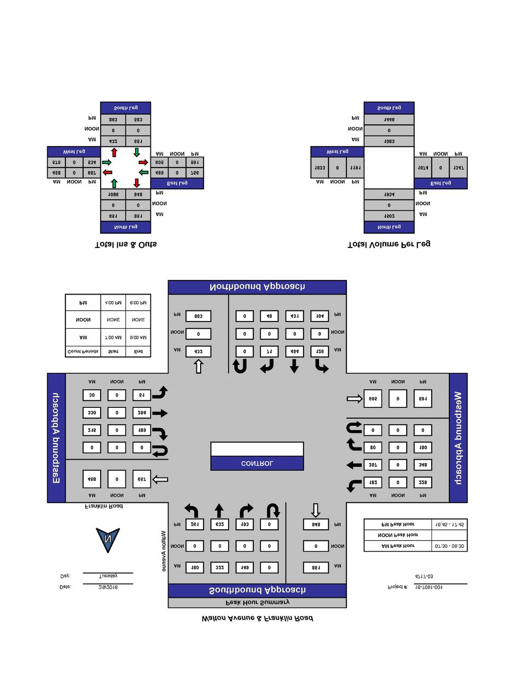
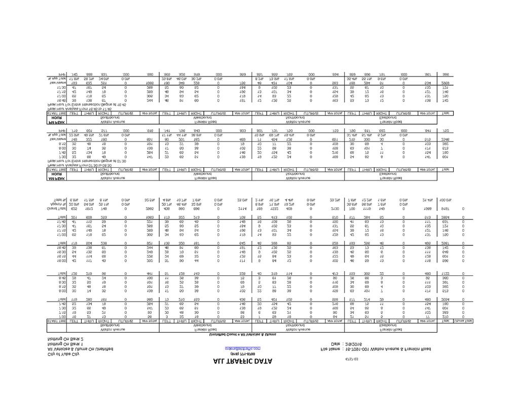
12 For this traffic impact study, available data is limited to peak hour volumes. Therefore, unsignalized intersections were evaluated using the Peak Hour Warrant (Warrant Number 3) from the California Manual on Uniform Traffic Control Devices (2012). This warrant was applied where the minor street experiences long delays in entering or crossing the major street for at least one hour of the day. It should also be noted that even if the Peak Hour Warrant is met, a more detailed signal warrant study is typically recommended before a signal is installed. The more detailed study should consider volumes during the eight highest hours of the day, pedestrian traffic, and accident histories. Existing Traffic Conditions and Levels of Service The following is a description of existing traffic operating conditions in the study area. Existing Traffic Volumes. New traffic volume data was collected for this traffic impact study at the seven study intersections on February 9, Data was collected in 15-minute increments from 7:00 9:00 a.m. and 4:00 6:00 p.m. The contiguous one hour periods with the highest volumes within the two-hour data collection period were used in this traffic impact study as the a.m. and p.m. peak hour. Figure 3 presents the existing lane configurations and existing peak hour traffic volumes at the seven study intersections. Existing Intersection Levels of Service. Table 2 presents a summary of existing peak hour LOS at the seven (7) study intersections. Level of Service calculations are provided in the Appendix. As shown in Table 2, all study intersections currently operate satisfactorily within the minimum standards for Level of Service established by the City of Yuba City. The major signalized intersections on Walton Road and SR 99 operate at LOS C and LOS D. Level of Service D or better is also provided at intersections controlled by stop signs. Intersection TABLE 2 EXISTING CONDITIONS INTERSECTION LEVELS OF SERVICE Control Existing AM Peak Hour PM Peak Hour LOS Delay LOS Delay 1. Franklin Road / Walton Road Signal D 43.1 D Franklin Road / Neil Drive SB Stop SB Left +Right Turn C 15.8 C Franklin Road / Littlejohn Road NB Stop NB Left + Right Turn C 15.7 C Franklin Road / Existing Driveway NB Stop NB Left + Right Turn C 23.0 D Franklin Road / WinCo SC Driveway Signal C 21.1 C Franklin Road / Onstott Road SB Right Turn SB Stop B 10.9 B Franklin Road / SR 99 Signal C 31.2 D 49.2 Traffic Impact Study for the Yuba Crossings Project Page 10 Yuba City, California (April 12, 2016)
13 Joy Way Whyler Rd Oji Way W Onstott Rd Anneka Ln 99 N Walton Ave Neil Dr Neil Dr Cinemark Kean Ave W Onstott Rd N.T.S. Franklin Rd Littlejohn Rd WinCo Foods (261) 322 (632) 193 (149) 182 (228) 207 (348) 80 (180) 2 R (8) 20 (10) 17 (25) 445 (727) (721) 34 (95) (761) 18 (45) (189) 215 (294) 330 (51) 30 (48) 71 (431) 454 (104) 126 (12) 12 (589) 589 (573) 594 (31) 20 (34) 20 (80) 99 R1-1 (554) 618 R1-1 (100) 72 (48) 18 (34) 9 5 Franklin Rd / N Walton Rd 1 (0) 0 (0) 0 (1) (2) 1 (454) 521 (131) (1) 413 (646) 209 (361) 4 (12) (156) 50 (0) 0 (319) R1-1 (697) 697 Franklin Rd / Neil Dr 25 (93) 28 (67) 602 (946) 7 Franklin Rd / Littlejohn Rd 125 (271) 732 (911) 87 (102) (9) 4 (202) 163 (375) 385 (207) (125) 310 (487) 75 (119) (246) 201 (1020) 1013 (114) 183 Franklin Rd / Existing Drwy Legend XX (XX) R1-1 AM Peak Hour Volume PM Peak Hour Volume Stop Sign Signalized Intersection Franklin Rd / Winco Drwy Franklin Rd / W Onstott Rd Franklin Rd / SR 99 KD Anderson & Associates, Inc. Transportation Engineers LT 4/12/2016 EXISTING TRAFFIC VOLUMES AND LANE CONFIGURATIONS figure 3
14 PROJECT TRAFFIC IMPACTS Development of the proposed project would attract additional traffic to the site, either as trips made by patrons of commercial uses or as trips made by project residents. This section of the traffic impact study identifies the assumptions made regarding the travel characteristics of the project and describes the impacts of project-related traffic relative to existing traffic conditions in the study area. Project Characteristics Trip Generation. Development of the project would generate new vehicle trips and potentially affect traffic operations at the study intersections. The number of vehicle trips that are expected to be generated by development of the proposed project has been estimated using published trip generation data. The Institute of Transportation Engineers (ITE) publication Trip Generation Manual, 9th Edition, has been used. The Trip Generation Manual was reviewed to identify the land use categories that are most similar to the use planned in the proposed project. As indicated in Table 3, standard ITE rates for single family residential units have been employed for detached homes and the ITE rates for apartments have been used for the residences anticipated with the mixed use and live/work areas. Because no specific businesses are known in the commercial areas, average ITE rates for Specialty Retail use have been employed. It has been assumed that ½ of the live work areas identified as commercial will also be retail, while the other ½ will be office space, and the average ITE rates for office building have been employed. Land Use / ITE Code Unit TABLE 3 TRIP GENERATION RATES Daily Trips per Unit AM Peak Hour PM Peak Hour In Out Total In Out Total Single Family Residential (210) dwelling % 75% % 36% 1.00 Apartments (220) dwelling % 80% % 35% 0.62 Ground Floor Retail (826) ksf % 38% % 56% 2.71 Live work Office (110) ksf % 12% % 83% 1.49 The identified trip generation rates have been applied to the project s land use quantities, and the resulting trip generation estimates are presented in Table 4. As shown, the proposed project is projected to generate a gross total of 1,653 daily trips with 83 trips in the a.m. peak hour and 133 trips in the p.m. peak hour. Traffic Impact Study for the Yuba Crossings Project Page 12 Yuba City, California (April 12, 2016)
15 Land Use Quantity TABLE 4 TRIP GENERATION FORECAST Daily Trips per Unit AM Peak Hour PM Peak Hour In Out Total In Out Total Single Family Residential 53 du s Apartments / Live Work 36 du s Ground Floor Retail Ksf Live work - Retail 3.43 ksf Live work Office 3.40 ksf Gross Total 1, Less Internal Live Work External Trips 1, Pass-By Trips 15% Net New External Trips 1, A portion of the trips generated by the project s uses will likely be made between complimentary uses and never be made by motor vehicles that reach the area street system. The most obvious internal interaction will be made between the residential and commercial areas of the live work units. The peak hour trips that would normally be made by these uses have been assumed to remain on-site, and their trips have been subtracted to yield the project s external trip forecast. The extent to which a portion of the trips attracted to the commercial retail uses may be drawn from the stream of traffic already passing the site (i.e., pass-by trips ) on Franklin Road has also been considered. While information in the ITE Trip Generation Handbook suggests high pass-by rates for small retail uses, because the types of uses are unknown, a minimal pass-by percentage has been assumed and only applied on a daily and p.m. peak hour basis. Based on these pass-by rates, we forecast that the project will generate 1,533 new daily trips, with 73 new trips occurring in the a.m. peak hour and 114 trips generated in the p.m. peak hour. Trip Distribution. The geographic distribution of vehicle trips associated with the proposed development has been based on existing traffic patterns, the location of probable origins or retail patrons within the project s probable trade areas and in the case of residential uses the locations of local schools and assumptions made on other recent traffic studies. 1 Table 5 presents the geographic trip distribution percentages for the project s new trips used for this analysis. 1 Traffic Impact Analysis for El Marguerite Master Plan, F&P, Traffic Impact Study for the Yuba Crossings Project Page 13 Yuba City, California (April 12, 2016)
16 Direction TABLE 5 TRIP DISTRIBUTION ASSUMPTIONS AM Peak Hour Residential Percent Distribution PM Peak Hour Commercial West on Franklin Road North on Walton Avenue South on Walton Avenue North on Neil Drive South on Littlejohn Road South to WinCo Center North on Onstott Road East on Franklin Road North on SR 99 South on SR 99 8% 18% 10% 0% 1% 2% 1% 12% 38% 10% 8% 18% 5% 0% 1% 5% 1% 5% 46% 11% 8% 6% 10% 1% 5% 2% 1% 20% 22% 25% Total 100% 100% 100% Trip Assignment. The trips associated with the project were directed to the study area circulation system via the main access on Franklin Road, and full access at this location was assumed. Figure 4 displays the project only traffic volumes for each study intersection during the a.m. and p.m. peak hours. Existing plus Project Intersection Levels of Service Project Impacts. To evaluate the project s impact the project s trips were superimposed onto current background traffic volumes, and Figure 5 displays the resulting Existing Plus Project traffic volumes anticipated at each study intersection during the peak hours. These volumes were then employed to calculate operating Levels of Service. Table 6 displays the peak hour LOS at each study intersection under the Existing plus Project conditions. As shown, because the project s trip generation is relatively small and no changes to the configuration of area traffic signals is immediately planned, the addition of project generated traffic is projected to result in relatively minor increases in delay at each of the existing intersections. Existing public street intersections will operate at LOS D or better. These impacts are considered less than significant based upon Yuba City and Caltrans standards of significance. The project s access on Franklin Road is, however, projected to operate at LOS E in the p.m. peak hour, and the introduction of traffic at this location will concurrently increase delays for existing traffic on the northbound approach. While the Level of Service at other private driveways is not a significance criteria, LOS E conditions at the proposed access is a significant impact under City of Yuba City standards. Traffic Impact Study for the Yuba Crossings Project Page 14 Yuba City, California (April 12, 2016)
17 Joy Way Whyler Rd Oji Way W Onstott Rd Anneka Ln 99 N Walton Ave Neil Dr Neil Dr Cinemark Kean Ave W Onstott Rd N.T.S. Franklin Rd Littlejohn Rd WinCo Foods (0) 0 (0) 3 (10) 8 (6) 4 (4) 5 (4) R1-1 0 (0) 0 (0) 0 (0) 17 (14) 17 (14) 0 (2) R (38) 29 (48) 17 (46) 0 (0) 0 (0) (0) 0 (5) 2 (0) 0 (0) 0 (0) 0 (4) 3 (0) 0 (19) 8 (19) 8 (0) 0 (0) 0 (1) 1 R1-1 (20) 9 R1-1 (0) 0 (0) 0 (0) 0 (0) 0 5 Franklin Rd / N Walton Rd 6 Franklin Rd / Neil Dr 7 Franklin Rd / Littlejohn Rd Franklin Rd / Existing Drwy 0 (0) 0 (0) 0 (0) (0) 0 (33) 28 (2) 1 0 (0) 17 (40) 0 (0) (3) 0 (0) 0 (0) 0 R1-1 (32) 28 0 (1) 1 (1) 16 (39) 17 (24) 0 (0) 0 (0) (1) 10 (16) 17 (7) 5 (10) 5 0 (0) 4 (6) 0 (0) (9) 5 (0) 0 (0) 0 XX (XX) R1-1 Legend AM Peak Hour Volume PM Peak Hour Volume Stop Sign Signalized Intersection Franklin Rd / Winco Drwy Franklin Rd / W Onstott Rd Franklin Rd / SR 99 KD Anderson & Associates, Inc. Transportation Engineers LT 4/12/2016 PROJECT ONLY FULL ACCESS TO FRANKLIN RD TRAFFIC VOLUMES AND LANE CONFIGURATIONS figure 4
18 Joy Way Whyler Rd Oji Way W Onstott Rd Anneka Ln 99 N Walton Ave Neil Dr Neil Dr Cinemark Kean Ave W Onstott Rd N.T.S. Franklin Rd Littlejohn Rd WinCo Foods (261) 322 (632) 142 (203) 190 (234) 211 (352) 85 (184) 2 R (8) 20 (10) 17 (25) 462 (741) (735) 35 (97) 4 18 (20) 0 (0) 29 (35) 17 (46) 450 (758) 18 (45) (189) 215 (299) 332 (51) 30 (48) 71 (431) 454 (108) 129 (12) 12 (608) 596 (592) 602 (31) 20 (34) 20 (81) 100 R1-1 (20) 9 R1-1 (554) 618 (100) 72 (48) 18 (0) 0 (34) 9 5 Franklin Rd / N Walton Rd 1 (1) 0 (0) 0 (1) (0) 0 (2) 1 (487) 549 (133) 110 (159) 50 (0) 0 (319) (1) 430 (686) 209 (361) 4 (12) 6 R1-1 Franklin Rd / Neil Dr (729) (94) 29 (68) 618 (985) 7 Franklin Rd / Littlejohn Rd 132 (295) 732 (911) 87 (102) (10) 5 (218) 180 (382) 390 (217) (125) 314 (493) 75 (119) (255) 206 (1020) 1013 (114) 183 Franklin Rd / Project Access Legend XX (XX) R1-1 AM Peak Hour Volume PM Peak Hour Volume Stop Sign Signalized Intersection Franklin Rd / Winco Drwy Franklin Rd / W Onstott Rd Franklin Rd / SR 99 KD Anderson & Associates, Inc. Transportation Engineers LT 4/12/2016 EXISTING PLUS PROJECT- FULL ACCESS ON FRANKLIN RD TRAFFIC VOLUMES AND LANE CONFIGURATIONS figure 5
19 Intersection Control TABLE 6 EXISTING PLUS PROJECT INTERSECTION LEVELS OF SERVICE LOS AM Peak Hour PM Peak Hour Existing Existing Plus Project Existing Existing Plus Project Average Delay (sec/veh) LOS Average Delay (sec/veh) LOS Average Delay (sec/veh) LOS Average Delay 1. Franklin Road / Walton Road Signal D 43.1 D 43.5 D 42.7 D 44.6 (sec/veh) 2. Franklin Road / Neil Drive SB Stop SB Left Turn C 15.8 C 16.2 C 18.5 C Franklin Road / Littlejohn Road NB Stop NB Left Turn C 15.7 C 15.9 C 21.4 C Franklin Road / Project Access NB/ SB Stop NB Left+ Right Turn SB Right +Right Turn C C C D E E Franklin Road / WinCo Driveway Signal C 21.1 C 21.0 C 26.1 C Franklin Road / Onstott Road SB Right Turn SB Stop B 10.9 B 11.0 B 14.1 B Franklin Road / SR 99 Signal C 31.2 C 31.7 D 49.2 D 52.9 Traffic Impact Study for the Yuba Crossings Project Page 17 Yuba City, California (April 12, 2016)
20 Mitigation Alternatives. Alternative actions that could be taken to improve the Level of Service at the Project s access on Franklin Road have been identified and evaluated in terms of Level of Service during the p.m. peak hour. Limit the amount of development occurring on site until such time as the project site is connected to the Franklin Road / WinCo SC signal. Limit project access to right turns in and out only and require that motorists intended to turn left instead make u-turns at adjoining intersections. Install the portion of Oji Way from the Franklin Road / WinCo SC signal to the project site and modify the traffic signal to operate with this fourth leg. Limited Site Development Alternative. The effects of a limited project development alternative have been investigated by identifying the traffic volumes associated with this alternative and reevaluating Level of Service. For this analysis it has been assumed that the phase of the project could include: % of the single family residential development % of the home / work units and their accompanying commercial space % of the mixed use area s apartments This phase would not include the ksf of proposed retail space. This phase would generate 911 external daily trips, with 57 trips in the a.m. peak hour and 77 p.m. peak hour trips. These projections represent roughly 60% of the external daily trips associated with the full project build out, as well as 78% of the a.m. and 64% of the p.m. external trips. Figure 6 presents Existing Plus Reduced Project traffic volumes. Table 7 identifies mitigated p.m. peak hour Levels of Service. As shown, the northbound and southbound approaches to the Franklin Road / Yuba Crossings Access intersection would deliver LOS D, which would satisfy the minimum standard. Thus, the project s impacts would be less than significant. Prohibit Outbound Left Turns Alternative. Under this plan a physical feature would be installed to preclude left turns out of the project onto eastbound Franklin Road. Theoretically, this might be a driveway island that forced all traffic leaving the site to turn right. Those motorists wishing to head east to SR 99 would then make a u-turn at the next opportunity, which is generally the Littlejohn Road intersection. Figure 7 presents Existing Plus Project with Right Turns Only at the exit. As noted in Table 7, this measure would improve the Level of Service for motorist leaving the project site, which would be LOS B. However, the delays for northbound traffic would increase and LOS E would remain on that approach, and conditions for the northbound traffic at Littlejohn would deteriorate to LOS D. However, the project s impact would not be significant. Traffic Impact Study for the Yuba Crossings Project Page 18 Yuba City, California (April 12, 2016)
21 Connect to WinCo Signal Alternative. Under this concept a connection would be made to the north leg of the WinCo Signal on Franklin Road, and outbound left turns would be prohibited at the project driveway. Traffic that is exiting the site from residential areas and headed to SR 99 would be expected to use the connection, but a portion of the exiting trips from the commercial area along Franklin Road will still turn right and make a u-turn at Littlejohn Road. Existing Plus Project traffic volumes under this alternative are presented in Figure 8. As noted in Table 7, this measure would improve the Level of Service for motorist leaving the project site, which would be LOS B. The Franklin Road / WinCo Access signal would operate at LOS D, which satisfies the City s minimum standard. The length of delays for northbound traffic at the existing driveway across the streets would be less that without the mitigation, and while LOS E would remain on that approach the delays would approach the LOS D threshold. The project s impact would not be significant. Traffic Impact Study for the Yuba Crossings Project Page 19 Yuba City, California (April 12, 2016)
22 Intersection Control TABLE 7 MITIGATED EXISTING PLUS PROJECT INTERSECTION LEVELS OF SERVICE LOS PM Peak Hour Existing Plus Project Unmitigated Phase 1 Only Right Turn Out Only Average Delay (sec/veh) LOS Average Delay (sec/veh) LOS Average Delay (sec/veh) Connection to WinCo Signal and Right Turn Only LOS Average Delay 1. Franklin Road / Walton Road Signal D 44.6 D 43.9 D 44.6 D 44.6 (sec/veh) 2. Franklin Road / Neil Drive SB Stop SB Left Turn C 19.1 C 18.9 C 19.1 C Franklin Road / Littlejohn Road NB Left + Right Turn WB left turn NB Stop C A C A C A C B Franklin Road / Project Access NB/ SB Stop NB Left+ Right Turn SB Right +Right Turn E E D D E B E B Franklin Road / WinCo Driveway Signal C 27.7 C 27.2 C 27.7 D Franklin Road / Onstott Road SB Right Turn SB Stop B 14.5 B 14.4 B 14.5 B Franklin Road / SR 99 Signal D 52.9 D 51.0 D 52.9 D 54.6 Traffic Impact Study for the Yuba Crossings Project Page 20 Yuba City, California (April 12, 2016)
23 Joy Way Whyler Rd Oji Way W Onstott Rd Anneka Ln 99 N Walton Ave Neil Dr Neil Dr Cinemark Kean Ave W Onstott Rd N.T.S. Franklin Rd Littlejohn Rd WinCo Foods (261) 322 (632) 142 (202) 190 (233) 211 (350) 85 (182) 2 R (8) 20 (10) 17 (25) 461 (736) (730) 35 (96) 4 R (10) 0 (0) 26 (21) 11 (33) 450 (761) 18 (45) (189) 215 (298) 331 (51) 30 (48) 71 (431) 454 (106) 128 (12) 12 (604) 594 (588) 600 (31) 20 (34) 20 (81) 99 R1-1 (16) 6 R1-1 (554) 618 (100) 72 (48) 18 (0) 0 (34) 9 5 Franklin Rd / N Walton Rd 1 (1) 0 (0) 0 (1) (2) 1 (473) 549 (132) (1) 424 (676) 209 (361) 4 (12) (158) 50 (0) 0 (319) R1-1 (716) 722 Franklin Rd / Neil Dr 25 (94) 29 (67) 613 (976) 7 Franklin Rd / Littlejohn Rd 130 (292) 732 (911) 87 (102) (9) 5 (215) 179 (378) 390 (211) (125) 313 (490) 75 (119) (252) 204 (1020) 1013 (114) 183 Franklin Rd / Existing Drwy Legend XX (XX) R1-1 AM Peak Hour Volume PM Peak Hour Volume Stop Sign Signalized Intersection Franklin Rd / Winco Drwy Franklin Rd / W Onstott Rd Franklin Rd / SR 99 KD Anderson & Associates, Inc. Transportation Engineers LT 4/12/2016 EXISTING PLUS PROJECT PHASE 1 - FULL ACCESS TRAFFIC VOLUMES AND LANE CONFIGURATIONS figure 6
24 Joy Way Whyler Rd Oji Way W Onstott Rd Anneka Ln 99 N Walton Ave Neil Dr Neil Dr Cinemark Kean Ave W Onstott Rd N.T.S. Franklin Rd Littlejohn Rd WinCo Foods (261) 322 (632) 193 (149) 182 (228) 207 (348) 80 (180) 2 R (8) 20 (10) 17 (25) 445 (727) (735) 35 (97) 29 (35) 4 47 (55) 17 (46) 450 (758) 18 (45) (189) 215 (294) 330 (51) 30 (48) 71 (431) 454 (104) 126 (12) 12 (589) 589 (573) 594 (31) 20 (34) 20 (80) 99 R1-1 (20) 9 R1-1 (589) 647 (102) 72 (48) 18 (34) 9 5 Franklin Rd / N Walton Rd 1 (0) 0 (0) 0 (1) (2) 1 (454) 521 (131) (1) 413 (646) 209 (361) 4 (12) (156) 50 (0) 0 (319) R1-1 (697) 697 Franklin Rd / Neil Dr 25 (93) 28 (67) 602 (946) 7 Franklin Rd / Littlejohn Rd 125 (271) 732 (911) 87 (102) (9) 4 (202) 163 (375) 385 (207) (125) 310 (487) 75 (119) (246) 201 (1020) 1013 (114) 183 Franklin Rd / Existing Drwy Legend XX (XX) R1-1 AM Peak Hour Volume PM Peak Hour Volume Stop Sign Signalized Intersection Franklin Rd / Winco Drwy Franklin Rd / W Onstott Rd Franklin Rd / SR 99 KD Anderson & Associates, Inc. Transportation Engineers LT 4/12/2016 EXISTING PLUS PROJECT WITH RIGHT TURN ONLY ACCESS TRAFFIC VOLUMES AND LANE CONFIGURATIONS figure 7
 322 (632) 193 (149) 182 (228) 207 (348) 80 (180) 2 R1-1 16 (8) 20 (10) 17 (25) 445 (727) 3 456 (734) 35 (97) 8 (13) 4 18 (27) 18 (38)")
25 Joy Way Whyler Rd Oji Way W Onstott Rd Anneka Ln 99 N Walton Ave Neil Dr Neil Dr Cinemark Kean Ave W Onstott Rd N.T.S. Franklin Rd Littlejohn Rd WinCo Foods (261) 322 (632) 193 (149) 182 (228) 207 (348) 80 (180) 2 R (8) 20 (10) 17 (25) 445 (727) (734) 35 (97) 8 (13) 4 18 (27) 18 (38) 458 (762) 18 (45) (189) 215 (294) 330 (51) 30 (48) 71 (431) 454 (104) 126 (12) 12 (589) 589 (592) 602 (31) 20 (34) 20 (81) 100 R1-1 (10) 4 R1-1 (577) 631 (100) 72 (48) 18 (34) 9 5 Franklin Rd / N Walton Rd 9 (5) 1 (1) 20 (20) (10) 6 (467) 529 (132) (15) 426 (672) 209 (361) 4 (12) (157) 50 (1) 0 (319) R1-1 (697) 697 Franklin Rd / Neil Dr 25 (93) 28 (67) 602 (946) 7 Franklin Rd / Littlejohn Rd 125 (271) 732 (911) 87 (102) (9) 4 (202) 163 (375) 385 (207) (125) 310 (487) 75 (119) (246) 201 (1020) 1013 (114) 183 Franklin Rd / Existing Drwy Legend XX (XX) R1-1 AM Peak Hour Volume PM Peak Hour Volume Stop Sign Signalized Intersection Franklin Rd / Winco Drwy Franklin Rd / W Onstott Rd Franklin Rd / SR 99 KD Anderson & Associates, Inc. Transportation Engineers LT 4/12/2016 EXISTING PLUS PROJECT WITH CONNECTION TO WINCO SIGNAL TRAFFIC VOLUMES AND LANE CONFIGURATIONS figure 8
26 Site Access Evaluation Main Access. Primary access to the site will be provided via a new driveway on Franklin Road located roughly midway between the Littlejohn Road intersection and the WinCo Access signal. The access is directly opposite the WinCo Shopping Center s westernmost existing driveway. Three key issues have been considered with regards to sight design: Adequacy of driveway throat Relative need for acceleration / deceleration treatment on Franklin Road Adequacy of the Two-Way Left-Turn lane on Franklin Road. Driveway Throat. The preliminary design indicates that a 32 wide driveway will be provided, and the driveway will include a divided entry aisle that is 100 feet long. The approach can accommodate 4-5 waiting vehicles prior to the queue reaching the first parking access aisle. The throat depth has been compared to forecasts of driveway queuing (95 th percentile queues) under immediate and short term conditions. In the near term the maximum exiting volume occurs if only Franklin Road access is available, and the maximum queues would occur if full access is permitted. The Level of Service calculations conducted for the project indicate that in both the a.m. and p.m. peak hours the 95 th percentile queue is 2 vehicles or less. As this queue can be accommodated, the throat depth is adequate with full access. Under long term conditions the access is expected to be limited to right turns only, and the peak queues would be shorter. Deceleration / Acceleration. The need for auxiliary treatments to accommodate traffic entering or exiting the site from westbound Franklin Road has also been evaluated based on the volume of traffic involved and City of Yuba City precedents. With access only to Franklin Road, a total of 46 right turns are projected to turn right into the project during the p.m. peak hour. This volume is projected to drop in the future if a connection to the WinCo SC access signal is created via Oji Way, and the forecast is for 37 right turns at that time. Acceleration treatments are rarely provided at private driveways on urban streets, and review of recent improvements to other access to Franklin Road reveals that separate right turn lanes have not been developed elsewhere. Based on this precedent, a separate westbound right turn lane is not recommended. TWLT lane. Left turns into the site will occur from Franklin Road s existing TWLT lane, and the adequacy of the lane for this purpose is related to the volume of turning at the project driveway and at the adjoining driveways where the TWLT lane will need to accommodate opposing traffic streams. The Littlejohn Road intersection and the access to St Andrews Presbyterian Church are located west of the project access and the westbound left turns at these intersections could need to share space with the motorists making eastbound left turns into the project. Measured centerline to Traffic Impact Study for the Yuba Crossings Project Page 24 Yuba City, California (April 12, 2016)
27 centerline St Andrew s driveway is 160 feet from the project access and Littlejohn Road is 320 feet away. The CVC limits travel in the TWL lane to 200 feet it is likely that St Andrews traffic could use the same portion of the TWLT lane as the project, but Littlejohn Road is far enough away to minimize this overlap when waiting queues are short. While St Andrews may attract appreciable traffic at times on Sunday, the number of left turns occurring on a regular basis would be low. Thus, the use of the existing TWLT lane by the Yuba Crossings project should be adequate with the project as proposed. If project access is restricted as discussed earlier, then the effects of queueing at Littlejohn Road should be considered in evaluating the TWLT lane. The Caltrans HDM includes recommendations for left turn lane storage which assume that space for a two minute accumulation of left turns is applicable. Without the access limitation, the westbound left turn lane would serve 95 vehicles in the p.m. peak hour, and 3 to 4 cars could need to be stored. Under this situation Littlejohn Road left turns could share space with the 20 vehicles making eastbound left turns into the project, and roughly 200 feet of space would be available for deceleration between the westbound and eastbound queues. With the access restriction 35 u- turns could be added at Littlejohn Road or at St Andrews Church driveway, and the storage requirements at these locations could increase. The space available between queues would decrease and the possibility of eastbound and westbound turns occupying the same deceleration area would increase. While this access alternative may address the Level of Service issues associated with the project access, it is not recommended due to the possibility of conflicts in the TWLT lane. Traffic Impact Study for the Yuba Crossings Project Page 25 Yuba City, California (April 12, 2016)
28 CUMULATIVE IMPACTS Long Term Cumulative Conditions Basis for Long Term Projections. The Year 2035 travel demand forecasting model used for the City of Yuba City General Plan Update EIR and subsequently updated for the El Marguerite EIR traffic study is the basis for the long term cumulative traffic volume forecasts used for this analysis. The technical approach employed for this analysis makes use of traffic model results and information from the El Marguerite EIR traffic study to create intersection turning movements for study area intersections in a manner that mimics the approach used for the GPU EIR. The long term Cumulative Plus Project traffic volume forecasts from the El Marguerite DEIR traffic study were assumed to remain valid as a condition that assumes site development without access to Franklin Road. These forecasts became the basis for through traffic on Franklin Road. City wide traffic model forecasts were the basis for projections on other streets, such as the Oji Way extension. Circulation System Assumptions. The traffic volume forecasts made for this analysis include those city-wide circulation system improvements incorporated into the General Plan traffic model and CIP. These include six lanes on SR 99 and completion of Lincoln Road as a 4-lane facility between SR 99 and Garden Highway. The improvements identified in the El Marguerite DEIR traffic study at the Franklin Road / Walton Road intersection and at the SR 99 / Franklin Road intersection were again assumed. These include dual left turn lanes and separate right turn lane on each approach. Oji Way was also assumed to be extended to Franklin Road. Because no formal design exists, for the purpose of this analysis it has been assumed that the southbound Oji Way approach to Franklin Road will be a single lane. However, it is possible that the design eventually pursued by the City when the street is extended could include auxiliary lanes regardless of whether the proposed project proceeds or not. Traffic Volume Forecasts. Peak hour intersection turning movements were created for No Project and Plus Project cumulative conditions. Figure 9 identifies cumulative traffic volumes at study intersections without development on the project site. Cumulative No Project Levels of Service. Table 8 identifies a.m. and p.m. peak hour Levels of Service under future conditions assuming that no changes are made to existing traffic controls at un-signalized intersections on Franklin Road. As indicated, the major signalized intersections on Franklin Road at Walton Avenue and at SR 99 are projected to operate at LOS E. The WinCo SC driveway signal is projected to operate at LOS D. As may be expected with the anticipated growth in traffic on Franklin Road, the un-signalized intersections on Franklin Road will operate with very long delays for motorists attempting to turn onto Franklin Road. These motorists would experience LOS F conditions, and it is reasonable to Traffic Impact Study for the Yuba Crossings Project Page 26 Yuba City, California (April 12, 2016)
29 expect that the City will eventually need to act to prohibit outbound left turns onto Franklin Road at these locations. Cumulative Plus Project Conditions. To evaluate project impacts the trips associated with Yuba Crossing have been superimposed onto the background cumulative condition and Levels of Service have been assessed. Because outbound left turns at the project access are already problematic under Existing Plus Project conditions, it is assumed that outbound left turns will be prohibited as noted under the evaluation of short term mitigation alternatives. In addition, under long term conditions the delays for inbound left turns may become problematic, and we have assumed that eastbound left turns into the site will be prohibited as well. Resulting peak hour traffic volumes are shown in Figure 10. Table 8 compares cumulative Levels of Service with and without the project. As shown, two signalized intersections (Walton Avenue / Franklin Road and SR 99 / Franklin Road) will operate at LOS E with and without Yuba Crossings. In this case the significance of the project s impact is determined based on the incremental change in delay. Because the incremental changes in delay of 0.7 seconds and 1.5 seconds are less than the 5.0 second increment permitted under City guidelines, the project s impact is not significant at these locations. Level of Service F is forecast for the un-signaled intersections on Franklin Road west of the project at Neil Drive and Littlejohn Road. In this case, significance is again based on change in delay, and the changes created by the project are expected to exceed the 5.0 threshold. Thus the project s impact is significant. As noted under the cumulative base condition, the delays experienced by motorists waiting to left turn onto Franklin Road will eventually be resolved by prohibiting those turns. This may be accomplished by a raised median or other action. The proposed project would mitigate its impact by contributing its fair share to the cost of future traffic controls in this area. With the project Level of Service E conditions are anticipated at the Franklin Road / WinCo SC / Oji Way intersection. As LOS E exceeds the City s minimum standard this is a significant impact. The Level of Service at this location can be improved to the City s LOS D minimum by providing a separate right turn lane on the new southbound approach. The proposed project would mitigate its impact by contributing its fair share to the cost of this improvement.. Traffic Impact Study for the Yuba Crossings Project Page 27 Yuba City, California (April 12, 2016)
30 Joy Way Whyler Rd Oji Way W Onstott Rd Anneka Ln 99 N Walton Ave Neil Dr Neil Dr Cinemark Kean Ave W Onstott Rd N.T.S. Franklin Rd Littlejohn Rd WinCo Foods (310) 320 (740) 120 (240) 135 (245) 815 (1215) 205 (245) 2 R (10) 20 (10) 20 (25) 1055 (1615) (1605) 35 (85) (1640) 20 (45) (220) 220 (975) 1190 (190) 130 (160) 170 (630) 530 (120) 150 (15) 15 (1265) 1480 (1250) 1470 (25) 30 (35) 20 (95) 90 R1-1 R1-1 (1245) 1490 (100) 70 (50) 20 (35) 10 5 Franklin Rd / N Walton Rd 15 (30) 20 (25) 15 (20) (45) 10 (1035) 1305 (200) 185 (260) 75 (20) 10 (370) (20) 1000 (1395) 230 (390) 6 R1-1 (1425) 1505 Franklin Rd / Neil Dr 15 (90) 15 (35) 1230 (1715) 7 Franklin Rd / Littlejohn Rd 615 (675) 1110 (1270) 180 (120) (395) 375 (875) 1000 (155) (250) 485 (875) 450 (620) (200) 145 (1630) 1190 (410) 630 Franklin Rd / Existing Drwy Legend XX (XX) R1-1 AM Peak Hour Volume PM Peak Hour Volume Stop Sign Signalized Intersection Franklin Rd / Winco Drwy Franklin Rd / W Onstott Rd Franklin Rd / SR 99 KD Anderson & Associates, Inc. Transportation Engineers LT 4/12/2016 CUMULATIVE NO PROJECT TRAFFIC VOLUMES AND LANE CONFIGURATIONS figure 9
31 Joy Way Whyler Rd Oji Way W Onstott Rd Anneka Ln 99 N Walton Ave Neil Dr Neil Dr Cinemark Kean Ave W Onstott Rd N.T.S. Franklin Rd Littlejohn Rd WinCo Foods (310) 320 (740) 123 ( (251) 819 (1219) 210 (249) 2 R (10) 20 (10) 20 (25) 1072 (1629) (1618) 36 (86) 7 (13) 4 17 (27) 17 (37) 1078 (1640) 20 (45) (220) 220 (980) 1192 (190) 130 (160) 170 (630) 530 (124) 153 (15) 15 (1284) 1488 (1269) 1478 (25) 30 (35) 20 (96) 91 R1-1 (1271) 1498 R1-1 (100) 70 (50) 20 (35) 10 5 Franklin Rd / N Walton Rd 23 (34) 21 (26) 34 (39) (8) 4 (57) 15 (1047) 1313 (201) (33) 1012 (1420) 34 (390) (261) 75 (21) 10 (370) R1-1 (1456)1532 Franklin Rd / Neil Dr 15 (90) 15 (35) 1246 (1753) 7 Franklin Rd / Littlejohn Rd 622 (698) 1110 (1270) 180 (120) (410) 391 (882) 1005 (165) (250) 489 (881) 450 (620) (209) 150 (1630) 1190 (410) 630 Franklin Rd / Existing Drwy Legend XX (XX) R1-1 AM Peak Hour Volume PM Peak Hour Volume Stop Sign Signalized Intersection Franklin Rd / Winco Drwy Franklin Rd / W Onstott Rd Franklin Rd / SR 99 KD Anderson & Associates, Inc. Transportation Engineers LT 4/12/2016 CUMULATIVE PLUS PROJECT - TWO ACCESS TRAFFIC VOLUMES AND LANE CONFIGURATIONS figure 10
32 Intersection Control TABLE 8 CUMULATIVE PLUS PROJECT INTERSECTION LEVELS OF SERVICE LOS AM Peak Hour PM Peak Hour No Project Plus Project No Project Plus Project Average Delay (sec/veh) LOS Average Delay (sec/veh) LOS Average Delay (sec/veh) LOS Average Delay 1. Franklin Road / Walton Road Signal D 39.5 D 39.9 E 68.4 E Franklin Road / Neil Drive Southbound Left Turn 3. Franklin Road / Littlejohn Road NB Left+RightTurn WB Left turn 4. Franklin Road / Project Access NB Left+ Right Turn SB Right Turn 5. Franklin Road / WinCo Driveway 6. Franklin Road / Onstott Road SB Right Turn SB Stop NB Stop NB/ SB Stop (sec/veh) F 79.3 F 83.8 F F F C > F - F D F F > F B > F C F >300 F C Signal D 35.3 D 36.2 D 51.2 E 61.0 mitigated D 55.0 SB Stop > > B 14.5 B 14.6 D 25.0 D Franklin Road / SR 99 Signal D 46.1 D 46.7 E 62.8 E 64.3 Traffic Impact Study for the Yuba Crossings Project Page 30 Yuba City, California (April 12, 2016)
33 APPENDICES Traffic Impact Study for the Yuba Crossings Project Page 31 Yuba City, California (April 12, 2016)
34
35
TRAFFIC IMPACT ANALYSIS FOR. McDONALD S RESTAURANT IN CARMICAEL Sacramento County, CA. Prepared For:
 TRAFFIC IMPACT ANALYSIS FOR McDONALD S RESTAURANT IN CARMICAEL Sacramento County, CA Prepared For: McDonald s USA, LLC Pacific Sierra Region 2999 Oak Road, Suite 900 Walnut Creek, CA 94597 Prepared By:
TRAFFIC IMPACT STUDY FOR SONIC DRIVE-IN RESTAURANT. Vallejo, CA. Prepared For:
 TRAFFIC IMPACT STUDY FOR SONIC DRIVE-IN RESTAURANT Vallejo, CA Prepared For: ELITE DRIVE-INS, INC. 2190 Meridian Park Blvd, Suite G Concord, CA 94520 Prepared By: KD Anderson & Associates 3853 Taylor Road,
LAWRENCE TRANSIT CENTER LOCATION ANALYSIS 9 TH STREET & ROCKLEDGE ROAD / 21 ST STREET & IOWA STREET LAWRENCE, KANSAS
 LAWRENCE TRANSIT CENTER LOCATION ANALYSIS 9 TH STREET & ROCKLEDGE ROAD / 21 ST STREET & IOWA STREET LAWRENCE, KANSAS TRAFFIC IMPACT STUDY FEBRUARY 214 OA Project No. 213-542 TABLE OF CONTENTS 1. INTRODUCTION...
APPENDIX C1 TRAFFIC ANALYSIS DESIGN YEAR TRAFFIC ANALYSIS
 APPENDIX C1 TRAFFIC ANALYSIS DESIGN YEAR TRAFFIC ANALYSIS DESIGN YEAR TRAFFIC ANALYSIS February 2018 Highway & Bridge Project PIN 6754.12 Route 13 Connector Road Chemung County February 2018 Appendix
Craig Scheffler, P.E., PTOE HNTB North Carolina, P.C. HNTB Project File: Subject
 TECHNICAL MEMORANDUM To Kumar Neppalli Traffic Engineering Manager Town of Chapel Hill From Craig Scheffler, P.E., PTOE HNTB North Carolina, P.C. Cc HNTB Project File: 38435 Subject Obey Creek TIS 2022
King Soopers #116 Thornton, Colorado
 Traffic Impact Study King Soopers #116 Thornton, Colorado Prepared for: Galloway & Company, Inc. T R A F F I C I M P A C T S T U D Y King Soopers #116 Thornton, Colorado Prepared for Galloway & Company
D R A F T TRAFFIC IMPACT ANALYSIS FOR. DARK HORSE GOLF RESORT EXPANSION Nevada County, CA. Prepared For:
 D R A F T TRAFFIC IMPACT ANALYSIS FOR DARK HORSE GOLF RESORT EXPANSION Nevada County, CA Prepared For: ASIAN PACIFIC GROUP 18000 Van Karman Avenue, Suite 500 Irvine, CA 92612 Prepared By: KD Anderson &
TALMONT TOWNHOMES MADISON KENNETH SPA TRAFFIC IMPACT STUDY. Sacramento, CA. Prepared For: MBK Homes. Prepared By:
 TALMONT TOWNHOMES MADISON KENNETH SPA TRAFFIC IMPACT STUDY Sacramento, CA Prepared For: MBK Homes Prepared By: KD Anderson & Associates 3853 Taylor Road, Suite G Loomis, California 95650 (916) 660-1555
2.0 Development Driveways. Movin Out June 2017
 Movin Out June 2017 1.0 Introduction The proposed Movin Out development is a mixed use development in the northeast quadrant of the intersection of West Broadway and Fayette Avenue in the City of Madison.
EXECUTIVE SUMMARY. The following is an outline of the traffic analysis performed by Hales Engineering for the traffic conditions of this project.
 EXECUTIVE SUMMARY This study addresses the traffic impacts associated with the proposed Shopko redevelopment located in Sugarhouse, Utah. The Shopko redevelopment project is located between 1300 East and
TIMBERVINE TRANSPORTATION IMPACT STUDY FORT COLLINS, COLORADO JANUARY Prepared for:
 TIMBERVINE TRANSPORTATION IMPACT STUDY FORT COLLINS, COLORADO JANUARY 2014 Prepared for: Hartford Companies 1218 W. Ash Street Suite A Windsor, Co 80550 Prepared by: DELICH ASSOCIATES 2272 Glen Haven Drive
Traffic Impact Analysis 5742 BEACH BOULEVARD MIXED USE PROJECT
 Traffic Impact Analysis 5742 BEACH BOULEVARD MIXED USE PROJECT CITY OF BUENA PARK Prepared by Project No. 14139 000 April 17 th, 2015 DKS Associates Jeffrey Heald, P.E. Rohit Itadkar, T.E. 2677 North Main
Proposed location of Camp Parkway Commerce Center. Vicinity map of Camp Parkway Commerce Center Southampton County, VA
 Proposed location of Camp Parkway Commerce Center Vicinity map of Camp Parkway Commerce Center Southampton County, VA Camp Parkway Commerce Center is a proposed distribution and industrial center to be
Date: February 7, 2017 John Doyle, Z-Best Products Robert Del Rio. T.E. Z-Best Traffic Operations and Site Access Analysis
 Memorandum Date: February 7, 07 To: From: Subject: John Doyle, Z-Best Products Robert Del Rio. T.E. Z-Best Traffic Operations and Site Access Analysis Introduction Hexagon Transportation Consultants, Inc.
TRAFFIC IMPACT ANALYSIS FOR. STERLING FIFTH STREET APARTMENTS PROJECT Davis, CA. Prepared For:
 TRAFFIC IMPACT ANALYSIS FOR STERLING FIFTH STREET APARTMENTS PROJECT Davis, CA Prepared For: Din/Cal 3, Inc. 3411 Richmond Avenue, Suite 200 Houston, Texas 77046 Prepared By: KD Anderson & Associates,
Traffic Impact Study Speedway Gas Station Redevelopment
 Traffic Impact Study Speedway Gas Station Redevelopment Warrenville, Illinois Prepared For: Prepared By: April 11, 2018 Table of Contents 1. Introduction... 1 2. Existing Conditions... 4 Site Location...
TRAFFIC IMPACT ANALYSIS
 TRAFFIC IMPACT ANALYSIS Emerald Isle Commercial Development Prepared by SEPI Engineering & Construction Prepared for Ark Consulting Group, PLLC March 2016 I. Executive Summary A. Site Location The Emerald
Traffic Impact Statement (TIS)
") Traffic Impact Statement (TIS) Vincentian PUDA Collier County, FL 10/18/2013 Prepared for: Global Properties of Naples Prepared by: Trebilcock Consulting Solutions, PA 2614 Tamiami Trail N, Suite 615 1205
Traffic Impact Statement (TIS) Vincentian PUDA Collier County, FL 10/18/2013 Prepared for: Global Properties of Naples Prepared by: Trebilcock Consulting Solutions, PA 2614 Tamiami Trail N, Suite 615 1205
Traffic Engineering Study
 Traffic Engineering Study Bellaire Boulevard Prepared For: International Management District Technical Services, Inc. Texas Registered Engineering Firm F-3580 November 2009 Executive Summary has been requested
The major roadways in the study area are State Route 166 and State Route 33, which are shown on Figure 1-1 and described below:
 3.5 TRAFFIC AND CIRCULATION 3.5.1 Existing Conditions 3.5.1.1 Street Network DRAFT ENVIRONMENTAL IMPACT REPORT The major roadways in the study area are State Route 166 and State Route 33, which are shown
MEMORANDUM. Figure 1. Roundabout Interchange under Alternative D
 MEMORANDUM Date: To: Liz Diamond, Dokken Engineering From: Subject: Dave Stanek, Fehr & Peers Western Placerville Interchanges 2045 Analysis RS08-2639 Fehr & Peers has completed a transportation analysis
TRAFFIC IMPACT ANALYSIS FOR THE. PANORAMA PD Shasta County, California. Prepared For: Enplan 3179 Bechelli Lane, Suite 100 Redding, CA 96002
 TRAFFIC IMPACT ANALYSIS FOR THE PANORAMA PD Shasta County, California Prepared For: Enplan 3179 Bechelli Lane, Suite 100 Redding, CA 96002 Prepared By: KD Anderson & Associates, Inc. 3853 Taylor Road,
APPENDIX B Traffic Analysis
 APPENDIX B Traffic Analysis Rim of the World Unified School District Reconfiguration Prepared for: Rim of the World School District 27315 North Bay Road, Blue Jay, CA 92317 Prepared by: 400 Oceangate,
TRAFFIC IMPACT ANALYSIS FOR. Prepared For: Din/Cal 3, Inc Richmond Avenue, Suite 200 Houston, Texas Prepared By:
 TRAFFIC IMPACT ANALYSIS FOR STERLING 5 th STREET APARTMENTS PROJECT Davis, CA Prepared For: Din/Cal 3, Inc. 3411 Richmond Avenue, Suite 200 Houston, Texas 77046 Prepared By: KD Anderson & Associates, Inc.
Traffic Impact Analysis West Street Garden Plots Improvements and DuPage River Park Garden Plots Development Naperville, Illinois
 Traffic Impact Analysis West Street Garden Plots Improvements and DuPage River Park Garden Plots Development Naperville, Illinois Submitted by April 9, 2009 Introduction Kenig, Lindgren, O Hara, Aboona,
CHAPTER 9: VEHICULAR ACCESS CONTROL Introduction and Goals Administration Standards
 9.00 Introduction and Goals 9.01 Administration 9.02 Standards 9.1 9.00 INTRODUCTION AND GOALS City streets serve two purposes that are often in conflict moving traffic and accessing property. The higher
Traffic Impact Analysis. Alliance Cole Avenue Residential Site Dallas, Texas. Kimley-Horn and Associates, Inc. Dallas, Texas.
 Traffic Impact Analysis Alliance Cole Avenue Residential Site Dallas, Texas February 15, 2018 Kimley-Horn and Associates, Inc. Dallas, Texas Project #064524900 Registered Firm F-928 Traffic Impact Analysis
APPENDIX E. Traffic Analysis Report
 APPENDIX E Traffic Analysis Report THIS PAGE INTENTIONALLY BLANK EAGLE RIVER TRAFFIC MITIGATION PHASE I OLD GLENN HIGHWAY/EAGLE RIVER ROAD INTERSECTION IMPROVEMENTS TRAFFIC ANALYSIS Eagle River, Alaska
V. DEVELOPMENT OF CONCEPTS
 Martin Luther King, Jr. Drive Extension FINAL Feasibility Study Page 9 V. DEVELOPMENT OF CONCEPTS Throughout the study process several alternative alignments were developed and eliminated. Initial discussion
King County Metro. Columbia Street Transit Priority Improvements Alternative Analysis. Downtown Southend Transit Study. May 2014.
 King County Metro Columbia Street Transit Priority Improvements Alternative Analysis Downtown Southend Transit Study May 2014 Parametrix Table of Contents Introduction... 1 Methodology... 1 Study Area...
4.14 TRANSPORTATION AND CIRCULATION
 4.14 TRANSPORTATION AND CIRCULATION 4.14.1 Summary Table 4.14-1 summarizes the identified environmental impacts, proposed mitigation measures, and residual impacts of the proposed project with regard to
TRAFFIC SIGNAL DESIGN REPORT KING OF PRUSSIA ROAD & RAIDER ROAD RADNOR TOWNSHIP PENNSYLVANIA
 TRAFFIC SIGNAL DESIGN REPORT KING OF PRUSSIA ROAD & RAIDER ROAD RADNOR TOWNSHIP PENNSYLVANIA PREPARED FOR: UNIVERSITY OF PENNSYLVANIA HEALTH SYSTEM 34 CIVIC CENTER BOULEVARD PHILADELPHIA, PA 1987 (61)
INDUSTRIAL DEVELOPMENT
 INDUSTRIAL DEVELOPMENT Traffic Impact Study Plainfield, Illinois August 2018 Prepared for: Seefried Industrial Properties, Inc. TABLE OF CONTENTS Executive Summary 2 Introduction 3 Existing Conditions
Bennett Pit. Traffic Impact Study. J&T Consulting, Inc. Weld County, Colorado. March 3, 2017
 Bennett Pit Traffic Impact Study J&T Consulting, Inc. Weld County, Colorado March 3, 217 Prepared By: Sustainable Traffic Solutions, Inc. http://www.sustainabletrafficsolutions.com/ Joseph L. Henderson,
Table of Contents. Traffic Impact Analysis Capital One Building at Schilling Place
 Traffic Impact Analysis Capital One Building at Schilling Place Table of Contents Executive Summary... 1 1. Introduction... 4 2. Project Description... 4 3. Background Information... 4 4. Study Scope...
West Hills Shopping Centre Lowe s Expansion Traffic Impact Study
 West Hills Shopping Centre Lowe s Expansion Traffic Impact Study Prepared for: Armel Corporation January 2015 Paradigm Transportation Solutions Ltd. 22 King Street South, Suite 300 Waterloo ON N2J 1N8
L1TILE BEARS DAY CARE TRANSPORTATION IMPACT STUDY FORT COLLINS, COLORADO MAY Prepared for:
 L1TILE BEARS DAY CARE TRANSPORTATION IMPACT STUDY FORT COLLINS, COLORADO MAY 2012 Prepared for: Hillside Construction, Inc. 216 Hemlock Street, Suite B Fort Collins, CO 80534 Prepared by: DELICH ASSOCIATES
Lacey Gateway Residential Phase 1
 Lacey Gateway Residential Phase Transportation Impact Study April 23, 203 Prepared for: Gateway 850 LLC 5 Lake Bellevue Drive Suite 02 Bellevue, WA 98005 Prepared by: TENW Transportation Engineering West
Volume 1 Traffic Impact Analysis Turtle Creek Boulevard Dallas, Texas. Kimley-Horn and Associates, Inc. Dallas, Texas.
 Volume 1 Traffic Impact Analysis 2727 Dallas, Texas June 18, 2018 Kimley-Horn and Associates, Inc. Dallas, Texas Project #064523000 Registered Firm F-928 Traffic Impact Analysis 2727 Dallas, Texas Prepared
Quantitative analyses of weekday a.m. and p.m. commuter hour conditions have been conducted for the following five scenarios:
 6.1 TRANSPORTATION AND CIRCULATION 6.1.1 INTRODUCTION This section of the EIR presents the results of TJKM s traffic impact analysis of the proposed Greenbriar Development. The analysis includes consideration
APPENDIX C-2. Traffic Study Supplemental Analysis Memo
 APPENDIX C-2 Traffic Study Supplemental Analysis Memo The Mobility Group Transportation Strategies & Solutions Memorandum To: From: Subject: Tomas Carranza, LADOT Matthew Simons Traffic Review - Revised
Transportation & Traffic Engineering
 Transportation & Traffic Engineering 1) Project Description This report presents a summary of findings for a Traffic Impact Analysis (TIA) performed by A+ Engineering, Inc. for the Hill Country Family
RE: A Traffic Impact Statement for a proposed development on Quinpool Road
 James J. Copeland, P.Eng. GRIFFIN transportation group inc. 30 Bonny View Drive Fall River, NS B2T 1R2 May 31, 2018 Ellen O Hara, P.Eng. Project Engineer DesignPoint Engineering & Surveying Ltd. 200 Waterfront
Appendix C. Traffic Study
 Appendix C Traffic Study TABLE OF CONTENTS SECTION Executive Summary PAGE 1.0 Introduction... 1 1.1 Scope of Work... 1 1.2 Study Area... 2 2.0 Project Description... 3 2.1 Site Access... 4 2.2 Pedestrian
Escondido Marriott Hotel and Mixed-Use Condominium Project TRAFFIC IMPACT ANALYSIS REPORT
 Escondido Marriott Hotel and Mixed-Use Condominium Project TRAFFIC IMPACT ANALYSIS REPORT Prepared for Phelps Program Management 420 Sixth Avenue, Greeley, CO 80632 Prepared by 5050 Avenida Encinas, Suite
Oakbrook Village Plaza City of Laguna Hills
 Oakbrook Village Plaza City of Laguna Hills Traffic Impact Analysis Prepared by: HDR Engineering 3230 El Camino Real, Suite 200 Irvine, CA 92602 October 2012 Revision 3 D-1 Oakbrook Village Plaza Laguna
Downtown One Way Street Conversion Technical Feasibility Report
 Downtown One Way Street Conversion Technical Feasibility Report As part of the City s Transportation Master Plan, this report reviews the technical feasibility of the proposed conversion of the current
TRANSPORTATION STUDY FOR THE 8899 BEVERLY BOULEVARD PROJECT
 DRAFT TRANSPORTATION STUDY FOR THE 8899 BEVERLY BOULEVARD PROJECT WEST HOLLYWOOD, CALIFORNIA NOVEMBER 2013 PREPARED FOR BEVERLY BOULEVARD ASSOCIATION PREPARED BY DRAFT TRANSPORTATION STUDY FOR THE 8899
TRAFFIC IMPACT ANALYSIS. for MILTON SQUARE
 TRAFFIC IMPACT ANALYSIS for MILTON SQUARE US Route 7 Milton, Vermont March 5, 2008 LAMOUREUX & DICKINSON 14 Morse Drive Essex Junction, Vermont 05452 (802) 878-4450 Traffic Impact Assessment EXECUTIVE
MILLERSVILLE PARK TRAFFIC IMPACT ANALYSIS ANNE ARUNDEL COUNTY, MARYLAND
 MILLERSVILLE PARK TRAFFIC IMPACT ANALYSIS ANNE ARUNDEL COUNTY, MARYLAND Prepared for: Department of Public Works Anne Arundel County Prepared by: URS Corporation 4 North Park Drive, Suite 3 Hunt Valley,
DRAFT TRANSPORTATION IMPACT STUDY CASTILIAN REDEVELOPMENT PROJECT
 DRAFT TRANSPORTATION IMPACT STUDY CASTILIAN REDEVELOPMENT PROJECT Prepared for: Submitted by: 299 Lava Ridge Ct. Suite 2 Roseville, CA. 95661 June 212 TABLE OF CONTENTS 1. Introduction... 1 Project Location
Table Existing Traffic Conditions for Arterial Segments along Construction Access Route. Daily
 5.8 TRAFFIC, ACCESS, AND CIRCULATION This section describes existing traffic conditions in the project area; summarizes applicable regulations; and analyzes the potential traffic, access, and circulation
DEVELOPMENT PROPERTY 1627 MAXIME STREET CITY OF OTTAWA TRANSPORTATION OVERVIEW. Prepared for: Subhas Bhargava. July 9, Overview_1.
 DEVELOPMENT PROPERTY 1627 MAXIME STREET CITY OF OTTAWA TRANSPORTATION OVERVIEW Prepared for: Subhas Bhargava July 9, 2015 115-620 Overview_1.doc D. J. Halpenny & Associates Ltd. Consulting Transportation
MEMO VIA . Ms. Amy Roth DPS Director, City of Three Rivers. To:
 MEMO To: Ms. Amy Roth DPS Director, City of Three Rivers VIA EMAIL From: Michael J. Labadie, PE Julie M. Kroll, PE, PTOE Brandon Hayes, PE, P.Eng. Fleis & VandenBrink Date: January 5, 2017 Re: Proposed
Table of Contents INTRODUCTION... 3 PROJECT STUDY AREA Figure 1 Vicinity Map Study Area... 4 EXISTING CONDITIONS... 5 TRAFFIC OPERATIONS...
 Crosshaven Drive Corridor Study City of Vestavia Hills, Alabama Table of Contents INTRODUCTION... 3 PROJECT STUDY AREA... 3 Figure 1 Vicinity Map Study Area... 4 EXISTING CONDITIONS... 5 TRAFFIC OPERATIONS...
RTE. 1 at RTE. 637 & RTE. 639
 INTERSECTION SAFETY STUDY Prepared for: Virginia Department of Transportation Central Region Operations Traffic Engineering (UPC #81378, TO 12-092) DAVENPORT Project Number: 13-368 / /2014 RTE. 1 at RTE.
Appendix C-5: Proposed Refinements Rail Operations and Maintenance Facility (ROMF) Traffic Impact Analysis. Durham-Orange Light Rail Transit Project
 Traffic Impact Analysis. Durham-Orange Light Rail Transit Project") Appendix C-5: Proposed Refinements Rail Operations and Maintenance Facility (ROMF) Traffic Impact Analysis Durham-Orange Light Rail Transit Project July 25, 218 ROMF Transportation Impact Analysis Version
Appendix C-5: Proposed Refinements Rail Operations and Maintenance Facility (ROMF) Traffic Impact Analysis Durham-Orange Light Rail Transit Project July 25, 218 ROMF Transportation Impact Analysis Version
TABLE OF CONTENTS SECTION PAGE. Executive Summary... xii
 TABLE OF CONTENTS SECTION PAGE Executive Summary... xii 1.0 Introduction... 1 1.1 Study Area... 2 1.2 Traffic Impact Analysis Scenarios... 4 1.3 Study Area - City of Orange... 4 2.0 Project Description
Traffic Impact Study Proposed Residential Development (Watson Parkway North - Starwood Drive Node, City of Guelph)
") Traffic Impact Study Proposed Residential Development (Watson Parkway North - Starwood Drive Node, City of Guelph) Prepared By: 332 Lorne Avenue East Stratford ON N5A 6S4 Prepared for: Paul Kemper, President
Traffic Impact Study Proposed Residential Development (Watson Parkway North - Starwood Drive Node, City of Guelph) Prepared By: 332 Lorne Avenue East Stratford ON N5A 6S4 Prepared for: Paul Kemper, President
INTERSECTION ANALYSIS PARK AVENUE AND BRADDOCK ROAD (FROSTBURG, MD) FOR LENHART TRAFFIC CONSULTING, INC.
 FOR LENHART TRAFFIC CONSULTING, INC.") INTERSECTION ANALYSIS FOR PARK AVENUE AND BRADDOCK ROAD (FROSTBURG, MD) Prepared for: City of Frostburg, Maryland & Allegany County Commissioners Prepared by: LENHART TRAFFIC CONSULTING, INC. TRAFFIC ENGINEERING
INTERSECTION ANALYSIS FOR PARK AVENUE AND BRADDOCK ROAD (FROSTBURG, MD) Prepared for: City of Frostburg, Maryland & Allegany County Commissioners Prepared by: LENHART TRAFFIC CONSULTING, INC. TRAFFIC ENGINEERING
TRAFFIC DATA. Existing Derousse Ave./River Rd. AM LOS Analysis Existing Derousse Ave./River Rd. PM LOS Analysis
 Appendix E NJ TRANSIT Pennsauken Junction Transit Center and Park & Ride RiverLINE and Atlantic City Line Pennsauken Township, Camden County, New Jersey TRAFFIC DATA Background Traffic Information for
MINERVA PARK SITE TRAFFIC IMPACT STUDY M/I HOMES. September 2, 2015
 5500 New Albany Road Columbus, Ohio 43054 Phone: 614.775.4500 Fax: 614.775.4800 Toll Free: 1-888-775-EMHT emht.com 2015-1008 MINERVA PARK SITE TRAFFIC IMPACT STUDY M/I HOMES September 2, 2015 Engineers
Access Management Standards
 Access Management Standards This section replaces Access Control Standards on Page number 300-4 of the Engineering Standards passed February 11, 2002 and is an abridged version of the Access Management
PROJECT: Wilkinson Road Corridor Improvement Traffic Management Planning Project SUBJECT: Traffic Analysis
 TECHNICAL MEMORANDUM DATE: September 10, 2014 PROJECT 5861.03 NO: PROJECT: Wilkinson Road Corridor Improvement Traffic Management Planning Project SUBJECT: Traffic Analysis TO: Steve Holroyd - District
Table 1 - Land Use Comparisons - Proposed King s Wharf Development. Retail (SF) Office (SF) 354 6,000 10, Land Uses 1
 Office (SF) 354 6,000 10, Land Uses 1") Ref. No. 171-6694 Phase 2 November 23, 217 Mr. David Quilichini, Vice President Fares & Co. Developments Inc. 31 Place Keelson Sales Centre DARTMOUTH NS B2Y C1 Sent Via Email to David@faresinc.com RE:
Ref. No. 171-6694 Phase 2 November 23, 217 Mr. David Quilichini, Vice President Fares & Co. Developments Inc. 31 Place Keelson Sales Centre DARTMOUTH NS B2Y C1 Sent Via Email to David@faresinc.com RE:
Alpine Highway to North County Boulevard Connector Study
 Alpine Highway to North County Boulevard Connector Study prepared by Avenue Consultants March 16, 2017 North County Boulevard Connector Study March 16, 2017 Table of Contents 1 Summary of Findings... 1
Traffic Impact Study for Proposed Olive Boulevard Development
 Traffic Impact Study for Proposed 11330 Olive Boulevard Development Creve Coeur, Missouri July 7, 2017 Prepared For: 11330 Olive Boulevard Development 11330 Olive Boulevard Creve Coeur, Missouri 63141
Transit City Etobicoke - Finch West LRT
 Delcan Corporation Transit City Etobicoke - Finch West LRT APPENDIX D Microsimulation Traffic Modeling Report March 2010 March 2010 Appendix D CONTENTS 1.0 STUDY CONTEXT... 2 Figure 1 Study Limits... 2
TRAFFIC IMPACT STUDY DERRY GREEN CORPORATE BUSINESS PARK MILTON SECONDARY PLAN MODIFICATION
 TRAFFIC IMPACT STUDY DERRY GREEN CORPORATE BUSINESS PARK MILTON SECONDARY PLAN MODIFICATION TRAFFIC IMPACT STUDY DERRY GREEN CORPORATE BUSINESS PARK MILTON SECONDARY PLAN MODIFICATION DECEMBER 24 UPDATED
Traffic Impact Study for the proposed. Town of Allegany, New York. August Project No Prepared For:
 Appendix B SRF Traffic Study (Revised November 2005) Draft Environmental Impact Statement University Commons Town of Allegany, Cattaraugus County, NY December 2005 Traffic Impact Study for the proposed
TRAFFIC PARKING ANALYSIS
 TRAFFIC PARKING ANALYSIS NAPA FLEA MARKET COUNTY OF NAPA Prepared for: Tom Harding Napa-Vallejo Flea Market 33 Kelly Road American Canyon, CA 9453 Prepared by: 166 Olympic Boulevard, Suite 21 Walnut Creek,
Appendix J Traffic Impact Study
 MRI May 2012 Appendix J Traffic Impact Study Level 2 Traffic Assessment Limited Impact Review Appendix J [This page was left blank intentionally.] www.sgm-inc.com Figure 1. Site Driveway and Trail Crossing
Existing Traffic Conditions
 May 14, 2014 Ms. Lorraine Weiss City of San Mateo 330 West 20 th Avenue San Mateo, CA 94403 Subject: Traffic Operational Study for the Proposed Tilton Avenue Residential Development in San Mateo, California
2. Valley Circle Boulevard/Andora Avenue/Baden Avenue and Lassen Street
 IV.J TRANSPORTATION 1. INTRODUCTION This section presents an overview of the existing traffic and circulation system in and surrounding the project site. This section also discusses the potential impacts
April 7, Mr. Blake Shutler Compass Homes Development LLC Summit Homes Construction, LLC PO Box 6539 Dillon, CO 80435
 Compass Homes Development LLC Summit Homes Construction, LLC PO Box 6539 Dillon, CO 80435 Re: Trip Generation Comparison West Hills Townhomes Keystone, Colorado FHU Reference No. 116388-01 Dear Mr. Shutler:
MONTEREY BAY AQUARIUM RESEARCH INSTITUTE (MBARI) MASTER PLAN UPDATE MOSS LANDING, CALIFORNIA
 MASTER PLAN UPDATE MOSS LANDING, CALIFORNIA") MONTEREY BAY AQUARIUM RESEARCH INSTITUTE (MBARI) MASTER PLAN UPDATE MOSS LANDING, CALIFORNIA TRAFFIC IMPACT ANALYSIS Administrative Draft Report Prepared For Monterey Bay Aquarium Research Institute Moss
MONTEREY BAY AQUARIUM RESEARCH INSTITUTE (MBARI) MASTER PLAN UPDATE MOSS LANDING, CALIFORNIA TRAFFIC IMPACT ANALYSIS Administrative Draft Report Prepared For Monterey Bay Aquarium Research Institute Moss
BARRHAVEN FELLOWSHIP CRC 3058 JOCKVALE ROAD OTTAWA, ONTARIO TRANSPORTATION BRIEF. Prepared for:
 BARRHAVEN FELLOWSHIP CRC 3058 JOCKVALE ROAD OTTAWA, ONTARIO TRANSPORTATION BRIEF Prepared for: Barrhaven Fellowship CRC 3058 Jockvale Road Ottawa, ON K2J 2W7 December 7, 2016 116-649 Report_1.doc D. J.
To: File From: Adrian Soo, P. Eng. Markham, ON File: Date: August 18, 2015
 Memo To: From: Adrian Soo, P. Eng. Markham, ON : 165620021 Date: Reference: E.C. Row Expressway, Dominion Boulevard Interchange, Dougall Avenue Interchange, and Howard 1. Review of Interchange Geometry
700 University Avenue Mixed-Use Development. Traffic Impact Analysis
 700 University Avenue Mixed-Use Development Traffic Impact Analysis January 20, 2006 Prepared by 700 UNIVERSITY AVENUE MIXED- USE DEVELOPMENT TRAFFIC IMPACT STUDY Table of Contents 1.0 Executive Summary...
105 Toronto Street South, Markdale Transportation Impact Study. Paradigm Transportation Solutions Limited
 105 Toronto Street South, Markdale Transportation Impact Study Paradigm Transportation Solutions Limited December 2016 Project Summary Project Number 162060 December 2016 Client Zelinka Priamo Ltd 318
Appendix Q Traffic Study
 Appendices Appendix Q Traffic Study Crummer Site Subdivision Draft EIR City of Malibu Appendices This page intentionally left blank. The Planning Center April 2013 TRAFFIC IMPACT ANALYSIS Photo z here
Subarea Study. Manning Avenue (CSAH 15) Corridor Management and Safety Improvement Project. Final Version 1. Washington County.
 Corridor Management and Safety Improvement Project. Final Version 1. Washington County.") Subarea Study Manning Avenue (CSAH 15) Corridor Management and Safety Improvement Project Final Version 1 Washington County June 12, 214 SRF No. 138141 Table of Contents Introduction... 1 Forecast Methodology
Subarea Study Manning Avenue (CSAH 15) Corridor Management and Safety Improvement Project Final Version 1 Washington County June 12, 214 SRF No. 138141 Table of Contents Introduction... 1 Forecast Methodology
ZINFANDEL LANE / SILVERADO TRAIL INTERSECTION TRAFFIC ANALYSIS
 ZINFANDEL LANE / SILVERADO TRAIL INTERSECTION TRAFFIC ANALYSIS UPDATED TRAFFIC STUDY FOR THE PROPOSED RAYMOND VINEYARDS WINERY USE PERMIT MODIFICATION #P11-00156 AUGUST 5, 2014 PREPARED BY: OMNI-MEANS,
TRAFFIC IMPACT ANALYSIS SHORTBREAD LOFTS 2009 MODIFICATION Chapel Hill, North Carolina
 TRAFFIC IMPACT ANALYSIS SHORTBREAD LOFTS 2009 MODIFICATION Chapel Hill, North Carolina Prepared for: The Town of Chapel Hill, NC Prepared by: Architects-Engineers-Planners, Inc. November 2009 Traffic Impact
NEWCASTLE MIDDLE SCHOOL Traffic Impact Analysis
 Gibson Traffic Consultants 2802 Wetmore Avenue Suite 220 Everett, WA 98201 425.339.8266 NEWCASTLE MIDDLE SCHOOL Traffic Impact Analysis Prepared for: Renton School District Jurisdiction: City of Newcastle
Section 5.0 Traffic Information
 Section 5.0 Traffic Information 10.0 TRANSPORTATION MDM Transportation Consultants, Inc. (MDM) has prepared an evaluation of transportation impacts for the proposed evaluation for the expansion of the
GASOLINE SERVICE STATION 1618, 1622 ROGER STEVENS DRIVE OTTAWA, ONTARIO TRANSPORTATION IMPACT ASSESSMENT. Prepared for:
 GASOLINE SERVICE STATION 1618, 1622 ROGER STEVENS DRIVE OTTAWA, ONTARIO TRANSPORTATION IMPACT ASSESSMENT Prepared for: Invecta Development (Ottawa) Corporation 758 Shanks Height Milton, ON L9T 7P7 May
D & B COMMERCIAL TRAFFIC IMPACT ANALYSIS
 D & B COMMERCIAL TRAFFIC IMPACT ANALYSIS TABLE OF CONTENTS I. Introduction...3 II. Project Description...3 III. Existing Conditions...3 IV. Future Traffic Conditions...8 V. Conclusions and Mitigation...14
Memorandum. To: Sue Polka, City Engineer, City of Arden Hills. From: Sean Delmore, PE, PTOE. Date: June 21, 2017
 Memorandum engineering planning environmental construction 701 Xenia Avenue South Suite 300 Minneapolis, MN 55416 Tel: 763-541-4800 Fax: 763-541-1700 To: Sue Polka, City Engineer, City of Arden Hills From:
TABLE OF CONTENTS 1.0 INTRODUCTION AND SUMMARY Purpose of Report and Study Objectives... 2
 TABLE OF CONTENTS 1.0 INTRODUCTION AND SUMMARY 1 1.1 Purpose of Report and Study Objectives... 2 1.2 Executive Summary... 3 1.2.1 Site Location and Study Area... 3 1.2.2 Development Description... 3 1.2.3
City of Marina. Regional Roundabout Study Utilizing Caltrans Intersection Control Evaluation Section 4: Transportation Agency for Monterey County
 Regional Roundabout Study Utilizing Caltrans Intersection Control Evaluation Section 4: City of Marina Study Intersections: RESERVATION ROAD AT BEACH ROAD RESERVATION ROAD AT DEFOREST ROAD CARDOZA AVENUE
TRANSPORTATION TECHNICAL REPORT
 TRANSPORTATION TECHNICAL REPORT for Sunrise Elementary School Replacement PREPARED FOR: Puyallup School District PREPARED BY: 6544 NE 61 st Street, Seattle, WA 98115 ph: (26) 523-3939 fx: (26) 523-4949
Shirk Road at State Route 198 Interchange Analysis Tulare County, California
 Shirk Road at State Route 198 Interchange Analysis Tulare County, California DRAFT REPORT Prepared By Tulare County Association of Governments (TCAG) April 2013 Table of Contents Introduction:... 3 Project
Traffic Impact Analysis for 2171 Rosecrans Avenue
 Traffic Impact Analysis for 2171 Rosecrans Avenue Prepared for: Continental Development Corporation Revised May 2016 LA16-2831 Prepared by: Fehr & Peers 600 Wilshire Blvd, Suite 1050 Los Angeles, CA 90017
RICHMOND OAKS HEALTH CENTRE 6265 PERTH STREET OTTAWA, ONTARIO TRANSPORTATION BRIEF. Prepared for: Guycoki (Eastern) Limited.
 Limited.") RICHMOND OAKS HEALTH CENTRE 6265 PERTH STREET OTTAWA, ONTARIO TRANSPORTATION BRIEF Prepared for: Guycoki (Eastern) Limited June 16, 2016 116-638 Brief_1.doc D. J. Halpenny & Associates Ltd. Consulting
RICHMOND OAKS HEALTH CENTRE 6265 PERTH STREET OTTAWA, ONTARIO TRANSPORTATION BRIEF Prepared for: Guycoki (Eastern) Limited June 16, 2016 116-638 Brief_1.doc D. J. Halpenny & Associates Ltd. Consulting
TRAFFIC IMPACT STUDY. USD #497 Warehouse and Bus Site
 TRAFFIC IMPACT STUDY for USD #497 Warehouse and Bus Site Prepared by: Jason Hoskinson, PE, PTOE BG Project No. 16-12L July 8, 216 145 Wakarusa Drive Lawrence, Kansas 6649 T: 785.749.4474 F: 785.749.734
LOTUS RANCH TRAFFIC IMPACT ANALYSIS. LLG Ref Senior Transportation Engineer & Charlene Sadiarin Transportation Engineer II
 TRAFFIC IMPACT ANALYSIS LOTUS RANCH El Centro, California July 31, 2015February 12, 2016 LLG Ref. 3-14-2392 Prepared by: KC Yellapu, P.E Senior Transportation Engineer & Charlene Sadiarin Transportation
One Harbor Point Residential
 Residential Gig Harbor, WA Transportation Impact Analysis January 23, 2017 Prepared for: Neil Walter Company PO Box 2181 Tacoma, WA 98401 Prepared by: TENW Transportation Engineering NorthWest 11400 SE
Prepared For: Toronto Transit Commission 1138 Bathurst Street Toronto, Ontario M5R 3H2. Prepared By:
 TRAFFIC IMPACT STUDY FOR THE TTC MCNICOLL BUS GARAGE CITY OF TORONTO Prepared For: Toronto Transit Commission 1138 Bathurst Street Toronto, Ontario M5R 3H2 Prepared By: Canada Inc. 4th Floor, 3 Leek Crescent
Vanier Parkway and Presland Road Residential Development Transportation Impact Study
 Vanier Parkway and Presland Road Residential Development Transportation Impact Study Final Report (Revised) March 2011 Submitted to: Groupe Lépine Ottawa Project No. 09-1613 Submitted by: Groupe Lépine