TRAFFIC IMPACT ANALYSIS FOR. Prepared For: Din/Cal 3, Inc Richmond Avenue, Suite 200 Houston, Texas Prepared By:
|
|
|
- Cecilia Bond
- 5 years ago
- Views:
Transcription
1 TRAFFIC IMPACT ANALYSIS FOR STERLING 5 th STREET APARTMENTS PROJECT Davis, CA Prepared For: Din/Cal 3, Inc Richmond Avenue, Suite 200 Houston, Texas Prepared By: KD Anderson & Associates, Inc Taylor Road, Suite G Loomis, California (916) August 10, Sterling 5 th St Apartments- Davis.rpt Transportation Engineers
2 STERLING 5 th STREET APARTMENTS PROJECT TRAFFIC IMPACT ANALYSIS TABLE OF CONTENTS EXECUTIVE SUMMARY... i INTRODUCTION... 1 Study Purpose and Objectives... 1 Project Description... 1 EXISTING SETTING... 4 Study Area... 4 Roadways... 4 Intersections... 4 Level of Service Analysis... 6 Existing Traffic Conditions... 8 Non-Automobile Transportation PROJECT IMPACTS Project Characteristics Existing Plus Project Level of Service Impacts Site Access Analysis Pedestrian Access & Circulation / Impacts Bicycle Circulation / Impacts Transit Impacts Queuing Analysis Effect on Post Office Circulation EXISTING PLUS APPROVED PROJECTS (EPAP) IMPACTS Approved Projects Existing Plus Approved Projects (EPAP) Conditions EPAP Plus Project CUMULATIVE 2035 IMPACTS Background Information Scenario #1 Cumulative 2035 Traffic Conditions with Embassy Suites Scenario #1 Cumulative 2035 w/embassy Suites Plus Project Traffic Conditions Scenario #2 Cumulative 2035 Traffic Conditions w/embassy Suites, MRIC and Nishi Projects Scenario #2 Cumulative 2035 w/mric and Nishi Projects Plus Project Traffic Conditions ALTERNATIVES ANALYSIS Project Alternatives Trip Generation IMPACT SUMMARY / MITIGATION MEASURES REFERENCES APPENDIX... 51
3 STERLING 5 th STREET APARTMENTS PROJECT TRAFFIC IMPACT ANALYSIS EXECUTIVE SUMMARY Project Description. This study evaluates the traffic impacts associated with the proposed Sterling 5 th Street Apartment Project in Davis. The project will be located along 5 th Street east of Pole Line Road in the vacant Families First site just east of the main post office. The project consists of a 244- unit apartment complex that would be developed as two separate sites and includes 203 units and 727 beds for UC Davis students and 41 units with 74 bedrooms identified for affordable housing. The combined project would have a total of 591 on-site parking spaces. The market-rate portion of the project is expected to cater to University of California Davis (UCD) students. Access to the site will be along 5 th Street, at the existing Families First driveway. The project is expected to generate approximately 1,454 new daily trips. 94 new trips are projected during the a.m. peak hour and 156 new trips will be generated in the p.m. peak hour. Existing Setting. Levels of Service were evaluated for nine (9) intersections in the area of the proposed project. The analysis considered both a.m. and p.m. traffic for analysis. The existing intersections operate at acceptable levels of service, at LOS C or better. This satisfies the City s LOS E minimum. - However, current resident complaints regarding Rancho Yolo access at the Pole Line Road / Diameter Drive intersection could be addressed by restriping Pole Line Road to reduce the crossing distance for exiting motorists making left turns onto southbound Pole Line Road. This change is recommended. Existing Plus Project Specific Impacts. The existing operating level of service will be maintained with the addition of project traffic. All locations operate at LOS C or better. Thus, the project s traffic impact is not significant based on this LOS criteria and no mitigation is required. Pedestrians, automobiles and bicycles will mix at the trail crossing on the project driveway, as was the case when Families First was in operation on this site. While review of the current landscaping plan indicates that potential conflicts will be resolved by providing adequate sight distance for all transportation modes, this issue will need to be reviewed when the final landscape plan is prepared. The project impact is not significant with the development of sight distance satisfying City requirements. Pedestrian access to the westbound Unitrans bus stop is about 300 west of the project. The closest crossing is at the 5 th Street / Pole Line Road intersection about 350 from the west side of the site. It is possible that residents may cross 5 th Street mid-block to reach the bus stop because of the out of direction travel. The following mitigation should be undertaken to facilitate pedestrian travel across 5 th Street: Traffic Impact Analysis for Sterling 5 th Street Apartments, Davis, CA (8/10/2016) Page i
4 - A mid-block pedestrian crossing should be constructed along the project frontage to facilitate pedestrian crossings of 5 th Street. The crossing should include a signed and marked crosswalk, center refuge island and a pedestrian actuated rectangular rapid flashing beacon (RRFB) to alert approaching motorists of impending pedestrian traffic. Standard City of Davis conditions of approval will require payment of existing MPFP fees as mitigation for city-wide impacts. Existing Plus Approved Projects (EPAP) Setting. All intersections will continue to operate at acceptable levels of service, at LOS C or better. EPAP Plus Project Specific Impacts. The addition of the project will maintain acceptable levels of service at the study intersections, at LOS C or better. The project s impacts are not significant and no additional mitigation is required. Cumulative Conditions Scenario #1 - Cumulative Year 2035 Conditions without Project. The analysis of Cumulative 2035 impacts is intended to consider the impact of this project within the context of future conditions in the City of Davis. The Cumulative 2035 Traffic Conditions assumes the project site remains undeveloped and the approved Embassy Suites / Conference Center project is incorporated. Cumulative 2035 traffic volumes along the study roadways were developed by Fehr and Peers using the Davis Travel Demand Model. All intersections and roadway segments except the 2 nd Street / Cantrill Drive intersection will operate at LOS E or better. This is consistent with the City of Davis LOS thresholds. The 2 nd Street / Cantrill Drive intersection will operate at LOS F with a delay of 79 seconds and will meet the peak hour signal warrant in the p.m. peak hour. The following recommendation is made: - Install a traffic signal at the 2nd Street / Cantrill Drive intersection. This will result in a LOS B condition (10.6 seconds) in the p.m. peak hour. Scenario #1 - Cumulative Year 2035 Conditions with Project. The addition of the project will maintain acceptable levels of service at all study intersections except 2 nd Street at Cantrill Drive, with each intersection operating at LOS E or better. The 2 nd Street / Cantrill Drive intersection will continue to operate at LOS F, with a delay of 81 seconds, and meet the peak hour signal warrant. The project will add 1.06% additional traffic to the intersection which is above the 1% significance threshold set by the City for unsignalized intersections. This is considered a significant impact. All roadway segments will continue to operate with acceptable City thresholds, at LOS E or better. The project should pay their fair share of the 2 nd Street / Cantrill Drive traffic signal identified under No Project conditions. The fair share is defined as the project traffic divided by the difference between future and existing plus approved projects volumes. The fair share project contribution is 3.3%, and the intersection will operate at an LOS B condition (10.7 seconds) in the p.m. peak hour. Traffic Impact Analysis for Sterling 5 th Street Apartments, Davis, CA (8/10/2016) Page ii
5 Scenario #2 - Cumulative Year 2035 Conditions with MRIC and Nishi Projects. Under the Cumulative 2035 with MRIC and Nishi scenario all roadway segments will operate at LOS E or better. Cumulative Year 2035 Conditions with MRIC and Nishi Projects plus Project. Under the Cumulative 2035 with MRIC and Nishi Projects plus Project scenario all roadway segments except one will continue to operate at LOS E or better and satisfy the minimum standard. The Pole Line Road segment between 5 th Street and Cowell Blvd will decline to LOS F. The MRIC DEIR concluded that no improvements were available to provide the minimum LOS E standard. This is considered significant and unavoidable. Traffic Impact Analysis for Sterling 5 th Street Apartments, Davis, CA (8/10/2016) Page iii
6 STERLING 5 th STREET APARTMENTS PROJECT TRAFFIC IMPACT ANALYSIS INTRODUCTION Study Purpose and Objectives This study evaluates the traffic impacts associated with the proposed Sterling 5 th Street Apartment Project in Davis. The project is located along 5 th Street east of Pole Line Road in the vacant Families First site just east of the main post office (Figure 1). The project consists of a 244-unit apartment complex that would be developed as two separate sites and includes 203 units and 727 beds for UC Davis students and 41 units with 74 bedrooms identified for affordable housing (Figure 2). The market-rate portion of the project is expected to cater to University of California Davis (UCD) students. Access to the site will be along 5 th Street, at the existing driveway. The study parameters are consistent with City of Davis guidelines. The study addresses the following traffic scenarios: 1. Existing A.M. and P.M. Peak Hour Traffic Conditions; 2. Existing Plus Project A.M. and P.M. Peak Hour Traffic Conditions; 3. Existing Plus Approved Projects (EPAP) A.M. and P.M. Peak Hour Conditions; 4. EPAP Plus Project A.M. and P.M. Peak Hour Conditions; 5. Cumulative Year 2035 Conditions with Embassy Suites without Project; 6. Cumulative Year 2035 Conditions with Embassy Suites Plus Project; 7. Cumulative Year 2035 Conditions with Embassy Suites, Nishi and MRIC Projects; and 8. Cumulative Year 2035 with Embassy Suites, Nishi and MRIC Projects Plus Project. The objective of this study is to identify what effects the projects will have on the area roadway network and local intersections. Project Description The Sterling 5 th Street project is an apartment complex consisting of two sites, a market-rate apartment project that is focused primarily on providing housing for University of California Davis (UCD) students and a separate affordable apartment project. The two projects will provide 244 apartment units, of which 203 will be student related housing. The remaining 41 units will be affordable multifamily residential. The unit types will vary, with the student housing consisting of 1, 2, 4 and 5 bedroom units while the multifamily units will be 1, 2 or 3 bedrooms. The student housing component will have a total of 727 beds. Access to the project will include a primary access driveway along 5 th Street about midway along the project frontage. A secondary driveway for emergency vehicle access only will also be provided. A 6-story (7 parking levels) parking structure on the south side of the site will be constructed as part of the project. A total of 550 parking spaces will be available for students in the parking structure and in surface spaces near the leasing office. 41 parking spaces will be provided for the affordable apartments in a surface lot on the affordable housing site. Traffic Impact Analysis for Page 1 Sterling 5 th Street Apartments, Davis, CA (August 10, 2016)
7 PROJECT LOCATION KD Anderson & Associates, Inc. Transportation Engineers RA 8/10/2016 VICINITY MAP figure 1

8 PROPOSED PEDESTRIAN CROSSING MARKET RATE STUDENT HOUSING AFFORDABLE HOUSING KD Anderson & Associates, Inc. SITE PLAN Transportation Engineers RA 8/10/2016 Figure 2
9 EXISTING SETTING Study Area This study addresses traffic conditions on the adjacent roadways that will be used to access the site and a review of the site plan. The text that follows describes these facilities. Roadways 5 th Street. 5 th Street is identified as a major arterial west of Pole Line Road and a minor arterial east of Pole Line Road. Between Pole Line Road and Cantrill Drive the road consists of two lanes in each direction with a center turn lane or landscaped median. Just west of the Cantrill Drive roundabout the road narrows to single lanes in each direction and continues as a two-lane roadway east to Alhambra Drive. There is a raised median on 5 th Street with a left turn pocket for access to the project site s existing driveway. There is a two-way left turn lane west of the driveway which turns into a raised median as it approaches the intersection at Pole Line Road. Bike lanes are present in both directions and parking is prohibited. A multi-purpose trail runs parallel to both sides of 5 th Street eastwards from Pole Line Road to Alhambra Drive. West of the project site between Pole Line Road and L Street, 5 th Street contains two lanes in each direction. No bike lanes are currently provided on this section. The multi-purpose path continues along the south side of 5 th Street. In 2014 the City reconfigured 5 th Street between A Street and L Street from four lanes to three lanes. This included a through lane in each direction and dedicated left turn lanes at signalized intersections west of G Street, and a two-way-left-turn-lane at unsignalized intersections east of G Street. The project provided for Class II bike lanes on both sides from A Street to L Street. October 2011 traffic counts show traffic along 5 th Street east of the post office to be about 10,330 average daily traffic (ADT) and daily count data collected in May 2012 shows traffic volumes west of the post office to be about 11,400 ADT. The posted speed along 5 th Street is 30 mph, east of L Street. The posted speed limit on Fifth Street west of L Street is 25 mph. The main post office is located in the southeast quadrant of the Pole Line Road / 5 th Street intersection with public ingress along 5 th Street and right turn only egress along Pole Line Road. The post office 5 th Street driveway is located about 300 west of the proposed project access main driveway. The center turn lane along 5 th Street is available for westbound left turning traffic to queue to enter the post office. Intersections The quality of traffic flow is often governed by the operation of the local intersections. For this study nine intersections were identified for evaluation. The study locations include: The Pole Line Road / East 8 th Street intersection is located north of the project site. The intersection is signalized with protected left turns along Pole Line Road and permitted left turns Traffic Impact Analysis for Page 4 Sterling 5 th Street Apartments, Davis, CA (August 10, 2016)
10 along East 8 th Street. The approaches along Pole Line Road include dedicated left and right turn lanes and a single through lane. The approaches along East 8 th Street include a through-left lane and a dedicated right turn lane. Bicycle lanes are present along each approach along with marked crosswalks. The E. 8 th Street / Diameter Drive (Rancho Yolo) intersection is located north of the project site. The intersection is a tee intersection and is stop controlled on the Diameter Drive approach. All approaches have a single through travel lane. Bike lanes and sidewalk are present along E. 8 th Street only and there are no marked crosswalks at the intersection. The Pole Line Road / Diameter Drive (Rancho Yolo) intersection is located north of the project site. The intersection is a tee intersection and is stop controlled on the Diameter Drive approach. Northbound Pole Line Road includes a through lane and a separate right turn lane, The southbound Pole Line Road approach includes a through lane and a left turn lane that is striped as a Two-Way-Left-Turn-Lane (TWLTL) to serve various driveways along the west side of Pole Line Road. Diameter Drive is a single lane approach. Bike lanes are present along Pole Line Road. Sidewalk is present along Pole Line Road only, and there are no marked crosswalks at the intersection. The Russell Blvd / Howard Way / College Park intersection is an 8-phase signal controlled intersection west of the site. This intersection provides access into the north side of the UC Davis campus; additional access to the campus can be made via the Russell Blvd / Anderson Road/ LaRue Road intersection further west. The intersection consists of four legs. The Russell Blvd approaches include a dedicated left turn lane, a through lane and a through-right lane. The College Park approach includes left, through and right turn lanes. The Howard Way approach includes a left turn lane and a through-right lane. Sidewalk is present along the north side of Russell Blvd and College Park while a multi-use path parallels Russell Blvd on the south side of the road. A multi-use path is available along the west side of Howard Way while a sidewalk is present on the east side leading to the campus. Bike lanes are not present along Russell Blvd, however, the multi-use path on the south side of the street provides east-west travel. As noted above, a multi-use path is also available on the west side of Howard Way, as is a bike lane for southbound travel only. There are no bike facilities along College Park. The 5 th Street / L Street intersection is located west of the project site. The intersection is signalized with protected left turns along each approach. The westbound 5 th Street approach includes a dedicated left turn lane, one through lane and a right turn lane while the eastbound approach includes a dedicated left turn lane and a through-right lane. A westbound bike lane begins about 100 east of the intersection and continues west along 5 th Street while an eastbound bike lane terminates at L Street; a bike path is present along the south side of 5 th Street between L Street and Pole Line Road. Marked crosswalks are present along each approach. The Pole Line Road / 5 th Street intersection is located west of the project site. The intersection is signalized with protected left turns along each approach. The 5 th Street approaches include dedicated left turn lanes, two through lanes and a free right turn lane while the Pole Line Road approaches include dedicated left turn lanes, single through lanes and free right turn lanes. Bicycle lanes are present along each approach along with marked crosswalks. Traffic Impact Analysis for Page 5 Sterling 5 th Street Apartments, Davis, CA (August 10, 2016)
11 The 5 th Street / Cantrill Drive intersection is located east of the project site. The intersection is a tee intersection and consists of a single lane roundabout. Bicycle lanes are present on each of the approaches but terminate prior to entering the roundabout. The bicycle lanes resume after departing the roundabout. Marked crosswalks are present along each approach. The 2 nd Street / Cantrill Drive intersection is located southeast of the project site. The intersection is a tee intersection and consists of stop control along Cantrill Drive. Eastbound 2 nd Street includes a dedicated left turn lane and a through lane while the westbound approach includes a through lane and a dedicated right turn lane. Southbound Cantrill Drive includes left and right turn lanes. Bike lanes are present along all roadways and a marked crosswalk is present across Cantrill Drive. The City has indicated that all-way stop control including a flashing beacon will be installed at Second Street / Cantrill Drive intersection in The intersection, therefore, was analyzed under an all-way stop condition. The Cowell Blvd / Pole Line Road / Lillard Drive intersection is a signal controlled intersection southwest of the project site on the south side of I-80. The intersection is a four leg intersection. The westbound Lillard Drive approach includes a dedicated left turn lane, two through lanes and a free right turn lane while eastbound Pole Line Road includes a dedicated left turn lane, one through lane and an exclusive right turn lane. Cowell Blvd includes dedicated left and right turn lanes and a single through lane. Pedestrian access is provided with crosswalks across all approaches. Bicycle lanes exist along all approaches. Other signalized intersections exist along 5 th Street between A Street and L Street west of the project. These intersections were not studied as part of this analysis because the City s allowable LOS F standard in the Core Area of the City (refer to Significance Thresholds). Because LOS F is accepted at these locations, any Level of Service or change in Level of Service at these locations resulting from the project impact would not be significant. Level of Service Analysis Methodology. Level of Service Analysis has been employed to provide a basis for describing existing traffic conditions and for evaluating the significance of project traffic impacts. Level of Service measures the quality of traffic flow and is represented by letter designations from "A" to "F", with a grade of "A" referring to the best conditions, and "F" representing the worst conditions. Table 1 presents typical Level of Service characteristics. Local agencies adopt minimum Level of Service standards for their facilities. The City of Davis identifies LOS E as the acceptable Level of Service within the City during the peak hour while LOS F is acceptable for the Core Area. The 2010 Highway Capacity Manual was used to provide a basis for describing existing traffic conditions and for evaluating the significance of project traffic impacts. Unsignalized intersections were analyzed using the methodology documented in the 2010 Highway Capacity Manual. This method considers gap acceptance and the average delay of motorists on minor streets and in main line turn lanes to calculate the weighted average total Traffic Impact Analysis for Page 6 Sterling 5 th Street Apartments, Davis, CA (August 10, 2016)
12 delay for each controlled movement and for the intersection as a whole. The intersection levels of service presented in this analysis are based on the weighted average total delay per vehicle for the intersection as a whole based on the delay thresholds shown in Table 1. TABLE 1 LEVEL OF SERVICE DEFINITIONS Level of Service Signalized Intersection Unsignalized Intersection Roadway (Daily) "A" Uncongested operations, all queues Little or no delay. Completely free flow. clear in a single-signal cycle. Delay < 10 sec/veh Delay < 10.0 sec "B" "C" Uncongested operations, all queues clear in a single cycle. Delay > 10.0 sec and < 20.0 sec Light congestion, occasional backups on critical approaches. Delay > 20.0 sec and < 35.0 sec "D" Significant congestion of critical approaches but intersection functional. Cars required to wait through more than one cycle during short peaks. No long queues formed. Delay > 35.0 sec and < 55.0 sec "E" Severe congestion with some long standing queues on critical approaches. Blockage of intersection may occur if traffic signal does not provide for protected turning movements. Traffic queue may block nearby intersection(s) upstream of critical approach(es). Delay > 55.0 sec and < 80.0 sec "F" Total breakdown, stop-and-go operation. Delay > 80.0 sec Short traffic delays. Delay > 10 sec/veh and < 15 sec/veh Average traffic delays. Delay > 15 sec/veh and < 25 sec/veh Long traffic delays. Delay > 25 sec/veh and < 35 sec/veh Very long traffic delays, failure, extreme congestion. Delay > 35 sec/veh and < 50 sec/veh Intersection blocked by external causes. Delay > 50 sec/veh Sources: 2010 Highway Capacity Manual, Transportation Research Board (TRB). Free flow, presence of other vehicles noticeable. Ability to maneuver and select operating speed affected. Unstable flow, speeds and ability to maneuver restricted. At or near capacity, flow quite unstable. Forced flow, breakdown. Significance Thresholds. Intersections. Significant traffic impacts at intersections within the City of Davis jurisdiction are defined when the addition of proposed project traffic causes any of the following: a) For signalized intersections outside the Core Area, causes overall intersection operations to deteriorate from an acceptable level (LOS E or better in the AM or PM peak hour) to an unacceptable level (LOS F in the AM or PM peak hour); b) For signalized intersections outside the Core Area, exacerbate unacceptable (LOS F) operations by increasing an intersection s average delay by five seconds or more; Traffic Impact Analysis for Page 7 Sterling 5 th Street Apartments, Davis, CA (August 10, 2016)
13 c) For unsignalized intersections outside the Core Area, causes the worst-case movement (or average of all movements for all-way stop-controlled intersections) to deteriorate from an acceptable level (LOS E or better in the AM or PM peak hour) to an unacceptable level (LOS F in the AM or PM peak hour) and meet the California Manual on Uniform Traffic Control Devices (MUTCD) peak hour signal warrant; d) For unsignalized intersections outside the Core Area that operate unacceptably (LOS F in the AM or PM peak hour) and meet MUTCD s peak hour signal warrant without the project, exacerbate operations by increasing the overall intersection s volume by more than one percent; or e) For unsignalized intersections that operate unacceptably, but do not meet MUTCD s peak hour signal warrant without the project, add sufficient volume to meet the MUTCD peak hour signal warrant. Roadway Segments. Significant traffic impacts on roadway segments within the City of Davis are defined when the addition of proposed project traffic causes any of the following: a) The operating level of a roadway segment deteriorates from LOS E (or better) to LOS F; or b) The traffic volume on a roadway segment already operating at LOS F, without the project, increases by more than five percent. Existing Traffic Conditions A.m. and p.m. traffic counts data was assembled for this analysis. Traffic counts were conducted during the week of October 13, 2014 for the following intersections: Cowell Blvd / Pole Line Road / Lillard Avenue 5 th Street / L Street 5 th Street / Pole Line Road 2 nd Street / Cantrill Drive Traffic counts for the 5 th Street / Cantrill Drive intersection were conducted twice, during the weeks of May 26, 2015 and April 4, The 2015 counts had higher volumes along the eastbound and westbound approaches, by about 45 vehicles in each direction during the p.m. peak hour. The northbound approach had about 15 additional trips during the 2016 p.m. peak hour count. The 2015 counts were used for this analysis as it had higher overall traffic volumes entering the intersection. Traffic Impact Analysis for Page 8 Sterling 5 th Street Apartments, Davis, CA (August 10, 2016)
14 Traffic counts were conducted during the week of April 18, 2016 at the following intersections: Pole Line Road / Diameter Drive E. 8 th Street / Diameter Drive Russell Blvd / Howard Way / College Park Traffic counts for the Pole Line Road / 8 th Street intersection were derived from the traffic counts conducted for The Cannery project. Figure 3 displays the existing traffic volumes and lane configurations. All counts were conducted after the City s 5 th Street Lane Reconfiguration project was completed. This project, completed in late July, 2014, reconfigured 5 th Street between B Street and L Street from four lanes to three lanes while adding bike lanes. Intersection Levels of Service. The Level of Service for signalized and unsignalized intersections is based on and measured in terms of the length of control delay occurring during the peak fifteen-minute analysis period within the peak hour. Table 2 summarizes current Levels of Service at the study area intersections during the a.m. and p.m. peak hour. As shown, all intersections currently operate at LOS C or better which satisfies minimum City standards. While all study intersections operate with Level of Service that satisfy the City s minimum LOS Goal, residents of the Rancho Yolo community have expressed concern regarding the quality of access to their senior community via the Pole Line Road / Diameter Drive intersection, specifically the left turn exiting movement. While this residential community has alternative access via a low volume connection to E. 8 th Street, the issues associated with the intersection on Pole Line Road have been investigated and a potential improvement has been identified. Pole Line Road is a relatively wide street in this area. The current intersection geometry includes a northbound through lane, a separate northbound right turn lane and a bicycle lane. The distance from curb to the center TWLT lane is about 34 feet, which is greater than the distance on other two lane streets with TWLT lanes, like Anderson Road. The right turn lane also continues across the intersection as a second northbound through lane north of the intersection which merges into a single lane about 120 feet north of Diameter Road. The width of Pole Line Road may inhibit drivers from initiating turns. Drivers exiting Diameter Drive must observe traffic moving at the 30 mph speed limit in two northbound lanes, and although the outside northbound lane is identified as a mandatory right turn, an inattentive motorist could continue through the intersection. The gap in traffic required to cross northbound Pole Line Road is also a second longer than needed on a typical two lane street. Thus, the corner sight distance normally required at 30 mph (i.e., 330 feet) increases to roughly 375 feet looking from the area near the curb. While the distance to the Pole Line Road / 5 th Street intersection is about 475 feet, motorists using the eastbound right turn lane at that intersection would become visible at a point roughly 400 feet from Diameter Drive. As a result Rancho Yolo residents may become uncertain as the wait to determine if they can safely enter Pole Line Road. Traffic Impact Analysis for Page 9 Sterling 5 th Street Apartments, Davis, CA (August 10, 2016)
15 Measures to improve the operation of this location were evaluated. Traffic controls such as an all-way stop or traffic signal were considered but rejected due to the relative traffic volume on each approach and the short distance to 5 th Street. Because the volume on Diameter Drive is low, current traffic volumes do not reach the level that satisfy CAMUTCD warrants for a traffic signal nor do current volume satisfy CAMUTCD guidelines for an all-way stop. Either treatment would likely result in excessive northbound queues that extend back to the 5 th Street intersection during peak hours. A revised intersection layout that would reduce the crossing distance across northbound Pole Line Road was evaluated. The intersection could be re-striped to better clarify the limits of the mandatory right turn lane. The northbound bike lane could also be moved to the standard location between the through and right turn lane per current CAMUTCD practice. The second through lane north of the intersection would be eliminated. The suggested layout is presented in Figure 4. This treatment would result in a shorter crossing distance for Rancho Yolo residents exiting their community. The distance from the TWLT lane to the limit of the new bike lane would be approximately 18 feet, or roughly 16 feet less than the current situation. The gap in traffic needed to cross Pole Line Road would be reduced resulting in an increased number of opportunities to cross and better sight distance at the intersection. Location TABLE 2 EXISTING PEAK HOUR LEVELS OF SERVICE AT INTERSECTIONS Control AM Peak Hour PM Peak Hour Peak Hour Average Average Warrants LOS Delay (secs) LOS Delay (secs) Met? 1. Pole Line Road / 8 th Street Signal B 12 B 14 N/A 2. E. 8 th St / Diameter Dr (Rancho Yolo) Northbound Approach Westbound left turn NB Stop A A 10 0 B A 10 0 No 3. Pole Line Rd / Diameter Dr Southbound left turn Westbound Approach WB Stop 4. Russell Blvd/Howard Way College Park Signal B 18 B 19 N/A 5. 5 th Street / L Street Signal B 16 B 20 N/A 6. 5 th Street / Pole Line Road Signal C 20 C 27 N/A 7. 5 th Street /Project Access Northbound approach NB Stop N/A Westbound left turn th Street / Cantrill Dr Roundabout A 7 A 8 N/A 9.2 nd Street / Cantrill Dr AWS B 11 C 20 No 10. Cowell Blvd / Pole Line Rd / Lillard Dr Signal B 19 C 20 N/A N/A is Not Applicable A B 8 14 A C 9 16 No Traffic Impact Analysis for Page 10 Sterling 5 th Street Apartments, Davis, CA (August 10, 2016)
16 Traffic Signal Warrants. Traffic volumes at the four unsignalized intersections were evaluated to determine whether the CAMUTCD peak hour traffic signal warrant was met. This warrant, which analyzes peak hour delays and peak hour volumes, is frequently the first warrant that is satisfied when determining if an intersection should be signalized. None of the study intersections carry volumes that meet the peak hour warrant, and it is unlikely that any other warrant would be met under existing traffic conditions. Other warrants include an 8-hour vehicular warrant, a 4-hour vehicular warrant, a pedestrian volume warrant, school crossing warrant, coordinated signal system warrant, crash experience warrant and a roadway network warrant. A cursory review of the vehicle, pedestrian and bicycle volumes indicated that these warrants did not require full evaluation. Traffic Impact Analysis for Page 11 Sterling 5 th Street Apartments, Davis, CA (August 10, 2016)
17 PROJECT LOCATION XX (XX) R1-1 Legend AM Peak Hour Volume PM Peak Hour Volume Stop Sign Signalized Intersection Roundabout R (110) 393 (347) 9 (22) (116) 49 (114) 44 (167) 110 Pole Line Rd / 8 th St R (99) 315 (273) 162 (158) 22 (21) 104 (65) 42 (40) (138) 103 (430) 205 (61) (200) 177 (143) 95 (101) (128) 85 (25) (91) 0 (0) (15) 14 (0) 2 Diameter Dr/ 8 th St R (444) 615 (618) 4 (11) 9 (13) 16 (18) (591) 296 (18) 8 Pole Line Rd / Diameter Dr 248 (328) 6 (4) 17 (16) 1 (0) 13 (19) (4) 4 (6) 7 (746) 435 (71) 197 Howard Way/ College Park/ Russell Blvd R (23) 85 (107) 9 (13) 387 (588) 194 (79) 2 (2) (186) 42 (1) 0 (173) (114) 237 (369) 67 (60) 165 (120) 50 (45) (76) 35 (326) 148 (120) (155) 82 (100) 13 (3) L St/ 5 th St 45 (66) 356 (353) 56 (61) (95) 59 (203) 74 (115) (6) 199 (182) 178 (154) (87) 27 (223) 89 (197) 109 (42) 8 (178) 175 (332) 235 (190) 111 Pole Line Rd / 5 th St (0) 0 (571) 362 (0) 0 5 th St / Access (348) 196 (97) 110 (122) 75 (17) 8 Cantrill Dr/ 5 th St (27) 12 (440) 246 R1-1 Cantrill Dr/ 2 nd St (180) 113 (198) 156 (157) 184 (170) 117 (141) 49 (189) 130 Pole Line Rd / Cowell Blvd KD Anderson & Associates, Inc. Transportation Engineers RA 8/10/2016 EXISTING TRAFFIC VOLUMES AND LANE CONFIGURATIONS figure 3
18 KD Anderson & Associates, Inc. Transportation Engineers RA 8/10/2016 PROPOSED RESTRIPING figure 4
19 Non-Automobile Transportation Public Transit. Unitrans and Yolo Bus provide public fixed-route transit service in Davis. The facilities serving the area of the proposed project include: 1. Unitrans. This is operated by the Associated Students of the University of California Davis (ASUCD). The A route operates along 5 th Street past the project site in both directions along 5 th Street. The route begins at The Silo terminal on the UCD campus and proceeds through downtown Davis to L Street where it then continues along 5 th Street past the project site, into Mace Ranch and to South Davis where it turns and heads back to the UCD campus. The route operates in the midweek on about 30 minute headways, departing The Silo between 7:00 a.m. to 8:00 p.m. and then on an hourly schedule Monday through Thursday until 10:10 p.m. The A line does not currently operate weekend service. The site is approximately a 15-minute ride to the UCD campus based on the scheduled weekday route information. The Z line operates from the Memorial Union and proceeds through downtown along 3 rd Street where it continues onto 5 th Street via L Street. The route then loops around Mace Ranch via Alhambra Drive, Mace Blvd, 2 nd Street and Pena Drive to 5 th Street where it heads back to the Memorial Union. The route operates in the midweek on ½ hour headways, departing the Memorial Union between 7:15 a.m. and 5:55 p.m. The site is approximately a 15-minute ride to the UCD campus based on the scheduled weekday route information. The O Line operates only on weekends. The route begins at The Silo Terminal and proceeds through downtown Davis to 5 th Street. The route passes the project site and heads to Target where it turns around and loops west to State Route 113 and then back to the Silo Terminal. The route operates on hourly headways from about 9:00 a.m. to 6:10 p.m. 2. Yolo Bus. Yolo Bus does not provide service in the vicinity of the project. Unitrans Utilization. Unitrans staff provided information regarding their operations. Buses generally have 36 to 40 seats. With standees Unitrans considers the design capacity of their buses to be 60 passengers for planning purposes. Given the variance in day to day ridership there may be more than 60 passengers on a bus, and Unitrans can get up to 100 passengers on a bus in what is termed a crush load. The A line serves about passengers during the peak periods. All runs departing the Silo Terminal are single bus runs except two morning runs, departing at 8:00 and 9:00 a.m. Unitrans typically schedules two buses during these two peak morning runs which correspond to the 8:50 a.m. and 9:50 a.m. arrival times at the Silo Terminal. For these two runs the first bus starts the inbound direction at El Cemonte Avenue with the second bus starting the inbound run at the 5 th Street / Cantrill Drive intersection at the scheduled time (8:33 and 9:33). The first bus serves all the stops from El Cemonte Avenue to Pena Drive and then goes out of service at Cantrill Drive and heads directly to the Silo Terminal. The second bus, which started at Cantrill Traffic Impact Analysis for Page 14 Sterling 5 th Street Apartments, Davis, CA (August 10, 2016)
20 Drive makes all of the scheduled inbound stops on the way to the Silo Terminal. Both buses arrive at the terminal at approximately the same time and with approximately equal passenger loads. While Unitrans operates the route in this manner there are days where only a single bus operates on the A line for all runs. This may be due to operating constraints, including out of service buses, lack of personnel, etc. Unitrans has indicated that they typically operate two buses 19 days a month with a single bus operated one day a month. When a single bus is operated for these two runs it results in a crush load. Afternoon ridership does not experience the same peaks as occur in the morning. The heaviest times are typically the 16:10 and 18:10 departures from the Silo Terminal. Data provided by Unitrans shows that the 18:10 departure is the only outbound bus that has an average ridership over 60; however, the ridership is inconsistent. Unitrans has indicated that with the operating constraints they are often forced to accept some level of crowding above their stated standard. Due to the schedule and the operation from the Memorial Union Terminal the Z line has average ridership in the peak hour of about 20 passengers. Bicycle and Pedestrian Facilities. Bicycle and pedestrian facilities are available throughout the City of Davis. The City has developed an extensive bicycle system connecting with the networks on the UCD campus and in Yolo County. On-street and off-street facilities are available in the project area with marked bike lanes along 5 th Street. Bike lanes are not present along 5 th Street between Pole Line Road and L Street; however, a bike path exists along the south side of roadway. At L Street, westbound bicyclists using the path can choose to use the bike lanes along 5 th Street or the bike lanes along 3 rd Street heading toward the campus. Eastbound bicyclists traveling along 5 th Street at L Street can exit the roadway and continue along the bike path to Pole Line Road where they can re-enter 5 th Street in a marked bike lane. The City of Davis is currently considering a project to extend the Complete Streets concept on 5 th Street from L Street to Pole Line Road. A through lane would be removed in each direction and bike lanes added. The existing travel lanes would be retained through the Pole Line Road intersection. This project, while not yet funded, would complete the Class 2 bicycle lane network between A Street and Alhambra Drive. Bicycle and pedestrian traffic was observed at two nearby apartment complexes commonly rented by UC Davis students (i.e., Greystone Apartments and The U Apartments) to determine alternative transportation mode use. Both apartments were observed April 13, 2016 to identify the number and directional distribution of both bicyclists and pedestrians. Traffic Impact Analysis for Page 15 Sterling 5 th Street Apartments, Davis, CA (August 10, 2016)
21 PROJECT IMPACTS Project Characteristics The development of this project will attract additional traffic to the project site. The amount of additional traffic on a particular section of the street network is dependent upon two factors: I. Trip Generation, the number of new vehicular trips generated by the project, and II. Trip Distribution and Assignment, the specific routes that the new traffic takes. Vehicular Trip Generation. Trip generation is determined by identifying the type and size of land use being developed, and recognized sources of trip generation data may then be used to calculate the total number of trip ends. The trip generation of the proposed project was computed using two sources as well as student housing data that was collected in Davis. For the affordable multifamily residential component, peak hour rates were obtained from rates published in Trip Generation (Institute of Transportation Engineers, 9th Edition, 2013). Daily trip generation rates from the City of Davis traffic model were used for this use. Student Housing. Trip generation rates for student apartments were based on new data collected for this study. Because no ITE rates are available for student housing, two similar off-campus student housing sites were surveyed to determine peak hour motor vehicle trip generation rates. The two sites studied included: Greystone Apartments located east of the project site on 5 th Street just west of the 5 th Street / Cantrill Drive intersection, and University Village Apartments located on Cantrill Drive between 2 nd Street and 5 th Street. Peak hour traffic volumes for both apartment complexes were surveyed during the week of May 26, Peak hour vehicular trip generation rates were developed from this data based on the trips recorded and the number of beds available in each complex. The number of beds was used as the independent variable because these apartments are rented by the bed. The rates used for this analysis were an average of the results from the two sites studied. For this analysis the project s daily traffic volume forecast was based on the City of Davis traffic model rate for apartments. Table 3 displays the resulting daily, a.m. and p.m. peak hour trip generation for the project. The proposed project is expected to generate 1,454 daily trips with 94 a.m. and 156 p.m. peak hour trips. Estimates have also been made for development based on the underlying light industrial land use designation. That development could yield 311 daily trips, with 45 trips originating in the a.m. peak hour and 44 trips generated in the p.m. peak hour. Vehicle Trip Distribution. The distribution of project vehicular traffic was determined based on review of the existing traffic counts at the surrounding intersections and review of the traffic counts made at the two existing student housing driveways, as well as existing and future travel Traffic Impact Analysis for Page 16 Sterling 5 th Street Apartments, Davis, CA (August 10, 2016)
22 patterns in the area. Table 4 displays the trip distribution assumptions used for the proposed projects. Vehicle Trip Assignment. Traffic generated by the project was assigned to the study area street system based on the projected distribution percentages. Figure 5 displays the project generated traffic alone assuming access as proposed. Figure 6 displays the resulting sum of existing a.m. and p.m. peak hour volumes and project trips at the study intersections for the Existing plus Project condition. Land Use University Related Housing Multifamily Residential Amount TABLE 3 PROJECT VEHICLE TRIP GENERATION Daily Trip Generation Rate AM Peak Hour PM Peak Hour Daily Trips AM Peak Hour PM Peak Hour Proposed Project 727 Beds 5.961* 0.10** 0.18** 1, (203 units) 41 Units 5.961* Net New Trips 1, In Out In Out In Out In Out University Related Housing 20% 80% 63% 37% Multifamily Residential 20% 80% 65% 35% Land Use Amount Daily Total New Trips - Directional Underlying Zoning Trip Generation Rate AM Peak Hour PM Peak Hour Daily Trips AM Peak Hour PM Peak Hour Light Industrial 6 acres * City traffic model traffic daily trip generation rate ** Rates developed from observation of two student housing sites Rates from ITE Trip Generation Note - numbers may not match due to rounding Traffic Impact Analysis for Page 17 Sterling 5 th Street Apartments, Davis, CA (August 10, 2016)
23 TABLE 4 PROJECT VEHICLE TRIP DISTRIBUTION Route % of Total Trips Student Housing Multifamily AM PM AM PM West on 5 th Street 50% 20% 10% 10% West on L Street (to 3 rd Street) 20% 25% 10% 10% North on Pole Line Road 5% 10% 15% 15% East on 5 th Street 10% 10% 20% 15% East on 2 nd Street 10% 10% 20% 15% West on Cowell Blvd 5% 5% 20% 20% East on Cowell Blvd 0% 5% 0% 5% South to Oakshade Town Center 0% 15% 5% 10% Total 100% 100% 100% 100% Traffic Impact Analysis for Page 18 Sterling 5 th Street Apartments, Davis, CA (August 10, 2016)
24 PROJECT LOCATION XX (XX) R1-1 Legend AM Peak Hour Volume PM Peak Hour Volume Stop Sign Signalized Intersection Roundabout R (0) 1 (11) 0 (0) (0) 0 (0) 0 (0) 0 0 (0) 0 (0) 0 (0) (0) 0 (6) 5 (0) 0 (0) 0 (0) 0 (0) 0 (0) 0 0 (0) 0 (0) R1-1 1 (11) 0 (0) 0 (0) 0 (0) (6) 5 (0) 0 0 (0) 0 (0) 0 (0) (0) 0 (0) 0 (14) 5 (0) 0 0 (0) 19 (8) 6 (2) 0 (0) (0) 0 (0) 0 (4) 2 0 (0) 0 (0) 0 (0) (0) 0 (18) 8 (0) 0 0 (0) 31 (11) 13 (13) (0) 0 (0) 0 (22) 3 Pole Line Rd / 8 th St R (0) 0 (0) 1 (11) 5 (6) 44 (23) 7 (15) Diameter Dr/ 8 th St 0 (0) 5 (21) Pole Line Rd /Diameter Dr 2 (11) 0 (0) Howard Way/ College Park/ Russell Blvd R1-1 0 (0) 9 (6) 2 (11) 0 (0) 0 (5) 0 (0) 0 (0) L St/ 5 th St 0 (0) 0 (0) 0 (0) (0) 0 (41) 11 (0) 0 (0) 0 (0) 0 (0) 0 (26) 1 (0) 0 (78) 14 (45) 56 (12) 18 R1-1 (6) 9 (6) 9 (11) 2 (0) 0 (0) 0 (0) 0 R1-1 (3) 0 (0) 0 (4) 6 (21) 2 (0) 0 (0) 0 Pole Line Rd / 5 th St 5 th St / Access Cantrill Dr/ 5 th St Cantrill Dr/ 2 nd St Pole Line Rd / Cowell Blvd KD Anderson & Associates, Inc. Transportation Engineers RA 8/10/2016 PROJECT ONLY TRAFFIC VOLUMES AND LANE CONFIGURATIONS figure 5
25 PROJECT LOCATION XX (XX) R1-1 Legend AM Peak Hour Volume PM Peak Hour Volume Stop Sign Signalized Intersection Roundabout R (110) 394 (358) 9 (22) (116) 49 (114) 44 (167) 110 Pole Line Rd / 8 th St Diameter Dr/ 8 th St Pole Line Rd / Diameter Dr Howard Way/ College Park/ Russell Blvd R (99) 315 (273) 163 (169) (87) 27 (265) 100 (197) (21) 104 (65) 42 (40) (138) 103 (436) 210 (61) (206) 221 (166) 102 (116) (42) 8 (178) 175 (332) 235 (216) 113 (128) 85 (25) 11 (571) 362 (78) 14 (15) 14 (0) (91) 0 (0) 340 (444) 5 (21) (45) 56 (12) 18 R1-1 R (629) 4 (11) (354) 205 (103) (339) 6 (4) 67 (60) 165 (120) 50 (45) (76) 35 (344) 156 (120) 65 L St/ 5 th St 45 (66) 387 (364) 69 (74) (95) 59 (203) 74 (137) 39 Pole Line Rd / 5 th St 5 th St / Access Cantrill Dr/ 5 th St Cantrill Dr/ 2 nd St Pole Line Rd / Cowell Blvd (597) 301 (18) 8 (133) 77 (17) 8 9 (13) 16 (18) 17 (16) 1 (0) 13 (19) (4) 4 (6) 7 (760) 440 (71) 197 R (23) 94 (113) (27) 12 (440) 246 R1-1 9 (13) 406 (596) 200 (81) 2 (2) (186) 42 (1) 0 (177) (125) 237 (369) 165 (160) 82 (100) 13 (3) (183) 113 (198) 156 (161) (6) 199 (182) 178 (154) (191) 119 (141) 49 (189) 130 KD Anderson & Associates, Inc. Transportation Engineers RA 8/10/2016 EXISTING PLUS PROJECT TRAFFIC VOLUMES AND LANE CONFIGURATIONS figure 6
26 Trips Made by Alternative Transportation Modes. The number of pedestrian and bicycle trips that would be generated by the proposed project, as well as the number of transit riders has been estimated based on observation of similar activity at the two adjoining student apartment projects. Because access to Greystone Apartments and University Village Apartments is focused on the immediately fronting streets, it was possible to monitor the number of pedestrians and bicyclists entering and exiting each complex during peak hours. Because the 5 th Street Unitrans stops are adjoining these apartments it was also possible to monitor transit use. Bicycle and pedestrian traffic was monitored during the typical weekday commute periods (i.e., 7:00 a.m. to 9:00 p.m.) on April 13, 2016, and this count data can be found in the appendix. Bicycle and transit/pedestrian rates for the multifamily portion of the project were those identified in the Cannery Project DEIR. Table 5 summarizes the trip generation estimates for alternative transportation modes. The observed data yielded average rates of transit / pedestrian trips per bed in the a.m. peak hour and trips per bed in the p.m. peak hour for student housing. The student housing component of the project is projected to generate 58 transit / pedestrian trips in the a.m. peak hour (5 inbound and 53 outbound) and 49 transit / pedestrian trips in the p.m. peak hour (29 inbound and 20 outbound) while the multifamily component is projected to generate 3 transit / pedestrian trips in both a.m. and p.m. peak hours. Close observation of the pedestrian activity at each existing apartment complex revealed the relationship between observed pedestrians and Unitrans transit rides. Nearly 100% of the pedestrians observed traveling to or from the existing apartments went to/from the Unitrans stops on 5 th Street. Thus, as noted in Table 5, during good weather the student housing is expected to result in 55 transit riders in the a.m. peak hour and 46 riders in the p.m. peak hour. Similarly, average bicycle trip rates for the two complexes are trips per bed in the a.m. peak hour and trips per bed in the p.m. peak hour. Thus, the project is projected to generate 35 bicycle trips in the a.m. peak hour (2 inbound and 33 outbound) and 36 bicycle trips in the p.m. peak hour (21 inbound and 15 outbound). Rates used for the multi-family housing were based on the trip rates identified in the Cannery DEIR and equaled 6.4% for transit and pedestrians and 15.1% for bicyclists. This will generate 3 transit / pedestrian peak hour trips and 6 bicycle peak hour trips. Traffic Impact Analysis for Page 21 Sterling 5 th Street Apartments, Davis, CA (August 10, 2016)
27 TABLE 5 PROJECT TRIP GENERATION FOR ALTERNATIVE MODES Land Use Amount Trip Generation Rate AM Peak Hour PM Peak Hour Transit / Pedestrian Trips AM Peak Hour Trips PM Peak Hour University Related Housing 727 beds Multi-Family Housing 41 units In Out In Out In Out In Out University Related Housing 8% 92% 60% 40% Multi-Family Housing 8% 92% 60% 40% Bicycle Trips University Related Housing 727 beds Multi-Family Housing 41 units Total Bicycle Riders In Out In Out In Out In Out University Related Housing 7% 93% 59% 41% Multi-Family Housing 7% 93% 59% 41% Transit Riders University Related Housing 727 beds Multi-Family Housing 41 units Note - numbers may not match due to rounding Total Transit Riders This information can be used to roughly suggest the peak hour modal split for university related student housing in this area of Davis. Assuming that some of the vehicular trip generation included a passenger (i.e., 1.25 persons per vehicle) then a total of 182 person trips would result from the project s student residences in the a.m. peak hour and 247 person trips would occur in the p.m. peak hour. Automobile travel would represent 50% to 66% of the peak hour person trips. Bicycle trips would represent 19% to 14% of the total and transit would be 30% to 19% of the total at those times. Traffic Impact Analysis for Page 22 Sterling 5 th Street Apartments, Davis, CA (August 10, 2016)
28 Travel Mode TABLE 6 UNIVERSITY RELATED STUDENT HOUSING MODAL CHOICE AM Peak Hour Percent of Person Trips Total PM Peak Hour Percent of Person Trips Total Motor Vehicle (1.25 person per vehicle) 91 50% % Bicycle 35 19% 36 14% Transit 55 30% 47 19% Pedestrian (Not Transit related) 2 1% 2 <1% % % Existing Plus Project Level of Service Impacts Intersection Levels of Service. Table 7 displays the a.m. and p.m. peak period level of service at each study intersection with the proposed project. As shown, all intersections will continue to operate within the City s level of service threshold, at LOS C or better. None of the unsignalized study intersections will carry traffic volumes that meet the peak hour signal warrant. Thus, the project s traffic impacts are not significant from the standpoint of City LOS policy. The project will add traffic through the Pole Line Road / Diameter Drive intersection that provides access to Rancho Yolo. However, the through traffic volume added on Pole Line Road is relatively low (i.e., 19 vehicles per hour) and the Level of Service at the intersection remains LOS C. While no mitigation is required to address the specific impacts of the project, the City may want to evaluate it further and consider the improvements identified previously to address existing conditions. Traffic Impact Analysis for Page 23 Sterling 5 th Street Apartments, Davis, CA (August 10, 2016)
29 Location TABLE 7 EXISTING PLUS PROJECT PEAK HOUR INTERSECTION LEVELS OF SERVICE Control Existing Existing Plus Project AM Peak Hour PM Peak Hour AM Peak Hour PM Peak Hour Average Average Average Average LOS Delay (secs) LOS Delay (secs) LOS Delay (secs) LOS Delay (secs) 1. Pole Line Blvd/8 th Street Signal B 12 B 14 B 12 B 15 N/A 2. E. 8 th St / Diameter Drive Northbound Approach Westbound left turn 3. Pole Line Rd / Diameter Drive Southbound left turn Westbound Approach 4. Russell Blvd/Howard Way College Park NB Stop WB Stop A A A B B A A C A A 10 0 B A 10 0 Peak Hour Warrant Met? Signal B 18 B 19 B 18 B 20 N/A 5. 5 th St / L Street Signal B 16 B 20 B 17 B 20 N/A 6. 5 th St / Pole Line Road Signal C 20 C 27 C 21 C 30 No 7. 5 th Street /Project Access Northbound Approach Westbound left turn NB Stop th St / Cantrill Drive Roundabout A 7 A 8 A 7 A 8 N/A 9. 2 nd St / Cantrill Drive AWS B 11 C 20 B 11 C 20 No 10. Cowell Blvd / Pole Line Road / Lillard Drive Signal B 19 C 20 B 19 C 21 N/A A B B A A C C A No No No Traffic Impact Analysis for Page 24 Sterling 5 th Street Apartments, Davis, CA (August 10, 2016)
30 Site Access Analysis This report section provides additional details regarding the operation of the site access on 5 th Street. Circulation Layout. The project is located along 5 th Street east of Pole Line Road, adjacent to the U.S. Post Office. The access to the site will utilize the existing driveway location of the former Families First site. The driveway is roughly 300 east of the existing Post Office driveway. An emergency vehicle access (EVA) entry will also be provided between the multifamily residential parking and the entrance to the parking structure on the south side of the project site. An on-site circulation system will be created to connect 5 th Street with the project s parking supply. A 6-story, 7-level garage will be constructed along the south side of the site for the student apartments. The interior roadway network wraps around the student site and provides access to both the student site and the affordable multifamily site. For the student site it traverses the north and east sides of the site, accessing the parking structure about roughly opposite of the project driveway but on the south side of the site. Upon entering the site a motorist will make an immediate 90 left turn to follow the route to the parking structure. The exit route involves a 90 right turn on the approach to 5 th Street. For the multifamily affordable site, a motorist will make a 90 right turn upon entering the site and head to the west. The exit route will include an eastbound approach to the driveway and a 90 left turn on the approach to 5 th Street. Two outbound lanes will be provided at the driveway, and the lanes will be configured for right turning and left turning vehicles. Pedestrian Access & Circulation / Impacts The project site is located along a minor arterial roadway and many facilities are available for alternative transportation modes. A multi-use pathway is already available along both sides of 5 th Street from L Street to Alhambra Drive on the south side and from Pole Line Road to Alhambra Drive on the north side. Bikes lanes exist along the project frontage on 5 th Street. A Unitrans bus line follows 5 th Street, and the closest bus stop is about 300 west of the project driveway. Unitrans has stops in both directions at the Post Office 5 th Street driveway. Pedestrian connections link the site with adjoining Unitrans stops on both sides of 5 th Street. The nearest marked crosswalk across 5 th Street is at the signalized Pole Line Road / 5 th Street intersection. Project residents boarding the westbound bus can cross 5 th Street at Pole Line Road and then walk east back to the bus stop which is about 250 from the intersection. However, it is reasonable to expect that some residents may elect to cross 5 th Street at a mid-block location, rather than walking to the Pole Line Road signal. The possibility of mid-block pedestrian activity is a potential safety impact that should be mitigated. A range of pedestrian crossing enhancements were considered and evaluated based on traffic volumes, crossing distances, etc. A full pedestrian traffic signal and high intensity activated crosswalk pedestrian beacon, or HAWK, were considered but judged to be Traffic Impact Analysis for Page 25 Sterling 5 th Street Apartments, Davis, CA (August 10, 2016)
31 inappropriate based on their effects on the flow of traffic on 5 th Street. A crosswalk with a pedestrian island and a rectangular rapid flashing beacon (RRFB) was identified as a mitigation, alerting motorists of pedestrian activity. This RRFB would be similar to the Russell Boulevard and California Avenue intersection. Based on discussion with Unitrans staff the eastbound bus stop would be relocated from its current stop in front of the post office to a location further east. This will allow it to continue to serve the post office as well as being closer to the project site. With these improvements, the project s impact on pedestrian safety would be mitigated. Bicycle Circulation / Impacts Bicyclists can currently use the bike lanes along 5 th Street or the multi-use two-way pathway along 5 th Street. As noted earlier, bike lanes do not exist along 5 th Street between Pole Line Road and L Street; however, the City is considering removing a through lane in each direction to add bike lanes which will complete the bike lane corridor between A Street and Alhambra Drive. The routes used by project residents have been identified. As noted earlier, approximately bicyclists are anticipated during peak hours. It is expected that many project residents will use the 5 th Street bike path adjacent to the project upon leaving the site and continue along the path to L Street. At the 5 th Street / L Street intersection they can enter the westbound bike lane along 5 th Street using a two-stage turn following the traffic signal indications or they can continue to ride south along the pathway on the east side of L Street to 4 th Street. At 4 th Street the bicyclists can cross L Street to ride along either 4 th Street or within the southbound L Street bike lanes and then proceed to 3 rd Street. Both routes provide a path to the university with 3 rd Street having bike lanes. Should bike lanes be installed between L Street and Pole Line Road, bicyclists will have an opportunity to enter the westbound bike lane via the proposed RRFB and continue to the UCD campus via a direct route on 5 th Street. This would provide bicyclists an alternative to the multi-use path and further improve bicycle connections. The project will introduce vehicular traffic across the 5 th Street multi-use path and across the eastbound bike lane, as was the case when Families First was in operation. Driveways across trails are not unusual, and potential vehicle/pedestrian/bicycle conflicts are typically minimized by providing adequate sight distance for all users and by providing a crossing surface that is commensurate with automobile and motor vehicle traffic. The current landscaping plan suggests that sight distance will be adequate, and this issue will need to be addressed as the final landscaping plan is completed. Transit Impacts Unitrans Service. As noted earlier there are two Unitrans routes that pass the project site during weekdays: the A line and the Z line Traffic Impact Analysis for Page 26 Sterling 5 th Street Apartments, Davis, CA (August 10, 2016)
32 The A line provides service to the Silo Terminal. According to Unitrans staff the A line is preferred by more riders presumably because the Silo and Shield stops are closer to more UCD classrooms. The A line schedule is also better aligned with most class start and stop times. Because of this, the A line has higher ridership than the Z line. The project could be expected to generate 54 new outbound Unitrans riders in the a.m. peak hour and 30 new inbound riders in the p.m. peak hour. The project s contribution to current routes has been estimated based on current ridership information and proportioning the project trips to the four Unitrans bus trips during these peak hours, as noted in Table 8. Line Scheduled Departure Times TABLE 8 PROJECT TRANSIT RIDERSHIP Project Boarders A 7:30 15 Z 7:45 7 Current Average Ridership A 8: Z 8:15 3 A 16:10 13 Z 16:25 3 A 16:40 11 Z 16:55 3 Total The project would increase transit use during peak periods. Under average conditions the 8:00 A line run is projected to have an average ridership of 110 passengers with the project. The later 9:00 run is projected to have an average ridership of 97 passengers. These demands are within the capacity of two Unitrans busses, but the demands in both periods will result in crush loads if Unitrans is unable to operate two buses. Schedules permitting, riders have the option to take the less crowded Z line. Including these two periods the number of runs exceeding the design load capacity will increase from three runs which it exceeds under current conditions to 11 runs on an average weekday with the project. Projected daily ridership data is provided in the appendix. Queuing Analysis A queuing analysis was undertaken for each of the stop controlled study intersections (i.e., 8 th Street / Diameter Drive, Pole Line Road / Diameter Drive, 2 nd Street / Cantrill Drive, 5 th Street/project access) where turn pockets are present in order to confirm that the available vehicle storage will be adequate. A 95% confidence level was assumed, meaning that the forecast queue length should be exceeded only 5% of the time. For side street stop controlled Traffic Impact Analysis for Page 27 Sterling 5 th Street Apartments, Davis, CA (August 10, 2016)
33 intersections the lengths of peak period queues were identified and compared to available left lane storage to determine whether spillover from turn lanes would affect the adjoining travel lanes or extend through adjacent intersections. For all-way stop controlled intersections the longest queue on each approach was identified. Queue lengths were calculated using Synchro software as a byproduct of LOS analysis. Table 9 presents the projected queue lengths under each of the study scenarios. The analysis shows that the 95 th percentile queue in each location is generally one car or less (i.e., <25 feet) at the side-street stop controlled intersections through 2035 plus Project conditions. The queues at the 2 nd Street / Cantrill Drive intersection are projected to be up to 193 feet along the eastbound approach and 128 feet on the westbound approach under the existing conditions and the all-way stop. These queues will increase by up to 7 feet through the EPAP plus Project conditions. By the 2035 No Project condition the projected queues are expected to lengthen to 683 feet along the eastbound approach and 290 feet along the westbound approach. The southbound Cantrill Drive approach is projected to lengthen to about 63 feet. Under 2035 plus Project conditions the longest queues are projected to lengthen by up to 10 feet. Traffic Impact Analysis for Page 28 Sterling 5 th Street Apartments, Davis, CA (August 10, 2016)
34 Location TABLE 9 PROJECTED 95 th PERCENTILE QUEUE LENGTHS Storage Length (feet) Existing Existing + Project AM/PM 95 th Percentile Queue Length (feet) EPAP EPAP + Project Year 2035 Year 2035+Project 2. 8 th Street / Diameter Drive N/A <25 / <25 <25 / <25 <25 / <25 <25 / <25 <25 / <25 <25 / <25 3. Pole Line Road / Diameter Drive Southbound Left 100 <25 / <25 <25 / <25 <25 / <25 <25 / <25 25 / <25 25 / < th Street / Project Access Northbound Left Northbound Right Westbound Left 9. 2 nd Street / Cantrill Drive Southbound Eastbound Westbound (---) is value not reported N/A N/A N/A --- / / / --- <25 / / / 128 <25 / <25 <25 / <25 <25 / <25 <25 / / / / / / --- <25 / / / 128 <25 / <25 <25 / <25 <25 / <25 <25 / / / / / / / / / 290 <25/ <25 <25 / <25 < 25 / <25 68 / / / 295 Traffic Impact Analysis for Page 29 Sterling 5 th Street Apartments, Davis, CA (August 10, 2016)
35 Effect on Post Office Circulation This analysis considers the relative effect of project s traffic on the use of the Post Office driveway, and alternatively, the effects of the Post Office traffic on the proposed site access driveway. Project Traffic Effects. The project will incrementally increase the volume of traffic on 5 th Street in the area of the Post Office driveway. Project traffic would have no effect on the flow of eastbound right turns into the Post Office. The project s eastbound traffic may incrementally lengthen delays for westbound left turns but the overall effect would be minimal. Post Office Traffic Effects. The TWLTL along 5 th Street provides storage for westbound vehicles making left turns to enter the Post Office. The distance between the two driveways is about 300 feet, and this area could accommodate about 12 waiting vehicles before blocking the project driveway. The City s average daily volume database suggests that there are approximately 2,500 daily trips to the post office. About 70% of the traffic comes from the west while about 30% comes from the east. Under current conditions traffic turning right or left into the Post Office can sometimes be delayed with queues forming along 5 th Street due to the Post Office parking layout. The parking lot has oneway public traffic flow entering from 5 th Street and exiting onto Pole Line Road. When cars are backing out of a parking stall near the driveway all inbound traffic flow can be stopped until that vehicle can begin to move forward. At this time a queue may develop along 5 th Street in both directions. Right turning vehicles would have the right-of-way over left turning vehicles, and a westbound queue can occur in the left turn lane until the driveway clears. Anecdotal evidence from City of Davis staff indicates that queuing occurs infrequently but is most noticeable when special circumstances occur (i.e., tax return filing days, Christmas season, etc.) and traffic at the post office is particularly heavy. However, there are several existing factors which help alleviate the westbound queuing issue. The traffic signal at the adjacent 5 th Street / Pole Line Road intersection essentially meters eastbound traffic leaving the intersection and provides gaps in the flow of traffic in the eastbound direction. Westbound U-turns are allowed at the intersection, and when a westbound queue starts to develop motorists have the option of passing the driveway and making a U-turn to gain quicker access to a right turn at the post office. As a result, it is unlikely that the queue of westbound traffic would approach the project driveway. Effects of New Pedestrian Crossing. The suggested pedestrian crossing treatment on 5 th Street will reduce the length of storage available for westbound left turns waiting to turn into the Post Office. The crossing and islands themselves will occupy roughly 40 feet and would be located in the area west of the driveway. The final location would need to consider the ability to maintain access to the existing apartment driveway on the north side of the street. The existing 300 foot TWLTL area could be allocated with 175 feet for the westbound left turn lane approaching the Post Office, 40 feet for the pedestrian crossing and 80 feet for the eastbound left turn. While this treatment would reduce the storage length available for peak post office traffic the resulting storage will accommodate 7 waiting vehicles. This would be adequate for the reported demands. Traffic Impact Analysis for Page 30 Sterling 5 th Street Apartments, Davis, CA (August 10, 2016)
36 EXISTING PLUS APPROVED PROJECTS (EPAP) IMPACTS Approved Projects The analysis of the near term cumulative condition is intended to consider the impact of this project within the context of the Existing Plus Approved Projects (EPAP) conditions, (i.e. including projects that are approved or are reasonably foreseeable in the near term). City of Davis staff was contacted to identify any approved or pending projects within the project vicinity. Six projects were identified including the following: 1) The Villages at Willow Creek - The project is located in South Davis in the southeast quadrant of Cowell Blvd and Drummond Avenue. It consists of 35 medium density single-family residential units with four units having an accessory dwelling unit; 2) The Cannery The project is located in the old Hunts Cannery along the north side of Covell Blvd, west of J Street. It includes up to 547 residential dwelling units, 40 accessory dwelling units and up to 171,270 square feet of mixed-use commercial, office and high density residential uses; 3) Chiles Ranch The project is located along E. 8 th Street east of Pole Line Road and includes a total of 107 homes plus 21 accessory dwelling units. Of the 107 homes, 30 are attached units and 77 are detached; 4) Del Rio Live-Work The project is located in the northwest quadrant of the Pena Drive/ Del Rio Place intersection. It includes 16 office spaces on the ground floor with 16 living units on the second and third floors; and 5) Life in 3D The project is an expansion of the existing Trokanski Dance Studio located on Del Rio Place. The project includes a 174 seat live theater, dance and rehearsal rooms totaling about 3,300 square feet, a 1,400 square foot restaurant, a visual arts studio totaling about 1,500 square feet, an 1,800± square foot yoga studio and a 1,700± square foot wellness center. 6) Creekside Apartments The project is located at th Street. It is a high density affordable apartment project with 90 multi-family residential units. The resident population will include extremely low income, very low income and lower income households. Forty percent of the units will be prioritized for individuals who are disabled and / or currently homeless. Existing Plus Approved Projects (EPAP) Conditions Available trip generation and distribution information was obtained for the first three projects from their respective traffic studies, and new trip generation and distribution assumptions were developed for the last three projects. The resulting trips were assigned to the study intersections, and total Existing Plus Approved Projects (EPAP) volumes are presented in Figure 7. Traffic Impact Analysis for Page 31 Sterling 5 th Street Apartments, Davis, CA (August 10, 2016)
37 Intersection Levels of Service. The identified EPAP volumes were used to recalculate operating Levels of Service at the study intersections. No improvements to the study area intersections were assumed to occur with completion of all of the EPAP projects. Table 10 displays the a.m. and p.m. peak hour Levels of Service at each study intersection in the EPAP setting. All intersections will continue to operate within acceptable City thresholds, operating at LOS C or better. A peak hour warrant analysis was conducted, and none of the unsignalized intersections meet the peak hour warrant. EPAP Plus Project Impacts Intersection Levels of Service. Project trips were superimposed onto the EPAP condition, and Figure 8 displays the resulting a.m. and p.m. peak hour volumes at the study intersections under EPAP plus Project conditions. Table 10 displays the a.m. and p.m. peak period Level of Service at each study intersection with the proposed project. All intersections will continue to operate within the City s level of service threshold, at LOS C or better. None of the unsignalized study intersections will meet the peak hour signal warrant. Traffic Impact Analysis for Page 32 Sterling 5 th Street Apartments, Davis, CA (August 10, 2016)
38 Location TABLE 10 EPAP PLUS PROJECT PEAK HOUR LEVELS OF SERVICE AT INTERSECTIONS Control Existing Plus Approved Projects EPAP Plus Project AM Peak Hour PM Peak Hour AM Peak Hour PM Peak Hour Average Average Average Average LOS Delay (secs) LOS Delay (secs) LOS Delay (secs) LOS Delay (secs) 1. Pole Line Blvd/8 th Street Signal B 13 B 16 B 13 B 16 N/A 2. E. 8 th St / Diameter Drive Northbound Approach Westbound left turn 3. Pole Line Rd / Diameter Dr Southbound left turn Westbound Approach 4. Russell Blvd/Howard Way College Park NB Stop WB Stop B A A C B A A C B A 11 0 B A 11 0 Peak Hour Warrant Met? Signal B 18 B 20 B 19 B 20 N/A 5. 5 th Street / L Street Signal B 17 C 20 B 17 C 21 N/A 6. 5 th Street / Pole Line Road Signal C 22 C 30 C 23 C 34 N/A 7. 5 th Street /Project Access Northbound Approach Westbound left turn NB Stop th Street / Cantrill Drive Roundabout A 7 A 8 A 7 A 9 N/A 9. 2 nd Street / Cantrill Drive AWS B 11 C 20 B 11 C 21 No 10. Cowell Blvd/Pole Line Rd /Lillard Dr Signal C 21 C 23 C 21 C 24 N/A A B B A A C C A No No No Traffic Impact Analysis for Page 33 Sterling 5 th Street Apartments, Davis, CA (August 10, 2016)
39 PROJECT LOCATION XX (XX) R1-1 Legend AM Peak Hour Volume PM Peak Hour Volume Stop Sign Signalized Intersection Roundabout R (110) 428 (385) 15 (34) (116) 49 (149) 56 (169) 111 Pole Line Rd / 8 th St Diameter Dr/ 8 th St Pole Line Rd / Diameter Dr Howard Way/ College Park/ Russell Blvd R (103) 338 (298) 176 (173) (94) 29 (234) 96 (200) (30) 142 (86) 56 (50) (140) 104 (467) 237 (79) (216) 188 (152) 99 (112) (42) 8 (180) 178 (366) 260 (202) 115 (193) 107 (25) 11 (609) 387 (0) 0 (15) 14 (0) (131) 0 (0) 366 (480) 0 (0) R (662) 4 (11) (384) 218 (99) (13) 16 (18) 270 (359) 6 (4) 67 (60) 169 (124) 50 (45) (76) 35 (345) 157 (120) 65 L St/ 5 th St 45 (66) 375 (367) 58 (62) (95) 59 (207) 78 (117) 37 Pole Line Rd / 5 th St 5 th St / Access Cantrill Dr/ 5 th St Cantrill Dr/ 2 nd St Pole Line Rd / Cowell Blvd (648) 333 (18) 8 (127) 79 (17) 8 17 (16) 1 (0) 13 (19) (4) 4 (6) 7 (763) 453 (71) 197 R (23) 88 (109) (27) 12 (441) 247 R1-1 9 (13) 402 (606) 201 (79) 2 (2) (186) 42 (1) 0 (177) (119) 238 (370) 173 (166) 85 (102) 13 (3) (197) 118 (202) 157 (179) (6) 202 (185) 179 (155) (204) 138 (145) 50 (190) 130 KD Anderson & Associates, Inc. Transportation Engineers RA 8/10/2016 EXISTING PLUS APPROVED PROJECTS (EPAP) TRAFFIC VOLUMES AND LANE CONFIGURATIONS figure 7
40 PROJECT LOCATION XX (XX) R1-1 Legend AM Peak Hour Volume PM Peak Hour Volume Stop Sign Signalized Intersection Roundabout R (110) 429 (396) 15 (34) (116) 49 (149) 56 (169) 111 Pole Line Rd / 8 th St Diameter Dr/ 8 th St Pole Line Rd / Diameter Dr Howard Way/ College Park/ Russell Blvd R (103) 338 (298) 177 (184) (94) 29 (275) 107 (200) (30) 142 (86) 56 (50) (140) 104 (473) 242 (79) (222) 232 (175) 106 (127) (42) 8 (180) 178 (366) 260 (228) 116 (193) 107 (25) 11 (609) 387 (78) 14 (15) 14 (0) (131) 0 (0) 366 (480) 5 (21) (45) 56 (12) 18 R1-1 R (673) 4 (11) (390) 227 (105) (13) 16 (18) 272 (370) 6 (4) 67 (60) 169 (124) 50 (45) (76) 35 (364) 165 (120) 65 L St/ 5 th St 45 (66) 406 (378) 71 (75) (95) 59 (207) 78 (139) 40 Pole Line Rd / 5 th St 5 th St / Access Cantrill Dr/ 5 th St Cantrill Dr/ 2 nd St Pole Line Rd / Cowell Blvd (654) 338 (18) 8 (138) 81 (17) 8 17 (16) 1 (0) 13 (19) (4) 4 (6) 7 (777) 458 (71) 197 R (23) 97 (115) (27) 12 (441) 247 R1-1 9 (13) 421 (614) 207 (81) 2 (2) (186) 42 (1) 0 (181) (130) 238 (370) 173 (171) 85 (102) 13 (3) (200) 118 (202) 157 (183) (6) 202 (185) 179 (155) (225) 140 (145) 50 (190) 130 KD Anderson & Associates, Inc. Transportation Engineers RA 8/10/2016 EPAP PLUS PROJECT TRAFFIC VOLUMES AND LANE CONFIGURATIONS figure 8
41 CUMULATIVE YEAR 2035 IMPACTS Background Information The analysis of Cumulative Year 2035 impacts is intended to consider the impact of this project within the context of future conditions under the City of Davis General Plan while also providing information regarding other reasonably foreseeable development proposals. Cumulative 2035 traffic volumes presented herein are based on information provided by Fehr & Peers Associates derived from the work performed for Embassy Suites, Nishi and Mace Ranch Innovation Center Draft EIR (MRIC DEIR). Analysis Scenarios. Two background scenarios were considered. The first scenario assumes buildout of the City of Davis General Plan without the three Measure R projects assessed in the MRIC DEIR, but with the approved Embassy Suites Hotel / Conference Center project. This scenario is addressed based on peak hour Level of Service at the study intersections and based on roadway segment analysis introduced in the MRIC DEIR. The second scenario includes the Embassy Suites Hotel / Conference Center project and adds traffic generated by the MRIC project and the Nishi project. This scenario addresses impacts based only on roadway segment Level of Service following the approach taken in the MRIC DEIR. The Cumulative Year 2035 base traffic conditions assume the project site s current land use designations (LI) are removed and the site remains undeveloped. The plus Project condition adds both elements of the Sterling Apartments project. Scenario #1 - Cumulative 2035 Traffic Conditions with Embassy Suites Approach. Peak hour intersection turning movement volumes were projected for the No Project Cumulative 2035 scenario. The volumes were developed by Fehr and Peers using the Davis Travel Demand Model as provided in their June 30, 2016 memorandum to KD Anderson. These volumes were then manually adjusted to delete traffic associated with the underlying Industrial land use on the project site, as was noted in Table 3. Figure 9 presents the Cumulative 2035 traffic volumes and lane configurations at the study intersections for the condition that assumed no site development (i.e., Cumulative No Project condition). Intersection Levels of Service. Table 11 displays the a.m. and p.m. peak hour Levels of Service at each study intersection in the Cumulative 2035 No Project condition. As shown, future growth in Davis will increase the volume of traffic on the study roadways. All intersections, except the 2 nd Street / Cantrill Drive intersection will continue to operate at a Level of Service that satisfies the City s minimum LOS standard, (i.e., at LOS E or better). The 2 nd Street / Cantrill Drive intersection will decline to an LOS F condition in the p.m. peak hour. Traffic Signal Warrants. The volume of traffic at the 2 nd Street / Cantrill Drive intersection will meet the peak hour signal warrant. Traffic Impact Analysis for Page 36 Sterling 5 th Street Apartments, Davis, CA (August 10, 2016)
42 PROJECT LOCATION XX (XX) R1-1 Legend AM Peak Hour Volume PM Peak Hour Volume Stop Sign Signalized Intersection Roundabout R (150) 474 (398) 20 (30) (120) 50 (230) 50 (180) 120 Pole Line Rd / 8 th St Diameter Dr/ 8 th St Pole Line Rd / Diameter Dr Howard Way/ College Park/ Russell Blvd R (120) 360 (320) 184 (168) (130) 30 (277) 183 (240) (30) 250 (90) 50 (40) (140) 110 (489) 233 (60) (193) 228 (261) 118 (101) (50) 10 (360) 250 (370) 260 (187) 111 (250) 110 (30) 20 (590) 470 (20) 40 (10) (110) 20 (20) R (560) 684 (618) 10 (30) (445) 288 (95) (20) 60 (40) 303 (348) 80 (100) 110 (80) 170 (120) 80 (50) (190) 40 (418) 276 (130) 100 L St/ 5 th St 50 (80) 509 (675) 89 (77) (100) 60 (230) 80 (170) 80 Pole Line Rd / 5 th St 5 th St / Access Cantrill Dr/ 5 th St Cantrill Dr/ 2 nd St Pole Line Rd / Cowell Blvd (633) 319 (40) 10 (218) 93 (20) (20) 10 (10) 20 (20) (10) 10 (990) 720 (110) 280 R (130) 178 (145) (60) 60 (600) 350 R (20) 620 (840) 320 (110) (250) 60 (10) 0 (330) (208) 350 (450) 160 (240) 200 (170) 20 (10) (280) 220 (170) 150 (171) (40) 230 (210) 320 (190) (287) 131 (200) 180 (410) 140 KD Anderson & Associates, Inc. Transportation Engineers RA 8/10/ NO PROJECT TRAFFIC VOLUMES AND LANE CONFIGURATIONS figure 9
43 Location TABLE 11 SCENARIO #1 - CUMULATIVE YEAR 2035 PEAK HOUR INTERSECTION LEVELS OF SERVICE Control Cumulative No Project Cumulative Plus Project Peak Hour AM Peak Hour PM Peak Hour AM Peak Hour PM Peak Hour Signal Average Average Average Average Warrant LOS Delay (secs) LOS Delay (secs) LOS Delay (secs) LOS Delay (secs) Met? 1. Pole Line Road / 8 th Street Signal B 16 B 18 B 16 B 19 N/A 2. E. 8 th Street / Diameter Drive Northbound Approach Westbound left turn 3. Pole Line Rd / Diameter Dr Southbound left turn Westbound approach 4. Russell Blvd/Howard Way College Park NB Stop WB Stop B A A C B A A C Signal D 53 D 41 E 55 D 43 N/A 5. 5 th Street / L Street Signal B 19 D 47 B 20 D 48 N/A 6. 5 th Street / Pole Line Road Signal C 32 E 74 C 33 E 78 N/A 7. 5 th Street /Project Access Northbound Approach Westbound left turn NB Stop th Street / Cantrill Drive Roundabout A 10 B 12 B 10 B 12 N/A 9. 2 nd Street / Cantrill Drive AWS C 20 F 79 C 20 F 81 Yes 10. Cowell Blvd/Pole Line Rd / Lillard Dr Signal E 56 D 45 E 57 D 51 N/A * meets p.m. peak hour - Cumulative and Cumulative plus Project Highlighted values exceed the LOS E standard B A A C C A B A A C C A No No No Traffic Impact Analysis for Page 38 Sterling 5 th Street Apartments, Davis, CA (August 10, 2016)
44 Roadway Levels of Service. Roadway Level of Service was analyzed under the Cumulative Year 2035 conditions. The approach was consistent with that identified in the MRIC DEIR. Roadway segment Level of Service was identified using LOS thresholds for peak hour volumes developed by Fehr & Peers for the MRIC DEIR based on City of Davis roadway characteristics and the roadway capacity methodology presented in the 2010 Highway Capacity Manual. This approach defines peak hour capacities based on roadway features including number of lanes, design speed, intersection spacing, horizontal and vertical curvature, and other factors. Table 12 presents the Level of Service thresholds employed for the roadway segment analysis. TABLE 12 ROADWAY SEGMENT LOS DEFINITIONS LOS Peak Hour Volume Not to Exceed (vph) Functional Classification C D E 4-Lane Major Arterial 3,170 4,400 4,770 2-Lane Major Arterial 1,370 1,650 1,780 2-Lane Minor Arterial 1,030 1,450 1,750 Collector ,110 Local Source: Mace Ranch Innovation Center DEIR Table 13 presents the projected roadway segment traffic volumes and Levels of Service during the a.m. and p.m. peak hours for the Cumulative Year 2035 No Project scenario. All roadway segments will operate at or above the City LOS E threshold. The segment of Pole Line Road south of 5 th Street will operate at LOS E while the remaining segments will operate at LOS D or better. TABLE 13 SCENARIO #1 - CUMULATIVE YEAR 2035 ROADWAY SEGMENT LEVELS OF SERVICE Roadway Location Facility Classification Peak Hour Volume / Level of Service Cumulative No Project Cumulative Plus Project AM PM AM PM Pole Line Rd South of 5 th Street 2-Lane Major Arterial 1,310 / C 1,690 / E 1,319 / C 1,731 / E North of 5 th Street 2-Lane Minor Arterial 1,090 / D 1,310 / D 1,096 / D 1,327 / D 5 th Street West of Pole Line Road 4-Lane Major Arterial 1,060 / C 1,400 / C 1,115 / C 1,464 / C East of Pole Line Road 4-Lane Minor Arterial 920 / C* 1,220 / D* 942 / C* 1,254 / D* East of Cantrill Drive 2-Lane Minor Arterial 690 / C 920 / C 701 / C 937 / C Cantrill Dr South of 5 th Street Collector 350 / C 440 / C 361 / C 457 / C * 2-lane segment entering roundabout at 5 th Street / Cantrill Drive Traffic Impact Analysis for Page 39 Sterling 5 th Street Apartments, Davis, CA (8/10/2016)
45 Scenario #1 - Cumulative Year 2035 with Embassy Suites Plus Project Traffic Conditions The impacts of the project under Year 2035 conditions were identified by superimposing project trips onto the Cumulative No Project volumes. Figure 10 displays the Cumulative Year 2035 plus Project volumes and lane configurations at each study intersection, Intersection Levels of Service. Table 11 displays the resulting a.m. and p.m. peak hour Levels of Service at each study intersection with the project. The project will add traffic to study area intersections and all intersections except the 2 nd Street / Cantrill Drive intersection will continue to operate within the City s minimum Level of Service E standard. The 2 nd Street / Cantrill Drive intersection will continue to operate at LOS F. Traffic Signal Warrants. The 2 nd Street / Cantrill Drive intersection will continue to meet the peak hour signal warrant. Roadway Levels of Service. Table 13 presents the roadway segment volumes during the a.m. and p.m. peak hours for the Cumulative Year 2035 plus Project scenario. All roadway segments will operate with Level of Service that satisfies the City LOS E minimum. Scenario #2 - Cumulative Year 2035 Traffic Conditions with Embassy Suites, MRIC and Nishi Projects The second cumulative scenario consists of Scenario #1 assumptions plus the MRIC project and the Nishi project. The analysis for this scenario was consistent with the approach taken in the MRIC DEIR and evaluated the roadway segment Level of Service impacts. Roadway Segment Level of Service. Table 14 displays the Scenario #2 daily traffic volumes along the various study roadway segments. All study area roadway segments will operate at LOS E or better and satisfy the City s minimum standard. Scenario #2 - Cumulative 2035 with MRIC and Nishi Projects plus Project Traffic Conditions Project traffic was added to the Scenario #2 Cumulative Year 2035 plus Embassy Suites, MRIC and Nishi Projects scenario to analyze roadway segment Levels of Service under Plus Project conditions. Roadway Segment Levels of Service. Table 14 displays the daily traffic volumes. All roadway segments except Pole Line Road south of 5 th Street will continue to operate above the City s LOS threshold, at LOS E or better. The No Project condition is within 20 vph of the LOS F threshold, and with the project Pole Line Road between 5 th Street and Cowell Blvd (Pole Line Road Overcrossing) will decline to LOS F. The project s contribution on this segment constitutes 37% of the additional cumulative trips over Scenario 1, but represents only 2.3% of the total trips. The condition of this segment was disclosed in the MRIC DEIR, and that document Traffic Impact Analysis for Page 40 Sterling 5 th Street Apartments, Davis, CA (8/10/2016)
46 concluded that no mitigation measure was available that would improve conditions on this roadway segment to the point that the City s LOS E standard could be met. This is considered a significant impact. Roadway TABLE 14 SCENARIO #2 - CUMULATIVE PLUS EMBASSY SUITES, MRIC AND NISHI ROADWAY SEGMENT LEVELS OF SERVICE Location Facility Classification Cumulative with Embassy Suites, MRCI and Nishi No Project Plus Project AM PM AM PM Pole Line Road South of 5 th Street 2-Lane Major Arterial 1,330 / C 1,760 / E 1,339 / C 1,801 / F North of 5 th Street 2-Lane Minor Arterial 1,100 / D 1,330 / D 1,106 / D 1,347 / D 5 th Street West of Pole Line Road 4-Lane Major Arterial 1,030 / C 1,390 / C 1,085 / C 1,454 / C East of Pole Line Road 4-Lane Minor Arterial 920 / C* 1,220 / D* 942 / C* 1,254 / D* East of Cantrill Drive 2-Lane Minor Arterial 740 / C 920 / C 751 / C 937 / C Cantrill Drive South of 5 th Street Collector 330 / C 420 / C 341 / C 437 / C Highlighted values exceed the LOS E standard. * 2-lane segment entering roundabout at 5 th Street / Cantrill Drive Traffic Impact Analysis for Page 41 Sterling 5 th Street Apartments, Davis, CA (8/10/2016)
47 PROJECT LOCATION XX (XX) R1-1 Legend AM Peak Hour Volume PM Peak Hour Volume Stop Sign Signalized Intersection Roundabout R (150) 475 (409) 20 (30) (120) 50 (230) 50 (180) (30) 250 (90) 50 (40) (140) 110 (495) 238 (60) 50 Pole Line Rd / 8 th St Diameter Dr/ 8 th St Pole Line Rd /Diameter Dr Howard Way/ College Park/ Russell Blvd R (120) 360 (320) 185 (179) (130) 30 (318) 194 (240) (199) 272 (284) 125 (116) (50) 10 (360) 250 (370) 260 (213) 113 (250) 110 (30) 20 (590) 470 (78) 14 (20) 40 (10) (110) 20 (20) 415 (560) 5 (21) (45) 56 (12) 18 R1-1 R (629) 10 (30) (451) 297 (101) 167 (639) 324 (40) (20) 60 (40) 305 (359) 80 (100) 110 (80) 170 (120) 80 (50) (190) 40 (436) 284 (130) 100 L St/ 5 th St 50 (80) 540 (686) 102 (90) (100) 60 (230) 80 (192) 83 Pole Line Rd / 5 th St 5 th St / Access Cantrill Dr/ 5 th St Cantrill Dr/ 2 nd St Pole Line Rd / Cowell Blvd (229) 95 (20) (20) 10 (10) 20 (20) (10) 10 (1004) 725 (110) 280 R (130) 187 (151) (60) 60 (600) 350 R (20) 639 (848) 326 (112) (250) 60 (10) 0 (334) (219) 350 (450) 160 (245) 200 (170) 20 (10) (283) 220 (170) 150 (175) (40) 230 (210) 320 (190) (308) 133 (200) 180 (410) 140 KD Anderson & Associates, Inc. Transportation Engineers RA 8/10/ PLUS PROJECT TRAFFIC VOLUMES AND LANE CONFIGURATIONS figure 10
48 ALTERNATIVES ANALYSIS Project Alternatives Seven (7) alternatives to the project were developed based on City of Davis staff and City Council input, input from the public during the NOP review period and the technical analysis that was performed to identify the environmental effects of the proposed project. The seven alternatives include: 1) Re-Use of Existing Buildings. The site remains in its current condition and the 55,000 square feet of buildings are occupied by a new tenant similar to a low-density residential treatment facility, a similar non-profit institution or a group of institutions. 2) Existing Zoning Non-Residential Redevelopment Alternative. The site would be redeveloped under current zoning but at a more intense level. The existing zoning allows hospitals, churches and public/quasi-public uses by right and offices are conditionally allowed. The existing General Plan establishes a maximum floor to area ratio (FAR) of 0.50 for the site equaling up to 130,680 square feet of development. This alternative assumes 130,680 sf of Office. 3) Conventional Apartment Alternative. The site would be redeveloped at a residential intensity similar to the proposed project but with conventional apartments. The density of this alternative would result in 203 market-rate units and 68 affordable units for a total of 271 apartment units. 4) Reduced Density Student Apartment Alternative. The project would be developed with 150 student apartment units and 39 affordable apartment units, for a total of 189 units. 5) Aggressive Transportation and Parking Demand Management Alternative. The project would be developed with the same number of student and affordable housing units as the proposed project, but with fewer parking spaces and enhanced measure to promote use of alternative transportation modes. The alternative seeks to reduce car use by limiting the site to: no more than 50 resident permit parking spaces 50 short term visitor spaces On-Site Car-sharing services 6) Off-Site City Alternative (3820 Chiles Road). The project would be relocated to south Davis and would consist of 220 market-rate apartments and 77 affordable apartment units for a total of 297 units. This site is located about two miles from the UC Davis campus, about twice as far as the proposed location. Traffic Impact Analysis for Page 43 Sterling 5 th Street Apartments, Davis, CA (8/10/2016)
49 7) Off-Site Woodland Alternative. This alternative would relocate the project outside the city to Woodland. The unnamed site would be similar in size to the proposed project (i.e., Student Housing). Trip Generation. The relative difference in impacts associated with each alternative has been assessed based on the trip generation associated with each alternative. The projected daily, a.m. peak hour and p.m. peak hour trip generation for each alternative is provided in Table 15. The land use categories used to select trip generation rates were based on the description of each alternative and consideration of similar land uses available in Trip Generation. Under Alternative 1, Nursing Home was used as the comparative land use for the residential treatment facility. ITE describes Nursing Home as a facility that provides care for persons who are unable to care for themselves. Examples of such facilities include rest homes and chronic care and convalescent homes. This use would generate 418 daily trips with 30 trips in the a.m. peak hour and 41 trips in the p.m. peak hour. The traffic impacts of this alternative would be similar to or less than those associated with the project. The cumulative impact to Pole Line Road under Scenario #2 (Year 2035 with Embassy Suites, Nishi and MRIC plus Project) would not occur with this alternative. Alternative 2 allows for a variety of uses. For this analysis Office land use was used as it presents the highest peak hour trips for the identified possible uses. This alternative would generate 1,441 daily trips with 204 and 195 trips generated in the a.m. and p.m. peak hours. Because this alternative generates more peak hour traffic than the proposed project, its impacts would be similar but potentially greater. Alternative 3 Conventional Apartments employs standard rates for apartments and results in 1,615 daily, 138 a.m. and 168 p.m. peak hour trips. These forecasts are very similar to those associated with the proposed project, and the impacts of this alternative would be similar to, but potentially greater than those associated with the proposed project. Alternative 4 Reduced Student Housing uses the same rates as assumed for the proposed project. This alternative generates 1,126 daily, 73 a.m. and 119 p.m. peak hour trips. The impacts of this project would be similar to or slightly less than those associated with the proposed project, but the cumulative impact to Pole Line Road would remain. For Alternative 5 Aggressive Transportation and Parking Demand Alternative a literature search was conducted for quantitative data showing the effects of reducing the number of parking spaces in apartment complexes. No quantitative information is available, although qualitative studies forecast a reduction in vehicular traffic when the number of spaces is reduced. It is reasonable to conclude that the effects of parking reduction would be sensitive to factors such as the availability of on-street parking, student demographics, the frequency of transit service, bicycle and pedestrian access, etc. It is possible that those students most needing a vehicle for regular peak period travel would be granted a parking space. Traffic Impact Analysis for Page 44 Sterling 5 th Street Apartments, Davis, CA (8/10/2016)
50 For this analysis it has been assumed that peak hour trips by students will be in proportion to available parking. The parking supply available for students and visitors under this alternative (i.e., 100 spaces) represents roughly 18% of the total with the proposed project. This factor was applied to student residences but conventional rates were applied to the affordable housing component. This alternative would therefore generate 463 daily trips, with 36 trips in the a.m. peak hour and 47 trips in the p.m. peak hour. The impacts of this project would be similar to or less than those associated with the proposed project. The cumulative impact to Pole Line Road south of 5 th Street would be eliminated. Conversely, this alternative could create demand for off-site parking as residents look for onstreet parking. This alternative would create substantially more transit riders than the proposed project. Based on the identified modal split and assuming diversion of automobile drivers to bicycle and transit in current proportions, the alternative could result in twice as many transit riders in the morning peak hour and three times as many riders in the p.m. peak hour. It is likely that expanded transit service featuring more vehicles would be needed on the routes serving the site. Alternative 6 Off-site Alternative within the City would generate trips based on conventional; apartment rates. A total of 1,770 daily, 151 a.m. and 184 p.m. peak hour trips would occur. While the trip generation forecasts are similar to those associated with the proposed project, because the alternative is located elsewhere in Davis, different streets and intersections would be used to reach the alternative. Alternative 7 Woodland Alternative would be similar to the proposed project, but the trip generation would differ based on the relative availability of alternative transportation modes. While student housing in Davis may obtain a high degree of bicycle use and transit ridership, the share devoted to these modes would be much less in Woodland. Assuming 100% automobile travel, this alternative would generate 1,454 daily trips, with 166 trips in the a.m. peak hour and 221 trips in the p.m. peak hour. However, this alternative would make use of different streets and intersections to reach the site. Traffic Impact Analysis for Page 45 Sterling 5 th Street Apartments, Davis, CA (8/10/2016)
51 Alternative Land Use (ITE Code) TABLE 15 TRIP GENERATION 7 ALTERNATIVES ASSESSMENT Amount Trip Generation Rate per unit AM PM Daily Peak Hour Peak Hour Daily Trips AM Peak Hour PM Peak Hour Proposed Project , Alt. # 1 Re-Use of Existing Buildings Nursing Home ksf (Residential Treatment Facility) LU 620 Alt. # 2 Existing Zoning Non -Residential Office (LU 710) ksf , Alt. # 3 Apartments LU du 5.961* , Conventional Apartments Apartments LU du 5.961* Alt. # 4 Reduced Student Housing Density Alt. # 5 Aggressive Transportation & Parking Demand Management Alt. # 6 Off-Site City Alt. # 7 Off-Site Woodland University Related Housing 1, du 5.961* Apartments LU du 5.961* , University Related 727 Beds Housing (203 units) Apartments LU Units 5.961* Apartments LU du 5.961* , Apartments LU du 5.961* University Related Housing 727 Beds (203 units) 1, * , Apartments LU Units 5.961* , Traffic Impact Analysis for Page 46 Sterling 5 th Street Apartments, Davis, CA (9/1/2016)
52 IMPACT SUMMARY / MITIGATION MEASURES The preceding analysis has identified project impacts that may occur without mitigation. The text that follows identifies a strategy for mitigating the impacts of the proposed project. Recommendations are identified for facilities that require mitigation but are not a result of the proposed project. If the project causes a significant impact, mitigations are identified for the facility. Existing Conditions Recommendations. No recommendations for improvements for existing conditions have been made to address Level of Service deficiencies at study intersections since all operate at acceptable Levels of Service, at LOS C or better. This satisfies the City s LOS E minimum. - However, current resident complaints regarding Rancho Yolo access at the Pole Line Road / Diameter Drive intersection could be addressed by restriping Pole Line Road to reduce the crossing distance for exiting motorists making left turns onto southbound Pole Line Road. A preliminary layout of improvements can be found in the appendix. This change is recommended. Existing Plus Project Conditions Adequate operating level of service will be maintained with the addition of project traffic, and the City s minimum Level of Service standard will be met. Thus, the project s traffic impact is not significant based on this LOS criteria and no mitigation is required. Confirm Sight Distance at Trail Crossing. Pedestrian/Vehicle/Bicycle conflicts could occur at the site access. This is a potential safety impact that can be mitigated by providing adequate sight distance for all transportation modes at this location. While the site plan indicates that sight distance should be adequate, this issue will need to be reviewed when the final landscape plan is prepared. The project impact is not significant with the development of sight distance satisfying City requirements. 5 th Street Pedestrian Crossing. Residents may cross 5 th Street mid-block to reach the westbound Unitrans bus stop, and this is a potential safety impact. The following mitigation should be undertaken to facilitate pedestrian travel across 5 th Street: - A mid-block pedestrian crossing should be constructed along the project frontage to facilitate pedestrian crossings of 5 th Street. The crossing should include a signed and marked crosswalk, center refuge island, and a pedestrian actuated rectangular rapid flashing beacon (RRFB) to alert approaching motorists of impending pedestrian traffic. Standard City of Davis conditions of approval will require payment of existing MPFP fees as mitigation for city-wide impacts. Traffic Impact Analysis for Page 47 Sterling 5 th Street Apartments, Davis, CA (8/10/2016)
53 Existing Plus Approved Projects (EPAP) Conditions Recommendations. No recommendations are made as all intersections will continue to operate at acceptable levels of service, at LOS C or better, which satisfies the City s LOS E minimum. EPAP Plus Project Conditions The addition of the project s trips will result in acceptable levels of service at all study intersections, with each intersection operating at LOS C or better. Since the LOS E standard will be satisfied, the project s impacts are not significant, and no additional mitigation is required. Cumulative Conditions Scenario #1 - Cumulative Year 2035 Conditions with Embassy Suites without Project All intersections and roadway segments except the 2 nd Street / Cantrill Drive intersection will operate at LOS E or better. This is consistent with the City of Davis minimum LOS E threshold. The 2 nd Street / Cantrill Drive intersection will operate at LOS F with a delay of 79 seconds and will meet the peak hour signal warrant in the p.m. peak hour. The following recommendation is made: Install a traffic signal at the 2nd Street / Cantrill Drive intersection. This will result in an LOS B condition (10.6 seconds) in the p.m. peak hour. Scenario #1 - Cumulative Year 2035 Conditions with Embassy Suites plus Project The addition of the project s trips will maintain acceptable Levels of Service at all study intersections except 2 nd Street at Cantrill Drive, with each intersection operating at LOS E or better. The 2 nd Street / Cantrill Drive intersection will continue to operate at LOS F, with a delay of 81 seconds, and meet the peak hour signal warrant. The project will add 1.06% additional traffic to the intersection which is above the 1% significance threshold set by the City for unsignalized intersections. This is considered a significant impact. All roadway segments will continue to operate with acceptable City thresholds, at LOS E or better. The project should pay their fair share of the 2 nd Street / Cantrill Drive traffic signal identified under No Project conditions. The fair share is defined as the project traffic divided by the difference between future and existing plus approved projects volumes. The fair share project contribution is 3.3%, and the intersection will operate at an LOS B condition (10.7 seconds) in the p.m. peak hour. Scenario #2 - Cumulative Year 2035 Conditions with Embassy Suites, MRIC and Nishi Projects Under the Cumulative Year 2035 with the MRIC and Nishi Projects scenario all roadway segments will operate at LOS E or better and satisfy the minimum LOS E standard. No improvements are needed. Traffic Impact Analysis for Page 48 Sterling 5 th Street Apartments, Davis, CA (8/10/2016)
54 Scenario #2 - Cumulative Year 2035 Conditions with Embassy Suites, MRIC and Nishi Projects plus Project Under the Cumulative Year 2035 with Embassy Suites, MRIC and Nishi Projects plus Project scenario all roadway segments except one will continue to operate at LOS E or better and satisfy the minimum standard. The Pole Line Road segment between 5 th Street and Cowell Blvd will decline to LOS F. The MRIC DEIR concluded that no physical improvements were available to provide the minimum LOS E standard. This is considered a significant and unavoidable impact. Traffic Impact Analysis for Page 49 Sterling 5 th Street Apartments, Davis, CA (8/10/2016)
55 REFERENCES 1. ITE Trip Generation, 9 th Edition, California Manual of Uniform Traffic Control Devices, November, Transportation Research Board, Special Report 209, Highway Capacity Manual, City of Davis General Plan, Transportation Element, December 10, Mace Ranch Innovation Center Draft Environmental Impact Report, Raney Planning and Management, August Telephone and correspondence, Roxanne Namazi and Eric Lee, City of Davis, May, June 2015 through August correspondence, Anthony Palmere, Unitrans, April through June, City of Davis, Public Draft Environmental Impact Report for the Cannery Project, February 2013 Traffic Impact Analysis for Page 50 Sterling 5 th Street Apartments, Davis, CA (8/10/2016)
56 APPENDIX Traffic Impact Analysis for Page 51 Sterling 5 th Street Apartments, Davis, CA (8/10/2016)
57 City of Davis All Vehicles on Unshifted Peds & Bikes on Bank 1 ALL TRAFFIC DATA (916) orders@atdtraffic.com File Name : Date : Nothing on Bank 2 Unshifted Count = All Vehicles Cantrill Drive 2nd Street 2nd Street Southbound Westbound Northbound Eastbound START TIME LEFT THRU RIGHT UTURNS APP.TOTAL LEFT THRU RIGHT UTURNS APP.TOTAL LEFT THRU RIGHT UTURNS APP.TOTAL LEFT THRU RIGHT UTURNS APP.TOTAL Total Uturn Total 07: : : : Total : : : : Total Cantrill Drive-2nd Street.ppd 10/15/ : : : : Total : : : : Total Grand Total Apprch % 79.6% 0.0% 20.4% 0.0% 0.0% 74.7% 25.2% 0.1% 0.0% 0.0% 0.0% 0.0% 5.1% 94.8% 0.0% 0.1% Total % 11.5% 0.0% 2.9% 0.0% 14.4% 0.0% 34.4% 11.6% 0.0% 46.1% 0.0% 0.0% 0.0% 0.0% 0.0% 2.0% 37.5% 0.0% 0.0% 39.5% 100.0% AM PEAK Cantrill Drive 2nd Street 2nd Street HOUR Southbound Westbound Northbound Eastbound START TIME LEFT THRU RIGHT UTURNS APP.TOTAL LEFT THRU RIGHT UTURNS APP.TOTAL LEFT THRU RIGHT UTURNS APP.TOTAL LEFT THRU RIGHT UTURNS APP.TOTAL Total Peak Hour Analysis From 08:00 to 09:00 Peak Hour For Entire Intersection Begins at 08:00 08: : : : Total Volume % App Total 78.0% 0.0% 22.0% 0.0% 0.0% 76.2% 23.8% 0.0% 0.0% 0.0% 0.0% 0.0% 4.7% 95.3% 0.0% 0.0% PHF PM PEAK HOUR Cantrill Drive Southbound 2nd Street Westbound Northbound 2nd Street Eastbound START TIME LEFT THRU RIGHT UTURNS APP.TOTAL LEFT THRU RIGHT UTURNS APP.TOTAL LEFT THRU RIGHT UTURNS APP.TOTAL LEFT THRU RIGHT UTURNS APP.TOTAL Total Peak Hour Analysis From 16:30 to 17:30 Peak Hour For Entire Intersection Begins at 16:30 16: : : : Total Volume % App Total 82.3% 0.0% 17.7% 0.0% 0.0% 76.4% 23.6% 0.0% 0.0% 0.0% 0.0% 0.0% 5.8% 94.0% 0.0% 0.2% PHF
58 City of Davis All Vehicles on Unshifted Peds & Bikes on Bank 1 Nothing on Bank 2 ALL TRAFFIC DATA (916) orders@atdtraffic.com File Name : Date : Unshifted Count = All Vehicles Cowell Boulevard Lillard Drive Cowell Boulevard Pole Line Road Southbound Westbound Northbound Eastbound START TIME LEFT THRU RIGHT UTURNS APP.TOTAL LEFT THRU RIGHT UTURNS APP.TOTAL LEFT THRU RIGHT UTURNS APP.TOTAL LEFT THRU RIGHT UTURNS APP.TOTAL Total Uturn Total 07: : : : Total : : : : Total Cowell Boulevard-Pole Line Road.ppd 10/16/ : : : : Total : : : : Total Grand Total Apprch % 3.2% 34.0% 62.6% 0.2% 43.2% 53.9% 2.9% 0.0% 40.4% 22.6% 36.9% 0.0% 30.8% 32.9% 35.9% 0.4% Total % 0.6% 6.1% 11.3% 0.0% 18.1% 10.0% 12.5% 0.7% 0.0% 23.1% 10.7% 6.0% 9.8% 0.0% 26.6% 9.9% 10.6% 11.6% 0.1% 32.2% 100.0% AM PEAK Cowell Boulevard Lillard Drive Cowell Boulevard Pole Line Road HOUR Southbound Westbound Northbound Eastbound START TIME LEFT THRU RIGHT UTURNS APP.TOTAL LEFT THRU RIGHT UTURNS APP.TOTAL LEFT THRU RIGHT UTURNS APP.TOTAL LEFT THRU RIGHT UTURNS APP.TOTAL Total Peak Hour Analysis From 08:00 to 09:00 Peak Hour For Entire Intersection Begins at 08:00 08: : : : Total Volume % App Total 5.0% 31.5% 63.5% 0.0% 45.2% 50.5% 4.3% 0.0% 39.5% 16.6% 43.9% 0.0% 24.9% 34.4% 40.6% 0.0% PHF PM PEAK HOUR Cowell Boulevard Southbound Lillard Drive Westbound Cowell Boulevard Northbound Pole Line Road Eastbound START TIME LEFT THRU RIGHT UTURNS APP.TOTAL LEFT THRU RIGHT UTURNS APP.TOTAL LEFT THRU RIGHT UTURNS APP.TOTAL LEFT THRU RIGHT UTURNS APP.TOTAL Total Peak Hour Analysis From 16:30 to 17:30 Peak Hour For Entire Intersection Begins at 16:30 16: : : : Total Volume % App Total 1.2% 38.8% 60.1% 0.0% 45.0% 53.2% 1.8% 0.0% 34.0% 28.2% 37.8% 0.0% 33.5% 36.8% 29.2% 0.6% PHF
59 City of Davis All Vehicles on Unshifted Peds & Bikes on Bank 1 Nothing on Bank 2 ALL TRAFFIC DATA (916) orders@atdtraffic.com File Name : Date : Unshifted Count = All Vehicles Pole Line Road 5th Street Pole Line Road 5th Street Southbound Westbound Northbound Eastbound START TIME LEFT THRU RIGHT UTURNS APP.TOTAL LEFT THRU RIGHT UTURNS APP.TOTAL LEFT THRU RIGHT UTURNS APP.TOTAL LEFT THRU RIGHT UTURNS APP.TOTAL Total Uturn Total 07: : : : Total : : : : Total Pole Line Road-5th Street.ppd 10/16/ : : : : Total : : : : Total Grand Total Apprch % 25.7% 53.9% 20.4% 0.0% 23.5% 41.5% 35.0% 0.0% 29.1% 44.5% 23.1% 3.4% 18.7% 41.5% 39.5% 0.3% Total % 7.4% 15.5% 5.9% 0.0% 28.8% 4.8% 8.5% 7.1% 0.0% 20.4% 9.6% 14.7% 7.6% 1.1% 33.0% 3.3% 7.4% 7.0% 0.1% 17.7% 100.0% AM PEAK Pole Line Road 5th Street Pole Line Road 5th Street HOUR Southbound Westbound Northbound Eastbound START TIME LEFT THRU RIGHT UTURNS APP.TOTAL LEFT THRU RIGHT UTURNS APP.TOTAL LEFT THRU RIGHT UTURNS APP.TOTAL LEFT THRU RIGHT UTURNS APP.TOTAL Total Peak Hour Analysis From 07:45 to 08:45 Peak Hour For Entire Intersection Begins at 07:45 07: : : : Total Volume % App Total 26.7% 51.9% 21.4% 0.0% 27.9% 52.1% 20.0% 0.0% 33.1% 44.4% 21.0% 1.5% 11.6% 39.6% 48.4% 0.4% PHF PM PEAK HOUR Pole Line Road Southbound 5th Street Westbound Pole Line Road Northbound 5th Street Eastbound START TIME LEFT THRU RIGHT UTURNS APP.TOTAL LEFT THRU RIGHT UTURNS APP.TOTAL LEFT THRU RIGHT UTURNS APP.TOTAL LEFT THRU RIGHT UTURNS APP.TOTAL Total Peak Hour Analysis From 16:15 to 17:15 Peak Hour For Entire Intersection Begins at 16:15 16: : : : Total Volume % App Total 29.8% 51.5% 18.7% 0.0% 22.7% 32.2% 45.0% 0.0% 24.0% 44.7% 25.6% 5.7% 17.0% 44.0% 38.9% 0.2% PHF
60 City of Davis All Vehicles on Unshifted Peds & Bikes on Bank 1 Nothing on Bank 2 ALL TRAFFIC DATA (916) orders@atdtraffic.com File Name : Date : Unshifted Count = All Vehicles L Street 5th Street L Street 5th Street Southbound Westbound Northbound Eastbound START TIME LEFT THRU RIGHT UTURNS APP.TOTAL LEFT THRU RIGHT UTURNS APP.TOTAL LEFT THRU RIGHT UTURNS APP.TOTAL LEFT THRU RIGHT UTURNS APP.TOTAL Total Uturn Total 07: : : : Total : : : : Total L Street-5th Street.ppd 10/16/ : : : : Total : : : : Total Grand Total Apprch % 18.8% 54.5% 26.7% 0.0% 12.4% 73.7% 13.9% 0.0% 27.0% 46.7% 26.3% 0.0% 15.8% 60.4% 23.8% 0.0% Total % 3.4% 9.9% 4.8% 0.0% 18.2% 4.2% 25.1% 4.7% 0.0% 34.0% 5.7% 9.9% 5.6% 0.0% 21.3% 4.2% 16.0% 6.3% 0.0% 26.5% 100.0% AM PEAK L Street 5th Street L Street 5th Street HOUR Southbound Westbound Northbound Eastbound START TIME LEFT THRU RIGHT UTURNS APP.TOTAL LEFT THRU RIGHT UTURNS APP.TOTAL LEFT THRU RIGHT UTURNS APP.TOTAL LEFT THRU RIGHT UTURNS APP.TOTAL Total Peak Hour Analysis From 08:00 to 09:00 Peak Hour For Entire Intersection Begins at 08:00 08: : : : Total Volume % App Total 17.7% 58.5% 23.8% 0.0% 12.3% 77.9% 9.8% 0.0% 34.9% 43.8% 21.3% 0.0% 14.1% 59.7% 26.2% 0.0% PHF PM PEAK HOUR L Street Southbound 5th Street Westbound L Street Northbound 5th Street Eastbound START TIME LEFT THRU RIGHT UTURNS APP.TOTAL LEFT THRU RIGHT UTURNS APP.TOTAL LEFT THRU RIGHT UTURNS APP.TOTAL LEFT THRU RIGHT UTURNS APP.TOTAL Total Peak Hour Analysis From 16:30 to 17:30 Peak Hour For Entire Intersection Begins at 16:30 16: : : : Total Volume % App Total 20.0% 53.3% 26.7% 0.0% 12.7% 73.5% 13.8% 0.0% 23.0% 49.2% 27.8% 0.0% 14.6% 62.5% 23.0% 0.0% PHF
61 EASTBOUND APPROACH LANES N. Diameter Dr PM Midday 0 0 AM WESTBOUND APPROACH LANES AM Midday PM N. Diameter Dr Intersection Turning Movement Prepared by: KD Anderson Associates, Inc. TMC Summary of N. Diameter Dr/E. 8th Street Project #: SOUTHBOUND APPROACH LANES N E. 8th Street E. 8th Street PM Midday AM AM Midday PM TURNING MOVEMENT COUNT N. Diameter Dr/E. 8th Street (Intersection Name) NORTHBOUND APPROACH LANES WEDNESDAY Day COUNT PERIODS am 7:00 AM - noon 11:00 AM - pm 4:00 PM - 3/30/16 Date 9:00 AM 2:00 PM 6:00 PM AM PEAK HOUR NOON PEAK HOUR PM PEAK HOUR 800 AM 0 AM 430 PM
62 Intersection Turning Movement Prepared by: N-S STREET: N. Diameter Dr DATE: 3/30/16 LOCATION: Davis E-W STREET: E. 8th Street DAY: WEDNESDAY PROJECT# NORTHBOUND SOUTHBOUND EASTBOUND WESTBOUND LANES: NL NT NR SL ST SR EL ET ER WL WT WR TOTAL 6:00 AM 6:15 AM 6:30 AM 6:45 AM 7:00 AM :15 AM :30 AM :45 AM :00 AM :15 AM :30 AM :45 AM :00 AM 9:15 AM 9:30 AM 9:45 AM 10:00 AM 10:15 AM 10:30 AM 10:45 AM TOTAL NL NT NR SL ST SR EL ET ER WL WT WR TOTAL VOLUMES = nb a nb d sb a sb d eb a eb d wb a nb d AM Peak Hr Begins at: 800 AM PEAK VOLUMES = PEAK HR. FACTOR: CONTROL:
63 Intersection Turning Movement Prepared by: N-S STREET: N. Diameter Dr DATE: 3/30/16 LOCATION: Davis E-W STREET: E. 8th Street DAY: WEDNESDAY PROJECT# NORTHBOUND SOUTHBOUND EASTBOUND WESTBOUND LANES: NL NT NR SL ST SR EL ET ER WL WT WR TOTAL 2:00 PM 2:15 PM 2:30 PM 2:45 PM 3:00 PM 3:15 PM 3:30 PM 3:45 PM 4:00 PM :15 PM :30 PM :45 PM :00 PM :15 PM :30 PM :45 PM :00 PM 6:15 PM 6:30 PM 6:45 PM TOTAL NL NT NR SL ST SR EL ET ER WL WT WR TOTAL VOLUMES = nb a nb d sb a sb d eb a eb d wb a nb d PM Peak Hr Begins at: 430 PM PEAK VOLUMES = PEAK HR. FACTOR: CONTROL:
64 EASTBOUND APPROACH LANES Pole Line Rd PM Midday 0 0 AM WESTBOUND APPROACH LANES AM Midday PM Pole Line Rd Intersection Turning Movement Prepared by: KD Anderson Associates, Inc. TMC Summary of Pole Line Rd/S. Diameter Dr Project #: SOUTHBOUND APPROACH LANES N S. Diameter Dr S. Diameter Dr PM Midday AM AM Midday PM TURNING MOVEMENT COUNT Pole Line Rd / S. Diameter Dr (Intersection Name) Day TUESDAY 3/29/16 Date NORTHBOUND APPROACH LANES COUNT PERIODS am 7:00 AM - noon 11:00 AM - pm 4:00 PM - 9:00 AM 2:00 PM 6:00 PM AM PEAK HOUR NOON PEAK HOUR PM PEAK HOUR 745 AM 0 AM 430 PM
65 Intersection Turning Movement Prepared by: N-S STREET: Pole Line Rd DATE: 3/29/16 LOCATION: Davis E-W STREET: S. Diameter Dr DAY: TUESDAY PROJECT# NORTHBOUND SOUTHBOUND EASTBOUND WESTBOUND LANES: NL NT NR SL ST SR EL ET ER WL WT WR TOTAL 6:00 AM 6:15 AM 6:30 AM 6:45 AM 7:00 AM :15 AM :30 AM :45 AM :00 AM :15 AM :30 AM :45 AM :00 AM 9:15 AM 9:30 AM 9:45 AM 10:00 AM 10:15 AM 10:30 AM 10:45 AM TOTAL NL NT NR SL ST SR EL ET ER WL WT WR TOTAL VOLUMES = nb a nb d sb a sb d eb a eb d wb a nb d AM Peak Hr Begins at: 745 AM PEAK VOLUMES = PEAK HR. FACTOR: CONTROL:
66 Intersection Turning Movement Prepared by: N-S STREET: Pole Line Rd DATE: 3/29/16 LOCATION: Davis E-W STREET: S. Diameter Dr DAY: TUESDAY PROJECT# NORTHBOUND SOUTHBOUND EASTBOUND WESTBOUND LANES: NL NT NR SL ST SR EL ET ER WL WT WR TOTAL 2:00 PM 2:15 PM 2:30 PM 2:45 PM 3:00 PM 3:15 PM 3:30 PM 3:45 PM 4:00 PM :15 PM :30 PM :45 PM :00 PM :15 PM :30 PM :45 PM :00 PM 6:15 PM 6:30 PM 6:45 PM TOTAL NL NT NR SL ST SR EL ET ER WL WT WR TOTAL VOLUMES = nb a nb d sb a sb d eb a eb d wb a nb d PM Peak Hr Begins at: 430 PM PEAK VOLUMES = PEAK HR. FACTOR: CONTROL:
67 EASTBOUND APPROACH LANES Cantrill Dr PM Midday 0 0 AM WESTBOUND APPROACH LANES AM Midday PM Cantrill Dr Intersection Turning Movement Prepared by: KD Anderson Associates, Inc. TMC Summary of Cantrill Dr/5th Street Project #: SOUTHBOUND APPROACH LANES N 5th Street 5th Street PM Midday AM AM Midday PM TURNING MOVEMENT COUNT Cantrill Dr / 5th Street (Intersection Name) Day TUESDAY 4/5/16 Date NORTHBOUND APPROACH LANES COUNT PERIODS am 7:00 AM - noon 11:00 AM - pm 4:00 PM - 9:00 AM 2:00 PM 6:00 PM AM PEAK HOUR NOON PEAK HOUR PM PEAK HOUR 800 AM 0 AM 430 PM
68 Intersection Turning Movement Prepared by: N-S STREET: Cantrill Dr DATE: 4/5/16 LOCATION: Davis E-W STREET: 5th Street DAY: TUESDAY PROJECT# NORTHBOUND SOUTHBOUND EASTBOUND WESTBOUND LANES: NL NT NR SL ST SR EL ET ER WL WT WR TOTAL 6:00 AM 6:15 AM 6:30 AM 6:45 AM 7:00 AM :15 AM :30 AM :45 AM :00 AM :15 AM :30 AM :45 AM :00 AM 9:15 AM 9:30 AM 9:45 AM 10:00 AM 10:15 AM 10:30 AM 10:45 AM TOTAL NL NT NR SL ST SR EL ET ER WL WT WR TOTAL VOLUMES = nb a nb d sb a sb d eb a eb d wb a nb d AM Peak Hr Begins at: 800 AM PEAK VOLUMES = PEAK HR. FACTOR: CONTROL:
69 Intersection Turning Movement Prepared by: N-S STREET: Cantrill Dr DATE: 4/5/16 LOCATION: Davis E-W STREET: 5th Street DAY: TUESDAY PROJECT# NORTHBOUND SOUTHBOUND EASTBOUND WESTBOUND LANES: NL NT NR SL ST SR EL ET ER WL WT WR TOTAL 2:00 PM 2:15 PM 2:30 PM 2:45 PM 3:00 PM 3:15 PM 3:30 PM 3:45 PM 4:00 PM :15 PM :30 PM :45 PM :00 PM :15 PM :30 PM :45 PM :00 PM 6:15 PM 6:30 PM 6:45 PM TOTAL NL NT NR SL ST SR EL ET ER WL WT WR TOTAL VOLUMES = nb a nb d sb a sb d eb a eb d wb a nb d PM Peak Hr Begins at: 430 PM PEAK VOLUMES = PEAK HR. FACTOR: CONTROL:
70 HCM 2010 Signalized Intersection Summary Exist AM 1: Pole Line Rd & 8th St 8/1/2016 Movement EBL EBT EBR WBL WBT WBR NBL NBT NBR SBL SBT SBR Lane Configurations Traffic Volume (veh/h) Future Volume (veh/h) Number Initial Q (Qb), veh Ped-Bike Adj(A_pbT) Parking Bus, Adj Adj Sat Flow, veh/h/ln Adj Flow Rate, veh/h Adj No. of Lanes Peak Hour Factor Percent Heavy Veh, % Cap, veh/h Arrive On Green Sat Flow, veh/h Grp Volume(v), veh/h Grp Sat Flow(s),veh/h/ln Q Serve(g_s), s Cycle Q Clear(g_c), s Prop In Lane Lane Grp Cap(c), veh/h V/C Ratio(X) Avail Cap(c_a), veh/h HCM Platoon Ratio Upstream Filter(I) Uniform Delay (d), s/veh Incr Delay (d2), s/veh Initial Q Delay(d3),s/veh %ile BackOfQ(50%),veh/ln LnGrp Delay(d),s/veh LnGrp LOS B B B B C A A D B A Approach Vol, veh/h Approach Delay, s/veh Approach LOS B B B B Timer Assigned Phs Phs Duration (G+Y+Rc), s Change Period (Y+Rc), s Max Green Setting (Gmax), s Max Q Clear Time (g_c+i1), s Green Ext Time (p_c), s Intersection Summary HCM 2010 Ctrl Delay 11.7 HCM 2010 LOS B Page 1
71 HCM 2010 TWSC Exist AM 2: Rancho Yolo & 8th St 8/1/2016 Intersection Int Delay, s/veh 0.7 Movement EBT EBR WBL WBT NBL NBR Lane Configurations Traffic Vol, veh/h Future Vol, veh/h Conflicting Peds, #/hr Sign Control Free Free Free Free Stop Stop RT Channelized - None - None - None Storage Length Veh in Median Storage, # Grade, % Peak Hour Factor Heavy Vehicles, % Mvmt Flow Major/Minor Major1 Major2 Minor1 Conflicting Flow All Stage Stage Critical Hdwy Critical Hdwy Stg Critical Hdwy Stg Follow-up Hdwy Pot Cap-1 Maneuver Stage Stage Platoon blocked, % Mov Cap-1 Maneuver Mov Cap-2 Maneuver Stage Stage Approach EB WB NB HCM Control Delay, s HCM LOS A Minor Lane/Major Mvmt NBLn1 EBT EBR WBL WBT Capacity (veh/h) HCM Lane V/C Ratio HCM Control Delay (s) HCM Lane LOS A - - A - HCM 95th %tile Q(veh) Page 2
72 HCM 2010 TWSC Exist AM 3: Pole Line Rd & Rancho Yolo 8/1/2016 Intersection Int Delay, s/veh 0.4 Movement WBL WBR NBT NBR SBL SBT Lane Configurations Traffic Vol, veh/h Future Vol, veh/h Conflicting Peds, #/hr Sign Control Stop Stop Free Free Free Free RT Channelized - None - None - None Storage Length Veh in Median Storage, # Grade, % Peak Hour Factor Heavy Vehicles, % Mvmt Flow Major/Minor Minor1 Major1 Major2 Conflicting Flow All Stage Stage Critical Hdwy Critical Hdwy Stg Critical Hdwy Stg Follow-up Hdwy Pot Cap-1 Maneuver Stage Stage Platoon blocked, % Mov Cap-1 Maneuver Mov Cap-2 Maneuver Stage Stage Approach WB NB SB HCM Control Delay, s HCM LOS B Minor Lane/Major Mvmt NBT NBRWBLn1 SBL SBT Capacity (veh/h) HCM Lane V/C Ratio HCM Control Delay (s) HCM Lane LOS - - B A - HCM 95th %tile Q(veh) Page 3
73 HCM 2010 Signalized Intersection Summary Exist AM 4: Howard Way /College Park & Russell Blvd 8/1/2016 Movement EBL EBT EBR WBL WBT WBR NBL NBT NBR SBL SBT SBR Lane Configurations Traffic Volume (veh/h) Future Volume (veh/h) Number Initial Q (Qb), veh Ped-Bike Adj(A_pbT) Parking Bus, Adj Adj Sat Flow, veh/h/ln Adj Flow Rate, veh/h Adj No. of Lanes Peak Hour Factor Percent Heavy Veh, % Cap, veh/h Arrive On Green Sat Flow, veh/h Grp Volume(v), veh/h Grp Sat Flow(s),veh/h/ln Q Serve(g_s), s Cycle Q Clear(g_c), s Prop In Lane Lane Grp Cap(c), veh/h V/C Ratio(X) Avail Cap(c_a), veh/h HCM Platoon Ratio Upstream Filter(I) Uniform Delay (d), s/veh Incr Delay (d2), s/veh Initial Q Delay(d3),s/veh %ile BackOfQ(50%),veh/ln LnGrp Delay(d),s/veh LnGrp LOS C B B C B B C C C C C Approach Vol, veh/h Approach Delay, s/veh Approach LOS B B C C Timer Assigned Phs Phs Duration (G+Y+Rc), s Change Period (Y+Rc), s * * 4.2 Max Green Setting (Gmax), s * * 16 Max Q Clear Time (g_c+i1), s Green Ext Time (p_c), s Intersection Summary HCM 2010 Ctrl Delay 17.9 HCM 2010 LOS B Notes Page 4
74 HCM 2010 Signalized Intersection Summary Exist AM 4: Howard Way /College Park & Russell Blvd 8/1/2016 User approved pedestrian interval to be less than phase max green. * HCM 2010 computational engine requires equal clearance times for the phases crossing the barrier. Page 5
75 HCM 2010 Signalized Intersection Summary Exist AM 5: L St & Russell Blvd/5th St 8/1/2016 Movement EBL EBT EBR WBL WBT WBR NBL NBT NBR SBL SBT SBR Lane Configurations Traffic Volume (veh/h) Future Volume (veh/h) Number Initial Q (Qb), veh Ped-Bike Adj(A_pbT) Parking Bus, Adj Adj Sat Flow, veh/h/ln Adj Flow Rate, veh/h Adj No. of Lanes Peak Hour Factor Percent Heavy Veh, % Cap, veh/h Arrive On Green Sat Flow, veh/h Grp Volume(v), veh/h Grp Sat Flow(s),veh/h/ln Q Serve(g_s), s Cycle Q Clear(g_c), s Prop In Lane Lane Grp Cap(c), veh/h V/C Ratio(X) Avail Cap(c_a), veh/h HCM Platoon Ratio Upstream Filter(I) Uniform Delay (d), s/veh Incr Delay (d2), s/veh Initial Q Delay(d3),s/veh %ile BackOfQ(50%),veh/ln LnGrp Delay(d),s/veh LnGrp LOS C B C B A C B B C B B Approach Vol, veh/h Approach Delay, s/veh Approach LOS B B B B Timer Assigned Phs Phs Duration (G+Y+Rc), s Change Period (Y+Rc), s Max Green Setting (Gmax), 5.0s Max Q Clear Time (g_c+i1), 3.2s Green Ext Time (p_c), s Intersection Summary HCM 2010 Ctrl Delay 16.2 HCM 2010 LOS B Page 6
76 HCM 2010 Signalized Intersection Summary Exist AM 6: Pole Line Rd & 5th St 8/1/2016 Movement EBL EBT EBR WBL WBT WBR NBL NBT NBR SBL SBT SBR Lane Configurations Traffic Volume (veh/h) Future Volume (veh/h) Number Initial Q (Qb), veh Ped-Bike Adj(A_pbT) Parking Bus, Adj Adj Sat Flow, veh/h/ln Adj Flow Rate, veh/h Adj No. of Lanes Peak Hour Factor Percent Heavy Veh, % Cap, veh/h Arrive On Green Sat Flow, veh/h Grp Volume(v), veh/h Grp Sat Flow(s),veh/h/ln Q Serve(g_s), s Cycle Q Clear(g_c), s Prop In Lane Lane Grp Cap(c), veh/h V/C Ratio(X) Avail Cap(c_a), veh/h HCM Platoon Ratio Upstream Filter(I) Uniform Delay (d), s/veh Incr Delay (d2), s/veh Initial Q Delay(d3),s/veh %ile BackOfQ(50%),veh/ln LnGrp Delay(d),s/veh LnGrp LOS D B C B C B C B Approach Vol, veh/h Approach Delay, s/veh Approach LOS C C B B Timer Assigned Phs Phs Duration (G+Y+Rc), s Change Period (Y+Rc), s Max Green Setting (Gmax), 11.0s Max Q Clear Time (g_c+i1), 7.2s Green Ext Time (p_c), s Intersection Summary HCM 2010 Ctrl Delay 20.4 HCM 2010 LOS C Page 7
77 HCM 2010 Roundabout Exist AM 8: Cantrill Dr & 5th St 8/1/2016 Intersection Intersection Delay, s/veh 6.5 Intersection LOS A Approach EB WB NB Entry Lanes Conflicting Circle Lanes Adj Approach Flow, veh/h Demand Flow Rate, veh/h Vehicles Circulating, veh/h Vehicles Exiting, veh/h Follow-Up Headway, s Ped Vol Crossing Leg, #/h Ped Cap Adj Approach Delay, s/veh Approach LOS A A A Lane Left Left Left Designated Moves TR LT LR Assumed Moves TR LT LR RT Channelized Lane Util Critical Headway, s Entry Flow, veh/h Cap Entry Lane, veh/h Entry HV Adj Factor Flow Entry, veh/h Cap Entry, veh/h V/C Ratio Control Delay, s/veh LOS A A A 95th %tile Queue, veh Page 8
78 HCM 2010 AWSC Exist AM 9: 2nd St & Cantrill Dr 8/1/2016 Intersection Intersection Delay, s/veh10.9 Intersection LOS B Movement EBU EBL EBT WBU WBT WBR SBU SBL SBR Lane Configurations Traffic Vol, veh/h Future Vol, veh/h Peak Hour Factor Heavy Vehicles, % Mvmt Flow Number of Lanes Approach EB WB SB Opposing Approach WB EB Opposing Lanes Conflicting Approach Left SB WB Conflicting Lanes Left Conflicting Approach Right SB EB Conflicting Lanes Right HCM Control Delay HCM LOS B B B Lane EBLn1 EBLn2WBLn1WBLn2 SBLn1 SBLn2 Vol Left, % 100% 0% 0% 0% 100% 0% Vol Thru, % 0% 100% 100% 0% 0% 0% Vol Right, % 0% 0% 0% 100% 0% 100% Sign Control Stop Stop Stop Stop Stop Stop Traffic Vol by Lane LT Vol Through Vol RT Vol Lane Flow Rate Geometry Grp Degree of Util (X) Departure Headway (Hd) Convergence, Y/N Yes Yes Yes Yes Yes Yes Cap Service Time HCM Lane V/C Ratio HCM Control Delay HCM Lane LOS A B B A B A HCM 95th-tile Q Page 9
79 HCM 2010 Signalized Intersection Summary Exist AM 10: Cowell Blvd & Pole Line Rd/Lillard Ave 8/1/2016 Movement EBL EBT EBR WBL WBT WBR NBL NBT NBR SBL SBT SBR Lane Configurations Traffic Volume (veh/h) Future Volume (veh/h) Number Initial Q (Qb), veh Ped-Bike Adj(A_pbT) Parking Bus, Adj Adj Sat Flow, veh/h/ln Adj Flow Rate, veh/h Adj No. of Lanes Peak Hour Factor Percent Heavy Veh, % Cap, veh/h Arrive On Green Sat Flow, veh/h Grp Volume(v), veh/h Grp Sat Flow(s),veh/h/ln Q Serve(g_s), s Cycle Q Clear(g_c), s Prop In Lane Lane Grp Cap(c), veh/h V/C Ratio(X) Avail Cap(c_a), veh/h HCM Platoon Ratio Upstream Filter(I) Uniform Delay (d), s/veh Incr Delay (d2), s/veh Initial Q Delay(d3),s/veh %ile BackOfQ(50%),veh/ln LnGrp Delay(d),s/veh LnGrp LOS C B C B C B D B Approach Vol, veh/h Approach Delay, s/veh Approach LOS B B C C Timer Assigned Phs Phs Duration (G+Y+Rc), s Change Period (Y+Rc), s Max Green Setting (Gmax), 4.0s Max Q Clear Time (g_c+i1), 2.3s Green Ext Time (p_c), s Intersection Summary HCM 2010 Ctrl Delay 19.3 HCM 2010 LOS B Page 10
80
81 HCM 2010 Signalized Intersection Summary Exist PM 1: Pole Line Rd & 8th St 8/1/2016 Movement EBL EBT EBR WBL WBT WBR NBL NBT NBR SBL SBT SBR Lane Configurations Traffic Volume (veh/h) Future Volume (veh/h) Number Initial Q (Qb), veh Ped-Bike Adj(A_pbT) Parking Bus, Adj Adj Sat Flow, veh/h/ln Adj Flow Rate, veh/h Adj No. of Lanes Peak Hour Factor Percent Heavy Veh, % Cap, veh/h Arrive On Green Sat Flow, veh/h Grp Volume(v), veh/h Grp Sat Flow(s),veh/h/ln Q Serve(g_s), s Cycle Q Clear(g_c), s Prop In Lane Lane Grp Cap(c), veh/h V/C Ratio(X) Avail Cap(c_a), veh/h HCM Platoon Ratio Upstream Filter(I) Uniform Delay (d), s/veh Incr Delay (d2), s/veh Initial Q Delay(d3),s/veh %ile BackOfQ(50%),veh/ln LnGrp Delay(d),s/veh LnGrp LOS B B B B C B A D B B Approach Vol, veh/h Approach Delay, s/veh Approach LOS B B B B Timer Assigned Phs Phs Duration (G+Y+Rc), s Change Period (Y+Rc), s Max Green Setting (Gmax), s Max Q Clear Time (g_c+i1), s Green Ext Time (p_c), s Intersection Summary HCM 2010 Ctrl Delay 14.3 HCM 2010 LOS B Page 1
82 HCM 2010 TWSC Exist PM 2: Rancho Yolo & 8th St 8/1/2016 Intersection Int Delay, s/veh 0.6 Movement EBT EBR WBL WBT NBL NBR Lane Configurations Traffic Vol, veh/h Future Vol, veh/h Conflicting Peds, #/hr Sign Control Free Free Free Free Stop Stop RT Channelized - None - None - None Storage Length Veh in Median Storage, # Grade, % Peak Hour Factor Heavy Vehicles, % Mvmt Flow Major/Minor Major1 Major2 Minor1 Conflicting Flow All Stage Stage Critical Hdwy Critical Hdwy Stg Critical Hdwy Stg Follow-up Hdwy Pot Cap-1 Maneuver Stage Stage Platoon blocked, % Mov Cap-1 Maneuver Mov Cap-2 Maneuver Stage Stage Approach EB WB NB HCM Control Delay, s HCM LOS B Minor Lane/Major Mvmt NBLn1 EBT EBR WBL WBT Capacity (veh/h) HCM Lane V/C Ratio HCM Control Delay (s) HCM Lane LOS B - - A - HCM 95th %tile Q(veh) Page 2
83 HCM 2010 TWSC Exist PM 3: Pole Line Rd & Rancho Yolo 8/1/2016 Intersection Int Delay, s/veh 0.5 Movement WBL WBR NBT NBR SBL SBT Lane Configurations Traffic Vol, veh/h Future Vol, veh/h Conflicting Peds, #/hr Sign Control Stop Stop Free Free Free Free RT Channelized - None - None - None Storage Length Veh in Median Storage, # Grade, % Peak Hour Factor Heavy Vehicles, % Mvmt Flow Major/Minor Minor1 Major1 Major2 Conflicting Flow All Stage Stage Critical Hdwy Critical Hdwy Stg Critical Hdwy Stg Follow-up Hdwy Pot Cap-1 Maneuver Stage Stage Platoon blocked, % Mov Cap-1 Maneuver Mov Cap-2 Maneuver Stage Stage Approach WB NB SB HCM Control Delay, s HCM LOS C Minor Lane/Major Mvmt NBT NBRWBLn1 SBL SBT Capacity (veh/h) HCM Lane V/C Ratio HCM Control Delay (s) HCM Lane LOS - - C A - HCM 95th %tile Q(veh) Page 3
84 HCM 2010 Signalized Intersection Summary Exist PM 4: Howard Way/College Park & Russell Blvd 8/1/2016 Movement EBL EBT EBR WBL WBT WBR NBL NBT NBR SBL SBT SBR Lane Configurations Traffic Volume (veh/h) Future Volume (veh/h) Number Initial Q (Qb), veh Ped-Bike Adj(A_pbT) Parking Bus, Adj Adj Sat Flow, veh/h/ln Adj Flow Rate, veh/h Adj No. of Lanes Peak Hour Factor Percent Heavy Veh, % Cap, veh/h Arrive On Green Sat Flow, veh/h Grp Volume(v), veh/h Grp Sat Flow(s),veh/h/ln Q Serve(g_s), s Cycle Q Clear(g_c), s Prop In Lane Lane Grp Cap(c), veh/h V/C Ratio(X) Avail Cap(c_a), veh/h HCM Platoon Ratio Upstream Filter(I) Uniform Delay (d), s/veh Incr Delay (d2), s/veh Initial Q Delay(d3),s/veh %ile BackOfQ(50%),veh/ln LnGrp Delay(d),s/veh LnGrp LOS C B B C B B C C C C Approach Vol, veh/h Approach Delay, s/veh Approach LOS B B C C Timer Assigned Phs Phs Duration (G+Y+Rc), s Change Period (Y+Rc), s * * 4.2 Max Green Setting (Gmax), s * * 16 Max Q Clear Time (g_c+i1), s Green Ext Time (p_c), s Intersection Summary HCM 2010 Ctrl Delay 19.4 HCM 2010 LOS B Notes Page 4
85 HCM 2010 Signalized Intersection Summary Exist PM 4: Howard Way/College Park & Russell Blvd 8/1/2016 User approved pedestrian interval to be less than phase max green. * HCM 2010 computational engine requires equal clearance times for the phases crossing the barrier. Page 5
86 HCM 2010 Signalized Intersection Summary Exist PM 5: L St & Russell Blvd/5th St 8/1/2016 Movement EBL EBT EBR WBL WBT WBR NBL NBT NBR SBL SBT SBR Lane Configurations Traffic Volume (veh/h) Future Volume (veh/h) Number Initial Q (Qb), veh Ped-Bike Adj(A_pbT) Parking Bus, Adj Adj Sat Flow, veh/h/ln Adj Flow Rate, veh/h Adj No. of Lanes Peak Hour Factor Percent Heavy Veh, % Cap, veh/h Arrive On Green Sat Flow, veh/h Grp Volume(v), veh/h Grp Sat Flow(s),veh/h/ln Q Serve(g_s), s Cycle Q Clear(g_c), s Prop In Lane Lane Grp Cap(c), veh/h V/C Ratio(X) Avail Cap(c_a), veh/h HCM Platoon Ratio Upstream Filter(I) Uniform Delay (d), s/veh Incr Delay (d2), s/veh Initial Q Delay(d3),s/veh %ile BackOfQ(50%),veh/ln LnGrp Delay(d),s/veh LnGrp LOS D B D B B C B B D B B Approach Vol, veh/h Approach Delay, s/veh Approach LOS B B C C Timer Assigned Phs Phs Duration (G+Y+Rc), s Change Period (Y+Rc), s Max Green Setting (Gmax), 4.0s Max Q Clear Time (g_c+i1), 3.7s Green Ext Time (p_c), s Intersection Summary HCM 2010 Ctrl Delay 19.7 HCM 2010 LOS B Page 6
87 HCM 2010 Signalized Intersection Summary Exist PM 6: Pole Line Rd & 5th St 8/1/2016 Movement EBL EBT EBR WBL WBT WBR NBL NBT NBR SBL SBT SBR Lane Configurations Traffic Volume (veh/h) Future Volume (veh/h) Number Initial Q (Qb), veh Ped-Bike Adj(A_pbT) Parking Bus, Adj Adj Sat Flow, veh/h/ln Adj Flow Rate, veh/h Adj No. of Lanes Peak Hour Factor Percent Heavy Veh, % Cap, veh/h Arrive On Green Sat Flow, veh/h Grp Volume(v), veh/h Grp Sat Flow(s),veh/h/ln Q Serve(g_s), s Cycle Q Clear(g_c), s Prop In Lane Lane Grp Cap(c), veh/h V/C Ratio(X) Avail Cap(c_a), veh/h HCM Platoon Ratio Upstream Filter(I) Uniform Delay (d), s/veh Incr Delay (d2), s/veh Initial Q Delay(d3),s/veh %ile BackOfQ(50%),veh/ln LnGrp Delay(d),s/veh LnGrp LOS D C D C D B C B Approach Vol, veh/h Approach Delay, s/veh Approach LOS C C C C Timer Assigned Phs Phs Duration (G+Y+Rc), s Change Period (Y+Rc), s Max Green Setting (Gmax), 13.0s Max Q Clear Time (g_c+i1), 8.4s Green Ext Time (p_c), s Intersection Summary HCM 2010 Ctrl Delay 26.7 HCM 2010 LOS C Page 7
88 HCM 2010 Roundabout Exist PM 8: Cantrill Dr & 5th St 8/1/2016 Intersection Intersection Delay, s/veh 7.8 Intersection LOS A Approach EB WB NB Entry Lanes Conflicting Circle Lanes Adj Approach Flow, veh/h Demand Flow Rate, veh/h Vehicles Circulating, veh/h Vehicles Exiting, veh/h Follow-Up Headway, s Ped Vol Crossing Leg, #/h Ped Cap Adj Approach Delay, s/veh Approach LOS A A A Lane Left Left Left Designated Moves TR LT LR Assumed Moves TR LT LR RT Channelized Lane Util Critical Headway, s Entry Flow, veh/h Cap Entry Lane, veh/h Entry HV Adj Factor Flow Entry, veh/h Cap Entry, veh/h V/C Ratio Control Delay, s/veh LOS A A A 95th %tile Queue, veh Page 8
89 HCM 2010 AWSC Exist PM 9: 2nd St & Cantrill Dr 8/1/2016 Intersection Intersection Delay, s/veh20.1 Intersection LOS C Movement EBU EBL EBT WBU WBT WBR SBU SBL SBR Lane Configurations Traffic Vol, veh/h Future Vol, veh/h Peak Hour Factor Heavy Vehicles, % Mvmt Flow Number of Lanes Approach EB WB SB Opposing Approach WB EB Opposing Lanes Conflicting Approach Left SB WB Conflicting Lanes Left Conflicting Approach Right SB EB Conflicting Lanes Right HCM Control Delay HCM LOS D C B Lane EBLn1 EBLn2WBLn1WBLn2 SBLn1 SBLn2 Vol Left, % 100% 0% 0% 0% 100% 0% Vol Thru, % 0% 100% 100% 0% 0% 0% Vol Right, % 0% 0% 0% 100% 0% 100% Sign Control Stop Stop Stop Stop Stop Stop Traffic Vol by Lane LT Vol Through Vol RT Vol Lane Flow Rate Geometry Grp Degree of Util (X) Departure Headway (Hd) Convergence, Y/N Yes Yes Yes Yes Yes Yes Cap Service Time HCM Lane V/C Ratio HCM Control Delay HCM Lane LOS A D C A B A HCM 95th-tile Q Page 9
90 HCM 2010 Signalized Intersection Summary Exist PM 10: Cowell Blvd & Pole Line Rd/Lillard Ave 8/1/2016 Movement EBL EBT EBR WBL WBT WBR NBL NBT NBR SBL SBT SBR Lane Configurations Traffic Volume (veh/h) Future Volume (veh/h) Number Initial Q (Qb), veh Ped-Bike Adj(A_pbT) Parking Bus, Adj Adj Sat Flow, veh/h/ln Adj Flow Rate, veh/h Adj No. of Lanes Peak Hour Factor Percent Heavy Veh, % Cap, veh/h Arrive On Green Sat Flow, veh/h Grp Volume(v), veh/h Grp Sat Flow(s),veh/h/ln Q Serve(g_s), s Cycle Q Clear(g_c), s Prop In Lane Lane Grp Cap(c), veh/h V/C Ratio(X) Avail Cap(c_a), veh/h HCM Platoon Ratio Upstream Filter(I) Uniform Delay (d), s/veh Incr Delay (d2), s/veh Initial Q Delay(d3),s/veh %ile BackOfQ(50%),veh/ln LnGrp Delay(d),s/veh LnGrp LOS C B C B C B E B Approach Vol, veh/h Approach Delay, s/veh Approach LOS C B C C Timer Assigned Phs Phs Duration (G+Y+Rc), s Change Period (Y+Rc), s Max Green Setting (Gmax), 4.0s Max Q Clear Time (g_c+i1), 2.1s Green Ext Time (p_c), s Intersection Summary HCM 2010 Ctrl Delay 20.0 HCM 2010 LOS C Page 10
91
92 HCM 2010 Signalized Intersection Summary Exist plus Project AM 1: Pole Line Rd & 8th St 8/1/2016 Movement EBL EBT EBR WBL WBT WBR NBL NBT NBR SBL SBT SBR Lane Configurations Traffic Volume (veh/h) Future Volume (veh/h) Number Initial Q (Qb), veh Ped-Bike Adj(A_pbT) Parking Bus, Adj Adj Sat Flow, veh/h/ln Adj Flow Rate, veh/h Adj No. of Lanes Peak Hour Factor Percent Heavy Veh, % Cap, veh/h Arrive On Green Sat Flow, veh/h Grp Volume(v), veh/h Grp Sat Flow(s),veh/h/ln Q Serve(g_s), s Cycle Q Clear(g_c), s Prop In Lane Lane Grp Cap(c), veh/h V/C Ratio(X) Avail Cap(c_a), veh/h HCM Platoon Ratio Upstream Filter(I) Uniform Delay (d), s/veh Incr Delay (d2), s/veh Initial Q Delay(d3),s/veh %ile BackOfQ(50%),veh/ln LnGrp Delay(d),s/veh LnGrp LOS B B B B C A A D B A Approach Vol, veh/h Approach Delay, s/veh Approach LOS B B B B Timer Assigned Phs Phs Duration (G+Y+Rc), s Change Period (Y+Rc), s Max Green Setting (Gmax), s Max Q Clear Time (g_c+i1), s Green Ext Time (p_c), s Intersection Summary HCM 2010 Ctrl Delay 11.7 HCM 2010 LOS B Page 1
93 HCM 2010 TWSC Exist plus Project AM 2: Rancho Yolo & 8th St 8/1/2016 Intersection Int Delay, s/veh 0.7 Movement EBT EBR WBL WBT NBL NBR Lane Configurations Traffic Vol, veh/h Future Vol, veh/h Conflicting Peds, #/hr Sign Control Free Free Free Free Stop Stop RT Channelized - None - None - None Storage Length Veh in Median Storage, # Grade, % Peak Hour Factor Heavy Vehicles, % Mvmt Flow Major/Minor Major1 Major2 Minor1 Conflicting Flow All Stage Stage Critical Hdwy Critical Hdwy Stg Critical Hdwy Stg Follow-up Hdwy Pot Cap-1 Maneuver Stage Stage Platoon blocked, % Mov Cap-1 Maneuver Mov Cap-2 Maneuver Stage Stage Approach EB WB NB HCM Control Delay, s HCM LOS A Minor Lane/Major Mvmt NBLn1 EBT EBR WBL WBT Capacity (veh/h) HCM Lane V/C Ratio HCM Control Delay (s) HCM Lane LOS A - - A - HCM 95th %tile Q(veh) Page 2
94 HCM 2010 TWSC Exist plus Project AM 3: Pole Line Rd & Rancho Yolo 8/1/2016 Intersection Int Delay, s/veh 0.4 Movement WBL WBR NBT NBR SBL SBT Lane Configurations Traffic Vol, veh/h Future Vol, veh/h Conflicting Peds, #/hr Sign Control Stop Stop Free Free Free Free RT Channelized - None - None - None Storage Length Veh in Median Storage, # Grade, % Peak Hour Factor Heavy Vehicles, % Mvmt Flow Major/Minor Minor1 Major1 Major2 Conflicting Flow All Stage Stage Critical Hdwy Critical Hdwy Stg Critical Hdwy Stg Follow-up Hdwy Pot Cap-1 Maneuver Stage Stage Platoon blocked, % Mov Cap-1 Maneuver Mov Cap-2 Maneuver Stage Stage Approach WB NB SB HCM Control Delay, s HCM LOS B Minor Lane/Major Mvmt NBT NBRWBLn1 SBL SBT Capacity (veh/h) HCM Lane V/C Ratio HCM Control Delay (s) HCM Lane LOS - - B A - HCM 95th %tile Q(veh) Page 3
95 HCM 2010 Signalized Intersection Summary Exist plus Project AM 4: Howard Way /College Park & Russell Blvd 8/1/2016 Movement EBL EBT EBR WBL WBT WBR NBL NBT NBR SBL SBT SBR Lane Configurations Traffic Volume (veh/h) Future Volume (veh/h) Number Initial Q (Qb), veh Ped-Bike Adj(A_pbT) Parking Bus, Adj Adj Sat Flow, veh/h/ln Adj Flow Rate, veh/h Adj No. of Lanes Peak Hour Factor Percent Heavy Veh, % Cap, veh/h Arrive On Green Sat Flow, veh/h Grp Volume(v), veh/h Grp Sat Flow(s),veh/h/ln Q Serve(g_s), s Cycle Q Clear(g_c), s Prop In Lane Lane Grp Cap(c), veh/h V/C Ratio(X) Avail Cap(c_a), veh/h HCM Platoon Ratio Upstream Filter(I) Uniform Delay (d), s/veh Incr Delay (d2), s/veh Initial Q Delay(d3),s/veh %ile BackOfQ(50%),veh/ln LnGrp Delay(d),s/veh LnGrp LOS C B B C B B C C C C C Approach Vol, veh/h Approach Delay, s/veh Approach LOS B B C C Timer Assigned Phs Phs Duration (G+Y+Rc), s Change Period (Y+Rc), s * * 4.2 Max Green Setting (Gmax), s * * 16 Max Q Clear Time (g_c+i1), s Green Ext Time (p_c), s Intersection Summary HCM 2010 Ctrl Delay 18.2 HCM 2010 LOS B Notes Page 4
96 HCM 2010 Signalized Intersection Summary Exist plus Project AM 4: Howard Way /College Park & Russell Blvd 8/1/2016 User approved pedestrian interval to be less than phase max green. * HCM 2010 computational engine requires equal clearance times for the phases crossing the barrier. Page 5
97 HCM 2010 Signalized Intersection Summary Exist plus Project AM 5: L St & Russell Blvd/5th St 8/1/2016 Movement EBL EBT EBR WBL WBT WBR NBL NBT NBR SBL SBT SBR Lane Configurations Traffic Volume (veh/h) Future Volume (veh/h) Number Initial Q (Qb), veh Ped-Bike Adj(A_pbT) Parking Bus, Adj Adj Sat Flow, veh/h/ln Adj Flow Rate, veh/h Adj No. of Lanes Peak Hour Factor Percent Heavy Veh, % Cap, veh/h Arrive On Green Sat Flow, veh/h Grp Volume(v), veh/h Grp Sat Flow(s),veh/h/ln Q Serve(g_s), s Cycle Q Clear(g_c), s Prop In Lane Lane Grp Cap(c), veh/h V/C Ratio(X) Avail Cap(c_a), veh/h HCM Platoon Ratio Upstream Filter(I) Uniform Delay (d), s/veh Incr Delay (d2), s/veh Initial Q Delay(d3),s/veh %ile BackOfQ(50%),veh/ln LnGrp Delay(d),s/veh LnGrp LOS C B C B A C B B C B B Approach Vol, veh/h Approach Delay, s/veh Approach LOS B B C B Timer Assigned Phs Phs Duration (G+Y+Rc), s Change Period (Y+Rc), s Max Green Setting (Gmax), 5.0s Max Q Clear Time (g_c+i1), 3.3s Green Ext Time (p_c), s Intersection Summary HCM 2010 Ctrl Delay 16.8 HCM 2010 LOS B Page 6
98 HCM 2010 Signalized Intersection Summary Exist plus Project AM 6: Pole Line Rd & 5th St 8/1/2016 Movement EBL EBT EBR WBL WBT WBR NBL NBT NBR SBL SBT SBR Lane Configurations Traffic Volume (veh/h) Future Volume (veh/h) Number Initial Q (Qb), veh Ped-Bike Adj(A_pbT) Parking Bus, Adj Adj Sat Flow, veh/h/ln Adj Flow Rate, veh/h Adj No. of Lanes Peak Hour Factor Percent Heavy Veh, % Cap, veh/h Arrive On Green Sat Flow, veh/h Grp Volume(v), veh/h Grp Sat Flow(s),veh/h/ln Q Serve(g_s), s Cycle Q Clear(g_c), s Prop In Lane Lane Grp Cap(c), veh/h V/C Ratio(X) Avail Cap(c_a), veh/h HCM Platoon Ratio Upstream Filter(I) Uniform Delay (d), s/veh Incr Delay (d2), s/veh Initial Q Delay(d3),s/veh %ile BackOfQ(50%),veh/ln LnGrp Delay(d),s/veh LnGrp LOS D B D B C B C B Approach Vol, veh/h Approach Delay, s/veh Approach LOS C C B C Timer Assigned Phs Phs Duration (G+Y+Rc), s Change Period (Y+Rc), s Max Green Setting (Gmax), 11.0s Max Q Clear Time (g_c+i1), 7.4s Green Ext Time (p_c), s Intersection Summary HCM 2010 Ctrl Delay 21.2 HCM 2010 LOS C Page 7
99 HCM 2010 TWSC Exist plus Project AM 7: Project Access & 5th St 8/1/2016 Intersection Int Delay, s/veh 1.3 Movement EBT EBR WBL WBT NBL NBR Lane Configurations Traffic Vol, veh/h Future Vol, veh/h Conflicting Peds, #/hr Sign Control Free Free Free Free Stop Stop RT Channelized - None - None - None Storage Length Veh in Median Storage, # Grade, % Peak Hour Factor Heavy Vehicles, % Mvmt Flow Major/Minor Major1 Major2 Minor1 Conflicting Flow All Stage Stage Critical Hdwy Critical Hdwy Stg Critical Hdwy Stg Follow-up Hdwy Pot Cap-1 Maneuver Stage Stage Platoon blocked, % Mov Cap-1 Maneuver Mov Cap-2 Maneuver Stage Stage Approach EB WB NB HCM Control Delay, s HCM LOS B Minor Lane/Major Mvmt NBLn1 NBLn2 EBT EBR WBL WBT Capacity (veh/h) HCM Lane V/C Ratio HCM Control Delay (s) HCM Lane LOS B A - - A - HCM 95th %tile Q(veh) Page 8
100 HCM 2010 Roundabout Exist plus Project AM 8: Cantrill Dr & 5th St 8/1/2016 Intersection Intersection Delay, s/veh 6.7 Intersection LOS A Approach EB WB NB Entry Lanes Conflicting Circle Lanes Adj Approach Flow, veh/h Demand Flow Rate, veh/h Vehicles Circulating, veh/h Vehicles Exiting, veh/h Follow-Up Headway, s Ped Vol Crossing Leg, #/h Ped Cap Adj Approach Delay, s/veh Approach LOS A A A Lane Left Left Left Designated Moves TR LT LR Assumed Moves TR LT LR RT Channelized Lane Util Critical Headway, s Entry Flow, veh/h Cap Entry Lane, veh/h Entry HV Adj Factor Flow Entry, veh/h Cap Entry, veh/h V/C Ratio Control Delay, s/veh LOS A A A 95th %tile Queue, veh Page 9
101 HCM 2010 AWSC Exist plus Project AM 9: 2nd St & Cantrill Dr 8/1/2016 Intersection Intersection Delay, s/veh 11 Intersection LOS B Movement EBU EBL EBT WBU WBT WBR SBU SBL SBR Lane Configurations Traffic Vol, veh/h Future Vol, veh/h Peak Hour Factor Heavy Vehicles, % Mvmt Flow Number of Lanes Approach EB WB SB Opposing Approach WB EB Opposing Lanes Conflicting Approach Left SB WB Conflicting Lanes Left Conflicting Approach Right SB EB Conflicting Lanes Right HCM Control Delay HCM LOS B B B Lane EBLn1 EBLn2WBLn1WBLn2 SBLn1 SBLn2 Vol Left, % 100% 0% 0% 0% 100% 0% Vol Thru, % 0% 100% 100% 0% 0% 0% Vol Right, % 0% 0% 0% 100% 0% 100% Sign Control Stop Stop Stop Stop Stop Stop Traffic Vol by Lane LT Vol Through Vol RT Vol Lane Flow Rate Geometry Grp Degree of Util (X) Departure Headway (Hd) Convergence, Y/N Yes Yes Yes Yes Yes Yes Cap Service Time HCM Lane V/C Ratio HCM Control Delay HCM Lane LOS A B B A B A HCM 95th-tile Q Page 10
102 HCM 2010 Signalized Intersection Summary Exist plus Project AM 10: Cowell Blvd & Pole Line Rd/Lillard Ave 8/1/2016 Movement EBL EBT EBR WBL WBT WBR NBL NBT NBR SBL SBT SBR Lane Configurations Traffic Volume (veh/h) Future Volume (veh/h) Number Initial Q (Qb), veh Ped-Bike Adj(A_pbT) Parking Bus, Adj Adj Sat Flow, veh/h/ln Adj Flow Rate, veh/h Adj No. of Lanes Peak Hour Factor Percent Heavy Veh, % Cap, veh/h Arrive On Green Sat Flow, veh/h Grp Volume(v), veh/h Grp Sat Flow(s),veh/h/ln Q Serve(g_s), s Cycle Q Clear(g_c), s Prop In Lane Lane Grp Cap(c), veh/h V/C Ratio(X) Avail Cap(c_a), veh/h HCM Platoon Ratio Upstream Filter(I) Uniform Delay (d), s/veh Incr Delay (d2), s/veh Initial Q Delay(d3),s/veh %ile BackOfQ(50%),veh/ln LnGrp Delay(d),s/veh LnGrp LOS C B C B C B D B Approach Vol, veh/h Approach Delay, s/veh Approach LOS B B C C Timer Assigned Phs Phs Duration (G+Y+Rc), s Change Period (Y+Rc), s Max Green Setting (Gmax), 4.0s Max Q Clear Time (g_c+i1), 2.3s Green Ext Time (p_c), s Intersection Summary HCM 2010 Ctrl Delay 19.4 HCM 2010 LOS B Page 11
103
104 HCM 2010 Signalized Intersection Summary Exist plus Project PM 1: Pole Line Rd & 8th St 8/1/2016 Movement EBL EBT EBR WBL WBT WBR NBL NBT NBR SBL SBT SBR Lane Configurations Traffic Volume (veh/h) Future Volume (veh/h) Number Initial Q (Qb), veh Ped-Bike Adj(A_pbT) Parking Bus, Adj Adj Sat Flow, veh/h/ln Adj Flow Rate, veh/h Adj No. of Lanes Peak Hour Factor Percent Heavy Veh, % Cap, veh/h Arrive On Green Sat Flow, veh/h Grp Volume(v), veh/h Grp Sat Flow(s),veh/h/ln Q Serve(g_s), s Cycle Q Clear(g_c), s Prop In Lane Lane Grp Cap(c), veh/h V/C Ratio(X) Avail Cap(c_a), veh/h HCM Platoon Ratio Upstream Filter(I) Uniform Delay (d), s/veh Incr Delay (d2), s/veh Initial Q Delay(d3),s/veh %ile BackOfQ(50%),veh/ln LnGrp Delay(d),s/veh LnGrp LOS B B B B C B A D B B Approach Vol, veh/h Approach Delay, s/veh Approach LOS B B B B Timer Assigned Phs Phs Duration (G+Y+Rc), s Change Period (Y+Rc), s Max Green Setting (Gmax), s Max Q Clear Time (g_c+i1), s Green Ext Time (p_c), s Intersection Summary HCM 2010 Ctrl Delay 14.5 HCM 2010 LOS B Page 1
105 HCM 2010 TWSC Exist plus Project PM 2: Rancho Yolo & 8th St 8/1/2016 Intersection Int Delay, s/veh 0.6 Movement EBT EBR WBL WBT NBL NBR Lane Configurations Traffic Vol, veh/h Future Vol, veh/h Conflicting Peds, #/hr Sign Control Free Free Free Free Stop Stop RT Channelized - None - None - None Storage Length Veh in Median Storage, # Grade, % Peak Hour Factor Heavy Vehicles, % Mvmt Flow Major/Minor Major1 Major2 Minor1 Conflicting Flow All Stage Stage Critical Hdwy Critical Hdwy Stg Critical Hdwy Stg Follow-up Hdwy Pot Cap-1 Maneuver Stage Stage Platoon blocked, % Mov Cap-1 Maneuver Mov Cap-2 Maneuver Stage Stage Approach EB WB NB HCM Control Delay, s HCM LOS B Minor Lane/Major Mvmt NBLn1 EBT EBR WBL WBT Capacity (veh/h) HCM Lane V/C Ratio HCM Control Delay (s) HCM Lane LOS B - - A - HCM 95th %tile Q(veh) Page 2
106 HCM 2010 TWSC Exist plus Project PM 3: Pole Line Rd & Rancho Yolo 8/1/2016 Intersection Int Delay, s/veh 0.5 Movement WBL WBR NBT NBR SBL SBT Lane Configurations Traffic Vol, veh/h Future Vol, veh/h Conflicting Peds, #/hr Sign Control Stop Stop Free Free Free Free RT Channelized - None - None - None Storage Length Veh in Median Storage, # Grade, % Peak Hour Factor Heavy Vehicles, % Mvmt Flow Major/Minor Minor1 Major1 Major2 Conflicting Flow All Stage Stage Critical Hdwy Critical Hdwy Stg Critical Hdwy Stg Follow-up Hdwy Pot Cap-1 Maneuver Stage Stage Platoon blocked, % Mov Cap-1 Maneuver Mov Cap-2 Maneuver Stage Stage Approach WB NB SB HCM Control Delay, s HCM LOS C Minor Lane/Major Mvmt NBT NBRWBLn1 SBL SBT Capacity (veh/h) HCM Lane V/C Ratio HCM Control Delay (s) HCM Lane LOS - - C A - HCM 95th %tile Q(veh) Page 3
107 HCM 2010 Signalized Intersection Summary Exist plus Project PM 4: Howard Way/College Park & Russell Blvd 8/1/2016 Movement EBL EBT EBR WBL WBT WBR NBL NBT NBR SBL SBT SBR Lane Configurations Traffic Volume (veh/h) Future Volume (veh/h) Number Initial Q (Qb), veh Ped-Bike Adj(A_pbT) Parking Bus, Adj Adj Sat Flow, veh/h/ln Adj Flow Rate, veh/h Adj No. of Lanes Peak Hour Factor Percent Heavy Veh, % Cap, veh/h Arrive On Green Sat Flow, veh/h Grp Volume(v), veh/h Grp Sat Flow(s),veh/h/ln Q Serve(g_s), s Cycle Q Clear(g_c), s Prop In Lane Lane Grp Cap(c), veh/h V/C Ratio(X) Avail Cap(c_a), veh/h HCM Platoon Ratio Upstream Filter(I) Uniform Delay (d), s/veh Incr Delay (d2), s/veh Initial Q Delay(d3),s/veh %ile BackOfQ(50%),veh/ln LnGrp Delay(d),s/veh LnGrp LOS C B B C B B C C C C Approach Vol, veh/h Approach Delay, s/veh Approach LOS B B C C Timer Assigned Phs Phs Duration (G+Y+Rc), s Change Period (Y+Rc), s * * 4.2 Max Green Setting (Gmax), s * * 16 Max Q Clear Time (g_c+i1), s Green Ext Time (p_c), s Intersection Summary HCM 2010 Ctrl Delay 19.6 HCM 2010 LOS B Notes Page 4
108 HCM 2010 Signalized Intersection Summary Exist plus Project PM 4: Howard Way/College Park & Russell Blvd 8/1/2016 User approved pedestrian interval to be less than phase max green. * HCM 2010 computational engine requires equal clearance times for the phases crossing the barrier. Page 5
109 HCM 2010 Signalized Intersection Summary Exist plus Project PM 5: L St & Russell Blvd/5th St 8/1/2016 Movement EBL EBT EBR WBL WBT WBR NBL NBT NBR SBL SBT SBR Lane Configurations Traffic Volume (veh/h) Future Volume (veh/h) Number Initial Q (Qb), veh Ped-Bike Adj(A_pbT) Parking Bus, Adj Adj Sat Flow, veh/h/ln Adj Flow Rate, veh/h Adj No. of Lanes Peak Hour Factor Percent Heavy Veh, % Cap, veh/h Arrive On Green Sat Flow, veh/h Grp Volume(v), veh/h Grp Sat Flow(s),veh/h/ln Q Serve(g_s), s Cycle Q Clear(g_c), s Prop In Lane Lane Grp Cap(c), veh/h V/C Ratio(X) Avail Cap(c_a), veh/h HCM Platoon Ratio Upstream Filter(I) Uniform Delay (d), s/veh Incr Delay (d2), s/veh Initial Q Delay(d3),s/veh %ile BackOfQ(50%),veh/ln LnGrp Delay(d),s/veh LnGrp LOS D B D B B C B B D B B Approach Vol, veh/h Approach Delay, s/veh Approach LOS B B C C Timer Assigned Phs Phs Duration (G+Y+Rc), s Change Period (Y+Rc), s Max Green Setting (Gmax), 4.0s Max Q Clear Time (g_c+i1), 3.8s Green Ext Time (p_c), s Intersection Summary HCM 2010 Ctrl Delay 20.3 HCM 2010 LOS C Page 6
110 HCM 2010 Signalized Intersection Summary Exist plus Project PM 6: Pole Line Rd & 5th St 8/1/2016 Movement EBL EBT EBR WBL WBT WBR NBL NBT NBR SBL SBT SBR Lane Configurations Traffic Volume (veh/h) Future Volume (veh/h) Number Initial Q (Qb), veh Ped-Bike Adj(A_pbT) Parking Bus, Adj Adj Sat Flow, veh/h/ln Adj Flow Rate, veh/h Adj No. of Lanes Peak Hour Factor Percent Heavy Veh, % Cap, veh/h Arrive On Green Sat Flow, veh/h Grp Volume(v), veh/h Grp Sat Flow(s),veh/h/ln Q Serve(g_s), s Cycle Q Clear(g_c), s Prop In Lane Lane Grp Cap(c), veh/h V/C Ratio(X) Avail Cap(c_a), veh/h HCM Platoon Ratio Upstream Filter(I) Uniform Delay (d), s/veh Incr Delay (d2), s/veh Initial Q Delay(d3),s/veh %ile BackOfQ(50%),veh/ln LnGrp Delay(d),s/veh LnGrp LOS D C F C D B D C Approach Vol, veh/h Approach Delay, s/veh Approach LOS C D C C Timer Assigned Phs Phs Duration (G+Y+Rc), s Change Period (Y+Rc), s Max Green Setting (Gmax), 13.0s Max Q Clear Time (g_c+i1), 9.0s Green Ext Time (p_c), s Intersection Summary HCM 2010 Ctrl Delay 30.1 HCM 2010 LOS C Page 7
111 HCM 2010 TWSC Exist plus Project PM 7: Project Access & 5th St 8/1/2016 Intersection Int Delay, s/veh 1.3 Movement EBT EBR WBL WBT NBL NBR Lane Configurations Traffic Vol, veh/h Future Vol, veh/h Conflicting Peds, #/hr Sign Control Free Free Free Free Stop Stop RT Channelized - None - None - None Storage Length Veh in Median Storage, # Grade, % Peak Hour Factor Heavy Vehicles, % Mvmt Flow Major/Minor Major1 Major2 Minor1 Conflicting Flow All Stage Stage Critical Hdwy Critical Hdwy Stg Critical Hdwy Stg Follow-up Hdwy Pot Cap-1 Maneuver Stage Stage Platoon blocked, % Mov Cap-1 Maneuver Mov Cap-2 Maneuver Stage Stage Approach EB WB NB HCM Control Delay, s HCM LOS C Minor Lane/Major Mvmt NBLn1 NBLn2 EBT EBR WBL WBT Capacity (veh/h) HCM Lane V/C Ratio HCM Control Delay (s) HCM Lane LOS D B - - A - HCM 95th %tile Q(veh) Page 8
112 HCM 2010 Roundabout Exist plus Project PM 8: Cantrill Dr & 5th St 8/1/2016 Intersection Intersection Delay, s/veh 8.0 Intersection LOS A Approach EB WB NB Entry Lanes Conflicting Circle Lanes Adj Approach Flow, veh/h Demand Flow Rate, veh/h Vehicles Circulating, veh/h Vehicles Exiting, veh/h Follow-Up Headway, s Ped Vol Crossing Leg, #/h Ped Cap Adj Approach Delay, s/veh Approach LOS A A A Lane Left Left Left Designated Moves TR LT LR Assumed Moves TR LT LR RT Channelized Lane Util Critical Headway, s Entry Flow, veh/h Cap Entry Lane, veh/h Entry HV Adj Factor Flow Entry, veh/h Cap Entry, veh/h V/C Ratio Control Delay, s/veh LOS A A A 95th %tile Queue, veh Page 9
113 HCM 2010 AWSC Exist plus Project PM 9: 2nd St & Cantrill Dr 8/1/2016 Intersection Intersection Delay, s/veh20.4 Intersection LOS C Movement EBU EBL EBT WBU WBT WBR SBU SBL SBR Lane Configurations Traffic Vol, veh/h Future Vol, veh/h Peak Hour Factor Heavy Vehicles, % Mvmt Flow Number of Lanes Approach EB WB SB Opposing Approach WB EB Opposing Lanes Conflicting Approach Left SB WB Conflicting Lanes Left Conflicting Approach Right SB EB Conflicting Lanes Right HCM Control Delay HCM LOS D C B Lane EBLn1 EBLn2WBLn1WBLn2 SBLn1 SBLn2 Vol Left, % 100% 0% 0% 0% 100% 0% Vol Thru, % 0% 100% 100% 0% 0% 0% Vol Right, % 0% 0% 0% 100% 0% 100% Sign Control Stop Stop Stop Stop Stop Stop Traffic Vol by Lane LT Vol Through Vol RT Vol Lane Flow Rate Geometry Grp Degree of Util (X) Departure Headway (Hd) Convergence, Y/N Yes Yes Yes Yes Yes Yes Cap Service Time HCM Lane V/C Ratio HCM Control Delay HCM Lane LOS A D C A B A HCM 95th-tile Q Page 10
114 HCM 2010 Signalized Intersection Summary Exist plus Project PM 10: Cowell Blvd & Pole Line Rd/Lillard Ave 8/1/2016 Movement EBL EBT EBR WBL WBT WBR NBL NBT NBR SBL SBT SBR Lane Configurations Traffic Volume (veh/h) Future Volume (veh/h) Number Initial Q (Qb), veh Ped-Bike Adj(A_pbT) Parking Bus, Adj Adj Sat Flow, veh/h/ln Adj Flow Rate, veh/h Adj No. of Lanes Peak Hour Factor Percent Heavy Veh, % Cap, veh/h Arrive On Green Sat Flow, veh/h Grp Volume(v), veh/h Grp Sat Flow(s),veh/h/ln Q Serve(g_s), s Cycle Q Clear(g_c), s Prop In Lane Lane Grp Cap(c), veh/h V/C Ratio(X) Avail Cap(c_a), veh/h HCM Platoon Ratio Upstream Filter(I) Uniform Delay (d), s/veh Incr Delay (d2), s/veh Initial Q Delay(d3),s/veh %ile BackOfQ(50%),veh/ln LnGrp Delay(d),s/veh LnGrp LOS C B C B C B F B Approach Vol, veh/h Approach Delay, s/veh Approach LOS C C C C Timer Assigned Phs Phs Duration (G+Y+Rc), s Change Period (Y+Rc), s Max Green Setting (Gmax), 4.0s Max Q Clear Time (g_c+i1), 2.1s Green Ext Time (p_c), s Intersection Summary HCM 2010 Ctrl Delay 21.2 HCM 2010 LOS C Page 11
115
116 HCM 2010 Signalized Intersection Summary EPAP AM 1: Pole Line Rd & 8th St 8/1/2016 Movement EBL EBT EBR WBL WBT WBR NBL NBT NBR SBL SBT SBR Lane Configurations Traffic Volume (veh/h) Future Volume (veh/h) Number Initial Q (Qb), veh Ped-Bike Adj(A_pbT) Parking Bus, Adj Adj Sat Flow, veh/h/ln Adj Flow Rate, veh/h Adj No. of Lanes Peak Hour Factor Percent Heavy Veh, % Cap, veh/h Arrive On Green Sat Flow, veh/h Grp Volume(v), veh/h Grp Sat Flow(s),veh/h/ln Q Serve(g_s), s Cycle Q Clear(g_c), s Prop In Lane Lane Grp Cap(c), veh/h V/C Ratio(X) Avail Cap(c_a), veh/h HCM Platoon Ratio Upstream Filter(I) Uniform Delay (d), s/veh Incr Delay (d2), s/veh Initial Q Delay(d3),s/veh %ile BackOfQ(50%),veh/ln LnGrp Delay(d),s/veh LnGrp LOS B B B B C A A D B A Approach Vol, veh/h Approach Delay, s/veh Approach LOS B B B B Timer Assigned Phs Phs Duration (G+Y+Rc), s Change Period (Y+Rc), s Max Green Setting (Gmax), s Max Q Clear Time (g_c+i1), s Green Ext Time (p_c), s Intersection Summary HCM 2010 Ctrl Delay 12.8 HCM 2010 LOS B Page 1
117 HCM 2010 TWSC EPAP AM 2: Rancho Yolo & 8th St 8/1/2016 Intersection Int Delay, s/veh 0.5 Movement EBT EBR WBL WBT NBL NBR Lane Configurations Traffic Vol, veh/h Future Vol, veh/h Conflicting Peds, #/hr Sign Control Free Free Free Free Stop Stop RT Channelized - None - None - None Storage Length Veh in Median Storage, # Grade, % Peak Hour Factor Heavy Vehicles, % Mvmt Flow Major/Minor Major1 Major2 Minor1 Conflicting Flow All Stage Stage Critical Hdwy Critical Hdwy Stg Critical Hdwy Stg Follow-up Hdwy Pot Cap-1 Maneuver Stage Stage Platoon blocked, % Mov Cap-1 Maneuver Mov Cap-2 Maneuver Stage Stage Approach EB WB NB HCM Control Delay, s HCM LOS B Minor Lane/Major Mvmt NBLn1 EBT EBR WBL WBT Capacity (veh/h) HCM Lane V/C Ratio HCM Control Delay (s) HCM Lane LOS B - - A - HCM 95th %tile Q(veh) Page 2
118 HCM 2010 TWSC EPAP AM 3: Pole Line Rd & Rancho Yolo 8/1/2016 Intersection Int Delay, s/veh 0.3 Movement WBL WBR NBT NBR SBL SBT Lane Configurations Traffic Vol, veh/h Future Vol, veh/h Conflicting Peds, #/hr Sign Control Stop Stop Free Free Free Free RT Channelized - None - None - None Storage Length Veh in Median Storage, # Grade, % Peak Hour Factor Heavy Vehicles, % Mvmt Flow Major/Minor Minor1 Major1 Major2 Conflicting Flow All Stage Stage Critical Hdwy Critical Hdwy Stg Critical Hdwy Stg Follow-up Hdwy Pot Cap-1 Maneuver Stage Stage Platoon blocked, % Mov Cap-1 Maneuver Mov Cap-2 Maneuver Stage Stage Approach WB NB SB HCM Control Delay, s HCM LOS B Minor Lane/Major Mvmt NBT NBRWBLn1 SBL SBT Capacity (veh/h) HCM Lane V/C Ratio HCM Control Delay (s) HCM Lane LOS - - B A - HCM 95th %tile Q(veh) Page 3
119 HCM 2010 Signalized Intersection Summary EPAP AM 4: Howard Way /College Park & Russell Blvd 8/1/2016 Movement EBL EBT EBR WBL WBT WBR NBL NBT NBR SBL SBT SBR Lane Configurations Traffic Volume (veh/h) Future Volume (veh/h) Number Initial Q (Qb), veh Ped-Bike Adj(A_pbT) Parking Bus, Adj Adj Sat Flow, veh/h/ln Adj Flow Rate, veh/h Adj No. of Lanes Peak Hour Factor Percent Heavy Veh, % Cap, veh/h Arrive On Green Sat Flow, veh/h Grp Volume(v), veh/h Grp Sat Flow(s),veh/h/ln Q Serve(g_s), s Cycle Q Clear(g_c), s Prop In Lane Lane Grp Cap(c), veh/h V/C Ratio(X) Avail Cap(c_a), veh/h HCM Platoon Ratio Upstream Filter(I) Uniform Delay (d), s/veh Incr Delay (d2), s/veh Initial Q Delay(d3),s/veh %ile BackOfQ(50%),veh/ln LnGrp Delay(d),s/veh LnGrp LOS C B B C B B C C C C C Approach Vol, veh/h Approach Delay, s/veh Approach LOS B B C C Timer Assigned Phs Phs Duration (G+Y+Rc), s Change Period (Y+Rc), s * * 4.2 Max Green Setting (Gmax), s * * 16 Max Q Clear Time (g_c+i1), s Green Ext Time (p_c), s Intersection Summary HCM 2010 Ctrl Delay 18.4 HCM 2010 LOS B Notes Page 4
120 HCM 2010 Signalized Intersection Summary EPAP AM 4: Howard Way /College Park & Russell Blvd 8/1/2016 User approved pedestrian interval to be less than phase max green. * HCM 2010 computational engine requires equal clearance times for the phases crossing the barrier. Page 5
121 HCM 2010 Signalized Intersection Summary EPAP AM 5: L St & Russell Blvd/5th St 8/1/2016 Movement EBL EBT EBR WBL WBT WBR NBL NBT NBR SBL SBT SBR Lane Configurations Traffic Volume (veh/h) Future Volume (veh/h) Number Initial Q (Qb), veh Ped-Bike Adj(A_pbT) Parking Bus, Adj Adj Sat Flow, veh/h/ln Adj Flow Rate, veh/h Adj No. of Lanes Peak Hour Factor Percent Heavy Veh, % Cap, veh/h Arrive On Green Sat Flow, veh/h Grp Volume(v), veh/h Grp Sat Flow(s),veh/h/ln Q Serve(g_s), s Cycle Q Clear(g_c), s Prop In Lane Lane Grp Cap(c), veh/h V/C Ratio(X) Avail Cap(c_a), veh/h HCM Platoon Ratio Upstream Filter(I) Uniform Delay (d), s/veh Incr Delay (d2), s/veh Initial Q Delay(d3),s/veh %ile BackOfQ(50%),veh/ln LnGrp Delay(d),s/veh LnGrp LOS C B C B A C B B C B B Approach Vol, veh/h Approach Delay, s/veh Approach LOS B B C B Timer Assigned Phs Phs Duration (G+Y+Rc), s Change Period (Y+Rc), s Max Green Setting (Gmax), 5.0s Max Q Clear Time (g_c+i1), 3.3s Green Ext Time (p_c), s Intersection Summary HCM 2010 Ctrl Delay 16.5 HCM 2010 LOS B Page 6
122 HCM 2010 Signalized Intersection Summary EPAP AM 6: Pole Line Rd & 5th St 8/1/2016 Movement EBL EBT EBR WBL WBT WBR NBL NBT NBR SBL SBT SBR Lane Configurations Traffic Volume (veh/h) Future Volume (veh/h) Number Initial Q (Qb), veh Ped-Bike Adj(A_pbT) Parking Bus, Adj Adj Sat Flow, veh/h/ln Adj Flow Rate, veh/h Adj No. of Lanes Peak Hour Factor Percent Heavy Veh, % Cap, veh/h Arrive On Green Sat Flow, veh/h Grp Volume(v), veh/h Grp Sat Flow(s),veh/h/ln Q Serve(g_s), s Cycle Q Clear(g_c), s Prop In Lane Lane Grp Cap(c), veh/h V/C Ratio(X) Avail Cap(c_a), veh/h HCM Platoon Ratio Upstream Filter(I) Uniform Delay (d), s/veh Incr Delay (d2), s/veh Initial Q Delay(d3),s/veh %ile BackOfQ(50%),veh/ln LnGrp Delay(d),s/veh LnGrp LOS D C D B C B C B Approach Vol, veh/h Approach Delay, s/veh Approach LOS C C C C Timer Assigned Phs Phs Duration (G+Y+Rc), s Change Period (Y+Rc), s Max Green Setting (Gmax), 11.0s Max Q Clear Time (g_c+i1), 8.0s Green Ext Time (p_c), s Intersection Summary HCM 2010 Ctrl Delay 21.8 HCM 2010 LOS C Page 7
123 HCM 2010 Roundabout EPAP AM 8: Cantrill Dr & 5th St 8/1/2016 Intersection Intersection Delay, s/veh 6.9 Intersection LOS A Approach EB WB NB Entry Lanes Conflicting Circle Lanes Adj Approach Flow, veh/h Demand Flow Rate, veh/h Vehicles Circulating, veh/h Vehicles Exiting, veh/h Follow-Up Headway, s Ped Vol Crossing Leg, #/h Ped Cap Adj Approach Delay, s/veh Approach LOS A A A Lane Left Left Left Designated Moves TR LT LR Assumed Moves TR LT LR RT Channelized Lane Util Critical Headway, s Entry Flow, veh/h Cap Entry Lane, veh/h Entry HV Adj Factor Flow Entry, veh/h Cap Entry, veh/h V/C Ratio Control Delay, s/veh LOS A A A 95th %tile Queue, veh Page 8
124 HCM 2010 AWSC EPAP AM 9: 2nd St & Cantrill Dr 8/1/2016 Intersection Intersection Delay, s/veh10.9 Intersection LOS B Movement EBU EBL EBT WBU WBT WBR SBU SBL SBR Lane Configurations Traffic Vol, veh/h Future Vol, veh/h Peak Hour Factor Heavy Vehicles, % Mvmt Flow Number of Lanes Approach EB WB SB Opposing Approach WB EB Opposing Lanes Conflicting Approach Left SB WB Conflicting Lanes Left Conflicting Approach Right SB EB Conflicting Lanes Right HCM Control Delay HCM LOS B B B Lane EBLn1 EBLn2WBLn1WBLn2 SBLn1 SBLn2 Vol Left, % 100% 0% 0% 0% 100% 0% Vol Thru, % 0% 100% 100% 0% 0% 0% Vol Right, % 0% 0% 0% 100% 0% 100% Sign Control Stop Stop Stop Stop Stop Stop Traffic Vol by Lane LT Vol Through Vol RT Vol Lane Flow Rate Geometry Grp Degree of Util (X) Departure Headway (Hd) Convergence, Y/N Yes Yes Yes Yes Yes Yes Cap Service Time HCM Lane V/C Ratio HCM Control Delay HCM Lane LOS A B B A B A HCM 95th-tile Q Page 9
125 HCM 2010 Signalized Intersection Summary EPAP AM 10: Cowell Blvd & Pole Line Rd/Lillard Ave 8/1/2016 Movement EBL EBT EBR WBL WBT WBR NBL NBT NBR SBL SBT SBR Lane Configurations Traffic Volume (veh/h) Future Volume (veh/h) Number Initial Q (Qb), veh Ped-Bike Adj(A_pbT) Parking Bus, Adj Adj Sat Flow, veh/h/ln Adj Flow Rate, veh/h Adj No. of Lanes Peak Hour Factor Percent Heavy Veh, % Cap, veh/h Arrive On Green Sat Flow, veh/h Grp Volume(v), veh/h Grp Sat Flow(s),veh/h/ln Q Serve(g_s), s Cycle Q Clear(g_c), s Prop In Lane Lane Grp Cap(c), veh/h V/C Ratio(X) Avail Cap(c_a), veh/h HCM Platoon Ratio Upstream Filter(I) Uniform Delay (d), s/veh Incr Delay (d2), s/veh Initial Q Delay(d3),s/veh %ile BackOfQ(50%),veh/ln LnGrp Delay(d),s/veh LnGrp LOS C B C B C B D B Approach Vol, veh/h Approach Delay, s/veh Approach LOS C B C C Timer Assigned Phs Phs Duration (G+Y+Rc), s Change Period (Y+Rc), s Max Green Setting (Gmax), 4.0s Max Q Clear Time (g_c+i1), 2.4s Green Ext Time (p_c), s Intersection Summary HCM 2010 Ctrl Delay 20.8 HCM 2010 LOS C Page 10
126
127 HCM 2010 Signalized Intersection Summary EPAP PM 1: Pole Line Rd & 8th St 8/1/2016 Movement EBL EBT EBR WBL WBT WBR NBL NBT NBR SBL SBT SBR Lane Configurations Traffic Volume (veh/h) Future Volume (veh/h) Number Initial Q (Qb), veh Ped-Bike Adj(A_pbT) Parking Bus, Adj Adj Sat Flow, veh/h/ln Adj Flow Rate, veh/h Adj No. of Lanes Peak Hour Factor Percent Heavy Veh, % Cap, veh/h Arrive On Green Sat Flow, veh/h Grp Volume(v), veh/h Grp Sat Flow(s),veh/h/ln Q Serve(g_s), s Cycle Q Clear(g_c), s Prop In Lane Lane Grp Cap(c), veh/h V/C Ratio(X) Avail Cap(c_a), veh/h HCM Platoon Ratio Upstream Filter(I) Uniform Delay (d), s/veh Incr Delay (d2), s/veh Initial Q Delay(d3),s/veh %ile BackOfQ(50%),veh/ln LnGrp Delay(d),s/veh LnGrp LOS B B B B D B A D B B Approach Vol, veh/h Approach Delay, s/veh Approach LOS B B B B Timer Assigned Phs Phs Duration (G+Y+Rc), s Change Period (Y+Rc), s Max Green Setting (Gmax), s Max Q Clear Time (g_c+i1), s Green Ext Time (p_c), s Intersection Summary HCM 2010 Ctrl Delay 15.9 HCM 2010 LOS B Page 1
128 HCM 2010 TWSC EPAP PM 2: Rancho Yolo & 8th St 8/1/2016 Intersection Int Delay, s/veh 0.4 Movement EBT EBR WBL WBT NBL NBR Lane Configurations Traffic Vol, veh/h Future Vol, veh/h Conflicting Peds, #/hr Sign Control Free Free Free Free Stop Stop RT Channelized - None - None - None Storage Length Veh in Median Storage, # Grade, % Peak Hour Factor Heavy Vehicles, % Mvmt Flow Major/Minor Major1 Major2 Minor1 Conflicting Flow All Stage Stage Critical Hdwy Critical Hdwy Stg Critical Hdwy Stg Follow-up Hdwy Pot Cap-1 Maneuver Stage Stage Platoon blocked, % Mov Cap-1 Maneuver Mov Cap-2 Maneuver Stage Stage Approach EB WB NB HCM Control Delay, s HCM LOS B Minor Lane/Major Mvmt NBLn1 EBT EBR WBL WBT Capacity (veh/h) HCM Lane V/C Ratio HCM Control Delay (s) HCM Lane LOS B - - A - HCM 95th %tile Q(veh) Page 2
129 HCM 2010 TWSC EPAP PM 3: Pole Line Rd & Rancho Yolo 8/1/2016 Intersection Int Delay, s/veh 0.4 Movement WBL WBR NBT NBR SBL SBT Lane Configurations Traffic Vol, veh/h Future Vol, veh/h Conflicting Peds, #/hr Sign Control Stop Stop Free Free Free Free RT Channelized - None - None - None Storage Length Veh in Median Storage, # Grade, % Peak Hour Factor Heavy Vehicles, % Mvmt Flow Major/Minor Minor1 Major1 Major2 Conflicting Flow All Stage Stage Critical Hdwy Critical Hdwy Stg Critical Hdwy Stg Follow-up Hdwy Pot Cap-1 Maneuver Stage Stage Platoon blocked, % Mov Cap-1 Maneuver Mov Cap-2 Maneuver Stage Stage Approach WB NB SB HCM Control Delay, s HCM LOS C Minor Lane/Major Mvmt NBT NBRWBLn1 SBL SBT Capacity (veh/h) HCM Lane V/C Ratio HCM Control Delay (s) HCM Lane LOS - - C A - HCM 95th %tile Q(veh) Page 3
130 HCM 2010 Signalized Intersection Summary EPAP PM 4: Howard Way/College Park & Russell Blvd 8/1/2016 Movement EBL EBT EBR WBL WBT WBR NBL NBT NBR SBL SBT SBR Lane Configurations Traffic Volume (veh/h) Future Volume (veh/h) Number Initial Q (Qb), veh Ped-Bike Adj(A_pbT) Parking Bus, Adj Adj Sat Flow, veh/h/ln Adj Flow Rate, veh/h Adj No. of Lanes Peak Hour Factor Percent Heavy Veh, % Cap, veh/h Arrive On Green Sat Flow, veh/h Grp Volume(v), veh/h Grp Sat Flow(s),veh/h/ln Q Serve(g_s), s Cycle Q Clear(g_c), s Prop In Lane Lane Grp Cap(c), veh/h V/C Ratio(X) Avail Cap(c_a), veh/h HCM Platoon Ratio Upstream Filter(I) Uniform Delay (d), s/veh Incr Delay (d2), s/veh Initial Q Delay(d3),s/veh %ile BackOfQ(50%),veh/ln LnGrp Delay(d),s/veh LnGrp LOS C B B C B B C C C C Approach Vol, veh/h Approach Delay, s/veh Approach LOS B B C C Timer Assigned Phs Phs Duration (G+Y+Rc), s Change Period (Y+Rc), s * * 4.2 Max Green Setting (Gmax), s * * 16 Max Q Clear Time (g_c+i1), s Green Ext Time (p_c), s Intersection Summary HCM 2010 Ctrl Delay 19.6 HCM 2010 LOS B Notes Page 4
131 HCM 2010 Signalized Intersection Summary EPAP PM 4: Howard Way/College Park & Russell Blvd 8/1/2016 User approved pedestrian interval to be less than phase max green. * HCM 2010 computational engine requires equal clearance times for the phases crossing the barrier. Page 5
132 HCM 2010 Signalized Intersection Summary EPAP PM 5: L St & Russell Blvd/5th St 8/1/2016 Movement EBL EBT EBR WBL WBT WBR NBL NBT NBR SBL SBT SBR Lane Configurations Traffic Volume (veh/h) Future Volume (veh/h) Number Initial Q (Qb), veh Ped-Bike Adj(A_pbT) Parking Bus, Adj Adj Sat Flow, veh/h/ln Adj Flow Rate, veh/h Adj No. of Lanes Peak Hour Factor Percent Heavy Veh, % Cap, veh/h Arrive On Green Sat Flow, veh/h Grp Volume(v), veh/h Grp Sat Flow(s),veh/h/ln Q Serve(g_s), s Cycle Q Clear(g_c), s Prop In Lane Lane Grp Cap(c), veh/h V/C Ratio(X) Avail Cap(c_a), veh/h HCM Platoon Ratio Upstream Filter(I) Uniform Delay (d), s/veh Incr Delay (d2), s/veh Initial Q Delay(d3),s/veh %ile BackOfQ(50%),veh/ln LnGrp Delay(d),s/veh LnGrp LOS D B D B B C B B D B B Approach Vol, veh/h Approach Delay, s/veh Approach LOS B B C C Timer Assigned Phs Phs Duration (G+Y+Rc), s Change Period (Y+Rc), s Max Green Setting (Gmax), 4.0s Max Q Clear Time (g_c+i1), 3.7s Green Ext Time (p_c), s Intersection Summary HCM 2010 Ctrl Delay 20.1 HCM 2010 LOS C Page 6
133 HCM 2010 Signalized Intersection Summary EPAP PM 6: Pole Line Rd & 5th St 8/1/2016 Movement EBL EBT EBR WBL WBT WBR NBL NBT NBR SBL SBT SBR Lane Configurations Traffic Volume (veh/h) Future Volume (veh/h) Number Initial Q (Qb), veh Ped-Bike Adj(A_pbT) Parking Bus, Adj Adj Sat Flow, veh/h/ln Adj Flow Rate, veh/h Adj No. of Lanes Peak Hour Factor Percent Heavy Veh, % Cap, veh/h Arrive On Green Sat Flow, veh/h Grp Volume(v), veh/h Grp Sat Flow(s),veh/h/ln Q Serve(g_s), s Cycle Q Clear(g_c), s Prop In Lane Lane Grp Cap(c), veh/h V/C Ratio(X) Avail Cap(c_a), veh/h HCM Platoon Ratio Upstream Filter(I) Uniform Delay (d), s/veh Incr Delay (d2), s/veh Initial Q Delay(d3),s/veh %ile BackOfQ(50%),veh/ln LnGrp Delay(d),s/veh LnGrp LOS D C E C D B D B Approach Vol, veh/h Approach Delay, s/veh Approach LOS C D C C Timer Assigned Phs Phs Duration (G+Y+Rc), s Change Period (Y+Rc), s Max Green Setting (Gmax), 13.0s Max Q Clear Time (g_c+i1), 9.2s Green Ext Time (p_c), s Intersection Summary HCM 2010 Ctrl Delay 29.7 HCM 2010 LOS C Page 7
134 HCM 2010 Roundabout EPAP PM 8: Cantrill Dr & 5th St 8/1/2016 Intersection Intersection Delay, s/veh 8.3 Intersection LOS A Approach EB WB NB Entry Lanes Conflicting Circle Lanes Adj Approach Flow, veh/h Demand Flow Rate, veh/h Vehicles Circulating, veh/h Vehicles Exiting, veh/h Follow-Up Headway, s Ped Vol Crossing Leg, #/h Ped Cap Adj Approach Delay, s/veh Approach LOS A A A Lane Left Left Left Designated Moves TR LT LR Assumed Moves TR LT LR RT Channelized Lane Util Critical Headway, s Entry Flow, veh/h Cap Entry Lane, veh/h Entry HV Adj Factor Flow Entry, veh/h Cap Entry, veh/h V/C Ratio Control Delay, s/veh LOS A A A 95th %tile Queue, veh Page 8
135 HCM 2010 AWSC EPAP PM 9: 2nd St & Cantrill Dr 8/1/2016 Intersection Intersection Delay, s/veh20.3 Intersection LOS C Movement EBU EBL EBT WBU WBT WBR SBU SBL SBR Lane Configurations Traffic Vol, veh/h Future Vol, veh/h Peak Hour Factor Heavy Vehicles, % Mvmt Flow Number of Lanes Approach EB WB SB Opposing Approach WB EB Opposing Lanes Conflicting Approach Left SB WB Conflicting Lanes Left Conflicting Approach Right SB EB Conflicting Lanes Right HCM Control Delay HCM LOS D C B Lane EBLn1 EBLn2WBLn1WBLn2 SBLn1 SBLn2 Vol Left, % 100% 0% 0% 0% 100% 0% Vol Thru, % 0% 100% 100% 0% 0% 0% Vol Right, % 0% 0% 0% 100% 0% 100% Sign Control Stop Stop Stop Stop Stop Stop Traffic Vol by Lane LT Vol Through Vol RT Vol Lane Flow Rate Geometry Grp Degree of Util (X) Departure Headway (Hd) Convergence, Y/N Yes Yes Yes Yes Yes Yes Cap Service Time HCM Lane V/C Ratio HCM Control Delay HCM Lane LOS A D C A B A HCM 95th-tile Q Page 9
136 HCM 2010 Signalized Intersection Summary EPAP PM 10: Cowell Blvd & Pole Line Rd/Lillard Ave 8/1/2016 Movement EBL EBT EBR WBL WBT WBR NBL NBT NBR SBL SBT SBR Lane Configurations Traffic Volume (veh/h) Future Volume (veh/h) Number Initial Q (Qb), veh Ped-Bike Adj(A_pbT) Parking Bus, Adj Adj Sat Flow, veh/h/ln Adj Flow Rate, veh/h Adj No. of Lanes Peak Hour Factor Percent Heavy Veh, % Cap, veh/h Arrive On Green Sat Flow, veh/h Grp Volume(v), veh/h Grp Sat Flow(s),veh/h/ln Q Serve(g_s), s Cycle Q Clear(g_c), s Prop In Lane Lane Grp Cap(c), veh/h V/C Ratio(X) Avail Cap(c_a), veh/h HCM Platoon Ratio Upstream Filter(I) Uniform Delay (d), s/veh Incr Delay (d2), s/veh Initial Q Delay(d3),s/veh %ile BackOfQ(50%),veh/ln LnGrp Delay(d),s/veh LnGrp LOS C B C B C B F C Approach Vol, veh/h Approach Delay, s/veh Approach LOS C C C C Timer Assigned Phs Phs Duration (G+Y+Rc), s Change Period (Y+Rc), s Max Green Setting (Gmax), 4.0s Max Q Clear Time (g_c+i1), 2.1s Green Ext Time (p_c), s Intersection Summary HCM 2010 Ctrl Delay 22.6 HCM 2010 LOS C Page 10
137
138 HCM 2010 Signalized Intersection Summary EPAP plus Project AM 1: Pole Line Rd & 8th St 8/1/2016 Movement EBL EBT EBR WBL WBT WBR NBL NBT NBR SBL SBT SBR Lane Configurations Traffic Volume (veh/h) Future Volume (veh/h) Number Initial Q (Qb), veh Ped-Bike Adj(A_pbT) Parking Bus, Adj Adj Sat Flow, veh/h/ln Adj Flow Rate, veh/h Adj No. of Lanes Peak Hour Factor Percent Heavy Veh, % Cap, veh/h Arrive On Green Sat Flow, veh/h Grp Volume(v), veh/h Grp Sat Flow(s),veh/h/ln Q Serve(g_s), s Cycle Q Clear(g_c), s Prop In Lane Lane Grp Cap(c), veh/h V/C Ratio(X) Avail Cap(c_a), veh/h HCM Platoon Ratio Upstream Filter(I) Uniform Delay (d), s/veh Incr Delay (d2), s/veh Initial Q Delay(d3),s/veh %ile BackOfQ(50%),veh/ln LnGrp Delay(d),s/veh LnGrp LOS B B B B C A A D B A Approach Vol, veh/h Approach Delay, s/veh Approach LOS B B B B Timer Assigned Phs Phs Duration (G+Y+Rc), s Change Period (Y+Rc), s Max Green Setting (Gmax), s Max Q Clear Time (g_c+i1), s Green Ext Time (p_c), s Intersection Summary HCM 2010 Ctrl Delay 12.8 HCM 2010 LOS B Page 1
139 HCM 2010 TWSC EPAP plus Project AM 2: Rancho Yolo & 8th St 8/1/2016 Intersection Int Delay, s/veh 0.5 Movement EBT EBR WBL WBT NBL NBR Lane Configurations Traffic Vol, veh/h Future Vol, veh/h Conflicting Peds, #/hr Sign Control Free Free Free Free Stop Stop RT Channelized - None - None - None Storage Length Veh in Median Storage, # Grade, % Peak Hour Factor Heavy Vehicles, % Mvmt Flow Major/Minor Major1 Major2 Minor1 Conflicting Flow All Stage Stage Critical Hdwy Critical Hdwy Stg Critical Hdwy Stg Follow-up Hdwy Pot Cap-1 Maneuver Stage Stage Platoon blocked, % Mov Cap-1 Maneuver Mov Cap-2 Maneuver Stage Stage Approach EB WB NB HCM Control Delay, s HCM LOS B Minor Lane/Major Mvmt NBLn1 EBT EBR WBL WBT Capacity (veh/h) HCM Lane V/C Ratio HCM Control Delay (s) HCM Lane LOS B - - A - HCM 95th %tile Q(veh) Page 2
140 HCM 2010 TWSC EPAP plus Project AM 3: Pole Line Rd & Rancho Yolo 8/1/2016 Intersection Int Delay, s/veh 0.4 Movement WBL WBR NBT NBR SBL SBT Lane Configurations Traffic Vol, veh/h Future Vol, veh/h Conflicting Peds, #/hr Sign Control Stop Stop Free Free Free Free RT Channelized - None - None - None Storage Length Veh in Median Storage, # Grade, % Peak Hour Factor Heavy Vehicles, % Mvmt Flow Major/Minor Minor1 Major1 Major2 Conflicting Flow All Stage Stage Critical Hdwy Critical Hdwy Stg Critical Hdwy Stg Follow-up Hdwy Pot Cap-1 Maneuver Stage Stage Platoon blocked, % Mov Cap-1 Maneuver Mov Cap-2 Maneuver Stage Stage Approach WB NB SB HCM Control Delay, s HCM LOS C Minor Lane/Major Mvmt NBT NBRWBLn1 SBL SBT Capacity (veh/h) HCM Lane V/C Ratio HCM Control Delay (s) HCM Lane LOS - - C A - HCM 95th %tile Q(veh) Page 3
141 HCM 2010 Signalized Intersection Summary EPAP plus Project AM 4: Howard Way /College Park & Russell Blvd 8/1/2016 Movement EBL EBT EBR WBL WBT WBR NBL NBT NBR SBL SBT SBR Lane Configurations Traffic Volume (veh/h) Future Volume (veh/h) Number Initial Q (Qb), veh Ped-Bike Adj(A_pbT) Parking Bus, Adj Adj Sat Flow, veh/h/ln Adj Flow Rate, veh/h Adj No. of Lanes Peak Hour Factor Percent Heavy Veh, % Cap, veh/h Arrive On Green Sat Flow, veh/h Grp Volume(v), veh/h Grp Sat Flow(s),veh/h/ln Q Serve(g_s), s Cycle Q Clear(g_c), s Prop In Lane Lane Grp Cap(c), veh/h V/C Ratio(X) Avail Cap(c_a), veh/h HCM Platoon Ratio Upstream Filter(I) Uniform Delay (d), s/veh Incr Delay (d2), s/veh Initial Q Delay(d3),s/veh %ile BackOfQ(50%),veh/ln LnGrp Delay(d),s/veh LnGrp LOS C B B C B B C C C C C Approach Vol, veh/h Approach Delay, s/veh Approach LOS B B C C Timer Assigned Phs Phs Duration (G+Y+Rc), s Change Period (Y+Rc), s * * 4.2 Max Green Setting (Gmax), s * * 16 Max Q Clear Time (g_c+i1), s Green Ext Time (p_c), s Intersection Summary HCM 2010 Ctrl Delay 18.8 HCM 2010 LOS B Notes Page 4
142 HCM 2010 Signalized Intersection Summary EPAP plus Project AM 4: Howard Way /College Park & Russell Blvd 8/1/2016 User approved pedestrian interval to be less than phase max green. * HCM 2010 computational engine requires equal clearance times for the phases crossing the barrier. Page 5
143 HCM 2010 Signalized Intersection Summary EPAP plus Project AM 5: L St & Russell Blvd/5th St 8/1/2016 Movement EBL EBT EBR WBL WBT WBR NBL NBT NBR SBL SBT SBR Lane Configurations Traffic Volume (veh/h) Future Volume (veh/h) Number Initial Q (Qb), veh Ped-Bike Adj(A_pbT) Parking Bus, Adj Adj Sat Flow, veh/h/ln Adj Flow Rate, veh/h Adj No. of Lanes Peak Hour Factor Percent Heavy Veh, % Cap, veh/h Arrive On Green Sat Flow, veh/h Grp Volume(v), veh/h Grp Sat Flow(s),veh/h/ln Q Serve(g_s), s Cycle Q Clear(g_c), s Prop In Lane Lane Grp Cap(c), veh/h V/C Ratio(X) Avail Cap(c_a), veh/h HCM Platoon Ratio Upstream Filter(I) Uniform Delay (d), s/veh Incr Delay (d2), s/veh Initial Q Delay(d3),s/veh %ile BackOfQ(50%),veh/ln LnGrp Delay(d),s/veh LnGrp LOS C B C B A C B B C B B Approach Vol, veh/h Approach Delay, s/veh Approach LOS B B C B Timer Assigned Phs Phs Duration (G+Y+Rc), s Change Period (Y+Rc), s Max Green Setting (Gmax), 5.0s Max Q Clear Time (g_c+i1), 3.3s Green Ext Time (p_c), s Intersection Summary HCM 2010 Ctrl Delay 17.1 HCM 2010 LOS B Page 6
144 HCM 2010 Signalized Intersection Summary EPAP plus Project AM 6: Pole Line Rd & 5th St 8/1/2016 Movement EBL EBT EBR WBL WBT WBR NBL NBT NBR SBL SBT SBR Lane Configurations Traffic Volume (veh/h) Future Volume (veh/h) Number Initial Q (Qb), veh Ped-Bike Adj(A_pbT) Parking Bus, Adj Adj Sat Flow, veh/h/ln Adj Flow Rate, veh/h Adj No. of Lanes Peak Hour Factor Percent Heavy Veh, % Cap, veh/h Arrive On Green Sat Flow, veh/h Grp Volume(v), veh/h Grp Sat Flow(s),veh/h/ln Q Serve(g_s), s Cycle Q Clear(g_c), s Prop In Lane Lane Grp Cap(c), veh/h V/C Ratio(X) Avail Cap(c_a), veh/h HCM Platoon Ratio Upstream Filter(I) Uniform Delay (d), s/veh Incr Delay (d2), s/veh Initial Q Delay(d3),s/veh %ile BackOfQ(50%),veh/ln LnGrp Delay(d),s/veh LnGrp LOS D C D B C B C B Approach Vol, veh/h Approach Delay, s/veh Approach LOS C C C C Timer Assigned Phs Phs Duration (G+Y+Rc), s Change Period (Y+Rc), s Max Green Setting (Gmax), 11.0s Max Q Clear Time (g_c+i1), 8.2s Green Ext Time (p_c), s Intersection Summary HCM 2010 Ctrl Delay 22.8 HCM 2010 LOS C Page 7
145 HCM 2010 TWSC EPAP plus Project AM 7: Project Access & 5th St 8/1/2016 Intersection Int Delay, s/veh 1.3 Movement EBT EBR WBL WBT NBL NBR Lane Configurations Traffic Vol, veh/h Future Vol, veh/h Conflicting Peds, #/hr Sign Control Free Free Free Free Stop Stop RT Channelized - None - None - None Storage Length Veh in Median Storage, # Grade, % Peak Hour Factor Heavy Vehicles, % Mvmt Flow Major/Minor Major1 Major2 Minor1 Conflicting Flow All Stage Stage Critical Hdwy Critical Hdwy Stg Critical Hdwy Stg Follow-up Hdwy Pot Cap-1 Maneuver Stage Stage Platoon blocked, % Mov Cap-1 Maneuver Mov Cap-2 Maneuver Stage Stage Approach EB WB NB HCM Control Delay, s HCM LOS B Minor Lane/Major Mvmt NBLn1 NBLn2 EBT EBR WBL WBT Capacity (veh/h) HCM Lane V/C Ratio HCM Control Delay (s) HCM Lane LOS C A - - A - HCM 95th %tile Q(veh) Page 8
146 HCM 2010 Roundabout EPAP plus Project AM 8: Cantrill Dr & 5th St 8/1/2016 Intersection Intersection Delay, s/veh 7.1 Intersection LOS A Approach EB WB NB Entry Lanes Conflicting Circle Lanes Adj Approach Flow, veh/h Demand Flow Rate, veh/h Vehicles Circulating, veh/h Vehicles Exiting, veh/h Follow-Up Headway, s Ped Vol Crossing Leg, #/h Ped Cap Adj Approach Delay, s/veh Approach LOS A A A Lane Left Left Left Designated Moves TR LT LR Assumed Moves TR LT LR RT Channelized Lane Util Critical Headway, s Entry Flow, veh/h Cap Entry Lane, veh/h Entry HV Adj Factor Flow Entry, veh/h Cap Entry, veh/h V/C Ratio Control Delay, s/veh LOS A A A 95th %tile Queue, veh Page 9
147 HCM 2010 AWSC EPAP plus Project AM 9: 2nd St & Cantrill Dr 8/1/2016 Intersection Intersection Delay, s/veh11.1 Intersection LOS B Movement EBU EBL EBT WBU WBT WBR SBU SBL SBR Lane Configurations Traffic Vol, veh/h Future Vol, veh/h Peak Hour Factor Heavy Vehicles, % Mvmt Flow Number of Lanes Approach EB WB SB Opposing Approach WB EB Opposing Lanes Conflicting Approach Left SB WB Conflicting Lanes Left Conflicting Approach Right SB EB Conflicting Lanes Right HCM Control Delay HCM LOS B B B Lane EBLn1 EBLn2WBLn1WBLn2 SBLn1 SBLn2 Vol Left, % 100% 0% 0% 0% 100% 0% Vol Thru, % 0% 100% 100% 0% 0% 0% Vol Right, % 0% 0% 0% 100% 0% 100% Sign Control Stop Stop Stop Stop Stop Stop Traffic Vol by Lane LT Vol Through Vol RT Vol Lane Flow Rate Geometry Grp Degree of Util (X) Departure Headway (Hd) Convergence, Y/N Yes Yes Yes Yes Yes Yes Cap Service Time HCM Lane V/C Ratio HCM Control Delay HCM Lane LOS A B B A B A HCM 95th-tile Q Page 10
148 HCM 2010 Signalized Intersection Summary EPAP plus Project AM 10: Cowell Blvd & Pole Line Rd/Lillard Ave 8/1/2016 Movement EBL EBT EBR WBL WBT WBR NBL NBT NBR SBL SBT SBR Lane Configurations Traffic Volume (veh/h) Future Volume (veh/h) Number Initial Q (Qb), veh Ped-Bike Adj(A_pbT) Parking Bus, Adj Adj Sat Flow, veh/h/ln Adj Flow Rate, veh/h Adj No. of Lanes Peak Hour Factor Percent Heavy Veh, % Cap, veh/h Arrive On Green Sat Flow, veh/h Grp Volume(v), veh/h Grp Sat Flow(s),veh/h/ln Q Serve(g_s), s Cycle Q Clear(g_c), s Prop In Lane Lane Grp Cap(c), veh/h V/C Ratio(X) Avail Cap(c_a), veh/h HCM Platoon Ratio Upstream Filter(I) Uniform Delay (d), s/veh Incr Delay (d2), s/veh Initial Q Delay(d3),s/veh %ile BackOfQ(50%),veh/ln LnGrp Delay(d),s/veh LnGrp LOS C B C B C B D B Approach Vol, veh/h Approach Delay, s/veh Approach LOS C B C C Timer Assigned Phs Phs Duration (G+Y+Rc), s Change Period (Y+Rc), s Max Green Setting (Gmax), 4.0s Max Q Clear Time (g_c+i1), 2.4s Green Ext Time (p_c), s Intersection Summary HCM 2010 Ctrl Delay 21.0 HCM 2010 LOS C Page 11
149
150 HCM 2010 Signalized Intersection Summary EPAP plus Project PM 1: Pole Line Rd & 8th St 8/1/2016 Movement EBL EBT EBR WBL WBT WBR NBL NBT NBR SBL SBT SBR Lane Configurations Traffic Volume (veh/h) Future Volume (veh/h) Number Initial Q (Qb), veh Ped-Bike Adj(A_pbT) Parking Bus, Adj Adj Sat Flow, veh/h/ln Adj Flow Rate, veh/h Adj No. of Lanes Peak Hour Factor Percent Heavy Veh, % Cap, veh/h Arrive On Green Sat Flow, veh/h Grp Volume(v), veh/h Grp Sat Flow(s),veh/h/ln Q Serve(g_s), s Cycle Q Clear(g_c), s Prop In Lane Lane Grp Cap(c), veh/h V/C Ratio(X) Avail Cap(c_a), veh/h HCM Platoon Ratio Upstream Filter(I) Uniform Delay (d), s/veh Incr Delay (d2), s/veh Initial Q Delay(d3),s/veh %ile BackOfQ(50%),veh/ln LnGrp Delay(d),s/veh LnGrp LOS B B B B D B A D B B Approach Vol, veh/h Approach Delay, s/veh Approach LOS B B B B Timer Assigned Phs Phs Duration (G+Y+Rc), s Change Period (Y+Rc), s Max Green Setting (Gmax), s Max Q Clear Time (g_c+i1), s Green Ext Time (p_c), s Intersection Summary HCM 2010 Ctrl Delay 16.1 HCM 2010 LOS B Page 1
151 HCM 2010 TWSC EPAP plus Project PM 2: Rancho Yolo & 8th St 8/1/2016 Intersection Int Delay, s/veh 0.4 Movement EBT EBR WBL WBT NBL NBR Lane Configurations Traffic Vol, veh/h Future Vol, veh/h Conflicting Peds, #/hr Sign Control Free Free Free Free Stop Stop RT Channelized - None - None - None Storage Length Veh in Median Storage, # Grade, % Peak Hour Factor Heavy Vehicles, % Mvmt Flow Major/Minor Major1 Major2 Minor1 Conflicting Flow All Stage Stage Critical Hdwy Critical Hdwy Stg Critical Hdwy Stg Follow-up Hdwy Pot Cap-1 Maneuver Stage Stage Platoon blocked, % Mov Cap-1 Maneuver Mov Cap-2 Maneuver Stage Stage Approach EB WB NB HCM Control Delay, s HCM LOS B Minor Lane/Major Mvmt NBLn1 EBT EBR WBL WBT Capacity (veh/h) HCM Lane V/C Ratio HCM Control Delay (s) HCM Lane LOS B - - A - HCM 95th %tile Q(veh) Page 2
152 HCM 2010 TWSC EPAP plus Project PM 3: Pole Line Rd & Rancho Yolo 8/1/2016 Intersection Int Delay, s/veh 0.4 Movement WBL WBR NBT NBR SBL SBT Lane Configurations Traffic Vol, veh/h Future Vol, veh/h Conflicting Peds, #/hr Sign Control Stop Stop Free Free Free Free RT Channelized - None - None - None Storage Length Veh in Median Storage, # Grade, % Peak Hour Factor Heavy Vehicles, % Mvmt Flow Major/Minor Minor1 Major1 Major2 Conflicting Flow All Stage Stage Critical Hdwy Critical Hdwy Stg Critical Hdwy Stg Follow-up Hdwy Pot Cap-1 Maneuver Stage Stage Platoon blocked, % Mov Cap-1 Maneuver Mov Cap-2 Maneuver Stage Stage Approach WB NB SB HCM Control Delay, s HCM LOS C Minor Lane/Major Mvmt NBT NBRWBLn1 SBL SBT Capacity (veh/h) HCM Lane V/C Ratio HCM Control Delay (s) HCM Lane LOS - - C A - HCM 95th %tile Q(veh) Page 3
153 HCM 2010 Signalized Intersection Summary EPAP plus Project PM 4: Howard Way/College Park & Russell Blvd 8/1/2016 Movement EBL EBT EBR WBL WBT WBR NBL NBT NBR SBL SBT SBR Lane Configurations Traffic Volume (veh/h) Future Volume (veh/h) Number Initial Q (Qb), veh Ped-Bike Adj(A_pbT) Parking Bus, Adj Adj Sat Flow, veh/h/ln Adj Flow Rate, veh/h Adj No. of Lanes Peak Hour Factor Percent Heavy Veh, % Cap, veh/h Arrive On Green Sat Flow, veh/h Grp Volume(v), veh/h Grp Sat Flow(s),veh/h/ln Q Serve(g_s), s Cycle Q Clear(g_c), s Prop In Lane Lane Grp Cap(c), veh/h V/C Ratio(X) Avail Cap(c_a), veh/h HCM Platoon Ratio Upstream Filter(I) Uniform Delay (d), s/veh Incr Delay (d2), s/veh Initial Q Delay(d3),s/veh %ile BackOfQ(50%),veh/ln LnGrp Delay(d),s/veh LnGrp LOS C B B C B B C C C C Approach Vol, veh/h Approach Delay, s/veh Approach LOS B B C C Timer Assigned Phs Phs Duration (G+Y+Rc), s Change Period (Y+Rc), s * * 4.2 Max Green Setting (Gmax), s * * 16 Max Q Clear Time (g_c+i1), s Green Ext Time (p_c), s Intersection Summary HCM 2010 Ctrl Delay 20.0 HCM 2010 LOS B Notes Page 4
154 HCM 2010 Signalized Intersection Summary EPAP plus Project PM 4: Howard Way/College Park & Russell Blvd 8/1/2016 User approved pedestrian interval to be less than phase max green. * HCM 2010 computational engine requires equal clearance times for the phases crossing the barrier. Page 5
155 HCM 2010 Signalized Intersection Summary EPAP plus Project PM 5: L St & Russell Blvd/5th St 8/1/2016 Movement EBL EBT EBR WBL WBT WBR NBL NBT NBR SBL SBT SBR Lane Configurations Traffic Volume (veh/h) Future Volume (veh/h) Number Initial Q (Qb), veh Ped-Bike Adj(A_pbT) Parking Bus, Adj Adj Sat Flow, veh/h/ln Adj Flow Rate, veh/h Adj No. of Lanes Peak Hour Factor Percent Heavy Veh, % Cap, veh/h Arrive On Green Sat Flow, veh/h Grp Volume(v), veh/h Grp Sat Flow(s),veh/h/ln Q Serve(g_s), s Cycle Q Clear(g_c), s Prop In Lane Lane Grp Cap(c), veh/h V/C Ratio(X) Avail Cap(c_a), veh/h HCM Platoon Ratio Upstream Filter(I) Uniform Delay (d), s/veh Incr Delay (d2), s/veh Initial Q Delay(d3),s/veh %ile BackOfQ(50%),veh/ln LnGrp Delay(d),s/veh LnGrp LOS D B D B B C B B D C B Approach Vol, veh/h Approach Delay, s/veh Approach LOS B B C C Timer Assigned Phs Phs Duration (G+Y+Rc), s Change Period (Y+Rc), s Max Green Setting (Gmax), 4.0s Max Q Clear Time (g_c+i1), 3.8s Green Ext Time (p_c), s Intersection Summary HCM 2010 Ctrl Delay 20.8 HCM 2010 LOS C Page 6
156 HCM 2010 Signalized Intersection Summary EPAP plus Project PM 6: Pole Line Rd & 5th St 8/1/2016 Movement EBL EBT EBR WBL WBT WBR NBL NBT NBR SBL SBT SBR Lane Configurations Traffic Volume (veh/h) Future Volume (veh/h) Number Initial Q (Qb), veh Ped-Bike Adj(A_pbT) Parking Bus, Adj Adj Sat Flow, veh/h/ln Adj Flow Rate, veh/h Adj No. of Lanes Peak Hour Factor Percent Heavy Veh, % Cap, veh/h Arrive On Green Sat Flow, veh/h Grp Volume(v), veh/h Grp Sat Flow(s),veh/h/ln Q Serve(g_s), s Cycle Q Clear(g_c), s Prop In Lane Lane Grp Cap(c), veh/h V/C Ratio(X) Avail Cap(c_a), veh/h HCM Platoon Ratio Upstream Filter(I) Uniform Delay (d), s/veh Incr Delay (d2), s/veh Initial Q Delay(d3),s/veh %ile BackOfQ(50%),veh/ln LnGrp Delay(d),s/veh LnGrp LOS D C F C D C D C Approach Vol, veh/h Approach Delay, s/veh Approach LOS C E C C Timer Assigned Phs Phs Duration (G+Y+Rc), s Change Period (Y+Rc), s Max Green Setting (Gmax), 13.0s Max Q Clear Time (g_c+i1), 9.9s Green Ext Time (p_c), s Intersection Summary HCM 2010 Ctrl Delay 34.3 HCM 2010 LOS C Page 7
157 HCM 2010 TWSC EPAP plus Project PM 7: Project Access & 5th St 8/1/2016 Intersection Int Delay, s/veh 1.2 Movement EBT EBR WBL WBT NBL NBR Lane Configurations Traffic Vol, veh/h Future Vol, veh/h Conflicting Peds, #/hr Sign Control Free Free Free Free Stop Stop RT Channelized - None - None - None Storage Length Veh in Median Storage, # Grade, % Peak Hour Factor Heavy Vehicles, % Mvmt Flow Major/Minor Major1 Major2 Minor1 Conflicting Flow All Stage Stage Critical Hdwy Critical Hdwy Stg Critical Hdwy Stg Follow-up Hdwy Pot Cap-1 Maneuver Stage Stage Platoon blocked, % Mov Cap-1 Maneuver Mov Cap-2 Maneuver Stage Stage Approach EB WB NB HCM Control Delay, s HCM LOS C Minor Lane/Major Mvmt NBLn1 NBLn2 EBT EBR WBL WBT Capacity (veh/h) HCM Lane V/C Ratio HCM Control Delay (s) HCM Lane LOS D B - - A - HCM 95th %tile Q(veh) Page 8
158 HCM 2010 Roundabout EPAP plus Project PM 8: Cantrill Dr & 5th St 8/1/2016 Intersection Intersection Delay, s/veh 8.6 Intersection LOS A Approach EB WB NB Entry Lanes Conflicting Circle Lanes Adj Approach Flow, veh/h Demand Flow Rate, veh/h Vehicles Circulating, veh/h Vehicles Exiting, veh/h Follow-Up Headway, s Ped Vol Crossing Leg, #/h Ped Cap Adj Approach Delay, s/veh Approach LOS A A A Lane Left Left Left Designated Moves TR LT LR Assumed Moves TR LT LR RT Channelized Lane Util Critical Headway, s Entry Flow, veh/h Cap Entry Lane, veh/h Entry HV Adj Factor Flow Entry, veh/h Cap Entry, veh/h V/C Ratio Control Delay, s/veh LOS A A A 95th %tile Queue, veh Page 9
159 HCM 2010 AWSC EPAP plus Project PM 9: 2nd St & Cantrill Dr 8/1/2016 Intersection Intersection Delay, s/veh20.7 Intersection LOS C Movement EBU EBL EBT WBU WBT WBR SBU SBL SBR Lane Configurations Traffic Vol, veh/h Future Vol, veh/h Peak Hour Factor Heavy Vehicles, % Mvmt Flow Number of Lanes Approach EB WB SB Opposing Approach WB EB Opposing Lanes Conflicting Approach Left SB WB Conflicting Lanes Left Conflicting Approach Right SB EB Conflicting Lanes Right HCM Control Delay HCM LOS D C B Lane EBLn1 EBLn2WBLn1WBLn2 SBLn1 SBLn2 Vol Left, % 100% 0% 0% 0% 100% 0% Vol Thru, % 0% 100% 100% 0% 0% 0% Vol Right, % 0% 0% 0% 100% 0% 100% Sign Control Stop Stop Stop Stop Stop Stop Traffic Vol by Lane LT Vol Through Vol RT Vol Lane Flow Rate Geometry Grp Degree of Util (X) Departure Headway (Hd) Convergence, Y/N Yes Yes Yes Yes Yes Yes Cap Service Time HCM Lane V/C Ratio HCM Control Delay HCM Lane LOS A D C A B A HCM 95th-tile Q Page 10
160 HCM 2010 Signalized Intersection Summary EPAP plus Project PM 10: Cowell Blvd & Pole Line Rd/Lillard Ave 8/1/2016 Movement EBL EBT EBR WBL WBT WBR NBL NBT NBR SBL SBT SBR Lane Configurations Traffic Volume (veh/h) Future Volume (veh/h) Number Initial Q (Qb), veh Ped-Bike Adj(A_pbT) Parking Bus, Adj Adj Sat Flow, veh/h/ln Adj Flow Rate, veh/h Adj No. of Lanes Peak Hour Factor Percent Heavy Veh, % Cap, veh/h Arrive On Green Sat Flow, veh/h Grp Volume(v), veh/h Grp Sat Flow(s),veh/h/ln Q Serve(g_s), s Cycle Q Clear(g_c), s Prop In Lane Lane Grp Cap(c), veh/h V/C Ratio(X) Avail Cap(c_a), veh/h HCM Platoon Ratio Upstream Filter(I) Uniform Delay (d), s/veh Incr Delay (d2), s/veh Initial Q Delay(d3),s/veh %ile BackOfQ(50%),veh/ln LnGrp Delay(d),s/veh LnGrp LOS C B C B C B F C Approach Vol, veh/h Approach Delay, s/veh Approach LOS C C C C Timer Assigned Phs Phs Duration (G+Y+Rc), s Change Period (Y+Rc), s Max Green Setting (Gmax), 4.0s Max Q Clear Time (g_c+i1), 2.1s Green Ext Time (p_c), s Intersection Summary HCM 2010 Ctrl Delay 23.7 HCM 2010 LOS C Page 11
161
162 HCM 2010 Signalized Intersection Summary 2035 AM 1: Pole Line Rd & 8th St 8/1/2016 Movement EBL EBT EBR WBL WBT WBR NBL NBT NBR SBL SBT SBR Lane Configurations Traffic Volume (veh/h) Future Volume (veh/h) Number Initial Q (Qb), veh Ped-Bike Adj(A_pbT) Parking Bus, Adj Adj Sat Flow, veh/h/ln Adj Flow Rate, veh/h Adj No. of Lanes Peak Hour Factor Percent Heavy Veh, % Cap, veh/h Arrive On Green Sat Flow, veh/h Grp Volume(v), veh/h Grp Sat Flow(s),veh/h/ln Q Serve(g_s), s Cycle Q Clear(g_c), s Prop In Lane Lane Grp Cap(c), veh/h V/C Ratio(X) Avail Cap(c_a), veh/h HCM Platoon Ratio Upstream Filter(I) Uniform Delay (d), s/veh Incr Delay (d2), s/veh Initial Q Delay(d3),s/veh %ile BackOfQ(50%),veh/ln LnGrp Delay(d),s/veh LnGrp LOS B B B B C A A D B B Approach Vol, veh/h Approach Delay, s/veh Approach LOS B B B B Timer Assigned Phs Phs Duration (G+Y+Rc), s Change Period (Y+Rc), s Max Green Setting (Gmax), s Max Q Clear Time (g_c+i1), s Green Ext Time (p_c), s Intersection Summary HCM 2010 Ctrl Delay 15.6 HCM 2010 LOS B Page 1
163 HCM 2010 TWSC 2035 AM 2: Rancho Yolo & 8th St 8/1/2016 Intersection Int Delay, s/veh 1.6 Movement EBT EBR WBL WBT NBL NBR Lane Configurations Traffic Vol, veh/h Future Vol, veh/h Conflicting Peds, #/hr Sign Control Free Free Free Free Stop Stop RT Channelized - None - None - None Storage Length Veh in Median Storage, # Grade, % Peak Hour Factor Heavy Vehicles, % Mvmt Flow Major/Minor Major1 Major2 Minor1 Conflicting Flow All Stage Stage Critical Hdwy Critical Hdwy Stg Critical Hdwy Stg Follow-up Hdwy Pot Cap-1 Maneuver Stage Stage Platoon blocked, % Mov Cap-1 Maneuver Mov Cap-2 Maneuver Stage Stage Approach EB WB NB HCM Control Delay, s HCM LOS B Minor Lane/Major Mvmt NBLn1 EBT EBR WBL WBT Capacity (veh/h) HCM Lane V/C Ratio HCM Control Delay (s) HCM Lane LOS B - - A A HCM 95th %tile Q(veh) Page 2
164 HCM 2010 TWSC 2035 AM 3: Pole Line Rd & Rancho Yolo 8/1/2016 Intersection Int Delay, s/veh 1.3 Movement WBL WBR NBT NBR SBL SBT Lane Configurations Traffic Vol, veh/h Future Vol, veh/h Conflicting Peds, #/hr Sign Control Stop Stop Free Free Free Free RT Channelized - None - None - None Storage Length Veh in Median Storage, # Grade, % Peak Hour Factor Heavy Vehicles, % Mvmt Flow Major/Minor Minor1 Major1 Major2 Conflicting Flow All Stage Stage Critical Hdwy Critical Hdwy Stg Critical Hdwy Stg Follow-up Hdwy Pot Cap-1 Maneuver Stage Stage Platoon blocked, % Mov Cap-1 Maneuver Mov Cap-2 Maneuver Stage Stage Approach WB NB SB HCM Control Delay, s HCM LOS C Minor Lane/Major Mvmt NBT NBRWBLn1 SBL SBT Capacity (veh/h) HCM Lane V/C Ratio HCM Control Delay (s) HCM Lane LOS - - C A - HCM 95th %tile Q(veh) Page 3
165 HCM 2010 Signalized Intersection Summary 2035 AM 4: Howard Way /College Park & Russell Blvd 8/1/2016 Movement EBL EBT EBR WBL WBT WBR NBL NBT NBR SBL SBT SBR Lane Configurations Traffic Volume (veh/h) Future Volume (veh/h) Number Initial Q (Qb), veh Ped-Bike Adj(A_pbT) Parking Bus, Adj Adj Sat Flow, veh/h/ln Adj Flow Rate, veh/h Adj No. of Lanes Peak Hour Factor Percent Heavy Veh, % Cap, veh/h Arrive On Green Sat Flow, veh/h Grp Volume(v), veh/h Grp Sat Flow(s),veh/h/ln Q Serve(g_s), s Cycle Q Clear(g_c), s Prop In Lane Lane Grp Cap(c), veh/h V/C Ratio(X) Avail Cap(c_a), veh/h HCM Platoon Ratio Upstream Filter(I) Uniform Delay (d), s/veh Incr Delay (d2), s/veh Initial Q Delay(d3),s/veh %ile BackOfQ(50%),veh/ln LnGrp Delay(d),s/veh LnGrp LOS C F F F B B D C C C C Approach Vol, veh/h Approach Delay, s/veh Approach LOS E C C C Timer Assigned Phs Phs Duration (G+Y+Rc), s Change Period (Y+Rc), s * * 4.2 Max Green Setting (Gmax), s * * 16 Max Q Clear Time (g_c+i1), s Green Ext Time (p_c), s Intersection Summary HCM 2010 Ctrl Delay 53.3 HCM 2010 LOS D Notes Page 4
166 HCM 2010 Signalized Intersection Summary 2035 AM 4: Howard Way /College Park & Russell Blvd 8/1/2016 User approved pedestrian interval to be less than phase max green. * HCM 2010 computational engine requires equal clearance times for the phases crossing the barrier. Page 5
167 HCM 2010 Signalized Intersection Summary 2035 AM 5: L St & Russell Blvd/5th St 8/1/2016 Movement EBL EBT EBR WBL WBT WBR NBL NBT NBR SBL SBT SBR Lane Configurations Traffic Volume (veh/h) Future Volume (veh/h) Number Initial Q (Qb), veh Ped-Bike Adj(A_pbT) Parking Bus, Adj Adj Sat Flow, veh/h/ln Adj Flow Rate, veh/h Adj No. of Lanes Peak Hour Factor Percent Heavy Veh, % Cap, veh/h Arrive On Green Sat Flow, veh/h Grp Volume(v), veh/h Grp Sat Flow(s),veh/h/ln Q Serve(g_s), s Cycle Q Clear(g_c), s Prop In Lane Lane Grp Cap(c), veh/h V/C Ratio(X) Avail Cap(c_a), veh/h HCM Platoon Ratio Upstream Filter(I) Uniform Delay (d), s/veh Incr Delay (d2), s/veh Initial Q Delay(d3),s/veh %ile BackOfQ(50%),veh/ln LnGrp Delay(d),s/veh LnGrp LOS D B C B A D B B D B B Approach Vol, veh/h Approach Delay, s/veh Approach LOS B B C C Timer Assigned Phs Phs Duration (G+Y+Rc), s Change Period (Y+Rc), s Max Green Setting (Gmax), 5.0s Max Q Clear Time (g_c+i1), 4.4s Green Ext Time (p_c), s Intersection Summary HCM 2010 Ctrl Delay 19.1 HCM 2010 LOS B Page 6
168 HCM 2010 Signalized Intersection Summary 2035 AM 6: Pole Line Rd & 5th St 8/1/2016 Movement EBL EBT EBR WBL WBT WBR NBL NBT NBR SBL SBT SBR Lane Configurations Traffic Volume (veh/h) Future Volume (veh/h) Number Initial Q (Qb), veh Ped-Bike Adj(A_pbT) Parking Bus, Adj Adj Sat Flow, veh/h/ln Adj Flow Rate, veh/h Adj No. of Lanes Peak Hour Factor Percent Heavy Veh, % Cap, veh/h Arrive On Green Sat Flow, veh/h Grp Volume(v), veh/h Grp Sat Flow(s),veh/h/ln Q Serve(g_s), s Cycle Q Clear(g_c), s Prop In Lane Lane Grp Cap(c), veh/h V/C Ratio(X) Avail Cap(c_a), veh/h HCM Platoon Ratio Upstream Filter(I) Uniform Delay (d), s/veh Incr Delay (d2), s/veh Initial Q Delay(d3),s/veh %ile BackOfQ(50%),veh/ln LnGrp Delay(d),s/veh LnGrp LOS D C D C E B D C Approach Vol, veh/h Approach Delay, s/veh Approach LOS C C D C Timer Assigned Phs Phs Duration (G+Y+Rc), s Change Period (Y+Rc), s Max Green Setting (Gmax), 11.0s Max Q Clear Time (g_c+i1), 9.6s Green Ext Time (p_c), s Intersection Summary HCM 2010 Ctrl Delay 31.9 HCM 2010 LOS C Page 7
169 HCM 2010 Roundabout 2035 AM 8: Cantrill Dr & 5th St 8/1/2016 Intersection Intersection Delay, s/veh 9.7 Intersection LOS A Approach EB WB NB Entry Lanes Conflicting Circle Lanes Adj Approach Flow, veh/h Demand Flow Rate, veh/h Vehicles Circulating, veh/h Vehicles Exiting, veh/h Follow-Up Headway, s Ped Vol Crossing Leg, #/h Ped Cap Adj Approach Delay, s/veh Approach LOS B A A Lane Left Left Left Designated Moves TR LT LR Assumed Moves TR LT LR RT Channelized Lane Util Critical Headway, s Entry Flow, veh/h Cap Entry Lane, veh/h Entry HV Adj Factor Flow Entry, veh/h Cap Entry, veh/h V/C Ratio Control Delay, s/veh LOS B A A 95th %tile Queue, veh Page 8
170 HCM 2010 AWSC 2035 AM 9: 2nd St & Cantrill Dr 8/1/2016 Intersection Intersection Delay, s/veh19.8 Intersection LOS C Movement EBU EBL EBT WBU WBT WBR SBU SBL SBR Lane Configurations Traffic Vol, veh/h Future Vol, veh/h Peak Hour Factor Heavy Vehicles, % Mvmt Flow Number of Lanes Approach EB WB SB Opposing Approach WB EB Opposing Lanes Conflicting Approach Left SB WB Conflicting Lanes Left Conflicting Approach Right SB EB Conflicting Lanes Right HCM Control Delay HCM LOS C C B Lane EBLn1 EBLn2WBLn1WBLn2 SBLn1 SBLn2 Vol Left, % 100% 0% 0% 0% 100% 0% Vol Thru, % 0% 100% 100% 0% 0% 0% Vol Right, % 0% 0% 0% 100% 0% 100% Sign Control Stop Stop Stop Stop Stop Stop Traffic Vol by Lane LT Vol Through Vol RT Vol Lane Flow Rate Geometry Grp Degree of Util (X) Departure Headway (Hd) Convergence, Y/N Yes Yes Yes Yes Yes Yes Cap Service Time HCM Lane V/C Ratio HCM Control Delay HCM Lane LOS B C D A C B HCM 95th-tile Q Page 9
171 HCM 2010 Signalized Intersection Summary 2035 AM 10: Cowell Blvd & Pole Line Rd/Lillard Ave 8/1/2016 Movement EBL EBT EBR WBL WBT WBR NBL NBT NBR SBL SBT SBR Lane Configurations Traffic Volume (veh/h) Future Volume (veh/h) Number Initial Q (Qb), veh Ped-Bike Adj(A_pbT) Parking Bus, Adj Adj Sat Flow, veh/h/ln Adj Flow Rate, veh/h Adj No. of Lanes Peak Hour Factor Percent Heavy Veh, % Cap, veh/h Arrive On Green Sat Flow, veh/h Grp Volume(v), veh/h Grp Sat Flow(s),veh/h/ln Q Serve(g_s), s Cycle Q Clear(g_c), s Prop In Lane Lane Grp Cap(c), veh/h V/C Ratio(X) Avail Cap(c_a), veh/h HCM Platoon Ratio Upstream Filter(I) Uniform Delay (d), s/veh Incr Delay (d2), s/veh Initial Q Delay(d3),s/veh %ile BackOfQ(50%),veh/ln LnGrp Delay(d),s/veh LnGrp LOS D C F B D B D C Approach Vol, veh/h Approach Delay, s/veh Approach LOS C F C C Timer Assigned Phs Phs Duration (G+Y+Rc), s Change Period (Y+Rc), s Max Green Setting (Gmax), 4.0s Max Q Clear Time (g_c+i1), 2.7s Green Ext Time (p_c), s Intersection Summary HCM 2010 Ctrl Delay 56.4 HCM 2010 LOS E Page 10
172
173 HCM 2010 Signalized Intersection Summary 2035 PM 1: Pole Line Rd & 8th St 8/1/2016 Movement EBL EBT EBR WBL WBT WBR NBL NBT NBR SBL SBT SBR Lane Configurations Traffic Volume (veh/h) Future Volume (veh/h) Number Initial Q (Qb), veh Ped-Bike Adj(A_pbT) Parking Bus, Adj Adj Sat Flow, veh/h/ln Adj Flow Rate, veh/h Adj No. of Lanes Peak Hour Factor Percent Heavy Veh, % Cap, veh/h Arrive On Green Sat Flow, veh/h Grp Volume(v), veh/h Grp Sat Flow(s),veh/h/ln Q Serve(g_s), s Cycle Q Clear(g_c), s Prop In Lane Lane Grp Cap(c), veh/h V/C Ratio(X) Avail Cap(c_a), veh/h HCM Platoon Ratio Upstream Filter(I) Uniform Delay (d), s/veh Incr Delay (d2), s/veh Initial Q Delay(d3),s/veh %ile BackOfQ(50%),veh/ln LnGrp Delay(d),s/veh LnGrp LOS B B B B D B A D B B Approach Vol, veh/h Approach Delay, s/veh Approach LOS B B C B Timer Assigned Phs Phs Duration (G+Y+Rc), s Change Period (Y+Rc), s Max Green Setting (Gmax), s Max Q Clear Time (g_c+i1), s Green Ext Time (p_c), s Intersection Summary HCM 2010 Ctrl Delay 18.3 HCM 2010 LOS B Page 1
174 HCM 2010 TWSC 2035 PM 2: Rancho Yolo & 8th St 8/1/2016 Intersection Int Delay, s/veh 1.1 Movement EBT EBR WBL WBT NBL NBR Lane Configurations Traffic Vol, veh/h Future Vol, veh/h Conflicting Peds, #/hr Sign Control Free Free Free Free Stop Stop RT Channelized - None - None - None Storage Length Veh in Median Storage, # Grade, % Peak Hour Factor Heavy Vehicles, % Mvmt Flow Major/Minor Major1 Major2 Minor1 Conflicting Flow All Stage Stage Critical Hdwy Critical Hdwy Stg Critical Hdwy Stg Follow-up Hdwy Pot Cap-1 Maneuver Stage Stage Platoon blocked, % Mov Cap-1 Maneuver Mov Cap-2 Maneuver Stage Stage Approach EB WB NB HCM Control Delay, s HCM LOS B Minor Lane/Major Mvmt NBLn1 EBT EBR WBL WBT Capacity (veh/h) HCM Lane V/C Ratio HCM Control Delay (s) HCM Lane LOS B - - A A HCM 95th %tile Q(veh) Page 2
175 HCM 2010 TWSC 2035 PM 3: Pole Line Rd & Rancho Yolo 8/1/2016 Intersection Int Delay, s/veh 1 Movement WBL WBR NBT NBR SBL SBT Lane Configurations Traffic Vol, veh/h Future Vol, veh/h Conflicting Peds, #/hr Sign Control Stop Stop Free Free Free Free RT Channelized - None - None - None Storage Length Veh in Median Storage, # Grade, % Peak Hour Factor Heavy Vehicles, % Mvmt Flow Major/Minor Minor1 Major1 Major2 Conflicting Flow All Stage Stage Critical Hdwy Critical Hdwy Stg Critical Hdwy Stg Follow-up Hdwy Pot Cap-1 Maneuver Stage Stage Platoon blocked, % Mov Cap-1 Maneuver Mov Cap-2 Maneuver Stage Stage Approach WB NB SB HCM Control Delay, s HCM LOS C Minor Lane/Major Mvmt NBT NBRWBLn1 SBL SBT Capacity (veh/h) HCM Lane V/C Ratio HCM Control Delay (s) HCM Lane LOS - - C A - HCM 95th %tile Q(veh) Page 3
176 HCM 2010 Signalized Intersection Summary 2035 PM 4: Howard Way/College Park & Russell Blvd 8/1/2016 Movement EBL EBT EBR WBL WBT WBR NBL NBT NBR SBL SBT SBR Lane Configurations Traffic Volume (veh/h) Future Volume (veh/h) Number Initial Q (Qb), veh Ped-Bike Adj(A_pbT) Parking Bus, Adj Adj Sat Flow, veh/h/ln Adj Flow Rate, veh/h Adj No. of Lanes Peak Hour Factor Percent Heavy Veh, % Cap, veh/h Arrive On Green Sat Flow, veh/h Grp Volume(v), veh/h Grp Sat Flow(s),veh/h/ln Q Serve(g_s), s Cycle Q Clear(g_c), s Prop In Lane Lane Grp Cap(c), veh/h V/C Ratio(X) Avail Cap(c_a), veh/h HCM Platoon Ratio Upstream Filter(I) Uniform Delay (d), s/veh Incr Delay (d2), s/veh Initial Q Delay(d3),s/veh %ile BackOfQ(50%),veh/ln LnGrp Delay(d),s/veh LnGrp LOS C D D D C C C F C C C Approach Vol, veh/h Approach Delay, s/veh Approach LOS D C E C Timer Assigned Phs Phs Duration (G+Y+Rc), s Change Period (Y+Rc), s * * 4.2 Max Green Setting (Gmax), s * * 16 Max Q Clear Time (g_c+i1), s Green Ext Time (p_c), s Intersection Summary HCM 2010 Ctrl Delay 41.3 HCM 2010 LOS D Notes Page 4
177 HCM 2010 Signalized Intersection Summary 2035 PM 4: Howard Way/College Park & Russell Blvd 8/1/2016 User approved pedestrian interval to be less than phase max green. * HCM 2010 computational engine requires equal clearance times for the phases crossing the barrier. Page 5
178 HCM 2010 Signalized Intersection Summary 2035 PM 5: L St & Russell Blvd/5th St 8/1/2016 Movement EBL EBT EBR WBL WBT WBR NBL NBT NBR SBL SBT SBR Lane Configurations Traffic Volume (veh/h) Future Volume (veh/h) Number Initial Q (Qb), veh Ped-Bike Adj(A_pbT) Parking Bus, Adj Adj Sat Flow, veh/h/ln Adj Flow Rate, veh/h Adj No. of Lanes Peak Hour Factor Percent Heavy Veh, % Cap, veh/h Arrive On Green Sat Flow, veh/h Grp Volume(v), veh/h Grp Sat Flow(s),veh/h/ln Q Serve(g_s), s Cycle Q Clear(g_c), s Prop In Lane Lane Grp Cap(c), veh/h V/C Ratio(X) Avail Cap(c_a), veh/h HCM Platoon Ratio Upstream Filter(I) Uniform Delay (d), s/veh Incr Delay (d2), s/veh Initial Q Delay(d3),s/veh %ile BackOfQ(50%),veh/ln LnGrp Delay(d),s/veh LnGrp LOS F B D D B D C C E C C Approach Vol, veh/h Approach Delay, s/veh Approach LOS E D C C Timer Assigned Phs Phs Duration (G+Y+Rc), s Change Period (Y+Rc), s Max Green Setting (Gmax), 4.0s Max Q Clear Time (g_c+i1), 4.4s Green Ext Time (p_c), s Intersection Summary HCM 2010 Ctrl Delay 46.7 HCM 2010 LOS D Page 6
179 HCM 2010 Signalized Intersection Summary 2035 PM 6: Pole Line Rd & 5th St 8/1/2016 Movement EBL EBT EBR WBL WBT WBR NBL NBT NBR SBL SBT SBR Lane Configurations Traffic Volume (veh/h) Future Volume (veh/h) Number Initial Q (Qb), veh Ped-Bike Adj(A_pbT) Parking Bus, Adj Adj Sat Flow, veh/h/ln Adj Flow Rate, veh/h Adj No. of Lanes Peak Hour Factor Percent Heavy Veh, % Cap, veh/h Arrive On Green Sat Flow, veh/h Grp Volume(v), veh/h Grp Sat Flow(s),veh/h/ln Q Serve(g_s), s Cycle Q Clear(g_c), s Prop In Lane Lane Grp Cap(c), veh/h V/C Ratio(X) Avail Cap(c_a), veh/h HCM Platoon Ratio Upstream Filter(I) Uniform Delay (d), s/veh Incr Delay (d2), s/veh Initial Q Delay(d3),s/veh %ile BackOfQ(50%),veh/ln LnGrp Delay(d),s/veh LnGrp LOS D C F C F C D C Approach Vol, veh/h Approach Delay, s/veh Approach LOS C D F C Timer Assigned Phs Phs Duration (G+Y+Rc), s Change Period (Y+Rc), s Max Green Setting (Gmax), 13.0s Max Q Clear Time (g_c+i1), 9.9s Green Ext Time (p_c), s Intersection Summary HCM 2010 Ctrl Delay 73.9 HCM 2010 LOS E Page 7
180 HCM 2010 Roundabout 2035 PM 8: Cantrill Dr & 5th St 8/1/2016 Intersection Intersection Delay, s/veh11.6 Intersection LOS B Approach EB WB NB Entry Lanes Conflicting Circle Lanes Adj Approach Flow, veh/h Demand Flow Rate, veh/h Vehicles Circulating, veh/h Vehicles Exiting, veh/h Follow-Up Headway, s Ped Vol Crossing Leg, #/h Ped Cap Adj Approach Delay, s/veh Approach LOS B B B Lane Left Left Left Designated Moves TR LT LR Assumed Moves TR LT LR RT Channelized Lane Util Critical Headway, s Entry Flow, veh/h Cap Entry Lane, veh/h Entry HV Adj Factor Flow Entry, veh/h Cap Entry, veh/h V/C Ratio Control Delay, s/veh LOS B B B 95th %tile Queue, veh Page 8
181 HCM 2010 AWSC 2035 PM 9: 2nd St & Cantrill Dr 8/1/2016 Intersection Intersection Delay, s/veh79.1 Intersection LOS F Movement EBU EBL EBT WBU WBT WBR SBU SBL SBR Lane Configurations Traffic Vol, veh/h Future Vol, veh/h Peak Hour Factor Heavy Vehicles, % Mvmt Flow Number of Lanes Approach EB WB SB Opposing Approach WB EB Opposing Lanes Conflicting Approach Left SB WB Conflicting Lanes Left Conflicting Approach Right SB EB Conflicting Lanes Right HCM Control Delay HCM LOS F E B Lane EBLn1 EBLn2WBLn1WBLn2 SBLn1 SBLn2 Vol Left, % 100% 0% 0% 0% 100% 0% Vol Thru, % 0% 100% 100% 0% 0% 0% Vol Right, % 0% 0% 0% 100% 0% 100% Sign Control Stop Stop Stop Stop Stop Stop Traffic Vol by Lane LT Vol Through Vol RT Vol Lane Flow Rate Geometry Grp Degree of Util (X) Departure Headway (Hd) Convergence, Y/N Yes Yes Yes Yes Yes Yes Cap Service Time HCM Lane V/C Ratio HCM Control Delay HCM Lane LOS B F F B C B HCM 95th-tile Q Page 9
182 HCM 2010 Signalized Intersection Summary 2035 PM 10: Cowell Blvd & Pole Line Rd/Lillard Ave 8/1/2016 Movement EBL EBT EBR WBL WBT WBR NBL NBT NBR SBL SBT SBR Lane Configurations Traffic Volume (veh/h) Future Volume (veh/h) Number Initial Q (Qb), veh Ped-Bike Adj(A_pbT) Parking Bus, Adj Adj Sat Flow, veh/h/ln Adj Flow Rate, veh/h Adj No. of Lanes Peak Hour Factor Percent Heavy Veh, % Cap, veh/h Arrive On Green Sat Flow, veh/h Grp Volume(v), veh/h Grp Sat Flow(s),veh/h/ln Q Serve(g_s), s Cycle Q Clear(g_c), s Prop In Lane Lane Grp Cap(c), veh/h V/C Ratio(X) Avail Cap(c_a), veh/h HCM Platoon Ratio Upstream Filter(I) Uniform Delay (d), s/veh Incr Delay (d2), s/veh Initial Q Delay(d3),s/veh %ile BackOfQ(50%),veh/ln LnGrp Delay(d),s/veh LnGrp LOS F B D B F B D C Approach Vol, veh/h Approach Delay, s/veh Approach LOS E C E C Timer Assigned Phs Phs Duration (G+Y+Rc), s Change Period (Y+Rc), s Max Green Setting (Gmax), 4.0s Max Q Clear Time (g_c+i1), 2.3s Green Ext Time (p_c), s Intersection Summary HCM 2010 Ctrl Delay 45.2 HCM 2010 LOS D Page 10
183
184 HCM 2010 Signalized Intersection Summary 2035 plus Project AM 1: Pole Line Rd & 8th St 8/1/2016 Movement EBL EBT EBR WBL WBT WBR NBL NBT NBR SBL SBT SBR Lane Configurations Traffic Volume (veh/h) Future Volume (veh/h) Number Initial Q (Qb), veh Ped-Bike Adj(A_pbT) Parking Bus, Adj Adj Sat Flow, veh/h/ln Adj Flow Rate, veh/h Adj No. of Lanes Peak Hour Factor Percent Heavy Veh, % Cap, veh/h Arrive On Green Sat Flow, veh/h Grp Volume(v), veh/h Grp Sat Flow(s),veh/h/ln Q Serve(g_s), s Cycle Q Clear(g_c), s Prop In Lane Lane Grp Cap(c), veh/h V/C Ratio(X) Avail Cap(c_a), veh/h HCM Platoon Ratio Upstream Filter(I) Uniform Delay (d), s/veh Incr Delay (d2), s/veh Initial Q Delay(d3),s/veh %ile BackOfQ(50%),veh/ln LnGrp Delay(d),s/veh LnGrp LOS B B B B C A A D B B Approach Vol, veh/h Approach Delay, s/veh Approach LOS B B B B Timer Assigned Phs Phs Duration (G+Y+Rc), s Change Period (Y+Rc), s Max Green Setting (Gmax), s Max Q Clear Time (g_c+i1), s Green Ext Time (p_c), s Intersection Summary HCM 2010 Ctrl Delay 15.6 HCM 2010 LOS B Page 1
185 HCM 2010 TWSC 2035 plus Project AM 2: Rancho Yolo & 8th St 8/1/2016 Intersection Int Delay, s/veh 1.6 Movement EBT EBR WBL WBT NBL NBR Lane Configurations Traffic Vol, veh/h Future Vol, veh/h Conflicting Peds, #/hr Sign Control Free Free Free Free Stop Stop RT Channelized - None - None - None Storage Length Veh in Median Storage, # Grade, % Peak Hour Factor Heavy Vehicles, % Mvmt Flow Major/Minor Major1 Major2 Minor1 Conflicting Flow All Stage Stage Critical Hdwy Critical Hdwy Stg Critical Hdwy Stg Follow-up Hdwy Pot Cap-1 Maneuver Stage Stage Platoon blocked, % Mov Cap-1 Maneuver Mov Cap-2 Maneuver Stage Stage Approach EB WB NB HCM Control Delay, s HCM LOS B Minor Lane/Major Mvmt NBLn1 EBT EBR WBL WBT Capacity (veh/h) HCM Lane V/C Ratio HCM Control Delay (s) HCM Lane LOS B - - A A HCM 95th %tile Q(veh) Page 2
186 HCM 2010 TWSC 2035 plus Project AM 3: Pole Line Rd & Rancho Yolo 8/1/2016 Intersection Int Delay, s/veh 1.3 Movement WBL WBR NBT NBR SBL SBT Lane Configurations Traffic Vol, veh/h Future Vol, veh/h Conflicting Peds, #/hr Sign Control Stop Stop Free Free Free Free RT Channelized - None - None - None Storage Length Veh in Median Storage, # Grade, % Peak Hour Factor Heavy Vehicles, % Mvmt Flow Major/Minor Minor1 Major1 Major2 Conflicting Flow All Stage Stage Critical Hdwy Critical Hdwy Stg Critical Hdwy Stg Follow-up Hdwy Pot Cap-1 Maneuver Stage Stage Platoon blocked, % Mov Cap-1 Maneuver Mov Cap-2 Maneuver Stage Stage Approach WB NB SB HCM Control Delay, s HCM LOS C Minor Lane/Major Mvmt NBT NBRWBLn1 SBL SBT Capacity (veh/h) HCM Lane V/C Ratio HCM Control Delay (s) HCM Lane LOS - - C A - HCM 95th %tile Q(veh) Page 3
187 HCM 2010 Signalized Intersection Summary 2035 plus Project AM 4: Howard Way /College Park & Russell Blvd 8/1/2016 Movement EBL EBT EBR WBL WBT WBR NBL NBT NBR SBL SBT SBR Lane Configurations Traffic Volume (veh/h) Future Volume (veh/h) Number Initial Q (Qb), veh Ped-Bike Adj(A_pbT) Parking Bus, Adj Adj Sat Flow, veh/h/ln Adj Flow Rate, veh/h Adj No. of Lanes Peak Hour Factor Percent Heavy Veh, % Cap, veh/h Arrive On Green Sat Flow, veh/h Grp Volume(v), veh/h Grp Sat Flow(s),veh/h/ln Q Serve(g_s), s Cycle Q Clear(g_c), s Prop In Lane Lane Grp Cap(c), veh/h V/C Ratio(X) Avail Cap(c_a), veh/h HCM Platoon Ratio Upstream Filter(I) Uniform Delay (d), s/veh Incr Delay (d2), s/veh Initial Q Delay(d3),s/veh %ile BackOfQ(50%),veh/ln LnGrp Delay(d),s/veh LnGrp LOS C F F F B B D C C C C Approach Vol, veh/h Approach Delay, s/veh Approach LOS E C C C Timer Assigned Phs Phs Duration (G+Y+Rc), s Change Period (Y+Rc), s * * 4.2 Max Green Setting (Gmax), s * * 16 Max Q Clear Time (g_c+i1), s Green Ext Time (p_c), s Intersection Summary HCM 2010 Ctrl Delay 55.0 HCM 2010 LOS E Notes Page 4
188 HCM 2010 Signalized Intersection Summary 2035 plus Project AM 4: Howard Way /College Park & Russell Blvd 8/1/2016 User approved pedestrian interval to be less than phase max green. * HCM 2010 computational engine requires equal clearance times for the phases crossing the barrier. Page 5
189 HCM 2010 Signalized Intersection Summary 2035 plus Project AM 5: L St & Russell Blvd/5th St 8/1/2016 Movement EBL EBT EBR WBL WBT WBR NBL NBT NBR SBL SBT SBR Lane Configurations Traffic Volume (veh/h) Future Volume (veh/h) Number Initial Q (Qb), veh Ped-Bike Adj(A_pbT) Parking Bus, Adj Adj Sat Flow, veh/h/ln Adj Flow Rate, veh/h Adj No. of Lanes Peak Hour Factor Percent Heavy Veh, % Cap, veh/h Arrive On Green Sat Flow, veh/h Grp Volume(v), veh/h Grp Sat Flow(s),veh/h/ln Q Serve(g_s), s Cycle Q Clear(g_c), s Prop In Lane Lane Grp Cap(c), veh/h V/C Ratio(X) Avail Cap(c_a), veh/h HCM Platoon Ratio Upstream Filter(I) Uniform Delay (d), s/veh Incr Delay (d2), s/veh Initial Q Delay(d3),s/veh %ile BackOfQ(50%),veh/ln LnGrp Delay(d),s/veh LnGrp LOS D B D B A D B B D C C Approach Vol, veh/h Approach Delay, s/veh Approach LOS B B C C Timer Assigned Phs Phs Duration (G+Y+Rc), s Change Period (Y+Rc), s Max Green Setting (Gmax), 5.0s Max Q Clear Time (g_c+i1), 4.5s Green Ext Time (p_c), s Intersection Summary HCM 2010 Ctrl Delay 20.0 HCM 2010 LOS B Page 6
190 HCM 2010 Signalized Intersection Summary 2035 plus Project AM 6: Pole Line Rd & 5th St 8/1/2016 Movement EBL EBT EBR WBL WBT WBR NBL NBT NBR SBL SBT SBR Lane Configurations Traffic Volume (veh/h) Future Volume (veh/h) Number Initial Q (Qb), veh Ped-Bike Adj(A_pbT) Parking Bus, Adj Adj Sat Flow, veh/h/ln Adj Flow Rate, veh/h Adj No. of Lanes Peak Hour Factor Percent Heavy Veh, % Cap, veh/h Arrive On Green Sat Flow, veh/h Grp Volume(v), veh/h Grp Sat Flow(s),veh/h/ln Q Serve(g_s), s Cycle Q Clear(g_c), s Prop In Lane Lane Grp Cap(c), veh/h V/C Ratio(X) Avail Cap(c_a), veh/h HCM Platoon Ratio Upstream Filter(I) Uniform Delay (d), s/veh Incr Delay (d2), s/veh Initial Q Delay(d3),s/veh %ile BackOfQ(50%),veh/ln LnGrp Delay(d),s/veh LnGrp LOS D C E C E B D C Approach Vol, veh/h Approach Delay, s/veh Approach LOS C C D C Timer Assigned Phs Phs Duration (G+Y+Rc), s Change Period (Y+Rc), s Max Green Setting (Gmax), 11.0s Max Q Clear Time (g_c+i1), 9.8s Green Ext Time (p_c), s Intersection Summary HCM 2010 Ctrl Delay 33.2 HCM 2010 LOS C Page 7
191 HCM 2010 TWSC 2035 plus Project AM 7: Project Access & 5th St 8/1/2016 Intersection Int Delay, s/veh 1.2 Movement EBT EBR WBL WBT NBL NBR Lane Configurations Traffic Vol, veh/h Future Vol, veh/h Conflicting Peds, #/hr Sign Control Free Free Free Free Stop Stop RT Channelized - None - None - None Storage Length Veh in Median Storage, # Grade, % Peak Hour Factor Heavy Vehicles, % Mvmt Flow Major/Minor Major1 Major2 Minor1 Conflicting Flow All Stage Stage Critical Hdwy Critical Hdwy Stg Critical Hdwy Stg Follow-up Hdwy Pot Cap-1 Maneuver Stage Stage Platoon blocked, % Mov Cap-1 Maneuver Mov Cap-2 Maneuver Stage Stage Approach EB WB NB HCM Control Delay, s HCM LOS C Minor Lane/Major Mvmt NBLn1 NBLn2 EBT EBR WBL WBT Capacity (veh/h) HCM Lane V/C Ratio HCM Control Delay (s) HCM Lane LOS C B - - A - HCM 95th %tile Q(veh) Page 8
192 HCM 2010 Roundabout 2035 plus Project AM 8: Cantrill Dr & 5th St 8/1/2016 Intersection Intersection Delay, s/veh 10.0 Intersection LOS B Approach EB WB NB Entry Lanes Conflicting Circle Lanes Adj Approach Flow, veh/h Demand Flow Rate, veh/h Vehicles Circulating, veh/h Vehicles Exiting, veh/h Follow-Up Headway, s Ped Vol Crossing Leg, #/h Ped Cap Adj Approach Delay, s/veh Approach LOS B A A Lane Left Left Left Designated Moves TR LT LR Assumed Moves TR LT LR RT Channelized Lane Util Critical Headway, s Entry Flow, veh/h Cap Entry Lane, veh/h Entry HV Adj Factor Flow Entry, veh/h Cap Entry, veh/h V/C Ratio Control Delay, s/veh LOS B A A 95th %tile Queue, veh Page 9
193 HCM 2010 AWSC 2035 plus Project AM 9: 2nd St & Cantrill Dr 8/1/2016 Intersection Intersection Delay, s/veh20.3 Intersection LOS C Movement EBU EBL EBT WBU WBT WBR SBU SBL SBR Lane Configurations Traffic Vol, veh/h Future Vol, veh/h Peak Hour Factor Heavy Vehicles, % Mvmt Flow Number of Lanes Approach EB WB SB Opposing Approach WB EB Opposing Lanes Conflicting Approach Left SB WB Conflicting Lanes Left Conflicting Approach Right SB EB Conflicting Lanes Right HCM Control Delay HCM LOS C C C Lane EBLn1 EBLn2WBLn1WBLn2 SBLn1 SBLn2 Vol Left, % 100% 0% 0% 0% 100% 0% Vol Thru, % 0% 100% 100% 0% 0% 0% Vol Right, % 0% 0% 0% 100% 0% 100% Sign Control Stop Stop Stop Stop Stop Stop Traffic Vol by Lane LT Vol Through Vol RT Vol Lane Flow Rate Geometry Grp Degree of Util (X) Departure Headway (Hd) Convergence, Y/N Yes Yes Yes Yes Yes Yes Cap Service Time HCM Lane V/C Ratio HCM Control Delay HCM Lane LOS B C D A C B HCM 95th-tile Q Page 10
194 HCM 2010 Signalized Intersection Summary 2035 plus Project AM 10: Cowell Blvd & Pole Line Rd/Lillard Ave 8/1/2016 Movement EBL EBT EBR WBL WBT WBR NBL NBT NBR SBL SBT SBR Lane Configurations Traffic Volume (veh/h) Future Volume (veh/h) Number Initial Q (Qb), veh Ped-Bike Adj(A_pbT) Parking Bus, Adj Adj Sat Flow, veh/h/ln Adj Flow Rate, veh/h Adj No. of Lanes Peak Hour Factor Percent Heavy Veh, % Cap, veh/h Arrive On Green Sat Flow, veh/h Grp Volume(v), veh/h Grp Sat Flow(s),veh/h/ln Q Serve(g_s), s Cycle Q Clear(g_c), s Prop In Lane Lane Grp Cap(c), veh/h V/C Ratio(X) Avail Cap(c_a), veh/h HCM Platoon Ratio Upstream Filter(I) Uniform Delay (d), s/veh Incr Delay (d2), s/veh Initial Q Delay(d3),s/veh %ile BackOfQ(50%),veh/ln LnGrp Delay(d),s/veh LnGrp LOS D C F B D B D C Approach Vol, veh/h Approach Delay, s/veh Approach LOS C F C C Timer Assigned Phs Phs Duration (G+Y+Rc), s Change Period (Y+Rc), s Max Green Setting (Gmax), 4.0s Max Q Clear Time (g_c+i1), 2.7s Green Ext Time (p_c), s Intersection Summary HCM 2010 Ctrl Delay 56.7 HCM 2010 LOS E Page 11
195
196 HCM 2010 Signalized Intersection Summary 2035 plus Project PM 1: Pole Line Rd & 8th St 8/1/2016 Movement EBL EBT EBR WBL WBT WBR NBL NBT NBR SBL SBT SBR Lane Configurations Traffic Volume (veh/h) Future Volume (veh/h) Number Initial Q (Qb), veh Ped-Bike Adj(A_pbT) Parking Bus, Adj Adj Sat Flow, veh/h/ln Adj Flow Rate, veh/h Adj No. of Lanes Peak Hour Factor Percent Heavy Veh, % Cap, veh/h Arrive On Green Sat Flow, veh/h Grp Volume(v), veh/h Grp Sat Flow(s),veh/h/ln Q Serve(g_s), s Cycle Q Clear(g_c), s Prop In Lane Lane Grp Cap(c), veh/h V/C Ratio(X) Avail Cap(c_a), veh/h HCM Platoon Ratio Upstream Filter(I) Uniform Delay (d), s/veh Incr Delay (d2), s/veh Initial Q Delay(d3),s/veh %ile BackOfQ(50%),veh/ln LnGrp Delay(d),s/veh LnGrp LOS B B B B D B A D B B Approach Vol, veh/h Approach Delay, s/veh Approach LOS B B C B Timer Assigned Phs Phs Duration (G+Y+Rc), s Change Period (Y+Rc), s Max Green Setting (Gmax), s Max Q Clear Time (g_c+i1), s Green Ext Time (p_c), s Intersection Summary HCM 2010 Ctrl Delay 18.5 HCM 2010 LOS B Page 1
197 HCM 2010 TWSC 2035 plus Project PM 2: Rancho Yolo & 8th St 8/1/2016 Intersection Int Delay, s/veh 1.1 Movement EBT EBR WBL WBT NBL NBR Lane Configurations Traffic Vol, veh/h Future Vol, veh/h Conflicting Peds, #/hr Sign Control Free Free Free Free Stop Stop RT Channelized - None - None - None Storage Length Veh in Median Storage, # Grade, % Peak Hour Factor Heavy Vehicles, % Mvmt Flow Major/Minor Major1 Major2 Minor1 Conflicting Flow All Stage Stage Critical Hdwy Critical Hdwy Stg Critical Hdwy Stg Follow-up Hdwy Pot Cap-1 Maneuver Stage Stage Platoon blocked, % Mov Cap-1 Maneuver Mov Cap-2 Maneuver Stage Stage Approach EB WB NB HCM Control Delay, s HCM LOS B Minor Lane/Major Mvmt NBLn1 EBT EBR WBL WBT Capacity (veh/h) HCM Lane V/C Ratio HCM Control Delay (s) HCM Lane LOS B - - A A HCM 95th %tile Q(veh) Page 2
198 HCM 2010 TWSC 2035 plus Project PM 3: Pole Line Rd & Rancho Yolo 8/1/2016 Intersection Int Delay, s/veh 1 Movement WBL WBR NBT NBR SBL SBT Lane Configurations Traffic Vol, veh/h Future Vol, veh/h Conflicting Peds, #/hr Sign Control Stop Stop Free Free Free Free RT Channelized - None - None - None Storage Length Veh in Median Storage, # Grade, % Peak Hour Factor Heavy Vehicles, % Mvmt Flow Major/Minor Minor1 Major1 Major2 Conflicting Flow All Stage Stage Critical Hdwy Critical Hdwy Stg Critical Hdwy Stg Follow-up Hdwy Pot Cap-1 Maneuver Stage Stage Platoon blocked, % Mov Cap-1 Maneuver Mov Cap-2 Maneuver Stage Stage Approach WB NB SB HCM Control Delay, s HCM LOS C Minor Lane/Major Mvmt NBT NBRWBLn1 SBL SBT Capacity (veh/h) HCM Lane V/C Ratio HCM Control Delay (s) HCM Lane LOS - - C A - HCM 95th %tile Q(veh) Page 3
199 HCM 2010 Signalized Intersection Summary 2035 plus Project PM 4: Howard Way/College Park & Russell Blvd 8/1/2016 Movement EBL EBT EBR WBL WBT WBR NBL NBT NBR SBL SBT SBR Lane Configurations Traffic Volume (veh/h) Future Volume (veh/h) Number Initial Q (Qb), veh Ped-Bike Adj(A_pbT) Parking Bus, Adj Adj Sat Flow, veh/h/ln Adj Flow Rate, veh/h Adj No. of Lanes Peak Hour Factor Percent Heavy Veh, % Cap, veh/h Arrive On Green Sat Flow, veh/h Grp Volume(v), veh/h Grp Sat Flow(s),veh/h/ln Q Serve(g_s), s Cycle Q Clear(g_c), s Prop In Lane Lane Grp Cap(c), veh/h V/C Ratio(X) Avail Cap(c_a), veh/h HCM Platoon Ratio Upstream Filter(I) Uniform Delay (d), s/veh Incr Delay (d2), s/veh Initial Q Delay(d3),s/veh %ile BackOfQ(50%),veh/ln LnGrp Delay(d),s/veh LnGrp LOS C D D D C C C F C C C Approach Vol, veh/h Approach Delay, s/veh Approach LOS D C E C Timer Assigned Phs Phs Duration (G+Y+Rc), s Change Period (Y+Rc), s * * 4.2 Max Green Setting (Gmax), s * * 16 Max Q Clear Time (g_c+i1), s Green Ext Time (p_c), s Intersection Summary HCM 2010 Ctrl Delay 42.6 HCM 2010 LOS D Notes Page 4
200 HCM 2010 Signalized Intersection Summary 2035 plus Project PM 4: Howard Way/College Park & Russell Blvd 8/1/2016 User approved pedestrian interval to be less than phase max green. * HCM 2010 computational engine requires equal clearance times for the phases crossing the barrier. Page 5
201 HCM 2010 Signalized Intersection Summary 2035 plus Project PM 5: L St & Russell Blvd/5th St 8/1/2016 Movement EBL EBT EBR WBL WBT WBR NBL NBT NBR SBL SBT SBR Lane Configurations Traffic Volume (veh/h) Future Volume (veh/h) Number Initial Q (Qb), veh Ped-Bike Adj(A_pbT) Parking Bus, Adj Adj Sat Flow, veh/h/ln Adj Flow Rate, veh/h Adj No. of Lanes Peak Hour Factor Percent Heavy Veh, % Cap, veh/h Arrive On Green Sat Flow, veh/h Grp Volume(v), veh/h Grp Sat Flow(s),veh/h/ln Q Serve(g_s), s Cycle Q Clear(g_c), s Prop In Lane Lane Grp Cap(c), veh/h V/C Ratio(X) Avail Cap(c_a), veh/h HCM Platoon Ratio Upstream Filter(I) Uniform Delay (d), s/veh Incr Delay (d2), s/veh Initial Q Delay(d3),s/veh %ile BackOfQ(50%),veh/ln LnGrp Delay(d),s/veh LnGrp LOS F C E D B D C C E C C Approach Vol, veh/h Approach Delay, s/veh Approach LOS E D C C Timer Assigned Phs Phs Duration (G+Y+Rc), s Change Period (Y+Rc), s Max Green Setting (Gmax), 4.0s Max Q Clear Time (g_c+i1), 4.5s Green Ext Time (p_c), s Intersection Summary HCM 2010 Ctrl Delay 48.1 HCM 2010 LOS D Page 6
202 HCM 2010 Signalized Intersection Summary 2035 plus Project PM 6: Pole Line Rd & 5th St 8/1/2016 Movement EBL EBT EBR WBL WBT WBR NBL NBT NBR SBL SBT SBR Lane Configurations Traffic Volume (veh/h) Future Volume (veh/h) Number Initial Q (Qb), veh Ped-Bike Adj(A_pbT) Parking Bus, Adj Adj Sat Flow, veh/h/ln Adj Flow Rate, veh/h Adj No. of Lanes Peak Hour Factor Percent Heavy Veh, % Cap, veh/h Arrive On Green Sat Flow, veh/h Grp Volume(v), veh/h Grp Sat Flow(s),veh/h/ln Q Serve(g_s), s Cycle Q Clear(g_c), s Prop In Lane Lane Grp Cap(c), veh/h V/C Ratio(X) Avail Cap(c_a), veh/h HCM Platoon Ratio Upstream Filter(I) Uniform Delay (d), s/veh Incr Delay (d2), s/veh Initial Q Delay(d3),s/veh %ile BackOfQ(50%),veh/ln LnGrp Delay(d),s/veh LnGrp LOS D C F C F C D C Approach Vol, veh/h Approach Delay, s/veh Approach LOS C E F C Timer Assigned Phs Phs Duration (G+Y+Rc), s Change Period (Y+Rc), s Max Green Setting (Gmax), 13.0s Max Q Clear Time (g_c+i1), 10.6s Green Ext Time (p_c), s Intersection Summary HCM 2010 Ctrl Delay 77.5 HCM 2010 LOS E Page 7
203 HCM 2010 TWSC 2035 plus Project PM 7: Project Access & 5th St 8/1/2016 Intersection Int Delay, s/veh 1.1 Movement EBT EBR WBL WBT NBL NBR Lane Configurations Traffic Vol, veh/h Future Vol, veh/h Conflicting Peds, #/hr Sign Control Free Free Free Free Stop Stop RT Channelized - None - None - None Storage Length Veh in Median Storage, # Grade, % Peak Hour Factor Heavy Vehicles, % Mvmt Flow Major/Minor Major1 Major2 Minor1 Conflicting Flow All Stage Stage Critical Hdwy Critical Hdwy Stg Critical Hdwy Stg Follow-up Hdwy Pot Cap-1 Maneuver Stage Stage Platoon blocked, % Mov Cap-1 Maneuver Mov Cap-2 Maneuver Stage Stage Approach EB WB NB HCM Control Delay, s HCM LOS C Minor Lane/Major Mvmt NBLn1 NBLn2 EBT EBR WBL WBT Capacity (veh/h) HCM Lane V/C Ratio HCM Control Delay (s) HCM Lane LOS D B - - A - HCM 95th %tile Q(veh) Page 8
204 HCM 2010 Roundabout 2035 plus Project PM 8: Cantrill Dr & 5th St 8/1/2016 Intersection Intersection Delay, s/veh 12.1 Intersection LOS B Approach EB WB NB Entry Lanes Conflicting Circle Lanes Adj Approach Flow, veh/h Demand Flow Rate, veh/h Vehicles Circulating, veh/h Vehicles Exiting, veh/h Follow-Up Headway, s Ped Vol Crossing Leg, #/h Ped Cap Adj Approach Delay, s/veh Approach LOS B B B Lane Left Left Left Designated Moves TR LT LR Assumed Moves TR LT LR RT Channelized Lane Util Critical Headway, s Entry Flow, veh/h Cap Entry Lane, veh/h Entry HV Adj Factor Flow Entry, veh/h Cap Entry, veh/h V/C Ratio Control Delay, s/veh LOS B B B 95th %tile Queue, veh Page 9
205 HCM 2010 AWSC 2035 plus Project PM 9: 2nd St & Cantrill Dr 8/1/2016 Intersection Intersection Delay, s/veh80.5 Intersection LOS F Movement EBU EBL EBT WBU WBT WBR SBU SBL SBR Lane Configurations Traffic Vol, veh/h Future Vol, veh/h Peak Hour Factor Heavy Vehicles, % Mvmt Flow Number of Lanes Approach EB WB SB Opposing Approach WB EB Opposing Lanes Conflicting Approach Left SB WB Conflicting Lanes Left Conflicting Approach Right SB EB Conflicting Lanes Right HCM Control Delay HCM LOS F E C Lane EBLn1 EBLn2WBLn1WBLn2 SBLn1 SBLn2 Vol Left, % 100% 0% 0% 0% 100% 0% Vol Thru, % 0% 100% 100% 0% 0% 0% Vol Right, % 0% 0% 0% 100% 0% 100% Sign Control Stop Stop Stop Stop Stop Stop Traffic Vol by Lane LT Vol Through Vol RT Vol Lane Flow Rate Geometry Grp Degree of Util (X) Departure Headway (Hd) Convergence, Y/N Yes Yes Yes Yes Yes Yes Cap Service Time HCM Lane V/C Ratio HCM Control Delay HCM Lane LOS B F F B C B HCM 95th-tile Q Page 10
206 HCM 2010 Signalized Intersection Summary 2035 plus Project PM 10: Cowell Blvd & Pole Line Rd/Lillard Ave 8/1/2016 Movement EBL EBT EBR WBL WBT WBR NBL NBT NBR SBL SBT SBR Lane Configurations Traffic Volume (veh/h) Future Volume (veh/h) Number Initial Q (Qb), veh Ped-Bike Adj(A_pbT) Parking Bus, Adj Adj Sat Flow, veh/h/ln Adj Flow Rate, veh/h Adj No. of Lanes Peak Hour Factor Percent Heavy Veh, % Cap, veh/h Arrive On Green Sat Flow, veh/h Grp Volume(v), veh/h Grp Sat Flow(s),veh/h/ln Q Serve(g_s), s Cycle Q Clear(g_c), s Prop In Lane Lane Grp Cap(c), veh/h V/C Ratio(X) Avail Cap(c_a), veh/h HCM Platoon Ratio Upstream Filter(I) Uniform Delay (d), s/veh Incr Delay (d2), s/veh Initial Q Delay(d3),s/veh %ile BackOfQ(50%),veh/ln LnGrp Delay(d),s/veh LnGrp LOS F B D B F B D C Approach Vol, veh/h Approach Delay, s/veh Approach LOS E C E C Timer Assigned Phs Phs Duration (G+Y+Rc), s Change Period (Y+Rc), s Max Green Setting (Gmax), 4.0s Max Q Clear Time (g_c+i1), 2.3s Green Ext Time (p_c), s Intersection Summary HCM 2010 Ctrl Delay 50.9 HCM 2010 LOS D Page 11
207
208 HCM 2010 Signalized Intersection Summary MITIG PM 9: 2nd St & Cantrill Dr 8/2/2016 Movement EBL EBT WBT WBR SBL SBR Lane Configurations Traffic Volume (veh/h) Future Volume (veh/h) Number Initial Q (Qb), veh Ped-Bike Adj(A_pbT) Parking Bus, Adj Adj Sat Flow, veh/h/ln Adj Flow Rate, veh/h Adj No. of Lanes Peak Hour Factor Percent Heavy Veh, % Cap, veh/h Arrive On Green Sat Flow, veh/h Grp Volume(v), veh/h Grp Sat Flow(s),veh/h/ln Q Serve(g_s), s Cycle Q Clear(g_c), s Prop In Lane Lane Grp Cap(c), veh/h V/C Ratio(X) Avail Cap(c_a), veh/h HCM Platoon Ratio Upstream Filter(I) Uniform Delay (d), s/veh Incr Delay (d2), s/veh Initial Q Delay(d3),s/veh %ile BackOfQ(50%),veh/ln LnGrp Delay(d),s/veh LnGrp LOS C A B A B B Approach Vol, veh/h Approach Delay, s/veh Approach LOS A A B Timer Assigned Phs Phs Duration (G+Y+Rc), s Change Period (Y+Rc), s * Max Green Setting (Gmax), s * Max Q Clear Time (g_c+i1), s Green Ext Time (p_c), s Intersection Summary HCM 2010 Ctrl Delay 10.6 HCM 2010 LOS B Notes Page 1
209 HCM 2010 Signalized Intersection Summary MITIG PM 9: 2nd St & Cantrill Dr 8/2/2016 * HCM 2010 computational engine requires equal clearance times for the phases crossing the barrier. Page 2
210 HCM 2010 Signalized Intersection Summary MITIG plus Project PM 9: 2nd St & Cantrill Dr 8/2/2016 Movement EBL EBT WBT WBR SBL SBR Lane Configurations Traffic Volume (veh/h) Future Volume (veh/h) Number Initial Q (Qb), veh Ped-Bike Adj(A_pbT) Parking Bus, Adj Adj Sat Flow, veh/h/ln Adj Flow Rate, veh/h Adj No. of Lanes Peak Hour Factor Percent Heavy Veh, % Cap, veh/h Arrive On Green Sat Flow, veh/h Grp Volume(v), veh/h Grp Sat Flow(s),veh/h/ln Q Serve(g_s), s Cycle Q Clear(g_c), s Prop In Lane Lane Grp Cap(c), veh/h V/C Ratio(X) Avail Cap(c_a), veh/h HCM Platoon Ratio Upstream Filter(I) Uniform Delay (d), s/veh Incr Delay (d2), s/veh Initial Q Delay(d3),s/veh %ile BackOfQ(50%),veh/ln LnGrp Delay(d),s/veh LnGrp LOS C A B A B B Approach Vol, veh/h Approach Delay, s/veh Approach LOS A A B Timer Assigned Phs Phs Duration (G+Y+Rc), s Change Period (Y+Rc), s * Max Green Setting (Gmax), s * Max Q Clear Time (g_c+i1), s Green Ext Time (p_c), s Intersection Summary HCM 2010 Ctrl Delay 10.7 HCM 2010 LOS B Notes Page 1
211 HCM 2010 Signalized Intersection Summary MITIG plus Project PM 9: 2nd St & Cantrill Dr 8/2/2016 * HCM 2010 computational engine requires equal clearance times for the phases crossing the barrier. Page 2
212
213 MEMORANDUM Date: July 11, 2016 To: From: Subject: Ken Anderson (KD Anderson & Associates) Jimmy Fong (Fehr & Peers) Davis Travel Forecasts for Sterling Apartments TIS RS This memorandum documents travel forecasts, developed using the City of Davis travel demand model, for use by KD Anderson in a Traffic Impact Study for the proposed Sterling Apartments project on Fifth Street, east of Pole Line Road, in the City of Davis. Background Forecasts are provided for three 2035 cumulative scenarios. The first scenario does not include any Measure R projects (i.e. projects proposed in areas outside of Davis city limits that would require a Measure R vote for approval). The second scenario includes the Mace Ranch Innovation Center (MRIC), which is a potential Measure R project. The third scenario includes MRIC and Nishi; both are potential Measure R projects. All scenarios include the approved Embassy Suites hotel conference center project without Measure R Projects 2035 with the potential MRIC Measure R Project 2035 with the potential MRIC and Nishi Measure R Projects Forecasts Forecasts were developed using the Davis Travel Demand Model. Peak hour intersection turning movement forecasts were developed only for cumulative year 2035 without Measure R projects. The following intersections were analyzed: 1. Pole Line Road / Eighth Street 2. Eighth Street / North Diameter Drive 3. Pole Line Road / South Diameter Drive 4. Russell Boulevard / Howard Way / College Park 5. Fifth Street / L Street 6. Fifth Street / Pole Line Road 7. Fifth Street / Cantrill Drive 8. Second Street / Cantrill Drive 9. Cowell Boulevard / Pole Line Road / Lillard Drive AM and PM peak hour turning movement forecasts for 2035 without Measure R projects are shown in Figure K Street 3 rd Floor Sacramento, CA (916) Fax (916)
 (120) 360 (320) acf180 190 (170) ace L St Pole Line Rd 80 (130) 180 (150) cf Cantrill Dr 110 (140) 240 (490) 50 (60) North Diameter Dr 40 (20) 10 (10) 320 (640) 10 (40) Howard Way 60 (250) 0")
214 140 (290) 180 (200) 140 (410) (240) 200 (170) acf (10) accf Cowell Blvd 60 (100) 80 (230) 80 (170) 10 (50) 250 (360) 260 (370) 120 (190) Cantrill Dr 100 (220) 10 (20) (80) 170 (120) acf (50) (120) 360 (320) acf (170) ace L St Pole Line Rd 80 (130) 180 (150) cf Cantrill Dr 110 (140) 240 (490) 50 (60) North Diameter Dr 40 (20) 10 (10) 320 (640) 10 (40) Howard Way 60 (250) 0 (10) 50 (330) (150) 480 (400) acf80 20 (30) Pole Line Rd 690 (620) 10 (30) g (20) 10 (10) acf20 20 (20) ace Pole Line Rd STOP College Park N:\2015 Projects\3346_DavisModelApartmentForecasts\Graphics\Draft\GIS\MXD\fig1_DavisApt_Locations.mxd 1. Pole Line Rd / Eighth St 2. Eighth St / North Diameter Dr 3. Pole Line Rd / South Diameter Dr 4. Russell Blvd / Howard Way / College Park Eighth St 50 (120) 50 (230) 120 (180) bf (30) bf (90) 50 (40) acf Eighth St 110 (250) 20 (30) e b280 (110) 20 (20) g STOP ac 20 (20) 60 (40) cf South Diameter Dr Russell Blvd 10 (10) 720 (990) 280 (110) ace 10 (20) 620 (840) 320 (110) ae 5. Fifth St / L St 6. Fifth St / Pole Line Rd 7. Fifth St / Cantrill Dr 8. Second St / Cantrill Dr Fifth St 40 (190) 280 (420) 100 (130) ae (80) 510 (680) acf50 90 (80) acf Fifth St 30 (130) 190 (280) 180 (240) ace 70 (200) 230 (270) 120 (110) ie Fifth St 290 (450) 160 (100) e b310 (350) 80 (100) g STOP Second St af 60 (60) 350 (600) ac 100 (210) 350 (450) 9. Cowell Blvd / Pole Line Rd / Lillard Dr Pole Line Rd 220 (280) 150 (170) 220 (180) acf 50 (40) 230 (210) 320 (190) acf Lillard Dr Turn Lane Peak Hour Traffic Volume Traffic Signal Stop Sign Roundabout Figure 1 Peak Hour Traffic Volumes and Lane Configurations Without Measure R Projects
215 Ken Anderson July 11, 2016 Page 3 of 3 Peak hour roadway segment forecasts were developed for all cumulative scenarios. The total roadway segment volumes during the AM and PM peak hours for all scenarios are shown in Table 1. Table 1 Peak Hour Total Roadway Segment Volumes ID Roadway Segment 2035 With Potential 2035 With Potential 2035 Without MRIC MRIC and Nishi Measure R Projects Measure R Project Measure R Projects AM PM AM PM AM PM 1 Pole Line Rd South of Fifth St 1,310 1,690 1,410 1,880 1,330 1,760 2 Pole Line Rd North of Fifth St 1,090 1,310 1,140 1,310 1,100 1,330 3 Fifth St West of Pole Line Rd 1,060 1,400 1,050 1,570 1,030 1,390 4 Fifth St East of Pole Line Rd 920 1, , ,220 5 Fifth St East of Cantrill Dr Cantrill Dr South of Fifth St Source: Fehr & Peers, 2016
216 APPENDIX BICYCLE AND PEDESTRIAN TRIP GENERATION STUDENT HOUSING OBSERVED PEDESTRIAN / BICYCLE TRIPS Greystone* Pedestrians Bikes AM Trips Observed Trip Rate (per Bed) Trips Observed Trip Rate (per Bed) 8:00 9:00 In Out In Out Total In Out In Out Total % 90% % 90% PM In Out In Out Total In Out In Out Total 4:00 5: % 52% % 50% The U AM In Out In Out Total In Out In Out Total 8:00 9: % 94% % 96% PM In Out In Out Total In Out In Out Total 4:00 5: % 29% % 32% AVERAGE RATES (per Bed) Pedestrians Bikes AM In Out Total In Out Total 8% 92% % 93% PM In Out Total In Out Total 60% 40% % 41% PROJECT TRIPS Pedestrians Bikes In Out Total In Out Total AM PM * beds beds beds
217 APPENDIX BICYCLE AND TRANSIT TRIP GENERATION MULTI-FAMILY RATES (per Unit)* Units Transit / Pedesrians Bikes % 15.1% AM In Out Total In Out Total 8% 92% 3 7% 93% 6 PM In Out Total In Out Total 60% 40% 3 59% 41% 6 PROJECT TRIPS Transit / Pedesrians Bikes In Out Total In Out Total AM PM * City of Davis, Public Draft Environmental Impact Report for the Cannery Project, SCH# , February 2013, Page
218 PEDESTRIAN AND BICYCLE ACTIVITY AT GREYSTONE 4/13/2016 peds bikes time period inbound outbound inbound outbound left thru right left right TOTAL left thru right left right TOTAL 7-7: :15-7: :30-7: :45-8: :00-8: :15-8: :30-8: :45-9: % 5% 90% 22% 7% 70% peak hr rate: 29 trips rate: 16 trips = trips/bed 405 beds 405 beds = trips/bed peds bikes time period inbound outbound inbound outbound left thru right left thru right TOTAL left thru right left thru right TOTAL 4-4: :15-4: :30-4: :45-5: : ;15-5: :30-5: : % 0% 40% 25% 0% 75% peak hour To / from Unitrans rate: 15 trips rate: 16 trips = trips/bed 405 beds 405 beds = trips/bed
219 PEDESTRIAN AND BICYCLE ACTIVITY AT THE U 4/13/2016 peds bikes time period inbound outbound inbound outbound left right left right left right left right 7-7: :15-7: :30-7: :45-8: :00-8: :15-8: :30-8: :45-9: % 2% 8% 92% peak hr rate: 50 trips rate: 27 trips = trips/bed 582 beds 582 beds = trips/bed peds bikes time period inbound outbound inbound outbound left right left right left right left right 4-4: :15-4: :30-4: :45-5: : ;15-5: :30-5: : peak hour rate: 34 trips rate: 28 trips = trips/bed = trips/bed 582 beds 582 beds
220 Unitrans Routes A,Z,P and Q Schedule and Ridership Data Line Start Time (Scheduled) Avg Riders Predominant Direction of Travel Max Riders Line Start Time (Scheduled) Avg Riders Predominant Direction of Travel Max Riders A 6: Z 7: A 7: Z 7: A 7: Z 8: A 8: Z 8: A 8: Z 9: A 9: Z 9: A 9: Z 10: A 10: Z 10: A 10: Z 11: A 11: Z 11: A 11: Z 12: A 12: Z 12: A 12: Z 13: A 13: Z 13: A 13: Z 14: A 14: Z 14: A 14: Z 15: A 15: Z 15: A 15: Z 16: A 16: Z 16: A 16: Z 17: A 17: Z 17: A 17: A 18: A 18: A 19: A 19: A 20: A 21: A 22: P 6: Q 6: P 7: Q 7: P 7: Q 7: P 8: Q 8: P 8: Q 8: P 9: Q 9: P 9: Q 9: P 10: Q 10: P 10: Q 10: P 11: Q 11: P 11: Q 11: P 12: Q 12: P 12: Q 12: P 13: Q 13: P 13: Q 13: P 14: Q 14: P 14: Q 14: P 15: Q 15: P 15: Q 15: P 16: Q 16: P 16: Q 16: P 17: Q 17: P 17: Q 17: P 18: Q 18: P 19: Q 19: P 20: Q 20: P 21: Q 21: P 22: Q 22:
221 Existing and 'Plus Project' Unitrans Ridership Line Start Time (Scheduled) Avg - Dir Max ridership total ridership both buses - maximum day Sterling Apt Peds (Peak Direction) total ridership both Avg - Dir Max ridership buses - maximum day Line Start Time (Scheduled) Avg - Dir PLUS STERLING APARTMENTS Max on any one bus Sterling Apt Peds Avg - Dir Max on any one bus A 6: Z 7: A 7: Z 7: A 7: Z 8: A 8: Z 8: A 8: Z 9: A 9: Z 9: A 9: Z 10: A 10: Z 10: A 10: Z 11: A 11: Z 11: A 11: Z 12: A 12: Z 12: A 12: Z 13: A 13: Z 13: A 13: Z 14: A 14: Z 14: A 14: Z 15: A 15: Z 15: A 15: Z 16: A 16: Z 16: A 16: Z 17: A 17: Z 17: A 17: A 18: A 18: A 19: A 19: A 20: A 21: A 22: bus design capacity = 60 passengers crush load is 100 passengers design load exceeded crush load or greater projected passengers proportioned based on a.m. peak hour proportioned based on p.m. peak hour
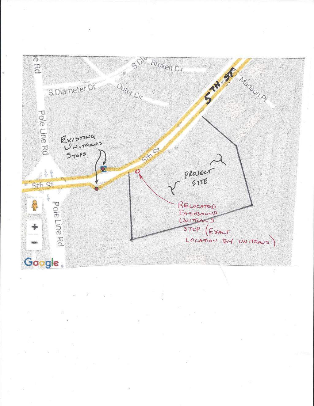
222
TRAFFIC IMPACT ANALYSIS FOR. STERLING FIFTH STREET APARTMENTS PROJECT Davis, CA. Prepared For:
 TRAFFIC IMPACT ANALYSIS FOR STERLING FIFTH STREET APARTMENTS PROJECT Davis, CA Prepared For: Din/Cal 3, Inc. 3411 Richmond Avenue, Suite 200 Houston, Texas 77046 Prepared By: KD Anderson & Associates,
TRAFFIC IMPACT STUDY FOR SONIC DRIVE-IN RESTAURANT. Vallejo, CA. Prepared For:
 TRAFFIC IMPACT STUDY FOR SONIC DRIVE-IN RESTAURANT Vallejo, CA Prepared For: ELITE DRIVE-INS, INC. 2190 Meridian Park Blvd, Suite G Concord, CA 94520 Prepared By: KD Anderson & Associates 3853 Taylor Road,
TRAFFIC IMPACT ANALYSIS FOR. RESIDENCE INN PROJECT Davis, CA. Prepared For: JACKSON PROPERTIES 155 Cadillac Drive, Suite 100 Sacramento, CA 95825
 TRAFFIC IMPACT ANALYSIS FOR RESIDENCE INN PROJECT Davis, CA Prepared For: JACKSON PROPERTIES 155 Cadillac Drive, Suite 100 Sacramento, CA 95825 Prepared By: KD Anderson & Associates, Inc. 3853 Taylor Road,
King County Metro. Columbia Street Transit Priority Improvements Alternative Analysis. Downtown Southend Transit Study. May 2014.
 King County Metro Columbia Street Transit Priority Improvements Alternative Analysis Downtown Southend Transit Study May 2014 Parametrix Table of Contents Introduction... 1 Methodology... 1 Study Area...
TRAFFIC IMPACT ANALYSIS FOR. McDONALD S RESTAURANT IN CARMICAEL Sacramento County, CA. Prepared For:
 TRAFFIC IMPACT ANALYSIS FOR McDONALD S RESTAURANT IN CARMICAEL Sacramento County, CA Prepared For: McDonald s USA, LLC Pacific Sierra Region 2999 Oak Road, Suite 900 Walnut Creek, CA 94597 Prepared By:
King Soopers #116 Thornton, Colorado
 Traffic Impact Study King Soopers #116 Thornton, Colorado Prepared for: Galloway & Company, Inc. T R A F F I C I M P A C T S T U D Y King Soopers #116 Thornton, Colorado Prepared for Galloway & Company
INDUSTRIAL DEVELOPMENT
 INDUSTRIAL DEVELOPMENT Traffic Impact Study Plainfield, Illinois August 2018 Prepared for: Seefried Industrial Properties, Inc. TABLE OF CONTENTS Executive Summary 2 Introduction 3 Existing Conditions
2.0 Development Driveways. Movin Out June 2017
 Movin Out June 2017 1.0 Introduction The proposed Movin Out development is a mixed use development in the northeast quadrant of the intersection of West Broadway and Fayette Avenue in the City of Madison.
Traffic Engineering Study
 Traffic Engineering Study Bellaire Boulevard Prepared For: International Management District Technical Services, Inc. Texas Registered Engineering Firm F-3580 November 2009 Executive Summary has been requested
DRAFT TRANSPORTATION IMPACT STUDY CASTILIAN REDEVELOPMENT PROJECT
 DRAFT TRANSPORTATION IMPACT STUDY CASTILIAN REDEVELOPMENT PROJECT Prepared for: Submitted by: 299 Lava Ridge Ct. Suite 2 Roseville, CA. 95661 June 212 TABLE OF CONTENTS 1. Introduction... 1 Project Location
TRAFFIC IMPACT STUDY FOR
 TRAFFIC IMPACT STUDY FOR YUBA CROSSINGS MIXED USE DEVELOPMENT Yuba City, CA Prepared For: Yuba Crossings LLC 1825 Del Paso Blvd Sacramento, CA 95815 Prepared By: KDAnderson & Associates, Inc. 3853 Taylor
LAWRENCE TRANSIT CENTER LOCATION ANALYSIS 9 TH STREET & ROCKLEDGE ROAD / 21 ST STREET & IOWA STREET LAWRENCE, KANSAS
 LAWRENCE TRANSIT CENTER LOCATION ANALYSIS 9 TH STREET & ROCKLEDGE ROAD / 21 ST STREET & IOWA STREET LAWRENCE, KANSAS TRAFFIC IMPACT STUDY FEBRUARY 214 OA Project No. 213-542 TABLE OF CONTENTS 1. INTRODUCTION...
EXECUTIVE SUMMARY. The following is an outline of the traffic analysis performed by Hales Engineering for the traffic conditions of this project.
 EXECUTIVE SUMMARY This study addresses the traffic impacts associated with the proposed Shopko redevelopment located in Sugarhouse, Utah. The Shopko redevelopment project is located between 1300 East and
D R A F T TRAFFIC IMPACT ANALYSIS FOR. DARK HORSE GOLF RESORT EXPANSION Nevada County, CA. Prepared For:
 D R A F T TRAFFIC IMPACT ANALYSIS FOR DARK HORSE GOLF RESORT EXPANSION Nevada County, CA Prepared For: ASIAN PACIFIC GROUP 18000 Van Karman Avenue, Suite 500 Irvine, CA 92612 Prepared By: KD Anderson &
Traffic Impact Analysis. Alliance Cole Avenue Residential Site Dallas, Texas. Kimley-Horn and Associates, Inc. Dallas, Texas.
 Traffic Impact Analysis Alliance Cole Avenue Residential Site Dallas, Texas February 15, 2018 Kimley-Horn and Associates, Inc. Dallas, Texas Project #064524900 Registered Firm F-928 Traffic Impact Analysis
The key roadways in the project vicinity are described below. Exhibit displays the existing number of lanes on the study roadways.
 4.2 TRAFFIC AND CIRCULATION This section presents the key assumptions, methods, and results of analysis for the transportation and circulation impacts of the proposed project. This section is based on
APPENDIX C1 TRAFFIC ANALYSIS DESIGN YEAR TRAFFIC ANALYSIS
 APPENDIX C1 TRAFFIC ANALYSIS DESIGN YEAR TRAFFIC ANALYSIS DESIGN YEAR TRAFFIC ANALYSIS February 2018 Highway & Bridge Project PIN 6754.12 Route 13 Connector Road Chemung County February 2018 Appendix
Proposed location of Camp Parkway Commerce Center. Vicinity map of Camp Parkway Commerce Center Southampton County, VA
 Proposed location of Camp Parkway Commerce Center Vicinity map of Camp Parkway Commerce Center Southampton County, VA Camp Parkway Commerce Center is a proposed distribution and industrial center to be
Traffic Impact Study Speedway Gas Station Redevelopment
 Traffic Impact Study Speedway Gas Station Redevelopment Warrenville, Illinois Prepared For: Prepared By: April 11, 2018 Table of Contents 1. Introduction... 1 2. Existing Conditions... 4 Site Location...
Traffic Impact Analysis West Street Garden Plots Improvements and DuPage River Park Garden Plots Development Naperville, Illinois
 Traffic Impact Analysis West Street Garden Plots Improvements and DuPage River Park Garden Plots Development Naperville, Illinois Submitted by April 9, 2009 Introduction Kenig, Lindgren, O Hara, Aboona,
APPENDIX E. Traffic Analysis Report
 APPENDIX E Traffic Analysis Report THIS PAGE INTENTIONALLY BLANK EAGLE RIVER TRAFFIC MITIGATION PHASE I OLD GLENN HIGHWAY/EAGLE RIVER ROAD INTERSECTION IMPROVEMENTS TRAFFIC ANALYSIS Eagle River, Alaska
TALMONT TOWNHOMES MADISON KENNETH SPA TRAFFIC IMPACT STUDY. Sacramento, CA. Prepared For: MBK Homes. Prepared By:
 TALMONT TOWNHOMES MADISON KENNETH SPA TRAFFIC IMPACT STUDY Sacramento, CA Prepared For: MBK Homes Prepared By: KD Anderson & Associates 3853 Taylor Road, Suite G Loomis, California 95650 (916) 660-1555
Date: February 7, 2017 John Doyle, Z-Best Products Robert Del Rio. T.E. Z-Best Traffic Operations and Site Access Analysis
 Memorandum Date: February 7, 07 To: From: Subject: John Doyle, Z-Best Products Robert Del Rio. T.E. Z-Best Traffic Operations and Site Access Analysis Introduction Hexagon Transportation Consultants, Inc.
TRAFFIC IMPACT ANALYSIS
 TRAFFIC IMPACT ANALYSIS Emerald Isle Commercial Development Prepared by SEPI Engineering & Construction Prepared for Ark Consulting Group, PLLC March 2016 I. Executive Summary A. Site Location The Emerald
TRAFFIC IMPACT ANALYSIS RIZZO CONFERENCE CENTER EXPANSION FINAL REPORT
 TRAFFIC IMPACT ANALYSIS RIZZO CONFERENCE CENTER EXPANSION Chapel Hill, North Carolina FINAL REPORT Prepared for: The Town of Chapel Hill, NC Prepared by: Architects-Engineers-Planners, Inc. December 2010
APPENDIX B Traffic Analysis
 APPENDIX B Traffic Analysis Rim of the World Unified School District Reconfiguration Prepared for: Rim of the World School District 27315 North Bay Road, Blue Jay, CA 92317 Prepared by: 400 Oceangate,
TRAFFIC PARKING ANALYSIS
 TRAFFIC PARKING ANALYSIS NAPA FLEA MARKET COUNTY OF NAPA Prepared for: Tom Harding Napa-Vallejo Flea Market 33 Kelly Road American Canyon, CA 9453 Prepared by: 166 Olympic Boulevard, Suite 21 Walnut Creek,
Existing Traffic Conditions
 May 14, 2014 Ms. Lorraine Weiss City of San Mateo 330 West 20 th Avenue San Mateo, CA 94403 Subject: Traffic Operational Study for the Proposed Tilton Avenue Residential Development in San Mateo, California
Lacey Gateway Residential Phase 1
 Lacey Gateway Residential Phase Transportation Impact Study April 23, 203 Prepared for: Gateway 850 LLC 5 Lake Bellevue Drive Suite 02 Bellevue, WA 98005 Prepared by: TENW Transportation Engineering West
Craig Scheffler, P.E., PTOE HNTB North Carolina, P.C. HNTB Project File: Subject
 TECHNICAL MEMORANDUM To Kumar Neppalli Traffic Engineering Manager Town of Chapel Hill From Craig Scheffler, P.E., PTOE HNTB North Carolina, P.C. Cc HNTB Project File: 38435 Subject Obey Creek TIS 2022
TIMBERVINE TRANSPORTATION IMPACT STUDY FORT COLLINS, COLORADO JANUARY Prepared for:
 TIMBERVINE TRANSPORTATION IMPACT STUDY FORT COLLINS, COLORADO JANUARY 2014 Prepared for: Hartford Companies 1218 W. Ash Street Suite A Windsor, Co 80550 Prepared by: DELICH ASSOCIATES 2272 Glen Haven Drive
TRANSPORTATION TECHNICAL REPORT
 TRANSPORTATION TECHNICAL REPORT for Sunrise Elementary School Replacement PREPARED FOR: Puyallup School District PREPARED BY: 6544 NE 61 st Street, Seattle, WA 98115 ph: (26) 523-3939 fx: (26) 523-4949
ZINFANDEL LANE / SILVERADO TRAIL INTERSECTION TRAFFIC ANALYSIS
 ZINFANDEL LANE / SILVERADO TRAIL INTERSECTION TRAFFIC ANALYSIS UPDATED TRAFFIC STUDY FOR THE PROPOSED RAYMOND VINEYARDS WINERY USE PERMIT MODIFICATION #P11-00156 AUGUST 5, 2014 PREPARED BY: OMNI-MEANS,
RE: A Traffic Impact Statement for a proposed development on Quinpool Road
 James J. Copeland, P.Eng. GRIFFIN transportation group inc. 30 Bonny View Drive Fall River, NS B2T 1R2 May 31, 2018 Ellen O Hara, P.Eng. Project Engineer DesignPoint Engineering & Surveying Ltd. 200 Waterfront
Revised Report. Traffic Study for Safeway Fuel Center at Washington Square Shopping Center. In The City of Petaluma.
 Revised Report Traffic Study for Safeway Fuel Center at Washington Square Shopping Center In The Pleasanton Fresno Sacramento Santa Rosa TJKM www.tjkm.com Revised Report Traffic Study for Safeway Fuel
Volume 1 Traffic Impact Analysis Turtle Creek Boulevard Dallas, Texas. Kimley-Horn and Associates, Inc. Dallas, Texas.
 Volume 1 Traffic Impact Analysis 2727 Dallas, Texas June 18, 2018 Kimley-Horn and Associates, Inc. Dallas, Texas Project #064523000 Registered Firm F-928 Traffic Impact Analysis 2727 Dallas, Texas Prepared
L1TILE BEARS DAY CARE TRANSPORTATION IMPACT STUDY FORT COLLINS, COLORADO MAY Prepared for:
 L1TILE BEARS DAY CARE TRANSPORTATION IMPACT STUDY FORT COLLINS, COLORADO MAY 2012 Prepared for: Hillside Construction, Inc. 216 Hemlock Street, Suite B Fort Collins, CO 80534 Prepared by: DELICH ASSOCIATES
TRAFFIC DATA. Existing Derousse Ave./River Rd. AM LOS Analysis Existing Derousse Ave./River Rd. PM LOS Analysis
 Appendix E NJ TRANSIT Pennsauken Junction Transit Center and Park & Ride RiverLINE and Atlantic City Line Pennsauken Township, Camden County, New Jersey TRAFFIC DATA Background Traffic Information for
TRAFFIC SIGNAL DESIGN REPORT KING OF PRUSSIA ROAD & RAIDER ROAD RADNOR TOWNSHIP PENNSYLVANIA
 TRAFFIC SIGNAL DESIGN REPORT KING OF PRUSSIA ROAD & RAIDER ROAD RADNOR TOWNSHIP PENNSYLVANIA PREPARED FOR: UNIVERSITY OF PENNSYLVANIA HEALTH SYSTEM 34 CIVIC CENTER BOULEVARD PHILADELPHIA, PA 1987 (61)
IMPROVEMENT CONCEPTS
 IMPROVEMENT CONCEPTS for the South Novato Transit Hub Study Prepared by: January 11, 2010 DKS Associates With Wilbur Smith Associates IMPROVEMENT CONCEPTS Chapter 1: Introduction 1. INTRODUCTION The strategic
4.14 TRANSPORTATION AND CIRCULATION
 4.14 TRANSPORTATION AND CIRCULATION 4.14.1 Summary Table 4.14-1 summarizes the identified environmental impacts, proposed mitigation measures, and residual impacts of the proposed project with regard to
Appendix C. Traffic Study
 Appendix C Traffic Study TABLE OF CONTENTS SECTION Executive Summary PAGE 1.0 Introduction... 1 1.1 Scope of Work... 1 1.2 Study Area... 2 2.0 Project Description... 3 2.1 Site Access... 4 2.2 Pedestrian
MINERVA PARK SITE TRAFFIC IMPACT STUDY M/I HOMES. September 2, 2015
 5500 New Albany Road Columbus, Ohio 43054 Phone: 614.775.4500 Fax: 614.775.4800 Toll Free: 1-888-775-EMHT emht.com 2015-1008 MINERVA PARK SITE TRAFFIC IMPACT STUDY M/I HOMES September 2, 2015 Engineers
IRSCH REEN Hirsch/Green Transportation Consulting, Inc.
 IRSCH REEN Hirsch/Green Transportation Consulting, Inc. February 6, 2013 Mr. David Weil Director of Finance St. Matthew s Parish School 1031 Bienveneda Avenue Pacific Palisades, California 90272 RE: Trip
V. DEVELOPMENT OF CONCEPTS
 Martin Luther King, Jr. Drive Extension FINAL Feasibility Study Page 9 V. DEVELOPMENT OF CONCEPTS Throughout the study process several alternative alignments were developed and eliminated. Initial discussion
MEMORANDUM. Figure 1. Roundabout Interchange under Alternative D
 MEMORANDUM Date: To: Liz Diamond, Dokken Engineering From: Subject: Dave Stanek, Fehr & Peers Western Placerville Interchanges 2045 Analysis RS08-2639 Fehr & Peers has completed a transportation analysis
Traffic Impact Statement (TIS)
") Traffic Impact Statement (TIS) Vincentian PUDA Collier County, FL 10/18/2013 Prepared for: Global Properties of Naples Prepared by: Trebilcock Consulting Solutions, PA 2614 Tamiami Trail N, Suite 615 1205
Traffic Impact Statement (TIS) Vincentian PUDA Collier County, FL 10/18/2013 Prepared for: Global Properties of Naples Prepared by: Trebilcock Consulting Solutions, PA 2614 Tamiami Trail N, Suite 615 1205
TRAFFIC IMPACT ANALYSIS SHORTBREAD LOFTS 2009 MODIFICATION Chapel Hill, North Carolina
 TRAFFIC IMPACT ANALYSIS SHORTBREAD LOFTS 2009 MODIFICATION Chapel Hill, North Carolina Prepared for: The Town of Chapel Hill, NC Prepared by: Architects-Engineers-Planners, Inc. November 2009 Traffic Impact
INTERSECTION ANALYSIS PARK AVENUE AND BRADDOCK ROAD (FROSTBURG, MD) FOR LENHART TRAFFIC CONSULTING, INC.
 FOR LENHART TRAFFIC CONSULTING, INC.") INTERSECTION ANALYSIS FOR PARK AVENUE AND BRADDOCK ROAD (FROSTBURG, MD) Prepared for: City of Frostburg, Maryland & Allegany County Commissioners Prepared by: LENHART TRAFFIC CONSULTING, INC. TRAFFIC ENGINEERING
INTERSECTION ANALYSIS FOR PARK AVENUE AND BRADDOCK ROAD (FROSTBURG, MD) Prepared for: City of Frostburg, Maryland & Allegany County Commissioners Prepared by: LENHART TRAFFIC CONSULTING, INC. TRAFFIC ENGINEERING
VOA Vista Drive Residential housing Development TIA Project #13915 TABLE OF CONTENTS
 VOA Vista Drive Residential housing Development TIA Project #13915 TABLE OF CONTENTS Executive Summary... 2 Project Background... 2 Conditions... 2 Findings... 3 Recommendations... 4 Introduction... 6
TRAFFIC IMPACT STUDY. USD #497 Warehouse and Bus Site
 TRAFFIC IMPACT STUDY for USD #497 Warehouse and Bus Site Prepared by: Jason Hoskinson, PE, PTOE BG Project No. 16-12L July 8, 216 145 Wakarusa Drive Lawrence, Kansas 6649 T: 785.749.4474 F: 785.749.734
Traffic Impact Study for Proposed Olive Boulevard Development
 Traffic Impact Study for Proposed 11330 Olive Boulevard Development Creve Coeur, Missouri July 7, 2017 Prepared For: 11330 Olive Boulevard Development 11330 Olive Boulevard Creve Coeur, Missouri 63141
Escondido Marriott Hotel and Mixed-Use Condominium Project TRAFFIC IMPACT ANALYSIS REPORT
 Escondido Marriott Hotel and Mixed-Use Condominium Project TRAFFIC IMPACT ANALYSIS REPORT Prepared for Phelps Program Management 420 Sixth Avenue, Greeley, CO 80632 Prepared by 5050 Avenida Encinas, Suite
Traffic Impact Analysis 5742 BEACH BOULEVARD MIXED USE PROJECT
 Traffic Impact Analysis 5742 BEACH BOULEVARD MIXED USE PROJECT CITY OF BUENA PARK Prepared by Project No. 14139 000 April 17 th, 2015 DKS Associates Jeffrey Heald, P.E. Rohit Itadkar, T.E. 2677 North Main
Table of Contents. Traffic Impact Analysis Capital One Building at Schilling Place
 Traffic Impact Analysis Capital One Building at Schilling Place Table of Contents Executive Summary... 1 1. Introduction... 4 2. Project Description... 4 3. Background Information... 4 4. Study Scope...
700 University Avenue Mixed-Use Development. Traffic Impact Analysis
 700 University Avenue Mixed-Use Development Traffic Impact Analysis January 20, 2006 Prepared by 700 UNIVERSITY AVENUE MIXED- USE DEVELOPMENT TRAFFIC IMPACT STUDY Table of Contents 1.0 Executive Summary...
MONTEREY BAY AQUARIUM RESEARCH INSTITUTE (MBARI) MASTER PLAN UPDATE MOSS LANDING, CALIFORNIA
 MASTER PLAN UPDATE MOSS LANDING, CALIFORNIA") MONTEREY BAY AQUARIUM RESEARCH INSTITUTE (MBARI) MASTER PLAN UPDATE MOSS LANDING, CALIFORNIA TRAFFIC IMPACT ANALYSIS Administrative Draft Report Prepared For Monterey Bay Aquarium Research Institute Moss
MONTEREY BAY AQUARIUM RESEARCH INSTITUTE (MBARI) MASTER PLAN UPDATE MOSS LANDING, CALIFORNIA TRAFFIC IMPACT ANALYSIS Administrative Draft Report Prepared For Monterey Bay Aquarium Research Institute Moss
NEWCASTLE MIDDLE SCHOOL Traffic Impact Analysis
 Gibson Traffic Consultants 2802 Wetmore Avenue Suite 220 Everett, WA 98201 425.339.8266 NEWCASTLE MIDDLE SCHOOL Traffic Impact Analysis Prepared for: Renton School District Jurisdiction: City of Newcastle
Draft Report: West Berkeley Bowl Project
 Draft Report: West Berkeley Bowl Project July 2004 Prepared for: The City of Berkeley 1031-1925 F EHR & PEERS TRANSPORTATION CONSULTANTS 3685 Mt. Diablo Blvd. #301 Lafayette, CA 94549 925-284-3200 Fax:
Table Existing Traffic Conditions for Arterial Segments along Construction Access Route. Daily
 5.8 TRAFFIC, ACCESS, AND CIRCULATION This section describes existing traffic conditions in the project area; summarizes applicable regulations; and analyzes the potential traffic, access, and circulation
Oakbrook Village Plaza City of Laguna Hills
 Oakbrook Village Plaza City of Laguna Hills Traffic Impact Analysis Prepared by: HDR Engineering 3230 El Camino Real, Suite 200 Irvine, CA 92602 October 2012 Revision 3 D-1 Oakbrook Village Plaza Laguna
Traffic Management Plan and Queuing Analysis Lakehill Preparatory School Z Hillside Drive, Dallas, TX October 27, 2015
 Traffic Management Plan and Queuing Analysis Lakehill Preparatory School Z145-235 2720 Hillside Drive, Dallas, TX October 27, 2015 Introduction: The Lakehill Preparatory School is located on the northeast
Appendix J Traffic Impact Study
 MRI May 2012 Appendix J Traffic Impact Study Level 2 Traffic Assessment Limited Impact Review Appendix J [This page was left blank intentionally.] www.sgm-inc.com Figure 1. Site Driveway and Trail Crossing
County State Aid Highway 32 (Cliff Road) and Dodd Road Intersection Study
 and Dodd Road Intersection Study") County State Aid Highway 32 (Cliff Road) and Dodd Road Intersection Study City of Eagan, Dakota County, Minnesota Date: March 2012 Project No. 14957.000 444 Cedar Street, Suite 1500 Saint Paul, MN 55101
County State Aid Highway 32 (Cliff Road) and Dodd Road Intersection Study City of Eagan, Dakota County, Minnesota Date: March 2012 Project No. 14957.000 444 Cedar Street, Suite 1500 Saint Paul, MN 55101
RTE. 1 at RTE. 637 & RTE. 639
 INTERSECTION SAFETY STUDY Prepared for: Virginia Department of Transportation Central Region Operations Traffic Engineering (UPC #81378, TO 12-092) DAVENPORT Project Number: 13-368 / /2014 RTE. 1 at RTE.
Quantitative analyses of weekday a.m. and p.m. commuter hour conditions have been conducted for the following five scenarios:
 6.1 TRANSPORTATION AND CIRCULATION 6.1.1 INTRODUCTION This section of the EIR presents the results of TJKM s traffic impact analysis of the proposed Greenbriar Development. The analysis includes consideration
APPENDIX C-2. Traffic Study Supplemental Analysis Memo
 APPENDIX C-2 Traffic Study Supplemental Analysis Memo The Mobility Group Transportation Strategies & Solutions Memorandum To: From: Subject: Tomas Carranza, LADOT Matthew Simons Traffic Review - Revised
TRANSPORTATION REVIEW
 TRANSPORTATION REVIEW - PROPOSED MIX OF LAND USES IS CONSISTENT WITH THE CITY S UNDER THE GRANVILLE BRIDGE POLICIES THAT AIM TO MEET NEIGHBOURING RESIDENTS SHOPPING NEEDS AND REDUCE RELIANCE ON AUTOMOBILE
The major roadways in the study area are State Route 166 and State Route 33, which are shown on Figure 1-1 and described below:
 3.5 TRAFFIC AND CIRCULATION 3.5.1 Existing Conditions 3.5.1.1 Street Network DRAFT ENVIRONMENTAL IMPACT REPORT The major roadways in the study area are State Route 166 and State Route 33, which are shown
Traffic Impact Analysis for 2171 Rosecrans Avenue
 Traffic Impact Analysis for 2171 Rosecrans Avenue Prepared for: Continental Development Corporation Revised May 2016 LA16-2831 Prepared by: Fehr & Peers 600 Wilshire Blvd, Suite 1050 Los Angeles, CA 90017
Transit City Etobicoke - Finch West LRT
 Delcan Corporation Transit City Etobicoke - Finch West LRT APPENDIX D Microsimulation Traffic Modeling Report March 2010 March 2010 Appendix D CONTENTS 1.0 STUDY CONTEXT... 2 Figure 1 Study Limits... 2
City of Marina. Regional Roundabout Study Utilizing Caltrans Intersection Control Evaluation Section 4: Transportation Agency for Monterey County
 Regional Roundabout Study Utilizing Caltrans Intersection Control Evaluation Section 4: City of Marina Study Intersections: RESERVATION ROAD AT BEACH ROAD RESERVATION ROAD AT DEFOREST ROAD CARDOZA AVENUE
2. Valley Circle Boulevard/Andora Avenue/Baden Avenue and Lassen Street
 IV.J TRANSPORTATION 1. INTRODUCTION This section presents an overview of the existing traffic and circulation system in and surrounding the project site. This section also discusses the potential impacts
Downtown One Way Street Conversion Technical Feasibility Report
 Downtown One Way Street Conversion Technical Feasibility Report As part of the City s Transportation Master Plan, this report reviews the technical feasibility of the proposed conversion of the current
County State Aid Highway 30 (Diffley Road) and Dodd Road Intersection Study
 and Dodd Road Intersection Study") County State Aid Highway 30 (Diffley Road) and Dodd Road Intersection Study City of Eagan, Dakota County, Minnesota Date: March 2012 Project No. 14957.000 444 Cedar Street, Suite 1500 Saint Paul, MN 55101
County State Aid Highway 30 (Diffley Road) and Dodd Road Intersection Study City of Eagan, Dakota County, Minnesota Date: March 2012 Project No. 14957.000 444 Cedar Street, Suite 1500 Saint Paul, MN 55101
TRANSPORTATION STUDY FOR THE 8899 BEVERLY BOULEVARD PROJECT
 DRAFT TRANSPORTATION STUDY FOR THE 8899 BEVERLY BOULEVARD PROJECT WEST HOLLYWOOD, CALIFORNIA NOVEMBER 2013 PREPARED FOR BEVERLY BOULEVARD ASSOCIATION PREPARED BY DRAFT TRANSPORTATION STUDY FOR THE 8899
TRAFFIC IMPACT STUDY DERRY GREEN CORPORATE BUSINESS PARK MILTON SECONDARY PLAN MODIFICATION
 TRAFFIC IMPACT STUDY DERRY GREEN CORPORATE BUSINESS PARK MILTON SECONDARY PLAN MODIFICATION TRAFFIC IMPACT STUDY DERRY GREEN CORPORATE BUSINESS PARK MILTON SECONDARY PLAN MODIFICATION DECEMBER 24 UPDATED
Figure 1 Map of intersection of SR 44 (Ravenna Rd) and Butternut Rd
 and Butternut Rd") Abbreviated Study District: 12 County: Geauga Route: SR 44 Section: 1.58 GEA 44 1.58 213 HSP # 47 (Rural Intersection) Prepared April 23, 215 By Bryan Emery Existing Conditions This study contains the
Abbreviated Study District: 12 County: Geauga Route: SR 44 Section: 1.58 GEA 44 1.58 213 HSP # 47 (Rural Intersection) Prepared April 23, 215 By Bryan Emery Existing Conditions This study contains the
BROWARD BOULEVARD CORRIDOR TRANSIT STUDY
 BROWARD BOULEVARD CORRIDOR TRANSIT STUDY FM # 42802411201 EXECUTIVE SUMMARY July 2012 GOBROWARD Broward Boulevard Corridor Transit Study FM # 42802411201 Executive Summary Prepared For: Ms. Khalilah Ffrench,
RICHMOND OAKS HEALTH CENTRE 6265 PERTH STREET OTTAWA, ONTARIO TRANSPORTATION BRIEF. Prepared for: Guycoki (Eastern) Limited.
 Limited.") RICHMOND OAKS HEALTH CENTRE 6265 PERTH STREET OTTAWA, ONTARIO TRANSPORTATION BRIEF Prepared for: Guycoki (Eastern) Limited June 16, 2016 116-638 Brief_1.doc D. J. Halpenny & Associates Ltd. Consulting
RICHMOND OAKS HEALTH CENTRE 6265 PERTH STREET OTTAWA, ONTARIO TRANSPORTATION BRIEF Prepared for: Guycoki (Eastern) Limited June 16, 2016 116-638 Brief_1.doc D. J. Halpenny & Associates Ltd. Consulting
Service Quality: Higher Ridership: Very Affordable: Image:
 Over the past decade, much attention has been placed on the development of Bus Rapid Transit (BRT) systems. These systems provide rail-like service, but with buses, and are typically less expensive to
Proposed Inn at Bellefield Traffic Impact Assessment
 Proposed Inn at Bellefield Traffic Impact Assessment Town of Hyde Park Dutchess County, New York Prepared for: T-Rex Hyde Park Owner LLC 500 Mamroneck Avenue, Suite 300 Harrison, NY 10528 June 21, 2017
MILLERSVILLE PARK TRAFFIC IMPACT ANALYSIS ANNE ARUNDEL COUNTY, MARYLAND
 MILLERSVILLE PARK TRAFFIC IMPACT ANALYSIS ANNE ARUNDEL COUNTY, MARYLAND Prepared for: Department of Public Works Anne Arundel County Prepared by: URS Corporation 4 North Park Drive, Suite 3 Hunt Valley,
Perris Apartments Traffic Impact Analysis City of Perris, California
 Perris Apartments Traffic Impact Analysis City of Perris, California Prepared for: JD Pierce Company, Inc. 2222 Martin St., Suite 100 Irvine, CA 92612 Prepared by: TJW ENGINEERING, INC. 540 N. Golden Circle
MERIVALE PRIORITY SQUARE 2852 MERIVALE ROAD CITY OF OTTAWA TRANSPORTATION BRIEF. Prepared for: ONT Inc. 25 Winding Way Nepean, Ontario K2C 3H1
 MERIVALE PRIORITY SQUARE 2852 MERIVALE ROAD CITY OF OTTAWA TRANSPORTATION BRIEF Prepared for: 2190986ONT Inc. 25 Winding Way Nepean, Ontario K2C 3H1 October 6, 2010 110-502 Report_1.doc D. J. Halpenny
Bennett Pit. Traffic Impact Study. J&T Consulting, Inc. Weld County, Colorado. March 3, 2017
 Bennett Pit Traffic Impact Study J&T Consulting, Inc. Weld County, Colorado March 3, 217 Prepared By: Sustainable Traffic Solutions, Inc. http://www.sustainabletrafficsolutions.com/ Joseph L. Henderson,
GASOLINE SERVICE STATION 1618, 1622 ROGER STEVENS DRIVE OTTAWA, ONTARIO TRANSPORTATION IMPACT ASSESSMENT. Prepared for:
 GASOLINE SERVICE STATION 1618, 1622 ROGER STEVENS DRIVE OTTAWA, ONTARIO TRANSPORTATION IMPACT ASSESSMENT Prepared for: Invecta Development (Ottawa) Corporation 758 Shanks Height Milton, ON L9T 7P7 May
1650 South Delaware Street
 65 South Delaware Street Final Transportation Impact Analysis Prepared for: City of San Mateo June 8, 28 Hexagon Transportation Consultants, Inc. Hexagon Office: 4 North Second Street, Suite 4 San Jose,
One Harbor Point Residential
 Residential Gig Harbor, WA Transportation Impact Analysis January 23, 2017 Prepared for: Neil Walter Company PO Box 2181 Tacoma, WA 98401 Prepared by: TENW Transportation Engineering NorthWest 11400 SE
Section 5.0 Traffic Information
 Section 5.0 Traffic Information 10.0 TRANSPORTATION MDM Transportation Consultants, Inc. (MDM) has prepared an evaluation of transportation impacts for the proposed evaluation for the expansion of the
THE CORNERSTONE APARTMENTS TRAFFIC IMPACT STUDY R&M PROJECT NO
 THE CORNERSTONE APARTMENTS SITUATED AT N/E/C OF STAUDERMAN AVENUE AND FOREST AVENUE VILLAGE OF LYNBROOK NASSAU COUNTY, NEW YORK TRAFFIC IMPACT STUDY R&M PROJECT NO. 2018-089 September 2018 50 Elm Street,
Traffic Impact Study Proposed Residential Development (Watson Parkway North - Starwood Drive Node, City of Guelph)
") Traffic Impact Study Proposed Residential Development (Watson Parkway North - Starwood Drive Node, City of Guelph) Prepared By: 332 Lorne Avenue East Stratford ON N5A 6S4 Prepared for: Paul Kemper, President
Traffic Impact Study Proposed Residential Development (Watson Parkway North - Starwood Drive Node, City of Guelph) Prepared By: 332 Lorne Avenue East Stratford ON N5A 6S4 Prepared for: Paul Kemper, President
Transportation & Traffic Engineering
 Transportation & Traffic Engineering 1) Project Description This report presents a summary of findings for a Traffic Impact Analysis (TIA) performed by A+ Engineering, Inc. for the Hill Country Family
4131 Chain Bridge Road
 Traffic Impact Study 4131 Chain Bridge Road City of Fairfax, VA 05/04/16 May 4, 2016 Prepared for: Paradigm 1415 North Taft Street Suite 100 Arlington, VA 22201 This report is printed on environmentally
MEMO VIA . Ms. Amy Roth DPS Director, City of Three Rivers. To:
 MEMO To: Ms. Amy Roth DPS Director, City of Three Rivers VIA EMAIL From: Michael J. Labadie, PE Julie M. Kroll, PE, PTOE Brandon Hayes, PE, P.Eng. Fleis & VandenBrink Date: January 5, 2017 Re: Proposed
Appendix H TRAFFIC IMPACT ANALYSIS
 Appendix H TRAFFIC IMPACT ANALYSIS Teichert Boca Quarry Expansion Traffic Impact Analysis Prepared for Teichert Aggregates Prepared by TRANSPORTATION CONSULTANTS, INC. LSC Transportation Consultants, Inc.
Traffic Feasibility Study
 Traffic Feasibility Study Town Center South Robbinsville Township, Mercer County, New Jersey December 19, 2017 Prepared For Robbinsville Township Department of Community Development 2298 Route 33 Robbinsville,
Appendix Q Traffic Study
 Appendices Appendix Q Traffic Study Crummer Site Subdivision Draft EIR City of Malibu Appendices This page intentionally left blank. The Planning Center April 2013 TRAFFIC IMPACT ANALYSIS Photo z here
ANDERSON PROPERTY SITE ANALYSIS
 ANDERSON PROPERTY SITE ANALYSIS Introduction The Montgomery County Department of Transportation (MCDOT) initiated a feasibility study in the fall of 2012 to evaluate the need for transit service expansion
Construction Realty Co.
 MEMORANDUM TO: FROM : Jeff Pickus Construction Realty Co. Luay R. Aboona, PE Principal 9575 West Higgins Road, Suite 400 Rosemont, Illinois 60018 p: 847-518-9990 f: 847-518-9987 DATE: May 22, 2014 SUBJECT: