Appendix H TRAFFIC IMPACT ANALYSIS
|
|
|
- Damian Wiggins
- 5 years ago
- Views:
Transcription
1 Appendix H TRAFFIC IMPACT ANALYSIS


2 Teichert Boca Quarry Expansion Traffic Impact Analysis Prepared for Teichert Aggregates Prepared by TRANSPORTATION CONSULTANTS, INC. LSC Transportation Consultants, Inc.
3
4 Teichert Boca Quarry Expansion Traffic Impact Analysis Prepared for Teichert Aggregates 3500 American River Drive Sacramento, CA Prepared by LSC Transportation Consultants, Inc Lake Forest Road, Suite 2C P.O. Box 5875 Tahoe City, CA September 8, 2011 LSC #117210
5
6 EXECUTIVE SUMMARY PURPOSE The Teichert Boca Quarry is located along Hinton Road east of Boca Reservoir and north of Interstate 80 (I-80) in Nevada County, California. The proposed project (the West Pit ) would expand the site to a total area of approximately 158 acres, with up to 15 employees and a maximum potential production of one million tons per year. The quarry operates from May through October. In addition to exporting material from the quarry, backfill material is imported to the quarry from other locations. Over the course of a peak season, about 250,000 tons of backfill are brought to the site. This report analyzes the traffic impacts associated with the quarry expansion. FINDINGS The findings of the Traffic Impact Analysis are as follows: 1. The proposed project is expected to generate up to approximately 1,432 daily oneway vehicle trips (716 inbound and 716 outbound) over the course of a peak weekday, with 150 AM peak-hour one-way trips (75 inbound and 75 outbound) and 50 PM peak-hour one-way trips (25 inbound and 25 outbound). On a peak Saturday, the project would generate up to 1,282 daily one-way trips and 150 peak-hour oneway trips. As these figures reflect the maximum potential production levels, this analysis is considered to be conservative. 2. All study intersections are expected to operate at an acceptable Level of Service (LOS) under 2011 and 2031 conditions, with or without the project. 3. The peak-hour traffic volumes at the site access intersection (Stampede Meadows Road/West Hinton Road) do not warrant any new turn lanes under 2011 or 2031 conditions, with or without the project. 4. The driver sight distance at the Stampede Meadows Road/West Hinton Road intersection meets or exceeds the desired sight distance, with the exception of the corner sight distance looking to the north from West Hinton Road. Although the corner sight distance looking to the north is adequate for truck drivers exiting the site, the corner sight distance for passenger vehicle drivers exiting the site is about 85 feet short of the desired distance. 5. The project is expected to generate up to 28,336 daily Vehicle Miles of Travel (VMT) and 3,000 peak-hour VMT in the local region over the course of a peak day. These figures represent worst-case conditions, as they assume the quarry is operating at maximum potential production levels. The VMT generated by the proposed project are not all necessarily "new" VMT, given the fact that there are some VMT associated with the existing site as well as with Teichert s Martis Quarry, which will cease production in a couple of years. Furthermore, the VMT associated with the Boca Executive Summary Traffic Impact Analysis LSC Transportation Consultants, Inc. Page ES-1
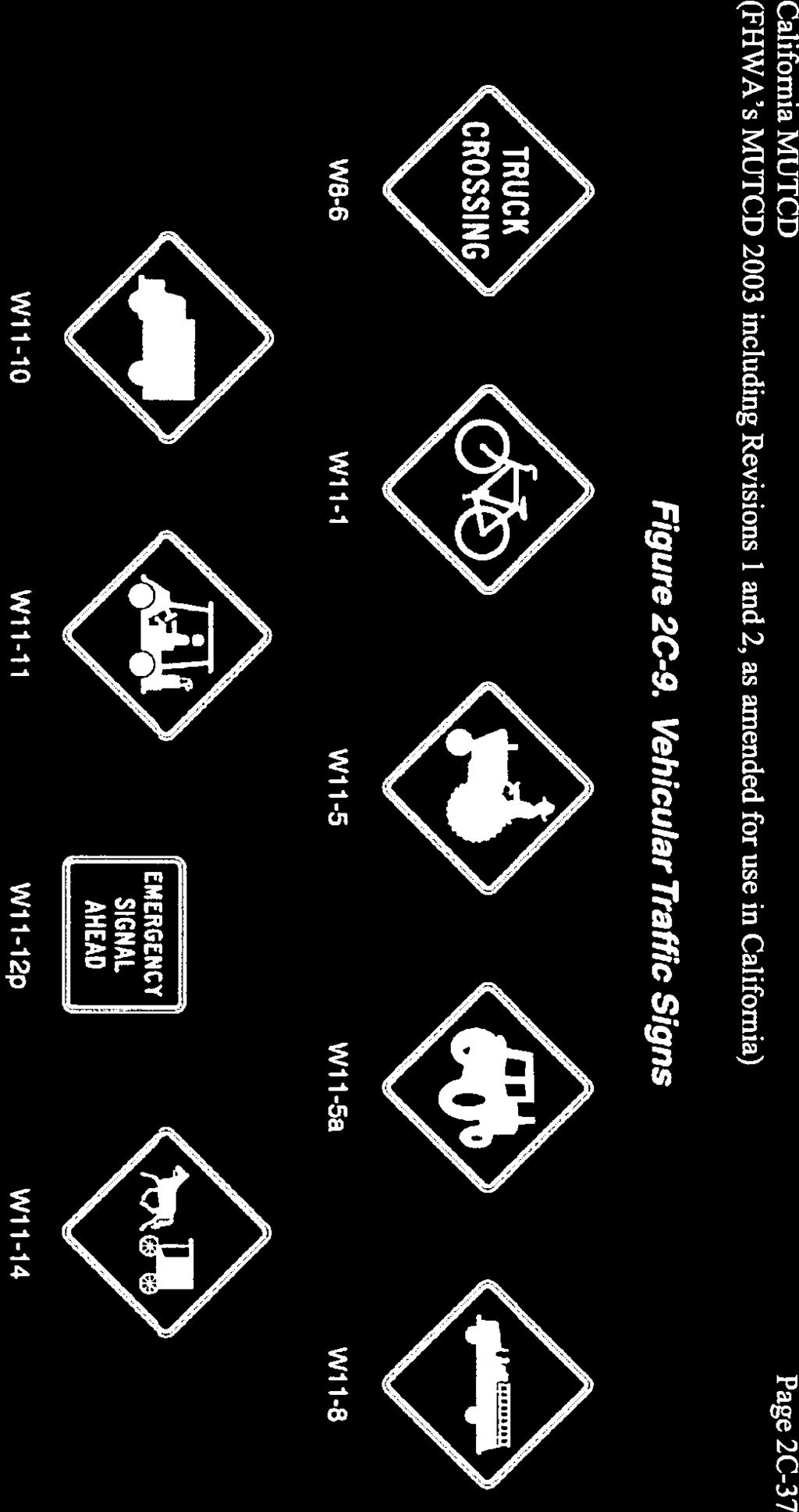
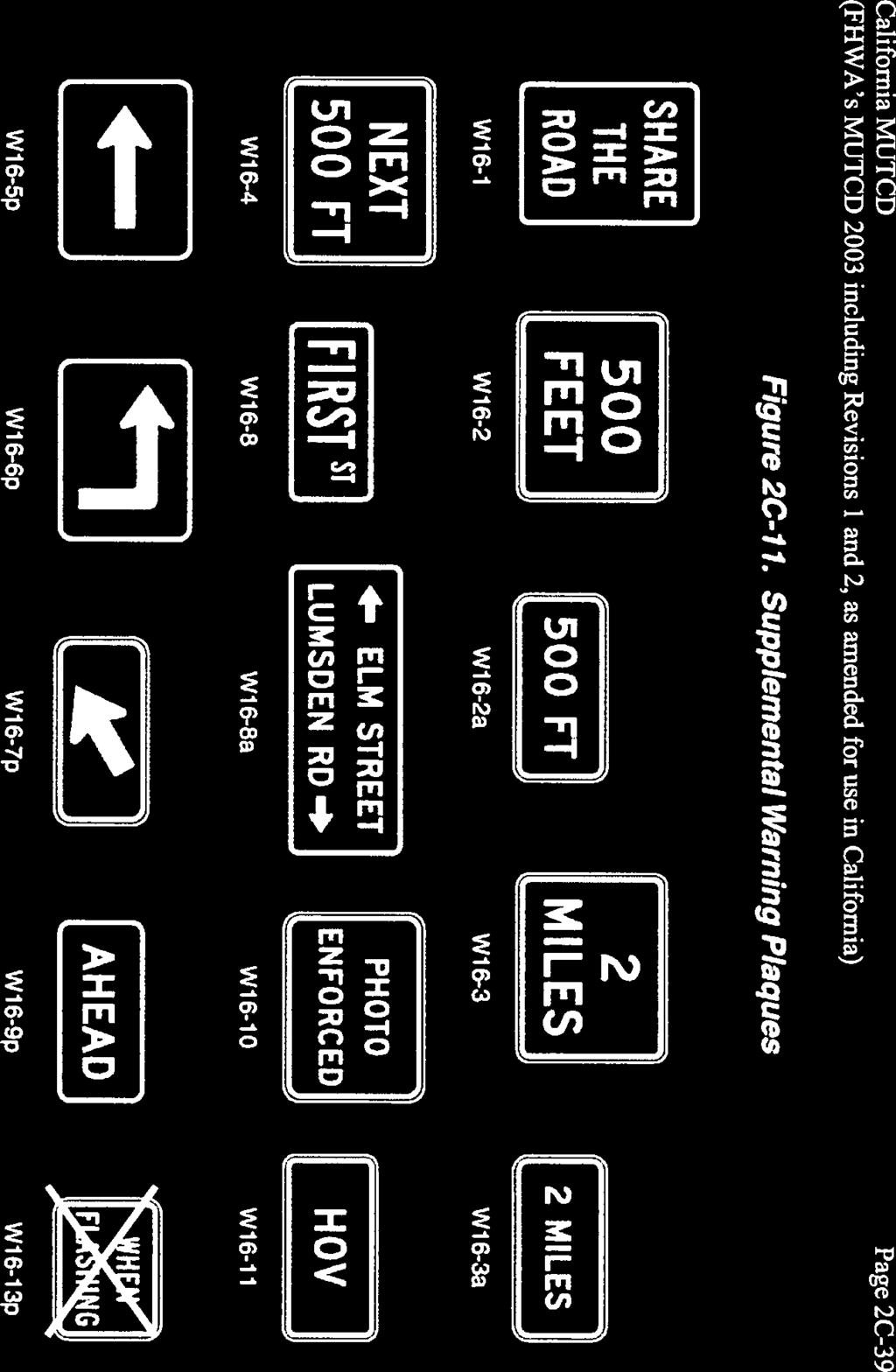
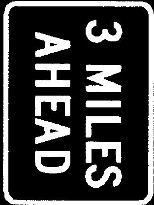
7 Quarry are not necessarily generated by the proposed project, but are actually necessitated by the construction projects that need the materials from the quarry. Without the proposed quarry project, these construction projects would still occur. If the Boca Quarry Expansion Project is not implemented, it is estimated that up to 50,400 additional daily VMT (or more, depending on which quarry would serve the local construction projects) would be generated over the course of a peak weekday in the local region and the I-80 corridor between the Hirschdale Interchange and Sparks, Nevada. Adding the 50,400 additional VMT to the 28,336 VMT yields a total of 78,736 daily VMT without the proposed project. Without the proposed project, it can be concluded that the VMT associated with quarry trips in the region would be about 2.8 times greater than that with the project. In other words, implementation of the Boca Quarry Expansion Project would ultimately reduce VMT in the greater region by roughly 35 percent. RECOMMENDATIONS It is recommended that modifications be made to the landscaping in the northeast corner of the Stampede Meadows Road/West Hinton Road intersection in order to provide at least 385 feet of corner sight distance for passenger car drivers looking to the north from West Hinton Road. In addition, warning signs should be provided in both directions along Stampede Meadows Road approximately 500 feet in advance of W. Hinton Road. Specifically, a sign with a picture of a truck on it (a W11-10 vehicular traffic sign) with a supplemental warning plaque (a W16-2a sign) indicating 500 FT should be placed in each direction along Stampede Meadows Road. These signs would supplement the existing TRUCK CROSSING signs, which are currently provided along Stampede Meadows Road roughly 1,000 feet in advance of the intersection. With these modifications, adequate driver sight distance would be provided. Executive Summary Traffic Impact Analysis LSC Transportation Consultants, Inc. Page ES-2
8 TABLE OF CONTENTS SECTION PAGE 1 Introduction...1 Scope of Study Existing Conditions...5 Existing Roadways...5 Existing Traffic Volumes Proposed Conditions...9 Project Description...9 Trip Generation and Distribution Level of Service Analysis...17 Description...17 Level of Service Standard...17 Level of Service Analysis Future Cumulative Conditions...19 Future Roadway Configuration...19 Future Traffic Volumes...19 Future Intersection LOS Traffic Impacts...23 Intersection Level of Service...23 Turn Lane Warrants at West Hinton Road/Stampede Meadows Road...23 Driver Sight Distance...23 Vehicle Miles Traveled (VMT)...24 Appendix A Traffic Counts Appendix B Level of Service Descriptions Appendix C Year 2011 Level of Service Calculations Appendix D Year 2031 Level of Service Calculations Appendix E Recommended Warning Signs Appendix F Aggregrate Sources in the Region Teichert Boca Quarry Traffic Impact Analysis LSC Transportation Consultants, Inc. Page i
9 LIST OF TABLES TABLE PAGE 1 Hourly Trip Generation Weekly Hourly trip Generation Saturday Year 2011 Intersection Level of Service Year 2031 Intersection Level of Service Project Generated Vehicle Miles of Travel...27 LIST OF FIGURES FIGURE PAGE 1 Teichert Boca Quarry Site Location Map Study Intersection Lane Configuration and Traffic Control Peak Hour Traffic Volumes Without Project Project Generated Peak Hour Traffic Volumes Peak Hour Traffic Volumes with Project Peak Hour Traffic Volumes Without Project Peak Hour Traffic Volumes With Project...21 Teichert Boca Quarry Traffic Impact Analysis LSC Transportation Consultants, Inc. Page ii
10 Section 1 INTRODUCTION This engineering report documents the findings and conclusions of a Traffic Impact Analysis (TIA) for the Teichert Boca Quarry Expansion Project in the eastern portion of Nevada County, California. The existing 40-acre site, which is nearly mined out, is located along Hinton Road east of Boca Reservoir and north of Interstate 80 (I-80). The project (proposed West Pit ) would expand the site to a total area of approximately 158 acres. The entire quarry site is shown in Figure 1. The purpose of this engineering study is to determine the impacts of the traffic generated by the project on the surrounding roadway infrastructure, as well as other transportation-related factors. SCOPE OF STUDY The existing lane configuration and traffic control at the following study intersections is depicted in Figure 2: I-80/Hirschdale Road Eastbound Ramps I-80/Hirschdale Road Westbound Ramps West Hinton Road/Stampede Meadows Road The following four scenarios were analyzed: Existing (2011) without project Existing (2011) with project Future (2031) without project Future (2031) with project In addition, the following traffic-related issues are addressed in this report: The need for new turn lanes at the West Hinton Road/Stampede Meadows Road intersection. Driver sight distance at the West Hinton Road/Stampede Meadows Road intersection. The project impact on Vehicle Miles Traveled (VMT). Traffic Impact Analysis LSC Transportation Consultants, Inc. Teichert Boca Quarry Expansion Page 1


11 89 FIGURE 1 Teichert Boca Quarry Site Location Map RENO SITE TRUCKEE TAHOE CITY 28 KINGS BEACH 50 CARSON CITY 89 SOUTH LAKE TAHOE SCALE 757 MINDEN IN MILES 88 GARDNERVILLE 1 SCALE 0 2,000 IN FEET BOCA DAM RESERVOIR RD STAMPEDE MEADOWS RD 2 WEST HINTON RD 2 LEGEND STUDY INTERSECTION 80 3 HIRSCH DALE RD SITE GLENSHIRE DR HIRSCHDALE RD HINTON RD 80 Site TRANSPORTATION CONSULTANTS, INC. HIRSCHDALE RD Page 2 LSC Transportation Consultants, Inc. Traffic Impact Analysis Teichert Boca Quarry Expansion
12 FIGURE 2 Study Intersection Lane Configuration and Traffic Control 2 LEGEND STUDY INTERSECTION TURNING MOVEMENT STOP SIGN STAMPEDE MEADOWS ROAD/ I-80 WESTBOUND RAMPS/ I-80 EASTBOUND RAMPS/ WEST HINTON ROAD HIRSCHDALE ROAD HIRSCHDALE ROAD STAMPEDE MEADOWS RD WEST HINTON RD HIRSCHDALE RD 80 HIRSCHDALE RD 80 1 SCALE 0 2,000 IN FEET BOCA DAM RESERVOIR RD STAMPEDE MEADOWS RD 2 WEST HINTON RD 80 3 HIRSCH DALE RD SITE GLENSHIRE DR HIRSCHDALE RD HINTON RD 80 BOCA TRANSPORTATION CONSULTANTS, INC. HIRSCHDALE RD Traffic Impact Analysis LSC Transportation Consultants, Inc. Teichert Boca Quarry Expansion Page 3
13 This Page Left Intentionally Blank. Page 4 LSC Transportation Consultants, Inc. Traffic Impact Analysis Teichert Boca Quarry Expansion
14 Section 2 EXISTING CONDITIONS EXISTING ROADWAYS The roadways within the study area are described below: Interstate 80 Interstate 80 (I-80) provides interregional highway connections east to Reno, Nevada and beyond, and west to Sacramento, California and the San Francisco Bay Area. The Town of Truckee area lies along both sides of I-80 to the west of the quarry site. This section of I-80 is currently a four-lane divided highway with limited truck climbing lanes, and with a posted speed limit of 65 miles per hour. There are eight interchanges serving Truckee on I-80, including the Donner Lake Road and Hirschdale Road interchanges. West Hinton Road West Hinton Road is an unpaved privately-maintained road running generally east-west from Stampede Meadows Road to the quarry. This roadway is about two and a half miles in length. Stampede Meadows Road Stampede Meadows Road is a two-lane collector roadway that runs generally northsouth from Interstate 80 on the south to Henness Pass Road just north of Stampede Reservoir. This roadway has a total pavement width of about 24 feet, and the posted speed limit is 35 miles per hour. Hirschdale Road Hirschdale Road is a two-lane collector roadway that connects the Glenshire area to I- 80. It also serves residences to the east of the Glenshire area. Hirschdale Road has a pavement width of about 22 feet, and the speed limit is not posted within the study area. EXISTING TRAFFIC VOLUMES Traffic counts were conducted at all study intersections on Friday July 8, 2011 from 7:00 AM to 9:00 AM and from 4:00 PM to 6:00 PM, and on Saturday July 9, 2011 from 2:00 PM to 5:00 PM. Based on a review of Caltrans hourly traffic volumes on the I-80/Hirschdale interchange ramps, the highest hourly traffic volumes on summer Saturdays typically occurs in the afternoon. Therefore, it was not necessary to conduct AM counts on Saturday. The count data is provided in Appendix A. During the count periods, Boca Dam Reservoir Road was closed. This road provides the primary access to a Traffic Impact Analysis LSC Transportation Consultants, Inc. Teichert Boca Quarry Expansion Page 5
15 campground on the west side of Boca Reservoir, but the campground can also be accessed from State Route 89 North. It is necessary to ensure that the 2011 traffic volumes reflect peak summer conditions. Therefore, Caltrans hourly traffic volumes at the I-80/Hirschdale interchange ramps from the summer of 2007 were reviewed, and they were found to be higher than the 2011 counts. Therefore, the count data was factored up to match the 2007 volumes, in order to remain conservative in this analysis. The same adjustment was applied to the volumes along Stampede Meadows Road and Hirschdale Road. The resulting Year 2011 weekday AM peak hour, weekday PM peak hour, and Saturday peak hour intersection volumes are shown in Figure 3. Page 6 LSC Transportation Consultants, Inc. Traffic Impact Analysis Teichert Boca Quarry Expansion
16 FIGURE Peak Hour Traffic Volumes Without Project 2 LEGEND STUDY INTERSECTION TURNING MOVEMENT TRAFFIC VOLUMES Weekday AM PM Weekday SATURDAY 22 (22) 22 STAMPEDE MEADOWS ROAD/ I-80 WESTBOUND RAMPS/ I-80 EASTBOUND RAMPS/ WEST HINTON ROAD HIRSCHDALE ROAD HIRSCHDALE ROAD 16 (80) 90 0 (2 ) 0 0 (2 ) 0 1 (3 ) 1 46 (100) (0 ) 3 9 (55) (33) (58) (43) (60) (73) 57 7 (27) (41) (77) (101) (64) (60) 43 1 SCALE 0 2,000 IN FEET BOCA DAM RESERVOIR RD STAMPEDE MEADOWS RD 2 WEST HINTON RD 80 3 HIRSCH DALE RD SITE GLENSHIRE DR HIRSCHDALE RD HINTON RD 80 Vol TRANSPORTATION CONSULTANTS, INC. HIRSCHDALE RD Traffic Impact Analysis LSC Transportation Consultants, Inc. Teichert Boca Quarry Expansion Page 7
17 This Page Left Intentionally Blank. Page 8 LSC Transportation Consultants, Inc. Traffic Impact Analysis Teichert Boca Quarry Expansion
18 Section 3 PROPOSED CONDITIONS The project location, the size of the project, and the time of the project completion are all important elements that need to be considered to determine the safety and capacity impacts of the development. It is also important to examine how the project will operate with the existing transportation system, estimate how much new traffic it will generate, identify how it would impact existing traffic patterns, and identify how traffic generated by the project site would be distributed. PROJECT DESCRIPTION The proposed project ( West Pit ) would expand the Teichert Boca Quarry site to a total area of approximately 158 acres, with up to 15 employees and a maximum potential production of one million tons per year. The quarry operates from May through October. In addition to exporting material from the quarry, backfill material is imported to the quarry from other locations. Over the course of a peak season, about 250,000 tons of backfill are brought to the site. Commercial access to the site is provided via unpaved West Hinton Road, which connects the site to Stampede Meadows Road to the west. Stampede Meadows Road is accessed via the I-80/Hirschdale Road Interchange. In addition, passenger vehicle and emergency vehicle access is currently temporarily provided via Hinton Road to the south and Hirschdale Road. However, this Hirschdale Road/Hinton Road route would never be used for truck trips associated with the Boca Quarry. TRIP GENERATION AND DISTRIBUTION Trip Generation The first step in the analysis of traffic impacts is to prepare an estimate of the number of trips generated by the proposed project. Trip generation is the evaluation of the number of vehicle-trips that would either have an origin or destination at the project site. Due to the fact that the existing pit has been mined out, the existing quarry currently generates a minimal amount of traffic. In order to remain conservative in this analysis, no credit is taken for trips associated with the existing quarry. That is, all traffic generated by the proposed project (the West Pit) is assumed to be new traffic. As standard ITE trip generation rates are not provided for a quarry, a detailed trip generation estimate was developed based upon an analysis of truck trip patterns and person-trip patterns, factored by travel mode and vehicle occupancy characteristics appropriate for the local area. There are 4 types of trips that are generated by the quarry. These are aggregate exporting trucks, backfill importing trucks, employees and maintenance trucks. Traffic Impact Analysis LSC Transportation Consultants, Inc. Teichert Boca Quarry Expansion Page 9
19 Aggregate Exporting Trucks A total of 10,080 tons of aggregate material are proposed to be hauled out of the site on a peak day in a peak year. Various sizes of trucks are used in aggregate hauling. According to Teichert Aggregates staff, the average truck is estimated to haul 18 tons of material. Dividing the total tons of material (10,080) by the average tonnage per truck (18) yields a total of 560 truck loads per day. As each truck load involves an empty truck entering the site and a full truck exiting the site, the total number of one-way trips per day generated by aggregate exporting trucks would be 1,120. Backfill Importing Trucks Backfill trucks consist of trucks full of construction waste entering the site, dumping the material, and exiting empty. These backfill trucks are estimated to haul at most onequarter of the amount hauled by aggregate exporting trucks, or a total of 2,520 tons per day. With an average of 18 tons per truck, this would generate approximately 140 round trips, or 280 one-way trips. Employees A maximum of 15 employees would be onsite over the course of a peak day. Based on data from the American Community Survey (U.S. Census data) for the Truckee area, the average vehicle occupancy for work trips is approximately 1.2 employees per vehicle. Dividing the total number of employees (15) by the average vehicle occupancy (1.2) yields about 13 vehicles associated with employees. Assuming each employee makes one round-trip commuting to/from work, and 2 employees also make a round-trip off the site during the work day (for lunch, errands, etc.), a total of about 30 one-way vehicle-trips would be made by employees. Maintenance Truck One maintenance vehicle is expected to visit the site over the course of a peak day for fueling and maintenance of onsite equipment, creating 2 one-way trips. Total Weekday Trips In summary, the total number of trips generated by the site is estimated to be 1,432 one-way trips (716 inbound and 716 outbound) on a peak weekday. Weekday Peak Hour Trips In order to estimate the number of trips generated by the quarry during the peak hours, it is necessary to develop an estimate of the hourly trip generation throughout the day. On weekdays, the quarry is open from 6:00 AM to 6:00 PM. Table 1 presents the number of one-way vehicle trips associated with each project component over the course of each hour. As shown, trucks arrive on site during the hour before the quarry opens. From then on, one aggregate exporting truck per minute can be filled, processed, and exit Page 10 LSC Transportation Consultants, Inc. Traffic Impact Analysis Teichert Boca Quarry Expansion
20 the site, for a maximum of 60 trucks per hour exiting the site. This high rate of production is expected to last until early afternoon and then drop off to only 20 trucks per hour. The backfill trucks are assumed to enter the site, dump their contents, and exit at the rate of one truck every 4 minutes (or 15 trucks per hour) in the peak times and drop down to 5 trucks an hour in the early afternoon. Employees are assumed to arrive on site in the hour before the plant opens and to depart in the hour after the site closes, with two employees making one round-trip offsite in the middle of the day. The maintenance truck is assumed to enter and exit after the site is closed for the day. As indicated in Table 1, approximately 150 one-way trips (75 inbound and 75 outbound) are estimated to occur in the weekday AM peak hour and 50 trips (25 inbound and 25 outbound) during the weekday PM peak hour. Saturday Trips The quarry is also permitted to operate on Saturdays from 8:00 AM to 4:00 PM. Table 2 shows the hourly trips over the course of a peak Saturday. A total of up to 1,282 daily one-way trips are expected on a peak Saturday, with 150 trips (75 inbound and 75 outbound) occurring during the peak hour. The 2:00 PM hour is identified as the PM peak hour, considering that it is the highest hour of quarry traffic that overlaps with the highest hour of the traffic count data. Trip Distribution and Assignment It is necessary to identify the proportion of trips generated by the site to and from each distribution area/gate in the study area, in order to assign the trips through the study intersections. The quarry will serve the entire area between Sierra Valley on the north and Tahoe s West Shore on the south. Based upon regional access patterns, the geographic area and uses served by the quarry, and the locations of residential uses within the vicinity of the site, about 95 percent of project-generated trips are assumed to be made to/from points along I-80 to the west, and the remaining 5 percent are assumed to be made to/from the Glenshire and Hirschdale areas. No trips are distributed to/from I-80 east of Hirschdale, as hauling trips to the east are expected to be minimal. The project trips were assigned through the study intersections based on the trip distribution percents. The resulting project-generated peak-hour intersection volumes are illustrated in Figure 4. Although some passenger cars could potentially access the site via the Hirschdale Road/Hinton Road route to the south, all project trips are assumed to access the site via the Stampede Meadows Road/West Hinton Road route, in order to remain conservative in this analysis. Adding the project-generated volumes to the 2011 no project volumes yields the 2011 with project volumes shown in Figure 5. Traffic Impact Analysis LSC Transportation Consultants, Inc. Teichert Boca Quarry Expansion Page 11
21 Table 1: Hourly Trip Generation - Weekday Aggregate Exporting Trucks Backfill Importing Trucks Employee Vehicles Maintenance Truck Total Vehicle Trips Hour Start Time In Out In Out In Out In Out In Out Total 5:00 AM :00 AM :00 AM :00 AM :00 AM :00 AM :00 AM :00 PM :00 PM :00 PM :00 PM :00 PM :00 PM :00 PM :00 PM Total ,432 AM and PM peak hours are shaded Source: LSC Transportation Consultants Teichert Quarry.xls Page 12 LSC Transportation Consultants, Inc. Traffic Impact Analysis Teichert Boca Quarry Expansion
22 Table 2: Hourly Trip Generation - Saturday Trucks Backfill Trucks Employee Vehicles Maintenance Truck Total Vehicle Trips Hour Start Time In Out In Out In Out In Out In Out Total 7:00 AM :00 AM :00 AM :00 AM :00 AM :00 PM :00 PM :00 PM :00 PM :00 PM :00 PM Total ,282 Saturday peak hour is shaded Source: LSC Transportation Consultants Teichert Quarry.xls Traffic Impact Analysis LSC Transportation Consultants, Inc. Teichert Boca Quarry Expansion Page 13
23 FIGURE 4 Teichert Boca Quarry Expansion Project Generated Peak Hour Traffic Volumes 2 LEGEND STUDY INTERSECTION TURNING MOVEMENT TRAFFIC VOLUMES Weekday AM Weekday PM SATURDAY 22 (22) 22 STAMPEDE MEADOWS ROAD/ I-80 WESTBOUND RAMPS/ I-80 EASTBOUND RAMPS/ WEST HINTON ROAD HIRSCHDALE ROAD HIRSCHDALE ROAD 0 (0) 0 0 (0) 0 0 (0) 0 75 (25) 75 0 (0) 0 75 (25) 75 4 (1) 4 71 (24) 71 0 (0) 0 0 (0) 0 75 (25) 75 0 (0) 0 0 (0) 0 71 (24) 71 0 (0) 0 4 (1) 4 0 (0) 0 4 (1) 4 1 SCALE 0 2,000 IN FEET BOCA DAM RESERVOIR RD STAMPEDE MEADOWS RD 2 WEST HINTON RD 80 3 HIRSCH DALE RD SITE GLENSHIRE DR HIRSCHDALE RD HINTON RD 80 Progen TRANSPORTATION CONSULTANTS, INC. HIRSCHDALE RD Page 14 LSC Transportation Consultants, Inc. Traffic Impact Analysis Teichert Boca Quarry Expansion
24 FIGURE 5 Teichert Boca Quarry Expansion 2011 Peak Hour Traffic Volumes with Project 2 LEGEND STUDY INTERSECTION TURNING MOVEMENT TRAFFIC VOLUMES Weekday AM Weekday PM SATURDAY 22 (22) 22 STAMPEDE MEADOWS ROAD/ I-80 WESTBOUND RAMPS/ I-80 EASTBOUND RAMPS/ WEST HINTON ROAD HIRSCHDALE ROAD HIRSCHDALE ROAD 16 (80) 90 0 (2) 0 0 (2) 0 75 (28) (25) (100) (56) (57) (83) (43) (60) (73) 57 7 (27) (65) (77) (102) (64) (61) 47 1 SCALE 0 2,000 IN FEET BOCA DAM RESERVOIR RD STAMPEDE MEADOWS RD 2 WEST HINTON RD 80 3 HIRSCH DALE RD SITE GLENSHIRE DR HIRSCHDALE RD HINTON RD 80 PLUSPRO TRANSPORTATION CONSULTANTS, INC. HIRSCHDALE RD Traffic Impact Analysis LSC Transportation Consultants, Inc. Teichert Boca Quarry Expansion Page 15
25 This Page Left Intentionally Blank. Page 16 LSC Transportation Consultants, Inc. Traffic Impact Analysis Teichert Boca Quarry Expansion
26 Section 4 LEVEL OF SERVICE ANALYSIS DESCRIPTION Traffic operations at the study intersections were assessed in terms of Level Of Service (LOS) and delay. LOS is a concept that was developed by transportation engineers to quantify the level of operation of intersections and roadways (Highway Capacity Manual (HCM), Transportation Research Board, 2000). LOS measures are classified in grades A through F, indicating the range of operation. LOS A signifies the best level of operation, while F represents the worst. A detailed LOS description is provided in Appendix B. Intersection Level of Service (LOS) with and without the project was calculated for both existing (2011) and future (2031) weekday AM, weekday PM, and Saturday peak-hour conditions. The HCM 2000 methodologies were applied to all intersections. LEVEL OF SERVICE STANDARD The Nevada County General Plan (Nevada County, 2010) requires that rural intersections and roadways maintain Level of Service (LOS) C, except where the existing LOS is less than C. In those situations, the LOS shall not be allowed to drop below the existing LOS. In other words, LOS on an intersection or roadway already below LOS C should not be allowed to degrade below its existing condition. LEVEL OF SERVICE ANALYSIS Study intersections were evaluated to determine existing operational conditions. Appendix C presents the actual output from each of the runs performed for the study intersections, and Table 3 summarizes the results for existing (2011) conditions with and without the project. As indicated, all study intersections currently operate at a relatively good level (LOS B or better) without the project. Although some movements would degrade from LOS A to LOS B with implementation of the proposed project, all intersections would continue to operate at LOS B or better in Traffic Impact Analysis LSC Transportation Consultants, Inc. Teichert Boca Quarry Expansion Page 17
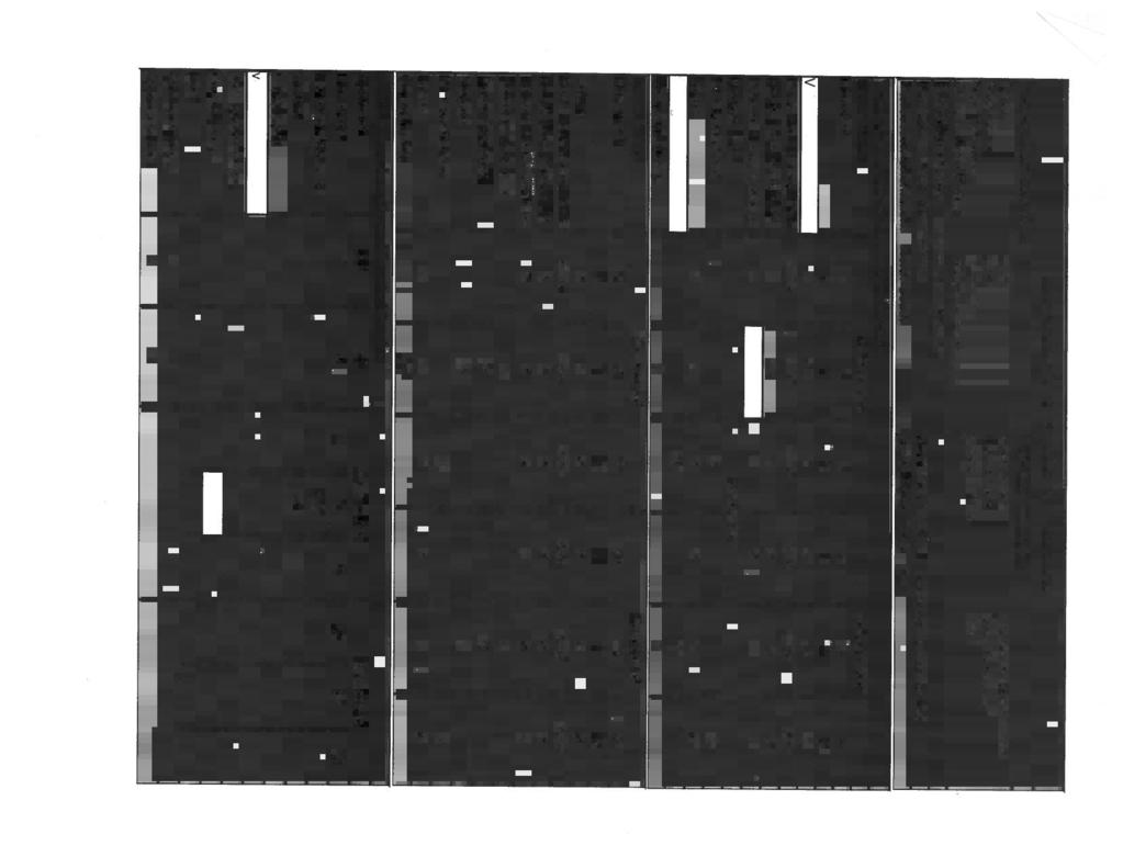
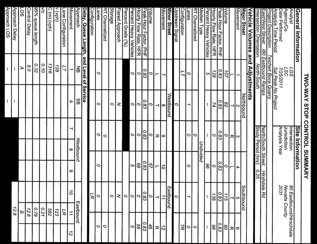
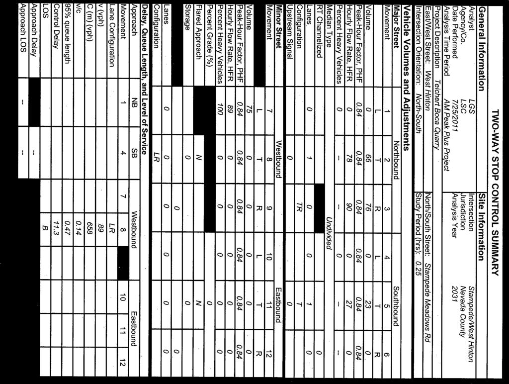
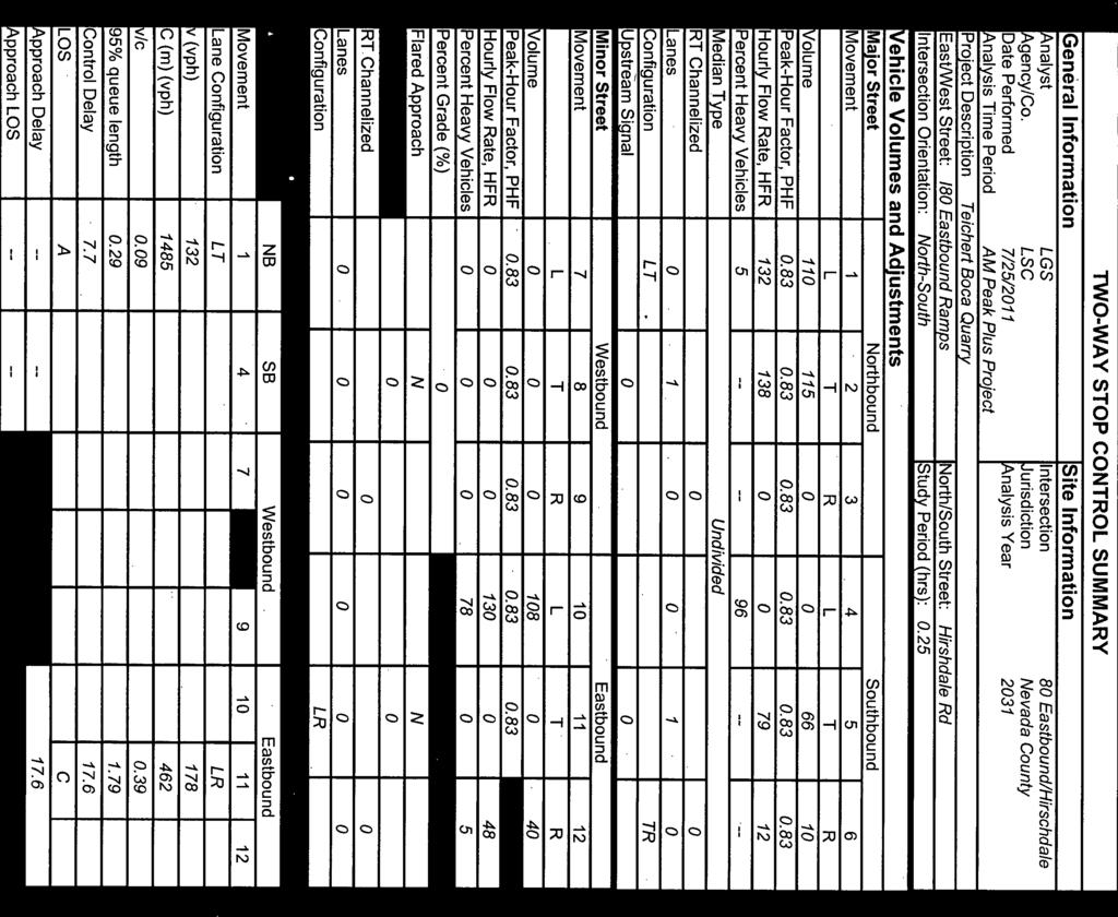
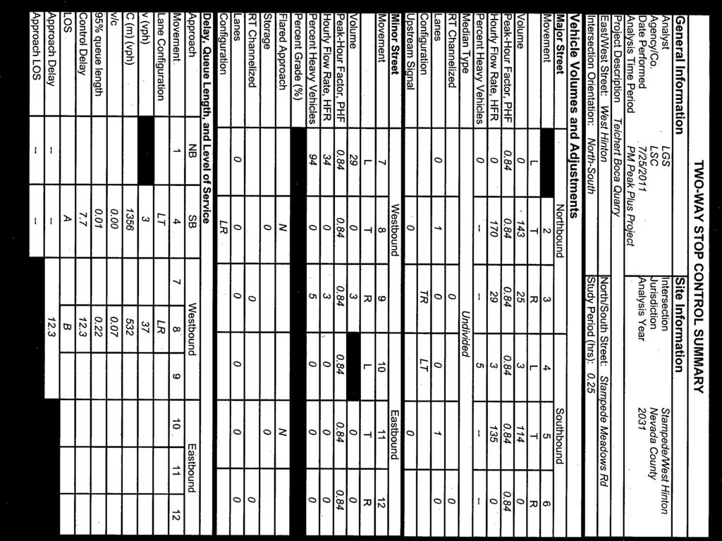
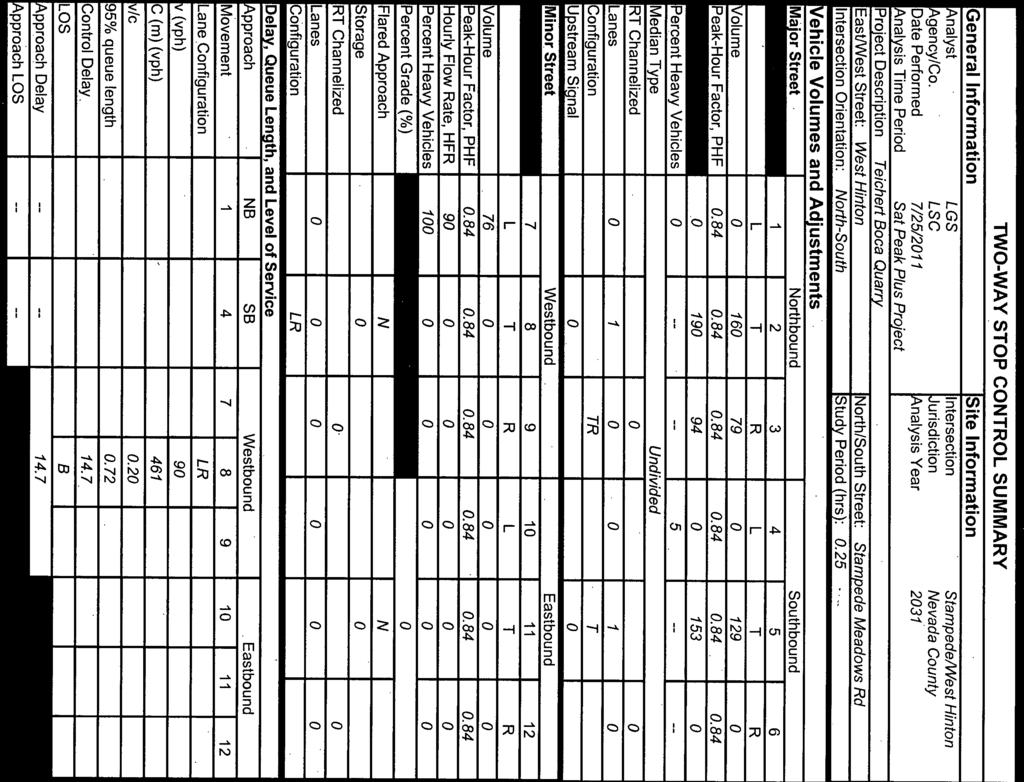
27 Table 3: Year 2011 Intersection Level of Service Without Project With Project Worst Movement Total Intersection Worst Movement Total Intersection Delay (sec/veh) LOS Delay (sec/veh) LOS Delay (sec/veh) LOS Delay (sec/veh) LOS AM Peak Hour Stampede Meadows Road/West Hinton 7.4 A 0.0 A 11.0 B 3.9 A I-80 Westbound Ramps/Hirschdale Road 9.2 A 5.3 A 9.7 A 3.1 A I-80 Eastbound Ramps/Hirschdale Road 10.1 B 4.4 A 13.8 B 6.8 A PM Peak Hour Stampede Meadows Road/West Hinton 9.4 A 0.3 A 11.3 B 1.2 A I-80 Westbound Ramps/Hirschdale Road 10.3 B 5.3 A 10.5 B 4.6 A I-80 Eastbound Ramps/Hirschdale Road 10.8 B 4.8 A 12.0 B 7.5 A Saturday Peak Hour Stampede Meadows Road/West Hinton 9.9 A 0.0 A 13.0 B 2.8 A I-80 Westbound Ramps/Hirschdale Road 10.3 B 4.6 A 11.2 B 3.3 A I-80 Eastbound Ramps/Hirschdale Road 10.9 B 4.2 A 14.7 B 6.6 A Source: LSC Transportation Consultants Teichert Quarry.xls Page 18 LSC Transportation Consultants, Inc. Traffic Impact Analysis Teichert Boca Quarry Expansion
28 Section 5 FUTURE CUMULATIVE CONDITIONS The potential traffic impacts of the proposed project under future cumulative conditions were evaluated. First, Year 2031 traffic volumes were estimated without the project. Next, 2031 volumes with the project were estimated. Finally, intersection LOS was analyzed with and without the project. FUTURE ROADWAY CONFIGURATION Nevada County proposes to construct a new roadway connecting West Hinton Road to Hinton Road. This potential new roadway would start at a point on West Hinton Road on the west side of the proposed West Pit area, and it would run to the south and east along the West Pit boundary, terminating at a point on Hinton Road about 390 feet north of I-80. This potential roadway would provide access to private properties along Hinton Road in the event that the bridge(s) along Hirschdale Road were closed. However, given the low traffic volumes along Hinton Road, the shift in background traffic volumes to the new roadway is expected to be minimal. FUTURE TRAFFIC VOLUMES Future 2031 traffic volumes were estimated by applying an average annual growth rate to the 2011 no project volumes. The Nevada County Regional Transportation Plan (July 20, 2011) estimated the countywide population average annual growth rate will be 1.6 percent from 2010 to 2020 and 0.8 percent from 2020 to This equates to an average annual growth rate of approximately 1.2 percent for the 20 year period from 2011 to This growth rate was applied to the 2011 traffic volumes in order to estimate the 2031 volumes, which are shown in Figure 6. County staff noted that in the Boca area of the County the growth rate may be lower. Therefore, the 2031 intersection volumes are considered to be conservatively high. Adding the project-generated traffic volumes to the 2031 no project volumes yields the 2031 with project volumes presented in Figure 7. FUTURE INTERSECTION LOS Evaluation of future intersection LOS is based on the lane configurations shown in Figure 2. The LOS calculations are included in Appendix D and summarized in Table 4. The worst movement on the Stampede Meadows Road/West Hinton Road intersection is expected to degrade from LOS A to LOS B due to the growth in background traffic from 2011 to However, as indicated in Table 4, all study intersections are expected to operate at a relatively good level (LOS B or better) in 2031 without the proposed project. With implementation of the proposed project, although the LOS on some movements would degrade by one level, all intersection movements would operate at an acceptable LOS C or better. Traffic Impact Analysis LSC Transportation Consultants, Inc. Teichert Boca Quarry Expansion Page 19
29 FIGURE 6 Teichert Boca Quarry 2031 Peak Hour Traffic Volumes Without Project 2 LEGEND STUDY INTERSECTION TURNING MOVEMENT TRAFFIC VOLUMES Weekday AM Weekday PM SATURDAY 22 (22) 22 STAMPEDE MEADOWS ROAD/ I-80 WESTBOUND RAMPS/ I-80 EASTBOUND RAMPS/ WEST HINTON ROAD HIRSCHDALE ROAD HIRSCHDALE ROAD 23 (114) (3) 0 0 (3) 0 0 (4) 1 66 (143) (0) 4 13 (79) (47) (83) (62) (86) (104) (39) (59) (110) (144) (92) (86) 62 1 SCALE 0 2,000 IN FEET BOCA DAM RESERVOIR RD STAMPEDE MEADOWS RD 2 WEST HINTON RD 80 3 HIRSCH DALE RD SITE GLENSHIRE DR HIRSCHDALE RD HINTON RD vol TRANSPORTATION CONSULTANTS, INC. HIRSCHDALE RD Page 20 LSC Transportation Consultants, Inc. Traffic Impact Analysis Teichert Boca Quarry Expansion
30 FIGURE 7 Teichert Boca Quarry Expansion 2031 Peak Hour Traffic Volumes With Project 2 LEGEND STUDY INTERSECTION TURNING MOVEMENT TRAFFIC VOLUMES AM PM SATURDAY 22 (22) 22 STAMPEDE MEADOWS ROAD/ I-80 WESTBOUND RAMPS/ I-80 EASTBOUND RAMPS/ WEST HINTON ROAD HIRSCHDALE ROAD HIRSCHDALE ROAD 23 (114) (3) 0 0 (3) 0 75 (29) (25) (143) (80) (71) (108) (62) (86) (104) (39) (83) (110) (145) (92) 107 (87) SCALE 0 2,000 IN FEET BOCA DAM RESERVOIR RD STAMPEDE MEADOWS RD 2 WEST HINTON RD 80 3 HIRSCH DALE RD SITE GLENSHIRE DR HIRSCHDALE RD HINTON RD plus TRANSPORTATION CONSULTANTS, INC. HIRSCHDALE RD Traffic Impact Analysis LSC Transportation Consultants, Inc. Teichert Boca Quarry Expansion Page 21
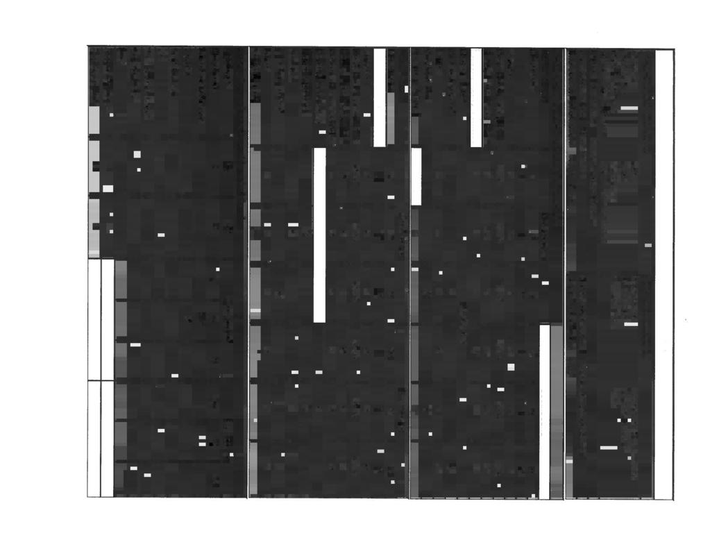
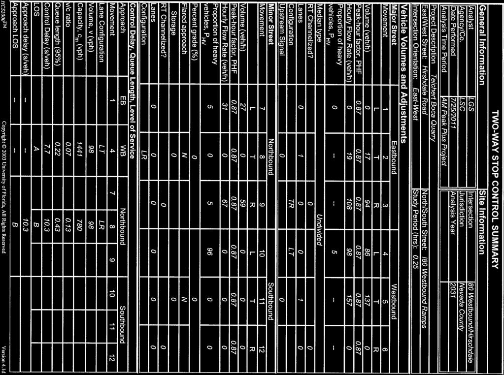
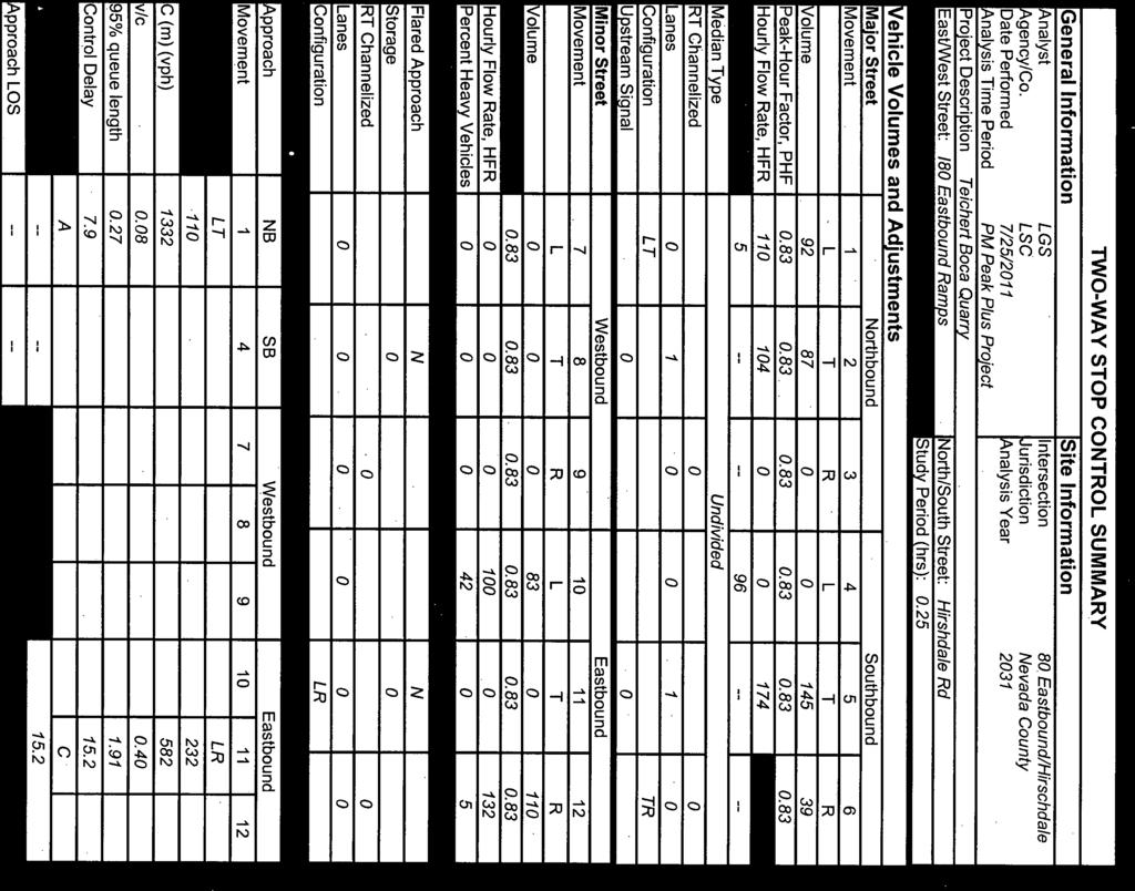
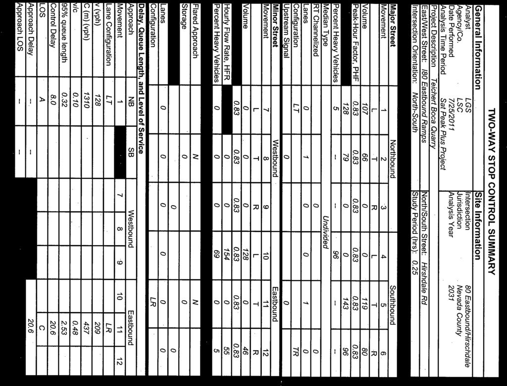
31 Table 4: Year 2031 Intersection Level of Service Without Project With Project Worst Movement Total Intersection Worst Movement Total Intersection Delay (sec/veh) LOS Delay (sec/veh) LOS Delay (sec/veh) LOS Delay (sec/veh) LOS AM Peak Hour Stampede Meadows Road/West Hinton 0.0 A 0.0 A 11.3 B 3.5 A I-80 Westbound Ramps/Hirschdale Road 9.7 A 5.5 A 10.3 B 4.2 A I-80 Eastbound Ramps/Hirschdale Road 11.3 B 4.6 A 17.6 C 7.7 A PM Peak Hour Stampede Meadows Road/West Hinton 9.9 A 0.3 A 12.3 B 1.3 A I-80 Westbound Ramps/Hirschdale Road 11.8 B 5.9 A 12.2 B 5.5 A I-80 Eastbound Ramps/Hirschdale Road 12.9 B 5.5 A 15.2 C 6.6 A Saturday Peak Hour Stampede Meadows Road/West Hinton 10.6 B 0.0 A 14.7 B 2.5 A I-80 Westbound Ramps/Hirschdale Road 11.7 B 5.2 A 13.1 B 4.3 A I-80 Eastbound Ramps/Hirschdale Road 12.8 B 4.6 A 20.6 C 8.1 A Source: LSC Transportation Consultants Teichert Quarry.xls Page 22 LSC Transportation Consultants, Inc. Traffic Impact Analysis Teichert Boca Quarry Expansion
32 Section 6 TRAFFIC IMPACTS The following potential areas of transportation impacts are considered in this section: Intersection Level of Service The need for new turn lanes at the West Hinton Road/Stampede Meadows Road intersection Driver sight distance at the West Hinton Road/Stampede Meadows Road intersection The project impact on Vehicle Miles Traveled (VMT) INTERSECTION LEVEL OF SERVICE All study intersections are expected to operate at an acceptable Level of Service (LOS) C or better under existing and future conditions, with or without the proposed project. Therefore, no intersection LOS mitigation measures are necessary. TURN LANE WARRANTS AT WEST HINTON ROAD/STAMPEDE MEADOWS ROAD A turn lane warrant analysis was performed for the project access point on Stampede Meadows Road using the National Cooperative Highway Research Program (NCHRP) Report 457 Evaluating Intersection Improvements: An Engineering Study Guide (Transportation Research Board, 2001). The peak-hour volume warrants are not met for either a southbound left-turn lane or a northbound right-turn lane along Stampede Meadows Road at West Hinton Road under existing or future scenarios, with or without the proposed project. Therefore, no new turn lanes are necessary at the site access intersection. DRIVER SIGHT DISTANCE A detailed evaluation of the driver sight distance at the site access intersection (Stampede Meadows Road/West Hinton Road intersection) was performed as a part of this study. Driver sight distance is an important criterion to consider at this location, as drivers preparing to enter a roadway from a driveway or intersection must be able to see and react to oncoming traffic in both directions in a safe manner. There are two types of sight distance criteria to consider at the site access location: stopping sight distance and corner sight distance. Traffic Impact Analysis LSC Transportation Consultants, Inc. Teichert Boca Quarry Expansion Page 23
33 Stopping Sight Distance Stopping sight distance requirements are meant to ensure that a driver on the approaching uncontrolled roadway has adequate time to perceive and react to the presence of an obstruction in the roadway, and come to a stop in a safe manner. This is the minimum distance needed for a driver approaching W. Hinton Road on Stampede Meadows Road to see an object in their travel path (such as a vehicle exiting W. Hinton Road) and safely come to a stop. The Caltrans Highway Design Manual specifies minimum stopping sight distance requirements as a function of roadway design speed. Corner sight distance requirements are meant to ensure that adequate time is provided for the waiting vehicle at an unsignalized intersection to either cross all lanes of through traffic, cross the near lanes and turn left, or turn right without requiring through traffic to radically alter their speed. Corner sight distance is the minimum distance that a driver waiting at a cross street (such as W. Hinton Road) should be able to see in either direction along the main roadway in order to accurately identify an acceptable gap in through traffic. A clear line of sight should be maintained between the driver pulling out of the minor street and any approaching vehicle on the major street. Desired and minimum corner sight distance requirements are provided in the Nevada County Road Standards. Based upon a posted speed limit of 35 miles per hour on Stampede Meadows Road, the required stopping sight distance is 250 feet. More than 250 feet of stopping sight distance is provided for drivers approaching W. Hinton Road from either direction along Stampede Meadows Road. Therefore, adequate stopping sight distance is provided at this intersection. Corner Sight Distance Assuming a prevailing speed of 35 miles per hour along Stampede Meadows Road, the desired corner sight distance is 385 feet. The corner sight distance requirements are meant to provide 7-1/2 seconds for the driver on the crossroad to complete the necessary maneuver, while the approaching vehicle travels at the assumed design speed of the major roadway. These requirements are based primarily on consideration of the passenger car as the design vehicle. However, most of the traffic associated with the quarry consists of truck traffic. The required sight distance for trucks turning left onto a crossroad is substantially longer than that for passenger cars. The corner sight distance requirements for single-unit and combination trucks can be estimated using tabulated values provided by the American Association of State Highway and Transportation Officials (AASHTO) in A Policy on Geometric Design of Highways and Streets. Assuming a design speed of 35 miles per hour on Stampede Meadows Road, the required corner sight distance for a combination truck is calculated to be about 595 feet. Looking to the south from W. Hinton Road, more than 400 feet of corner sight distance is provided for passenger car drivers, assuming a driver s eye height of about 3.5 feet. Over 595 feet of corner sight distance is provided for truck drivers looking to the south, Page 24 LSC Transportation Consultants, Inc. Traffic Impact Analysis Teichert Boca Quarry Expansion
34 assuming a truck driver s eye height of about 7.6 feet. As these values exceed the desired corner sight distance requirements, the driver sight distance to the south is considered to be adequate. Looking to the north from W. Hinton Road, only about 300 feet of corner sight distance is provided for passenger cars. This is about 85 feet short of the desired corner sight distance. The corner sight distance for passenger car drivers looking to the north is limited by the existing embankment and vegetation, as well as by the horizontal curvature along Stampede Meadows Road. However, over 595 feet of corner sight distance is provided for truck drivers looking to the north. Recommendations It is recommended that the landscaping in the northeast quadrant of the site access intersection be modified in order to provide at least 385 feet of corner sight distance for passenger cars. In addition, warning signs should be provided in both directions along Stampede Meadows Road approximately 500 feet in advance of W. Hinton Road. Specifically, a sign with a picture of a truck on it (a W11-10 vehicular traffic sign) with a supplemental warning plaque (a W16-2a sign) indicating 500 FT should be placed in each direction along Stampede Meadows Road. These signs would inform drivers of the distance to the location where trucks enter the roadway, and they would supplement the existing TRUCK CROSSING signs, which are currently provided along Stampede Meadows Road roughly 1,000 feet in advance of the intersection. These sign types are shown in Appendix E. With these modifications, adequate driver sight distance would be provided. Note that the need to alert oncoming drivers about trucks entering the roadway is not an issue during the winter season when the quarry is closed. VEHICLE MILES TRAVELED (VMT) The effect of the proposed project on Vehicle Miles Traveled (VMT) in the region is dependent on the total trip generation and the length of these vehicle trips. The increase in VMT resulting from the proposed project was estimated based on the trip lengths and the total number of daily and peak-hour trips generated. The quarry will serve the entire area between Sierra Valley on the north and Tahoe s West Shore on the south. Hauling trips made along I-80 to the east (between Hirschdale and the California/Nevada State Line) are expected to be minimal. Considering the geographic region and uses served by the quarry, the average trip length for truck trips made to/from the quarry is estimated to be about 20 miles. The average trip length for employees is assumed to be approximately 10.5 miles, based on data from the American Community Survey (U.S. Census data) for the Truckee area. As Table 5 indicates, up to approximately 28,336 daily VMT are associated with the proposed project over the course of a peak weekday, with up to 3,000 VMT occurring during the busiest hour of site-generated traffic (the AM peak hour). These figures reflect worst-case conditions, as they assume the quarry is operating at the maximum potential production. Note that the project would generate less VMT on a Saturday. The VMT generated by the proposed project are not all necessarily "new" VMT, given the fact that there are some VMT associated with the existing site. Also, in the local region, Traffic Impact Analysis LSC Transportation Consultants, Inc. Teichert Boca Quarry Expansion Page 25
35 there are some existing VMT associated with the Teichert Martis quarry, which will cease production in a couple of years. Furthermore, the VMT associated with the Boca Quarry are not necessarily generated by the proposed project, but are actually necessitated by the construction projects that need the materials from the quarry. Without the proposed quarry project, these construction projects would still occur. That is, a similar number of VMT would be generated in the study region regardless of which quarry supplies the materials. Other than the Martis and Boca quarries, the nearest large quarry capable of supplying the typical project in the study region is located at least an additional 40 miles away via I-80 (toward Reno or Sacramento). A map illustrating the aggregate sources in the region is included in Appendix F. Without the Martis and Boca quarries, the additional trip length associated with aggregate exporting truck trips potentially made from the nearest quarry in Sparks, Nevada is estimated to be approximately 36 additional miles in one direction. (This additional distance is based on a total of about 40 miles from the Hirschdale Interchange to the Sparks quarry, minus the roughly 4 miles of travel that Boca Quarry trucks travel in order to access the Hirschdale Interchange.) Multiplying 36 additional miles by up to 1,120 daily one-way trips associated with the aggregate exporting trucks yields a total of up to 40,320 additional VMT generated over the course of a peak weekday. Assuming the same methodology applies to the backfill importing trucks, about 10,080 additional daily VMT (36 additional miles multiplied by 280 one-way trips) would be made by the backfill importing trucks going to/from Sparks instead of to/from the Boca Quarry. Therefore, with respect to the region including the area served by the Boca Quarry as well as the I-80 corridor between the Hirschdale Interchange and Sparks, Nevada, a total of up to 50,400 additional daily VMT (40,320 plus 10,080) would be generated if the Boca Quarry Expansion Project is not implemented. In summary, up to 28,336 daily VMT are associated with the proposed quarry project. However, without project implementation, an additional 50,400 daily VMT would be generated in the region (or more, depending on which quarry would serve the local construction projects), for a total of 78,736 daily VMT. Without the proposed project, it can be concluded that the VMT associated with quarry trips in the region would be about 2.8 times greater than that with the project. In other words, implementation of the Boca Quarry Expansion Project would ultimately reduce VMT in the greater region by roughly 35 percent. Note that these figures are based on maximum production levels. Page 26 LSC Transportation Consultants, Inc. Traffic Impact Analysis Teichert Boca Quarry Expansion
36 Table 5: Project Generated Vehicle Miles of Travel Number of Trips 1 Average Trip Vehicle Miles Traveled Description Daily Peak Hour Length (miles) Daily Peak Hour Aggregate Exporting Trucks 1, ,400 2,400 Backfill Importing Trucks , Employee Vehicles Maintenance Truck Total 1, ,336 3,000 Note: Reflects weekday conditions. Vehicle miles traveled on a Saturday would be less. Note 1: Reference Table 1. Source: LSC Transportation Consultants Teichert Quarry.xls Traffic Impact Analysis LSC Transportation Consultants, Inc. Teichert Boca Quarry Expansion Page 27
37
38 APPENDIX A Traffic Counts
39
40
41
42
43
44 APPENDIX B Level of Service Descriptions
45
46
47
48 APPENDIX C Year 2011 Level of Service Calculations
49
50
51
52
53

54
55
56
57
58
59
60
61
62

63
64
65
66
67
68 APPENDIX D Year 2031 Level of Service Calculations
69
70
71
72
73
74
75
76
77
78
79
80
81
82

83
84
85
86
87
88 APPENDIX E Advance Warning Signs
89


90


91
92 APPENDIX F Aggregrate Sources in the Region
93


94 Aggregate sources in the Truckee/Tahoe region
Date: February 7, 2017 John Doyle, Z-Best Products Robert Del Rio. T.E. Z-Best Traffic Operations and Site Access Analysis
 Memorandum Date: February 7, 07 To: From: Subject: John Doyle, Z-Best Products Robert Del Rio. T.E. Z-Best Traffic Operations and Site Access Analysis Introduction Hexagon Transportation Consultants, Inc.
The major roadways in the study area are State Route 166 and State Route 33, which are shown on Figure 1-1 and described below:
 3.5 TRAFFIC AND CIRCULATION 3.5.1 Existing Conditions 3.5.1.1 Street Network DRAFT ENVIRONMENTAL IMPACT REPORT The major roadways in the study area are State Route 166 and State Route 33, which are shown
King Soopers #116 Thornton, Colorado
 Traffic Impact Study King Soopers #116 Thornton, Colorado Prepared for: Galloway & Company, Inc. T R A F F I C I M P A C T S T U D Y King Soopers #116 Thornton, Colorado Prepared for Galloway & Company
INDUSTRIAL DEVELOPMENT
 INDUSTRIAL DEVELOPMENT Traffic Impact Study Plainfield, Illinois August 2018 Prepared for: Seefried Industrial Properties, Inc. TABLE OF CONTENTS Executive Summary 2 Introduction 3 Existing Conditions
Clean Harbors Canada, Inc.
 Clean Harbors Canada, Inc. Proposed Lambton Landfill Expansion Environmental Assessment Terms of Reference Transportation Assessment St. Clair Township, Ontario September 2009 itrans Consulting Inc. 260
LAWRENCE TRANSIT CENTER LOCATION ANALYSIS 9 TH STREET & ROCKLEDGE ROAD / 21 ST STREET & IOWA STREET LAWRENCE, KANSAS
 LAWRENCE TRANSIT CENTER LOCATION ANALYSIS 9 TH STREET & ROCKLEDGE ROAD / 21 ST STREET & IOWA STREET LAWRENCE, KANSAS TRAFFIC IMPACT STUDY FEBRUARY 214 OA Project No. 213-542 TABLE OF CONTENTS 1. INTRODUCTION...
TRAFFIC IMPACT ANALYSIS
 TRAFFIC IMPACT ANALYSIS Emerald Isle Commercial Development Prepared by SEPI Engineering & Construction Prepared for Ark Consulting Group, PLLC March 2016 I. Executive Summary A. Site Location The Emerald
Traffic Engineering Study
 Traffic Engineering Study Bellaire Boulevard Prepared For: International Management District Technical Services, Inc. Texas Registered Engineering Firm F-3580 November 2009 Executive Summary has been requested
Section 5.0 Traffic Information
 Section 5.0 Traffic Information 10.0 TRANSPORTATION MDM Transportation Consultants, Inc. (MDM) has prepared an evaluation of transportation impacts for the proposed evaluation for the expansion of the
APPENDIX B Traffic Analysis
 APPENDIX B Traffic Analysis Rim of the World Unified School District Reconfiguration Prepared for: Rim of the World School District 27315 North Bay Road, Blue Jay, CA 92317 Prepared by: 400 Oceangate,
APPENDIX C1 TRAFFIC ANALYSIS DESIGN YEAR TRAFFIC ANALYSIS
 APPENDIX C1 TRAFFIC ANALYSIS DESIGN YEAR TRAFFIC ANALYSIS DESIGN YEAR TRAFFIC ANALYSIS February 2018 Highway & Bridge Project PIN 6754.12 Route 13 Connector Road Chemung County February 2018 Appendix
PROJECT: Wilkinson Road Corridor Improvement Traffic Management Planning Project SUBJECT: Traffic Analysis
 TECHNICAL MEMORANDUM DATE: September 10, 2014 PROJECT 5861.03 NO: PROJECT: Wilkinson Road Corridor Improvement Traffic Management Planning Project SUBJECT: Traffic Analysis TO: Steve Holroyd - District
Traffic Impact Analysis. Alliance Cole Avenue Residential Site Dallas, Texas. Kimley-Horn and Associates, Inc. Dallas, Texas.
 Traffic Impact Analysis Alliance Cole Avenue Residential Site Dallas, Texas February 15, 2018 Kimley-Horn and Associates, Inc. Dallas, Texas Project #064524900 Registered Firm F-928 Traffic Impact Analysis
Proposed location of Camp Parkway Commerce Center. Vicinity map of Camp Parkway Commerce Center Southampton County, VA
 Proposed location of Camp Parkway Commerce Center Vicinity map of Camp Parkway Commerce Center Southampton County, VA Camp Parkway Commerce Center is a proposed distribution and industrial center to be
EXECUTIVE SUMMARY. The following is an outline of the traffic analysis performed by Hales Engineering for the traffic conditions of this project.
 EXECUTIVE SUMMARY This study addresses the traffic impacts associated with the proposed Shopko redevelopment located in Sugarhouse, Utah. The Shopko redevelopment project is located between 1300 East and
Appendix J Traffic Impact Study
 MRI May 2012 Appendix J Traffic Impact Study Level 2 Traffic Assessment Limited Impact Review Appendix J [This page was left blank intentionally.] www.sgm-inc.com Figure 1. Site Driveway and Trail Crossing
Transportation & Traffic Engineering
 Transportation & Traffic Engineering 1) Project Description This report presents a summary of findings for a Traffic Impact Analysis (TIA) performed by A+ Engineering, Inc. for the Hill Country Family
The key roadways in the project vicinity are described below. Exhibit displays the existing number of lanes on the study roadways.
 4.2 TRAFFIC AND CIRCULATION This section presents the key assumptions, methods, and results of analysis for the transportation and circulation impacts of the proposed project. This section is based on
MILLERSVILLE PARK TRAFFIC IMPACT ANALYSIS ANNE ARUNDEL COUNTY, MARYLAND
 MILLERSVILLE PARK TRAFFIC IMPACT ANALYSIS ANNE ARUNDEL COUNTY, MARYLAND Prepared for: Department of Public Works Anne Arundel County Prepared by: URS Corporation 4 North Park Drive, Suite 3 Hunt Valley,
Bennett Pit. Traffic Impact Study. J&T Consulting, Inc. Weld County, Colorado. March 3, 2017
 Bennett Pit Traffic Impact Study J&T Consulting, Inc. Weld County, Colorado March 3, 217 Prepared By: Sustainable Traffic Solutions, Inc. http://www.sustainabletrafficsolutions.com/ Joseph L. Henderson,
TRAFFIC IMPACT STUDY FOR SONIC DRIVE-IN RESTAURANT. Vallejo, CA. Prepared For:
 TRAFFIC IMPACT STUDY FOR SONIC DRIVE-IN RESTAURANT Vallejo, CA Prepared For: ELITE DRIVE-INS, INC. 2190 Meridian Park Blvd, Suite G Concord, CA 94520 Prepared By: KD Anderson & Associates 3853 Taylor Road,
Alpine Highway to North County Boulevard Connector Study
 Alpine Highway to North County Boulevard Connector Study prepared by Avenue Consultants March 16, 2017 North County Boulevard Connector Study March 16, 2017 Table of Contents 1 Summary of Findings... 1
MEMO VIA . Ms. Amy Roth DPS Director, City of Three Rivers. To:
 MEMO To: Ms. Amy Roth DPS Director, City of Three Rivers VIA EMAIL From: Michael J. Labadie, PE Julie M. Kroll, PE, PTOE Brandon Hayes, PE, P.Eng. Fleis & VandenBrink Date: January 5, 2017 Re: Proposed
TIMBERVINE TRANSPORTATION IMPACT STUDY FORT COLLINS, COLORADO JANUARY Prepared for:
 TIMBERVINE TRANSPORTATION IMPACT STUDY FORT COLLINS, COLORADO JANUARY 2014 Prepared for: Hartford Companies 1218 W. Ash Street Suite A Windsor, Co 80550 Prepared by: DELICH ASSOCIATES 2272 Glen Haven Drive
Traffic Impact Study Speedway Gas Station Redevelopment
 Traffic Impact Study Speedway Gas Station Redevelopment Warrenville, Illinois Prepared For: Prepared By: April 11, 2018 Table of Contents 1. Introduction... 1 2. Existing Conditions... 4 Site Location...
West Hills Shopping Centre Lowe s Expansion Traffic Impact Study
 West Hills Shopping Centre Lowe s Expansion Traffic Impact Study Prepared for: Armel Corporation January 2015 Paradigm Transportation Solutions Ltd. 22 King Street South, Suite 300 Waterloo ON N2J 1N8
Traffic Impact Analysis West Street Garden Plots Improvements and DuPage River Park Garden Plots Development Naperville, Illinois
 Traffic Impact Analysis West Street Garden Plots Improvements and DuPage River Park Garden Plots Development Naperville, Illinois Submitted by April 9, 2009 Introduction Kenig, Lindgren, O Hara, Aboona,
APPENDIX J LAKE WOHLFORD DAM REPLACEMENT PROJECT TRAFFIC IMPACT ANALYSIS (DAM REPLACEMENT) Lake Wohlford Dam Replacement Project EIR
 Lake Wohlford Dam Replacement Project EIR") APPENDIX J LAKE WOHLFORD DAM REPLACEMENT PROJECT TRAFFIC IMPACT ANALYSIS (DAM REPLACEMENT) Replacement Project EIR Appendices TRAFFIC IMPACT ANALYSIS LAKE WOHLFORD DAM Escondido, California December 19,
APPENDIX J LAKE WOHLFORD DAM REPLACEMENT PROJECT TRAFFIC IMPACT ANALYSIS (DAM REPLACEMENT) Replacement Project EIR Appendices TRAFFIC IMPACT ANALYSIS LAKE WOHLFORD DAM Escondido, California December 19,
TRAFFIC IMPACT STUDY DERRY GREEN CORPORATE BUSINESS PARK MILTON SECONDARY PLAN MODIFICATION
 TRAFFIC IMPACT STUDY DERRY GREEN CORPORATE BUSINESS PARK MILTON SECONDARY PLAN MODIFICATION TRAFFIC IMPACT STUDY DERRY GREEN CORPORATE BUSINESS PARK MILTON SECONDARY PLAN MODIFICATION DECEMBER 24 UPDATED
Volume 1 Traffic Impact Analysis Turtle Creek Boulevard Dallas, Texas. Kimley-Horn and Associates, Inc. Dallas, Texas.
 Volume 1 Traffic Impact Analysis 2727 Dallas, Texas June 18, 2018 Kimley-Horn and Associates, Inc. Dallas, Texas Project #064523000 Registered Firm F-928 Traffic Impact Analysis 2727 Dallas, Texas Prepared
STH 60 Northern Reliever Route Feasibility Study Report
 #233087 v3 STH 60 Northern Reliever Route Feasibility Study Report Washington County Public Works Committee Meeting September 28, 2016 1 STH 60 Northern Reliever Route Feasibility Study Hartford Area Development
Appendix C. Traffic Study
 Appendix C Traffic Study TABLE OF CONTENTS SECTION Executive Summary PAGE 1.0 Introduction... 1 1.1 Scope of Work... 1 1.2 Study Area... 2 2.0 Project Description... 3 2.1 Site Access... 4 2.2 Pedestrian
2.0 Development Driveways. Movin Out June 2017
 Movin Out June 2017 1.0 Introduction The proposed Movin Out development is a mixed use development in the northeast quadrant of the intersection of West Broadway and Fayette Avenue in the City of Madison.
Subarea Study. Manning Avenue (CSAH 15) Corridor Management and Safety Improvement Project. Final Version 1. Washington County.
 Corridor Management and Safety Improvement Project. Final Version 1. Washington County.") Subarea Study Manning Avenue (CSAH 15) Corridor Management and Safety Improvement Project Final Version 1 Washington County June 12, 214 SRF No. 138141 Table of Contents Introduction... 1 Forecast Methodology
Subarea Study Manning Avenue (CSAH 15) Corridor Management and Safety Improvement Project Final Version 1 Washington County June 12, 214 SRF No. 138141 Table of Contents Introduction... 1 Forecast Methodology
RE: A Traffic Impact Statement for a proposed development on Quinpool Road
 James J. Copeland, P.Eng. GRIFFIN transportation group inc. 30 Bonny View Drive Fall River, NS B2T 1R2 May 31, 2018 Ellen O Hara, P.Eng. Project Engineer DesignPoint Engineering & Surveying Ltd. 200 Waterfront
King County Metro. Columbia Street Transit Priority Improvements Alternative Analysis. Downtown Southend Transit Study. May 2014.
 King County Metro Columbia Street Transit Priority Improvements Alternative Analysis Downtown Southend Transit Study May 2014 Parametrix Table of Contents Introduction... 1 Methodology... 1 Study Area...
Escondido Marriott Hotel and Mixed-Use Condominium Project TRAFFIC IMPACT ANALYSIS REPORT
 Escondido Marriott Hotel and Mixed-Use Condominium Project TRAFFIC IMPACT ANALYSIS REPORT Prepared for Phelps Program Management 420 Sixth Avenue, Greeley, CO 80632 Prepared by 5050 Avenida Encinas, Suite
TRAFFIC PARKING ANALYSIS
 TRAFFIC PARKING ANALYSIS NAPA FLEA MARKET COUNTY OF NAPA Prepared for: Tom Harding Napa-Vallejo Flea Market 33 Kelly Road American Canyon, CA 9453 Prepared by: 166 Olympic Boulevard, Suite 21 Walnut Creek,
Appendix C-5: Proposed Refinements Rail Operations and Maintenance Facility (ROMF) Traffic Impact Analysis. Durham-Orange Light Rail Transit Project
 Traffic Impact Analysis. Durham-Orange Light Rail Transit Project") Appendix C-5: Proposed Refinements Rail Operations and Maintenance Facility (ROMF) Traffic Impact Analysis Durham-Orange Light Rail Transit Project July 25, 218 ROMF Transportation Impact Analysis Version
Appendix C-5: Proposed Refinements Rail Operations and Maintenance Facility (ROMF) Traffic Impact Analysis Durham-Orange Light Rail Transit Project July 25, 218 ROMF Transportation Impact Analysis Version
Table Existing Traffic Conditions for Arterial Segments along Construction Access Route. Daily
 5.8 TRAFFIC, ACCESS, AND CIRCULATION This section describes existing traffic conditions in the project area; summarizes applicable regulations; and analyzes the potential traffic, access, and circulation
TRANSPORTATION STUDY FOR THE 8899 BEVERLY BOULEVARD PROJECT
 DRAFT TRANSPORTATION STUDY FOR THE 8899 BEVERLY BOULEVARD PROJECT WEST HOLLYWOOD, CALIFORNIA NOVEMBER 2013 PREPARED FOR BEVERLY BOULEVARD ASSOCIATION PREPARED BY DRAFT TRANSPORTATION STUDY FOR THE 8899
TALMONT TOWNHOMES MADISON KENNETH SPA TRAFFIC IMPACT STUDY. Sacramento, CA. Prepared For: MBK Homes. Prepared By:
 TALMONT TOWNHOMES MADISON KENNETH SPA TRAFFIC IMPACT STUDY Sacramento, CA Prepared For: MBK Homes Prepared By: KD Anderson & Associates 3853 Taylor Road, Suite G Loomis, California 95650 (916) 660-1555
Appendix B Traffic Impact Analysis, Asphalt Plant No. 1 Replacement and Modernization
 Appendix B Traffic Impact Analysis, Asphalt Plant No. 1 Replacement and Modernization REPORT Traffic Impact Analysis, Asphalt Plant No. 1 Replacement and Modernization Prepared for City of Los Angeles
Traffic Impact Analysis 5742 BEACH BOULEVARD MIXED USE PROJECT
 Traffic Impact Analysis 5742 BEACH BOULEVARD MIXED USE PROJECT CITY OF BUENA PARK Prepared by Project No. 14139 000 April 17 th, 2015 DKS Associates Jeffrey Heald, P.E. Rohit Itadkar, T.E. 2677 North Main
Shirk Road at State Route 198 Interchange Analysis Tulare County, California
 Shirk Road at State Route 198 Interchange Analysis Tulare County, California DRAFT REPORT Prepared By Tulare County Association of Governments (TCAG) April 2013 Table of Contents Introduction:... 3 Project
Traffic Impact Study for Proposed Olive Boulevard Development
 Traffic Impact Study for Proposed 11330 Olive Boulevard Development Creve Coeur, Missouri July 7, 2017 Prepared For: 11330 Olive Boulevard Development 11330 Olive Boulevard Creve Coeur, Missouri 63141
APPENDIX E. Traffic Analysis Report
 APPENDIX E Traffic Analysis Report THIS PAGE INTENTIONALLY BLANK EAGLE RIVER TRAFFIC MITIGATION PHASE I OLD GLENN HIGHWAY/EAGLE RIVER ROAD INTERSECTION IMPROVEMENTS TRAFFIC ANALYSIS Eagle River, Alaska
Figure 1 Map of intersection of SR 44 (Ravenna Rd) and Butternut Rd
 and Butternut Rd") Abbreviated Study District: 12 County: Geauga Route: SR 44 Section: 1.58 GEA 44 1.58 213 HSP # 47 (Rural Intersection) Prepared April 23, 215 By Bryan Emery Existing Conditions This study contains the
Abbreviated Study District: 12 County: Geauga Route: SR 44 Section: 1.58 GEA 44 1.58 213 HSP # 47 (Rural Intersection) Prepared April 23, 215 By Bryan Emery Existing Conditions This study contains the
Appendix B Traffic Impact Analysis, Asphalt Plant No. 1 Replacement and Modernization
 Appendix B Traffic Impact Analysis, Asphalt Plant No. 1 Replacement and Modernization DRAFT REPORT Traffic Impact Analysis, Asphalt Plant No. 1 Replacement and Modernization Prepared for City of Los Angeles
ZINFANDEL LANE / SILVERADO TRAIL INTERSECTION TRAFFIC ANALYSIS
 ZINFANDEL LANE / SILVERADO TRAIL INTERSECTION TRAFFIC ANALYSIS UPDATED TRAFFIC STUDY FOR THE PROPOSED RAYMOND VINEYARDS WINERY USE PERMIT MODIFICATION #P11-00156 AUGUST 5, 2014 PREPARED BY: OMNI-MEANS,
Traffic, Transportation & Civil Engineering Ali R. Khorasani, P.E. P.O. Box 804, Spencer, MA 01562, Tel: (508)
") Associates Traffic, Transportation & Civil Engineering Ali R. Khorasani, P.E. P.O. Box 804, Spencer, MA 01562, Tel: (508) 885-5121 Ms. Teri Ford, Associate 800 Boylston Street, Suite 1570 Boston, MA July
Associates Traffic, Transportation & Civil Engineering Ali R. Khorasani, P.E. P.O. Box 804, Spencer, MA 01562, Tel: (508) 885-5121 Ms. Teri Ford, Associate 800 Boylston Street, Suite 1570 Boston, MA July
105 Toronto Street South, Markdale Transportation Impact Study. Paradigm Transportation Solutions Limited
 105 Toronto Street South, Markdale Transportation Impact Study Paradigm Transportation Solutions Limited December 2016 Project Summary Project Number 162060 December 2016 Client Zelinka Priamo Ltd 318
Appendix Q Traffic Study
 Appendices Appendix Q Traffic Study Crummer Site Subdivision Draft EIR City of Malibu Appendices This page intentionally left blank. The Planning Center April 2013 TRAFFIC IMPACT ANALYSIS Photo z here
Table of Contents INTRODUCTION... 3 PROJECT STUDY AREA Figure 1 Vicinity Map Study Area... 4 EXISTING CONDITIONS... 5 TRAFFIC OPERATIONS...
 Crosshaven Drive Corridor Study City of Vestavia Hills, Alabama Table of Contents INTRODUCTION... 3 PROJECT STUDY AREA... 3 Figure 1 Vicinity Map Study Area... 4 EXISTING CONDITIONS... 5 TRAFFIC OPERATIONS...
Construction Realty Co.
 MEMORANDUM TO: FROM : Jeff Pickus Construction Realty Co. Luay R. Aboona, PE Principal 9575 West Higgins Road, Suite 400 Rosemont, Illinois 60018 p: 847-518-9990 f: 847-518-9987 DATE: May 22, 2014 SUBJECT:
Traffic Impact Study for the proposed. Town of Allegany, New York. August Project No Prepared For:
 Appendix B SRF Traffic Study (Revised November 2005) Draft Environmental Impact Statement University Commons Town of Allegany, Cattaraugus County, NY December 2005 Traffic Impact Study for the proposed
V. DEVELOPMENT OF CONCEPTS
 Martin Luther King, Jr. Drive Extension FINAL Feasibility Study Page 9 V. DEVELOPMENT OF CONCEPTS Throughout the study process several alternative alignments were developed and eliminated. Initial discussion
4.7 Construction Surface Transportation
 4.7 Construction Surface Transportation 4.7.1 Introduction The traffic analysis presented in this section addresses the construction traffic impacts specific to the proposed Project. The construction traffic
LCPS Valley Service Center
 Traffic Impact Study LCPS Valley Service Center Loudoun County, Virginia November 4, 2015 Prepared For: Loudoun County Public Schools 21000 Education Court Ashburn, VA 20148 Prepared by: 1140 Connecticut
Craig Scheffler, P.E., PTOE HNTB North Carolina, P.C. HNTB Project File: Subject
 TECHNICAL MEMORANDUM To Kumar Neppalli Traffic Engineering Manager Town of Chapel Hill From Craig Scheffler, P.E., PTOE HNTB North Carolina, P.C. Cc HNTB Project File: 38435 Subject Obey Creek TIS 2022
1. INTRODUCTION 2. PROJECT DESCRIPTION CUBES SELF-STORAGE MILL CREEK TRIP GENERATION COMPARISON
 CUBES SELF-STORAGE MILL CREEK TRIP GENERATION COMPARISON 1. INTRODUCTION This report summarizes traffic impacts of the proposed CUBES Self-Storage Mill Creek project in comparison to the traffic currently
Revised Report. Traffic Study for Safeway Fuel Center at Washington Square Shopping Center. In The City of Petaluma.
 Revised Report Traffic Study for Safeway Fuel Center at Washington Square Shopping Center In The Pleasanton Fresno Sacramento Santa Rosa TJKM www.tjkm.com Revised Report Traffic Study for Safeway Fuel
TRAFFIC IMPACT ANALYSIS FOR. McDONALD S RESTAURANT IN CARMICAEL Sacramento County, CA. Prepared For:
 TRAFFIC IMPACT ANALYSIS FOR McDONALD S RESTAURANT IN CARMICAEL Sacramento County, CA Prepared For: McDonald s USA, LLC Pacific Sierra Region 2999 Oak Road, Suite 900 Walnut Creek, CA 94597 Prepared By:
NEWCASTLE MIDDLE SCHOOL Traffic Impact Analysis
 Gibson Traffic Consultants 2802 Wetmore Avenue Suite 220 Everett, WA 98201 425.339.8266 NEWCASTLE MIDDLE SCHOOL Traffic Impact Analysis Prepared for: Renton School District Jurisdiction: City of Newcastle
GASOLINE SERVICE STATION 1618, 1622 ROGER STEVENS DRIVE OTTAWA, ONTARIO TRANSPORTATION IMPACT ASSESSMENT. Prepared for:
 GASOLINE SERVICE STATION 1618, 1622 ROGER STEVENS DRIVE OTTAWA, ONTARIO TRANSPORTATION IMPACT ASSESSMENT Prepared for: Invecta Development (Ottawa) Corporation 758 Shanks Height Milton, ON L9T 7P7 May
LOTUS RANCH TRAFFIC IMPACT ANALYSIS. LLG Ref Senior Transportation Engineer & Charlene Sadiarin Transportation Engineer II
 TRAFFIC IMPACT ANALYSIS LOTUS RANCH El Centro, California July 31, 2015February 12, 2016 LLG Ref. 3-14-2392 Prepared by: KC Yellapu, P.E Senior Transportation Engineer & Charlene Sadiarin Transportation
D R A F T TRAFFIC IMPACT ANALYSIS FOR. DARK HORSE GOLF RESORT EXPANSION Nevada County, CA. Prepared For:
 D R A F T TRAFFIC IMPACT ANALYSIS FOR DARK HORSE GOLF RESORT EXPANSION Nevada County, CA Prepared For: ASIAN PACIFIC GROUP 18000 Van Karman Avenue, Suite 500 Irvine, CA 92612 Prepared By: KD Anderson &
TRAFFIC IMPACT STUDY. USD #497 Warehouse and Bus Site
 TRAFFIC IMPACT STUDY for USD #497 Warehouse and Bus Site Prepared by: Jason Hoskinson, PE, PTOE BG Project No. 16-12L July 8, 216 145 Wakarusa Drive Lawrence, Kansas 6649 T: 785.749.4474 F: 785.749.734
2. Valley Circle Boulevard/Andora Avenue/Baden Avenue and Lassen Street
 IV.J TRANSPORTATION 1. INTRODUCTION This section presents an overview of the existing traffic and circulation system in and surrounding the project site. This section also discusses the potential impacts
Proposed CVS/pharmacy
 Traffic Impact and Access Study Proposed CVS/pharmacy West Main Street (Route 1) at Hull Street Clinton, Connecticut PREPARED FOR Arista Development LLC 520 Providence Highway, Suite 9 Norwood, Massachusetts
5.9 TRANSPORTATION AND TRAFFIC
 5.9 TRANSPORTATION AND TRAFFIC This section evaluates transportation- and traffic-related impacts that have the potential to result from the construction and operation of the Project. Information and analysis
Parks and Transportation System Development Charge Methodology
 City of Sandy Parks and Transportation System Development Charge Methodology March, 2016 Background In order to implement a City Council goal the City of Sandy engaged FCS Group in January of 2015 to update
RTE. 1 at RTE. 637 & RTE. 639
 INTERSECTION SAFETY STUDY Prepared for: Virginia Department of Transportation Central Region Operations Traffic Engineering (UPC #81378, TO 12-092) DAVENPORT Project Number: 13-368 / /2014 RTE. 1 at RTE.
Appendix M. Traffic Impact Analysis Report
 Appendix M Traffic Impact Analysis Report California Flats Solar Project Traffic Impact Analysis Report August 5, 213 Contents Executive Summary... 1 1. Introduction... 4 2. Existing Conditions... 12 3.
MERIVALE PRIORITY SQUARE 2852 MERIVALE ROAD CITY OF OTTAWA TRANSPORTATION BRIEF. Prepared for: ONT Inc. 25 Winding Way Nepean, Ontario K2C 3H1
 MERIVALE PRIORITY SQUARE 2852 MERIVALE ROAD CITY OF OTTAWA TRANSPORTATION BRIEF Prepared for: 2190986ONT Inc. 25 Winding Way Nepean, Ontario K2C 3H1 October 6, 2010 110-502 Report_1.doc D. J. Halpenny
MINERVA PARK SITE TRAFFIC IMPACT STUDY M/I HOMES. September 2, 2015
 5500 New Albany Road Columbus, Ohio 43054 Phone: 614.775.4500 Fax: 614.775.4800 Toll Free: 1-888-775-EMHT emht.com 2015-1008 MINERVA PARK SITE TRAFFIC IMPACT STUDY M/I HOMES September 2, 2015 Engineers
RICHMOND OAKS HEALTH CENTRE 6265 PERTH STREET OTTAWA, ONTARIO TRANSPORTATION BRIEF. Prepared for: Guycoki (Eastern) Limited.
 Limited.") RICHMOND OAKS HEALTH CENTRE 6265 PERTH STREET OTTAWA, ONTARIO TRANSPORTATION BRIEF Prepared for: Guycoki (Eastern) Limited June 16, 2016 116-638 Brief_1.doc D. J. Halpenny & Associates Ltd. Consulting
RICHMOND OAKS HEALTH CENTRE 6265 PERTH STREET OTTAWA, ONTARIO TRANSPORTATION BRIEF Prepared for: Guycoki (Eastern) Limited June 16, 2016 116-638 Brief_1.doc D. J. Halpenny & Associates Ltd. Consulting
Traffic Feasibility Study
 Traffic Feasibility Study Town Center South Robbinsville Township, Mercer County, New Jersey December 19, 2017 Prepared For Robbinsville Township Department of Community Development 2298 Route 33 Robbinsville,
Appendix C. Traffic Impact Study
 Appendix C Traffic Impact Study TRAFFIC STUDY FOR THE EAGLE ROCK AGGREGATE TERMINAL Prepared by: FEHR & PEERS 201 Santa Monica Blvd. Suite 500 Santa Monica, CA 90401-2213 T. (310) 458-9916 F. (310) 394-7663
MONTEREY BAY AQUARIUM RESEARCH INSTITUTE (MBARI) MASTER PLAN UPDATE MOSS LANDING, CALIFORNIA
 MASTER PLAN UPDATE MOSS LANDING, CALIFORNIA") MONTEREY BAY AQUARIUM RESEARCH INSTITUTE (MBARI) MASTER PLAN UPDATE MOSS LANDING, CALIFORNIA TRAFFIC IMPACT ANALYSIS Administrative Draft Report Prepared For Monterey Bay Aquarium Research Institute Moss
MONTEREY BAY AQUARIUM RESEARCH INSTITUTE (MBARI) MASTER PLAN UPDATE MOSS LANDING, CALIFORNIA TRAFFIC IMPACT ANALYSIS Administrative Draft Report Prepared For Monterey Bay Aquarium Research Institute Moss
Prepared For: Toronto Transit Commission 1138 Bathurst Street Toronto, Ontario M5R 3H2. Prepared By:
 TRAFFIC IMPACT STUDY FOR THE TTC MCNICOLL BUS GARAGE CITY OF TORONTO Prepared For: Toronto Transit Commission 1138 Bathurst Street Toronto, Ontario M5R 3H2 Prepared By: Canada Inc. 4th Floor, 3 Leek Crescent
TRAFFIC IMPACT ANALYSIS RIZZO CONFERENCE CENTER EXPANSION FINAL REPORT
 TRAFFIC IMPACT ANALYSIS RIZZO CONFERENCE CENTER EXPANSION Chapel Hill, North Carolina FINAL REPORT Prepared for: The Town of Chapel Hill, NC Prepared by: Architects-Engineers-Planners, Inc. December 2010
DRAFT TRANSPORTATION IMPACT STUDY CASTILIAN REDEVELOPMENT PROJECT
 DRAFT TRANSPORTATION IMPACT STUDY CASTILIAN REDEVELOPMENT PROJECT Prepared for: Submitted by: 299 Lava Ridge Ct. Suite 2 Roseville, CA. 95661 June 212 TABLE OF CONTENTS 1. Introduction... 1 Project Location
TRAFFIC IMPACT ANALYSIS. for MILTON SQUARE
 TRAFFIC IMPACT ANALYSIS for MILTON SQUARE US Route 7 Milton, Vermont March 5, 2008 LAMOUREUX & DICKINSON 14 Morse Drive Essex Junction, Vermont 05452 (802) 878-4450 Traffic Impact Assessment EXECUTIVE
Interstate 85 Widening Phase III Interchange Modification Report Exit 106 E. Cherokee Street. Cherokee County, SC
 Interstate 85 Widening Phase III Interchange Modification Report Exit 16 E. Cherokee Street Cherokee County, SC Prepared for: South Carolina Department of Transportation Prepared by: Stantec Consulting
BARRHAVEN FELLOWSHIP CRC 3058 JOCKVALE ROAD OTTAWA, ONTARIO TRANSPORTATION BRIEF. Prepared for:
 BARRHAVEN FELLOWSHIP CRC 3058 JOCKVALE ROAD OTTAWA, ONTARIO TRANSPORTATION BRIEF Prepared for: Barrhaven Fellowship CRC 3058 Jockvale Road Ottawa, ON K2J 2W7 December 7, 2016 116-649 Report_1.doc D. J.
Madison BRT Transit Corridor Study Proposed BRT Operations Plans
 Madison BRT Transit Corridor Study Proposed BRT Operations Plans This paper presents a description of the proposed BRT operations plan for use in the Madison BRT Transit Corridor Study. The objective is
Proposed Commercial Service at Paine Field Traffic Impact Analysis
 Gibson Traffic Consultants 80 Wetmore Avenue Suite 0 Everett, WA 980.9.86 Prepared for: Federal Aviation Administration July 0 GTC #09-07 TABLE OF CONTENTS. EXECUTIVE SUMMARY.... PROJECT IDENTIFICATION....
APPENDIX C-2. Traffic Study Supplemental Analysis Memo
 APPENDIX C-2 Traffic Study Supplemental Analysis Memo The Mobility Group Transportation Strategies & Solutions Memorandum To: From: Subject: Tomas Carranza, LADOT Matthew Simons Traffic Review - Revised
Introduction and Background Study Purpose
 Introduction and Background The Brent Spence Bridge on I-71/75 across the Ohio River is arguably the single most important piece of transportation infrastructure the Ohio-Kentucky-Indiana (OKI) region.
Proposed Hotel and Restaurant Development
 Traffic Impact Study Proposed Hotel and Restaurant Development Marbledale Road Tuckahoe, NY PREPARED FOR BILLWIN DEVELOPMENT AFFILIATES, LLC 365 WHITE PLAINS ROAD EASTCHESTER, NY. 10709 PREPARED BY Engineering
DEVELOPMENT PROPERTY 1627 MAXIME STREET CITY OF OTTAWA TRANSPORTATION OVERVIEW. Prepared for: Subhas Bhargava. July 9, Overview_1.
 DEVELOPMENT PROPERTY 1627 MAXIME STREET CITY OF OTTAWA TRANSPORTATION OVERVIEW Prepared for: Subhas Bhargava July 9, 2015 115-620 Overview_1.doc D. J. Halpenny & Associates Ltd. Consulting Transportation
ANDERSON PROPERTY SITE ANALYSIS
 ANDERSON PROPERTY SITE ANALYSIS Introduction The Montgomery County Department of Transportation (MCDOT) initiated a feasibility study in the fall of 2012 to evaluate the need for transit service expansion
IRSCH REEN Hirsch/Green Transportation Consulting, Inc.
 IRSCH REEN Hirsch/Green Transportation Consulting, Inc. February 6, 2013 Mr. David Weil Director of Finance St. Matthew s Parish School 1031 Bienveneda Avenue Pacific Palisades, California 90272 RE: Trip
Submittal Document II.G. D-bar-A Project, Traffic Impact Study, prepared by Bergmman Associates, dated November 3, 2015 ( Traffic Study )
") Submittal Document II.G. D-bar-A Project, Traffic Impact Study, prepared by Bergmman Associates, dated November 3, 2015 ( Traffic Study ) D-bar-A Project Traffic Impact Study November 3 rd, 2015 1427
Submittal Document II.G. D-bar-A Project, Traffic Impact Study, prepared by Bergmman Associates, dated November 3, 2015 ( Traffic Study ) D-bar-A Project Traffic Impact Study November 3 rd, 2015 1427
Quantitative analyses of weekday a.m. and p.m. commuter hour conditions have been conducted for the following five scenarios:
 6.1 TRANSPORTATION AND CIRCULATION 6.1.1 INTRODUCTION This section of the EIR presents the results of TJKM s traffic impact analysis of the proposed Greenbriar Development. The analysis includes consideration
TRAFFIC SIGNAL DESIGN REPORT KING OF PRUSSIA ROAD & RAIDER ROAD RADNOR TOWNSHIP PENNSYLVANIA
 TRAFFIC SIGNAL DESIGN REPORT KING OF PRUSSIA ROAD & RAIDER ROAD RADNOR TOWNSHIP PENNSYLVANIA PREPARED FOR: UNIVERSITY OF PENNSYLVANIA HEALTH SYSTEM 34 CIVIC CENTER BOULEVARD PHILADELPHIA, PA 1987 (61)
Traffic Impact Statement (TIS)
") Traffic Impact Statement (TIS) Vincentian PUDA Collier County, FL 10/18/2013 Prepared for: Global Properties of Naples Prepared by: Trebilcock Consulting Solutions, PA 2614 Tamiami Trail N, Suite 615 1205
Traffic Impact Statement (TIS) Vincentian PUDA Collier County, FL 10/18/2013 Prepared for: Global Properties of Naples Prepared by: Trebilcock Consulting Solutions, PA 2614 Tamiami Trail N, Suite 615 1205
INTERSECTION CONTROL EVALUATION
 INTERSECTION CONTROL EVALUATION Trunk Highway 22 and CSAH 21 (E Hill Street/Shanaska Creek Road) Kasota, Le Sueur County, Minnesota November 2018 Trunk Highway 22 and Le Sueur CSAH 21 (E Hill Street/Shanaska
Draft Report: West Berkeley Bowl Project
 Draft Report: West Berkeley Bowl Project July 2004 Prepared for: The City of Berkeley 1031-1925 F EHR & PEERS TRANSPORTATION CONSULTANTS 3685 Mt. Diablo Blvd. #301 Lafayette, CA 94549 925-284-3200 Fax: