Traffic Impact Analysis 5742 BEACH BOULEVARD MIXED USE PROJECT
|
|
|
- August Owens
- 5 years ago
- Views:
Transcription
1 Traffic Impact Analysis 5742 BEACH BOULEVARD MIXED USE PROJECT CITY OF BUENA PARK Prepared by Project No April 17 th, 2015 DKS Associates Jeffrey Heald, P.E. Rohit Itadkar, T.E North Main Street Suite 520 Santa Ana, CA Telephone (714) Facsimile (714)
2 TABLE OF CONTENTS 1.0 INTRODUCTION... 1 Purpose and Objectives of the TIA... 1 Analysis Scenarios... 1 Site Location and Study Area... 1 Methodology EXISTING CONDITIONS... 6 Existing Traffic Conditions FUTURE (2035) CONDITIONS PROJECT DESCRIPTION...18 Project Size and Description...18 Project Traffic PROJECT INTERSECTION IMPACTS...22 Existing (2014) Plus Project...22 Future (2035) Plus Project FAIRSHARE ACCESS ANALYSIS & QUEUING SHARED PARKING ANALYSIS CONGESTION MANAGEMENT PROGRAM (CMP) CONSISTENCY CONCLUSION...38 APPENDICES Appendix A LOS Parameters from Mobility Element Appendix B Raw Turning Movement Counts Appendix C Existing (2014) Intersection Level of Service Worksheets Appendix D Future (2035) Intersection Level of Service Worksheets Appendix E Existing (2014) Plus Project Intersection Level of Service Worksheets Appendix F Future (2035) Plus Project Intersection Level of Service Worksheets Appendix G Future (2035) Plus Project Plus Mitigation Intersection Level of Service Worksheets Appendix H Queuing Analysis Worksheets Appendix I Caltrans Comment Letters 5742 Beach Boulevard Mixed Use TIA
3 1.0 INTRODUCTION The following presents the Traffic Impact Analysis (TIA) prepared by DKS Associates (DKS) for a mixed use project at a proposed multi story structure which consists of 60 units of senior housing apartment, 6,123 sq.ft (square feet) of restaurant, 2,284 sq.ft (square feet) of retail, and 36,303 sq.ft of medical office. The project is located on the southeast corner of Beach Boulevard and Franklin Street in Buena Park, California. This TIA has been prepared consistent with the policies of the City of Buena Park General Plan Mobility Element requirements, discussions with the City staff, and methodologies from the Institute of Transportation Engineers (ITE) manuals. Purpose and Objectives of the TIA Based on discussions with the City, the purpose of this TIA is to evaluate the traffic and circulation impacts of the proposed project. The study objectives of this TIA include: Documentation of existing traffic conditions and future traffic conditions corresponding to the future year (existing plus ambient growth) of the proposed project when it would be completely built out and fully occupied. Determination of the adequacy of the number of parking spaces provided in the proposed project site for the proposed land uses. Analysis Scenarios Based on discussions with the City, the analysis is conducted at the study intersections and roadway segments for the following scenarios as a part of the TIA: 1) Existing (2014) Conditions 2) Existing (2014) Plus Project Conditions 3) Future (2035) No Project Conditions 4) Future (2035) Plus Project Conditions 5) Future (2035) Plus Project Plus Mitigation Conditions (if required) Site Location and Study Area The project site is located in the City of Buena Park on the east side of Beach Boulevard, south of Franklin Street, west of Homewood Avenue and north of Holt Street. Regional access is provided by Interstate 5 (I 5), State Route 91 (SR 91) and Beach Boulevard (SR 39). Based on discussions with the City, the project s traffic related impact will be evaluated at following intersections: 1) Beach Boulevard/La Mirada Boulevard 2) Beach Boulevard/Stage Road 5742 Beach Boulevard Mixed Use TIA 1
4 3) Beach Boulevard/Franklin Street 4) Beach Boulevard/Artesia Boulevard 5) Beach Boulevard/Commonwealth Avenue 6) Beach Boulevard/I 5 Southbound Ramps 7) I 5 Northbound Ramps /Artesia Boulevard 8) I 5 Southbound Ramps/Artesia Boulevard 9) Stanton Avenue/Artesia Boulevard 10) Dale Street/Artesia Boulevard 11) I 5 Southbound Ramps/Auto Center Drive 12) Beach Boulevard/Auto Center Drive 13) Beach Boulevard/Holt Street Based on discussions with the City, the project s traffic related impact will be evaluated on the following roadway segments: 1) Beach Boulevard between La Mirada Boulevard and Artesia Boulevard 2) Beach Boulevard between Artesia Boulevard and I 5 Ramps 3) Artesia Boulevard between I 5 Ramps and Beach Boulevard 4) Artesia Boulevard between Beach Boulevard and Dale Street 5) Franklin Street between Beach Boulevard and Stanton Avenue 6) Homewood Avenue between Franklin Street and Artesia Boulevard 7) Holt Street between Beach Boulevard and Stanton Avenue 8) Darlington Avenue between Franklin Street and Artesia Boulevard 9) Marshall Avenue between Franklin Street and Artesia Boulevard Figure 1 illustrates the project site location and study area intersections. Methodology Per consultation with the City, and the review of the City of Buena Park General Plan Mobility Element, the analysis of signalized intersections was performed using the Highway Capacity Manual (HCM) and Intersection Capacity Utilization (ICU) methodologies. HCM methodology is used for the analysis of unsignalized intersections. The City of Buena Park requires the analysis of all study intersections based on both HCM and ICU methodologies as a part of the TIA. Intersections under the jurisdiction of 5742 Beach Boulevard Mixed Use TIA 2
5 BEACH BLVD BLVD 1 2 Coyote Creek FRANKLIN ST 3 13 FIRESTONE BLVD ROSTRATA AV Project Site HO ST 8 7 AESIA BLVD WESTERN AV KNOTT AV INTERSTATE HOMEWOOD AV 6 STANTON AV COMMONWEAL AV DALE ST AUTO CENTER DR # LEGEND - Study Intersection - Study Street Segments Figure 1 Project Site Location and Study Area Intersections No Scale
6 Caltrans require the analysis to be performed using the HCM methodology. The assessment of intersection conditions addresses level of service (LOS), in terms of the average vehicle delay and volume to capacity (V/C) ratio for HCM and ICU analysis respectively for signalized intersections. The parameters used for both methodologies are consistent with the City of Buena Park General Plan Circulation Element. HCM analysis uses 1900 vehicle per hour per lane (vphpl), the peak hour factor is 0.92 for the existing and 0.95 for the future year conditions. Two percent trucks are applied on the dedicated truck routes. For the ICU analysis, the saturation flow rate is 1700 vphpl and clearance interval is The details of the parameters used for both methodologies for the analysis is provided in the appendix A. The Synchro software package was used to determine intersection LOS based on HCM methodology for all study intersections and the ICU calculation spreadsheet was used to determine intersection LOS based on ICU methodology for the study intersections. The degree of congestion at an intersection is described by the level of service, which ranges from LOS A to LOS F, with LOS A representing free flow conditions with little delay and LOS F representing over saturated traffic flow throughout the peak hour. Brief level of service definitions along with the corresponding control delay for the HCM methodology and volume to capacity ratio for the ICU methodology are shown in Tables A and B, respectively. Table C provides a description of each specific level of service grade (LOS A through LOS F). The intersection of Beach Boulevard/Auto Center Drive consists of a through lane in southbound direction which is used only for the vehicles turning left on the intersection located downstream (Beach Boulevard/I 5 Southbound Ramps). Due to the limitations of the software used in the analysis, this unique operation cannot be depicted in the synchro model. Therefore, the actual operations of the intersection may be worse than the theoretical results from the analysis in the study. Table A Level of Service Definitions for Signalized and Unsignalized Intersections Based on HCM Delay Level of Service Delay per Vehicle (in seconds) (Signalized) (Unsignalized) A B > > C > > D > > E > > F > 80 > 50 SOURCE: Highway Capacity Manual, Transportation Research Board, Special Report No. 209, Washington, D.C., Beach Boulevard Mixed Use TIA 4
7 Table B Level of Service Definitions for Signalized Intersections Based on ICU V/C Level of Service V/C Ratio A B C D E F 1.01 or greater SOURCE: Orange County Congestion Management Plan, 2013 Table C Level of Service Descriptions SOURCE: LOS A B C D E F Description No approach phase is fully utilized by traffic, and no vehicle waits longer than one red indication. Typically, the approach appears quite open, turns are made easily, and nearly all drivers find freedom of operation. This service level represents stable operation, where an occasional approach phase is fully utilized and a substantial number are nearing full use. Many drivers begin to feel restricted within platoons of vehicles. This level still represents stable operating conditions. Occasionally drivers may have to wait through more than one red signal indication, and backups may develop behind turning vehicles. Most drivers feel somewhat restricted, but not objectionably so. This level encompasses a zone of increasing restriction approaching instability at the intersection. Delays to approaching vehicles may be substantial during short peaks within the peak period; however, enough cycles with lower demand occur to permit periodic clearance of developing queues, thus preventing excessive backups. Capacity occurs at the upper end of this service level. It represents the most vehicles that any particular intersection approach can accommodate. Full utilization of every signal cycle is seldom attained no matter how great the demand. This level describes forced flow operations at low speeds, where volumes exceed capacity. These conditions usually result from queues of vehicles backing up from a restriction downstream. Speeds are reduced substantially, and stoppages may occur for short or long periods of time due to the congestion. In the extreme case, both speed and volume can drop to zero. Highway Capacity Manual, Transportation Research Board, Special Report No. 209, Washington, D.C., The roadway segment analysis will address the project s impact on the study roadway segments within the project study area. Roadway segments are evaluated by comparing the traffic volume on a roadway segment to the capacity of that segment to determine the volume to capacity (V/C) ratio. The roadway capacity is based on the roadway 5742 Beach Boulevard Mixed Use TIA 5
8 classification as shown in the City of Buena Park General Plan Mobility Element which is consistent with the Orange County Transportation Authority (OCTA) Master Plan of Arterial Highways. Significance Criteria Based on the review of the Mobility Element for the City of Buena Park, the acceptable level of service for all study intersections and roadway segments is LOS D. For all Congestion Management Program (CMP) monitoring intersections, the acceptable level of service is LOS E. Based on discussions with the City of Buena Park, a significant traffic impact is defined as a increase in the V/C ratio (ICU methodology) and 2 seconds increase in control delay (HCM methodology) due to project generated traffic at a study intersection. This is valid only at a location which currently operates at, or, with the addition of project traffic, will operate at an unacceptable level of service (LOS E or F) in the future study year. Where project related traffic creates a significant adverse impact, mitigation measures are to be identified to improve operations to LOS D. If the impacted location is projected to operate at LOS E or F without project traffic in the future study year, mitigation measures are identified to achieve the no project levels of service, with an insignificant increase in ICU or V/C (i.e. and ICU or V/C increase which is less than 0.020). For intersections under the jurisdiction of Caltrans, the significant impact criteria are based on the Caltrans Guide for the Preparation of Traffic Impact Studies document. Caltrans maintains a target LOS at the transition between LOS C and LOS D using the HCM methodology. The project impact on a Caltrans intersection would be significant if the project either causes an intersection operating at LOS C to deteriorate to LOS D or worse or causes an intersection already operating at LOS D or worse to deteriorate to a worse Level of Service. 2.0 EXISTING CONDITIONS Existing Traffic Conditions Roadways Regional access to the project vicinity is provided by the Interstate 5 (I 5) and State Route 91 freeway located south of the site and Beach Boulevard located west of the site. Local access is provided via Franklin Street and Holt Street immediately adjacent to the project site. The following describes the existing roads in the study area Beach Boulevard Mixed Use TIA 6
9 Interstate 5 (I 5) Within the vicinity of the project site, the Interstate 5 (I 5) is an eight lane freeway (four lanes in each direction) and is oriented in a northwest southeast direction going through the project vicinity. I 5 is located approximately one mile south of the project site and connects to other major freeways and highways in the greater Los Angeles area such as I 710, I 605 in the north and SR 91 to the south. State Route 91 (SR 91) Within the vicinity of the project site, the State Route 91 (SR 91) is an eight lane freeway (four lanes in each direction) and is oriented in east west direction going through the project vicinity. SR 91 is located approximately one mile south of the project site and connects to other major freeways and highways in the greater Los Angeles area such as I 110, I 605 in the west and SR 57 to the east. Beach Boulevard Beach Boulevard is a six lane divided roadway with a raised median and is located immediately west of the project site. It is designated as a Major Arterial in the City of Buena Park General Plan Mobility Element. Beach Boulevard is under the jurisdiction of Caltrans however, City controls portion of the corridor as well. In the study area, Beach Boulevard consists of signalized intersections with La Mirada Boulevard, Stage Road, Franklin Street, Artesia Boulevard, Commonwealth Avenue, Auto Center Drive and I 5 Southbound Ramps. It consists of an unsignalized study intersection with Holt Street. On street parking is prohibited along the roadway. The posted speed limit is 40 miles per hour (MPH). Artesia Boulevard Artesia Boulevard is a four lane undivided roadway between Beach Boulevard and Dale Street and five lane undivided between I 5 Ramps and Beach Boulevard. It is located south of the project site. It is designated as a Secondary Arterial in the City of Buena Park General Plan Mobility Element. In the study area, Artesia Boulevard is signalized at intersections with Beach Boulevard, Stanton Avenue, Dale Street, and I 5 Northbound and Southbound Ramps. On street parking is prohibited along the roadway. The posted speed limit is 40 miles per hour (MPH). Franklin Street, Homewood Avenue, Darlington Avenue, Marshall Avenue and Holt Street These streets are two lane undivided residential roadways and are located in the immediate vicinity of the project. Franklin Street and Holt Street provide direct access to the project site. On street parking is permitted along these roadways. The de facto speed limit is 25 miles per hour (MPH). Figure 2 and Figure 3 illustrate the proposed project site plan and existing lane configurations at study area intersections respectively Beach Boulevard Mixed Use TIA 7
10 2 Site Plan Figure Source: Corbel Architects
11 KNOTT AV STANTON AV DALE ST BEACH BLVD BLVD 1 No Scale 2 FIRESTONE BLVD Coyote Creek FRANKLIN ST 13 3 Project Site HO ST 1. Beach La Mirada Blvd. 8 7 AESIA BLVD INTERSTATE 5 AUTO CENTER DR 11 5 HOMEWOOD AV 12 COMMONWEAL AV 6 2. Beach Stage Rd Beach Franklin St. Beach Artesia Blvd. Beach Commonwealth Av. 6. Beach I-5 SB Ramps I-5 NB Ramps/Firestone Blvd. & Artesia Blvd. I-5 SB Ramps/Knott Ave. & Artesia Blvd. Stanton Artesia Blvd. 10. Dale Artesia Blvd. 11. I-5 NB Auto Center Dr. 12. Beach Auto Center Dr. 13. Beach Holt St. # LEGEND - Study Intersection - Study Street Segments - Lane Configuration - Traffic Signal - Stop Sign Figure 3 Existing Lane Configurations
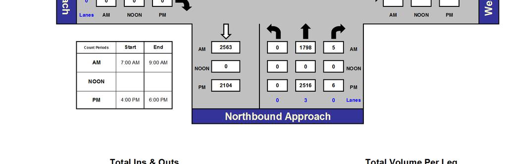
12 Traffic Volumes Existing traffic volumes adjacent to the project site were collected in September and October 2014 at the study intersections and on the roadway segments. The peak hours were determined by combining the four highest adjacent 15 minute periods during the AM peak period (7:00 9:00 AM) and the PM peak period (4:00 6:00 PM) at intersections. Additionally, the 24 hour average daily traffic volumes were collected on the roadway segments to support the street segment analysis required by the City. Figure 4 illustrates the existing AM and PM peak hour traffic volumes at the study intersections. The actual counts are provided in the Appendix B. Level of Service The existing level of service has been evaluated at study intersections based on ICU and HCM methodology. The level of service on the roadway segments has been calculated by comparing the ADT counts to the roadway segment capacity. The LOS summary for intersections and roadway segments is shown in Table D and Table E respectively. As shown in Table D, all intersections operate at LOS D or better with the exception of the following: Beach Boulevard/La Mirada Boulevard which operates at LOS E in the AM and PM peak hours based on the HCM methodology and operates at LOS E in the AM peak hour based on the ICU methodology. Beach Boulevard/Franklin Street which operates at LOS E in the PM peak hour based on the ICU methodology. I 5 Northbound Ramps/Artesia Boulevard which operates at LOS E in the PM peak hour based on the HCM methodology and LOS F in the PM peak hour based on the ICU methodology Beach Boulevard Mixed Use TIA 10
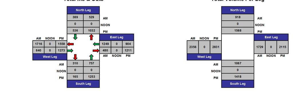
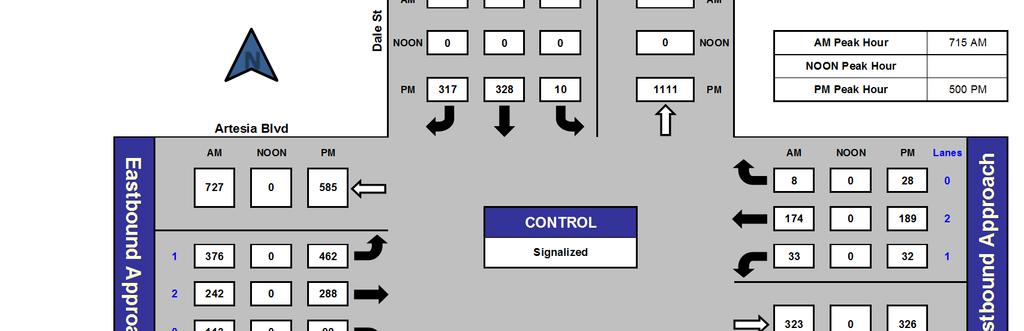
13 KNOTT AV BEACH STANTON AV DALE ST BLVD BLVD 1 No Scale 2 FIRESTONE BLVD 8 Coyote Creek 7 INTERSTATE 5 FRANKLIN ST AESIA BLVD AUTO CENTER DR HOMEWOOD AV Project Site HO ST 9 10 COMMONWEAL AV 1. Beach La Mirada Blvd. (292) 99 (747) 573 (473) (131) 1722 (1322) 155 (181) (561) 346 (1803) 1179 (151) (210) 610 (793) 312 (233) Beach Stage Rd. (111) 81 (23) 9 (217) 228 Beach I-5 SB Ramps (99) 101 (242) (63) 1539 (1383) 882 (741) 12 (16) 2638 (1926) (185) 146 (2590) 1694 (52) 20 (1349) 1117 (107) (36) 31 (31) 69 (103) Dale Artesia Blvd Beach Franklin St. Beach Artesia Blvd. Beach Commonwealth Av. (166) 142 (13) 14 (31) (161) 2444 (2033) 25 (37) I-5 NB Ramps/Firestone Blvd. & Artesia Blvd. 327 (391) 8 (5) 54 (140) (185) 142 (972) 383 (116) 115 (19) 23 (2541) 1654 (7) 8 (541) 452 (613) 262 (99) (117) 11 (9) 1 (18) 125 (234) 937 (626) 187 (44) 364 (297) 1944 (1631) 71 (124) (512) 266 (540) 319 (101) 51 I-5 SB Ramps/Knott Ave. & Artesia Blvd. (1275) 433 (93) (18) 168 (144) 130 (169) Stanton Artesia Blvd. 11. I-5 NB Auto Center Dr. 12. Beach Auto Center Dr. 13. Beach Holt St. (68) 57 (1776) 1286 (55) 44 (132) 94 (440) (280) 520 (367) 90 (106) 915 (882) 292 (151) (18) 6 (547) 369 (135) (70) 2058 (1738) 47 (95) (90) 44 (213) 132 (43) (14) 40 (36) 23 (22) (33) 34 (1774) 1274 (141) 116 (346) 187 (109) 33 (238) (98) 230 (209) 185 (154) 6 (10) 504 (390) 211 (143) 496 (317) 603 (328) 22 (10) 8 (28) 174 (189) 33 (32) 1 (11) 0 (8) 2 (29) 6 (6) 137 (146) 207 (107) 42 (38) 2085 (1785) 37 (27) 242 (401) 166 (129) 77 (92) 2563 (2104) 28 (25) (462) 376 (288 ) 242 (99) 113 (79) 57 (621) 319 (28) 59 (12) 4 (129) 144 (47) 92 (261) 131 (8) 12 (337) 166 (327) 181 (66) 88 (127) 45 (105) 148 (1333) 1178 (107) 76 (2516) 1798 (6) 5 # LEGEND - Study Intersection - Lane Configuration - Study Street Segments AM (PM) - Peak Hour Traffic Volumes Left Thru Right - Volume Turn Movement - Traffic Signal - Stop Sign Figure 4 Existing AM/PM Peak Hour Traffic Volumes
14 Table D: Existing (2014) Intersection Level of Service Summary Intersection AM Peak Hour PM Peak Hour ICU HCM ICU HCM V/C LOS Delay LOS V/C LOS Delay LOS 1. Beach Boulevard/La Mirada Boulevard 0.98 E 65.1 E 0.86 D 57.6 E 2. Beach Boulevard/Stage Road 0.73 C 14.5 B 0.78 C 18.8 B 3. Beach Boulevard/Franklin Street 0.83 D 12.1 B 0.91 E 17.2 B 4. Beach Boulevard/Artesia Boulevard 0.76 C 38.5 D 0.80 C 40.1 D 5. Beach Boulevard/Commonwealth Avenue 0.67 B 30.6 C 0.66 B 30.3 C 6. Beach Boulevard/I 5 Southbound Ramps 0.66 B 30.5 C 0.73 C 38.4 D 7. I 5 Northbound Ramps/Artesia Boulevard 0.70 B 44.8 D 1.05 F 76.4 E 8. I 5 Southbound Ramps/Artesia Boulevard 0.45 A 28.9 C 0.59 A 36.3 D 9. Stanton Avenue/Artesia Boulevard 0.44 A 23.7 C 0.55 A 22.9 C 10. Dale Street/Artesia Boulevard 0.55 A 33.7 C 0.58 A 51.4 D 11. I 5 Southbound Ramps/Auto Center Drive 0.32 A 32.2 C 0.46 A 31.2 C 12. Beach Boulevard/Auto Center Drive 0.62 B 24.2 C 0.69 B 44.9 D 13. Beach Boulevard/Holt Street 9.2 A 10.3 B Delay is in seconds Intersection LOS calculation sheets are provided in Appendix C. As shown in the Table E, all roadway segments operate at LOS D or better with the exception of: Beach Boulevard between La Mirada Boulevard and Artesia Boulevard which operates at LOS F. Beach Boulevard between Artesia Boulevard and I 5 Ramps which operates at LOS E Beach Boulevard Mixed Use TIA 12
15 Table E: Existing (2014) Roadway Level of Service Summary Roadway Segment Segment Limits (between) Class Capacity Volume V/C LOS Beach Boulevard La Mirada Boulevard and Artesia Boulevard Major Arterial 56,300 66,398 >1 F Artesia Boulevard and I 5 Ramps Major Arterial 56,300 51, E Artesia Boulevard I 5 Ramps and Beach Boulevard Secondary Arterial Major Arterial 31,250* 23, C Beach Boulevard and Dale Street Secondary Arterial 25,000 14, A Franklin Street Beach Boulevard and Stanton Avenue Commuter Arterial 10,000 1, A Homewood Avenue Franklin Street and Artesia Avenue Local Street 4, A Holt Street Beach Boulevard and Stanton Avenue Commuter Arterial 10, A Darlington Avenue Franklin Street and Artesia Avenue Commuter Arterial 10, A Marshall Avenue Franklin Street and Artesia Avenue Commuter Arterial 10, A Roadway class and capacities are consistent with the City of Buena Park General Plan Mobility Element. *Assumed capacity calculated based on 5 lane cross section using same lane capacity as the Secondary Arterial. 3.0 FUTURE (2035) CONDITIONS Traffic Volumes Future buildout traffic forecasts were developed in order to analyze the project traffic impacts during the buildout year horizon of the project. Based on discussions with the City staff, a 1% annual growth was added to the existing vehicular traffic volumes and 24 hour counts for a period of 21 years to determine the future 2035 traffic volumes at the study intersections and roadway segments. In addition, the City of Buena Park Planning Department provided a list, locations and traffic study documents of cumulative projects to be used for the future 2035 analysis. Cumulative volumes were developed and distributed to the roadway network. Planned roadway and intersection improvements based on the General Plan Mobility Element were included in the future (2035) analysis. The list of cumulative project is presented in Table F Beach Boulevard Mixed Use TIA 13
16 Table F: List of Cumulative Projects No. Cumulative Project Description 1. Parker Collection Residential Project 70 apartment units and 128 townhouses. 2. Orangethorpe and Thomas Residential Project 54 residential condominiums/townhouses. 3. Buena Park Nabisco Mixed Use Project 149 residential condominiums/townhouses, 100 room hotel and automobile dealership. 4. The Source 504 condominium Units, 300 room hotel, 195,000 square feet of office, 355,000 square feet of retail 5. Orangethorpe and Magnolia Townhomes 108 condominiums 6. Los Coyotes Country Club Development Plan 125 condominiums Figure 5 shows the locations of cumulative projects along with the future ambient growth and cumulative project volumes at study intersections. Figure 6 illustrates the 2035 pre project AM and PM peak hour traffic volumes in the study area. Levels of Service The future (2035) no project level of service has been evaluated at study intersections based on ICU and HCM methodology. The level of service on the roadway segments has been calculated by comparing the future roadway volumes to the roadway segment capacity. The LOS summary for intersections and roadway segments is shown in Table G and Table H respectively. As shown in Table G, all intersections operate at LOS D or better with the exception of the following: Beach Boulevard/La Mirada Boulevard which operates at LOS E and LOS F in the AM and PM peak hours respectively based on the HCM methodology. It also operates at LOS E in the PM peak hour based on the ICU methodology. Beach Boulevard/Stage Road which operates at LOS E in the PM peak hour based on the ICU methodology. Beach Boulevard/Franklin Street which operates at LOS F and LOS E in the AM and PM peak hours respectively based on the ICU methodology. Beach Boulevard/Artesia Boulevard which operates at LOS F and LOS E in the AM and PM peak hours respectively based on the HCM methodology. It also operates at LOS E in the AM and PM peak hours based on the ICU methodology Beach Boulevard Mixed Use TIA 14
17 KNOTT AV BEACH STANTON AV DALE ST BLVD BLVD 1 No Scale FIRESTONE BLVD 8 Coyote Creek 7 3 FRANKLIN ST AESIA BLVD AUTO CENTER DR INTERSTATE 5 Beach Stage Rd HOMEWOOD AV Project Site HO ST 9 10 COMMONWEAL AV Beach La Mirada Blvd. Beach Franklin St. Beach Artesia Blvd. Beach Commonwealth Av. 1. (61) 21 (157) 120 (99) (28) 453 (394) 33 (38) (118) 73 (495) 321 (32) (44) 128 (167) 66 (49) (23) 17 (5) 2 (46) (13) (39) 31 3 (3) 645 (520) (11) 4 (660) (8) 7 (7) 14 (22) 52 (34) 604 (543) 5 (8) (35) 30 (3) 3 (7) 5 (4) 5 (650) 420 (1) 2 13 (25) 2 (2) 0 (4) 99 (81) 476 (440) 15 (26) (133) 69 (126) 77 (49) 29 (58) 45 (464) 330 (12) 9 21 (59) 120 (90) 19 (22) 19 (15) 458 (420) 10 (20) (19) 9 (45) 28 (9) 9 (7) 7 (408) 311 (30) (21) 48 (44) 39 (32) 6. Beach I-5 SB Ramps I-5 NB Ramps/Firestone Blvd. & Artesia Blvd. I-5 SB Ramps/Knott Ave. & Artesia Blvd. Stanton Artesia Blvd. 347 (337) 187 (164) 69 (82) 2 (1) 14 (31) 27 (53) 242 (176) 55 (23) 13 (4) 35 (30) 29 (44) 232 (228) 61 (32) 3 (3) 8 (8) 5 (5) 1 (2) 117 (95) 44 (30) (21) 21 (51) 32 (318) 278 (22) 24 (39) 30 (256) 111 (24) 24 (114) 95 (129) 55 (42) 24 (311) 120 (20) 11 (28) 20 (92) 63 (4) 1 (128) 87 (28) 20 (73) 39 (23) 7 (50) Dale Artesia Blvd. 11. I-5 NB Auto Center Dr. 12. Beach Auto Center Dr. 13. Beach Holt St. 104 (67) 127 (69) 5 (2) 2 (6) 48 (53) 7 (7) 0 (2) 0 (2) 0 (6) 1 (1) 29 (31) 43 (22) 9 (8) 464 (430) 8 (6) 51 (84) 35 (27) 16 (19) 629 (558) 6 (5) (97) 79 (73) 61 (21) 24 (17) 12 (130) 67 (6) 12 (3) 1 (27) 30 (10) 19 (55) 28 (2) 3 (71) 35 (69) 38 (14) 18 (27) 9 (22) 31 (315) 290 (22) 16 (644) 451 (1) 1 LEGEND # - Study Intersection - Lane Configuration - Traffic Signal - Study Street AM (PM) - Peak Hour Traffic Volumes - Stop Sign Segments - Volume Turn Movement # - Cumulative Project Left Thru Right Figure 5 Ambient Growth & Cumulative Project AM/PM Peak Hour Traffic Volumes
18 KNOTT AV BEACH STANTON AV DALE ST BLVD BLVD 1 No Scale 2 FIRESTONE BLVD 8 Coyote Creek 7 INTERSTATE 5 FRANKLIN ST AESIA BLVD AUTO CENTER DR HOMEWOOD AV Project Site HO ST 9 10 COMMONWEAL AV 1. Beach La Mirada Blvd. (353) 120 (904) 693 (572) (159) 2175 (1716) 188 (219) (679) 419 (2298) 1500 (183) (254) 738 (960) 378 (282) 2. Beach Stage Rd Beach Franklin St. Beach Artesia Blvd. Beach Commonwealth Av. (134) 98 (28) 11 (263) (76) 3283 (2446) 15 (19) (224) 177 (3250) 2123 (63) (44) 38 (38) 83 (125) (201) 172 (16) 17 (38) (195) 3048 (2576) 30 (45) (23) 28 (3191) 2074 (8) (142) 13 (11) 1 (22) 463 (378) 2420 (2071) 86 (150) (645) 335 (666) 396 (150) 80 (126) 102 (2240) 1616 (67) (339) 640 (457) 109 (128) 108 (85) 2516 (2158) 57 (115) (109) 53 (258) 160 (52) 52 (40) 41 (2182) 1585 (171) (119) 278 (253) 224 (186) Beach I-5 SB Ramps (120) 122 (293) (1720) 1069 (905) (1667) 1395 (129) 137 Dale Artesia Blvd I-5 NB Ramps/Firestone Blvd. & Artesia Blvd. 396 (473) 10 (6) 68 (171) (224) 172 (1228) 494 (140) 139 (655) 547 (742) 317 (141) (287) 1179 (802) 242 (67) I-5 SB Ramps/Knott Ave. & Artesia Blvd. (1586) 553 (113) (22) 203 (174) 159 (213) Stanton Artesia Blvd. 11. I-5 NB Auto Center Dr. 12. Beach Auto Center Dr. 13. Beach Holt St. (160) 114 (532) (1110) 353 (183) (22) 7 (675) 456 (163) (17) 48 (44) 28 (27) (419) 226 (132) 40 (288) (12) 621 (485) 255 (173) # (559) 455 (361) 303 (120) (384) 730 (397) 27 (12) LEGEND (96) 69 (751) 386 (34) (34) 222 (242) 40 (39) - Study Intersection - Lane Configuration - Study Street Segments AM (PM) - Peak Hour Traffic Volumes Left Thru Right (15) 5 (156) 174 (57) (13) 0 (10) 2 (35) - Volume Turn Movement (316) 159 (10) 15 (408) (7) 166 (177) 250 (129) - Traffic Signal - Stop Sign 51 (46) 2549 (2215) 45 (33) (396) 219 (80) 106 (154) 54 (127) 179 (1648) 1468 (129) (485) 201 (156) 93 (111) 3192 (2662) Figure 6 Future (2035) No Project AM/PM Peak Hour Traffic Volumes (3160) 2249 (7) 6 34 (30)
19 Beach Boulevard/I 5 Southbound Ramps which operates at LOS E in the AM and PM peak hours based on the HCM methodology. I 5 Northbound Ramps/Artesia Boulevard which operates at LOS E and LOS F in the AM and PM peak hours respectively based on the HCM methodology. It also operates at LOS F in the PM peak hour based on the ICU methodology. I 5 Southbound Ramps/Artesia Boulevard which operates at LOS E in the PM peak hour based on the HCM methodology. Dale Street/Artesia Boulevard which operates at LOS E in the PM peak hour based on the HCM methodology. Table G: Future (2035) No Project Intersection Level of Service Summary AM Peak Hour PM Peak Hour Intersection ICU HCM ICU HCM V/C LOS Delay LOS V/C LOS Delay LOS 1. Beach Boulevard/La Mirada Boulevard 1.19 F F 1.05 F F 2. Beach Boulevard/Stage Road 0.89 D 34.7 C 0.95 E 32.2 C 3. Beach Boulevard/Franklin Street 1.01 F 24.5 C 0.92 E 19.4 B 4. Beach Boulevard/Artesia Boulevard 0.94 E 93.0 F 0.94 E 79.1 E 5. Beach Boulevard/Commonwealth Avenue 0.80 C 34.4 C 0.79 C 35.6 D 6. Beach Boulevard/I 5 Southbound Ramps 0.80 C 56.2 E 0.88 D 71.4 E 7. I 5 Northbound Ramps/Artesia Boulevard 0.73 C 60.1 E 1.25 F F 8. I 5 Southbound Ramps/Artesia Boulevard 0.53 A 31.9 C 0.71 C 56.8 E 9. Stanton Avenue/Artesia Boulevard 0.53 A 26.2 C 0.68 B 24.7 C 10. Dale Street/Artesia Boulevard 0.66 B 42.1 D 0.70 B 67.1 E 11. I 5 Southbound Ramp/Auto Center Drive 0.38 A 32.3 C 0.55 A 31.3 C 12. Beach Boulevard/Auto Center Drive 0.74 C 30.0 C 0.84 D 54.5 D 13. Beach Boulevard/Holt Street 9.7 A 11.3 B Delay is in seconds. Intersection LOS calculation sheets are provided in the Appendix D. As shown in the Table H, all roadway segments operate at LOS D or better with the exception of: Beach Boulevard between La Mirada Boulevard and Artesia Boulevard which operates at LOS F Beach Boulevard Mixed Use TIA 17
20 Beach Boulevard between Artesia Boulevard and I 5 Ramps which operates at LOS F. Artesia Boulevard between I 5 Ramps and Beach Boulevard which operates at LOS E. Table H: Future (2035) No Project Roadway Level of Service Summary Roadway Segment Segment Limits (between) Class Capacity Volume V/C LOS Beach Boulevard La Mirada Boulevard and Artesia Boulevard Major Arterial 56,300 80,342 >1 F Artesia Boulevard and I 5 Ramps Major Arterial 56,300 62,903 >1 F Artesia Boulevard I 5 Ramps and Beach Boulevard Secondary Arterial Major Arterial 31,250* 29, E Beach Boulevard and Dale Street Secondary Arterial 25,000 17, B Franklin Street Beach Boulevard and Stanton Avenue Commuter Arterial 10,000 2, A Homewood Avenue Franklin Street and Artesia Avenue Local Street 4, A Holt Street Beach Boulevard and Stanton Avenue Commuter Arterial 10, A Darlington Avenue Franklin Street and Artesia Avenue Commuter Arterial 10, A Marshall Avenue Franklin Street and Artesia Avenue Commuter Arterial 10, A Roadway Class and capacities are consistent with the City of Buena Park General Plan Mobility Element. *Assumed capacity calculated based on 5 lane cross section using same lane capacity as the Secondary Arterial. 4.0 PROJECT DESCRIPTION Project Size and Description Figure 2 illustrates the site plan of the proposed project. The proposed project would develop 60 units of senior housing apartment, 6,123 sq.ft. (square feet) of restaurant, 2,284 sq.ft. of retail, and 36,303 sq.ft of medical use. The project would provide three full accesses via Holt Street and three via Franklin Street to the project site. Project Traffic Trip Generation Per the Institute of Transportation Engineers (ITE) Trip Generation, 9 th Edition, trip generation estimates for the proposed project were developed using ITE trip rates. A summary of the trip generation rates and resulting vehicle trips from the proposed project is presented in Table I. Pass by reduction and internal trip reduction were 5742 Beach Boulevard Mixed Use TIA 18
21 included in the trip generation analysis to account for the trips which were not directly due to the proposed project. As shown in Table I, the proposed project would generate 2,007 ADT (average daily trips), 171 (113 inbound, 58 outbound) trips during the AM peak hour, and 184 (68 inbound and 116 outbound) trips during the PM peak hour. Land Use Table I: Project Trip Generation Summary ITE Code Size Daily AM Peak Hour PM Peak Hour In Out Total In Out Total Trip Rates Retail (Pharmacy without Drive Through 880 per TSF Window) Restaurant (High Turnover [Sit Down] 932 per TSF Restaurant) Medical Office 720 per TSF Senior Housing 252 per DU Trip Generation Retail (Pharmacy without Drive Through Window) TSF Restaurant (High Turnover [Sit Down] Restaurant) TSF Medical Office TSF 1, Senior Housing 60 DU Pass by Reduction for Retail Pass by Reduction for Restaurant Internal Trip Capture Gross Total Trips 2, Net Project Trip Generation 2, Pass by reduction is based on percentages provided in the ITE Trip Generation Handbook. Internal trip reduction is based on percentages provided in the ITE Trip Generation Handbook. Trip Distribution and Assignment Project trip distribution patterns were based on factors such as: 1) transportation facility characteristics that impact travel demand (i.e. location of urban arterials, freeways, and interchanges); 2) location of employment and commercial facilities; 3) existing traffic patterns; and 4) inputs received from Caltrans letter dated February 12 th, Figure 7 illustrates trip distribution percentages for the proposed project. Trip distribution percentages were applied to the proposed project s trip generation to calculate the traffic volumes which the project would generate at study intersections (i.e. trip assignment). The resulting AM and PM peak hour trip assignments are shown in Figure Beach Boulevard Mixed Use TIA 19
22 BEACH BLVD BLVD 20% 25% 20% 25% Coyote Creek FIRESTONE BLVD 20% 10% 10% 10% 30% 10% 20% 20% 5% ROSTRATA AV FRANKLIN ST WESTERN AV AESIA BLVD 20% 10% 35% 30% 15% 35% 10% 30% 10% 30% 15% 35% 10% 5% 30% 10% 5% Project Site HO ST 15% 15% 15% AUTO CENTER DR KNOTT AV INTERSTATE 5 20% 5% HOMEWOOD AV STANTON AV 5% COMMONWEAL AV 5% 5% 15% 5% 20% 15% 20% 20% 25% 0% 0% LEGEND - Inbound Trip Distribution Percentage - Outbound Trip Distribution Percentage Figure 7 Project Trip Distribution No Scale
23 KNOTT AV BEACH STANTON AV DALE ST BLVD BLVD 1 No Scale 2 FIRESTONE BLVD 8 Coyote Creek 7 INTERSTATE 5 FRANKLIN ST AESIA BLVD AUTO CENTER DR HOMEWOOD AV Project Site HO ST 9 10 COMMONWEAL AV 1. Beach La Mirada Blvd. (0) 0 (0) 0 (0) 0 0 (0) 23 (14) 0 (0) (0) 0 (0) 0 (29) 15 0 (0) 0 (0) 0 (0) 2. Beach Stage Rd Beach Franklin St. Beach Artesia Blvd. Beach Commonwealth Av. (0) 0 (0) 0 (0) 0 0 (0) 23 (14) 0 (0) (0) 0 (29) 15 (0) 0 0 (0) 0 (0) 0 (0) 0 (0) 0 (0) 23 (14) (0) 0 (0) 0 (0) 0 (12) 6 (12) 6 (24) 39 9 (17) 0 (0) 20 (41) 17 (35) 9 (18) 0 (0) (24) 39 (0) 0 (0) 0 0 (0) 6 (12) 3 (6) (0) 0 (20) 34 (0) 0 0 (0) 12 (23) 0 (0) (0) 0 (0) 0 (0) 0 6 (3) 0 (0) 0 (0) (0) 0 (17) 28 (0) 0 6. Beach I-5 SB Ramps I-5 NB Ramps/Firestone Blvd. & Artesia Blvd. I-5 SB Ramps/Knott Ave. & Artesia Blvd. Stanton Artesia Blvd. 9 (17) 3 (6) 0 (0) 0 (0) 0 (0) 0 (0) 12 (23) 12 (23) 0 (0) 0 (0) 23 (14) 6 (12) 0 (0) 0 (0) 0 (0) 0 (0) 0 (0) 17 (10) 0 (0) (0) 0 (0) 0 (14) 23 (0) 0 (0) 0 (20) 34 (0) 0 (0) 0 (0) 0 (3) 6 (7) 11 (0) 0 (0) 0 (0) 0 (0) 0 (17) 9 (0) 0 (0) 0 (0) 0 (0) Dale Artesia Blvd. 11. I-5 NB Auto Center Dr. 12. Beach Auto Center Dr. 13. Beach Holt St. 0 (0) 0 (0) 0 (0) 0 (0) 17 (10) 0 (0) 0 (0) 0 (0) 0 (0) 0 (0) 0 (0) 0 (0) 0 (0) 12 (23) 0 (0) 0 (0) 0 (0) 0 (0) 26 (52) 12 (23) (0) 0 (17) 9 (0) 0 (0) 0 (0) 0 (0) 0 (0) 0 (0) 0 (0) 0 (0) 0 (0) 0 (3) 6 (3) 6 (0) 0 (0) 0 (0) 0 (14) 23 (0) 0 (24) 39 (20) 34 # LEGEND - Study Intersection - Lane Configuration - Study Street Segments AM (PM) - Peak Hour Traffic Volumes Left Thru Right - Volume Turn Movement - Traffic Signal - Stop Sign Figure 8 Project Trip Assignment AM/PM Peak Hour Traffic Volumes
24 5.0 PROJECT INTERSECTION IMPACTS This section describes the traffic conditions related to the following traffic scenarios: Existing (2014) Plus Project Future (2035) Year Plus Project Future (2035) Year Plus Project Plus Mitigation (if required) Existing (2014) Plus Project Traffic Volumes The trips generated from the project as shown in Figure 8 were added to the existing traffic volumes shown in Figure 4 which would result in the existing plus project traffic scenario. Figure 9 illustrates the Existing Year (2014) Plus Project traffic volumes. Levels of Service The existing plus project level of service has been evaluated at study intersections based on ICU and HCM methodology. The level of service on the roadway segments has been calculated by comparing the ADT counts plus project ADT to the roadway segment capacity. The LOS summary for intersections and roadway segments is shown in Table J and Table K respectively. As shown in Table J, all intersections operate at LOS D or better with the exception of the following: Beach Boulevard/La Mirada Boulevard which operates at LOS E in the AM and PM peak hours based on the HCM methodology and operates at LOS E in the AM peak hour based on the ICU methodology. I 5 Northbound Ramps/Artesia Boulevard which operates at LOS E in the PM peak hour based on the HCM methodology and LOS F in the PM peak hour based on the ICU methodology Beach Boulevard Mixed Use TIA 22
25 KNOTT AV BEACH STANTON AV DALE ST BLVD BLVD 1 No Scale 2 FIRESTONE BLVD 8 Coyote Creek 7 INTERSTATE 5 FRANKLIN ST AESIA BLVD AUTO CENTER DR HOMEWOOD AV Project Site HO ST 9 10 COMMONWEAL AV 1. (292) 99 (747) 573 (473) 675 Beach La Mirada Blvd. (561) 346 (1832) 1194 (151) (131) 1745 (1336) 155 (181) 98 (210) 610 (793) 312 (233) Beach Stage Rd. (111) 81 (23) 9 (217) (63) Beach I-5 SB Ramps 1548 (1400) 885 (747) (99) 101 (242) (16) 2661 (1940) (185) 146 (2619) 1709 (52) 20 (1363) 1140 (107) (36) 31 (31) 69 (103) Dale Artesia Blvd Beach Franklin St. Beach Artesia Blvd. Beach Commonwealth Av. (166) 142 (13) 14 (31) (161) 2444 (2033) 48 (51) (31) 29 (2553) 1660 (31) (134) 11 (9) 21 (59) I-5 NB Ramps/Firestone Blvd. & Artesia Blvd. 327 (391) 8 (5) 54 (140) (185) 142 (992) 417 (116) 115 (541) 452 (613) 262 (102) (234) 949 (649) 199 (67) 381 (332) 1953 (1649) 71 (124) (536) 305 (540) 319 (101) 51 (68) 57 (1796) 1320 (55) (280) 526 (379) 93 (112) I-5 SB Ramps/Knott Ave. & Artesia Blvd. (1282) 444 (93) (18) 168 (144) 153 (183) Stanton Artesia Blvd. 11. I-5 NB Auto Center Dr. 12. Beach Auto Center Dr. 13. Beach Holt St. (132) 94 (440) (151) 292 (894) 89 (70) 2070 (1761) 47 (95) (90) 44 (213) 132 (43) 43 (18) 6 (564) 378 (135) (14) 40 (36) 23 (22) (33) 34 (1791) 1302 (141) 116 (346) 187 (109) 33 (238) (101) 230 (209) 185 (154) 6 (10) 521 (400) 211 (143) 496 (317) 603 (328) 22 (10) 8 (28) 191 (199) 33 (32) 1 (11) 0 (8) 2 (29) 6 (6) 137 (146) 207 (107) 42 (38) 2097 (1808) 37 (27) 242 (401) 166 (129) 77 (92) 2589 (2156) 40 (48) (462) 376 (305) 251 (99) 113 (79) 57 (621) 319 (28) 59 (12) 4 (129) 144 (47) 92 (261) 131 (8) 12 (340) 172 (330) 187 (66) 88 (127) 45 (105) 148 (1347) 1201 (107) 76 (2540) 1837 (26) 39 # LEGEND - Study Intersection - Lane Configuration - Study Street Segments AM (PM) - Peak Hour Traffic Volumes Left Thru Right - Volume Turn Movement - Traffic Signal - Stop Sign Figure 9 Existing Plus Project AM/PM Peak Hour Traffic Volumes
26 Table J: Existing (2014) Plus Project Intersection Level of Service AM Peak Hour PM Peak Hour Intersection ICU HCM ICU HCM V/C LOS Delay LOS V/C LOS Delay LOS 1. Beach Boulevard/La Mirada Boulevard 0.98 E 66.4 E 0.87 D 55.2 E 2. Beach Boulevard/Stage Road 0.73 C 14.9 B 0.79 C 18.7 B 3. Beach Boulevard/Franklin Street 0.83 D 13.3 B 0.89 D 18.6 B 4. Beach Boulevard/Artesia Boulevard 0.77 C 43.3 D 0.81 D 42.3 D 5. Beach Boulevard/Commonwealth Avenue 0.68 B 30.6 C 0.66 B 30.4 C 6. Beach Boulevard/I 5 Southbound Ramps 0.67 B 30.6 C 0.73 C 39.2 D 7. I 5 Northbound Ramps/Artesia Boulevard 0.70 B 45.2 D 1.06 F 76.6 E 8. I 5 Southbound Ramps/Artesia Boulevard 0.45 A 29.0 C 0.59 A 36.5 D 9. Stanton Avenue/Artesia Boulevard 0.45 A 23.8 C 0.56 A 22.9 C 10. Dale Street/Artesia Boulevard 0.55 A 33.9 C 0.59 A 50.4 D 11. I 5 Southbound Ramp/Auto Center Drive 0.32 A 31.7 C 0.46 A 31.3 C 12. Beach Boulevard/Auto Center Drive 0.63 B 24.6 C 0.70 B 45.1 D 13. Beach Boulevard/Holt Street 9.3 A 10.5 B Delay is in seconds. Intersection LOS calculation sheets are provided in the Appendix E. As shown in the Table K, all roadway segments operate at LOS D or better with the exception of: Beach Boulevard between La Mirada Boulevard and Artesia Boulevard which operates at LOS F. Beach Boulevard between Artesia Boulevard and I 5 Ramps which operates at LOS E Beach Boulevard Mixed Use TIA 24
27 Table K: Existing (2014) Plus Project Roadway Level of Service Roadway Segment Segment Limits (between) Class Capacity Existing ADT Volume Project ADT Existing Plus Project Volume V/C LOS Beach Boulevard La Mirada Boulevard and Artesia Boulevard Major Arterial 56,300 66, ,304 >1 F Artesia Boulevard and I 5 Ramps Major Arterial 56,300 51, , E Artesia Boulevard I 5 Ramps and Beach Boulevard Secondary Arterial Major Arterial 31,250* 23, , C Beach Boulevard and Dale Street Secondary Arterial 25,000 14, , A Franklin Street Beach Boulevard and Stanton Avenue Commuter Arterial 10,000 1,753 1,006 2, A Homewood Avenue Franklin Street and Artesia Avenue Local Street 4, , A Holt Street Beach Boulevard and Stanton Avenue Commuter Arterial 10, ,003 1, A Darlington Avenue Franklin Street and Artesia Avenue Commuter Arterial 10, A Marshall Avenue Franklin Street and Artesia Avenue Commuter Arterial 10, A Roadway Class and capacities are consistent with the City of Buena Park General Plan Mobility Element. *Assumed capacity calculated based on 5 lane cross section using same lane capacity as the Secondary Arterial. Future (2035) Plus Project Traffic Volumes The trips generated from the project as shown in Figure 8 were added to the future (2035) no project traffic volumes shown in Figure 6 which would result in the future (2035) plus project traffic scenario. Figure 10 illustrates the Future (2035) Plus Project traffic volumes Beach Boulevard Mixed Use TIA 25
28 KNOTT AV BEACH STANTON AV DALE ST BLVD BLVD 1 No Scale 2 FIRESTONE BLVD 8 Coyote Creek 7 INTERSTATE 5 FRANKLIN ST AESIA BLVD AUTO CENTER DR HOMEWOOD AV Project Site HO ST 9 10 COMMONWEAL AV 1. (353) 120 (904) 693 (572) 817 Beach La Mirada Blvd. (679) 419 (2327) 1515 (183) (159) 2198 (1730) 188 (219) 119 (254) 738 (960) 378 (282) 2. Beach Stage Rd Beach Franklin St. Beach Artesia Blvd. Beach Commonwealth Av. (134) 98 (28) 11 (263) (76) 3306 (2460) 15 (19) (224) 177 (3279) 2138 (63) (44) 38 (38) 83 (125) (201) 172 (16) 17 (38) (195) 3048 (2576) 53 (59) (35) 34 (3203) 2080 (32) (159) 13 (11) 21 (63) 480 (413) 2429 (2089) 86 (150) (669) 374 (666) 396 (150) 80 (126) 102 (2260) 1650 (67) (339) 646 (469) 112 (134) 108 (85) 2528 (2181) 57 (115) (109) 53 (258) 160 (52) 52 (40) 41 (2199) 1613 (171) (122) 278 (253) 224 (186) Beach I-5 SB Ramps 1895 (1737) 1072 (911) (120) 122 (293) 184 (1681) 1418 (129) 137 Dale Artesia Blvd I-5 NB Ramps/Firestone Blvd. & Artesia Blvd. 396 (473) 10 (6) 68 (171) (224) 172 (1248) 528 (140) 139 (655) 547 (742) 317 (144) (287) 1191 (825) 254 (90) I-5 SB Ramps/Knott Ave. & Artesia Blvd. 76 (22) 203 (174) 182 (227) (1593) 564 (113) 63 (160) 114 (532) (1122) 353 (183) Stanton Artesia Blvd. (22) 7 (692) 465 (163) (17) 48 (44) 28 (27) (419) 226 (132) 40 (288) I-5 NB Auto Center Dr. 12. Beach Auto Center Dr. 13. Beach Holt St. 7 (12) 638 (495) 255 (173) 600 (384) 730 (397) 27 (12) 10 (34) 239 (252) 40 (39) 1 (13) 0 (10) 2 (35) 7 (7) 166 (177) 250 (129) 51 (46) 2561 (2238) 45 (33) 293 (485) 201 (156) 93 (111) 3218 (2714) 46 (53) (559) 455 (378) 312 (120) 137 (96) 69 (751) 386 (34) 71 (15) 5 (156) 174 (57) 111 (316) 159 (10) 15 (411) 207 (399) 225 (80) 106 (154) 54 (127) 179 (1662) 1491 (129) 92 (3184) 2288 (27) 40 # LEGEND - Study Intersection - Lane Configuration - Study Street Segments AM (PM) - Peak Hour Traffic Volumes Left Thru Right - Volume Turn Movement - Traffic Signal - Stop Sign Figure 10 Future (2035) Plus Project AM/PM Peak Hour Traffic Volumes
29 Levels of Service The future plus project level of service has been evaluated at study intersections based on the ICU and HCM methodology. The level of service on roadway segments has been calculated by comparing the future roadway volumes plus project ADT to the roadway segment capacity. The LOS summary for intersections and roadway segments is shown in Table L and Table M respectively. As shown in Table L all intersections operate at LOS D or better with the exception of the following: Beach Boulevard/La Mirada Boulevard which operates at LOS E and LOS F in the AM and PM peak hours respectively based on the HCM methodology. It also operates at LOS E in the PM peak hour based on the ICU methodology. Beach Boulevard/Stage Road which operates at LOS E in the PM peak hour based on the ICU methodology. Beach Boulevard/Franklin Street which operates at LOS F and LOS E in the AM and PM peak hours respectively based on the ICU methodology. Beach Boulevard/Artesia Boulevard which operates at LOS F in the AM and PM peak hours based on the HCM methodology. It also operates at LOS E in the AM and PM peak hours based on the ICU methodology. Beach Boulevard/I 5 Southbound Ramps which operates at LOS E in the AM and PM peak hours based on the HCM methodology. I 5 Northbound Ramps/Artesia Boulevard which operates at LOS E and LOS F in the AM and PM peak hours respectively based on the HCM methodology. It also operates at LOS F in the PM peak hour based on the ICU methodology. I 5 Southbound Ramps/Artesia Boulevard which operates at LOS E in the PM peak hour based on the HCM methodology. Dale Street/Artesia Boulevard which operates at LOS E in the PM peak hour based on the HCM methodology Beach Boulevard Mixed Use TIA 27
30 Table L: Future (2035) Plus Project Intersection Level of Service AM Peak Hour PM Peak Hour Intersection ICU HCM ICU HCM V/C LOS Delay LOS V/C LOS Delay LOS 1. Beach Boulevard/La Mirada Boulevard 1.19 F F 1.06 F F 2. Beach Boulevard/Stage Road 0.90 D 37.1 D 0.96 E 33.1 C 3. Beach Boulevard/Franklin Street 1.01 F 26.6 C 0.93 E 21.7 C 4. Beach Boulevard/Artesia Boulevard 0.95 E F 0.96 E 87.1 F 5. Beach Boulevard/Commonwealth Avenue 0.80 C 34.6 C 0.80 C 35.8 D 6. Beach Boulevard/I 5 Southbound Ramps 0.81 D 56.5 E 0.89 D 72.8 E 7. I 5 Northbound Ramps/Artesia Boulevard 0.73 C 60.9 E 1.26 F F 8. I 5 Southbound Ramps/Artesia Boulevard 0.53 A 30.6 C 0.71 C 58.0 E 9. Stanton Avenue/Artesia Boulevard 0.53 A 25.9 C 0.69 B 25.0 C 10. Dale Street/Artesia Boulevard 0.66 B 44.2 D 0.71 C 66.0 E 11. I 5 Southbound Ramp/Auto Center Drive 0.38 A 32.2 C 0.55 A 31.3 C 12. Beach Boulevard/Auto Center Drive 0.76 C 30.6 C 0.84 D 54.8 D 13. Beach Boulevard/Holt Street 9.9 A 11.6 B Delay is in seconds. Intersection LOS calculation sheets are provided in the Appendix F. As shown in the Table M, all roadway segments operate at LOS D or better with the exception of: Beach Boulevard between La Mirada Boulevard and Artesia Avenue which operates at LOS F. Beach Boulevard between Artesia Avenue and I 5 Ramps which operates at LOS F. Artesia Boulevard between I 5 Ramps and Beach Boulevard which operates at LOS E Beach Boulevard Mixed Use TIA 28
31 Roadway Segment Beach Boulevard Table M: Future (2035) Plus Project Roadway Level of Service Segment Limits (between) Class Capacity Future Baseline ADT Volume La Mirada Boulevard and Artesia Boulevard Project ADT Future Plus Project Volume V/C Major Arterial 56,300 80, ,346 >1 F Artesia Boulevard and I 5 Ramps Major Arterial 56,300 62, ,404 >1 F Artesia Boulevard I 5 Ramps and Beach Boulevard Secondary Arterial Major Arterial Franklin Street Homewood Avenue Holt Street Darlington Avenue Marshall Avenue Beach Boulevard and Dale Street Beach Boulevard and Stanton Avenue Franklin Street and Artesia Avenue Beach Boulevard and Stanton Avenue Franklin Street and Artesia Avenue Franklin Street and Artesia Avenue Secondary Arterial Commuter Arterial 31,250* 29, , E 25,000 17, , C 10,000 2,121 1,006 3, A Local Street 4, , A Commuter Arterial Commuter Arterial Commuter Arterial Roadway Class and capacities are consistent with the City of Buena Park General Plan Mobility Element. *Assumed capacity calculated based on 5 lane cross section using same lane capacity as the Secondary Arterial. 10, ,003 1, A 10, A 10, A LOS Future (2035) Plus Project Plus Mitigation Based on the significant impact threshold criteria for the City of Buena Park and Caltrans, the intersections are evaluated for significant project impacts. The City of Buena Park evaluates the significant project impact at an intersection based on both the ICU and HCM methodologies. Caltrans evaluates the significant project impact at an intersection based on the HCM methodology. Table N summarizes the significant project impact at intersections in the future (2035) scenario based on the City of Buena Park criteria for project impacts as per the ICU methodology. As shown in the table, the intersection of Beach Boulevard/Artesia Boulevard is impacted due to the proposed project trips Beach Boulevard Mixed Use TIA 29
32 Table N: Future (2035) Plus Project Significant Impact Summary (ICU Methodology) Intersection AM Peak Hour PM Peak Hour Added Project V/C No Project Plus Project No Project Plus Project V/C LOS V/C LOS V/C LOS V/C LOS AM PM 1. Beach Boulevard/La Mirada Boulevard 1.19 F 1.19 F 1.05 F 1.06 F No 2. Beach Boulevard/Stage Road 0.89 D 0.90 D 0.95 E 0.96 E No 3. Beach Boulevard/Franklin Street 1.01 F 1.01 F 0.92 E 0.93 E No 4. Beach Boulevard/Artesia Boulevard 0.94 E 0.95 E 0.94 E 0.96 E Yes 5. Beach Boulevard/Commonwealth Avenue 0.80 C 0.80 C 0.79 C 0.80 C No 6. Beach Boulevard/I 5 Southbound Ramps 0.80 C 0.81 D 0.88 D 0.89 D No 7. I 5 Northbound Ramps/Artesia Boulevard 0.73 C 0.73 C 1.25 F 1.26 F No 8. I 5 Southbound Ramps/Artesia Boulevard 0.53 A 0.53 A 0.71 C 0.71 C No 9. Stanton Avenue/Artesia Boulevard 0.53 A 0.53 A 0.68 B 0.69 B No 10. Dale Street/Artesia Boulevard 0.66 B 0.66 B 0.70 B 0.71 C No 11. I 5 Southbound Ramp/Auto Center Drive 0.38 A 0.38 A 0.55 A 0.55 A No 12. Beach Boulevard/Auto Center Drive 0.74 C 0.76 C 0.84 D 0.84 D No 13. Beach Boulevard/Holt Street Project Impact? Table O summarizes the significant project impact at intersections in the future (2035) scenario based on the City of Buena Park and Caltrans criteria for project impacts as per the HCM methodology. As shown in the table, the intersection of Beach Boulevard/La Mirada, and Beach Boulevard/Artesia Boulevard are impacted due to the proposed project trips Beach Boulevard Mixed Use TIA 30
33 Table O: Future (2035) Plus Project Significant Impact Summary (HCM Methodology) Intersection AM Peak Hour PM Peak Hour Added Project Project Impact? No Project Plus Project No Project Plus Project Delay Delay LOS Delay LOS Delay LOS Delay LOS AM PM City Caltrans 1 Beach Boulevard/La Mirada Boulevard F F F F Yes Yes 2 Beach Boulevard/Stage Road 34.7 C 37.1 D 32.2 C 33.1 C No No 3 Beach Boulevard/Franklin Street 24.5 C 26.6 C 19.4 B 21.7 C No No 4 Beach Boulevard/Artesia Boulevard 93.0 F F 79.1 E 87.1 F Yes Yes 5 Beach Boulevard/Commonwealth Avenue 34.4 C 34.6 C 35.6 D 35.8 D No No 6 Beach Boulevard/I 5 Southbound Ramps 56.2 E 56.5 E 71.4 E 72.8 E No No 7 I 5 Northbound Ramps/Artesia Boulevard 60.1 E 60.9 E F F No No 8 I 5 Southbound Ramps/Artesia Boulevard 31.9 C 30.6 C 56.8 E 58.0 E No No 9 Stanton Avenue/Artesia Boulevard 26.2 C 25.9 C 24.7 C 25.0 C No No 10 Dale Street/Artesia Boulevard 42.1 D 44.2 D 67.1 E 66.0 E No No 11 I 5 Southbound Ramp/Auto Center Drive 32.3 C 32.2 C 31.3 C 31.3 C No No 12 Beach Boulevard/Auto Center Drive 30.0 C 30.6 C 54.5 D 54.8 D No No 13 Beach Boulevard/Holt Street 9.7 A 9.9 A 11.3 B 11.6 B No No Delay is in seconds. The LOS after mitigation is shown in Table P. The proposed mitigation measures to mitigate the significant project impacts to pre project conditions are as follows: Beach Boulevard/La Mirada Boulevard: As per the City s General Plan Mobility Element, the city proposes improvements in the future buildout year at this location. The improvements are as follows: Addition of an eastbound right turn lane. Addition of a southbound left turn lane. Addition of a southbound through lane. Implementation of the above improvements would mitigate the project impacts in the future buildout scenario. As shown in Table P, the intersection would improve from LOS F (delay sec) to LOS E (delay 56.3 sec) in the AM peak hour and from LOS F (delay sec) to LOS F (delay 90.4 sec) in the PM peak hour Beach Boulevard Mixed Use TIA 31
34 Beach Boulevard/Artesia Boulevard: The Buena Park Beach/Orangethorpe Mixed Use Project Traffic Analysis proposed the addition of a southbound right turn lane and converting the westbound right turn into an overlap to mitigate the project related impacts at this location. The implementation of the above improvements would mitigate the project impacts of the proposed project. As shown in the Table P, with the implementation of those improvements, the intersection would improve from LOS F (delay sec) to LOS D (delay 54.7 sec) in the AM peak hour and from LOS F (delay 87.1 sec) to LOS E (delay 59.2 sec) in the PM peak hour. For the ICU analysis the intersection would improve from LOS E (v/c 0.96) to LOS E (v/c 0.95).The synchro and ICU worksheets for the mitigation scenario are provided in Appendix G. Table P: Future (2035) Plus Project Plus Mitigation Intersection Level of Service With Project With Mitigations AM Peak Hour PM Peak Hour AM Peak Hour PM Peak Hour Intersections Methodology Delay/v/c LOS Delay/v/c LOS Delay/v/c LOS Delay/v/c LOS 1 Beach Boulevard/La Mirada Boulevard 4 Beach Boulevard/Artesia Boulevard 4 Beach Boulevard/Artesia Boulevard HCM F F 56.3 E 90.4 F HCM F 87.1 F 54.7 D 59.2 E ICU 0.96 E 0.95 E 6.0 FAIRSHARE The project mitigation measure is to participate in the improvements on a fair share basis. The project fair share is a function of the project portion to the growth at the intersection. Since the project impacts are in the future year 2035, the share is based on the future year 2035 volumes. The fair share calculation at the intersection of Beach Boulevard/La Mirada Boulevard is based on the PM peak hour volumes since the impact is in the PM peak hour. For the intersection of Beach Boulevard/Artesia Boulevard, the fair share is calculated for the AM and the PM peak hour and the higher fair share is considered. Project Share % = Project Volume / (Future 2035 Plus Project Volumes Existing No Project Volumes) The fairshare calculation is summarized in Table Q Beach Boulevard Mixed Use TIA 32
35 Beach Boulevard/La Mirada Boulevard Table Q: Fairshare Calculation Summary PM Peak Hour Beach Boulevard/Artesia Boulevard Existing Volume 6897 Existing Volume 5110 Future (2035) No Project Volume 8579 Future (2035) No Project Volume 6422 Future (2035) With Project Volume 8622 Future (2035) With Project Volume 6527 Future (2035) With Project Minus Existing Volume 1725 Future (2035) With Project Minus Existing Volume 1417 Project Volume Increment 43 Project Volume Increment 105 Project Share 2.49% Project Share 7.40% AM Peak Hour As shown in Table Q, the fair share contribution for the project at the intersection of Beach Boulevard/La Mirada Boulevard is 2.49% based on the PM peak hour and at the intersection of Beach Boulevard/Artesia Boulevard is 7.40% in the AM peak hour. 7.0 ACCESS ANALYSIS & QUEUING The project site plan provides a total of six full access driveways to the project site. Three access locations are from Franklin Street and three are located on Holt Street. All driveways provide access to the parking structure and parking lots located on the project site. The 20 feet wide alley bisects the project site which is oriented in the northsouth direction from Holt Street to Franklin Street. The following provides a brief description of each access point and the on site circulation from the two streets. Driveways on Franklin Street: All three proposed access points along this street are full access driveways and are 25 ft. in width with one lane (inbound and outbound) in each direction. The driveway located closest to the intersection of Beach Boulevard/Franklin Street is approximately 76 ft. from the intersection. It provides access to the parking lot located on the north west side of the project site. The remaining two driveways are located at a distance of 160 ft. and 220 ft. from the intersection of Beach Boulevard/Franklin Street and provide access to the parking lot located on the northeast side of the project site. Driveways on Holt Street: All three proposed access points along this street are full access driveways and are 25 ft. in width with one lane (inbound and outbound) in each direction. The driveway located closest to the intersection of Beach Boulevard/Holt Street is approximately 85 ft. from the intersection. It provides access to the underground parking structure located on the project site. The remaining two driveways are located at a distance of 170 ft. and 230 ft. from the intersection of Beach 5742 Beach Boulevard Mixed Use TIA 33
36 Boulevard/Franklin Street and provide access to the parking lot located on the southeast side of the project site. The minimum width of the fire access for a driveway access to a commercial/residential project is 20 ft. based on the Orange County Fire Authority (OCFA) Fire Master Plans for Commercial and Residential Development. All project driveways provide adequate width to allow emergency access throughout the project site. The emergency circulation plan is provided in Figure 11. The queuing analysis was conducted at Franklin Street and Holt Street along Beach Boulevard since they provide direct access to the project site in the existing plus project conditions. Based on Caltrans request, the queuing analysis was provided at Beach Boulevard/Artesia Boulevard and all ramp locations associated with this project. The queuing summary is provided Table R. The results indicate that the expected queue formation can be accommodated by the queuing capacity provided by the existing turn storage lengths. The queuing worksheets are provided in Appendix H. Table R: Queuing Summary Intersection Direction Queuing Queue Formation (ft.) Capacity (ft.)* AM Peak Hour PM Peak Hour Beach Boulevard/Franklin Street SBL WBT WBR Beach Boulevard/Holt Street WBR 85 <25 <25 Beach Boulevard/Artesia NBL Boulevard SBL EBL WBL Beach Boulevard/I 5 Southbound Ramps I 5 Northbound Ramps/Artesia Boulevard I 5 Southbound Ramps/Artesia Boulevard I 5 Southbound Ramp/Auto Center Drive SBL EBL EBR NBL NBR SBL EBL WBL NBL SBL WBL NBTL NBR EBL WBL *Queuing capacities are determined based on field observations. Queuing capacity is adjusted for dual lanes Beach Boulevard Mixed Use TIA 34

37 11 Emergency Vehicle Circulation Plan Figure Source: Corbel Architects
38 8.0 SHARED PARKING ANALYSIS A shared parking analysis has been conducted to determine the possibility of individual uses of the proposed mixed use project to share parking spaces on site. This analysis is based on the assumption that all parking spaces provided on site are shared spaces. The parking spaces required for individual land uses (Restaurant, Medical Office, Retail (Pharmacy/Drugstore) were calculated based on the City of Buena Park parking requirements. The number of parking spaces required for Senior Housing was based on the parking rates in the ITE Parking Generation Manual, 4 th Edition. The proposed project would require a total of 270 parking spaces as presented in Table S. According to the site plan, the total parking spaces provided are 269 as a part of the proposed mixeduse project. Table S: Parking Requirement Per City of Buena Park and Parking Generation Manual Quantity/Units Land Use Parking Requirements Required Spaces 60 DU Senior Housing* 0.59 spaces per unit TSF Restaurant Full Service/Semi Enclosed 10.0 spaces per TSF TSF Medical Office 5.0 spaces per TSF TSF Retail (Pharmacy/Drugstore) 5.0 spaces per TSF 11 Total Spaces Required as per City Code and Parking Generation Manual, 4 th Edition 270 Total Parking Spaces Provided 269 Parking Shortfall 1 * Parking rates are from Parking Generation Manual, 4 th Edition. Due to the mix of land uses that peak during different times of the day, a shared parking concept was applied. A shared parking analysis consistent with the methodology presented in the Urban Land Institute (ULI) Shared Parking, 2 nd Edition (2005), was conducted to determine the hourly parking demand of each individual land use of the proposed project. The hourly parking utilization of each of the proposed uses was used to determine the total parking demand for every hour at the proposed project site. The result of this shared parking analysis is shown in Table T. According to Table T, the peak parking demand for the project site is 259 parking spaces between 1:00 p.m. to 2:00 p.m. This peak demand is within the parking supply of 269 spaces. Therefore, based on the ULI approach, the number of parking spaces provided at the project site will be adequate to accommodate the demand of the proposed project. In addition, the project applicant is investigating a shared parking agreement with the Church located just south of the project site. This will allow vehicles from the project to park at the church site which consists of 52 standard parking spaces which are anticipated to be vacant on weekdays Beach Boulevard Mixed Use TIA 36
39 Table T Shared Parking Analysis WEEKDAY SHARED PARKING Total Peak Demand = 259 Total Parking Supply = 269 Residual Parking = 11 Senior Housing Retail Restaurant Medical Office Req. Spaces 35 Req. Spaces 11 Req. Spaces 61 Req. Spaces 162 Time of Day % Utilization Accumulation % Utilization Accumulation % Utilization Accumulation % Utilization Accumulation Total 6:00 a.m. 100% 35 1% 0 50% 31 0% :00 a.m. 90% 32 5% 1 75% 46 0% :00 a.m. 85% 30 15% 2 90% 55 60% :00 a.m. 80% 28 35% 4 90% % :00 a.m. 75% 26 65% 7 100% % :00 a.m. 70% 25 85% 9 100% % :00 p.m. 65% 23 95% % % :00 p.m. 70% % % % :00 p.m. 70% 25 95% % % :00 p.m. 70% 25 90% 10 75% % :00 p.m. 75% 26 90% 10 75% % :00 p.m. 85% 30 95% 10 95% % :00 p.m. 90% 32 95% 10 95% 58 67% :00 p.m. 97% 34 95% 10 95% 58 30% :00 p.m. 98% 34 80% 9 95% 58 15% :00 p.m. 99% 35 50% 6 80% 49 0% :00 p.m. 100% 35 30% 3 65% 40 0% :00 p.m. 100% 35 10% 1 65% 40 0% :00 a.m. 100% 35 0% 0 35% 21 0% 0 56 Notes: Methodology based on Urban Land Institute's (ULI) Shared Parking, 2nd Edition XX Peak parking demand
40 9.0 CONGESTION MANAGEMENT PROGRAM (CMP) CONSISTENCY The traffic study requires the level of service analysis of intersections monitored by the Congestion Management Program (CMP) to be consistent with the analysis provided in the 2013 Orange County Congestion Management Program. The only CMP intersection analyzed as a part of the study is Beach Boulevard/I 5 Southbound Ramps which is required to be monitored for consistency with the CMP as a part of the traffic study. As per the performance criteria stated in the 2013 Orange County Congestion Management Program, the CMP uses LOS E for the intersection analysis based on the Intersection Capacity Utilization (ICU) methodology. As per Table D, the intersection of Beach Boulevard/I 5 Southbound Ramps operates better than LOS E based on the ICU methodology. Also, based on the Figure 4 in the 2013 Orange County Congestion Management Program, the intersection operates at LOS B in both peak hours for 2013 baseline which is consistent with the LOS in the existing 2014 scenario as previously shown in Table D. Therefore, the intersection of Beach Boulevard/I 5 Southbound Ramp is consistent with the CMP performance measures CONCLUSION Based on the results of the traffic analysis, the proposed project would create a significant impact on two study intersections. The impacts on Beach Boulevard/La Mirada Boulevard and Beach Boulevard/Artesia Boulevard would require capacity enhancement by roadway widening to mitigate the impacts. The project would contribute in the improvements on a fair share basis as a mitigation measure. Based on the queuing analysis at the intersection of Beach Boulevard/Franklin Street and Beach Boulevard/Holt Street, the project would not have any significant impacts in terms of queuing. An evaluation of parking demand for the project site was performed. Based on the shared parking analysis, the project would have adequate parking available on the project site. The proposed project would allow for adequate vehicular circulation for public and emergency vehicles in the project site Beach Boulevard Mixed Use TIA 38
41 APPENDIX A LOS Parameters from the Mobility Element 5742 Beach Boulevard Mixed Use TIA
42 Mitigation Requirement For V/C greater than the acceptable LOS, improvement is required to bring the link back to acceptable LOS. Intersections The HCM delay and the ICU capacity analyses are both based on peak hour volumes and use individual turn movements through the intersection and the intersection lane geometry to estimate LOS. For the HCM delay analysis, additional parameters, such as intersection control type, signal phasing, and overall signal timing are used. For a signalized intersection, average control delay per vehicle for the overall intersection is used to determine LOS. HCM DELAY MEODOLOGY LOS is based on peak hour intersection delay using the 2000 HCM methodology and calculated using the following input parameters 1 : Ideal Flow Rate Peak Hour Factor Minimum Phase Time Cycle Length Lost Time Truck Factor 1,900 vehicles per hour (vph) of green per lane 0.92 for Existing and 0.95 for Future 6 seconds each movement 70 to 140 seconds Four seconds per phase Two percent (2%) on designated truck routes ICU (V/C) MEODOLOGY LOS is based on peak hour intersection capacity utilization (ICU) values calculated using the following input parameters: Saturation Flow Rate 1,700 vehicles per hour per lane Clearance Interval 0.05 Right-turn-on-red Utilization Factor 0.75 De-facto right-turn lane is assumed in the ICU calculation if 19 feet exists from edge to outside of through lane and parking is prohibited during peak periods. Performance Standard CMP Intersections. LOS E (peak hour HCM delay of 80.0 seconds or less for signalized intersections, and ICU less than or equal to 1.00). All Other Intersections. LOS D (peak hour HCM delay of 55.0 seconds or less for signalized intersections, and ICU less than or equal to 0.90). 1 Refer to HCM 2000 for any default values not specified here. It should be noted that for the intersection of Beach Boulevard and Orangethorpe Avenue, a flow rate of 1,700 vph per lane is used (less than the ideal flow rate of 1,900) for certain movement affected by busses that block traffic on Beach Boulevard. 3-11
43 APPENDIX B Raw Turning Movement Counts 5742 Beach Boulevard Mixed Use TIA
44
45
46
47
48
49
50
51
52
53
54
Appendix Q Traffic Study
 Appendices Appendix Q Traffic Study Crummer Site Subdivision Draft EIR City of Malibu Appendices This page intentionally left blank. The Planning Center April 2013 TRAFFIC IMPACT ANALYSIS Photo z here
Escondido Marriott Hotel and Mixed-Use Condominium Project TRAFFIC IMPACT ANALYSIS REPORT
 Escondido Marriott Hotel and Mixed-Use Condominium Project TRAFFIC IMPACT ANALYSIS REPORT Prepared for Phelps Program Management 420 Sixth Avenue, Greeley, CO 80632 Prepared by 5050 Avenida Encinas, Suite
APPENDIX B Traffic Analysis
 APPENDIX B Traffic Analysis Rim of the World Unified School District Reconfiguration Prepared for: Rim of the World School District 27315 North Bay Road, Blue Jay, CA 92317 Prepared by: 400 Oceangate,
TRANSPORTATION STUDY FOR THE 8899 BEVERLY BOULEVARD PROJECT
 DRAFT TRANSPORTATION STUDY FOR THE 8899 BEVERLY BOULEVARD PROJECT WEST HOLLYWOOD, CALIFORNIA NOVEMBER 2013 PREPARED FOR BEVERLY BOULEVARD ASSOCIATION PREPARED BY DRAFT TRANSPORTATION STUDY FOR THE 8899
Oakbrook Village Plaza City of Laguna Hills
 Oakbrook Village Plaza City of Laguna Hills Traffic Impact Analysis Prepared by: HDR Engineering 3230 El Camino Real, Suite 200 Irvine, CA 92602 October 2012 Revision 3 D-1 Oakbrook Village Plaza Laguna
Appendix C. Traffic Study
 Appendix C Traffic Study TABLE OF CONTENTS SECTION Executive Summary PAGE 1.0 Introduction... 1 1.1 Scope of Work... 1 1.2 Study Area... 2 2.0 Project Description... 3 2.1 Site Access... 4 2.2 Pedestrian
King Soopers #116 Thornton, Colorado
 Traffic Impact Study King Soopers #116 Thornton, Colorado Prepared for: Galloway & Company, Inc. T R A F F I C I M P A C T S T U D Y King Soopers #116 Thornton, Colorado Prepared for Galloway & Company
TABLE OF CONTENTS SECTION PAGE. Executive Summary... xii
 TABLE OF CONTENTS SECTION PAGE Executive Summary... xii 1.0 Introduction... 1 1.1 Study Area... 2 1.2 Traffic Impact Analysis Scenarios... 4 1.3 Study Area - City of Orange... 4 2.0 Project Description
Volume 1 Traffic Impact Analysis Turtle Creek Boulevard Dallas, Texas. Kimley-Horn and Associates, Inc. Dallas, Texas.
 Volume 1 Traffic Impact Analysis 2727 Dallas, Texas June 18, 2018 Kimley-Horn and Associates, Inc. Dallas, Texas Project #064523000 Registered Firm F-928 Traffic Impact Analysis 2727 Dallas, Texas Prepared
APPENDIX C1 TRAFFIC ANALYSIS DESIGN YEAR TRAFFIC ANALYSIS
 APPENDIX C1 TRAFFIC ANALYSIS DESIGN YEAR TRAFFIC ANALYSIS DESIGN YEAR TRAFFIC ANALYSIS February 2018 Highway & Bridge Project PIN 6754.12 Route 13 Connector Road Chemung County February 2018 Appendix
LAWRENCE TRANSIT CENTER LOCATION ANALYSIS 9 TH STREET & ROCKLEDGE ROAD / 21 ST STREET & IOWA STREET LAWRENCE, KANSAS
 LAWRENCE TRANSIT CENTER LOCATION ANALYSIS 9 TH STREET & ROCKLEDGE ROAD / 21 ST STREET & IOWA STREET LAWRENCE, KANSAS TRAFFIC IMPACT STUDY FEBRUARY 214 OA Project No. 213-542 TABLE OF CONTENTS 1. INTRODUCTION...
APPENDIX C-2. Traffic Study Supplemental Analysis Memo
 APPENDIX C-2 Traffic Study Supplemental Analysis Memo The Mobility Group Transportation Strategies & Solutions Memorandum To: From: Subject: Tomas Carranza, LADOT Matthew Simons Traffic Review - Revised
Traffic Impact Analysis. Alliance Cole Avenue Residential Site Dallas, Texas. Kimley-Horn and Associates, Inc. Dallas, Texas.
 Traffic Impact Analysis Alliance Cole Avenue Residential Site Dallas, Texas February 15, 2018 Kimley-Horn and Associates, Inc. Dallas, Texas Project #064524900 Registered Firm F-928 Traffic Impact Analysis
Transportation & Traffic Engineering
 Transportation & Traffic Engineering 1) Project Description This report presents a summary of findings for a Traffic Impact Analysis (TIA) performed by A+ Engineering, Inc. for the Hill Country Family
TRAFFIC IMPACT ANALYSIS
 TRAFFIC IMPACT ANALYSIS Emerald Isle Commercial Development Prepared by SEPI Engineering & Construction Prepared for Ark Consulting Group, PLLC March 2016 I. Executive Summary A. Site Location The Emerald
Traffic Impact Statement (TIS)
") Traffic Impact Statement (TIS) Vincentian PUDA Collier County, FL 10/18/2013 Prepared for: Global Properties of Naples Prepared by: Trebilcock Consulting Solutions, PA 2614 Tamiami Trail N, Suite 615 1205
Traffic Impact Statement (TIS) Vincentian PUDA Collier County, FL 10/18/2013 Prepared for: Global Properties of Naples Prepared by: Trebilcock Consulting Solutions, PA 2614 Tamiami Trail N, Suite 615 1205
Date: February 7, 2017 John Doyle, Z-Best Products Robert Del Rio. T.E. Z-Best Traffic Operations and Site Access Analysis
 Memorandum Date: February 7, 07 To: From: Subject: John Doyle, Z-Best Products Robert Del Rio. T.E. Z-Best Traffic Operations and Site Access Analysis Introduction Hexagon Transportation Consultants, Inc.
Section 5.8 Transportation and Traffic
 Section 5.8 Transportation and Traffic 5.8 TRANSPORTATION AND TRAFFIC Generous This Section is based on the Topgolf Specific Plan Traffic Impact Analysis (RK Engineering Group, Inc., October 31, 2016);
Lacey Gateway Residential Phase 1
 Lacey Gateway Residential Phase Transportation Impact Study April 23, 203 Prepared for: Gateway 850 LLC 5 Lake Bellevue Drive Suite 02 Bellevue, WA 98005 Prepared by: TENW Transportation Engineering West
4.14 TRANSPORTATION AND CIRCULATION
 4.14 TRANSPORTATION AND CIRCULATION 4.14.1 Summary Table 4.14-1 summarizes the identified environmental impacts, proposed mitigation measures, and residual impacts of the proposed project with regard to
2.0 Development Driveways. Movin Out June 2017
 Movin Out June 2017 1.0 Introduction The proposed Movin Out development is a mixed use development in the northeast quadrant of the intersection of West Broadway and Fayette Avenue in the City of Madison.
Quantitative analyses of weekday a.m. and p.m. commuter hour conditions have been conducted for the following five scenarios:
 6.1 TRANSPORTATION AND CIRCULATION 6.1.1 INTRODUCTION This section of the EIR presents the results of TJKM s traffic impact analysis of the proposed Greenbriar Development. The analysis includes consideration
Traffic Impact Analysis for 2171 Rosecrans Avenue
 Traffic Impact Analysis for 2171 Rosecrans Avenue Prepared for: Continental Development Corporation Revised May 2016 LA16-2831 Prepared by: Fehr & Peers 600 Wilshire Blvd, Suite 1050 Los Angeles, CA 90017
EXECUTIVE SUMMARY. The following is an outline of the traffic analysis performed by Hales Engineering for the traffic conditions of this project.
 EXECUTIVE SUMMARY This study addresses the traffic impacts associated with the proposed Shopko redevelopment located in Sugarhouse, Utah. The Shopko redevelopment project is located between 1300 East and
Clean Harbors Canada, Inc.
 Clean Harbors Canada, Inc. Proposed Lambton Landfill Expansion Environmental Assessment Terms of Reference Transportation Assessment St. Clair Township, Ontario September 2009 itrans Consulting Inc. 260
The major roadways in the study area are State Route 166 and State Route 33, which are shown on Figure 1-1 and described below:
 3.5 TRAFFIC AND CIRCULATION 3.5.1 Existing Conditions 3.5.1.1 Street Network DRAFT ENVIRONMENTAL IMPACT REPORT The major roadways in the study area are State Route 166 and State Route 33, which are shown
V. DEVELOPMENT OF CONCEPTS
 Martin Luther King, Jr. Drive Extension FINAL Feasibility Study Page 9 V. DEVELOPMENT OF CONCEPTS Throughout the study process several alternative alignments were developed and eliminated. Initial discussion
APPENDIX H. Transportation Impact Study
 APPENDIX H Transportation Impact Study BUENA VISTA LAGOON ENHANCEMENT PROJECT TRANSPORTATION IMPACT STUDY Prepared for: San Diego Association of Governments Prepared by: VRPA Technologies, Inc. 9520 Padgett
MILLERSVILLE PARK TRAFFIC IMPACT ANALYSIS ANNE ARUNDEL COUNTY, MARYLAND
 MILLERSVILLE PARK TRAFFIC IMPACT ANALYSIS ANNE ARUNDEL COUNTY, MARYLAND Prepared for: Department of Public Works Anne Arundel County Prepared by: URS Corporation 4 North Park Drive, Suite 3 Hunt Valley,
L1TILE BEARS DAY CARE TRANSPORTATION IMPACT STUDY FORT COLLINS, COLORADO MAY Prepared for:
 L1TILE BEARS DAY CARE TRANSPORTATION IMPACT STUDY FORT COLLINS, COLORADO MAY 2012 Prepared for: Hillside Construction, Inc. 216 Hemlock Street, Suite B Fort Collins, CO 80534 Prepared by: DELICH ASSOCIATES
Appendix E TRAFFIC IMPACT ANALYSIS
 Appendix E TRAFFIC IMPACT ANALYSIS HENRY MAYO NEWHALL MEMORIAL HOSPITAL MASTER PLAN Traffic Impact Analysis MAY 2008 HENRY MAYO NEWHALL MEMORIAL HOSPITAL MASTER PLAN TRAFFIC IMPACT ANALYSIS Prepared by:
Perris Apartments Traffic Impact Analysis City of Perris, California
 Perris Apartments Traffic Impact Analysis City of Perris, California Prepared for: JD Pierce Company, Inc. 2222 Martin St., Suite 100 Irvine, CA 92612 Prepared by: TJW ENGINEERING, INC. 540 N. Golden Circle
TRAFFIC IMPACT STUDY FOR SONIC DRIVE-IN RESTAURANT. Vallejo, CA. Prepared For:
 TRAFFIC IMPACT STUDY FOR SONIC DRIVE-IN RESTAURANT Vallejo, CA Prepared For: ELITE DRIVE-INS, INC. 2190 Meridian Park Blvd, Suite G Concord, CA 94520 Prepared By: KD Anderson & Associates 3853 Taylor Road,
Vanier Parkway and Presland Road Residential Development Transportation Impact Study
 Vanier Parkway and Presland Road Residential Development Transportation Impact Study Final Report (Revised) March 2011 Submitted to: Groupe Lépine Ottawa Project No. 09-1613 Submitted by: Groupe Lépine
Traffic Feasibility Study
 Traffic Feasibility Study Town Center South Robbinsville Township, Mercer County, New Jersey December 19, 2017 Prepared For Robbinsville Township Department of Community Development 2298 Route 33 Robbinsville,
IV. ENVIRONMENTAL IMPACT ANALYSIS N. TRANSPORTATION AND TRAFFIC
 IV. ENVIRONMENTAL IMPACT ANALYSIS N. TRANSPORTATION AND TRAFFIC The following section summarizes the information provided in the traffic report entitled Traffic Impact Analysis for a Proposed Residential
PROJECT: Wilkinson Road Corridor Improvement Traffic Management Planning Project SUBJECT: Traffic Analysis
 TECHNICAL MEMORANDUM DATE: September 10, 2014 PROJECT 5861.03 NO: PROJECT: Wilkinson Road Corridor Improvement Traffic Management Planning Project SUBJECT: Traffic Analysis TO: Steve Holroyd - District
Table of Contents. Traffic Impact Analysis Capital One Building at Schilling Place
 Traffic Impact Analysis Capital One Building at Schilling Place Table of Contents Executive Summary... 1 1. Introduction... 4 2. Project Description... 4 3. Background Information... 4 4. Study Scope...
TIMBERVINE TRANSPORTATION IMPACT STUDY FORT COLLINS, COLORADO JANUARY Prepared for:
 TIMBERVINE TRANSPORTATION IMPACT STUDY FORT COLLINS, COLORADO JANUARY 2014 Prepared for: Hartford Companies 1218 W. Ash Street Suite A Windsor, Co 80550 Prepared by: DELICH ASSOCIATES 2272 Glen Haven Drive
Traffic Impact Study Speedway Gas Station Redevelopment
 Traffic Impact Study Speedway Gas Station Redevelopment Warrenville, Illinois Prepared For: Prepared By: April 11, 2018 Table of Contents 1. Introduction... 1 2. Existing Conditions... 4 Site Location...
INDUSTRIAL DEVELOPMENT
 INDUSTRIAL DEVELOPMENT Traffic Impact Study Plainfield, Illinois August 2018 Prepared for: Seefried Industrial Properties, Inc. TABLE OF CONTENTS Executive Summary 2 Introduction 3 Existing Conditions
TRAFFIC IMPACT ANALYSIS 661 BEAR VALLEY. Escondido, California September 1, LLG Ref
 TRAFFIC IMPACT ANALYSIS 661 BEAR VALLEY Escondido, California September 1, 2015 LLG Ref. 3-13-2299 EXECUTIVE SUMMARY The Project (Project) proposes the development of 55 residential dwelling units on 40.88
Alpine Highway to North County Boulevard Connector Study
 Alpine Highway to North County Boulevard Connector Study prepared by Avenue Consultants March 16, 2017 North County Boulevard Connector Study March 16, 2017 Table of Contents 1 Summary of Findings... 1
Traffic Impact Analysis Update
 Willow Bend Traffic Impact Analysis Update TABLE OF CONTENTS Page I. INTRODUCTION -------------------------------------------------------------------------------------------- 1 II. EXISTING CONDITIONS
TRAFFIC IMPACT ANALYSIS FOR. McDONALD S RESTAURANT IN CARMICAEL Sacramento County, CA. Prepared For:
 TRAFFIC IMPACT ANALYSIS FOR McDONALD S RESTAURANT IN CARMICAEL Sacramento County, CA Prepared For: McDonald s USA, LLC Pacific Sierra Region 2999 Oak Road, Suite 900 Walnut Creek, CA 94597 Prepared By:
TALMONT TOWNHOMES MADISON KENNETH SPA TRAFFIC IMPACT STUDY. Sacramento, CA. Prepared For: MBK Homes. Prepared By:
 TALMONT TOWNHOMES MADISON KENNETH SPA TRAFFIC IMPACT STUDY Sacramento, CA Prepared For: MBK Homes Prepared By: KD Anderson & Associates 3853 Taylor Road, Suite G Loomis, California 95650 (916) 660-1555
Impacts to street segments were analyzed based on procedures detailed in the Highway Capacity Manual for levels of service related to roadways.
 4.7 Transportation and Circulation This report documents the results of a study of the potential traffic impacts created by the Whittier Main Oil Field Development Project. The study is included as Appendix
APPENDIX E. Traffic Analysis Report
 APPENDIX E Traffic Analysis Report THIS PAGE INTENTIONALLY BLANK EAGLE RIVER TRAFFIC MITIGATION PHASE I OLD GLENN HIGHWAY/EAGLE RIVER ROAD INTERSECTION IMPROVEMENTS TRAFFIC ANALYSIS Eagle River, Alaska
LOTUS RANCH TRAFFIC IMPACT ANALYSIS. LLG Ref Senior Transportation Engineer & Charlene Sadiarin Transportation Engineer II
 TRAFFIC IMPACT ANALYSIS LOTUS RANCH El Centro, California July 31, 2015February 12, 2016 LLG Ref. 3-14-2392 Prepared by: KC Yellapu, P.E Senior Transportation Engineer & Charlene Sadiarin Transportation
TRANSPORTATION 1. INTRODUCTION
 IV.F TRANSPORTATION 1. INTRODUCTION This section evaluates potential impacts associated with Project-related traffic, circulation, and access. The analysis summarizes the findings of the traffic study
IV. ENVIRONMENTAL IMPACT ANALYSIS J. TRANSPORTATION AND TRAFFIC
 IV. ENVIRONMENTAL IMPACT ANALYSIS J. TRANSPORTATION AND TRAFFIC This Section summarizes the information provided in the Traffic Study for the Santa Monica College Bundy Campus Master Plan (Traffic Study),
TRAFFIC SIGNAL DESIGN REPORT KING OF PRUSSIA ROAD & RAIDER ROAD RADNOR TOWNSHIP PENNSYLVANIA
 TRAFFIC SIGNAL DESIGN REPORT KING OF PRUSSIA ROAD & RAIDER ROAD RADNOR TOWNSHIP PENNSYLVANIA PREPARED FOR: UNIVERSITY OF PENNSYLVANIA HEALTH SYSTEM 34 CIVIC CENTER BOULEVARD PHILADELPHIA, PA 1987 (61)
TRAFFIC IMPACT STUDY DERRY GREEN CORPORATE BUSINESS PARK MILTON SECONDARY PLAN MODIFICATION
 TRAFFIC IMPACT STUDY DERRY GREEN CORPORATE BUSINESS PARK MILTON SECONDARY PLAN MODIFICATION TRAFFIC IMPACT STUDY DERRY GREEN CORPORATE BUSINESS PARK MILTON SECONDARY PLAN MODIFICATION DECEMBER 24 UPDATED
Re: Addendum No. 4 Transportation Overview 146 Mountshannon Drive Ottawa, Ontario
 April 18 th, 2017 Mr. Kevin Yemm Vice President, Land Development Richraft Group of Companies 2280 St. Laurent Boulevard, Suite 201 Ottawa, Ontario (Tel: 613.739.7111 / e-mail: keviny@richcraft.com) Re:
West Hills Shopping Centre Lowe s Expansion Traffic Impact Study
 West Hills Shopping Centre Lowe s Expansion Traffic Impact Study Prepared for: Armel Corporation January 2015 Paradigm Transportation Solutions Ltd. 22 King Street South, Suite 300 Waterloo ON N2J 1N8
TRAFFIC IMPACT ANALYSIS WESTMINSTER SEMINARY. Escondido, California June 25, LLG Ref Transportation Engineer II
 TRAFFIC IMPACT ANALYSIS WESTMINSTER SEMINARY Escondido, California June 25, 2015 LLG Ref. 3-15-2420 Prepared by: Pedram Massoudi Transportation Engineer II Under the Supervision of: John Boarman, P.E.
MEMO VIA . Ms. Amy Roth DPS Director, City of Three Rivers. To:
 MEMO To: Ms. Amy Roth DPS Director, City of Three Rivers VIA EMAIL From: Michael J. Labadie, PE Julie M. Kroll, PE, PTOE Brandon Hayes, PE, P.Eng. Fleis & VandenBrink Date: January 5, 2017 Re: Proposed
TRAFFIC IMPACT ANALYSIS SAFARI HIGHLANDS RANCH
 TRAFFIC IMPACT ANALYSIS SAFARI HIGHLANDS RANCH, California November 11, 2016 LLG Ref. 3-14-2334 EXECUTIVE SUMMARY The Project proposes the development of 550 luxury residential dwelling units, public trails,
2. Valley Circle Boulevard/Andora Avenue/Baden Avenue and Lassen Street
 IV.J TRANSPORTATION 1. INTRODUCTION This section presents an overview of the existing traffic and circulation system in and surrounding the project site. This section also discusses the potential impacts
CHAPTER 9: VEHICULAR ACCESS CONTROL Introduction and Goals Administration Standards
 9.00 Introduction and Goals 9.01 Administration 9.02 Standards 9.1 9.00 INTRODUCTION AND GOALS City streets serve two purposes that are often in conflict moving traffic and accessing property. The higher
ZINFANDEL LANE / SILVERADO TRAIL INTERSECTION TRAFFIC ANALYSIS
 ZINFANDEL LANE / SILVERADO TRAIL INTERSECTION TRAFFIC ANALYSIS UPDATED TRAFFIC STUDY FOR THE PROPOSED RAYMOND VINEYARDS WINERY USE PERMIT MODIFICATION #P11-00156 AUGUST 5, 2014 PREPARED BY: OMNI-MEANS,
Task 5.1: Existing Conditions Review and Analysis
 City of Oceanside Coast Highway Corridor Task 5.1: Existing Conditions Review and Analysis Technical Memorandum August 2014 DOCUMENT CONTROL Client: Project Name: Report Title: City of Oceanside City of
Appendix B Traffic Impact Analysis, Asphalt Plant No. 1 Replacement and Modernization
 Appendix B Traffic Impact Analysis, Asphalt Plant No. 1 Replacement and Modernization REPORT Traffic Impact Analysis, Asphalt Plant No. 1 Replacement and Modernization Prepared for City of Los Angeles
APPENDICES. Appendix R Traffic Impact Analysis (January 2017)
") APPENDICES Appendix R Traffic Impact Analysis (January 2017) 661 Bear Valley Parkway EIR March 2017 APPENDICES This page intentionally left blank 661 Bear Valley Parkway EIR March 2017 TRAFFIC IMPACT ANALYSIS
APPENDICES Appendix R Traffic Impact Analysis (January 2017) 661 Bear Valley Parkway EIR March 2017 APPENDICES This page intentionally left blank 661 Bear Valley Parkway EIR March 2017 TRAFFIC IMPACT ANALYSIS
ARVADA TRIANGLE REDEVELOPMENT TRAFFIC IMPACT ANALYSIS
 ARVADA TRIANGLE REDEVELOPMENT TRAFFIC IMPACT ANALYSIS Prepared for: Arvada Urban Renewal Authority 5601 Olde Wadsworth Boulevard, Suite 210 Arvada, Colorado 80002 (720) 898-7062 Prepared by: Felsburg Holt
MEMORANDUM. Figure 1. Roundabout Interchange under Alternative D
 MEMORANDUM Date: To: Liz Diamond, Dokken Engineering From: Subject: Dave Stanek, Fehr & Peers Western Placerville Interchanges 2045 Analysis RS08-2639 Fehr & Peers has completed a transportation analysis
Traffic Impact Study for Proposed Olive Boulevard Development
 Traffic Impact Study for Proposed 11330 Olive Boulevard Development Creve Coeur, Missouri July 7, 2017 Prepared For: 11330 Olive Boulevard Development 11330 Olive Boulevard Creve Coeur, Missouri 63141
TRAFFIC IMPACT STUDY FOR
 TRAFFIC IMPACT STUDY FOR YUBA CROSSINGS MIXED USE DEVELOPMENT Yuba City, CA Prepared For: Yuba Crossings LLC 1825 Del Paso Blvd Sacramento, CA 95815 Prepared By: KDAnderson & Associates, Inc. 3853 Taylor
The key roadways in the project vicinity are described below. Exhibit displays the existing number of lanes on the study roadways.
 4.2 TRAFFIC AND CIRCULATION This section presents the key assumptions, methods, and results of analysis for the transportation and circulation impacts of the proposed project. This section is based on
Appendix B Traffic Impact Analysis, Asphalt Plant No. 1 Replacement and Modernization
 Appendix B Traffic Impact Analysis, Asphalt Plant No. 1 Replacement and Modernization DRAFT REPORT Traffic Impact Analysis, Asphalt Plant No. 1 Replacement and Modernization Prepared for City of Los Angeles
IV. ENVIRONMENTAL IMPACT ANALYSIS B. TRAFFIC AND CIRCULATION
 IV. ENVIRONMENTAL IMPACT ANALYSIS B. TRAFFIC AND CIRCULATION 1. INTRODUCTION This section is based on the technical report, Traffic Study for 10131 Constellation Boulevard Residential Project, prepared
IV. ENVIRONMENTAL IMPACT ANALYSIS L. TRANSPORTATION/TRAFFIC
 IV. ENVIRONMENTAL IMPACT ANALYSIS L. TRANSPORTATION/TRAFFIC INTRODUCTION The following section summarizes the information provided in the traffic report entitled Traffic Impact Analysis for a Proposed
5.9 TRANSPORTATION AND TRAFFIC
 5.9 TRANSPORTATION AND TRAFFIC This section evaluates transportation- and traffic-related impacts that have the potential to result from the construction and operation of the Project. Information and analysis
Appendix C-5: Proposed Refinements Rail Operations and Maintenance Facility (ROMF) Traffic Impact Analysis. Durham-Orange Light Rail Transit Project
 Traffic Impact Analysis. Durham-Orange Light Rail Transit Project") Appendix C-5: Proposed Refinements Rail Operations and Maintenance Facility (ROMF) Traffic Impact Analysis Durham-Orange Light Rail Transit Project July 25, 218 ROMF Transportation Impact Analysis Version
Appendix C-5: Proposed Refinements Rail Operations and Maintenance Facility (ROMF) Traffic Impact Analysis Durham-Orange Light Rail Transit Project July 25, 218 ROMF Transportation Impact Analysis Version
Bennett Pit. Traffic Impact Study. J&T Consulting, Inc. Weld County, Colorado. March 3, 2017
 Bennett Pit Traffic Impact Study J&T Consulting, Inc. Weld County, Colorado March 3, 217 Prepared By: Sustainable Traffic Solutions, Inc. http://www.sustainabletrafficsolutions.com/ Joseph L. Henderson,
DRAFT TRANSPORTATION IMPACT STUDY CASTILIAN REDEVELOPMENT PROJECT
 DRAFT TRANSPORTATION IMPACT STUDY CASTILIAN REDEVELOPMENT PROJECT Prepared for: Submitted by: 299 Lava Ridge Ct. Suite 2 Roseville, CA. 95661 June 212 TABLE OF CONTENTS 1. Introduction... 1 Project Location
Interstate Operations Study: Fargo-Moorhead Metropolitan Area Simulation Output
 NDSU Dept #2880 PO Box 6050 Fargo, ND 58108-6050 Tel 701-231-8058 Fax 701-231-6265 www.ugpti.org www.atacenter.org Interstate Operations Study: Fargo-Moorhead Metropolitan Area 2015 Simulation Output Technical
Table Existing Traffic Conditions for Arterial Segments along Construction Access Route. Daily
 5.8 TRAFFIC, ACCESS, AND CIRCULATION This section describes existing traffic conditions in the project area; summarizes applicable regulations; and analyzes the potential traffic, access, and circulation
BERKELEY DOWNTOWN AREA PLAN PROGRAM ENVIRONMENTAL IMPACT REPORT TRAFFIC IMPACT ANALYSIS
 BERKELEY DOWNTOWN AREA PLAN PROGRAM ENVIRONMENTAL IMPACT REPORT TRAFFIC IMPACT ANALYSIS Prepared for: City of Berkeley Prepared by: REVISED JANUARY 9, 2009 Berkeley Downtown Area Plan Program EIR Traffic
Traffic Engineering Study
 Traffic Engineering Study Bellaire Boulevard Prepared For: International Management District Technical Services, Inc. Texas Registered Engineering Firm F-3580 November 2009 Executive Summary has been requested
King County Metro. Columbia Street Transit Priority Improvements Alternative Analysis. Downtown Southend Transit Study. May 2014.
 King County Metro Columbia Street Transit Priority Improvements Alternative Analysis Downtown Southend Transit Study May 2014 Parametrix Table of Contents Introduction... 1 Methodology... 1 Study Area...
Appendix C. Traffic Impact Study
 Appendix C Traffic Impact Study TRAFFIC STUDY FOR THE EAGLE ROCK AGGREGATE TERMINAL Prepared by: FEHR & PEERS 201 Santa Monica Blvd. Suite 500 Santa Monica, CA 90401-2213 T. (310) 458-9916 F. (310) 394-7663
APPENDIX J LAKE WOHLFORD DAM REPLACEMENT PROJECT TRAFFIC IMPACT ANALYSIS (DAM REPLACEMENT) Lake Wohlford Dam Replacement Project EIR
 Lake Wohlford Dam Replacement Project EIR") APPENDIX J LAKE WOHLFORD DAM REPLACEMENT PROJECT TRAFFIC IMPACT ANALYSIS (DAM REPLACEMENT) Replacement Project EIR Appendices TRAFFIC IMPACT ANALYSIS LAKE WOHLFORD DAM Escondido, California December 19,
APPENDIX J LAKE WOHLFORD DAM REPLACEMENT PROJECT TRAFFIC IMPACT ANALYSIS (DAM REPLACEMENT) Replacement Project EIR Appendices TRAFFIC IMPACT ANALYSIS LAKE WOHLFORD DAM Escondido, California December 19,
MADERAS HOTEL TRANSPORTATION IMPACT ANALYSIS. LLG Ref Transportation Planner III & Jorge Cuyuch Transportation Engineer I
 TRANSPORTATION IMPACT ANALYSIS MADERAS HOTEL Poway, California June 21, 2016 LLG Ref. 3-16-2602 Prepared by: Amelia Giacalone Transportation Planner III & Jorge Cuyuch Transportation Engineer I Under the
Section 5.0 ENVIRONMENTAL ANALYSIS
 Section 5.0 ENVIRONMENTAL ANALYSIS 5.2 TRANSPORTATION/CIRCULATION/PARKING This section evaluates potential traffic-related and parking impacts associated with the proposed project. The following discussion
Proposed location of Camp Parkway Commerce Center. Vicinity map of Camp Parkway Commerce Center Southampton County, VA
 Proposed location of Camp Parkway Commerce Center Vicinity map of Camp Parkway Commerce Center Southampton County, VA Camp Parkway Commerce Center is a proposed distribution and industrial center to be
APPENDIX G TRAFFIC STUDY TECHNICAL MEMORANDUM
 APPENDIX G TRAFFIC STUDY TECHNICAL MEMORANDUM TECHNICAL MEMORANDUM To: From: Date: Subject: Jerry Flores - AECOM Brian A. Marchetti, AICP September 9, 5 DRAFT Traffic Study LABOE Channel 5 Studio Relocation
Shirk Road at State Route 198 Interchange Analysis Tulare County, California
 Shirk Road at State Route 198 Interchange Analysis Tulare County, California DRAFT REPORT Prepared By Tulare County Association of Governments (TCAG) April 2013 Table of Contents Introduction:... 3 Project
NEWCASTLE MIDDLE SCHOOL Traffic Impact Analysis
 Gibson Traffic Consultants 2802 Wetmore Avenue Suite 220 Everett, WA 98201 425.339.8266 NEWCASTLE MIDDLE SCHOOL Traffic Impact Analysis Prepared for: Renton School District Jurisdiction: City of Newcastle
MURRIETA APARTMENTS TRAFFIC IMPACT ANALYSIS CITY OF MURRIETA, CALIFORNIA
 MURRIETA APARTMENTS TRAFFIC IMPACT ANALYSIS CITY OF MURRIETA, CALIFORNIA SEPTEMBER 20, 2012 Prepared for: Golden Eagle Multi-Family Properties, LLC 6201 Oak Canyon Rd., Suite 250 Irvine, CA 92618 Prepared
IV. ENVIRONMENTAL IMPACT ANALYSIS M. TRANSPORTATION AND TRAFFIC
 IV. ENVIRONMENTAL IMPACT ANALYSIS M. TRANSPORTATION AND TRAFFIC INTRODUCTION This section of the (Draft EIR) addresses the subject of traffic and transportation with respect to the proposed (Project or
Traffic Study for the United California, California and Bradley ( UCCB ) Energy Project, Orcutt, CA
 Energy Project, Orcutt, CA") Stantec Consulting Services Inc. 111 East Victoria Street, Santa Barbara CA 93101-2018 June 25, 2015 File: 2064107000 Erik Vasquez PetroRock, LLC 4700 Stockdale Highway, Suite 120 Bakersfield, CA. 93309
Stantec Consulting Services Inc. 111 East Victoria Street, Santa Barbara CA 93101-2018 June 25, 2015 File: 2064107000 Erik Vasquez PetroRock, LLC 4700 Stockdale Highway, Suite 120 Bakersfield, CA. 93309
Proposed Commercial Service at Paine Field Traffic Impact Analysis
 Gibson Traffic Consultants 80 Wetmore Avenue Suite 0 Everett, WA 980.9.86 Prepared for: Federal Aviation Administration July 0 GTC #09-07 TABLE OF CONTENTS. EXECUTIVE SUMMARY.... PROJECT IDENTIFICATION....
Craig Scheffler, P.E., PTOE HNTB North Carolina, P.C. HNTB Project File: Subject
 TECHNICAL MEMORANDUM To Kumar Neppalli Traffic Engineering Manager Town of Chapel Hill From Craig Scheffler, P.E., PTOE HNTB North Carolina, P.C. Cc HNTB Project File: 38435 Subject Obey Creek TIS 2022
Appendix 5. Haymeadow Interim Traffic Analysis
 Appendix 5 Haymeadow Interim Traffic Analysis 20 MEMORANDUM To: From: Rick Pylman Gary Brooks Bill Fox Date: September 15, 2016 Project: Subject: Haymeadow Evaluation of interim access configuration Currently
Trafalgar Road & Lower Base Line Transportation Study Ontario Inc.
 Trafalgar Road & Lower Base Line Transportation Study 1255723 Ontario Inc. Trafalgar Road & Lower Base Line Transportation Study 1255723 Ontario Inc. 1465 Pickering Parkway Suite 200 Pickering ON L1V 7G7
D & B COMMERCIAL TRAFFIC IMPACT ANALYSIS
 D & B COMMERCIAL TRAFFIC IMPACT ANALYSIS TABLE OF CONTENTS I. Introduction...3 II. Project Description...3 III. Existing Conditions...3 IV. Future Traffic Conditions...8 V. Conclusions and Mitigation...14
TABLE OF CONTENTS 1.0 INTRODUCTION AND SUMMARY Purpose of Report and Study Objectives... 2
 TABLE OF CONTENTS 1.0 INTRODUCTION AND SUMMARY 1 1.1 Purpose of Report and Study Objectives... 2 1.2 Executive Summary... 3 1.2.1 Site Location and Study Area... 3 1.2.2 Development Description... 3 1.2.3
Section 3.12 Traffic and Transportation
 Section. Traffic and Transportation SECTION SUMMARY This section describes existing ground transportation within the Port and surrounding area associated with implementation of the proposed Project. An
MERIVALE PRIORITY SQUARE 2852 MERIVALE ROAD CITY OF OTTAWA TRANSPORTATION BRIEF. Prepared for: ONT Inc. 25 Winding Way Nepean, Ontario K2C 3H1
 MERIVALE PRIORITY SQUARE 2852 MERIVALE ROAD CITY OF OTTAWA TRANSPORTATION BRIEF Prepared for: 2190986ONT Inc. 25 Winding Way Nepean, Ontario K2C 3H1 October 6, 2010 110-502 Report_1.doc D. J. Halpenny