PROJECT: Wilkinson Road Corridor Improvement Traffic Management Planning Project SUBJECT: Traffic Analysis
|
|
|
- Verity Cannon
- 5 years ago
- Views:
Transcription
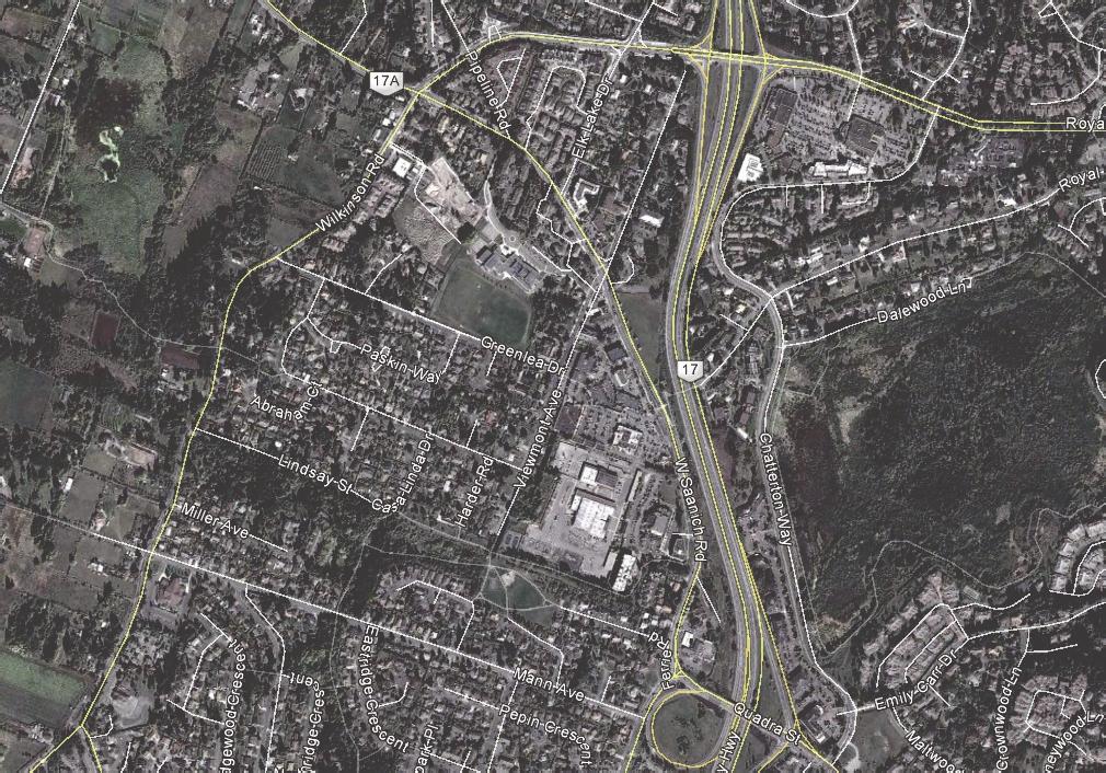
1 TECHNICAL MEMORANDUM DATE: September 10, 2014 PROJECT NO: PROJECT: Wilkinson Road Corridor Improvement Traffic Management Planning Project SUBJECT: Traffic Analysis TO: Steve Holroyd - District of Saanich FROM: Daniel Fung / Billy Dong / Sharon Lee Bunt & Associates As part of the Wilkinson Road Corridor Improvement Traffic Management Planning Project, Bunt & Associates has been tasked to recommend the optimal closure scenario, brought on by construction to improve Wilkinson Road between Mann Avenue and the Quick Bottom s Trail Connection, and also any necessary mitigation measures to best minimize the traffic impacts in the study area. With that, Bunt prepared this technical memorandum to summarize the traffic analysis work performed. This memorandum is separated into the following sections: 1. Data Collection; 2. Traffic Analysis Methodology; and 3. Conclusions & Recommendations. 1. DATA COLLECTION As part of the project, turning movement counts and road tube data count were provided by the District of Saanich at key study intersections while some intersection short counts were performed by Bunt & Associates. The following is a listing of count information received or collected during the AM and PM peak hours: Mann Avenue / Wilkinson Road (May 2014); Miller Road / Wilkinson Road (May 2014); Lindsay Street / Wilkinson Road (May 2014); Greenlea Drive / Wilkinson Road (May 2014); West Saanich Road / Wilkinson Road (May 2014); West Saanich Road / Elk Lake Drive (May 2014); West Saanich Road / Viewmont Avenue (May 2014);
2 West Saanich Road / Royal Oak Centre (May 2014); Mann Avenue / West Glanford Avenue (May 2014); Quadra Avenue / West Saanich Road (May 2014); Viaduct Avenue / Viewmont Avenue (May 2014); February Daily Traffic Information for Prospect Lake Road; and March / April Daily Traffic Information for Interurban Road. Utilizing Ministry of Transportation and Infrastructure (MOTI) permanent count station data (Station: Royal Oak P-11-2NS NY, Route 17, 0.5 km north of Quadra Street, Saanich) a seasonal traffic volume increase of 2% was applied to all the collected traffic counts to account for increase in traffic during the summer months. In addition to the above information, we had also received output from the Capital Regional District s (CRD) TransCAD regional model for the existing and closure conditions (further described in Section 2.1) as guidance for the analysis. Wilkinson Road Corridor Improvement Traffic Management Planning Project 2
3 2. TRAFFIC ANALYSIS METHODOLOGY 2.1 Closure Scenarios The District has proposed temporary closure scenarios on Wilkinson Road between Mann Avenue and Greenlea Drive when Wilkinson Road will be improved. In order to assess the feasibility of the closures from a traffic standpoint, the following scenarios were analyzed for both the AM and PM peak hours: Scenario 1: Wilkinson Road closed in the Northbound direction; Scenario 2: Wilkinson Road closed in the Southbound direction; and Scenario 3: Wilkinson Road closed in both direction (Full Closure). 2.2 Trip Re-assignment The closure or partial closure of Wilkinson Road will ultimately result in a traffic re-assignment for the road network. Bunt studied CRD s TransCAD regional model vehicle direction distributions for the existing and traffic closure scenarios, and reassigned / re-routed volumes accordingly based on existing traffic count information. Figure 2.1 and 2.2 below show the traffic volumes for the existing condition and the full closure scenario, which we assume full re-routing of traffic within the study network, respectively. Wilkinson Road Corridor Improvement Traffic Management Planning Project 3
4
5
6 2.3 Traffic Operations Analysis The existing operations of study area intersections and access points were assessed using the methods outlined in the 2000 Highway Capacity Manual (HCM) and was prepared using the Synchro 8.0 analysis software. The traffic operations were assessed using the Levels of Service (LOS) and Volume-to-Capacity (v/c) ratio measures of effectiveness. The LOS rating is based on average vehicle delay and ranges from A to F based on the quality of operation at the intersection. LOS A represents optimal, minimal delay conditions while a LOS F represents an over-capacity condition with considerable congestion and/or delay. Delay is calculated in seconds and is based on the average intersection delay per vehicle. The volume to capacity (v/c) ratio of an intersection represents ratio between the demand volume and the available capacity. Generally, a v/c ratio less than 0.85 indicate that there is sufficient capacity to accommodate demands and generally represents reasonable traffic conditions. A v/c value between 0.85 and 0.95 indicates an intersection is approaching practical capacity; a v/c ratio over 0.95 indicates that traffic demands are close to exceeding the available capacity, resulting in saturated conditions. A v/c ratio over 1.0 indicates a very congested intersection. For the purposes of construction traffic management, we have assumed a v/c ratio of 1.00 as the worst case acceptable. Wilkinson Road Corridor Improvement Traffic Management Planning Project 6
7 3. ANALYSIS RESULTS To outline our analysis results, the intersections of the existing conditions and the proposed closure conditions as outlined in Section 2.1, are analyzed. Note only critical intersections are reported. 3.1 Existing Conditions Table 2.1 summarizes the operational issues of the study network under existing conditions. Table 2.1 Operational Issues Existing Conditions Intersection Peak Period AM PM Wilkinson Road / West Saanich Road (Signalized) Eastbound left turn movement v/c = 1.2 Overall intersection approaching capacity at v/c = 0.99 Glanford Avenue / Quadra Street (Signalized) Overall westbound through movement approaching capacity v/c = 0.91 Overall westbound movements at LOS E/F and v/c 1.10 Glanford Avenue / Mann Avenue (Unsignalized) Eastbound movement LOS F and v/c = 1.03 (stop controlled) Eastbound movement LOS F and approach capacity at v/c = 0.95 (stop controlled) Using the existing conditions as a base-line, the above intersections pose near or above capacity operational conditions. These intersections were evaluated based on the available existing signal timing information as provided by the District. Some of these operational issues could be improved with optimizations to the signal timing plans where intersections are signalized. Of specific note, the eastbound Glanford Avenue / Mann Avenue unsignalized intersection is currently operating near or at capacity. With most of the closure scenarios below, this movement further deteriorates since this movement fosters the most (likely) attractive route. The SB movement on Glanford Avenue has a queue of 150m in the AM and 130m in the PM peak hours, which exceeds the length of the link. Wilkinson Road Corridor Improvement Traffic Management Planning Project 7
8 The Glanford Avenue / Quadra Street signalized intersection is nearing or at capacity with the WB queues on Quadra Street being about 155m long in the AM peak hour and 190m in the PM peak hour. Interurban Road is generally a corridor with a 2-lane cross-section in the near vicinity of the closure area. Reviewing the March / April daily count information through various sections (near Hector Road, Grange Road, and Columbine Way), the counts ranged between 9,000 and 12,300 vehicles per day. Based on experience from other corridors, these volumes could increase 10% during the summer months, and with that, the corridor would be at near capacity conditions. This is echoed by District staff indicating the corridor peaking at 12,000 14,000 vehicles per day with constraints at the intersections. With the general assumption that the average daily traffic volumes equate roughly 10% of the daily peak hour volumes, we estimate the corridor to have in the order of 200 vehicles per hour (combined both directions) reserve capacity. Prospect Lake Drive is generally a rural corridor with a 2-lane cross-section in the near vicinity of the closure area. Reviewing the February daily count information through various sections (near Munn Avenue, Viaduct Avenue, Deer Road, and Saanich Road), the counts ranged between 900 and 2,000 vehicles per day. As such, we expect there is reserve capacity available on this corridor even with potential 10-15% increases between general February and summer month counts. Based on MOTI traffic information, Highway 17, between the Highway 17A (Royal Oak Drive) Interchange and Quadra Street Interchange houses in the order of 60,000 vehicles per day during the summer months with a 4-laned cross section. The peak hour volumes reach in the order of 5,000 vehicles. Some reserve capacity is expected to be available on the highway. An approximate conservative expectation of highway capacity would be in the range of 1,500 vehicles / hour / lane under free flow conditions. 3.2 Scenario 1: Northbound Closure Scenario Signalized intersections for this scenario are assumed to be further optimized from the existing conditions. Table 2.2 summarizes the operational issues of the study network with the northbound direction closure. Wilkinson Road Corridor Improvement Traffic Management Planning Project 8
9 Table 2.2 Operational Issues Scenario 1: NB Closure Scenario Intersection Peak Period AM PM Wilkinson Road / West Saanich Road (Signalized) - Eastbound left movement approach capacity at v/c = 0.97 Glanford Avenue / Quadra Street (Signalized) Overall v/c = All movements approaching or at capacity. LOS Es for all movements. Overall v/c = All movements approaching or at capacity. LOS Es/Fs for all movements. Glanford Avenue / Mann Avenue (Unsignalized) Eastbound movement LOS F with excessive v/c ratio. Eastbound movement LOS F with excessive v/c ratio. Overall intersection LOS E. Although some movements for the Wilkinson Road / Saanich Road intersection approaches capacity, the re-routing of vehicles, due to the closure, will improve the intersection s overall performance from the existing conditions. The Glanford Avenue / Quadra Street intersection will be nearing or at-capacity with NBL turn queues (180m) on Glanford Avenue exceeding past the next intersection in both the AM and PM peak hours. The WB queues on Quadra Street will be approximately 160m long in the AM peak hour and 180m in the PM peak hour. The Glanford Avenue / Mann Avenue intersection eastbound movements will fail as a result of the stop control for the eastbound Mann Avenue approach. With the existing conditions already failing for this movement, the operations further deteriorate. Note it is expected a majority of the drivers will continue to utilize the Glanford Avenue / Mann Avenue intersection as part of detour routing and a large proportion re-routed of traffic is not expected to be feasible. Excessive queues will be created with the unsignalized configuration at this location where EBL turn movements will queue 1,290m in the AM and 880m in the PM peak periods. Also, the SB movements on Glanford Avenue will queue past the next intersection (120m) in the PM peak hour. Of note, signalization of Glanford Wilkinson Road Corridor Improvement Traffic Management Planning Project 9
10 Avenue / Mann Avenue at this intersection would yield acceptable results for this scenario. The SB movement on Glanford Avenue will have a queue of 130m in the AM peak hour and 200m in the PM peak hour, which exceeds the length of the link. With that, Mann Avenue is expected to foster an extra 390 / 290 vehicles during the AM / PM peak hour, while Interurban Road and Highway 17 is expected to foster an extra 70 / 100 vehicles and 80 / 125 vehicles during the AM / PM peak period, respectively. Should delay / congestion be worse than those depicted by the Highway 17 or Interurban Road traffic volumes, some traffic may choose to use Prospect Lake Road instead. 3.3 Scenario 2: Southbound Closure Scenario Note that the signals for these intersections were further optimized (timing) from existing conditions based on the re-routed volumes. Table 2.3 summarizes the operational issues of the study network with the southbound direction closed. Table 2.3 Operational Issues Scenario 2: SB Closed Intersection Peak Period AM PM Wilkinson Road / West Saanich Road (Signalized) - Eastbound left movement approach capacity at v/c = 0.92 Glanford Avenue / Quadra Street (Signalized) Northbound left turn movement approach capacity. Overall v/c = Some eastbound and westbound movements approaching capacity. Glanford Avenue / Mann Avenue (Unsignalized) Eastbound movement with excessive v/c ratio above capacity. Eastbound movement with excessive v/c ratio above capacity. Due to the re-routing of southbound vehicles accessing the West Saanich Road / Elk Lake Road intersection instead of the Wilkinson Road / West Saanich Road, the Wilkinson Road / West Saanich Wilkinson Road Corridor Improvement Traffic Management Planning Project 10
11 Road intersection improves in operations as compared to the existing conditions with manageable queues. The Glanford Avenue / Quadra Street intersection will be nearing or at capacity. The WB queues on Quadra Street will be approximately 100m long in the AM peak hour and 180m in the PM peak hour. The Glanford Avenue / Mann Avenue eastbound movements will fail as a result of the stop control for the eastbound Mann Avenue approach. With the existing conditions already failing for this movement, the operations will further deteriorate with the SB movements on Glanford Avenue queuing past the next intersection in both the AM peak hour (150m) and the PM peak hour (160m). Of note, signalization of Glanford Avenue / Mann Avenue will yield generally acceptable operations results for this scenario in terms of delay and v/c ratios. After signalization, the SB movement on Glanford Avenue will have a queue of 165m in the AM peak hour and 300m in the PM peak hour, which exceeds the length of the link. With that, Mann Avenue is expected to foster an extra 150 / 140 vehicles during the AM / PM peak hour, while Interurban Road and Highway 17 is expected to foster an extra 40 / 50 vehicles and 60 / 70 vehicles during the AM / PM peak period, respectively. We also tested additional laning options at the Glanford Road / Quadra Street and at the Glanford Road / Mann Avenue intersections. By including a southbound right turn lane (approximately 50m) at the Glanford Avenue / Mann Avenue intersection (and assuming the existing shared through and right turn lane will be a through only lane), the intersection operates acceptably with southbound queues to be in the order of 145m during the PM peak hour. Although queues still extend onto the next intersection (Quadra Street / Glanford Road), the queue will be reduced significantly as compared to existing laning configurations. Northbound improvements, either at the Glanford Avenue / Mann Avenue intersection or the Glanford Avenue / Quadra Street intersection only improves the intersections minimally. 3.4 Scenario 3: Full Closure Scenario Similar to the above two Scenarios, signalized intersections for Scenario 3 are assumed to be further optimized from the existing case. Table 2.4 summarizes the operational issues of the study network with both directions closed. Wilkinson Road Corridor Improvement Traffic Management Planning Project 11
12 Table 2.4 Operational Issues Scenario 3: Full Closure Intersection Peak Period AM PM Glanford Avenue / Quadra Street (Signalized) Overall v/c = All movements approaching or above capacity. Overall v/c = All movements approaching or above capacity. Glanford Avenue / Mann Avenue (Unsignalized) Eastbound movement LOS F with excessive v/c ratio capacity. Eastbound movement LOS F with excessive v/c ratio above capacity. Due to diversion of some of the Wilkinson Road / West Saanich Road intersection volumes to Elk Lake Road / West Saanich Road, the Wilkinson Road / West Saanich Road intersection will improve as compared to the existing conditions with manageable queues. The Glanford Avenue / Quadra Street intersection will be at the fringe of failure with NBL turn queues (180m) on Glanford Avenue exceeding past the next intersection in both the AM and PM peak hours. The WB queues on Quadra Street are about 160m long in the AM peak hour and 200m in the PM peak hour. This is expected based on the already near capacity operations during the existing conditions however, it must be noted that the general delay will be within acceptable levels. The Glanford Avenue / Mann Avenue intersection eastbound movements will fail as a result of the stop control for the eastbound Mann Avenue approach with the EBL turn movements will have a queue of approximately 1,160m in the AM and 1,190m in the PM peak periods. The SB movements on Glanford Avenue will have queues past the next intersection (140m) in the PM peak hour. The failure will be further emphasized with additional traffic from both northbound and southbound detour vehicle routing. With the detoured volumes, signalization of this intersection will still yield unfavorable results. Testing of additional laning options at the Glanford Road / Quadra Street intersection or at the Glanford Road / Mann Avenue intersections were conducted. By including a southbound right turn lane (approximately 50m) at the Glanford Avenue / Mann Avenue intersection (and assuming the existing shared through and right turn lane will be a through only lane), the intersection operates Wilkinson Road Corridor Improvement Traffic Management Planning Project 12
13 acceptably with southbound queues in the order of 150m. Although queues will still extend onto the next intersection (Quadra Street / Glanford Road), the queue will be reduced significantly as compared to existing laning configurations. Northbound improvements, either at the Glanford Avenue / Mann Avenue intersection or the Glanford Avenue / Quadra Street intersection only improves the intersections minimally. As further study (to the Glanford Avenue / Mann Avenue intersection), we further re-routed approximately 100 vehicles per hour (50 vehicles / hour for the eastbound left turn movement and 50 vehicles / hour for the southbound right turn movement) anticipating that commuters would redirect themselves to less congested routes once they have gotten used to traffic patterns during construction. With this further re-route of 100 vehicles, this signalized intersection will operate within acceptable manner. The SB movement on Glanford Avenue will have a queue of 190m in the AM and 300m in the PM, which exceeds the length of the link. Mann Avenue is expected to foster an extra 540 / 430 vehicles during the AM / PM peak hour, while Interurban Road and Highway 17 is expected to foster an extra 110 / 150 vehicles and 140 / 195 vehicles during the AM / PM peak period, respectively. Wilkinson Road Corridor Improvement Traffic Management Planning Project 13
14 4. CONCLUSIONS & RECOMMENDATIONS Under existing conditions, Glanford Avenue / Quadra Street and Glanford Avenue and Mann Avenue intersections are already approaching capacity. In order for the diverted traffic to operate within acceptable manner at the Glanford Avenue / Mann Avenue intersection, signalization is required. We expect a signal would cost in the order $150,000 to $250,000. Note that signalization analysis was conducted for Glanford Avenue / Mann Avenue to be on one controller or two separate controllers with Glanford Avenue / Quadra Avenue. It was found that the two intersections will need to be operated as two separate signals (coordinated if/where appropriate) in order to yield acceptable operations for the base case (existing conditions). The northbound closure scenario (Scenario 1) will create challenging operation conditions for both the AM and PM peak hours. Both the southbound closure scenario (Scenario 2) and the full closure scenario (Scenario 3) will be favorable options during construction with the southbound closure scenario producing the least overall impacts to the network as a whole. Wilkinson Road Corridor Improvement Traffic Management Planning Project 14
Downtown One Way Street Conversion Technical Feasibility Report
 Downtown One Way Street Conversion Technical Feasibility Report As part of the City s Transportation Master Plan, this report reviews the technical feasibility of the proposed conversion of the current
APPENDIX C1 TRAFFIC ANALYSIS DESIGN YEAR TRAFFIC ANALYSIS
 APPENDIX C1 TRAFFIC ANALYSIS DESIGN YEAR TRAFFIC ANALYSIS DESIGN YEAR TRAFFIC ANALYSIS February 2018 Highway & Bridge Project PIN 6754.12 Route 13 Connector Road Chemung County February 2018 Appendix
Clean Harbors Canada, Inc.
 Clean Harbors Canada, Inc. Proposed Lambton Landfill Expansion Environmental Assessment Terms of Reference Transportation Assessment St. Clair Township, Ontario September 2009 itrans Consulting Inc. 260
EXECUTIVE SUMMARY. The following is an outline of the traffic analysis performed by Hales Engineering for the traffic conditions of this project.
 EXECUTIVE SUMMARY This study addresses the traffic impacts associated with the proposed Shopko redevelopment located in Sugarhouse, Utah. The Shopko redevelopment project is located between 1300 East and
King Soopers #116 Thornton, Colorado
 Traffic Impact Study King Soopers #116 Thornton, Colorado Prepared for: Galloway & Company, Inc. T R A F F I C I M P A C T S T U D Y King Soopers #116 Thornton, Colorado Prepared for Galloway & Company
King County Metro. Columbia Street Transit Priority Improvements Alternative Analysis. Downtown Southend Transit Study. May 2014.
 King County Metro Columbia Street Transit Priority Improvements Alternative Analysis Downtown Southend Transit Study May 2014 Parametrix Table of Contents Introduction... 1 Methodology... 1 Study Area...
LAWRENCE TRANSIT CENTER LOCATION ANALYSIS 9 TH STREET & ROCKLEDGE ROAD / 21 ST STREET & IOWA STREET LAWRENCE, KANSAS
 LAWRENCE TRANSIT CENTER LOCATION ANALYSIS 9 TH STREET & ROCKLEDGE ROAD / 21 ST STREET & IOWA STREET LAWRENCE, KANSAS TRAFFIC IMPACT STUDY FEBRUARY 214 OA Project No. 213-542 TABLE OF CONTENTS 1. INTRODUCTION...
Date: February 7, 2017 John Doyle, Z-Best Products Robert Del Rio. T.E. Z-Best Traffic Operations and Site Access Analysis
 Memorandum Date: February 7, 07 To: From: Subject: John Doyle, Z-Best Products Robert Del Rio. T.E. Z-Best Traffic Operations and Site Access Analysis Introduction Hexagon Transportation Consultants, Inc.
V. DEVELOPMENT OF CONCEPTS
 Martin Luther King, Jr. Drive Extension FINAL Feasibility Study Page 9 V. DEVELOPMENT OF CONCEPTS Throughout the study process several alternative alignments were developed and eliminated. Initial discussion
Transit City Etobicoke - Finch West LRT
 Delcan Corporation Transit City Etobicoke - Finch West LRT APPENDIX D Microsimulation Traffic Modeling Report March 2010 March 2010 Appendix D CONTENTS 1.0 STUDY CONTEXT... 2 Figure 1 Study Limits... 2
TRAFFIC IMPACT ANALYSIS
 TRAFFIC IMPACT ANALYSIS Emerald Isle Commercial Development Prepared by SEPI Engineering & Construction Prepared for Ark Consulting Group, PLLC March 2016 I. Executive Summary A. Site Location The Emerald
Bennett Pit. Traffic Impact Study. J&T Consulting, Inc. Weld County, Colorado. March 3, 2017
 Bennett Pit Traffic Impact Study J&T Consulting, Inc. Weld County, Colorado March 3, 217 Prepared By: Sustainable Traffic Solutions, Inc. http://www.sustainabletrafficsolutions.com/ Joseph L. Henderson,
MEMO VIA . Ms. Amy Roth DPS Director, City of Three Rivers. To:
 MEMO To: Ms. Amy Roth DPS Director, City of Three Rivers VIA EMAIL From: Michael J. Labadie, PE Julie M. Kroll, PE, PTOE Brandon Hayes, PE, P.Eng. Fleis & VandenBrink Date: January 5, 2017 Re: Proposed
TRAFFIC IMPACT STUDY DERRY GREEN CORPORATE BUSINESS PARK MILTON SECONDARY PLAN MODIFICATION
 TRAFFIC IMPACT STUDY DERRY GREEN CORPORATE BUSINESS PARK MILTON SECONDARY PLAN MODIFICATION TRAFFIC IMPACT STUDY DERRY GREEN CORPORATE BUSINESS PARK MILTON SECONDARY PLAN MODIFICATION DECEMBER 24 UPDATED
To: File From: Adrian Soo, P. Eng. Markham, ON File: Date: August 18, 2015
 Memo To: From: Adrian Soo, P. Eng. Markham, ON : 165620021 Date: Reference: E.C. Row Expressway, Dominion Boulevard Interchange, Dougall Avenue Interchange, and Howard 1. Review of Interchange Geometry
APPENDIX E. Traffic Analysis Report
 APPENDIX E Traffic Analysis Report THIS PAGE INTENTIONALLY BLANK EAGLE RIVER TRAFFIC MITIGATION PHASE I OLD GLENN HIGHWAY/EAGLE RIVER ROAD INTERSECTION IMPROVEMENTS TRAFFIC ANALYSIS Eagle River, Alaska
MEMORANDUM. Figure 1. Roundabout Interchange under Alternative D
 MEMORANDUM Date: To: Liz Diamond, Dokken Engineering From: Subject: Dave Stanek, Fehr & Peers Western Placerville Interchanges 2045 Analysis RS08-2639 Fehr & Peers has completed a transportation analysis
Table 1 - Land Use Comparisons - Proposed King s Wharf Development. Retail (SF) Office (SF) 354 6,000 10, Land Uses 1
 Office (SF) 354 6,000 10, Land Uses 1") Ref. No. 171-6694 Phase 2 November 23, 217 Mr. David Quilichini, Vice President Fares & Co. Developments Inc. 31 Place Keelson Sales Centre DARTMOUTH NS B2Y C1 Sent Via Email to David@faresinc.com RE:
Ref. No. 171-6694 Phase 2 November 23, 217 Mr. David Quilichini, Vice President Fares & Co. Developments Inc. 31 Place Keelson Sales Centre DARTMOUTH NS B2Y C1 Sent Via Email to David@faresinc.com RE:
Memorandum. 1 Short List Analysis Background. James Hinkamp and Tony Coe, City of Lafayette Steering Committee
 To Copies James Hinkamp and Tony Coe, City of Lafayette Steering Committee Date August 26, 2016 Reference number 243381 From Mike Iswalt, Vanessa Peers, Will Baumgardner File reference 4-05 Subject Lafayette
Craig Scheffler, P.E., PTOE HNTB North Carolina, P.C. HNTB Project File: Subject
 TECHNICAL MEMORANDUM To Kumar Neppalli Traffic Engineering Manager Town of Chapel Hill From Craig Scheffler, P.E., PTOE HNTB North Carolina, P.C. Cc HNTB Project File: 38435 Subject Obey Creek TIS 2022
MILLERSVILLE PARK TRAFFIC IMPACT ANALYSIS ANNE ARUNDEL COUNTY, MARYLAND
 MILLERSVILLE PARK TRAFFIC IMPACT ANALYSIS ANNE ARUNDEL COUNTY, MARYLAND Prepared for: Department of Public Works Anne Arundel County Prepared by: URS Corporation 4 North Park Drive, Suite 3 Hunt Valley,
L1TILE BEARS DAY CARE TRANSPORTATION IMPACT STUDY FORT COLLINS, COLORADO MAY Prepared for:
 L1TILE BEARS DAY CARE TRANSPORTATION IMPACT STUDY FORT COLLINS, COLORADO MAY 2012 Prepared for: Hillside Construction, Inc. 216 Hemlock Street, Suite B Fort Collins, CO 80534 Prepared by: DELICH ASSOCIATES
TIMBERVINE TRANSPORTATION IMPACT STUDY FORT COLLINS, COLORADO JANUARY Prepared for:
 TIMBERVINE TRANSPORTATION IMPACT STUDY FORT COLLINS, COLORADO JANUARY 2014 Prepared for: Hartford Companies 1218 W. Ash Street Suite A Windsor, Co 80550 Prepared by: DELICH ASSOCIATES 2272 Glen Haven Drive
Traffic Impact Analysis 5742 BEACH BOULEVARD MIXED USE PROJECT
 Traffic Impact Analysis 5742 BEACH BOULEVARD MIXED USE PROJECT CITY OF BUENA PARK Prepared by Project No. 14139 000 April 17 th, 2015 DKS Associates Jeffrey Heald, P.E. Rohit Itadkar, T.E. 2677 North Main
APPENDIX G TRAFFIC STUDY TECHNICAL MEMORANDUM
 APPENDIX G TRAFFIC STUDY TECHNICAL MEMORANDUM TECHNICAL MEMORANDUM To: From: Date: Subject: Jerry Flores - AECOM Brian A. Marchetti, AICP September 9, 5 DRAFT Traffic Study LABOE Channel 5 Studio Relocation
Traffic Impact Analysis. Alliance Cole Avenue Residential Site Dallas, Texas. Kimley-Horn and Associates, Inc. Dallas, Texas.
 Traffic Impact Analysis Alliance Cole Avenue Residential Site Dallas, Texas February 15, 2018 Kimley-Horn and Associates, Inc. Dallas, Texas Project #064524900 Registered Firm F-928 Traffic Impact Analysis
Traffic Impact Analysis West Street Garden Plots Improvements and DuPage River Park Garden Plots Development Naperville, Illinois
 Traffic Impact Analysis West Street Garden Plots Improvements and DuPage River Park Garden Plots Development Naperville, Illinois Submitted by April 9, 2009 Introduction Kenig, Lindgren, O Hara, Aboona,
Trafalgar Road & Lower Base Line Transportation Study Ontario Inc.
 Trafalgar Road & Lower Base Line Transportation Study 1255723 Ontario Inc. Trafalgar Road & Lower Base Line Transportation Study 1255723 Ontario Inc. 1465 Pickering Parkway Suite 200 Pickering ON L1V 7G7
Escondido Marriott Hotel and Mixed-Use Condominium Project TRAFFIC IMPACT ANALYSIS REPORT
 Escondido Marriott Hotel and Mixed-Use Condominium Project TRAFFIC IMPACT ANALYSIS REPORT Prepared for Phelps Program Management 420 Sixth Avenue, Greeley, CO 80632 Prepared by 5050 Avenida Encinas, Suite
RTE. 1 at RTE. 637 & RTE. 639
 INTERSECTION SAFETY STUDY Prepared for: Virginia Department of Transportation Central Region Operations Traffic Engineering (UPC #81378, TO 12-092) DAVENPORT Project Number: 13-368 / /2014 RTE. 1 at RTE.
TRAFFIC DATA. Existing Derousse Ave./River Rd. AM LOS Analysis Existing Derousse Ave./River Rd. PM LOS Analysis
 Appendix E NJ TRANSIT Pennsauken Junction Transit Center and Park & Ride RiverLINE and Atlantic City Line Pennsauken Township, Camden County, New Jersey TRAFFIC DATA Background Traffic Information for
3.0 Future (2040) Transportation
 Transportation") 30 Future () Transportation Conditions Future traffic and structural bridge conditions within the I-84 Hartford Project Area have been analyzed to identify the needs and deficiencies which the Project
30 Future () Transportation Conditions Future traffic and structural bridge conditions within the I-84 Hartford Project Area have been analyzed to identify the needs and deficiencies which the Project
MEMO. McCORMICK RANKIN CORPORATION. File FROM: Keyur Shah DATE: February 1, 2010 COPIES: OUR FILE: SUBJECT: TO:
 McCORMICK RANKIN CORPORATION 2655 North Sheridan Way Mississauga, Ontario, L5K 2P8 Tel: (905)823-8500 Fax: (905) 823-8503 E-mail: mrc@mrc.ca Website: www.mrc.ca MEMO TO: File FROM: Keyur Shah DATE: February
Appendix H: Construction Impacts H-2 Transportation
 Appendix H: Construction Impacts H-2 Transportation \ AECOM 71 W. 23 rd Street New York, NY 10010 www.aecom.com 212 366 6200 tel 212 366 6214 fax Memorandum To CC Subject Robert Conway Donald Tone Construction
West Hills Shopping Centre Lowe s Expansion Traffic Impact Study
 West Hills Shopping Centre Lowe s Expansion Traffic Impact Study Prepared for: Armel Corporation January 2015 Paradigm Transportation Solutions Ltd. 22 King Street South, Suite 300 Waterloo ON N2J 1N8
Volume 1 Traffic Impact Analysis Turtle Creek Boulevard Dallas, Texas. Kimley-Horn and Associates, Inc. Dallas, Texas.
 Volume 1 Traffic Impact Analysis 2727 Dallas, Texas June 18, 2018 Kimley-Horn and Associates, Inc. Dallas, Texas Project #064523000 Registered Firm F-928 Traffic Impact Analysis 2727 Dallas, Texas Prepared
Oakbrook Village Plaza City of Laguna Hills
 Oakbrook Village Plaza City of Laguna Hills Traffic Impact Analysis Prepared by: HDR Engineering 3230 El Camino Real, Suite 200 Irvine, CA 92602 October 2012 Revision 3 D-1 Oakbrook Village Plaza Laguna
ZINFANDEL LANE / SILVERADO TRAIL INTERSECTION TRAFFIC ANALYSIS
 ZINFANDEL LANE / SILVERADO TRAIL INTERSECTION TRAFFIC ANALYSIS UPDATED TRAFFIC STUDY FOR THE PROPOSED RAYMOND VINEYARDS WINERY USE PERMIT MODIFICATION #P11-00156 AUGUST 5, 2014 PREPARED BY: OMNI-MEANS,
Section 5.0 Traffic Information
 Section 5.0 Traffic Information 10.0 TRANSPORTATION MDM Transportation Consultants, Inc. (MDM) has prepared an evaluation of transportation impacts for the proposed evaluation for the expansion of the
MEMO. McCORMICK RANKIN CORPORATION. File Mark VanderSluis, Keyur Shah DATE: October 26, 2009 COPIES: OUR FILE: TO: FROM: Jack Thompson
 McCORMICK RANKIN CORPORATION 2655 North Sheridan Way Mississauga, Ontario, L5K 2P8 Tel: (95)823-85 Fax: (95) 823-853 E-mail: mrc@mrc.ca Website: www.mrc.ca MEMO TO: FROM: File Mark VanderSluis, Keyur Shah
LCPS Valley Service Center
 Traffic Impact Study LCPS Valley Service Center Loudoun County, Virginia November 4, 2015 Prepared For: Loudoun County Public Schools 21000 Education Court Ashburn, VA 20148 Prepared by: 1140 Connecticut
INDUSTRIAL DEVELOPMENT
 INDUSTRIAL DEVELOPMENT Traffic Impact Study Plainfield, Illinois August 2018 Prepared for: Seefried Industrial Properties, Inc. TABLE OF CONTENTS Executive Summary 2 Introduction 3 Existing Conditions
HIGHWAY 28 FUNCTIONAL DESIGN
 HIGHWAY 28 FUNCTIONAL DESIGN PUBLIC OPEN HOUSE #1 WEDNESDAY, MARCH 12, 2014 Stantec Presenters: Brad Vander Heyden, Project Engineer Neal Cormack, Project Manager Dave Parker, Project Engineer Beth Thola,
Traffic Engineering Study
 Traffic Engineering Study Bellaire Boulevard Prepared For: International Management District Technical Services, Inc. Texas Registered Engineering Firm F-3580 November 2009 Executive Summary has been requested
Appendix H TRAFFIC IMPACT ANALYSIS
 Appendix H TRAFFIC IMPACT ANALYSIS Teichert Boca Quarry Expansion Traffic Impact Analysis Prepared for Teichert Aggregates Prepared by TRANSPORTATION CONSULTANTS, INC. LSC Transportation Consultants, Inc.
TRAFFIC IMPACT STUDY FOR SONIC DRIVE-IN RESTAURANT. Vallejo, CA. Prepared For:
 TRAFFIC IMPACT STUDY FOR SONIC DRIVE-IN RESTAURANT Vallejo, CA Prepared For: ELITE DRIVE-INS, INC. 2190 Meridian Park Blvd, Suite G Concord, CA 94520 Prepared By: KD Anderson & Associates 3853 Taylor Road,
Alpine Highway to North County Boulevard Connector Study
 Alpine Highway to North County Boulevard Connector Study prepared by Avenue Consultants March 16, 2017 North County Boulevard Connector Study March 16, 2017 Table of Contents 1 Summary of Findings... 1
The major roadways in the study area are State Route 166 and State Route 33, which are shown on Figure 1-1 and described below:
 3.5 TRAFFIC AND CIRCULATION 3.5.1 Existing Conditions 3.5.1.1 Street Network DRAFT ENVIRONMENTAL IMPACT REPORT The major roadways in the study area are State Route 166 and State Route 33, which are shown
Transportation & Traffic Engineering
 Transportation & Traffic Engineering 1) Project Description This report presents a summary of findings for a Traffic Impact Analysis (TIA) performed by A+ Engineering, Inc. for the Hill Country Family
INTERCHANGE OPERTIONS STUDY Interstate 77 / Wallings Road Interchange
 INTERCHANGE OPERTIONS STUDY Interstate 77 / Wallings Road Interchange City of Broadview Heights, Cuyahoga County, Ohio Prepared For: City of Broadview Heights Department of Engineering 9543 Broadview Road
Appendix C-5: Proposed Refinements Rail Operations and Maintenance Facility (ROMF) Traffic Impact Analysis. Durham-Orange Light Rail Transit Project
 Traffic Impact Analysis. Durham-Orange Light Rail Transit Project") Appendix C-5: Proposed Refinements Rail Operations and Maintenance Facility (ROMF) Traffic Impact Analysis Durham-Orange Light Rail Transit Project July 25, 218 ROMF Transportation Impact Analysis Version
Appendix C-5: Proposed Refinements Rail Operations and Maintenance Facility (ROMF) Traffic Impact Analysis Durham-Orange Light Rail Transit Project July 25, 218 ROMF Transportation Impact Analysis Version
Proposed Hotel and Restaurant Development
 Traffic Impact Study Proposed Hotel and Restaurant Development Marbledale Road Tuckahoe, NY PREPARED FOR BILLWIN DEVELOPMENT AFFILIATES, LLC 365 WHITE PLAINS ROAD EASTCHESTER, NY. 10709 PREPARED BY Engineering
Prepared For: Toronto Transit Commission 1138 Bathurst Street Toronto, Ontario M5R 3H2. Prepared By:
 TRAFFIC IMPACT STUDY FOR THE TTC MCNICOLL BUS GARAGE CITY OF TORONTO Prepared For: Toronto Transit Commission 1138 Bathurst Street Toronto, Ontario M5R 3H2 Prepared By: Canada Inc. 4th Floor, 3 Leek Crescent
Appendix B: Traffic Reports
 Appendix B: Traffic Reports 407 TRANSITWAY - KENNEDY ROAD TO BROCK ROAD MINISTRY OF TRANSPORTATION - CENTRAL REGION Report Markham Road Station Traffic Study Prepared for Ministry of Transportation, Ontario
Appendix 5. Haymeadow Interim Traffic Analysis
 Appendix 5 Haymeadow Interim Traffic Analysis 20 MEMORANDUM To: From: Rick Pylman Gary Brooks Bill Fox Date: September 15, 2016 Project: Subject: Haymeadow Evaluation of interim access configuration Currently
APPENDIX C-2. Traffic Study Supplemental Analysis Memo
 APPENDIX C-2 Traffic Study Supplemental Analysis Memo The Mobility Group Transportation Strategies & Solutions Memorandum To: From: Subject: Tomas Carranza, LADOT Matthew Simons Traffic Review - Revised
Project Advisory Committee
 Meredith US 3/NH 25 Improvements Transportation Planning Study Project Advisory Committee March 18, 2008 Meredith US 3/NH 25 Improvements Transportation Planning Study Meeting Agenda Welcome Traffic Model
Location Concept Plan Amendment Recommendation Approved 2011 Concept Plan
 Valley Line West LRT Concept Plan Recommended Amendments Lewis Farms LRT Terminus Site Location Concept Plan Amendment Recommendation Approved 2011 Concept Plan Lewis Farms LRT terminus site, 87 Avenue/West
HUMC/Mountainside Hospital Redevelopment Plan
 Traffic and Parking Analysis HUMC/Mountainside Hospital Redevelopment Plan in Glen Ridge Borough and Montclair Township PREPARED FOR H2M 119 Cherry Hill Road, Suite 110 Parsippany, NJ 07054 862.207.5900
Lacey Gateway Residential Phase 1
 Lacey Gateway Residential Phase Transportation Impact Study April 23, 203 Prepared for: Gateway 850 LLC 5 Lake Bellevue Drive Suite 02 Bellevue, WA 98005 Prepared by: TENW Transportation Engineering West
AVERAGE DELAY PER VEHICLE EXISTING CONDITIONS AND NO BUILD ALTERNATIVE
 AVERAGE DELAY PER VEHICLE EXISTING CONDITIONS AND NO BUILD ALTERNATIVE EXISTING CONDITIONS (1) NO BUILD ALTERNATIVE () Compared to existing conditions Peak Hour/Train Scenario No Train 1 With Train No
INTERSECTION CONTROL EVALUATION
 INTERSECTION CONTROL EVALUATION Trunk Highway 22 and CSAH 21 (E Hill Street/Shanaska Creek Road) Kasota, Le Sueur County, Minnesota November 2018 Trunk Highway 22 and Le Sueur CSAH 21 (E Hill Street/Shanaska
Traffic Feasibility Study
 Traffic Feasibility Study Town Center South Robbinsville Township, Mercer County, New Jersey December 19, 2017 Prepared For Robbinsville Township Department of Community Development 2298 Route 33 Robbinsville,
Ryan Coyne, PE City Engineer City of Rye 1051 Boston Post Road Rye, NY Boston Post Road Realignment and Roundabout Design Report
 March 6, 2015 Ryan Coyne, PE City Engineer City of Rye 1051 Boston Post Road Rye, NY 10580 RE: JMC Project 14108 Boston Post Road Roundabout Boston Post Road and Parsons Street City of Rye, NY Dear Ryan:
Traffic Assessment SUNY Buffalo School of Medicine & Biomedical Sciences TRAFFIC ASSESSMENT
 TRAFFIC ASSESSMENT University at Buffalo School of Medicine & Biomedical Sciences Buffalo Niagara Medical Campus Buffalo, NY Prepared for: State University Construction Fund 353 Broadway Albany, New York
MERIVALE PRIORITY SQUARE 2852 MERIVALE ROAD CITY OF OTTAWA TRANSPORTATION BRIEF. Prepared for: ONT Inc. 25 Winding Way Nepean, Ontario K2C 3H1
 MERIVALE PRIORITY SQUARE 2852 MERIVALE ROAD CITY OF OTTAWA TRANSPORTATION BRIEF Prepared for: 2190986ONT Inc. 25 Winding Way Nepean, Ontario K2C 3H1 October 6, 2010 110-502 Report_1.doc D. J. Halpenny
2.1.5 Traffic and Circulation. Table Level of Service Criteria for Highway Segment Regulatory Setting Affected Environment
 2.1.5 Traffic and Circulation This section addresses the potential impacts to traffic and circulation associated with construction and long-term operation of the proposed project. The traffic and circulation
Letter of Transmittal
 Letter of Transmittal To: Chris Lovell City of Richmond Hill Date: 5/2/6 Job 2582 Re: Richmond Hill-South Bryan County Transportation STudy WE ARE SENDING YOU THE FOLLOWING ITEMS ( attached) ( under separate
830 Main Street Halifax Regional Municipality
 830 Main Street Halifax Regional Municipality Traffic Impact Statement Final Report Prepared by: GRIFFIN transportation group inc. 30 Bonny View Drive Fall River, NS B2T 1R2 www.griffininc.ca Prepared
BERKELEY DOWNTOWN AREA PLAN PROGRAM ENVIRONMENTAL IMPACT REPORT TRAFFIC IMPACT ANALYSIS
 BERKELEY DOWNTOWN AREA PLAN PROGRAM ENVIRONMENTAL IMPACT REPORT TRAFFIC IMPACT ANALYSIS Prepared for: City of Berkeley Prepared by: REVISED JANUARY 9, 2009 Berkeley Downtown Area Plan Program EIR Traffic
Traffic Analysis for Bon Air Bridge Mitigation Magnolia Storm Water Quality Project
 Memo To: Paul DiDonato, ATI Architects and Engineers From: David Parisi, PE and Ashley Tam, EIT Date: February 23, 216 Subject: Traffic Analysis for Bon Air Bridge Mitigation Magnolia Storm Water Quality
Proposed location of Camp Parkway Commerce Center. Vicinity map of Camp Parkway Commerce Center Southampton County, VA
 Proposed location of Camp Parkway Commerce Center Vicinity map of Camp Parkway Commerce Center Southampton County, VA Camp Parkway Commerce Center is a proposed distribution and industrial center to be
Vanier Parkway and Presland Road Residential Development Transportation Impact Study
 Vanier Parkway and Presland Road Residential Development Transportation Impact Study Final Report (Revised) March 2011 Submitted to: Groupe Lépine Ottawa Project No. 09-1613 Submitted by: Groupe Lépine
Table of Contents INTRODUCTION... 3 PROJECT STUDY AREA Figure 1 Vicinity Map Study Area... 4 EXISTING CONDITIONS... 5 TRAFFIC OPERATIONS...
 Crosshaven Drive Corridor Study City of Vestavia Hills, Alabama Table of Contents INTRODUCTION... 3 PROJECT STUDY AREA... 3 Figure 1 Vicinity Map Study Area... 4 EXISTING CONDITIONS... 5 TRAFFIC OPERATIONS...
Lakeside Terrace Development
 Lakeside Terrace Development City of Barrie, County of Simcoe Traffic Brief for: Type of Document: Final Report Project Number: JDE 1617 Date Submitted: April 29 th, 216 4/29/16 John Northcote, P.Eng.
Traffic Impact Statement (TIS)
") Traffic Impact Statement (TIS) Vincentian PUDA Collier County, FL 10/18/2013 Prepared for: Global Properties of Naples Prepared by: Trebilcock Consulting Solutions, PA 2614 Tamiami Trail N, Suite 615 1205
Traffic Impact Statement (TIS) Vincentian PUDA Collier County, FL 10/18/2013 Prepared for: Global Properties of Naples Prepared by: Trebilcock Consulting Solutions, PA 2614 Tamiami Trail N, Suite 615 1205
Creditview Road Schedule C Class Environmental Assessment Traffic Operations Analysis Final Report
 Capability City of Mississauga Creditview Road Schedule C Class Environmental Assessment Traffic Operations Analysis Final Report Prepared by: AECOM 5080 Commerce Boulevard 905 238 0007 tel Mississauga,
TRAFFIC IMPACT ASSESSMENT PART OF AN ENVIRONMENTAL IMPACT ASSESSMENT FOR THE KEBRAFIELD ROODEPOORT COLLIERY IN THE PULLEN S HOPE AREA
 TRAFFIC IMPACT ASSESSMENT PART OF AN ENVIRONMENTAL IMPACT ASSESSMENT FOR THE KEBRAFIELD ROODEPOORT COLLIERY IN THE PULLEN S HOPE AREA 20 March 2014 Report prepared by: Corli Havenga Transportation Engineers
Traffic Impact Study for Proposed Olive Boulevard Development
 Traffic Impact Study for Proposed 11330 Olive Boulevard Development Creve Coeur, Missouri July 7, 2017 Prepared For: 11330 Olive Boulevard Development 11330 Olive Boulevard Creve Coeur, Missouri 63141
Quantitative analyses of weekday a.m. and p.m. commuter hour conditions have been conducted for the following five scenarios:
 6.1 TRANSPORTATION AND CIRCULATION 6.1.1 INTRODUCTION This section of the EIR presents the results of TJKM s traffic impact analysis of the proposed Greenbriar Development. The analysis includes consideration
APPENDIX B Traffic Analysis
 APPENDIX B Traffic Analysis Rim of the World Unified School District Reconfiguration Prepared for: Rim of the World School District 27315 North Bay Road, Blue Jay, CA 92317 Prepared by: 400 Oceangate,
Traffic Impact Study Speedway Gas Station Redevelopment
 Traffic Impact Study Speedway Gas Station Redevelopment Warrenville, Illinois Prepared For: Prepared By: April 11, 2018 Table of Contents 1. Introduction... 1 2. Existing Conditions... 4 Site Location...
Traffic Impact Analysis Update
 Willow Bend Traffic Impact Analysis Update TABLE OF CONTENTS Page I. INTRODUCTION -------------------------------------------------------------------------------------------- 1 II. EXISTING CONDITIONS
Regional Transportation System The regional transportation system is discussed in Chapter 5, Section 5.7.
 6.7 TRAFFIC 6.7.1 Affected Environment Regional Transportation System The regional transportation system is discussed in Chapter 5, Section 5.7. Local Transportation System The proposed Dillingham Trail
TRAFFIC AND TRANSPORTATION TECHNICAL MEMORANDUM
 TRAFFIC AND TRANSPORTATION TECHNICAL MEMORANDUM for ENVIRONMENTAL ASSESSMENT US 460 Bypass Interchange and Southgate Drive Relocation State Project No.: 0460-150-204, P101, R201, C501, B601; UPC 99425
BARRHAVEN FELLOWSHIP CRC 3058 JOCKVALE ROAD OTTAWA, ONTARIO TRANSPORTATION BRIEF. Prepared for:
 BARRHAVEN FELLOWSHIP CRC 3058 JOCKVALE ROAD OTTAWA, ONTARIO TRANSPORTATION BRIEF Prepared for: Barrhaven Fellowship CRC 3058 Jockvale Road Ottawa, ON K2J 2W7 December 7, 2016 116-649 Report_1.doc D. J.
Shirk Road at State Route 198 Interchange Analysis Tulare County, California
 Shirk Road at State Route 198 Interchange Analysis Tulare County, California DRAFT REPORT Prepared By Tulare County Association of Governments (TCAG) April 2013 Table of Contents Introduction:... 3 Project
Ref. No Task 3. April 28, Mr. Cesar Saleh, P. Eng. VP Planning and Design W.M. Fares Group th
 Ref. No. 151-00564 Task 3 April 28, 2015 Mr. Cesar Saleh, P. Eng. VP Planning and Design W.M. Fares Group th 3480 Joseph Howe Drive, 5 Floor HALIFAX NS B3L 4H7 Sent via Email to ceasr.saleh@wmfares.com
Provide an overview of the development proposal including projected site traffic volumes;
 December 19, 2013 File: 163600935 Attention: Troy Elliott Carl Elliott Limited 15-1831 Robertson Road PO Box 11117 Nepean, Ontario K1H 7T8 Dear Mr. Elliott, Reference: 2235 and 2265 Robertson Road Transportation
Table of Contents. Traffic Impact Analysis Capital One Building at Schilling Place
 Traffic Impact Analysis Capital One Building at Schilling Place Table of Contents Executive Summary... 1 1. Introduction... 4 2. Project Description... 4 3. Background Information... 4 4. Study Scope...
Traffic Impact Study Proposed Residential Development (Watson Parkway North - Starwood Drive Node, City of Guelph)
") Traffic Impact Study Proposed Residential Development (Watson Parkway North - Starwood Drive Node, City of Guelph) Prepared By: 332 Lorne Avenue East Stratford ON N5A 6S4 Prepared for: Paul Kemper, President
Traffic Impact Study Proposed Residential Development (Watson Parkway North - Starwood Drive Node, City of Guelph) Prepared By: 332 Lorne Avenue East Stratford ON N5A 6S4 Prepared for: Paul Kemper, President
TABLE OF CONTENTS SECTION PAGE. Executive Summary... xii
 TABLE OF CONTENTS SECTION PAGE Executive Summary... xii 1.0 Introduction... 1 1.1 Study Area... 2 1.2 Traffic Impact Analysis Scenarios... 4 1.3 Study Area - City of Orange... 4 2.0 Project Description
RESPONSE TO TRAFFIC IMPACT STUDY COMMENTS
 RESPONSE TO TRAFFIC IMPACT STUDY COMMENTS Proposed Gas Station 40 Arthur Street (Highway 26), Town of the Blue Mountains (Thornbury), County of Grey, Ontario AUGUST 2013 August 27, 2013 MR. REG RUSSWURM
One Harbor Point Residential
 Residential Gig Harbor, WA Transportation Impact Analysis January 23, 2017 Prepared for: Neil Walter Company PO Box 2181 Tacoma, WA 98401 Prepared by: TENW Transportation Engineering NorthWest 11400 SE
NEWCASTLE MIDDLE SCHOOL Traffic Impact Analysis
 Gibson Traffic Consultants 2802 Wetmore Avenue Suite 220 Everett, WA 98201 425.339.8266 NEWCASTLE MIDDLE SCHOOL Traffic Impact Analysis Prepared for: Renton School District Jurisdiction: City of Newcastle
Regional Transportation System The regional transportation system is discussed in Chapter 5, Section 5.7.
 6.7 TRAFFIC 6.7.1 Affected Environment Regional Transportation System The regional transportation system is discussed in Chapter 5, Section 5.7. Local Transportation System The proposed Dillingham Trail
Technical Feasibility Report
 Prepared For: Bow Concord I-93 Improvements Project Bow and Concord, NH Prepared By: 53 Regional Drive Concord, NH 03301 NHDOT Project # 13742 Federal Project #T-A000(018) September 2018 TABLE OF CONTENTS
Parks and Transportation System Development Charge Methodology
 City of Sandy Parks and Transportation System Development Charge Methodology March, 2016 Background In order to implement a City Council goal the City of Sandy engaged FCS Group in January of 2015 to update
City of Lafayette Agenda Downtown Congestion Reduction Plan Steering Committee
 City of Lafayette Agenda Downtown Congestion Reduction Plan Steering Committee Regular Meeting Date: Wednesday, August 31, 2016 Time: 7:00 p.m. Location: Lafayette City Offices Room 265 3675 Mount Diablo
RTID Travel Demand Modeling: Assumptions and Method of Analysis
 RTID Travel Demand Modeling: Assumptions and Method of Analysis Overall Model and Scenario Assumptions The Puget Sound Regional Council s (PSRC) regional travel demand model was used to forecast travel