APPENDIX G TRAFFIC STUDY TECHNICAL MEMORANDUM
|
|
|
- Corey Lang
- 5 years ago
- Views:
Transcription
1 APPENDIX G TRAFFIC STUDY TECHNICAL MEMORANDUM
2 TECHNICAL MEMORANDUM To: From: Date: Subject: Jerry Flores - AECOM Brian A. Marchetti, AICP September 9, 5 DRAFT Traffic Study LABOE Channel 5 Studio Relocation CEQA, Los Angeles KOA Project JB5 This traffic analysis was conducted to determine future levels of service with the proposed construction project at three study intersections. The proposed project includes the design and construction of a new digital television studio within the Merced Theatre (4 North Main Street) and Masonic Hall (46 North Main Street) in the El Pueblo de Los Angeles Historic District in the City of Los Angeles. In order to utilize the three-story Merced Theatre and two-story Masonic Hall for studio use, the proposed project would require extensive structural, mechanical, electrical, and plumbing system retrofits. The proposed project would also seismically retrofit the Pico House, which is attached to the Merced Theatre. Construction of the proposed Project is anticipated to begin in October 6 and be completed by December 7. The Project construction activities would generate approximately net new daily weekday trips, with approximately 6 net new a.m. peak-hour trips and 6 net new p.m. peak-hour trips. The proposed Project will not result in any permanent traffic impacts to the analyzed roadway facilities. INTRODUCTION This technical memorandum summarizes the results and findings of the traffic analysis conducted for the proposed Channel 5 Studio Relocation Project (hereinafter referred to as the Project ) to be located at the Merced Theatre (4 North Main Street) and the Masonic Hall (46 North Main Street) in the City of Los Angeles. The site is bordered by North Main Street to the west, the Pico House to the north, the Chinese American Museum to the east, and Arcadia Street to the south. All of the figures referenced in this report are provided in Attachment A. Figure illustrates the location of the Project site. Vehicular access would be provided via Sanchez Street, a private street extending easterly from Arcadia Street. Traffic Study LABOE Channel 5 Studio Relocation CEQA, Los Angeles Page Prepared for AECOM JB5 September 9, 5 DRAFT
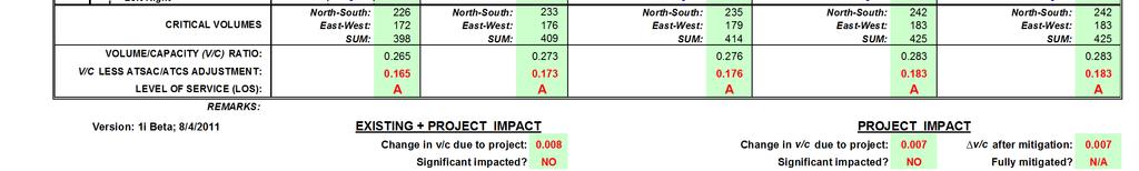
3 ANALYSIS METHODOLOGY The general methodology and assumptions contained in this technical memorandum are based on the Los Angeles Department of Transportation (LADOT) document entitled Traffic Study Policies and Procedures, published in May. According to the LADOT Traffic Study Policies and Procedures, a smaller technical memorandum report is required when a project is likely to add 5 to 4 peak-hour trips. The Project construction period activity is estimated to generate 6 net a.m. peak-hour trips and 6 net p.m. peak-hour trips. As such, a technical memorandum has been prepared for this Project. The Project study area includes the following three study intersections:. Main Street and Arcadia Street. Main Street and Aliso Street. Alameda Street and Los Angeles Street/Union Station Driveway The study intersection locations, with geographic reference to the Project site, are illustrated on Figure. The City of Los Angeles has designated the Critical Movement Analysis (CMA) methodology for the analysis of traffic operating conditions at signalized intersections. The concept of roadway level of service under the CMA method is based on the volume-to-capacity ratios for each approach movement (left turns, thru movements, right turns) and the sums of critical movements for the intersection. Critical movements are the highest-volume opposing and conflicting movements, such as the eastbound thru movement and the westbound left turn. These movements cannot proceed through the intersection at the same time, so one movement affects the other. The output from this method is a V/C ratio and a level of service for the intersection as a whole. Level of service (LOS) values range from LOS A to LOS F. LOS A indicates excellent operating conditions with little delay to motorists, whereas LOS F represents congested conditions with excessive vehicle delay. LOS E is typically defined as the operating capacity of a roadway. Table defines the level of service values applied to the study intersections. Traffic Study LADWP 99 th Street Chloramination Station, Los Angeles Page 5 Prepared for AECOM JB September, DRAFT
4 LOS A B C D Table Level of Service Definitions Interpretation Excellent operation. All approaches to the intersection appear quite open, turning movements are easily made, and nearly all drivers find freedom of operation. Very good operation. Many drivers begin to feel somewhat restricted within platoons of vehicles. This represents stable flow. An approach to an intersection may occasionally be fully utilized and traffic queues start to form. Good operation. Occasionally backups may develop behind turning vehicles. Most drivers feel somewhat restricted. Fair operation. There are no long-standing traffic queues. This level is typically associated with design practice for peak periods. Signalized Intersection Volume to Capacity Ratio (CMA) E Poor operation. Some long standing vehicular queues develop on critical approaches F Forced flow. Represents jammed conditions. Backups from locations downstream or on the cross street may restrict or prevent movements of vehicles out of the intersection approach lanes; therefore, volumes carried are not predictable. Potential for stop-and-go type traffic flow. Over. Source: Highway Capacity Manual, Special Report 9, Transportation Research Board, Washington D.C., and Interim Materials on Highway Capacity, NCHRP Circular, The study intersections are currently equipped with City of Los Angeles Automated Traffic Surveillance and Control (ATSAC) and Adaptive Traffic Control System (ATCS) functionality. For capacity analysis, LADOT policies provide for a.7 reduction in the V/C ratio with the implementation of ATSAC, and an additional. reduction with the implementation of ATCS. EXISTING CONDITIONS Local Roadway Characteristics The proposed Project would travel along Main Street, which has three travels lanes in one direction only. Onstreet parking and stopping is not permitted along Main Street in the study area. Arcadia Street, just south of the Project site, has three travel lanes in one direction only. The parking prohibitions exist on this roadway within the study area. Existing Traffic Counts KOA compiled manual intersection counts at the study intersections from the LADOT historical traffic count database. Intersection counts at the three intersections were conducted on Tuesday, March 8, 4, Tuesday, May, 4, and Tuesday, December,, respectively, for the 7: a.m. to : a.m. and : p.m. to 6: p.m. peak periods. Traffic Study LADWP 99 th Street Chloramination Station, Los Angeles Page 5 Prepared for AECOM JB September, DRAFT
5 The traffic counts were increased by one percent per year to reflect 5 conditions. The intersection traffic count sheets are included in Attachment B. Existing Levels of Service The results of the counts were utilized to determine existing a.m. and p.m. peak-hour traffic volume conditions. The existing level of service conditions were calculated based on the traffic count levels, intersection approach lanes, and signal phasing characteristics. Figure illustrates the existing study intersection approach lane and control configurations. As shown in Table, all of the study intersections are currently operating at LOS A during the a.m. and p.m. peak hours. Table Intersection Level of Service Existing (5) Conditions Study Intersections AM Peak PM Peak V/C LOS V/C LOS Main St & Arcadia St.6 A.78 A Main St & Aliso St.65 A.5 A Alameda St & Los Angeles St- Union Station Dwy LOS = Level of Service V/C = Volume-to-Capacity Ratio.7 A.56 A The existing intersection turn volumes are provided on Figures and 4 for the a.m. and p.m. peak hours, respectively. The level of service calculation worksheets for all analysis scenarios are provided in Attachment C. PROJECT TRAFFIC This section provides definitions for truck and employee vehicle trip generation during the peak period of project construction, along with the distribution and assignment of those trips to the study area roadway network. This is a planning-level analysis of construction activity, used for the purposes of determining LOS during the project construction period. Therefore, basic construction details defined for the project planning process have been used to analyze potential construction-period impacts. Project Trip Generation Methodology Project trip generation calculations included construction employee vehicle trips and construction truck trip estimates. The trip generation totals were determined based on the most intense period of construction activity for the project. In converting trucks to passenger car equivalents, a Passenger Car Equivalent (PCE) factor of.5 was assumed. This factoring was used to increase truck volumes due to the additional roadway space and design capacity utilized by larger and slower trucks. The applied value matches typical factors used in area studies that include trips Traffic Study LADWP 99 th Street Chloramination Station, Los Angeles Page 5 Prepared for AECOM JB September, DRAFT
6 generated by trucking activities. The factor is based on conservative factors defined by the Southern California Association of Governments (SCAG) Heavy Duty Truck Model. For construction, the maximum number of employees on the project site would be 6. The maximum number of daily trucks would be 5. Project Trip Generation Calculations In calculating peak-hour trips for the Project, it is estimated that approximately to construction personnel would be on-site per day. Additionally, approximately 5 to truck trips would occur per day to haul construction material and soil to and from the site. Approximately 7 cubic yards (CY) of materials would be hauled off-site during Project construction. Additionally, excavation of soil would occur approximately 4 feet deep with approximately, cubic feet of soil being excavated during ground disturbing activities. Project construction would occur Monday through Friday between the hours of 7: a.m. and 9: p.m., although daily construction would not likely occur after 6: p.m. Construction would occur between the hours of 8: a.m. and 6: p.m. on Saturdays and National Holidays. There would be no construction activities on Sundays and no construction would occur during prohibited hours. As indicated by Table, Project construction would generate a daily total of passenger car equivalent trips, with 6 (+) trips occurring during the a.m. peak hour and 6 (+) trips occurring during the p.m. peak hour. Table Project Trip Generation AM PEAK HOUR PM PEAK HOUR PEAK MONTH xx TRIP Truck Employee Total Truck Employee Total DAILY TRIPS GENERATION Trips* Trips Trips Trips* Trips Trips Trucks* Employee Total In Out In Out In Out In Out In Out In Out Consruction Personnel Truck Delivery 5-5 TOTAL TRIPS 5 6 * Truck trips include a Passenger Car Equivalency (PCE) factor of.5. Construction Project Trip Distribution The distribution of construction truck trips was assumed to be primarily freeway-oriented. Truck trips were primarily assigned to the US- freeway, on the south side of the study area. The distribution pattern for analyzed employee trips assumed that employees would arrive on-site primarily from the US- freeway. The regional trip distribution pattern is summarized below and illustrated on Figure 5. Traffic Study LADWP 99 th Street Chloramination Station, Los Angeles Page 5 Prepared for AECOM JB September, DRAFT
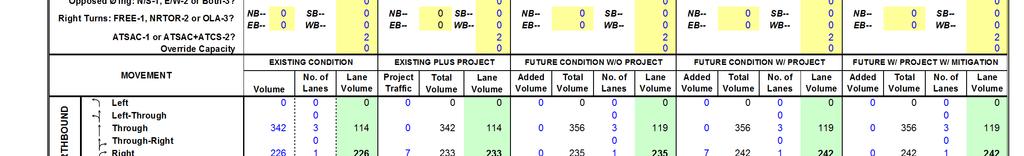
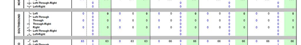
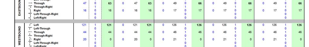
7 North 5% East 4% West 4% South % Based on the trip generation and distribution assumptions described above, the Project traffic was assigned to the roadway system based on the construction site access location and the roadways that would likely be used to access the regional highway system. The Project trip assignment is illustrated on Figures 6 and 7 for the a.m. and p.m. peak hours, respectively FUTURE 7 TRAFFIC CONDITIONS The following section summarizes traffic conditions at the study intersections under both future without-project and with-project scenarios. The year 7 was selected for analysis based on the anticipated completion of the construction of the proposed Project. Future without-project Conditions The future traffic forecasts include an ambient growth rate of two percent per year which was applied to the existing peak-hour counts. The rate is consistent with the generally applied traffic growth rate of one percent, doubled to account for planned local development projects. The future without-project level of service analysis was conducted for the three study intersections. As shown by the data in Table 4, all of study intersections would continue to operate at LOS A during the a.m. and p.m. peak hours. The future without-project traffic volumes are provided on Figures 8 and 9 for the weekday a.m. and p.m. peak hours, respectively. Table 4 Intersection Level of Service Future without Project Conditions Study Intersections AM Peak PM Peak V/C LOS V/C LOS Main St & Arcadia St.49 A.97 A Main St & Aliso St.76 A.7 A Alameda St & Los Angeles St- Union Station Dwy LOS = Level of Service V/C = Volume-to-Capacity Ratio.4 A.5 A Traffic Study LADWP 99 th Street Chloramination Station, Los Angeles Page 5 Prepared for AECOM JB September, DRAFT
8 Future with-project Conditions The Project trip assignment pattern defined by Figures 6 and 7 was added to the future without-project traffic forecasts to estimate future with-project traffic volumes. Figures and provide the future with Project traffic volumes for the weekday a.m. and p.m. peak hours, respectively. The future with-project level of service analysis results are summarized in Table 5. All of the study intersections would continue to operate at LOS A during the a.m. and p.m. peak hours. Table 5 Intersection Level of Service Future with Project Conditions Study Intersections AM Peak PM Peak V/C LOS V/C LOS Main St & Arcadia St.5 A.44 A Main St & Aliso St.8 A.7 A Alameda St & Los Angeles St- Union Station Dwy LOS = Level of Service V/C = Volume-to-Capacity Ratio.5 A.5 A PROJECT TRAFFIC IMPACTS Construction of the proposed Project will not result in any permanent traffic impacts to area roadway facilities. The new employment levels at the Project site are expected to be low, and trips during the operations period would be less than those identified for the construction period. As such, permanent physical or operations improvements to the analyzed study intersections are not required, based on the applied LADOT impact standards. Based on results of the traffic analysis, there does not appear to be a need for manual traffic control along haul routes, or area detours, during the construction period. Caltrans should be contacted to obtain permits for the transport of over-sized loads, to obtain encroachment permits, if necessary. CONCLUSIONS Construction of the proposed Project will not create any significant impacts on the area circulation network. Once the project site is operational, the new employment levels at the Project site are expected to be low, and trips during the operations period would be less than those identified for the construction period. The City of Los Angeles will require construction worksite traffic control plans, to minimize the effects on roadway operations in the vicinity of the construction site and its access point. The Project will not generate any new measurable and regular vehicle trips during the operations period, and long-term mitigation measures are therefore not recommended. Traffic Study LADWP 99 th Street Chloramination Station, Los Angeles Page 5 Prepared for AECOM JB September, DRAFT
9 ATTACHMENT A STUDY FIGURES Figure Project Study Area Figure Intersection Lane Configurations and Controls Figure Existing AM Peak Hour Traffic Volumes Figure 4 Existing PM Peak Hour Traffic Volumes Figure 5 Project Trip Distribution Percentages Figure 6 Project Trip Assignment AM Peak Hour Traffic Volumes Figure 7 Project Trip Assignment PM Peak Hour Traffic Volumes Figure 8 Future (7) Without Project AM Peak Hour Traffic Volumes Figure 9 Future (7) Without Project PM Peak Hour Traffic Volumes Figure Future (7) With Project AM Peak Hour Traffic Volumes Figure Future (7) With Project PM Peak Hour Traffic Volumes Traffic Study LABOE Channel 5 Studio Relocation CEQA, Los Angeles Prepared for AECOM September 9, 5 DRAFT Attachments JB5
10 LEGEND Project Location # Study Intersections LABOE Channel 5 Studio Relocation I Figure Project Study Area
11 S S S # S STOP LEGEND Project Location Study Intersection Signalized Intersection Unsignalized Intersection Intersection Lane Configuration I LABOE Channel 5 Studio Relocation Figure Intersection Lane Configurations and Controls
12 LEGEND Project Location ## XX Study Intersection Intersection Volumes I LABOE Channel 5 Studio Relocation Figure Existing AM Peak Hour Traffic Volumes
13 LEGEND Project Location ## XX Study Intersection Intersection Volumes I LABOE Channel 5 Studio Relocation Figure 4 Existing PM Peak Hour Traffic Volumes
14 % % % % 9% % % % % % % % % % % 7% % % % LEGEND Project Location ## XX% Study Intersection Distribution Percentages I LABOE Channel 5 Studio Relocation Figure 5 Project Trip Distribution Percentages
15 7 7 LEGEND Project Location ## XX Study Intersection Intersection Volumes I LABOE Channel 5 Studio Relocation Figure 6 Project Trip Assignment - AM Peak Hour Traffic Volumes
16 4 LEGEND Project Location ## XX Study Intersection Intersection Volumes I LABOE Channel 5 Studio Relocation Figure 7 Project Trip Assignment - PM Peak Hour Traffic Volumes
17 LEGEND Project Location ## XX Study Intersection Intersection Volumes I LABOE Channel 5 Studio Relocation Figure 8 Future (7) without Project - AM Peak Hour Traffic Volumes
18 LEGEND Project Location ## XX Study Intersection Intersection Volumes I LABOE Channel 5 Studio Relocation Figure 9 Future (7) without Project - PM Peak Hour Traffic Volumes
19 LEGEND Project Location ## XX Study Intersection Intersection Volumes I LABOE Channel 5 Studio Relocation Figure Future (7) with Project - AM Peak Hour Traffic Volumes
20 LEGEND Project Location ## XX Study Intersection Intersection Volumes I LABOE Channel 5 Studio Relocation Figure Future (7) with Project - PM Peak Hour Traffic Volumes
21 ATTACHMENT B INTERSECTION TRAFFIC COUNTS Traffic Study LABOE Channel 5 Studio Relocation CEQA, Los Angeles Prepared for AECOM September 9, 5 DRAFT Attachments JB5
22 PM AM AM PM INTERSECTION TURNING MOVEMENT COUNTS PREPARED BY: AimTD LLC tel: pacific@aimtd.com DATE: LOCATION: China Town PROJECT #: SC5 Tue, Mar 8, 4 NORTH & SOUTH: Main LOCATION #: 5 EAST & WEST: CONTROL: SIGNAL NOTES: Arcadia AM PM N MD W E OTHER S OTHER NORTHBOUND SOUTHBOUND EASTBOUND WESTBOUND U-TURNS Main Main Arcadia Arcadia NL NT NR SL ST SR EL ET ER WL WT WR TOTAL NB SB EB WB TTL LANES: X X X X X X X X X X X X 7: AM :5 AM : AM :45 AM : AM :5 AM : AM :45 AM : AM :5 AM : AM :45 AM VOLUMES , 4,84 APPROACH % % 9% % % % % % % % % 97% % APP/DEPART,5 /,47 / 8 / 8,6 /,9 BEGIN PEAK HR 8:5 AM VOLUMES 7,99 4,497 APPROACH % % 9% % % % % % % % % 96% 4% PEAK HR FACTOR APP/DEPART 57 / 6 / /,4 /,6 : PM :5 PM : PM :45 PM : PM :5 PM : PM :45 PM : PM :5 PM : PM :45 PM VOLUMES 86,75,57 4,769 APPROACH % 9% 9% % % % % % % % % 87% % APP/DEPART, /,946 / /,758 /,8 BEGIN PEAK HR 5: PM VOLUMES 99, 596 5, APPROACH % 7% 9% % % % % % % % % 85% 5% PEAK HR FACTOR APP/DEPART,49 /,45 / / 7 / 695 Main NORTH SIDE Arcadia WEST SIDE EAST SIDE Arcadia ALL PED AND BIKE SOUTH SIDE Main PEDESTRIAN CROSSINGS BICYCLE CROSSINGS SCHOOL AGE PED N SIDE S SIDE E SIDE W SIDE TOTAL N SIDE S SIDE E SIDE W SIDE TOTAL NS SS ES WS TOTAL NS SS ES WS TOTAL 7: AM :5 AM : AM :45 AM : AM :5 AM : AM :45 AM : AM :5 AM : AM :45 AM TOTAL : PM :5 PM : PM :45 PM : PM :5 PM : PM :45 PM : PM :5 PM : PM :45 PM TOTAL
23 AM PM INTERSECTION TURNING MOVEMENT COUNTS PREPARED BY: AimTD LLC tel: pacific@aimtd.com DATE: LOCATION: China town PROJECT #: SC76 Tue, May, 4 NORTH & SOUTH: Main LOCATION #: EAST & WEST: CONTROL: SIGNAL NOTES: Aliso AM PM N MD W E OTHER S OTHER NORTHBOUND SOUTHBOUND EASTBOUND WESTBOUND U-TURNS Main Main Aliso Aliso NL NT NR SL ST SR EL ET ER WL WT WR TOTAL NB SB EB WB TTL LANES: X X X X X X X X X X X X 7: AM :5 AM : AM :45 AM : AM :5 AM : AM :45 AM : AM :5 AM : AM :45 AM VOLUMES ,94,8 APPROACH % % 6% 9% % % % 4% 86% % % % % APP/DEPART,444 /,78 /,88 /,754 / BEGIN PEAK HR 9: AM VOLUMES ,74 APPROACH % % 6% 4% % % % 4% 86% % % % % PEAK HR FACTOR APP/DEPART 56 / 48 / 5 / 666 / : PM :5 PM : PM :45 PM : PM :5 PM : PM :45 PM : PM :5 PM : PM :45 PM VOLUMES,99,8 9,648 5,94 APPROACH % % 7% 7% % % % % 9% % % % % APP/DEPART 4,99 /,84 /,84 /,756 / BEGIN PEAK HR 4:45 PM VOLUMES, ,77 APPROACH % % 79% % % % % % 9% % % % % PEAK HR FACTOR APP/DEPART,755 /,45 / 6 / 96 / Main NORTH SIDE Aliso WEST SIDE EAST SIDE Aliso SOUTH SIDE Main

24 City Of Los Angeles Department Of Transportation MANUAL TRAFFIC COUNT SUMMARY STREET: North/South East/West ALAMEDA ST. LOS ANGELES ST./UNION STATION DRWY. Day: TUESDAY Date: December, Weather: SUNNY Hours: 7-AM -5PM Chekrs: BD KL JC School Day: YES District: CENTRAL I/S CODE 5869 N/B S/B E/B W/B DUAL- WHEELED BIKES BUSES 4 7 N/B TIME S/B TIME E/B TIME W/B TIME AM PK 5 MIN PM PK 5 MIN AM PK HOUR PM PK HOUR NORTHBOUND Approach SOUTHBOUND Approach TOTAL XING S/L XING N/L Hours Lt Th Rt Total Hours Lt Th Rt Total N-S Ped Sch Ped Sch TOTAL TOTAL EASTBOUND Approach WESTBOUND Approach TOTAL XING W/L XING E/L Hours Lt Th Rt Total Hours Lt Th Rt Total E-W Ped Sch Ped Sch TOTAL 88 TOTAL (Rev Oct 6)
25 ATTACHMENT C LEVEL OF SERVICE WORKSHEETS Traffic Study LABOE Channel 5 Studio Relocation CEQA, Los Angeles Prepared for AECOM September 9, 5 DRAFT Attachments JB5
26
27
28
29
30
31
APPENDIX B Traffic Analysis
 APPENDIX B Traffic Analysis Rim of the World Unified School District Reconfiguration Prepared for: Rim of the World School District 27315 North Bay Road, Blue Jay, CA 92317 Prepared by: 400 Oceangate,
Winnetka Avenue Bike Lanes Traffic Impact Analysis
 Winnetka Avenue Bike Lanes Traffic Impact Analysis January 4, 2019 Prepared by City of Los Angeles Department of Transportation Active Transportation Division Winnetka Ave Bike Lanes Traffic Impact Analysis
Table Existing Traffic Conditions for Arterial Segments along Construction Access Route. Daily
 5.8 TRAFFIC, ACCESS, AND CIRCULATION This section describes existing traffic conditions in the project area; summarizes applicable regulations; and analyzes the potential traffic, access, and circulation
Bennett Pit. Traffic Impact Study. J&T Consulting, Inc. Weld County, Colorado. March 3, 2017
 Bennett Pit Traffic Impact Study J&T Consulting, Inc. Weld County, Colorado March 3, 217 Prepared By: Sustainable Traffic Solutions, Inc. http://www.sustainabletrafficsolutions.com/ Joseph L. Henderson,
EXECUTIVE SUMMARY. The following is an outline of the traffic analysis performed by Hales Engineering for the traffic conditions of this project.
 EXECUTIVE SUMMARY This study addresses the traffic impacts associated with the proposed Shopko redevelopment located in Sugarhouse, Utah. The Shopko redevelopment project is located between 1300 East and
Date: February 7, 2017 John Doyle, Z-Best Products Robert Del Rio. T.E. Z-Best Traffic Operations and Site Access Analysis
 Memorandum Date: February 7, 07 To: From: Subject: John Doyle, Z-Best Products Robert Del Rio. T.E. Z-Best Traffic Operations and Site Access Analysis Introduction Hexagon Transportation Consultants, Inc.
Traffic Impact Analysis for 2171 Rosecrans Avenue
 Traffic Impact Analysis for 2171 Rosecrans Avenue Prepared for: Continental Development Corporation Revised May 2016 LA16-2831 Prepared by: Fehr & Peers 600 Wilshire Blvd, Suite 1050 Los Angeles, CA 90017
IV. ENVIRONMENTAL IMPACT ANALYSIS B. TRAFFIC AND CIRCULATION
 IV. ENVIRONMENTAL IMPACT ANALYSIS B. TRAFFIC AND CIRCULATION 1. INTRODUCTION This section is based on the technical report, Traffic Study for 10131 Constellation Boulevard Residential Project, prepared
MILLERSVILLE PARK TRAFFIC IMPACT ANALYSIS ANNE ARUNDEL COUNTY, MARYLAND
 MILLERSVILLE PARK TRAFFIC IMPACT ANALYSIS ANNE ARUNDEL COUNTY, MARYLAND Prepared for: Department of Public Works Anne Arundel County Prepared by: URS Corporation 4 North Park Drive, Suite 3 Hunt Valley,
PROJECT: Wilkinson Road Corridor Improvement Traffic Management Planning Project SUBJECT: Traffic Analysis
 TECHNICAL MEMORANDUM DATE: September 10, 2014 PROJECT 5861.03 NO: PROJECT: Wilkinson Road Corridor Improvement Traffic Management Planning Project SUBJECT: Traffic Analysis TO: Steve Holroyd - District
ZINFANDEL LANE / SILVERADO TRAIL INTERSECTION TRAFFIC ANALYSIS
 ZINFANDEL LANE / SILVERADO TRAIL INTERSECTION TRAFFIC ANALYSIS UPDATED TRAFFIC STUDY FOR THE PROPOSED RAYMOND VINEYARDS WINERY USE PERMIT MODIFICATION #P11-00156 AUGUST 5, 2014 PREPARED BY: OMNI-MEANS,
Traffic Impact Analysis 5742 BEACH BOULEVARD MIXED USE PROJECT
 Traffic Impact Analysis 5742 BEACH BOULEVARD MIXED USE PROJECT CITY OF BUENA PARK Prepared by Project No. 14139 000 April 17 th, 2015 DKS Associates Jeffrey Heald, P.E. Rohit Itadkar, T.E. 2677 North Main
Traffic Engineering Study
 Traffic Engineering Study Bellaire Boulevard Prepared For: International Management District Technical Services, Inc. Texas Registered Engineering Firm F-3580 November 2009 Executive Summary has been requested
TRAFFIC IMPACT ANALYSIS
 TRAFFIC IMPACT ANALYSIS Emerald Isle Commercial Development Prepared by SEPI Engineering & Construction Prepared for Ark Consulting Group, PLLC March 2016 I. Executive Summary A. Site Location The Emerald
MEMORANDUM. Figure 1. Roundabout Interchange under Alternative D
 MEMORANDUM Date: To: Liz Diamond, Dokken Engineering From: Subject: Dave Stanek, Fehr & Peers Western Placerville Interchanges 2045 Analysis RS08-2639 Fehr & Peers has completed a transportation analysis
Traffic Impact Study Speedway Gas Station Redevelopment
 Traffic Impact Study Speedway Gas Station Redevelopment Warrenville, Illinois Prepared For: Prepared By: April 11, 2018 Table of Contents 1. Introduction... 1 2. Existing Conditions... 4 Site Location...
Clean Harbors Canada, Inc.
 Clean Harbors Canada, Inc. Proposed Lambton Landfill Expansion Environmental Assessment Terms of Reference Transportation Assessment St. Clair Township, Ontario September 2009 itrans Consulting Inc. 260
IV. ENVIRONMENTAL IMPACT ANALYSIS N. TRANSPORTATION AND TRAFFIC
 IV. ENVIRONMENTAL IMPACT ANALYSIS N. TRANSPORTATION AND TRAFFIC The following section summarizes the information provided in the traffic report entitled Traffic Impact Analysis for a Proposed Residential
4.7 Construction Surface Transportation
 4.7 Construction Surface Transportation 4.7.1 Introduction The traffic analysis presented in this section addresses the construction traffic impacts specific to the proposed Project. The construction traffic
4.7 Construction Surface Transportation
 4.7.1 Introduction The traffic analysis presented in this section addresses the construction traffic impacts specific to the proposed Project. The construction traffic impacts were analyzed for both the
3.8 TRANSPORTATION, CIRCULATION AND PARKING
 3.8 TRANSPORTATION, CIRCULATION AND PARKING This section provides an overview of traffic, circulation and parking impacts and evaluates the construction and operational impacts associated with the Proposed
Traffic Analysis for Bon Air Bridge Mitigation Magnolia Storm Water Quality Project
 Memo To: Paul DiDonato, ATI Architects and Engineers From: David Parisi, PE and Ashley Tam, EIT Date: February 23, 216 Subject: Traffic Analysis for Bon Air Bridge Mitigation Magnolia Storm Water Quality
The major roadways in the study area are State Route 166 and State Route 33, which are shown on Figure 1-1 and described below:
 3.5 TRAFFIC AND CIRCULATION 3.5.1 Existing Conditions 3.5.1.1 Street Network DRAFT ENVIRONMENTAL IMPACT REPORT The major roadways in the study area are State Route 166 and State Route 33, which are shown
King Soopers #116 Thornton, Colorado
 Traffic Impact Study King Soopers #116 Thornton, Colorado Prepared for: Galloway & Company, Inc. T R A F F I C I M P A C T S T U D Y King Soopers #116 Thornton, Colorado Prepared for Galloway & Company
MERIVALE PRIORITY SQUARE 2852 MERIVALE ROAD CITY OF OTTAWA TRANSPORTATION BRIEF. Prepared for: ONT Inc. 25 Winding Way Nepean, Ontario K2C 3H1
 MERIVALE PRIORITY SQUARE 2852 MERIVALE ROAD CITY OF OTTAWA TRANSPORTATION BRIEF Prepared for: 2190986ONT Inc. 25 Winding Way Nepean, Ontario K2C 3H1 October 6, 2010 110-502 Report_1.doc D. J. Halpenny
Section 5.8 Transportation and Traffic
 Section 5.8 Transportation and Traffic 5.8 TRANSPORTATION AND TRAFFIC Generous This Section is based on the Topgolf Specific Plan Traffic Impact Analysis (RK Engineering Group, Inc., October 31, 2016);
BARRHAVEN FELLOWSHIP CRC 3058 JOCKVALE ROAD OTTAWA, ONTARIO TRANSPORTATION BRIEF. Prepared for:
 BARRHAVEN FELLOWSHIP CRC 3058 JOCKVALE ROAD OTTAWA, ONTARIO TRANSPORTATION BRIEF Prepared for: Barrhaven Fellowship CRC 3058 Jockvale Road Ottawa, ON K2J 2W7 December 7, 2016 116-649 Report_1.doc D. J.
LAWRENCE TRANSIT CENTER LOCATION ANALYSIS 9 TH STREET & ROCKLEDGE ROAD / 21 ST STREET & IOWA STREET LAWRENCE, KANSAS
 LAWRENCE TRANSIT CENTER LOCATION ANALYSIS 9 TH STREET & ROCKLEDGE ROAD / 21 ST STREET & IOWA STREET LAWRENCE, KANSAS TRAFFIC IMPACT STUDY FEBRUARY 214 OA Project No. 213-542 TABLE OF CONTENTS 1. INTRODUCTION...
APPENDIX A LEVEL OF SERVICE CONCEPTS, ANALYSIS METHODOLOGIES,STANDARDS OF SIGNIFICANCE
 APPENDIX A LEVEL OF SERVICE CONCEPTS, ANALYSIS METHODOLOGIES,STANDARDS OF SIGNIFICANCE Roadway Segment Level of Service Definitions LOS V/C Congestion/Delay Traffic Description (Used for surface streets,
Appendix J Traffic Impact Study
 MRI May 2012 Appendix J Traffic Impact Study Level 2 Traffic Assessment Limited Impact Review Appendix J [This page was left blank intentionally.] www.sgm-inc.com Figure 1. Site Driveway and Trail Crossing
TRAFFIC DATA. Existing Derousse Ave./River Rd. AM LOS Analysis Existing Derousse Ave./River Rd. PM LOS Analysis
 Appendix E NJ TRANSIT Pennsauken Junction Transit Center and Park & Ride RiverLINE and Atlantic City Line Pennsauken Township, Camden County, New Jersey TRAFFIC DATA Background Traffic Information for
December 5, Red Bank Planning Board Municipal Building 90 Monmouth Street Red Bank, NJ 07701
 Dynamic Traffic, LLC www.dynamic-traffic.com 1904 Main Street Lake Como, NJ 07719 T. 732.681.0760 December 5, 2016 Red Bank Planning Board Municipal Building 90 Monmouth Street Red Bank, NJ 07701 Re: Traffic
Appendix C-5: Proposed Refinements Rail Operations and Maintenance Facility (ROMF) Traffic Impact Analysis. Durham-Orange Light Rail Transit Project
 Traffic Impact Analysis. Durham-Orange Light Rail Transit Project") Appendix C-5: Proposed Refinements Rail Operations and Maintenance Facility (ROMF) Traffic Impact Analysis Durham-Orange Light Rail Transit Project July 25, 218 ROMF Transportation Impact Analysis Version
Appendix C-5: Proposed Refinements Rail Operations and Maintenance Facility (ROMF) Traffic Impact Analysis Durham-Orange Light Rail Transit Project July 25, 218 ROMF Transportation Impact Analysis Version
2.0 Development Driveways. Movin Out June 2017
 Movin Out June 2017 1.0 Introduction The proposed Movin Out development is a mixed use development in the northeast quadrant of the intersection of West Broadway and Fayette Avenue in the City of Madison.
TRAFFIC IMPACT STUDY DERRY GREEN CORPORATE BUSINESS PARK MILTON SECONDARY PLAN MODIFICATION
 TRAFFIC IMPACT STUDY DERRY GREEN CORPORATE BUSINESS PARK MILTON SECONDARY PLAN MODIFICATION TRAFFIC IMPACT STUDY DERRY GREEN CORPORATE BUSINESS PARK MILTON SECONDARY PLAN MODIFICATION DECEMBER 24 UPDATED
4.11 TRANSPORTATION AND CIRCULATION
 4.11 TRANSPORTATION AND CIRCULATION This section analyzes onsite development s impacts to the local transportation and circulation system. The analysis is based upon the traffic study prepared by KOA Corporation
County State Aid Highway 32 (Cliff Road) and Dodd Road Intersection Study
 and Dodd Road Intersection Study") County State Aid Highway 32 (Cliff Road) and Dodd Road Intersection Study City of Eagan, Dakota County, Minnesota Date: March 2012 Project No. 14957.000 444 Cedar Street, Suite 1500 Saint Paul, MN 55101
County State Aid Highway 32 (Cliff Road) and Dodd Road Intersection Study City of Eagan, Dakota County, Minnesota Date: March 2012 Project No. 14957.000 444 Cedar Street, Suite 1500 Saint Paul, MN 55101
Alpine Highway to North County Boulevard Connector Study
 Alpine Highway to North County Boulevard Connector Study prepared by Avenue Consultants March 16, 2017 North County Boulevard Connector Study March 16, 2017 Table of Contents 1 Summary of Findings... 1
2. Valley Circle Boulevard/Andora Avenue/Baden Avenue and Lassen Street
 IV.J TRANSPORTATION 1. INTRODUCTION This section presents an overview of the existing traffic and circulation system in and surrounding the project site. This section also discusses the potential impacts
IRSCH REEN Hirsch/Green Transportation Consulting, Inc.
 IRSCH REEN Hirsch/Green Transportation Consulting, Inc. February 6, 2013 Mr. David Weil Director of Finance St. Matthew s Parish School 1031 Bienveneda Avenue Pacific Palisades, California 90272 RE: Trip
Appendix G Traffic and Parking Report
 Appendix G Traffic and Parking Report TABLE OF CONTENTS SECTION PAGE Executive Summary... v 1.0 Introduction... 1 1.1 Study Area... 3 2.0 Project Description... 4 2.1 Site Location... 4 2.2 Existing Project
APPENDIX C1 TRAFFIC ANALYSIS DESIGN YEAR TRAFFIC ANALYSIS
 APPENDIX C1 TRAFFIC ANALYSIS DESIGN YEAR TRAFFIC ANALYSIS DESIGN YEAR TRAFFIC ANALYSIS February 2018 Highway & Bridge Project PIN 6754.12 Route 13 Connector Road Chemung County February 2018 Appendix
Section 5.0 Traffic Information
 Section 5.0 Traffic Information 10.0 TRANSPORTATION MDM Transportation Consultants, Inc. (MDM) has prepared an evaluation of transportation impacts for the proposed evaluation for the expansion of the
IV. ENVIRONMENTAL IMPACT ANALYSIS J. TRANSPORTATION AND TRAFFIC
 IV. ENVIRONMENTAL IMPACT ANALYSIS J. TRANSPORTATION AND TRAFFIC This Section summarizes the information provided in the Traffic Study for the Santa Monica College Bundy Campus Master Plan (Traffic Study),
Oakbrook Village Plaza City of Laguna Hills
 Oakbrook Village Plaza City of Laguna Hills Traffic Impact Analysis Prepared by: HDR Engineering 3230 El Camino Real, Suite 200 Irvine, CA 92602 October 2012 Revision 3 D-1 Oakbrook Village Plaza Laguna
MEMO VIA . Ms. Amy Roth DPS Director, City of Three Rivers. To:
 MEMO To: Ms. Amy Roth DPS Director, City of Three Rivers VIA EMAIL From: Michael J. Labadie, PE Julie M. Kroll, PE, PTOE Brandon Hayes, PE, P.Eng. Fleis & VandenBrink Date: January 5, 2017 Re: Proposed
Proposed location of Camp Parkway Commerce Center. Vicinity map of Camp Parkway Commerce Center Southampton County, VA
 Proposed location of Camp Parkway Commerce Center Vicinity map of Camp Parkway Commerce Center Southampton County, VA Camp Parkway Commerce Center is a proposed distribution and industrial center to be
Transportation & Traffic Engineering
 Transportation & Traffic Engineering 1) Project Description This report presents a summary of findings for a Traffic Impact Analysis (TIA) performed by A+ Engineering, Inc. for the Hill Country Family
Appendix Q Traffic Study
 Appendices Appendix Q Traffic Study Crummer Site Subdivision Draft EIR City of Malibu Appendices This page intentionally left blank. The Planning Center April 2013 TRAFFIC IMPACT ANALYSIS Photo z here
Appendix B Traffic Impact Analysis, Asphalt Plant No. 1 Replacement and Modernization
 Appendix B Traffic Impact Analysis, Asphalt Plant No. 1 Replacement and Modernization REPORT Traffic Impact Analysis, Asphalt Plant No. 1 Replacement and Modernization Prepared for City of Los Angeles
IV. REVISIONS TO THE DRAFT IS/MND
 IV. REVISIONS TO THE DRAFT IS/MND 1. REVISIONS TO THE DRAFT IS/MND This section presents corrections and clarifications that have been made to the text of the Draft IS/MND. These changes include revisions
INDUSTRIAL DEVELOPMENT
 INDUSTRIAL DEVELOPMENT Traffic Impact Study Plainfield, Illinois August 2018 Prepared for: Seefried Industrial Properties, Inc. TABLE OF CONTENTS Executive Summary 2 Introduction 3 Existing Conditions
Section 3.12 Traffic and Transportation
 Section. Traffic and Transportation SECTION SUMMARY This section describes existing ground transportation within the Port and surrounding area associated with implementation of the proposed Project. An
D & B COMMERCIAL TRAFFIC IMPACT ANALYSIS
 D & B COMMERCIAL TRAFFIC IMPACT ANALYSIS TABLE OF CONTENTS I. Introduction...3 II. Project Description...3 III. Existing Conditions...3 IV. Future Traffic Conditions...8 V. Conclusions and Mitigation...14
One Harbor Point Residential
 Residential Gig Harbor, WA Transportation Impact Analysis January 23, 2017 Prepared for: Neil Walter Company PO Box 2181 Tacoma, WA 98401 Prepared by: TENW Transportation Engineering NorthWest 11400 SE
TIMBERVINE TRANSPORTATION IMPACT STUDY FORT COLLINS, COLORADO JANUARY Prepared for:
 TIMBERVINE TRANSPORTATION IMPACT STUDY FORT COLLINS, COLORADO JANUARY 2014 Prepared for: Hartford Companies 1218 W. Ash Street Suite A Windsor, Co 80550 Prepared by: DELICH ASSOCIATES 2272 Glen Haven Drive
Table of Contents. Traffic Impact Analysis Capital One Building at Schilling Place
 Traffic Impact Analysis Capital One Building at Schilling Place Table of Contents Executive Summary... 1 1. Introduction... 4 2. Project Description... 4 3. Background Information... 4 4. Study Scope...
Appendix B Traffic Impact Analysis, Asphalt Plant No. 1 Replacement and Modernization
 Appendix B Traffic Impact Analysis, Asphalt Plant No. 1 Replacement and Modernization DRAFT REPORT Traffic Impact Analysis, Asphalt Plant No. 1 Replacement and Modernization Prepared for City of Los Angeles
Traffic Impact Analysis. Alliance Cole Avenue Residential Site Dallas, Texas. Kimley-Horn and Associates, Inc. Dallas, Texas.
 Traffic Impact Analysis Alliance Cole Avenue Residential Site Dallas, Texas February 15, 2018 Kimley-Horn and Associates, Inc. Dallas, Texas Project #064524900 Registered Firm F-928 Traffic Impact Analysis
Traffic Impact Analysis Update
 Willow Bend Traffic Impact Analysis Update TABLE OF CONTENTS Page I. INTRODUCTION -------------------------------------------------------------------------------------------- 1 II. EXISTING CONDITIONS
County State Aid Highway 30 (Diffley Road) and Dodd Road Intersection Study
 and Dodd Road Intersection Study") County State Aid Highway 30 (Diffley Road) and Dodd Road Intersection Study City of Eagan, Dakota County, Minnesota Date: March 2012 Project No. 14957.000 444 Cedar Street, Suite 1500 Saint Paul, MN 55101
County State Aid Highway 30 (Diffley Road) and Dodd Road Intersection Study City of Eagan, Dakota County, Minnesota Date: March 2012 Project No. 14957.000 444 Cedar Street, Suite 1500 Saint Paul, MN 55101
TRAFFIC IMPACT ANALYSIS FOR. McDONALD S RESTAURANT IN CARMICAEL Sacramento County, CA. Prepared For:
 TRAFFIC IMPACT ANALYSIS FOR McDONALD S RESTAURANT IN CARMICAEL Sacramento County, CA Prepared For: McDonald s USA, LLC Pacific Sierra Region 2999 Oak Road, Suite 900 Walnut Creek, CA 94597 Prepared By:
4.14 TRANSPORTATION AND CIRCULATION
 4.14 TRANSPORTATION AND CIRCULATION 4.14.1 Summary Table 4.14-1 summarizes the identified environmental impacts, proposed mitigation measures, and residual impacts of the proposed project with regard to
Volume 1 Traffic Impact Analysis Turtle Creek Boulevard Dallas, Texas. Kimley-Horn and Associates, Inc. Dallas, Texas.
 Volume 1 Traffic Impact Analysis 2727 Dallas, Texas June 18, 2018 Kimley-Horn and Associates, Inc. Dallas, Texas Project #064523000 Registered Firm F-928 Traffic Impact Analysis 2727 Dallas, Texas Prepared
Craig Scheffler, P.E., PTOE HNTB North Carolina, P.C. HNTB Project File: Subject
 TECHNICAL MEMORANDUM To Kumar Neppalli Traffic Engineering Manager Town of Chapel Hill From Craig Scheffler, P.E., PTOE HNTB North Carolina, P.C. Cc HNTB Project File: 38435 Subject Obey Creek TIS 2022
Lacey Gateway Residential Phase 1
 Lacey Gateway Residential Phase Transportation Impact Study April 23, 203 Prepared for: Gateway 850 LLC 5 Lake Bellevue Drive Suite 02 Bellevue, WA 98005 Prepared by: TENW Transportation Engineering West
DEVELOPMENT PROPERTY 1627 MAXIME STREET CITY OF OTTAWA TRANSPORTATION OVERVIEW. Prepared for: Subhas Bhargava. July 9, Overview_1.
 DEVELOPMENT PROPERTY 1627 MAXIME STREET CITY OF OTTAWA TRANSPORTATION OVERVIEW Prepared for: Subhas Bhargava July 9, 2015 115-620 Overview_1.doc D. J. Halpenny & Associates Ltd. Consulting Transportation
Ryan Coyne, PE City Engineer City of Rye 1051 Boston Post Road Rye, NY Boston Post Road Realignment and Roundabout Design Report
 March 6, 2015 Ryan Coyne, PE City Engineer City of Rye 1051 Boston Post Road Rye, NY 10580 RE: JMC Project 14108 Boston Post Road Roundabout Boston Post Road and Parsons Street City of Rye, NY Dear Ryan:
IV. ENVIRONMENTAL IMPACT ANALYSIS L. TRANSPORTATION/TRAFFIC
 IV. ENVIRONMENTAL IMPACT ANALYSIS L. TRANSPORTATION/TRAFFIC INTRODUCTION The following section summarizes the information provided in the traffic report entitled Traffic Impact Analysis for a Proposed
Appendix H TRAFFIC IMPACT ANALYSIS
 Appendix H TRAFFIC IMPACT ANALYSIS Teichert Boca Quarry Expansion Traffic Impact Analysis Prepared for Teichert Aggregates Prepared by TRANSPORTATION CONSULTANTS, INC. LSC Transportation Consultants, Inc.
Traffic Feasibility Study
 Traffic Feasibility Study Town Center South Robbinsville Township, Mercer County, New Jersey December 19, 2017 Prepared For Robbinsville Township Department of Community Development 2298 Route 33 Robbinsville,
The key roadways in the project vicinity are described below. Exhibit displays the existing number of lanes on the study roadways.
 4.2 TRAFFIC AND CIRCULATION This section presents the key assumptions, methods, and results of analysis for the transportation and circulation impacts of the proposed project. This section is based on
Shirk Road at State Route 198 Interchange Analysis Tulare County, California
 Shirk Road at State Route 198 Interchange Analysis Tulare County, California DRAFT REPORT Prepared By Tulare County Association of Governments (TCAG) April 2013 Table of Contents Introduction:... 3 Project
Appendix C. Traffic Impact Study
 Appendix C Traffic Impact Study TRAFFIC STUDY FOR THE EAGLE ROCK AGGREGATE TERMINAL Prepared by: FEHR & PEERS 201 Santa Monica Blvd. Suite 500 Santa Monica, CA 90401-2213 T. (310) 458-9916 F. (310) 394-7663
TRANSPORTATION STUDY FOR THE 8899 BEVERLY BOULEVARD PROJECT
 DRAFT TRANSPORTATION STUDY FOR THE 8899 BEVERLY BOULEVARD PROJECT WEST HOLLYWOOD, CALIFORNIA NOVEMBER 2013 PREPARED FOR BEVERLY BOULEVARD ASSOCIATION PREPARED BY DRAFT TRANSPORTATION STUDY FOR THE 8899
TRAFFIC IMPACT STUDY FOR SONIC DRIVE-IN RESTAURANT. Vallejo, CA. Prepared For:
 TRAFFIC IMPACT STUDY FOR SONIC DRIVE-IN RESTAURANT Vallejo, CA Prepared For: ELITE DRIVE-INS, INC. 2190 Meridian Park Blvd, Suite G Concord, CA 94520 Prepared By: KD Anderson & Associates 3853 Taylor Road,
TABLE OF CONTENTS SECTION PAGE. Executive Summary... xii
 TABLE OF CONTENTS SECTION PAGE Executive Summary... xii 1.0 Introduction... 1 1.1 Study Area... 2 1.2 Traffic Impact Analysis Scenarios... 4 1.3 Study Area - City of Orange... 4 2.0 Project Description
TALMONT TOWNHOMES MADISON KENNETH SPA TRAFFIC IMPACT STUDY. Sacramento, CA. Prepared For: MBK Homes. Prepared By:
 TALMONT TOWNHOMES MADISON KENNETH SPA TRAFFIC IMPACT STUDY Sacramento, CA Prepared For: MBK Homes Prepared By: KD Anderson & Associates 3853 Taylor Road, Suite G Loomis, California 95650 (916) 660-1555
King County Metro. Columbia Street Transit Priority Improvements Alternative Analysis. Downtown Southend Transit Study. May 2014.
 King County Metro Columbia Street Transit Priority Improvements Alternative Analysis Downtown Southend Transit Study May 2014 Parametrix Table of Contents Introduction... 1 Methodology... 1 Study Area...
Downtown One Way Street Conversion Technical Feasibility Report
 Downtown One Way Street Conversion Technical Feasibility Report As part of the City s Transportation Master Plan, this report reviews the technical feasibility of the proposed conversion of the current
Vanier Parkway and Presland Road Residential Development Transportation Impact Study
 Vanier Parkway and Presland Road Residential Development Transportation Impact Study Final Report (Revised) March 2011 Submitted to: Groupe Lépine Ottawa Project No. 09-1613 Submitted by: Groupe Lépine
APPENDIX E. Traffic Analysis Report
 APPENDIX E Traffic Analysis Report THIS PAGE INTENTIONALLY BLANK EAGLE RIVER TRAFFIC MITIGATION PHASE I OLD GLENN HIGHWAY/EAGLE RIVER ROAD INTERSECTION IMPROVEMENTS TRAFFIC ANALYSIS Eagle River, Alaska
Traffic Impact Analysis West Street Garden Plots Improvements and DuPage River Park Garden Plots Development Naperville, Illinois
 Traffic Impact Analysis West Street Garden Plots Improvements and DuPage River Park Garden Plots Development Naperville, Illinois Submitted by April 9, 2009 Introduction Kenig, Lindgren, O Hara, Aboona,
Appendix H: Construction Impacts H-2 Transportation
 Appendix H: Construction Impacts H-2 Transportation \ AECOM 71 W. 23 rd Street New York, NY 10010 www.aecom.com 212 366 6200 tel 212 366 6214 fax Memorandum To CC Subject Robert Conway Donald Tone Construction
APPENDIX H. Transportation Impact Study
 APPENDIX H Transportation Impact Study BUENA VISTA LAGOON ENHANCEMENT PROJECT TRANSPORTATION IMPACT STUDY Prepared for: San Diego Association of Governments Prepared by: VRPA Technologies, Inc. 9520 Padgett
RESPONSE TO TRAFFIC IMPACT STUDY COMMENTS
 RESPONSE TO TRAFFIC IMPACT STUDY COMMENTS Proposed Gas Station 40 Arthur Street (Highway 26), Town of the Blue Mountains (Thornbury), County of Grey, Ontario AUGUST 2013 August 27, 2013 MR. REG RUSSWURM
Creditview Road Schedule C Class Environmental Assessment Traffic Operations Analysis Final Report
 Capability City of Mississauga Creditview Road Schedule C Class Environmental Assessment Traffic Operations Analysis Final Report Prepared by: AECOM 5080 Commerce Boulevard 905 238 0007 tel Mississauga,
Escondido Marriott Hotel and Mixed-Use Condominium Project TRAFFIC IMPACT ANALYSIS REPORT
 Escondido Marriott Hotel and Mixed-Use Condominium Project TRAFFIC IMPACT ANALYSIS REPORT Prepared for Phelps Program Management 420 Sixth Avenue, Greeley, CO 80632 Prepared by 5050 Avenida Encinas, Suite
Transit City Etobicoke - Finch West LRT
 Delcan Corporation Transit City Etobicoke - Finch West LRT APPENDIX D Microsimulation Traffic Modeling Report March 2010 March 2010 Appendix D CONTENTS 1.0 STUDY CONTEXT... 2 Figure 1 Study Limits... 2
Table of Contents INTRODUCTION... 3 PROJECT STUDY AREA Figure 1 Vicinity Map Study Area... 4 EXISTING CONDITIONS... 5 TRAFFIC OPERATIONS...
 Crosshaven Drive Corridor Study City of Vestavia Hills, Alabama Table of Contents INTRODUCTION... 3 PROJECT STUDY AREA... 3 Figure 1 Vicinity Map Study Area... 4 EXISTING CONDITIONS... 5 TRAFFIC OPERATIONS...
V. DEVELOPMENT OF CONCEPTS
 Martin Luther King, Jr. Drive Extension FINAL Feasibility Study Page 9 V. DEVELOPMENT OF CONCEPTS Throughout the study process several alternative alignments were developed and eliminated. Initial discussion
Appendix C. Traffic Study
 Appendix C Traffic Study TABLE OF CONTENTS SECTION Executive Summary PAGE 1.0 Introduction... 1 1.1 Scope of Work... 1 1.2 Study Area... 2 2.0 Project Description... 3 2.1 Site Access... 4 2.2 Pedestrian
L1TILE BEARS DAY CARE TRANSPORTATION IMPACT STUDY FORT COLLINS, COLORADO MAY Prepared for:
 L1TILE BEARS DAY CARE TRANSPORTATION IMPACT STUDY FORT COLLINS, COLORADO MAY 2012 Prepared for: Hillside Construction, Inc. 216 Hemlock Street, Suite B Fort Collins, CO 80534 Prepared by: DELICH ASSOCIATES
MINERVA PARK SITE TRAFFIC IMPACT STUDY M/I HOMES. September 2, 2015
 5500 New Albany Road Columbus, Ohio 43054 Phone: 614.775.4500 Fax: 614.775.4800 Toll Free: 1-888-775-EMHT emht.com 2015-1008 MINERVA PARK SITE TRAFFIC IMPACT STUDY M/I HOMES September 2, 2015 Engineers
APPENDIX C-2. Traffic Study Supplemental Analysis Memo
 APPENDIX C-2 Traffic Study Supplemental Analysis Memo The Mobility Group Transportation Strategies & Solutions Memorandum To: From: Subject: Tomas Carranza, LADOT Matthew Simons Traffic Review - Revised
TRANSPORTATION 1. INTRODUCTION
 IV.F TRANSPORTATION 1. INTRODUCTION This section evaluates potential impacts associated with Project-related traffic, circulation, and access. The analysis summarizes the findings of the traffic study
INTERSECTION ANALYSIS PARK AVENUE AND BRADDOCK ROAD (FROSTBURG, MD) FOR LENHART TRAFFIC CONSULTING, INC.
 FOR LENHART TRAFFIC CONSULTING, INC.") INTERSECTION ANALYSIS FOR PARK AVENUE AND BRADDOCK ROAD (FROSTBURG, MD) Prepared for: City of Frostburg, Maryland & Allegany County Commissioners Prepared by: LENHART TRAFFIC CONSULTING, INC. TRAFFIC ENGINEERING
INTERSECTION ANALYSIS FOR PARK AVENUE AND BRADDOCK ROAD (FROSTBURG, MD) Prepared for: City of Frostburg, Maryland & Allegany County Commissioners Prepared by: LENHART TRAFFIC CONSULTING, INC. TRAFFIC ENGINEERING
D R A F T TRAFFIC IMPACT ANALYSIS FOR. DARK HORSE GOLF RESORT EXPANSION Nevada County, CA. Prepared For:
 D R A F T TRAFFIC IMPACT ANALYSIS FOR DARK HORSE GOLF RESORT EXPANSION Nevada County, CA Prepared For: ASIAN PACIFIC GROUP 18000 Van Karman Avenue, Suite 500 Irvine, CA 92612 Prepared By: KD Anderson &
Proposed CVS/pharmacy
 Traffic Impact and Access Study Proposed CVS/pharmacy West Main Street (Route 1) at Hull Street Clinton, Connecticut PREPARED FOR Arista Development LLC 520 Providence Highway, Suite 9 Norwood, Massachusetts
105 Toronto Street South, Markdale Transportation Impact Study. Paradigm Transportation Solutions Limited
 105 Toronto Street South, Markdale Transportation Impact Study Paradigm Transportation Solutions Limited December 2016 Project Summary Project Number 162060 December 2016 Client Zelinka Priamo Ltd 318