BERKELEY DOWNTOWN AREA PLAN PROGRAM ENVIRONMENTAL IMPACT REPORT TRAFFIC IMPACT ANALYSIS
|
|
|
- Kory Mosley
- 5 years ago
- Views:
Transcription

1 BERKELEY DOWNTOWN AREA PLAN PROGRAM ENVIRONMENTAL IMPACT REPORT TRAFFIC IMPACT ANALYSIS Prepared for: City of Berkeley Prepared by: REVISED JANUARY 9, 2009
2 Berkeley Downtown Area Plan Program EIR Traffic Impact Analysis TABLE OF CONTENTS EXECUTIVE SUMMARY INTRODUCTION REPORT SECTIONS PROJECT DESCRIPTION TRANSPORTATION ANALYSIS METHODOLOGY FUTURE TRAFFIC FORECASTING METHODOLOGY TRAFFIC ANALYSIS DETERMINATION OF SIGNIFICANCE EXISTING TRANSPORTATION CONDITIONS NON-MOTORIZED TRANSPORTATION TRANSIT TRAFFIC PARKING FUTURE TRANSPORTATION CONDITIONS WITHOUT THE PROPOSED PROJECT YEAR 2030 BASELINE NON-MOTORIZED TRANSPORTATION TRANSIT TRAFFIC PARKING TRIP GENERATION FUTURE TRANSPORTATION CONDITIONS WITH PROPOSED PROJECT NON-MOTORIZED TRANSPORTATION TRANSIT TRAFFIC PARKING GRADE CROSSINGS CALTRANS/CONGESTION MANAGEMENT PROGRAM ANALYSIS PEDESTRIAN AND BICYCLE SAFETY CONSISTENCY WITH LOCAL AND REGIONAL TRANSPORTATION POLICIES RECOMMENDED MITIGATION MEASURES NON-MOTORIZED TRANSPORTATION TRAFFIC PARKING TRANSIT...96 APPENDIX...98 IBI GROUP PAGE i i
3 Berkeley Downtown Area Plan Program EIR Traffic Impact Analysis LIST OF FIGURES Figure 1-1: Project Study Area, Existing Roadway Network and Study Intersections...13 Figure 1-2: Year 2030 With Project Transportation Network...16 Figure 1-3: DAP Study Area Traffic Analysis Zones...18 Figure 1-4: Population Forecasts...19 Figure 1-5: Employment Forecasts...20 Figure 3-1: Midday Pedestrian Flows (Generated from Space Syntax Model)...26 Figure 3-2: Study Area Transit Network (September 2008)...28 Figure 3-3: Total Daily AC Transit and BART Boardings by Nearest Intersection (Year 2008)...29 Figure 3-4: Volume of Bus Activity during PM Peak Hour (September 2008)...30 Figure 3-5: UC Shuttle Network...35 Figure 3-6: Lawrence Berkeley Lab Shuttle Routes Serving the Study Area...37 Figure 3-7: Existing Study Intersection Geometry...39 Figure 3-8: Existing Volume AM Peak Hour...42 Figure 3-9: Existing Volume PM Peak Hour...43 Figure 3-10: Distribution of downtown area off-street parking ownership...44 Figure 3-11: Off Street Parking Facilities...46 Figure 3-12: On-Street Parking...47 Figure 3-13: Residential Parking Permit Zones...48 Figure 3-14: Center Street Garage Average Weekday Utilization Comparison September 2005 and September Figure 4-1: Year 2030 Baseline Intersection Geometry...61 Figure 4-2: Year 2030 Baseline Intersection Volumes - AM Peak Hour...62 Figure 4-3: Year 2030 Baseline Intersection Volumes - PM Peak Hour...63 Figure 6-1: Year 2030 With Project Study Intersection Geometry...74 Figure 6-2: Year 2030 With Project Intersection Volumes - AM Peak Hour...75 Figure 6-3: Year 2030 With Project Intersection Volumes - PM Peak Hour...76 IBI GROUP PAGE ii ii
4 Berkeley Downtown Area Plan Program EIR Traffic Impact Analysis LIST OF TABLES Table ES-1: Berkeley DAP Study Area Auto Trip Generation... 2 Table ES-2: Berkeley DAP Study Area Transit Trip Generation... 2 Table ES-3: Year 2030 AM Peak Hour Level of Service... 3 Table ES-4: Year 2030 PM Peak Hour Level of Service... 3 Table ES-5: Mitigation Measures... 6 Table 1-1: Year 2030 Transportation Network Configuration Table 2-1: Level of Service for Signalized Intersections Table 3-1: Downtown Study Area Transit Summary Table 3-2: Bus Route Density in Downtown Berkeley Table 3-3: AC Transit Study Area Serving Route Ridership Table 3-4: UC Berkeley Shuttle Ridership Table 3-5: Existing Condition AM Peak Hour Level of Service Table 3-6: Existing Condition PM Peak Hour Level of Service Table 3-7: Unsignalized Intersection Controlled Approach Level of Service Table 3-8: New Parking Developments Table 3-9: City Parking Standards Table 3-10: Off-Street Parking Peak Occupancy Rates Table 3-11: On Street Parking Occupancy 7:00 AM Table 3-12: On Street Parking Occupancy 12:00 Noon to 3:00 PM Table 3-13: On Street Parking Occupancy 4:00 PM to 6:00 PM Table 4-1: AM Peak Hour Average Load of AC Transit Lines Table 4-2: AM Peak Hour Ridership in Berkeley for BART Lines Year 2030 Baseline Table 4-3: AM Peak Hour Average Load for BART Lines Year 2030 Baseline Table 4-4: Year 2030 Baseline Condition AM Peak Hour Level of Service Table 4-5: Year 2030 Baseline PM Peak Hour Level of Service Table 5-1: Berkeley DAP Study Area Auto Trip Generation Table 5-2: Berkeley DAP Study Area Transit Trip Generation Table 5-3: Berkeley DAP Study Area Pedestrian and Bike Trip Generation Table 6-1: Milvia Street Bicycle Boulevard - AM Peak Hour Vehicle Traffic Volumes Table 6-2: Milvia Street Bicycle Boulevard - PM Peak Hour Vehicle Traffic Volumes Table 6-3: AM Peak Hour Average Load of AC Transit Lines Table 6-4: AM Peak Hour Ridership in Berkeley for BART Lines Year 2030 With Project Table 6-5: AM Peak Hour Average Load of BART Lines Year 2030 With Project Table 6-6: AM Peak Hour Average Load of AC Transit BRT Line Table 6-7: Year 2030 With Project Condition AM Peak Hour Level of Service Table 6-8: Year 2030 With Project Condition PM Peak Hour Level of Service Table 6-9: At-Grade Crossings Year 2030 Traffic Volume Comparison Table 6-10: Year 2030 Without Project and Year 2030 With Project Peak Hour Delay Table 6-11: Caltrans/CMP Facilities Daily Traffic Volumes Table 6-12: Alameda County CMP Arterial Roadway Average Travel Speed and LOS Table 6-13: Alameda County CMP Freeway Average Travel Speed and LOS Table 6-14: Alameda County CMP LOS Analysis AM Peak Hour Table 6-15: Alameda County CMP LOS Analysis PM Peak Hour Table 7-1: Changes in Year 2030 AM Peak Hour Level of Service Table 7-2: Changes in Year 2030 PM Peak Hour Level of Service Table 7-3: Mitigation Measures IBI GROUP PAGE iii iii
5 Berkeley Downtown Area Plan Program EIR Traffic Impact Analysis EXECUTIVE SUMMARY This traffic impact analysis report summarizes the forecasted transportation conditions for the Year 2030 as part of the preparation of a Program Environmental Impact Report (EIR) for the Berkeley Downtown Area Plan (DAP). Project Description The land use assumptions for the Year 2030 Baseline condition are consistent with forecasts contained in the Alameda County Congestion Management Agency (ACCMA) travel demand model, which are based on the Year 2000 Census and the Association of Bay Area Governments (ABAG) Projections 2005 data. The Year 2030 With Project condition assumes the implementation of approximately 3,100 additional residential units and about 1,000,000 of additional square feet of non-residential floor space to the existing DAP study area land use condition (the vast majority of which would be related to University of California, Berkeley growth). The Year 2030 Baseline transportation network assumes no changes to the existing roadway network, with the exception of the signalization of three intersections along Oxford Street consistent with the UC Berkeley Long Range Development Plan (LRDP) EIR. Transit enhancements for the Year 2030 include only the improvements to local AC Transit services that are assumed in the ACCMA model. The Year 2030 With Project condition proposes several changes to the downtown transportation network. This scenario includes the implementation of AC Transit s proposed bus rapid transit (BRT) service operating in an exclusive transit-only lane on Shattuck Avenue between Durant Avenue and Center Street. Proposed changes to the study area roadway network for the Year 2030 With Project condition include: A change in the operation of Shattuck Avenue (west side of the couplet) to two-way traffic with one lane in each direction between University Avenue and Center Street. Shattuck Square would be open for local traffic access only. The removal of mid-block traffic lanes on University Avenue and Hearst Avenue between Shattuck Avenue and Oxford Street, modifying these roadways from four lane streets (two lanes in each direction) to two lane streets (one lane in each direction). The conversion of Shattuck Avenue to a boulevard street, achieved through the removal of one traffic lane in each direction between Durant Avenue and Center Street. Closure of Center Street to vehicle traffic between Shattuck Avenue and Oxford Street. Analysis Methodology The traffic impact analysis is performed in accordance with the City of Berkeley standards. The transportation modeling effort was completed using the Alameda County Congestion Management Agency (ACCMA) travel demand model, and the traffic operations were analyzed using the Highway Capacity Manual (HCM) 2000 methodology. Trip Generation The ACCMA model produces auto trip generation forecasts for the AM and PM peak hours and transit trip forecasts for the AM peak period and the mid-day off-peak period. The AM peak period transit trip forecasts are then estimated for the AM peak hour by dividing the peak period trip forecast by the number of hours in the peak period. Table ES-1 summarizes the automobile person trips generated within the DAP study area in these time periods for each of the modeled Year 2030 scenarios and highlights the increase in trips between the Year 2000, Year 2030 Baseline, and Year 2030 With Project conditions. Table ES-2 summarizes the transit person trips IBI GROUP PAGE 1 1
6 Berkeley Downtown Area Plan Program EIR Traffic Impact Analysis generated within the DAP study area for each of the modeled scenarios, as well as the increase between scenarios. Table ES-1: Berkeley DAP Study Area Auto Trip Generation Total Auto Trips (person trips) Increase in Auto Trips (person trips) Year 2000 to Year 2030 AM Peak Hour PM Peak Hour AM Peak Hour PM Peak Hour Option To From To From To From To From Year , ,054 2, Year 2030 Baseline 2, ,733 2, Year 2030 With Project 3, ,048 2, Source: ACCMA Travel Demand Model Year 2030 Forecasts prepared by IBI Group Table ES-2: Berkeley DAP Study Area Transit Trip Generation Total Transit (person trips) Increase in Transit Trips (person trips) Year 2000 to Year 2030 AM Peak Hour Off-Peak AM Peak Hour Off-peak Option To From To From To From To From Year , ,094 1, Year 2030 Baseline 2, ,513 2,168 1, , Year 2030 With Project 2, ,202 2,983 1, ,108 1,561 Source: ACCMA Travel Demand Model Year 2030 Forecasts prepared by IBI Group It is important to note that while the Year 2030 With Project condition does result in a substantial increase in auto and transit trips when compared to the Year 2000, the majority of this increase is forecast to already occur as part of the Year 2030 Baseline, which includes the development capacity of the Downtown Area under existing zoning. The trips generated by the Year 2030 With Project condition represent an incremental increase above the Year 2030 Baseline trip generation forecast. Traffic Analysis Results As anticipated, the Year 2030 Baseline traffic conditions do show an increase in automobile traffic in the downtown and the deterioration in level of service at study area intersections in the downtown. As discussed in the previous sections of this report, a significant portion of the traffic growth that occurs in the downtown is a result of regional traffic. Table ES-3 and Table ES-4 summarize the results of the traffic analysis for the Year 2030 Baseline and Year 2030 With Project condition. Significant traffic impacts are also identified. IBI GROUP PAGE 2 2
7 Berkeley Downtown Area Plan Program EIR Traffic Impact Analysis Table ES-3: Year 2030 AM Peak Hour Level of Service Baseline With Project No. Intersection Delay (in Sec) LOS Delay (in Sec) LOS Significant Impact 1 Martin Luther Jr. Way / Hearst Avenue 16.5 B 45.0 D 2 Martin Luther Jr. Way / University Avenue 63.9 E 51.7 D 3 Martin Luther Jr. Way / Center Street 75.2 E 36.1 D 4 Martin Luther Jr. Way / Allston Way 21.4 C 21.6 C 5 Milvia Street / University Avenue 13.6 B 91.4 F yes - LOS changes to F 6 Milvia Street / Center Street 10.8 B 44.0 D 7 Milvia Street / Allston Way 12.6 B 37.9 D 8 Shattuck Avenue / Hearst Avenue 13.4 B 12.1 B 9 Shattuck Avenue / University Avenue 14.8 B 24.7 C 10 Shattuck Avenue / Center Street 9.8 A 18.4 B 11 Shattuck Avenue / Allston Way 10.2 B 27.0 C 12 Shattuck Avenue / Bancroft Way 11.4 B 15.3 B 13 Shattuck Avenue / Durant Avenue 23.8 C F yes - LOS changes to F 14 Shattuck Avenue / Haste Street 13.2 B 13.8 B 15 Shattuck Avenue / Dwight Way 19 B 23.1 C 16 Oxford Street / Hearst Avenue 46.4 D F yes - LOS changes to F 17 Oxford Street / University Avenue 43.6 D 59.7 E yes - LOS changes to E 18 Oxford Street / Center Street 15.7 B 12.7 B 19 Oxford Street / Allston Way 17.0 B 13.9 B 20 Oxford Street / Fulton Street / Bancroft Way 9.6 A 11.5 B 21 Fulton Street / Durant Avenue 16.4 B 15.2 B *All intersections are signalized in the Year 2030 condition Table ES-4: Year 2030 PM Peak Hour Level of Service Baseline With Project No. Intersection Delay (in Sec) LOS Delay (in Sec) LOS Significant Impact 1 Martin Luther Jr. Way / Hearst Avenue F F yes - delay increase > 3 sec. 2 Martin Luther Jr. Way / University Avenue 61.3 E 63.2 E no - delay increase < 3 sec. 3 Martin Luther Jr. Way / Center Street 36.9 D 35.1 D 4 Martin Luther Jr. Way / Allston Way 40.7 D 80.7 F yes - LOS changes to F 5 Milvia Street / University Avenue 53.2 D 57.5 E yes - LOS changes to E 6 Milvia Street / Center Street 84.0 F 98.1 F yes - delay increase > 3 sec. 7 Milvia Street / Allston Way F 88.9 F no - delay increase < 3 sec. 8 Shattuck Avenue / Hearst Avenue F 12.6 B 9 Shattuck Avenue / University Avenue F 60.7 E no - delay increase < 3 sec. 10 Shattuck Avenue / Center Street 66.7 E F yes - LOS changes to F 11 Shattuck Avenue / Allston Way 38.0 D F yes - LOS changes to F 12 Shattuck Avenue / Bancroft Way 16.7 B 67.8 E yes - LOS changes to E 13 Shattuck Avenue / Durant Avenue 16.3 B 89.2 F yes - LOS changes to F IBI GROUP PAGE 3 3
8 Berkeley Downtown Area Plan Program EIR Traffic Impact Analysis Baseline With Project No. Intersection Delay (in Sec) LOS 14 Shattuck Avenue / Haste Street 24.0 C 43.0 D 15 Shattuck Avenue / Dwight Way 50.0 D 35.4 D Delay (in Sec) LOS Significant Impact 16 Oxford Street / Hearst Avenue 69.9 E F yes - LOS changes to F 17 Oxford Street / University Avenue 30.4 C 26.7 C 18 Oxford Street / Center Street 54.2 D 13.9 B 19 Oxford Street / Allston Way 64.4 E F yes - LOS changes to F 20 Oxford Street / Fulton Street / Bancroft Way 14.4 B 13.2 B 21 Fulton Street / Durant Avenue 14.9 B 17.4 B *All intersections are signalized in the Year 2030 condition In the Year 2030 Baseline, two intersections in the AM peak hour are forecast to operate at a deficient level of service. By comparison, nine intersections are forecast to operate at a deficient level of service in the PM peak hour. The roadway network changes proposed in the Year 2030 With Project condition result in changes to traffic distribution within the DAP study area when compared to the Year 2030 Baseline. The ACCMA model forecasts produced for the Year 2030 With Project condition show a shift in automobile traffic volumes away from Shattuck Avenue as more drivers are inclined to use Oxford Street and Milvia Street because of the lane reductions on Shattuck. In the Year 2030 With Project condition, four intersections in the AM peak hour are forecast to operate at a deficient level of service. By comparison, 13 intersections are forecast to operate at a deficient level of service in the PM peak hour. Parking Demand Existing public parking supply in the DAP study area is assumed to be about 3,800 parking spaces. In the Year 2030 Baseline condition, the public parking figure is anticipated to increase by at least 350 parking spaces due to the proposed expansion of the Center Street Garage currently under study and the reopening of the Oxford Plaza Garage, currently under construction. This would result in a supply of about 4,150 public parking spaces in the Year Additional parking is planned by UC Berkeley as part of the Long Range Development Plan (LRDP). Up to 1,275 parking spaces are permitted to be developed by UC Berkeley under the LRDP by The portion of UC Berkeley parking spaces that could be built within the DAP study area has yet to be determined. If UC Berkeley parking is proposed in the DAP study area, UC Berkeley has proposed through the LRDP to attempt to prioritize locations that maximize shared public and campus use and would consider public/private partnerships to develop new parking structures. Existing usage of on-street and off-street parking spaces is about 2,600 spaces (68%) in the AM peak hours, and 3,300 (86%) in mid day peak hours. With the proposed expansion of public parking capacity to 4,150 spaces, about 850 public parking spaces would be anticipated to be available during the mid-day mid-week time period. Growth in future parking demand for the Year 2030 Baseline is forecast using the parking rates developed by Wilbur Smith Associates for the City of Berkeley in the MTC Smart Growth Study. The parking rates are presented for each land use considering the mid-day mid-week peak as well as the heaviest use time. The parking rates are applied to the anticipated new residential units and commercial floor area forecast for the DAP study area in the Year 2030 Baseline IBI GROUP PAGE 4 4
9 Berkeley Downtown Area Plan Program EIR Traffic Impact Analysis condition. It is estimated that demand for up to 2,900 additional parking spaces would be generated during the mid-day mid-week period with the Year 2030 Baseline forecast new land use development in the downtown. New developments (private and UC Berkeley) constructed as part of the Year 2030 Baseline condition are anticipated to contribute about 2,400 new private parking spaces in the downtown area, based on current city parking standards and the UC Berkeley LRDP. This figure, added to the 850 available public parking spaces, results in a supply increase of about 3,250 parking spaces. This figure exceeds the forecast increase in parking demand; therefore, the anticipated parking supply in the Year 2030 Baseline condition is estimated to be sufficient to accommodate the forecasted increase in parking demand. The WSA parking demand rates are then applied to the anticipated new residential units and commercial floor area that are forecast for the downtown study area in the Year 2030 With Project condition. In this condition, it is estimated that demand for up to 4,500 additional parking spaces would be generated in the mid-day mid-week period with the Year 2030 With Project land use development. As occurs in Year 2030 Baseline condition, the new developments (private and UC Berkeley) proposed in the Year 2030 with Project condition would to contribute additional parking spaces in the downtown. The estimated number of new private parking spaces added to the downtown as part of new development would be 4,200 spaces, using existing City parking standards. Adding this private supply to the 850 available public spaces, results in a supply of about 5,050 parking spaces. This supply figure exceeds the new demand of 4,500 parking spaces. Therefore, the parking supply in the Year 2030 With Project condition is estimated to accommodate the forecasted increase in parking demand. Mitigation Measures Traffic Mitigation measures that address the significant traffic impacts are summarized in Table ES-5. IBI GROUP PAGE 5 5
10 Berkeley Downtown Area Plan Program EIR Traffic Impact Analysis Table ES-5: Mitigation Measures Intersection Existing Geometry With Project Geometry Impact on LOS With Project Mitigation Measures New LOS Geometry with Mitigation Measures 1 AM - not deficient PM - maintains LOS F, delay changes from 200.6s to 261.1s Add a lane for left turns in WB direction, changing the right lane to through-right. AM - not deficient PM - maintains LOS F, delay changes from 200.6s to 131.2s 4 5 AM - not deficient PM - change in LOS to F AM - change in LOS to F PM - change in LOS to E Change EB lane configuration to one left turn lane and one through-right lane and add one right turn lane to the SB direction, changing the throughright lane to through only. Add one lane for left turns in the WB direction, changing the middle lane to through only and add one lane for right turns in EB direction, changing the middle lane to through only. AM - not deficient PM - LOS changes to D (acceptable) with delay of 49.8s AM - LOS changed to B (acceptable) with delay of 14.9s PM - LOS changes to C (acceptable) with delay of AM - not deficient PM - maintains LOS F, delay changes from 84.0s to 98.1s Add one left-turn lane to NB and SB directions AM - not deficient PM - LOS changes to C (acceptable) with delay of 24.0s IBI GROUP PAGE 6 6
11 Berkeley Downtown Area Plan Program EIR Traffic Impact Analysis Intersection Existing Geometry With Project Geometry Impact on LOS With Project Mitigation Measures New LOS Geometry with Mitigation Measures 10 AM - not deficient PM - change in LOS to F Add one through lane in NB direction. AM - not deficient PM - LOS changes to D (acceptable) with delay of AM - not deficient PM - change in LOS to F Add one lane to WB direction and change lane configuration to one right turn lane and one through-left lane and maintain three lanes in NB and SB directions, with one lane for each movement. AM - not deficient PM - LOS changes to D (acceptable) with delay of 37.6s AM - not deficient PM - change in LOS to E AM - change in LOS to F PM - change in LOS to F Maintain two lanes in the SB direction, changing the geometry to one through lane and one through-right lane. Maintain existing number of lanes in the NB direction, designating one lane for each movement. Increase cycle time by 20s in PM peak. AM - not deficient PM - LOS changes to D (acceptable) with delay of 37.6s AM - LOS changes to B (acceptable) with delay of 17.8s PM - LOS changes to C (acceptable) with delay of 21.6s IBI GROUP PAGE 7 7
12 Berkeley Downtown Area Plan Program EIR Traffic Impact Analysis Intersection Existing Geometry With Project Geometry Impact on LOS With Project Mitigation Measures New LOS AM - change in LOS to F PM - change in LOS to F AM change in LOS to E Maintain existing geometry in EB direction. Add one left turn lane in the SB direction, changing the middle lane to through only. Convert shared WB left/through lane to through only. Change signal phasing to provide protected left turns for all approaches Maintain original EB configuration AM - LOS changes to D (acceptable) with delay of 44.9s PM - maintains LOS E (same as Baseline), delay changes to 69.0s AM - LOS changes to D (acceptable) with delay of 40.2s Geometry with Mitigation Measures 19 PM not deficient AM - not deficient PM - change in LOS to F Add one lane in EB direction, allowing turn movements to be in separate lanes. Add one right turn lane in SB direction and one left turn lane in NB direction. Increase cycle time by 25s. Protect NB left turn PM not deficient AM - not deficient PM - LOS changes to C (acceptable) with delay of 33.6s Alameda County Congestion Management Program Analysis Significant traffic impacts were identified on Ashby Avenue in the Year 2030 With Project condition as part of the Alameda County CMP analysis. The recommended mitigation measure to address these roadway corridor impacts is to implement traffic signal coordination in the Ashby Avenue corridor between San Pablo Avenue and Telegraph Avenue. This mitigation measure is intended to improve traffic flow in the corridor and improve average vehicle speeds during the AM and PM peak hours. Parking The analysis of future parking demand in the study area identified that there is likely to be sufficient parking capacity to accommodate future demand. Transit The analysis of transit ridership and capacity for the Year 2030 With Project condition identified impacts to selected AC Transit bus lines and BART rail lines. Additionally, several AC Transit bus lines, including the proposed BRT line, and all BART lines serving the City of Berkeley in the Year 2030 are forecast to experience ridership volumes in excess of planned capacity. The City of Berkeley alone does not have the authority to increase service frequencies or the capacity of transit services operating within the City. However, the City does have the ability to provide IBI GROUP PAGE 8 8
13 Berkeley Downtown Area Plan Program EIR Traffic Impact Analysis support to AC Transit and BART in the form of conditioning new development to contribute to a transportation services fee and/or seeking local, State, or Federal funding sources to assist in the expansion of transit services. Findings The key findings of the DAP transportation analysis are as follows: Traffic conditions in the DAP study area for the Year 2030 Baseline and Year 2030 With Project (i.e. under DAP assumptions) condition deteriorate when compared to the existing condition. The change in traffic conditions is partially attributable to growth in the study area. However, the substantial amounts of population and employment growth forecasted in the region and increased travel demand throughout Alameda County will also add trips in the study area. The ACCMA model forecasts suggest that a significant portion of the observed auto traffic growth within the DAP study area has origins located outside of the DAP boundaries and UC Berkeley campus. This is an important aspect of the analysis, because it demonstrates that while changes to land use densities and policies in the downtown would have an impact on automobile trip generation, the impact of these changes on the downtown roadway network is somewhat diluted by the percentage of trips in the DAP study area that are regional in nature, with origins and destinations located outside the boundaries and jurisdiction of the DAP. The population residing with the DAP study area is forecast to increase by 37% between Year 2000 and the Year 2030 Baseline condition. The additional residential units proposed in the Year 2030 With Project condition further increase the forecast population by an additional 50% above the Year 2030 Baseline condition. Employment within the DAP is forecast to grow at a slower pace than population between the Year 2000 and the Year 2030 Baseline condition. The estimated increase for this 30 year period is about 5%. The land use changes proposed in the Year 2030 With Project condition would further increase employment by about 6% above the Year 2030 Baseline forecast. The majority (about 60% to 70%) of the future forecast increase in auto trips generated in the DAP study area is projected to occur as part of the Year 2030 Baseline condition, which assumes that the population and employment levels will grow even with no change to the existing zoning. The Year 2030 With Project Condition generates an incremental increase in auto trips for the Year 2030 above the forecast for the Year 2030 Baseline. It is likely that the proposed lane reductions have a greater level of responsibility for the anticipated traffic impacts compared to the proposed land use changes. A higher transit mode split is forecast for the Year 2030 With Project condition when compared to the Year 2030 Baseline. This shift reflects the strategies employed with the DAP land use plan to focus density near transit services and stations. The increase in transit mode split also results in a lower number of new auto trips generated by the Year 2030 With Project condition than would otherwise be the case for this level of development. The increased land use densities associated with the 2030 With Project condition contributes toward higher levels of pedestrian and bicycle trip generation when compared to the Baseline 2030 condition. The proposed lane reductions on Shattuck Avenue between University Avenue and Durant Avenue result in a redistribution of traffic from this corridor to Milvia Street and Oxford Street. However, there does not appear to be a substantial shift in traffic to the Martin Luther King Jr. Way corridor. Unacceptable traffic conditions are forecast for the IBI GROUP PAGE 9 9
14 Berkeley Downtown Area Plan Program EIR Traffic Impact Analysis Year 2030 With Project condition at several study intersections on Milvia Street and Oxford Street. Targeted improvements may mitigate some of these impacts. Traffic operations at intersections on Shattuck Avenue do deteriorate with the implementation of the lane reduction strategy. Targeted improvements to selected intersections could mitigate potentially significant traffic impacts. Potential mitigation measures could include improving traffic signal coordination and progression, maintaining travel lanes at intersections and limiting lane reductions, diverting traffic from particular streets, and implementing traffic improvements on streets that are parallel to the roadway segments with proposed lane reductions to better accommodate redistributed traffic volumes. The proposed lane reductions on Hearst Avenue and University Avenue (east of Shattuck Square) do not appear to be major contributors to unacceptable traffic conditions forecasted by the model. UC Berkeley does contribute a significant number of person trips to the DAP study area. However, the ACCMA model shows a high mode split towards transit use and nonmotorized transportation that is consistent with the UC s strategies to promote alternative transportation modes. These trips are also part of the Year 2030 Baseline condition and are forecast to occur with or without the DAP With Project condition. IBI GROUP PAGE 10 10
15 Berkeley Downtown Area Plan Program EIR Traffic Impact Analysis 1.0 INTRODUCTION This report documents the results of the transportation modeling effort conducted for the Year 2030 condition as part of the transportation analysis for the Downtown Area Plan (DAP) Program Environmental Impact Report (EIR). 1.1 REPORT SECTIONS The information contained in this report is presented in the following sections: 1. Introduction 2. Transportation Analysis Methodology 3. Existing Transportation Conditions 4. Year 2030 Estimated Transportation Conditions Without the Proposed Project 5. Project Trip Generation 6. Year 2030 Estimated Transportation Conditions With the Proposed Project 7. Recommended Mitigation Measures Section 1 introduces the report, identifies the main sections, and provides a general overview of the project area. Section 2 describes the transportation analysis and the modeling process. The existing transportation conditions are presented in Section 3. Section 4 consolidates the results of the forecast transportation conditions for Year 2030 without the proposed project. The forecasts regarding future trip generation in the DAP study area are discussed in Section 5. The results of the analysis of the Year 2030 with proposed project are discussed in Section 6. Section 7 contains the recommended mitigation measures to address traffic impacts anticipated to occur with the proposed project. 1.2 PROJECT DESCRIPTION The Berkeley Downtown Area Plan (DAP) was developed under the guidance of the Downtown Area Plan Advisory Committee (DAPAC), and the City of Berkeley Planning Commission. This section provides a brief overview of the proposed project, the study area for the transportation analysis, and the study intersections selected for inclusion in the traffic impact analysis. Study Area The proposed project site is located in Downtown Berkeley, adjacent to the University of California (UC Berkeley) campus in the City of Berkeley. The DAP study area is bounded by Hearst Avenue to the north, Dwight Way on the south, Martin Luther King Jr. Way to the west and Oxford Street/Fulton Street on the east. Analysis Years The transportation analysis described in this report involves the assessment of forecast transportation conditions for Year 2008 with existing transportation infrastructure and for two future scenarios: Year 2030 Baseline This scenario serves as the future no project condition and assumes population and employment growth in the study area consistent with regional growth projections and existing city zoning and development regulations. Year 2030 With Project This scenario incorporates population and employment growth that would be reasonably assumed to occur with the implementation of the proposed IBI GROUP PAGE 11 11
16 Berkeley Downtown Area Plan Program EIR Traffic Impact Analysis DAP land use plan. The DAP land use plan assumes up to 3,100 new residential units the study area and up to 1,000,000 square feet of non-residential uses (the vast majority of which would be related to University of California, Berkeley growth). This scenario also includes the Alameda County Transit (AC Transit) proposed bus rapid transit (BRT) service operating in the median of Shattuck Avenue between Durant Avenue and the vicinity of Center Street, and changes to the study roadway network that will be described in greater detail later in this report. Study Intersections For the DAP Program EIR, a traffic analysis of Year 2030 forecast traffic conditions was performed for 21 intersections within the study area. The intersections analyzed are: 1) Martin Luther King Jr. Way / Hearst Avenue 2) Martin Luther King Jr. Way / University Avenue 3) Martin Luther King Jr. Way / Center Street 4) Martin Luther King Jr. Way / Allston Way 5) Milvia Street / University Avenue 6) Milvia Street / Center Street 7) Milvia Street / Allston Way 8) Shattuck Avenue / Hearst Avenue 9) Shattuck Avenue / University Avenue 10) Shattuck Avenue / Center Street 11) Shattuck Avenue / Allston Way 12) Shattuck Avenue / Bancroft Way 13) Shattuck Avenue / Durant Avenue 14) Shattuck Avenue / Haste Street 15) Shattuck Avenue / Dwight Way 16) Oxford Street / Hearst Avenue 17) Oxford Street / University Avenue 18) Oxford Street / Center Street 19) Oxford Street / Allston Way 20) Oxford Street / Fulton Street / Bancroft Way 21) Oxford Street / Durant Avenue Figure 1-1 illustrates the project study area, the existing roadway network, and the study intersections. IBI GROUP PAGE 12 12


17 Berkeley Downtown Area Plan Program EIR Traffic Impact Analysis Figure 1-1: Project Study Area, Existing Roadway Network and Study Intersections IBI GROUP PAGE 13 13
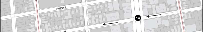
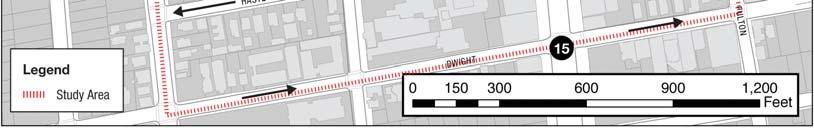
18 Berkeley Downtown Area Plan Program EIR Traffic Impact Analysis Study Area Roadway Network The roadway network in the study area is defined by a north-south/east-west grid. The main roadways that serve the study area in the north-south direction are Martin Luther King Jr. Way (west boundary), Shattuck Avenue, and Oxford Street (east boundary). Milvia Street is a northsouth collector street and Bicycle Boulevard in the study area, and is designed to serve lower traffic volumes than the three previously mentioned major streets. In the east-west direction, there is one main arterial roadway, University Avenue, which provides a connection from the study area to Interstate 80 (I-80). There are several smaller secondary local and collector streets in the study area, such as Hearst Avenue (north boundary), Center Street, Allston Way, Bancroft Way (also a Bicycle Boulevard), Durant Avenue, Haste Street, and Dwight Way (south boundary). Other streets complement the lists presented above, but primarily serve as local access streets. The existing configuration of selected arterial roadways and streets that serve or cross the study area are described below. Shattuck Avenue is a four-lane divided major street that runs north and south in the project area. Between University Avenue and Center Street, Shattuck Avenue branches into two separate one-way streets. The west branch has three southbound lanes, and the east branch has three northbound lanes. Shattuck Avenue has retail and commercial property along the east and west sides. On-street parking is available, and is separated from through traffic lanes by parking bays with landscaped buffers along some segments. Oxford/Fulton Street is a north-south divided major street that runs along the west side of the University of California at Berkeley (UCB) campus. The four-lane roadway is named Oxford Street north of Kittredge Street, and becomes Fulton Street south of Kittredge. South of Durant Avenue, Fulton transitions into a one-way street with two southbound lanes. Metered on-street parking is available along both sides of the street. Martin Luther King Jr. Way is a four-lane undivided major street that runs north and south in the project area. Dwight Way is an eastbound one-way major street with two lanes. Center Street is an east-west local street with one lane in each direction. Ground floor retail and restaurants line the street, and there is high pedestrian activity between UC Berkeley and Shattuck Avenue. Center Street is a heavily-used bicycle route with a Class II bike lane from Milvia to Shattuck. Hearst Avenue is a two-lane major street that runs east and west in the project area. Allston Way is an east-west local street with one lane in each direction. Kittredge Street is an east-west local street with one lane in each direction. Bancroft Way is a two-lane, east-west collector street with one lane in each direction west of Shattuck Avenue. East of Shattuck Avenue, Bancroft is one-way street with two westbound lanes. Durant Avenue is a two-lane, east-west collector street with one lane in each direction west of Shattuck Avenue. East of Shattuck Avenue, Durant is a one-way street with two eastbound lanes. Channing Way is a two-lane local street that runs east and west in the project area, and is designated as a Bicycle Boulevard. The Year 2030 Baseline condition assumes limited changes to the transportation network in the downtown, which include planned service improvements to local AC Transit bus routes contained in the Alameda County Congestion Management Agency (ACCMA) travel demand model and the signalization of the Addison Street, Kittredge Street, and Allston Way intersections along Oxford IBI GROUP PAGE 14 14
19 Berkeley Downtown Area Plan Program EIR Traffic Impact Analysis Street consistent with the UC Berkeley Long Range Development Plan (LRDP) EIR. The Year 2030 With Project condition proposes several alterations to the transportation network. The transportation network conditions for each of the Year 2030 analysis scenarios are summarized in Table 1-1. The changes are highlighted in Figure 1-2. Table 1-1: Year 2030 Transportation Network Configuration Transportation Network Feature BRT System Shattuck Avenue (West Shattuck Square between University Avenue and Center Street) East Shattuck Avenue (East Shattuck Square between University Avenue and Center Street) Shattuck Avenue (between Center Street and Durant Avenue) Center Street (between Shattuck Avenue and Oxford Street) University Avenue (between Shattuck Avenue and Oxford Street) Hearst Avenue (between Shattuck Avenue and Oxford Street) Source: Draft Berkeley Downtown Area Plan Existing/Year 2030 Baseline Configuration n/a One-way street with three lanes southbound One-way street with three lanes northbound Two lanes in each direction Open to auto traffic Two lanes in each direction Two lanes in each direction Year 2030 With Project Configuration Operation of a BRT System, with vehicles running in dedicated lane on Shattuck Avenue between Durant Avenue and Center Street Two-way street with one lane in each direction One-way street with one lane northbound, local access only One lane in each direction Closed to auto traffic, local access only One lane in each direction One lane in each direction IBI GROUP PAGE 15 15


20 Berkeley Downtown Area Plan Program EIR Traffic Impact Analysis Figure 1-2: Year 2030 With Project Transportation Network IBI GROUP PAGE 16 16
21 Berkeley Downtown Area Plan Program EIR Traffic Impact Analysis Study Area Socio-Economic Data The transportation modeling effort was completed using the latest version of the Alameda County Congestion Management Agency (ACCMA) travel demand model, dated July 2007, available at the release of the Notice of Preparation (NOP). The ACCMA model includes estimates of existing development and future forecasted growth in Alameda County that are consistent with the Year 2000 Census and the Association of Bay Area Governments (ABAG) Projections 2005 data. It is likely that the Projections 2005 data provides a conservative assessment of growth in the DAP study area and the surrounding region as these forecasts are based on anticipated regional population and employment growth rather than strictly General Plan and zoning regulations. The ACCMA model generates travel forecasts using socio-economic data factors that are contained within transportation analysis zones (TAZs). The primary socio-economic data factors include population, employment, employed residents, household type and size, income, and age allocations. Alameda County is subdivided into 1,403 TAZs, and the adopted Berkeley DAP study area is comprised of ten of these TAZs. TAZs can vary in size, but are typically larger than standard city blocks and encompass the population and employment figures for several parcels. The size of the TAZs also means that as updates are made to population, households, or employment figures, these changes are made at the TAZ level, not the parcel level. Spreading these changes throughout the TAZ helps to account for factors such as off-site parking, which is common in the downtown area. Figure 1-3 illustrates the TAZ boundaries within the DAP study area. IBI GROUP PAGE 17 17

22 Berkeley Downtown Area Plan Program EIR Traffic Impact Analysis Figure 1-3: DAP Study Area Traffic Analysis Zones IBI GROUP PAGE 18 18
23 Berkeley Downtown Area Plan Program EIR Traffic Impact Analysis As can be observed in Figure 1-3, the DAP study area boundaries are coincident with the TAZ boundaries in all directions, except to the north. In this direction, there are two TAZs that are not completely contained by the DAP study area. TAZ number 47 has approximately two-thirds of its area inside the DAP boundary, and TAZ number 45 has about one-third of its area within the study area boundary. As mentioned previously, the population and employment forecasts included in the ACCMA model are based on the Projections 2005 data prepared by ABAG. The Year 2030 Baseline condition assumed for the DAP transportation modeling effort is consistent with the ACCMA Baseline Year 2030 conditions. In order to produce travel demand forecasts for the Year 2030 With Project condition, updates to the Year 2030 household, population, and employment forecasts were incorporated into the ACCMA model. The population and employment updates are made at a disaggregated level (parcel level) and then are aggregated to the respective blocks and TAZs. The updates made to the number of households in the study area are consistent with a maximum increase of 3,100 residential dwelling units assumed for the Year 2030 horizon for the DAP. The ACCMA model socioeconomic projections estimate an average dwelling unit occupancy of 1.6 persons per unit in the DAP study area. This ratio is slightly lower than the typical ratio assumed in suburban areas (generally just above 2.0 persons per unit), but is believed to be reasonable for the DAP study area given the more urban environment and the prevalence of multi-family units that typically support lower person per unit ratios compared to single family residential areas. The Year 2030 With Project condition maintains the 1.6 persons per unit ratio with the addition of the 3,100 proposed residential units. Figure 1-4 illustrates the population forecasts assumed in the ACCMA model for the ten ACCMA TAZs that encompass the DAP study area. These TAZs do incorporate about 800 additional residential units north of Hearst Avenue, but the information allows for a comparison between existing and future years. For the With Project condition, population forecasts are developed by converting the proposed residential units to a population figure using the baseline household type and size assumptions for the Year 2030 contained in the ACCMA data files. 12,000 10,000 9,780 8,000 POPULATION 6,000 4,761 4,870 5,414 6,528 4,000 2, Baseline 2030 With Project YEAR Figure 1-4: Population Forecasts IBI GROUP PAGE 19 19
24 Berkeley Downtown Area Plan Program EIR Traffic Impact Analysis As shown in Figure 1-4, the population residing within the DAP study area is forecast to increase by 37% between Year 2000 and the Year 2030 Baseline condition. The additional residential units proposed in the Year 2030 With Project condition further increase the forecast population by an additional 50% above the Year 2030 Baseline condition to 105% over the Year 2000 figure. Employment within the DAP is forecast to grow at a slower pace than population between the Year 2000 and the Year 2030 Baseline condition. The estimated increase for this 30 year period is about 5%. The land use changes proposed in the Year 2030 With Project condition would further increase employment by about 6% above the Year 2030 Baseline forecast to 11% over the Year 2000 figure. Figure 1-5 illustrates the employment forecasts assumed in the ACCMA model for the DAP study area. 14,500 14,000 14,112 EMPLOYMENT 13,500 13,000 12,720 12,577 12,959 13,328 12,500 12,000 11, Baseline 2030 With Project YEAR Figure 1-5: Employment Forecasts The land use changes proposed in the DAP With Project condition add approximately 1,000,000 square feet of new non-residential uses to the existing condition. The vast majority of new nonresidential growth is attributable to development by UC Berkeley in the Downtown Area and the adjacent "Tang" site. Aside from the future University Art Museum, UC Berkeley DAP growth has been assumed to be administrative uses because this use generates the highest level of impact among all of the uses that the University is considering. Non-University related non-residential growth was allocated primarily as retail or cultural uses as these are prevalent in the downtown and a majority of this non-residential growth is forecast to be located in the ground floor of mixeduse developments. Travel demand forecasts for the Year 2030 Baseline condition and the Year 2030 With Project condition were generated using these land use assumptions. Additional detail regarding the results of the transportation modeling effort is provided in subsequent sections of this report. IBI GROUP PAGE 20 20
25 Berkeley Downtown Area Plan Program EIR Traffic Impact Analysis 2.0 TRANSPORTATION ANALYSIS METHODOLOGY The traffic impact analysis is performed in accordance with the City of Berkeley standards. The analysis examines weekday AM peak hour and PM peak hour traffic conditions in the study area. 2.1 FUTURE TRAFFIC FORECASTING METHODOLOGY The volumes for the future years are forecasted using the latest available version of the Alameda County Congestion Management Agency (ACCMA) travel demand model. This version of the model is the same version used in the previous Berkeley DAP modeling efforts, conducted in 2007, and is the most recent version available at the time of the release of the NOP. The ACCMA model is a regional travel demand model that is based on and consistent with the larger Metropolitan Transportation Commission (MTC) regional model. The ACCMA model is focused on Alameda County and is intended for use by the ACCMA and local agencies in Alameda County to forecast future travel demand for automobile, transit, and non-motorized transportation modes. The existing network used to run the ACCMA model was updated near and inside the study area to produce a more representative distribution of the trips using the Downtown s transportation infrastructure. Updates included the inclusion of Milvia Street and the extension of streets such as Bancroft and Durant from Shattuck Avenue to Milvia Street. For the analysis of the Year 2030 With Project Condition, the ACCMA model was updated to include the new transportation network (consisting of the changes to the existing network listed in Table 1-1) and a new socioeconomic data file (generated by the application of the DAP land use assumptions described in Section 1.2). The outputs from the ACCMA model are processed to obtain the necessary data to analyze the forecast demand and traffic conditions. 2.2 TRAFFIC ANALYSIS The DAP traffic impact analysis is performed in accordance with City of Berkeley Guidelines for Development of Traffic Impact Reports. Study intersection future forecast traffic conditions are analyzed with the Synchro traffic analysis software using the capacity analysis methodology published in the Transportation Research Board Highway Capacity Manual (HCM) 2000 update. City of Berkeley defines Level of Service (LOS) D or better as acceptable. LOS E and F are considered to be unacceptable or deficient. Traffic conditions at signalized intersections were evaluated using the 2000 HCM operations methodology for signalized intersections (Operational Method described in Chapter 16, Section II of the HCM), which evaluates capacity in terms of the volume-to-capacity (v/c) ratio and evaluates LOS based on controlled delay per vehicle. Controlled delay is defined as the portion of the total delay attributed to the traffic signal operation including deceleration delay, queue move-up time, stopped delay, and final acceleration delay. The relationship between controlled delay per vehicle and LOS for signalized intersections is summarized in Table 2-1. IBI GROUP PAGE 21 21
26 Berkeley Downtown Area Plan Program EIR Traffic Impact Analysis Table 2-1: Level of Service for Signalized Intersections Level of Service A B C D E F Description of Traffic Conditions Insignificant delays: no approach phase is fully utilized and no vehicle waits longer than one red indication. Minimal delays: an occasional approach phase is fully utilized. Drivers begin to feel restricted. Acceptable delays: major approach phase may become fully utilized. Most drivers feel somewhat restricted. Tolerable delays: drivers may wait through more than one red indication. Queues may develop but dissipate rapidly, without excessive delays. Significant delays: volumes approaching capacity. Vehicles may wait through several cycles and long vehicle queues form upstream. Excessive delays: represents conditions at capacity, with extremely long delays. Queues may block upstream intersections. Controlled Delay (sec/veh) 10 > > > > > 80 Source: Highway Capacity Manual, Transportation Research Board, DETERMINATION OF SIGNIFICANCE Traffic Impacts Per the City s Traffic Impact Report Guidelines (City of Berkeley, September 2005), level of service for signalized intersections and the determination of the threshold for significant impacts are assessed using the following standards: The Highway Capacity Manual (2000) defines levels of service based on average seconds of delay per vehicle. The upper threshold for LOS D is 55 sec/veh and for LOS E is 80 seconds/vehicle. The average delay can be significantly affected by signal timing at a signalized intersection. In general, traffic impact analyses should retain cycle lengths, phase minimums, and phasing that occur for existing conditions. Phase lengths can be adjusted but should not adversely affect signal coordination. Any major changes need to be documented and fully justified. The City has established significance thresholds based on the fact that for a given level of traffic on critical movements, the delay increases at a greater rate as LOS F is approached. The following average delay thresholds have been established: LOS D to E=2 seconds; LOS E and LOS E to F=3 seconds. The volume-to-capacity ratio (v/c) is also an important indicator of capacity and should be included as part of all Level of Service tables. It can indicate the extent to which the signal timing is optimal and provides a useful indicator for over-saturated conditions. However, v/c s are not utilized for identifying level of service. As the delay can increase dramatically with small increases of traffic after LOS F has been reached, a threshold of an increase of 0.01 in the volume-to-capacity ratio will be used. Intersection level of service is dependent on a variety of factors. In general, existing timing and phasing should be retained for scenarios with and without the project. In this way, the only variable is the traffic volume, which ensures a valid comparison of project impacts. Nevertheless, with the approval of City staff, mitigations can include changes in signal timing; but care must be taken to ensure that these changes do not affect IBI GROUP PAGE 22 22
27 Berkeley Downtown Area Plan Program EIR Traffic Impact Analysis operations at adjacent signals. Finally, where closely spaced signals exist, estimated queue lengths should be provided to demonstrate whether or not there are potential impacts on upstream intersections or on access to turn lanes. Transit Impacts Significant impacts to ridership capacity on Alameda County (AC) Transit and Bay Area Rapid Transit (BART) services are defined as follows: Increase average ridership on AC Transit lines by 3% at bus stops where the average load factor with the project in place would exceed 125% over a peak 30-minute period. Increase peak hour ridership on BART by 3% where the passenger volume would exceed the standing capacity of BART trains. IBI GROUP PAGE 23 23
28 Berkeley Downtown Area Plan Program EIR Traffic Impact Analysis 3.0 EXISTING TRANSPORTATION CONDITIONS This section provides information on the transportation system that serves the project site, including the surrounding street network, bus routes, bicycle paths, and parking facilities. Existing traffic counts and levels of service at the project study intersections are also presented in this section. 3.1 NON-MOTORIZED TRANSPORTATION Bicycle Transportation The City of Berkeley has a strong bike mode share and accommodating the bicycle as a mode of transportation is important to the overall success of the downtown network. The city has designated a series of classifications for their bicycle network. These classifications are defined as: Class 1 (Bike Path) Completely separate right-of-way Bicycle Boulevard Modified roadway to meet the needs of the cyclist ( arterials of citywide bike network) Class 2 (Bike Lane) Striped lane on roadway to designate exclusive bike use Class 2.5 (Bike Route) Signed and improved roadway for bicycles but used in areas where conditions don t allow for designated bike lanes. Provides direct access and connections to major destinations in Berkeley. Class 3 (Bike Route) Signed roadway for bicyclists In the existing condition, about 3,200 daily bicycle trips are estimated to be generated in the Downtown Area. Bike volumes tend to concentrate outside the downtown core, and within the core at Center Street and Shattuck Avenue. This indicates that bicyclists transitioning between the UC Berkeley campus and the areas to the west prefer less congested streets such as Hearst Avenue, Berkeley Way, Channing Way, and Durant Avenue. The top six intersections for peak hour bike activity considered in the study area are: Shattuck Avenue and Hearst Avenue Oxford Street and Hearst Avenue Martin Luther King Jr. Way and Hearst Avenue Martin Luther King Jr. Way and University Avenue Shattuck Avenue and University Avenue Shattuck Avenue and Center Street The downtown study area has both an east/west (Channing Way) and a north/south (Milvia Street) Bike Boulevard. These Bike Boulevards provide links to many other bike lanes in the City. Pedestrians The downtown study area s urban environment encourages walking as a feasible mode of access. UC Berkeley and Berkeley City College, and the compact development surrounding the major transit hubs, generate the highest volumes of pedestrian activity during certain times of the IBI GROUP PAGE 24 24
29 Berkeley Downtown Area Plan Program EIR Traffic Impact Analysis day. The Downtown Area is estimated to generate approximately 17,700 pedestrian trips per day in the existing condition. The pedestrian counts indicate that the intersections with high pedestrian volumes within the study area are: Milvia Street and Allston Way Milvia Street and Center Street Shattuck Avenue and Center Street Shattuck Avenue and Allston Shattuck Avenue and University Avenue Existing midday pedestrian volumes can be observed in Figure 3-1, which graphically depicts these movement patterns. The figure also shows intersections where high numbers of accidents involving pedestrians occurred over the past five years. IBI GROUP PAGE 25 25
 IBI GROUP PAGE 26")
30 Berkeley Downtown Area Plan Program EIR Traffic Impact Analysis Figure 3-1: Midday Pedestrian Flows (Generated from Space Syntax Model) IBI GROUP PAGE 26 26
31 Berkeley Downtown Area Plan Program EIR Traffic Impact Analysis 3.2 TRANSIT The Downtown Berkeley area is served by an extensive transit system, including bus service and the Bay Area Rapid Transit (BART) system. Transit service routes and frequencies are discussed in this section. The downtown study area is served by a number of different transit options as summarized in Table 3-1 and shown in Figure 3-2. The transit network includes commuter rail (BART), local and regional bus (AC Transit), and two campus shuttles (UC Shuttle and Lawrence Berkeley Lab Shuttle). It is estimated that about 38,000 transit passenger trips for all purposes (work and non-work) occur in the study area during an average weekday. Two-thirds of these trips are produced by BART and nearly three-quarters of all transit trips have an origin or destination at the intersection of Shattuck Avenue and Center Street. The approximate location of the total daily activity for the AC Transit and for BART in the downtown area can be observed in Figure 3-3. Table 3-1: Downtown Study Area Transit Summary Agency Mode Avg. Weekday Trips Number of Lines Number of Stops BART Commuter Rail 24, AC Transit Local/Regional Bus 10, UC Shuttle* Campus Bus 1, Lawrence Berkeley Lab Shuttle Campus Bus 1, Total 37, * Trips in daytime routes only nighttime routes add 160 daily trips, 4 lines and 4 stops in Downtown Berkeley Table 3-2 summarizes the number of bus routes traveling on major roadways in the downtown during peak hours. The numbers reflect the sum of both directions of travel. The numbers include both AC Transit routes and UC Berkeley shuttle routes. This can be better observed in Figure 3-4, which spacializes the transit density in the downtown area for the PM peak hour. Table 3-2: Bus Route Density in Downtown Berkeley Street Segment Number of Buses During Peak Hour University Avenue MLK to Shattuck Avenue 30 University Avenue Shattuck Avenue to Oxford Street 49 Center Street MLK to Shattuck Avenue 12 Center Street Shattuck Avenue to Oxford Street 28 Bancroft Way Shattuck Avenue to Oxford Street 29 Durant Avenue Shattuck Avenue to Oxford Street 24 MLK Jr.Way Hearst Avenue to Center Street 2 Shattuck Avenue Hearst Avenue to Center Street 42 Shattuck Avenue Center Street to Durant Avenue 59 Oxford Street Hearst Avenue to Center Street 25 Oxford/Fulton Street Center Street to Durant Avenue 16 IBI GROUP PAGE 27 27

32 Berkeley Downtown Area Plan Program EIR Traffic Impact Analysis TRANSIT NETWORK RFS B O 18 7 FS 52L 52L F 67 F O R C 52L R C P B O RFS RFS L B O FS 51 FS 65 P C F 851 C 15 R 9 1R 1 P B O P 1R O 65 R 1 F 1R C RFS R B R P F 51 B P 851 F 1R 1 51 R R F 9 9 F Figure 3-2: Study Area Transit Network (September 2008) IBI GROUP PAGE 28 28


33 Berkeley Downtown Area Plan Program EIR Traffic Impact Analysis Figure 3-3: Total Daily AC Transit and BART Boardings by Nearest Intersection (Year 2008) IBI GROUP PAGE 29 29

 IBI GROUP PAGE 30 30")
34 Berkeley Downtown Area Plan Program EIR Traffic Impact Analysis BUS VOLUMES DURING PM PEAK HOUR B O 18 7 FS 52L 52L F 67 F O R 52L R P B O P L B O FS 51 FS 65 P F 851 C 15 R 9 1R 1 P B O 1R O 65 R 1 F 1R R B R P F 51 B P 851 F 1R 1 51 R R F 9 9 F Figure 3-4: Volume of Bus Activity during PM Peak Hour (September 2008) IBI GROUP PAGE 30 30
35 Berkeley Downtown Area Plan Program EIR Traffic Impact Analysis Bay Area Rapid Transit The Bay Area Rapid Transit (BART) network provides service to the downtown area through the Downtown Berkeley Station. This station has the eighth highest ridership volume in the BART system. The Average Weekday Passengers at the Downtown Berkeley Station is 24,316 1 people with 11,992 boardings (ons) and 12,324 alightings (offs). The top three BART stations in terms of activity to and from Downtown Berkeley are El Cerrito del Norte (1,808 trips/day), Powell Street (2,358 trips/day), and Embarcadero (1,984 trips/day). The Downtown Berkeley Station, located near the corner of Center Street and Shattuck Avenue, is served by two lines. The Richmond/Fremont train runs seven days a week between the hours of 4:00 AM and 1:30 AM (weekday), 6:00 AM and 1:30 AM (Saturday), and 8:00 AM and 1:30 AM (Sunday). The Richmond/Daly City/Millbrae train runs six days a week from 4:00 AM to 8:00 PM (weekday), and 9:00 AM to 8:00 PM (Saturday). The train lines operating between Richmond- Daly City/Millbrae and Richmond-Fremont run with 15-minute headways, for a total of 16 stops per hour at this station during the weekday peak periods. AC Transit Alameda County Transit (AC Transit) provides bus service to Downtown Berkeley seven days a week, 24 hours a day. A total of 16 routes (twelve local, two Transbay, and two all-night services) link the downtown to the rest of Alameda County and into San Francisco. Individual route descriptions are provided below. Headways range significantly between the different routes. Route 51 has headways as frequent as six to eight minutes during the weekday peak. The allnight routes typically run on 60-minute headways. The line descriptions are outlined below, and the average weekday headway on the local service is approximately 15 to 20 minutes. AC Transit Local Service AC Transit Line 1: Line 1 runs in the north-south direction on weekdays and weekends between Bay Fair BART and Berkeley BART station. AC Transit Line 1R: Line 1R runs in the north-south direction on weekdays between Bay Fair BART to the West Entrance of UC Berkeley. It runs in the north/south direction between Bay Fair BART and 12th Street/Broadway. AC Transit Line 7 Arlington: Line 7 runs in the north-south direction on weekdays and weekend between Rockridge BART station and El Cerrito Del Norte BART station. AC Transit Line 9 Dwight: Line 9 runs in the east-west direction on weekdays and weekend between Berkeley Marina and Ashby Avenue/Claremont Avenue. AC Transit Line 15 Martin Luther King Jr.: Line 15 runs in the east-west direction on weekdays and weekends. In eastbound direction it runs between West Entrance of UC Berkeley and Morage Avenue/Medau Place. In westbound direction it runs between Morage Avenue/Medau Place and El Cerrito Plaza BART station. AC Transit Line 18: Line 18 runs in the east-west direction on both weekdays and weekends between San Pablo Avenue & Marin Avenue and Moraga Avenue & Medau Place. AC Transit Line 19: Line 19 serves the downtown area only on weekdays at select hours (6 trips for AM Peak and 7 trips for PM Peak). On these trips, it runs in the east-west direction from the Fruitvale BART station to the Berkeley BART station. On the 1 BART, August 2008 IBI GROUP PAGE 31 31
36 Berkeley Downtown Area Plan Program EIR Traffic Impact Analysis weekends it runs in the east/west direction between the North Berkeley BART station and Fruitvale BART station. AC Transit Line 51 Broadway: Line 51 runs in the north-south direction on weekdays and weekend between Broadway/Blanding Avenue and Third Street/University Avenue. AC Transit Line 52L University Limited: Line 52L runs in the north-south direction on weekdays and weekend between Bancroft Way/Telegraph Avenue and Jackson Street /Ohlone Avenue. AC Transit Line 65 Euclid: Line 65 runs in the east-west direction on weekdays and weekend. In eastbound direction it runs between Berkeley BART station and Grizzly Peak Boulevard /Senior Avenue on weekdays and between Berkeley BART and Lawrence Hall of Science on weekends. In westbound direction it runs between Lawrence Hall of Science and Berkeley BART station on both weekdays and weekends. AC Transit Line 67 Spruce: Line 67 runs in the east-west direction on weekdays and weekend. In eastbound direction it runs between Spruce Street/Grizzly Peak Boulevard and Berkeley BART station on weekdays and between Brazilian Building in Tilden Park and Berkeley BART station on weekends. In westbound direction it runs between Berkeley BART station and Spruce Street/Grizzly Peak Boulevard on weekdays and between Berkeley BART station and Brazilian Building in Tilden Park on weekends. AC Transit Line 79: Line 79 runs in the east/west direction on both weekdays and weekends between El Cerrito Plaza BART and Berkeley BART. AC Transit All Nighter Service AC Transit Line 800 Transbay All Nighter: Line 800 is a daily service (including holidays) and runs in the east-west direction between Market Street/Van Ness Avenue and Richmond BART station. AC Transit Line 851 Broadway All Nighter: Line 851 is a daily service and runs in the north-south direction between Park Street/Santa Clara Avenue and Berkeley BART station. AC Transit Transbay Service AC Transit Line F Adeline: Line F runs in the east-west direction on weekdays and weekend between San Francisco (Transbay Terminal) and University Avenue /Shattuck Avenue. AC Transit Line FS North Berkeley: Line FS runs in the east-west direction on weekdays and weekend between San Francisco (Transbay Terminal) and Solano Avenue /Colusa Avenue. Table 3-3 shows a line by line and directional breakdown for a typical weekday on the AC Transit lines that service the downtown study area. The data presented is specific to the limits of the study area. IBI GROUP PAGE 32 32
37 Berkeley Downtown Area Plan Program EIR Traffic Impact Analysis Table 3-3: AC Transit Study Area Serving Route Ridership Route # of Stops in Downtown Direction ON OFF Downtown Ridership Total Downtown Ridership % of Total Route s Ridership 1 2 NB % 5 SB % 1R 1 NB ,031 5% 1 SB % 7 5 SB % 3 NB % 9 7 EB % 7 WB % 15 7 EB % 7 WB % 18 5 EB ,668 17% 6 WB % 51 7 SB ,584 13% 5 NB % 52L 3 SB % 3 NB % 65 2 EB % 1 WB % 67 1 EB % 3 WB % 79 5 EB % 4 WB % EB % 7 WB % SB % 2 NB % F 6 EB ,009 37% 9 WB % FS 3 WB % 3 EB % Source: AC Transit, ridership data from September 2008, exception Route FS (ridership data from 2006) UC Berkeley Shuttles The UC Berkeley Shuttles provide service to the downtown study area due the close proximity of the campus to the area. The service is free for students and fares vary from $1.00 to $1.50 for non-students. Four of the five UC Shuttle daytime routes have at least one stop in the downtown study area (Figure 4-19). Shuttles run Monday through Friday with both daytime and nighttime service. The daytime service runs from 6:45 AM to 7:30 PM. The nighttime service runs from 7:30 PM to 3:00 AM. Weekday headways vary between 12 and 30 minutes. There is also a doorto-door night safety shuttle, named the Owl Line that runs from 3:00 AM to 6:00 AM upon phone IBI GROUP PAGE 33 33
38 Berkeley Downtown Area Plan Program EIR Traffic Impact Analysis request. The Average Weekday Passengers is 1,585 people system wide. Figure 3-2 in the beginning of this section displays the UC Berkeley shuttle routes serving downtown with existing AC Transit bus services. Table 3-4 presents the average daily ridership for the UC Berkeley Shuttles. Table 3-4: UC Berkeley Shuttle Ridership Shuttle Line Average Daily Ridership Perimeter (P) 829 Reverse Perimeter (R) 238 Hill (H) 274 Central Campus (C) 36 Richmond Field Station (RFS) 48 Night Safety (N) 26 Night Safety (D) 27 Night Safety (E) 88 Night Safety (A) 19 Total 1,585 Source: UC Parking & Transportation Department, September 2008 IBI GROUP PAGE 34 34
39 Berkeley Downtown Area Plan Program EIR Traffic Impact Analysis (DRAFT) Downtown Study Area Figure 3-5: UC Shuttle Network IBI GROUP PAGE 35 35
40 Berkeley Downtown Area Plan Program EIR Traffic Impact Analysis Lawrence Berkeley Lab Shuttles The Lawrence Berkeley Lab, located in the Berkeley Hills to the east of campus, provides its own off-site shuttle service to the downtown study area. The service is free of charge for students, employees, and guests. Two of the three off-site routes connect the Laboratory to the downtown (Figure 3-6). The Orange Route traverses through the study area, servicing BART and multiple stops along Center Street, Milvia Street, and Hearst Avenue. It runs from 6:28 AM to 6:58 PM on 15-minute headways (30-minute headways during the first two and last hour of service). The Blue Route runs along the east side of the study area, entering Oxford Street on Bancroft, turning left on Center Street, right on Milvia Street and exiting the study area on Hearst Avenue. This route is offered from 6:10 AM to 7:25 PM, running on 15-minute headways (30-minute headways during the final two hours of service). The current 2 daily average ridership provided from the Lab s transportation coordinator is 1,300 users system wide and does not include detailed stop by stop or line by line breakdowns. 2 Data provided in September 2008 IBI GROUP PAGE 36 36

41 Berkeley Downtown Area Plan Program EIR Traffic Impact Analysis Figure 3-6: Lawrence Berkeley Lab Shuttle Routes Serving the Study Area IBI GROUP PAGE 37 37
42 Berkeley Downtown Area Plan Program EIR Traffic Impact Analysis 3.3 TRAFFIC The DAP existing conditions traffic impact analysis is performed in accordance with City of Berkeley Guidelines for Development of Traffic Impact Reports. Traffic operations are analyzed with the Synchro traffic analysis software using the capacity analysis methodology published in the Transportation Research Board Highway Capacity Manual (HCM) 2000 update. Signalized intersections are analyzed using the Operational Method described in Chapter 16, Section II of the HCM, and unsignalized intersections are analyzed using HCM Chapter 17. Existing lane geometries at each of the project study intersections are illustrated in Figure 3-7 on the following page. IBI GROUP PAGE 38 38
43 Martin Luther King Jr. Wy. Grove St. Milvia St. Milvia St. MLK Jr. Way Hearst Ave. Shattuck Ave. University Ave. Oxford Street University Ave MLK Jr. Way University Ave. 2 Shattuck Ave. Center Street 10 Oxford Street Center Street 18 1 Delaware St. Hearst Ave. 8 Shattuck Ave. Walnut St. 16 Oxford St. MLK Jr. Way Center Street Shattuck Ave. Allston Way Oxford Street Allston Way Bonita St. Berkeley Wy University Ave Addison St. MLK Jr. Way Allston Way 4 Shattuck Ave. Bancroft Way 12 Fulton Street Bancroft Way Center St. Allston Wy Shattuck Ave W. Entrance Campanile Wy. Milvia Street University Ave. Shattuck Ave. Durant Ave. Fulton Street Durant Ave. Kittredge St. Bancroft Wy Fulton St Durant Ave Milvia Street Center Street Shattuck Ave. Haste Street Channing Wy Haste St. 14 Milvia Street Allston Way Shattuck Ave. Dwight Way Dwight Wy Shattuck Ave. Hearst Ave. 8 Oxford Street Hearst Ave. 16 N LEGEND Study Intersection - Signalized Study Intersection - Unsignalized Intersection Geometry IBI GROUP Berkeley Downtown Area Traffic Impact Analysis Existing Study Intersection Geometry Figure 3-7
44 Berkeley Downtown Area Plan Program EIR Traffic Impact Analysis The existing traffic conditions are analyzed in terms of level of service according to methodology presented in Section 2. The weekday and weekend peak hour conditions are presented below. Weekday Peak Hour Conditions Existing traffic volumes at the project study intersections were obtained from the City of Berkeley or through traffic counts conducted in November A growth factor of 1% per year is applied to all traffic volumes collected from previous years in order to estimate Year 2008 conditions. Figures 3-8 and 3-9 summarize the existing traffic volumes at each of the study intersections. Table 3-5 and Table 3-6 summarize the level of service values for study intersections in the existing condition. Table 3-5: Existing Condition AM Peak Hour Level of Service No. Intersection Control V/C Delay (in LOS Sec) 1 Martin Luther Jr. Way / Hearst Avenue Signalized B 2 Martin Luther Jr. Way / University Avenue Signalized C 3 Martin Luther Jr. Way / Center Street Signalized B 4 Martin Luther Jr. Way / Allston Way Signalized B 5 Milvia Street / University Avenue Signalized A 6 Milvia Street / Center Street Signalized B 7 Milvia Street / Allston Way Signalized B 8 Shattuck Avenue / Hearst Avenue Signalized B 9 Shattuck Avenue / University Avenue Signalized B 10 Shattuck Avenue / Center Street Signalized B 11 Shattuck Avenue / Allston Way Signalized B 12 Shattuck Avenue / Bancroft Way Signalized A 13 Shattuck Avenue / Durant Avenue Signalized B 14 Shattuck Avenue / Haste Street Signalized A 15 Shattuck Avenue / Dwight Way Signalized B 16 Oxford Street / Hearst Avenue Signalized C 17 Oxford Street / University Avenue Signalized C 18 Oxford Street / Center Street Signalized B 19 Oxford Street / Allston Way Unsignalized/ EB stop A 20 Oxford Street / Fulton Street / Bancroft Way Signalized B 21 Fulton Street / Durant Avenue Signalized B Table 3-6: Existing Condition PM Peak Hour Level of Service No. Intersection Control V/C Delay (in LOS Sec) 1 Martin Luther Jr. Way / Hearst Avenue Signalized B 2 Martin Luther Jr. Way / University Avenue Signalized C 3 Martin Luther Jr. Way / Center Street Signalized B 4 Martin Luther Jr. Way / Allston Way Signalized B 5 Milvia Street / University Avenue Signalized B 6 Milvia Street / Center Street Signalized B 7 Milvia Street / Allston Way Signalized B 8 Shattuck Avenue / Hearst Avenue Signalized B IBI GROUP PAGE 40 40
45 Berkeley Downtown Area Plan Program EIR Traffic Impact Analysis No. Intersection Control V/C Delay (in Sec) 9 Shattuck Avenue / University Avenue Signalized B 10 Shattuck Avenue / Center Street Signalized B 11 Shattuck Avenue / Allston Way Signalized B 12 Shattuck Avenue / Bancroft Way Signalized A 13 Shattuck Avenue / Durant Avenue Signalized B 14 Shattuck Avenue / Haste Street Signalized A 15 Shattuck Avenue / Dwight Way Signalized B 16 Oxford Street / Hearst Avenue Signalized C 17 Oxford Street / University Avenue Signalized C 18 Oxford Street / Center Street Signalized B 19 Oxford Street / Allston Way Unsignalized/ EB stop A 20 Oxford Street / Fulton Street / Bancroft Way Signalized B 21 Fulton Street / Durant Avenue Signalized A LOS The LOS results summarized in Tables 3-5 and 3-6 present average intersection delay at the 21 study intersections in the downtown. The City of Berkeley Traffic Impact Guidelines also require that approach delay and level of service at two-way stop sign controlled intersections be provided for the approach(es) controlled by stop signs. There is one intersection that qualifies for this category. Table 3-7 summarizes the worst approach LOS at the unsignalized intersection during the AM and PM peak hours. Table 3-7: Unsignalized Intersection Controlled Approach Level of Service No. Intersection Approach AM Peak Delay (in sec) LOS Approach PM Peak Delay (in sec) 19 Oxford Street / Allston Way EB 20.2 C EB 132 F At the intersection summarized in Table 3-7, the worst approach is operating at LOS F on the weekday PM peak hour. The City of Berkeley Traffic Impact Guidelines do not specifically call for mitigations at unsignalized intersections that experience a LOS F in a single approach, if the full intersection average delay is still acceptable based on the city guidelines. However, it is important to note that this intersection will be signalized in the future and is expected to operate at an acceptable level of service with signal control. LOS IBI GROUP PAGE 41 41
46 Martin Luther King Jr. Wy. Grove St. Milvia St. Milvia St IBI GROUP MLK Jr. Way. Hearst Ave. 1 MLK Jr. Way University Ave MLK Jr. Way Center Street MLK Jr. Way Allston Way Milvia Street University Ave Shattuck Ave. Hearst Ave Milvia Street Center Street Milvia Street Allston Way Shattuck Ave. University Ave Shattuck Ave. Dwight Way Oxford Street Hearst Ave Shattuck Ave. Center Street Shattuck Ave. Allston Way Shattuck Ave. Bancroft Way Shattuck Ave. Durant Ave Shattuck Ave. Haste Street Oxford Street University Ave Berkeley Downtown Area Traffic Impact Analysis Existing Conditions Intersection Volumes - AM Peak Hour Oxford Street Center Street Oxford Street Allston Way Fulton Street Bancroft Way Fulton Street Durant Ave Delaware St. N Bonita St Hearst Ave. Berkeley Wy. University Ave. Addison St. Center St. Allston Wy. Kittredge St. Bancroft Wy. Durant Ave. Channing Wy. Haste St. Dwight Wy. ## Shattuck Ave Shattuck Ave. Walnut St LEGEND Study Intersection - Signalized Study Intersection - Unsignalized AM Peak Hour Volume Fulton St Oxford St. W. Entrance Campanile Wy. Figure 3-8
47 Martin Luther King Jr. Wy. Grove St. Milvia St. Milvia St IBI GROUP MLK Jr. Way Hearst Ave. 1 MLK Jr. Way University Ave MLK Jr. Way Center Street MLK Jr. Way Allston Way 4 Milvia Street University Ave Shattuck Ave. Hearst Ave Milvia Street Center Street Milvia Street Allston Way Shattuck Ave. University Ave Shattuck Ave. Dwight Way Oxford Street Hearst Ave Shattuck Ave. Center Street Shattuck Ave. Allston Way Shattuck Ave. Bancroft Way Shattuck Ave. Durant Ave Shattuck Ave. Haste Street Oxford Street University Ave Berkeley Downtown Area Traffic Impact Analysis Existing Conditions Intersection Volumes - PM Peak Hour Oxford Street Center Street Oxford Street Allston Way Fulton Street Bancroft Way Fulton Street Durant Ave Delaware St. N Bonita St Hearst Ave. Berkeley Wy. University Ave. Addison St. Center St. Allston Wy. Kittredge St. Bancroft Wy. Durant Ave. Channing Wy. Haste St. Dwight Wy. ## 8 9 Shattuck Ave Shattuck Ave. Walnut St. 20 LEGEND Study Intersection - Signalized Study Intersection - Unsignalized PM Peak Hour Volume Fulton St Oxford St. W. Entrance Campanile Wy. Figure 3-9
48 Berkeley Downtown Area Plan Program EIR Traffic Impact Analysis 3.4 PARKING Parking Supply and Policies The downtown study area has an estimated combined 3,800 public parking spaces available between garages and lots (2,150 spaces) and on-street metered spaces (1,650 spaces). The offstreet public parking supply is owned by the private sector and two public agencies. The ownership shares are illustrated in Figure Off-Street Parking Ownership UC 15% City 30% Private 55% Figure 3-10: Distribution of downtown area off-street parking ownership Four new developments are expected to add to or modify the existing parking supply in the downtown study area and are listed under Table 3-8. Except for Oxford Plaza and Library Gardens, other developments are in the planning stages. The supply of parking spaces for the developments in planning stages is subject to change. IBI GROUP PAGE 44 44
49 Berkeley Downtown Area Plan Program EIR Traffic Impact Analysis Table 3-8: New Parking Developments Name Location Status # Public Spaces Total Spaces Total Spaces Daytime Evening Public Private Oxford Plaza* Oxford between Allston & Kittredge Under construction / Opening April Center Street Garage Between Center and Addison and Milvia and Shattuck Planning Stage ~250(net increase) ~250 (net increase) ~250 (net increase) 0 Berkeley High School Milvia between Bancroft & Durant Planning Stage UC Hotel and Conference Facility Shattuck Square and Center Proposed Total * The old Oxford Plaza lot provided 132 spaces. The rebuilt lot will result in a net loss of 35 public parking spaces. Off-street parking facility locations are shown in Figure 3.11 on the following page. The on-street supply is composed of 600 single-head metered spaces with time limits varying from 10 minutes to 2 hours, 697 Pay and Display spaces, and approximately 375 free parking spaces within Residential Parking Permit areas (2 hour limit between 8:00 AM and 7:00 PM, except Saturdays, Sundays and Holidays). The rates for on-street metered spaces are currently $1.25 per hour. The spatial distribution of the on-street parking supply is shown in Figure Figure 3-13 presents the distribution of the designated Residential Parking Permit Zones. IBI GROUP PAGE 45 45
50 Berkeley Downtown Area Plan Program EIR Traffic Impact Analysis Figure 3-11: Off Street Parking Facilities IBI GROUP PAGE 46 46


51 Berkeley Downtown Area Plan Program EIR Traffic Impact Analysis Figure 3-12: On-Street Parking IBI GROUP PAGE 47 47

52 Berkeley Downtown Area Plan Program EIR Traffic Impact Analysis Figure 3-13: Residential Parking Permit Zones IBI GROUP PAGE 48 48
53 Berkeley Downtown Area Plan Program EIR Traffic Impact Analysis Table 3-9 displays the current parking standards based on the City s zoning code. This table is accompanied by a map showing the spatial locations of the corresponding zoning classifications. The zoning classifications used in Table 3-9 are: R2A Multiple Family Residential District (medium density residential) R3 Multiple Family Residential (higher density residential) R4 - Multiple Family Residential (higher density residential) C-1 General Commercial C-2 Central Commercial C-N Neighborhood Commercial C-SA South Area Commercial IBI GROUP PAGE 49 49
54 Berkeley Downtown Area Plan Program EIR Traffic Impact Analysis Table 3-9: City Parking Standards Use Off Street Requirement Dwelling: Dorms; Fraternity and Sorority Houses; Rooming and Boarding Houses; and Senior Congregate Housing One per 5 residents, plus one for manager Dwelling: One and Two Family One per unit* Dwelling: One to Four Units One per unit Dwelling: Multiple One per unit (75% less for seniors) Dwelling: Multiple (fewer than 10) One per unit (75% less for seniors) Dwelling: Multiple (5 or more) One per 3 dwelling units Dwelling: Multiple (10 or more) Employees: Community Care Facility One per 4 residents Senior Congregate Housing One per each 5 residents plus 1 for manager Hospitals Room Rentals R3 R4 C-1 C-2 C-N C-SA R-3 R-4 One per 1,000 sq. ft. of gross floor area (75% less for seniors) One per 2 non-resident employees for a Community Care Facility** Group Living Accommodations Nursing Homes R2A One per each 5 residents, plus one per each 3 employees One per each 4 beds, plus one per each 3 employees One per each 2 roomers or boarders One per each 3 guest rooms, plus one per each 3 employees One per each guest/sleeping room plus one space for owner or manager Hotels Motels Single Room Occupancy Residential Hotels, with only common facilities One per 8 residents Single Room Occupancy Residential Hotels, with some facilities One per 4 residents Libraries One per 500 sq. ft of floor area that is publicly accessible Offices (Medical) One per 300 sq. ft. of gross floor area Offices (other) One per 400 sq. ft. of gross floor area (possible reduction) Quick or Full Service Restaurants One per 300 sq. ft of floor area Residential Uses, Nursing Homes R-3 * This also shall include Accessory Dwelling Units. An application for an Accessory Dwelling Unit that does not meet this standard may apply for an administrative use permit to waive this requirement subject to a special finding under Section 23D D **This requirement does not apply to those Community Care Facilities which under state law must be treated in the same manner as a single family residence IBI GROUP PAGE 50
55 Berkeley Downtown Area Plan Program EIR Traffic Impact Analysis Off-Street Parking Utilization Utilization of off-street parking spaces varies by location and time of day. In 2007 the Berkeley Way lot was converted to a Pay and Display off-street lot, with three machines controlling 109 spaces and an occupancy rate of 79 percent (September 2008). Table 3-10 shows a breakdown of the off-street parking structures ownwed by the Private Sector, City of Berkeley and UC Berkeley, and their utilizations for the most recent year with available data. Table 3-10: Off-Street Parking Peak Occupancy Rates Facility Name Oxford Street Parking Lot Center Street Garage Berkeley Way Lot Ownership Type City of Berkeley City of Berkeley City of Berkeley City of Berkeley Averages Number of Spaces Currently closed M-F AM M-F Afternoon Occupancy Rates M-F PM Sat AM Sat PM n/a n/a n/a n/a n/a % 40% 24% 13% 24% 109 Average weekday occupancy of 79% n/a n/a Surface Lot UC Berkeley 22 n/a n/a n/a n/a n/a University Hall Structure UC Berkeley % n/a 27% 13% 10% University Hall West UC Berkeley 29 95% n/a 65% 65% 65% Banway Lot UC Berkeley % n/a 15% n/a 9% Tang Center (Bancroft/ Fulton Lot) UC Berkeley 232 n/a n/a n/a n/a n/a UC Berkeley Averages: n/a 97% n/a 36% 39% 28% Allston Way Parking Private % 84% 37% 27% 11% Kittredge Street Parking (new facility only) Private % 70% 58% 48% 74% Promenade Parking Private % n/a 30% n/a 0% Golden Bear Garage Private % n/a 22% n/a 0% 2126 Bancroft Parking Private 30 n/a n/a n/a n/a n/a Al's Parking Lot Private % 129% 21% 71% 0% Bank of America Building Private 39 n/a n/a n/a n/a n/a Firestone Parking Lot Private 43 n/a n/a n/a n/a n/a Private Operators Averages: n/a 79% 94% 34% 49% 17% Downtown Averages: n/a 82% 88% 43% 45% 30% City of Berkeley Reserved Parking Spaces and Permits: Center Street Garage: 16 spaces (6 reserved for Court), Berkeley Way Lot: 19 permit, Old City Hall: 8 spaces, New City Hall: 13 spaces, Veterans Building: 12 spaces. n/a: not available Sources: City of Berkeley (2008), UC Berkeley (2005), Private Operators (2005), Surveys IBI GROUP PAGE 51
56 Berkeley Downtown Area Plan Program EIR Traffic Impact Analysis The weekday occupancy of the Center Street Garage by hour is shown in Figure Data from September 2005 and September 2008 is shown for comparison. The weekend occupancy by hour for 2005 and 2008 is presented in Figure As illustrated in these figures, occupancy has increased over the last three years during weekdays and weekends. 50% 45% 40% 35% 30% Utilization 25% 20% Sep-05 Sep-08 15% 10% 5% 0% 5:00:00 AM 6:00:00 AM 7:00:00 AM 8:00:00 AM 9:00:00 AM 10:00:00 AM 11:00:00 AM 12:00:00 PM 1:00:00 PM 2:00:00 PM 3:00:00 PM 4:00:00 PM 5:00:00 PM 6:00:00 PM 7:00:00 PM 8:00:00 PM 9:00:00 PM 10:00:00 PM 11:00:00 PM Time Figure 3-14: Center Street Garage Average Weekday Utilization Comparison September 2005 and September % 30% 25% Utilization 20% 15% Sep-05 Sep-08 10% 5% 0% 5:00:00 AM 6:00:00 AM 7:00:00 AM 8:00:00 AM 9:00:00 AM 10:00:00 AM 11:00:00 AM 12:00:00 PM 1:00:00 PM 2:00:00 PM 3:00:00 PM 4:00:00 PM 5:00:00 PM 6:00:00 PM 7:00:00 PM 8:00:00 PM 9:00:00 PM 10:00:00 PM 11:00:00 PM Time Figure 3-15: Center Street Garage Average Weekend Utilization Comparison September 2005 and September 2008 IBI GROUP PAGE 52
57 Berkeley Downtown Area Plan Program EIR Traffic Impact Analysis On-Street Parking Utilization In 2007, the Metropolitan Transportation Commission (MTC) conducted the Parking Policies for Smart Growth Study and selected Downtown Berkeley as a case study location. The MTC study included the collection of existing on-street parking utilization data within the Downtown area. Data for on-street parking utilization collected to date and provided to the City of Berkeley by MTC is presented in this section. The observations include a ten-block area of Downtown Berkeley defined by University Avenue to the north, Bancroft Way to the south, Oxford Street to the east, and Milvia Street to the west. The parking utilization observations were conducted during three different time periods: 7:00 AM, 12:00 PM to 3:00 PM and 4:00 PM to 6:00 PM. Table 3-11 summarizes the utilization data for the morning time period. The street segments with the highest utilization rate during this time period are Addison Street between Shattuck Avenue and Shattuck Square and on Shattuck Avenue between Addison Street and Center Street at 83 percent. The second highest utilized street segments are Addison Street between Milvia and Shattuck with 64 percent and Milvia Street between Addison and Center at 62 percent. Shattuck Avenue between University and Addison and between Allston and Kittredge followed with around 50 percent occupancy. The total average utilization for the 7:00 AM time period is 44 percent. Table 3-11: On Street Parking Occupancy 7:00 AM Downtown On-Street Parking Occupancy 7:00 AM Street Between Supply # Occupied % Occupied Spaces University Avenue Milvia/Shattuck % University Avenue Shattuck/Oxford % Addison Street Milvia/ Shattuck % Addison Street Shattuck Ave/Shattuck Sq % Addison Street Shattuck/Oxford % Center Street Milvia/Shattuck % Center Street Shattuck/Oxford % Milvia Street Addison/Center % Shattuck Avenue University/Addison % Shattuck Square University/Addison % Shattuck Avenue Addison/Center % Shattuck Square Addison/Center % Shattuck Avenue Center/Allston 2 0 0% Shattuck Avenue Allston/Kittredge % Shattuck Avenue Kittredge/Bancroft % Source: MTC Smart Growth and Parking Study, 2006 Total % IBI GROUP PAGE 53
58 Berkeley Downtown Area Plan Program EIR Traffic Impact Analysis Table 3-12 summarizes the on-street parking utilization data for the mid-day time period. Information for this time period was collected on an hourly basis and covers the street limits identified above. Table 3-12: On Street Parking Occupancy 12:00 Noon to 3:00 PM Downtown On-Street Parking Supply 12:00PM to 3:00PM 12:00 PM 1:00 PM 2:00 PM 3:00 PM Street Between Supply # % # % # % # % Spaces Occup. Spaces Occup. Spaces Occup. Spaces Occup. University Avenue Milvia/Shattuck % 25 78% 24 75% 28 88% University Avenue Shattuck/Oxford % % 22 92% 21 88% Addison Street Milvia/ Shattuck % 32 68% 36 77% 36 70% Addison Street Shattuck Ave/Shattuck Sq % 4 67% 6 100% 6 100% Addison Street Shattuck/Oxford % 22 88% 22 88% 23 92% Center Street Milvia/Shattuck % 12 71% 13 76% 14 82% Center Street Shattuck/Oxford % 19 79% 17 71% 11 46% Milvia Street Addison/Center % % 11 85% % Shattuck Avenue University/Addison % 18 90% 18 90% 19 95% Shattuck Square University/Addison % % % 15 88% Shattuck Avenue Addison/Center % % 10 83% 11 92% Shattuck Square Addison/Center % 7 100% 6 86% 7 100% Shattuck Avenue Center/Allston 2 0 0% 1 50% 1 50% 1 50% Shattuck Avenue Allston/Kittredge % 32 94% 31 91% 33 97% Shattuck Avenue Kittredge/Bancroft % 21 84% 20 80% 21 84% Total % % % % Source: MTC Smart Growth and Parking Study, 2006 The street segments with the highest utilization at 12:00 PM are Shattuck Square between Addison/Center and Milvia Street between Addison/Center at 100 percent. Shattuck Avenue between Allston/Kittredge and Shattuck Square between University/Addison were the next highest at 94 percent. Out of 305 parking spots, 250 are utilized at 12:00 PM. The total average occupancy for this time period is 77 percent. In the 1:00 PM time slot, two of the most highly utilized street segments in the 12:00 PM stayed constant. (Milvia Street between Addison/Center and Shattuck Square between Addison/Center) Addison Street between the Shattuck couplet and Shattuck Avenue between Addison/Center increased to 100 percent. This time period experiences a higher occupancy rate than 12:00 PM, with 263 parking spots utilized out of 305 (an average occupancy rate of 86 percent). At 2:00 PM, the highest utilization occurs on Addison Street in the Shattuck couplet and on Shattuck Square between University/Addison. Addison Street between Shattuck/Oxford is occupied at 88 percent. Shattuck Avenue between Allston/Kittredge experiences a utilization of 91 percent. The IBI GROUP PAGE 54
59 Berkeley Downtown Area Plan Program EIR Traffic Impact Analysis lowest utilization observed is on Center Street between Shattuck and Oxford at 71 percent. The average occupancy is 82 percent. The street segments at 3:00 PM with the highest occupancy are Addison Street between Shattuck Square and Shattuck Avenue and Shattuck Square between Addison/Center. Shattuck Avenue between Allston/Kittredge is occupied at 97 percent. Shattuck Avenue between University/Addison is at 95 percent occupancy. Out of the 305 parking spots available, on average 256 are occupied, equaling an 84 percent utilization rate. In the mid-day time period, the 1:00 to 3:00 PM time period experienced the highest average parking occupancy rates. Table 3-13 summarizes the parking utilization data in the late afternoon/evening time period. This time period experiences the highest parking utilization rates, particularly closer to 6:00 PM when parking meter enforcement is discontinued. Table 3-13: On Street Parking Occupancy 4:00 PM to 6:00 PM Street Between Supply Downtown On-Street Parking Supply 4:00PM to 6:00PM 4:00 PM 5:00 PM 6:00 PM # % # % # % Spaces Occup. Spaces Occup. Spaces Occup. University Avenue Milvia/Shattuck % % 31 97% University Avenue Shattuck/Oxford % 21 88% % Addison Street Milvia/ Shattuck % 37 79% 42 89% Addison Street Shattuck Ave/Shattuck Sq % 6 100% 6 100% Addison Street Shattuck/Oxford % 23 92% % Center Street Milvia/Shattuck % 16 94% 15 88% Center Street Shattuck/Oxford % 21 88% % Milvia Street Addison/Center % 11 85% % Shattuck Avenue University/Addison % 18 90% 19 95% Shattuck Square University/Addison % 16 89% % Shattuck Avenue Addison/Center % 11 92% 11 92% Shattuck Square Addison/Center % 6 86% 7 100% Shattuck Avenue Center/Allston % 1 50% 1 50% Shattuck Avenue Allston/Kittredge % 33 97% % Shattuck Avenue Kittredge/Bancroft % 22 88% 22 88% Total % % % Source: MTC Smart Growth and Parking Study, 2006 At 4:00 PM, the highest record parking utilization was 100 percent, observed on the following street segments: Addison Street between Shattuck Avenue and Shattuck Square Milvia Street between Addison and Center IBI GROUP PAGE 55
60 Berkeley Downtown Area Plan Program EIR Traffic Impact Analysis Shattuck Avenue between University and Addison Shattuck Square between Addison and Center Shattuck Avenue between Center and Allston Shattuck Street between Allston and Kittredge The lowest occupancy of 67 percent occurs on Center Street between Shattuck Avenue and Oxford Street. Out of 305 parking slots, 268 are occupied for an average 88 percent utilization rate. At 5:00 PM, the highest observed parking utilization occurred on University Avenue between Milvia/Shattuck and Addison Street between Shattuck Avenue and Shattuck Square, both of which are 100 percent occupied. Out of 305 parking spots avaliable, 274 are occupied for an average utilization of 89 percent. At 6:00 PM, full (100 percent) utilization was observed at the following locations: University Avenue between Shattuck Avenue and Oxford Street Addison Street between Shattuck Avenue and Shattuck Square Addison Street between Shattuck Square and Oxford Street Center Street between Shattuck Square and Oxford Street Milvia Street between Addison Street and Center Street Shattuck Square between University Avenue and Addison Street Shattuck Square between Addison Street and Center Street Shattuck Avenue between Allston Street and Kittredge Street This time period experienced the highest average occupancy rate at 96 percent and is the peak parking demand period for on-street parking in the Downtown. On-street parking utilization increases during the day and reaches high rates of occupancy, particularly in the late afternoon time period between 4:00 PM and 6:00 PM. The highest demand occurs in the downtown core along Shattuck Avenue/Shattuck Square, Center Street and Addison Street. IBI GROUP PAGE 56
61 Berkeley Downtown Area Plan Program EIR Traffic Impact Analysis 4.0 FUTURE TRANSPORTATION CONDITIONS WITHOUT THE PROPOSED PROJECT YEAR 2030 BASELINE The Year 2030 Without Project Transportation (Year 2030 Baseline) conditions were estimated using the Year 2030 population and employment forecasts contained in the ACCMA model, consistent with ABAG s Projections The network configuration assumed transportation improvements that included transit enhancements contained in the ACCMA model (increased AC Transit service levels) and signalization of Oxford Street intersections with Addison, Kittredge, and Allston proposed as part of the UC Berkeley Long Range Development Plan (LRDP). Traffic volumes for the AM and PM peak hours were forecasted using the ACCMA model with the assumptions identified above. The resulting forecast traffic volumes were then compared to the ACCMA model s Year 2000 baseline forecast to identify the anticipated annual growth for traffic in the study area. This growth is applied to existing traffic volumes to establish the refined forecast for the Year 2030 intersection volumes at each of the twenty-one intersections identified earlier in this document. 4.1 NON-MOTORIZED TRANSPORTATION The use of non-motorized transportation modes for Year 2030 Baseline is discussed in this section. Considering a linear annual growth factor, the non-motorized modes are forecast to increase at an annual growth rate of about 0.5%, when compared to the existing condition. Bicycle Transportation The forecast daily number of bicycle trips generated in the downtown area for Year 2030 Baseline is estimated to be approximately 3,750 trips. This represents about 15% of the total number of nonmotorized trips. Pedestrians Pedestrians are responsible for about 85% of the non-motorized trips. The forecast number of people using walking as their only mode of transportation in the downtown area for Year 2030 Baseline is estimated to be about 20,400 people per day. 4.2 TRANSIT In the AM peak period, the number of transit trips that originate or arrive in the downtown area is estimated to grow at an average annual rate of 2.0%. The transit trips that originate in the downtown area for this same period are estimated to increase by 1.7% per year. For the off-peak period the increase in transit trips is slightly lower, around 1.3% per year for both directions. AC Transit The average number of passengers and load factors for the AC Transit bus lines that serve the study area for the Year 2030 Baseline AM peak hour are shown in Table 4-1. The load factor represents the ratio of passengers to seating capacity for each bus. A load factor greater than 1.0 (one) represents that the maximum seating capacity has been reached. IBI GROUP PAGE 57
62 Berkeley Downtown Area Plan Program EIR Traffic Impact Analysis Table 4-1: AM Peak Hour Average Load of AC Transit Lines Route Direction Load 3 Load Factor SB n/a n/a 1 NB n/a n/a ext to Albany R L SB NB EB WB EB WB EB WB EB n/a n/a WB n/a n/a SB NB EB WB EB WB EB n/a n/a WB n/a n/a EB n/a n/a WB n/a n/a SB n/a n/a NB n/a n/a SB n/a n/a NB n/a n/a SB NB SB NB SB NB EB F WB EB FS WB 0 0 ACCMA model does not produce ridership forecast data for AC Transit routes 1/1R, 18, 79, 800, and Estimated average number of on-board passengers for the entire segment of one trip of each bus line during the AM Peak Hour IBI GROUP PAGE 58
63 Berkeley Downtown Area Plan Program EIR Traffic Impact Analysis The data presented in Table 4-1 indicates that AC Transit Lines 51 and 52L are forecast to operate with load factors greater than 1.0 during AM peak period during the Year 2030 Baseline condition. This condition does not necessarily mean that the line is operating beyond service capacity, because buses can accommodate standing passengers during peak hours. Bay Area Rapid Transit BART ridership forecasts were obtained from the ACCMA model for both lines serving the City of Berkeley (Richmond to Fremont and Richmond to Millbrae/Daly City). Ridership figures were blended for the two lines as suggested by BART staff, since most riders at Berkeley stations will take the first available train and then transfer, if necessary, at the MacArthur station. Year 2030 Baseline condition BART service assumptions are as follows (verified with BART staff): Headways 15 minutes for each line effectively means one train every 7.5 minutes Cars per train - Richmond-Fremont 8 cars, Richmond - Millbrae/Daly City 10 cars Seated Capacity 75 persons per car Ridership forecasts for BART system within the City of Berkeley in the Year 2030 Baseline condition are summarized in Table 4-2. The ridership numbers are presented for the AM peak hour only as forecasted by the ACCMA model. Table 4-2: AM Peak Hour Ridership in Berkeley for BART Lines Year 2030 Baseline Richmond/Millbrae & Fremont/Richmond AM Peak Hour Northbound Direction From Station To Station Volume MacArthur Ashby 1,741 Ashby Berkeley 1,751 Berkeley North Berkeley 340 North Berkeley El Cerrito Plaza 337 Southbound Direction From Station To Station Volume El Cerrito Plaza North Berkeley 8,956 North Berkeley Berkeley 10,164 Berkeley Ashby 10,008 Ashby MacArthur 10,758 The load factors for the BART lines that serve the Study Area for the AM peak hour for the Year 2030 Baseline condition are presented in Table 4-3. These load factors represent the maximum peak load segment for each BART line, and the maximum load segment is not necessarily the segment within the Berkeley DAP Study Area. While the individual BART lines may have ridership forecasts that exceed capacity, this condition may not occur with the City of Berkeley. The Richmond-Fremont train was considered to be constituted of eight cars and the trains running the Richmond-Millbrae/Daly City line were considered to operate with ten cars. IBI GROUP PAGE 59
64 Berkeley Downtown Area Plan Program EIR Traffic Impact Analysis Table 4-3: AM Peak Hour Average Load for BART Lines Year 2030 Baseline Route BART - Rich. ->Frem. BART - Rich. ->Mill./D.City Direction Passenger Load per Train 4 Load Factor Richmond-Fremont Fremont-Richmond Richmond-Millbrae/D. City 2, Millbrae/D.City-Richmond 1, The data indicates that both lines are estimated to operate at load factors higher than 1.0. Load factors can be higher than 1.0 due to the fact that the trains can accommodate standing passengers during peak hours, which can double the capacity of the line, but both lines are expected to operate well beyond seated and standing capacity for the Year 2030 Baseline. 4.3 TRAFFIC As anticipated, the Year 2030 Baseline traffic conditions do show an increase in automobile traffic in the downtown and the deterioration in level of service at study area intersections when compared to the existing condition. A significant portion of the traffic growth that occurs in the downtown is a result of regional traffic. Trip generation and trip origins are discussed in Section 5 in greater detail. Figure 4-1 on the following page identifies the study intersection lane geometry. Figure 4-2 and 4-3 show the traffic volumes at study intersections in the AM and PM peak hours. 4 Load extracted from the maximum load point IBI GROUP PAGE 60
65 Martin Luther King Jr. Wy. Grove St. Milvia St. Milvia St. MLK Jr. Way Hearst Ave. Shattuck Ave. University Ave. Oxford Street University Ave MLK Jr. Way University Ave. 2 Shattuck Ave. Center Street 10 Oxford Street Center Street 18 1 Delaware St. Hearst Ave. 8 Shattuck Ave. Walnut St. 16 Oxford St. MLK Jr. Way Center Street Shattuck Ave. Allston Way Oxford Street Allston Way Bonita St. Berkeley Wy University Ave Addison St. MLK Jr. Way Allston Way 4 Shattuck Ave. Bancroft Way 12 Fulton Street Bancroft Way Center St. Allston Wy Shattuck Ave W. Entrance Campanile Wy. Milvia Street University Ave. Shattuck Ave. Durant Ave. Fulton Street Durant Ave. Kittredge St. Bancroft Wy Fulton St Durant Ave Milvia Street Center Street Shattuck Ave. Haste Street Channing Wy Haste St. 14 Milvia Street Allston Way Shattuck Ave. Dwight Way Dwight Wy Shattuck Ave. Hearst Ave. Oxford Street Hearst Ave. N LEGEND Study Intersection - Signalized 8 16 Intersection Geometry IBI GROUP Berkeley Downtown Area Traffic Impact Analysis 2030 Baseline Study Intersection Geometry Figure 4-1
66 Martin Luther King Jr. Wy. Grove St. Milvia St. Milvia St MLK Jr. Way Hearst Ave. 1 MLK Jr. Way University Ave MLK Jr. Way Center Street MLK Jr. Way Allston Way Milvia Street University Ave Milvia Street Center Street Milvia Street Allston Way Shattuck Ave. University Ave Shattuck Ave. Dwight Way Shattuck Ave. Center Street Shattuck Ave. Allston Way Shattuck Ave. Bancroft Way Shattuck Ave. Durant Ave Shattuck Ave. Haste Street Oxford Street University Ave Oxford Street Center Street Oxford Street Allston Way Fulton Street Bancroft Way Fulton Street Durant Ave Delaware St. Bonita St Hearst Ave. Berkeley Wy. University Ave. Addison St. Center St. Allston Wy. Kittredge St. Bancroft Wy. Durant Ave. Channing Wy. Haste St. Dwight Wy. Shattuck Ave Shattuck Ave. Walnut St. Fulton St Oxford St. W. Entrance Campanile Wy. Shattuck Ave. Hearst Ave Oxford Street Hearst Ave N ## LEGEND Study Intersection - Signalized AM Peak Hour Volume IBI GROUP Berkeley Downtown Area Traffic Impact Analysis 2030 Baseline Intersection Volumes - AM Peak Hour Figure 4-2
67 Martin Luther KinmgJr. Wy. Grove St. Milvia St. Milvia St MLK Jr. Way Hearst Ave. 1 MLK Jr. Way University Ave MLK Jr. Way Center Street MLK Jr. Way Allston Way Milvia Street University Ave Milvia Street Center Street Milvia Street Allston Way Shattuck Ave. University Ave Shattuck Ave. Dwight Way Shattuck Ave. Center Street Shattuck Ave. Allston Way Shattuck Ave. Bancroft Way Shattuck Ave. Durant Ave Shattuck Ave. Haste Street Oxford Street University Ave Oxford Street Center Street Oxford Street Allston Way Fulton Street Bancroft Way Fulton Street Durant Ave Delaware St. Bonita St Hearst Ave. Berkeley Wy. University Ave. Addison St. Center St. Allston Wy. Kittredge St. Bancroft Wy. Durant Ave. Channing Wy. Haste St. Dwight Wy. Shattuck Ave Shattuck Ave. Walnut St. Fulton St Oxford St. W. Entrance Campanile Wy. Shattuck Ave. Hearst Ave Oxford Street Hearst Ave N ## LEGEND Study Intersection - Signalized PM Peak Hour Volume IBI GROUP Berkeley Downtown Area Traffic Impact Analysis 2030 Baseline Intersection Volumes - PM Peak Hour Figure 4-3
68 Berkeley Downtown Area Plan Program EIR Traffic Impact Analysis Tables 4-4 and 4-5 summarize the traffic conditions for the study intersections for the AM and PM peak hours. Table 4-4: Year 2030 Baseline Condition AM Peak Hour Level of Service No. Intersection Control V/C Delay (in Sec) LOS Deficient 1 Martin Luther Jr. Way / Hearst Avenue Signalized B 2 Martin Luther Jr. Way / University Avenue Signalized E X 3 Martin Luther Jr. Way / Center Street Signalized E X 4 Martin Luther Jr. Way / Allston Way Signalized C 5 Milvia Street / University Avenue Signalized B 6 Milvia Street / Center Street Signalized B 7 Milvia Street / Allston Way Signalized B 8 Shattuck Avenue / Hearst Avenue Signalized B 9 Shattuck Avenue / University Avenue Signalized B 10 Shattuck Avenue / Center Street Signalized A 11 Shattuck Avenue / Allston Way Signalized B 12 Shattuck Avenue / Bancroft Way Signalized B 13 Shattuck Avenue / Durant Avenue Signalized C 14 Shattuck Avenue / Haste Street Signalized B 15 Shattuck Avenue / Dwight Way Signalized B 16 Oxford Street / Hearst Avenue Signalized D 17 Oxford Street / University Avenue Signalized D 18 Oxford Street / Center Street Signalized B 19 Oxford Street / Allston Way Signalized B 20 Oxford Street / Fulton Street / Bancroft Way Signalized A 21 Fulton Street / Durant Avenue Signalized B Table 4-5: Year 2030 Baseline PM Peak Hour Level of Service No. Intersection Control V/C Delay (in Sec) LOS Deficient 1 Martin Luther Jr. Way / Hearst Avenue Signalized F X 2 Martin Luther Jr. Way / University Avenue Signalized E X 3 Martin Luther Jr. Way / Center Street Signalized D 4 Martin Luther Jr. Way / Allston Way Signalized D 5 Milvia Street / University Avenue Signalized D 6 Milvia Street / Center Street Signalized F X 7 Milvia Street / Allston Way Signalized F X 8 Shattuck Avenue / Hearst Avenue Signalized F X 9 Shattuck Avenue / University Avenue Signalized F X 10 Shattuck Avenue / Center Street Signalized E X 11 Shattuck Avenue / Allston Way Signalized D 12 Shattuck Avenue / Bancroft Way Signalized B 13 Shattuck Avenue / Durant Avenue Signalized B 14 Shattuck Avenue / Haste Street Signalized C 15 Shattuck Avenue / Dwight Way Signalized D 16 Oxford Street / Hearst Avenue Signalized E X IBI GROUP PAGE 64
69 Berkeley Downtown Area Plan Program EIR Traffic Impact Analysis No. Intersection Control V/C Delay (in Sec) 17 Oxford Street / University Avenue Signalized C 18 Oxford Street / Center Street Signalized D 19 Oxford Street / Allston Way Signalized E X 20 Oxford Street / Fulton Street / Bancroft Way Signalized B 21 Fulton Street / Durant Avenue Signalized B LOS Deficient As can be seen in tables 4-4 and 4-5, there is a significant deterioration of the traffic conditions between the existing condition and the Year 2030 Baseline, mostly along the north-south corridors (Martin Luther King Jr. Way, Shattuck Avenue and Milvia Street), which is evidence of the growth of the number of trips passing through the downtown area. In the east-west direction, it can be observed that the trips along Hearst Avenue and University Avenue are forecast to increase significantly. 4.4 PARKING Existing public parking supply in the DAP study area is assumed to be about 3,800 parking spaces. In the Year 2030 Baseline condition, the public parking figure is anticipated to increase by at least 350 parking spaces due to the proposed expansion of the Center Street Garage currently under study and the reopening of the Oxford Plaza Garage, currently under construction. This would result in a supply of about 4,150 public parking spaces in the Year Additional parking is planned by UC Berkeley as part of the Long Range Development Plan (LRDP). Up to 1,275 parking spaces are permitted to be developed by UC Berkeley under the LRDP by The portion of UC Berkeley parking spaces that could be built within the DAP study area has yet to be determined. If UC Berkeley parking is proposed in the DAP study area, UC Berkeley has proposed through the LRDP to attempt to prioritize locations that maximize shared public and campus use and would consider public/private partnerships to develop new parking structures. Existing usage of on-street and off-street parking spaces is about 2,600 spaces (68%) in the AM peak hours, and 3,300 (86%) in mid day peak hours. With the proposed expansion of public parking capacity to 4,150 spaces, about 850 public parking spaces would be anticipated to be available during the mid-day mid-week time period. Growth in future parking demand for the Year 2030 Baseline is forecast using the parking rates developed by Wilbur Smith Associates for the City of Berkeley in the MTC Smart Growth Study. The parking rates are presented for each land use considering the mid-day mid-week peak as well as the heaviest use time. The parking rates are applied to the anticipated new residential units and commercial floor area forecast for the DAP study area in the Year 2030 Baseline condition. It is estimated that demand for up to 2,900 additional parking spaces would be generated during the midday mid-week period with the Year 2030 Baseline forecast new land use development in the downtown. New developments (private and UC Berkeley) constructed as part of the Year 2030 Baseline condition are anticipated to contribute about 2,400 new private parking spaces in the downtown area, based on current city parking standards and the UC Berkeley LRDP. This figure, added to the 850 available public parking spaces, results in a supply increase of about 3,250 parking spaces. This figure exceeds the forecast increase in parking demand; therefore, the anticipated parking supply in the Year 2030 Baseline condition is estimated to be sufficient to accommodate the forecasted increase in parking demand. IBI GROUP PAGE 65
70 Berkeley Downtown Area Plan Program EIR Traffic Impact Analysis 5.0 TRIP GENERATION The ACCMA Model was used to forecast future travel demand and trip generation for motorized and non-motorized transportation modes. At an aggregate level, the model generates trips for automobile, transit, pedestrian and bicycle modes. The ACCMA Model trip generation forecasts for Year 2030 in the DAP study area are discussed below. Automobile and Transit Trip Generation The ACCMA model produces daily trip generation forecasts. These daily trip forecasts are then converted to auto trip forecasts for the AM and PM peak hours and transit trip forecasts for the AM peak period and the off-peak period. The AM peak period transit trip forecasts are then estimated for the AM peak hour by multiplying the peak period trip forecast by a peak factor, assumed to be onethird of the four hour peak period demand. Table 5-1 summarizes the automobile person trips generated within the DAP study area in these time periods for each of the modeled Year 2030 scenarios and highlights the increase in trips between the Year 2000, Year 2030 Baseline, and Year 2030 With Project conditions. Table 5-2 summarizes the transit person trips generated within the DAP study area for each of the modeled scenarios, as well as the increase between scenarios. Option Table 5-1: Berkeley DAP Study Area Auto Trip Generation Increase in Auto Trips (person trips) Total Auto Trips (person trips) Year 2000 to Year 2030 AM Peak Hour PM Peak Hour AM Peak Hour PM Peak Hour To From To From To From To From Year , ,054 2, Year 2030 Baseline 2, ,733 2, Year 2030 With Project 3, ,048 2, Source: ACCMA Travel Demand Model Year 2030 Forecasts prepared by IBI Group Option Table 5-2: Berkeley DAP Study Area Transit Trip Generation Increase in Transit Trips (person trips) Total Transit Trips (person trips) Year 2000 to Year 2030 AM Peak Hour Off-Peak AM Peak Hour Off-peak To From To From To From To From Year , ,094 1, Year 2030 Baseline 2, ,513 2,168 1, , Year 2030 With Project 2, ,202 2,983 1, ,108 1,561 Source: ACCMA Travel Demand Model Year 2030 Forecasts prepared by IBI Group The data contained in Table 5-1 and Table 5-2 shows that auto and transit trip generation forecasts in the Year 2030 With Project condition are higher than the forecast for the Year 2030 Baseline. Overall, the Year 2030 With Project condition increases the total number of auto and transit trips traveling to and from the DAP study area when compared to the Year 2000 and the Year 2030 Baseline. It is important to note that while the Year 2030 With Project condition does result in a substantial increase in auto and transit trips when compared to the Year 2000, a majority (60% to 70%) of this IBI GROUP PAGE 66
71 Berkeley Downtown Area Plan Program EIR Traffic Impact Analysis increase is forecast to already occur as part of the Year 2030 Baseline, which includes the development capacity of the Downtown Area under existing zoning. The trips generated by the Year 2030 With Project condition represent an incremental increase above the Year 2030 Baseline trip generation forecast. Additional findings in this data to be highlighted include the increase in outbound auto and transit trips in the AM peak period. This is reflective of the increase in residential uses in the study area proposed in the With Project Condition. There is also a strong increase in off-peak transit trips, which suggests that the land use changes in the downtown result in a higher transit mode split during off-peak as well as peak time periods. Pedestrian and Bicycle Trip Generation ACCMA model also produces trip generation data for pedestrian and bicycle modes in a daily format. Table 5-3 summarizes pedestrian and bicycle trip generation data produced by the model for the DAP study area. Trip generation forecasts for pedestrians and bicycles are only available for the daily time period, so a direct comparison with automobile and transit person trips is not possible. However, this daily information does allow for a comparison of the trends associated with the Year 2030 Baseline condition and the Year 2030 With Project condition. Table 5-3: Berkeley DAP Study Area Pedestrian and Bike Trip Generation Option Walk Daily Trips Bicycle Daily Trips To From To From Year ,178 5,584 2, Year 2030 Baseline 13,450 6,942 2, Year 2030 With Project 14,847 9,040 3,006 1,310 Source: ACCMA Travel Demand Model Year 2030 Forecasts prepared by IBI Group As shown in Table 5-3, there is a significant forecasted increase in pedestrian trips (around 17%) and bicycle trips (approximately 16%) between the Year 2030 Baseline condition and the Year 2030 With Project condition. The results suggest that the increased densities associated with the Year 2030 With Project condition improve the land use mix within the downtown and help to encourage increased levels of pedestrian and bicycle travel. IBI GROUP PAGE 67
72 Berkeley Downtown Area Plan Program EIR Traffic Impact Analysis 6.0 FUTURE TRANSPORTATION CONDITIONS WITH PROPOSED PROJECT The future transportation conditions in the DAP study area, considering the proposed land use development and network changes are discussed in this section. 6.1 NON-MOTORIZED TRANSPORTATION The use of non-motorized transportation modes for Year 2030 With Project is discussed in this section. Non-motorized transportation modes are forecast to experience a growth of about 1.0% per year. There was no significant change in the usage of these two modes, maintaining the mode split observed in the base year. Bicycle Transportation The forecast daily number of bicycle trips in the downtown area is estimated to be approximately 4,300 trips. This represents 15% of the total number of non-motorized trips in the study area for the Year 2030 With Project condition. The Downtown area includes several designated bicycle corridors that provide essential connections through the City of Berkeley and provide residents and commuters with opportunities to utilize a nonmotorized transportation mode to access destinations in the Downtown and nearby UC Berkeley. Designated bicycle corridors, and their limits within the DAP study area, include the following: Bicycle Boulevards o Milvia Street Hearst Avenue to Dwight Way o Channing Way MLK Jr. Way to Fulton Street Class 2 Bike Lanes o Center Street Milvia Street to Shattuck Avenue o Oxford Street/Fulton Street Hearst Avenue to Dwight Way o Hearst Avenue MLK Jr. Way to Oxford Street Class 2.5 Bike Route (upgraded bike route with targeted improvements) o Center Street Shattuck Avenue to Oxford Street Class 3 Bike Route o Allston Way MLK Jr. Way to Shattuck Avenue The City of Berkeley has defined a Bicycle Boulevard as a roadway that has been modified as needed to enhance bicyclists safety and convenience. Both Milvia Street and Channing Way are existing low volume streets that incorporate specific traffic control and traffic calming measures that are intended to reduce automobile volumes and speeds, while improving the operating environment for cyclists. The City of Berkeley Bicycle Plan notes that if traffic volumes increase significantly along Bicycle Boulevards modifications, including the implementation of Class 2 bike lanes, are recommended to maintain a safe and convenient environment for cyclists. The ACCMA model network produces traffic volume forecasts in AM and PM peak hours for Milvia Street between University Avenue and Dwight Way. The vehicle traffic forecasts were obtained from the model by segment for both the Year 2030 Baseline condition and the Year 2030 With Project condition in order to compare the two scenarios and to determine in the proposed land use and transportation network changes contained in the DAP proposal would result in a significant impact to bicycle transition along Milvia Street. Tables 6-1 and 6-2 summarize the Am and PM peak hour traffic IBI GROUP PAGE 68
73 Berkeley Downtown Area Plan Program EIR Traffic Impact Analysis volumes on Milvia Street for the Year 2030 Baseline condition and the Year 2030 With Project condition. Table 6-1: Milvia Street Bicycle Boulevard - AM Peak Hour Vehicle Traffic Volumes AM Peak Hour Volumes Southbound Direction Northbound Direction From Street To Street Year 2030 Baseline Year 2030 With Project Change (%) Year 2030 Baseline Year 2030 With Project Change (%) University Avenue Center Street % % Center Street Allston Way % % Allston Way Kittredge Street % % Kittredge Street Bancroft Way % % Bancroft Way Durant Avenue % % Durant Avenue Channing Way % % Channing Way Haste Street % % Haste Street Dwight Way % % Table 6-2: Milvia Street Bicycle Boulevard - PM Peak Hour Vehicle Traffic Volumes PM Peak Hour Volumes Southbound Direction Northbound Direction From Street To Street Year 2030 Baseline Year 2030 With Project Change (%) Year 2030 Baseline Year 2030 With Project Change (%) University Avenue Center Street % % Center Street Allston Way % % Allston Way Kittredge Street % % Kittredge Street Bancroft Way % % Bancroft Way Durant Avenue % % Durant Avenue Channing Way % % Channing Way Haste Street % % Haste Street Dwight Way % % In most cases, the Year 2030 With Project condition results in a lower forecast traffic volume on Milvia Street than is forecast for the Year 2030 Baseline condition. There are several factors behind this condition: Milvia Street operates more as a local street within the Downtown, providing connections to adjacent properties and parking facilities. The street is not conducive to through vehicle traffic given the limited capacity of the roadway and the frequency of traffic controls and traffic diverters used on the street. The lane reductions proposed on Shattuck Avenue as part of the Year 2030 With Project condition are forecast to cause a shift in traffic away from the Shattuck Avenue corridor towards Oxford Street and Martin Luther King Jr. Way. This redistribution of traffic may also divert some traffic from Milvia Street, since vehicle trips that may have used Milvia Street and Shattuck Avenue together are now forecast to use alternative routes. IBI GROUP PAGE 69
74 Berkeley Downtown Area Plan Program EIR Traffic Impact Analysis While traffic volume forecasts do show a reduction in traffic volumes on most segments of Milvia Street between the Year 2030 Baseline and Year 2030 With Project conditions, select segments of Milvia Street are anticipated to experience a substantial increase in vehicle traffic volumes. The section of Milvia Street between University Avenue and Allston Way is forecast to experience a net increase in traffic volumes during both the AM and PM peak hours between the Year 2030 Baseline and Year 2030 With Project conditions. The size of the forecasted increase in traffic volumes within this segment of the Bicycle Boulevard is anticipated to significantly impact the convenience of bicyclists using this segment of the Milvia Street Bicycle Boulevard. Mitigation measures to address this impact are discussed in Section 7.0. While the ACCMA model does not forecast traffic volumes on Channing Way, the DAP land use and transportation network changes are not anticipated to substantially change traffic volumes on this street between the Year 2030 Baseline and Year 2030 With Project conditions. No significant impacts to bicycle transportation are anticipated on the Channing Way Bicycle Boulevard. The roadway network changes and improvements proposed as part of the DAP would not result in a significant impact to any existing or proposed Class 2 Bike Lanes and Class 3 Bike Routes in the DAP study area. While traffic volumes may increase on these streets, the bicycle infrastructure would be maintained. In select cases, such as the proposed Hearst Avenue lane reductions between Shattuck Avenue and Oxford Street, the proposed roadway network changes would improve the street environment for bicyclists by providing additional right-of-way for wider bicycle lanes. Pedestrians Pedestrians are responsible for about 85% of the non-motorized trips. The forecast number of people using walking as their only mode of transportation in the downtown area for Year 2030 Baseline is estimated to be about 23,900 people per day. 6.2 TRANSIT The use of transit modes in the downtown area for Year 2030 With Project is forecast to experience similar growth to the Year 2030 Baseline Condition for the AM peak period. The number of transit trips that arrive in the downtown area is estimated to grow an average of 2.0% per year. The transit trips that have origins in the downtown area for this same period are estimated to grow at 3.0% per year. The off-peak period experiences a slightly lower increase when compared to AM peak period. The increase in transit trips is around 1.7% for arriving trips and 2.5% for those trips that leave the downtown area. AC Transit The average number of passengers and load factors for the AC Transit bus lines that serve the study area for the Year 2030 Baseline AM peak hour are shown in Table 6-3. The load factor represents the ratio of passengers to seating capacity for each bus. A load factor greater than 1.0 (one) represents that the maximum seating capacity has been reached. Table 6-3: AM Peak Hour Average Load of AC Transit Lines Route 1 Direction Passenger Load per Bus 5 Load Factor Change from 2030 Baseline SB n/a n/a n/a NB n/a n/a n/a Significant Impact 5 Estimated average number of on-board passengers for the entire segment of one trip of each bus line during the AM Peak Hour IBI GROUP PAGE 70
75 Berkeley Downtown Area Plan Program EIR Traffic Impact Analysis Route ext to Albany R L Direction Passenger Load per Bus 5 Load Factor Change from 2030 Baseline SB NB (0.02) EB WB (0.01) EB WB EB WB EB n/a n/a n/a WB n/a n/a n/a SB (0.06) NB (0.32) EB (0.05) WB (0.01) EB WB EB n/a n/a n/a WB n/a n/a n/a EB n/a n/a n/a WB n/a n/a n/a SB n/a n/a n/a NB n/a n/a n/a SB n/a n/a n/a NB n/a n/a n/a SB NB SB NB SB (1.18) NB Significant Impact EB (0.52) F WB EB n/a FS WB ACCMA model did not produce ridership forecast data for AC Transit routes 1/1R, 18, 79, 800, and 851 The data presented in Table 6-3 indicates that Line 51 is estimated to operate with load factor greater than 1.0 during AM peak hour. This condition does not necessarily mean that the line is operating beyond service capacity, because buses can accommodate standing passengers during peak hours. A significant impact is defined as a change where the route is now over capacity with the proposed project, assuming available capacity in the Year 2030 Baseline or an increase in the load factor of IBI GROUP PAGE 71
76 Berkeley Downtown Area Plan Program EIR Traffic Impact Analysis greater than 3 percent if the line is already at capacity in the Baseline condition. Using this criterion, no significant impacts are identified to AC Transit services in the Year 2030 With Project condition. Bay Area Rapid Transit Consistent with the analysis completed for the Year 2030 Baseline condition, BART ridership forecasts were obtained from the ACCMA model for both lines serving the City of Berkeley (Richmond to Fremont and Richmond to Millbrae/Daly City). Table 6-4 presents this information. Ridership figures were blended for the two lines as suggested by BART staff, since most riders at Berkeley stations will take the first available train and then transfer, if necessary, at the MacArthur station. Table 6-4: AM Peak Hour Ridership in Berkeley for BART Lines Year 2030 With Project Richmond/Millbrae & Fremont/Richmond AM Peak Hour Northbound Direction From Station To Station Volume MacArthur Ashby 1,415 Ashby Berkeley 1,438 Berkeley North Berkeley 346 North Berkeley El Cerrito Plaza 342 Southbound Direction From Station To Station Volume El Cerrito Plaza North Berkeley 9,235 North Berkeley Berkeley 10,526 Berkeley Ashby 10,155 Ashby MacArthur 10,857 Southbound BART ridership volumes are forecast to increase between the Year 2030 Baseline condition and the Year 2030 With Project condition. This increase reflects the proposed increase in land use development with Downtown Berkeley proposed as part of the With Project condition. In contrast, the northbound BART ridership volumes are forecast to decrease between the Year 2030 Baseline condition and the Year 2030 With Project condition. This decrease is likely linked to the proposed implementation of the AC Transit BRT service, which is incorporated into the With Project condition. The load factors for the BART lines that serve the Study Area for the AM peak hour for the Year 2030 Baseline condition are presented in Table 6-5. The Richmond-Fremont train was considered to be constituted of eight cars and the trains running the Richmond-Millbrae/Daly City were considered to operate with ten cars. Table 6-5: AM Peak Hour Average Load of BART Lines Year 2030 With Project Route BART - Rich. ->Frem. BART - Rich. ->Mill./D.City Direction Passenger Load per Train 6 Load Factor Change from 2030 Baseline Richmond-Fremont Fremont-Richmond (0.08) Richmond-Millbrae/D. City 2, Millbrae/D.City-Richmond 1, Significant Impact 6 Load extracted from the maximum load point IBI GROUP PAGE 72
77 Berkeley Downtown Area Plan Program EIR Traffic Impact Analysis The BART ridership forecast data indicates that both lines are estimated to operate at load factors higher than 1.0. Load factors can be higher than 1.0 due to the fact that the trains can accommodate standing passengers during peak hours, which can double the capacity of the line, but both lines are expected to operate beyond seated and standing capacity. Using the same criterion for determining a significant impact that was applied to AC Transit bus routes, BART trips generated in the Year 2030 With Project condition are not forecast to cause a significant impact. AC Transit BRT The average passenger load of the BRT Line that is proposed to operate the DAP study area in the Year 2030 With Project condition is summarized in Table 6-6. Table 6-6: AM Peak Hour Average Load of AC Transit BRT Line Route BRT Direction Passenger Load per Bus 7 Load Factor Southbound Northbound The data indicates that the BRT line is estimated to operate at load factors higher than 1.0. Load factors can be higher than 1.0 due to the fact that the bus can accommodate standing passengers during peak hours, which can increase the capacity of the line. This ridership forecasts also correlate to the BART ridership forecasts and show the forecasted shift in transit ridership from BART to BRT in the Year 2030 With Project condition. 6.3 TRAFFIC Year 2030 With Project condition assumes the implementation of the DAP proposed land use scenario, which includes up to 3,100 new residential dwelling units and up to 1,000,000 new square feet of non-residential floor area in the downtown when compared to the existing condition. The ACCMA model forecasts also incorporate the impact of the proposed transportation network changes outlined in Table 2-1. The roadway network changes proposed in the Year 2030 With Project condition result in changes to traffic distribution within the DAP study area when compared to the Year 2030 Baseline. The ACCMA model forecasts produced for the Year 2030 With Project condition show a shift in automobile traffic volumes away from Shattuck Avenue as more drivers are inclined to use Oxford Street and Milvia Street because of the lane reductions on Shattuck. The redistribution of traffic away from the Shattuck Avenue corridor would help in reducing the potential traffic delays in this corridor resulting from the proposed lane reduction. The level of service is considered deficient in fourteen intersections inside the study area, three of them in both peak hours analyzed. As observed in the Year 2030 Without Project Condition, the PM peak is responsible for the majority of the intersections with unacceptable Level of service (LOS E or F ), and a significant portion of the traffic growth that occurs in the downtown is a result of regional traffic. Figure 6-1 on the following page shows the study intersection geometries for the Year 2030 With Project condition. Figure 6-2 and 6-3 show the traffic volumes for the AM and PM peak hours at these study intersections. 7 Load extracted from the maximum load point IBI GROUP PAGE 73
78 Martin Luther King Jr. Wy. Grove St. Milvia St. Milvia St. MLK Jr. Way Hearst Ave. Shattuck Ave. University Ave. Oxford Street University Ave MLK Jr. Way University Ave. 2 Shattuck Ave. Center Street 10 Oxford Street Center Street 18 1 Delaware St. Hearst Ave. 8 Shattuck Ave. Walnut St. 16 Oxford St. MLK Jr. Way Center Street Shattuck Ave. Allston Way Oxford Street Allston Way Bonita St. Berkeley Wy University Ave Addison St. MLK Jr. Way. Allston Way 4 Shattuck Ave. Bancroft Way 12 Fulton Street Bancroft Way Center St. Allston Wy Shattuck Ave W. Entrance Campanile Wy. Milvia Street University Ave. Shattuck Ave. Durant Ave. Fulton Street Durant Ave. Kittredge St. Bancroft Wy Fulton St Durant Ave Milvia Street Center Street Shattuck Ave. Haste Street Channing Wy Haste St. 14 Milvia Street Allston Way Shattuck Ave. Dwight Way Dwight Wy Shattuck Ave. Hearst Ave. Oxford Street Hearst Ave. N LEGEND Study Intersection - Signalized 8 16 Intersection Geometry IBI GROUP Berkeley Downtown Area Traffic Impact Analysis 2030 Downtown Area Plan Study Intersection Geometry Figure 6-1
79 Martin Luther King Jr. Wy. Grove St. Milvia St. Milvia St IBI GROUP MLK Jr. Way Hearst Ave. 1 MLK Jr. Way University Ave MLK Jr. Way Center Street MLK Jr. Way Allston Way Milvia Street University Ave Shattuck Ave. Hearst Ave Milvia Street Center Street Milvia Street Allston Way Shattuck Ave. University Ave Shattuck Ave. Center Street Shattuck Ave. Allston Way Shattuck Ave. Bancroft Way Shattuck Ave. Dwight Way Oxford Street Hearst Ave Shattuck Ave. Durant Ave Shattuck Ave. Haste Street Oxford Street University Ave Berkeley Downtown Area Traffic Impact Analysis 2030 With Project Intersection Volumes - AM Peak Hour Oxford Street Center Street Oxford Street Allston Way Fulton Street Bancroft Way Fulton Street Durant Ave Delaware St. N Bonita St Hearst Ave. Berkeley Wy. University Ave. Addison St. Center St. Allston Wy. Kittredge St. Bancroft Wy. Durant Ave. Channing Wy. Haste St. Dwight Wy. ## Shattuck Ave Shattuck Ave. Walnut St LEGEND Study Intersection - Signalized AM Peak Hour Volume Fulton St Oxford St. W. Entrance Campanile Wy. Figure 6-2
80 Martin Luther King Jr. Wy. Grove St. Milvia St. Milvia St IBI GROUP MLK Jr. Way Hearst Ave. 1 MLK Jr. Way University Ave MLK Jr. Way Center Street MLK Jr. Way Allston Way Milvia Street University Ave Shattuck Ave. Hearst Ave Milvia Street Center Street Milvia Street Allston Way Shattuck Ave. University Ave Shattuck Ave. Center Street 10 Shattuck Ave. Allston Way Shattuck Ave. Bancroft Way Shattuck Ave. Dwight Way Oxford Street Hearst Ave Shattuck Ave. Durant Ave Shattuck Ave. Haste Street Oxford Street University Ave Berkeley Downtown Area Traffic Impact Analysis 2030 With Project Intersection Volumes - PM Peak Hour 17 1 Oxford Street Center Street Oxford Street Allston Way Fulton Street Bancroft Way Fulton Street Durant Ave Delaware St. N Bonita St Hearst Ave. Berkeley Wy. University Ave. Addison St. Center St. Allston Wy. Kittredge St. Bancroft Wy. Durant Ave. Channing Wy. Haste St. Dwight Wy. Shattuck Ave Shattuck Ave. Walnut St. Study Intersection - Signalized ## PM Peak Hour Volume Fulton St LEGEND Oxford St. W. Entrance Campanile Wy. Figure 6-3
81 Berkeley Downtown Area Plan Program EIR Traffic Impact Analysis Tables 6-7 and 6-8 summarize the traffic conditions for the studied intersections for the AM and PM peak hours. Table 6-7: Year 2030 With Project Condition AM Peak Hour Level of Service No. Intersection Control V/C Delay (in LOS Deficient Sec) 1 Martin Luther Jr. Way / Hearst Avenue Signalized D 2 Martin Luther Jr. Way / University Avenue Signalized D 3 Martin Luther Jr. Way / Center Street Signalized D 4 Martin Luther Jr. Way / Allston Way Signalized C 5 Milvia Street / University Avenue Signalized F X 6 Milvia Street / Center Street Signalized D 7 Milvia Street / Allston Way Signalized D 8 Shattuck Avenue / Hearst Avenue Signalized B 9 Shattuck Avenue / University Avenue Signalized C 10 Shattuck Avenue / Center Street Signalized B 11 Shattuck Avenue / Allston Way Signalized C 12 Shattuck Avenue / Bancroft Way Signalized B 13 Shattuck Avenue / Durant Avenue Signalized F X 14 Shattuck Avenue / Haste Street Signalized B 15 Shattuck Avenue / Dwight Way Signalized C 16 Oxford Street / Hearst Avenue Signalized F X 17 Oxford Street / University Avenue Signalized E X 18 Oxford Street / Center Street Signalized B 19 Oxford Street / Allston Way Signalized B 20 Oxford Street / Fulton Street / Bancroft Way Signalized B 21 Fulton Street / Durant Avenue Signalized B Table 6-8: Year 2030 With Project Condition PM Peak Hour Level of Service No. Intersection Control V/C Delay (in LOS Deficient Sec) 1 Martin Luther Jr. Way / Hearst Avenue Signalized F X 2 Martin Luther Jr. Way / University Avenue Signalized E X 3 Martin Luther Jr. Way / Center Street Signalized D 4 Martin Luther Jr. Way / Allston Way Signalized F X 5 Milvia Street / University Avenue Signalized E X 6 Milvia Street / Center Street Signalized F X 7 Milvia Street / Allston Way Signalized F X 8 Shattuck Avenue / Hearst Avenue Signalized B 9 Shattuck Avenue / University Avenue Signalized E X 10 Shattuck Avenue / Center Street Signalized F X 11 Shattuck Avenue / Allston Way Signalized F X 12 Shattuck Avenue / Bancroft Way Signalized E X 13 Shattuck Avenue / Durant Avenue Signalized F X 14 Shattuck Avenue / Haste Street Signalized D 15 Shattuck Avenue / Dwight Way Signalized D IBI GROUP PAGE 77
82 Berkeley Downtown Area Plan Program EIR Traffic Impact Analysis No. Intersection Control V/C Delay (in LOS Deficient Sec) 16 Oxford Street / Hearst Avenue Signalized F X 17 Oxford Street / University Avenue Signalized C 18 Oxford Street / Center Street Signalized B 19 Oxford Street / Allston Way Signalized F X 20 Oxford Street / Fulton Street / Bancroft Way Signalized B 21 Fulton Street / Durant Avenue Signalized B The street lane reductions and increased land use development proposed in the Year 2030 With Project condition do increase auto travel delay in the downtown. Significant traffic impacts and mitigation measures to address these impacts are discussed in Section 7.0. In terms of auto and transit mobility, the conversion of Shattuck Avenue between Center Street and University Avenue to serve two-way traffic would allow for more efficient traffic operations in the corridor as the proposal would eliminate the existing jog on Shattuck Square at University Avenue. However, the reduction in travel lanes in the Shattuck Avenue corridor from two lanes in each direction to a single lane may impact bus and auto traffic flow as buses service bus stops in the corridor. As is the case in the Year 2030 Baseline condition, some minor localized delays to transit services would be anticipated at intersections that experience higher levels of traffic delay. The closure of Center Street, also assumed in the With Project condition, would necessitate the rerouting of AC Transit Lines 1, 15, 65, and 67 to a parallel street. 6.4 PARKING The review of anticipated parking demand and supply in the Year 2030 Baseline condition did not identify a forecasted shortfall in parking supply with the downtown. The increased land use development proposed in the Year 2030 With Project condition would also increase parking demand compared with the Year 2030 Baseline, but the new development would be anticipated to also provide additional parking supply. The WSA parking demand rates were applied to the anticipated new residential units and commercial floor area that are forecast for the downtown study area in the Year 2030 With Project condition. In this condition, it is estimated that demand for up to 4,500 additional parking spaces would be generated in the mid-day mid-week period with the Year 2030 With Project land use development. As occurs in Year 2030 Baseline condition, the new developments (private and UC Berkeley) proposed in the Year 2030 with Project condition would to contribute additional parking spaces in the downtown. The estimated number of new private parking spaces added to the downtown as part of new development would be 4,200 spaces, using existing City parking standards. Adding this private supply to the 850 available public spaces, results in a supply of about 5,050 parking spaces. This supply figure exceeds the new demand of 4,500 parking spaces. Therefore, the parking supply in the Year 2030 With Project condition is estimated to accommodate the forecasted increase in parking demand. 6.5 GRADE CROSSINGS The California Public Utilities Commission (CPUC) requested the analysis of three grade crossings to assess the potential impacts of the DAP scenario on future traffic conditions for at-grade crossings located near the study area. The nearest rail corridor to the DAP study area is the Capital Corridor/Union Pacific rail corridor, which operates in a north-south alignment within the City of Berkeley, immediately east of the Interstate 80 (I-80) Freeway. This rail corridor is located about 1.5 IBI GROUP PAGE 78
83 Berkeley Downtown Area Plan Program EIR Traffic Impact Analysis miles from the western edge of the DAP study area. The three at-grade crossings requested for review are: Addison Street/Third Street Hearst Avenue/Third Street Virginia Street/Third Street Table 6-9 summarizes the forecast Year 2030 traffic volumes at each grade crossing for the Baseline and With Project conditions for the AM and PM peak periods. CPUC Crossing No. 001A-9.10 Table 6-9: At-Grade Crossings Year 2030 Traffic Volume Comparison Intersection Addison Street/Third Street Peak Period Year 2030 Baseline Traffic Volume Year 2030 With Project Traffic Volume AM PM A-9.30 Hearst Avenue/Third Street AM PM A-9.60 Virginia Street/Third Street AM n/a n/a PM n/a n/a n/a: not available. The ACCMA model does not include Virginia Street in the roadway network. As such, no future forecast traffic volumes are available. Given the location of this street in relation to the DAP study area, no significant impact is anticipated as a result of DAP generated traffic. A rail grade crossing delay analysis was completed for the Addison Street and Hearst Avenue grade crossings using the traffic volumes presented in Table 6-9. Information on future forecast train volumes and physical conditions at both of the grade crossings was obtained from the West Berkeley Circulation Master Plan, Quiet Zone Study Existing Conditions Report 8. The rail grade crossing delay analysis methodology is focused on the amount of peak hour delay imposed on each vehicle at each at-grade crossing. The formulas are based on several data factors, including: Traffic Volumes Train Trips, Length and Train Speed Roadway Classification and Number of Lanes for each Street Width of Street at each Crossing Arrival and Departure Rates Additional Delay due to Switching and/or Passenger Loading at Stations The formula used in this analysis looks at the delay at an at-grade crossing as a function of the time of crossing blockage, highway traffic volume, and the rate of vehicle queue discharge after the train has passed. This can be calculated on both a daily and peak hour basis. The formula for determining the delay is: Delay = (TB2*q) / 2*(1-q/d) Where: Delay = total minutes of vehicle delay 8 City of Berkeley - West Berkeley Circulation Master Plan, Quiet Zone Study Existing Conditions Report, Prepared by Wilbur Smith & Associates, March 28, IBI GROUP PAGE 79
84 Berkeley Downtown Area Plan Program EIR Traffic Impact Analysis TB = the length of time the crossing is blocked by the train q = vehicle arrival rate (vpm) d = vehicle departure rate (vpm) The vehicle departure rate is calculated as a function of the number of traffic lanes available and the percentage of trucks in the traffic stream. It was assumed that 10-percent of the overall traffic stream during the day was comprised of trucks. This is a conservative estimate that accounts for potential growth of truck volumes in the future. Using this assumption, the departure rate calculated was 1,520 vehicles per hour per lane following the passage of the trains. In determining the amount of time each crossing is blocked when a train passes, two components are calculated. One component is based on the lead and lag time of the crossing closing. The lead time is the amount of time that the gates are lowered before a train begins to cross the arterial. The lag time is the amount of time that passes after the end of the train has crossed the arterial until the gates rise. A lead time of 28 seconds and a lag time of 8 seconds are assumed to be typical for all crossings, for a total delay of 36 seconds or minutes per crossing. The second component is a variable and is equal to the span of time beginning when the front of the train enters the near side of the intersection and ending when the rear of the train clears the point beyond the intersection that signals the end of the crossing warning. As a factor of safety, a distance of 50 feet is added to the train length in the following formula, which was developed to calculate the amount of time (in minutes) an arterial is blocked. TB =.603+((50+L+W) / V) Where: L = length of the train in feet W = roadway width at the crossing in feet V = train speed in feet per minute The width of each roadway, train speeds and average train length was obtained from the West Berkeley Circulation Master Plan. The lane width is 12 feet, the train speeds are 35 mph (passenger) and 25 mph (freight), and average train length are 700 ft (passenger) and 7,000 ft (freight). Forecasts of railroad passenger and freight train information were obtained from the West Berkeley Circulation Master Plan, Quiet Zone Study Existing Conditions Report, and are presented below: 30 freight trains per day (evenly spread throughout the day 1.25 trains per hour) 44 passenger trains per day (from 6am to 10pm 4 to 5 trains on peak hours) The results of the application of the proposed methodology to the Year 2030 Without Project condition and to Year 2030 With Project Condition are summarized in Table IBI GROUP PAGE 80
85 Berkeley Downtown Area Plan Program EIR Traffic Impact Analysis Table 6-10: Year 2030 Without Project and Year 2030 With Project Peak Hour Delay Year 2030 Without Project Year 2030 With Project CPUC Crossing No. Intersection Time Period Vehicle Volume (veh/hr) Vehicles Delayed (veh) Average Delay (sec/veh) Vehicle Volume (veh/hr) Vehicles Delayed (veh) Average Delay (sec/veh) Impact 001A A-9.30 Addison AM No Street/Third Street PM No Hearst Avenue AM No /Third Street PM No Virginia Street AM n/a n/a n/a n/a n/a n/a n/a 001A-9.60 /Third Street PM n/a n/a n/a n/a n/a n/a n/a * Total Peak Delay considers the influence of the Berkeley Amtrak Station While the traffic volumes at both grade crossings are forecast to increase between the Year 2030 Baseline and the Year 2030 With Project, the volume of traffic is not forecast to create a significant traffic impact at the either Hearst Avenue or the Addison Street grade crossing. At the Addison Street crossing, there is a forecasted increase in average delay of one second per vehicle in the AM peak hour and eight seconds in the PM peak hour. In the Year 2030 With Project, the Addison Street crossing would continue to operate at LOS C in the AM peak hour and change from LOS C to LOS D in the PM peak hour when compared to the Year 2030 Baseline. The Hearst Avenue crossing is forecasted to operate at LOS F during both peak hours. The 2030 With Project condition is forecast to cause a slight increase in the average delay in both time periods, but this increase is not a significant change compared to the Year 2030 Baseline. 6.6 CALTRANS/CONGESTION MANAGEMENT PROGRAM ANALYSIS No Caltrans or Alameda County Congestion Management Program (CMP) facilities pass directly through the DAP study area. The three closest Caltrans/CMP roadways and/or freeways to the DAP study area are as follows: Ashby Avenue State Route (SR) 13, located 0.6 miles south of the southern study area boundary San Pablo Avenue SR 123, located one mile west of the western study area boundary I-80 Freeway - located 1.7 miles west of the western study area boundary Table 6-11 provides a comparison of the Existing Year 2008, Year 2030 Baseline, and Year 2030 With Project traffic volumes for specific segments of each Caltrans highway. Year 2008 volumes are obtained using Year 2007 traffic counts obtained from Caltrans and applying a 1% annual growth factor to estimated Year 2008 volumes. IBI GROUP PAGE 81
86 Berkeley Downtown Area Plan Program EIR Traffic Impact Analysis Table 6-11: Caltrans/CMP Facilities Daily Traffic Volumes Caltrans Facility I-80 SR-13 (Ashby Avenue) SR-123 (San Pablo Avenue) Year 2030 Year 2030 With Year 2008 Segment Baseline Traffic Project Traffic Impact Traffic Volume Volume Volume Gilman to University 270, , ,000 No University to Ashby 273, , ,000 No I-80 to San Pablo 31,000 38,400 38,600 No San Pablo to Adeline 24,000 38,100 36,400 No Adeline to Telegraph 21,000 33,000 30,200 No Gilman to University 26,000 56,600 55,200 No University to Ashby 25,000 51,600 50,900 No The majority of future growth in daily volumes is anticipated to occur as part of the Year 2030 Baseline condition. The implementation of the DAP land use plane will increase forecast traffic volumes on selected CMP roadway and freeways segments and reduce volumes on other segments. The volume reductions are likely a result of the changing travel patterns that are forecast to occur in the Year 2030 With Project condition, which showed increases in transit use, and pedestrian and bicycle transportation over the Year 2030 Baseline forecast. To complete this analysis, the performance of the street segments identified above is assessed using the Alameda County CMP methodology for determining roadway and freeway segment LOS. This methodology is based on Chapter 15 of the 2000 HCM and is also used by Caltrans to assess LOS. In this analysis LOS is determining using the average travel speed for the roadway/freeway express in miles per hour. Table 6-12 identifies the LOS ranges by arterial roadway classification. Table 6-13 identifies LOS for freeways. Table 6-12: Alameda County CMP Arterial Roadway Average Travel Speed and LOS Arterial Class I II III Range of Free Flow Speeds (mph) 35 to to to 35 Typical Free Flow Speed (mph) Level of Service I II III Average Travel Speed (miles per hour) A >35 >30 >25 B >28 >24 >19 C >22 >18 >13 D >17 >14 >9 E >13 >10 >7 F <13 <10 <7 IBI GROUP PAGE 82
87 Berkeley Downtown Area Plan Program EIR Traffic Impact Analysis Table 6-13: Alameda County CMP Freeway Average Travel Speed and LOS LOS Average Travel Speed (miles per hour) Volume-to-Capacity Ratio Maximum Traffic Volume (vehicles/hour/lane) A > B > ,000 C > ,500 D > ,800 E > ,000 F <30 variable - The results of this analysis are presented in Table 6-14 and Table 6-14: Alameda County CMP LOS Analysis AM Peak Hour Caltrans Facility I-80 SR-13 (Ashby Avenue) SR-123 (San Pablo Avenue) Segment / Direction Year 2030 Baseline Speed (mph) Year 2030 Baseline Level of Service Year 2030 With Project Speed (mph) Year 2030 With Project Level of Service Impact Gilman to University NB 43 D 41 D Gilman to University SB 3 F 2 F University to Ashby NB 42 D 42 D University to Ashby SB 2 F 2 F I-80 to San Pablo EB 29 A 30 A I-80 to San Pablo WB 30 A 30 A San Pablo to Adeline EB 1 F 24 B San Pablo to Adeline WB 4 F 30 A Adeline to Telegraph EB 11 D 7 F x Adeline to Telegraph WB 30 A 30 A Gilman to University NB 30 B 30 B Gilman to UniversitySB 1 F 1 F University to Ashby NB 30 B 30 B University to Ashby SB 2 F 1 F IBI GROUP PAGE 83
88 Berkeley Downtown Area Plan Program EIR Traffic Impact Analysis Table 6-15: Alameda County CMP LOS Analysis PM Peak Hour Caltrans Facility I-80 SR-13 (Ashby Avenue) SR-123 (San Pablo Avenue) Segment / Direction Year 2030 Baseline Speed (mph) Year 2030 Baseline Level of Service Year 2030 With Project Speed (mph) Year 2030 With Project Level of Service Gilman to University NB 4 F 4 F Gilman to University SB 50 C 50 C University to Ashby NB 4 F 4 F University to Ashby SB 46 D 47 D I-80 to San Pablo EB 30 A 15 C I-80 to San Pablo WB 30 A 29 A San Pablo to Adeline EB 29 A 12 D San Pablo to Adeline WB 29 A 23 B Adeline to Telegraph EB 30 A 30 A Adeline to Telegraph WB 1 F 4 F Gilman to University NB 3 F 4 F Gilman to UniversitySB 29 B 30 B University to Ashby NB 1 F 2 F University to Ashby SB 2 F 1 F Impact One significant traffic impact was identified in the AM peak hour on Ashby Avenue (SR-13) in the eastbound direction between Adeline and Telegraph. Mitigation measures for these impacts are discussed in Section PEDESTRIAN AND BICYCLE SAFETY Improving pedestrian and bicycle safety is a goal of the DAP process and policies proposed as part of the plan. While it is not feasible to specifically quantify the potential for reducing pedestrian and bicycle accidents, nor to predict how many accidents would occur if the DAP roadway and sidewalk changes are not implemented, it is possible to discuss the potential improvements to the pedestrian and bicycle environment that are proposed to be implemented as part of the DAP. The roadway lane reduction proposals on Shattuck Avenue, University Avenue, and Hearst Avenue are designed improve the pedestrian and bicycle environment through the provision of wider sidewalks, bicycle lanes, and reducing street crossing distances at designated crossing locations. These roadway design features are intended to improve pedestrian and bicycle mobility in the downtown and promote safer pedestrian and bicyclist operation within the DAP study area. 6.8 CONSISTENCY WITH LOCAL AND REGIONAL TRANSPORTATION POLICIES The transportation and access components of the proposed DAP are designed to enhance mobility within the Downtown, particularly with transit use and non-motorized transportation. The Strategic Statement for the DAP Access Chapter states: Downtown Berkeley s transportation system must support existing and proposed land uses and serve the needs and goals of Downtown in its three different roles: Downtown as a walkable neighborhood, Downtown as a thriving community center service Berkeley as a whole, and Downtown as a regional employment, arts, and education destination. IBI GROUP PAGE 84
89 Berkeley Downtown Area Plan Program EIR Traffic Impact Analysis The DAP Access Chapter spelled out elsewhere in the Draft Environmental Impact Report outline the specific goals, objectives, and policies of the DAP. It is necessary to compare these goals, objectives and policies with local and regional documents and policies that support alternative transportation modes. Local Alternative Transportation Policy Sources include (but are not limited to): Berkeley General Plan Transportation Element Berkeley Bicycle Plan Berkeley Pedestrian Master Plan BART Plaza and Transit Area Design Plan Regional Alternative Transportation Policy Sources include (but are not limited to): Alameda County Congestion Management Agency Congestion Management Program Caltrans Directive 64: Outlines complete streets policies MTC Regional Policy for the Accommodation of Non-Motorized Travelers The DAP Access Chapter specifically encourages the improvement of the Downtown roadway network and transportation infrastructure to provide more support for transit services and non-motorized transportation. The Access Chapter notes that the DAP should: Prioritize transit, pedestrians, and bicyclists and Seek(s) to establish walking as the dominant mode in Downtown, paired with transit service and bicycle use Many of the street modifications proposed to Shattuck Avenue, Hearst Avenue, Center Street, and University Avenue are intended to increase the amount of street right-of-way available for exclusive use by pedestrians and bicyclists. The improvements proposed for Center Street and Hearst Avenue overlap with designated bicycle corridors in the City of Berkeley, promoting the enhancement of these facilities. Given the stated non-motorized transportation goals, objectives, and policies of the DAP, no significant impacts are anticipated to be caused by the project with regard to local and regional alternative transportation policies and plans. IBI GROUP PAGE 85
90 Berkeley Downtown Area Plan Program EIR Traffic Impact Analysis 7.0 RECOMMENDED MITIGATION MEASURES Significant traffic impacts in the DAP study area forecast to result from the proposed project are identified in this section. Mitigations measures to address these impacts are also discussed. Strategies to address potential parking shortfalls are also presented. 7.1 NON-MOTORIZED TRANSPORTATION The Year 2030 With Project condition is forecast to cause a significant impact to bicycle transportation along the Milvia Street Bicycle Boulevard between University Avenue and Allston Way. Two potential mitigation measures have been identified to address this impact. Either mitigation measure would address the significant impact. The mitigation measure alternatives are: Install Class 2 Bike Lanes on Milvia Street between University Avenue and Allston Way. This mitigation measure may result in the loss of on-street parking stalls along Milvia Street in order to accommodate the bike lanes. Up to 35 on-street parking stalls could be impacted by this mitigation measure. As noted in the parking demand discussion presented in this report, sufficient public parking capacity is anticipated in the Year 2030 With Project condition, so the loss of these parking stalls would not be anticipated to cause a significant impact. This mitigation measure would also not preclude the implementation of the traffic mitigation measures at the University Avenue/Milvia Street intersection and the Center Street/Milvia Street intersection. Install traffic calming devices on Milvia Street either between University Avenue and Allston Way or immediately north and south of this segment to discourage through vehicle traffic from traveling on this section of the roadway. Traffic calming devices could include speed humps, turn restrictions/prohibitions, or other measures determined by the City of Berkeley. 7.2 TRAFFIC The changes in intersection level of service from the Year 2030 Baseline to the Year 2030 With Project Condition is shown in Table 7-1 and Table 7-2. Table 7-1: Changes in Year 2030 AM Peak Hour Level of Service Baseline With Project Delay Delay No. Intersection (in Sec) LOS (in Sec) LOS Significant Impact 1 Martin Luther Jr. Way / Hearst Avenue 16.5 B 45.0 D 2 Martin Luther Jr. Way / University Avenue 63.9 E 51.7 D 3 Martin Luther Jr. Way / Center Street 75.2 E 36.1 D 4 Martin Luther Jr. Way / Allston Way 21.4 C 21.6 C 5 Milvia Street / University Avenue 13.6 B 91.4 F yes - LOS changes to F 6 Milvia Street / Center Street 10.8 B 44.0 D 7 Milvia Street / Allston Way 12.6 B 37.9 D 8 Shattuck Avenue / Hearst Avenue 13.4 B 12.1 B 9 Shattuck Avenue / University Avenue 14.8 B 24.7 C 10 Shattuck Avenue / Center Street 9.8 A 18.4 B 11 Shattuck Avenue / Allston Way 10.2 B 27.0 C 12 Shattuck Avenue / Bancroft Way 11.4 B 15.3 B 13 Shattuck Avenue / Durant Avenue 23.8 C F yes - LOS changes to F IBI GROUP PAGE 86
91 Berkeley Downtown Area Plan Program EIR Traffic Impact Analysis No. Intersection Baseline Delay (in Sec) LOS With Project 14 Shattuck Avenue / Haste Street 13.2 B 13.8 B 15 Shattuck Avenue / Dwight Way 19.0 B 23.1 C Delay (in Sec) LOS Significant Impact 16 Oxford Street / Hearst Avenue 46.4 D F yes - LOS changes to F 17 Oxford Street / University Avenue 43.6 D 59.7 E yes - LOS changes to E 18 Oxford Street / Center Street 15.7 B 12.7 B 19 Oxford Street / Allston Way 17.0 B 13.9 B 20 Oxford Street / Fulton Street / Bancroft Way 9.6 A 11.5 B 21 Fulton Street / Durant Avenue 16.4 B 15.2 B Table 7-2: Changes in Year 2030 PM Peak Hour Level of Service Baseline With Project Delay Delay No. Intersection (in Sec) LOS (in Sec) LOS Significant Impact 1 Martin Luther Jr. Way / Hearst Avenue F F yes - delay increase > 3 sec. 2 Martin Luther Jr. Way / University Avenue 61.3 E 63.2 E no - delay increase < 3 sec. 3 Martin Luther Jr. Way / Center Street 36.9 D 35.1 D 4 Martin Luther Jr. Way / Allston Way 40.7 D 80.7 F yes - LOS changes to F 5 Milvia Street / University Avenue 53.2 D 57.5 E yes - LOS changes to E 6 Milvia Street / Center Street 84.0 F 98.1 F yes - delay increase > 3 sec. 7 Milvia Street / Allston Way F 88.9 F no - delay increase < 3 sec. 8 Shattuck Avenue / Hearst Avenue F 12.6 B 9 Shattuck Avenue / University Avenue F 60.7 E no - delay increase < 3 sec. 10 Shattuck Avenue / Center Street 66.7 E F yes - LOS changes to F 11 Shattuck Avenue / Allston Way 38.0 D F yes - LOS changes to F 12 Shattuck Avenue / Bancroft Way 16.7 B 67.8 E yes - LOS changes to E 13 Shattuck Avenue / Durant Avenue 16.3 B 89.2 F yes - LOS changes to F 14 Shattuck Avenue / Haste Street 24.0 C 43.0 D 15 Shattuck Avenue / Dwight Way 50.0 D 35.4 D 16 Oxford Street / Hearst Avenue 69.9 E F yes - LOS changes to F 17 Oxford Street / University Avenue 30.4 C 26.7 C 18 Oxford Street / Center Street 54.2 D 13.9 B 19 Oxford Street / Allston Way 64.4 E F yes - LOS changes to F 20 Oxford Street / Fulton Street / Bancroft Way 14.4 B 13.2 B 21 Fulton Street / Durant Avenue 14.9 B 17.4 B The intersections identified as impacted in Tables 7.1 and 7.2, as well as the mitigation measures proposed to eliminate or reduce the impacts, are discussed below. IBI GROUP PAGE 87
92 Berkeley Downtown Area Plan Program EIR Traffic Impact Analysis Intersection 1 Martin Luther King Jr. Way/Hearst Avenue: o Impact: Unacceptable LOS at PM peak hour o Magnitude of impact: LOS F occurs in Year 2030 Baseline, but delay increases from seconds to seconds in Year 2030 With Project condition. This impact results from the increase in vehicle traffic due to the land use development proposed in the DAP, and is aggravated by a redistribution of traffic due to proposed changes in the downtown street network. o Existing Geometry: one through-right and one through-left lane for northbound and southbound directions, one through-left and one right-turn lane for eastbound direction and one lane permitting left, through and right movements in the westbound direction. Bicycle lane on the east portion of Hearst Avenue on both sides of the avenue, and on the right side of the west portion of Hearst. o With Project Geometry: same as existing geometry o Mitigation Measure: modify lane configuration at the intersection Add a lane to Hearst Avenue for left turns in the westbound direction, changing the right lane to a through-right. Implementation of this mitigation measure would still result in LOS F in the PM peak hour, but delay will be reduced to seconds, eliminating the significant impact. The implementation of this mitigation measure requires re-striping of Hearst Avenue east of Martin Luther King Jr. Way to accommodate the new lane, eliminating the bike lane in part of the block; or the acquisition of additional right of way on this segment of Hearst Avenue to accommodate the new lane and maintain the bike lane. This measure is not anticipated to cause significant impacts to pedestrian traffic. Intersection 4 Martin Luther King Jr. Way/Allston Way: o Impact: Unacceptable LOS at PM peak hour o Magnitude of impact: LOS changes from D in Year 2030 Baseline to F in Year 2030 With Project condition. The likely cause of this impact is the increase in traffic volumes due to increased land use development proposed in the DAP. o Existing Geometry: one through-right and one through-left lane for northbound and southbound directions, one through-left and one right-turn lane for eastbound and westbound directions. o With Project Geometry: same as existing geometry o Mitigation Measure: modify lane configuration at the intersection Change lane configuration on Allston Way in the eastbound direction, turning the existing through-left lane to left turn only and the right lane to a throughright. Add a right turn lane to Martin Luther King Jr. Way in the southbound direction, changing the through-right lane to through only. This mitigation measure will result in change of LOS to D, with a delay of 49.8 seconds. The implementation of this mitigation measure requires re-striping of Allston Way west of Martin Luther King Jr. Way to accommodate the lane changes, and the acquisition of right of way north of Allston Way to accommodate the southbound right turn lane. This measure is not anticipated to cause significant impacts to pedestrian traffic. IBI GROUP PAGE 88
93 Berkeley Downtown Area Plan Program EIR Traffic Impact Analysis Intersection 5 Milvia Street/University Avenue: o Impact: Unacceptable LOS at AM and PM peak hours o Magnitude of impact: LOS changes from B in Year 2030 Baseline to F in Year 2030 With Project condition for the AM peak hour and from LOS D to E in the PM peak hour. The likely cause of this impact is the reconfiguration of the downtown street network and redistribution of vehicle traffic. o Existing Geometry: one through-right and one left lane for the northbound direction, one lane in the southbound direction, one through-left and one through-right lane for eastbound and westbound directions. Milvia Street is also a Bicycle Boulevard o With Project Geometry: same as existing geometry o Mitigation Measure: modify lane configuration at the intersection Add right turn lane to University Avenue to the eastbound direction and one left turn lane to University Avenue in the westbound direction. In the eastbound direction, the configuration of lanes would be one through-left lane, one through and one right turn lane. In the westbound direction, the configuration of lanes would be one left turn lane, one through lane and one through-right lane. This mitigation measure would change LOS to B, with delay of 14.9 seconds in the AM peak and to LOS C with delay of 25.9 seconds in the PM peak. The implementation of this mitigation measure requires the removal of the median east of the intersection in order to accommodate the extra lane, and the re-striping of University Avenue on both sides of Milvia Street. This measure is not anticipated to cause significant impacts to pedestrian traffic, but a right turn on green only with an advance stop bar can be implemented on University Avenue to avoid conflicts with pedestrians crossing Milvia Street. This measure would increase pedestrian safety and does not change the LOS of the intersection. The implementation of a bicycle waiting area placed ahead of the cars waiting to turn right can reduce the conflicts between through bicycle flows and right-turn vehicle movements on Milvia Street in the southbound direction. This measure requires re-striping of Milvia Street. Intersection 6 Milvia Street/Center Street: o Impact: Unacceptable LOS at PM peak hour o Magnitude of impact: LOS F occurs in Year 2030 Baseline, but delay increases from 84.0 seconds to 98.1 seconds in Year 2030 With Project condition. The likely cause of this impact is the increase in traffic volumes due to land use development proposed by the DAP. o Existing Geometry: one lane for Northbound and Southbound directions, one lane for Eastbound direction, and one through-left and one right lane for Westbound direction. Milvia Street is also a Bicycle Boulevard o With Project Geometry: same as existing geometry o Mitigation Measure: modify lane configuration at the intersection Add one left turn lane to Milvia Street in the northbound and southbound directions, changing lane configuration to one through-right and one left turn lane. This mitigation measure will result in change of LOS to C, with delay of IBI GROUP PAGE 89
94 Berkeley Downtown Area Plan Program EIR Traffic Impact Analysis 24.0 seconds in the PM peak. The implementation of this mitigation measure requires the removal of on-street parking spaces in the northbound and southbound directions to accommodate the left turn, and the re-striping of Milvia Street on both sides of Center Street. This measure is not anticipated to cause significant impacts to pedestrian or bicycle traffic. Milvia Street will remain a bicycle boulevard and sufficient traffic lane width would be provided for bicycles and vehicles to make through movements at this intersection. This improvement would result in the loss of about eight on-street parking spaces, but is not anticipated to generate significant impact with regard to parking. Intersection 10 Shattuck Avenue/Center Street: o Impact: Unacceptable LOS at PM peak hour o Magnitude of impact: LOS E occurs in Year 2030 Baseline, but deteriorates to F in Year 2030 With Project condition. The likely cause of this impact is the reconfiguration of the downtown street network, in particular the changes in the number of lanes on Shattuck Avenue. o Existing Geometry: Shattuck Avenue is a one-way street, with four lanes in the southbound direction: one through-left, two through lanes and one through-right lane. In the eastbound and westbound directions, there is one through-left lane. o With Project Geometry: Shattuck Avenue will be converted to a two-way street, with one through and one left-turn lane northbound and one through and one right-turn lane southbound. Center Street will be closed to traffic east of Shattuck and the eastbound direction will have one right-turn lane and one left-turn lane. o Mitigation Measure: modify lane configuration at the intersection The significant impact at this intersection can only be mitigated by restoring Shattuck Avenue to provide two traffic lanes in the northbound direction. The proposed mitigation measure would add one lane to Shattuck Avenue in the northbound direction, changing lane configuration to one left-turn and two through lanes. This mitigation measure would result in change of LOS to D, with an average delay of 42.6 seconds per vehicle in the PM peak. The implementation of this mitigation measure requires the removal of the parking spaces in the northbound direction on Shattuck Avenue, the reconfiguration of the southeast sidewalk, and the re-striping of Shattuck Avenue in the block south of Center Street. This improvement would result in the loss of about eight on-street parking spaces, but is not anticipated to cause a significant impact to parking. Intersection 11 Shattuck Avenue/Allston Way: o Impact: Unacceptable LOS at PM peak hour o Magnitude of impact: LOS D occurs in Year 2030 Baseline, and deteriorates to F in Year 2030 With Project condition. This impact results from the combination of the increase in vehicle traffic due to increased land use development and the reconfiguration of the downtown street network. This impact is connected to the changes proposed on Shattuck Avenue. o Existing Geometry: In the northbound and southbound directions, the lane configuration is one left-turn, one through and one through-right lane. In the eastbound and westbound directions, there is one lane that allows all movements. IBI GROUP PAGE 90
95 Berkeley Downtown Area Plan Program EIR Traffic Impact Analysis o o With Project Geometry: Northbound and southbound directions loose a through lane. Existing lane configuration in eastbound and westbound directions is maintained. Mitigation Measure: modify lane configuration at the intersection Maintain existing number of lanes (three) in the northbound and southbound directions, changing lane configuration to one left-turn lane, one through lane, and one right-turn lane. Add one right-turn lane to the westbound direction, changing the existing lane to a through-left only. This mitigation measure would change the forecast LOS to D, with an average delay of 37.6 seconds per vehicle in the PM peak. The proposed mitigation measure would maintain the single through lane concept of the Shattuck Boulevard plan, but would widen the street cross section by providing a right turn lane in the northbound and southbound directions. On Allston Way, the implementation of the proposed mitigation measure requires the removal of on-street parking to accommodate the new lane configuration. This measure is not anticipated to cause significant impacts to pedestrian traffic. The anticipated loss of six on-street parking spaces on Allston Way and nine spaces on Shattuck is not anticipated to generate significant impacts. Intersection 12 Shattuck Avenue/Bancroft Way: o Impact: Unacceptable LOS at PM peak hour o Magnitude of impact: LOS B occurs in Year 2030 Baseline, and deteriorates to E in Year 2030 With Project condition. This impact results from the combination of the increase in trips due to increased land use development and the reconfiguration of the downtown street network. This impact is associated to the changes proposed to lane geometries on Shattuck Avenue. o Existing Geometry: one left-turn and two through lanes in the northbound direction. One through and one through-right lane in the westbound direction, one through and one through-right lane in southbound direction, and one right turn in the eastbound direction. Bancroft Way is also a Bicycle Boulevard. o With Project Geometry: Northbound direction configuration is one left-turn and one through lane and southbound direction should be reduced to one lane. Existing lane configuration in eastbound and westbound directions is maintained. o Mitigation Measure: modify lane configuration at the intersection Maintain existing configuration in the southbound direction (one through and one through-right lane). This mitigation measure will result in change of LOS to D, with delay of 37.6 seconds in the PM peak. The proposed mitigation measure would not maintain the single through concept of the Shattuck Boulevard plan. On Shattuck Avenue, the implementation of this mitigation measure requires the reconfiguration of the parking spaces and sidewalk in the southbound direction and the re-striping of the segment in the block north of Bancroft Way. This measure is not anticipated to cause significant impacts to pedestrian traffic. IBI GROUP PAGE 91
96 Berkeley Downtown Area Plan Program EIR Traffic Impact Analysis Intersection 13 Shattuck Avenue/Durant Avenue: o Impact: Unacceptable LOS at AM and PM peak hours o Magnitude of impact: LOS C occurs in the AM peak hour and in LOS B occurs in the PM peak hour in Year 2030 Baseline, and both periods experience deterioration to LOS F in Year 2030 With Project condition. The likely cause of this impact is the reconfiguration of lane geometry on Shattuck Avenue. o Existing Geometry: one left-turn, one through and one through-right lane in the northbound and southbound directions. Durant Way is a one-way street with one through-left and one through-right turn in the eastbound direction. o With Project Geometry: Northbound and southbound directions are changed to one left-turn and one through-right lanes. Existing lane configuration in eastbound and westbound directions is maintained. o Mitigation Measure: modify lane configuration at the intersection Maintain existing number of lanes in the northbound direction, changing lane configuration to one left-turn, one through and one right-turn lane. This mitigation measure will result in change of LOS to B in the AM peak hour (17.8 seconds delay). LOS C is achieved in the PM peak hour (21.6 seconds delay) applying the mitigation measures described above plus a 20 second increase in cycle time. On Shattuck Avenue, the implementation of this mitigation measure requires the reconfiguration of the parking spaces and sidewalk in the northbound direction and the re-striping of the segment in the block south of Durant Avenue. This measure is not anticipated to cause significant impacts to pedestrian traffic. Intersection 16 Oxford Street/Hearst Avenue: o Impact: Unacceptable LOS at AM and PM peak hours o Magnitude of impact: LOS D occurs in the AM peak hour and in LOS E occurs in the PM peak hour in Year 2030 Baseline, and both periods experience deterioration to LOS F in Year 2030 With Project condition. This impact results from the increase in traffic due to increased land use development, and is aggravated by the proposed lane reductions on Hearst Avenue. o Existing Geometry: one left-turn, two through and one right-turn lane in the northbound direction, one through-left and one through-right in the southbound direction. Eastbound lane configuration is one left-turn, one through and one throughright lane, and westbound configuration is one left-turn, one through-left and one through-right lane. o With Project Geometry: Eastbound configuration is changed to one left-turn lane and one through-right lane. Existing lane configuration in northbound, southbound and westbound directions is maintained. o Mitigation Measure: modify lane configuration at the intersection Maintain existing lane geometry in the northbound and eastbound directions at this intersection. Proposed lane reduction on Hearst could be maintained to the west of the intersection. Add one lane in southbound direction, changing lane configuration to one left-turn, one through and one throughright lane. Change the westbound direction lane configuration to one left-turn, one through and one right-turn lane. This mitigation measure will result in IBI GROUP PAGE 92
97 Berkeley Downtown Area Plan Program EIR Traffic Impact Analysis change of LOS to D in the AM peak hour (44.9 seconds delay). In the PM peak hour, the 2030 Baseline level of service is maintained (LOS E ), with delay reduced from 69.9 seconds to 69.0 seconds. On Oxford Street, the implementation of this mitigation measure requires the removal of seven parking spaces in the southbound direction and the re-striping of the segment in the block north of Hearst Avenue. On Hearst Avenue, existing configuration should be maintained in both directions. This measure is not anticipated to cause significant impacts to pedestrian traffic. The loss of on-street parking spaces on Oxford is not anticipated to generate significant impacts. Intersection 17 Oxford Street/University Avenue: o Impact: Unacceptable LOS at AM peak hour o Magnitude of impact: LOS D occurs in the AM peak hour in Year 2030 Baseline, and experiences deterioration to LOS E in Year 2030 With Project condition. The primary cause of this impact is the increase in traffic volumes due to the land use development proposed by the DAP. o Existing Geometry: one left-turn, one through and one through-right lane in the northbound and southbound directions, one left-turn and one through-right in the eastbound direction. Westbound lane configuration is one lane only allowing all movements. o With Project Geometry: Eastbound direction lane configuration changes to one leftturn and one through-right lane. All other directions maintain existing geometry. o Mitigation Measure: modify lane configuration at the intersection Maintain existing eastbound lane configuration. This mitigation measure will result in change of LOS to D in the AM peak hour, with delay of 40.2 seconds. Proposed lane reduction on University could be maintained west of the intersection. The implementation of this mitigation measure requires the maintenance of the eastbound lane configuration. This measure is not anticipated to cause significant impacts to pedestrian traffic. Intersection 19 Oxford Street/Allston Way: o Impact: Unacceptable LOS at PM peak hour o Magnitude of impact: LOS E occurs in the PM peak hour in Year 2030 Baseline, and experiences deterioration to LOS F in Year 2030 With Project condition. The likely cause of this impact is the increase in vehicle trips due to the land use development proposed by the DAP. o Existing Geometry: one through-left and one through lane in the northbound direction, one through and one through-right in the southbound direction. Eastbound lane configuration is one lane only allowing right and left turns only. o With Project Geometry: same as existing geometry o Mitigation Measure: modify lane configuration at the intersection Add one lane in southbound direction, changing lane configuration to two through and one right turn lane. Add one left turn lane to the northbound direction, changing the configuration to one left-turn and two through lanes. Add a lane in the eastbound direction, changing configuration to one left-turn lane and one right-turn lane. Increase cycle length by 25 seconds and provide a protected left signal phase in the northbound direction. This mitigation IBI GROUP PAGE 93
98 Berkeley Downtown Area Plan Program EIR Traffic Impact Analysis measure will result in change of LOS to C in the PM peak hour, with delay of 33.6 seconds. On Oxford Street, the implementation of this mitigation measure requires the removal of five parking spaces in the southbound direction and the re-striping of the segment in the block north of Allston Way. In the northbound direction there is the need to use the median space, as well as re-stripe the roadway. On Allston Way, the addition of the extra lane will require the loss of four onstreet parking spaces on the south side of the street, as well as re-striping. This measure is not anticipated to cause significant impacts to pedestrian traffic. The loss of on-street parking spaces on Oxford Street and Allston Way are not anticipated to generate significant impacts. Table 7-3 contains the current configuration of the intersections that need mitigation measures, the identified mitigation measures and the level of service achieved with the changes to geometry/signal operation. Table 7-3: Mitigation Measures Intersection Existing Geometry With Project Geometry Impact on LOS With Project Mitigation Measures New LOS Geometry with Mitigation Measures 1 AM - not deficient PM - maintains LOS F, delay changes from 200.6s to 261.1s Add a lane for left turns in WB direction, changing the right lane to through-right. AM - not deficient PM - maintains LOS F, delay changes from 200.6s to 131.2s 4 5 AM - not deficient PM - change in LOS to F AM - change in LOS to F PM - change in LOS to E Change EB lane configuration to one left turn lane and one through-right lane and add one right turn lane to the SB direction, changing the throughright lane to through only. Add one lane for left turns in the WB direction, changing the middle lane to through only and add one lane for right turns in EB direction, changing the middle lane to through only. AM - not deficient PM - LOS changes to D (acceptable) with delay of 49.8s AM - LOS changed to B (acceptable) with delay of 14.9s PM - LOS changes to C (acceptable) with delay of 25.9 IBI GROUP PAGE 94
99 Berkeley Downtown Area Plan Program EIR Traffic Impact Analysis Intersection Existing Geometry With Project Geometry Impact on LOS With Project Mitigation Measures New LOS Geometry with Mitigation Measures 6 AM - not deficient PM - maintains LOS F, delay changes from 84.0s to 98.1s Add one left-turn lane to NB and SB directions AM - not deficient PM - LOS changes to C (acceptable) with delay of 24.0s 10 AM - not deficient PM - change in LOS to F Add one through lane in NB direction. AM - not deficient PM - LOS changes to D (acceptable) with delay of AM - not deficient PM - change in LOS to F Add one lane to WB direction and change lane configuration to one right turn lane and one through-left lane and maintain three lanes in NB and SB directions, with one lane for each movement. AM - not deficient PM - LOS changes to D (acceptable) with delay of 37.6s AM - not deficient PM - change in LOS to E AM - change in LOS to F PM - change in LOS to F Maintain two lanes in the SB direction, changing the geometry to one through lane and one through-right lane. Maintain existing number of lanes in the NB direction, designating one lane for each movement. Increase cycle time in 20s for PM peak. AM - not deficient PM - LOS changes to D (acceptable) with delay of 37.6s AM - LOS changes to B (acceptable) with delay of 17.8s PM - LOS changes to C (acceptable) with delay of 21.6s IBI GROUP PAGE 95

100 Berkeley Downtown Area Plan Program EIR Traffic Impact Analysis Intersection Existing Geometry With Project Geometry Impact on LOS With Project Mitigation Measures New LOS AM - change in LOS to F PM - change in LOS to F AM change in LOS to E Maintain existing geometry in EB direction. Add one left turn lane in the SB direction, changing the middle lane to through only. Convert shared WB left/through lane to through only. Change signal phasing to provide protected left turns for all approaches Maintain original EB configuration AM - LOS changes to D (acceptable) with delay of 44.9s PM - maintains LOS E (same as Baseline), delay changes to 69.0s AM - LOS changes to D (acceptable) with delay of 40.2s Geometry with Mitigation Measures 19 PM not deficient AM - not deficient PM - change in LOS to F Add one lane in EB direction, allowing turn movements to be in separate lanes. Add one right turn lane in SB direction and one left turn lane in NB direction. Increase cycle time in 25s. Protect NB left turn PM not deficient AM - not deficient PM - LOS changes to C (acceptable) with delay of 33.6s One significant traffic impacts was identified on Ashby Avenue in the Year 2030 With Project condition as part of the Alameda County CMP analysis. The recommended mitigation measure to address this roadway corridor impact is to implement traffic signal coordination in the Ashby Avenue corridor between San Pablo Avenue and Telegraph Avenue. This mitigation measure is intended to improve traffic flow in the corridor and improve average vehicle speeds during the AM and PM peak hours. 7.3 PARKING The analysis of future parking demand in the study area identified adequate parking supply would be available to meet future parking demand generated by proposed increases in land use development within the downtown. 7.4 TRANSIT The analysis of transit ridership and capacity for the Year 2030 With Project condition identified impacts to selected AC Transit bus lines and BART rail lines. Additionally, several AC Transit bus lines, including the proposed BRT line and all BART lines serving the City of Berkeley in the Year 2030, are forecast to experience ridership volumes in excess of planned capacity. The City of Berkeley alone does not have the authority to increase service frequencies or the capacity of transit IBI GROUP PAGE 96
EXECUTIVE SUMMARY. The following is an outline of the traffic analysis performed by Hales Engineering for the traffic conditions of this project.
 EXECUTIVE SUMMARY This study addresses the traffic impacts associated with the proposed Shopko redevelopment located in Sugarhouse, Utah. The Shopko redevelopment project is located between 1300 East and
APPENDIX E. Traffic Analysis Report
 APPENDIX E Traffic Analysis Report THIS PAGE INTENTIONALLY BLANK EAGLE RIVER TRAFFIC MITIGATION PHASE I OLD GLENN HIGHWAY/EAGLE RIVER ROAD INTERSECTION IMPROVEMENTS TRAFFIC ANALYSIS Eagle River, Alaska
BROWARD BOULEVARD CORRIDOR TRANSIT STUDY
 BROWARD BOULEVARD CORRIDOR TRANSIT STUDY FM # 42802411201 EXECUTIVE SUMMARY July 2012 GOBROWARD Broward Boulevard Corridor Transit Study FM # 42802411201 Executive Summary Prepared For: Ms. Khalilah Ffrench,
Escondido Marriott Hotel and Mixed-Use Condominium Project TRAFFIC IMPACT ANALYSIS REPORT
 Escondido Marriott Hotel and Mixed-Use Condominium Project TRAFFIC IMPACT ANALYSIS REPORT Prepared for Phelps Program Management 420 Sixth Avenue, Greeley, CO 80632 Prepared by 5050 Avenida Encinas, Suite
TRAFFIC IMPACT STUDY DERRY GREEN CORPORATE BUSINESS PARK MILTON SECONDARY PLAN MODIFICATION
 TRAFFIC IMPACT STUDY DERRY GREEN CORPORATE BUSINESS PARK MILTON SECONDARY PLAN MODIFICATION TRAFFIC IMPACT STUDY DERRY GREEN CORPORATE BUSINESS PARK MILTON SECONDARY PLAN MODIFICATION DECEMBER 24 UPDATED
King Soopers #116 Thornton, Colorado
 Traffic Impact Study King Soopers #116 Thornton, Colorado Prepared for: Galloway & Company, Inc. T R A F F I C I M P A C T S T U D Y King Soopers #116 Thornton, Colorado Prepared for Galloway & Company
700 University Avenue Mixed-Use Development. Traffic Impact Analysis
 700 University Avenue Mixed-Use Development Traffic Impact Analysis January 20, 2006 Prepared by 700 UNIVERSITY AVENUE MIXED- USE DEVELOPMENT TRAFFIC IMPACT STUDY Table of Contents 1.0 Executive Summary...
Executive Summary. Draft Environmental Impact Statement/Environmental Impact Report ES-1
 Executive Summary Introduction The Eastside Transit Corridor Phase 2 Project is a vital public transit infrastructure investment that would provide a transit connection to the existing Metro Gold Line
V. DEVELOPMENT OF CONCEPTS
 Martin Luther King, Jr. Drive Extension FINAL Feasibility Study Page 9 V. DEVELOPMENT OF CONCEPTS Throughout the study process several alternative alignments were developed and eliminated. Initial discussion
LAWRENCE TRANSIT CENTER LOCATION ANALYSIS 9 TH STREET & ROCKLEDGE ROAD / 21 ST STREET & IOWA STREET LAWRENCE, KANSAS
 LAWRENCE TRANSIT CENTER LOCATION ANALYSIS 9 TH STREET & ROCKLEDGE ROAD / 21 ST STREET & IOWA STREET LAWRENCE, KANSAS TRAFFIC IMPACT STUDY FEBRUARY 214 OA Project No. 213-542 TABLE OF CONTENTS 1. INTRODUCTION...
Subarea Study. Manning Avenue (CSAH 15) Corridor Management and Safety Improvement Project. Final Version 1. Washington County.
 Corridor Management and Safety Improvement Project. Final Version 1. Washington County.") Subarea Study Manning Avenue (CSAH 15) Corridor Management and Safety Improvement Project Final Version 1 Washington County June 12, 214 SRF No. 138141 Table of Contents Introduction... 1 Forecast Methodology
Subarea Study Manning Avenue (CSAH 15) Corridor Management and Safety Improvement Project Final Version 1 Washington County June 12, 214 SRF No. 138141 Table of Contents Introduction... 1 Forecast Methodology
Craig Scheffler, P.E., PTOE HNTB North Carolina, P.C. HNTB Project File: Subject
 TECHNICAL MEMORANDUM To Kumar Neppalli Traffic Engineering Manager Town of Chapel Hill From Craig Scheffler, P.E., PTOE HNTB North Carolina, P.C. Cc HNTB Project File: 38435 Subject Obey Creek TIS 2022
The major roadways in the study area are State Route 166 and State Route 33, which are shown on Figure 1-1 and described below:
 3.5 TRAFFIC AND CIRCULATION 3.5.1 Existing Conditions 3.5.1.1 Street Network DRAFT ENVIRONMENTAL IMPACT REPORT The major roadways in the study area are State Route 166 and State Route 33, which are shown
Travel Forecasting Methodology
 Travel Forecasting Methodology Introduction This technical memorandum documents the travel demand forecasting methodology used for the SH7 BRT Study. This memorandum includes discussion of the following:
King County Metro. Columbia Street Transit Priority Improvements Alternative Analysis. Downtown Southend Transit Study. May 2014.
 King County Metro Columbia Street Transit Priority Improvements Alternative Analysis Downtown Southend Transit Study May 2014 Parametrix Table of Contents Introduction... 1 Methodology... 1 Study Area...
2. Valley Circle Boulevard/Andora Avenue/Baden Avenue and Lassen Street
 IV.J TRANSPORTATION 1. INTRODUCTION This section presents an overview of the existing traffic and circulation system in and surrounding the project site. This section also discusses the potential impacts
Lacey Gateway Residential Phase 1
 Lacey Gateway Residential Phase Transportation Impact Study April 23, 203 Prepared for: Gateway 850 LLC 5 Lake Bellevue Drive Suite 02 Bellevue, WA 98005 Prepared by: TENW Transportation Engineering West
INDUSTRIAL DEVELOPMENT
 INDUSTRIAL DEVELOPMENT Traffic Impact Study Plainfield, Illinois August 2018 Prepared for: Seefried Industrial Properties, Inc. TABLE OF CONTENTS Executive Summary 2 Introduction 3 Existing Conditions
Proposed location of Camp Parkway Commerce Center. Vicinity map of Camp Parkway Commerce Center Southampton County, VA
 Proposed location of Camp Parkway Commerce Center Vicinity map of Camp Parkway Commerce Center Southampton County, VA Camp Parkway Commerce Center is a proposed distribution and industrial center to be
4.14 TRANSPORTATION AND CIRCULATION
 4.14 TRANSPORTATION AND CIRCULATION 4.14.1 Summary Table 4.14-1 summarizes the identified environmental impacts, proposed mitigation measures, and residual impacts of the proposed project with regard to
Transit City Etobicoke - Finch West LRT
 Delcan Corporation Transit City Etobicoke - Finch West LRT APPENDIX D Microsimulation Traffic Modeling Report March 2010 March 2010 Appendix D CONTENTS 1.0 STUDY CONTEXT... 2 Figure 1 Study Limits... 2
Alpine Highway to North County Boulevard Connector Study
 Alpine Highway to North County Boulevard Connector Study prepared by Avenue Consultants March 16, 2017 North County Boulevard Connector Study March 16, 2017 Table of Contents 1 Summary of Findings... 1
Oakbrook Village Plaza City of Laguna Hills
 Oakbrook Village Plaza City of Laguna Hills Traffic Impact Analysis Prepared by: HDR Engineering 3230 El Camino Real, Suite 200 Irvine, CA 92602 October 2012 Revision 3 D-1 Oakbrook Village Plaza Laguna
APPENDIX C1 TRAFFIC ANALYSIS DESIGN YEAR TRAFFIC ANALYSIS
 APPENDIX C1 TRAFFIC ANALYSIS DESIGN YEAR TRAFFIC ANALYSIS DESIGN YEAR TRAFFIC ANALYSIS February 2018 Highway & Bridge Project PIN 6754.12 Route 13 Connector Road Chemung County February 2018 Appendix
Traffic Impact Analysis. Alliance Cole Avenue Residential Site Dallas, Texas. Kimley-Horn and Associates, Inc. Dallas, Texas.
 Traffic Impact Analysis Alliance Cole Avenue Residential Site Dallas, Texas February 15, 2018 Kimley-Horn and Associates, Inc. Dallas, Texas Project #064524900 Registered Firm F-928 Traffic Impact Analysis
Abrams Associates TRIP GENERATION AND PARKING ANALYSIS. City of Berkeley
 TRIP GENERATION AND PARKING ANALYSIS 2556 TELEGRAPH PROJECT City of Berkeley Prepared for: Realtex Group 505 Sansome Street, Suite 400 San Francisco, CA 94111 Prepared by: 1875 Olympic Boulevard, Suite
Draft Report: West Berkeley Bowl Project
 Draft Report: West Berkeley Bowl Project July 2004 Prepared for: The City of Berkeley 1031-1925 F EHR & PEERS TRANSPORTATION CONSULTANTS 3685 Mt. Diablo Blvd. #301 Lafayette, CA 94549 925-284-3200 Fax:
BARRHAVEN FELLOWSHIP CRC 3058 JOCKVALE ROAD OTTAWA, ONTARIO TRANSPORTATION BRIEF. Prepared for:
 BARRHAVEN FELLOWSHIP CRC 3058 JOCKVALE ROAD OTTAWA, ONTARIO TRANSPORTATION BRIEF Prepared for: Barrhaven Fellowship CRC 3058 Jockvale Road Ottawa, ON K2J 2W7 December 7, 2016 116-649 Report_1.doc D. J.
Table Existing Traffic Conditions for Arterial Segments along Construction Access Route. Daily
 5.8 TRAFFIC, ACCESS, AND CIRCULATION This section describes existing traffic conditions in the project area; summarizes applicable regulations; and analyzes the potential traffic, access, and circulation
TRAFFIC IMPACT ANALYSIS
 TRAFFIC IMPACT ANALYSIS Emerald Isle Commercial Development Prepared by SEPI Engineering & Construction Prepared for Ark Consulting Group, PLLC March 2016 I. Executive Summary A. Site Location The Emerald
TRAVEL DEMAND FORECASTS
 Jiangxi Ji an Sustainable Urban Transport Project (RRP PRC 45022) TRAVEL DEMAND FORECASTS A. Introduction 1. The purpose of the travel demand forecasts is to assess the impact of the project components
APPENDIX H. Transportation Impact Study
 APPENDIX H Transportation Impact Study BUENA VISTA LAGOON ENHANCEMENT PROJECT TRANSPORTATION IMPACT STUDY Prepared for: San Diego Association of Governments Prepared by: VRPA Technologies, Inc. 9520 Padgett
Parks and Transportation System Development Charge Methodology
 City of Sandy Parks and Transportation System Development Charge Methodology March, 2016 Background In order to implement a City Council goal the City of Sandy engaged FCS Group in January of 2015 to update
Executive Summary. Treasure Valley High Capacity Transit Study Priority Corridor Phase 1 Alternatives Analysis October 13, 2009.
 Treasure Valley High Capacity Transit Study Priority Corridor Phase 1 Alternatives Analysis October 13, 2009 Background As the Treasure Valley continues to grow, high-quality transportation connections
TIMBERVINE TRANSPORTATION IMPACT STUDY FORT COLLINS, COLORADO JANUARY Prepared for:
 TIMBERVINE TRANSPORTATION IMPACT STUDY FORT COLLINS, COLORADO JANUARY 2014 Prepared for: Hartford Companies 1218 W. Ash Street Suite A Windsor, Co 80550 Prepared by: DELICH ASSOCIATES 2272 Glen Haven Drive
2030 Multimodal Transportation Study
 2030 Multimodal Transportation Study City of Jacksonville Planning and Development Department Prepared by Ghyabi & Associates April 29,2010 Introduction Presentation Components 1. Study Basis 2. Study
Interstate Operations Study: Fargo-Moorhead Metropolitan Area Simulation Results
 NDSU Dept #2880 PO Box 6050 Fargo, ND 58108-6050 Tel 701-231-8058 Fax 701-231-6265 www.ugpti.org www.atacenter.org Interstate Operations Study: Fargo-Moorhead Metropolitan Area 2025 Simulation Results
MERIVALE PRIORITY SQUARE 2852 MERIVALE ROAD CITY OF OTTAWA TRANSPORTATION BRIEF. Prepared for: ONT Inc. 25 Winding Way Nepean, Ontario K2C 3H1
 MERIVALE PRIORITY SQUARE 2852 MERIVALE ROAD CITY OF OTTAWA TRANSPORTATION BRIEF Prepared for: 2190986ONT Inc. 25 Winding Way Nepean, Ontario K2C 3H1 October 6, 2010 110-502 Report_1.doc D. J. Halpenny
West Hills Shopping Centre Lowe s Expansion Traffic Impact Study
 West Hills Shopping Centre Lowe s Expansion Traffic Impact Study Prepared for: Armel Corporation January 2015 Paradigm Transportation Solutions Ltd. 22 King Street South, Suite 300 Waterloo ON N2J 1N8
Traffic Impact Analysis 5742 BEACH BOULEVARD MIXED USE PROJECT
 Traffic Impact Analysis 5742 BEACH BOULEVARD MIXED USE PROJECT CITY OF BUENA PARK Prepared by Project No. 14139 000 April 17 th, 2015 DKS Associates Jeffrey Heald, P.E. Rohit Itadkar, T.E. 2677 North Main
Memorandum. 1 Short List Analysis Background. James Hinkamp and Tony Coe, City of Lafayette Steering Committee
 To Copies James Hinkamp and Tony Coe, City of Lafayette Steering Committee Date August 26, 2016 Reference number 243381 From Mike Iswalt, Vanessa Peers, Will Baumgardner File reference 4-05 Subject Lafayette
5. OPPORTUNITIES AND NEXT STEPS
 5. OPPORTUNITIES AND NEXT STEPS When the METRO Green Line LRT begins operating in mid-2014, a strong emphasis will be placed on providing frequent connecting bus service with Green Line trains. Bus hours
Interstate Operations Study: Fargo-Moorhead Metropolitan Area Simulation Output
 NDSU Dept #2880 PO Box 6050 Fargo, ND 58108-6050 Tel 701-231-8058 Fax 701-231-6265 www.ugpti.org www.atacenter.org Interstate Operations Study: Fargo-Moorhead Metropolitan Area 2015 Simulation Output Technical
Traffic and Toll Revenue Estimates
 The results of WSA s assessment of traffic and toll revenue characteristics of the proposed LBJ (MLs) are presented in this chapter. As discussed in Chapter 1, Alternatives 2 and 6 were selected as the
IV. ENVIRONMENTAL IMPACT ANALYSIS K.2. PARKING
 IV. ENVIRONMENTAL IMPACT ANALYSIS K.2. PARKING ENVIRONMENTAL SETTING The following analysis summarizes the findings and conclusions of the Traffic Analysis (Traffic Study), prepared by The Mobility Group,
Traffic Impact Statement (TIS)
") Traffic Impact Statement (TIS) Vincentian PUDA Collier County, FL 10/18/2013 Prepared for: Global Properties of Naples Prepared by: Trebilcock Consulting Solutions, PA 2614 Tamiami Trail N, Suite 615 1205
Traffic Impact Statement (TIS) Vincentian PUDA Collier County, FL 10/18/2013 Prepared for: Global Properties of Naples Prepared by: Trebilcock Consulting Solutions, PA 2614 Tamiami Trail N, Suite 615 1205
Transportation & Traffic Engineering
 Transportation & Traffic Engineering 1) Project Description This report presents a summary of findings for a Traffic Impact Analysis (TIA) performed by A+ Engineering, Inc. for the Hill Country Family
DEVELOPMENT PROPERTY 1627 MAXIME STREET CITY OF OTTAWA TRANSPORTATION OVERVIEW. Prepared for: Subhas Bhargava. July 9, Overview_1.
 DEVELOPMENT PROPERTY 1627 MAXIME STREET CITY OF OTTAWA TRANSPORTATION OVERVIEW Prepared for: Subhas Bhargava July 9, 2015 115-620 Overview_1.doc D. J. Halpenny & Associates Ltd. Consulting Transportation
Traffic Feasibility Study
 Traffic Feasibility Study Town Center South Robbinsville Township, Mercer County, New Jersey December 19, 2017 Prepared For Robbinsville Township Department of Community Development 2298 Route 33 Robbinsville,
Clean Harbors Canada, Inc.
 Clean Harbors Canada, Inc. Proposed Lambton Landfill Expansion Environmental Assessment Terms of Reference Transportation Assessment St. Clair Township, Ontario September 2009 itrans Consulting Inc. 260
MEMO VIA . Ms. Amy Roth DPS Director, City of Three Rivers. To:
 MEMO To: Ms. Amy Roth DPS Director, City of Three Rivers VIA EMAIL From: Michael J. Labadie, PE Julie M. Kroll, PE, PTOE Brandon Hayes, PE, P.Eng. Fleis & VandenBrink Date: January 5, 2017 Re: Proposed
MONTEREY BAY AQUARIUM RESEARCH INSTITUTE (MBARI) MASTER PLAN UPDATE MOSS LANDING, CALIFORNIA
 MASTER PLAN UPDATE MOSS LANDING, CALIFORNIA") MONTEREY BAY AQUARIUM RESEARCH INSTITUTE (MBARI) MASTER PLAN UPDATE MOSS LANDING, CALIFORNIA TRAFFIC IMPACT ANALYSIS Administrative Draft Report Prepared For Monterey Bay Aquarium Research Institute Moss
MONTEREY BAY AQUARIUM RESEARCH INSTITUTE (MBARI) MASTER PLAN UPDATE MOSS LANDING, CALIFORNIA TRAFFIC IMPACT ANALYSIS Administrative Draft Report Prepared For Monterey Bay Aquarium Research Institute Moss
Bi-County Transitway/ Bethesda Station Access Demand Analysis
 Bi-County Transitway/ Bethesda Station Access Demand Analysis Prepared for: Washington Metropolitan Area Transit Authority Office of Planning and Project Development May 2005 Prepared by: in conjunction
PROJECT: Wilkinson Road Corridor Improvement Traffic Management Planning Project SUBJECT: Traffic Analysis
 TECHNICAL MEMORANDUM DATE: September 10, 2014 PROJECT 5861.03 NO: PROJECT: Wilkinson Road Corridor Improvement Traffic Management Planning Project SUBJECT: Traffic Analysis TO: Steve Holroyd - District
TRANSPORTATION STUDY FOR THE 8899 BEVERLY BOULEVARD PROJECT
 DRAFT TRANSPORTATION STUDY FOR THE 8899 BEVERLY BOULEVARD PROJECT WEST HOLLYWOOD, CALIFORNIA NOVEMBER 2013 PREPARED FOR BEVERLY BOULEVARD ASSOCIATION PREPARED BY DRAFT TRANSPORTATION STUDY FOR THE 8899
Appendix B: Travel Demand Forecasts July 2017
 Appendix B: Travel Demand Forecasts July 2017 Table of Contents 1 Introduction... 2 2 Model Review and Updates... 2 2.1 Overview of Smart Moves Model ( City of London Model )... 2 2.1.1 Network and Zone
Citizens Committee for Facilities
 Citizens Committee for Facilities AGENDA Thursday, December 11, 2014 City Council Chambers 305 3 rd Avenue East -Twin Falls, Idaho 11:30 A.M. AGENDA ITEMS Purpose By 1. Discussion and possible action on
TEXAS CITY PARK & RIDE RIDERSHIP ANALYSIS
 TEXAS CITY PARK & RIDE RIDERSHIP ANALYSIS This document reviews the methodologies and tools used to calculate the projected ridership and parking space needs from the proposed Texas City Park & Ride to
RICHMOND OAKS HEALTH CENTRE 6265 PERTH STREET OTTAWA, ONTARIO TRANSPORTATION BRIEF. Prepared for: Guycoki (Eastern) Limited.
 Limited.") RICHMOND OAKS HEALTH CENTRE 6265 PERTH STREET OTTAWA, ONTARIO TRANSPORTATION BRIEF Prepared for: Guycoki (Eastern) Limited June 16, 2016 116-638 Brief_1.doc D. J. Halpenny & Associates Ltd. Consulting
RICHMOND OAKS HEALTH CENTRE 6265 PERTH STREET OTTAWA, ONTARIO TRANSPORTATION BRIEF Prepared for: Guycoki (Eastern) Limited June 16, 2016 116-638 Brief_1.doc D. J. Halpenny & Associates Ltd. Consulting
Traffic Engineering Study
 Traffic Engineering Study Bellaire Boulevard Prepared For: International Management District Technical Services, Inc. Texas Registered Engineering Firm F-3580 November 2009 Executive Summary has been requested
TRAFFIC AND TRANSPORTATION TECHNICAL MEMORANDUM
 TRAFFIC AND TRANSPORTATION TECHNICAL MEMORANDUM for ENVIRONMENTAL ASSESSMENT US 460 Bypass Interchange and Southgate Drive Relocation State Project No.: 0460-150-204, P101, R201, C501, B601; UPC 99425
The key roadways in the project vicinity are described below. Exhibit displays the existing number of lanes on the study roadways.
 4.2 TRAFFIC AND CIRCULATION This section presents the key assumptions, methods, and results of analysis for the transportation and circulation impacts of the proposed project. This section is based on
TABLE OF CONTENTS SECTION PAGE. Executive Summary... xii
 TABLE OF CONTENTS SECTION PAGE Executive Summary... xii 1.0 Introduction... 1 1.1 Study Area... 2 1.2 Traffic Impact Analysis Scenarios... 4 1.3 Study Area - City of Orange... 4 2.0 Project Description
To: File From: Adrian Soo, P. Eng. Markham, ON File: Date: August 18, 2015
 Memo To: From: Adrian Soo, P. Eng. Markham, ON : 165620021 Date: Reference: E.C. Row Expressway, Dominion Boulevard Interchange, Dougall Avenue Interchange, and Howard 1. Review of Interchange Geometry
MILLERSVILLE PARK TRAFFIC IMPACT ANALYSIS ANNE ARUNDEL COUNTY, MARYLAND
 MILLERSVILLE PARK TRAFFIC IMPACT ANALYSIS ANNE ARUNDEL COUNTY, MARYLAND Prepared for: Department of Public Works Anne Arundel County Prepared by: URS Corporation 4 North Park Drive, Suite 3 Hunt Valley,
GASOLINE SERVICE STATION 1618, 1622 ROGER STEVENS DRIVE OTTAWA, ONTARIO TRANSPORTATION IMPACT ASSESSMENT. Prepared for:
 GASOLINE SERVICE STATION 1618, 1622 ROGER STEVENS DRIVE OTTAWA, ONTARIO TRANSPORTATION IMPACT ASSESSMENT Prepared for: Invecta Development (Ottawa) Corporation 758 Shanks Height Milton, ON L9T 7P7 May
City of Pacific Grove
 Regional Study Utilizing Caltrans Intersection Evaluation Section 7: City of Pacific Grove s: FIRST STREET AT CENTRAL AVENUE Transportation Agency for Monterey County Prepared by Transportation Agency
Downtown One Way Street Conversion Technical Feasibility Report
 Downtown One Way Street Conversion Technical Feasibility Report As part of the City s Transportation Master Plan, this report reviews the technical feasibility of the proposed conversion of the current
Section 5.8 Transportation and Traffic
 Section 5.8 Transportation and Traffic 5.8 TRANSPORTATION AND TRAFFIC Generous This Section is based on the Topgolf Specific Plan Traffic Impact Analysis (RK Engineering Group, Inc., October 31, 2016);
Traffic Impact Analysis West Street Garden Plots Improvements and DuPage River Park Garden Plots Development Naperville, Illinois
 Traffic Impact Analysis West Street Garden Plots Improvements and DuPage River Park Garden Plots Development Naperville, Illinois Submitted by April 9, 2009 Introduction Kenig, Lindgren, O Hara, Aboona,
TRAFFIC IMPACT STUDY. USD #497 Warehouse and Bus Site
 TRAFFIC IMPACT STUDY for USD #497 Warehouse and Bus Site Prepared by: Jason Hoskinson, PE, PTOE BG Project No. 16-12L July 8, 216 145 Wakarusa Drive Lawrence, Kansas 6649 T: 785.749.4474 F: 785.749.734
Proposed Inn at Bellefield Traffic Impact Assessment
 Proposed Inn at Bellefield Traffic Impact Assessment Town of Hyde Park Dutchess County, New York Prepared for: T-Rex Hyde Park Owner LLC 500 Mamroneck Avenue, Suite 300 Harrison, NY 10528 June 21, 2017
City of Marina. Regional Roundabout Study Utilizing Caltrans Intersection Control Evaluation Section 4: Transportation Agency for Monterey County
 Regional Roundabout Study Utilizing Caltrans Intersection Control Evaluation Section 4: City of Marina Study Intersections: RESERVATION ROAD AT BEACH ROAD RESERVATION ROAD AT DEFOREST ROAD CARDOZA AVENUE
Waco Rapid Transit Corridor (RTC) Feasibility Study
 Feasibility Study") Waco Rapid Transit Corridor (RTC) Feasibility Study Chris Evilia, Director of Waco Metropolitan Planning Organization Allen Hunter, General Manager Waco Transit System Jimi Mitchell, Project Manager AECOM
Waco Rapid Transit Corridor (RTC) Feasibility Study Chris Evilia, Director of Waco Metropolitan Planning Organization Allen Hunter, General Manager Waco Transit System Jimi Mitchell, Project Manager AECOM
Downtown Lee s Summit Parking Study
 Downtown Lee s Summit Parking Study As part of the Downtown Lee s Summit Master Plan, a downtown parking and traffic study was completed by TranSystems Corporation in November 2003. The parking analysis
THE CORNERSTONE APARTMENTS TRAFFIC IMPACT STUDY R&M PROJECT NO
 THE CORNERSTONE APARTMENTS SITUATED AT N/E/C OF STAUDERMAN AVENUE AND FOREST AVENUE VILLAGE OF LYNBROOK NASSAU COUNTY, NEW YORK TRAFFIC IMPACT STUDY R&M PROJECT NO. 2018-089 September 2018 50 Elm Street,
Re: Addendum No. 4 Transportation Overview 146 Mountshannon Drive Ottawa, Ontario
 April 18 th, 2017 Mr. Kevin Yemm Vice President, Land Development Richraft Group of Companies 2280 St. Laurent Boulevard, Suite 201 Ottawa, Ontario (Tel: 613.739.7111 / e-mail: keviny@richcraft.com) Re:
Transportation Statistical Data Development Report BAY COUNTY 2035 LONG RANGE TRANSPORTATION PLAN
 Transportation Statistical Data Development Report BAY COUNTY 2035 LONG RANGE TRANSPORTATION PLAN Prepared for Bay County Transportation Planning Organization and The Florida Department of Transportation,
3.1 Introduction Transportation Elements and Study Area Meeting the Need for the Project
 Chapter 3 Transportation Environment and Consequences 3. Introduction This chapter summarizes the characteristics of the transportation system in the East Link Project vicinity and discusses potential
Appendix Q Traffic Study
 Appendices Appendix Q Traffic Study Crummer Site Subdivision Draft EIR City of Malibu Appendices This page intentionally left blank. The Planning Center April 2013 TRAFFIC IMPACT ANALYSIS Photo z here
Section 5.0 Traffic Information
 Section 5.0 Traffic Information 10.0 TRANSPORTATION MDM Transportation Consultants, Inc. (MDM) has prepared an evaluation of transportation impacts for the proposed evaluation for the expansion of the
IV. ENVIRONMENTAL IMPACT ANALYSIS N. TRANSPORTATION AND TRAFFIC
 IV. ENVIRONMENTAL IMPACT ANALYSIS N. TRANSPORTATION AND TRAFFIC The following section summarizes the information provided in the traffic report entitled Traffic Impact Analysis for a Proposed Residential
APPENDIX B Traffic Analysis
 APPENDIX B Traffic Analysis Rim of the World Unified School District Reconfiguration Prepared for: Rim of the World School District 27315 North Bay Road, Blue Jay, CA 92317 Prepared by: 400 Oceangate,
Traffic Impact Study Speedway Gas Station Redevelopment
 Traffic Impact Study Speedway Gas Station Redevelopment Warrenville, Illinois Prepared For: Prepared By: April 11, 2018 Table of Contents 1. Introduction... 1 2. Existing Conditions... 4 Site Location...
STH 60 Northern Reliever Route Feasibility Study Report
 #233087 v3 STH 60 Northern Reliever Route Feasibility Study Report Washington County Public Works Committee Meeting September 28, 2016 1 STH 60 Northern Reliever Route Feasibility Study Hartford Area Development
L1TILE BEARS DAY CARE TRANSPORTATION IMPACT STUDY FORT COLLINS, COLORADO MAY Prepared for:
 L1TILE BEARS DAY CARE TRANSPORTATION IMPACT STUDY FORT COLLINS, COLORADO MAY 2012 Prepared for: Hillside Construction, Inc. 216 Hemlock Street, Suite B Fort Collins, CO 80534 Prepared by: DELICH ASSOCIATES
Volume 1 Traffic Impact Analysis Turtle Creek Boulevard Dallas, Texas. Kimley-Horn and Associates, Inc. Dallas, Texas.
 Volume 1 Traffic Impact Analysis 2727 Dallas, Texas June 18, 2018 Kimley-Horn and Associates, Inc. Dallas, Texas Project #064523000 Registered Firm F-928 Traffic Impact Analysis 2727 Dallas, Texas Prepared
METRO Orange Line BRT American Boulevard Station Options
 METRO Orange Line BRT American Boulevard Station Options Bloomington City Council Work Session November 18, 2013 Christina Morrison BRT/Small Starts Project Office Coordinating Planning and Design AMERICAN
APPENDIX VMT Evaluation
 APPENDIX 2.7-2 VMT Evaluation MEMORANDUM To: From: Mr. Jonathan Frankel New Urban West, Incorporated Chris Mendiara LLG, Engineers Date: May 19, 2017 LLG Ref: 3-16-2614 Subject: Villages VMT Evaluation
HIGHWAY 28 FUNCTIONAL DESIGN
 HIGHWAY 28 FUNCTIONAL DESIGN PUBLIC OPEN HOUSE #1 WEDNESDAY, MARCH 12, 2014 Stantec Presenters: Brad Vander Heyden, Project Engineer Neal Cormack, Project Manager Dave Parker, Project Engineer Beth Thola,
Vanier Parkway and Presland Road Residential Development Transportation Impact Study
 Vanier Parkway and Presland Road Residential Development Transportation Impact Study Final Report (Revised) March 2011 Submitted to: Groupe Lépine Ottawa Project No. 09-1613 Submitted by: Groupe Lépine
IMPROVEMENT CONCEPTS
 IMPROVEMENT CONCEPTS for the South Novato Transit Hub Study Prepared by: January 11, 2010 DKS Associates With Wilbur Smith Associates IMPROVEMENT CONCEPTS Chapter 1: Introduction 1. INTRODUCTION The strategic
Appendix C-5: Proposed Refinements Rail Operations and Maintenance Facility (ROMF) Traffic Impact Analysis. Durham-Orange Light Rail Transit Project
 Traffic Impact Analysis. Durham-Orange Light Rail Transit Project") Appendix C-5: Proposed Refinements Rail Operations and Maintenance Facility (ROMF) Traffic Impact Analysis Durham-Orange Light Rail Transit Project July 25, 218 ROMF Transportation Impact Analysis Version
Appendix C-5: Proposed Refinements Rail Operations and Maintenance Facility (ROMF) Traffic Impact Analysis Durham-Orange Light Rail Transit Project July 25, 218 ROMF Transportation Impact Analysis Version
HUMC/Mountainside Hospital Redevelopment Plan
 Traffic and Parking Analysis HUMC/Mountainside Hospital Redevelopment Plan in Glen Ridge Borough and Montclair Township PREPARED FOR H2M 119 Cherry Hill Road, Suite 110 Parsippany, NJ 07054 862.207.5900
Date: February 7, 2017 John Doyle, Z-Best Products Robert Del Rio. T.E. Z-Best Traffic Operations and Site Access Analysis
 Memorandum Date: February 7, 07 To: From: Subject: John Doyle, Z-Best Products Robert Del Rio. T.E. Z-Best Traffic Operations and Site Access Analysis Introduction Hexagon Transportation Consultants, Inc.
Table of Contents. Traffic Impact Analysis Capital One Building at Schilling Place
 Traffic Impact Analysis Capital One Building at Schilling Place Table of Contents Executive Summary... 1 1. Introduction... 4 2. Project Description... 4 3. Background Information... 4 4. Study Scope...
Table 1 - Land Use Comparisons - Proposed King s Wharf Development. Retail (SF) Office (SF) 354 6,000 10, Land Uses 1
 Office (SF) 354 6,000 10, Land Uses 1") Ref. No. 171-6694 Phase 2 November 23, 217 Mr. David Quilichini, Vice President Fares & Co. Developments Inc. 31 Place Keelson Sales Centre DARTMOUTH NS B2Y C1 Sent Via Email to David@faresinc.com RE:
Ref. No. 171-6694 Phase 2 November 23, 217 Mr. David Quilichini, Vice President Fares & Co. Developments Inc. 31 Place Keelson Sales Centre DARTMOUTH NS B2Y C1 Sent Via Email to David@faresinc.com RE:
3.3 TRANSPORTATION, TRAFFIC, CIRCULATION, AND PARKING
 3.3 Transportation, Traffic, Circulation, and Parking January 2013 3.3 TRANSPORTATION, TRAFFIC, CIRCULATION, AND PARKING This section describes the transportation network in the vicinity of the VA Transfer
TRAFFIC IMPACT ANALYSIS SHORTBREAD LOFTS 2009 MODIFICATION Chapel Hill, North Carolina
 TRAFFIC IMPACT ANALYSIS SHORTBREAD LOFTS 2009 MODIFICATION Chapel Hill, North Carolina Prepared for: The Town of Chapel Hill, NC Prepared by: Architects-Engineers-Planners, Inc. November 2009 Traffic Impact
Transportation Sustainability Program
 Transportation Sustainability Program Photo: Sergio Ruiz San Francisco 2016 Roads and public transit nearing capacity Increase in cycling and walking despite less than ideal conditions 2 San Francisco