IMPROVEMENT CONCEPTS
|
|
|
- Nigel Harrington
- 6 years ago
- Views:
Transcription
1 IMPROVEMENT CONCEPTS for the South Novato Transit Hub Study Prepared by: January 11, 2010 DKS Associates With Wilbur Smith Associates

2 IMPROVEMENT CONCEPTS Chapter 1: Introduction 1. INTRODUCTION The strategic plan for improving bus patron access and transfers in Novato consists of upgrading three current transit stop facilities, rather than investment in a single major transit center. This strategy best serves bus riders, would involve virtually no major adverse changes to current bus routings, and would involve minimal impact on land uses. Improvements would be made in the following three areas: the existing Downtown Transit Center on Redwood Boulevard at Grant Ave, stops near the Rowland Boulevard and Highway 101 interchange, and stops near the Igancio/Bel Marin Keys and Highway 101 interchange. These are existing high use stops (> 100 boarding a day) that serve multiple bus lines and have impediments that limit the local bus to regional bus transfers (Table 1). A brief overview of current problems at the bus stops in these areas is provided in this introduction section. This is followed by a description of the proposed improvements at each of the three bus hub locations. Figure 1 - Improvement Site Locations Downtown Transit Center, Redwood Blvd at Grant Ave This location was selected because it is the existing transfer location in the City of Novato. The site is well located with respect to passenger destinations and works well for bus routing, but needs to be upgraded to meet current standards and allow additional transfer opportunities. The current Downtown Transit Center has poor sight lines for passenger safety and cannot accommodate loading two buses simultaneously southbound or northbound. Page 2
3 IMPROVEMENT CONCEPTS Chapter 1: Introduction Rowland Interchange Regional and Local Stops This location was selected because of the proximity to passenger destinations including the Vintage Oaks shopping center. The walking distances from the Southbound bus pad stop to the local stops on Rowland Boulevard are longer than desired and make transfers difficult. The regional stop is 850 feet (five minute walk) from the local eastbound stop and 550 feet (three minute walk) from the westbound Rowland Boulevard local bus stops and separated from them by a traffic signal. The southbound bus pad stop for Highway 101 buses is located adjacent to shrubs and is not well connected to the area sidewalk system. Near the northbound freeway bus pas, high traffic volumes and difficult pedestrian crossings create unsafe conditions for passengers needing to walk between local and regional stops and destinations. The northbound and southbound bus stops for Highway 101 buses are located on the north side of the interchange, while the sidewalk on the freeway overcrossing is located on the south side. The high volume northbound off-ramp dual right-turn movement creates a very unsafe conflict for pedestrian crossings of Rowland Boulevard. Ignacio/Bel Marin Keys Regional and Local Stops This location was selected because it is the southern connection point between local at regional transit routes in Novato and current site limitations require local buses to make significant detours to allow connections. The unusual configuration of this interchange, combined with the high volumes of turning traffic, have resulted in very inefficient bus routings for local buses connecting with trunk Highway 101 bus services. In order to minimize transfer walking distances, local buses connecting between Nave Drive and Ignacio Boulevard divert one mile north on Highway 101 and back (another mile) to serve the freeway bus pad stops. During peak traffic congestion this diversion onto the freeway impairs schedule reliability of the local bus service. When traffic is moving well on Highway 101, the current divertion takes an additional five minutes, when Highway 101 is congested, the divertion can take 10 minutes or more. This longer running time adversely impacts schedule reliability on Routes 49 and 51. In addition to the access issues, there are pedestrian safety issues at the Bel Marin Keys northbound on-ramp intersection where the current northbound bus pad stop is located. Table 1 Passenger and Vehicle Activity at Improvement Locations Location Rowland Interchange Ignacio/Bel Marin Keys Interchange Downtown Transit Center Redwood/Grant Passengers per day Routes Buses per Weekday Buses per Weekend ~250 51, 52, 56, 70, 71, ~640 ~ , 51, 52, 54, 70, 71, 75, 80 51, 52, 58, 70, 71, 80, Page 3

4 2. DOWNTOWN TRANSIT CENTER IMPROVEMENT CONCEPTS Chapter 2: Downtown Transit Center The location and footprint of the current transit center works well and should be retained. Minor changes to the bus stop area, which is located in the median of Redwood Boulevard, are suggested to allow loading of two buses simultaneously in the northbound and southbound direction. One of these loading positions should be for an articulated bus. Bus entry and exit to the transit center would remain unchanged, with a single exception. Realignment of the pedestrian crossing of Redwood Boulevard, which also provides access to the transit center, is proposed to provide a straight path. Figure 2 describes the concept. The transit center shelter design would be upgraded to provide better security and traffic lines of sight. The design motif and details of passenger amenities for the new shelter would be defined with input from the local community, a next step in the planning process. The costs for the upgrade will depend on these yet to be defined elements of the project, but probably would be near $3 million. Figure 2 - Downtown Novato Transit Center 1. Extend platforms to allow for loading of multiple buses and articulated vehicles 4.. Provide 15 bus by-pass lane 2. Improve safety include better pedestrian sight lines 3. Upgrade passenger amenities Page 4

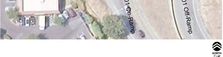
5 3. ROWLAND BOULEVARD BUS PADS The Rowland Interchange Bus Pad facilities are split into southbound and northbound elements. Passenger transfers can be accomplished between local and Highway 101 bus services on either side of the interchange. For passengers walking to the freeway bus pad stops, however, they must walk across the overcrossing for either their initial or their return trip. This project proposes to improve pedestrian safety, patron security and local and regional transfer convenience to address current problems. Figure 3 - Overview of Rowland Boulevard Interchange 2) Northbound: Improve Pedestrian Safety 2 1 1) Southbound: Relocate Westbound Local Stop to Improve Transfer Connections Southbound - The transfer distance between the southbound freeway bus pad stop and the local bus stops, which are located west of Redwood Boulevard are longer than desired 850 feet to the eastbound local stop and 550 feet for the westbound local bus stop. Transfer patrons are also delayed by the Redwood Boulevard traffic signal, which separates the local and freeway bus pad stops. Page 5
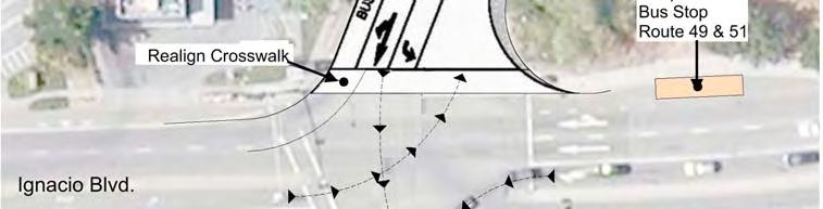
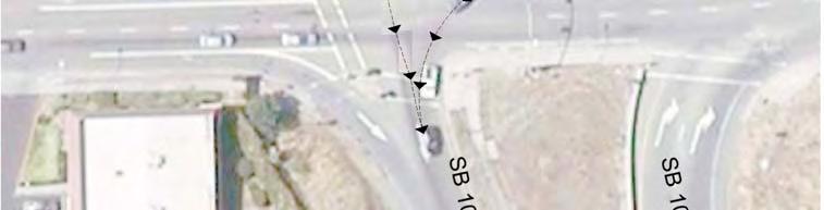
6 While it would be desirable to move both local stops closer to the southbound freeway bus pad stop, there is no safe place to relocate the eastbound local stop. The westbound local bus stop, however, would be moved nearer to the southbound off-ramp (150 feet) and provide a shorter walking distance for patrons of either bus routes 51 and 52 who wish to transfer to the regional buses at the bus pad stop, as shown in Figure 4. As a result of moving the westbound local bus stop the stop for the Southbound Route 58 which currently stops at the farside of the Rowland Blvd/Redwood Blvd intersection along Rowland Blvd, would be discontinued. This is a Golden Gate Transit commute Route with four southbound trips in the morning and three northbound trips in the evening and relatively few boarding in this location. The high volume of right-turns from the southbound off-ramp and the high volume of right-turns from Rowland Boulevard to northbound Redwood Boulevard can cause potential conflicts with buses stopped at the relocated bus stop on Rowland Blvd. Therefore, the traffic signal placed may need to employ a queue jump for departing buses. A paved 8 foot sidewalk is proposed to connect the southbound freeway bus pad stop with the local stops and the sidewalk system west of Redwood Boulevard. The new curb and gutter for the walkway along the north side of Rowland, would be sited to maintain a 10-foot shoulder lane to allow buses to stop at the new local stop without impeding the flow of westbound Rowland traffic. Preliminary investigation indicates that there is sufficient room to make the sidewalk improvements without additional right of way. The last improvement would be to create a fence to separate the freeway bus pad shelter area from the adjacent shrubs. The new fence and trimming the shrubs will increase visibility in the area and reduce security concerns. The cost for these improvements would be about $150,000. Northbound The improvements at the northbound freeway bus pad stop would primarily be focused on pedestrian improvements at the intersection of Rowland Boulevard and northbound freeway on/off ramps. The improvements would redirect the high volume right turn off-ramp traffic movement away from the crosswalk across Rowland Boulevard (Figure 5) and create a pedestrian refuge island. This will create a safer crossing for passengers needing to use the pedestrian sidewalk on the south side of the Rowland overpass. The dual northbound right-turn movement would continue to be signal controlled. Walking distances between the northbound bus pad stop and the westbound local stop is about 350 feet (2 min walk) and the distance between the northbound bus pad stop and the eastbound stop is about 450 feet (2.5 min walk). The current locations of the eastbound and westbound bus stops are outside of the vehicle traffic flow and are very convenient for patrons who are visiting the adjacent commercial developments and transferring to the regional northbound bus stop. Page 6

7 The cost for this improvement would be about $600,000. Figure 4 - Southbound Improvements at Rowland Boulevard Page 7

8 Figure 5 - Northbound Improvements at Rowland Blvd Page 8
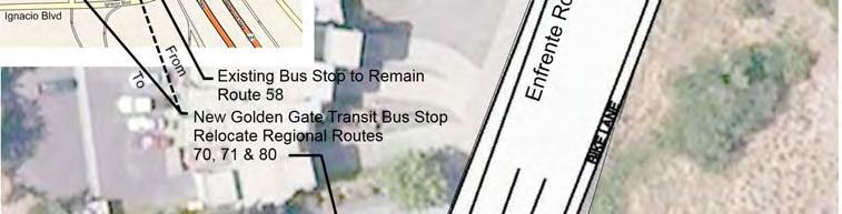
9 4. IGNACIO/BEL MARIN KEYS BUS PADS Due to the lack of conveniently located local bus stops on both the east and west side of this freeway interchange, the local bus Route 49/51 makes a circuitous deviation onto Highway 101 to service the freeway bus pads and allow for local to regional transfers. On the east side, there is not a convenient southbound stop on Nave Drive for passenger transfers and the northbound local stop is located 1,000 feet south of the northbound freeway bus pad stop. On the west side, there are no bus stops on Ignacio Boulevard east of Alameda del Prado, which is 1,500 feet from the southbound on-ramp. Figure 6 shows the circuitous routings for local Routes 49, and 51and their relationships to Highway 101 bus services (Routes 54, 70, 71, 75 and 80). On weekdays, Route 49 and Route 51 buses are interlined (connected together). Northbound Route 49 buses on Nave Drive connect to northbound 51 buses on Ignacio Boulevard via the northbound Bel Marin Keys Highway 101 on-ramp, a U-Turn at Highway 37 s interchange, southbound Highway 101, the Enfrente Road off-ramp and a right-turn onto Ignacio Boulevard. Southbound Ignacio Boulevard Route 51 buses destined for southbound Nave Drive connect via an even more circuitous path. They crossover Highway 101, turn right onto Nave Drive, right again to the northbound on-ramp, make a U-Turn at the Highway 101 interchange, travel southbound on Highway 101, exit to Enfrente Road, turn left onto Ignacio Boulevard, cross the freeway for the second time and then make a right-turn onto Nave Drive. All of this circuitous travel is to co-locate local and express bus stops to facilitate passenger transfers. The proposed Southbound and Northbound improvements would eliminate the need for local Route 49 and 51 buses to loop north to the Highway 37 interchange and would therefore reduce travel times and improve schedule reliability. Figure 9 describes the more direct routing. Southbound - The proposed improvement is to relocate the Enfrente Road southbound freeway bus stop to the Ignacio Boulevard intersection and reactivate the westbound local bus stop nearside of the Enfrente Road intersection (Figure 7). Reactivation of the eastbound local bus stop near Enfrente Road is not recommended due to the high volume of off-ramp traffic and pedestrian safety concerns. The relocation of the southbound freeway bus stop on Enfrente Road has two complications. There are class 2 bike lanes striped on either side of the roadway and there is a fire station located midblock in the vicinity of the proposed improvements. Currently there is a 50-foot roadway section between curbs. To place the southbound Enfrente Road bus stop near the intersection, some widening may be required in proximity of the intersection of Enfrente Road and Ignacio Boulevard. A bus pad would be constructed along the existing easterly curb. The bike lane would merge into the bus pad and extend to the corner. The striping of the intersection would be changed such that the existing southbound lanes would be configured such that lane number 1 would become a dedicated left turn lane and lane number 2 would be a through right turn lane. The bus stop would be available for bikes as well as buses. Pavement buttons would be installed along with DO NOT BLOCK driveway markings for the fire station driveway area. Due to right turning traffic volumes at the intersection, there is a potential for the turning vehicles Page 9


10 trapping the regional buses and the US 101 buses at the new bus stop. One solution to this problem would be to add a queue jump phase at the intersection which would allow regional buses to merge onto Hwy 101 prior to allowing the vehicles to make a right turn. An extinguishable no-right turn sign would be added to the traffic signal. The existing stop on Enfrente located about 400-feet north of the Enfrente- Ignacio Intersection would be kept in service to only serve the proposed Route 58 bus and the weekend Route 52 southbound bus because these two routes turn left at Ignacio Boulevard from Enfrente Road and would be unable to use the new southbound stop. These southbound weekend buses, however, could make needed transfer connections on the eastside of the interchange near the northbound off-ramp. Figure 6 - Local and Regional Bus Service at Ignacio Blvd and Bel Marin Keys Blvd. Page 10

11 Figure 7 - Pedestrian and Bus Stop Improvements at Enfrente Road and Ignacio Page 11
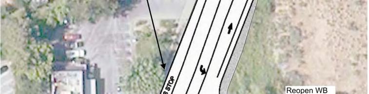
12 IMPROVEMENT CONCEPTS Chapter 4: Ignacio/Bel Marin Keys The resulting transfer distances between the southbound bus pad stop and the westbound local stop would be 150 feet. Connection distances to the eastbound local stop on Ignacio Boulevard would be 600 feet and 900 feet to the northbound Alameda Del Prado bus stop. The cost for this concept would be about $100,000. Northbound - The proposed concept is to locate the local and Highway 101 freeway bus stops near each other as shown in Figure 8. The current distances between the northbound freeway pad stop and the local southbound stop and the local northbound stop are 1,500 feet and 1,000 feet respectively. This concept would entail developing a nearside stop at the ramp terminal for the northbound off-ramp and relocating the current southbound local stop north along Nave Drive so that it would be a farside stop at the NB 101 off ramp intersection. This would place the local and regional stops in close proximity. The new bus stop on southbound Nave Drive would serve the local bus routes, 49 and 51. A new island would be constructed at the ramp end to divide the off ramp traffic and provide room for two buses at the new regional stop at the ramp end. The island would also provide sufficient length along Nave Drive to accommodate the bus stop, and crosswalk The relocated crosswalk will serve transfer transit patrons between the regional and local buses that require crossing Nave Drive. A bus activated signal phase is recommended to assist buses exiting northbound onto Nave Drive. The location of the regional bus stop provides a favorable amount of safe stopping distance between the end of the bus stop and the freeway off ramp. The current STOP bar for the southbound traffic would remain at its current location. The current northbound express bus pad stop on the northbound on-ramp would be retained to serve Bel Marin Keys passengers. A bus only left-turn for eastbound traffic onto the northbound on-ramp is also proposed. This bus only left turn would enable the weekday northbound route 52 to make convenient connections. The cost for this improvement would be about $700,000. Page 12

13 Figure 8 - Pedestrian and Bus Stop Improvements at Nave Drive and Northbound 101 Off-ramp Relocation of Bus Stop Routes 49 &51 Page 13

14 Figure 9 - New Local Route at Ignacio Blvd. and Bel Marin Keys Blvd. Page 14
King County Metro. Columbia Street Transit Priority Improvements Alternative Analysis. Downtown Southend Transit Study. May 2014.
 King County Metro Columbia Street Transit Priority Improvements Alternative Analysis Downtown Southend Transit Study May 2014 Parametrix Table of Contents Introduction... 1 Methodology... 1 Study Area...
Develop ground transportation improvements to make the Airport a multi-modal regional
 Project Overview TRANSPORTATION IMPROVEMENTS WHAT ARE THE PROJECT GOALS? Transportation transportation hub. Develop ground transportation improvements to make the Airport a multi-modal regional Land Use
MBTA Key Bus Route. Community Meeting Route 1 - Boston
 MBTA Key Bus Route Improvement Program Community Meeting Route 1 - Boston United South End Settlement Agenda Welcome and introductions Safety briefing/accommodations Key Bus Route Program overview Existing
Location Concept Plan Amendment Recommendation Approved 2011 Concept Plan
 Valley Line West LRT Concept Plan Recommended Amendments Lewis Farms LRT Terminus Site Location Concept Plan Amendment Recommendation Approved 2011 Concept Plan Lewis Farms LRT terminus site, 87 Avenue/West
2.0 Development Driveways. Movin Out June 2017
 Movin Out June 2017 1.0 Introduction The proposed Movin Out development is a mixed use development in the northeast quadrant of the intersection of West Broadway and Fayette Avenue in the City of Madison.
METRO Orange Line BRT American Boulevard Station Options
 METRO Orange Line BRT American Boulevard Station Options Bloomington City Council Work Session November 18, 2013 Christina Morrison BRT/Small Starts Project Office Coordinating Planning and Design AMERICAN
MBTA Key Bus Route Improvement Program. Community Meeting Route 57 - Boston. January 31, 2011 Boston Arts Academy, 174 Ipswich St.
 MBTA Key Bus Route Improvement Program Community Meeting Route 57 - Boston January 31, 2011 Boston Arts Academy, 174 Ipswich St., Boston Agenda Welcome and introductions Safety briefing/accommodations
Traffic Impact Study for Hamilton Fields
 Whitlock & Weinberger Transportation, Inc. 490 Mendocino Avenue Suite 201 Santa Rosa, CA 95401 voice (707) 542-9500 fax (707) 542-9590 475 14 th Street Suite 290 Oakland, CA 94612 voice (510) 444-2600
Figure 2-14: Existing Bus Routing at Irwindale Station
 494 W oothill Blvd 69 N Irwindale Ave 185 Irwindale E 1st St 3 6 feet igure 2-14: Existing Bus Routing at Irwindale 39 Proposed Bus Route 494 W oothill Blvd Proposed Discontinued Bus Route Proposed New
TRANSPORTATION REVIEW
 TRANSPORTATION REVIEW - PROPOSED MIX OF LAND USES IS CONSISTENT WITH THE CITY S UNDER THE GRANVILLE BRIDGE POLICIES THAT AIM TO MEET NEIGHBOURING RESIDENTS SHOPPING NEEDS AND REDUCE RELIANCE ON AUTOMOBILE
State Avenue Corridor Bus Rapid Transit (BRT)
") State Avenue Corridor Bus Rapid Transit (BRT) Moving Forward Incrementally April 2010 State Ave. BRT Update Bus Rapid Transit Overview State Ave. Alternatives Analysis Results What s Coming Up Right Away!
State Avenue Corridor Bus Rapid Transit (BRT) Moving Forward Incrementally April 2010 State Ave. BRT Update Bus Rapid Transit Overview State Ave. Alternatives Analysis Results What s Coming Up Right Away!
Traffic Impact Study Speedway Gas Station Redevelopment
 Traffic Impact Study Speedway Gas Station Redevelopment Warrenville, Illinois Prepared For: Prepared By: April 11, 2018 Table of Contents 1. Introduction... 1 2. Existing Conditions... 4 Site Location...
Central Park Drives Traffic Management Overview
 Central Park Drives Traffic Management Overview Spring 2015 New York City Department of Transportation Existing Traffic Management From Labor Day thru Last Day of NYC Public School: 8-10 AM weekdays (Southbound)
MBTA Key Bus Route Improvement Program. Community Meeting Route 66 Allston/Brighton
 MBTA Key Bus Route Improvement Program Community Meeting Route 66 Allston/Brighton January 19, 2011 Honan-Allston Library 300 North Harvard Street Agenda Welcome and introductions Safety briefing/accommodations
Service Quality: Higher Ridership: Very Affordable: Image:
 Over the past decade, much attention has been placed on the development of Bus Rapid Transit (BRT) systems. These systems provide rail-like service, but with buses, and are typically less expensive to
Traffic Engineering Study
 Traffic Engineering Study Bellaire Boulevard Prepared For: International Management District Technical Services, Inc. Texas Registered Engineering Firm F-3580 November 2009 Executive Summary has been requested
TRAFFIC SIGNAL DESIGN REPORT KING OF PRUSSIA ROAD & RAIDER ROAD RADNOR TOWNSHIP PENNSYLVANIA
 TRAFFIC SIGNAL DESIGN REPORT KING OF PRUSSIA ROAD & RAIDER ROAD RADNOR TOWNSHIP PENNSYLVANIA PREPARED FOR: UNIVERSITY OF PENNSYLVANIA HEALTH SYSTEM 34 CIVIC CENTER BOULEVARD PHILADELPHIA, PA 1987 (61)
EUGENE-SPRINGFIELD, OREGON EAST WEST PILOT BRT LANE TRANSIT DISTRICT
 EUGENE-SPRINGFIELD, OREGON EAST WEST PILOT BRT LANE TRANSIT DISTRICT (BRIEF) Table of Contents EUGENE-SPRINGFIELD, OREGON (USA)... 1 COUNTY CONTEXT AND SYSTEM DESCRIPTION... 1 SYSTEM OVERVIEW... 1 PLANNING
EXCEPTION TO STANDARDS REPORT
 EXCEPTION TO STANDARDS REPORT PROJECT DESCRIPTION AND NEED The project is located in Section 6, Township 23 North, Range 9 East and Section 31 Township 24 North, Range 9 East, in the Town of Stockton,
Revised Report. Traffic Study for Safeway Fuel Center at Washington Square Shopping Center. In The City of Petaluma.
 Revised Report Traffic Study for Safeway Fuel Center at Washington Square Shopping Center In The Pleasanton Fresno Sacramento Santa Rosa TJKM www.tjkm.com Revised Report Traffic Study for Safeway Fuel
STH 60 Northern Reliever Route Feasibility Study Report
 #233087 v3 STH 60 Northern Reliever Route Feasibility Study Report Washington County Public Works Committee Meeting September 28, 2016 1 STH 60 Northern Reliever Route Feasibility Study Hartford Area Development
Traffic Management Plan and Queuing Analysis Lakehill Preparatory School Z Hillside Drive, Dallas, TX October 27, 2015
 Traffic Management Plan and Queuing Analysis Lakehill Preparatory School Z145-235 2720 Hillside Drive, Dallas, TX October 27, 2015 Introduction: The Lakehill Preparatory School is located on the northeast
TRAFFIC IMPACT ANALYSIS FOR. McDONALD S RESTAURANT IN CARMICAEL Sacramento County, CA. Prepared For:
 TRAFFIC IMPACT ANALYSIS FOR McDONALD S RESTAURANT IN CARMICAEL Sacramento County, CA Prepared For: McDonald s USA, LLC Pacific Sierra Region 2999 Oak Road, Suite 900 Walnut Creek, CA 94597 Prepared By:
Trans-Canada Highway and McCallum Road Interchange Upgrade
 Trans-Canada Highway and McCallum Road Interchange Upgrade A Value Added Project Prepared by: Cory Clark, P.Eng. Project Engineer ISL Engineering and Land Services Suite 301, 20338-65 th Avenue Langley,
TRAFFIC PARKING ANALYSIS
 TRAFFIC PARKING ANALYSIS NAPA FLEA MARKET COUNTY OF NAPA Prepared for: Tom Harding Napa-Vallejo Flea Market 33 Kelly Road American Canyon, CA 9453 Prepared by: 166 Olympic Boulevard, Suite 21 Walnut Creek,
Transit City Etobicoke - Finch West LRT
 Delcan Corporation Transit City Etobicoke - Finch West LRT APPENDIX D Microsimulation Traffic Modeling Report March 2010 March 2010 Appendix D CONTENTS 1.0 STUDY CONTEXT... 2 Figure 1 Study Limits... 2
Technical Feasibility Report
 Prepared For: Bow Concord I-93 Improvements Project Bow and Concord, NH Prepared By: 53 Regional Drive Concord, NH 03301 NHDOT Project # 13742 Federal Project #T-A000(018) September 2018 TABLE OF CONTENTS
I-820 (East) Project Description. Fort Worth District. Reconstruct Southern I-820/SH 121 Interchange
 Project Description. Fort Worth District. Reconstruct Southern I-820/SH 121 Interchange") I-820 (East) Project Description Fort Worth District Reconstruct Southern I-820/SH 121 Interchange I-820 from approximately 2,000 feet north of Pipeline Road/Glenview Drive to approximately 3,200 feet
I-820 (East) Project Description Fort Worth District Reconstruct Southern I-820/SH 121 Interchange I-820 from approximately 2,000 feet north of Pipeline Road/Glenview Drive to approximately 3,200 feet
Preliminary Definition of Alternatives. 3.0 Preliminary Definition of Alternatives
 3.0 What preliminary alternatives are being evaluated? The alternatives for the East San Fernando Valley Transit Corridor project that were considered for screening include the No Build Alternative, Transportation
I-494/I-35 Interchange Vision Layout Development - BRT Station Concepts S.P B SEH No
 TECHNICAL MEMORANDUM TO: FROM: Transit Advisory Group Jeff Rhoda DATE: RE: I-494/I-35 Interchange Vision Layout Development - BRT Station Concepts S.P. 2785-330B SEH No. 123252 04.00 I-494/I-35W Interchange
TRAFFIC DATA. Existing Derousse Ave./River Rd. AM LOS Analysis Existing Derousse Ave./River Rd. PM LOS Analysis
 Appendix E NJ TRANSIT Pennsauken Junction Transit Center and Park & Ride RiverLINE and Atlantic City Line Pennsauken Township, Camden County, New Jersey TRAFFIC DATA Background Traffic Information for
Station Evaluation. Durham-Orange Light Rail Transit Project Spring 2012
 Station Evaluation Durham-Orange Light Rail Transit Project Spring 2012 Key Ingredients for Station Development Platform Designs UNC Hospitals Station The UNC Hospitals Station Option D would be the westerly
Sherman Oaks Community Traffic Plan
 Sherman Oaks is a community that is geographically bound by the Santa Monica mountains on its southern boundary, and the ever-expanding San Fernando Valley on its western, northern, and eastern boundaries.
1. INTRODUCTION 2. PROJECT DESCRIPTION CUBES SELF-STORAGE MILL CREEK TRIP GENERATION COMPARISON
 CUBES SELF-STORAGE MILL CREEK TRIP GENERATION COMPARISON 1. INTRODUCTION This report summarizes traffic impacts of the proposed CUBES Self-Storage Mill Creek project in comparison to the traffic currently
I-405 Sepulveda Pass Improvements Project Wilshire Ramps Reconstruction
 metro.net/works I-405 Sepulveda Pass Improvements Project Wilshire Ramps Reconstruction We re working to create safer, smoother interchanges. Project Overview The primary goal of the I-405 Sepulveda Pass
4 Circulation & Transportation
 4.1 Mobility Network The mobility network at the new St. Paul s hospital and health campus is comprised of an interconnected system of sidewalks, cycle paths, transit routes and roadways. Figure 4-1: Indicative
BROWARD BOULEVARD CORRIDOR TRANSIT STUDY
 BROWARD BOULEVARD CORRIDOR TRANSIT STUDY FM # 42802411201 EXECUTIVE SUMMARY July 2012 GOBROWARD Broward Boulevard Corridor Transit Study FM # 42802411201 Executive Summary Prepared For: Ms. Khalilah Ffrench,
Existing Traffic Conditions
 May 14, 2014 Ms. Lorraine Weiss City of San Mateo 330 West 20 th Avenue San Mateo, CA 94403 Subject: Traffic Operational Study for the Proposed Tilton Avenue Residential Development in San Mateo, California
Pace Bus Depot Location Analysis
 Pace Bus Depot Location Analysis Key Notes 1. Options refer to conceptual sketches prepared by Kimley Horn. 2. The depot is assumed to accommodate Pace routes as they currently exist: 17 routes on the
KEY BUS ROUTE IMPROVEMENT PROJECT ROUTE 23 AGENDA
 KEY BUS ROUTE IMPROVEMENT PROJECT ROUTE 23 December 9, 2009 Codman Tech 450 Washington Street AGENDA Introduction Key Bus Routes Program Route 23 Challenges Proposed Improvement Plan Next Steps Question
APPENDIX E. Traffic Analysis Report
 APPENDIX E Traffic Analysis Report THIS PAGE INTENTIONALLY BLANK EAGLE RIVER TRAFFIC MITIGATION PHASE I OLD GLENN HIGHWAY/EAGLE RIVER ROAD INTERSECTION IMPROVEMENTS TRAFFIC ANALYSIS Eagle River, Alaska
Mannheim/Higgins. Lee/Touhy. Municipal. Alternate 1), Village of Rosemont (Eastbound. Major Considerations:
, Village of Rosemont (Eastbound. Major Considerations:") Mannheim/Higgins Municipality: Municipality: City of Village Des Plaines of Skokie (Eastbound Alternate 1), Village of Rosemont (Eastbound Alternate Major 2 and Considerations: Westbound Alternate 1),
Mannheim/Higgins Municipality: Municipality: City of Village Des Plaines of Skokie (Eastbound Alternate 1), Village of Rosemont (Eastbound Alternate Major 2 and Considerations: Westbound Alternate 1),
Construction Staging Area 4 Avenue Road
 REPORT FOR ACTION Construction Staging Area 4 Avenue Road Date: September 27, 2017 To: Toronto and East York Community Council From: Acting Director, Transportation Services, Toronto and East York District
TALMONT TOWNHOMES MADISON KENNETH SPA TRAFFIC IMPACT STUDY. Sacramento, CA. Prepared For: MBK Homes. Prepared By:
 TALMONT TOWNHOMES MADISON KENNETH SPA TRAFFIC IMPACT STUDY Sacramento, CA Prepared For: MBK Homes Prepared By: KD Anderson & Associates 3853 Taylor Road, Suite G Loomis, California 95650 (916) 660-1555
New Jersey Turnpike Authority Interchange 6 to 9 Widening Program
 New Jersey Turnpike Authority Interchange 6 to 9 Widening Program Tuesday, September 18, 2007 Public Hearings: Time: 5:00 PM - 8:00 PM Wednesday, September 19, 2007 Senior Center 3 Municipal Drive Bordentown,
State Route 1/State Route 41/ Main Street Intersection Control Evaluation (Step 2) Report. City of Morro Bay. Prepared for: Prepared by:
 Report. City of Morro Bay. Prepared for: Prepared by:") State Route 1/State Route 41/ Main Street Intersection Control Evaluation (Step 2) Report Prepared for: City of Morro Bay Prepared by: (Caltrans Project No. 0515000104, EA 0F670) State Route 1/State Route
State Route 1/State Route 41/ Main Street Intersection Control Evaluation (Step 2) Report Prepared for: City of Morro Bay Prepared by: (Caltrans Project No. 0515000104, EA 0F670) State Route 1/State Route
Functional Design Report
 Presented to: City of Beverly MassDOT Highway Division Rte 128 Exit 19 Interchange Improvements Project Beverly, MA Functional Design Report May 30, 2014 Submitted by: Jacobs 343 Congress Street Boston,
GASOLINE SERVICE STATION 1618, 1622 ROGER STEVENS DRIVE OTTAWA, ONTARIO TRANSPORTATION IMPACT ASSESSMENT. Prepared for:
 GASOLINE SERVICE STATION 1618, 1622 ROGER STEVENS DRIVE OTTAWA, ONTARIO TRANSPORTATION IMPACT ASSESSMENT Prepared for: Invecta Development (Ottawa) Corporation 758 Shanks Height Milton, ON L9T 7P7 May
TRAFFIC IMPACT STUDY. USD #497 Warehouse and Bus Site
 TRAFFIC IMPACT STUDY for USD #497 Warehouse and Bus Site Prepared by: Jason Hoskinson, PE, PTOE BG Project No. 16-12L July 8, 216 145 Wakarusa Drive Lawrence, Kansas 6649 T: 785.749.4474 F: 785.749.734
EXECUTIVE SUMMARY. The following is an outline of the traffic analysis performed by Hales Engineering for the traffic conditions of this project.
 EXECUTIVE SUMMARY This study addresses the traffic impacts associated with the proposed Shopko redevelopment located in Sugarhouse, Utah. The Shopko redevelopment project is located between 1300 East and
I-405 Sepulveda Pass Improvements Project
 I-405 Sepulveda Pass Improvements Project Community Meeting November 15, 2012 1 Wilshire Segment Overview of Wilshire Segment There are a total of 23 bridges being constructed on this project; almost half
BARRHAVEN FELLOWSHIP CRC 3058 JOCKVALE ROAD OTTAWA, ONTARIO TRANSPORTATION BRIEF. Prepared for:
 BARRHAVEN FELLOWSHIP CRC 3058 JOCKVALE ROAD OTTAWA, ONTARIO TRANSPORTATION BRIEF Prepared for: Barrhaven Fellowship CRC 3058 Jockvale Road Ottawa, ON K2J 2W7 December 7, 2016 116-649 Report_1.doc D. J.
SERVICE DESIGN GUIDELINES
 VTA TRANSIT SUSTAINABILITY POLICY: APPENDIX A SERVICE DESIGN GUIDELINES Adopted February 2007 COMMUNITYBUS LOCALBUS EXPRESSBUS BUSRAPIDTRANSIT LIGHTRAILTRANSIT STATIONAREAS S A N T A C L A R A Valley Transportation
Chapter 4 : THEME 2. Transportation
 Chapter 4 : THEME 2 Strengthen connections to keep the Central Area easy to reach and get around 55 Figure 4.2.1 Promote region-wide transit investments. Metra commuter rail provides service to the east,
Challenges in a Post-Katrina Environment East-West Corridor Project Overview February, 2007
 EAST-WEST CORRIDOR Challenges in a Post-Katrina Environment East-West Corridor Project Overview February, 2007 Presentation Agenda Project Overview / Purpose and Need Highway Component Transit Component
West LRT. Alignment Update and Costing Report May Calgary Transit Transportation Planning Clifton ND Lea Consultants
 West LRT Alignment Update and Costing Report 2006 May Calgary Transit Transportation Planning Clifton ND Lea Consultants West LRT Update Background The service area for West LRT is generally described
Maryland Gets to Work
 I-695/Leeds Avenue Interchange Reconstruction Baltimore County Reconstruction of the I-695/Leeds Avenue interchange including replacing the I-695 Inner Loop bridges over Benson Avenue, Amtrak s Northeast
Quantitative analyses of weekday a.m. and p.m. commuter hour conditions have been conducted for the following five scenarios:
 6.1 TRANSPORTATION AND CIRCULATION 6.1.1 INTRODUCTION This section of the EIR presents the results of TJKM s traffic impact analysis of the proposed Greenbriar Development. The analysis includes consideration
VOA Vista Drive Residential housing Development TIA Project #13915 TABLE OF CONTENTS
 VOA Vista Drive Residential housing Development TIA Project #13915 TABLE OF CONTENTS Executive Summary... 2 Project Background... 2 Conditions... 2 Findings... 3 Recommendations... 4 Introduction... 6
Appendix G Traffic and Parking Report
 Appendix G Traffic and Parking Report TABLE OF CONTENTS SECTION PAGE Executive Summary... v 1.0 Introduction... 1 1.1 Study Area... 3 2.0 Project Description... 4 2.1 Site Location... 4 2.2 Existing Project
Traffic Impact Analysis West Street Garden Plots Improvements and DuPage River Park Garden Plots Development Naperville, Illinois
 Traffic Impact Analysis West Street Garden Plots Improvements and DuPage River Park Garden Plots Development Naperville, Illinois Submitted by April 9, 2009 Introduction Kenig, Lindgren, O Hara, Aboona,
Click to edit Master title style
 Nelson/Nygaard Consulting Associates SERVICE IMPROVEMENT STRATEGIES September 22, 2015 1 PROJECT OVERVIEW & WORK TO DATE 1. Extensive stakeholder involvement Throughout 2. System and market assessment
Attachment F Transportation Technical Memorandum
 Attachment F Transportation Technical Memorandum Sounder Yard and Shops Facility Project Transportation Technical Memorandum March 25, 216 Prepared for: Sound Transit Prepared by: Parsons Brinckerhoff
Public Information Packet FY Fargo-Moorhead Metropolitan Transportation Improvement Program (TIP)
") Public Information Packet FY - Fargo-Moorhead Metropolitan Transportation Improvement Program (TIP) Comment Form Annual Element TIP Projects - TIP Projects Year - Metropolitan Transportation Improvement
Public Information Packet FY - Fargo-Moorhead Metropolitan Transportation Improvement Program (TIP) Comment Form Annual Element TIP Projects - TIP Projects Year - Metropolitan Transportation Improvement
RICHMOND OAKS HEALTH CENTRE 6265 PERTH STREET OTTAWA, ONTARIO TRANSPORTATION BRIEF. Prepared for: Guycoki (Eastern) Limited.
 Limited.") RICHMOND OAKS HEALTH CENTRE 6265 PERTH STREET OTTAWA, ONTARIO TRANSPORTATION BRIEF Prepared for: Guycoki (Eastern) Limited June 16, 2016 116-638 Brief_1.doc D. J. Halpenny & Associates Ltd. Consulting
RICHMOND OAKS HEALTH CENTRE 6265 PERTH STREET OTTAWA, ONTARIO TRANSPORTATION BRIEF Prepared for: Guycoki (Eastern) Limited June 16, 2016 116-638 Brief_1.doc D. J. Halpenny & Associates Ltd. Consulting
SOUTHERN GATEWAY. Transportation and Trinity River Project Committee 11 May 2015
 SOUTHERN GATEWAY Transportation and Trinity River Project Committee 11 May 2015 Southern Gateway Project History Began in 2001 as a Major Investment Study [ MIS ], Schematic, and Environmental Assessment
Brigham City 1200 West Box Elder Creek Bridge - Widening Project Type Reconstruction
 Brigham City 1200 West Box Elder Creek Bridge - Widening Project Type Reconstruction 550 North to 650 North $ 1,750,000 $ 1,582,113 To widen an existing bridge on 1200 West over Box Elder Creek that will
Lacey Gateway Residential Phase 1
 Lacey Gateway Residential Phase Transportation Impact Study April 23, 203 Prepared for: Gateway 850 LLC 5 Lake Bellevue Drive Suite 02 Bellevue, WA 98005 Prepared by: TENW Transportation Engineering West
Greater Cleveland Regional Transit Authority. Bus Stop Design Guidelines
 Greater Cleveland Regional Transit Authority Bus Stop Design Guidelines Contents Purpose... I Bus Stop Design & Location... 1 Bus Stop Planning... 1 Bus Stop Safety & Consolidation... 1 As Needed Basis...
5 VAUGHAN METROPOLITAN CENTRE AND SURROUNDING AREAS TRANSPORTATION STUDY PROGRESS
 5 VAUGHAN METROPOLITAN CENTRE AND SURROUNDING AREAS TRANSPORTATION STUDY PROGRESS The Transportation Services Committee recommends the adoption of the recommendations contained in the following report
2.1.5 Traffic and Circulation. Table Level of Service Criteria for Highway Segment Regulatory Setting Affected Environment
 2.1.5 Traffic and Circulation This section addresses the potential impacts to traffic and circulation associated with construction and long-term operation of the proposed project. The traffic and circulation
TRAFFIC IMPACT STUDY DERRY GREEN CORPORATE BUSINESS PARK MILTON SECONDARY PLAN MODIFICATION
 TRAFFIC IMPACT STUDY DERRY GREEN CORPORATE BUSINESS PARK MILTON SECONDARY PLAN MODIFICATION TRAFFIC IMPACT STUDY DERRY GREEN CORPORATE BUSINESS PARK MILTON SECONDARY PLAN MODIFICATION DECEMBER 24 UPDATED
CTfastrak Expansion. Stakeholder Meeting #4 Manchester Town Hall June 3, 2016
 CTfastrak Expansion Stakeholder Meeting #4 Manchester Town Hall June 3, 2016 Today s Agenda Phase I Update 2016 Service Plan Implementation Schedule & Cost Update Phase II Services Timeline Market Analysis
The key roadways in the project vicinity are described below. Exhibit displays the existing number of lanes on the study roadways.
 4.2 TRAFFIC AND CIRCULATION This section presents the key assumptions, methods, and results of analysis for the transportation and circulation impacts of the proposed project. This section is based on
East Falls Church Ballston-MU Virginia Sq-GMU
 Arlington Cou Fairfax C ORANGE LINE Vienna/Fairfax-GMU Dunn Loring-Merrifield West Falls Church-VT/UVA East Falls Church Ballston-MU Virginia Sq-GMU Clarendon Court House Prepared for Arlington County,
Sound Transit East Link: Bus/LRT System Integration Study
 Sound Transit East Link: Bus/LRT System Integration Study Prepared For: Sound Transit King County Metro Mercer Island WSDOT Prepared By: CH2M HILL July, 2014 1 SOUND TRANSIT EAST LINK: BUS/LRT SYSTEMES
US 59 (SOUTHWEST FWY) IH 610 (West Loop) to SH 288 (South Fwy)
 IH 610 (West Loop) to SH 288 (South Fwy)") Mobility Investment Priorities Project Houston US 59 US 59 (SOUTHWEST FWY) IH 610 (West Loop) to SH 288 (South Fwy) Current Conditions From IH 610 West to SH 288, US 59 operates with four or five lanes
Mobility Investment Priorities Project Houston US 59 US 59 (SOUTHWEST FWY) IH 610 (West Loop) to SH 288 (South Fwy) Current Conditions From IH 610 West to SH 288, US 59 operates with four or five lanes
800 Access Control, R/W Use Permits and Drive Design
 Table of Contents 801 Access Control... 8-1 801.1 Access Control Directives... 8-1 801.2 Access Control Policies... 8-1 801.2.1 Interstate Limited Access... 8-1 801.2.2 Limited Access... 8-1 801.2.3 Controlled
CHAPTER 2 PROPOSED BUS ROUTE MODIFICATIONS
 OVERVIEW This chapter presents the recommended bus interface plan to coincide with the opening of the Metro Gold Line Foothill Extension Pasadena to Azusa project in 2015. This project will extend rail
King Soopers #116 Thornton, Colorado
 Traffic Impact Study King Soopers #116 Thornton, Colorado Prepared for: Galloway & Company, Inc. T R A F F I C I M P A C T S T U D Y King Soopers #116 Thornton, Colorado Prepared for Galloway & Company
TRAFFIC IMPACT ANALYSIS
 TRAFFIC IMPACT ANALYSIS Emerald Isle Commercial Development Prepared by SEPI Engineering & Construction Prepared for Ark Consulting Group, PLLC March 2016 I. Executive Summary A. Site Location The Emerald
Table of Contents INTRODUCTION... 3 PROJECT STUDY AREA Figure 1 Vicinity Map Study Area... 4 EXISTING CONDITIONS... 5 TRAFFIC OPERATIONS...
 Crosshaven Drive Corridor Study City of Vestavia Hills, Alabama Table of Contents INTRODUCTION... 3 PROJECT STUDY AREA... 3 Figure 1 Vicinity Map Study Area... 4 EXISTING CONDITIONS... 5 TRAFFIC OPERATIONS...
Orange Line Bus Rapid Transit Project Plan Update. Metro Transit June 2014 D R A F T
 Orange Line Bus Rapid Transit Metro Transit D R A F T Contents 1 Background 4 2 Scope 6 2.1 Mode 2.2 Stations 2.3 Guideway 2.4 Right of Way Needs 2.5 Technology 2.6 Fare Collection 2.7 Branding and Marketing
TRAFFIC IMPACT STUDY FOR SONIC DRIVE-IN RESTAURANT. Vallejo, CA. Prepared For:
 TRAFFIC IMPACT STUDY FOR SONIC DRIVE-IN RESTAURANT Vallejo, CA Prepared For: ELITE DRIVE-INS, INC. 2190 Meridian Park Blvd, Suite G Concord, CA 94520 Prepared By: KD Anderson & Associates 3853 Taylor Road,
EXECUTIVE SUMMARY. The valet operation, service area, and drop-off lanes provided will be adequate Page i
 EXECUTIVE SUMMARY MacKenzie Engineering and Planning, Inc. performed an analysis of the traffic impacts resulting from the proposed project site located at 25 SE 4th Avenue, Delray Beach, Florida (PCN
Sepulveda Pass Corridor Systems Planning Study
 Los Angeles County Metropolitan Transportation Authority Sepulveda Pass Corridor Systems Planning Study Streets and Freeways Subcommittee January 17, 2013 1 Sepulveda Pass Study Corridor Extends for 30
Analysis of Radial and Trunk Feeder Transit System Configurations in Downtown Charlottesville
 Analysis of Radial and Trunk Feeder Transit System Configurations in Downtown Charlottesville 1. Introduction During the stakeholder input sessions of Charlottesville Area Transit s (CAT) Transit Development
LAWRENCE TRANSIT CENTER LOCATION ANALYSIS 9 TH STREET & ROCKLEDGE ROAD / 21 ST STREET & IOWA STREET LAWRENCE, KANSAS
 LAWRENCE TRANSIT CENTER LOCATION ANALYSIS 9 TH STREET & ROCKLEDGE ROAD / 21 ST STREET & IOWA STREET LAWRENCE, KANSAS TRAFFIC IMPACT STUDY FEBRUARY 214 OA Project No. 213-542 TABLE OF CONTENTS 1. INTRODUCTION...
Specific recommendations are made for downtown Austin, park-and-rides, and several different transit center locations.
 CHAPTER 6 CAPITAL FACILITIES RECOMMENDATIONS Select ServicePlan2020 service recommendations must occur with an upgrade of select capital facilities. In addition to the capital improvements discussed in
Construction Realty Co.
 MEMORANDUM TO: FROM : Jeff Pickus Construction Realty Co. Luay R. Aboona, PE Principal 9575 West Higgins Road, Suite 400 Rosemont, Illinois 60018 p: 847-518-9990 f: 847-518-9987 DATE: May 22, 2014 SUBJECT:
Unified Corridor Investment Study DRAFT Step 2 Scenario Analysis Report
 Unified Corridor Investment Study DRAFT Step 2 Scenario Analysis Report REVISIONS 1. Table 39: New Public Investments for Operation and Maintenance Costs 2. Appendix A-10: Passenger Rail Service - Operations
TABLE 4-4 DAILY LRT ALTERNATIVE STATION PASSENGER VOLUMES IN 2030
 Station Volumes and Boardings/Alightings The stations proposed for the LRT Alternative were selected due to their proximity to population and employment centers, major existing transportation facilities,
INTERSECTION ANALYSIS PARK AVENUE AND BRADDOCK ROAD (FROSTBURG, MD) FOR LENHART TRAFFIC CONSULTING, INC.
 FOR LENHART TRAFFIC CONSULTING, INC.") INTERSECTION ANALYSIS FOR PARK AVENUE AND BRADDOCK ROAD (FROSTBURG, MD) Prepared for: City of Frostburg, Maryland & Allegany County Commissioners Prepared by: LENHART TRAFFIC CONSULTING, INC. TRAFFIC ENGINEERING
INTERSECTION ANALYSIS FOR PARK AVENUE AND BRADDOCK ROAD (FROSTBURG, MD) Prepared for: City of Frostburg, Maryland & Allegany County Commissioners Prepared by: LENHART TRAFFIC CONSULTING, INC. TRAFFIC ENGINEERING
5.9 TRANSPORTATION AND TRAFFIC
 5.9 TRANSPORTATION AND TRAFFIC This section evaluates transportation- and traffic-related impacts that have the potential to result from the construction and operation of the Project. Information and analysis
ANDERSON PROPERTY SITE ANALYSIS
 ANDERSON PROPERTY SITE ANALYSIS Introduction The Montgomery County Department of Transportation (MCDOT) initiated a feasibility study in the fall of 2012 to evaluate the need for transit service expansion
Draft Supplemental Transportation Analysis Santa Clara - Alum Rock Transit Corridor APPENDIX A TRAFFIX Level of Service Calculation Sheets 2012 BRT 20
 Draft Supplemental Transportation Analysis Santa Clara - Alum Rock Transit Corridor APPENDIX A TRAFFIX Level of Service Calculation Sheets 202 BRT 2030 BRT 2030 BRT Mitigation COMPARE Wed May 8 2:02: 20
APPENDIX C1 TRAFFIC ANALYSIS DESIGN YEAR TRAFFIC ANALYSIS
 APPENDIX C1 TRAFFIC ANALYSIS DESIGN YEAR TRAFFIC ANALYSIS DESIGN YEAR TRAFFIC ANALYSIS February 2018 Highway & Bridge Project PIN 6754.12 Route 13 Connector Road Chemung County February 2018 Appendix
Project Status Update January 2017
 Project Status Update January 2017 1 What is the Purple Line? A new 16 mile east-west light rail line Operates mostly on the surface with 21 stations Connects New Carrollton in Prince George s County and
4.0 TIER 2 ALTERNATIVES
 4.0 TIER 2 ALTERNATIVES The Tier 2 Alternatives represent the highest performing Tier 1 Alternatives. The purpose of the Tier 2 Screening was to identify the LPA utilizing a more robust list of evaluation
City of Houston Fondren Road Paving and Drainage
 City of Houston Fondren Road Paving and Drainage From Braeswood Boulevard to Creekbend Drive TRC Meeting March 2016 Location and Vicinity Maps City Council District K Key Map 530 Z, 530 Y Land Use Commercial