West LRT. Alignment Update and Costing Report May Calgary Transit Transportation Planning Clifton ND Lea Consultants
|
|
|
- Willis Carson
- 5 years ago
- Views:
Transcription
1
2 West LRT Alignment Update and Costing Report 2006 May Calgary Transit Transportation Planning Clifton ND Lea Consultants
.")

3 West LRT Update Background The service area for West LRT is generally described as being west of 14 Street SW, north of Richmond Road SW and south of the Bow River as shown on this map which is reproduced from the original study report noted below. In 1983, a functional planning study for West LRT was completed by the Transportation Department (CALTS Series 86). This study is documented in two volumes. Volume 1 - Summary Report provides an overview of a recommended LRT alignment, facilities, operational characteristics, land use considerations and cost implications. Volume 2 Technical Report provides a comprehensive overview of the study area, study process, evaluation of alternatives, land use and cost implications and recommendations. In 1990, Council approved the recommendations of West LRT Functional Study Volume Update. This report provides updated population, land use and cost information and confirmed the alignment for West LRT that was identified in the 1983 study. 1
4 West LRT Alignment Update Overview The purpose of this report is to provide a technical update of the previously approved plans for the West LRT line, to identify land requirements and to provide a cost estimate to facilitate budget planning. During this update study a number of revisions to the approved plan were identified and investigated. The recommended changes to the approved alignment are not significant from a routing perspective and the line can still be constructed within the general scope of the approved right of way. However, the resulting updated plan requires considerably more elevated structures and some additional property in comparison with the approved plans. In general, this is required to better integrate West LRT into the adjacent communities and land uses that have evolved since It is acknowledged that the outcome of this report will be subject to a public engagement process. The updated revisions reflect: Land use development that did not occur as anticipated, Revised LRT design standards (right of way widths, track, structure and station area requirements), Revised roadway standards and opportunities, Need to minimize land use and property impacts, and Opportunities to facilitate future transit oriented development This report provides: 1. Updated population, employment and ridership projections. 2. Description of the updated West LRT alignment. 3. A cost estimate for the revised plan based on current pricing. 4. Conclusion and Recommendations Appendix 1 LRT Cost Estimates by Area Appendix 2 List of Properties Impacted by West LRT Appendix Approved West LRT Alignment Drawings. Appendix 4 West LRT Technical Update Plan Clifton ND Lea report 2
5 1. Updated Population, Employment and Ridership Projections Since the 1988 West LRT report, the projected population and employment figures for the West LRT service area have increased significantly. Table 1 shows that the current (2005) population and employment levels for the area have exceeded the values that were previously given for the city s 1.25 million horizon year. The most recent forecasts show that population and employment for the 1.25 million horizon (expected to be reached in year 2025) are 30 percent and 40 percent higher than the old forecasts, respectively. Ultimately, the population of this area could reach approximately 159,000 with up to 44,000 jobs with full build-out of the area east of the future Ring Road. Table 1 Comparison of Population and Employment Forecasts For West LRT Service Area 1985 Actual 2005 Actual Previous Projection for 1.25 Million Current Projection for 1.25 Million Population 33,361 81,300 80, ,000 Employment 8,261 18,600 15,445 22,000 Note: Previous projections based on 1985 data. Current projections based on 2005 data West LRT Ridership Estimate The following figures show the previous and updated weekday ridership forecasts for West LRT based on these population and employment projections for the 1.25 million population horizon year noted above West LRT Weekday Ridership Estimate = 23,400 to 25,800 Updated West LRT Weekday Ridership Estimate = 32,000 to 37,000 = 37,000 to 44,000 with TOD Redevelopment with higher density, mixed land use is possible within the future West LRT station areas in accordance with the City s Transit Oriented Development (TOD) Guidelines. The most likely locations for significant TOD are in the vicinity of Westbrook Mall and the future Sirocco Drive and Sunalta station areas. A modest level of TOD is also possible in the vicinity of the other stations subject to land use studies and community consultation. A conservative estimate suggests that an additional 5,000 to 7,000 daily trips on West LRT could be achieved beyond the ridership estimates noted above as a result of TOD. 3
6 2. Description of The Updated West LRT Alignment In 2005 December, the consulting firm of Clifton ND Lea was retained by The City of Calgary Transportation Department to conduct a technical review of the approved alignment for West LRT as defined in the 1983 and 1988 West LRT studies noted at the beginning of this report. Based on this review a number of functional design concept changes to the approved plan for West LRT are recommended. A description of each area of the recommended alignment and updated functional drawings are provided below. As well, a summary of changes from the approved plans are also noted here. A revised cost estimate for the updated alignment is provided in section #3 of this report. Drawings of the approved alignment from the 1983 and 1988 studies are provided in Appendix 3 for comparison purposes. A technical description of key elements of the updated alignment is provided in the Clifton ND Lea report which is attached as Appendix 4. Area 1 10 Street to 18 Street SW The West LRT line will begin at the west end of 7 Avenue, just east of 11 Street SW. A new 11 Street station is scheduled for construction in 2007 to replace the existing 10 Street station that is the current terminus of Northeast LRT. West LRT will operate as an extension of Northeast LRT so that trains on this line will no longer turn around in the downtown. West LRT tracks will cross 11 Street at-grade and pass through the Telus World of Science (Science Centre) site. This will require the demolition of a raised deck that provides an additional exit from the Science Centre. Discussions with the Science Centre suggest that the Science Centre will no longer occupy this building by the time West LRT is constructed, however, vehicular and pedestrian access to accommodate the future use of this building and the adjacent Millennium Park will be required as part of the final LRT design for this area. Just west of the Science Centre the LRT tracks will ramp up to an elevated structure that will take the tracks over Millennium Park, 14 Street, 9 Avenue and the CPR mainline tracks. West LRT will remain on an elevated structure within the south portion of the CPR right of way. An elevated station with side loading platforms will be constructed just west of 16 Street SW with pedestrian connections to the Greyhound terminal to the north and to the Sunalta community to the south. This station will include a third track on the south side of the inbound station platform to facilitate train turn arounds and a storage track for 4 car trains. All West LRT stations will be designed for 4 car train operation. West of the Sunalta Station, LRT tracks will proceed on an elevated structure located within the CPR right of way and then follow the south edge of the eastbound lanes of Bow Trail and the Crowchild Trail off-ramp. CPR has indicated that this land, currently leased to business on the north side of 10 Avenue can be leased or purchased. Several industrial buildings in this area and a small piece of land on the south side of 10 Avenue at the westerly end must be purchased to accommodate LRT. There will be residual lands under the elevated structure that can continue to be available when LRT is completed. 4
7 Changes Proposed in Area 1 vs Approved Alignment 1. A station is located on 7 th Avenue between 10 th and 11 Streets SW (to be completed in 2007). 2. Millennium Park has replaced Mewata Stadium and some modifications to Millennium Park will be required to accommodate LRT. 3. The Sunalta Station is located south of the CPR tracks, which requires a structure to carry LRT over 9 Avenue SW and the CPR. 4. The Sunalta Station is elevated to provide a better track profile and improved pedestrian access. 5. A turn around and storage track is incorporated into the Sunalta Station to facilitate the operation of 4 car trains and to allow the short turning or storage of trains. 6. LRT can be built independent of Bow Trail roadway improvement. 5
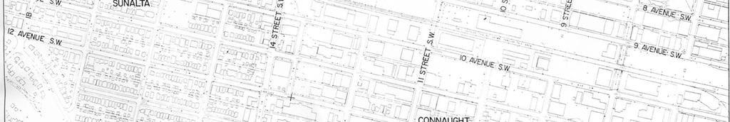
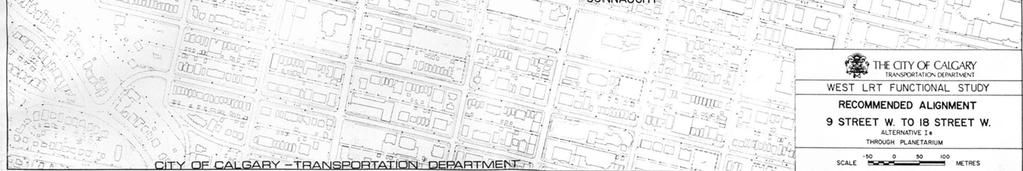
8 Updated Alignment Area 1 6
9 Area 2 18 Street to 26 Street SW From 10 Avenue SW, the LRT line will parallel the south edge of eastbound Bow Trail on an elevated structure that will pass over the southern most portion of the Crowchild Trail / Bow Trail interchange and then swing to the north coming back to grade to run along the north side of Bow Trail. The line will cross 26 Street SW at-grade. A centre loading platform will be located immediately west of 26 Street with at-grade access for pedestrians via the existing roadway crossing and area sidewalks. Some additional property along the south edge of the Jacques Lodges (Metropolitan Calgary Foundation) site must be obtained. As well, land will also be required from south edge of the Shaganappi Golf Course. Some degree of golf course revision is anticipated depending on the final design width of Bow Trail. Changes Proposed in Area 2 vs Approved Alignment 1. LRT is elevated over Crowchild Trail to avoid conflict with the interchange and Enmax power lines. 2. LRT is located along the north side of Bow Trail to minimize impact to the park on the south side of Bow Trail and to the Shaganappi Golf Course. 3. The 26 Street Station is located on the north side of Bow Trail, just west of 26 Street SW which provides for improve pedestrian access and a better station environment for passengers since the platform is not in the roadway median. 7
10 Updated Alignment Area 2 8
11 Area 3 26 Street to 37 Street SW West of the 26 Street Station, LRT tracks will parallel the north side of the westbound lanes of Bow Trail. As noted in Area 2, land for LRT and future Bow Trail widening will be required from the south edge of the Shaganappi Golf Course and some golf course revisions will be necessary. It is intended that the final design of Bow Trail and LRT will strive to minimize the land needed from the golf course and the residential properties to the south. An urban corridor design is being prepared for this area. At approximately 29 Street SW, LRT will ramp up to an elevated structure that will take the tracks southward over Bow Trail. At this point two options were investigated. A minimum impact alignment has the elevated LRT structure located parallel to the west edge of 33 Street SW with a tight turn to parallel the north side of 17 Avenue SW. Existing land uses along 33 Street and 17 Avenue SW, except for the abandoned Plains Indians Cultural Survival School (Melville Scott School), can remain with little impact to their access since LRT will be overhead. The second option for this section will require redevelopment of the block of land bounded by 33 Street, 37 Street, Bow Trail and 17 Avenue. LRT can cross diagonally through this site with an elevated station incorporated into the redevelopment. Conceptually, this redevelopment would include transit supportive, higher density retail, office and residential uses. This concept is generally supported by the major land owners (Westbrook Mall and the Calgary Board of Education). Some additional land assembly and relocation of the Ernest Manning High School to a new site reserved at 17 Avenue & 69 Street SW is required. Ideally, redevelopment of this site should occur concurrently with the construction of West LRT. A land use plan for this area is underway to explore redevelopment concepts and integration with the adjacent communities. Regardless of which LRT alignment option is pursued in this section, an elevated station should be located in close proximity to 17 Avenue and 37 Street SW which will be the primary location of bus zones for feeder buses serving the surrounding communities. The station will be accessed via a combination of ramps, stairs and elevators from the street level. As well, +15 connections can be developed as part of future redevelopment on the adjacent lands. As well, opportunities for the creation of approximately 300 to 500 park and ride stalls (potentially as part of a joint use arrangement) will be sought with the redevelopment of these lands. Changes Proposed in Area 3 vs Approved Alignment 1. LRT is located along the north side of Bow Trail. 2. An elevated structure carries LRT over Bow Trail and either along the west edge of 33 Street SW or diagonally through the centre of a redeveloped Westbrook Mall / Ernest Manning High School site. An elevated structure is considerably less expensive than a tunnel and reduces impacts to existing businesses or access to the future development site. 9
12 Updated Alignment Area 3 10
13 Area 4 37 Street to Glenside Drive SW The elevated LRT structure crosses over 37 Street along the north edge of the 17 Avenue SW right of way and returns to grade just west of 39 Street SW. An LRT right of way has been protected with setbacks along the north side of 17 Avenue SW and some land has already been acquired in this area. As well, construction of the AMA and Calgary Police Services buildings has left sufficient land for LRT. It is recommended that West LRT be routed along the north side of 17 Avenue. An at-grade, centre loading platform would be located just east of 45 Street SW. Access to the station will be via sidewalk connections and the existing at-grade intersection. Most existing street connections from the north (except 45 Street) should be closed north of 17 Avenue SW to minimize conflicts with LRT. Rather than constructing culde-sacs it is proposed that connecting lanes be constructed parallel to the north side of the LRT alignment. In some locations this will require property that would be in addition to the currently protected setback. Community consultation and a traffic study are required to determine the final configuration of these streets. The potential for a future LRT spur line to serve development along the future Sarcee Trail ring road, south of Glenmore Trail, has been identified. A spur line connection to West LRT is feasible west of 46 Street SW. This connection should be made via an elevated structure beginning just west of 45 Street SW. Conceptually, the spur line could run down the old section of 17 Avenue SW before turning south to enter the Sarcee Trail right of way. A decision on this spur line is required prior to construction of West LRT. Changes Proposed in Area 4 vs Approved Alignment 1. LRT is located along the north side of the 17 Avenue SW. This requires some additional property from the protected setback. This configuration will mean less impact to 17 Avenue and intersecting streets. 2. The 45 Street Station is located on the north side of 17 Avenue which will improve pedestrian access and provide a better passenger environment since it will not be in the roadway median. 3. A connection to a potential Sarcee Trail spur line may be feasible to serve future development on Tsu Tina land and further south in the future Providence community. 11
14 Updated Alignment Area 4 12
15 Area 5 Glenside Drive to Christie Park Gate SW At either 46 Street or Glenside Drive SW, an elevated structure would begin to carry LRT over Sarcee Trail. This structure is located to facilitate the future construction of an interchange at 17 Avenue and Sarcee Trail SW. A final design for this roadway structure and future upgrading of Sarcee Trail is required. West LRT will remain within the north portion of the 17 Avenue SW right of way. West of Sarcee Trail, the Signal Hill station will be located on a portion of the LRT structure immediately east of the intersection of Sirocco Drive / Costello Boulevard. A bus terminal and a parking structure for approximately 685 park and ride spaces will be constructed at the east end of Signature Park on the current Calgary Transit park and ride site east of the West Market Square shopping centre. Pedestrian access to the station will be via an overpass from the bus terminal / park and ride and via at-grade connections from the intersection and the residential community to the north. West of Sirocco Drive SW, LRT will be at-grade and located in the northern portion of the 17 Avenue SW right of way. This will require reconstruction of 17 Avenue between Sarcee Trail and 69 Street SW. LRT will cross Costello Boulevard and Christie Park Gate intersections atgrade. Changes Proposed in Area 5 vs Approved Alignment 1. An LRT structure is on the north side of the future Sarcee Trail interchange to allow LRT to proceed independent of the interchange. 2. LRT is located along the north side of 17 Avenue. This requires the rebuilding of 17 Avenue between Sarcee Trail and 69 Street SW (some rebuilding at intersections was required for a median LRT operation). LRT on the north side has less impact on the functionality of 17 Avenue. 3. The Signal Hill Station can be accessed via a pedestrian overpass from the south and at grade sidewalk connections from the north. 4. A parking structure for 685 cars and bus terminal for 4 buses will be located east of West Market Square. A parking structure while more expensive than surface parking allows optimum use of the site and with an option to expand the parking. 13
16 Updated Alignment Area 5 14
17 Area 6 Christie Park Gate to 69 Street SW LRT will continue at-grade along the north side of 17 Avenue SW. An at-grade station will be located approximately 200 metres east of 69 Street. This station is expected to function as a terminal station for this line for an extended period of time or until such time as LRT supportive development occurs to the west. To reflect the importance and the extensive area served by this station, a conceptual plan for a bus terminal with ten bus bays and an elevated structure for 590 parking stalls is proposed on the City owned lands immediately south of 17 Avenue SW. This plan includes a pedestrian overpass to provide a grade separated connection from the bus terminal and park and ride lot to the LRT station. At-grade sidewalk connections will provide pedestrian access from the 69 Street SW intersection and local community pathways to the north and east. An LRT storage track can be provided between the west end of the platform and 69 Street. A portion of the area proposed for the bus terminal and park and ride facility currently contains a small bus loop and a 170 stall park and ride lot. The remainder of the land required for an expanded bus terminal and park and ride lot is currently leased to the Westside Recreation Centre. Negotiations with the Westside Recreation Centre are required to determine how this site can be modified to incorporate an expanded transit facility, bus and vehicular access and future Westside operating requirements for the benefit of both parties. Changes Proposed in Area 6 vs Approved Alignment 1. LRT is located along the north side of 17 Avenue SW. (see Area 5). This facilitates the potential for a further westward extension of West LRT. 2. LRT is closer to homes to the north but the roadway is further away. 3. The 69 Street Station is located east of 69 Street and is accessed via a pedestrian overpass from the south and at-grade sidewalk connections from the north. 4. A park and ride structure for 590 cars and a bus terminal with 10 bays is proposed on the south side of 17 Avenue SW. The approved (1988) plan calls for a bus terminal and 500 to 1,000 parking spaces to be built as part of a Strathcona Towne Centre that was not built as envisioned. Revision to the current Calgary Transit park and ride lot and bus terminal plus the Westside Recreation Centre parking and outdoor recreation space is required. 15
18 Updated Alignment Area 6 16
19 West LRT Station Design All West LRT stations have been planned to accommodate 4 car train lengths. It is not feasible to operate 5 car trains on the West or Northeast lines due to the limited space available in the downtown to construct platforms for trains more than 4 cars in length. Future Extension West of 69 Street SW As noted above, it is expected that the 69 Street Station will function as a terminal station for West LRT for the foreseeable future. A right of way for a potential long range, westward extension of LRT, with an at-grade crossing of 69 Street SW, has been protected along the north side of 17 Avenue SW. As well, a future LRT right of way and station site with a small park and ride lot has been reserved west of 85 th Street SW as part of the community plan. This extension is dependent on the long term development of LRT supportive land use west of 69 th Street SW. West LRT Staging Nearly 70 percent of the population that will be served by West LRT is located in the new and developing communities west of Sarcee Trail. Construction of LRT west of Sarcee Trail will result in more efficient local bus routings and shorter feeder bus connections to LRT. Expanded park and ride facilities will intercept auto trips before they cross Sarcee Trail. These improvements planned as part of the West LRT line will greatly improve the attractiveness of transit service in this area, reduce current transit travel times and reduce auto travel towards the downtown and other destinations. These benefits would not be provided if West LRT is only constructed as far as Westbrook Mall. A terminal station (albeit short term) at Westbrook Mall, located only 4 km from the downtown, would result in very little travel time savings for the majority of transit customers within the service area. As well, there is very limited opportunity to provide the required park and ride and bus terminal facilities at Westbrook and the resulting traffic would have a detrimental impact on the area communities and roadways. 17
20 3. Cost Estimate of Updated West LRT Plan The following cost estimate is based on the updated alignment as shown in the previous drawings. This cost estimate includes the land, structures, track work, LRVs, stations, landscaping, signals and communications, engineering and project management costs. Estimated costs are based on 2005/2006 unit costs and project requirements based on the known elements at a functional plan level of detail. Contingency costs, of 25 to 30 percent are recommended to be budgeted based on the total estimate for fixed facilities. This allows for unknown elements such as complications related to property acquisition, utilities and geotechnical elements. As well, additional costs may be experienced at the time of construction due to inflation. Detailed cost estimates for each area of the alignment are provided in Appendix 1. 18
21 4. Conclusion and Recommendations Conclusion This report provides an updated alignment with drawings and a cost estimate prepared at a functional level of detail for West LRT. The report also provides a revised LRT ridership forecast based on current population and employment forecasts for the West LRT service area. As well, an explanation is provided to describe how the updated plan differs from the plan approved for West LRT. The 1988 plan drawings are provided for reference in Appendix 3. Since plans for West LRT were approved in 1990, significant growth has occurred in the area identified as the future service area for this line. Current population and employment levels exceed the previous 1.25 million horizon year forecasts published in the 1988 West LRT Functional Study. Recent forecasts for the 1.25 million city population horizon year (expected at 2025) predict an additional 30 percent growth in population and an 18 percent rise in employment from the current (2005) levels. Additional population and employment predicted within the West LRT service area, plus 25 years of LRT operating experience suggest that future West LRT ridership will exceed the original forecasts by about 40 percent. Intensification of land use (transit oriented development) in the vicinity of several of the proposed stations could see this number increase by an additional 15 to 20 percent. As a result, it is expected that this line will carry at least 40,000 daily passengers. Therefore, West LRT represents an appropriate and timely investment from a transportation and land use perspective. The updated plan for West LRT includes a number of recommended changes to the approved plan. In general these changes are required to reflect current LRT and roadway design standards, reduce construction and property costs, minimize land use impacts and improve station area plans. The main differences from the approved plan are: a) an increase in the length of elevated structures in the area east of 37 th Street SW, b) a revised alignment for West LRT to exit the downtown, and c) location of LRT within the 17 Avenue SW right of way. Prior to detailed design and construction of this line, several outstanding issues require resolution. Pedestrian and vehicular access to the Telus World of Science building and Millennium Park (this will depend on the future use of the former Science Centre building). Final design of Bow Trail east of 33 Street SW. A land use plan for the potential redevelopment of Westbrook Mall and Calgary Board of Education lands between 33 and 37 Street SW. Land use plans (urban corridor design) for other areas adjacent to the LRT line. A community roadway plan along the north of 17 Avenue, west of 37 th Street SW The need for a proposed West LRT spur line southwards along Sarcee Trail Access / egress to the park and ride lot proposed for the north portion of the Westside Recreation Centre complex. 19
22 Recommendations: 1. That the updated plan for West LRT be reviewed in a public engagement process and that a recommended plan be submitted for LPT and Council approval. 2. That a comprehensive plan for the lands in the vicinity of Westbrook Mall be prepared in conjunction with the current land owners and local communities. 3. That Transit Oriented Development land use plans be developed for the other West LRT station areas including an urban corridor plan for the area adjacent to the LRT line along Bow Trail and 17 Avenue SW. 4. That discussions be held with the Westside Recreation Centre to explore how the current parking and recreation area on the north portion of this site can be modified to accommodate facilities required for a terminal LRT station that is mutually beneficial for both parties. 5. That plans for the upgrading of Bow Trail, east of 33 Street SW be finalized in conjunction with the LRT requirements and the intention of minimizing the impact on the Shaganappi Golf Course. 20
23 Appendix 1 LRT Cost Estimates by Area
24
25
26
27
28
29
30 APPENDIX 2 List of Properties Impacted by West LRT Updated Alignment
31 i
32 APPENDIX Approved West LRT Alignment Drawings i


33 1988 Approved Alignment Area 1 i
34 1988 Approved Alignment Area 2 ii
35 1988 Approved Alignment Area 3 (Alternative 1) iii
36 1988 Approved Alignment Area 3 (Alternative 2) iv
37 1988 Approved Alignment Area 3 (Alternative 3) v
38 1988 Approved Alignment Area 4 & 5 vi
39 1988 Approved Alignment Area 6 vii
40 Appendix 4 West LRT Technical Update: Updated Plan Clifton ND Lea
Location Concept Plan Amendment Recommendation Approved 2011 Concept Plan
 Valley Line West LRT Concept Plan Recommended Amendments Lewis Farms LRT Terminus Site Location Concept Plan Amendment Recommendation Approved 2011 Concept Plan Lewis Farms LRT terminus site, 87 Avenue/West
TORONTO TRANSIT COMMISSION REPORT NO.
 Form Revised: February 2005 TORONTO TRANSIT COMMISSION REPORT NO. MEETING DATE: October 24, 2012 SUBJECT: DOWNTOWN RAPID TRANSIT EXPANSION STUDY (DRTES) PHASE 1 STRATEGIC PLAN ACTION ITEM RECOMMENDATIONS
DOWNTOWN LRT FEASIBILITY STUDY
 INTEGRATED ENGINEERING SOLUTIONS DOWNTOWN LRT FEASIBILITY STUDY SUBMITTED TO: CITY OF CALGARY TRANSPORTATION PLANNING DIVISION SUBMITTED BY: CLIFTON ND LEA FEBRUARY 2006 INTEGRATED ENGINEERING SOLUTIONS
THE WAY WE MOVE LRT FOR EVERYONE
 THE WAY WE MOVE LRT FOR EVERYONE 2 LRT for Everyone LRT FOR EVERYONE Light rail is about more than transit; it s about transforming Edmonton. As the city grows, so do its transportation needs. LRT is an
Bi-County Transitway/ Bethesda Station Access Demand Analysis
 Bi-County Transitway/ Bethesda Station Access Demand Analysis Prepared for: Washington Metropolitan Area Transit Authority Office of Planning and Project Development May 2005 Prepared by: in conjunction
CEDAR AVENUE TRANSITWAY Implementation Plan Update
 CEDAR AVENUE TRANSITWAY Implementation Plan Update EECUTIVE SUMMARY DECEMBER 2015 Executive Summary In 2013, the Twin Cities metropolitan area s first bus rapid transit (BRT) line, the METRO Red Line,
Calgary Transit and the Calgary Transportation Plan Chris Jordan, M.Sc., P.Eng. Coordinator, Strategic Transit Planning, Calgary Transit
 Calgary Transit and the Calgary Transportation Plan Chris Jordan, M.Sc., P.Eng. Coordinator, Strategic Transit Planning, Calgary Transit 1. Plan It Calgary the new Municipal Development Plan and Calgary
Welcome. Green Line in Your Community
 Welcome Green Line in Your Community Today's session will provide you with information about Administration's recommendation for connecting the Green Line in the Beltline to Victoria Park and Inglewood/Ramsay
Committee Report. Transportation Committee. Business Item No
 Committee Report Business Item No. 2015-280 Transportation Committee For the Metropolitan Council meeting of December 9, 2015 Subject: METRO Blue Line Extension (Bottineau Light Rail Transit) Revised Scope
Green Line LRT: Beltline Recommendation Frequently Asked Questions
 Green Line LRT: Beltline Recommendation Frequently Asked Questions June 2017 Quick Facts Administration has evaluated several alignment options that would connect the Green Line in the Beltline to Victoria
Light rail, Is New Zealand Ready for Light Rail? What is Needed in Terms of Patronage, Density and Urban Form.
 Light rail, Is New Zealand Ready for Light Rail? What is Needed in Terms of Patronage, Density and Urban Form. THE PROBLEM LIGHT RAIL THE SOLUTION? INTRODUCTION Light rail transit (LRT) provides the opportunity
IMPROVEMENT CONCEPTS
 IMPROVEMENT CONCEPTS for the South Novato Transit Hub Study Prepared by: January 11, 2010 DKS Associates With Wilbur Smith Associates IMPROVEMENT CONCEPTS Chapter 1: Introduction 1. INTRODUCTION The strategic
Green Line LRT: Beltline Segment Update April 19, 2017
 Green Line LRT: Beltline Segment Update April 19, 2017 Quick Facts On April 11, 2017, City Council approved Administration s recommendation for the Green Line to be underground in the Beltline from 2 Street
METRO Orange Line BRT American Boulevard Station Options
 METRO Orange Line BRT American Boulevard Station Options Bloomington City Council Work Session November 18, 2013 Christina Morrison BRT/Small Starts Project Office Coordinating Planning and Design AMERICAN
TORONTO TRANSIT COMMISSION REPORT NO.
 Form Revised: February 2005 TORONTO TRANSIT COMMISSION REPORT NO. MEETING DATE: May 28, 2009 SUBJECT: DON MILLS STATION ACTION ITEM RECOMMENDATIONS It is recommended that the Commission: 1. Endorse the
V03. APTA Multimodal Operations Planning Workshop August Green Line LRT
 V03 APTA Multimodal Operations Planning Workshop August 2016 Green Line LRT 2 Presentation Outline Past Present Future 3 16/03/2016 RouteAhead Update 4 4 16/03/2016 RouteAhead Update 5 5 16/03/2016 6 6
Maryland Gets to Work
 I-695/Leeds Avenue Interchange Reconstruction Baltimore County Reconstruction of the I-695/Leeds Avenue interchange including replacing the I-695 Inner Loop bridges over Benson Avenue, Amtrak s Northeast
2.0 Development Driveways. Movin Out June 2017
 Movin Out June 2017 1.0 Introduction The proposed Movin Out development is a mixed use development in the northeast quadrant of the intersection of West Broadway and Fayette Avenue in the City of Madison.
Station Evaluation. Durham-Orange Light Rail Transit Project Spring 2012
 Station Evaluation Durham-Orange Light Rail Transit Project Spring 2012 Key Ingredients for Station Development Platform Designs UNC Hospitals Station The UNC Hospitals Station Option D would be the westerly
1 Downtown LRT Connector: Draft Concept
 Downtown LRT Connector: Draft Concept Plan November 2010 We re moving forward. Get involved. On June 21, 2010, City Council approved a street-level downtown LRT route, including a connector for the future
EXECUTIVE SUMMARY. Hartford East Bus Rapid Transit Feasibility Study. Hartford East Hartford Manchester - Vernon. Rail Corridor.
 EXECUTIVE SUMMARY Hartford East Bus Rapid Transit Feasibility Study Hartford East Hartford Manchester - Vernon VERNON Buckland Hills Mall Rails to Trails HARTFORD Rail Corridor Griffin Corridor Union Station
BROWARD BOULEVARD CORRIDOR TRANSIT STUDY
 BROWARD BOULEVARD CORRIDOR TRANSIT STUDY FM # 42802411201 EXECUTIVE SUMMARY July 2012 GOBROWARD Broward Boulevard Corridor Transit Study FM # 42802411201 Executive Summary Prepared For: Ms. Khalilah Ffrench,
Executive Summary. Draft Environmental Impact Statement/Environmental Impact Report ES-1
 Executive Summary Introduction The Eastside Transit Corridor Phase 2 Project is a vital public transit infrastructure investment that would provide a transit connection to the existing Metro Gold Line
4.0 TIER 2 ALTERNATIVES
 4.0 TIER 2 ALTERNATIVES The Tier 2 Alternatives represent the highest performing Tier 1 Alternatives. The purpose of the Tier 2 Screening was to identify the LPA utilizing a more robust list of evaluation
Welcome The City has undertaken a naming exercise for the existing and future LRT lines. The SE to West LRT, as the project has been called to date,
 Welcome The City has undertaken a naming exercise for the existing and future LRT lines. The SE to West LRT, as the project has been called to date, is now called the Valley Line. We are here to present
APPENDIX VMT Evaluation
 APPENDIX 2.7-2 VMT Evaluation MEMORANDUM To: From: Mr. Jonathan Frankel New Urban West, Incorporated Chris Mendiara LLG, Engineers Date: May 19, 2017 LLG Ref: 3-16-2614 Subject: Villages VMT Evaluation
Attachment 5 Eglinton West LRT Planning and Technical Update
 Eglinton West LRT Planning and Technical Update 1. Introduction In July 2016, City Council approved an Eglinton West LRT with between 8 and 12 stops between Mount Dennis and Renforth Gateway, and up to
Business Advisory Committee. July 7, 2015
 Business Advisory Committee July 7, 2015 1 Today s Topics Outreach Update TI #1 and 2: Target Field Station Connection to I-94: Recommendation 85 th Station Configuration 93 rd Station Configuration DEIS
Note: The October 2007 version of this report has been updated in this December 2008 report to present costs in year 2007 dollars.
 Sound Transit Phase 2 South Corridor LRT Design Report: SR 99 and I-5 Alignment Scenarios (S 200 th Street to Tacoma Dome Station) Tacoma Link Extension to West Tacoma Prepared for: Sound Transit Prepared
I-20 EAST TRANSIT INITIATIVE Tier 1 and Tier 2 Alternatives Screening Report EXECUTIVE SUMMARY
 EXECUTIVE SUMMARY The purpose of this report is to document the results of the Tier 1 and Tier 2 Screening of alternatives for the I-20 East Transit Initiative. The two-tier screening process presented
Craig Scheffler, P.E., PTOE HNTB North Carolina, P.C. HNTB Project File: Subject
 TECHNICAL MEMORANDUM To Kumar Neppalli Traffic Engineering Manager Town of Chapel Hill From Craig Scheffler, P.E., PTOE HNTB North Carolina, P.C. Cc HNTB Project File: 38435 Subject Obey Creek TIS 2022
appendix 4: Parking Management Study, Phase II
 appendix 4: Parking Management Study, Phase II A4-1 A4-2 Eastlake Parking Management Study Final Phase 2 Report Future Parking Demand & Supply January 6, 2017 Submitted by Denver Corp Center III 7900 E.
TRAFFIC IMPACT STUDY. USD #497 Warehouse and Bus Site
 TRAFFIC IMPACT STUDY for USD #497 Warehouse and Bus Site Prepared by: Jason Hoskinson, PE, PTOE BG Project No. 16-12L July 8, 216 145 Wakarusa Drive Lawrence, Kansas 6649 T: 785.749.4474 F: 785.749.734
West LRT Lewis Estates to Downtown Concept Plan
 West LRT Lewis Estates to Downtown Concept Plan March 2011 We re moving forward. Learn more. On January 19, 2011, City Council approved the West LRT Concept Plan, with a modification to use Meadowlark
ANDERSON PROPERTY SITE ANALYSIS
 ANDERSON PROPERTY SITE ANALYSIS Introduction The Montgomery County Department of Transportation (MCDOT) initiated a feasibility study in the fall of 2012 to evaluate the need for transit service expansion
Alpine Highway to North County Boulevard Connector Study
 Alpine Highway to North County Boulevard Connector Study prepared by Avenue Consultants March 16, 2017 North County Boulevard Connector Study March 16, 2017 Table of Contents 1 Summary of Findings... 1
The Engineering Department recommends Council receive this report for information.
 CORPORATE REPORT NO: R161 COUNCIL DATE: July 23, 2018 REGULAR COUNCIL TO: Mayor & Council DATE: July 19, 2018 FROM: General Manager, Engineering FILE: 8740-01 SUBJECT: Surrey Long-Range Rapid Transit Vision
EXECUTIVE SUMMARY. The following is an outline of the traffic analysis performed by Hales Engineering for the traffic conditions of this project.
 EXECUTIVE SUMMARY This study addresses the traffic impacts associated with the proposed Shopko redevelopment located in Sugarhouse, Utah. The Shopko redevelopment project is located between 1300 East and
Update on Community or Heritage Rail Project (Project Manager Services) The Engineering Department recommends that Council:
 The Engineering Department recommends that Council:") Corporate NO: R279 Report COUNCIL DATE: DECEMBER 18, 2006 REGULAR COUNCIL TO: Mayor & Council DATE: December 15, 2006 FROM: General Manager, Engineering FILE: 8710-20 (Heritage) SUBJECT: Update on Community
Corporate NO: R279 Report COUNCIL DATE: DECEMBER 18, 2006 REGULAR COUNCIL TO: Mayor & Council DATE: December 15, 2006 FROM: General Manager, Engineering FILE: 8710-20 (Heritage) SUBJECT: Update on Community
I-820 (East) Project Description. Fort Worth District. Reconstruct Southern I-820/SH 121 Interchange
 Project Description. Fort Worth District. Reconstruct Southern I-820/SH 121 Interchange") I-820 (East) Project Description Fort Worth District Reconstruct Southern I-820/SH 121 Interchange I-820 from approximately 2,000 feet north of Pipeline Road/Glenview Drive to approximately 3,200 feet
I-820 (East) Project Description Fort Worth District Reconstruct Southern I-820/SH 121 Interchange I-820 from approximately 2,000 feet north of Pipeline Road/Glenview Drive to approximately 3,200 feet
West Hills Shopping Centre Lowe s Expansion Traffic Impact Study
 West Hills Shopping Centre Lowe s Expansion Traffic Impact Study Prepared for: Armel Corporation January 2015 Paradigm Transportation Solutions Ltd. 22 King Street South, Suite 300 Waterloo ON N2J 1N8
RE: 67/71 Marquette Avenue Redevelopment Transportation Overview
 1223 Michael Street, Suite 100, Ottawa, Ontario K1J 7T2 Tel: 613.738.4160 Fax: 613.739.7105 www.delcan.com April 23, 2014 OUR REF: TO3157TOA00 BY EMAIL: mark.larose@urbanrisedevelopment.com Urban Rise
BARRHAVEN FELLOWSHIP CRC 3058 JOCKVALE ROAD OTTAWA, ONTARIO TRANSPORTATION BRIEF. Prepared for:
 BARRHAVEN FELLOWSHIP CRC 3058 JOCKVALE ROAD OTTAWA, ONTARIO TRANSPORTATION BRIEF Prepared for: Barrhaven Fellowship CRC 3058 Jockvale Road Ottawa, ON K2J 2W7 December 7, 2016 116-649 Report_1.doc D. J.
THE CORNERSTONE APARTMENTS TRAFFIC IMPACT STUDY R&M PROJECT NO
 THE CORNERSTONE APARTMENTS SITUATED AT N/E/C OF STAUDERMAN AVENUE AND FOREST AVENUE VILLAGE OF LYNBROOK NASSAU COUNTY, NEW YORK TRAFFIC IMPACT STUDY R&M PROJECT NO. 2018-089 September 2018 50 Elm Street,
Chapter 7: Travel Demand Analysis. Chapter 8. Plan Scenarios. LaSalle Community Center. Image Credit: Town of LaSalle
 Chapter 7: Travel Demand Analysis Chapter 8 Plan Scenarios LaSalle Community Center. Image Credit: Town of LaSalle 164 Chapter 8: Plan Scenarios Moving Ahead for Progress in the 21 st Century Act (MAP
5 VAUGHAN METROPOLITAN CENTRE AND SURROUNDING AREAS TRANSPORTATION STUDY PROGRESS
 5 VAUGHAN METROPOLITAN CENTRE AND SURROUNDING AREAS TRANSPORTATION STUDY PROGRESS The Transportation Services Committee recommends the adoption of the recommendations contained in the following report
King County Metro. Columbia Street Transit Priority Improvements Alternative Analysis. Downtown Southend Transit Study. May 2014.
 King County Metro Columbia Street Transit Priority Improvements Alternative Analysis Downtown Southend Transit Study May 2014 Parametrix Table of Contents Introduction... 1 Methodology... 1 Study Area...
I-494/I-35 Interchange Vision Layout Development - BRT Station Concepts S.P B SEH No
 TECHNICAL MEMORANDUM TO: FROM: Transit Advisory Group Jeff Rhoda DATE: RE: I-494/I-35 Interchange Vision Layout Development - BRT Station Concepts S.P. 2785-330B SEH No. 123252 04.00 I-494/I-35W Interchange
Sound Transit East Link: Bus/LRT System Integration Study
 Sound Transit East Link: Bus/LRT System Integration Study Prepared For: Sound Transit King County Metro Mercer Island WSDOT Prepared By: CH2M HILL July, 2014 1 SOUND TRANSIT EAST LINK: BUS/LRT SYSTEMES
CITY OF LONDON STRATEGIC MULTI-YEAR BUDGET ADDITIONAL INVESTMENTS BUSINESS CASE # 6
 2016 2019 CITY OF LONDON STRATEGIC MULTI-YEAR BUDGET ADDITIONAL INVESTMENTS BUSINESS CASE # 6 STRATEGIC AREA OF FOCUS: SUB-PRIORITY: STRATEGY: INITIATIVE: INITIATIVE LEAD(S): BUILDING A SUSTAINABLE CITY
Appendix F-1 Description of the Long-Term Alternatives
 Appendix F-1 Description of the Long-Term Alternatives Memorandum Page 1 of 21 Project No. 9309 Phase 280 Date June 2, 2015 From Chris Sidlar (LEA) To Edward Presta / City of Toronto C.C. Terry Wallace
Transportation Infrastructure Investment Program moving
 moving CALGARY What is TIIP? Ten Year Transportation Capital Program Last approved by Council in 2005 Defines: Major infrastructure projects Lifecycle programs What is TIIP? Represents current planned
Madison BRT Transit Corridor Study Proposed BRT Operations Plans
 Madison BRT Transit Corridor Study Proposed BRT Operations Plans This paper presents a description of the proposed BRT operations plan for use in the Madison BRT Transit Corridor Study. The objective is
STRATEGIC PRIORITIES AND POLICY COMMITTEE MAY 5, 2016
 STRATEGIC PRIORITIES AND POLICY COMMITTEE MAY 5, 2016 Shift Rapid Transit Initiative Largest infrastructure project in the city s history. Rapid Transit initiative will transform London s public transit
Energy Technical Memorandum
 Southeast Extension Project Lincoln Station to RidgeGate Parkway Prepared for: Federal Transit Administration Prepared by: Denver Regional Transportation District May 2014 Table of Contents Page No. Chapter
Parks and Transportation System Development Charge Methodology
 City of Sandy Parks and Transportation System Development Charge Methodology March, 2016 Background In order to implement a City Council goal the City of Sandy engaged FCS Group in January of 2015 to update
Town of Londonderry, New Hampshire NH Route 28 Western Segment Traffic Impact Fee Methodology
 Town of Londonderry, New Hampshire NH Route 28 Western Segment Traffic Impact Fee Methodology Prepared by the Londonderry Community Development Department Planning & Economic Development Division Based
CORE AREA SPECIFIC PLAN
 only four (A, B, D, and F) extend past Eighth Street to the north, and only Richards Boulevard leaves the Core Area to the south. This street pattern, compounded by the fact that Richards Boulevard is
Station Evaluation Summary
 Station Evaluation Summary Preferred Site Location 10/1/00 Loop 1 Station Points 70 Key Issues: Potential Master Plan Development suggests a strong economic development potential for the larger property
Attachment 5. High Speed Transit Planning Study REPORT SUMMARY. Prepared by: City of Edmonton Transportation Planning Branch. Stantec Consulting Ltd.
 Attachment 5 High Speed Transit Planning Study Prepared by: City of Edmonton Transportation Planning Branch Stantec Consulting Ltd. Transportation Management & Design, Inc. with Lea Consulting Ltd. [135-35130]
PROJECT BACKGROUND 3
 AGENDA 1. Welcome & Introductions 2. Project Background 3. Project Approach & Schedule 4. Draft Long List of Options 5. Evaluation Process 6. Next Steps 2 PROJECT BACKGROUND 3 OUR RAPID TRANSIT NETWORK
NEW HAVEN HARTFORD SPRINGFIELD RAIL PROGRAM
 NEW HAVEN HARTFORD SPRINGFIELD RAIL PROGRAM Hartford Rail Alternatives Analysis www.nhhsrail.com What Is This Study About? The Connecticut Department of Transportation (CTDOT) conducted an Alternatives
5. OPPORTUNITIES AND NEXT STEPS
 5. OPPORTUNITIES AND NEXT STEPS When the METRO Green Line LRT begins operating in mid-2014, a strong emphasis will be placed on providing frequent connecting bus service with Green Line trains. Bus hours
Calgary West LRT Navigating a Contracting Strategy through Stakeholder Management and Public Engagement
 Calgary West LRT Navigating a Contracting Strategy through Stakeholder Management and Public Engagement Jon Halford, P.Eng., Project Director The City of Calgary 1700, 700-6 Avenue SW Calgary, Alberta
Proposed location of Camp Parkway Commerce Center. Vicinity map of Camp Parkway Commerce Center Southampton County, VA
 Proposed location of Camp Parkway Commerce Center Vicinity map of Camp Parkway Commerce Center Southampton County, VA Camp Parkway Commerce Center is a proposed distribution and industrial center to be
BUS RAPID TRANSIT (BRT) MISSISSAUGA SEGMENT IMPLEMENTATION PLAN
 MISSISSAUGA SEGMENT IMPLEMENTATION PLAN") APPENDIX 1 CITY OF MISSISSAUGA BUS RAPID TRANSIT (BRT) MISSISSAUGA SEGMENT IMPLEMENTATION PLAN Executive Summary McCORMICK RANKIN May 2003 Introduction This executive summary highlights the findings and
APPENDIX 1 CITY OF MISSISSAUGA BUS RAPID TRANSIT (BRT) MISSISSAUGA SEGMENT IMPLEMENTATION PLAN Executive Summary McCORMICK RANKIN May 2003 Introduction This executive summary highlights the findings and
PLANNING JUSTIFICATION REPORT ZONING AMENDMENT
 PLANNING JUSTIFICATION REPORT ZONING AMENDMENT Proposed Expansion of Mercedes-Benz Motor Vehicle Dealership 441 North Service Road, Burlington, Ontario December 2016 Prepared for: Mr. Ken Szekely Quantum
TIMBERVINE TRANSPORTATION IMPACT STUDY FORT COLLINS, COLORADO JANUARY Prepared for:
 TIMBERVINE TRANSPORTATION IMPACT STUDY FORT COLLINS, COLORADO JANUARY 2014 Prepared for: Hartford Companies 1218 W. Ash Street Suite A Windsor, Co 80550 Prepared by: DELICH ASSOCIATES 2272 Glen Haven Drive
Subarea Study. Manning Avenue (CSAH 15) Corridor Management and Safety Improvement Project. Final Version 1. Washington County.
 Corridor Management and Safety Improvement Project. Final Version 1. Washington County.") Subarea Study Manning Avenue (CSAH 15) Corridor Management and Safety Improvement Project Final Version 1 Washington County June 12, 214 SRF No. 138141 Table of Contents Introduction... 1 Forecast Methodology
Subarea Study Manning Avenue (CSAH 15) Corridor Management and Safety Improvement Project Final Version 1 Washington County June 12, 214 SRF No. 138141 Table of Contents Introduction... 1 Forecast Methodology
Downtown Lee s Summit Parking Study
 Downtown Lee s Summit Parking Study As part of the Downtown Lee s Summit Master Plan, a downtown parking and traffic study was completed by TranSystems Corporation in November 2003. The parking analysis
SUBMISSION TO METROLINK PUBLIC CONSULTATION. From: Eamon Ryan TD Dáil Éireann, Kildare Street, Dublin 2 Date: 8th May 2018
 SUBMISSION TO METROLINK PUBLIC CONSULTATION From: Eamon Ryan TD Dáil Éireann, Kildare Street, Dublin 2 Date: 8th May 2018 Suggested Route Map including stations Rathmines, Terenure, Rathfarnham INTRODUCTION
Submission to Greater Cambridge City Deal
 What Transport for Cambridge? 2 1 Submission to Greater Cambridge City Deal By Professor Marcial Echenique OBE ScD RIBA RTPI and Jonathan Barker Introduction Cambridge Futures was founded in 1997 as a
NAVY YARD BALLPARK STATION ACCESS IMPROVEMENTS STUDY. Final Report. Washington Metropolitan Area Transit Authority
 NAVY YARD BALLPARK STATION ACCESS IMPROVEMENTS STUDY Final Report Washington Metropolitan Area Transit Authority Office of Real Estate and Station Planning April 2016 [This page intentionally left blank]
Attachment D Environmental Justice and Outreach
 Attachment D Environmental Justice and Outreach ATTACHMENT D Environmental Justice and Outreach Indicate whether the project will have disproportionately high and adverse impacts on minority or low income
Chapter 4 : THEME 2. Transportation
 Chapter 4 : THEME 2 Strengthen connections to keep the Central Area easy to reach and get around 55 Figure 4.2.1 Promote region-wide transit investments. Metra commuter rail provides service to the east,
MERIVALE PRIORITY SQUARE 2852 MERIVALE ROAD CITY OF OTTAWA TRANSPORTATION BRIEF. Prepared for: ONT Inc. 25 Winding Way Nepean, Ontario K2C 3H1
 MERIVALE PRIORITY SQUARE 2852 MERIVALE ROAD CITY OF OTTAWA TRANSPORTATION BRIEF Prepared for: 2190986ONT Inc. 25 Winding Way Nepean, Ontario K2C 3H1 October 6, 2010 110-502 Report_1.doc D. J. Halpenny
Troost Corridor Transit Study
 Troost Corridor Transit Study May 23, 2007 Kansas City Area Transportation Authority Agenda Welcome Troost Corridor Planning Study Public participation What is MAX? Survey of Troost Riders Proposed Transit
FINAL. Sound Transit Long-Range Plan Update. Issue Paper S.1: Tacoma Link Integration with Central Link. Prepared for: Sound Transit
 Sound Transit Long-Range Plan Update Issue Paper S.1: Tacoma Link Integration with Central Link Prepared for: Sound Transit Prepared by: Quade & Douglas, Inc. FINAL March 2005 Foreword This issue paper
Pace Bus Depot Location Analysis
 Pace Bus Depot Location Analysis Key Notes 1. Options refer to conceptual sketches prepared by Kimley Horn. 2. The depot is assumed to accommodate Pace routes as they currently exist: 17 routes on the
Construction Realty Co.
 MEMORANDUM TO: FROM : Jeff Pickus Construction Realty Co. Luay R. Aboona, PE Principal 9575 West Higgins Road, Suite 400 Rosemont, Illinois 60018 p: 847-518-9990 f: 847-518-9987 DATE: May 22, 2014 SUBJECT:
Preliminary Definition of Alternatives. 3.0 Preliminary Definition of Alternatives
 3.0 What preliminary alternatives are being evaluated? The alternatives for the East San Fernando Valley Transit Corridor project that were considered for screening include the No Build Alternative, Transportation
Challenges in a Post-Katrina Environment East-West Corridor Project Overview February, 2007
 EAST-WEST CORRIDOR Challenges in a Post-Katrina Environment East-West Corridor Project Overview February, 2007 Presentation Agenda Project Overview / Purpose and Need Highway Component Transit Component
West Broadway Transit Study. Community Advisory Committee September 17, 2015
 West Broadway Transit Study Community Advisory Committee September 17, 2015 Introductions Community Engagement Summer Outreach Fall Outreach Technical Analysis Process Update Alternatives Review Economic
3.14 Parks and Community Facilities
 3.14 Parks and Community Facilities 3.14.1 Introduction This section identifies the park and community facility resources in the study area and examines the potential impacts that the proposed Expo Phase
TRANSPORTATION REVIEW
 TRANSPORTATION REVIEW - PROPOSED MIX OF LAND USES IS CONSISTENT WITH THE CITY S UNDER THE GRANVILLE BRIDGE POLICIES THAT AIM TO MEET NEIGHBOURING RESIDENTS SHOPPING NEEDS AND REDUCE RELIANCE ON AUTOMOBILE
The Eastern Connector Study November, 2007 planning for the future
 The Eastern Connector Study November, 2007 planning for the future In late 2006, Albemarle County and the City of Charlottesville jointly initiated the Eastern Connector Corridor Study. The Project Team
Chevy Chase Lake. Preliminary Plan # B TRAFFIC STATEMENT. Prepared for: Chevy Chase Land Company & Bozzuto Development Company
 Chevy Chase Lake Preliminary Plan # 12002020B TRAFFIC STATEMENT Prepared for: Chevy Chase Land Company & Bozzuto Development Company Montgomery County, Maryland Prepared by: SSSTS Consulting (410) 718-8660
Analysis of Radial and Trunk Feeder Transit System Configurations in Downtown Charlottesville
 Analysis of Radial and Trunk Feeder Transit System Configurations in Downtown Charlottesville 1. Introduction During the stakeholder input sessions of Charlottesville Area Transit s (CAT) Transit Development
Letter EL652 City of Mercer Island. Page 1. No comments n/a
 Letter EL652 City of Mercer Island Page 1 No comments n/a Page 2 Response to comment EL652 1 Section 4.5.3 of the Final EIS presents the range of potential impacts of the project. This project also lists
West Santa Ana Branch Transit Corridor. Informational Briefing Gateway Cities Service Council April 13, 2017
 West Santa Ana Branch Transit Corridor Informational Briefing Gateway Cities Service Council April 13, 2017 Project Study Area 98 square miles 20 individual cities plus unincorporated LA County 1.2 million
RE: A Traffic Impact Statement for a proposed development on Quinpool Road
 James J. Copeland, P.Eng. GRIFFIN transportation group inc. 30 Bonny View Drive Fall River, NS B2T 1R2 May 31, 2018 Ellen O Hara, P.Eng. Project Engineer DesignPoint Engineering & Surveying Ltd. 200 Waterfront
Reston Transportation Strategy July 9, 2018
 Reston Transportation Strategy July 9, 2018 Background: On February 11, 2014, the Board of Supervisors adopted the Reston Phase I Comprehensive Plan Amendment for the core areas of Reston between Sunset
Community Advisory Committee. October 5, 2015
 Community Advisory Committee October 5, 2015 1 Today s Topics Hennepin County Community Works Update Project Ridership Estimates Technical Issue #4:Golden Valley Rd and Plymouth Ave Stations Technical
Executive Summary. Treasure Valley High Capacity Transit Study Priority Corridor Phase 1 Alternatives Analysis October 13, 2009.
 Treasure Valley High Capacity Transit Study Priority Corridor Phase 1 Alternatives Analysis October 13, 2009 Background As the Treasure Valley continues to grow, high-quality transportation connections
Interstate Operations Study: Fargo-Moorhead Metropolitan Area Simulation Output
 NDSU Dept #2880 PO Box 6050 Fargo, ND 58108-6050 Tel 701-231-8058 Fax 701-231-6265 www.ugpti.org www.atacenter.org Interstate Operations Study: Fargo-Moorhead Metropolitan Area 2015 Simulation Output Technical
Escondido Marriott Hotel and Mixed-Use Condominium Project TRAFFIC IMPACT ANALYSIS REPORT
 Escondido Marriott Hotel and Mixed-Use Condominium Project TRAFFIC IMPACT ANALYSIS REPORT Prepared for Phelps Program Management 420 Sixth Avenue, Greeley, CO 80632 Prepared by 5050 Avenida Encinas, Suite
Highway 18 BNSF Railroad Overpass Feasibility Study Craighead County. Executive Summary
 Highway 18 BNSF Railroad Overpass Feasibility Study Craighead County Executive Summary October 2014 Highway 18 BNSF Railroad Overpass Feasibility Study Craighead County Executive Summary October 2014 Prepared
Restoration of Historic Streetcar Services in Downtown Los Angeles
 Restoration of Historic Streetcar Services in Downtown Los Angeles Early Scoping Meeting for Alternatives Analysis (AA) May 17, 2011 Introduction Key players Local lead agency: Metro Federal lead agency:
TRAFFIC ENGINEERING ASSESSMENT MOUNT EDEN ROAD, MOUNT EDEN
 12 September 2017 Iain McManus Civitas Planning Consultants PO Box 47020 Ponsonby AUCKLAND 1144 Dear Iain, TRAFFIC ENGINEERING ASSESSMENT 43-45 45 MOUNT EDEN ROAD, MOUNT EDEN As requested, we have prepared
Needs and Community Characteristics
 Needs and Community Characteristics Anticipate Population and Job Growth in the City Strongest density of population and jobs in Ann Arbor are within the Study Area Population expected to grow 8.4% by