Highway 18 BNSF Railroad Overpass Feasibility Study Craighead County. Executive Summary
|
|
|
- Elaine Tate
- 6 years ago
- Views:
Transcription


1 Highway 18 BNSF Railroad Overpass Feasibility Study Craighead County Executive Summary October 2014

 complies with all civil rights provisions of")
2 Highway 18 BNSF Railroad Overpass Feasibility Study Craighead County Executive Summary October 2014 Prepared by the Transportation Planning and Policy Division Arkansas State Highway and Transportation Department In cooperation with the Federal Highway Administration This report was funded in part by the Federal Highway Administration, U.S. Department of Transportation. The views and opinions of the authors expressed herein do not necessarily state or reflect those of the U.S. Department of Transportation. ARKANSAS STATE HIGHWAY AND TRANSPORTATION DEPARTMENT NOTICE OF NONDISCRIMINATION The Arkansas State Highway and Transportation Department (Department) complies with all civil rights provisions of federal statutes and related authorities that prohibited discrimination in programs and activities receiving federal financial assistance. Therefore, the Department does not discriminate on the basis of race, sex, color, age, national origin, religion or disability, in the admission, access to and treatment in Department s programs and activities, as well as the Department s hiring or employment practices. Complaints of alleged discrimination and inquiries regarding the Department s nondiscrimination policies may be directed to EEO/DBE Section Head (ADA/504/Title VI Coordinator), P. O. Box 2261, Little Rock, AR 72203, (501) , (Voice/TTY 711), or the following address: EEO/DBE_Section_Head@ahtd.ar.gov This notice is available from the ADA/504/Title VI Coordinator in large print, on audiotape and in Braille. AHTD:TPP:MPP:JHS:sag:10/23/2014
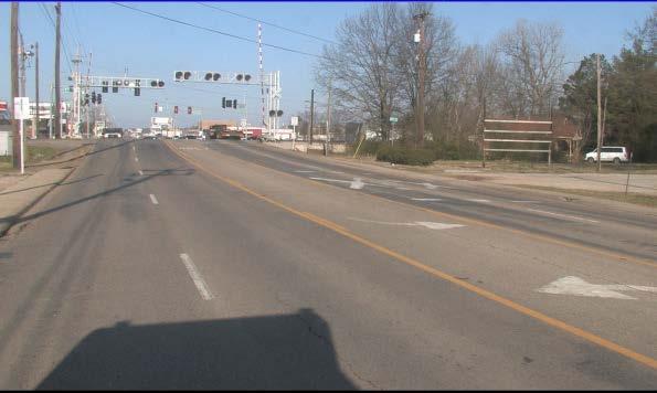
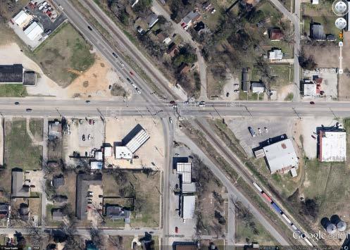
3 Introduction Highway 18, a principal arterial, is part of the Arkansas Primary Highway Network (APHN) and the National Highway System (NHS). In Jonesboro, Highway 18 (Highland Drive) crosses the Burlington Northern Santa Fe (BNSF) main lines and the Union Pacific Railroad (UPRR) main lines within 2,000 feet from each other. Local officials have expressed concerns involving safety and delays at the BNSF main line crossing. At the request of the City of Jonesboro, the Arkansas State Highway Commission approved Minute Order , which authorized a study to determine the need for and feasibility of constructing a railroad overpass at the BNSF main line crossing on Highway 18 (Figure ES-1). Local officials have also expressed interest in partnering with the Department to develop a project to improve safety and alleviate delays due to railroad crossing blockages. Purpose and Need The City of Jonesboro, located in Craighead County in northeast Arkansas, lies approximately 70 miles northwest of the City of Memphis. The population of Jonesboro grew from 55,515 in 2000 to 67,263 in 2010, an increase of approximately 21 percent. The Craighead County population grew from 82,148 in 2000 to 96,443 in 2010, a rise of approximately 17 percent. The scope of this study is to determine the need for, and feasibility of, a railroad overpass on Highway 18 that would enhance safety and improve east-west traffic flow through Jonesboro. The purpose of the proposed railroad overpass is to eliminate vehicle conflicts and delays at the existing Highway 18 railroad crossing and to provide emergency service vehicles an unimpeded path across the tracks. The result would be decreased response times for medical, fire and other emergency services. 1

4 Figure ES-1: Study Area 2
5 Existing Conditions Within the study area, Highway 18 consists of four 12-foot travel lanes with curb and gutter and sidewalks on the majority of the segment, and a continuous two-way, left turn lane from west of Cain Street to east of Arch Street. At the BNSF railroad crossing (DOT # L), there is a single track and the crossing is protected by flashing lights and gates. The UPRR crossing (DOT #425746W), located east of the BNSF crossing, has a single track and the crossing is protected with lights on cantilevers. Traffic Volumes As shown in Figure ES-2, the 2014 average daily traffic (ADT) on Highway 18 ranges from 12,000 vehicles per day (vpd) to 14,000 vpd. The 2034 ADT is forecasted to be as high as 16,000 vpd along the study segment. The land use adjacent to Highway 18 is zoned for a mix of commercial, industrial, and residential development. The BNSF rail line has approximately 34 trains per day traveling at random times through Jonesboro at a maximum speed of 40 mph. The concrete panel surface at the BNSF railroad crossing is in fair condition. BNSF plans to add tracks in the vicinity of this crossing in the next few years. The UPRR rail line has approximately nine trains per day, but the UPRR crossing does not pose any significant delays. Level of Service Level of service (LOS), A through F, is a quality measure describing conditions within a traffic stream, generally in terms of such service measures as speed and travel time, freedom to maneuver, traffic interruptions, and comfort and convenience. The LOS was determined for Highway 18 in the vicinity of the railroad crossing using the Highway Capacity Manual Traffic is currently operating at LOS D on the study segment, and would operate at LOS E in 2034 if no improvements are made. With trains known to stop on the tracks for up to 50 minutes, significant delays have been observed. As a result, a LOS F is possible at this intersection. The LOS for the intersection of Highway 18 and Cain Street is currently operating at LOS A and will continue to operate at LOS A in 2034 if no improvements are made. 3

6 Figure ES-2: Projected Traffic 4
7 Crossing Safety Railroad crossing safety in Arkansas is determined using hazard ratings which are based on a formula that includes the number of crashes during the most recent 15-year period, the number of trains per day, the ADT and the number of tracks at the crossing. Railroad crossing hazard ratings range from 0 to 100 with 0 being the least hazardous. Two crossings on Highway 18 as well as the crossing on Highway 63B were reviewed. The crossing safety data is summarized in Table ES-1. With a hazard rating of 17.69, there are 60 railroad crossings in Arkansas with higher hazard ratings than the Highway 18 BNSF railroad crossing in Jonesboro. Table ES-1 - Crash History and Hazard Ratings ( ) Roadway Total Crashes Fatal Crashes Injury Crashes Property Damage Only Crashes Trains Per Day Hazard Rating Statewide Hazard Rating Rank* Warning Device Hwy. 18 (BNSF) Flashing Lights & Gates Hwy. 18 (UPRR) Hwy 63B & Nettleton (UPRR) Lights on Cantilevers Lights Note: *Out of 2462 railroad crossings in the State. Crossing Delay Study A delay study was conducted at the BNSF crossing to estimate the extent of motorist delay caused by crossing trains. In addition, video log of the crossing operation provided by the City of Jonesboro was used to supplement the delay study. 5
8 Table ES-2 Crossing Delay Study Results Average Number of Vehicles Delayed (vehicles/day) Average Delay (seconds/vehicle) Approximate Annual Delay Cost* $63,000 Note: *Based on a Delay Cost of $14.86/vehicle hour (updated to current year) Source: User and Non-User Benefit Analysis for Highways (2010). As shown in the delay study, about 318 vehicles per day are delayed for approximately seconds each, resulting in an average of 11.6 vehicle-hours of delay per day. Assuming a cost of $14.86 per hour, the cost of vehicle delay at the crossing is approximately $63,000 per year. Train log data shows that trains are typically on the tracks from 1 minute to 8 minutes. Occasionally, trains stop on the tracks for a significant amount of time due to switching operations between BNSF and UPRR. 6
9 Alternative Analysis Based on evaluation of the existing conditions, highway and railroad traffic, crossing safety and delay analyses, an overpass would enhance safety and eliminate vehicle delays at the existing Highway 18 railroad crossing. It would also provide emergency services vehicles an unimpeded path across the tracks, thus decreasing response times for medical, fire and other emergency services providers. The following alternatives were developed to address these needs. The total estimated costs, in 2014 dollars, include preliminary engineering, right of way acquisition, utility relocation, construction, and construction engineering. No-Action Alternative This alternative would include routine maintenance, but no improvements would be included for this crossing. Therefore, the existing highway and railroad traffic conflicts would not be addressed, delays would continue, and the potential for crashes would continue to exist at this crossing. By taking no action, there would be no adverse impacts such as land use changes, relocations and environmental disruptions caused by new construction. Improvement Alternatives The improvement alternatives include the construction of an overpass with four 12-foot travel lanes with a continuous two-way left-turn lane, curb and gutter with sidewalks, and the closing of the existing BNSF at-grade railroad crossing on Highway 18. Highway 63B from Highway 18 to Highway 351, approximately 0.94 mile, would be removed from the State Highway System and Highway 63B from Highway 351 to Highway 63 would be designated as part of Highway 463. Alternative 1 Alternative 1 shown in Figure ES-3 would construct an overpass slightly north of the existing railroad crossing and improve Cain Street to Nettleton Avenue. A new location connector between Arch Street and Conveyor Street would be provided to maintain 7
10 traffic access to Highway 18. A new connection between Irby Street and Watt Street would also be made. The total estimated cost for Alternative 1 is $15.9 million. The estimated construction cost is $6.6 million. This alternative would construct a Highway 18 railroad overpass to span over E. Nettleton Avenue, the BNSF rail line and Irby Street. It would provide Highway 18 traffic an unimpeded path over the existing BNSF at-grade crossing and the E. Nettleton Avenue. The E. Nettleton Avenue traffic from the south could travel north unimpededly under the overpass and access Highway 18 via Cain Street. The Highway 18 intersection with Cain Street would operate at LOS B during a 20-year study period. Alternative 2 Alternative 2 shown in Figure ES-4 would construct an overpass slightly south of the existing railroad crossing. Improvements to Cain Street, a new location connector between Arch Street and Conveyor Street, realignment of Watt Street as well as E. Nettleton Avenue would be constructed to maintain traffic access to Highway 18. The total estimated cost for Alternative 2 is $19.0 million. The estimated construction cost is $8.6 million. This alternative would also improve traffic flow to a level of service similar to Alternative 1. 8

11 Figure ES-3: Alternative 1 9

12 Figure ES-4: Alternative 2 10
13 Environmental Consideration A preliminary environmental review was conducted of the study area along Highway 18 that is being considered for a grade separation of the BNSF. The evaluation consisted of preliminary Geographic Information Systems (GIS) constraints mapping and research that included checking the national registry for historic sites. See Figure ES-5 for the Environmental Constraints Map. Alternatives 1 & 2 A review of the State Historic Preservation Office s files indicated no known historic properties in the study area. There are no recorded or identified cemeteries, municipal parks, schools or municipal/county resource agencies in the study area. Two fuel stations are located within the study area in the southwest quadrant along Highway 18 (East Highland Drive) and Highway 63B (Thorn Street). These properties are not considered constraints; however, there is a possibility of hazardous waste associated with underground storage tanks at the fuel stations. The locations of these properties are included on the constraints map. Table ES-3 summarizes the environmental impacts for each alternative. Table ES-3 - Environmental Impacts Alternative Estimated Environmental Impacts Residential Owners Businesses Recreational No-Action Alternative Alternative

14 Figure ES-5: Environmental Constraints 12
15 Conclusion Local officials in the City of Jonesboro have expressed concerns about the impact of railroad operations at the BNSF railroad crossing on Highway 18. There is a demonstrated need for the proposed railroad overpass as significant delays have been documented at this crossing. A project to construct a Highway 18 grade separation over the BNSF mainline is included in the Jonesboro Area MPO 2035 Metropolitan Transportation Plan. Two improvement alternatives were analyzed in this study. Each alternative includes a four-lane railroad overpass of the BNSF main line. Alternative 1 consists of construction of an overpass north of the existing Highway 18 railroad crossing. Alternative 2 consists of construction of an overpass to the south of the existing railroad crossing on Highway 18. The estimated total cost of each alternative is shown in Table ES-4. Table ES-4 Alternative Costs Alternative 2014 Total Cost (x Millions) 2014 Construction Cost (x Millions) Alternative 1 $15.9 $6.6 Alternative 2 $19.0 $8.6 Note: Subject to negotiation, BNSF would participate up to five percent of the cost for an overpass structure. The improvement alternatives analyzed in this study were determined to be feasible. Once funding sources are identified, all involved jurisdictions should work cooperatively to identify a preferred alternative for the implementation of a railroad overpass. 13
16


17
Public Information Workshop
 Public Information Workshop Charlotte County-Punta Gorda MPO - Meeting Rooms A and B March 29, 2018 Welcome to the Public Information Workshop for Harborview Road Project Development and Environment (PD&E)
US 81 Bypass of Chickasha Environmental Assessment Public Meeting
 US 81 Bypass of Chickasha Environmental Assessment Public Meeting March 14, 2013 Introductions ODOT FHWA SAIC Meeting Purpose Present need for bypass Provide responses to 10/04/11 public meeting comments
Alpine Highway to North County Boulevard Connector Study
 Alpine Highway to North County Boulevard Connector Study prepared by Avenue Consultants March 16, 2017 North County Boulevard Connector Study March 16, 2017 Table of Contents 1 Summary of Findings... 1
EXCEPTION TO STANDARDS REPORT
 EXCEPTION TO STANDARDS REPORT PROJECT DESCRIPTION AND NEED The project is located in Section 6, Township 23 North, Range 9 East and Section 31 Township 24 North, Range 9 East, in the Town of Stockton,
Purpose and Need Report
 Purpose and Need Report State Highway (SH) 29 From Southwestern Boulevard to SH 95 Williamson County, Texas (CSJ: 0337-02-045) Prepared by Blanton & Associates, Inc. Date: November, 2015 The environmental
Traffic Engineering Study
 Traffic Engineering Study Bellaire Boulevard Prepared For: International Management District Technical Services, Inc. Texas Registered Engineering Firm F-3580 November 2009 Executive Summary has been requested
Open House. Highway212. Meetings. Corridor Access Management, Safety & Phasing Plan. 5:30 to 6:30 p.m. - Southwest Corridor Transportation Coalition
 Welcome Meetings 5:30 to 6:30 p.m. - Southwest Corridor Transportation Coalition 6:30 to 8:00 p.m. - Open House Why is Highway 212 Project Important? Important Arterial Route Local Support Highway 212
STH 60 Northern Reliever Route Feasibility Study Report
 #233087 v3 STH 60 Northern Reliever Route Feasibility Study Report Washington County Public Works Committee Meeting September 28, 2016 1 STH 60 Northern Reliever Route Feasibility Study Hartford Area Development
Rocky Mount. Transportation Plan. Transportation Planning Division. Virginia Department of Transportation
 2020 Transportation Plan Developed by the Transportation Planning Division of the Virginia Department of Transportation in cooperation with the U.S. Department of Transportation, Federal Highway Administration
Table of Contents INTRODUCTION... 3 PROJECT STUDY AREA Figure 1 Vicinity Map Study Area... 4 EXISTING CONDITIONS... 5 TRAFFIC OPERATIONS...
 Crosshaven Drive Corridor Study City of Vestavia Hills, Alabama Table of Contents INTRODUCTION... 3 PROJECT STUDY AREA... 3 Figure 1 Vicinity Map Study Area... 4 EXISTING CONDITIONS... 5 TRAFFIC OPERATIONS...
LAWRENCE TRANSIT CENTER LOCATION ANALYSIS 9 TH STREET & ROCKLEDGE ROAD / 21 ST STREET & IOWA STREET LAWRENCE, KANSAS
 LAWRENCE TRANSIT CENTER LOCATION ANALYSIS 9 TH STREET & ROCKLEDGE ROAD / 21 ST STREET & IOWA STREET LAWRENCE, KANSAS TRAFFIC IMPACT STUDY FEBRUARY 214 OA Project No. 213-542 TABLE OF CONTENTS 1. INTRODUCTION...
Environmental Assessment Derry Road and Argentia Road Intersection
 Air and Noise Study Environmental Assessment Derry Road and Argentia Road Intersection Project 11-4295 City of Mississauga, Region of Peel October 17, 2014 1 Region of Peel Environmental Assessment for
Exhibit A Sound Transit Board Resolution R Selecting the bicycle, pedestrian, and parking access improvements to be built for the Puyallup
 Exhibit A Sound Transit Board Resolution R2016-07 Selecting the bicycle, pedestrian, and parking access improvements to be built for the Puyallup Access Improvement Project. RESOLUTION NO. R2016-07 Selecting
IH 35 FEASIBILITY STUDY
 IH 35 FEASIBILITY STUDY COOKE COUNTY, TEXAS February 1, 2007 Prepared by: Carter & Burgess, Inc. For: The Wichita Falls District of the Texas Department of Transportation INDEX I. INTRODUCTION. 3 II. PURPOSE
II. PROJECT DESCRIPTION
 II. PROJECT DESCRIPTION A. PROJECT APPLICANT The project applicants for the proposed Sepulveda/Rosecrans Site Rezoning are: Mar Ventures, Inc., 2050 West 190 th Street, Suite 108, Torrance, California,
The major roadways in the study area are State Route 166 and State Route 33, which are shown on Figure 1-1 and described below:
 3.5 TRAFFIC AND CIRCULATION 3.5.1 Existing Conditions 3.5.1.1 Street Network DRAFT ENVIRONMENTAL IMPACT REPORT The major roadways in the study area are State Route 166 and State Route 33, which are shown
MILLERSVILLE PARK TRAFFIC IMPACT ANALYSIS ANNE ARUNDEL COUNTY, MARYLAND
 MILLERSVILLE PARK TRAFFIC IMPACT ANALYSIS ANNE ARUNDEL COUNTY, MARYLAND Prepared for: Department of Public Works Anne Arundel County Prepared by: URS Corporation 4 North Park Drive, Suite 3 Hunt Valley,
Construction Realty Co.
 MEMORANDUM TO: FROM : Jeff Pickus Construction Realty Co. Luay R. Aboona, PE Principal 9575 West Higgins Road, Suite 400 Rosemont, Illinois 60018 p: 847-518-9990 f: 847-518-9987 DATE: May 22, 2014 SUBJECT:
Southern Windsor County 2016 Traffic Count Program Summary April 2017
 Southern Windsor County 2016 Traffic Count Program Summary April 2017 The Southern Windsor County Regional Planning Commission (the RPC ) has been monitoring traffic at 19 locations throughout the southern
EXECUTIVE SUMMARY. The following is an outline of the traffic analysis performed by Hales Engineering for the traffic conditions of this project.
 EXECUTIVE SUMMARY This study addresses the traffic impacts associated with the proposed Shopko redevelopment located in Sugarhouse, Utah. The Shopko redevelopment project is located between 1300 East and
Validation Study. Proposed Railroad Grade Separation Algonquin Road at the Union Pacific Milwaukee Railroad. May 15, 2008.
 Validation Study Proposed Railroad Grade Separation Algonquin Road at the Union Pacific Milwaukee Railroad May 15, 2008 Prepared for: City of Des Plaines Des Plaines Civic Center 1420 Miner Street Des
TIMBERVINE TRANSPORTATION IMPACT STUDY FORT COLLINS, COLORADO JANUARY Prepared for:
 TIMBERVINE TRANSPORTATION IMPACT STUDY FORT COLLINS, COLORADO JANUARY 2014 Prepared for: Hartford Companies 1218 W. Ash Street Suite A Windsor, Co 80550 Prepared by: DELICH ASSOCIATES 2272 Glen Haven Drive
Town of Londonderry, New Hampshire NH Route 28 Western Segment Traffic Impact Fee Methodology
 Town of Londonderry, New Hampshire NH Route 28 Western Segment Traffic Impact Fee Methodology Prepared by the Londonderry Community Development Department Planning & Economic Development Division Based
Traffic Impact Study Speedway Gas Station Redevelopment
 Traffic Impact Study Speedway Gas Station Redevelopment Warrenville, Illinois Prepared For: Prepared By: April 11, 2018 Table of Contents 1. Introduction... 1 2. Existing Conditions... 4 Site Location...
Executive Summary. Draft Environmental Impact Statement/Environmental Impact Report ES-1
 Executive Summary Introduction The Eastside Transit Corridor Phase 2 Project is a vital public transit infrastructure investment that would provide a transit connection to the existing Metro Gold Line
Chicago to St. Louis High-Speed Rail. IDOT District 8 Crossings. July 29, 2015
 Chicago to St. Louis High-Speed Rail IDOT District 8 Crossings July 29, 2015 1 History: Chicago-St. Louis Corridor» IDOT has actively developed the Chicago to St. Louis corridor since the mid 1980 s» In
Wentzville Parkway South Phase 2 & 2A
 Wentzville Parkway South Phase 2 & 2A Sponsor Wentzville Project No. RB18-000034 Project Type New Road TOTAL FUNDING Phase 2 Total County Sponsor Federal $10,000,000 $8,000,000 $2,000,000 $0 Phase 2A Total
June WASHINGTON STATE DEPARTMENT OF TRANSPORTATION Alaskan Way Viaduct and Seawall Replacement Program Seattle, Washington
 DESIGN DEVIATION NOs. 1 & 2 Horizontal Stopping Sight Distance and Shoulder Width Reduction SR 99 S. Holgate St to S. King St. Viaduct Replacement Stage 2 MP 29.89 TO MP 30.78 XL-3237 PIN-809936D June
MPO Staff Report Technical Advisory Committee: July 12, 2017
 MPO Staff Report Technical Advisory Committee: July 12, 2017 RECOMMENDED ACTION: 2 nd TAC Meeting with Kimley-Horn/WSB in Updating the Street/Highway Element of 2045 Metropolitan Transportation Plan. Matter
1. INTRODUCTION 2. PROJECT DESCRIPTION CUBES SELF-STORAGE MILL CREEK TRIP GENERATION COMPARISON
 CUBES SELF-STORAGE MILL CREEK TRIP GENERATION COMPARISON 1. INTRODUCTION This report summarizes traffic impacts of the proposed CUBES Self-Storage Mill Creek project in comparison to the traffic currently
Public Meeting. SD Highway 28 From US81 W 11 miles through Lake Norden Hamlin County PH 0028(37)329 PCN 04JY
329 PCN 04JY") Public Meeting SD Highway 28 From US81 W 11 miles through Lake Norden Hamlin County PH 0028(37)329 PCN 04JY Neil Schochenmaier, PE Road Design Engineering Supervisor March 16, 2017 Purpose of the Meeting
Public Meeting SD Highway 28 From US81 W 11 miles through Lake Norden Hamlin County PH 0028(37)329 PCN 04JY Neil Schochenmaier, PE Road Design Engineering Supervisor March 16, 2017 Purpose of the Meeting
Interchange Modification Justification Study. I-90/Timberline Road Interchange, Exit 402 SIOUX FALLS MPO
 Interchange Modification Justification Study I-90/Timberline Road Interchange, Exit 402 SIOUX FALLS MPO Technical analysis to accompany companion Environmental Assessment Interchange Modification Justification
VIADUCT LOCATION STUDY. October 19, 2009
 VIADUCT LOCATION STUDY October 19, 2009 Background Information Traffic Study Alternative Evaluation Public Involvement Preferred Concept Next Steps Evaluate alternatives for the location of a viaduct to
APPENDIX E. Traffic Analysis Report
 APPENDIX E Traffic Analysis Report THIS PAGE INTENTIONALLY BLANK EAGLE RIVER TRAFFIC MITIGATION PHASE I OLD GLENN HIGHWAY/EAGLE RIVER ROAD INTERSECTION IMPROVEMENTS TRAFFIC ANALYSIS Eagle River, Alaska
Corridor Sketch Summary
 Corridor Sketch Summary SR 241: I-82 Jct (Sunnyside) to SR 24 Jct Corridor Highway No. 241 Mileposts: 7.53 to 25.21 Length: 17.65 miles Corridor Description The seventeen and one-half mile corridor begins
CAPITAL FUND 9510 STREET & SIDEWALK IMPROVEMENTS FIVE-YEAR CAPITAL IMPROVEMENT PROGRAM FISCAL YEARS
 9510 STREET & SIDEWALK IMPROVEMENTS FIVE-YEAR CAPITAL IMPROVEMENT PROGRAM FISCAL YEARS 2019-2023 9510 STREET & SIDEWALK IMPROVEMENTS - 01 STREET AND SIDEWALK MAINTENANCE PROGRAM $1,250,000 $0 $1,250,000
2. Valley Circle Boulevard/Andora Avenue/Baden Avenue and Lassen Street
 IV.J TRANSPORTATION 1. INTRODUCTION This section presents an overview of the existing traffic and circulation system in and surrounding the project site. This section also discusses the potential impacts
Speed Evaluation Saw Mill Drive
 Speed Evaluation Saw Mill Drive Prepared for: Mount Laurel Township Burlington County, New Jersey Prepared by: Dana Litwornia Litwornia & Associates, Inc. Transportation, Traffic & Environmental Engineering
MEMORANDUM. Figure 1. Roundabout Interchange under Alternative D
 MEMORANDUM Date: To: Liz Diamond, Dokken Engineering From: Subject: Dave Stanek, Fehr & Peers Western Placerville Interchanges 2045 Analysis RS08-2639 Fehr & Peers has completed a transportation analysis
Dixie Transportation Planning Office
 A project must be given a yes rating on items 1 & 2 in order to be prioritized. Sponsor: St. George City Project: Pioneer Parkway Type: Road Widening and Reconstruction Rev. 9/17/2010 Dixie Transportation
MINERVA PARK SITE TRAFFIC IMPACT STUDY M/I HOMES. September 2, 2015
 5500 New Albany Road Columbus, Ohio 43054 Phone: 614.775.4500 Fax: 614.775.4800 Toll Free: 1-888-775-EMHT emht.com 2015-1008 MINERVA PARK SITE TRAFFIC IMPACT STUDY M/I HOMES September 2, 2015 Engineers
Bi-County Transitway/ Bethesda Station Access Demand Analysis
 Bi-County Transitway/ Bethesda Station Access Demand Analysis Prepared for: Washington Metropolitan Area Transit Authority Office of Planning and Project Development May 2005 Prepared by: in conjunction
Section 5.0 Traffic Information
 Section 5.0 Traffic Information 10.0 TRANSPORTATION MDM Transportation Consultants, Inc. (MDM) has prepared an evaluation of transportation impacts for the proposed evaluation for the expansion of the
Transportation & Traffic Engineering
 Transportation & Traffic Engineering 1) Project Description This report presents a summary of findings for a Traffic Impact Analysis (TIA) performed by A+ Engineering, Inc. for the Hill Country Family
Western ND Meeting. February 19, 2014 Grant Levi, NDDOT Director
 Western ND Meeting February 19, 2014 Grant Levi, NDDOT Director 1 Traffic Trends in North Dakota 2 Truck Traffic 2008 3 Truck Traffic 2012 4 Average Daily Traffic 5 ND Vehicle Miles Traveled Statewide
I-35 Access Justification Report Kearney/Clay County
 I-35 Access Justification Report Kearney/Clay County March 2014 4435 Main Street, Suite 1000 Kansas City, MO 64111 I-35 Access Justification Report Kearney/Clay County March 2014 Prepared for: In coordination
Interchange Justification Report
 Interchange Justification Report Interstate 29 at 85 th Street- Exit 74 Sioux Falls, SD SEH No. 132589 October 1, 2018 Prepared by: Short Elliott Hendrickson Inc. Executive Summary The Interchange Justification
CHAPTER 9: VEHICULAR ACCESS CONTROL Introduction and Goals Administration Standards
 9.00 Introduction and Goals 9.01 Administration 9.02 Standards 9.1 9.00 INTRODUCTION AND GOALS City streets serve two purposes that are often in conflict moving traffic and accessing property. The higher
City of Pacific Grove
 Regional Study Utilizing Caltrans Intersection Evaluation Section 7: City of Pacific Grove s: FIRST STREET AT CENTRAL AVENUE Transportation Agency for Monterey County Prepared by Transportation Agency
The Eastern Connector Study November, 2007 planning for the future
 The Eastern Connector Study November, 2007 planning for the future In late 2006, Albemarle County and the City of Charlottesville jointly initiated the Eastern Connector Corridor Study. The Project Team
Engineering Report: Shasta-Trinity National Forest. South Fork Management Unit. Analysis of. National Forest System Road 30N44
 Engineering Report: Shasta-Trinity National Forest South Fork Management Unit Analysis of National Forest System Road 30N44 (milepost 0.00 to 0.40) for Motorized Mixed Use Designation Forest: Shasta-Trinity
4 COSTS AND OPERATIONS
 4 COSTS AND OPERATIONS 4.1 INTRODUCTION This chapter summarizes the estimated capital and operations and maintenance (O&M) costs for the Modal and High-Speed Train (HST) Alternatives evaluated in this
RTE. 1 at RTE. 637 & RTE. 639
 INTERSECTION SAFETY STUDY Prepared for: Virginia Department of Transportation Central Region Operations Traffic Engineering (UPC #81378, TO 12-092) DAVENPORT Project Number: 13-368 / /2014 RTE. 1 at RTE.
3.15 SAFETY AND SECURITY
 3.15 SAFETY AND SECURITY Introduction This section describes the environmental setting and potential effects of the alternatives analyzed in this EIR with regard to safety and security in the SantaClara-Alum
APPENDIX C1 TRAFFIC ANALYSIS DESIGN YEAR TRAFFIC ANALYSIS
 APPENDIX C1 TRAFFIC ANALYSIS DESIGN YEAR TRAFFIC ANALYSIS DESIGN YEAR TRAFFIC ANALYSIS February 2018 Highway & Bridge Project PIN 6754.12 Route 13 Connector Road Chemung County February 2018 Appendix
Kendall Drive Premium Transit PD&E Study Project Kick-Off Meeting SR 94/Kendall Drive/SW 88 Street Project Development and Environment (PD&E) Study
 Study") Florida Department of Transportation District Six Kendall Drive Premium Transit PD&E Study Project Kick-Off Meeting SR 94/Kendall Drive/SW 88 Street Project Development and Environment (PD&E) Study What
Florida Department of Transportation District Six Kendall Drive Premium Transit PD&E Study Project Kick-Off Meeting SR 94/Kendall Drive/SW 88 Street Project Development and Environment (PD&E) Study What
Task Force Meeting January 15, 2009
 Task Force Meeting January 15, 2009 Study Update August 14 th Task Force Meeting Update on Traffic Projections and Financial Feasibility Study presented by Kane County and WSA staff The presentation summarized
ANDERSON PROPERTY SITE ANALYSIS
 ANDERSON PROPERTY SITE ANALYSIS Introduction The Montgomery County Department of Transportation (MCDOT) initiated a feasibility study in the fall of 2012 to evaluate the need for transit service expansion
Energy Technical Memorandum
 Southeast Extension Project Lincoln Station to RidgeGate Parkway Prepared for: Federal Transit Administration Prepared by: Denver Regional Transportation District May 2014 Table of Contents Page No. Chapter
Diablo Vista Pumping Plant Replacement
 Diablo Vista Pumping Plant Replacement Traffic Study PHA Transportation Consultants 12-05-359 October 2012 Diablo Vista Pumping Plant Replacement Traffic Study For EBMUD October 2012 PHA Transportation
WELCOME PUBLIC OPEN HOUSE FOR US-64 FROM THE SH-18 INTERSECTION EAST 6.5 MILES JANUARY 10TH, 2017 PAWNEE CITY HALL, 5:30 PM
 WELCOME PUBLIC OPEN HOUSE FOR US-64 FROM THE SH-18 INTERSECTION EAST 6.5 MILES JANUARY 10TH, 2017 PAWNEE CITY HALL, 5:30 PM 1 PURPOSE OF THIS OPEN HOUSE Present information about the proposed improvements
ELMORE COUNTY HIGHWAY DEPARTMENT
 Adopted 11/27/06 Effective 2/1/07 Amended 4/10/08 ELMORE COUNTY HIGHWAY DEPARTMENT 155 County Shop Road Wetumpka, Alabama 36092 Phone (334) 567-1162 Fax (334) 567-1100 Access Management Policy The Elmore
Characterization of Combined Use of County Road Segment
 Department of Public Works Inyo County, California Characterization of Combined Use of County Road Segment Segment Name: _Lone Pine No. 1_ Purpose: Which of the following does the combined-use segment
Introduction. Assumptions. Jeff Holstein, P.E., City of Brooklyn Park Steve Wilson, Principal Tim Babich, Associate Krista Anderson, Engineer
 SRF No. 10482 To: From: Jeff Holstein, P.E., City of Brooklyn Park Steve Wilson, Principal Tim Babich, Associate Krista Anderson, Engineer Date: May 16, 2018 Subject: City of Brooklyn Park Year 2040 Forecasts
ODOT Transportation Safety. It All Starts With Crash Data
 ODOT Transportation Safety Programs It All Starts With Crash Data Robin Ness, Mgr. Crash Analysis & Reporting Unit Oregon Department of Transportation (ODOT) 17 th Annual Northwest Tribal Symposium Red
Leadership NC. November 8, 2018
 v Leadership NC November 8, 2018 Planning for our region s growth The Triangle is one of the fastestgrowing regions in the nation. More than 2 million people are already part of the equation, and the
Pacific Electric Right-of-Way / West Santa Ana Branch Corridor Alternatives Analysis
 Pacific Electric Right-of-Way / West Santa Ana Branch Corridor Alternatives Analysis Transit Coalition September 26, 2012 2 Study Area Pacific Electric Rightof-Way/West Santa Ana Branch (PEROW/ WSAB) extends
FY 2013 Candidate Projects ($ Thousands) Street & Traffic Control Program - Thoroughfares
 Street & Traffic Control Program - Thoroughfares") Need Area: NT032 Alternative No.: 1 Name: Drive Council District: G Limits: Dallas to Dickson Key Map No.: 492M Type: Major Thoroughfare and Collector Super Neighborhood: WBS No.: (To be assigned by the
Need Area: NT032 Alternative No.: 1 Name: Drive Council District: G Limits: Dallas to Dickson Key Map No.: 492M Type: Major Thoroughfare and Collector Super Neighborhood: WBS No.: (To be assigned by the
Bella Vista Bypass Benefit Cost Analysis
 Bella Vista Benefit Cost Analysis The Benefit Cost Analysis (BCA) was performed in accordance with the ARRA guidance provided in the Federal Register. These benefits and costs were quantified in accordance
WELLS COUNTY TRANSPORTATION PLAN
 WELLS COUNTY TRANSPORTATION PLAN 2010 NORTHEASTERN INDIANA REGIONAL COORDINATION COUNCIL INTRODUCTION The Northeastern Indiana Regional Coordinating Council has conducted the transportation planning activities
105 Toronto Street South, Markdale Transportation Impact Study. Paradigm Transportation Solutions Limited
 105 Toronto Street South, Markdale Transportation Impact Study Paradigm Transportation Solutions Limited December 2016 Project Summary Project Number 162060 December 2016 Client Zelinka Priamo Ltd 318
MEMORANDUM. Project Description. Operational Trip Generation. Construction Trip Generation. Date: August 12, 2014 TG: To: From: Subject:
 MEMORANDUM Date: August 12, 2014 TG: 13329.01 To: From: Subject: Jeremy Krout EPD Solutions Inc. Rafik Albert EPD Solutions Inc. Rawad Hani Transpo Group AP North Lake Solar Project Traffic Scoping The
F:\PROJ\ \dwg\Alt-bridge-alignments.dwg, 17-2, 11/12/ :22:17 PM, saamhu, Acrobat PDFWriter
 F:\PROJ\55211014\dwg\Alt-bridge-alignments.dwg, 17-2, 11/12/2002 03:22:17 PM, saamhu, Acrobat PDFWriter MERRIFIELD RIVER CROSSING METHOD OF CHANGE FROM ID# ISSUES MEASUREMENT UNITS VALUE BASE CONDITIONS
TIGER VI Discretionary Grant Program. Project Name: Highway 67 Interchange
 Department of Transportation s National Infrastructure Investments under the Consolidated Appropriations Act, 2014 TIGER VI Discretionary Grant Program Project Name: Highway 67 Interchange Project Location:
Railroad Impact Study
 Railroad Impact Study Ryan Huebschman, PE, PTOE Jason O Neill November 21, 2016 Study Impetus CSXT to lease and improve rail line between Louisville and Indianapolis Rail improvements will allow CSXT to
New Jersey Turnpike Authority Interchange 6 to 9 Widening Program
 New Jersey Turnpike Authority Interchange 6 to 9 Widening Program Tuesday, September 18, 2007 Public Hearings: Time: 5:00 PM - 8:00 PM Wednesday, September 19, 2007 Senior Center 3 Municipal Drive Bordentown,
FREQUENTLY ASKED QUESTIONS
 THE PROJECT Last updated on 2/19/16 FREQUENTLY ASKED QUESTIONS What s happening on Highway 169? The Minnesota Department of Transportation (MnDOT) is planning to rebuild and repair the infrastructure on
Executive Summary. Treasure Valley High Capacity Transit Study Priority Corridor Phase 1 Alternatives Analysis October 13, 2009.
 Treasure Valley High Capacity Transit Study Priority Corridor Phase 1 Alternatives Analysis October 13, 2009 Background As the Treasure Valley continues to grow, high-quality transportation connections
Proposed location of Camp Parkway Commerce Center. Vicinity map of Camp Parkway Commerce Center Southampton County, VA
 Proposed location of Camp Parkway Commerce Center Vicinity map of Camp Parkway Commerce Center Southampton County, VA Camp Parkway Commerce Center is a proposed distribution and industrial center to be
Citizens Committee for Facilities
 Citizens Committee for Facilities AGENDA Thursday, December 11, 2014 City Council Chambers 305 3 rd Avenue East -Twin Falls, Idaho 11:30 A.M. AGENDA ITEMS Purpose By 1. Discussion and possible action on
FREQUENTLY ASKED QUESTIONS
 THE PROJECT Last updated on 9/8/16 FREQUENTLY ASKED QUESTIONS What s happening on Highway 169? The Minnesota Department of Transportation (MnDOT) is planning to rebuild and repair the infrastructure on
Subarea Study. Manning Avenue (CSAH 15) Corridor Management and Safety Improvement Project. Final Version 1. Washington County.
 Corridor Management and Safety Improvement Project. Final Version 1. Washington County.") Subarea Study Manning Avenue (CSAH 15) Corridor Management and Safety Improvement Project Final Version 1 Washington County June 12, 214 SRF No. 138141 Table of Contents Introduction... 1 Forecast Methodology
Subarea Study Manning Avenue (CSAH 15) Corridor Management and Safety Improvement Project Final Version 1 Washington County June 12, 214 SRF No. 138141 Table of Contents Introduction... 1 Forecast Methodology
APPENDIX B Traffic Analysis
 APPENDIX B Traffic Analysis Rim of the World Unified School District Reconfiguration Prepared for: Rim of the World School District 27315 North Bay Road, Blue Jay, CA 92317 Prepared by: 400 Oceangate,
Table Existing Traffic Conditions for Arterial Segments along Construction Access Route. Daily
 5.8 TRAFFIC, ACCESS, AND CIRCULATION This section describes existing traffic conditions in the project area; summarizes applicable regulations; and analyzes the potential traffic, access, and circulation
King County Metro. Columbia Street Transit Priority Improvements Alternative Analysis. Downtown Southend Transit Study. May 2014.
 King County Metro Columbia Street Transit Priority Improvements Alternative Analysis Downtown Southend Transit Study May 2014 Parametrix Table of Contents Introduction... 1 Methodology... 1 Study Area...
Comprehensive Regional Goods Movement Plan and Implementation Strategy Goods Movement in the 2012 RTP/SCS
 Comprehensive Regional Goods Movement Plan and Implementation Strategy Goods Movement in the 2012 RTP/SCS Annie Nam Southern California Association of Governments September 24, 2012 The Goods Movement
Business Advisory Committee. July 7, 2015
 Business Advisory Committee July 7, 2015 1 Today s Topics Outreach Update TI #1 and 2: Target Field Station Connection to I-94: Recommendation 85 th Station Configuration 93 rd Station Configuration DEIS
Restoration of Historic Streetcar Services in Downtown Los Angeles
 Restoration of Historic Streetcar Services in Downtown Los Angeles Alternatives Analysis Community Update Meeting August 2, 2011 Introduction Key players Local lead agency: Metro Federal lead agency: Federal
March 2, 2017 Integrating Transportation Planning, Project Development, and Project Programming
 COORDINATION WITH VDOT DISTRICTS TO DELIVER IMPLEMENTABLE IMPROVEMENT PROJECTS March 2, 2017 Integrating Transportation Planning, Project Development, and Project Programming PRESENTATION OUTLINE What
Figure 1 Map of intersection of SR 44 (Ravenna Rd) and Butternut Rd
 and Butternut Rd") Abbreviated Study District: 12 County: Geauga Route: SR 44 Section: 1.58 GEA 44 1.58 213 HSP # 47 (Rural Intersection) Prepared April 23, 215 By Bryan Emery Existing Conditions This study contains the
Abbreviated Study District: 12 County: Geauga Route: SR 44 Section: 1.58 GEA 44 1.58 213 HSP # 47 (Rural Intersection) Prepared April 23, 215 By Bryan Emery Existing Conditions This study contains the
Escondido Marriott Hotel and Mixed-Use Condominium Project TRAFFIC IMPACT ANALYSIS REPORT
 Escondido Marriott Hotel and Mixed-Use Condominium Project TRAFFIC IMPACT ANALYSIS REPORT Prepared for Phelps Program Management 420 Sixth Avenue, Greeley, CO 80632 Prepared by 5050 Avenida Encinas, Suite
5. OPPORTUNITIES AND NEXT STEPS
 5. OPPORTUNITIES AND NEXT STEPS When the METRO Green Line LRT begins operating in mid-2014, a strong emphasis will be placed on providing frequent connecting bus service with Green Line trains. Bus hours
Right-of-Way Obstruction Permit Fee Structure Minneapolis Department of Public Works May 10, 2001
 Right-of-Way Obstruction Permit Fee Structure Minneapolis Department of Public Works May 10, 2001 Revised April 5, 2005 Revised January 27, 2006 Prepared by: Steve Collin, Engineer 2.5 Revised by Douglas
West Santa Ana Branch Transit Corridor. Informational Briefing Gateway Cities Service Council April 13, 2017
 West Santa Ana Branch Transit Corridor Informational Briefing Gateway Cities Service Council April 13, 2017 Project Study Area 98 square miles 20 individual cities plus unincorporated LA County 1.2 million
Restoration of Historic Streetcar Services in Downtown Los Angeles
 Restoration of Historic Streetcar Services in Downtown Los Angeles Early Scoping Meeting for Alternatives Analysis (AA) May 17, 2011 Introduction Key players Local lead agency: Metro Federal lead agency:
State Highway 32 East TIGER Discretionary Grant Application APPENDIX C - BENEFIT COST ANALYSIS REPORT
 State Highway 32 East TIGER Discretionary Grant Application APPENDIX C - BENEFIT COST ANALYSIS REPORT April 2016 I. COST-EFFECTIVENESS ANALYSIS A Benefit-Cost Analysis (BCA) was conducted in conformance
TRAFFIC CALMING PROGRAM
 TRAFFIC CALMING PROGRAM PROGRAM BASICS Mount Pleasant Transportation Department 100 Ann Edwards Lane Mt. Pleasant, SC 29465 Tel: 843-856-3080 www.tompsc.com The Town of Mount Pleasant has adopted a traffic
Turnpike Mitigation Program Application
 Ohio Department of Transportation & Ohio Turnpike and Infrastructure Commission Turnpike Mitigation Program Application Please note the following eligibility criteria: 1) Projects must be sponsored by
CROSSING RAIL PROJECT (P4) RAIL
 RAIL") GRAND CROSSING RAIL PROJECT (P4) Community Advisory Group October 10, 2012 1:30 pm Grand Crossing Park Field House 7655 S. Ingleside Avenue, Chicago GRAND CROSSING RAIL PROJECT (P4) Community Advisory
GRAND CROSSING RAIL PROJECT (P4) Community Advisory Group October 10, 2012 1:30 pm Grand Crossing Park Field House 7655 S. Ingleside Avenue, Chicago GRAND CROSSING RAIL PROJECT (P4) Community Advisory
TALMONT TOWNHOMES MADISON KENNETH SPA TRAFFIC IMPACT STUDY. Sacramento, CA. Prepared For: MBK Homes. Prepared By:
 TALMONT TOWNHOMES MADISON KENNETH SPA TRAFFIC IMPACT STUDY Sacramento, CA Prepared For: MBK Homes Prepared By: KD Anderson & Associates 3853 Taylor Road, Suite G Loomis, California 95650 (916) 660-1555