DOWNTOWN LRT FEASIBILITY STUDY
|
|
|
- Catherine Sanders
- 5 years ago
- Views:
Transcription
1 INTEGRATED ENGINEERING SOLUTIONS DOWNTOWN LRT FEASIBILITY STUDY SUBMITTED TO: CITY OF CALGARY TRANSPORTATION PLANNING DIVISION SUBMITTED BY: CLIFTON ND LEA FEBRUARY 2006
2 INTEGRATED ENGINEERING SOLUTIONS TABLE OF CONTENTS 1. INTRODUCTION Southeast LRT North-Central LRT West LRT Future LRT Network and Downtown LRT Operating Requirements Southeast LRT SE LRT Downtown Study Process SE LRT DOWNTOWN NETWORK CONCEPTS Potential Routing Options Preliminary Screening of SE LRT Downtown Concepts Preferred SE LRT Options North Central LRT North-Central LRT Connection Options to Downtown West LRT West LRT Options in the Downtown Study Conclusions and Recommendations i
3 INTEGRATED ENGINEERING SOLUTIONS FIGURES Figure 1 Figure 2 Figure 3 Figure 4 Figure 5 Figure 6 Southeast LRT Approved Alignment Southeast LRT Downtown Options Southeast LRT Preferred Downtown Options North Central LRT Options West LRT Options Recommended LRT Network ii
4 INTEGRATED ENGINEERING SOLUTIONS APPENDICES Appendix A Appendix B Appendix C Preferred Southeast LRT Options in the Downtown North Central LRT Options West LRT Options SUPPLEMENTARY INFORMATION Southeast LRT Functional Planning Study, Phase III Glenmore Trail to Elbow River, by Clifton ND Lea, January 2004 Downtown Transit Study Review of Transit Modes, by Clifton ND Lea, July 2004 Southeast Mass Transit Corridor Strategic Planning Study, Calts 128, by Reid Crowther & Partners, January 1987 iii
5 INTEGRATED ENGINEERING SOLUTIONS 1. INTRODUCTION LRT network planning has identified the need for three additional LRT lines to be built before the city reaches the 1.5 million-population horizon. The purpose of this report is to examine the feasibility of alignments required to complete the connection of Southeast LRT to the downtown and to examine the implications of planning for the West and North-Central lines. 1.1 Southeast LRT A downtown alignment for Southeast LRT is required to complete the planning for this future line. An approved alignment for Southeast LRT extends from south of Highway 22X to the Elbow River, just south of 9 Avenue SW (see Figure 1) Alignment options have been developed to complete this future line into the heart of the downtown. 1.2 North-Central LRT A North-Central line is required to serve future communities north of Stoney Trail in North Central Calgary. A review has been conducted to confirm the feasibility of connecting a potential Nose Creek alignment for a North-Central LRT line with the current Northeast LRT line at the Deerfoot Trail / Memorial Drive interchange. Planning for this connection was done as part of the interchange and Northeast LRT construction. 1.3 West LRT An alignment and functional plan for West LRT was approved in 1983 and updated in However, in the west end of the downtown there have been changes in land use and future roadway design issues have emerged. It is necessary to confirm the feasibility of the approved alignment and explore additional options for West LRT to extend from the current terminus of LRT on 7th Avenue to the Bow Trail corridor at Crowchild Trail. 1
6 2 INTEGRATED ENGINEERING SOLUTIONS
7 INTEGRATED ENGINEERING SOLUTIONS 2. Future LRT Network and Downtown LRT Operating Requirements As Calgary grows, the downtown will continue to be a significant employment centre. It is projected that 25,000 additional downtown jobs will be added by the time the city reaches a total population of 1.25 million. However, other employment areas, notably the Southeast, are projected to grow at a faster pace. Despite a shrinking percentage of the city's overall employment, there will be increasing demand for transit service to the downtown due to the high concentration of jobs and limited roadway and parking capacity. In fact, increased transit service capacity is critical to continued employment growth in the downtown. Population and employment growth projections indicate that new LRT lines will be require to serve the Southeast, North and West areas of the city before Calgary reaches the 1.5 million-population horizon. Planning studies have identified alignments for the West and Southeast lines outside of the downtown. A right of way for a North-Central line has been reserved north of Beddington Trail and a likely location for this line has been identified within the Nose Creek valley. A review of Downtown LRT routing concepts and operating requirements is required to determine the final section of the Southeast line and to examine the implications of adding a North-Central line. Downtown LRT Capacity The following table and drawing illustrates the projected future peak hour / peak direction passenger demand and the number of trains required (based on 3, 4 or 5 car trains) on each LRT line entering the downtown at the 1.5 million population horizon. It has been determined that the maximum achievable capacity of 7th Avenue is approximately 36 trains per hour in each direction. This is based on factors including station dwell times, distance between stations, train acceleration / deceleration characteristics, and optimum downtown traffic signal timing. The current (2005) C-Train schedule has a total of 26-3 car trains on the South and Northeast lines that enter the downtown from the east during the a.m. peak hour carrying over 11,000 people. Based on the capacity of 7th Avenue, 10 additional 3-car trains can be added during the peak hour. Construction has commenced to expand stations on all lines (beginning in the downtown) to enable service with 4-car trains. Ultimately, the system can be expanded to 5-car train operation. 3
8 INTEGRATED ENGINEERING SOLUTIONS Projected AM Peak Hour / Peak Direction LRT Ridership and Train Requirements Entering Downtown 1.5 million Population Horizon Entering Downtow n Existing Future Demand Future Train Volumes by Train Length (cars) From East (am peak) (am peak) South 6,600 9, Northeast 4,700 5, Southeast Future 5, North Central Future 6, Total Peak Direction 11,300 27, From West Northwest 3,400 5, W est Future 3, Total Peak Direction 3,400 9, Average per hour capacity per car = 180 Note: - practical CTrain car capacity is ridership projections are for peak hour inbound trips. 4
9 INTEGRATED ENGINEERING SOLUTIONS The current LRT network has two lines entering / exiting the downtown via switch control at both ends of 7 th Avenue (east = S+NE, west = NE+NW). Transit network planning has identified the need for two additional LRT lines to serve the Southeast and North-Central corridors. These new lines will enter the downtown from the east while the future West line will operate as an extension of the Northeast LRT from its current terminus at the west-end of 7 th Avenue. Therefore the issue of 7 th Avenue capacity is related to the addition of the Southeast and North-Central lines entering and exiting the east-end of the downtown. Assuming that all lines will operate in the future with 4 or 5-car trains the total number of peak hour / peak direction trains on 7 th Avenue would be approximately 41 and 32 respectively. With the addition of the Southeast and North-Central lines to 7 th Avenue and with 4-car train operation, the capacity of 7th Avenue would be exceeded. Even with 5 car trains the peak hour train volume is still approaching the capacity limitation of 36 trains per hour leaving little room for adding capacity. Based on this analysis, it is concluded that there is not sufficient long-range capacity for all future LRT lines to operate on 7th Avenue. As a result of this analysis, it is concluded that LRT planning must consider that: There is sufficient capacity on 7 th Avenue to add only one new LRT line at the east end of the downtown. Either the future Southeast or North-Central lines will require an independent connection into the downtown. In this scenario the total number of peak direction trains on 7 th Avenue would be 32 and 25 for 4 car and 5 car trains per hour, respectively. Ultimately it will be necessary to operate at least the South line on a separate downtown right of way although this could be delayed with the operation of 5 car trains. It should be noted that there may be operational limitations with 5 car train operation that require resolution (e.g. switch clearance time, downtown block lengths, station dwell time, etc). 8th Avenue Downtown Subway The South and Northwest LRT lines were constructed with the long term view that they could ultimately be shifted to a subway running under 8 th Avenue SW. A tunnel has been constructed under the Municipal Building to permit a connection from the South line. As well, there is sufficient room in the 9 th Street SW right of way to connect Northwest LRT to an 8 th Avenue tunnel. Construction of an 8 th Avenue subway will have a significant cost (at least $500 million in 2005 dollars). Based on the above discussion, this shift is not likely needed to address LRT capacity requirements until beyond the 1.5M population horizon. 5
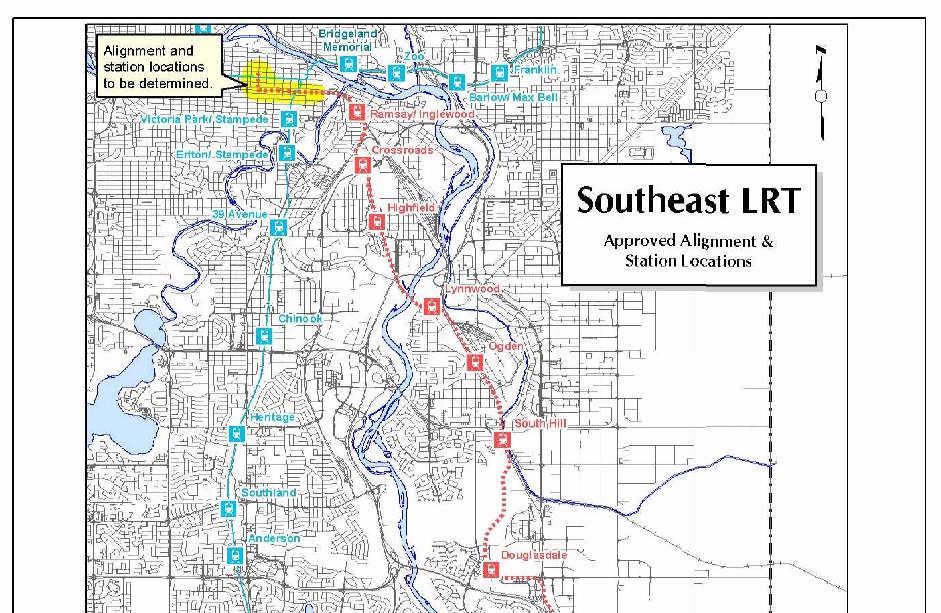
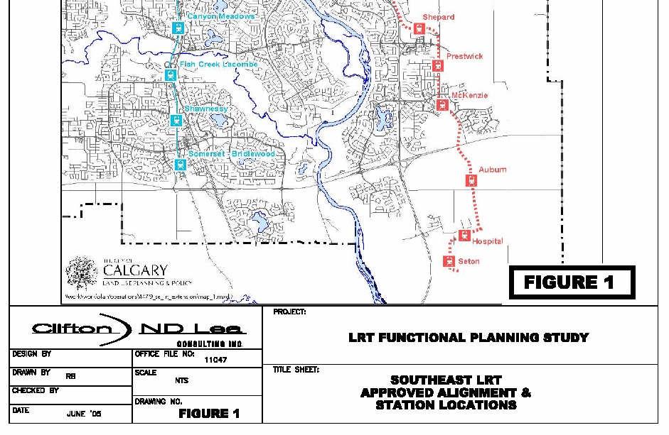
10 INTEGRATED ENGINEERING SOLUTIONS 3. Southeast LRT Background The Southeast LRT Corridor has been identified through the Calgary Transportation Plan process (GO Plan) as a future LRT Corridor extending from the downtown through the Southeast industrial area to McKenzie Town and then south of Marquis of Lorne Trail (Hwy 22X), to serve new development lands. A Transportation Department report completed in , evaluated various options for creating a mass transit corridor to serve this large residential and industrial growth area. Recent forecasts for the ultimate build-out of the area (beyond the City s 1.25 milion-population horizon) now project a population of 225,000 and employment of 108,000. When this development is realized, the potential weekday demand for transit travel to / from the downtown is estimated at 46,000 to 56,000 trips. The report concluded that a separate LRT line is required to serve the Southeast corridor. The report also demonstrated that a spur line from the existing South LRT line to serve this area would overload the South LRT Line without major upgrading. To date, there are three approved functional planning studies for different segments of the future Southeast LRT line: South East LRT Functional Planning Study (South Hil) by Reid Crowther & Partners Ltd (Earth Tech Canada Inc.), approved 2000 February TTP99-69 Southeast LRT 52 nd Street SE Functional Planning Study by Earth Tech Canada Inc, approved 2002 April TTP Southeast LRT Functional Planning Study - Glenmore Trail to Elbow River, by Clifton ND Lea. approved 2004 April LPT These studies provide functional alignments and station locations for SE LRT from the Elbow River to the Marquis of Lorne Trail. The alignment and station locations for south of the Marquis of Lorne Trail have been incorporated into recently approved land use policy plans including the proposed regional hospital (Figure 1). A primary purpose of this study is to examine options and recommend a route alignment for Southeast LRT to access the downtown. Selection of the downtown alignment of Southeast LRT takes into account LRT operating requirements, land use, and community planning, urban design, the roadway network and area redevelopment planning studies in East Victoria, the Beltline, East Village and Downtown. 1 Southeast Mass Transit Coridor Strategic Planning Study, Calts 128, Reid Crowther & Partners Ltd for City of Calgary Transportation Department, January
11 INTEGRATED ENGINEERING SOLUTIONS 3.1 SE LRT Downtown Study Process The final phase of the Southeast LRT study involved examining potential routes to connect the end of the approved Southeast LRT alignment (east of the Elbow River) with the downtown core. The study area included a number of inner city and downtown communities. Within the areas examined for potential routes, several planning studies, each with established stakeholder groups, were well underway. During 2003, 2004 and 2005, Transportation Department representatives met with these groups on a number of occasions to discuss LRT route options and to obtain feedback. Input received from these groups has been incorporated into the design and evaluation of the alignment alternatives. Stakeholder groups included in these discussions were: Downtown Urban Structure Plan Victoria Crossing BRZ Calgary Downtown Association (CDA) Beltline Communities (Beltline ARP) Building Owners and Managers Association of the Greater Calgary Area (BOMA-Calgary) East Victoria Redevelopment Study The input received from these groups has focused on a desire to integrate the SE LRT line and stations with the existing and future streetscapes, minimize impact of LRT on traffic and enhance mobility within the downtown and inner city. The preference of these groups is for low floor LRT cars which would reduce the scale of the station platforms to that of enhanced sidewalks. A preferred alignment for SE LRT, with two construction options that would utilize a portion of 10 th Avenue SE, has been incorporated into the recommended Beltline ARP. This alignment is consistent with the recommendations of this study. The following sections of the report outline the basis for selecting this preferred alignment. 7
12 INTEGRATED ENGINEERING SOLUTIONS 3.2 SE LRT DOWNTOWN NETWORK CONCEPTS Overview This section outlines the criteria used as the basis for developing downtown LRT concepts for Southeast LRT. Section outlines the implications of different vertical configurations with the LRT being either at-grade or grade separated. Section outlines the operating characteristics of existing and potential Light Rail Vehicles (LRVs) based on current LRT design standards and vehicle characteristics of alternative LRT trains examples of which are produced by Bombardier and Siemens. Section describes the potential routing of the 3 basic concepts to connect the SE LRT into the Downtown. It identifies the key features of the alignment and provides commentary on routing, LRT operations and potential impacts. Section provides a basis for comparison of the 3 concepts and provides a recommendation to develop the preferred concept. Section outlines the characteristics and issues of the concepts recommended for further evaluation LRT Design Options This overview lists the implications of various LRT design options that were considered when evaluating alternatives for this line within the downtown and adjacent communities. SE LRT At-Grade System Lowest capital cost. Greatest potential to impact traffic and transit capacity. Priority for LRT will increase traffic delay as lines and train frequencies increase. There are impacts to existing and future developments and access points Low floor light rail vehicle technologies are more attractive than current high floor vehicles for new LRT lines in terms of station and platform design but they are precluded from operating on 7 th Avenue with existing trains. For on-street running, dedicated lanes are required for LRT these may be bus lanes as well. 8
13 INTEGRATED ENGINEERING SOLUTIONS North / south at-grade operation in the downtown is limited to 3 car trains due to block lengths. SE LRT Elevated System More expensive than at-grade (~2X) Elevated stations have access limitations Visual impact perceived as undesirable in some locations Potential conflicts with +15 crossings requires integration Minimal impact on traffic and transit capacity / delay Does not limit train length in the downtown SE LRT Underground System Highest capital costs (~6X) Potential issues with ground water levels Impacts to underground utilities and existing South LRT tunnel Potential impacts to building foundations Does not impact traffic and transit capacity and delay Does not limit train length in the downtown Underground stations present access limitations Cut and cover construction is more economical than tunnel boring In order to maintain future capacity of the system, 4 or 5 car trains are optimal and therefore the downtown segment of the line will need to be fully grade separated if it has a north/south alignment. The east/west segments could be at grade or grade separated Geometric Characteristics and Constraints Current High Floor LRT Minimum turning radius: 60 m Maximum gradient: 6.0% Platform height 0.9 m 9
14 INTEGRATED ENGINEERING SOLUTIONS Low Floor LRT Minimum turning radius may be under 20 m (2 articulations \ car) Typically m (1 articulation \ car) Maximum gradient: 8.0% Platform height 0.36 m Grade separations will require a portal or ramp. The length for minimum clearance for the LRT of 4.6m (or 4.5m for a roadway) with a 2.0m structural depth is: 180m for a 60 kph design using a 6% maximum gradient. 135m for a 40 kph design using a 6% maximum gradient 106m for a 40 kph design and an 8.0% gradient (maximum gradient practical for rail, ideal conditions) 3.3 Potential Routing Options This study identified and examined 3 base concepts for SE LRT routing options in the downtown (see Figure 2). Each starts from the terminus of the approve alignment at the Elbow River, just south of the CPR. 1. Concept 1 connects the new SE LRT line to 7 th Avenue via the East Village. 2. Concept 2 is an independent SE LRT line connecting to the Downtown via the Beltline, entering the downtown on a north / south alignment via either 2 nd or 6 th Street SW. 3. Concept 3 is an independent SE LRT line connecting to the Downtown via 9 th Avenue with a north / south Downtown alignment on Centre Street. 10
15 FIGURE 2
16 3.3.1 Concept 1-7th Avenue The SE LRT line would continue from the previously approved alignment just west of the Elbow River. There are two feasible options for Concept 1 and each requires a connection of the Southeast line to LRT on 7 th Avenue. Concept 1A connects with 7 th Avenue via 6 th Street SE while Concept 1B connects via 4 th Street SE. Both options require an elevated crossing of the CPR tracks with approach structures approximately 200m in length on both sides of the CPR tracks. Essentially, an elevated structure would extend from the Elbow River with a return to grade just before entering 7th Avenue. There is no opportunity to provide a station within the East Village area and these concepts are not reflective of the current East Village plan. There is a limit to the number of trains that can ultimately utilize 7 th Avenue (see Section 2). Since Concept 1 alignments require a connection of the SE line to 7 th Avenue, construction of either of these alignments would require that the existing South line be relocated to an 8 th Avenue subway much sooner than with the other options to address 7 th Avenue capacity constraints Concept 2 - Beltline A total of seven Concept 2 alternatives were developed within the Beltline area. These options begin at the end of the previously approved alignment just west of the Elbow River and would move onto either 10 th, 11 th or 12 th Avenues via some combination of the CPR right of way or City owned land east of 6 Street SE. Each of the options would turn northward, via tunnel, into the downtown under either 2 nd or 6 th Streets SW. Downtown stations would be underground to permit longer trains to stop between the avenues. Low floor LRT technology is required for each of these options due to the need for shorter turning radii in order for the tracks to remain within the existing roadway rights of way. As well, low platform LRT stations along on-street segments, made possible by use of low floor LRT vehicles, would allow stations to be integrated into the streetscape and adjacent development. Essentially, an enhanced sidewalk would be the station platform. A reserved lane would be required to allow LRT to operate at-grade in mixed traffic. This is necessary to provide transit priority and to ensure that multi-car trains are able to move into the next block. Regular traffic movements across the LRT track at s and intersections would be permitted. Currently this area has relatively low traffic volumes with manageable access conflicts across the proposed at-grade LRT operation. Future development of the area will be significant; however, this development could be designed to fit with the requirements of a future LRT line. For all Concept 2 options, stations would be located in the vicinity of 4 th Street SE, 1 st Street SW and (if the line enters the downtown via 6 th Street SW) 4 th Street SW. 13
17 10 th Avenue / 11 th Avenue Options Concepts 2A, 2B, 2D and 2E are alternative routings that would utilize 10 th Avenue or a combination of 10 th and 11 th Avenues. Concept 2A would see a two-way, at grade LRT operation along the curb lanes of 10 th Avenue. The centre lanes of 10 th Avenue would continue to be used by normal traffic with no restrictions on vehicles crossing LRT tracks. In concept 2A, LRT would enter a tunnel just west of 1 Street SW to pass under the CPR and remain underground with subway stations in the downtown under 2 nd Street SW. Concept 2E is the same as 2A except it would enter the downtown via tunnel to a 6 th Street SW alignment. Concept 2D follows the same alignment as Concept 2A but it would be in a longer tunnel that would start west of MacLeod Trail after passing over the existing South LRT tunnel. Similar to Concept 2A, the tunnel would continue into the downtown via 2nd Street SW. To minimize the impact of the tunnel portal west of MacLeod Trail, LRT would operate in the centre lanes of 10 Avenue between 3 rd Street SE and MacLeod Trail. The station at Centre Street S would be underground. This option was developed in order to minimise the conflicts between LRT and accesses, and also to reduce the impact to traffic on 10 th Avenue. It is the most expensive of the Beltline options because it requires a longer tunnel section. Concepts 2B and 2F are one way couplet systems that would see LRT operate in the south curb lane on both 10 th and 11 th Avenues. The south curb lane is required to provide an adequate turning radius where the line turns north into the downtown. Trains would run opposite to the direction of traffic to provide greater operational safety. Ideally, to optimize traffic capacity, these concepts would require the remainder of the street to operate with one-way traffic for the section shared with LRT. Concept 2B and 2F would enter the downtown in a tunnel on 2 nd Street SW and 6 th Street SW respectively. These options would minimize potential conflicts between LRT and regular traffic, particularly for the lands along the north side of 10 th Avenue where access is already restricted by the railway tracks and road subways on the north/south streets. Traffic access to local s along the south side of 10 th Avenue could be redirected to the lane that runs between 10 th and 11 th Avenues. There is no mid block lane between 11 th or 12 th Avenues to permit redirection of access from 11 th Avenue. 11 th and 12 th Avenue Options Concepts 2C and 2G are one way couplet systems that would occupy the south curb lanes of 11 th and 12 th Avenues. LRT would operate opposite to the direction of traffic to provide for greater operational safety. There is no mid block lane between 11 th or 12 th Avenues to permit redirection of access. 14
18 3.3.3 Concept 3 - Centre Street Concept 3 involves an elevated crossing of the CPR tracks with approach structures approximately 200m in length on both sides of the CPR tracks. The line would run along the south side of 9 th Avenue opposite Fort Calgary. An at-grade station between 6 th and 5 th Street SE is feasible with a pedestrian overpass connection over 9 th Avenue SE to the future development in the East Village. The alignment enters private property west of 6 th Street SE and into a very deep tunnel to go under the future 4 th Street SE underpass and beneath the existing South LRT tunnel. The alignment remains in tunnel turning northward under Centre Street, terminating in an under ground station on Centre Street S. between 7 th and 5 th Avenue. The purpose of investigating a Centre Street alignment was to facilitate a possible future northward connection. However, it has been determined that it would be very difficult to continue this line further north due to the impact on buildings in Chinatown, the Centre Street Bridge and communities north of the Bow River Other SE LRT Concepts The possibility of the Southeast LRT line entering the heart of the downtown via the CPR right of way was explored. CPR has indicated that their long-term plan is to expand from two to five railway tracks across the Elbow River. There is room to accommodate six railway tracks through the Palliser Square and Gulf Canada complex. This would limit SE LRT to one directional LRT track within the CPR right of way. CPR has advised that they would prefer to keep their future mainline options open to accommodate future capacity requirements including a possible High Speed Rail Station in the vicinity of Palliser Square. Therefore, it is not possible to locate SE LRT within the CPR right of way west of 4 th Street SE. 3.4 Preliminary Screening of SE LRT Downtown Concepts Each of the Concepts described above were evaluated and compared on the basis of LRT operations, transportation network, land use/urban design, environmental and capital costs. The evaluation criteria and brief description is indicated in Table 1, and a comparison of concepts is shown in Table 2. 15
19 TABLE 1 Preliminary Screening Criteria for SE LRT Downtown Concepts Category Criteria Description LRT Operations Transportation Network LRT System Connectivity Future LRT Capacity Travel Time Service Area Roadway Capacity Safety/Operating Conflicts How well does this option allow the LRT lines to function as a system with good connectivity between LRT lines in the downtown Impact on the flexibility and capacity for handling future LRT system capacity Relative measure of train operating speed and travel time LRT service area accessible from station areas including the core employment area of the downtown Impact on adjacent roadway capacity within the Beltline and downtown Number of potential conflict points between train and other traffic or pedestrians Land Use / Urban Design Environmental Impact on Redevelopment Pedestrian Environment Property Access Business Impact Residential Impact Potential to influence land use that is supported by City of Calgary and local community planning objectives Potential to provide a high quality pedestrian environment within the streetscape Impact on access to adjacent lands - number of and alley crossings that would be subject to control Minimize constraints and maximize business opportunities Minimize impact and maximize benefits to adjacent residents Impact on natural and urban environment Costs Land Number and size of land parcels required for the project including city owned land Infrastructure Includes structures, track and signaling, power, stations and related roadway / traffic control modifications. 16
20 TABLE 2 Preliminary Screening Comparison for SE LRT Downtown Concepts Comparative Score Category LRT Operations Criteria 1 (7 th Ave) Concepts To 6 th Street SW 2 (Beltline) To 2 nd Street SW 3 (9th Ave Centre Street) LRT System Connectivity * Very good Fair Very good Fair Future LRT Capacity Poor Best Best Best Travel Time * Best Poor good Poor Downtown Service Area Poor Very good good Poor Transportation Roadway Capacity Very good Fair good Best Network Safety/Operating conflicts * good Fair good Very good Land Use/Urban Design Impact on Redevelopment * Poor Very good Poor good Pedestrian Environment Poor Very Very good Poor good Property Access Fair Fair good good Business Impact * good good Fair Very good Residential Impact Poor good good Very good Environmental Natural Fair Best Best Fair Costs Land good Fair good Poor Infrastructure * Poor good Very good Fair Fixed facility costs, $M Comparative Costs Overall Ranking 4th 2nd 1st 3rd * Indicates a critical element 17
21 3.4.1 Summary of Evaluation Concept 1 ranked last in the preliminary screening comparison for the following reasons: Impacts to the East Village where land use planning does not include a provision for LRT. Impacts to the Fort Calgary historical site for concept 1A. A high profile elevated structure across the CPR tracks and 9th Avenue at the entrance way to the downtown is not seen as a desirable feature. This option limits the ultimate LRT capacity in the downtown and therefore there is no reserve LRT capacity beyond the 1.5 million population horizon. Has the highest capital cost due to the requirement for an earlier relocation of the South LRT line and construct the 8 th Avenue subway tunnel. The 8 th Avenue tunnel has an estimated capital cost of $500M (2004) There is no opportunity to provide an LRT station in the East Village. Concept 3 ranked second last in the preliminary screening comparison for the following reasons: A high profile elevated structure across the CPR tracks and 9 th Avenue at the entrance way to the downtown is not seen as a desirable feature. This concept would severely impact developable land on the south side of 9 th Avenue between the Elbow River and 4 th Street SE. Does not serve the core employment area of the downtown. A bored tunnel with significant construction cost is required to avoid a conflict with the existing South LRT line tunnel near 3 rd Street and 9 th Avenue SE Concept 2 options ranked first and second in the preliminary screening since they have the potential to serve a greater region of the downtown on both the north and south sides of the CPR tracks. These routings leave significant future residual capacity for the LRT on 7 th Avenue. Low floor LRT cars are required and this technology results in at-grade stations that can be integrated with the pedestrian facilities and adjacent development. Low floor LRT cars are also advantageous along the remainder of the Southeast line, particularly in the planned development south of Highway 22X. Concepts involving a 2 nd Street SW connection to the downtown core are ranked higher than those using 6 th Street SW for the following reasons: 18
22 2 nd Street, SW is better able to serve the central core of downtown employment with a station adjacent to the 7 th Avenue LRT station at 3 rd Street, SW. Minimizes travel times to downtown Minimizes impacts to roadway and land use Minimizes construction and operating costs Maximizes interchange between LRT lines The greatest perceived impacts are to traffic since two dedicated lanes will be required for LRT on either 10 th, 11 th or 12 th Avenues in the Beltline. Following this evaluation and review by stakeholder groups, a review was conducted on the following options (shown on Figure 3). 2A 10 th Avenue, 2 - way LRT 2B 10 th & 11 th Avenue, LRT one way couplet 2C 11 th & 12 th Avenue, LRT one way couplet 2D 10 th Avenue, 2 - way LRT, Underground 3.5 Preferred SE LRT Option The following discussion details the advantages and drawbacks of the Concept 2 options for the SE LRT alignment. These alignments have been given consideration relative to the ongoing land use and redevelopment planning in this area of the Beltline. As well, these options have been designed in association with planning for the proposed 4 th Street SE underpass. Conceptual station locations have been developed for each option and are indicated on the drawings (see Appendix A) for each of the four options. Station details are subject to area redevelopment plans. Downtown stations on 2 nd Street SW are common to all concepts. Two underground stations are proposed - one between 7 th and 5 th Avenue providing for a pedestrian interchange with the 7 th Avenue LRT Line and a terminal station located between 3 rd and 1 st Avenue near Eau Claire. For each downtown station, two concepts are proposed: one with offset station heads located on land adjacent to the street and one with in-street station heads located in the road right of way. In-street station heads on 2 nd Street SW are preferred since they simplify pedestrian access to the underground platforms and they do not require additional property. The advantage to the offset station head layout is that through traffic lanes on 2 nd Street can be maintained. Provision for station links from adjacent property should be obtained as part of future development. 19


23 As described previously, at-grade, on street LRT operation in the Beltline will require a reserved lane. The track bed would be raised 75mm to 100mm above the adjacent roadway by means of a mountable curb and gutter. The LRT right of way would also be delineated from the adjacent sidewalk with curb and gutter. The surface colour and texture would further delineate the LRT lane from the roadway and sidewalk areas. Access to s would be permitted across the LRT; however, they should be consolidated or redirected to the back lane or side street as part of future development planning wherever feasible. Emergency vehicles could also run on the LRT right of way. LRT vehicles would be low floor vehicles similar to the examples provided in Appendix D. This would enable the integration of the sidewalk and the station platform areas with adjacent development. Connecting buses could also use the LRT in-street right of way and operate using the same station platforms. The following photos are from Denver, Colorado, showing the operation of their LRT in the Downtown which is designed based on the above principles. The above photo shows a typical downtown in-street LRT operation in Denver. The LRT trains are running counter flow to the direction of traffic on a one way street. Note the combined lighting/catenary poles, and physical differentiation between the LRT right of way and the adjacent roadway and sidewalk. 20
 there is a need for a ramp to provide handicapped access to the head end of the train.")

24 The photo above shows a typical station in downtown Denver where the platform is integrated with the sidewalk. Note that since the Denver LRVs are not true low floor cars (they have steps inside the cars) there is a need for a ramp to provide handicapped access to the head end of the train. It is intended that low floor LRVs for the SE line would be fully accessible and this type of facility would not be required. Overall the station platform amenities are very modest. The photo on the next page shows a typical parkade exit/entrance in downtown Denver where vehicles are permitted to cross the LRT right of way with minimal protective devices. Warning signs are posted inside the parkade and just prior to the road crossing. Note that this crossing is also in a track turnout area. 21
25 FIGURE 3

.")
26 3.5.1 Details of Concept 2A 10th Avenue, 2 way LRT Concept 2A would operate at grade from a crossing of the Elbow River to 2nd Street SW where it enters into a cut and cover tunnel on 2nd Street SW into the downtown. See Appendix A for detailed drawings and cross sections. The alignment is largely within the CPR right of way east of 4th Street SE and in the 10th Avenue road right of way west of 4th Street SE to 2nd Street SW. In the downtown it is in a cut and cover tunnel with underground stations between 7th and 5th Avenue SW and a terminal station between 3rd and 1st Avenue SW (Eau Claire). On 10th Avenue, LRT would operate in exclusive curb lanes, with the flow of traffic at up to 40 kph. This alternative enters 10th Avenue west of 4th Street SE. Desired station locations at 4th Street SE and 3rd Street SE and at Centre Street S. The station location at 4th Street SE is subject to the final design for the proposed 4th Street SE underpass and redevelopment of the adjacent land. 22
27 With LRT operating in the curb lane, accesses would not be restricted from crossing the LRT. For the land on the south side of 10th Avenue, s should be redirected to the lane between 10th and 11th Avenue SW where feasible to minimize potential LRT / traffic conflicts. For all Concept 2 options the tunnel required to enter the downtown via 2nd Street SW goes under the current access ramp to the Gulf Canada Parkade. This will require that the ramp be demolished and then rebuilt. The parkade access on 10th Avenue is not affected In summary the implications of Concept 2A on 10th Avenue are: Reduces 10th Avenue capacity and function to one lane in each direction, however, preliminary design work for the proposed 4th Street SE underpass indicates that the connection of 10th Avenue with 4th Street SE may be restricted or closed resulting in reduced traffic. Access for emergency vehicles needs to be managed in conjunction with the reserved curb lane for LRT. Access for new buildings can be arranged to respect future LRT requirements. Most south accesses can be redirected to the lane; however there will be some LRT conflicts. On street parking on 10th Avenue would not be permitted. As well, a major watermain located within the 10th Street right of way will require shifting to permit LRT to enter the tunnel section on 10th Avenue S Details of Concept 2B 10th & 11th Avenue, LRT one way couplet Concept 2B would operate at grade from the Elbow River crossing to 2nd Street SW where it enters into a cut and cover tunnel on 2nd Street SW for access into the downtown. Concept 2B involves a one way couplet system operating in the south curb lanes of both 10th and 11th Avenues. LRT must be located on the south side of 11th Avenue to maximize the turning radii for the 90 degree turn to 2nd Street SW. Current LRT double articulated car technology permits reduced radius turns of 25 metres or less resulting in reduced property impacts. This geometry will allow this tunnel to be constructed without impact to Lewis Lofts (historic building) located very close to the NE corner of 11th Avenue and 2nd Street SW. The LRT would operate on 10th and 11th Avenue opposite to the flow of traffic at up to 40 kph. This counter flow LRT movement improves traffic safety for traffic turning movements. Driveway accesses would not be restricted from crossing the LRT, but, they would be redirected to the lane between 10th and 11th Avenue SW or to the side street where feasible. The west bound LRT approach alignment to 10th Avenue is very similar to concept 2A, with LRT entering the 10th Avenue road right of way west of 4th Street SE. For this option it is recommended that 10th Avenue be converted to a one-way 24
28 operation. Alternately 10th Avenue could remain as a two-way street with a counter flow lane. East of 6th Street SE the east bound LRT alignment connects with the Elbow River crossing along the north boundary of the Calgary Transit Victoria Park Garage. Tunnel approaches for both LRT alignments would be located on 11th and 12th Avenues west of 1st Street SW to eliminate traffic conflicts at 2nd Street. The downtown segment of the LRT alignment is the same as Concept 2A. The downtown segment of the LRT alignment is the same as Concept 2A. The recommended stations on 10th and 11th Avenues would be located at 4th Street SE and Centre Street S. The location of the westbound 4th Street SE station at 4th Street is subject to the final design of the 4th Street SE underpass. This station can be incorporated into the redevelopment of the adjacent lands. In summary, the implications of Concept 2B on 10th and 11th Avenues is as follows: LRT is in the south curb of each roadway, operating opposite to traffic flow. Traffic capacity of 10th and 11th Avenue is reduced from 4 lanes to 3 lanes. Recommended conversion of 10th Avenue to one-way traffic operation in this area. 11th Avenue to remain as one-way in the area common to LRT operation. On street parking would be limited to the north curb lanes on each avenue. Most accesses on the south side of 10th Avenue can be redirected to the lane; however there will be some LRT conflicts on 11th Avenue. Some land is required from the Calgary Transit Victoria Park Garage site and this may require the construction of a parkade if the garage is to remain here. As well, a major watermain located within the 10th Street right of way will require shifting to permit LRT to enter the tunnel section on 10th Avenue S. Concept 2C Details 11th & 12th Avenue, LRT one way couplet Concept 2C would operate at grade system from the Elbow River crossing to 2nd Street SW where it enters into a cut and cover tunnel on 2nd Street SW into the downtown. It is a one way couplet system operating in the south curb lane of 11th Avenue, and the south centre lane of 12th Avenue. LRT must be located on the south side of 11th Avenue to maximize the turning radii for the 90 degree turn that provides access to and from the downtown on 2nd Street SW. Current LRT double articulated car technology permits reduced radii turns of 25 metres or less resulting in reduced property impacts. 25
29 There are numerous s that access both 11th and 12th Avenue. A continuous mid block lane to provide alternative access is not available therefore, the potential to mitigate conflicts is limited. To minimize conflicts, the LRT alignment would occupy the 2nd traffic lane. In blocks where stations are located the station platform/sidewalk would extend into the curb lane. This results in more generous platform areas. The capacity of 12 Avenue would be reduced by 2 lanes but the south curb lane can be designated for right turns with some off-peak parking. LRT would operate in a dedicated lane on 11th and 12th Avenue opposite to the flow of traffic at 40 kph. This counter flow LRT movement improves traffic safety for turning movements of opposing traffic. Driveway accesses would not be restricted from crossing the LRT. They would however be redirected to the side street where feasible. The east and west bound LRT alignment runs along the north boundary of the Calgary Transit Victoria Park Garage and enters 11th and 12th Avenue at 6th Street SE. Similar to 2B, this would require construction of a parkade. This alignment would have a greater impact on bus operations at the Victoria Park Garage due to the increased right of way width. Tunnel approaches for both LRT alignments would be located on 11th and 12th Avenues west of 1st Street SW to eliminate traffic conflicts at 2nd Street. The downtown segment of the LRT alignment is the same as Concept 2A. The recommended stations on 11th and 12th Avenues would be located at 4th Street SE and Centre Street S. and these stations can be incorporated into the redevelopment of the adjacent lands. In summary the implications of Concept 2C on 11th and 12th Avenues is as follows: LRT is on the south side of each roadway, operating opposite to traffic flow The traffic capacity of 11th and 12th Avenue is reduced to 3 and 2 lanes respectively, from 4 lanes. 11th and 12th Avenues to remain as one-way traffic operation in this area. Multiple mid block conflicts Complex traffic operation on 12th Avenue. South curb lane parking would be eliminated on 11th Avenue and restricted on 12th Avenue. Functionality of the Calgary Transit Victoria Park Garage may be compromised if it is to remain here. Some property required along 6th Street SE 26
30 3.5.3 Concept 2D Details 10th Avenue, 2 way LRT, Underground Concept 2D is similar to Concept 2A except that the LRT tracks would be located in the centre lanes of 10th Avenue east of MacLeod Trail. This is to facilitate access to the tunnel that begins just west of MacLeod Trail. An underground station is feasible between Centre Street and 1st Street SW. East of MacLeod Trail, LRT tracks in the centre of 10th Avenue is less desirable from a traffic and LRT operational standpoint. In summary the Implications of Concept 2D on 10th Avenue are: There is less reduction in 10th Avenue traffic capacity and function compared to Concept 2A fewer blocks with an in-street LRT operation. Most south accesses can be redirected to the lane between 4th Street SE and 1st Street. SE, where this option enters into a tunnel. Least number of potential conflicts between LRT and current s compared to Concepts 2A, 2B and 2C. Some property impacts for the under ground station on 10th Avenue at Centre Street A major watermain located within the 10th Street right of way will require shifting to permit the LRT to enter the tunnel section at MacLeod Trail. Significantly higher capital cost than Concepts 2A, 2B or 2C Traffic Impact A traffic analysis was conducted by the City of Calgary Transportation Department to compare the impact of options 2A, 2B and 2D on the local street network, east of MacLeod Trail during the PM peak period on weekdays for the year The area for analysis is common to all alternatives. Concept 2C was not analysed since it scored lowest in other evaluation criteria. The following observations were noted: No significant differences in travel times along the MacLeod Trail and 1st SE corridors were observed between the options. No significant difference in travel time along 12th AV S was observed between the options. Concepts 2A and 2D exhibited increased travel times for westbound traffic resulting from traffic diverted from 10th AV S. Concepts 2A and 2D exhibited a significant improvement in travel time for southbound traffic on 4th ST SE (a reduction of at least 1 minute) due to 27
31 better signal coordination without the constraint of accommodating LRT operation through the intersection. In general, concepts 2A and 2D have less impact on local traffic travel times and levels of congestion compared to option 2B. A summary of the evaluation of the Concept 2 options is provided in Table 3. Table 3 Evaluation of Concept 2 Options Criteria 2A 2B 2C 2D Impact to Property Access Moderate Moderate Worse Better Some Some More More Moderate Poor Poor Better Good Good Poor Better $250M $287M $277M $312M Property Requirement Traffic Impact LRT Operations Cost* Overall *Maj orex cl usi ons:pr oper t y,lrv s,cont r ol / mai nt enanc ecent r e Conclusion Concepts 2A, 2D (10th Avenue), and Concept 2B (10th and 11th Avenue one way couplet) are the most feasible options for the connection of Southeast LRT to the downtown. This conclusion is based on considerations of LRT operations and service, street network operation and capacity, and cost. Concepts 2A / 2D operating on 10th Avenue have less impact on local traffic and are the preferred options from a land use planning perspective. Therefore, Concepts 2A and 2D have been included as the preferred options for Southeast LRT in the Beltline ARP document. Concept 2A is the recommended alignment option. Concept 2D may be considered in the future when this project is ready for detailed design. 28
32 4. North Central LRT The Calgary Transportation Plan indicates the need for a high capacity transit service from future development in the North Calgary area to the Downtown. The Transportation Department has estimated the demand for transit service options based on population and employment projections and several long range transit service options have been examined. In North Calgary, an LRT right of way has been reserved in the median of Harvest Hills Boulevard from Beddington Trail to the north City Limits. South of Beddington Trail there is a need to finalize an alignment for this line, particularly the connection into the downtown. It is acknowledged that there is potential for a central, incommunity LRT line along either Centre Street, or Edmonton Trail. However, such alignments would have significant community impacts with reduced LRT operating capabilities. As well, there is a need to consider a potential bus / LRT terminal in conjunction with a future high speed rail station proposed just south of 96th Avenue / Airport Trail adjacent to the CP Rail line. A right of way for a North-Central LRT link to the downtown is being planned along the railway corridor within Nose Creek valley. A functional study, complete with examination of these options, community consultation and public engagement is required for the North-Central line. Preliminary analysis has been concluded that: In order to meet the demand of the growing North Calgary area, and to meet the goals of Calgary Transportation Plan, transit service must be frequent and competitive in terms of cost and travel times with the private automobile. The projected ridership from this area will be more than adequate to support an LRT line to the downtown at the 1.5 million population horizon for the City of Calgary. Bus Rapid Transit (BRT) service on Centre Street will be effective as an interim measure to serve this corridor prior to the need for LRT. Beyond the 1.25 million population horizon (or when significant development occurs north of Stoney Trail), an LRT line located within the Nose Creek valley can accommodate the needs of the developing and future communities north of Beddington Trail. As part of this study to identify downtown LRT connectivity options, three possible downtown links for the North-Central line were evaluated assuming that the most likely route will be via the Nose Creek valley. 29
33 4.1 North-Central LRT Connection Options to Downtown As noted above, a potential route alignment for North-Central LRT would follow the Nose Creek valley adjacent to or within the current CPR right of way. Three options have been identified to connect this line to the downtown. These options are shown on Figure 4 and described below. Option 1 Option 1 parallels the CPR tracks from the Bow River to the east limit of the downtown where it connects to 7th Avenue via 6th Street SE. It requires: Relocation of the CPR tracks north of Memorial Drive to permit LRT to be located along the east side of Nose Creek, Construction of a new LRT bridge across the Bow River parallel to the existing CPR bridge, Use of the utility right-of-way on the west side of the CPR tracks from the Bow River to 9th Avenue SE, A long diagonal structure crossing of the Elbow River, and 9th Avenue extending through East Village to 7th Avenue (similar to Concept 1 for SE LRT), Acquisition of property on the east side of 6th Street SE between 9th and 7th Avenues. Impact to Fort Calgary property and some additional property is also required along the south side of 9th Avenue from the Elbow River to 6th Street, The extension of LRT tracks on 7th Avenue from 4th Street SE to 6th Street SE within the East Village. Option 2 Option 2 ties the North-Central LRT to the Northeast LRT east of the Zoo Station. The Memorial Drive / Deerfoot Trail interchange was designed to permit this connection. The alignment and profile are detailed on the drawing NC-OPT2 in Appendix B. The following is required: Relocation of the CPR tracks north of Memorial Drive to permit LRT to be located along the east side of Nose Creek, Modification of sub structure elements of the existing underpasses is required for Memorial Drive westbound and the inbound Northeast LRT structures. 30
Location Concept Plan Amendment Recommendation Approved 2011 Concept Plan
 Valley Line West LRT Concept Plan Recommended Amendments Lewis Farms LRT Terminus Site Location Concept Plan Amendment Recommendation Approved 2011 Concept Plan Lewis Farms LRT terminus site, 87 Avenue/West
West LRT. Alignment Update and Costing Report May Calgary Transit Transportation Planning Clifton ND Lea Consultants
 West LRT Alignment Update and Costing Report 2006 May Calgary Transit Transportation Planning Clifton ND Lea Consultants West LRT Update Background The service area for West LRT is generally described
Welcome. Green Line in Your Community
 Welcome Green Line in Your Community Today's session will provide you with information about Administration's recommendation for connecting the Green Line in the Beltline to Victoria Park and Inglewood/Ramsay
TORONTO TRANSIT COMMISSION REPORT NO.
 Form Revised: February 2005 TORONTO TRANSIT COMMISSION REPORT NO. MEETING DATE: October 24, 2012 SUBJECT: DOWNTOWN RAPID TRANSIT EXPANSION STUDY (DRTES) PHASE 1 STRATEGIC PLAN ACTION ITEM RECOMMENDATIONS
Green Line LRT: Beltline Segment Update April 19, 2017
 Green Line LRT: Beltline Segment Update April 19, 2017 Quick Facts On April 11, 2017, City Council approved Administration s recommendation for the Green Line to be underground in the Beltline from 2 Street
Green Line LRT: Beltline Recommendation Frequently Asked Questions
 Green Line LRT: Beltline Recommendation Frequently Asked Questions June 2017 Quick Facts Administration has evaluated several alignment options that would connect the Green Line in the Beltline to Victoria
V03. APTA Multimodal Operations Planning Workshop August Green Line LRT
 V03 APTA Multimodal Operations Planning Workshop August 2016 Green Line LRT 2 Presentation Outline Past Present Future 3 16/03/2016 RouteAhead Update 4 4 16/03/2016 RouteAhead Update 5 5 16/03/2016 6 6
Calgary Transit and the Calgary Transportation Plan Chris Jordan, M.Sc., P.Eng. Coordinator, Strategic Transit Planning, Calgary Transit
 Calgary Transit and the Calgary Transportation Plan Chris Jordan, M.Sc., P.Eng. Coordinator, Strategic Transit Planning, Calgary Transit 1. Plan It Calgary the new Municipal Development Plan and Calgary
METRO Orange Line BRT American Boulevard Station Options
 METRO Orange Line BRT American Boulevard Station Options Bloomington City Council Work Session November 18, 2013 Christina Morrison BRT/Small Starts Project Office Coordinating Planning and Design AMERICAN
Welcome The City has undertaken a naming exercise for the existing and future LRT lines. The SE to West LRT, as the project has been called to date,
 Welcome The City has undertaken a naming exercise for the existing and future LRT lines. The SE to West LRT, as the project has been called to date, is now called the Valley Line. We are here to present
STRATEGIC PRIORITIES AND POLICY COMMITTEE MAY 5, 2016
 STRATEGIC PRIORITIES AND POLICY COMMITTEE MAY 5, 2016 Shift Rapid Transit Initiative Largest infrastructure project in the city s history. Rapid Transit initiative will transform London s public transit
BROWARD BOULEVARD CORRIDOR TRANSIT STUDY
 BROWARD BOULEVARD CORRIDOR TRANSIT STUDY FM # 42802411201 EXECUTIVE SUMMARY July 2012 GOBROWARD Broward Boulevard Corridor Transit Study FM # 42802411201 Executive Summary Prepared For: Ms. Khalilah Ffrench,
Transportation Infrastructure Investment Program moving
 moving CALGARY What is TIIP? Ten Year Transportation Capital Program Last approved by Council in 2005 Defines: Major infrastructure projects Lifecycle programs What is TIIP? Represents current planned
THE WAY WE MOVE LRT FOR EVERYONE
 THE WAY WE MOVE LRT FOR EVERYONE 2 LRT for Everyone LRT FOR EVERYONE Light rail is about more than transit; it s about transforming Edmonton. As the city grows, so do its transportation needs. LRT is an
Attachment 5 Eglinton West LRT Planning and Technical Update
 Eglinton West LRT Planning and Technical Update 1. Introduction In July 2016, City Council approved an Eglinton West LRT with between 8 and 12 stops between Mount Dennis and Renforth Gateway, and up to
Bi-County Transitway/ Bethesda Station Access Demand Analysis
 Bi-County Transitway/ Bethesda Station Access Demand Analysis Prepared for: Washington Metropolitan Area Transit Authority Office of Planning and Project Development May 2005 Prepared by: in conjunction
5. OPPORTUNITIES AND NEXT STEPS
 5. OPPORTUNITIES AND NEXT STEPS When the METRO Green Line LRT begins operating in mid-2014, a strong emphasis will be placed on providing frequent connecting bus service with Green Line trains. Bus hours
The Engineering Department recommends Council receive this report for information.
 CORPORATE REPORT NO: R161 COUNCIL DATE: July 23, 2018 REGULAR COUNCIL TO: Mayor & Council DATE: July 19, 2018 FROM: General Manager, Engineering FILE: 8740-01 SUBJECT: Surrey Long-Range Rapid Transit Vision
IMPROVEMENT CONCEPTS
 IMPROVEMENT CONCEPTS for the South Novato Transit Hub Study Prepared by: January 11, 2010 DKS Associates With Wilbur Smith Associates IMPROVEMENT CONCEPTS Chapter 1: Introduction 1. INTRODUCTION The strategic
FINAL. Sound Transit Long-Range Plan Update. Issue Paper S.1: Tacoma Link Integration with Central Link. Prepared for: Sound Transit
 Sound Transit Long-Range Plan Update Issue Paper S.1: Tacoma Link Integration with Central Link Prepared for: Sound Transit Prepared by: Quade & Douglas, Inc. FINAL March 2005 Foreword This issue paper
NEW HAVEN HARTFORD SPRINGFIELD RAIL PROGRAM
 NEW HAVEN HARTFORD SPRINGFIELD RAIL PROGRAM Hartford Rail Alternatives Analysis www.nhhsrail.com What Is This Study About? The Connecticut Department of Transportation (CTDOT) conducted an Alternatives
4.0 TIER 2 ALTERNATIVES
 4.0 TIER 2 ALTERNATIVES The Tier 2 Alternatives represent the highest performing Tier 1 Alternatives. The purpose of the Tier 2 Screening was to identify the LPA utilizing a more robust list of evaluation
Appendix G: Rapid Transit Technology Backgrounder July 2017
 Appendix G: Rapid Transit Technology Backgrounder This appendix provides additional details regarding Bus Rapid Transit and Light Rail Transit technologies, with examples from other systems, including:
RE: A Traffic Impact Statement for a proposed development on Quinpool Road
 James J. Copeland, P.Eng. GRIFFIN transportation group inc. 30 Bonny View Drive Fall River, NS B2T 1R2 May 31, 2018 Ellen O Hara, P.Eng. Project Engineer DesignPoint Engineering & Surveying Ltd. 200 Waterfront
Attachment 5. High Speed Transit Planning Study REPORT SUMMARY. Prepared by: City of Edmonton Transportation Planning Branch. Stantec Consulting Ltd.
 Attachment 5 High Speed Transit Planning Study Prepared by: City of Edmonton Transportation Planning Branch Stantec Consulting Ltd. Transportation Management & Design, Inc. with Lea Consulting Ltd. [135-35130]
King County Metro. Columbia Street Transit Priority Improvements Alternative Analysis. Downtown Southend Transit Study. May 2014.
 King County Metro Columbia Street Transit Priority Improvements Alternative Analysis Downtown Southend Transit Study May 2014 Parametrix Table of Contents Introduction... 1 Methodology... 1 Study Area...
1 Downtown LRT Connector: Draft Concept
 Downtown LRT Connector: Draft Concept Plan November 2010 We re moving forward. Get involved. On June 21, 2010, City Council approved a street-level downtown LRT route, including a connector for the future
Subarea Study. Manning Avenue (CSAH 15) Corridor Management and Safety Improvement Project. Final Version 1. Washington County.
 Corridor Management and Safety Improvement Project. Final Version 1. Washington County.") Subarea Study Manning Avenue (CSAH 15) Corridor Management and Safety Improvement Project Final Version 1 Washington County June 12, 214 SRF No. 138141 Table of Contents Introduction... 1 Forecast Methodology
Subarea Study Manning Avenue (CSAH 15) Corridor Management and Safety Improvement Project Final Version 1 Washington County June 12, 214 SRF No. 138141 Table of Contents Introduction... 1 Forecast Methodology
Waco Rapid Transit Corridor (RTC) Feasibility Study
 Feasibility Study") Waco Rapid Transit Corridor (RTC) Feasibility Study Chris Evilia, Director of Waco Metropolitan Planning Organization Allen Hunter, General Manager Waco Transit System Jimi Mitchell, Project Manager AECOM
Waco Rapid Transit Corridor (RTC) Feasibility Study Chris Evilia, Director of Waco Metropolitan Planning Organization Allen Hunter, General Manager Waco Transit System Jimi Mitchell, Project Manager AECOM
Executive Summary. Draft Environmental Impact Statement/Environmental Impact Report ES-1
 Executive Summary Introduction The Eastside Transit Corridor Phase 2 Project is a vital public transit infrastructure investment that would provide a transit connection to the existing Metro Gold Line
Challenges in a Post-Katrina Environment East-West Corridor Project Overview February, 2007
 EAST-WEST CORRIDOR Challenges in a Post-Katrina Environment East-West Corridor Project Overview February, 2007 Presentation Agenda Project Overview / Purpose and Need Highway Component Transit Component
appendix 4: Parking Management Study, Phase II
 appendix 4: Parking Management Study, Phase II A4-1 A4-2 Eastlake Parking Management Study Final Phase 2 Report Future Parking Demand & Supply January 6, 2017 Submitted by Denver Corp Center III 7900 E.
Kendall Drive Premium Transit PD&E Study Project Kick-Off Meeting SR 94/Kendall Drive/SW 88 Street Project Development and Environment (PD&E) Study
 Study") Florida Department of Transportation District Six Kendall Drive Premium Transit PD&E Study Project Kick-Off Meeting SR 94/Kendall Drive/SW 88 Street Project Development and Environment (PD&E) Study What
Florida Department of Transportation District Six Kendall Drive Premium Transit PD&E Study Project Kick-Off Meeting SR 94/Kendall Drive/SW 88 Street Project Development and Environment (PD&E) Study What
Transit City Etobicoke - Finch West LRT
 Delcan Corporation Transit City Etobicoke - Finch West LRT APPENDIX D Microsimulation Traffic Modeling Report March 2010 March 2010 Appendix D CONTENTS 1.0 STUDY CONTEXT... 2 Figure 1 Study Limits... 2
IV. ENVIRONMENTAL IMPACT ANALYSIS K.2. PARKING
 IV. ENVIRONMENTAL IMPACT ANALYSIS K.2. PARKING ENVIRONMENTAL SETTING The following analysis summarizes the findings and conclusions of the Traffic Analysis (Traffic Study), prepared by The Mobility Group,
Needs and Community Characteristics
 Needs and Community Characteristics Anticipate Population and Job Growth in the City Strongest density of population and jobs in Ann Arbor are within the Study Area Population expected to grow 8.4% by
Restoration of Historic Streetcar Services in Downtown Los Angeles
 Restoration of Historic Streetcar Services in Downtown Los Angeles Early Scoping Meeting for Alternatives Analysis (AA) May 17, 2011 Introduction Key players Local lead agency: Metro Federal lead agency:
To: File From: Adrian Soo, P. Eng. Markham, ON File: Date: August 18, 2015
 Memo To: From: Adrian Soo, P. Eng. Markham, ON : 165620021 Date: Reference: E.C. Row Expressway, Dominion Boulevard Interchange, Dougall Avenue Interchange, and Howard 1. Review of Interchange Geometry
5 VAUGHAN METROPOLITAN CENTRE AND SURROUNDING AREAS TRANSPORTATION STUDY PROGRESS
 5 VAUGHAN METROPOLITAN CENTRE AND SURROUNDING AREAS TRANSPORTATION STUDY PROGRESS The Transportation Services Committee recommends the adoption of the recommendations contained in the following report
Craig Scheffler, P.E., PTOE HNTB North Carolina, P.C. HNTB Project File: Subject
 TECHNICAL MEMORANDUM To Kumar Neppalli Traffic Engineering Manager Town of Chapel Hill From Craig Scheffler, P.E., PTOE HNTB North Carolina, P.C. Cc HNTB Project File: 38435 Subject Obey Creek TIS 2022
2.0 Development Driveways. Movin Out June 2017
 Movin Out June 2017 1.0 Introduction The proposed Movin Out development is a mixed use development in the northeast quadrant of the intersection of West Broadway and Fayette Avenue in the City of Madison.
4.2 Series Station Option Description
 4.2 Series Station Option Description The series station proposal features a new set of side platforms constructed approximately 250 feet north of the existing platforms. The two new platforms would extend
T-THIRD PHASE 3 CONCEPT STUDY C: DETAILED DESCRIPTIONS OF CONCEPT ALIGNMENTS D: CONSTRUCTABILITY ANALYSIS AND COST ESTIMATES (HNTB CONSULTANTS)
") A: 2014 SFMTA TRANSIT SERVICE INFORMATION B: SFMTA TRAFFIC COUNT DATA C: DETAILED DESCRIPTIONS OF CONCEPT ALIGNMENTS D: CONSTRUCTABILITY ANALYSIS AND COST ESTIMATES (HNTB CONSULTANTS) E: LAND USE AND VALUE
A: 2014 SFMTA TRANSIT SERVICE INFORMATION B: SFMTA TRAFFIC COUNT DATA C: DETAILED DESCRIPTIONS OF CONCEPT ALIGNMENTS D: CONSTRUCTABILITY ANALYSIS AND COST ESTIMATES (HNTB CONSULTANTS) E: LAND USE AND VALUE
TRANSPORTATION REVIEW
 TRANSPORTATION REVIEW - PROPOSED MIX OF LAND USES IS CONSISTENT WITH THE CITY S UNDER THE GRANVILLE BRIDGE POLICIES THAT AIM TO MEET NEIGHBOURING RESIDENTS SHOPPING NEEDS AND REDUCE RELIANCE ON AUTOMOBILE
CITY OF LONDON STRATEGIC MULTI-YEAR BUDGET ADDITIONAL INVESTMENTS BUSINESS CASE # 6
 2016 2019 CITY OF LONDON STRATEGIC MULTI-YEAR BUDGET ADDITIONAL INVESTMENTS BUSINESS CASE # 6 STRATEGIC AREA OF FOCUS: SUB-PRIORITY: STRATEGY: INITIATIVE: INITIATIVE LEAD(S): BUILDING A SUSTAINABLE CITY
Spadina Subway Extension Downsview Station to Steeles Avenue Environmental Assessment
 Spadina Subway Extension Downsview Station to Steeles Avenue Environmental Assessment APPENDIX Q SUBWAY OPERATIONS REPORT Spadina Subway Extension Downsview Station to Steeles Avenue Environmental Assessment
TIMBERVINE TRANSPORTATION IMPACT STUDY FORT COLLINS, COLORADO JANUARY Prepared for:
 TIMBERVINE TRANSPORTATION IMPACT STUDY FORT COLLINS, COLORADO JANUARY 2014 Prepared for: Hartford Companies 1218 W. Ash Street Suite A Windsor, Co 80550 Prepared by: DELICH ASSOCIATES 2272 Glen Haven Drive
GO Transit s deliverable: the 2020 Service Plan
 GO Transit s deliverable: the 2020 Service Plan GO Transit s 2020 Service Plan describes GO s commitment to customers, existing and new, to provide a dramatically expanded interregional transit option
Troost Corridor Transit Study
 Troost Corridor Transit Study May 23, 2007 Kansas City Area Transportation Authority Agenda Welcome Troost Corridor Planning Study Public participation What is MAX? Survey of Troost Riders Proposed Transit
Preliminary Definition of Alternatives. 3.0 Preliminary Definition of Alternatives
 3.0 What preliminary alternatives are being evaluated? The alternatives for the East San Fernando Valley Transit Corridor project that were considered for screening include the No Build Alternative, Transportation
TRAFFIC IMPACT STUDY DERRY GREEN CORPORATE BUSINESS PARK MILTON SECONDARY PLAN MODIFICATION
 TRAFFIC IMPACT STUDY DERRY GREEN CORPORATE BUSINESS PARK MILTON SECONDARY PLAN MODIFICATION TRAFFIC IMPACT STUDY DERRY GREEN CORPORATE BUSINESS PARK MILTON SECONDARY PLAN MODIFICATION DECEMBER 24 UPDATED
Note: The October 2007 version of this report has been updated in this December 2008 report to present costs in year 2007 dollars.
 Sound Transit Phase 2 South Corridor LRT Design Report: SR 99 and I-5 Alignment Scenarios (S 200 th Street to Tacoma Dome Station) Tacoma Link Extension to West Tacoma Prepared for: Sound Transit Prepared
CEDAR AVENUE TRANSITWAY Implementation Plan Update
 CEDAR AVENUE TRANSITWAY Implementation Plan Update EECUTIVE SUMMARY DECEMBER 2015 Executive Summary In 2013, the Twin Cities metropolitan area s first bus rapid transit (BRT) line, the METRO Red Line,
GTA West Corridor Planning and EA Study Stage 1
 GTA West Corridor Planning and EA Study Stage 1 Draft Development Strategy Presentation to Peel Goods Movement Task Force April 8 2011 Study Areas 2 Unique Approach Unprecedented two-stage EA process:
Sound Transit East Link: Bus/LRT System Integration Study
 Sound Transit East Link: Bus/LRT System Integration Study Prepared For: Sound Transit King County Metro Mercer Island WSDOT Prepared By: CH2M HILL July, 2014 1 SOUND TRANSIT EAST LINK: BUS/LRT SYSTEMES
I-20 EAST TRANSIT INITIATIVE Tier 1 and Tier 2 Alternatives Screening Report EXECUTIVE SUMMARY
 EXECUTIVE SUMMARY The purpose of this report is to document the results of the Tier 1 and Tier 2 Screening of alternatives for the I-20 East Transit Initiative. The two-tier screening process presented
Traffic Engineering Study
 Traffic Engineering Study Bellaire Boulevard Prepared For: International Management District Technical Services, Inc. Texas Registered Engineering Firm F-3580 November 2009 Executive Summary has been requested
Downtown One Way Street Conversion Technical Feasibility Report
 Downtown One Way Street Conversion Technical Feasibility Report As part of the City s Transportation Master Plan, this report reviews the technical feasibility of the proposed conversion of the current
EGLINTON CROSSTOWN LIGHT RAIL TRANSIT (LRT) PLEASE SIGN IN
 PLEASE SIGN IN") WELCOME TO OUR PUBLIC OPEN HOUSE EGLINTON CROSSTOWN LIGHT RAIL TRANSIT (LRT) Preliminary Planning for a Transit Project Assessment June 15, 17, 18, 23, 24 and 25, 2009 PLEASE SIGN IN Members of the Project
WELCOME TO OUR PUBLIC OPEN HOUSE EGLINTON CROSSTOWN LIGHT RAIL TRANSIT (LRT) Preliminary Planning for a Transit Project Assessment June 15, 17, 18, 23, 24 and 25, 2009 PLEASE SIGN IN Members of the Project
Chapter 4 : THEME 2. Transportation
 Chapter 4 : THEME 2 Strengthen connections to keep the Central Area easy to reach and get around 55 Figure 4.2.1 Promote region-wide transit investments. Metra commuter rail provides service to the east,
Escondido Marriott Hotel and Mixed-Use Condominium Project TRAFFIC IMPACT ANALYSIS REPORT
 Escondido Marriott Hotel and Mixed-Use Condominium Project TRAFFIC IMPACT ANALYSIS REPORT Prepared for Phelps Program Management 420 Sixth Avenue, Greeley, CO 80632 Prepared by 5050 Avenida Encinas, Suite
Executive Summary. Treasure Valley High Capacity Transit Study Priority Corridor Phase 1 Alternatives Analysis October 13, 2009.
 Treasure Valley High Capacity Transit Study Priority Corridor Phase 1 Alternatives Analysis October 13, 2009 Background As the Treasure Valley continues to grow, high-quality transportation connections
Downtown Lee s Summit Parking Study
 Downtown Lee s Summit Parking Study As part of the Downtown Lee s Summit Master Plan, a downtown parking and traffic study was completed by TranSystems Corporation in November 2003. The parking analysis
Traffic Management Plan and Queuing Analysis Lakehill Preparatory School Z Hillside Drive, Dallas, TX October 27, 2015
 Traffic Management Plan and Queuing Analysis Lakehill Preparatory School Z145-235 2720 Hillside Drive, Dallas, TX October 27, 2015 Introduction: The Lakehill Preparatory School is located on the northeast
I-494/I-35 Interchange Vision Layout Development - BRT Station Concepts S.P B SEH No
 TECHNICAL MEMORANDUM TO: FROM: Transit Advisory Group Jeff Rhoda DATE: RE: I-494/I-35 Interchange Vision Layout Development - BRT Station Concepts S.P. 2785-330B SEH No. 123252 04.00 I-494/I-35W Interchange
STH 60 Northern Reliever Route Feasibility Study Report
 #233087 v3 STH 60 Northern Reliever Route Feasibility Study Report Washington County Public Works Committee Meeting September 28, 2016 1 STH 60 Northern Reliever Route Feasibility Study Hartford Area Development
Scarborough Transit Planning
 Scarborough Transit Planning April 23, 2016 Transportation Planning Section City Planning Division Overview 1. Developing Toronto s Transit Network Plan 2. Scarborough Transit Planning 1. Minutes of last
Chapter 7: Travel Demand Analysis. Chapter 8. Plan Scenarios. LaSalle Community Center. Image Credit: Town of LaSalle
 Chapter 7: Travel Demand Analysis Chapter 8 Plan Scenarios LaSalle Community Center. Image Credit: Town of LaSalle 164 Chapter 8: Plan Scenarios Moving Ahead for Progress in the 21 st Century Act (MAP
CTfastrak Expansion. Stakeholder Meeting #4 Manchester Town Hall June 3, 2016
 CTfastrak Expansion Stakeholder Meeting #4 Manchester Town Hall June 3, 2016 Today s Agenda Phase I Update 2016 Service Plan Implementation Schedule & Cost Update Phase II Services Timeline Market Analysis
Rail alignment and benefits (rab) study
 study") Rail alignment and benefits (rab) study previously known as railyard alternatives & i-280 boulevard study May 22, 2018 CONNECTING CALIFORNIA 4,300 lane miles + 115 Airport gates would be needed to create
Rail alignment and benefits (rab) study previously known as railyard alternatives & i-280 boulevard study May 22, 2018 CONNECTING CALIFORNIA 4,300 lane miles + 115 Airport gates would be needed to create
5 RAPID TRANSIT NETWORK PLAN PRINCIPLES, METROLINX BUSINESS CASE, AND ALTERNATIVE FINANCE AND PROCUREMENT ANALYSIS UPDATE
 5 RAPID TRANSIT NETWORK PLAN PRINCIPLES, METROLINX BUSINESS CASE, AND ALTERNATIVE FINANCE AND PROCUREMENT ANALYSIS UPDATE The Rapid Transit Public/Private Partnership Steering Committee recommends the
Alternatives Analysis Findings Report
 6.0 This chapter presents estimates of the potential capital, operations and maintenance costs associated with the alternatives carried forward for detailed evaluation. The methodology used to develop
NAVY YARD BALLPARK STATION ACCESS IMPROVEMENTS STUDY. Final Report. Washington Metropolitan Area Transit Authority
 NAVY YARD BALLPARK STATION ACCESS IMPROVEMENTS STUDY Final Report Washington Metropolitan Area Transit Authority Office of Real Estate and Station Planning April 2016 [This page intentionally left blank]
Energy Technical Memorandum
 Southeast Extension Project Lincoln Station to RidgeGate Parkway Prepared for: Federal Transit Administration Prepared by: Denver Regional Transportation District May 2014 Table of Contents Page No. Chapter
Recommended Vision for the Downtown Rapid Transit Network
 Recommended Vision for the Downtown Rapid Transit Network April 2008 Presentation Overview Context Transit options Assessment of options Recommended network Building the network 2 1 Rapid Our Vision Reliable
TRAFFIC IMPACT ANALYSIS
 TRAFFIC IMPACT ANALYSIS Emerald Isle Commercial Development Prepared by SEPI Engineering & Construction Prepared for Ark Consulting Group, PLLC March 2016 I. Executive Summary A. Site Location The Emerald
CORE AREA SPECIFIC PLAN
 only four (A, B, D, and F) extend past Eighth Street to the north, and only Richards Boulevard leaves the Core Area to the south. This street pattern, compounded by the fact that Richards Boulevard is
METRO Light Rail Update
 American Society of Highway Engineers METRO Light Rail Update Brian Buchanan Director, Design and Construction October 13, 2009 1 High Capacity Transit System 2 20-Mile Light Rail Line 3 Operations Operations
SCARBOROUGH RAPID TRANSIT ENVIRONMENTAL PROJECT REPORT CHAPTER 2 PROJECT DESCRIPTION. Project Description
 Project Description 2 PROJECT DESCRIPTION This chapter documents the extensive preliminary planning activities undertaken prior to the commencement of this Transit Project Assessment Process. Preliminary
Restoration of Historic Streetcar Services in Downtown Los Angeles
 Restoration of Historic Streetcar Services in Downtown Los Angeles Alternatives Analysis Community Update Meeting August 2, 2011 Introduction Key players Local lead agency: Metro Federal lead agency: Federal
EXECUTIVE SUMMARY. The following is an outline of the traffic analysis performed by Hales Engineering for the traffic conditions of this project.
 EXECUTIVE SUMMARY This study addresses the traffic impacts associated with the proposed Shopko redevelopment located in Sugarhouse, Utah. The Shopko redevelopment project is located between 1300 East and
LAWRENCE TRANSIT CENTER LOCATION ANALYSIS 9 TH STREET & ROCKLEDGE ROAD / 21 ST STREET & IOWA STREET LAWRENCE, KANSAS
 LAWRENCE TRANSIT CENTER LOCATION ANALYSIS 9 TH STREET & ROCKLEDGE ROAD / 21 ST STREET & IOWA STREET LAWRENCE, KANSAS TRAFFIC IMPACT STUDY FEBRUARY 214 OA Project No. 213-542 TABLE OF CONTENTS 1. INTRODUCTION...
Draft Results and Open House
 Waco Rapid Transit Corridor (RTC) Feasibility Study Draft Results and Open House Chris Evilia, Director of Waco Metropolitan Planning Organization Allen Hunter, General Manager Waco Transit System Jimi
1. INTRODUCTION 2. PROJECT DESCRIPTION CUBES SELF-STORAGE MILL CREEK TRIP GENERATION COMPARISON
 CUBES SELF-STORAGE MILL CREEK TRIP GENERATION COMPARISON 1. INTRODUCTION This report summarizes traffic impacts of the proposed CUBES Self-Storage Mill Creek project in comparison to the traffic currently
I-10 West AA/EIS Pre-Screening and Tier 1 Analysis Results. Public Meeting. Wulf Grote, Director Project Development Rick Pilgrim, Project Manager
 I-10 West AA/EIS Pre-Screening and Tier 1 Analysis Results Public Meeting Wulf Grote, Director Project Development Rick Pilgrim, Project Manager March 4 & 5, 2008 Today s Agenda Overview of Alternatives
Station Evaluation Summary
 Station Evaluation Summary Preferred Site Location 10/1/00 Loop 1 Station Points 70 Key Issues: Potential Master Plan Development suggests a strong economic development potential for the larger property
2 MAJOR MACKENZIE DRIVE WEST JOG ELIMINATION AT HUNTINGTON ROAD CITY OF VAUGHAN
 2 MAJOR MACKENZIE DRIVE WEST JOG ELIMINATION AT HUNTINGTON ROAD CITY OF VAUGHAN The Transportation Services Committee recommends the adoption of the recommendations contained in the following report dated
ANDERSON PROPERTY SITE ANALYSIS
 ANDERSON PROPERTY SITE ANALYSIS Introduction The Montgomery County Department of Transportation (MCDOT) initiated a feasibility study in the fall of 2012 to evaluate the need for transit service expansion
WELCOME TO OUR PUBLIC OPEN HOUSE Eglinton Crosstown Light Rail Transit (LRT)
") WELCOME TO OUR PUBLIC OPEN HOUSE Eglinton Crosstown Light Rail Transit (LRT) Preliminary Planning for a Transit Project Assessment November 23 rd, 24 th, 25 th, 26 th & December 2 nd, 8 th, 10 th 2009
WELCOME TO OUR PUBLIC OPEN HOUSE Eglinton Crosstown Light Rail Transit (LRT) Preliminary Planning for a Transit Project Assessment November 23 rd, 24 th, 25 th, 26 th & December 2 nd, 8 th, 10 th 2009
Madison BRT Transit Corridor Study Proposed BRT Operations Plans
 Madison BRT Transit Corridor Study Proposed BRT Operations Plans This paper presents a description of the proposed BRT operations plan for use in the Madison BRT Transit Corridor Study. The objective is
Highway 18 BNSF Railroad Overpass Feasibility Study Craighead County. Executive Summary
 Highway 18 BNSF Railroad Overpass Feasibility Study Craighead County Executive Summary October 2014 Highway 18 BNSF Railroad Overpass Feasibility Study Craighead County Executive Summary October 2014 Prepared
West Hills Shopping Centre Lowe s Expansion Traffic Impact Study
 West Hills Shopping Centre Lowe s Expansion Traffic Impact Study Prepared for: Armel Corporation January 2015 Paradigm Transportation Solutions Ltd. 22 King Street South, Suite 300 Waterloo ON N2J 1N8
TRAFFIC IMPACT STUDY. USD #497 Warehouse and Bus Site
 TRAFFIC IMPACT STUDY for USD #497 Warehouse and Bus Site Prepared by: Jason Hoskinson, PE, PTOE BG Project No. 16-12L July 8, 216 145 Wakarusa Drive Lawrence, Kansas 6649 T: 785.749.4474 F: 785.749.734
Parks and Transportation System Development Charge Methodology
 City of Sandy Parks and Transportation System Development Charge Methodology March, 2016 Background In order to implement a City Council goal the City of Sandy engaged FCS Group in January of 2015 to update
Travel Time Savings Memorandum
 04-05-2018 TABLE OF CONTENTS 1 Background 3 Methodology 3 Inputs and Calculation 3 Assumptions 4 Light Rail Transit (LRT) Travel Times 5 Auto Travel Times 5 Bus Travel Times 6 Findings 7 Generalized Cost
King Soopers #116 Thornton, Colorado
 Traffic Impact Study King Soopers #116 Thornton, Colorado Prepared for: Galloway & Company, Inc. T R A F F I C I M P A C T S T U D Y King Soopers #116 Thornton, Colorado Prepared for Galloway & Company
South Lexington Transportation Study Lexington, Massachusetts
 South Lexington Transportation Study Lexington, Massachusetts Preliminary Findings and Options for Consideration Businesses Meeting 10/10/13 Town of Lexington Engineering and Planning Departments Meeting
Town of Londonderry, New Hampshire NH Route 28 Western Segment Traffic Impact Fee Methodology
 Town of Londonderry, New Hampshire NH Route 28 Western Segment Traffic Impact Fee Methodology Prepared by the Londonderry Community Development Department Planning & Economic Development Division Based
Rail alignment and benefits (rab) study
 study") Rail alignment and benefits (rab) study previously known as railyard alternatives & i-280 boulevard study June 5, 2018 CONNECTING CALIFORNIA 4,300 lane miles + 115 Airport gates would be needed to create
Rail alignment and benefits (rab) study previously known as railyard alternatives & i-280 boulevard study June 5, 2018 CONNECTING CALIFORNIA 4,300 lane miles + 115 Airport gates would be needed to create
FREQUENTLY ASKED QUESTIONS
 THE PROJECT Last updated on 9/8/16 FREQUENTLY ASKED QUESTIONS What s happening on Highway 169? The Minnesota Department of Transportation (MnDOT) is planning to rebuild and repair the infrastructure on