Appendix G Traffic and Parking Report
|
|
|
- Osborn Price
- 5 years ago
- Views:
Transcription
1 Appendix G Traffic and Parking Report
2
3 TABLE OF CONTENTS SECTION PAGE Executive Summary... v 1.0 Introduction Study Area Project Description Site Location Existing Project Site Proposed Project Description Roadway Dedication and Project Roadway Improvement Features Voluntary Roadway Improvements Construction Programming Construction Schedule Construction Assumptions Site Access and Circulation Vehicular Site Access Existing Site Access Proposed Project Site Access Pedestrian Access Project Parking City of Los Angeles Code Parking Requirements Proposed Parking Supply Existing Street System Regional Highway System Study Intersections Roadway Descriptions Public Bus Transit Services Traffic Counts Intersection Manual Traffic Counts On-Street Parking Utilization Cumulative Development Projects Related Projects Ambient Traffic Growth Factor Traffic Forecasting Methodology Traffic Generation Construction Traffic Generation Project Occupancy Traffic Generation i
4 TABLE OF CONTENTS (continued) SECTION PAGE 8.0 Traffic Forecasting Methodology (continued) Traffic Distribution and Assignment Construction Traffic Distribution and Assignment Project-Related Localized Distribution Shift and Assignment Traffic Impact Analysis Methodology Impact Criteria and Thresholds LADOT ATSAC/ATCS Traffic Impact Analysis Scenarios Construction Traffic Impact Analysis Scenarios Project Occupancy Traffic Impact Analysis Scenarios Construction Traffic Analysis Existing Conditions Existing Conditions Existing With Construction Traffic Conditions Future Conditions Future Cumulative Baseline Conditions Future Cumulative With Construction Traffic Conditions Project Occupancy Traffic Analysis Existing Conditions Existing Conditions Existing With Project Occupancy Traffic Conditions Future Conditions Future Cumulative Baseline Conditions Future Cumulative With Project Occupancy Traffic Conditions Street Segment Analysis Existing Conditions Future Conditions Summary of Effects of Project-Related Roadway Improvements Effects of Harvard-Westlake Improvements Conclusion Congestion Management Program Traffic Impact Assessment Intersections Freeways Transit Impact Review Conclusions ii
5 SECTION FIGURE # LIST OF FIGURES PAGE 1 1 Vicinity Map Campus Map Project Site Plan Ground Level Existing Lane Configurations Existing Public Transit Routes Existing Traffic Volumes Commuter AM Peak Hour Existing Traffic Volumes Commuter PM Peak Hour Existing Traffic Volumes School AM and PM Peak Hours Location of Related Projects Related Projects Traffic Volumes Commuter AM Peak Hour Related Projects Traffic Volumes Commuter PM Peak Hour Construction Trip Distribution Construction Traffic Volumes Commuter AM and PM Peak Hours Net Project Occupancy Shifted Traffic Volumes School AM Peak Hour Net Project Occupancy Shifted Traffic Volumes School PM Peak Hour Existing With Construction Traffic Volumes Commuter AM Peak Hour Existing With Construction Traffic Volumes Commuter PM Peak Hour Future Cumulative Baseline Traffic Volumes Commuter AM Peak Hour Future Cumulative Baseline Traffic Volumes Commuter PM Peak Hour Future With Construction Traffic Volumes Commuter AM Peak Hour Future With Construction Traffic Volumes Commuter PM Peak Hour Existing With Project Occupancy Traffic Volumes School AM and PM Peak Hours Future Cumulative Baseline Traffic Volumes School AM and PM Peak Hours Future Cumulative With Project Occupancy Traffic Volumes School AM and PM Peak Hours iii
6 SECTION TABLE # LIST OF TABLES PAGE 5 1 Existing Transit Routes Existing Traffic Volumes Commuter Peak Hours Existing Traffic Volumes School Peak Hours Summary of On-Street Parking Related Projects List and Trip Generation Construction Trip Generation City of Los Angeles Intersection Impact Threshold Criteria Summary of Volume to Capacity Ratios and Levels of Service Construction Traffic Summary of Volume to Capacity Ratios and Levels of Service Project Occupancy Summary of Street Segment Levels of Service Project Occupancy APPENDIX APPENDICES A. Manual Traffic Count Data B. Project Occupancy Localized Distribution Shift and Assignment Figures C. CMA and Levels of Service Explanation CMA Data Worksheets AM and PM Peak Hours D. HCS Data Worksheets iv
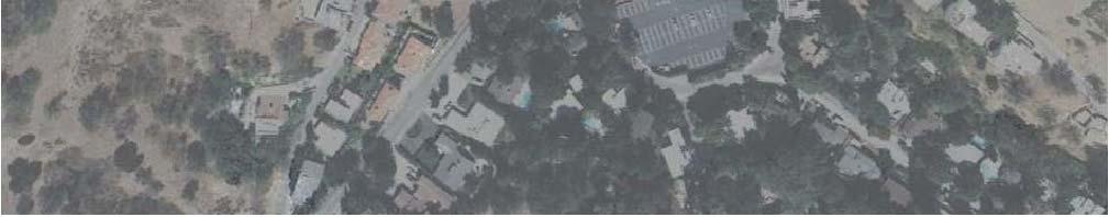
7 EXECUTIVE SUMMARY This traffic analysis has been conducted to identify and evaluate the potential traffic impacts of the proposed. The project would develop a parking structure and rooftop athletic practice field immediately across the street from the existing Harvard-Westlake Campus. In full compliance with all applicable City and other regulatory requirements, the traffic report concludes that the project would not cause any potentially significant impacts at the five studied intersections. These findings by the traffic report were based on a number of conservative assumptions (as detailed throughout the report). In addition, the project includes a number of improvements that will enhance access to and from the proposed parking structure as well as the existing campus. Finally, the project will provide increased on-site parking supply for the Harvard-Westlake Campus for school use, as well as for typical school-related activities outside regular school hours, essentially eliminating the need for school-related vehicles to park on-street, either on Coldwater Canyon Avenue or in the residential neighborhood near the campus. The traffic analysis follows City of Los Angeles traffic study guidelines and is consistent with traffic assessment guidelines set forth in the 2010 Los Angeles County Congestion Management Program. This traffic analysis evaluates potential project and construction-related impacts at 5 key intersections in the vicinity of the project site. The study intersections were determined in consultation with City of Los Angeles Department of Transportation staff. This traffic analysis also evaluates the potential impact of the proposed project within the context of cumulative impact of all ongoing developments (10 related projects) in the area. In addition, a review was conducted of Los Angeles County Metropolitan Transportation Authority intersection and freeway monitoring stations to determine if a Congestion Management Program transportation impact assessment is required for the proposed project. Harvard-Westlake owns property on the east and west sides of Coldwater Canyon Avenue, approximately 1/3 of a mile south of Ventura Boulevard and 1.3 miles north of Mulholland Drive. The existing Harvard-Westlake Campus is located at 3700 Coldwater Canyon Avenue, on the east side of Coldwater Canyon Avenue. The site of the proposed Harvard-Westlake parking structure ( project site ) is located at 3701 Coldwater Canyon Avenue, on the west side of Coldwater Canyon Avenue, immediately across the street from the Harvard-Westlake Campus. The proposed project would entail the development of a three-story parking structure consisting of 750 parking spaces and an athletic practice field to serve as an accessory use to the existing school. The proposed project also consists of the construction of a pedestrian bridge crossing Coldwater Canyon Avenue that will connect the proposed parking structure to the existing campus. No increase in student enrollment or faculty is proposed as part of the proposed project. Occupancy of the proposed project is anticipated in the year A total of 568 parking spaces are currently provided on the existing Harvard-Westlake Campus. Although the school complies with and exceeds the required parking supply of 436 spaces, it was still noted that the existing supply of parking was insufficient to accommodate existing parking v
8 demand during regular school days, as well as in conjunction with school-related activities that occur outside regular school hours such as football games. As a result, it was observed that school-related vehicles regularly park on-street on Coldwater Canyon Avenue, as well as in the residential neighborhood nearby. Following completion of the proposed parking structure, 1,126 parking spaces will be provided on the Harvard-Westlake Campus. Vehicular access to the existing Harvard-Westlake Campus is provided via three project driveways located along Coldwater Canyon Avenue: the northerly driveway on the north end of the campus property, the middle driveway at the Harvard-Westlake Main Entrance ( Harvard- Westlake Driveway ) which is controlled by a traffic signal, and the southerly driveway at Hacienda Drive at the southern end of the campus property. Vehicular access to the proposed project site will be provided via two driveways on the west side of Coldwater Canyon Avenue: the northerly project driveway and the southerly project driveway. As part of the proposed project, it is proposed that the existing Harvard-Westlake driveway be relocated slightly to the south (by approximately 37 feet) along Coldwater Canyon Avenue in order to align with the proposed northerly project driveway. Similar to the existing Harvard-Westlake driveway, the proposed relocated intersection with the northerly project driveway will be controlled by a traffic signal, with new traffic signal equipment provided based on LADOT requirements. The site of the proposed parking structure is located along the west side of Coldwater Canyon Avenue. Provisions in the Municipal Code require the City to consider half-street dedications and improvements for roadways adjacent to development sites in accordance with adopted standards in the Transportation Element of the General Plan. Coldwater Canyon is designated as a Secondary Highway in the Transportation Element of the City of Los Angeles General Plan. The proposed project includes the dedication on the west side of Coldwater Canyon Avenue along the school s property frontage by 15 feet to provide the City s standard half right-of-way dimension for Secondary Highways as measured from the roadway centerline. Specifically, the widening will allow for the installation of a separate northbound left-turn lane into the northerly project driveway, a southbound right-turn lane into each of the project driveways, and finally an additional southbound through lane on Coldwater Canyon Avenue to provide additional capacity for southbound traffic and minimize potential delay and loss of green-time to non-school related vehicles on Coldwater Canyon Avenue. At the intersection of Coldwater Canyon Avenue and the proposed project s northerly driveway opposite the relocated Harvard-Westlake driveway, new traffic signal equipment will be provided, including left-turn phasing for northbound and southbound Coldwater Canyon Avenue traffic, and LADOT s ATSAC/ATCS equipment with connection to the Coldwater Canyon Avenue intersection at Ventura Boulevard. In addition to the project roadway improvement features described above, the project proposes the implementation of an additional and voluntary roadway improvement in the vicinity of the project site to further enhance traffic circulation along Coldwater Canyon Avenue. This voluntary improvement includes the modification of the roadway striping on Coldwater Canyon Avenue between Ventura Boulevard and the northerly edge of the project side so as to provide two southbound lanes. In the segment of Coldwater Canyon Avenue between Ventura Boulevard and Van Noord Avenue, the right southbound lane would be available as a through vi
9 travel lane during the weekday morning commute period from 7:00 AM to 10:00 AM, and a parking lane during all other hours. The two southbound through lanes on southbound Coldwater Canyon Avenue would connect with the two southbound through lanes proposed to be provided adjacent to the project site. Although not required by City of Los Angeles traffic study guidelines, a street segment analysis was prepared using the Highway Capacity Manual (HCM) methodology for the segment of Coldwater Canyon Avenue between Ventura Boulevard and the Harvard-Westlake driveway in order to demonstrate the substantial benefit that the additional southbound lane would provide to traffic flow during the weekday morning commute peak hours of traffic by providing two southbound lanes during this period. It is assumed that excavation would occur on the project site during the first year of construction and would require the removal of approximately 135,000 cubic yards of material from the site. After the initial phase of excavation, final grading and structure construction would begin on the site. Based on the review and mapping of the construction phases of the project, it is determined that the peak construction activity and the corresponding highest number of vehicle/truck trips will occur during the construction grading and material export phase of the project. Thus, the greatest potential for impact on the adjacent street system would occur during this peak condition. Excavation of the proposed project site is forecast to generate 240 PCE (passenger car equivalent) vehicle trips per day (120 inbound trips and 120 outbound trips) during the peak construction grading and material export phases at the site. During the weekday commuter AM peak hour and the weekday commuter PM peak hour, it is estimated that approximately 22 PCE vehicle trips would be generated during each of these hours. Application of the City s threshold criteria to the Existing with Construction and Future with Construction scenarios indicate that none of the five study intersections are anticipated to be significantly impacted by construction traffic related to the proposed project during the weekday conditions. Incremental but not significant impacts are noted at each of the study intersections. A traffic analysis for the intersection of Coldwater Canyon Avenue and the relocated Harvard- Westlake driveway/northerly project driveway was also conducted for the proposed project following completion and occupancy of the parking structure. However, since no changes in student enrollment at Harvard-Westlake are anticipated as part of the proposed project, no new vehicle trips to and from the site are expected to be generated. Instead, a localized distribution shift and traffic assignment was conducted for school-related traffic volumes following completion of the proposed project. This traffic assignment is based on the shift of the majority of school-related traffic due to the project features of the proposed project. Application of the City s threshold criteria to the Existing With Project Occupancy and Future with Project Occupancy scenarios indicate that the study intersection is not anticipated to be significantly impacted by the shifted school-related traffic related to the proposed project during the weekday conditions. Incremental but not significant impacts are noted at the study intersection. The Congestion Management Program (CMP) is a state-mandated program that was enacted by the State Legislature with the passage of Proposition 111 in The program is intended to vii
10 address the impact of local growth on the regional transportation system. The analysis has been prepared in accordance with procedures outlined in the 2010 Congestion Management Program, County of Los Angeles Metropolitan Transportation Authority. It is concluded that the project will not result in significant traffic impacts at designated monitoring locations on the CMP highway system, including on the nearby U.S. 101 (Ventura) Freeway. Also, in compliance with the CMP, the project is not anticipated to cause a significant impact to local public transit services. viii
11 TRAFFIC & PARKING IMPACT STUDY HARVARD-WESTLAKE SCHOOL PARKING IMPROVEMENT PLAN City of Los Angeles, California October 30, INTRODUCTION This traffic analysis has been conducted to identify and evaluate the potential traffic and parking impacts of the proposed. The project applicant seeks to obtain entitlements to develop a parking structure and rooftop athletic practice field at 3701 Coldwater Canyon Avenue in the Studio City area of the City of Los Angeles, California. The proposed project is located in the Sherman Oaks-Studio City-Toluca Lake- Cahuenga Pass Plan area of the City of Los Angeles. The proposed project site is located on the west side of Coldwater Canyon Avenue, south of Ventura Boulevard and directly across from the existing Harvard-Westlake Campus which is bounded by Halkirk Street to the north and Hacienda Drive to the south. The project site location and general vicinity are shown in Figure 1 1. The traffic analysis follows City of Los Angeles traffic study guidelines 1 and is consistent with traffic impact assessment guidelines set forth in the Los Angeles County Congestion Management Program 2. This traffic analysis evaluates potential project-related impacts at five key intersections in the vicinity of the project site. The study intersections were determined in consultation with City of Los Angeles Department of Transportation (LADOT) staff. The Critical Movement Analysis method was used to determine Volume-to-Capacity ratios and corresponding Levels of Service for all five study intersections. A review also was conducted of Los Angeles County Metropolitan Transportation Authority freeway and intersection monitoring stations to determine if a Congestion Management Program transportation impact assessment analysis is required for the proposed project. This study (i) presents existing traffic volumes, (ii) includes existing traffic volumes with the forecast net new traffic volumes from the proposed project and associated construction traffic, (iii) recommends mitigation measures, where necessary, (iv) forecasts future cumulative baseline traffic volumes, (v) forecasts future traffic volumes with the proposed project and associated construction traffic, (vi) determines future forecast with project-related and construction-related impacts, and (vii) recommends mitigation measures, where necessary. 1 Traffic Study Policies and Procedures, City of Los Angeles Department of Transportation, May Congestion Management Program for Los Angeles County, Los Angeles County Metropolitan Transportation Authority,
12 -2-
13 1.1 Study Area Based on coordination with LADOT staff, five study intersections have been identified for evaluation during the weekday morning and afternoon peak hours. The five study intersections provide local access to the study area and define the extent of the boundaries for this traffic impact analysis. Further discussion of the existing street system and study area is provided in Section 3.0. The general location of the project in relation to the study locations and surrounding street system is presented in Figure 1 1. The traffic analysis study area is generally comprised of those locations which have the greatest potential to experience significant traffic impacts due to the proposed project as defined by the Lead Agency. In the traffic engineering practice, the study area generally includes those intersections that are: a. Immediately adjacent or in close proximity to the project site; b. In the vicinity of the project site that are documented to have current or projected future adverse operational issues; and c. In the vicinity of the project site that are forecast to experience a relatively greater percentage of project-related vehicular turning movements (e.g., at freeway ramp intersections). The locations selected for analysis were based on the above criteria, existing Harvard-Westlake peak hour vehicle trip generation, the anticipated distribution of project and construction vehicular trips and existing intersection/corridor operations
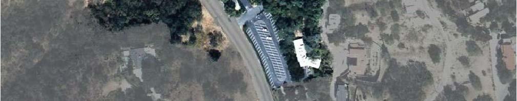
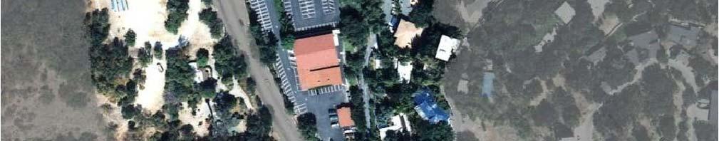
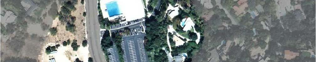
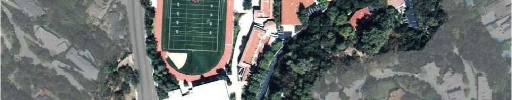
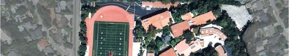
14 2.0 PROJECT DESCRIPTION 2.1 Site Location The Harvard-Westlake property is located on the east and west sides of Coldwater Canyon Avenue, approximately 1/3 of a mile south of Ventura Boulevard and 1.3 miles north of Mulholland Drive, in the Sherman Oaks-Studio City-Toluca Lake-Cahuenga Pass Plan area of the City of Los Angeles, California. The existing Harvard-Westlake Campus is located at 3700 Coldwater Canyon Avenue on the east side of Coldwater Canyon Avenue and is generally bounded by Halkirk Street to the north, Coldwater Canyon Avenue to the west, and Hacienda Drive to the south. The site of the proposed Harvard-Westlake parking structure is located at 3701 Coldwater Canyon Avenue, on the west side of Coldwater Canyon Avenue, directly across from the existing Harvard-Westlake Campus. The project site location and general vicinity are shown in Figure 1-1. A campus map of the proposed project site and the existing Harvard- Westlake Campus is illustrated in Figure Existing Project Site Harvard-Westlake is an independent co-educational college preparatory grade school for students in grades 7 through 12. Harvard-Westlake teaches students in grades 10 through 12 with a current student enrollment of 876 students. Vehicular access to the existing campus is presently provided via three driveways located on the east side of Coldwater Canyon Avenue. The three existing driveways consist of the northerly driveway on the north end of the campus property, the middle driveway at the Harvard-Westlake Main Entrance ( Harvard-Westlake Driveway ) which is controlled by a traffic signal, and the southerly driveway at Hacienda Drive at the southern end of the campus property. The three existing driveways along Coldwater Canyon Avenue all currently accommodate full access (i.e. left-turn and right-turn ingress and egress movements), although only one driveway is controlled by a traffic signal. A total of 568 parking spaces are currently provided on the existing Harvard-Westlake Campus. As documented in a following section, the existing supply of parking is insufficient to accommodate existing parking demand during regular school days, as well as in conjunction with school-related activities that occur outside regular school hours such as football games. Thus, it is noted that school-related vehicles regularly park on-street along Coldwater Canyon Avenue, as well as in the residential neighborhood near the campus. Harvard-Westlake has a school bus program, utilizing eight school buses to transport students to and from campus. Currently, due to insufficient space on-site, students currently board and alight from the school buses along the east side of Coldwater Canyon Avenue, north and south of the existing Harvard-Westlake driveway, potentially in conflict with vehicular traffic entering and exiting campus during drop-off and pick-up periods. The 5.5-acre project site on the west side of Coldwater Canyon Avenue is currently owned by Harvard-Westlake and is primarily unimproved. Vehicular access to the project site is presently provided via two partially-paved driveways located on the west side of Coldwater Canyon Avenue, south of the existing Harvard-Westlake driveway and north of Hacienda Drive
15 - 5 -
16 2.3 Proposed Project Description The project applicant seeks to obtain entitlements to develop a new three-story parking structure consisting of 750 parking spaces and an athletic practice field to serve as an accessory use to the existing school. The proposed parking structure will be utilized by faculty/staff, students, and visitors to the school. The proposed project also consists of the construction of a pedestrian bridge crossing Coldwater Canyon Avenue that will connect the proposed parking structure to the existing campus. No increase in student enrollment or faculty is proposed as part of the proposed project. Vehicular access to the proposed project site will be provided via two driveways on the west side Coldwater Canyon Avenue. The northerly project driveway is planned to provide primary access to the proposed parking structure. As part of the proposed project, the existing Harvard- Westlake driveway will be relocated slightly to the south (by approximately 37 feet) along Coldwater Canyon Avenue in order to align with the proposed northerly project driveway. Similar to the existing Harvard-Westlake Driveway intersection, the proposed relocated intersection which will include the northerly project driveway will be controlled by a traffic signal, with new traffic signal equipment provided based on LADOT requirements. The southerly project driveway will provide secondary access to the parking structure. It is noted that the proposed parking structure would be used for parking purposes only, with no student dropoff and pick-up operations permitted on the project site. All student drop-offs and pick-ups will continue to be accommodated on the main campus, although in a slightly modified configuration to allow for a safer and more efficient operation for motorists and pedestrians. Further discussion of the proposed project site access and circulation scheme is provided in Section 3.0. The ground floor site plan for the proposed project is illustrated in Figure 2-2. The proposed project would provide the following: Increased on-site parking supply for the Harvard-Westlake Campus for regular school use, as well as for typical school-related activities outside of regular school hours such as football games, essentially eliminating the need for school-related vehicles to park onstreet, either on Coldwater Canyon Avenue or in the nearby residential neighborhood; and Opportunities to provide enhanced and safer vehicular and pedestrian circulation on the main campus, including the relocation of the school bus drop-off/pick-up operations onsite from Coldwater Canyon Avenue. 2.4 Roadway Dedication and Project Roadway Improvement Features The site of the proposed parking structure is located along the west side of Coldwater Canyon Avenue. Provisions in the Municipal Code require the City to consider half-street dedications and improvements for roadways adjacent to development sites in accordance with adopted standards in the Transportation Element of the General Plan. Coldwater Canyon Avenue is designated as a Secondary Highway in the Transportation Element of the City of Los Angeles General Plan. The standard cross-section for a Secondary Highway is a 70-foot roadway on a - 6 -
17 - 7 -
18 90-foot right-of-way (or a 35-foot half roadway on a 45-foot half right-of-way as measured from the centerline). Review of City as-built plans show an existing half roadway width of 24 feet and a half right-ofway width of 30 feet along the west side of Coldwater Canyon Avenue adjacent to the project site. Therefore, the proposed project includes the dedication on the west side of Coldwater Canyon Avenue along the school s property frontage by 15 feet to provide the City s standard half right-of-way dimension for Secondary Highways as measured from the roadway centerline. On the southbound Coldwater Canyon Avenue approaches to the two driveways proposed to serve the parking structure, the widening of 11 feet is proposed to provide the minimum 35-foot half-street dimension. The roadway widening is proposed at the driveway approaches so as to allow for the striping of separate right-turn lanes for each intersection. Specifically, the widening will allow for a separate 300-foot long northbound left-turn lane and a 200-foot long southbound right-turn lane at the northerly signalized intersection. A separate 100-foot southbound right-turn lane will also be provided at the southerly driveway. Two southbound through lanes on Coldwater Canyon Avenue will also be installed to provide additional capacity for southbound traffic and minimize potential delay and loss of green-time to non-school related vehicles on Coldwater Canyon Avenue. In summary, the following Coldwater Canyon Avenue project roadway improvement features are proposed in conjunction with the project: Provide one northbound through lane and two southbound through lanes on Coldwater Canyon Avenue along the project frontage (i.e., addition of one southbound through lane); At the intersection of Coldwater Canyon Avenue and the proposed project s northerly driveway opposite the relocated Harvard-Westlake driveway, provide: o Northbound: One left-turn lane, one through lane and one right-turn lane; o Southbound: One left-turn lane, two through lanes and one right-turn lane; o Eastbound: One left-turn lane and one optional through/right-turn lane; and o Westbound: One left-turn lane and one optional through/right-turn lane; Also at the intersection of Coldwater Canyon Avenue and the proposed project s northerly driveway opposite the relocated Harvard-Westlake driveway, provide new traffic signal equipment, including left-turn phasing for northbound and southbound Coldwater Canyon Avenue traffic, and LADOT s ATSAC/ATCS equipment with connection to the Coldwater Canyon Avenue intersection at Ventura Boulevard; At the intersection of Coldwater Canyon Avenue and the proposed project s southerly driveway, provide: - 8 -
19 o Northbound: One through lane (i.e., no left-turns from northbound Coldwater Canyon Avenue to the southerly driveway will be permitted); o Southbound: Two through lanes and one right-turn lane; and o Eastbound: One optional left-turn/right-lane (controlled by a stop sign, with no left-turns permitted weekdays 7:00 a.m. 7:00 p.m.). To enhance safety for students and others using the project site, no pedestrian crossings will be provided at the street level. Accordingly, a sidewalk is not recommended along the west side of Coldwater Canyon Avenue so as to further discourage the possibility of student drop-off or pickups from occurring along the west side of Coldwater Canyon Avenue. The project will appropriately landscape the strip of public right-of-way between the westerly curbline and westerly property line. Additionally, no crosswalks are recommended across Coldwater Canyon Avenue adjacent to the project site, including at the signalized intersection with the project s northerly driveway across from the Harvard-Westlake driveway. As previously noted, a pedestrian bridge is proposed connecting the proposed parking structure with the Harvard- Westlake Campus. The proposed Coldwater Canyon Avenue roadway improvements proposed along the proposed project site are illustrated in Figure Voluntary Roadway Improvements In addition to the project roadway improvement features described above, the project proposes the implementation of additional and voluntary roadway improvements in the vicinity of the project site to further enhance traffic circulation along Coldwater Canyon Avenue. These improvements are not required to be implemented as part of the project; however, if approved by LADOT, Harvard-Westlake has stated that it would construct these voluntary improvements in conjunction with construction of the proposed project. These voluntary improvements are as follows: Modify the roadway striping on Coldwater Canyon Avenue between Ventura Boulevard and the northerly edge of the project site so as to provide two southbound lanes. Thus, this segment of Coldwater Canyon Avenue would provide one northbound lane, one center two-way left-turn lane, and two southbound lanes. In the segment between Ventura Boulevard and Van Noord Avenue, the right southbound lane would be available as a through travel lane during the weekday morning commute period (e.g., through signage such as No Stopping 7:00 a.m. 10:00 a.m.), and a parking lane during all other hours. The two southbound through lanes on southbound Coldwater Canyon Avenue would connect with the two southbound through lanes proposed to be provided adjacent to the project site. Although not required by City of Los Angeles traffic study guidelines, a street segment analysis was prepared using the Highway Capacity Manual (HCM) methodology for the segment of - 9 -
20 Coldwater Canyon Avenue between Ventura Boulevard and the Harvard-Westlake driveway in order to demonstrate the substantial benefit that the additional southbound lane would provide to traffic flow during the weekday morning commute peak hours of traffic by providing two southbound lanes during this period. The discussion of the Coldwater Canyon Avenue street segment analysis is provided in a following section. 2.6 Construction Programming A description of the anticipated construction-related activities, both overall as well as during each phase of construction of the proposed project, was obtained from the Applicant. The description also included construction worker trips, on-site equipment operation as well as offsite truck traffic generation. The following sections summarize in greater detail the anticipated construction schedule and construction assumptions Construction Schedule It is assumed that excavation would occur on the project site during the first year of construction. It is also assumed that following completion of the initial phase of excavation, final grading and structure construction would begin on the site. It is estimated that the excavation would require the removal of approximately 135,000 cubic yards of material from the site. It is anticipated that the equipment staging area and construction worker parking during the initial phases of construction grading, as well as after the start of construction, will occur on the project site. Based on the review and mapping of these construction phases, it has been determined that the peak construction activity and the corresponding highest number of vehicle/truck trips will occur during the construction grading and material export phase. Thus, the greatest potential for impact on the adjacent street system would occur during this peak condition Construction Assumptions The type and number of on-site equipment needs associated with each phase of construction have also been determined based on information provided by the Applicant and the environmental consultant. The following truck trips were estimated for each of the construction phases: 1) construction grading and material export: trucks trips per day and 2) final grading and structure construction: trucks trips per day. In addition, the following construction worker estimates were estimated for each of the construction phases: 1) construction grading and material export: workers and 2) final grading and structure construction: workers. As previously stated, the estimated export associated with the excavation phase is estimated at 135,000 cubic yards of material
21 3.0 SITE ACCESS AND CIRCULATION The proposed site access scheme for the is displayed in Figure 2-2. A description of the existing and proposed project site access and circulation scheme is provided in the following subsections. 3.1 Vehicular Site Access Existing Site Access Vehicular access to the existing campus is presently provided via three driveways located on the east side Coldwater Canyon Avenue. Descriptions of the existing driveways are provided in the following paragraphs: North Entrance Driveway: The North Entrance driveway is located on the east side of Coldwater Canyon Avenue at the northwest corner of the Harvard-Westlake Campus. The North Entrance driveway presently accommodates a majority of student pick-ups/drop-offs as well as access to faculty parking. The North Entrance driveway currently provides full vehicular access (i.e., left-turn and right-turn ingress and egress movements). Harvard-Westlake Driveway: The Harvard-Westlake driveway is located on the east side of Coldwater Canyon Avenue at the main entrance to the Harvard-Westlake Campus and is controlled by a traffic signal. The Harvard-Westlake driveway presently accommodates both staff and student vehicles. The Harvard-Westlake driveway currently provides full vehicular access (i.e., left-turn and right-turn ingress and egress movements). Hacienda Drive Driveway: The Hacienda Drive driveway is located on the east side of Coldwater Canyon Avenue at Hacienda Drive at the south end of the Harvard-Westlake Campus. The Hacienda Drive driveway presently accommodates student vehicles and provides access to the main campus. In addition, the Hacienda Drive driveway provides access to the parking lot immediately south of Hacienda Drive and north of St. Michael s and All Angels Episcopal Church ( South Lot ), which currently serves as student parking during school hours. The Hacienda Drive driveway currently provides full vehicular access (i.e., leftturn and right-turn ingress and egress movements). Vehicular access to the proposed project site is presently provided via two partially-paved driveways on the west side of Coldwater Canyon Avenue, south of the existing Harvard- Westlake driveway and north of Hacienda Drive Proposed Project Site Access The proposed project site access scheme is displayed in Figure 2-2. Vehicular access to the proposed project site will be provided via two driveways located along the west side of
22 Coldwater Canyon Avenue. Descriptions of the proposed project site driveways are provided in the following paragraphs: Northerly Project Driveway: The northerly project driveway will be located on the west side of Coldwater Canyon Avenue at the northeast corner of the proposed project site. The northerly project driveway will be located directly across from the Harvard-Westlake driveway following the relocation of the existing traffic signal. The northerly project driveway will provide primary access into the proposed parking structure and will accommodate full vehicular access (i.e., left-turn and right-turn ingress and egress movements). Southerly Project Driveway: The southerly project driveway will be located on the west side of Coldwater Canyon Avenue at the southeast corner of the proposed project site. The southerly project driveway will provide secondary access to the proposed parking structure and will accommodate limited vehicular access (i.e., right-turn ingress and right-turn egress movements, with left-turn egress permitted outside of the weekday period 7:00 a.m. 7:00 p.m.). 3.2 Pedestrian Access As part of the proposed project, the Applicant proposes to construct a new pedestrian bridge crossing Coldwater Canyon Avenue, connecting the proposed parking structure to the main campus. The location of the proposed pedestrian bridge is illustrated in Figure 2-2. The proposed pedestrian bridge would allow for safe crossing between the parking structure and the main campus without stopping vehicles traveling north and south along Coldwater Canyon Avenue. The pedestrian bridge would measure 163 feet long and 13 feet wide and would provide a minimum clearance of 25-feet and 6-inches above Coldwater Canyon Avenue. Connection to the pedestrian bridge will be provided at Level 2 of the proposed parking structure and a bridge landing on the existing main campus. As previously noted, due to safety reasons and the danger of speeding vehicles currently traveling along Coldwater Canyon Avenue, no pedestrian access to the project site will be provided from the street. Pedestrians can access the existing main campus from the parking structure, and vice versa, only via the proposed pedestrian bridge crossing Coldwater Canyon Avenue
23 4.0 PROJECT PARKING This section summarizes the review of the proposed project s parking requirements according to the City of Los Angeles Municipal Code requirements and of the planned project parking supply. It should be noted that Code parking for any development project is ultimately determined by the City of Los Angeles Department of Building and Safety at the time that a project applicant submit building plan to the Department. It is anticipated that the proposed project will provide Code required parking as determined by the City of Los Angeles Department of Building and Safety prior to issuance of a building permit for the project. 4.1 City of Los Angeles Code Parking Requirements In accordance with City of Los Angeles Planning Department Deputy Advisory Agency parking requirements, 436 parking spaces 3 are currently required for the existing Harvard-Westlake Campus. As no increase in student enrollment is proposed as part of the proposed project, Harvard-Westlake must continue to provide a minimum of 436 parking spaces. 4.2 Proposed Parking Supply A total of 568 parking spaces are currently provided on the existing Harvard-Westlake Campus. This total parking supply includes parking on the main campus as well as on the South Lot. As part of the proposed project, a total of 192 parking spaces will be removed, which includes 89 spaces from the main campus parking lot and 103 spaces from the South Lot. The South Lot will instead be utilized as a bus drop-off and pick-up staging area during school hours and as an overflow parking lot for special events on-site. With the construction of the proposed parking structure, an additional 750 parking spaces are planned to be provided. Thus, following the construction of the proposed project, 1,126 parking spaces will be provided on-site on the Harvard-Westlake Campus. As part of the parking supply, the project must also provide a minimum of 15 handicap accessible spaces. This complies with the American with Disabilities Act requirements of a minimum of two percent (2%) of the on-site parking supply as handicap spaces for parking facilities with 501 to 1,000 spaces, with one in every eight handicap spaces being van accessible. 3 Per City of Los Angeles Department of City Planning, Case No. ZA PAD
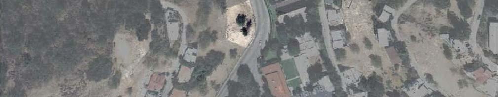
24 5.0 EXISTING STREET SYSTEM 5.1 Regional Highway System Regional access to the project site is provided by the U.S. 101 (Ventura) Freeway as shown in Figure 1-1. A brief description of the U.S. 101 Freeway is provided in the following paragraph. U.S. 101 (Ventura) Freeway is a major north-south freeway that extends across northern and southern California. In the project vicinity, five main travel lanes are provided in each direction on the U.S. 101 Freeway. Both northbound and southbound ramps are provided on the U.S. 101 Freeway at Coldwater Canyon Avenue, which are located approximately one mile north of the project site. 5.2 Study Intersections Immediate access to the project site is provided by Coldwater Canyon Avenue. The following study intersections were selected in consultation with LADOT staff for analysis of potential impacts due to the proposed project (the jurisdiction in which each study intersection is located is identified in parentheses): 1. Coldwater Canyon Avenue/US-101 Freeway Northbound Ramps (City of Los Angeles/Caltrans) 2. Coldwater Canyon Avenue/US-101 Freeway Southbound Ramps (City of Los Angeles/Caltrans) 3. Coldwater Canyon Avenue/Moorpark Street (City of Los Angeles) 4. Coldwater Canyon Avenue/Ventura Boulevard (City of Los Angeles) 5. Coldwater Canyon Avenue/Harvard-Westlake Driveway (City of Los Angeles) All five study intersections selected for analysis are presently controlled by traffic signals. The existing lane configurations at the study intersections are displayed in Figure Roadway Descriptions Brief descriptions of the important roadways in the project site vicinity are provided in the following paragraphs: Coldwater Canyon Avenue is a north-south oriented roadway that borders the proposed project site to the east and the existing Harvard-Westlake Campus to the west. Coldwater Canyon Avenue is classified as a Secondary Highway in the City of Los Angeles General Plan Transportation Element. Two through travel lanes are provided in each direction on Coldwater Canyon Avenue north of Ventura Boulevard. One travel lane is provided in each direction on Coldwater Canyon Avenue south of Dickens Street. Separate exclusive left-turn lanes are provided on Coldwater Canyon Avenue at major intersections in the project study area
25 - 15 -
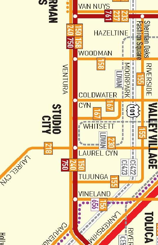
26 Coldwater Canyon Avenue is posted for a 35 miles per hour speed limit north of Hacienda Drive and a 30 miles per hour speed limit south of Hacienda Drive, except adjacent to Harvard- Westlake Campus where a School Zone 25 miles per hour speed limit is posted. Moorpark Street is an east-west oriented roadway that is located north of the project site. Moorpark Street is designated as a Secondary Highway in the City of Los Angeles General Plan Transportation Element. One through travel lane is generally provided in each direction on Moorpark Street in the project vicinity. Separate exclusive left-turn lanes are provided on Moorpark Street at major intersections in the project study area. Moorpark Street is posted for a 35 miles per hour speed limit in the project vicinity. Ventura Boulevard is an east-west oriented roadway that is located north of the project site. Ventura Boulevard is designated as a Major Highway Class II in the City of Los Angeles General Plan Transportation Element. Two through travel lanes are provided in each direction on Ventura Boulevard near the project site. Separate exclusive left-turn lanes are provided on Ventura Boulevard at major intersections in the project study area. Ventura Boulevard is posted for a 35 miles per hour speed limit in the project vicinity. Halkirk Street is an east-west oriented roadway that is located north of the project site. Halkirk Street is designated as a Local Street in the local Community Plan. One through travel lane is generally provided in each direction on Halkirk Street. Street intersections on Halkirk Street are currently stop-controlled in the project vicinity. There is no posted speed limit on Halkirk Street, thus it is assumed to be a prima-facie speed limit of 25 miles per hour. Hacienda Drive is an east-west oriented roadway that is located immediately south of the project site. Hacienda Drive is designated as a Private Street. One through travel lane is generally provided in each direction on Hacienda Drive. Street intersections on Hacienda Drive are currently stop-controlled in the project vicinity. There is no posted speed limit on Hacienda Drive, thus it is assumed to be a prima-facie speed limit of 25 miles per hour. Avenida del Sol is an east-west oriented roadway that is located just south of the project site. Avenida del Sol is designated as a Local Street in the local Community Plan. One through travel lane is generally provided in each direction on Avenida del Sol. Street intersections are currently stop-controlled in the project vicinity. There is no posted speed limit on Avenida del Sol, thus it is assumed to be a prima-facie speed limit of 25 miles per hour. 5.4 Public Bus Transit Services Public bus transit service in the project study area is currently provided by the Los Angeles County Metropolitan Transportation Authority (Metro) and the Los Angeles Department of Transportation (LADOT). A summary of the existing transit service, including the transit route, destinations and peak hour headways is presented in Table 5 1. The existing public transit routes provided within the project site vicinity are illustrated in Figure
27 NO. OF BUSES Metro Rapid 750 Universal City to Warner Center Ventura Boulevard EB 5 5 (via Sherman Oaks and Tarzana) WB 10 5 Total Table 5-1 EXISTING TRANSIT ROUTES [1] ROADWAY(S) DURING PEAK HOUR ROUTE DESTINATIONS NEAR SITE DIR AM PM Metro 150/240 Universal City to Canoga Park Ventura Boulevard EB 4 6 (via Studio City, Sherman Oaks, Encino, Tarzana, Reseda, WB 5 5 Northridge, Woodland Hills, and Canoga Park) Metro 167 Chatsworth to Studio City Coldwater Canyon, Whitsett Avenue, EB 1 2 (via Northridge, North Hills, Panorama City, and Ventura Boulevard, Moorpark Street WB 2 1 North Hollywood) LADOT DASH Van Nuys to Studio City Moorpark Street EB 2 2 Van Nuys/Studio City (via Sherman Oaks) WB 2 2 [1] Sources: Los Angeles County Metropolitan Transportation Authority (Metro) and Los Angeles Department of Transportation (LADOT) websites, February 2012.
28 - 18 -
29 6.0 TRAFFIC COUNTS 6.1 Intersection Manual Traffic Counts Manual traffic counts of vehicular turning movements were conducted at each of the study intersections during the weekday morning and afternoon commuter periods to determine the peak hour traffic volumes. The manual traffic counts at the study intersections were conducted from 7:00 AM to 10:00 AM to determine the AM peak commuter hour and from 3:00 PM to 6:00 PM to determine the PM peak commuter hours. Traffic volumes at the study intersections show the typical peak periods between 7:00 AM to 10:00 AM and 3:00 PM to 6:00 PM generally associated with the peak morning and afternoon commuter time periods. Manual traffic counts of vehicular turning movements were also conducted at the existing Harvard-Westlake Campus driveways during the weekday morning and afternoon commuter periods, as well as for an additional hour from 2:00PM to 3:00PM in conjunction with typical PM peak departure patterns at the Harvard-Westlake Campus to determine the school peak hour traffic volumes. It should be noted that while school-related traffic volumes at the existing project driveways showed the AM peak hour to be similar for both the commuter and school peak hours, school-related traffic volumes during the afternoon peak hour did not directly coincide with the highest peak of commuter afternoon traffic volumes along Coldwater Canyon Avenue. Rather, traffic volumes at the existing project driveways show the typical school peak periods between 7:00 AM to 9:00 AM and 2:00 PM to 4:00 PM generally associated with the peak arrival and departure patterns of the school. The weekday commuter AM and PM peak period manual counts of vehicle movements at the study intersections are summarized in Table 6 1. As shown on Table 6-1, the traffic counts were conducted in January 2011, which was prior to the current City Trunk Line construction project on Coldwater Canyon Avenue by the Department of Water and Power (thus, there were no travel lane constrictions on Coldwater Canyon Avenue at the time of the intersection traffic counts). In addition, for purposes of this analysis, the existing traffic volumes were increased by a factor of 2% in order to reflect 2012 conditions. The existing traffic volumes at the study intersections during the weekday commuter AM and PM peak hours are shown in Figures 6-1 and 6-2, respectively. Similarly, the weekday school AM and PM peak period manual counts of vehicle movements are summarized in Table 6-2. The existing traffic volumes at the study intersections during the weekday school AM and PM peak hours are shown in Figure 6-3. Summary data worksheets of the manual traffic counts at the study intersections are contained in Appendix A
3.8 TRANSPORTATION, CIRCULATION AND PARKING
 3.8 TRANSPORTATION, CIRCULATION AND PARKING This section provides an overview of traffic, circulation and parking impacts and evaluates the construction and operational impacts associated with the Proposed
2. Valley Circle Boulevard/Andora Avenue/Baden Avenue and Lassen Street
 IV.J TRANSPORTATION 1. INTRODUCTION This section presents an overview of the existing traffic and circulation system in and surrounding the project site. This section also discusses the potential impacts
IRSCH REEN Hirsch/Green Transportation Consulting, Inc.
 IRSCH REEN Hirsch/Green Transportation Consulting, Inc. February 6, 2013 Mr. David Weil Director of Finance St. Matthew s Parish School 1031 Bienveneda Avenue Pacific Palisades, California 90272 RE: Trip
STUDIO CITY SENIOR LIVING CENTER PROJECT ENV EIR APPENDIX I TRAFFIC IMPACT STUDY
 STUDIO CITY SENIOR LIVING CENTER PROJECT ENV 2001-1196-EIR APPENDIX I TRAFFIC IMPACT STUDY TABLE OF CONTENTS SECTION PAGE 1.0 Introduction... 1 1.1 Study Area... 3 2.0 Project Description... 4 2.1 Site
APPENDIX B Traffic Analysis
 APPENDIX B Traffic Analysis Rim of the World Unified School District Reconfiguration Prepared for: Rim of the World School District 27315 North Bay Road, Blue Jay, CA 92317 Prepared by: 400 Oceangate,
IV. ENVIRONMENTAL IMPACT ANALYSIS N. TRANSPORTATION AND TRAFFIC
 IV. ENVIRONMENTAL IMPACT ANALYSIS N. TRANSPORTATION AND TRAFFIC The following section summarizes the information provided in the traffic report entitled Traffic Impact Analysis for a Proposed Residential
ENVIRONMENTAL IMPACT ANALYSIS J. TRAFFIC, CIRCULATION AND ACCESS
 IV. ENVIRONMENTAL IMPACT ANALYSIS A traffic study was prepared for the Proposed Project by Linscott, Law & Greenspan, Engineers, dated August 5, 2008 (see Appendix I: Traffic Study). The traffic study
IV. ENVIRONMENTAL IMPACT ANALYSIS B. TRAFFIC AND CIRCULATION
 IV. ENVIRONMENTAL IMPACT ANALYSIS B. TRAFFIC AND CIRCULATION 1. INTRODUCTION This section is based on the technical report, Traffic Study for 10131 Constellation Boulevard Residential Project, prepared
King County Metro. Columbia Street Transit Priority Improvements Alternative Analysis. Downtown Southend Transit Study. May 2014.
 King County Metro Columbia Street Transit Priority Improvements Alternative Analysis Downtown Southend Transit Study May 2014 Parametrix Table of Contents Introduction... 1 Methodology... 1 Study Area...
INDUSTRIAL DEVELOPMENT
 INDUSTRIAL DEVELOPMENT Traffic Impact Study Plainfield, Illinois August 2018 Prepared for: Seefried Industrial Properties, Inc. TABLE OF CONTENTS Executive Summary 2 Introduction 3 Existing Conditions
Escondido Marriott Hotel and Mixed-Use Condominium Project TRAFFIC IMPACT ANALYSIS REPORT
 Escondido Marriott Hotel and Mixed-Use Condominium Project TRAFFIC IMPACT ANALYSIS REPORT Prepared for Phelps Program Management 420 Sixth Avenue, Greeley, CO 80632 Prepared by 5050 Avenida Encinas, Suite
IV. ENVIRONMENTAL IMPACT ANALYSIS L. TRANSPORTATION/TRAFFIC
 IV. ENVIRONMENTAL IMPACT ANALYSIS L. TRANSPORTATION/TRAFFIC INTRODUCTION The following section summarizes the information provided in the traffic report entitled Traffic Impact Analysis for a Proposed
Traffic Impact Study Speedway Gas Station Redevelopment
 Traffic Impact Study Speedway Gas Station Redevelopment Warrenville, Illinois Prepared For: Prepared By: April 11, 2018 Table of Contents 1. Introduction... 1 2. Existing Conditions... 4 Site Location...
EXECUTIVE SUMMARY. The following is an outline of the traffic analysis performed by Hales Engineering for the traffic conditions of this project.
 EXECUTIVE SUMMARY This study addresses the traffic impacts associated with the proposed Shopko redevelopment located in Sugarhouse, Utah. The Shopko redevelopment project is located between 1300 East and
King Soopers #116 Thornton, Colorado
 Traffic Impact Study King Soopers #116 Thornton, Colorado Prepared for: Galloway & Company, Inc. T R A F F I C I M P A C T S T U D Y King Soopers #116 Thornton, Colorado Prepared for Galloway & Company
IV. ENVIRONMENTAL IMPACT ANALYSIS J. TRANSPORTATION AND TRAFFIC
 IV. ENVIRONMENTAL IMPACT ANALYSIS J. TRANSPORTATION AND TRAFFIC This Section summarizes the information provided in the Traffic Study for the Santa Monica College Bundy Campus Master Plan (Traffic Study),
Table Existing Traffic Conditions for Arterial Segments along Construction Access Route. Daily
 5.8 TRAFFIC, ACCESS, AND CIRCULATION This section describes existing traffic conditions in the project area; summarizes applicable regulations; and analyzes the potential traffic, access, and circulation
Traffic Impact Analysis West Street Garden Plots Improvements and DuPage River Park Garden Plots Development Naperville, Illinois
 Traffic Impact Analysis West Street Garden Plots Improvements and DuPage River Park Garden Plots Development Naperville, Illinois Submitted by April 9, 2009 Introduction Kenig, Lindgren, O Hara, Aboona,
TIMBERVINE TRANSPORTATION IMPACT STUDY FORT COLLINS, COLORADO JANUARY Prepared for:
 TIMBERVINE TRANSPORTATION IMPACT STUDY FORT COLLINS, COLORADO JANUARY 2014 Prepared for: Hartford Companies 1218 W. Ash Street Suite A Windsor, Co 80550 Prepared by: DELICH ASSOCIATES 2272 Glen Haven Drive
TABLE OF CONTENTS SECTION PAGE. Executive Summary... xii
 TABLE OF CONTENTS SECTION PAGE Executive Summary... xii 1.0 Introduction... 1 1.1 Study Area... 2 1.2 Traffic Impact Analysis Scenarios... 4 1.3 Study Area - City of Orange... 4 2.0 Project Description
Appendix C. Traffic Study
 Appendix C Traffic Study TABLE OF CONTENTS SECTION Executive Summary PAGE 1.0 Introduction... 1 1.1 Scope of Work... 1 1.2 Study Area... 2 2.0 Project Description... 3 2.1 Site Access... 4 2.2 Pedestrian
Traffic Management Plan and Queuing Analysis Lakehill Preparatory School Z Hillside Drive, Dallas, TX October 27, 2015
 Traffic Management Plan and Queuing Analysis Lakehill Preparatory School Z145-235 2720 Hillside Drive, Dallas, TX October 27, 2015 Introduction: The Lakehill Preparatory School is located on the northeast
ENVIRONMENTAL IMPACT ANALYSIS D. TRANSPORTATION AND CIRCULATION 1. INTRODUCTION
 IV. ENVIRONMENTAL IMPACT ANALYSIS 1. INTRODUCTION This section is based on a traffic and parking impact study that was prepared for the proposed CSMC West Tower Project by Linscott, Law & Greenspan, Engineers,
IV. ENVIRONMENTAL IMPACT ANALYSIS K.2. PARKING
 IV. ENVIRONMENTAL IMPACT ANALYSIS K.2. PARKING ENVIRONMENTAL SETTING The following analysis summarizes the findings and conclusions of the Traffic Analysis (Traffic Study), prepared by The Mobility Group,
2.0 Development Driveways. Movin Out June 2017
 Movin Out June 2017 1.0 Introduction The proposed Movin Out development is a mixed use development in the northeast quadrant of the intersection of West Broadway and Fayette Avenue in the City of Madison.
TRANSPORTATION STUDY FOR THE 8899 BEVERLY BOULEVARD PROJECT
 DRAFT TRANSPORTATION STUDY FOR THE 8899 BEVERLY BOULEVARD PROJECT WEST HOLLYWOOD, CALIFORNIA NOVEMBER 2013 PREPARED FOR BEVERLY BOULEVARD ASSOCIATION PREPARED BY DRAFT TRANSPORTATION STUDY FOR THE 8899
MINERVA PARK SITE TRAFFIC IMPACT STUDY M/I HOMES. September 2, 2015
 5500 New Albany Road Columbus, Ohio 43054 Phone: 614.775.4500 Fax: 614.775.4800 Toll Free: 1-888-775-EMHT emht.com 2015-1008 MINERVA PARK SITE TRAFFIC IMPACT STUDY M/I HOMES September 2, 2015 Engineers
Traffic Engineering Study
 Traffic Engineering Study Bellaire Boulevard Prepared For: International Management District Technical Services, Inc. Texas Registered Engineering Firm F-3580 November 2009 Executive Summary has been requested
Date: February 7, 2017 John Doyle, Z-Best Products Robert Del Rio. T.E. Z-Best Traffic Operations and Site Access Analysis
 Memorandum Date: February 7, 07 To: From: Subject: John Doyle, Z-Best Products Robert Del Rio. T.E. Z-Best Traffic Operations and Site Access Analysis Introduction Hexagon Transportation Consultants, Inc.
LAWRENCE TRANSIT CENTER LOCATION ANALYSIS 9 TH STREET & ROCKLEDGE ROAD / 21 ST STREET & IOWA STREET LAWRENCE, KANSAS
 LAWRENCE TRANSIT CENTER LOCATION ANALYSIS 9 TH STREET & ROCKLEDGE ROAD / 21 ST STREET & IOWA STREET LAWRENCE, KANSAS TRAFFIC IMPACT STUDY FEBRUARY 214 OA Project No. 213-542 TABLE OF CONTENTS 1. INTRODUCTION...
5.9 TRANSPORTATION AND TRAFFIC
 5.9 TRANSPORTATION AND TRAFFIC This section evaluates transportation- and traffic-related impacts that have the potential to result from the construction and operation of the Project. Information and analysis
NEWCASTLE MIDDLE SCHOOL Traffic Impact Analysis
 Gibson Traffic Consultants 2802 Wetmore Avenue Suite 220 Everett, WA 98201 425.339.8266 NEWCASTLE MIDDLE SCHOOL Traffic Impact Analysis Prepared for: Renton School District Jurisdiction: City of Newcastle
IV. ENVIRONMENTAL IMPACT ANALYSIS C. TRAFFIC CIRCULATION AND PARKING
 IV. ENVIRONMENTAL IMPACT ANALYSIS C. TRAFFIC CIRCULATION AND PARKING 1. INTRODUCTION This section is based on the technical report Traffic Impact Study Health Sciences Campus Project, City of Los Angeles,
TRAFFIC SIGNAL DESIGN REPORT KING OF PRUSSIA ROAD & RAIDER ROAD RADNOR TOWNSHIP PENNSYLVANIA
 TRAFFIC SIGNAL DESIGN REPORT KING OF PRUSSIA ROAD & RAIDER ROAD RADNOR TOWNSHIP PENNSYLVANIA PREPARED FOR: UNIVERSITY OF PENNSYLVANIA HEALTH SYSTEM 34 CIVIC CENTER BOULEVARD PHILADELPHIA, PA 1987 (61)
Transportation & Traffic Engineering
 Transportation & Traffic Engineering 1) Project Description This report presents a summary of findings for a Traffic Impact Analysis (TIA) performed by A+ Engineering, Inc. for the Hill Country Family
APPENDIX E. Traffic Analysis Report
 APPENDIX E Traffic Analysis Report THIS PAGE INTENTIONALLY BLANK EAGLE RIVER TRAFFIC MITIGATION PHASE I OLD GLENN HIGHWAY/EAGLE RIVER ROAD INTERSECTION IMPROVEMENTS TRAFFIC ANALYSIS Eagle River, Alaska
Sherman Oaks Community Traffic Plan
 Sherman Oaks is a community that is geographically bound by the Santa Monica mountains on its southern boundary, and the ever-expanding San Fernando Valley on its western, northern, and eastern boundaries.
IMPROVEMENT CONCEPTS
 IMPROVEMENT CONCEPTS for the South Novato Transit Hub Study Prepared by: January 11, 2010 DKS Associates With Wilbur Smith Associates IMPROVEMENT CONCEPTS Chapter 1: Introduction 1. INTRODUCTION The strategic
TRAFFIC PARKING ANALYSIS
 TRAFFIC PARKING ANALYSIS NAPA FLEA MARKET COUNTY OF NAPA Prepared for: Tom Harding Napa-Vallejo Flea Market 33 Kelly Road American Canyon, CA 9453 Prepared by: 166 Olympic Boulevard, Suite 21 Walnut Creek,
TALMONT TOWNHOMES MADISON KENNETH SPA TRAFFIC IMPACT STUDY. Sacramento, CA. Prepared For: MBK Homes. Prepared By:
 TALMONT TOWNHOMES MADISON KENNETH SPA TRAFFIC IMPACT STUDY Sacramento, CA Prepared For: MBK Homes Prepared By: KD Anderson & Associates 3853 Taylor Road, Suite G Loomis, California 95650 (916) 660-1555
Appendix Q Traffic Study
 Appendices Appendix Q Traffic Study Crummer Site Subdivision Draft EIR City of Malibu Appendices This page intentionally left blank. The Planning Center April 2013 TRAFFIC IMPACT ANALYSIS Photo z here
Appendix B Traffic Impact Analysis, Asphalt Plant No. 1 Replacement and Modernization
 Appendix B Traffic Impact Analysis, Asphalt Plant No. 1 Replacement and Modernization REPORT Traffic Impact Analysis, Asphalt Plant No. 1 Replacement and Modernization Prepared for City of Los Angeles
Los Angeles Mission College Facilities Master Plan Draft Program Environmental Impact Report 3.13 TRANSPORTATION / TRAFFIC
 3.13 TRANSPORTATION / TRAFFIC As a result of the analysis undertaken in the Initial Study for the Los Angeles Mission College Facilities Master Plan, the (LACCD) determined that the proposed project may
TRANSPORTATION TECHNICAL REPORT
 TRANSPORTATION TECHNICAL REPORT for Sunrise Elementary School Replacement PREPARED FOR: Puyallup School District PREPARED BY: 6544 NE 61 st Street, Seattle, WA 98115 ph: (26) 523-3939 fx: (26) 523-4949
Traffic Impact Analysis 5742 BEACH BOULEVARD MIXED USE PROJECT
 Traffic Impact Analysis 5742 BEACH BOULEVARD MIXED USE PROJECT CITY OF BUENA PARK Prepared by Project No. 14139 000 April 17 th, 2015 DKS Associates Jeffrey Heald, P.E. Rohit Itadkar, T.E. 2677 North Main
The major roadways in the study area are State Route 166 and State Route 33, which are shown on Figure 1-1 and described below:
 3.5 TRAFFIC AND CIRCULATION 3.5.1 Existing Conditions 3.5.1.1 Street Network DRAFT ENVIRONMENTAL IMPACT REPORT The major roadways in the study area are State Route 166 and State Route 33, which are shown
This letter summarizes our observations, anticipated traffic changes, and conclusions.
 Mr. David Jorschumb Project Manager Boulder Valley School District Re: Review of proposed school access improvements at the Foothills Elementary School in Boulder Dear Mr. Jorschumb, At your request, the
Alpine Highway to North County Boulevard Connector Study
 Alpine Highway to North County Boulevard Connector Study prepared by Avenue Consultants March 16, 2017 North County Boulevard Connector Study March 16, 2017 Table of Contents 1 Summary of Findings... 1
IV. ENVIRONMENTAL IMPACT ANALYSIS
 IV. ENVIRONMENTAL IMPACT ANALYSIS J. TRANSPORTATION AND CIRCULATION This section presents the findings of the traffic study for the proposed project prepared by Crain & Associates of Southern California
Section 5.8 Transportation and Traffic
 Section 5.8 Transportation and Traffic 5.8 TRANSPORTATION AND TRAFFIC Generous This Section is based on the Topgolf Specific Plan Traffic Impact Analysis (RK Engineering Group, Inc., October 31, 2016);
Appendix B Traffic Impact Analysis, Asphalt Plant No. 1 Replacement and Modernization
 Appendix B Traffic Impact Analysis, Asphalt Plant No. 1 Replacement and Modernization DRAFT REPORT Traffic Impact Analysis, Asphalt Plant No. 1 Replacement and Modernization Prepared for City of Los Angeles
THE CORNERSTONE APARTMENTS TRAFFIC IMPACT STUDY R&M PROJECT NO
 THE CORNERSTONE APARTMENTS SITUATED AT N/E/C OF STAUDERMAN AVENUE AND FOREST AVENUE VILLAGE OF LYNBROOK NASSAU COUNTY, NEW YORK TRAFFIC IMPACT STUDY R&M PROJECT NO. 2018-089 September 2018 50 Elm Street,
Table of Contents INTRODUCTION... 3 PROJECT STUDY AREA Figure 1 Vicinity Map Study Area... 4 EXISTING CONDITIONS... 5 TRAFFIC OPERATIONS...
 Crosshaven Drive Corridor Study City of Vestavia Hills, Alabama Table of Contents INTRODUCTION... 3 PROJECT STUDY AREA... 3 Figure 1 Vicinity Map Study Area... 4 EXISTING CONDITIONS... 5 TRAFFIC OPERATIONS...
TRAFFIC IMPACT STUDY. USD #497 Warehouse and Bus Site
 TRAFFIC IMPACT STUDY for USD #497 Warehouse and Bus Site Prepared by: Jason Hoskinson, PE, PTOE BG Project No. 16-12L July 8, 216 145 Wakarusa Drive Lawrence, Kansas 6649 T: 785.749.4474 F: 785.749.734
Section 5.0 Traffic Information
 Section 5.0 Traffic Information 10.0 TRANSPORTATION MDM Transportation Consultants, Inc. (MDM) has prepared an evaluation of transportation impacts for the proposed evaluation for the expansion of the
Proposed location of Camp Parkway Commerce Center. Vicinity map of Camp Parkway Commerce Center Southampton County, VA
 Proposed location of Camp Parkway Commerce Center Vicinity map of Camp Parkway Commerce Center Southampton County, VA Camp Parkway Commerce Center is a proposed distribution and industrial center to be
The key roadways in the project vicinity are described below. Exhibit displays the existing number of lanes on the study roadways.
 4.2 TRAFFIC AND CIRCULATION This section presents the key assumptions, methods, and results of analysis for the transportation and circulation impacts of the proposed project. This section is based on
TABLE OF CONTENTS 1.0 INTRODUCTION AND SUMMARY Purpose of Report and Study Objectives... 2
 TABLE OF CONTENTS 1.0 INTRODUCTION AND SUMMARY 1 1.1 Purpose of Report and Study Objectives... 2 1.2 Executive Summary... 3 1.2.1 Site Location and Study Area... 3 1.2.2 Development Description... 3 1.2.3
IV. ENVIRONMENTAL IMPACT ANALYSIS H. TRANSPORTATION/TRAFFIC
 IV. ENVIRONMENTAL IMPACT ANALYSIS H. TRANSPORTATION/TRAFFIC The following summarizes the information provided in the traffic report prepared by Fehr & Peers/Kaku Associates entitled, Traffic Study for
TRANSPORTATION 1. INTRODUCTION
 IV.F TRANSPORTATION 1. INTRODUCTION This section evaluates potential impacts associated with Project-related traffic, circulation, and access. The analysis summarizes the findings of the traffic study
Traffic Feasibility Study
 Traffic Feasibility Study Town Center South Robbinsville Township, Mercer County, New Jersey December 19, 2017 Prepared For Robbinsville Township Department of Community Development 2298 Route 33 Robbinsville,
Draft Report: West Berkeley Bowl Project
 Draft Report: West Berkeley Bowl Project July 2004 Prepared for: The City of Berkeley 1031-1925 F EHR & PEERS TRANSPORTATION CONSULTANTS 3685 Mt. Diablo Blvd. #301 Lafayette, CA 94549 925-284-3200 Fax:
TRAFFIC IMPACT STUDY DERRY GREEN CORPORATE BUSINESS PARK MILTON SECONDARY PLAN MODIFICATION
 TRAFFIC IMPACT STUDY DERRY GREEN CORPORATE BUSINESS PARK MILTON SECONDARY PLAN MODIFICATION TRAFFIC IMPACT STUDY DERRY GREEN CORPORATE BUSINESS PARK MILTON SECONDARY PLAN MODIFICATION DECEMBER 24 UPDATED
Madison BRT Transit Corridor Study Proposed BRT Operations Plans
 Madison BRT Transit Corridor Study Proposed BRT Operations Plans This paper presents a description of the proposed BRT operations plan for use in the Madison BRT Transit Corridor Study. The objective is
Mercer Island Center for the Arts Parking Management Plan
 Parking Stalls Mercer Island Center for the Arts Parking Management Plan June 15, 2016 This Parking Management Plan (P) covers all tenants at the Mercer Island Center for the Arts (MICA) campus, including
Traffic Impact Analysis. Alliance Cole Avenue Residential Site Dallas, Texas. Kimley-Horn and Associates, Inc. Dallas, Texas.
 Traffic Impact Analysis Alliance Cole Avenue Residential Site Dallas, Texas February 15, 2018 Kimley-Horn and Associates, Inc. Dallas, Texas Project #064524900 Registered Firm F-928 Traffic Impact Analysis
Clean Harbors Canada, Inc.
 Clean Harbors Canada, Inc. Proposed Lambton Landfill Expansion Environmental Assessment Terms of Reference Transportation Assessment St. Clair Township, Ontario September 2009 itrans Consulting Inc. 260
RE: A Traffic Impact Statement for a proposed development on Quinpool Road
 James J. Copeland, P.Eng. GRIFFIN transportation group inc. 30 Bonny View Drive Fall River, NS B2T 1R2 May 31, 2018 Ellen O Hara, P.Eng. Project Engineer DesignPoint Engineering & Surveying Ltd. 200 Waterfront
Traffic Impact Study for Proposed Olive Boulevard Development
 Traffic Impact Study for Proposed 11330 Olive Boulevard Development Creve Coeur, Missouri July 7, 2017 Prepared For: 11330 Olive Boulevard Development 11330 Olive Boulevard Creve Coeur, Missouri 63141
Section 3.12 Traffic and Transportation
 Section. Traffic and Transportation SECTION SUMMARY This section describes existing ground transportation within the Port and surrounding area associated with implementation of the proposed Project. An
TRANSPORTATION 1. INTRODUCTION 2. METHODOLOGY
 IV.K TRANSPORTATION 1. INTRODUCTION This section provides an analysis of potential impacts associated with traffic, parking, and access. The analysis provides an overview of existing traffic conditions
Oakbrook Village Plaza City of Laguna Hills
 Oakbrook Village Plaza City of Laguna Hills Traffic Impact Analysis Prepared by: HDR Engineering 3230 El Camino Real, Suite 200 Irvine, CA 92602 October 2012 Revision 3 D-1 Oakbrook Village Plaza Laguna
Traffic Impact Statement (TIS)
") Traffic Impact Statement (TIS) Vincentian PUDA Collier County, FL 10/18/2013 Prepared for: Global Properties of Naples Prepared by: Trebilcock Consulting Solutions, PA 2614 Tamiami Trail N, Suite 615 1205
Traffic Impact Statement (TIS) Vincentian PUDA Collier County, FL 10/18/2013 Prepared for: Global Properties of Naples Prepared by: Trebilcock Consulting Solutions, PA 2614 Tamiami Trail N, Suite 615 1205
Diablo Vista Pumping Plant Replacement
 Diablo Vista Pumping Plant Replacement Traffic Study PHA Transportation Consultants 12-05-359 October 2012 Diablo Vista Pumping Plant Replacement Traffic Study For EBMUD October 2012 PHA Transportation
TRAFFIC DATA. Existing Derousse Ave./River Rd. AM LOS Analysis Existing Derousse Ave./River Rd. PM LOS Analysis
 Appendix E NJ TRANSIT Pennsauken Junction Transit Center and Park & Ride RiverLINE and Atlantic City Line Pennsauken Township, Camden County, New Jersey TRAFFIC DATA Background Traffic Information for
Craig Scheffler, P.E., PTOE HNTB North Carolina, P.C. HNTB Project File: Subject
 TECHNICAL MEMORANDUM To Kumar Neppalli Traffic Engineering Manager Town of Chapel Hill From Craig Scheffler, P.E., PTOE HNTB North Carolina, P.C. Cc HNTB Project File: 38435 Subject Obey Creek TIS 2022
APPENDIX G TRAFFIC STUDY TECHNICAL MEMORANDUM
 APPENDIX G TRAFFIC STUDY TECHNICAL MEMORANDUM TECHNICAL MEMORANDUM To: From: Date: Subject: Jerry Flores - AECOM Brian A. Marchetti, AICP September 9, 5 DRAFT Traffic Study LABOE Channel 5 Studio Relocation
Construction Realty Co.
 MEMORANDUM TO: FROM : Jeff Pickus Construction Realty Co. Luay R. Aboona, PE Principal 9575 West Higgins Road, Suite 400 Rosemont, Illinois 60018 p: 847-518-9990 f: 847-518-9987 DATE: May 22, 2014 SUBJECT:
4.7 Construction Surface Transportation
 4.7 Construction Surface Transportation 4.7.1 Introduction The traffic analysis presented in this section addresses the construction traffic impacts specific to the proposed Project. The construction traffic
IV. ENVIRONMENTAL IMPACT ANALYSIS M. TRANSPORTATION AND TRAFFIC
 IV. ENVIRONMENTAL IMPACT ANALYSIS M. TRANSPORTATION AND TRAFFIC INTRODUCTION This section of the (Draft EIR) addresses the subject of traffic and transportation with respect to the proposed (Project or
Ingraham High School Parking and Traffic Analysis
 Parking and Traffic Analysis Seattle, WA Prepared for: URS Corporation 1501 4th Avenue, Suite 1400 Seattle, WA 98101-1616 Mirai Transportation Planning & Engineering 11410 NE 122nd Way, Suite 320 Kirkland,
APPENDIX C-2. Traffic Study Supplemental Analysis Memo
 APPENDIX C-2 Traffic Study Supplemental Analysis Memo The Mobility Group Transportation Strategies & Solutions Memorandum To: From: Subject: Tomas Carranza, LADOT Matthew Simons Traffic Review - Revised
Vanier Parkway and Presland Road Residential Development Transportation Impact Study
 Vanier Parkway and Presland Road Residential Development Transportation Impact Study Final Report (Revised) March 2011 Submitted to: Groupe Lépine Ottawa Project No. 09-1613 Submitted by: Groupe Lépine
Appendix H TRAFFIC IMPACT ANALYSIS
 Appendix H TRAFFIC IMPACT ANALYSIS Teichert Boca Quarry Expansion Traffic Impact Analysis Prepared for Teichert Aggregates Prepared by TRANSPORTATION CONSULTANTS, INC. LSC Transportation Consultants, Inc.
ANDERSON PROPERTY SITE ANALYSIS
 ANDERSON PROPERTY SITE ANALYSIS Introduction The Montgomery County Department of Transportation (MCDOT) initiated a feasibility study in the fall of 2012 to evaluate the need for transit service expansion
MONTEREY BAY AQUARIUM RESEARCH INSTITUTE (MBARI) MASTER PLAN UPDATE MOSS LANDING, CALIFORNIA
 MASTER PLAN UPDATE MOSS LANDING, CALIFORNIA") MONTEREY BAY AQUARIUM RESEARCH INSTITUTE (MBARI) MASTER PLAN UPDATE MOSS LANDING, CALIFORNIA TRAFFIC IMPACT ANALYSIS Administrative Draft Report Prepared For Monterey Bay Aquarium Research Institute Moss
MONTEREY BAY AQUARIUM RESEARCH INSTITUTE (MBARI) MASTER PLAN UPDATE MOSS LANDING, CALIFORNIA TRAFFIC IMPACT ANALYSIS Administrative Draft Report Prepared For Monterey Bay Aquarium Research Institute Moss
APPENDIX C1 TRAFFIC ANALYSIS DESIGN YEAR TRAFFIC ANALYSIS
 APPENDIX C1 TRAFFIC ANALYSIS DESIGN YEAR TRAFFIC ANALYSIS DESIGN YEAR TRAFFIC ANALYSIS February 2018 Highway & Bridge Project PIN 6754.12 Route 13 Connector Road Chemung County February 2018 Appendix
4.14 TRANSPORTATION AND CIRCULATION
 4.14 TRANSPORTATION AND CIRCULATION 4.14.1 Summary Table 4.14-1 summarizes the identified environmental impacts, proposed mitigation measures, and residual impacts of the proposed project with regard to
TRAFFIC IMPACT ANALYSIS FOR. McDONALD S RESTAURANT IN CARMICAEL Sacramento County, CA. Prepared For:
 TRAFFIC IMPACT ANALYSIS FOR McDONALD S RESTAURANT IN CARMICAEL Sacramento County, CA Prepared For: McDonald s USA, LLC Pacific Sierra Region 2999 Oak Road, Suite 900 Walnut Creek, CA 94597 Prepared By:
STAFF REPORT # CHANGE OF ZONING
 STAFF REPORT #17-2000-0007 CHANGE OF ZONING PLANNING COMMISSION MEETING DATE: November 16, 2017 (Applicant Provided Materials / Traffic Study = Blue) 1. APPLICATION: A public hearing for an application
HUMC/Mountainside Hospital Redevelopment Plan
 Traffic and Parking Analysis HUMC/Mountainside Hospital Redevelopment Plan in Glen Ridge Borough and Montclair Township PREPARED FOR H2M 119 Cherry Hill Road, Suite 110 Parsippany, NJ 07054 862.207.5900
DOMINICK S FINER FOODS Traffic Impact Analysis Sheridan Road and Foster Avenue (#2890) March 17, 2009
 March 17, 2009") DOMINICK S FINER FOODS Traffic Impact Analysis Sheridan Road and Foster Avenue (#2890) March 17, 2009 Prepared for: Manhard Consulting, Ltd. 900 Woodlands Parkway Vernon Hills, Illinois 60061 Prepared
DOMINICK S FINER FOODS Traffic Impact Analysis Sheridan Road and Foster Avenue (#2890) March 17, 2009 Prepared for: Manhard Consulting, Ltd. 900 Woodlands Parkway Vernon Hills, Illinois 60061 Prepared
MILLERSVILLE PARK TRAFFIC IMPACT ANALYSIS ANNE ARUNDEL COUNTY, MARYLAND
 MILLERSVILLE PARK TRAFFIC IMPACT ANALYSIS ANNE ARUNDEL COUNTY, MARYLAND Prepared for: Department of Public Works Anne Arundel County Prepared by: URS Corporation 4 North Park Drive, Suite 3 Hunt Valley,
TRAFFIC IMPACT STUDY FOR SONIC DRIVE-IN RESTAURANT. Vallejo, CA. Prepared For:
 TRAFFIC IMPACT STUDY FOR SONIC DRIVE-IN RESTAURANT Vallejo, CA Prepared For: ELITE DRIVE-INS, INC. 2190 Meridian Park Blvd, Suite G Concord, CA 94520 Prepared By: KD Anderson & Associates 3853 Taylor Road,
Impacts to street segments were analyzed based on procedures detailed in the Highway Capacity Manual for levels of service related to roadways.
 4.7 Transportation and Circulation This report documents the results of a study of the potential traffic impacts created by the Whittier Main Oil Field Development Project. The study is included as Appendix
Appendix J Traffic Impact Study
 MRI May 2012 Appendix J Traffic Impact Study Level 2 Traffic Assessment Limited Impact Review Appendix J [This page was left blank intentionally.] www.sgm-inc.com Figure 1. Site Driveway and Trail Crossing
Environmental Assessment Derry Road and Argentia Road Intersection
 Air and Noise Study Environmental Assessment Derry Road and Argentia Road Intersection Project 11-4295 City of Mississauga, Region of Peel October 17, 2014 1 Region of Peel Environmental Assessment for
Traffic, Transportation & Civil Engineering Ali R. Khorasani, P.E. P.O. Box 804, Spencer, MA 01562, Tel: (508)
") Associates Traffic, Transportation & Civil Engineering Ali R. Khorasani, P.E. P.O. Box 804, Spencer, MA 01562, Tel: (508) 885-5121 Ms. Teri Ford, Associate 800 Boylston Street, Suite 1570 Boston, MA July
Associates Traffic, Transportation & Civil Engineering Ali R. Khorasani, P.E. P.O. Box 804, Spencer, MA 01562, Tel: (508) 885-5121 Ms. Teri Ford, Associate 800 Boylston Street, Suite 1570 Boston, MA July
Volume 1 Traffic Impact Analysis Turtle Creek Boulevard Dallas, Texas. Kimley-Horn and Associates, Inc. Dallas, Texas.
 Volume 1 Traffic Impact Analysis 2727 Dallas, Texas June 18, 2018 Kimley-Horn and Associates, Inc. Dallas, Texas Project #064523000 Registered Firm F-928 Traffic Impact Analysis 2727 Dallas, Texas Prepared
TRAFFIC IMPACT ANALYSIS. for MILTON SQUARE
 TRAFFIC IMPACT ANALYSIS for MILTON SQUARE US Route 7 Milton, Vermont March 5, 2008 LAMOUREUX & DICKINSON 14 Morse Drive Essex Junction, Vermont 05452 (802) 878-4450 Traffic Impact Assessment EXECUTIVE