MMM Group Limited. Communities. Transportation. Buildings. Infrastructure
|
|
|
- Alicia Miles
- 5 years ago
- Views:
Transcription


1 MMM Group Limited Traffic Study CASA MIA Community Care Facility Vancouver, BC Communities Transportation Buildings Infrastructure February
2
3 STANDARD LIMITATIONS This report was prepared by MMM Group (MMM) for the account of The Care Group (the Client). The disclosure of any information contained in this report is the sole responsibility of the Client. The material in this report reflects MMM's best judgment in light of the information available to it at the time of preparation. Any use which a third party makes of this report, or any reliance on or decisions to be made based on it, are the responsibility of such third parties. MMM accepts no responsibility for damages, if any, suffered by a third party as a result of decisions made or actions based on this report.
4
5 TABLE OF CONTENTS 1. INTRODUCTION METHODOLOGY PROPOSED DEVELOPMENT TRAFFIC IMPACT ASSESSMENT TRANSPORTATION DEMAND MANAGEMENT ON-SITE CIRCULATION LOADING MANAGEMENT PLAN RECOMMENDATIONS SUMMARY Traffic Study CASA MIA Community Care Facility i
6 LIST OF FIGURES Figure 1 Site Location... 2 Figure 2 Proposed Site Plan... 5 Figure 3 Existing Traffic Volumes... 6 Figure 4 Site-Generated Traffic Volumes... 8 Figure 5 Future Total (2017) Traffic Volumes... 9 LIST OF TABLES Table 1 Trip Generation... 7 Table 2 Trip Distribution... 8 Table 3 LOS Analysis Future Total (2017) Traffic Study CASA MIA Community Care Facility ii
7 1. INTRODUCTION The Care Group is embarking on plans to rezone the existing heritage home at 1920 SW Marine Drive, also known as CASA MIA, to a 92-bed community care facility. The current plan proposes to maintain the existing heritage building with a connection to a new, three-storey building on the northwest portion of the property. A new underground parkade will be located under the proposed building, with access to and from SW Marine Drive provided via the north driveway. The existing south driveway will be maintained for pick-up / drop-off activities. The site location is illustrated in Figure 1. The proposed development aims to achieve LEED Gold certification. With this vision in mind, MMM Group was retained by The Care Group to undertake a traffic and parking study for the proposed development in support of the rezoning application. Specifically, the objectives of this study are to: Evaluate future traffic patterns at CASA MIA and its impact on the adjacent road network; Identify opportunities for Transportation Demand Management measures; Review on-site truck circulation; and Provide a Loading Management Plan (LMP) that aims to reduce traffic impact induced by loading activities Traffic Study CASA MIA Community Care Facility 1


8 Site Location Figure 1 Site Location (Source: Google Maps) Traffic Study CASA MIA Community Care Facility 2
9 2. METHODOLOGY In order to address the City s requirements, MMM Group completed the following work plan: Confirmed Terms of Reference with the City of Vancouver Obtained and reviewed the latest site plans / development statistics Visited the site and surroundings on Friday, January 6, 2012 to clearly understand the site development in terms of access, parking restrictions, street laning, pedestrian and cyclist facilities, transit, and traffic control / traffic calming measures Conducted data collection program on Saturday, January 7, 2012 and Wednesday, January 11, 2012 on SW Marine Drive at the existing CASA MIA driveways to document traffic flows for the following peak periods: Weekday morning (7:00 9:00 AM) Weekday afternoon (4:00 6:00 PM) Saturday midday (12:00 2:00 PM) Assessed traffic impacts at the CASA MIA driveways: Estimated trip generation at CASA MIA by applying data collected at three comparable Community Care facilities in Vancouver: Point Grey Private Hospital 76 beds Braddan Private Hospital 72 beds Arbutus Care Centre 160 beds Estimated directional distribution and assigned new site traffic based on the existing traffic patterns on SW Marine Drive Used Synchro 8 software to evaluate intersection operations at the study area intersections for the opening day. Measures of effectiveness include level of service (LOS) and volume to capacity ratio (v/c ratio) For the purpose of achieving LEED Gold points, listed alternative transportation options that will help reduce pollution and land development impacts from automobile use Assessed site circulation of the pick-up / drop-off area: Confirmed the design vehicle and used AutoTURN software to verify vehicle maneuverings Prepared a Loading Management Plan: Obtained information identifying the type, frequency, schedule and class of pickup and delivery vehicles to and from the site Provided recommendations with a view to lessen traffic impacts by delivery trucks on City streets Traffic Study CASA MIA Community Care Facility 3
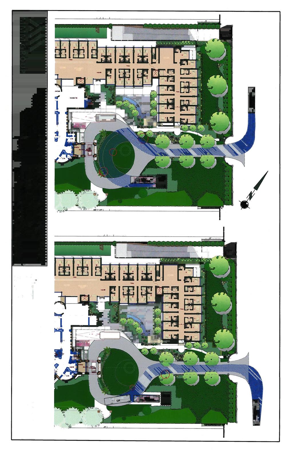
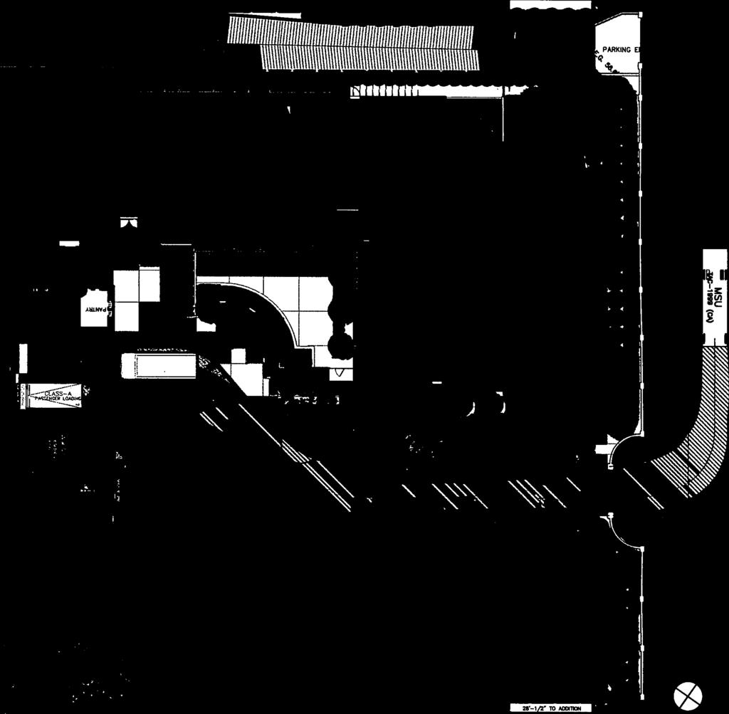
10 3. PROPOSED DEVELOPMENT Figure 2 illustrates the proposed site plan. For the purpose of this report, Marine Drive is described with a north-south orientation. Key aspects of the CASA MIA proposal include: Maintenance of the existing heritage building A new three-storey community care facility attached to the heritage building, with a total of 92 beds Maintenance of the existing all-movement south driveway and porte-cochere for pick-up / drop-off / loading activities Upgrading the all-movement north driveway for access to the underground parkade for visitors and staff. The ramp to the parkade is 6m wide, which should be adequate for two-way travels. It is our understanding that parking will be provided in accordance with bylaw requirements Two passenger spaces (one Class A and one Class B) located along the porte-cochere. These two spaces are intended for small deliveries and Handy- DART vehicles. There is also a mountable grass surface for vehicles to turn around if the existing clearance of the canopy is too low for certain types of vehicles One Class B loading space for larger vehicles (i.e. garbage trucks) An area for bicycle parking Traffic Study CASA MIA Community Care Facility 4
 Traffic Study CASA MIA Community Care Facility")
11 North Driveway SW MARINE DRIVE South Driveway Proposed Improved Driveway (6m wide) Garbage Area Class B Loading Space Mountable Grass Surface Existing Canopy Proposed Wing Class A & Class B Passenger Spaces Existing Building Figure 2 Proposed Site Plan (Source: Stuart Howard Architect) Traffic Study CASA MIA Community Care Facility 5

12 4. TRAFFIC IMPACT ASSESSMENT 4.1 Existing Site and Surroundings CASA MIA is bounded by SW Marine Drive to the east and single family homes to its north, south and west. The surrounding land use is primarily residential consisting of mostly singlefamily houses. Current access to the site is provided via an all-movement south driveway on SW Marine Drive. The existing north driveway appears unused. SW Marine Drive is a north-south oriented primary arterial that connects from Granville Street (Marpole area) to UBC. SW Marine Drive is a major route to UBC, carrying nearly 2,000 vehicles in the morning and afternoon peak hours. Within the vicinity of the study area, SW Marine Drive has a two-lane cross-section with a posted speed limit of 50km/hr. It is a dedicated bicycle route, with shoulder bicycle lanes in both directions. Sidewalk is not provided on both sides, with parking generally permitted on the gravel shoulders. 4.2 Existing Traffic Volumes Existing (2012) weekday AM and PM peak hour traffic volumes on SW Marine Drive at the CASA MIA driveways are illustrated in Figure 3. As illustrated, SW Marine Drive experiences traffic volumes in the order of 1,950 vehicles per hour (vph) during the weekday AM and PM peak hours. Little to no traffic was observed to use the site driveways, as the site is currently vacant. Figure 3 Existing Traffic Volumes Traffic Study CASA MIA Community Care Facility 6
13 4.3 Site Generated Traffic The site generated traffic at CASA MIA is estimated based on the trip generation characteristics at Point Grey Private Hospital (PGPH), Braddan Private Hospital (Braddan) and Arbutus Care Centre (Arbutus) (See Table 1). Trip generation rates published in the Institute of Transportation Engineers (ITE) Trip Generation Manual 1 were included in Table 1 for comparative purposes. The observed rates were first averaged, then adjusted upwards to reflect an assumption for the CASA MIA location that 95% of facility users would travel by car, with the remaining 5% by other means (i.e. Carpool / Cycling). Compared to the other sites, alternative forms of transportation to and from CASA MIA appears to be limited given the distance to the nearest bus stop (400m) and the absence of sidewalk. Table 1 Trip Generation Location Unit Trip Rate (vph/bed) Traffic Volumes (vph) In (%) Out (%) Total In (%) Out (%) Total Weekday AM PGPH 76 Beds 67% 33% Braddan 72 Beds 71% 29% Arbutus 160 Beds 45% 55% Average 61% 39% 0.08 CASA MIA 92 Beds 61% 39% ITE (Land use 620) 92 Beds 65% 35% Weekday PM PGPH 76 Beds 42% 58% Braddan 72 Beds 44% 56% Arbutus 160 Beds 50% 50% Average 45% 55% 0.22 CASA MIA 92 Beds 45% 55% ITE (Land use 620) 92 Beds 44% 56% Saturday Midday PGPH 76 Beds 44% 56% Braddan 72 Beds 53% 47% Arbutus 160 Beds 46% 54% Average 48% 52% 0.30 CASA MIA 92 Beds 48% 52% ITE (Land use 620) 92 Beds 50% 50% Trip Generation Manual, 9 th Edition (Washington, DC: Institute of Transportation Engineers, 2012) Traffic Study CASA MIA Community Care Facility 7
14 When completed, CASA MIA is expected to add 10 new vehicle trips (= 6 entering + 4 exiting) to the road network during the weekday AM peak hour, 25 vehicle trips (= 11 entering + 14 exiting) during the PM peak hour, and 35 vehicles trips (=17 entering + 18 exiting) during the Saturday peak hour. Site-generate traffic was then distributed to the road network using the existing traffic patterns along SW Marine Drive. Table 2 summarizes the trip distribution. Table 2 Trip Distribution Direction Weekday AM Weekday PM Saturday Midday To From To From To From North 55% 45% 45% 55% 45% 55% South 45% 55% 55% 45% 55% 45% The assignment of site-generated traffic to the study area is illustrated in Figure 4. Note that the majority of staff and visitors are expected to use the north driveway to park at the parkade. Figure 4 Site-Generated Traffic Volumes Traffic Study CASA MIA Community Care Facility 8

 to LOS F (oversaturated) conditions.")
15 4.4 Future (2017) Traffic The Future Total (2017) traffic volumes were estimated by adding the site-generated traffic volumes to the existing (2012) traffic volumes (Figure 5). Background traffic growth was not applied as historic volumes show a decreasing trend of traffic volumes along Marine Drive for the past 10 years. 4.5 Operational Analysis Figure 5 Future Total (2017) Traffic Volumes Reported measures of traffic performance include volume to capacity (v/c) ratio and a delaybased traffic Level of Service (LOS) indicator ranging from LOS A (ideal) to LOS F (oversaturated) conditions. Typical peak hour urban conditions are in the LOS C to LOS D range with average delays ranging from 20 to 55 seconds per vehicle at signalized intersections and 15 to 35 seconds per vehicle at unsignalized intersections. As a target for design parameters, LOS D for individual approaches is considered appropriate for the study area. The results for the Future Total (2017) scenario based upon the Highway Capacity Manual (Washington DC: Transportation Research Board, 2000) unsignalized intersection capacity generated by the Synchro 8.0 software are attached in Appendix A and summarized in Table 3. Traffic Study CASA MIA Community Care Facility 9
16 Table 3 LOS Analysis Future Total (2017) Intersection Control Movement 1 Weekday AM Peak Weekday PM Peak Saturday Midday Peak LOS Delay V/C LOS Delay V/C LOS Delay V/C SW Marine Drive / North Driveway Minor Street Stop- Controlled Intersection EB-LR NB-LT SB-TR C E A A C E A A A C A A SW Marine Drive / South Driveway Minor Street Stop- Controlled Intersection EB-LR NB-LT SB-TR C E A A C E A A A D A A Key findings from Table 3 include: For all peak periods, traffic on SW Marine Drive in the northbound and southbound directions is expected to operate at a satisfactory level (LOS A) with minimal delays caused by development traffic. The outbound movements at both driveways are expected to experience longer delays (LOS E) during the AM and PM peak hours. The delays are mostly attributed to left-turn vehicles. As a result, it is anticipated that drivers may choose to turn right on SW Marine Drive and detour using other streets. Overall, the traffic generated by the CASA MIA redevelopment will represent less than 3% of the total peak hour traffic on SW Marine Drive (0.6% in the weekday AM peak, 1.5% in the weekday PM peak, and 2.8% in the Saturday midday peak). Traffic Study CASA MIA Community Care Facility 10
17 5. TRANSPORTATION DEMAND MANAGEMENT Transportation Demand Management (TDM) principles emphasize the movement of people and goods rather than the movement of motor vehicles, and as such give priority to alternative modes of transportation such as walking and cycling. As part of this study for the project, a list of possible TDM measures is presented below with a view to encourage and support a reduction in single occupancy vehicle (SOV) trips and parking demands at the facility: Explore the feasibility of providing shuttle buses for staff to and from the Marpole area during shift changes to promote transit usage, and to encourage the enrollment of TransLink s Employee Pass Program (EPP), which offers discounted annual transit passes when 25 or more employees are enrolled into the program. Dedicate priority parking stalls for staff that car-pool. Install covered and secured bike parking / storage for visitors and staff. Recommend that the City review pedestrian and bike corridors in the study area to improve walkability and ride quality (for example, a continuous sidewalk along SW Marine Drive). Recommend that the City review illumination and visibility on SW Marine Drive with a view to enhance pedestrian safety. Publish educational material for staff, highlighting health benefits of walking or cycling, and environmental benefits of taking transit. Traffic Study CASA MIA Community Care Facility 11
18 6. ON-SITE CIRCULATION An AutoTURN analysis of trucks maneuvering into and out of the Class B Passenger Space (Passenger Space) and Class B Off-Street Loading Space (Loading Space) is included in Appendix B. A MSU vehicle (10m total length) template was used to simulate the largest size TransLink Handy-DART shuttle bus and a front loading garbage truck. The vertical clearance of the existing canopy of the porte-cochere is inadequate in accommodating trucks. As such, a mountable grass median is provided for trucks to bypass the canopy. Key findings of the analysis include: The current design could accommodate vehicles entering the Passenger Spaces. Vehicles backing up from the Passenger Space would conflict with landscape features. Widening the mountable grass surface and modifications to landscaping would allow a MSU vehicle to turn around. It is our understanding that the Loading space / Garbage area will be shifted east (towards Marine Drive), such that turn-around movement will not be blocked by a garbage truck. Trucks entering the Loading Space and garbage area could be accommodated by widening the mountable grass surface. The current design could accommodate trucks exiting the Loading Space by widening the driveway slightly. The sketches in Appendix B show areas where additional widening of pavement / driveable lawn and modifications to landscaping are needed. Traffic Study CASA MIA Community Care Facility 12
19 7. LOADING MANAGEMENT PLAN This Loading Management Plan (LMP) is developed to identify and control loading operations for CASA MIA with a view to lessen the traffic impacts by delivery trucks on city streets. This LMP addresses the following goals: Encourage the use of symbiotic loading schedules to spread the loading activity more evenly and reduce the peak traffic demand Provide a framework for the optimization of loading activities and suggest areas of improvement, if any Maintain effective communication with the various stakeholders to ensure proper coordination of efforts 7.1 Site Context CASA MIA s loading / service area will include two Passenger Spaces (one Class A and one Class B), plus one Loading Space (Class B). All loading operations will take place entirely within the site with access off SW Marine Drive at the existing south driveway. Backing onto the street will not be allowed. The main types of services that will utilize the area include: Food Delivery Garbage Pick-up Recycling Pick-up Supply Delivery Passenger pick-up / drop-off Community shuttle buses, such as TransLink s Handy-DART, are expected to utilize the Class B Passenger Space during pick-up and drop-off activities. Other truck activities would take place using the Loading Space. The AutoTURN analysis of truck circulation as seen in Appendix B suggests that trucks with a maximum length of 10m (i.e. MSU) should be used on site. 7.2 Anticipated Loading Activities All loading and delivery services are expected to occur once per week, generally between 8am and 4pm. Passenger pick-up and drop-off activities would vary throughout the day at the Passenger Space. After-hours loading and delivery services are not expected at this site. It is anticipated that the on-site loading area would be sufficient to accommodate all loading and delivery activities given the anticipated truck schedules. Traffic Study CASA MIA Community Care Facility 13
20 7.3 Loading Management Measures Loading Area Manager An appointed staff shall act as a Loading Area Manager, who will be responsible for supervising on-site loading and delivery activities, and ensuring safe manoeuvre and proper loading and delivery operations on site. He / She will also be responsible for scheduling, liaising stakeholders, monitoring truck activities, ensuring truck engines are shut down while vehicles are parked, maintaining cleanliness and appearance of loading areas, oversees the security and safety of the loading area, etc Optimization of Loading Schedules Regular communication between the various loading and delivery companies will optimize scheduling. Coordination should reduce, if not eliminate, the potential for loading conflict as well as queuing of trucks waiting to enter the site on SW Marine Drive. To coordinate, the following should be considered: Identify times for garbage and recycling pick-up Identify times for scheduled food and supply deliveries Adjust scheduled times as necessary to avoid conflicts Confirm schedules with related companies Monitor loading and delivery activities, and adjust to suit Optimization of Arrival Patterns In general, the Loading Area Manager would be responsible to manage the arrival and departure patterns of trucks at the loading area in order to minimize conflicts. Traffic Study CASA MIA Community Care Facility 14
21 8. RECOMMENDATIONS In light of our findings, the following recommendations are presented for consideration: Truck turning movements could be accommodated by revising driveway and mountable grass surface, and landscaping layout Implement LMP measures, such as: Appointing a Loading Area Manager to be responsible for scheduling and on-going monitoring of loading activity, supervision of loading activity and enforcement of loading area use regulations Conducting Loading Management meetings to co-ordinate loading schedules Optimizing scheduled loading activities to make best use of slow periods Continuing to monitor and adjust loading schedules accordingly Consider implementing TDM measures as documented in Section 5 of this report Traffic Study CASA MIA Community Care Facility 15
22 9. SUMMARY The Care Group is proposing to redevelop the existing CASA MIA heritage building, located at 1920 SW Marine Drive in Vancouver, as a 92-bed community care facility. A new underground parkade intended to be used by visitors and staff is proposed, with access provided via the north driveway on SW Marine Drive. The existing south driveway will be maintained for pick-up / drop-off / loading activities. The facility is anticipated to generate up to 10 vehicles (6 inbound + 4 outbound) in the morning peak hour, up to 25 vehicles (11 inbound + 14 outbound) in the afternoon peak hour, and up to 35 vehicles (17 inbound and 18 outbound) in the Saturday midday peak hour. Trip generation was based on observed rates at three similar community care facilities in Vancouver (Point Grey Private Hospital, Bradden Private Hospital, and Arbutus Care Centre). The rates were adjusted up to reflect the projected mode splits at the site. Overall, the traffic generated by the redevelopment at CASA MIA will represent 0.6% of the total weekday AM peak hour traffic, 1.5% of the total weekday PM peak hour traffic, and 2.8% of the total Saturday midday peak hour traffic on SW Marine Drive. For all peak periods, SW Marine Drive in the northbound and southbound directions is expected to operate at a satisfactory level (LOS A) with minimal delays caused by development traffic. Operational analysis at the two site driveways in the Future Total (2017) scenario shows that outbound movements would experience longer delays (LOS E) during the weekday AM and PM peaks. As a result, it is anticipated that drivers may choose to turn right on SW Marine Drive and detour using other streets. An AutoTURN analysis concluded that the current driveway and grass median surface layout can be modified and widened to accommodate delivery trucks and Handy-DART vehicles on site. It is anticipated that with a proper Loading Management Plan, the on-site loading area will be adequate for accommodating all loading and delivery activities given the anticipated truck schedules. Traffic Study CASA MIA Community Care Facility 16
23 APPENDIX A Synchro Analysis Output
24
25 Casa Mia Community Care Facility 1: SW Marine Drive & Proposed Driveway Lanes, Volumes, Timings Total Volume (AM) Casa Mia Community Care Facility 1: SW Marine Drive & Proposed Driveway HCM Unsignalized Intersection Capacity Analysis Total Volume (AM) Lane Group EBL EBR NBL NBT SBT SBR Lane Configurations Volume (vph) Ideal Flow (vphpl) Lane Util. Factor Ped Bike Factor Frt Flt Protected Satd. Flow (prot) Flt Permitted Satd. Flow (perm) Link Speed (mph) Link Distance (ft) Travel Time (s) Confl. Bikes (#/hr) 2 Peak Hour Factor Heavy Vehicles (%) 2% 2% 2% 9% 8% 2% Adj. Flow (vph) Shared Lane Traffic (%) Lane Group Flow (vph) Sign Control Stop Free Free Intersection Summary Area Type: Other Control Type: Unsignalized Intersection Capacity Utilization 67.4% Analysis Period (min) 15 ICU Level of Service C Movement EBL EBR NBL NBT SBT SBR Lane Configurations Volume (veh/h) Sign Control Stop Free Free Grade 0% 0% 0% Peak Hour Factor Hourly flow rate (vph) Pedestrians Lane Width (ft) Walking Speed (ft/s) Percent Blockage Right turn flare (veh) Median type None None Median storage veh) Upstream signal (ft) px, platoon unblocked vc, conflicting volume vc1, stage 1 conf vol vc2, stage 2 conf vol vcu, unblocked vol tc, single (s) tc, 2 stage (s) tf (s) p0 queue free % cm capacity (veh/h) Direction, Lane # EB 1 NB 1 SB 1 Volume Total Volume Left Volume Right csh Volume to Capacity Queue Length 95th (ft) Control Delay (s) Lane LOS E A Approach Delay (s) Approach LOS E Intersection Summary Average Delay 0.1 Intersection Capacity Utilization 67.4% ICU Level of Service C Analysis Period (min) 15 MMM 2/20/2013 MMM 2/20/2013
26 Casa Mia Community Care Facility 3: SW Marine Drive & Site Driveway Lanes, Volumes, Timings Total Volume (AM) Casa Mia Community Care Facility 3: SW Marine Drive & Site Driveway HCM Unsignalized Intersection Capacity Analysis Total Volume (AM) Lane Group EBL EBR NBL NBT SBT SBR Lane Configurations Volume (vph) Ideal Flow (vphpl) Lane Util. Factor Ped Bike Factor Frt Flt Protected Satd. Flow (prot) Flt Permitted Satd. Flow (perm) Link Speed (mph) Link Distance (ft) Travel Time (s) Confl. Bikes (#/hr) 2 Peak Hour Factor Heavy Vehicles (%) 2% 2% 2% 9% 8% 2% Adj. Flow (vph) Shared Lane Traffic (%) Lane Group Flow (vph) Sign Control Stop Free Free Intersection Summary Area Type: Other Control Type: Unsignalized Intersection Capacity Utilization 65.1% Analysis Period (min) 15 ICU Level of Service C Movement EBL EBR NBL NBT SBT SBR Lane Configurations Volume (veh/h) Sign Control Stop Free Free Grade 0% 0% 0% Peak Hour Factor Hourly flow rate (vph) Pedestrians Lane Width (ft) Walking Speed (ft/s) Percent Blockage Right turn flare (veh) Median type None None Median storage veh) Upstream signal (ft) px, platoon unblocked vc, conflicting volume vc1, stage 1 conf vol vc2, stage 2 conf vol vcu, unblocked vol tc, single (s) tc, 2 stage (s) tf (s) p0 queue free % cm capacity (veh/h) Direction, Lane # EB 1 NB 1 SB 1 Volume Total Volume Left Volume Right csh Volume to Capacity Queue Length 95th (ft) Control Delay (s) Lane LOS E Approach Delay (s) Approach LOS E Intersection Summary Average Delay 0.0 Intersection Capacity Utilization 65.1% ICU Level of Service C Analysis Period (min) 15 MMM 2/20/2013 MMM 2/20/2013
27 Casa Mia Community Care Facility 1: SW Marine Drive & Proposed Driveway Lanes, Volumes, Timings Total Volume (PM) Casa Mia Community Care Facility 1: SW Marine Drive & Proposed Driveway HCM Unsignalized Intersection Capacity Analysis Total Volume (PM) Lane Group EBL EBR NBL NBT SBT SBR Lane Configurations Volume (vph) Ideal Flow (vphpl) Lane Util. Factor Ped Bike Factor Frt Flt Protected Satd. Flow (prot) Flt Permitted Satd. Flow (perm) Link Speed (mph) Link Distance (ft) Travel Time (s) Confl. Bikes (#/hr) 5 Peak Hour Factor Adj. Flow (vph) Shared Lane Traffic (%) Lane Group Flow (vph) Sign Control Stop Free Free Intersection Summary Area Type: Other Control Type: Unsignalized Intersection Capacity Utilization 68.6% Analysis Period (min) 15 ICU Level of Service C Movement EBL EBR NBL NBT SBT SBR Lane Configurations Volume (veh/h) Sign Control Stop Free Free Grade 0% 0% 0% Peak Hour Factor Hourly flow rate (vph) Pedestrians Lane Width (ft) Walking Speed (ft/s) Percent Blockage Right turn flare (veh) Median type None None Median storage veh) Upstream signal (ft) px, platoon unblocked vc, conflicting volume vc1, stage 1 conf vol vc2, stage 2 conf vol vcu, unblocked vol tc, single (s) tc, 2 stage (s) tf (s) p0 queue free % cm capacity (veh/h) Direction, Lane # EB 1 NB 1 SB 1 Volume Total Volume Left Volume Right csh Volume to Capacity Queue Length 95th (ft) Control Delay (s) Lane LOS E A Approach Delay (s) Approach LOS E Intersection Summary Average Delay 0.4 Intersection Capacity Utilization 68.6% ICU Level of Service C Analysis Period (min) 15 MMM 2/20/2013 MMM 2/20/2013
28 Casa Mia Community Care Facility 3: SW Marine Drive & Site Driveway Lanes, Volumes, Timings Total Volume (PM) Casa Mia Community Care Facility 3: SW Marine Drive & Site Driveway HCM Unsignalized Intersection Capacity Analysis Total Volume (PM) Lane Group EBL EBR NBL NBT SBT SBR Lane Configurations Volume (vph) Ideal Flow (vphpl) Lane Util. Factor Ped Bike Factor Frt Flt Protected Satd. Flow (prot) Flt Permitted Satd. Flow (perm) Link Speed (mph) Link Distance (ft) Travel Time (s) Confl. Bikes (#/hr) 5 Peak Hour Factor Adj. Flow (vph) Shared Lane Traffic (%) Lane Group Flow (vph) Sign Control Stop Free Free Intersection Summary Area Type: Other Control Type: Unsignalized Intersection Capacity Utilization 68.6% Analysis Period (min) 15 ICU Level of Service C Movement EBL EBR NBL NBT SBT SBR Lane Configurations Volume (veh/h) Sign Control Stop Free Free Grade 0% 0% 0% Peak Hour Factor Hourly flow rate (vph) Pedestrians Lane Width (ft) Walking Speed (ft/s) Percent Blockage Right turn flare (veh) Median type None None Median storage veh) Upstream signal (ft) px, platoon unblocked vc, conflicting volume vc1, stage 1 conf vol vc2, stage 2 conf vol vcu, unblocked vol tc, single (s) tc, 2 stage (s) tf (s) p0 queue free % cm capacity (veh/h) Direction, Lane # EB 1 NB 1 SB 1 Volume Total Volume Left Volume Right csh Volume to Capacity Queue Length 95th (ft) Control Delay (s) Lane LOS E A Approach Delay (s) Approach LOS E Intersection Summary Average Delay 0.1 Intersection Capacity Utilization 68.6% ICU Level of Service C Analysis Period (min) 15 MMM 2/20/2013 MMM 2/20/2013
29 Casa Mia Community Care Facility 1: SW Marine Drive & Proposed Driveway Lanes, Volumes, Timings Total Volume (Sat) Casa Mia Community Care Facility 1: SW Marine Drive & Proposed Driveway HCM Unsignalized Intersection Capacity Analysis Total Volume (Sat) Lane Group EBL EBR NBL NBT SBT SBR Lane Configurations Volume (vph) Ideal Flow (vphpl) Lane Util. Factor Frt Flt Protected Satd. Flow (prot) Flt Permitted Satd. Flow (perm) Link Speed (mph) Link Distance (ft) Travel Time (s) Peak Hour Factor Heavy Vehicles (%) 2% 2% 2% 4% 4% 2% Adj. Flow (vph) Shared Lane Traffic (%) Lane Group Flow (vph) Sign Control Stop Free Free Intersection Summary Area Type: Other Control Type: Unsignalized Intersection Capacity Utilization 52.2% Analysis Period (min) 15 ICU Level of Service A Movement EBL EBR NBL NBT SBT SBR Lane Configurations Volume (veh/h) Sign Control Stop Free Free Grade 0% 0% 0% Peak Hour Factor Hourly flow rate (vph) Pedestrians Lane Width (ft) Walking Speed (ft/s) Percent Blockage Right turn flare (veh) Median type None None Median storage veh) Upstream signal (ft) px, platoon unblocked vc, conflicting volume vc1, stage 1 conf vol vc2, stage 2 conf vol vcu, unblocked vol tc, single (s) tc, 2 stage (s) tf (s) p0 queue free % cm capacity (veh/h) Direction, Lane # EB 1 NB 1 SB 1 Volume Total Volume Left Volume Right csh Volume to Capacity Queue Length 95th (ft) Control Delay (s) Lane LOS C A Approach Delay (s) Approach LOS C Intersection Summary Average Delay 0.3 Intersection Capacity Utilization 52.2% ICU Level of Service A Analysis Period (min) 15 MMM 2/20/2013 MMM 2/20/2013
30 Casa Mia Community Care Facility 3: SW Marine Drive & Site Driveway Lanes, Volumes, Timings Total Volume (Sat) Casa Mia Community Care Facility 3: SW Marine Drive & Site Driveway HCM Unsignalized Intersection Capacity Analysis Total Volume (Sat) Lane Group EBL EBR NBL NBT SBT SBR Lane Configurations Volume (vph) Ideal Flow (vphpl) Lane Util. Factor Frt Flt Protected Satd. Flow (prot) Flt Permitted Satd. Flow (perm) Link Speed (mph) Link Distance (ft) Travel Time (s) Peak Hour Factor Heavy Vehicles (%) 2% 2% 2% 4% 4% 2% Adj. Flow (vph) Shared Lane Traffic (%) Lane Group Flow (vph) Sign Control Stop Free Free Intersection Summary Area Type: Other Control Type: Unsignalized Intersection Capacity Utilization 52.2% Analysis Period (min) 15 ICU Level of Service A Movement EBL EBR NBL NBT SBT SBR Lane Configurations Volume (veh/h) Sign Control Stop Free Free Grade 0% 0% 0% Peak Hour Factor Hourly flow rate (vph) Pedestrians Lane Width (ft) Walking Speed (ft/s) Percent Blockage Right turn flare (veh) Median type None None Median storage veh) Upstream signal (ft) px, platoon unblocked vc, conflicting volume vc1, stage 1 conf vol vc2, stage 2 conf vol vcu, unblocked vol tc, single (s) tc, 2 stage (s) tf (s) p0 queue free % cm capacity (veh/h) Direction, Lane # EB 1 NB 1 SB 1 Volume Total Volume Left Volume Right csh Volume to Capacity Queue Length 95th (ft) Control Delay (s) Lane LOS D A Approach Delay (s) Approach LOS D Intersection Summary Average Delay 0.1 Intersection Capacity Utilization 52.2% ICU Level of Service A Analysis Period (min) 15 MMM 2/20/2013 MMM 2/20/2013
31 APPENDIX B AutoTURN Analysis
32
33


34
886 March Road McDonald's Transportation Study
 McDonald's Restaurants of Canada Limited March 2013 886 March Road McDonald's Transportation Study Submitted by: HDR Corporation 100 York Boulevard, Suite 300 Richmond Hill, ON L4B 1J8 (905) 882-4100 www.hdrinc.com
HCM Unsignalized Intersection Capacity Analysis 6: Brian Street & LC 111 5/26/2009
 6: Brian Street & LC 111 5/26/2009 Movement EBL EBR NBL NBT SBT SBR Volume (veh/h) 116 20 8 405 137 56 Sign Control Stop Free Free Grade 0% 0% 0% Peak Hour Factor 0.81 0.81 0.67 0.67 0.89 0.89 Hourly flow
L1TILE BEARS DAY CARE TRANSPORTATION IMPACT STUDY FORT COLLINS, COLORADO MAY Prepared for:
 L1TILE BEARS DAY CARE TRANSPORTATION IMPACT STUDY FORT COLLINS, COLORADO MAY 2012 Prepared for: Hillside Construction, Inc. 216 Hemlock Street, Suite B Fort Collins, CO 80534 Prepared by: DELICH ASSOCIATES
STANDARD LIMITATIONS
 STANDARD LIMITATIONS This report was prepared by MMM Group (MMM) for the account of Spire Construction Inc. (the Client). The disclosure of any information contained in this report is the sole responsibility
Village of Richmond Transportation Brief
 Village of Richmond Transportation Brief GENIVAR Project Number 111-18482-00 June 21 st, 2011 www.genivar.com GENIVAR 15 Fitzgerald Road, Suite 100 Ottawa, Ontario, CANADA K2H 9G1 Telephone: 613-829-2800
ZINFANDEL LANE / SILVERADO TRAIL INTERSECTION TRAFFIC ANALYSIS
 ZINFANDEL LANE / SILVERADO TRAIL INTERSECTION TRAFFIC ANALYSIS UPDATED TRAFFIC STUDY FOR THE PROPOSED RAYMOND VINEYARDS WINERY USE PERMIT MODIFICATION #P11-00156 AUGUST 5, 2014 PREPARED BY: OMNI-MEANS,
MEMORANDUM. Date: November 4, Cheryl Burrell, Pebble Beach Company. Rob Rees, P.E. Inclusionary Housing Transportation Analysis WC
 MEMORANDUM Date: November 4, 2013 To: From: Subject: Cheryl Burrell, Pebble Beach Company Rob Rees, P.E. Inclusionary Housing Transportation Analysis As requested, Fehr & Peers is providing clarification
RESPONSE TO TRAFFIC IMPACT STUDY COMMENTS
 RESPONSE TO TRAFFIC IMPACT STUDY COMMENTS Proposed Gas Station 40 Arthur Street (Highway 26), Town of the Blue Mountains (Thornbury), County of Grey, Ontario AUGUST 2013 August 27, 2013 MR. REG RUSSWURM
Barrhaven Honda Dealership. Dealership Drive, Ottawa, ON. Transportation Brief
 Barrhaven Honda Dealership Dealership Drive, Ottawa, ON Transportation Brief Prepared By: NOVATECH Suite 200, 240 Michael Cowpland Drive Ottawa, Ontario K2M 1P6 September, 2015 File: 115136 Ref: R-2015-152
 Traffic Analysis For Approved Uses within the St. Lucie West DRI Aldi Port St. Lucie, FL Prepared for: Bohler Engineering, LLC 1000 Corporate Drive Suite 250 Fort Lauderdale, FL 33334 Prepared by: 10795
Traffic Impact Study Hudson Street Parking Garage MC Project No.: A Table of Contents
 Traffic Impact Study Hudson Street Parking Garage MC Project No.: 15001714A Table of Contents Table of Contents I. INTRODUCTION... 1 II. EXISTING CONDITIONS... 4 III. 2015 EXISTING TRAFFIC CONDITIONS...
Sugarland Crossing Gwinnett County, Georgia
 Sugarland Crossing Gwinnett County, Georgia S IGNAL W ARRANT A NALYSIS For the Intersection of: Sugarloaf Parkway / Richards Middle School Driveway / Sugarland Crossing Main Site Driveway Prepared for:
Lakeside Terrace Development
 Lakeside Terrace Development City of Barrie, County of Simcoe Traffic Brief for: Type of Document: Final Report Project Number: JDE 1617 Date Submitted: April 29 th, 216 4/29/16 John Northcote, P.Eng.
(A) Project Manager, Infrastructure Approvals
 Project Manager, Infrastructure Approvals") February 14th, 2014 BY E-MAIL: wally.dubyk@ottawa.ca City of Ottawa Planning and Growth Management Branch 110 Laurier Ave. W., 4 th Floor, Ottawa, Ontario K1P 1J1 Attention: Wally Dubyk, C.E.T (A) Project
February 14th, 2014 BY E-MAIL: wally.dubyk@ottawa.ca City of Ottawa Planning and Growth Management Branch 110 Laurier Ave. W., 4 th Floor, Ottawa, Ontario K1P 1J1 Attention: Wally Dubyk, C.E.T (A) Project
LOST LAKE CORRIDOR REVIEW
 LOST LAKE CORRIDOR REVIEW Prepared for: Prepared by: Broadview Developments Inc. c/o Westbrook Consulting Watt Consulting Group Our File: 2064.B01 Date: October 31, 2016 TABLE OF CONTENTS 1.0 INTRODUCTION...
Traffic Impact Study Proposed Commercial Development Ballwin, Missouri. Technical Memorandum for Traffic Impact Study
 Traffic Impact Study Proposed Commercial Development Ballwin, Missouri Technical Memorandum for Traffic Impact Study Crawford, Bunte, Brammeier May 1, 2009 MEMORANDUM Date: April 24, 2009 To: From: Subject:
CastleGlenn Consultants Inc.
 CastleGlenn Consultants Inc. Engineers, Project Managers & Planners March 11 th, 2013 Domenic Idone, P. Eng Planning Manager R.W. Tomlinson Ltd. 5597 Power Road Ottawa, Ontario K1G 3N4 Dear Mr. Idone:
MURRIETA APARTMENTS TRAFFIC IMPACT ANALYSIS CITY OF MURRIETA, CALIFORNIA
 MURRIETA APARTMENTS TRAFFIC IMPACT ANALYSIS CITY OF MURRIETA, CALIFORNIA SEPTEMBER 20, 2012 Prepared for: Golden Eagle Multi-Family Properties, LLC 6201 Oak Canyon Rd., Suite 250 Irvine, CA 92618 Prepared
April Salvation Army Barrhaven Church 102 Bill Leathem Drive Transportation Brief
 April 26 Salvation Army Barrhaven Church 2 Bill Leathem Drive Transportation Brief Salvation Army Barrhaven Church 2 Bill Leathem Drive Transportation Brief prepared for: The Salvation Army 2 Overlea Blvd.
Bennett Pit. Traffic Impact Study. J&T Consulting, Inc. Weld County, Colorado. March 3, 2017
 Bennett Pit Traffic Impact Study J&T Consulting, Inc. Weld County, Colorado March 3, 217 Prepared By: Sustainable Traffic Solutions, Inc. http://www.sustainabletrafficsolutions.com/ Joseph L. Henderson,
Provide an overview of the development proposal including projected site traffic volumes;
 December 19, 2013 File: 163600935 Attention: Troy Elliott Carl Elliott Limited 15-1831 Robertson Road PO Box 11117 Nepean, Ontario K1H 7T8 Dear Mr. Elliott, Reference: 2235 and 2265 Robertson Road Transportation
BARRHAVEN FELLOWSHIP CRC 3058 JOCKVALE ROAD OTTAWA, ONTARIO TRANSPORTATION BRIEF. Prepared for:
 BARRHAVEN FELLOWSHIP CRC 3058 JOCKVALE ROAD OTTAWA, ONTARIO TRANSPORTATION BRIEF Prepared for: Barrhaven Fellowship CRC 3058 Jockvale Road Ottawa, ON K2J 2W7 December 7, 2016 116-649 Report_1.doc D. J.
Weaver Road Senior Housing Traffic Impact Analysis
 Gibson Traffic Consultants, Inc. 2813 Rockefeller Avenue Suite B Everett, WA 9821 425.339.8266 Weaver Road Senior Housing Traffic Impact Analysis Jurisdiction: City of Snohomish January 218 GTC #17-37
TECHNICAL MEMORANDUM Upper Broadway Road Diet Summary of Findings
 TECHNICAL MEMORANDUM Summary of Findings Date: June 17, 2014 Project #: 17121.15 To: Si Lau, P.E.; City of Oakland, CA From: Erin Ferguson, P.E.; Aaron Elias, P.E.; Daphne Dethier; and Mark Bowman, P.E.;
Table 1 - Land Use Comparisons - Proposed King s Wharf Development. Retail (SF) Office (SF) 354 6,000 10, Land Uses 1
 Office (SF) 354 6,000 10, Land Uses 1") Ref. No. 171-6694 Phase 2 November 23, 217 Mr. David Quilichini, Vice President Fares & Co. Developments Inc. 31 Place Keelson Sales Centre DARTMOUTH NS B2Y C1 Sent Via Email to David@faresinc.com RE:
Ref. No. 171-6694 Phase 2 November 23, 217 Mr. David Quilichini, Vice President Fares & Co. Developments Inc. 31 Place Keelson Sales Centre DARTMOUTH NS B2Y C1 Sent Via Email to David@faresinc.com RE:
Paisley & Whitelaw - Paisley Park OPA / ZBA for Mixed Density Residential Use
 Paisley & Whitelaw - Paisley Park OPA / ZBA for Mixed Density Residential Use Transportation Impact Study City of Guelph Prepared for: Armel Corporation August 2018 Table of Contents 1 Introduction...
Addendum to Traffic Impact Analysis for Port Marigny Site Mandeville, LA
 Addendum to Traffic Impact Analysis for Port Marigny Site Mandeville, LA (St. Tammany Parish Mandeville, LA) Prepared For The Pittman Companies Michael N Pittman, MD 328 East Boston St Covington, LA 70433
Proposed Office Building Traffic Impact Study Chicago Avenue Evanston, Illinois
 Proposed Office Building Traffic Impact Study 1714-1720 Chicago Avenue Evanston, Illinois Prepared For: HOLABIRD & ROOT, LLC Prepared by: Eriksson Engineering Associates, Ltd. 145 Commerce Drive, Ste A,
MERIVALE PRIORITY SQUARE 2852 MERIVALE ROAD CITY OF OTTAWA TRANSPORTATION BRIEF. Prepared for: ONT Inc. 25 Winding Way Nepean, Ontario K2C 3H1
 MERIVALE PRIORITY SQUARE 2852 MERIVALE ROAD CITY OF OTTAWA TRANSPORTATION BRIEF Prepared for: 2190986ONT Inc. 25 Winding Way Nepean, Ontario K2C 3H1 October 6, 2010 110-502 Report_1.doc D. J. Halpenny
One Harbor Point Residential
 Residential Gig Harbor, WA Transportation Impact Analysis January 23, 2017 Prepared for: Neil Walter Company PO Box 2181 Tacoma, WA 98401 Prepared by: TENW Transportation Engineering NorthWest 11400 SE
JRL consulting. March Hartland Developments Limited 1993 Hammonds Plains Road Hammonds Plains, NS B4B 1P3
 March 2015 Prepared for Hartland Developments Limited 1993 Hammonds Plains Road Hammonds Plains, NS B4B 1P3 JRL consulting JRL consulting TABLE OF CONTENTS 1 INTRODUCTION... 2 1.1 BACKGROUND... 2 2 EXISTING
Dartmouth, NS B3B 1X7 Tel: WSP. Canada Inc.
 Traffic Impact Study: Proposed Residential Development Herring Cove Road Halifax, NS Presented to: FH Construction Ltd. 1 Spectacle Lake Drive Dartmouth, NS B3B 1X7 Tel: 902 835 9955 Fax: 902 835 1645
Wellington Street West
 Transportation Brief prepared for: 185 Davenport Road Suite 300 Toronto, ON M5R 1J1 prepared by: 1223 Michael Street Suite 100 Ottawa, ON K1J 7T2 November 5, 2013 TO3131TOH Transportation Brief November
267 O Connor Street Residential Development
 M a y 2014 267 O Connor Street Residential Development Transportation Brief Google 2014 Bing 2014 Prepared for: MASTERCRAFT STARWOOD Prepared by: Study 267 O'Connor Type Street May 2014 Study Residential
830 Main Street Halifax Regional Municipality
 830 Main Street Halifax Regional Municipality Traffic Impact Statement Final Report Prepared by: GRIFFIN transportation group inc. 30 Bonny View Drive Fall River, NS B2T 1R2 www.griffininc.ca Prepared
TRAFFIC IMPACT STUDY DERRY GREEN CORPORATE BUSINESS PARK MILTON SECONDARY PLAN MODIFICATION
 TRAFFIC IMPACT STUDY DERRY GREEN CORPORATE BUSINESS PARK MILTON SECONDARY PLAN MODIFICATION TRAFFIC IMPACT STUDY DERRY GREEN CORPORATE BUSINESS PARK MILTON SECONDARY PLAN MODIFICATION DECEMBER 2014 UPDATED
DEVELOPMENT PROPERTY 1627 MAXIME STREET CITY OF OTTAWA TRANSPORTATION OVERVIEW. Prepared for: Subhas Bhargava. July 9, Overview_1.
 DEVELOPMENT PROPERTY 1627 MAXIME STREET CITY OF OTTAWA TRANSPORTATION OVERVIEW Prepared for: Subhas Bhargava July 9, 2015 115-620 Overview_1.doc D. J. Halpenny & Associates Ltd. Consulting Transportation
APPENDICES. APPENDIX D Synchro Level of Service Output Sheets
 APPENDICES APPENDIX D Synchro Level of Service Output Sheets Lanes, Volumes, Timings NO BUILD 2016 PM 8: 10th St & Thain Rd 10/05/2016 Lane Group NBL NBT NBR SBL SBT SBR SEL SET SER NWL NWT NWR
Traffic Impact Analysis Farmington Center Village
 Traffic Impact Analysis Farmington Center Village Route 4 (Farmington Avenue) Farmington, Connecticut Prepared for: The Town of Farmington, CT Prepared By: BL Companies Meriden, Connecticut December 2016
Rockingham Ridge Plaza Commercial Development Halifax Regional Municipality
 Rockingham Ridge Plaza Commercial Development Halifax Regional Municipality Traffic Impact Study Final Draft Report Prepared by: GRIFFIN transportation group inc. 30 Bonny View Drive Fall River, NS B2T
INTERSECTION ANALYSIS PARK AVENUE AND BRADDOCK ROAD (FROSTBURG, MD) FOR LENHART TRAFFIC CONSULTING, INC.
 FOR LENHART TRAFFIC CONSULTING, INC.") INTERSECTION ANALYSIS FOR PARK AVENUE AND BRADDOCK ROAD (FROSTBURG, MD) Prepared for: City of Frostburg, Maryland & Allegany County Commissioners Prepared by: LENHART TRAFFIC CONSULTING, INC. TRAFFIC ENGINEERING
INTERSECTION ANALYSIS FOR PARK AVENUE AND BRADDOCK ROAD (FROSTBURG, MD) Prepared for: City of Frostburg, Maryland & Allegany County Commissioners Prepared by: LENHART TRAFFIC CONSULTING, INC. TRAFFIC ENGINEERING
RICHMOND OAKS HEALTH CENTRE 6265 PERTH STREET OTTAWA, ONTARIO TRANSPORTATION BRIEF. Prepared for: Guycoki (Eastern) Limited.
 Limited.") RICHMOND OAKS HEALTH CENTRE 6265 PERTH STREET OTTAWA, ONTARIO TRANSPORTATION BRIEF Prepared for: Guycoki (Eastern) Limited June 16, 2016 116-638 Brief_1.doc D. J. Halpenny & Associates Ltd. Consulting
RICHMOND OAKS HEALTH CENTRE 6265 PERTH STREET OTTAWA, ONTARIO TRANSPORTATION BRIEF Prepared for: Guycoki (Eastern) Limited June 16, 2016 116-638 Brief_1.doc D. J. Halpenny & Associates Ltd. Consulting
Re: Cyrville Road Car Dealership
 1223 Michael Street, Suite 100, Ottawa, ON K1J 7T2 Tel: 613.738.4160 Fax: 613.739.7105 www.delcan.com February 25, 2013 OUR REF: TO3098TOE Mark Motors of Ottawa 611 Montreal Road Ottawa, ON K1K 0T8 Attention:
Salvini Consulting Inc. 459 Deer Ridge Drive Kitchener, ON N2P 0A November 8, 2017 Revised December 20, 2017
 Salvini Consulting Inc. 459 Deer Ridge Drive Kitchener, ON N2P 0A7 519-591-0426 November 8, 2017 Revised December 20, 2017 Laurie Wills, PEng Deputy Director of Public Works Town of Cobourg 740 Division
Zachary Bugg, PhD, Diego Arguea, PE, and Phill Worth University of Oregon North Campus Conditional Use Permit Application Transportation Assessment
 MEMORANDUM Date: June 22, 2018 Project #: 21562 To: Colin McArthur, AICP From: Project: Subject: Zachary Bugg, PhD, Diego Arguea, PE, and Phill Worth University of Oregon North Campus Conditional Use Permit
Appendix I: The Project Traffic Impact Study report by TJKM Transportation Consultants
 Appendix I: The Project Traffic Impact Study report by TJKM Transportation Consultants TJKM Transportation Consultants Draft Report Traffic Impact Study for the Residential Development at 4659 Proctor
10 th Street Residences Development Traffic Impact Analysis
 Gibson Traffic Consultants, Inc. 2813 Rockefeller Avenue Suite B Everett, WA 98201 425.339.8266 10 th Street Residences Development Traffic Impact Analysis Jurisdiction: City of Snohomish September 2018
Sweetwater Landing Traffic Impact Analysis
 Gibson Traffic Consultants, Inc. 8 Rockefeller Avenue Suite B Everett, WA 98 45.9.8 Sweetwater Landing Traffic Impact Analysis Jurisdiction: City of Snohomish February 8 GTC #7-87 Sweetwater Landing Traffic
KUM & GO 6400 WESTOWN PARKWAY WEST DES MOINES, IOWA 50266
 KUM & GO #300 PECOS STREET & 88 TH AVENUE THORNTON, COLORADO TRAFFIC IMPACT STUDY REVISION 1 PREPARED FOR KUM & GO 6400 WESTOWN PARKWAY WEST DES MOINES, IOWA 50266 JANUARY 23, 2014 OA PROJECT NO. 013-1721
Traffic Impact Analysis Update
 Willow Bend Traffic Impact Analysis Update TABLE OF CONTENTS Page I. INTRODUCTION -------------------------------------------------------------------------------------------- 1 II. EXISTING CONDITIONS
Traffic Impact Study Morgan Road Commerce Park Pasco County, Florida
 Traffic Impact Study Morgan Road Commerce Park Pasco County, Florida Summary Report June 2008 Prepared by: 12909 N 56 th Street # 201 Tampa, FL 33617 Ph: (813) 988-3180 Fax: (813) 343-6854 Morgan Road
Re: Residential Development - Ogilvie/Cummings Transportation Overview
 1223 Michael Street, Suite 100, Ottawa, ON K1J 7T2 Tel: 613.738.4160 Fax: 613.739.7105 www.delcan.com March 28, 2012 OUR REF: TO3088TOY Barry J. Hobin & Architects 63 Pamilla Street Ottawa, ON K1S 3K7
Traffic Impact Study. Eastern Springs. A Proposed Development in Manorville, NY. April Haas Group Inc Transportation Planners and Engineers
 Traffic Impact Study For Eastern Springs A Proposed Development in Manorville, NY April 2018 Haas Group Inc Transportation Planners and Engineers Table of Contents 1) Executive Summary... 2 2) Study Purpose...
TRAFFIC PARKING ANALYSIS
 TRAFFIC PARKING ANALYSIS NAPA FLEA MARKET COUNTY OF NAPA Prepared for: Tom Harding Napa-Vallejo Flea Market 33 Kelly Road American Canyon, CA 9453 Prepared by: 166 Olympic Boulevard, Suite 21 Walnut Creek,
TRANSPORTATION ANALYSIS. Wawa US 441 and Morningside Drive. Prepared for: Brightwork Real Estate, Inc.
 TRANSPORTATION ANALYSIS Wawa US 441 and Morningside Drive Prepared for: Brightwork Real Estate, Inc. TABLE OF CONTENTS Introduction... 1 Project Description... 1 Estimated Daily Project Traffic... 3 Estimated
Minto Mahogany Stage 2
 Minto Mahogany Stage 2 Transportation Impact Study prepared for: Minto Developments Inc 200-180 Kent Street Ottawa, ON K1P 0B6 prepared by: 1223 Michael Street Suite 100 Ottawa, ON K1J 7T2 June 27, 2017
INDUSTRIAL DEVELOPMENT
 INDUSTRIAL DEVELOPMENT Traffic Impact Study Plainfield, Illinois August 2018 Prepared for: Seefried Industrial Properties, Inc. TABLE OF CONTENTS Executive Summary 2 Introduction 3 Existing Conditions
1140 Wellington Street West Transportation Brief
 1140 Wellington Street West Transportation Brief October 2013 Study 1140 Wellington Type Street West October 2013 Study Transportation Name Brief February 2011 TB Check List TIS / TB/ CTS Check List prepared
LATSON INTERCHANGE DEVELOPMENT TRAFFIC STUDIES. Genoa Township, Livingston County, MI
 LATSON INTERCHANGE DEVELOPMENT TRAFFIC STUDIES Genoa Township, Livingston County, MI DRAFT TRAFFIC STUDY FOR I-96 AT LATSON RD INTERCHANGE Livingston County CS 47065 JN 101622C Submitted to: Michigan Department
Alpine Highway to North County Boulevard Connector Study
 Alpine Highway to North County Boulevard Connector Study prepared by Avenue Consultants March 16, 2017 North County Boulevard Connector Study March 16, 2017 Table of Contents 1 Summary of Findings... 1
Date: December 20, Project #:
 To: Craig Rottenberg Long s Jewelers 60A South Avenue Burlington, MA 01803 From: Patrick Dunford, P.E. Senior Project Manager Date: December 20, 2018 Project #: 14416.00 Re: Burlington Mall Proposed Long
MEMO. McCORMICK RANKIN CORPORATION. File FROM: Keyur Shah DATE: February 1, 2010 COPIES: OUR FILE: SUBJECT: TO:
 McCORMICK RANKIN CORPORATION 2655 North Sheridan Way Mississauga, Ontario, L5K 2P8 Tel: (905)823-8500 Fax: (905) 823-8503 E-mail: mrc@mrc.ca Website: www.mrc.ca MEMO TO: File FROM: Keyur Shah DATE: February
Proposed location of Camp Parkway Commerce Center. Vicinity map of Camp Parkway Commerce Center Southampton County, VA
 Proposed location of Camp Parkway Commerce Center Vicinity map of Camp Parkway Commerce Center Southampton County, VA Camp Parkway Commerce Center is a proposed distribution and industrial center to be
Re: Addendum No. 4 Transportation Overview 146 Mountshannon Drive Ottawa, Ontario
 April 18 th, 2017 Mr. Kevin Yemm Vice President, Land Development Richraft Group of Companies 2280 St. Laurent Boulevard, Suite 201 Ottawa, Ontario (Tel: 613.739.7111 / e-mail: keviny@richcraft.com) Re:
770 SOMERSET STREET RESIDENTIAL DEVELOPMENT
 Downtown North York by PFHLai / CC-BY-3. September 217 77 SOMERSET STREET RESIDENTIAL DEVELOPMENT Transportation Impact Assessment 77 Somerset Street Residential Development Transportation Impact Assessment
Traffic Impact Analysis West Street Garden Plots Improvements and DuPage River Park Garden Plots Development Naperville, Illinois
 Traffic Impact Analysis West Street Garden Plots Improvements and DuPage River Park Garden Plots Development Naperville, Illinois Submitted by April 9, 2009 Introduction Kenig, Lindgren, O Hara, Aboona,
Parking/Traffic Assessment Study
 Brock Road Industrial Mall 985 Brock Road South City of Pickering Parking/Traffic Assessment Study Prepared by: Tranplan Associates, Toronto Toronto 416-670-2005 Sudbury 705-522-0272 Peterborough 705-874-3638
MEMORANDUM. Saint Edward Ballfields Traffic and Parking Analysis (Updated)
") MEMORANDUM Date: May 26, 2016 To: From: Subject: Debbie Bent and Kris Overleese, City of Kenmore Kendra Breiland and Sarah Keenan, Fehr & Peers Saint Edward Ballfields Traffic and Parking Analysis (Updated)
MEMORANDUM Date: May 26, 2016 To: From: Subject: Debbie Bent and Kris Overleese, City of Kenmore Kendra Breiland and Sarah Keenan, Fehr & Peers Saint Edward Ballfields Traffic and Parking Analysis (Updated)
D & B COMMERCIAL TRAFFIC IMPACT ANALYSIS
 D & B COMMERCIAL TRAFFIC IMPACT ANALYSIS TABLE OF CONTENTS I. Introduction...3 II. Project Description...3 III. Existing Conditions...3 IV. Future Traffic Conditions...8 V. Conclusions and Mitigation...14
Ingraham High School Parking and Traffic Analysis
 Parking and Traffic Analysis Seattle, WA Prepared for: URS Corporation 1501 4th Avenue, Suite 1400 Seattle, WA 98101-1616 Mirai Transportation Planning & Engineering 11410 NE 122nd Way, Suite 320 Kirkland,
APPENDIX G. Traffic Data
 APPENDIX G Traffic Data HCM Signalized Intersection Capacity Analysis 2: Duanesburg Road & I-88 Ramps 10/7/2004 Movement EBL EBT EBR WBL WBT WBR NBL NBT NBR SBL SBT SBR Lane Configurations Ideal Flow (vphpl)
ARVADA TRIANGLE REDEVELOPMENT TRAFFIC IMPACT ANALYSIS
 ARVADA TRIANGLE REDEVELOPMENT TRAFFIC IMPACT ANALYSIS Prepared for: Arvada Urban Renewal Authority 5601 Olde Wadsworth Boulevard, Suite 210 Arvada, Colorado 80002 (720) 898-7062 Prepared by: Felsburg Holt
APPENDIX C1 TRAFFIC ANALYSIS DESIGN YEAR TRAFFIC ANALYSIS
 APPENDIX C1 TRAFFIC ANALYSIS DESIGN YEAR TRAFFIC ANALYSIS DESIGN YEAR TRAFFIC ANALYSIS February 2018 Highway & Bridge Project PIN 6754.12 Route 13 Connector Road Chemung County February 2018 Appendix
King County Metro. Columbia Street Transit Priority Improvements Alternative Analysis. Downtown Southend Transit Study. May 2014.
 King County Metro Columbia Street Transit Priority Improvements Alternative Analysis Downtown Southend Transit Study May 2014 Parametrix Table of Contents Introduction... 1 Methodology... 1 Study Area...
Downtown One Way Street Conversion Technical Feasibility Report
 Downtown One Way Street Conversion Technical Feasibility Report As part of the City s Transportation Master Plan, this report reviews the technical feasibility of the proposed conversion of the current
Section 5.0 Traffic Information
 Section 5.0 Traffic Information 10.0 TRANSPORTATION MDM Transportation Consultants, Inc. (MDM) has prepared an evaluation of transportation impacts for the proposed evaluation for the expansion of the
Wellings Communities Holding Inc and Extendicare (Canada) Inc Hazeldean Road. Transportation Impact Study. Ottawa, Ontario. Project ID
 Inc Hazeldean Road. Transportation Impact Study. Ottawa, Ontario. Project ID") Wellings Communities Holding Inc and Extendicare (Canada) Inc. 5731 Hazeldean Road Transportation Impact Study Ottawa, Ontario Project ID 160401195 Prepared by: Stantec Consulting Ltd. March 2016 WELLINGS
Wellings Communities Holding Inc and Extendicare (Canada) Inc. 5731 Hazeldean Road Transportation Impact Study Ottawa, Ontario Project ID 160401195 Prepared by: Stantec Consulting Ltd. March 2016 WELLINGS
MEMORANDUM November 19, 2012
 COUNCIL OF GOVERNMENTS CENTRAL NAUGATUCK VALLEY 60 NORTH MAIN ST 3RD Floor WATERBURY, CT 06702-1403 (203)757-0535 Web Site: www.cogcnv.org E-Mail: cogcnv@cogcnv.org November 19, 2012 MEMORANDUM 111912
Appendix B: Traffic Reports
 Appendix B: Traffic Reports 407 TRANSITWAY - KENNEDY ROAD TO BROCK ROAD MINISTRY OF TRANSPORTATION - CENTRAL REGION Report Markham Road Station Traffic Study Prepared for Ministry of Transportation, Ontario
TIMBERVINE TRANSPORTATION IMPACT STUDY FORT COLLINS, COLORADO JANUARY Prepared for:
 TIMBERVINE TRANSPORTATION IMPACT STUDY FORT COLLINS, COLORADO JANUARY 2014 Prepared for: Hartford Companies 1218 W. Ash Street Suite A Windsor, Co 80550 Prepared by: DELICH ASSOCIATES 2272 Glen Haven Drive
Traffic Engineering Study
 Traffic Engineering Study Bellaire Boulevard Prepared For: International Management District Technical Services, Inc. Texas Registered Engineering Firm F-3580 November 2009 Executive Summary has been requested
LEMON FLATS SECOND ACCESS
 LEMON FLATS SECOND ACCESS RECONNAISSANCE STUDY SEPTEMBER 2007 APPENDIX A Synchro Analysis Worksheets HCM Signalized Intersection Capacity Analysis 2005 - Background 3: Anka Street & Lemon Flats Second
700 Hunt Club Road. Transportation Impact Study - Addendum #1. Submitted by:
 700 Hunt Club Road Transportation Impact Study - Addendum #1 Submitted by: 14 June 2013 1223 Michael Street, Suite 100, Ottawa, ON K1J 7T2 Tel: 613.738.4160 Fax: 613.739.7105 www.delcan.com 14 June 2013
TRAFFIC IMPACT STUDY FOR ST. JOSEPH'S ELEMENTARY SCHOOL ADDITION
 CATHOLIC DISTRICT SCHOOL BOARD OF EASTERN ONTARIO P.O. 61992 TRAFFIC IMPACT STUDY FOR ST. JOSEPH'S ELEMENTARY SCHOOL ADDITION SEPTEMBER 5, 218 TRAFFIC IMPACT STUDY FOR ST. JOSEPH'S ELEMENTARY SCHOOL ADDITION
TRAFFIC AND TRANSPORTATION TECHNICAL MEMORANDUM
 TRAFFIC AND TRANSPORTATION TECHNICAL MEMORANDUM for ENVIRONMENTAL ASSESSMENT US 460 Bypass Interchange and Southgate Drive Relocation State Project No.: 0460-150-204, P101, R201, C501, B601; UPC 99425
2.0 Development Driveways. Movin Out June 2017
 Movin Out June 2017 1.0 Introduction The proposed Movin Out development is a mixed use development in the northeast quadrant of the intersection of West Broadway and Fayette Avenue in the City of Madison.
Existing Traffic Conditions
 May 14, 2014 Ms. Lorraine Weiss City of San Mateo 330 West 20 th Avenue San Mateo, CA 94403 Subject: Traffic Operational Study for the Proposed Tilton Avenue Residential Development in San Mateo, California
Trafalgar Road & Lower Base Line Transportation Study Ontario Inc.
 Trafalgar Road & Lower Base Line Transportation Study 1255723 Ontario Inc. Trafalgar Road & Lower Base Line Transportation Study 1255723 Ontario Inc. 1465 Pickering Parkway Suite 200 Pickering ON L1V 7G7
1133 Melville Street Office Building Development REZONING APPLICATION SUBMISSION
 1133 Melville Office Building Development REZONING APPLICATION SUBMISSION MAY 22, 215 TRANSPORTATION IMPACT STUDY BUNT & ASSOCIATES - TRANSPORTATION PLANNERS AND ENGINEERS oxford properties group kohn
MEMO 1. SITE LOCATION AND EXISTING USE. 2.1 Vehicle Access. Table 1: Vehicle Parking Requirements and Proposed Supply
 MEMO DATE: March 22, 2016 PROJECT O: 4241-44 PROJECT: 1550 Alberni Street SUBJECT: Transportation Design Rationale for Rezoning Application (Update with Design Package) TO: Dave Leung, 1550 Alberni Limited
LAWRENCE TRANSIT CENTER LOCATION ANALYSIS 9 TH STREET & ROCKLEDGE ROAD / 21 ST STREET & IOWA STREET LAWRENCE, KANSAS
 LAWRENCE TRANSIT CENTER LOCATION ANALYSIS 9 TH STREET & ROCKLEDGE ROAD / 21 ST STREET & IOWA STREET LAWRENCE, KANSAS TRAFFIC IMPACT STUDY FEBRUARY 214 OA Project No. 213-542 TABLE OF CONTENTS 1. INTRODUCTION...
MEMO. McCORMICK RANKIN CORPORATION. File Mark VanderSluis, Keyur Shah DATE: October 26, 2009 COPIES: OUR FILE: TO: FROM: Jack Thompson
 McCORMICK RANKIN CORPORATION 2655 North Sheridan Way Mississauga, Ontario, L5K 2P8 Tel: (95)823-85 Fax: (95) 823-853 E-mail: mrc@mrc.ca Website: www.mrc.ca MEMO TO: FROM: File Mark VanderSluis, Keyur Shah
TRAFFIC IMPACT ANALYSIS
 TRAFFIC IMPACT ANALYSIS Emerald Isle Commercial Development Prepared by SEPI Engineering & Construction Prepared for Ark Consulting Group, PLLC March 2016 I. Executive Summary A. Site Location The Emerald
June 21, Mr. Jeff Mark The Landhuis Company 212 North Wahsatch Avenue, Suite 301. Colorado Springs, CO 80903
 LSC TRANSPORTATION CONSULTANTS, INC. 545 East Pikes Peak Avenue, Suite 210 Colorado Springs, CO 80903 (719) 633-2868 FAX (719) 633-5430 E-mail: lsc@lsctrans.com Website: http://www.lsctrans.com June 21,
Oakbrook Village Plaza City of Laguna Hills
 Oakbrook Village Plaza City of Laguna Hills Traffic Impact Analysis Prepared by: HDR Engineering 3230 El Camino Real, Suite 200 Irvine, CA 92602 October 2012 Revision 3 D-1 Oakbrook Village Plaza Laguna
TRAFFIC DATA. Existing Derousse Ave./River Rd. AM LOS Analysis Existing Derousse Ave./River Rd. PM LOS Analysis
 Appendix E NJ TRANSIT Pennsauken Junction Transit Center and Park & Ride RiverLINE and Atlantic City Line Pennsauken Township, Camden County, New Jersey TRAFFIC DATA Background Traffic Information for
Traffic Feasibility Study
 Traffic Feasibility Study Town Center South Robbinsville Township, Mercer County, New Jersey December 19, 2017 Prepared For Robbinsville Township Department of Community Development 2298 Route 33 Robbinsville,
C. iv) Analysis/Results
 Analysis/Results") The Pettengill Road project is located outside the borders of the model in an external zone. As a result, inserting all Pettengill Road trip generation assumptions into the NRPC model and running a new
The Pettengill Road project is located outside the borders of the model in an external zone. As a result, inserting all Pettengill Road trip generation assumptions into the NRPC model and running a new
Ref. No Task 3. April 28, Mr. Cesar Saleh, P. Eng. VP Planning and Design W.M. Fares Group th
 Ref. No. 151-00564 Task 3 April 28, 2015 Mr. Cesar Saleh, P. Eng. VP Planning and Design W.M. Fares Group th 3480 Joseph Howe Drive, 5 Floor HALIFAX NS B3L 4H7 Sent via Email to ceasr.saleh@wmfares.com
RE: A Traffic Impact Statement for a proposed development on Quinpool Road
 James J. Copeland, P.Eng. GRIFFIN transportation group inc. 30 Bonny View Drive Fall River, NS B2T 1R2 May 31, 2018 Ellen O Hara, P.Eng. Project Engineer DesignPoint Engineering & Surveying Ltd. 200 Waterfront