1354 Carling Avenue. Community Transportation Study/ Transportation Impact Study
|
|
|
- Gerard Booker
- 5 years ago
- Views:
Transcription


1
2 354 Carling Avenue Community Transportation Study/ Transportation Impact Study prepared for: Holloway Lodging Corporation 69 Quinpool Road, th Floor Halifax, NS B3K 5J7 prepared by: 223 Michael Street Suite Ottawa, ON KJ 7T2 April,
3 Table of Contents. INTRODUCTION EXISTING CONDITIONS AREA ROAD NETWORK PEDESTRIAN/CYCLING NETWORK TRANSIT NETWORK EXISTING STUDY AREA INTERSECTIONS EXISTING INTERSECTION OPERATIONS EXISTING ROAD SAFETY CONDITIONS SCREENLINE OPERATIONS DEMAND FORECASTING PLANNED STUDY AREA TRANSPORTATION NETWORK CHANGES OTHER AREA DEVELOPMENT BACKGROUND TRAFFIC GROWTH BACKGROUND TRAFFIC INTERSECTION PERFORMANCE SITE TRIP GENERATION VEHICLE TRAFFIC DISTRIBUTION AND ASSIGNMENT FUTURE TRAFFIC OPERATIONS PROJECTED 29 CONDITIONS AT PHASE SITE DEVELOPMENT PROJECTED 224 CONDITIONS AT FULL SITE BUILD-OUT Carling Avenue Transit Priority Condition NEIGHBOURHOOD IMPACTS TRANSPORTATION DEMAND MANAGEMENT SITE PLAN REVIEW FINDINGS AND RECOMMENDATIONS List of Appendices Appendix A: Existing Intersection Count Data Appendix B: SYNCHRO Capacity Analysis Existing Conditions Appendix C: Collision Data and Analysis Appendix D: Screenline Classification and Occupancy Counts Appendix E: Traffic Growth Analysis Appendix F: Total Background 224 Traffic Volumes and SYNCHRO Output Appendix G: Phase and 2 Detailed Trip Generation Appendix H: SYNCHRO Capacity Analysis Projected 29 Appendix I: SYNCHRO Capacity Analysis Modified Projected 29 Appendix J: SYNCHRO Capacity Analysis Projected 224 Appendix K: SYNCHRO Capacity Analysis Modified Projected Carling Avenue Community Traffic Study/Transportation Impact Study i
4 List of Figures Figure : Local Context... Figure 2: Proposed Phase Site Plan... 2 Figure 3: Proposed Ultimate Site Plan... 3 Figure 4: Area Transit Network... 5 Figure 5: Existing Peak Hour Traffic Volumes... 7 Figure 6: TMP Rapid Transit and Transit Priority 23 Affordable Network... Figure 7: HWY 47 Eastbound On-Ramps... Figure 8: Proposed Modifications at the Carling/Kirkwood and Carling/Saigon Intersections... 2 Figure 9: Projected 29 Area Development Traffic... 4 Figure : Projected 224 Area Development Traffic... 4 Figure : Phase New and Pass-by Site-Generated Traffic Volumes... 9 Figure 2: Phase and 2 New and Pass-by Site-Generated Traffic Volumes... 9 Figure 3: Total Projected 29 Peak Hour Traffic Volumes... 2 Figure 4: Total Projected 224 Peak Hour Traffic Volumes Figure 5: Proposed Carling Avenue Transit Priority Plan List of Tables Table : Existing Performance at Study Area Intersections... 8 Table 2: Existing Screenline Station Performance... 9 Table 3: Merivale/Carling Historical Background Growth... 5 Table 4: Projected Background 224 Performance at Study Area Intersections... 5 Table 5: ITE Trip Generation Rates... 6 Table 6: Phase Modified Person Trip Generation... 7 Table 7: Phase Condominium Modal Site Trip Generation... 7 Table 8: Phase Specialty Retail Modal Site Trip Generation... 7 Table 9: Phase Total Site Vehicle Trip Generation... 8 Table : Phase and 2 Total Site Vehicle Trip Generation... 8 Table : Projected 29 Performance of Study Area Intersections... 2 Table 2: Projected 224 Performance of Study Area Intersections Table 3: Projected 224 Performance of Study Area Intersections Modified Signal Timing Table 4: Projected 224 Performance of Study Area Intersections Reduced Carling Avenue Cross-Section Carling Avenue Community Traffic Study/Transportation Impact Study ii

 of commercial is proposed fronting Carling Avenue as part of Buildings A and B.")

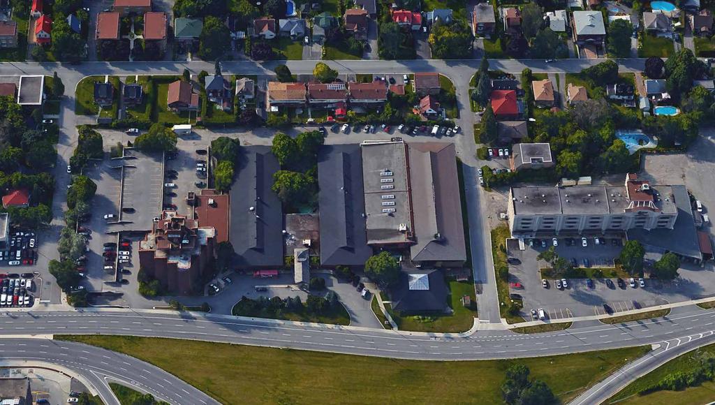
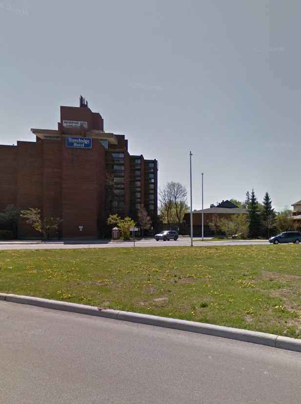
5 Community Transportation Study/Transportation Impact Study. INTRODUCTION Holloway Lodging is proposing a new residential development consisting of four buildings on the properties municipally known as 376 and 354 Carling Avenue. Two buildings (Buildings A and B) front Carling Avenue and are both proposed with 2 storeys and two 9 storey buildings (Buildings C and D) are proposed further south on the site. The total number of residential units is 94 within the four buildings. Approximately 2,44 m 2 (26,2 ft 2 ) of commercial is proposed fronting Carling Avenue as part of Buildings A and B. The site is currently occupied by a hotel (Travelodge) and parking structure with multiple (3) driveway connections to Carling Avenue and to a private road at the south end of the site. Access to the future development is proposed via one rightin/right-out driveway to Carling Avenue, four full-movement driveways to Meath Street and four full-movement driveways to Archibald Street (underground and surface parking lot accesses). Within the vicinity of HWY 47, the east and westbound sections of Carling Avenue are divided. As such, all access to/from Carling Avenue at this location will operate as right-in/right-out in the eastbound direction. The local context of the site is provided as Figure and the proposed Phase Site Plan and Ultimate Site Plan are provided as Figures 2 and 3, respectively. Figure : Local Context The site is planned to be developed in two phases. The first phase will consist of Building B and Building D (identified on the Site Plan) and the existing hotel will remain. The Ultimate Phase will include all four buildings and the removal of the existing hotel. For the purpose of this assessment, horizon years will be analyzed for the year 29 representing full occupancy of Phase, and at the year 224, representing ultimate build out. The study area will consist of the signalized and unsignalized intersections of Carling EB/Kirkwood South, Carling WB/Kirkwood North, Carling/gate Shopping Centre, Carling/Merivale, and the unsignalized Merivale/Thames. 354 Carling Avenue Community Traffic Study/Transportation Impact Study
6 Figure 2: Proposed Phase Site Plan

7 Figure 3: Proposed Ultimate Site Plan
8 As part of the rezoning and Site Plan Application processes, the City of Ottawa requires a submission of a formal Transportation Impact Assessment (TIA) consistent with their guidelines dated October 26. With respect to these guidelines and for a rezoning/site Plan application, a Community Transportation Study (CTS)/Transportation Impact Study (TIS) is considered the appropriate type of study. As such, a combined CTS/TIS is provided in support of the proposed development. 2. EXISTING CONDITIONS 2.. AREA ROAD NETWORK Carling Avenue is an east-west arterial roadway with a six-lane cross-section and a 44.5 m right-of-way (ROW) within the study area. It extends from March Road in the west and Bronson Avenue in the east. Within the study area, the unposted speed limit is understood to be 5 km/h. Merivale Road is a north-south arterial roadway with a two-lane cross-section and a 3 m ROW within the study area. It extends from Island Park Drive in the north and Prince of Wales Drive in the south. Within the study area, the posted speed limit is 5 km/h. Kirkwood Avenue is a north-south arterial roadway with a four-lane cross-section within the study area. It extends from Wilber Avenue in the north and Merivale Road in the south. Within the study area, the posted speed limit is 5 km/h. Meath Street and Archibald Street are north-south local roadways with two-lane cross-sections and on-street parking permitted along the west side of the streets. Both roadways form T -intersections with Carling Avenue, permitting northbound right and eastbound right turning movements only. A private roadway connects these roads directly south of the subject site. South of this private roadway, both Meath Street and Archibald Street operate as one-way roadways in the northbound direction. It is assumed that this restriction was put in place to prevent cut-through traffic from Carling Avenue to Merivale Road, via Thames Street. The unposted speed limit along these roadways is understood to be 5 km/h. Thames Street is an east-west local roadway with a two-lane cross-section and on-street parking permitted along the south side of the roadway. Thames Street forms a T -intersection with Merivale Road and is cul-de-sac at the west end. The unposted speed limit is understood to be 5 km/h. Highway 47 is an east-west Provincial Freeway with a six-lane cross-section within the study area. This highway is part of the Trans-Canada Highway and extends beyond the borders of Ottawa in both the west and east ends. The posted speed limit is km/h. Access/egress to/from HWY 47 is provided via multiple on/off ramps on Carling Avenue within the vicinity of the Carling/Kirkwood intersections PEDESTRIAN/CYCLING NETWORK Sidewalk facilities in the vicinity of the site are provided along both sides of Carling Avenue, Kirkwood Avenue, and Merivale Road. No sidewalks are provided along the local roadways Archibald Street, Meath Street and Thames Street. Dedicated bicycle facilities are currently provided in the form of bike lanes in both directions along Carling Avenue (west of Merivale Road) and along Merivale Road (north of Carling Avenue). Kirkwood Avenue is identified as a suggested route. According to the City s Cycling Plan, Merivale Road and Carling Avenue are classified as Spine Routes and Kirkwood Avenue is classified as a Local Route. 354 Carling Avenue Community Traffic Study/Transportation Impact Study 4


9 2.3. TRANSIT NETWORK Transit service within the vicinity of the site is currently provided by OC Transpo Routes #85,, 3, and 5. Regular/Local Routes #85,, 5 provide frequent all-day service and Peak Hour Route #3 provides service during the weekday peak hours only. Bus stops for all routes are located along Carling Avenue within 5 m walking distance from the proposed development. Figure 4: Area Transit Network 2.4. EXISTING STUDY AREA INTERSECTIONS Carling EB/Kirkwood South The Carling EB/Kirkwood S intersection is a signalized four-legged intersection. The eastbound approach consists of a single channelized right-turn lane, two through lanes, a shared through/left-turn lane and a left-turn lane. The southbound approach consists of a shared through/left-turn lane and a single through lane. The northbound approach consists of two through lanes and a single right-turn lane. At this location, the only restricted movement is the no right-turn on red in the northbound direction. Also, Carling Avenue operates in the eastbound direction only at this location. 354 Carling Avenue Community Traffic Study/Transportation Impact Study 5


10 Merivale/Carling The Merivale/Carling intersection is a signalized fourlegged intersection. The westbound approach consists of a single left-turn lane, two through lanes and a shared through/right-turn lane. The eastbound approach consists a two through lanes and a shared through/right-turn lane. The southbound approach consists of a single left-turn lane, a single through lane and a single right-turn lane. The northbound approach consists of a single left-turn lane, a single through lane and a single channelized right-turn lane. At this location, the eastbound left-turn movement is prohibited and all other movements are permitted. Carling/gate Shopping Centre The Carling/gate Shopping Centre intersection is a signalized four-legged intersection. The east and westbound approaches both consist of a single left-turn lane, two through lanes and a shared through/right-turn lane. The southbound approach consists of a share through/left-turn lane and a single right-turn lane. The northbound approach consists of a single all-movement lane. At this location, there are no restricted or banned movements. Carling WB/Kirkwood North The Carling WB/Kirkwood N intersection is a signalized four-legged intersection. The westbound approach consists of a shared through/right-turn lane, a through lane, a shared through/left-turn lane and a left-turn lane. The southbound approach consists of a single right-turn lane and two through lanes. The northbound approach consists of a single through lane and a single left-turn lane. At this location, there are no restricted or banned movements; however, Carling Avenue operates in the westbound direction only. 354 Carling Avenue Community Traffic Study/Transportation Impact Study 6
 consists of a single fullmovement lane.")
11 STOP STOP Merivale/Thames The Merivale/Thames intersection is an unsignalized fourlegged intersection with STOP control on the minor approaches only. The north and southbound approaches consist of two through lanes, with turning movement permitted from the through lanes. The eastbound approach (Thames Street) consists of a single fullmovement lane. The westbound approach is a short residential loop off Merivale Road that consists of a single full movement lane EXISTING INTERSECTION OPERATIONS Illustrated as Figure 5, are the most recent weekday morning and afternoon peak hour traffic volumes obtained from the City of Ottawa for the signalized Carling/Kirkwood N, Carling/Kirkwood S, Carling/Shopping Centre, and Carling/Merivale intersections. The unsignalized Merivale/Thames intersection and the Travelodge driveway were counted by Parsons in March 27. It is noteworthy that the existing access to the parking structure from Carling Avenue was under construction at the time and as such the traffic volumes from the private driveway were counted (off of Archibald and Meath). In addition, the Merivale/Carling intersection count data dated August 26 is noted as being lower than the October 25 count, and as such, the higher 25 count was used as a conservative method. Peak hour traffic volumes are included as Appendix A. Figure 5: Existing Peak Hour Traffic Volumes 36(4) 352(48) 25(35) 7(285) 336(2) 439(372) 336(3) Kirkwood 28(227) 37(545) 5(5) (6) 35() (4) 38(99) 75(4) 59(3) 892(72) 3(8) 6() 2(3) 5(4) 67(24) 753(675) 2() 238(22) 268(285) 24(59) () 9(68) 83(65) Merivale 52(26) 237(99) 352(245) 3(77) 56(53) 8(43) 87(49) 82(33) 87(33) 369(328) 339(258) () Meath 3(3) 6() () SITE 8(5) () Archibald (5) Thames 6(28) 55(848) (4) 4(3) () 2() xx (yy) AM Peak Hour Volumes PM Peak Hour Volumes (8) () 9(22) 2(22) 726(559) (2) 354 Carling Avenue Community Traffic Study/Transportation Impact Study 7
12 The following Table provides a summary of existing traffic operations at study area intersections based on the SYNCHRO (V9) traffic analysis software. The subject intersections were assessed in terms of the volume-to-capacity (v/c) ratio and the corresponding Level of Service (LoS) for the critical movement(s). The subject intersections as a whole were assessed based on a weighted v/c ratio. The unsignalized intersection was assessed in terms of delay and the corresponding Level of Service. The SYNCHRO model output of existing conditions is provided within Appendix B. Table : Existing Performance at Study Area Intersections Weekday AM Peak (PM Peak) Intersection Critical Movement Intersection as a whole LoS max. v/c or avg. delay (s) Movement Delay (s) LoS v/c Kirkwood S/Carling EB E(D).9(.88) EBT(NBR) 35.4(26.) E(B).9(.68) Merivale/Carling B(F).7(.) NBL(WBL) 25.4(32.) A(C).59(.7) Kirkwood N/Carling WB D(F).85(.3) SBR(WBT) 28.5(74.6) C(F).72(.2) Carling/gate SC A(B).54(.67) EBT(EBL) 4.4(9.9) A(B).5(.63) Merivale/Thames C(C) 8.5(8.9) EBL(EBL).6(.6) - - Note: Analysis of signalized intersections assumes a PHF of.95 and a saturation flow rate of 8 veh/h/lane. As shown in Table, the Merivale/Carling and Carling/gate Shopping Centre are currently operating overall at an acceptable LoS C or better during morning and afternoon commuter peak hours. During the morning peak hour, the Kirkwood South/Carling EB intersection as a whole is operating at capacity (LoS E ) and during the afternoon peak hour, the Kirkwood North/Carling WB intersection as a whole is operating above capacity (LoS F ). With regard to critical movements at study area intersections, the eastbound through movement at the Kirkwood South/Carling EB intersection is currently operating at capacity (LoS E ) during the morning peak hour. During the afternoon peak hour, the westbound through and westbound left-turn movements at the Kirkwood N/Carling WB and Merivale/Carling intersections are currently failing (LoS F ). All other critical movements at study area intersections are currently operating at an acceptable LoS D or better during peak hours with respect to the City s operating standard of LoS D or better (v/c.9). With regard to the unsignalized Merivale/Thames intersection, the SYNCHRO analysis indicates delays for side street traffic in the range of 6 to 8 seconds during morning and afternoon peak hours. As mentioned previously, Archibald Street and Meath Street operate as one-way roadways in the northbound direction south of the site. Field observations noted one to two s travelling southbound to Thames Street along both Archibald Street and Meath Street EXISTING ROAD SAFETY CONDITIONS Collision history for study area roads (23 to 25, inclusive) was obtained from the City of Ottawa and most collisions (83%) involved only property damage, indicating low impact speeds, and 6% involved personal injuries. The remaining % were identified as non-reportable, indicating the total damage to a was less than $,. The primary causes of collisions cited by police include; rear end (29%), turning movement (29%), sideswipe (25%), and angle (%) type collisions. A standard unit of measure for assessing collisions at an intersection is based on the number collisions per million entering s (MEV). At intersections within the study area, reported collisions have historically taken place at a rate of:.35/mev at the Carling/Kirkwood N intersection; 354 Carling Avenue Community Traffic Study/Transportation Impact Study 8
13 .3/MEV at the Carling/Kirkwood S intersection;.35/mev at the Carling/gate Shopping Centre intersection; and.97/mev at the Carling/Merivale intersection. The Carling/Kirkwood N intersection has experienced high numbers of collisions in the past years. Changes are proposed at the Carling/Kirkwood N intersection with the removal of the HWY 47 eastbound on-ramp (outlined in Section 3.). These modifications will help reduce the amount of traffic from the highway attempting to merge over multiple lanes to turn left onto Kirkwood Avenue. At the Merivale/Thames intersection, 2 collisions were reported in a 3-year period and there were no reported collisions at the Carling/Meath and Carling/Archibald intersection between 23 to 25. It is noteworthy that in 22 there was a fatal accident involving a cyclist and a passenger at the Carling/Archibald intersection. In addition, between 2 and 23 there were 5 reported collisions involving cyclists within the study area along Carling Avenue. As part of the City s Transit Priority project along Carling Avenue, on-street cycling lanes (and cycle tracks approaching Carling/Kirkwood North) are proposed along the curb lane between the sidewalk and the Transit Lane within the study area (west of Merivale Road). With regard to the Carling/gate Shopping Centre intersection, there is a notable volume of westbound U-turning s. Within the 3-years of provided collision data, there are no collisions involving U-turn movements, however, there are 5 collisions involving s turning eastbound left (which could indicate they were making a U-turn). One possible mitigative measure to reduce chances of collisions involving U-turns is to not allow southbound right-turns-on-red for the gate Shopping Centre. The source collision data as provided by the City of Ottawa and related analysis is provided as Appendix C SCREENLINE OPERATIONS The relevant screenlines within the vicinity of the proposed development are: SL 28 CPR Line o Highway 47 station SL 27 CPR Line South o Carling Station The City of Ottawa provided the most recent 24 and 26 Screenline count data, which is included as Appendix D. The existing performance of the relevant study area Screenline stations is summarized below in Table 2. Screenline Station CPR Line South (SL#29) Carling Station CPR Line (SL #28) Highway 47 Station Table 2: Existing Screenline Station Performance Peak Directional Demand (PCU) 2 AM Peak Inbound PM Peak Outbound Directional Capacity 3 (PCU),9,736,8 5,657 6,38 5,4 AM Peak.62 (LoS B ).5 (LoS F ). 24 volumes obtained from the City of Ottawa 2. PCU (Passenger Car Units) were assumed to be the sum of autos and 2x heavy s 3. Directional capacities were obtained from IBI s Road Network Development Report and the 28 Road Infrastructure Needs Study v/c PM Peak.96 (LoS E ).7 (LoS F ) As shown in Table 2, both Screenline stations at Carling and HWY47 are operating at or above capacity (LoS E or F ) in the afternoon peak hour in the outbound direction (westbound). During the morning peak hour, SL #28 HWY 47 Station is operating above capacity (v/c >.) and the Carling Station is operating at an acceptable LoS B. 354 Carling Avenue Community Traffic Study/Transportation Impact Study 9

 will provide additional person capacity and mitigate the existing capacity constraints across this screenline.")
14 It is noteworthy that for SL #28, the assumed capacity of the station located at the HWY 47, between the Rochester and Parkdale interchanges, is consider low for a four-lane freeway facility. Given existing volumes exceed the assumed capacity, and given the assumed capacity is considered low, the performance of SL #28 is likely better than a v/c of.5 to.7. However, based on observations, it is reasonable to assume that SL #28 is operating close to or at capacity (v/c =.9 to.). It should be noted that the implementation of the east-west Light Rail Transit (LRT) will provide additional person capacity and mitigate the existing capacity constraints across this screenline. In addition, the planned transit priority along Carling Avenue will increase person capacity along this corridor, although it will also reduce the automobile capacity (lane reductions). 3. DEMAND FORECASTING 3.. PLANNED STUDY AREA TRANSPORTATION NETWORK CHANGES Within the City s 23 TMP and identified on the 23 Affordable Network Plan, there are no plans to increase the existing auto capacity within the vicinity of the site on City roadways. HWY 47 between Maitland Avenue and Carling Avenue is planned to be widened from 6 lanes to 8 lanes, starting Summer 27. In terms of planned network improvements for transit, Carling Avenue is identified as a future Transit Priority corridor and Merivale Road is identified to receive isolated Transit Priority measures as shown in Figure 6. Figure 6: TMP Rapid Transit and Transit Priority 23 Affordable Network Identified on the 23 Network Concept Plan (planned network changes beyond the 23 planning horizon year), further improvements to transit within the study area are planned. Carling Avenue is identified as a future Light Rail Transit (LRT) corridor with a station planned at the Merivale Road, and Merivale Road is identified as a future BRT corridor. The MTO has indicated that as part of the planned widening of the highway from 6 lanes to 8 lanes between Maitland Avenue and Carling Avenue, the existing westbound Carling Avenue onramp to eastbound Highway 47 is planned to be closed. MTO has indicated that this is a relatively low-use ramp serving approximately 3,9 s per day. The alternative route for these s is to continue along Carling Avenue westbound, turn left at Kirkwood Avenue, and left onto Carling Avenue eastbound to the HWY 47 ramp. This route is shown in the following figure in green and the planned closed ramp is shown in red. 354 Carling Avenue Community Traffic Study/Transportation Impact Study

15 Figure 7: HWY 47 Eastbound On-Ramps Given the projected increase in traffic at the Carling WB/Kirkwood N intersection, MTO along with the City of Ottawa, is proposing modifications to the Carling WB/Kirkwood N intersection to improve operations. There is an existing concern regarding s exiting HWY 47 eastbound and weaving across multiple lanes of traffic on Carling Avenue to turn left (heading southbound) on Kirkwood Avenue. To reduce the amount of weaving s, a concrete median is proposed separating the left-turn lanes from the through s. This would prevent s from HWY 47 turning left onto Kirkwood. Vehicles will instead turn left at the adjacent Carling/Saigon intersection. Additional capacity in the form of a new westbound left-turn lane (double left-turn lanes) is proposed at the Carling WB/Kirkwood N intersection and additional left-turn lanes are proposed at both the Carling WB/Saigon and Carling EB/Saigon intersections. The Carling EB/Saigon intersection will also be signalized in the future. These proposed modifications are outlined in the following figure which is an excerpt of the MTO s presentation to the City of Ottawa Transportation Committee. 354 Carling Avenue Community Traffic Study/Transportation Impact Study
16 Figure 8: Proposed Modifications at the Carling/Kirkwood and Carling/Saigon Intersections Ministry of Transportation, WSP, MMM Group. (March, 27). Proposed Highway 47 Carling Avenue E-E Ramp Closure [PDF]. Retrieved from Carling Avenue Community Traffic Study/Transportation Impact Study 2
17 3.2. OTHER AREA DEVELOPMENT With respect to other area development, the following development applications have been submitted to the City of Ottawa in the vicinity of the proposed site: gate Shopping Centre - 39 Carling The gate Shopping Centre is located approximately 2 m northeast of the subject development and is planned to be redeveloped in four phases, with Phase occupancy planned for 27 and Phase 2 and 3 occupancy planned for 222. Phase of the Site Plan consists of 87 residential units and approximately 24,5 ft 2 of commercial and Phases 2 and 3 consist of an additional,83 residential units and 96,25 ft 2 of commercial. The Community Transportation Study (prepared by Parsons) projected an increase in two-way traffic of 95 to 2 veh/h during the weekday commuter peak hours for Phase of the development and a net increase in two-way traffic of 38 to 348 veh/h for Phase 2 and 3 (taking into account the partial removal of existing mall-generated traffic). The projected traffic distribution from Phase of the development is included herein in the 29 Horizon year, and the additional traffic generated by Phases 2 and 3 is included herein as part of the 224 Horizon year as background traffic. 335 Carling 335 Carling Avenue, which is location approximately 75 m northeast of the subject development, is planned to be redeveloped on approximately the same timeline as the planned redevelopment of the gate Shopping Centre. The current proposal is to redevelop 335 Carling Avenue to consist of an -storey office/commercial tower, totaling approximately 8, ft 2. The current site consists of a 6-storey building, totaling approximately 72, ft 2 of office/commercial. The gate Shopping Centre Redevelopment CTS outlines projected increases in traffic volumes for this development to be in the range of veh/h and 8 veh/h during the weekday morning and afternoon peak hours, respectively. The projected traffic distribution from this planned development is included herein in the 29 Horizon year background traffic. 4 Carling Avenue The above-noted address is located directly adjacent to the west of the subject development. A requested has been submitted to increase the existing retirement home from storeys to 3 storeys. No Traffic Impact Study was prepared for this application. 9 Merivale Road An expansion of the existing Community Health Centre is planned at the above-noted location, which is located approximately 25 m southeast of the subject development. The Transportation Overview (prepared by Parsons) projects an increase in two-way traffic of 4 to 5 veh/h during the weekday commuter peak hours. 999 Merivale Road A residential building consisting of 4 condominium units is planned at the above-noted address, which is located approximately 5 m southeast of the subject development. The Transportation Overview (prepared by Novatech) projects an increase in two-way traffic of approximately veh/h during the weekday commuter peak hours. The projected traffic generated by the gate Shopping Centre redevelopment and by the 335 Carling development was added as background traffic to the study area intersections. These combined traffic volumes are illustrated as Figure 9 for the Horizon year 29 and Figure for the Horizon year Carling Avenue Community Traffic Study/Transportation Impact Study 3
18 STOP STOP STOP STOP Figure 9: Projected 29 Area Development Traffic 34(79) Kirkwood 75(3) 27(43) 7(2) 75(3) SITE 5(5) 3(5) Merivale 75(3) 4(2) 7(6) 27(4) 2(4) 5(8) 7(2) 3() 2(2) (3) 5(4) 23(7) Meath Archibald Thames xx (yy) AM Peak Hour Volumes PM Peak Hour Volumes Figure : Projected 224 Area Development Traffic (35) Kirkwood 4(99) 4(38) 29(28) 5(99) SITE 2(7) Merivale 4(99) 4(2) 8(25) 27(4) (9) 9(8) 2(3) (6) 2(25) 6(8) 5(9) 2(7) 3(2) Meath Archibald Thames xx (yy) AM Peak Hour Volumes PM Peak Hour Volumes 354 Carling Avenue Community Traffic Study/Transportation Impact Study 4
19 3.3. BACKGROUND TRAFFIC GROWTH The following background traffic growth through the immediate study area (summarized in Table 3) was calculated based on historical traffic count data (years 23, 2, 24, 25, and 26) provided by the City of Ottawa at the Merivale/Carling intersection. Detailed analysis is included as Appendix E. Time Period Table 3: Merivale/Carling Historical Background Growth Percent Annual Change North Leg South Leg East Leg Leg Overall 8 hrs -.7% -.4%.48% -.34% -.2% AM Peak -.58% -.97% -.88% -.2% -.4% PM Peak -.69% -.84%.64% -.27% -.8% As show in Table 3, the Merivale/Carling intersection has experienced no overall growth (calculated as a weighted average) in recent years. Therefore, no additional background traffic growth was assumed for the subsequent analysis of future traffic operations BACKGROUND TRAFFIC INTERSECTION PERFORMANCE Prior to any development of the proposed site, the following Table 4 provides a summary of background 224 traffic operations at study area intersections based on the SYNCHRO (V9) traffic analysis software. The area development traffic volumes, outlined in Figure, were added onto existing traffic volumes to calculate baseline background traffic volumes (illustrated as Appendix F). The SYNCHRO model assumes existing intersection geometry and signal timing except at the Kirkwood N/Carling intersection were modifications are planned. The following analysis assumes a double westbound leftturn lane at the Kirkwood N/Carling intersection associated with the closure of the HWY 47 eastbound on-ramp. The detailed SYNCHRO model output of projected background conditions is provided within Appendix F. Table 4: Projected Background 224 Performance at Study Area Intersections Weekday AM Peak (PM Peak) Intersection LoS Critical Movement max. v/c or avg. delay (s) Intersection as a Whole Movement Delay (s) LoS v/c Kirkwood S/Carling EB E(D).96(.88) EBT(NBR) 38.9(26.6) E(B).95(.65) Merivale/Carling C(F).76(.6) NBL(WBL) 28.8(34.5) B(C).62(.74) Kirkwood N/Carling WB D(F).86(.) SBR(WBT) 28.(65.6) C(F).72(.) Carling/gate SC D(D).9(.82) EBT(EBT).7(4.8) D(C).85(.79) Merivale/Thames C(C) 9.2(9.6) EBT(EBT).6(.6) - - Note: Analysis of signalized intersections assumes a PHF of.95 and a saturation flow rate of 8 veh/h/lane. As shown in Table 4, the signalized study area intersections as a whole are projected to continue to operate at an acceptable LoS D or better, with the exception of the Kirkwood S/Carling EB intersection during the morning peak hour and the adjacent Kirkwood N/Carling WB intersection during the afternoon peak hour, which are projected to operate at or above capacity (LoS E and LoS F ). This is similar to the existing condition. With regard to the critical movements, similar to existing conditions, the eastbound through movement at the Kirkwood S/Carling EB intersection during the morning peak hour is projected to continue to operate at capacity (LoS E ) and the westbound through and westbound left-turn movements at the Kirkwood N/Carling WB and Merivale/Carling intersections are projected to operate above capacity (LoS F ) during the afternoon peak hour. The critical movements at the 354 Carling Avenue Community Traffic Study/Transportation Impact Study 5
20 Carling/gate SC intersection have decreased from LoS A and B to LoS D as there is an increase in the turning movements into and out of the gate Shopping Centre development. These results are similar to the intersection capacity analysis noted in the gate Shopping Centre Redevelopment CTS. As noted in the gate CTS, minimal mitigation to improve intersection performance is feasible given the physical constraints at the intersections, specifically those in close proximity to HWY 47 (Kirkwood/Carling intersections). In terms of storage length for turn lanes, the east and westbound left-turn lanes along Carling Avenue are currently constructed with as much storage as possible given the adjacent intersections. With regard to the eastbound left-turn movement at the Carling/gate Shopping Centre, the existing and background volumes at this location are significant. As mentioned previously, the existing traffic volumes are 3 to 6 left turning s with an additional 4 to 75 s performing a U-turn, totally approximately 7 to 235 veh/h in this left-turn lane. With the addition of the traffic generated by the adjacent developments, the total volume projected to be in this lane is approximately 27 to 35 veh/h during the morning and afternoon peak hours. As such, this movement is projected to operate at LoS D with projected 95 th percentile queues of approximately to 5 m with existing signal timing. The existing storage length at this location is approximately 75 m and as such, the 95 th percentile queue is projected to spill back out of the turn lane given the background conditions. With regard to the eastbound U-turn movement along Carling Avenue, the Carling/gate Shopping Centre intersection is the only intersection that permits left-turns and U-turns within the vicinity of the site. U-turns and left-turns are permitted further east at the Civic Hospital driveways (unsignalized) and at the signalized Carling/Holland intersection (which is located 7 m east of the Carling/gate Shopping Centre intersection). Given Carling Avenue s configuration within the study area, there is a high demand for s to perform a U-turn to head westbound on Carling Avenue towards the HWY 47 on-off ramps. This is represented by the 4 to 75 veh/h that perform this U-turn today SITE TRIP GENERATION Appropriate trip generation rates for the proposed development consisting of approximately 94 residential units and 26,23 ft 2 of ground floor commercial (assumed to be retail) were obtained from the 9 th Edition of the Institute of Transportation Engineers (ITE) Trip Generation Manual, which are summarized in Table 5. Table 5: ITE Trip Generation Rates Land Use Data Source Condominiums ITE 23 Specialty Retail Centre ITE 826 AM Peak T =.44(du); ln(t) =.8 ln(du) +.26 T =.36(X); T =.2(X) +.74 Notes: T = Average Vehicle Trip Ends X = ft 2 Gross Floor Area du = dwelling units Specialty Retail AM Peak is assumed to be 5% of the PM Peak Trip Rates PM Peak T =.52(du); ln(t) =.82 ln(du) +.32 T = 2.7(X); T = 2.4(X) As ITE trip generation surveys only record trips and typically reflect highly suburban locations (with little to no access by travel modes other than private automobiles), adjustment factors appropriate to the more urban study area context were applied to attain estimates of person trips for the proposed development. This approach is considered appropriate within the industry for urban infill developments. To convert ITE trip rates to person trips, an auto occupancy factor and a non-auto trip factor were applied to the ITE trip rates. Our review of available literature suggests that a combined factor of approximately.3 is considered 354 Carling Avenue Community Traffic Study/Transportation Impact Study 6
21 reasonable to account for typical North American auto occupancy values of approximately.5 and combined transit and non-motorized modal shares of less than %. For Phase of the development, the existing hotel will remain and two of the buildings will be constructed on the east side of the site. As such, Phase of the development will consist of approximately 342 residential units and 9,44 ft 2 of commercial. The person trip generation for the proposed Phase of the development is summarized in Table 6. Table 6: Phase Modified Person Trip Generation Land Use Area AM Peak (Person Trips/h) PM Peak (Person Trips/h) In Out Total In Out Total Condominiums 342 du Specialty Retail 9,44 ft² Total Person Trips Note:.3 factor to account for typical North American auto occupancy values of approximately.5 and combined transit and non-motorized modal shares of less than % The person trips shown in Table 6 for the proposed site were then reduced by modal share values, including a reduction for pass-by trips based on the site s location and proximity to adjacent communities, employment, other shopping uses and transit availability. Modal share and pass-by values for condominiums and specialty retail uses within the proposed Phase development are summarized in Tables 7 and 8, respectively, with the total Phase site-generated traffic summarized in Table 9. Table 7: Phase Condominium Modal Site Trip Generation Mode AM Peak (Person Trips/h) PM Peak (Person Trips/h) Travel Mode Share In Out Total In Out Total Auto Driver 5% Auto Passenger % Transit 25% Non-motorized 5% Total Person Trips % Total New Auto Trips Table 8: Phase Specialty Retail Modal Site Trip Generation Travel Mode Mode AM Peak (Person Trips/h) PM Peak (Person Trips/h) Share In Out Total In Out Total Auto Driver 5% Auto Passenger 5% Transit 5% Non-motorized 2% Total Person Trips % Less Retail 25% Pass-By Total New Auto Trips Carling Avenue Community Traffic Study/Transportation Impact Study 7
22 Table 9: Phase Total Site Vehicle Trip Generation Land Use AM Peak (veh/h) PM Peak (veh/h) In Out Total In Out Total Condominiums Specialty Retail Retail Pass-By (3%) Total New Auto Trips As shown in Table 9, the resulting number of potential new two-way trips for the proposed Phase development is approximately and 3 veh/h during the weekday morning and afternoon peak hours, respectively. The ultimate development is planned to consist of four buildings with a total of 94 residential units and approximately 26,2 ft 2 of ground floor commercial, assumed to be ground floor retail for this study. In the ultimate scenario, the hotel will be demolished and as such, traffic generated from the hotel will be removed from the roadway network. As shown in Figure 5 Existing Peak Hour Traffic Volumes, the total amount of traffic travelling to/from the hotel during the peak hours is approximately 3 veh/h. Following the same method outlined above, the total Phase and 2 site-trip generation is summarized in Table and detailed in Appendix G. Land Use Table : Phase and 2 Total Site Vehicle Trip Generation AM Peak (veh/h) PM Peak (veh/h) In Out Total In Out Total Condominiums Specialty Retail Retail Pass-By (3%) Total New Auto Trips Less Existing Hotel Trips Total Net New Auto Trips As shown in Table, the resulting number of potential new two-way trips for the proposed development is approximately 25 and 28 veh/h during the weekday morning and afternoon peak hours, respectively. With the removal of the existing trips to/from the hotel site, the net increase in traffic is projected to be 85 to 253 veh/h during the weekday morning and afternoon peak hours, respectively VEHICLE TRAFFIC DISTRIBUTION AND ASSIGNMENT Traffic distribution was based existing volume splits at study area intersections and our knowledge of the surrounding area. As Carling Avenue operates as a one-way roadway at the site access and as the on/off ramps for HWY 47 are located to the west of the site, the distribution for s leaving the site is assumed to be slightly different than the distribution for s entering the site. For example, it is assumed that more eastbound s, exiting the site, will elect to travel along Carling Avenue to their destination or to the next on-ramp to HWY 47 to avoid performing a U-turn along Carling Avenue. However, when arriving to the site, most drivers will exit the on/off ramps at Carling Avenue and continue eastbound on Carling to the site. The resultant distribution is outlined as follows: 354 Carling Avenue Community Traffic Study/Transportation Impact Study 8
23 STOP STOP STOP STOP From the Site % to eastbound HWY 47 2% to westbound HWY 47; 5% to the east via Carling Avenue; 5% to the west via Carling Avenue; and 5% to the south via Merivale Road; % To the Site 4% from eastbound HWY 47 2% from westbound HWY 47; 2% from the east via Carling Avenue; % from the west via Carling Avenue; and % from the south via Merivale Road; % Based on these distributions, new and pass-by site-generated trips were assigned to study area intersections, which are illustrated as Figure for Phase site-generated traffic and Figure 2 for Phase and 2 site-generated traffic. Figure : Phase New and Pass-by Site-Generated Traffic Volumes Saigon 28(44) 8(5) Merivale 8(32) 5(57) Kirkwood 8(5) 7(28) Meath 3(2) 5(2) 3(8) 36(22) 6(6) SITE 4(24) 7(25) Archibald 3(2) Thames 28(7) 52(3) 4(24) 2(7) 4(6) 2(7) 4(6) xx (yy) AM Peak Hour Volumes PM Peak Hour Volumes 2(8) Figure 2: Phase and 2 New and Pass-by Site-Generated Traffic Volumes Saigon 52(88) 5(9) Merivale 4(64) 24(2) Kirkwood 5(9) 2(56) Meath 5(23) 6(4) 6(5) 68(42) 2(2) SITE 76(47) (48) Archibald 5(24) Thames 53(33) 99(6) 76(47) 23(4) 7(32) 23(4) 7(32) xx (yy) AM Peak Hour Volumes PM Peak Hour Volumes 3(5) 354 Carling Avenue Community Traffic Study/Transportation Impact Study 9
24 STOP STOP 4. FUTURE TRAFFIC OPERATIONS 4.. PROJECTED 29 CONDITIONS AT PHASE SITE DEVELOPMENT The total projected 29 volumes associated with the proposed development were derived by superimposing Phase new and pass-by site-generated traffic volumes (Figure ) and 29 area development traffic (Figure 9) onto existing traffic volumes (Figure 5). The resulting total projected 29 volumes are illustrated as Figure 3. Figure 3: Total Projected 29 Peak Hour Traffic Volumes 36(4) 352(48) 25(35) 79(238) 344(25) 439(372) 344(36) 87(49) 9(22) 87(33) Kirkwood 28(227) 37(545) 369(328) 339(258) 8(34) Meath 7(2) 5(27) 2() () SITE 4(24) () 7(25) Archibald 3(2) Thames 62(43) (4) 45() 3(58) 262(79) 948(753) 3(8) 6() 2(3) 5(4) 74(3) 78(679) 2() 2(44) 532(87) (4) 238(22) 27(289) 29(67) () 957(663) 98(83) Merivale 4(3) () 2() 63(29) 239(2) 352(245) 35(8) 584(537) 85(446) xx (yy) AM Peak Hour Volumes PM Peak Hour Volumes (8) () 9(22) 23(3) 739(564) (2) The Carling/Kirkwood N and Carling/Kirkwood S intersections will have significant changes to the turning movement volumes given the proposed plan to close the HWY 47 eastbound on-ramp. It is anticipated that there will be an increase in volume travelling through both intersections as Carling Avenue westbound s destined for HWY 47 eastbound will travel through both Carling/Kirkwood intersections or find a different route. Given the relatively significant amount of unknown factors that would affect the traffic patterns within the study area, the existing traffic volumes were assumed as background traffic for the purpose of this study. The following Table provides a projected performance summary for study area intersections, based on total projected 29 traffic volumes. The proposed modifications to the Carling/Kirkwood N intersection are included in there ensuing analysis. The detailed SYNCHRO model output of projected 29 conditions is provided within Appendix H. 354 Carling Avenue Community Traffic Study/Transportation Impact Study 2
25 Table : Projected 29 Performance of Study Area Intersections Weekday AM Peak (PM Peak) Critical Movement Intersection as a Whole Intersection max. v/c or avg. LoS Movement Delay (s) LoS v/c delay (s) Kirkwood S/Carling EB E(D).95(.88) EBT(NBR) 38.3(26.3) E(B).94(.64) Merivale/Carling C(F).74(.9) NBL(WBL) 26.7(35.6) B(C).63(.75) Kirkwood N/Carling WB D(F).85(.) SBR(WBT) 27.7(69.6) B(F).7(.) Carling/gate SC D(C).88(.8) EBT(EBL) 7.6(2.5) D(C).84(.77) Merivale/Thames C(C) 9.2(2.) EBT(EBT).6(.7) - - Note: Analysis of signalized intersections assumes a PHF of.95 and a saturation flow rate of 8 veh/h/lane. As shown in Table, the study area intersections are projected to operate as a whole with acceptable levels of service LoS D or better during the peak hours, with the exception of the Carling/Kirkwood intersections. This is similar to existing and background 224 conditions. With regard to the critical movements, the eastbound through movement at the Carling/Kirkwood S intersection is projected to continue to operate at capacity (LoS E ) during the morning peak hour. During the afternoon peak hour, the westbound left-turn movement at the Carling/Merivale intersection and the westbound through movement at the Carling/Kirkwood N intersection are projected to operate above capacity (LoS F ), similar to existing conditions. As mentioned in Section 3.4 Background Traffic Intersection Performance, the mitigative measures to improve performance at the study area intersections are relatively restricted given the current geometry. Signal timing adjustments can help improve some of the critical movements, however, most critical movements continue to operate in the range of LoS D to LoS F. The SYNCHRO model output of these changes is provided within Appendix I. As mentioned previously, significant traffic pattern changes are anticipated with the removal of the HWY 47 eastbound on-ramp. In addition, the future transit priority corridor will help reduce the reliance on passenger automobiles, ultimately reducing the number of s on the roadway. As such, and given the roadway geometry constraints, minimal mitigation is possible, and traffic volumes are expected to change and/or be reduced in the future with the planned network changes PROJECTED 224 CONDITIONS AT FULL SITE BUILD-OUT The total projected 224 volumes associated with the proposed development were derived by superimposing Phase and 2 new and pass-by site-generated traffic volumes (Figure 2) and 224 area development traffic (Figure ) onto existing traffic volumes (Figure 5). The resulting total projected 224 volumes are illustrated as Figure Carling Avenue Community Traffic Study/Transportation Impact Study 2
26 STOP STOP Figure 4: Total Projected 224 Peak Hour Traffic Volumes 36(4) 352(48) 25(35) 28(248) 35(29) 439(372) 35(32) 87(49) 959(344) 87(33) Kirkwood 28(227) 37(545) 369(328) 339(258) 2(56) Meath 8(26) 74(42) () 7(7) SITE 84(52) () (54) Archibald 6(29) Thames 76(38) (4) 67(27) 28(74) 273(23) 995(783) 3(8) 6() 2(3) 5(4) 85(49) 78(679) 2() () 7(696) 7(95) 23(6) 559(887) (4) 238(22) 278(294) 43(77) Merivale 4(3) () 2() 67(35) 243(27) 352(245) 42(94) 59(55) 88(462) xx (yy) AM Peak Hour Volumes PM Peak Hour Volumes The following Table 2 provides a projected performance summary for study area intersections, based on total projected 224 traffic volumes. The detailed SYNCHRO model output of projected 224 conditions is provided within Appendix J. Table 2: Projected 224 Performance of Study Area Intersections Weekday AM Peak (PM Peak) Critical Movement Intersection as a Whole Intersection max. v/c or avg. LoS Movement Delay (s) LoS v/c delay (s) Kirkwood S/Carling EB E(D).97(.88) EBT(NBR) 4.4(27.2) E(B).96(.69) Merivale/Carling C(F).76(.8) NBL(WBL) 28.7(39.8) B(C).67(.79) Kirkwood N/Carling WB D(F).86(.5) SBR(WBT) 26.2(75.2) C(F).74(.4) Carling/gate SC F(D).4(.82) EBL(WBT) 4.5(2.7) A(C).48(.76) Merivale/Thames C(C) 2.(2.2) EBT(EBT).6(.8) - - Note: Analysis of signalized intersections assumes a PHF of.95 and a saturation flow rate of 8 veh/h/lane. As shown in Table 2, the study area intersections are projected to operate as a whole with acceptable levels of service LoS D or better during the peak hours, with the exception of the Carling/Kirkwood intersections. This is similar to existing and background 224 conditions. With regard to the critical movements, the eastbound through movement at the Carling/Kirkwood S intersection is projected to continue to operate at capacity (LoS E ) during the morning peak hour. During the afternoon peak hour, the westbound left-turn movement at the Carling/Merivale intersection and the westbound through movement at the Carling/Kirkwood N intersection are projected to operate above capacity (LoS F ). The eastbound left-turn movement at the Carling/gate Shopping Centre intersection is projected to operate above capacity (LoS F ) during the morning peak hour. As mentioned previously, signal timing adjustments can be made to improve the performance for certain movements. These modifications include: (8) () 9(22) 24(37) 747(576) (2) 354 Carling Avenue Community Traffic Study/Transportation Impact Study 22
27 Optimized signal timing at all study area intersections; Provide protected/permitted eastbound left-turn phase at the Carling/gate Shopping Centre intersection; and Double westbound left-turn lanes at the Kirkwood N/Carling WB intersection as per the MTO and City s plans associated with the closure of the HWY 47 eastbound on-ramp. Given these modifications, the resulting study area intersection performance is outlined in Table 3 and the SYNCHRO model output is provided at Appendix K. Table 3: Projected 224 Performance of Study Area Intersections Modified Signal Timing Weekday AM Peak (PM Peak) Critical Movement Intersection as a Whole Intersection max. v/c or avg. LoS Movement Delay (s) LoS v/c delay (s) Kirkwood S/Carling EB D(D).9(.88) EBT(NBR) 36.6(27.) D(B).9(.69) Merivale/Carling C(E).76(.92) NBL(WBL) 32.(33.5) B(C).67(.8) Kirkwood N/Carling WB D(F).85(.6) SBR(SBR) 29.2(57.4) C(F).74(.3) Carling/gate SC C(D).77(.8) EBL(EBL) 3.6(2.4) C(C).74(.78) Note: Analysis of signalized intersections assumes a PHF of.95 and a saturation flow rate of 8 veh/h/lane. As shown, with some adjustments to timing, most study area intersection are projected to operate with acceptable levels of service. The Kirkwood N/Carling WB intersection continues to operate above capacity during the afternoon peak hour. The total amount of s that are projected to perform a U-turn at the Carling/gate Shopping Centre intersection ranges from 75 to 3 veh/h during the peak hours. As there is an existing protected/permitted left-turn phase at this location during the afternoon peak hour (and recommended during the morning peak hour), there is sufficient capacity for the left-turn and U-turn s to operate at LoS D. As mentioned previously, consideration could be given to restricting the southbound right-turn movement to no-right-on-red to help prevent collisions associated with heavy U-turn traffic. With regard to queues at the Carling/gate Shopping Centre intersection, the eastbound left-turn lane 95 th percentile queue is projected to be approximately 85 to 5 m, which spills out past the provided 75 m storage lane. This is similar to Background 224 traffic volume scenario as there is a significant amount of traffic using the left-turn lane for left-turn as well as U-turn movements. With the future modifications to Carling Avenue, both the closure of the HWY 47 eastbound on-ramp and the future transit priority lanes, significant changes to traffic conditions are anticipated within this network. With the closure of the eastbound on-ramp, drivers may elect to continue eastbound along Carling Avenue instead of performing the U-turn movement. In addition, with the implementation of transit priority, passenger traffic is likely to decrease given the more reliable transit service and the reduction of lane capacity on Carling Avenue CARLING AVENUE TRANSIT PRIORITY CONDITION The City of Ottawa project to provide transit priority continuous lanes along Carling Avenue is identified in the 23 TMP as part of the affordable network. The Open House for this project was held in February 27 and illustrates the proposed plan along Carling Avenue. The following Figure 5 illustrates the plan for Carling Avenue within the vicinity of the site. 354 Carling Avenue Community Traffic Study/Transportation Impact Study 23

 Critical Movement Intersection as a Whole Intersection max. v/c or avg.")
28 Figure 5: Proposed Carling Avenue Transit Priority Plan As shown in the above figure, the proposed cross-section of Carling Avenue would consist of two travel lanes and a transit only lane along the curb side. This will reduce passenger capacity along the corridor. The total projected 224 traffic volume scenario was assessed with this new configuration and the results as summarized in Table 4. These results include the mitigative measures outlined above. Table 4: Projected 224 Performance of Study Area Intersections Reduced Carling Avenue Cross-Section Weekday AM Peak (PM Peak) Critical Movement Intersection as a Whole Intersection max. v/c or avg. LoS Movement Delay (s) LoS v/c delay (s) Kirkwood S/Carling EB D(D).9(.88) EBT(NBR) 36.5(27.6) D(B).9(.69) Merivale/Carling D(D).83(.9) EBT(WBL) 49.9(55.4) C(D).79(.85) Kirkwood N/Carling WB D(F).86(.5) SBR(WBT) 29.6(52.9) C(F).74(.5) Carling/gate SC C(F).74(.) EBL(WBT) 5.5(47.7) A(E).5(.95) Note: Analysis of signalized intersections assumes a PHF of.95 and a saturation flow rate of 8 veh/h/lane. As shown in Table 7, the study area intersections as a whole are projected to operate at an acceptable LoS D or better during the peak hours, with the exception of the Kirkwood N/Carling WB and Carling/gate Shopping Centre intersection during the afternoon peak hour. With regard to the critical movements, the westbound through movements at the Kirkwood N/Carling WB and Carling/gate Shopping Centre intersections are projected to operate above capacity (LoS F ) given the reduced travel lanes. All other critical movements are projected to operate with acceptable levels of service given the signal timing plan modifications outlined above. It is noteworthy, providing a transit priority corridor along Carling Avenue will ultimately reduce the number of passenger s on the roadway, as more people will be inclined to take transit with improved travel times. With a reduction of passenger s, the levels of service for the study area intersection will improve. 354 Carling Avenue Community Traffic Study/Transportation Impact Study 24
29 4.3. NEIGHBOURHOOD IMPACTS Based on the location of the proposed development and its connections to Carling Avenue (arterial road), there is minimal site-generated traffic projected to travel along local streets within the vicinity of the subject site. Given the one-way configuration of Archibald Street and Meath Street, site-generated traffic can use these streets to access the development, however, they are restricted from using Archibald Street and Meath Street to travel southbound to Thames Street to exit the site. Approximately 3% of inbound traffic to the site is projected to travel via Thames Street, Archibald Street and Meath Street, which equates to approximately to 5 veh/h during peak hours for the ultimate condition. This amount of traffic represents less than each minute on average and the total traffic travelling along Thames Street in the westbound direction is less than veh/h during the afternoon peak hour, which is appropriate for a local roadway. With respect to neighbourhood transit, the site is projected to generate an approximate total of 5 and 35 new two-way person transit trips during the weekday morning and afternoon peak hours, respectively, for the ultimate condition. This amount of person traffic can be easily accommodated by the proposed transit priority corridor. 5. TRANSPORTATION DEMAND MANAGEMENT Depending on the nature of a development, Transportation Demand Management (TDM) strategies have the potential to be an integral part of a planned development in order to address and support the City s policies with regard to TDM. For this particular site, its proximity to the existing transit service is considered very advantageous in lessening the reliance on the private automobile. A number of other TDM measures could also be considered, including: Improving the quality and safety of pedestrian facilities, such as enhanced sidewalks/lighting; Provide quality and safe cycling facilities, such as storage facilities; Provide change area/shower facilities for any on-site employees; Providing transit information in common areas or/and enhance bus shelters to encourage transit use; and Provide appropriate car sharing programs/facilities to reduce auto ownership and attract residents who do not own a. TDM strategies are important in encouraging active modes of transportation to/from the site, further lessening the reliance on the private automobile. 6. SITE PLAN REVIEW This section provides an overview of site access, parking requirements, pedestrian circulation and transit accessibility. The proposed Phase and Ultimate Site Plans were previously illustrated as Figures 2 and 3. Parking Parking is planned to be provided at grade with access to/from Carling Avenue, Archibald Street and Meath Street. In addition, underground parking is planned with access to/from Archibald Street and Meath Street. A total of 457 parking spaces are required for the residential units, 92 are required for the visitor parking and depending on the land use of the commercial parcels additional parking may be required. Currently the Ultimate Site Plan indicates a total of 48 surface level parking spaces and the parking garage plan indicates a total of 537 parking spaces, for a total of 685 parking spaces. This amount of parking meets the City s By-Law requirements for Area Y (Inner Urban Mainstreet) as identified on Schedule A. The surface parking space dimensions are noted as 5.4 m in length and 2.7 m in width, and the underground parking space dimensions are noted as 5.3 m in length and 2.6 m in width, which satisfies the City s By-Law requirements. Site Circulation With regard to on-site circulation, the proposed parking lot is laid out effectively, such that two-way traffic can be efficiently accommodated. The proposed drive aisles are noted as 6.7 m in width, which meets the City s By-Law requirements. There 354 Carling Avenue Community Traffic Study/Transportation Impact Study 25
30 are four proposed ramps to/from the underground parking, which will minimize conflicts within the parking garage and on the ramps. There are three separate surface level parking lots. The one serving the two buildings fronting Carling Avenue (Buildings A and B) has three driveway connections to public streets (one to Archibald, one to Carling and one to Meath). Each of the 9 storey buildings (Buildings C and D) have individual surface parking lots with one driveway connection to the local street. Providing multiple driveways to the parking garages and parking lots will minimize the amount of s conflicts and reduce speeds on-site. The ramp providing access to the lower level parking should be equal to or less than 2% grade for 9 m from the property line. Appropriate transitions grades should be provided at the top and bottom of the ramps. Truck routes or loading areas are not identified on the proposed Site Plan; however, sufficient turning radii on-site and at the site driveway connections should be provided for fire, garbage and delivery truck circulation. Access Requirements Based on projected volumes and proximity to adjacent intersections, additional traffic control/auxiliary turn lanes are not warranted or required at the proposed driveway connections. The proposed Site Plan has one driveway connection to Carling Avenue, 4 driveway connections to Meath Street and 4 driveway connections to Archibald Street. According to the Private Approach By-Law the maximum number of private approaches allowed on each frontage is 2 two-way private approaches. As such, the number of driveways on Meath Street and Archibald Street exceed the maximum allowed by the Private Approach By-Law. In addition, driveways to the same property should be distanced at least 9 m apart according to the Private Approach By-Law. All driveways meet this By-Law with the exception of the Building B accesses which has two driveways that are spaced approximately 7.5 m apart. This was done to maximize the distance of the driveways from the arterial roadway (Carling Avenue). Given the Site Plan design, providing an underground parking access for each building will minimize on site conflicts and reduce speeds within the parking garage. In addition, as the surface parking lots are not all connected on site, and as each parking lot serves an individual building, providing an access to each parking lot is considered appropriate. In addition, the traffic volumes along Archibald Street and Meath Street were observed to be very low, in the range of 2 to 3 veh/h two-way, which equates to approximately every 2 to 3 minutes. As such, off-site conflicts with s exiting and entering the site are projected to be low. Based on the foregoing, the proposed amount of driveways is considered acceptable. Pedestrians/Transit To connect pedestrians to transit service and other nearby employment, shopping and recreation opportunities, sidewalks are provided along both sides of Carling Avenue, Merivale Road and Kirkwood Avenue. Pedestrian pathways are planned connecting the parking lots to/from the four proposed buildings and a pedestrian crossing is proposed crossing the drive aisle that connects to Carling Avenue. Transit service within the vicinity of the site is currently provided by OC Transpo Routes #85,, 3, and 5. Regular/Local Routes #85,, 5 provide frequent all-day service and Peak Hour Route #3 provides service during the weekday peak hours only. Bus stops for all routes are located along Carling Avenue within 5 m walking distance from the proposed development. Carling Avenue is planned to have transit priority lanes adjacent to the site in the future. Bicycles A total of 458 underground bicycle parking spaces are proposed to serve the development, which is sufficient with respect to the City s By-Law requirements for the proposed site. Surface bicycle parking, located in well-lit areas, close to main building entrances, should also be provided for the commercial portion of the site. 354 Carling Avenue Community Traffic Study/Transportation Impact Study 26
31 7. FINDINGS AND RECOMMENDATIONS Based on the foregoing analysis of the proposed development, the following transportation-related conclusions are offered: EXISTING CONDITIONS The study area intersections adjacent to the site are currently operating as a whole with an overall LoS D or better during the weekday morning and afternoon peak hours, with the exception on the Carling/Kirkwood North and South intersections; With regard to critical movements at study area intersections, the eastbound through movement at the Kirkwood South/Carling EB intersection is currently operating at capacity (LoS E ) during the morning peak hour. During the afternoon peak hour, the westbound through and westbound left-turn movements at the Kirkwood N/Carling WB and Merivale/Carling intersections are currently failing (LoS F ). All other movements are operating at acceptable LoS D or better during peak hours; Based on the available collision data, Carling/Kirkwood N intersection has experienced high numbers of collisions in the past years. Changes are proposed at the Carling/Kirkwood N intersection with the removal of the HWY 47 eastbound on-ramp to help mitigate issues with weaving s; Between the year 2 to 23 there were several collisions involving cyclists along Carling Avenue; PROJECTED CONDITIONS Based on historic counts at the Carling/Merivale intersection, the study area has experiences no overall growth in recent years; There are several proposed developments within the study area, and traffic from the major developments (gate Shopping Centre redevelopment and 335 Carling Avenue) has been accounted for the in the background traffic volumes; Carling Avenue is planned to have transit priority lanes in both directions, which will reduce the number of passenger lanes along Carling Avenue form 6-lanes to 4-lanes; The MTO has plans to close the HWY 47 eastbound on-ramp along Carling Avenue as part of the HWY 47 widening. Modifications to the Carling/Kirkwood N intersection are planned to mitigate future traffic pattern changes; The proposed development is projected to generate new two-way volumes of approximately and 3 veh/h during the weekday morning and afternoon peak hours, respectively for Phase of the development and 85 to 253 veh/h for the ultimate development; At Phase site occupancy (year 29), study area intersections continue to operate with some capacity constraints for certain movements. Mitigation in the form of signal timing adjustments is recommended as there are minimal possible geometric improvements given the existing geometry. Signal timing adjustments results in most critical movements operating at LoS D to LoS F ; At full occupancy (year 224), the results are similar to year 29 results with minimal mitigation recommended; Significant traffic pattern changes are anticipated with the removal of the HWY 47 eastbound on-ramp and the implementation of the transit priority corridor along Carling Avenue. In addition, the future transit priority corridor 354 Carling Avenue Community Traffic Study/Transportation Impact Study 27

32 will help reduce the reliance on passenger automobiles, ultimately reducing the number of s on the roadway; The total projected 224 traffic volume scenario was assessed with a 4-lane cross section along Carling Avenue and results reveal some capacity constraints for the east and westbound movements, given the reduced passenger capacity. As mentioned, the transit priority design plans for Carling Avenue will ultimately help reduce the number of s on the roadways; There is a significant amount of existing and projected U-turning s at the Carling/gate Shopping Centre intersection. There is a high demand for s to turn around to access HWY 47. The total projected 224 volume scenario indicates that this movement is projected to operate at LoS D with 95 th percentile queues that extend past the provided storage lane; o o o With future modifications to the road network, travel patterns are expected to change significantly and the queues at this intersection may be reduced; A protected/permitted eastbound left-turn signal phase is recommended during the morning peak hour (already implemented during the afternoon peak hour); Implementing a no-right-on-red restriction for the southbound movement would likely reduce the amount of conflicts with U-turning s; SITE PLAN Based on projected volumes and proximity to adjacent intersections, additional traffic control/auxiliary turn lanes are not warranted or required at the proposed driveway connections; The proposed / bicycle parking supply and dimensioning; and the proposed drive aisles widths of 6.7m are sufficient with respect to the City s By-Law requirements; The proposed driveway connections meet the City s Private Approach By-Law requirements with respect to spacing, with the exception of the Building B accesses, which have been placed closer together in order to maximize the distance from Carling Avenue; and The proposed number of accesses exceeds that recommended in the Private Approach By-Law. However, this plan is recommended as it separates the underground garage accesses from the surface parking lot entrances, reducing the number of conflict points on the site, while having a minimal impact on the adjacent streets. Based on the foregoing, the proposed development fits well into the context of the surrounding area, and its location and design serves to promote use of walking, cycling, and transit modes, thus supporting City of Ottawa policies, goals and objectives with respect to redevelopment, intensification and modal share. Therefore, the proposed 354 Carling Avenue residential development is recommended from a transportation perspective. Prepared By: Reviewed By: André Jane Sponder, B.A.Sc. Engineering Associate, Transportation Christopher Gordon, P.Eng. Senior Project Manager, Transportation Carling Avenue Community Traffic Study/Transportation Impact Study 28
TIS / TB/ CTS Check List
 Study Merivale Type Road Central Park Mixed-Use Development May 2011 Study TIS/CTS Name February 2011 CTS/TIS Check List TIS / TB/ CTS Check List prepared for: Ashcroft Homes 18 Antares Drive Ottawa, ON
Re: Cyrville Road Car Dealership
 1223 Michael Street, Suite 100, Ottawa, ON K1J 7T2 Tel: 613.738.4160 Fax: 613.739.7105 www.delcan.com February 25, 2013 OUR REF: TO3098TOE Mark Motors of Ottawa 611 Montreal Road Ottawa, ON K1K 0T8 Attention:
1012 & 1024 McGarry Terrace
 December 217 112 & 124 McGarry Terrace Transportation Impact Study 112 & 124 McGarry Terrace Transportation Impact Study prepared for: Lépine Corporation 32 March Road Kanata, ON K2K 2E3 prepared by: 1223
700 Hunt Club Road. Transportation Impact Study. Submitted by:
 700 Hunt Club Road Transportation Impact Study Submitted by: December 2012 700 Hunt Club Road Transportation Impact Study prepared for: Lone Star Group of Companies 472 Morden Road Unit 101 Oakville, ON
Re: Residential Development - Ogilvie/Cummings Transportation Overview
 1223 Michael Street, Suite 100, Ottawa, ON K1J 7T2 Tel: 613.738.4160 Fax: 613.739.7105 www.delcan.com March 28, 2012 OUR REF: TO3088TOY Barry J. Hobin & Architects 63 Pamilla Street Ottawa, ON K1S 3K7
DEVELOPMENT PROPERTY 1627 MAXIME STREET CITY OF OTTAWA TRANSPORTATION OVERVIEW. Prepared for: Subhas Bhargava. July 9, Overview_1.
 DEVELOPMENT PROPERTY 1627 MAXIME STREET CITY OF OTTAWA TRANSPORTATION OVERVIEW Prepared for: Subhas Bhargava July 9, 2015 115-620 Overview_1.doc D. J. Halpenny & Associates Ltd. Consulting Transportation
BARRHAVEN FELLOWSHIP CRC 3058 JOCKVALE ROAD OTTAWA, ONTARIO TRANSPORTATION BRIEF. Prepared for:
 BARRHAVEN FELLOWSHIP CRC 3058 JOCKVALE ROAD OTTAWA, ONTARIO TRANSPORTATION BRIEF Prepared for: Barrhaven Fellowship CRC 3058 Jockvale Road Ottawa, ON K2J 2W7 December 7, 2016 116-649 Report_1.doc D. J.
267 O Connor Street Residential Development
 M a y 2014 267 O Connor Street Residential Development Transportation Brief Google 2014 Bing 2014 Prepared for: MASTERCRAFT STARWOOD Prepared by: Study 267 O'Connor Type Street May 2014 Study Residential
MERIVALE PRIORITY SQUARE 2852 MERIVALE ROAD CITY OF OTTAWA TRANSPORTATION BRIEF. Prepared for: ONT Inc. 25 Winding Way Nepean, Ontario K2C 3H1
 MERIVALE PRIORITY SQUARE 2852 MERIVALE ROAD CITY OF OTTAWA TRANSPORTATION BRIEF Prepared for: 2190986ONT Inc. 25 Winding Way Nepean, Ontario K2C 3H1 October 6, 2010 110-502 Report_1.doc D. J. Halpenny
April Salvation Army Barrhaven Church 102 Bill Leathem Drive Transportation Brief
 April 26 Salvation Army Barrhaven Church 2 Bill Leathem Drive Transportation Brief Salvation Army Barrhaven Church 2 Bill Leathem Drive Transportation Brief prepared for: The Salvation Army 2 Overlea Blvd.
RICHMOND OAKS HEALTH CENTRE 6265 PERTH STREET OTTAWA, ONTARIO TRANSPORTATION BRIEF. Prepared for: Guycoki (Eastern) Limited.
 Limited.") RICHMOND OAKS HEALTH CENTRE 6265 PERTH STREET OTTAWA, ONTARIO TRANSPORTATION BRIEF Prepared for: Guycoki (Eastern) Limited June 16, 2016 116-638 Brief_1.doc D. J. Halpenny & Associates Ltd. Consulting
RICHMOND OAKS HEALTH CENTRE 6265 PERTH STREET OTTAWA, ONTARIO TRANSPORTATION BRIEF Prepared for: Guycoki (Eastern) Limited June 16, 2016 116-638 Brief_1.doc D. J. Halpenny & Associates Ltd. Consulting
2405 Mer Bleue Orleans, (Ottawa), ON Community Transportation Study Mattamy Homes. Prepared By: Stantec Consulting Ltd. Version 2
, ON Community Transportation Study Mattamy Homes. Prepared By: Stantec Consulting Ltd. Version 2") 2405 Mer Bleue Orleans, (Ottawa), ON Community Transportation Study Mattamy Homes Prepared By: Stantec Consulting Ltd. Version 2 April 2014 Stantec Consulting Ltd. 400-1331 Clyde Avenue, Ottawa ON K2C
2405 Mer Bleue Orleans, (Ottawa), ON Community Transportation Study Mattamy Homes Prepared By: Stantec Consulting Ltd. Version 2 April 2014 Stantec Consulting Ltd. 400-1331 Clyde Avenue, Ottawa ON K2C
Clean Harbors Canada, Inc.
 Clean Harbors Canada, Inc. Proposed Lambton Landfill Expansion Environmental Assessment Terms of Reference Transportation Assessment St. Clair Township, Ontario September 2009 itrans Consulting Inc. 260
RE: Taggart Retail Site Plan: Kanata West Proposal for Traffic Impact Study: Addendum #2
 1223 Michael Street, Suite 100, Ottawa, Ontario K1J 7T2 Tel: 613.738.4160 Fax: 613.739.7105 www.delcan.com July 9, 2014 OUR REF: TO3073TOK00 BY EMAIL: jparkes@taggart.ca/aturner@taggart.ca Taggart Commercial
GASOLINE SERVICE STATION 1618, 1622 ROGER STEVENS DRIVE OTTAWA, ONTARIO TRANSPORTATION IMPACT ASSESSMENT. Prepared for:
 GASOLINE SERVICE STATION 1618, 1622 ROGER STEVENS DRIVE OTTAWA, ONTARIO TRANSPORTATION IMPACT ASSESSMENT Prepared for: Invecta Development (Ottawa) Corporation 758 Shanks Height Milton, ON L9T 7P7 May
Wellington Street West
 Transportation Brief prepared for: 185 Davenport Road Suite 300 Toronto, ON M5R 1J1 prepared by: 1223 Michael Street Suite 100 Ottawa, ON K1J 7T2 November 5, 2013 TO3131TOH Transportation Brief November
Vanier Parkway and Presland Road Residential Development Transportation Impact Study
 Vanier Parkway and Presland Road Residential Development Transportation Impact Study Final Report (Revised) March 2011 Submitted to: Groupe Lépine Ottawa Project No. 09-1613 Submitted by: Groupe Lépine
EXECUTIVE SUMMARY. The following is an outline of the traffic analysis performed by Hales Engineering for the traffic conditions of this project.
 EXECUTIVE SUMMARY This study addresses the traffic impacts associated with the proposed Shopko redevelopment located in Sugarhouse, Utah. The Shopko redevelopment project is located between 1300 East and
Traffic Impact Study Speedway Gas Station Redevelopment
 Traffic Impact Study Speedway Gas Station Redevelopment Warrenville, Illinois Prepared For: Prepared By: April 11, 2018 Table of Contents 1. Introduction... 1 2. Existing Conditions... 4 Site Location...
105 Toronto Street South, Markdale Transportation Impact Study. Paradigm Transportation Solutions Limited
 105 Toronto Street South, Markdale Transportation Impact Study Paradigm Transportation Solutions Limited December 2016 Project Summary Project Number 162060 December 2016 Client Zelinka Priamo Ltd 318
King Soopers #116 Thornton, Colorado
 Traffic Impact Study King Soopers #116 Thornton, Colorado Prepared for: Galloway & Company, Inc. T R A F F I C I M P A C T S T U D Y King Soopers #116 Thornton, Colorado Prepared for Galloway & Company
RE: A Traffic Impact Statement for a proposed development on Quinpool Road
 James J. Copeland, P.Eng. GRIFFIN transportation group inc. 30 Bonny View Drive Fall River, NS B2T 1R2 May 31, 2018 Ellen O Hara, P.Eng. Project Engineer DesignPoint Engineering & Surveying Ltd. 200 Waterfront
West Hills Shopping Centre Lowe s Expansion Traffic Impact Study
 West Hills Shopping Centre Lowe s Expansion Traffic Impact Study Prepared for: Armel Corporation January 2015 Paradigm Transportation Solutions Ltd. 22 King Street South, Suite 300 Waterloo ON N2J 1N8
TIMBERVINE TRANSPORTATION IMPACT STUDY FORT COLLINS, COLORADO JANUARY Prepared for:
 TIMBERVINE TRANSPORTATION IMPACT STUDY FORT COLLINS, COLORADO JANUARY 2014 Prepared for: Hartford Companies 1218 W. Ash Street Suite A Windsor, Co 80550 Prepared by: DELICH ASSOCIATES 2272 Glen Haven Drive
886 March Road McDonald's Transportation Study
 McDonald's Restaurants of Canada Limited March 2013 886 March Road McDonald's Transportation Study Submitted by: HDR Corporation 100 York Boulevard, Suite 300 Richmond Hill, ON L4B 1J8 (905) 882-4100 www.hdrinc.com
Craig Scheffler, P.E., PTOE HNTB North Carolina, P.C. HNTB Project File: Subject
 TECHNICAL MEMORANDUM To Kumar Neppalli Traffic Engineering Manager Town of Chapel Hill From Craig Scheffler, P.E., PTOE HNTB North Carolina, P.C. Cc HNTB Project File: 38435 Subject Obey Creek TIS 2022
Re: Addendum No. 4 Transportation Overview 146 Mountshannon Drive Ottawa, Ontario
 April 18 th, 2017 Mr. Kevin Yemm Vice President, Land Development Richraft Group of Companies 2280 St. Laurent Boulevard, Suite 201 Ottawa, Ontario (Tel: 613.739.7111 / e-mail: keviny@richcraft.com) Re:
INDUSTRIAL DEVELOPMENT
 INDUSTRIAL DEVELOPMENT Traffic Impact Study Plainfield, Illinois August 2018 Prepared for: Seefried Industrial Properties, Inc. TABLE OF CONTENTS Executive Summary 2 Introduction 3 Existing Conditions
PROJECT: Wilkinson Road Corridor Improvement Traffic Management Planning Project SUBJECT: Traffic Analysis
 TECHNICAL MEMORANDUM DATE: September 10, 2014 PROJECT 5861.03 NO: PROJECT: Wilkinson Road Corridor Improvement Traffic Management Planning Project SUBJECT: Traffic Analysis TO: Steve Holroyd - District
2.0 Development Driveways. Movin Out June 2017
 Movin Out June 2017 1.0 Introduction The proposed Movin Out development is a mixed use development in the northeast quadrant of the intersection of West Broadway and Fayette Avenue in the City of Madison.
APPENDIX E. Traffic Analysis Report
 APPENDIX E Traffic Analysis Report THIS PAGE INTENTIONALLY BLANK EAGLE RIVER TRAFFIC MITIGATION PHASE I OLD GLENN HIGHWAY/EAGLE RIVER ROAD INTERSECTION IMPROVEMENTS TRAFFIC ANALYSIS Eagle River, Alaska
TRAFFIC IMPACT STUDY. USD #497 Warehouse and Bus Site
 TRAFFIC IMPACT STUDY for USD #497 Warehouse and Bus Site Prepared by: Jason Hoskinson, PE, PTOE BG Project No. 16-12L July 8, 216 145 Wakarusa Drive Lawrence, Kansas 6649 T: 785.749.4474 F: 785.749.734
830 Main Street Halifax Regional Municipality
 830 Main Street Halifax Regional Municipality Traffic Impact Statement Final Report Prepared by: GRIFFIN transportation group inc. 30 Bonny View Drive Fall River, NS B2T 1R2 www.griffininc.ca Prepared
L1TILE BEARS DAY CARE TRANSPORTATION IMPACT STUDY FORT COLLINS, COLORADO MAY Prepared for:
 L1TILE BEARS DAY CARE TRANSPORTATION IMPACT STUDY FORT COLLINS, COLORADO MAY 2012 Prepared for: Hillside Construction, Inc. 216 Hemlock Street, Suite B Fort Collins, CO 80534 Prepared by: DELICH ASSOCIATES
Traffic Impact Study Proposed Residential Development (Watson Parkway North - Starwood Drive Node, City of Guelph)
") Traffic Impact Study Proposed Residential Development (Watson Parkway North - Starwood Drive Node, City of Guelph) Prepared By: 332 Lorne Avenue East Stratford ON N5A 6S4 Prepared for: Paul Kemper, President
Traffic Impact Study Proposed Residential Development (Watson Parkway North - Starwood Drive Node, City of Guelph) Prepared By: 332 Lorne Avenue East Stratford ON N5A 6S4 Prepared for: Paul Kemper, President
LAWRENCE TRANSIT CENTER LOCATION ANALYSIS 9 TH STREET & ROCKLEDGE ROAD / 21 ST STREET & IOWA STREET LAWRENCE, KANSAS
 LAWRENCE TRANSIT CENTER LOCATION ANALYSIS 9 TH STREET & ROCKLEDGE ROAD / 21 ST STREET & IOWA STREET LAWRENCE, KANSAS TRAFFIC IMPACT STUDY FEBRUARY 214 OA Project No. 213-542 TABLE OF CONTENTS 1. INTRODUCTION...
Traffic Impact Analysis West Street Garden Plots Improvements and DuPage River Park Garden Plots Development Naperville, Illinois
 Traffic Impact Analysis West Street Garden Plots Improvements and DuPage River Park Garden Plots Development Naperville, Illinois Submitted by April 9, 2009 Introduction Kenig, Lindgren, O Hara, Aboona,
Re: 233 Armstrong Street Residential Condominium Traffic Brief
 1223 Michael Street, Suite 100, Ottawa, ON K1J 7T2 Tel: 613.738.4160 Fax: 613.739.7105 www.delcan.com August 8, 2008 TO3031TOP00 BY E-MAIL: gerry.lalonde@rogers.com Spencedale Properties 7 Cobb Court Ottawa,
Transportation & Traffic Engineering
 Transportation & Traffic Engineering 1) Project Description This report presents a summary of findings for a Traffic Impact Analysis (TIA) performed by A+ Engineering, Inc. for the Hill Country Family
Transit City Etobicoke - Finch West LRT
 Delcan Corporation Transit City Etobicoke - Finch West LRT APPENDIX D Microsimulation Traffic Modeling Report March 2010 March 2010 Appendix D CONTENTS 1.0 STUDY CONTEXT... 2 Figure 1 Study Limits... 2
Traffic Impact Analysis. Alliance Cole Avenue Residential Site Dallas, Texas. Kimley-Horn and Associates, Inc. Dallas, Texas.
 Traffic Impact Analysis Alliance Cole Avenue Residential Site Dallas, Texas February 15, 2018 Kimley-Horn and Associates, Inc. Dallas, Texas Project #064524900 Registered Firm F-928 Traffic Impact Analysis
Trafalgar Road & Lower Base Line Transportation Study Ontario Inc.
 Trafalgar Road & Lower Base Line Transportation Study 1255723 Ontario Inc. Trafalgar Road & Lower Base Line Transportation Study 1255723 Ontario Inc. 1465 Pickering Parkway Suite 200 Pickering ON L1V 7G7
Lakeside Terrace Development
 Lakeside Terrace Development City of Barrie, County of Simcoe Traffic Brief for: Type of Document: Final Report Project Number: JDE 1617 Date Submitted: April 29 th, 216 4/29/16 John Northcote, P.Eng.
TRANSPORTATION REVIEW
 TRANSPORTATION REVIEW - PROPOSED MIX OF LAND USES IS CONSISTENT WITH THE CITY S UNDER THE GRANVILLE BRIDGE POLICIES THAT AIM TO MEET NEIGHBOURING RESIDENTS SHOPPING NEEDS AND REDUCE RELIANCE ON AUTOMOBILE
Half Moon Bay North Apartment Block Transportation Impact Assessment. Full Report. March 15, Prepared for: Mattamy Homes.
 Half Moon Bay North Apartment Block Transportation Impact Assessment Full Report March 15, 2018 Prepared for: Mattamy Homes Prepared by: Stantec Consulting Ltd. Table of Contents 1.0 SCREENING... 1 1.1
TRAFFIC IMPACT STUDY DERRY GREEN CORPORATE BUSINESS PARK MILTON SECONDARY PLAN MODIFICATION
 TRAFFIC IMPACT STUDY DERRY GREEN CORPORATE BUSINESS PARK MILTON SECONDARY PLAN MODIFICATION TRAFFIC IMPACT STUDY DERRY GREEN CORPORATE BUSINESS PARK MILTON SECONDARY PLAN MODIFICATION DECEMBER 24 UPDATED
TRAFFIC SIGNAL DESIGN REPORT KING OF PRUSSIA ROAD & RAIDER ROAD RADNOR TOWNSHIP PENNSYLVANIA
 TRAFFIC SIGNAL DESIGN REPORT KING OF PRUSSIA ROAD & RAIDER ROAD RADNOR TOWNSHIP PENNSYLVANIA PREPARED FOR: UNIVERSITY OF PENNSYLVANIA HEALTH SYSTEM 34 CIVIC CENTER BOULEVARD PHILADELPHIA, PA 1987 (61)
MEMO VIA . Ms. Amy Roth DPS Director, City of Three Rivers. To:
 MEMO To: Ms. Amy Roth DPS Director, City of Three Rivers VIA EMAIL From: Michael J. Labadie, PE Julie M. Kroll, PE, PTOE Brandon Hayes, PE, P.Eng. Fleis & VandenBrink Date: January 5, 2017 Re: Proposed
Section 5.0 Traffic Information
 Section 5.0 Traffic Information 10.0 TRANSPORTATION MDM Transportation Consultants, Inc. (MDM) has prepared an evaluation of transportation impacts for the proposed evaluation for the expansion of the
CitiGate Retail Development
 CitiGate Retail Development Transportation Impact Study prepared for: Trinity Development Group Inc. Sun Life Financial Centre, East Tower 3250 Bloor Street West, Suite 1000 Toronto, ON M8X 2X9 prepared
Escondido Marriott Hotel and Mixed-Use Condominium Project TRAFFIC IMPACT ANALYSIS REPORT
 Escondido Marriott Hotel and Mixed-Use Condominium Project TRAFFIC IMPACT ANALYSIS REPORT Prepared for Phelps Program Management 420 Sixth Avenue, Greeley, CO 80632 Prepared by 5050 Avenida Encinas, Suite
Traffic Engineering Study
 Traffic Engineering Study Bellaire Boulevard Prepared For: International Management District Technical Services, Inc. Texas Registered Engineering Firm F-3580 November 2009 Executive Summary has been requested
TRAFFIC IMPACT ANALYSIS
 TRAFFIC IMPACT ANALYSIS Emerald Isle Commercial Development Prepared by SEPI Engineering & Construction Prepared for Ark Consulting Group, PLLC March 2016 I. Executive Summary A. Site Location The Emerald
Lacey Gateway Residential Phase 1
 Lacey Gateway Residential Phase Transportation Impact Study April 23, 203 Prepared for: Gateway 850 LLC 5 Lake Bellevue Drive Suite 02 Bellevue, WA 98005 Prepared by: TENW Transportation Engineering West
1140 Wellington Street West Transportation Brief
 1140 Wellington Street West Transportation Brief October 2013 Study 1140 Wellington Type Street West October 2013 Study Transportation Name Brief February 2011 TB Check List TIS / TB/ CTS Check List prepared
Proposed location of Camp Parkway Commerce Center. Vicinity map of Camp Parkway Commerce Center Southampton County, VA
 Proposed location of Camp Parkway Commerce Center Vicinity map of Camp Parkway Commerce Center Southampton County, VA Camp Parkway Commerce Center is a proposed distribution and industrial center to be
King County Metro. Columbia Street Transit Priority Improvements Alternative Analysis. Downtown Southend Transit Study. May 2014.
 King County Metro Columbia Street Transit Priority Improvements Alternative Analysis Downtown Southend Transit Study May 2014 Parametrix Table of Contents Introduction... 1 Methodology... 1 Study Area...
RE: 67/71 Marquette Avenue Redevelopment Transportation Overview
 1223 Michael Street, Suite 100, Ottawa, Ontario K1J 7T2 Tel: 613.738.4160 Fax: 613.739.7105 www.delcan.com April 23, 2014 OUR REF: TO3157TOA00 BY EMAIL: mark.larose@urbanrisedevelopment.com Urban Rise
Volume 1 Traffic Impact Analysis Turtle Creek Boulevard Dallas, Texas. Kimley-Horn and Associates, Inc. Dallas, Texas.
 Volume 1 Traffic Impact Analysis 2727 Dallas, Texas June 18, 2018 Kimley-Horn and Associates, Inc. Dallas, Texas Project #064523000 Registered Firm F-928 Traffic Impact Analysis 2727 Dallas, Texas Prepared
TRAFFIC DATA. Existing Derousse Ave./River Rd. AM LOS Analysis Existing Derousse Ave./River Rd. PM LOS Analysis
 Appendix E NJ TRANSIT Pennsauken Junction Transit Center and Park & Ride RiverLINE and Atlantic City Line Pennsauken Township, Camden County, New Jersey TRAFFIC DATA Background Traffic Information for
D. J. Halpenny & Associates Ltd. Consulting Transportation Engineers
 D. J. Halpenny & Associates Ltd. Consulting Transportation Engineers August 24, 2015 File: 115-622 Mr. R. Baumann, President The RGB Group 277 Kirchoffer Avenue Ottawa, ON K2A 1Y1 RE: RESIDENTIAL DEVELOPMENT
Prepared For: Toronto Transit Commission 1138 Bathurst Street Toronto, Ontario M5R 3H2. Prepared By:
 TRAFFIC IMPACT STUDY FOR THE TTC MCNICOLL BUS GARAGE CITY OF TORONTO Prepared For: Toronto Transit Commission 1138 Bathurst Street Toronto, Ontario M5R 3H2 Prepared By: Canada Inc. 4th Floor, 3 Leek Crescent
V. DEVELOPMENT OF CONCEPTS
 Martin Luther King, Jr. Drive Extension FINAL Feasibility Study Page 9 V. DEVELOPMENT OF CONCEPTS Throughout the study process several alternative alignments were developed and eliminated. Initial discussion
King Street & Wyman Road Transportation Impact Study & Transportation Demand Management. Paradigm Transportation Solutions Limited
 King Street & Wyman Road Transportation Impact Study & Transportation Demand Management Paradigm Transportation Solutions Limited April 28 Project Summary Project Number 822 April 28 Client RISE Commercial
Bennett Pit. Traffic Impact Study. J&T Consulting, Inc. Weld County, Colorado. March 3, 2017
 Bennett Pit Traffic Impact Study J&T Consulting, Inc. Weld County, Colorado March 3, 217 Prepared By: Sustainable Traffic Solutions, Inc. http://www.sustainabletrafficsolutions.com/ Joseph L. Henderson,
Traffic Impact Study for Proposed Olive Boulevard Development
 Traffic Impact Study for Proposed 11330 Olive Boulevard Development Creve Coeur, Missouri July 7, 2017 Prepared For: 11330 Olive Boulevard Development 11330 Olive Boulevard Creve Coeur, Missouri 63141
Traffic Feasibility Study
 Traffic Feasibility Study Town Center South Robbinsville Township, Mercer County, New Jersey December 19, 2017 Prepared For Robbinsville Township Department of Community Development 2298 Route 33 Robbinsville,
Minto Mahogany Stage 2
 Minto Mahogany Stage 2 Transportation Impact Study prepared for: Minto Developments Inc 200-180 Kent Street Ottawa, ON K1P 0B6 prepared by: 1223 Michael Street Suite 100 Ottawa, ON K1J 7T2 June 27, 2017
MILLERSVILLE PARK TRAFFIC IMPACT ANALYSIS ANNE ARUNDEL COUNTY, MARYLAND
 MILLERSVILLE PARK TRAFFIC IMPACT ANALYSIS ANNE ARUNDEL COUNTY, MARYLAND Prepared for: Department of Public Works Anne Arundel County Prepared by: URS Corporation 4 North Park Drive, Suite 3 Hunt Valley,
TRAFFIC IMPACT STUDY FOR SONIC DRIVE-IN RESTAURANT. Vallejo, CA. Prepared For:
 TRAFFIC IMPACT STUDY FOR SONIC DRIVE-IN RESTAURANT Vallejo, CA Prepared For: ELITE DRIVE-INS, INC. 2190 Meridian Park Blvd, Suite G Concord, CA 94520 Prepared By: KD Anderson & Associates 3853 Taylor Road,
One Harbor Point Residential
 Residential Gig Harbor, WA Transportation Impact Analysis January 23, 2017 Prepared for: Neil Walter Company PO Box 2181 Tacoma, WA 98401 Prepared by: TENW Transportation Engineering NorthWest 11400 SE
APPENDIX C1 TRAFFIC ANALYSIS DESIGN YEAR TRAFFIC ANALYSIS
 APPENDIX C1 TRAFFIC ANALYSIS DESIGN YEAR TRAFFIC ANALYSIS DESIGN YEAR TRAFFIC ANALYSIS February 2018 Highway & Bridge Project PIN 6754.12 Route 13 Connector Road Chemung County February 2018 Appendix
November 1, Mr. Jafar Tabrizi President, Tabrizi Rugs 180 Bedford Highway. Traffic Impact Statement BH-1 and BH-2, Southgate Drive, Bedford, NS
 161-12598 Mr. Jafar Tabrizi President, Tabrizi Rugs 180 Bedford Highway Bedford, NS B4A 1C1 [Via Email: tabrizi@tabrizi.com] RE: Traffic Impact Statement Dear Mr. Tabrizi: Plans are being prepared for
TRAFFIC IMPACT STUDY FOR ST. JOSEPH'S ELEMENTARY SCHOOL ADDITION
 CATHOLIC DISTRICT SCHOOL BOARD OF EASTERN ONTARIO P.O. 61992 TRAFFIC IMPACT STUDY FOR ST. JOSEPH'S ELEMENTARY SCHOOL ADDITION SEPTEMBER 5, 218 TRAFFIC IMPACT STUDY FOR ST. JOSEPH'S ELEMENTARY SCHOOL ADDITION
TRAFFIC IMPACT ANALYSIS SHORTBREAD LOFTS 2009 MODIFICATION Chapel Hill, North Carolina
 TRAFFIC IMPACT ANALYSIS SHORTBREAD LOFTS 2009 MODIFICATION Chapel Hill, North Carolina Prepared for: The Town of Chapel Hill, NC Prepared by: Architects-Engineers-Planners, Inc. November 2009 Traffic Impact
HUMC/Mountainside Hospital Redevelopment Plan
 Traffic and Parking Analysis HUMC/Mountainside Hospital Redevelopment Plan in Glen Ridge Borough and Montclair Township PREPARED FOR H2M 119 Cherry Hill Road, Suite 110 Parsippany, NJ 07054 862.207.5900
TRAFFIC IMPACT STUDY 3171 LAKESHORE ROAD WEST RESIDENTIAL DEVELOPMENT TOWN OF OAKVILLE, REGIONAL MUNICIPALITY OF HALTON
 TRAFFIC IMPACT STUDY 3171 LAKESHORE ROAD WEST RESIDENTIAL DEVELOPMENT TOWN OF OAKVILLE, REGIONAL MUNICIPALITY OF HALTON PREPARED FOR: VOGUE WYCLIFFE (OAKVILLE) LIMITED PREPARED BY: C.F. CROZIER & ASSOCIATES
Proposed CVS/pharmacy
 Traffic Impact and Access Study Proposed CVS/pharmacy West Main Street (Route 1) at Hull Street Clinton, Connecticut PREPARED FOR Arista Development LLC 520 Providence Highway, Suite 9 Norwood, Massachusetts
Traffic Impact Statement (TIS)
") Traffic Impact Statement (TIS) Vincentian PUDA Collier County, FL 10/18/2013 Prepared for: Global Properties of Naples Prepared by: Trebilcock Consulting Solutions, PA 2614 Tamiami Trail N, Suite 615 1205
Traffic Impact Statement (TIS) Vincentian PUDA Collier County, FL 10/18/2013 Prepared for: Global Properties of Naples Prepared by: Trebilcock Consulting Solutions, PA 2614 Tamiami Trail N, Suite 615 1205
770 SOMERSET STREET RESIDENTIAL DEVELOPMENT
 Downtown North York by PFHLai / CC-BY-3. September 217 77 SOMERSET STREET RESIDENTIAL DEVELOPMENT Transportation Impact Assessment 77 Somerset Street Residential Development Transportation Impact Assessment
Downtown One Way Street Conversion Technical Feasibility Report
 Downtown One Way Street Conversion Technical Feasibility Report As part of the City s Transportation Master Plan, this report reviews the technical feasibility of the proposed conversion of the current
1133 Melville Street Office Building Development REZONING APPLICATION SUBMISSION
 1133 Melville Office Building Development REZONING APPLICATION SUBMISSION MAY 22, 215 TRANSPORTATION IMPACT STUDY BUNT & ASSOCIATES - TRANSPORTATION PLANNERS AND ENGINEERS oxford properties group kohn
Table of Contents INTRODUCTION... 3 PROJECT STUDY AREA Figure 1 Vicinity Map Study Area... 4 EXISTING CONDITIONS... 5 TRAFFIC OPERATIONS...
 Crosshaven Drive Corridor Study City of Vestavia Hills, Alabama Table of Contents INTRODUCTION... 3 PROJECT STUDY AREA... 3 Figure 1 Vicinity Map Study Area... 4 EXISTING CONDITIONS... 5 TRAFFIC OPERATIONS...
AECOM 30 Leek Cres., 4 th Floor Richmond Hill, ON L4B 4N4 Canada
 \ AECOM 30 Leek Cres., 4 th Floor Richmond Hill, ON L4B 4N4 Canada www.aecom.com 905-882-4401 tel 905-882-4399 fax Memorandum To CC Subject Peter Dorton (MTO), Eric Terro (MTO) Olga Garces (MTO) Page 1
Proposed Inn at Bellefield Traffic Impact Assessment
 Proposed Inn at Bellefield Traffic Impact Assessment Town of Hyde Park Dutchess County, New York Prepared for: T-Rex Hyde Park Owner LLC 500 Mamroneck Avenue, Suite 300 Harrison, NY 10528 June 21, 2017
TABLE OF CONTENTS 1.0 INTRODUCTION AND SUMMARY Purpose of Report and Study Objectives... 2
 TABLE OF CONTENTS 1.0 INTRODUCTION AND SUMMARY 1 1.1 Purpose of Report and Study Objectives... 2 1.2 Executive Summary... 3 1.2.1 Site Location and Study Area... 3 1.2.2 Development Description... 3 1.2.3
Trim Road, Commercial Development, City of Ottawa
 HARDEN REALTIES July 2016 Trim Road, Commercial Development, City of Ottawa Transportation Impact Study Trim Road, Commercial Development, City of Ottawa Transportation Impact Study prepared for: Harden
Barrhaven Honda Dealership. Dealership Drive, Ottawa, ON. Transportation Brief
 Barrhaven Honda Dealership Dealership Drive, Ottawa, ON Transportation Brief Prepared By: NOVATECH Suite 200, 240 Michael Cowpland Drive Ottawa, Ontario K2M 1P6 September, 2015 File: 115136 Ref: R-2015-152
RESPONSE TO TRAFFIC IMPACT STUDY COMMENTS
 RESPONSE TO TRAFFIC IMPACT STUDY COMMENTS Proposed Gas Station 40 Arthur Street (Highway 26), Town of the Blue Mountains (Thornbury), County of Grey, Ontario AUGUST 2013 August 27, 2013 MR. REG RUSSWURM
TRANSPORTATION STUDY FOR THE 8899 BEVERLY BOULEVARD PROJECT
 DRAFT TRANSPORTATION STUDY FOR THE 8899 BEVERLY BOULEVARD PROJECT WEST HOLLYWOOD, CALIFORNIA NOVEMBER 2013 PREPARED FOR BEVERLY BOULEVARD ASSOCIATION PREPARED BY DRAFT TRANSPORTATION STUDY FOR THE 8899
To: File From: Adrian Soo, P. Eng. Markham, ON File: Date: August 18, 2015
 Memo To: From: Adrian Soo, P. Eng. Markham, ON : 165620021 Date: Reference: E.C. Row Expressway, Dominion Boulevard Interchange, Dougall Avenue Interchange, and Howard 1. Review of Interchange Geometry
TRANSPORTATION MASTER PLAN AND TRANSPORTATION IMPACT ASSESSMENT FOR THREE SISTERS MOUNTAIN VILLAGE RESORT CENTRE ASP
 TRANSPORTATION MASTER PLAN AND TRANSPORTATION IMPACT ASSESSMENT FOR THREE SISTERS MOUNTAIN VILLAGE RESORT CENTRE ASP OCTOBER 2016 STANDARD LIMITATIONS This report was prepared by MMM Group Limited, a WSP
Appendix Q Traffic Study
 Appendices Appendix Q Traffic Study Crummer Site Subdivision Draft EIR City of Malibu Appendices This page intentionally left blank. The Planning Center April 2013 TRAFFIC IMPACT ANALYSIS Photo z here
STANDARD LIMITATIONS
 STANDARD LIMITATIONS This report was prepared by MMM Group (MMM) for the account of Spire Construction Inc. (the Client). The disclosure of any information contained in this report is the sole responsibility
The Re:Queen and Sparks Traffic Brief - Addendum #2
 June 11, 2015 Ashcroft Homes 18 Antares Drive Ottawa, ON K2E 1A9 EMAIL: mpham@ashcrofthomes.com Attention: May Pham Development Planner Dear May, Re: The Re:Queen and Sparks Traffic Brief - Addendum #2
Provide an overview of the development proposal including projected site traffic volumes;
 December 19, 2013 File: 163600935 Attention: Troy Elliott Carl Elliott Limited 15-1831 Robertson Road PO Box 11117 Nepean, Ontario K1H 7T8 Dear Mr. Elliott, Reference: 2235 and 2265 Robertson Road Transportation
Mineola Village Green
 Traffic Impact Analysis Report Mineola Village Green 199 2 nd Street Mineola, New York Prepared for Mineola Metro LLC c/o Lalezarian Properties 1999 Marcus Avenue, Suite 310 Lake Success, NY 11042 Prepared
DRAFT TRANSPORTATION IMPACT STUDY CASTILIAN REDEVELOPMENT PROJECT
 DRAFT TRANSPORTATION IMPACT STUDY CASTILIAN REDEVELOPMENT PROJECT Prepared for: Submitted by: 299 Lava Ridge Ct. Suite 2 Roseville, CA. 95661 June 212 TABLE OF CONTENTS 1. Introduction... 1 Project Location
Location Concept Plan Amendment Recommendation Approved 2011 Concept Plan
 Valley Line West LRT Concept Plan Recommended Amendments Lewis Farms LRT Terminus Site Location Concept Plan Amendment Recommendation Approved 2011 Concept Plan Lewis Farms LRT terminus site, 87 Avenue/West
December 5, Red Bank Planning Board Municipal Building 90 Monmouth Street Red Bank, NJ 07701
 Dynamic Traffic, LLC www.dynamic-traffic.com 1904 Main Street Lake Como, NJ 07719 T. 732.681.0760 December 5, 2016 Red Bank Planning Board Municipal Building 90 Monmouth Street Red Bank, NJ 07701 Re: Traffic