TRAFFIC IMPACT STUDY 3171 LAKESHORE ROAD WEST RESIDENTIAL DEVELOPMENT TOWN OF OAKVILLE, REGIONAL MUNICIPALITY OF HALTON
|
|
|
- Estella Alexia Cummings
- 5 years ago
- Views:
Transcription

1 TRAFFIC IMPACT STUDY 3171 LAKESHORE ROAD WEST RESIDENTIAL DEVELOPMENT TOWN OF OAKVILLE, REGIONAL MUNICIPALITY OF HALTON PREPARED FOR: VOGUE WYCLIFFE (OAKVILLE) LIMITED PREPARED BY: C.F. CROZIER & ASSOCIATES INC HIGH POINT DRIVE, SUITE 100 MILTON, ON L9T 6P4 DECEMBER 2017 CFCA FILE NO The material in this report reflects best judgment in light of the information available at the time of preparation. Any use which a third party makes of this report, or any reliance on or decisions made based on it, are the responsibilities of such third parties. C.F. Crozier & Associates Inc. accepts no responsibility for damages, if any, suffered by any third party as a result of decisions made or actions based on this report.
2 3171 Lakeshore Road West, Town of Oakville Traffic Impact Study Vogue Wycliffe (Oakville) Limited December EXECUTIVE SUMMARY CF Crozier & Associates Inc. (Crozier) was retained by Vogue Wycliffe (Oakville) Limited to undertake a Traffic Impact Study in support of the Zoning By-Law Amendment and Draft Plan of Subdivision application for a residential development located at 3171 Lakeshore Road West in the Town of Oakville and the proposed extension of Victoria Street. The purpose of the study is to evaluate the transportation-related impacts of the proposed development and road extension on the boundary road network and to recommend any required mitigation measures, as required. The subject lands are bound by existing residential developments to the north, Lakeshore Road West to the south, existing residential developments and the existing Victoria Street alignment to the west, and existing residential developments and West Street/Victoria Street to the east. Per the Site Plan prepared by VA3 Design Inc. (dated December 4, 2017), the development proposes 22 residential single-detached dwelling units. However, with adjoining lands considered, a total of 25 units could be achieved. In addition, the development also proposes the extension of Victoria Street to connect the existing east and west segments. The development illustrates 7 dwelling units fronting Lakeshore Road West and 15 dwelling units fronting the proposed Victoria Street extension. Analysis of the 2017 existing traffic conditions indicate that the study intersections are operating at LOS B or better during the weekday a.m. and p.m. peak hour. The year of full build-out is unknown but it is expected to occur on a short-term scale (ie. within one or two years). The five-year horizon (2022) is assumed to capture the full build-out of the proposed development. Therefore, the 2022 horizon year was analyzed. Crozier was instructed by Town of Oakville staff to apply a compounded growth rate of 1% per annum to existing traffic volumes. Analysis of the 2022 future background traffic operations indicate that the study intersections are anticipated to operate at LOS B or better during the weekday a.m. and p.m. peak hour. Crozier was provided with a Concept Plan at the time the trip generation was forecasted. The Concept Plan identified a total build-out of 32 residential units with adjoining lands considered; with 11 units fronting Lakeshore Road West and 21 units fronting the Victoria Street extension. Although a maximum of 25 units can be achieved per the recent Site Plan, the analysis conducted in this report was not updated as it was based on a 32-unit build-out and is thus considered conservative. The proposed residential development is anticipated to add 41 and 40 trips to the boundary road network during the weekday a.m. and p.m. peak hours, respectively. The proposed extension of Victoria Street to its easterly segment will result in a change in travel patterns on the boundary road network. The changes in travel patterns were focused on the areas of Victoria Street westerly (west of the subject property) adjacent to Speyside Drive, Willard Street, and Ulman Road. It is estimated that approximately 40 drivers in the neighbourhood west of the subject property travelling eastbound will take advantage of the new Victoria Street extension. Analysis of the 2022 future total traffic operations indicate that the study intersections are anticipated to operate at unchanged levels of service compared to 2022 future background conditions. Therefore, It is anticipated that the addition of development site traffic and diverted existing traffic to the boundary road network will minimally impact the road network from a traffic operations perspective. The extension of Victoria Street will result in an overall positive impact to traffic connectivity, providing more options for neighbourhood community travel and alleviating existing traffic on Chalmers Drive and Riverview Street. C.F. Crozier & Associates Inc. Project No Page i
3 3171 Lakeshore Road West, Town of Oakville Traffic Impact Study Vogue Wycliffe (Oakville) Limited December 2017 Analysis of sight distance at the proposed residential dwelling accesses fronting Lakeshore Road West indicates that there is sufficient sight distance for passenger vehicles exiting and entering the dwellings, and that the accesses are supportable from a sight distance perspective. The proposed Victoria Street extension will include concrete sidewalks on both sides of the roadway. This pedestrian infrastructure will provide continuous pedestrian connectivity from the west side of Victoria Street to the east side of Victoria Street, and increase the walkability options for the local neighbourhood. It is understood that the existing ROW for West Street east of the subject property is currently used by pedestrians as a route from Victoria Street/West Street to Lakeshore Road West. The proposed development will not obstruct or restrict the existing pedestrian connectivity between Victoria Street/West Street and Lakeshore Road West. The existing pedestrian route will remain as-is for pedestrian use. The unopened West Street ROW between Victoria Street and Lakeshore Road west was examined to determine whether the roadway link is required or may be considered surplus to a wider roadway network. The construction of a roadway link in the unopened West Street right-of-way is not required from a traffic operations perspective. Should the Town deem the ROW as surplus, any redevelopment can incorporate a public trail or path to maintain the pedestrian connection. Any minor changes to the Site Plan will not materially affect the conclusions contained within this report. In conclusion, the Zoning By-Law Amendment can be supported from a traffic and pedestrian operation and safety perspective. C.F. Crozier & Associates Inc. Project No Page ii
4 3171 Lakeshore Road West, Town of Oakville Traffic Impact Study Vogue Wycliffe (Oakville) Limited December 2017 TABLE OF CONTENTS 1.0 EXECUTIVE SUMMARY... i 2.0 INTRODUCTION Background Development Proposal EXISTING CONDITIONS Development Lands Study Area Boundary Road Network Transit Operations Traffic Data Intersection Operations FUTURE BACKGROUND CONDITIONS Horizon Years Growth Rate Intersection Operations SITE GENERATED TRAFFIC Site Trip Generation Trip Distribution and Assignment TRAVEL PATTERN ANALYSIS Catchment Area Peak Hour Trip Generation Peak Hour Trip Distribution FUTURE TOTAL CONDITIONS Basis of Assessment Intersection Operations SIGHT DISTANCE ANALYSIS PEDESTRIAN CONNECTIVITY WEST STREET UNOPENED RIGHT-OF-WAY CONCLUSIONS C.F. Crozier & Associates Inc. Project No Page iii
5 3171 Lakeshore Road West, Town of Oakville Traffic Impact Study Vogue Wycliffe (Oakville) Limited December 2017 List of Appendices Appendix A: Appendix B: Appendix C: Appendix D: Appendix E: Appendix F: Appendix G: Appendix H: Town of Oakville Zoning By-Law Excerpts Transit Data Traffic Data LOS Definitions Detailed Capacity Analysis Worksheets TTS Data Traffic Diversion Analysis Sight Distance Analysis List of Figures Figure 1: Figure 2: Figure 3: Figure 4: Figure 5: Figure 6: Figure 7: Figure 8: Figure 9: Site Location Site Plan 2017 Existing Traffic 2022 Future Background Traffic Trip Distribution Proposed Development Trip Assignment Proposed Development Trip Distribution Traffic Diversions Trip Distribution Traffic Diversions 2022 Future Total Traffic C.F. Crozier & Associates Inc. Project No Page iv
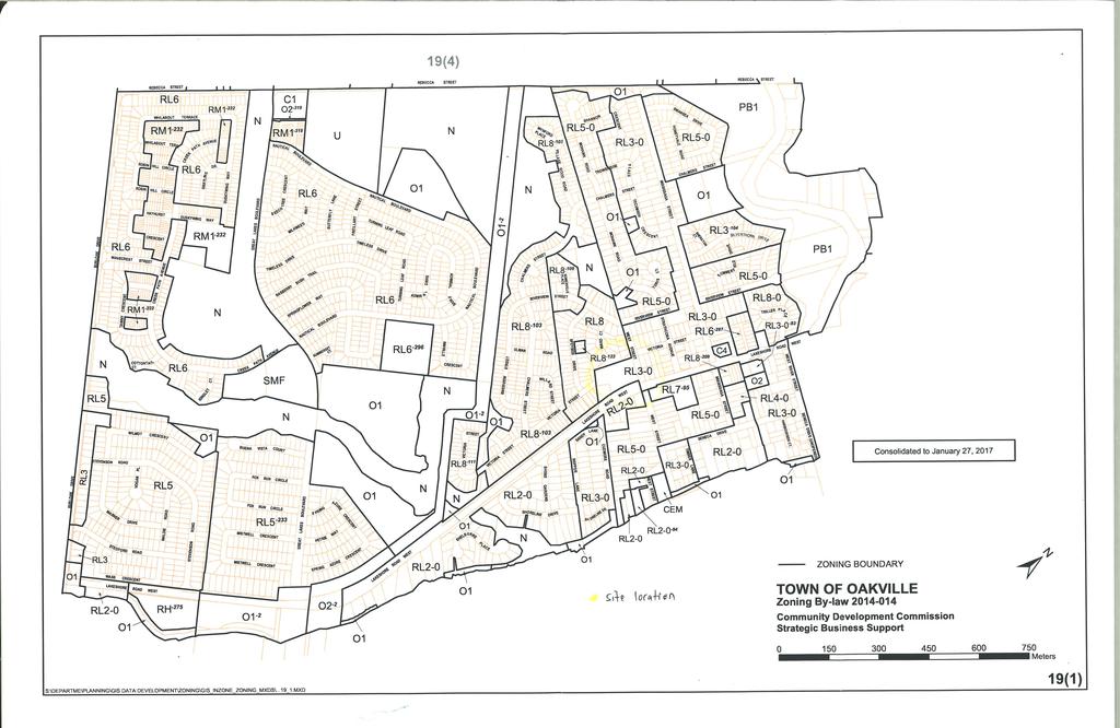
6 3171 Lakeshore Road West, Town of Oakville Traffic Impact Study Vogue Wycliffe (Oakville) Limited December INTRODUCTION 2.1 Background CF Crozier & Associates Inc. (Crozier) was retained by Vogue Wycliffe (Oakville) Limited to undertake a Traffic Impact Study in support of the Zoning By-Law Amendment and Draft Plan of Subdivision application for a residential development located at 3171 Lakeshore Road West in the Town of Oakville and the proposed extension of Victoria Street. The purpose of the study is to evaluate the transportation-related impacts of the proposed development and road extension on the boundary road network and to recommend any required mitigation measures, as required. The subject lands are bound by existing residential developments to the north, Lakeshore Road West to the south, existing residential developments and the existing Victoria Street alignment to the west, and existing residential developments and West Street/Victoria Street to the east. Figure 1 illustrates the site location. The study has been completed in accordance with the procedures set out in the Region of Halton s Transportation Impact Study Guidelines (January 2015) as well as agreed-upon Terms of Reference with Town of Oakville staff (Phone call, Syed Rizvi/Alexander Fleming, May 10, 2017). 2.2 Development Proposal Per the Site Plan prepared by VA3 Design Inc. (dated December 4, 2017), the development proposes 22 residential single-detached dwelling units. However, with adjoining lands considered, a total of 25 units could be achieved. In addition, the development also proposes the extension of Victoria Street to connect the existing east and west segments. The development illustrates 7 dwelling units fronting Lakeshore Road West and 15 dwelling units fronting the proposed Victoria Street extension. Figure 2 illustrates the Site Plan. It is unknown when the full build-out of the development is expected to occur. However, it is expected that full build-out will occur on a short-term scale (i.e. within two years). 3.0 EXISTING CONDITIONS 3.1 Development Lands The subject lands cover an area of approximately 0.99 ha. Cudmore s Garden Centre currently exists on the subject lands with two existing accesses to Lakeshore Road West. The subject lands are zoned as RL3-0 and RL8-0 Residential Low per Town of Oakville Zoning By-Law Appendix A contains the zoning information for the subject lands. 3.2 Study Area The Traffic Impact Study analyzes the following existing intersections: Lakeshore Road West and Mississauga Street Victoria Street and Mississauga Street C.F. Crozier & Associates Inc. Page 1 Project No
7 3171 Lakeshore Road West, Town of Oakville Traffic Impact Study Vogue Wycliffe (Oakville) Limited December Boundary Road Network Lakeshore Road West is an east-west minor arterial roadway with an urban cross-section. Lakeshore Road West is under the jurisdiction of the Town of Oakville with a posted speed limit of 50 km/h. The roadway consists of two approximate 3.5 metre travel lanes and an approximate 3.0 metre centre two-way left-turn lane (TWLTL). Bicycle lanes exist on both sides of the roadway, separated from the travel lanes by a solid white line. An approximate 2.0 metre concrete sidewalk exists directly adjacent to the north side of the roadway. An approximate 1.5 metre concrete sidewalk exists on the south side of the roadway, separated by an approximate 5.5 metre in-grass boulevard. The roadway transitions to four lanes approximately 200 metres east of Mississauga Street. Mississauga Street is a north-south minor collector roadway with an urban cross-section. Mississauga Street is under the jurisdiction of the Town of Oakville with an assumed speed limit of 50 km/h per municipal regulation. The roadway consists of two approximate 3.0 metre travel lanes. Bicycle lanes exist on both sides of the roadway, separated from the travel lanes by a solid white line. An approximate 1.5 metre concrete sidewalk exists on both sides of the roadway, separated by an ingrass boulevard on the east side of the roadway and located directly adjacent to the west side of the roadway. Victoria Street is an east-west local roadway with a rural cross-section east of the site and an urban cross-section west of the site. Victoria Street is under the jurisdiction of the Town of Oakville with an assumed speed limit of 50 km/h per municipal regulation. The segment west of the subject property consists of two approximate 3.2 metre travel lanes. An approximate 1.5 metre sidewalk exists on both sides of the roadway, separated by an approximate 3.0 metre in-grass boulevard. There are no cycling facilities on the roadway. The segment east of the subject property consists of two approximate 3.2 metre travel lanes. There are no cycling or pedestrian facilities on the roadway. There is an unopened right-of-way (ROW) for West Street east of the subject property, spanning northsouth from the easterly segment of Victoria Street to Lakeshore Road West. The existing ROW is grassed and does not contain any pedestrian or cycling facilities. However, it is understood that this ROW is used by pedestrians as a route from Victoria Street/West Street to Lakeshore Road West. The intersection of Lakeshore Road West and Mississauga Street is signalized. The east approach (Lakeshore Road West) consists of an exclusive left-turn lane with approximately 30 metres of storage, a through lane, and an exclusive right-turn lane with approximately 195 metres of effective storage. The west approach (Lakeshore Road West) consists of an exclusive left-turn lane with approximately 35 metres of storage, and a shared through/right-turn lane. The north approach (Mississauga Street) consists of an exclusive left-turn lane with approximately 80 metres of storage and a shared through/right-turn lane. The south approach (Mississauga Street) consists of a shared leftturn/through/right-turn lane. The intersection of Victoria Street and Mississauga Street is unsignalized. The west approach (Victora Street) is stop controlled and consists of a shared left-turn/right-turn lane. The north approach (Mississauga Street) consists of a shared through/right-turn lane. The south approach (Mississauga Street) consists of a shared left-turn/through lane. C.F. Crozier & Associates Inc. Page 2 Project No
8 3171 Lakeshore Road West, Town of Oakville Traffic Impact Study Vogue Wycliffe (Oakville) Limited December Transit Operations Oakville Transit operates Bus Route 14 (Lakeshore Road West) within the study area. The route connects GO Appleby to GO Oakville and spans east-west on Lakeshore Road West. The routes operates from Monday to Sunday with peak hour transit headways of 15 minutes during the weekday. There are bus stops located on the north and south side of Lakeshore Road West west of Mississauga Street. Appendix B contains relevant transit information. 3.5 Traffic Data Turning movement counts were undertaken by Spectrum Traffic Inc. on Tuesday May 16, 2017 between 7:00a.m.-10:00a.m. and 4:00p.m.-7:00p.m. Intersection analysis was conducted utilizing peak hour factors (PHFs) as calculated for each intersection during each time period. Signal timing plans were also made available to Crozier for modelling purposes. The traffic count data and signal timing plans are contained in Appendix C. PHFs as calculated for each intersection are included in the traffic count data. Figure 3 illustrates the 2017 existing traffic volumes. 3.6 Intersection Operations The operations of the critical intersections were analyzed on the basis of the 2017 existing traffic volumes illustrated in Figure 3 and existing signal timings provided in Appendix C. The Level of Service (LOS) definitions for signalized and unsignalized intersections are included in Appendix D. Detailed capacity analysis worksheets are included in Appendix E. Table 1 outlines the 2017 existing traffic volumes levels of service. Table Existing Level of Service Intersection Lakeshore Road West and Mississauga Street Control Signal Peak Hour Level of Service Control Delay Critical v/c ratios 1 95%tile queues > storage length A.M. B 10.6 s None None P.M. A 9.7 s None None Victoria Street and Mississauga Street Note: Stop (Minor Street) A.M. A 9.0 s None None P.M. A 9.0 s None None The Level of Service of a signalized intersection is based on the average control delay per vehicle. The Level of Service of a stop-controlled intersection is based on the delay associated with the critical minor road approach; ie., Victoria Street. 1) Per Regional TIS Guidelines, a critical v/c ratio for a through movement or shared through/turning movement is a v/c ratio that exceeds 0.85, and a critical v/c ratio for an exclusive movement is a v/c ratio that exceeds C.F. Crozier & Associates Inc. Page 3 Project No
9 3171 Lakeshore Road West, Town of Oakville Traffic Impact Study Vogue Wycliffe (Oakville) Limited December 2017 The signalized intersection of Lakeshore Road West and Mississauga Street is currently operating at level of service (LOS) B and A during the weekday a.m. and p.m. peak hours, respectively, with a maximum control delay of 10.6 seconds. No movements are currently operating at critical volume tocapacity ratios. These traffic operations indicate that the intersection is operating efficiently with minor delays. The unsignalized intersection of Victoria Street and Mississauga Street is currently operating at LOS A during the weekday a.m. and p.m. peak hours with a maximum control delay of 9.0 seconds. No movements are currently operating at critical volume-to-capacity ratios. These traffic operations indicate that the intersection is operating efficiently with minor delays. The traffic operations outlined above indicate that the boundary road network is currently operating at LOS B or better during all time periods. 4.0 FUTURE BACKGROUND CONDITIONS 4.1 Horizon Years Per the Region s Transportation Impact Study guidelines, horizon years consisting of five years and potentially ten years from the date of full build-out must be analyzed. As mentioned in Section 2.2, the year of full build-out is unknown but it is expected to occur on a short term scale (ie. within two years). The five-year horizon (2022) is assumed to capture the full build-out of the proposed development. Therefore, the 2022 horizon year was analyzed, as confirmed in the Terms of Reference with the Town of Oakville. 4.2 Growth Rate Crozier was instructed by Town of Oakville staff to apply a compounded growth rate of 1% per annum to existing traffic volumes. Figure 4 illustrates the 2022 future background traffic volumes. 4.3 Intersection Operations The operations of the subject intersections were analyzed on the basis of the future background traffic volumes illustrated in Figure 4. Table 2 outlines the 2022 future background traffic levels of service. Detailed capacity analysis worksheets are included in Appendix E. C.F. Crozier & Associates Inc. Page 4 Project No
10 3171 Lakeshore Road West, Town of Oakville Traffic Impact Study Vogue Wycliffe (Oakville) Limited December 2017 Table Future Background Level of Service Intersection Lakeshore Road West and Mississauga Street Control Signal Peak Hour Level of Service Control Delay Critical v/c ratios 1 95%tile queues > storage length A.M. B 12.2 s 0.86 (EBTR) None P.M. B 11.1 s None None Victoria Street and Mississauga Street Note: The Level of Service of a signalized intersection is based on the average control delay per vehicle. The Level of Service of a stop-controlled intersection is based on the delay associated with the critical minor road approach; ie., Phillips Street. 1) Per Regional TIS Guidelines, a critical v/c ratio for a through movement or shared through/turning movement is a v/c ratio that exceeds 0.85, and a critical v/c ratio for an exclusive movement is a v/c ratio that exceeds The signalized intersection of Lakeshore Road West and Mississauga Street is anticipated to change from LOS A to B during the weekday p.m. peak period in the 2022 future background conditions with a maximum increase in control delay of 1.4 seconds. Additionally, the eastbound through/rightturn movement during the weekday a.m. peak period is anticipated to operate at a volume-tocapacity ratio of This volume-to-capacity ratio is reflective of commuter travel patterns. However, the movement is not at capacity and the lane will operate with an average approach delay of 14.3 seconds. The unsignalized intersection of Victoria Street and Mississauga Street is anticipated to operate at unchanged levels of service in the 2022 future background conditions compared to 2017 existing conditions. The intersection is anticipated to experience a maximum increase in control delay of 0.1 seconds. The intersection is anticipated to operate efficiently with minor delays. 5.0 SITE GENERATED TRAFFIC The proposed development will result in additional trips on the boundary road network that would otherwise not exist. The proposed development will also result in additional turning movements at the boundary road intersections. 5.1 Site Trip Generation Stop (Minor Street) A.M. A 9.1 s None None P.M. A 9.1 s None None Trip generation for the residential development was forecasted using the fitted curve equations provided in the Institute of Transportation Engineers (ITE) Trip Generation Manual, 8 th Edition. Crozier was provided with a Concept Plan at the time the trip generation was forecasted. The Concept Plan identified a total build-out of 32 residential units with adjoining lands considered; with 11 units fronting Lakeshore Road West and 21 units fronting the Victoria Street extension. Although a maximum of 25 units can be achieved per the recent Site Plan, the analysis conducted in this report was not updated as it was based on a 32-unit build-out and is thus considered conservative. C.F. Crozier & Associates Inc. Page 5 Project No
11 3171 Lakeshore Road West, Town of Oakville Traffic Impact Study Vogue Wycliffe (Oakville) Limited December 2017 Land Use Category 210 (Single-Family Detached Housing) was applied to the development proposal. Trip generation was calculated separately for the proposed units fronting Lakeshore Road West and the proposed units fronting the Victoria Street extension. The forecasted trips for the site are tabulated in Table 3. Location Number of Units Table 3 Site Trip Generation Peak Hour Trips Generated Inbound Outbound Total Lakeshore Road West Victoria Street extension Total 32 A.M P.M A.M P.M A.M P.M Trip Distribution and Assignment The trips generated by the development were distributed to the boundary roadways based on TTS data. TTS results were filtered to reflect home-based work trips made during 7:00a.m.-10:00a.m. from the 2006 GTA zone that the subject property is currently located in (4001). The zone is residential in nature, and thus the TTS results will be appropriate for the proposed residential development. Trip distribution was determined based on the most convenient route of travel between each origindestination pair. Refer to Appendix F for the TTS data. The resulting trip distribution is as follows: 72% to the east (e.g. Toronto, Mississauga, Oakville, etc.) 2% to the north (e.g. Milton, etc.) 26% to the west (e.g. Burlington, Ancaster, Hamilton, Niagara Falls, etc.) Trips entering from and exiting to the east were assumed to travel on Lakeshore Road West or Rebecca Street to the north to access the rest of Oakville, as well as the Queen Elizabeth Way/Highway 403 to the north via Bronte Road. It was assumed that trips generating from the proposed dwelling units fronting Lakeshore Road West will travel on Lakeshore Road West, while trips generating from the proposed dwelling units fronting the Victoria Street extension will either travel northbound on Mississauga Street, then eastbound on Rebecca Street; or to travel southbound on Mississauga Street, then eastbound on Lakeshore Road. Based on existing travel patterns, approximately one-third of eastbound exiting vehicles at Victoria Street and Mississauga Street travel northbound and two-thirds travel southbound. Additionally, approximately one-third of vehicles turning onto Victoria Street from Mississauga Street are coming southbound on Mississauga Road while two-thirds are coming northbound on Mississauga Road. These entering and exiting proportions were applied to the trip assignment. C.F. Crozier & Associates Inc. Page 6 Project No
12 3171 Lakeshore Road West, Town of Oakville Traffic Impact Study Vogue Wycliffe (Oakville) Limited December 2017 Trips arriving from and departing to the north were assumed to do so via Bronte Road. Therefore, the trip assignment assumed for trips entering from and exiting to the east (as described above) was applied to trips entering from and exiting to the north. The balance of the trips arriving from and departing to the west were assumed to do so via Lakeshore Road West (outside the study area). The trip distribution for trips entering from and exiting to the east/north and the west totalled 74% and 26%, respectively. The final trip distribution was assumed to be 75% and 25% for trips entering from and exiting to the east/north and the west, respectively. The total trips generated by the development were assigned to the boundary road network on the basis of the distribution outlined in Figure 5 and assignment outlined in Figure TRAVEL PATTERN ANALYSIS The proposed extension of Victoria Street to its easterly segment will result in a change in travel patterns on the boundary road network. These changes in travel patterns were forecasted based on the most convenient route of travel assuming the future road network, including the Victoria Street extension. 6.1 Catchment Area It was assumed that drivers coming from Victoria Street easterly (east of the subject property) heading westbound will likely use the adjacent north/south Strathcona Avenue to access Lakeshore Road West. This route would result in a faster travel time compared to driving west on Victoria Street, then turning left onto Chalmers Street, and turning right onto Lakeshore Road West. Therefore, the changes in travel patterns were focused on the areas of Victoria Street west of the subject property adjacent to Speyside Drive, Willard Street, and Ulman Road. It was assumed that all drivers coming from the existing residential units fronting Victoria Street, between Willard Street and the existing easterly terminus, that are travelling east will use the new Victoria Street extension. This area includes a total of 15 existing residential units. It was assumed that drivers coming from residential units on Victoria Street west of Willard Street will continue to use Chalmers Drive to the west given its close proximity to the residential units. It was assumed that drivers coming from the existing residential units fronting Speyside Drive, between Victoria Street and the horizontal curve north of Ulman Road, that are travelling east will use the new Victoria Street extension. This area includes a total of approximately 25 existing residential units. It was assumed that drivers coming from residential units on Speyside Drive north of the horizontal curve north of Ulman Road will continue to use Riverview Street to the north given its close proximity to the residential units. Therefore, it is estimated that motorists from approximately 40 homes in the neighbourhood west of the subject property travelling eastbound will take advantage of the new Victoria Street extension. Appendix G contains the traffic diversion analysis. C.F. Crozier & Associates Inc. Page 7 Project No
13 3171 Lakeshore Road West, Town of Oakville Traffic Impact Study Vogue Wycliffe (Oakville) Limited December Peak Hour Trip Generation Applying the ITE Trip Generation rates for Land Use Category 210 (Single-Family Detached Housing), the estimated trips on the road network is outlined below in Table 4. Location Table 4 Trip Generation Area Affected by Victoria Street Extension Estimated Number of Units Peak Hour Trips Generated Inbound Outbound Total See Section A.M P.M Peak Hour Trip Distribution The trip distribution of 75% to the east/north and 25% to the west (per Section 5.2) was applied to the study area. Of the 75% of trips heading east, the same one-third/two-third proportion was applied to trips heading northbound and southbound on Mississauga Street, respectively. Figure 7 outlines the assumed trip distribution and Figure 8 outlines the assumed trip assignment. 7.0 FUTURE TOTAL CONDITIONS 7.1 Basis of Assessment The traffic impacts arising from the proposed development were assessed on the basis of the site generated traffic illustrated in Figure 6 and the traffic diversions illustrated in Figure 8 being superimposed on the future background traffic volumes in Figure 4 The resulting total traffic volumes for the weekday a.m. and p.m. peak hours are illustrated in Figure Intersection Operations The operations of the subject intersections were analyzed on the basis of the traffic volumes illustrated in Figure 9. Table 5 outlines the 2022 future total traffic levels of service. Detailed capacity analysis worksheets are included in Appendix E. C.F. Crozier & Associates Inc. Page 8 Project No
14 3171 Lakeshore Road West, Town of Oakville Traffic Impact Study Vogue Wycliffe (Oakville) Limited December 2017 Table Future Total Level of Service Intersection Lakeshore Road West and Mississauga Street Control Signal Peak Hour Level of Service Control Delay Critical v/c ratios 1 95%tile queues > storage length A.M. B 13.6 s 0.88 (EBTR) None P.M. B 11.8 s None None Victoria Street and Mississauga Street Note: Stop (Minor Street) The Level of Service of a signalized intersection is based on the average control delay per vehicle. The Level of Service of a stop-controlled intersection is based on the delay associated with the critical minor road approach; ie., Phillips Street. 1) Per Regional TIS Guidelines, a critical v/c ratio for a through movement or shared through/turning movement is a v/c ratio that exceeds 0.85, and a critical v/c ratio for an exclusive movement is a v/c ratio that exceeds The signalized intersection of Lakeshore Road West and Mississauga Street is anticipated to operate at unchanged levels of service in the 2022 future total conditions with a maximum increase in control delay of 1.4 seconds or less. The volume-to-capacity ratio for the critical eastbound through/right-turn movement during the weekday a.m. peak period is anticipated to increase by 0.02, though the movement will operate with an average delay of 16.2 seconds. These traffic operations indicate that the intersection is anticipated to operate at acceptable levels of service with minor delays. The unsignalized intersection of Victoria Street and Mississauga Street is anticipated to operate at unchanged levels of service in the 2022 future background conditions compared to 2017 existing conditions. The intersection is anticipated to experience a maximum increase in control delay of 0.2 seconds. The intersection is anticipated to operate efficiently with minor delays. These traffic operations indicate that the addition of development site traffic and diverted existing traffic to the boundary road network is expected to have a negligible impact on traffic operations. All intersections are expected to remain operating at LOS B or better during all time periods. Therefore, the proposed development and extension of Victoria Street is supportable from a traffic operations perspective. The extension of Victoria Street is anticipated to result in an overall positive impact to traffic connectivity, providing more options for neighbourhood community travel. For example, existing traffic in the neighbourhood to the west of the subject property will have the opportunity to take advantage of the new Victoria Street extension to travel east as opposed to backtracking to Chalmers Drive and Riverview Street. Therefore, the new Victoria Street extension is expected to alleviate existing traffic operations on Chalmers Drive and Riverview Street. 8.0 SIGHT DISTANCE ANALYSIS A.M. A 9.3 s None None P.M. A 9.3 s None None Sight distance measurements were conducted using Transportation Association of Canada (TAC) Geometric Design Guide for Canadian Roads (GDGCR) guidelines for driver line of sight and vehicle dimensions in order to measure the distance available for motorists exiting from the proposed dwelling units on Lakeshore Road West. The posted speed limit on Lakeshore Road West is 50 kilometres per C.F. Crozier & Associates Inc. Page 9 Project No
15 3171 Lakeshore Road West, Town of Oakville Traffic Impact Study Vogue Wycliffe (Oakville) Limited December 2017 hour. The design speed of a roadway is typically kilometres per hour in excess of the speed limit in urban environments. However, considering that Lakeshore Road West is a minor arterial roadway, a conservative design speed of 70 kilometres per hour was assumed for Lakeshore Road West. Per Table a of the TAC GDGCR, a minimum sight distance of 156 metres is required for passenger vehicles to safely exit the driveways fronting Lakeshore Road West via left-turn, and to cross the centre TWLTL. Appendix H contains the sight distance analysis calculations. The boundary road network is relatively flat with a minor horizontal curve in the roadway at the site. However, the proposed dwelling units will front the north side of the curve, thus providing increased sightlines as a result of the road curvature. Using a three metre setback from the approximate extension of the outer curb to represent a vehicle waiting to exit the driveway, sight distance was assessed from the proposed accesses. A sight distance in excess of 200 metres was measured in both directions along the entire frontage of the property. Therefore, the proposed dwelling units fronting Lakeshore Road West are supportable from a sight distance perspective. 9.0 PEDESTRIAN CONNECTIVITY The proposed Victoria Street extension will include concrete sidewalks on both sides of the roadway. The proposed cross-section would be consistent with the existing Victoria Street cross-section west of the subject property. The sidewalk on the north side of the proposed extension will connect with the existing sidewalk on the west side of West Street (spanning from Victoria Street to Riverview Street). The proposed Victoria Street extension would provide continuous pedestrian connectivity from the west side of Victoria Street to the east side of Victoria Street, and increase the walkability options for the local neighbourhood. It is understood that the existing ROW for West Street east of the subject property is currently used by pedestrians as a shortcut from Victoria Street/West Street to Lakeshore Road West. The proposed development will not obstruct or restrict the existing pedestrian connectivity between Victoria Street/West Street and Lakeshore Road West via the West Street unopened ROW. The existing pedestrian route will remain as-is for pedestrian use WEST STREET UNOPENED RIGHT-OF-WAY West Street is discontinuous with an unopened ROW between Victoria Street and Lakeshore Road West. A purpose of this study is to examine whether the roadway link is required or may be considered surplus to a wider roadway network. From a traffic operations perspective, a link would provide a slightly more direct route to Lakeshore Road West for residents in the immediate vicinity, being approximately 15 homes. However, the traffic operations at the nearby intersections do not require a further Lakeshore Road West intersection to diffuse traffic volumes. Accordingly, the connection is not required from a traffic operations perspective. It is highlighted that the unopened West Street ROW is used as a pedestrian linkage. Should the Town deem the ROW as surplus, any redevelopment can incorporate a public trail or path to maintain the pedestrian connection. C.F. Crozier & Associates Inc. Page 10 Project No
16 3171 Lakeshore Road West, Town of Oakville Traffic Impact Study Vogue Wycliffe (Oakville) Limited December CONCLUSIONS The detailed analysis contained within this assessment has resulted in the following key findings: Analysis of the 2017 existing traffic conditions indicate that the study intersections are operating at LOS B or better during the weekday a.m. and p.m. peak hour; Analysis of the 2022 future background traffic operations indicate that the study intersections are anticipated to operate at LOS B or better during the weekday a.m. and p.m. peak hour; The proposed development is anticipated to add 41 and 40 trips to the boundary road network during the weekday a.m. and p.m. peak hours, respectively; The proposed extension of Victoria Street is anticipated to divert existing traffic from the areas of Victoria Street westerly (west of the subject property) adjacent to Speyside Drive, Willard Street, and Ulman Road; It is estimated that approximately 40 drivers in the neighbourhood west of the subject property travelling eastbound will take advantage of the new Victoria Street extension; Analysis of the 2022 future total traffic operations indicate that the study intersections are anticipated to operate at unchanged levels of service compared to 2022 future background conditions; It is anticipated that the addition of development site traffic and diverted existing traffic to the boundary road network will minimally impact the road network from a traffic operations perspective; The extension of Victoria Street will result in an overall positive impact to traffic connectivity, providing more options for neighbourhood community travel and alleviating traffic on Chalmers Drive and Riverview Street; Analysis of sight distance at the proposed residential dwelling accesses fronting Lakeshore Road West indicates that there is sufficient sight distance for passenger vehicles exiting and entering the dwellings, and that the accesses are supportable from a sight distance perspective; The proposed sidewalks on the Victoria Street extension would provide continuous pedestrian connectivity from the west side of Victoria Street to the east side of Victoria Street, and increase the walkability options for the local neighbourhood; The proposed development will not obstruct or restrict the existing pedestrian connectivity between Victoria Street/West Street and Lakeshore Road West, allowing the existing pedestrian route to remain as-is for pedestrian use; and The construction of a roadway link in the unopened West Street right-of-way is not required from a traffic operations perspective, and if deemed surplus by the Town, could maintain a pedestrian trail or path in any redevelopment. C.F. Crozier & Associates Inc. Page 11 Project No

17 3171 Lakeshore Road West, Town of Oakville Traffic Impact Study Vogue Wycliffe (Oakville) Limited December 2017 The current Site Plan was prepared by VA3 Design Inc., dated December 4, Crozier was provided with a Concept Plan at the time the trip generation was forecasted. The Concept Plan identified a total build-out of 32 residential units with adjoining lands considered; with 11 units fronting Lakeshore Road West and 21 units fronting the Victoria Street extension. Although a maximum of 25 units can be achieved per the recent Site Plan, the analysis conducted in this report was not updated as it was based on a 32-unit build-out and is thus considered conservative. Any minor changes to the Site Plan will not materially affect the conclusions contained within this report. In conclusion, the Zoning By-Law Amendment and Draft Plan of Subdivision application can be supported from a traffic and pedestrian operation and safety perspective. Prepared by, C.F. CROZIER & ASSOCIATES INC. C.F. CROZIER & ASSOCIATES INC. Alexander J. W. Fleming, MBA, P.Eng. Associate Darren J. Loro Transportation Technologist J:\1100\1159-Wyecliff Clark Ltd\ Lakeshore Rd W\Reports\4614_3171 Lakeshore Road TIS (December 2017) v3.0.docx C.F. Crozier & Associates Inc. Page 12 Project No
18 3171 Lakeshore Road West, Town of Oakville Traffic Impact Study Vogue Wycliffe (Oakville) Limited December 2017 APPENDIX A Town of Oakville Zoning By-Law Excerpts C.F. Crozier & Associates Inc. Project No
19
20 3171 Lakeshore Road West, Town of Oakville Traffic Impact Study Vogue Wycliffe (Oakville) Ltd. December 2017 APPENDIX B Transit Data C.F. Crozier & Associates Inc. Project No
21 14 LAKESHORE WEST Monday to Friday Effective September 4, 2016 Timepoint Oakville GO (Depart) Church & Dunn Rebecca & Kerr South Oakville Centre (Dp.) Lakeshore & Bronte Lakeshore & Great Lakes Great Lakes & Rebecca Harvester & Burloak Harvester & Appleby Appleby GO (Arrive) Appleby GO (Depart) Harvester & Appleby Harvester & Burloak Great Lakes & Rebecca Lakeshore & Great Lakes Lakeshore & Bronte South Oakville Centre (Dp.) Rebecca & Kerr Church & Dunn Oakville GO (Arrive) a.m. p.m. Monday to Friday To Appleby GO To Oakville GO First trip to Oakville GO enters service at Lakeshore and Jones :20 5:30 5:37 5:42 5: :42* 5:46 5:50 6:00 6:07 6:12 6:23 * These trips enter service at Burloak & Prince William at 5:40, 5:55 and 6:10 a.m :57* 6:01 6:05 6:15 6:22 6:27 6: :12* 6:16 6:20 6:30 6:37 6:42 6: :15 6:19 6:23 6:27 6:31 6:35 6:45 6:52 6:57 7: :30 6:34 6:38 6:42 6:46 6:50 7:00 7:07 7:12 7: :45 6:49 6:53 6:57 7:01 7:05 7:15 7:22 7:27 7: :00 7:04 7:08 7:12 7:16 7:20 7:30 7:37 7:42 7:53 6:10 6:19 6:22 6:35 6:44 6:48 6:52 6:56 6:59 7:05 7:15 7:19 7:23 7:27 7:31 7:35 7:45 7:52 7:57 8:08 6:25 6:34 6:37 6:50 6:59 7:03 7:07 7:11 7:14 7:20 7:30 7:34 7:38 7:42 7:46 7:50 8:00 8:07 8:12 8:23 6:40 6:49 6:52 7:05 7:14 7:18 7:22 7:26 7:29 7:35 7:45 7:49 7:53 7:57 8:01 8:05 8:15 8:22 8:27 8:38 6:55 7:04 7:07 7:20 7:29 7:33 7:37 7:41 7:44 7:50 8:00 8:04 8:08 8:12 8:16 8:20 8:30 8:37 8:42 8:53 7:10 7:19 7:22 7:35 7:44 7:48 7:52 7:56 7:59 8:05 8:15 8:19 8:23 8:27 8:31 8:35 8:45 8:52 8:57 9:08 7:25 7:34 7:37 7:50 7:59 8:03 8:07 8:11 8:14 8:20 8:30 8:34 8:38 8:42 8:46 8:50 9:00 9:07 9:12 9:23 7:40 7:49 7:52 8:05 8:14 8:18 8:22 8:26 8:29 8:35 8:45 8:49 8:53 8:57 9:01 9:05 9:15 9:22 9:27 9:38 7:55 8:04 8:07 8:20 8:29 8:33 8:37 8:41 8:44 8: :10 8:19 8:22 8:35 8:44 8:48 8:52 8:56 8:59 9:05 9:15 9:19 9:23 9:27 9:31 9:35 9:45 9:52 9:57 10:08 8:25 8:34 8:37 8:50 8:59 9:03 9:07 9:11 9:14 9: :40 8:49 8:52 9:05 9:14 9:18 9:22 9:26 9:29 9:35 9:45 9:49 9:53 9:57 10:01 10:05 10:15 10:22 10:27 10:38 9:10 9:19 9:22 9:35 9:44 9:48 9:52 9:56 9:59 10:05 10:15 10:19 10:23 10:27 10:31 10:35 10:45 10:52 10:57 11:08 and every 30 minutes until and every 30 minutes until 3:10 3:19 3:22 3:35 3:44 3:48 3:52 3:56 3:59 4:05 4:15 4:19 4:23 4:27 4:31 4:35 4:45 4:52 4:57 5:08 3:40 3:49 3:52 4:05 4:14 4:18 4:22 4:26 4:29 4:35 4:45 4:49 4:53 4:57 5:01 5:05 5:15 5:22 5:27 5:38 4:10 4:19 4:22 4:35 4:44 4:48 4:52 4:56 4:59 5:05 5:15 5:19 5:23 5:27 5:31 5:35 5:45 5:52 5:57 6:08 4:25 4:34 4:37 4:50 4:59 5:03 5:07 5:11 5:14 5:20 5:30 5:34 5:38 5:42 5:46 5:50 6:00 6:07 6:12 6:23 4:40 4:49 4:52 5:05 5:14 5:18 5:22 5:26 5:29 5:35 5:45 5:49 5:53 5:57 6:01 6:05 6:15 6:22 6:27 6:38 4:55 5:04 5:07 5:20 5:29 5:33 5:37 5:41 5:44 5:50 6:00 6:04 6:08 6:12 6:16 6:20 6:30 6:37 6:42 6:53 5:10 5:19 5:22 5:35 5:44 5:48 5:52 5:56 5:59 6:05 6:15 6:19 6:23 6:27 6:31 6:35 6:45 6:52 6:57 7:08 5:25 5:34 5:37 5:50 5:59 6:03 6:07 6:11 6:14 6:20 6:30 6:34 6:38 6:42 6:46 6:50 7:00 7:07 7:12 7:23 5:40 5:49 5:52 6:05 6:14 6:18 6:22 6:26 6:29 6:35 6:45 6:49 6:53 6:57 7:01 7:05 7:15 7:22 7:27 7:38 5:55 6:04 6:07 6:20 6:29 6:33 6:37 6:41 6:44 6: :10 6:19 6:22 6:35 6:44 6:48 6:52 6:56 6:59 7:05 7:15 7:19 7:23 7:27 7:31 7:35 7:45 7:52 7:57 8:08 6:25 6:34 6:37 6:50 6:59 7:03 7:07 7:11 7:14 7: :40 6:49 6:52 7:05 7:14 7:18 7:22 7:26 7:29 7:35 7:45 7:49 7:53 7:57 8:01 8:05 8:15 8:22 8:27 8:38 7:10 7:19 7:22 7:35 7:44 7:48 7:52 7:56 7:59 8: :40 7:49 7:52 8:05 8:14 8:18 8:22 8:26 8:29 8:35 8:45 8:49 8:53 8:57 9:01 9:05 9:15 9:22 9:27 9:38 8:40 8:49 8:52 9:05 9:14 9:18 9:22 9:26 9:29 9:35 9:45 9:49 9:53 9:57 10:01 10:05 10:15 10:22 10:27 10:38 9:40 9:49 9:52 10:05 10:14 10:18 10:22 10:26 10:29 10:35 10:45 10:49 10:53 10:57 11:01 11:05 11:15 11:22 11:27 11:38 10:40 10:49 10:52 11:05 11:14 11:18 11:22 11:26 11:29 11:35 11:45 11:48 11:51 11:54 11:57 12:00 12:10 12:16 12:20 12:30 Late Night Service departs from the Oakville GO station at 11:40 p.m., 12:30 and 1:30a.m., Monday to Saturday, and 7:40 p.m. on Sunday and holidays. Let the driver know the nearest bus stop to your destination within Oakville. Drop-off service covers up to Burloak Drive only. Have you tried real-time bus tracking? Track your bus at oakvilletransit.ca or download the Oakville Transit mobile app. Oakville Transit 430 Wyecroft Road 8:30 a.m. - 4:30 p.m. Monday - Friday Mailing Address Oakville Transit 1225 Trafalgar Road Oakville, ON L6H 0H3 Info Line care-a-van While every effort will be made to operate our service to these timetables, all schedules including bus stop times and transfer times are based on normal traffic and weather conditions and as such are subject to change. Oakville Transit will not be responsible for any loss, damage or inconvenience that may result from any errors, omissions or service delays.
 Lakeshore & Bronte Lakeshore & Great Lakes Great Lakes & Rebecca Harvester & Burloak Harvester & Appleby Appleby GO (Arrive) Appleby GO (Depart) Harvester & Appleby Harvester & Burloak Great Lakes")
22 14 LAKESHORE WEST Saturday, Sunday/Holidays Effective September 4, 2016 Timepoint Oakville GO (Depart) Church & Dunn Rebecca & Kerr South Oakville Centre (Dp.) Lakeshore & Bronte Lakeshore & Great Lakes Great Lakes & Rebecca Harvester & Burloak Harvester & Appleby Appleby GO (Arrive) Appleby GO (Depart) Harvester & Appleby Harvester & Burloak Great Lakes & Rebecca Lakeshore & Great Lakes Lakeshore & Bronte South Oakville Centre (Dp.) Rebecca & Kerr Church & Dunn Oakville GO (Arrive) a.m. 14 Lakeshore West Timepoint p.m. Oakville GO (Depart) Church & Dunn Rebecca & Kerr South Oakville Centre (Dep.) Lakeshore & Bronte Lakeshore & Great Lakes Great Lakes & Rebecca Harvester & Burloak Harvester & Appleby Appleby GO (Arrive) Appleby GO (Depart) Harvester & Appleby Harvester & Burloak Great Lakes & Rebecca Lakeshore & Great Lakes Lakeshore & Bronte South Oakville Centre (Dep.) Rebecca & Kerr Church & Dunn Oakville GO a.m. p.m. To Appleby GO * These trips enter service at Burloak & Prince William at 6:25 and 6:55 a.m. Saturday To Oakville GO :27* 6:31 6:35 6:45 6:52 6:57 7: :57* 7:01 7:05 7:15 7:22 7:27 7: :15 7:19 7:23 7:27 7:31 7:35 7:45 7:52 7:57 8: :45 7:49 7:53 7:57 8:01 8:05 8:15 8:22 8:27 8:38 7:10 7:19 7:22 7:35 7:44 7:48 7:52 7:56 7:59 8:05 8:15 8:19 8:23 8:27 8:31 8:35 8:45 8:52 8:57 9:08 7:40 7:49 7:52 8:05 8:14 8:18 8:22 8:26 8:29 8:35 8:45 8:49 8:53 8:57 9:01 9:05 9:15 9:22 9:27 9:38 8:10 8:19 8:22 8:35 8:44 8:48 8:52 8:56 8:59 9:05 9:15 9:19 9:23 9:27 9:31 9:35 9:45 9:52 9:57 10:08 and every 30 minutes until and every 30 minutes until 6:40 6:49 6:52 7:05 7:14 7:18 7:22 7:26 7:29 7:35 7:45 7:49 7:53 7:57 8:01 8:05 8:15 8:22 8:27 8:38 7:10 7:19 7:22 7:35 7:44 7:48 7:52 7:56 7:59 8:05 8:15 8:19 8:23 8:27 8:31 8:35 8:45 8:52 8:57 9:08 7:40 7:49 7:52 8:05 8:14 8:18 8:22 8:26 8:29 8:35 8:45 8:49 8:53 8:57 9:01 9:05 9:15 9:22 9:27 9:38 8:40 8:49 8:52 9:05 9:14 9:18 9:22 9:26 9:29 9:35 9:45 9:49 9:53 9:57 10:01 10:05 10:15 10:22 10:27 10:38 9:40 9:49 9:52 10:05 10:14 10:18 10:22 10:26 10:29 10:35 10:45 10:49 10:53 10:57 11:01 11:05 11:15 11:22 11:27 11:38 10:40 10:49 10:52 11:05 11:14 11:18 11:22 11:26 11:29 11: Sunday / Holidays To Appleby GO To Oakville GO * Enters service at Burloak & Prince William at 7:55 a.m :57* 8:01 8:05 8:15 8:22 8:27 8: :15 8:19 8:23 8:27 8:31 8:35 8:45 8:52 8:57 9: :45 8:49 8:53 8:57 9:01 9:05 9:15 9:22 9:27 9:38 8:10 8:19 8:22 8:35 8:44 8:48 8:52 8:56 8:59 9:05 9:15 9:19 9:23 9:27 9:31 9:35 9:45 9:52 9:57 10:08 8:40 8:49 8:52 9:05 9:14 9:18 9:22 9:26 9:29 9:35 9:45 9:49 9:53 9:57 10:01 10:05 10:15 10:22 10:27 10:38 9:10 9:19 9:22 9:35 9:44 9:48 9:52 9:56 9:59 10:05 10:15 10:19 10:23 10:27 10:31 10:35 10:45 10:52 10:57 11:08 and every 30 minutes until and every 30 minutes until 5:10 5:19 5:22 5:35 5:44 5:48 5:52 5:56 5:59 6:05 6:15 6:19 6:23 6:27 6:31 6:35 6:45 6:52 6:57 7:08 5:40 5:49 5:52 6:05 6:14 6:18 6:22 6:26 6:29 6:35 6:45 6:49 6:53 6:57 7:01 7:05 7:15 7:22 7:27 7:38 6:10 6:19 6:22 6:35 6:44 6:48 6:52 6:56 6:59 7:05 7:15 7:19 7:23 7:27 7:31 7:35 7:45 7:52 7:57 8:08 6:40 6:49 6:52 7:05 7:14 7:18 7:22 7:26 7:29 7: :10 7:19 7:22 7:35 7:44 7:48 7:52 7:56 7:59 8: (Arrive) Late Night Service departs from the Oakville GO station at 11:40 p.m., 12:30 and 1:30a.m., Monday to Saturday, and 7:40 p.m. on Sunday and holidays. Let the driver know the nearest bus stop to your destination within Oakville. Drop-off service covers up to Burloak Drive only. While every effort will be made to operate our service to these timetables, all schedules including bus stop times and transfer times are based on normal traffic and weather conditions and as such are subject to change. Oakville Transit will not be responsible for any loss, damage or inconvenience that may result from any errors, omissions or service delays.
23 3171 Lakeshore Road West, Town of Oakville Traffic Impact Study Vogue Wycliffe (Oakville) Ltd. December 2017 APPENDIX C Traffic Data C.F. Crozier & Associates Inc. Project No
24 Turning Movement Count Location Name: LAKESHORE RD W & MISSISSAUGA ST Date: Tue, May 16, 2017 Deployment Lead: Theo Daglis Crozier & Associates,, Turning Movement Count (1. LAKESHORE RD W & MISSISSAUGA ST) Start Time Right N:W Thru N:S N Approach MISSISSAUGA ST Left N:E U-Turn N:N Peds N: Approach Total Right E:N Thru E:W E Approach LAKESHORE RD W Left E:S U-Turn E:E Peds E: Approach Total Right S:E Thru S:N S Approach MISSISSAUGA ST Left S:W U-Turn S:S Peds S: Approach Total Right W:S Thru W:E W Approach LAKESHORE RD W Left W:N U-Turn W:W Peds W: Approach Total Int. Total (15 min) Int. Total (1 hr) 07:00: :15: :30: :45: :00: :15: :30: :45: :00: :15: :30: :45: ***BREAK*** 16:00: :15: :30: :45: :00: :15: :30: :45: :00: :15: :30: :45: Grand Total Approach% 26.7% 5.8% 67.4% 0% - 9.5% 89.4% 1.1% 0% % 22.4% 19% 0% - 0.4% 97.7% 1.9% 0% Totals % 1.6% 0.3% 3.9% 0% 5.8% 4.4% 41.7% 0.5% 0% 46.6% 0.9% 0.3% 0.3% 0% 1.5% 0.2% 45% 0.9% 0% 46.1% - - Heavy Heavy % 2.5% 3.8% 3.3% 0% - 2.7% 2.3% 2.6% 0% - 1.5% 15.4% 4.5% 0% - 0% 1.8% 3% 0% Bicycles Bicycle % 0% 0% 0% 0% - 0% 0.7% 0% 0% - 0% 0% 0% 0% - 0% 0.4% 1.5% 0% Turning Movement Count Page 1 of 6 CRA17B2L
25 Turning Movement Count Location Name: LAKESHORE RD W & MISSISSAUGA ST Date: Tue, May 16, 2017 Deployment Lead: Theo Daglis Crozier & Associates,, Turning Movement Count Page 2 of 6 CRA17B2L
26 Turning Movement Count Location Name: LAKESHORE RD W & MISSISSAUGA ST Date: Tue, May 16, 2017 Deployment Lead: Theo Daglis Crozier & Associates,, Peak Hour: 08:00 AM - 09:00 AM Weather: Overcast (8.6 C) Start Time N Approach MISSISSAUGA ST E Approach LAKESHORE RD W S Approach MISSISSAUGA ST W Approach LAKESHORE RD W Right Thru Left U-Turn Peds Approach Total Right Thru Left U-Turn Peds Approach Total Right Thru Left U-Turn Peds Approach Total Right Thru Left U-Turn Peds Approach Total Int. Total (15 min) 08:00: :15: :30: :45: Grand Total Approach% 16.3% 5.1% 78.6% 0% % 85.8% 1.6% 0% % 26.1% 8.7% 0% - 0.1% 97.9% 2% 0% - - Totals % 1.1% 0.3% 5.2% 0% 6.6% 3.2% 22% 0.4% 0% 25.6% 1% 0.4% 0.1% 0% 1.5% 0.1% 64.9% 1.3% 0% 66.3% - PHF Heavy Heavy % 0% 20% 1.3% 0% 2% 4.2% 4.9% 16.7% 0% 5% 6.7% 16.7% 0% 0% 8.7% 0% 1.7% 0% 0% 1.6% - Lights Lights % 100% 80% 98.7% 0% 98% 95.8% 95.1% 83.3% 0% 95% 93.3% 83.3% 100% 0% 91.3% 100% 98.3% 100% 0% 98.4% - Single-Unit Trucks Single-Unit Trucks % 0% 20% 0% 0% 1% 0% 1.2% 16.7% 0% 1.3% 0% 0% 0% 0% 0% 0% 0.7% 0% 0% 0.7% - Buses Buses % 0% 0% 1.3% 0% 1% 4.2% 3.1% 0% 0% 3.1% 6.7% 16.7% 0% 0% 8.7% 0% 0.9% 0% 0% 0.9% - Articulated Trucks Articulated Trucks % 0% 0% 0% 0% 0% 0% 0.6% 0% 0% 0.5% 0% 0% 0% 0% 0% 0% 0% 0% 0% 0% - Pedestrians Pedestrians% % % % % - Bicycles on Crosswalk Bicycles on Crosswalk% % % % % - Bicycles on Road Bicycles on Road% % % % % - Turning Movement Count Page 3 of 6 CRA17B2L
27 Turning Movement Count Location Name: LAKESHORE RD W & MISSISSAUGA ST Date: Tue, May 16, 2017 Deployment Lead: Theo Daglis Crozier & Associates,, Peak Hour: 04:45 PM - 05:45 PM Weather: Mostly Cloudy (18.6 C) Start Time N Approach MISSISSAUGA ST E Approach LAKESHORE RD W S Approach MISSISSAUGA ST W Approach LAKESHORE RD W Right Thru Left U-Turn Peds Approach Total Right Thru Left U-Turn Peds Approach Total Right Thru Left U-Turn Peds Approach Total Right Thru Left U-Turn Peds Approach Total Int. Total (15 min) 16:45: :00: :15: :30: Grand Total Approach% 41.5% 7.4% 51.1% 0% - 9.5% 89.9% 0.6% 0% - 60% 10% 30% 0% - 0.8% 96.9% 2.2% 0% - - Totals % 2.5% 0.5% 3.1% 0% 6% 6.6% 62.7% 0.4% 0% 69.7% 0.8% 0.1% 0.4% 0% 1.3% 0.2% 22.3% 0.5% 0% 23% - PHF Heavy Heavy % 2.6% 0% 0% 0% 1.1% 1% 1.1% 0% 0% 1.1% 0% 0% 16.7% 0% 5% 0% 1.7% 12.5% 0% 2% - Lights Lights % 97.4% 100% 100% 0% 98.9% 99% 98.9% 100% 0% 98.9% 100% 100% 83.3% 0% 95% 100% 98.3% 87.5% 0% 98% - Single-Unit Trucks Single-Unit Trucks % 2.6% 0% 0% 0% 1.1% 1% 0.4% 0% 0% 0.5% 0% 0% 0% 0% 0% 0% 0.3% 0% 0% 0.3% - Buses Buses % 0% 0% 0% 0% 0% 0% 0.7% 0% 0% 0.6% 0% 0% 0% 0% 0% 0% 1.2% 12.5% 0% 1.4% - Articulated Trucks Articulated Trucks % 0% 0% 0% 0% 0% 0% 0% 0% 0% 0% 0% 0% 16.7% 0% 5% 0% 0.3% 0% 0% 0.3% - Pedestrians Pedestrians% % % % % - Bicycles on Crosswalk Bicycles on Crosswalk% % % % % - Bicycles on Road Bicycles on Road% % % % % - Turning Movement Count Page 4 of 6 CRA17B2L
 Legend: ### (#.# %) TOTAL VEHICLES (HEAVY %) 381 E 1058 74 N 98 ( 1.3%) 77 48 (4.2% ) 327 (4.9% ) 6 (16.7%) (20.0%) 5 ( 0.0%) 16 0 6 4 15 (6.7% ) 2 6 (16.7%) 2 (0.0% ) (0.0%) 20 (1.7%) 966 (0.")
28 Turning Movement Count Location Name: LAKESHORE RD W & MISSISSAUGA ST Date: Tue, May 16, 2017 Deployment Lead: Theo Daglis Crozier & Associates,, Peak Hour: 08:00 AM - 09:00 AM Weather: Overcast (8.6 C) Legend: ### (#.# %) TOTAL VEHICLES (HEAVY %) 381 E N 98 ( 1.3%) (4.2% ) 327 (4.9% ) 6 (16.7%) (20.0%) 5 ( 0.0%) (6.7% ) 2 6 (16.7%) 2 (0.0% ) (0.0%) 20 (1.7%) 966 (0.0%) 1 23 S W 987 Bicycles on Crosswalk Pedestrians N 2 4 S 0 4 E 0 0 W 0 2 Turning Movement Count Page 5 of 6 CRA17B2L
29 13 Turning Movement Count Location Name: LAKESHORE RD W & MISSISSAUGA ST Date: Tue, May 16, 2017 Deployment Lead: Theo Daglis Crozier & Associates,, Peak Hour: 04:45 PM - 05:45 PM Weather: Mostly Cloudy (18.6 C) Legend: ### (#.# %) TOTAL VEHICLES (HEAVY %) 1083 E N 94 (0.0%) (1.0%) 974 (1.1%) 6 (0.0%) (0.0%) 7 (2.6%) (0.0% ) 3 2 (0.0% ) 6 (16.7%) (12.5%) 8 ( 1.7%) 346 ( 0.0%) 3 20 S W 357 Bicycles on Crosswalk Pedestrians N 1 12 S 0 6 E 1 2 W 0 3 Turning Movement Count Page 6 of 6 CRA17B2L
30 Turning Movement Count Location Name: VICTORIA ST & MISSISSAUGA ST Date: Tue, May 16, 2017 Deployment Lead: Theo Daglis Crozier & Associates,, Turning Movement Count (2. VICTORIA ST & MISSISSAUGA ST) Start Time Right N:W Thru N:S N Approach MISSISSAUGA ST U-Turn N:N Peds N: Approach Total Thru S:N Left S:W S Approach MISSISSAUGA ST U-Turn S:S Peds S: Approach Total Right W:S Left W:N W Approach VICTORIA ST U-Turn W:W Peds W: Approach Total Int. Total (15 min) Int. Total (1 hr) 07:00: :15: :30: :45: :00: :15: :30: :45: :00: :15: :30: :45: ***BREAK*** 16:00: :15: :30: :45: :00: :15: :30: :45: :00: :15: :30: Turning Movement Count Page 1 of 6 CRA17B2L
31 Turning Movement Count Location Name: VICTORIA ST & MISSISSAUGA ST Date: Tue, May 16, 2017 Deployment Lead: Theo Daglis Crozier & Associates,, 18:45: Grand Total Approach% 4.2% 95.6% 0.2% % 5.3% 0.5% % 43.5% 0% Totals % 2% 46.3% 0.1% 48.4% 44% 2.5% 0.2% 46.6% 2.8% 2.1% 0% 4.9% - - Heavy Heavy % 0% 2.5% 0% - 3.4% 4.3% 50% - 3.8% 10% 0% Bicycles Bicycle % 0% 0.2% 0% - 0% 0% 0% - 3.8% 0% 0% Turning Movement Count Page 2 of 6 CRA17B2L
32 Turning Movement Count Location Name: VICTORIA ST & MISSISSAUGA ST Date: Tue, May 16, 2017 Deployment Lead: Theo Daglis Crozier & Associates,, Peak Hour: 08:00 AM - 09:00 AM Weather: Overcast (8.6 C) Start Time N Approach MISSISSAUGA ST S Approach MISSISSAUGA ST W Approach VICTORIA ST Right Thru U-Turn Peds Approach Total Thru Left U-Turn Peds Approach Total Right Left U-Turn Peds Approach Total Int. Total (15 min) 08:00: :15: :30: :45: Grand Total Approach% 2% 97% 1% % 8.3% 0% % 38.5% 0% - - Totals % 1.1% 52.7% 0.5% 54.3% 35.5% 3.2% 0% 38.7% 4.3% 2.7% 0% 7% - PHF Heavy Heavy % 0% 2% 0% 2% 6.1% 0% 0% 5.6% 0% 0% 0% 0% - Lights Lights % 100% 98% 100% 98% 93.9% 100% 0% 94.4% 100% 100% 0% 100% - Single-Unit Trucks Single-Unit Trucks % 0% 1% 0% 1% 0% 0% 0% 0% 0% 0% 0% 0% - Buses Buses % 0% 1% 0% 1% 6.1% 0% 0% 5.6% 0% 0% 0% 0% - Pedestrians Pedestrians% % % % - Bicycles on Crosswalk Bicycles on Crosswalk% % % % - Bicycles on Road Bicycles on Road% % % % - Turning Movement Count Page 3 of 6 CRA17B2L
33 Turning Movement Count Location Name: VICTORIA ST & MISSISSAUGA ST Date: Tue, May 16, 2017 Deployment Lead: Theo Daglis Crozier & Associates,, Peak Hour: 05:00 PM - 06:00 PM Weather: Mostly Cloudy (18.6 C) Start Time N Approach MISSISSAUGA ST S Approach MISSISSAUGA ST W Approach VICTORIA ST Right Thru U-Turn Peds Approach Total Thru Left U-Turn Peds Approach Total Right Left U-Turn Peds Approach Total Int. Total (15 min) 17:00: :15: :30: :45: Grand Total Approach% 4.3% 95.7% 0% % 5.1% 0% % 42.9% 0% - - Totals % 1.8% 41% 0% 42.9% 51.2% 2.8% 0% 53.9% 1.8% 1.4% 0% 3.2% - PHF Heavy Heavy % 0% 1.1% 0% 1.1% 1.8% 0% 0% 1.7% 0% 0% 0% 0% - Lights Lights % 100% 98.9% 0% 98.9% 98.2% 100% 0% 98.3% 100% 100% 0% 100% - Single-Unit Trucks Single-Unit Trucks % 0% 1.1% 0% 1.1% 0.9% 0% 0% 0.9% 0% 0% 0% 0% - Buses Buses % 0% 0% 0% 0% 0.9% 0% 0% 0.9% 0% 0% 0% 0% - Pedestrians Pedestrians% % % % - Bicycles on Crosswalk Bicycles on Crosswalk% % % % - Bicycles on Road Bicycles on Road% % % % - Turning Movement Count Page 4 of 6 CRA17B2L
 Legend: ### (#.# %) TOTAL VEHICLES (HEAVY %) 71 N 100 (2.0%) 98 0 0 6 66 (6.1%) 6 (0.0%) (0.0%) 5 (0.")
34 (0.0%) 2 Turning Movement Count Location Name: VICTORIA ST & MISSISSAUGA ST Date: Tue, May 16, 2017 Deployment Lead: Theo Daglis Crozier & Associates,, Peak Hour: 08:00 AM - 09:00 AM Weather: Overcast (8.6 C) Legend: ### (#.# %) TOTAL VEHICLES (HEAVY %) 71 N 100 (2.0%) (6.1%) 6 (0.0%) (0.0%) 5 (0.0%) 8 72 S W 13 Bicycles on Crosswalk Pedestrians N 0 0 S 0 0 W 3 3 Turning Movement Count Page 5 of 6 CRA17B2L
35 (0.0%) 4 Turning Movement Count Location Name: VICTORIA ST & MISSISSAUGA ST Date: Tue, May 16, 2017 Deployment Lead: Theo Daglis Crozier & Associates,, Peak Hour: 05:00 PM - 06:00 PM Weather: Mostly Cloudy (18.6 C) Legend: ### (#.# %) TOTAL VEHICLES (HEAVY %) 114 N 93 (1.1%) (1.8%) 6 (0.0%) (0.0%) 3 (0.0%) S W 7 Bicycles on Crosswalk Pedestrians N 0 0 S 0 0 W 0 2 Turning Movement Count Page 6 of 6 CRA17B2L
36 file:///c:/users/rzutis/appdata/roaming/econolite/0/printall.html Page 1 of 12 5/25/2017 Configuration Phase Sequence Controller Sequence (MM)1-1-1 Hardware Alternate Sequence Enable: No Town of Oakville, ON OAK Lakeshore Mississaga St - Econolite Type - ASC3 Phase Ring Sequence...(Note: Sequences identical to the prior one are not printed) B B B B B Sequence 1 Ring Ring Sequence 2 Ring Ring Sequence 3 Ring Ring Sequence 4 Ring Ring Sequence 5 Ring Ring Sequence 6 Ring Ring Sequence 7 Ring Ring Sequence 8 Ring Ring Sequence 9 Ring Ring Sequence 10 Ring Ring Sequence 11 Ring Ring Sequence 12 Ring Ring Sequence 13 Ring Ring Sequence 14 Ring Ring Sequence 15 Ring Ring Sequence 16 Ring Ring Phases In Use / Exclusive PED (MM)1-2 Phase Phases in Use X X X X
37 file:///c:/users/rzutis/appdata/roaming/econolite/0/printall.html Page 2 of 12 5/25/2017 Exclusive PED Phase Compatibility (MM)1-1-2 Phase Compatible Phase n/a Barrier Mode Phase and Overlap Descriptions Phase Description EB SB WB NB Overlap A B C D E F G H I J L K L M N O Description Administration (MM)1-7-1 Enable CU/Cabinet Interlock CRC No Request Download Controller Data No Controller Database CRC 0000 Enable Automatic Backup to Datakey No
38 Page 3 of 12 Backup Prevent (MM)1-1-3 Phases Timing / Backup Simultaneous Gap (MM)1-1-4 Phases Phase Must Gap With Phase Disable Load Switch Assignments (MMU Channel) (MM)1-3 Phase / Overlap Type Dimming Power Up Auto Flash Together Red Yellow Green Dark Auto Red Yellow Dark Red Yellow 1 1 V + X X 2 2 V + X X X 3 3 V + X X 4 4 V + X X X 5 5 V - X X 6 6 V - X X X 7 7 V - X X 8 8 V - X X X 9 2 P + X 10 4 P + X 11 6 P - X 12 8 P - X 13 1 O + X X 14 2 O - X X X 15 3 O + X X 16 4 O - X X X Town of Oakville, ON file:///c:/users/rzutis/appdata/roaming/econolite/0/printall.html 5/25/2017
39 file:///c:/users/rzutis/appdata/roaming/econolite/0/printall.html Page 4 of 12 5/25/2017 Configuration Port 1 (SDLC) SDLC Options (MM)1-4-1 OAK Lakeshore Mississaga St - Econolite Type - ASC3 BIU Term and Facility Enable Detector Rack Enable Enable TS2/MMU Type Cabinet: No Enable MMU Extended Status: No Enable SDLC Stop Time: No Enable 3 Critical RFE's Lockup: Yes MMU Program (MM)1-4-2 Channel Can Serve with Channel Channel 1 Channel 2 Color Check Enable (MM)1-4-3 Enable Color Check: Yes MMU Channel Green X X X X X X X X X X X X X X X X Yellow X X X X X X X X X X X X X X X X Red X X X X X X X X X X X X X X X X Secondary To Secondary Addressing (MM)1-4-4 ID MMU Term and Facility Enable ID Diag Detector Rack Enable Diagonstics (Test Fixture) Enable: No Configuration Communications Town of Oakville, ON OAK Lakeshore Mississaga St - Econolite Type - ASC3 Ethernet Port Configuration (MM)1-5-1 Controller IP: Subnet Mask: Default Gateway IP: Server IP: NTCIP Parameters (MM)1-5-5 Backup Time: 0 UDP Port: 501 Ethernet Priority: 1 Port 2 Priority: 4 Port 3A Priority: 2 Port 3B Priority: 3 Port Configuration (MM)1-5-2 to Port 2 (C50S) 3A (C21S) 3B (C22S) Protocol Terminal NTCIP ECPIP Enable No No No Data Rate K 1200 Data Parity Stop 8 N 1 8 N 1 8 N 1 Modem Setup String None None None User String Comm Port Address System Detector Telemetry Response Delay
40 file:///c:/users/rzutis/appdata/roaming/econolite/0/printall.html Page 5 of 12 5/25/2017 Duplex Half/Full Half Full Full Flow Control Yes Yes Yes AB3418 NTCIP Group Address AB3418 NTCIP Single Flag Enable No No No RTS to CTS Delay RTS Turn Off Delay Droupout Time Early RTS No No No Telemetry Mode FSK FSK FSK Rail Road Rail Road Line ATCS Group Wayside Device ATCS Device Wayside SubNode ATCS SubNode ECPIP Parameters (MM)1-5-6 Controller Address: 0 Expanded System Detector Address: 0 Local System Detector Local System Detector Number Configuration Logging/Display Town of Oakville, ON OAK Lakeshore Mississaga St - Econolite Type - ASC3 Event Logging (MM)1-6-1 Critical RFE's Yes 3 Critical RFE's in 24 Hours Yes MMU Flash Faults Yes Local Flash Faults Yes Non-Critical RFE's (Det/Test) Yes Detector Errors Yes Coordination Errors Yes Controller Download Yes Preempt Yes TSP Yes Power On/Off Yes Low Battery Yes Access Yes Data Change Yes Online/Offline Yes Alarm Log Enable Logging X X X X X X X X X X X X X X X X Display Options (MM)1-7-2 Key Click Enable: Backlight Enable: LED Mode: Main Status Display Mode: Screen Format: Trans Mode Pop-up Disable: Yes Yes Auto Advanced Advanced No Sign On (MM)8-5 Sign On Message Line 1: Solutions that Move the World Sign On Message Line 2: Town of Oakville, ON OAK Lakeshore Mississaga St - Econolite Type - ASC3
41 file:///c:/users/rzutis/appdata/roaming/econolite/0/printall.html Page 6 of 12 5/25/2017 Controller Timing Plan (MM)2-1 Plan 1 Phase Direction EB SB WB NB Min Green BK Min Green CS Min Green Delay Green Walk Walk Walk Max Ped Clear Ped Clear Ped Clear Max Ped CO Vehicle Ext Vehicle Ext Max Max Max DYM Max DYM Stp Yellow Red Clear Red Max Red Revert ACT B SEC/ACT Max Int Time B Cars Wt STPT Duc Time To Reduce Min Gap Plan 2 Phase Direction EB SB WB NB Min Green BK Min Green CS Min Green Delay Green Walk Walk Walk Max Ped Clear Ped Clear Ped Clear Max Ped CO Vehicle Ext Vehicle Ext Max Max Max DYM Max DYM Stp Yellow Red Clear Red Max Red Revert ACT B SEC/ACT
42 file:///c:/users/rzutis/appdata/roaming/econolite/0/printall.html Page 7 of 12 5/25/2017 Max Int Time B Cars Wt STPT Duc Time To Reduce Min Gap Plan 3 Phase Direction EB SB WB NB Min Green BK Min Green CS Min Green Delay Green Walk Walk Walk Max Ped Clear Ped Clear Ped Clear Max Ped CO Vehicle Ext Vehicle Ext Max Max Max DYM Max DYM Stp Yellow Red Clear Red Max Red Revert ACT B SEC/ACT Max Int Time B Cars Wt STPT Duc Time To Reduce Min Gap Plan 4 Phase Direction EB SB WB NB Min Green BK Min Green CS Min Green Delay Green Walk Walk Walk Max Ped Clear Ped Clear Ped Clear Max Ped CO Vehicle Ext Vehicle Ext Max Max Max DYM Max DYM Stp
43 file:///c:/users/rzutis/appdata/roaming/econolite/0/printall.html Page 8 of 12 5/25/2017 Yellow Red Clear Red Max Red Revert ACT B SEC/ACT Max Int Time B Cars Wt STPT Duc Time To Reduce Min Gap Town of Oakville, ON OAK Lakeshore Mississaga St - Econolite Type - ASC3 Controller Overlaps Vehicle Overlaps (MM)2-2 Overlap Type Lag Green Yellow Red Advance Green Phases Overlap Phase Included Protect Ped Protect Not Overlap Modifier Lag X Phase Lag 2 Phase Flash Green PPLT FYA Protected Overlap Left Turn Opposing Through Flash Arrow Output Flash Arrow Channel FYA Delay FYA Clearance Special Function Disable Ped Protected Guaranteed Minimum Time Data (MM) 2-4 Phase Time Data Phase Min Green Walk Ped Clear Yellow Red Clear Overlap Green A B C D E F G H I J K L M N O P Controller Pedestrian Overlaps Pedestrian Overlaps (MM) 2-3 Included Phase Ped Overlap Town of Oakville, ON OAK Lakeshore Mississaga St - Econolite Type - ASC3
44 file:///c:/users/rzutis/appdata/roaming/econolite/0/printall.html Page 9 of 12 5/25/2017 Controller Start/Fash (MM) 2-5 Startup Phase Phase Setting 2 Y 6 Y Overlap A B C D Flash > Mon: No Flash Time: 0 All Red: 6 Power Start Sequence: 1 MUTCD Enabled: No MUTCD Yellow to Green: n/a Town of Oakville, ON OAK Lakeshore Mississaga St - Econolite Type - ASC3 Automatic Flash Entry Phase 2 6 Exit Phase 2 6 Overlap Exit A B C D Flash > Mon: No Exit Flash Interval: W Minimum Auto Flash: 8 Minimumin Recall: No Cycle Through Phase: No Controller Options Town of Oakville, ON OAK Lakeshore Mississaga St - Econolite Type - ASC3 Controller Options (MM)2-6-1 Phase Flashing Green Phase Guaranteed Passage Non Act 1 X X Non Act 2 X X Dual Entry
45 file:///c:/users/rzutis/appdata/roaming/econolite/0/printall.html Page 10 of 12 5/25/2017 Conditional Service Conditional Reservice Ped Reservice Rest In Walk Flashing Walk Ped Clear Yellow Ped Clear Red IGRN + Veh Ext Ped Clear Protect: Off Red Revert: 2.0 MUTCD 3 Seconds Don't Walk: No Act Pre-Time (MM)2-7 Pre-Time Mode Enable: No Free Input Enables Pre-Timed: Yes Phase Pre-Timed Phase Phase Recall Options (MM)2-8 Plan 1 Phase Lock Detector X X X X X X X X X X X X X X X X Vehicle Recall Ped Recall Max Recall Soft Recall No Rest AI Calc Town of Oakville, ON OAK Lakeshore Mississaga St - Econolite Type - ASC3 Coordination Options Coordination Options (MM)3-1 Manual Pattern Auto ECPI Coord Yes System Source TBC System Format STD Splits In Seconds Offsets In Seconds Transition Smooth Max Select MAXINH Dwell/Add Time 0 Delay Coord Walk to LZ No Force Off Float Offset Reference Lead Use Ped Time Yes Ped Recall No Ped Reservice No Local Zero Override No FO Added Initial Green No Re-Sync Count 0 Multisync No Auto Perm Minimum Green (Seconds) (MM)3-4 Phase Minimum Green Split Demand (MM)3-5 Phase Demand 1 Demand 2 Demand 1 2 Detector 0 0 Call Time (Sec) 0 0
46 file:///c:/users/rzutis/appdata/roaming/econolite/0/printall.html Page 11 of 12 5/25/2017 Cycle Count 0 0 Coordination Pattern Data Pattern Data (MM)3-2 Town of Oakville, ON OAK Lakeshore Mississaga St - Econolite Type - ASC3 Town of Oakville, ON OAK Lakeshore Mississaga St - Econolite Type - ASC3 Preemptor Preempt Plan (MM)4-1 No Enabled Preempts Time Base Clock/Calendar Clock/Calendar Options (MM)5-1 Enable Action Plan: 0 Sync Reference Time: 12:00 AM Sync Reference: Reference Time Day Light Savings: No Time Reset Input Set Time: 3:30:00 Standard Time From GMT: 0 Town of Oakville, ON OAK Lakeshore Mississaga St - Econolite Type - ASC3 Time Base Action Plan Action Plan (MM)5-2 Time Base Day Plan/Schedule Day Plan (MM)5-3 Town of Oakville, ON OAK Lakeshore Mississaga St - Econolite Type - ASC3 Town of Oakville, ON OAK Lakeshore Mississaga St - Econolite Type - ASC3
47 file:///c:/users/rzutis/appdata/roaming/econolite/0/printall.html Page 12 of 12 5/25/2017 Schedule (MM)5-4 Town of Oakville, ON OAK Lakeshore Mississaga St - Econolite Type - ASC3 Time Base Exceptions Exception Day Program (MM)5-5 Day Fixed/Float Month Day of Week/Month Week of Month/Year Day Plan
48 3171 Lakeshore Road West, Town of Oakville Traffic Impact Study Vogue Wycliffe (Oakville) Ltd. December 2017 APPENDIX D LOS Definitions C.F. Crozier & Associates Inc. Project No
49
50
51 3171 Lakeshore Road West, Town of Oakville Traffic Impact Study Vogue Wycliffe (Oakville) Ltd. December 2017 APPENDIX E Detailed Capacity Analysis Worksheets C.F. Crozier & Associates Inc. Project No
52 Queues 2017 Existing Conditions AM 1: Mississauga Street & Lakeshore Road 07/25/2017 Lane Group EBL EBT WBL WBT WBR NBT SBL SBT Lane Group Flow (vph) v/c Ratio Control Delay Queue Delay Total Delay Queue Length 50th (m) Queue Length 95th (m) 4.2 # Internal Link Dist (m) Turn Bay Length (m) Base Capacity (vph) Starvation Cap Reductn Spillback Cap Reductn Storage Cap Reductn Reduced v/c Ratio Intersection Summary # 95th percentile volume exceeds capacity, queue may be longer. Queue shown is maximum after two cycles. Synchro 9 Report
53 HCM Signalized Intersection Capacity Analysis 2017 Existing Conditions AM 1: Mississauga Street & Lakeshore Road 07/25/2017 Movement EBL EBT EBR WBL WBT WBR NBL NBT NBR SBL SBT SBR Lane Configurations Traffic Volume (vph) Future Volume (vph) Ideal Flow (vphpl) Lane Width Total Lost time (s) Lane Util. Factor Frpb, ped/bikes Flpb, ped/bikes Frt Flt Protected Satd. Flow (prot) Flt Permitted Satd. Flow (perm) Peak-hour factor, PHF Adj. Flow (vph) RTOR Reduction (vph) Lane Group Flow (vph) Confl. Peds. (#/hr) Heavy Vehicles (%) 0% 2% 0% 17% 5% 4% 0% 17% 7% 1% 20% 0% Bus Blockages (#/hr) Turn Type Perm NA Perm NA Perm Perm NA Perm NA Protected Phases Permitted Phases Actuated Green, G (s) Effective Green, g (s) Actuated g/c Ratio Clearance Time (s) Vehicle Extension (s) Lane Grp Cap (vph) v/s Ratio Prot c v/s Ratio Perm c0.06 v/c Ratio Uniform Delay, d Progression Factor Incremental Delay, d Delay (s) Level of Service A B A A A C C C Approach Delay (s) Approach LOS B A C C Intersection Summary HCM 2000 Control Delay 10.6 HCM 2000 Level of Service B HCM 2000 Volume to Capacity ratio 0.73 Actuated Cycle Length (s) 61.2 Sum of lost time (s) 8.0 Intersection Capacity Utilization 69.1% ICU Level of Service C Analysis Period (min) 15 c Critical Lane Group Synchro 9 Report
54 HCM Unsignalized Intersection Capacity Analysis 2017 Existing Conditions AM 2: Mississauga Street & Victoria Street 07/25/2017 Movement EBL EBR NBL NBT SBT SBR Lane Configurations Traffic Volume (veh/h) Future Volume (Veh/h) Sign Control Stop Free Free Grade 0% 0% 0% Peak Hour Factor Hourly flow rate (vph) Pedestrians 6 Lane Width (m) 3.2 Walking Speed (m/s) 1.1 Percent Blockage 1 Right turn flare (veh) Median type TWLTL None Median storage veh) 2 Upstream signal (m) 98 px, platoon unblocked vc, conflicting volume vc1, stage 1 conf vol 115 vc2, stage 2 conf vol 87 vcu, unblocked vol tc, single (s) tc, 2 stage (s) 5.4 tf (s) p0 queue free % cm capacity (veh/h) Direction, Lane # EB 1 NB 1 SB 1 Volume Total Volume Left Volume Right csh Volume to Capacity Queue Length 95th (m) Control Delay (s) Lane LOS A A Approach Delay (s) Approach LOS A Intersection Summary Average Delay 0.9 Intersection Capacity Utilization 18.4% ICU Level of Service A Analysis Period (min) 15 Synchro 9 Report
55 Queues 2017 Existing Conditions PM 1: Mississauga Street & Lakeshore Road 07/25/2017 Lane Group EBL EBT WBL WBT WBR NBT SBL SBT Lane Group Flow (vph) v/c Ratio Control Delay Queue Delay Total Delay Queue Length 50th (m) Queue Length 95th (m) # Internal Link Dist (m) Turn Bay Length (m) Base Capacity (vph) Starvation Cap Reductn Spillback Cap Reductn Storage Cap Reductn Reduced v/c Ratio Intersection Summary # 95th percentile volume exceeds capacity, queue may be longer. Queue shown is maximum after two cycles. Synchro 9 Report
56 HCM Signalized Intersection Capacity Analysis 2017 Existing Conditions PM 1: Mississauga Street & Lakeshore Road 07/25/2017 Movement EBL EBT EBR WBL WBT WBR NBL NBT NBR SBL SBT SBR Lane Configurations Traffic Volume (vph) Future Volume (vph) Ideal Flow (vphpl) Lane Width Total Lost time (s) Lane Util. Factor Frpb, ped/bikes Flpb, ped/bikes Frt Flt Protected Satd. Flow (prot) Flt Permitted Satd. Flow (perm) Peak-hour factor, PHF Adj. Flow (vph) RTOR Reduction (vph) Lane Group Flow (vph) Confl. Peds. (#/hr) Heavy Vehicles (%) 13% 2% 0% 0% 1% 1% 17% 0% 0% 0% 0% 3% Bus Blockages (#/hr) Turn Type Perm NA Perm NA Perm Perm NA Perm NA Protected Phases Permitted Phases Actuated Green, G (s) Effective Green, g (s) Actuated g/c Ratio Clearance Time (s) Vehicle Extension (s) Lane Grp Cap (vph) v/s Ratio Prot 0.21 c v/s Ratio Perm c0.04 v/c Ratio Uniform Delay, d Progression Factor Incremental Delay, d Delay (s) Level of Service A A A B A C C C Approach Delay (s) Approach LOS A B C C Intersection Summary HCM 2000 Control Delay 9.7 HCM 2000 Level of Service A HCM 2000 Volume to Capacity ratio 0.71 Actuated Cycle Length (s) 60.4 Sum of lost time (s) 8.0 Intersection Capacity Utilization 66.4% ICU Level of Service C Analysis Period (min) 15 c Critical Lane Group Synchro 9 Report
57 HCM Unsignalized Intersection Capacity Analysis 2017 Existing Conditions PM 2: Mississauga Street & Victoria Street 07/25/2017 Movement EBL EBR NBL NBT SBT SBR Lane Configurations Traffic Volume (veh/h) Future Volume (Veh/h) Sign Control Stop Free Free Grade 0% 0% 0% Peak Hour Factor Hourly flow rate (vph) Pedestrians 2 Lane Width (m) 3.2 Walking Speed (m/s) 1.1 Percent Blockage 0 Right turn flare (veh) Median type TWLTL None Median storage veh) 2 Upstream signal (m) 98 px, platoon unblocked vc, conflicting volume vc1, stage 1 conf vol 106 vc2, stage 2 conf vol 140 vcu, unblocked vol tc, single (s) tc, 2 stage (s) 5.4 tf (s) p0 queue free % cm capacity (veh/h) Direction, Lane # EB 1 NB 1 SB 1 Volume Total Volume Left Volume Right csh Volume to Capacity Queue Length 95th (m) Control Delay (s) Lane LOS A A Approach Delay (s) Approach LOS A Intersection Summary Average Delay 0.5 Intersection Capacity Utilization 20.7% ICU Level of Service A Analysis Period (min) 15 Synchro 9 Report
58 Queues 2022 Future Background AM 1: Mississauga Street & Lakeshore Road 07/25/2017 Lane Group EBL EBT WBL WBT WBR NBT SBL SBT Lane Group Flow (vph) v/c Ratio Control Delay Queue Delay Total Delay Queue Length 50th (m) Queue Length 95th (m) 4.3 # Internal Link Dist (m) Turn Bay Length (m) Base Capacity (vph) Starvation Cap Reductn Spillback Cap Reductn Storage Cap Reductn Reduced v/c Ratio Intersection Summary # 95th percentile volume exceeds capacity, queue may be longer. Queue shown is maximum after two cycles. Synchro 9 Report
59 HCM Signalized Intersection Capacity Analysis 2022 Future Background AM 1: Mississauga Street & Lakeshore Road 07/25/2017 Movement EBL EBT EBR WBL WBT WBR NBL NBT NBR SBL SBT SBR Lane Configurations Traffic Volume (vph) Future Volume (vph) Ideal Flow (vphpl) Lane Width Total Lost time (s) Lane Util. Factor Frpb, ped/bikes Flpb, ped/bikes Frt Flt Protected Satd. Flow (prot) Flt Permitted Satd. Flow (perm) Peak-hour factor, PHF Adj. Flow (vph) RTOR Reduction (vph) Lane Group Flow (vph) Confl. Peds. (#/hr) Heavy Vehicles (%) 0% 2% 0% 17% 5% 4% 0% 17% 7% 1% 20% 0% Bus Blockages (#/hr) Turn Type Perm NA Perm NA Perm Perm NA Perm NA Protected Phases Permitted Phases Actuated Green, G (s) Effective Green, g (s) Actuated g/c Ratio Clearance Time (s) Vehicle Extension (s) Lane Grp Cap (vph) v/s Ratio Prot c v/s Ratio Perm c0.06 v/c Ratio Uniform Delay, d Progression Factor Incremental Delay, d Delay (s) Level of Service A B A A A C C C Approach Delay (s) Approach LOS B A C C Intersection Summary HCM 2000 Control Delay 12.2 HCM 2000 Level of Service B HCM 2000 Volume to Capacity ratio 0.77 Actuated Cycle Length (s) 61.1 Sum of lost time (s) 8.0 Intersection Capacity Utilization 71.9% ICU Level of Service C Analysis Period (min) 15 c Critical Lane Group Synchro 9 Report
60 HCM Unsignalized Intersection Capacity Analysis 2022 Future Background AM 2: Mississauga Street & Victoria Street 07/25/2017 Movement EBL EBR NBL NBT SBT SBR Lane Configurations Traffic Volume (veh/h) Future Volume (Veh/h) Sign Control Stop Free Free Grade 0% 0% 0% Peak Hour Factor Hourly flow rate (vph) Pedestrians 6 Lane Width (m) 3.2 Walking Speed (m/s) 1.1 Percent Blockage 1 Right turn flare (veh) Median type TWLTL None Median storage veh) 2 Upstream signal (m) 98 px, platoon unblocked vc, conflicting volume vc1, stage 1 conf vol 120 vc2, stage 2 conf vol 90 vcu, unblocked vol tc, single (s) tc, 2 stage (s) 5.4 tf (s) p0 queue free % cm capacity (veh/h) Direction, Lane # EB 1 NB 1 SB 1 Volume Total Volume Left Volume Right csh Volume to Capacity Queue Length 95th (m) Control Delay (s) Lane LOS A A Approach Delay (s) Approach LOS A Intersection Summary Average Delay 0.9 Intersection Capacity Utilization 18.6% ICU Level of Service A Analysis Period (min) 15 Synchro 9 Report
61 Queues 2022 Future Background PM 1: Mississauga Street & Lakeshore Road 07/25/2017 Lane Group EBL EBT WBL WBT WBR NBT SBL SBT Lane Group Flow (vph) v/c Ratio Control Delay Queue Delay Total Delay Queue Length 50th (m) Queue Length 95th (m) # Internal Link Dist (m) Turn Bay Length (m) Base Capacity (vph) Starvation Cap Reductn Spillback Cap Reductn Storage Cap Reductn Reduced v/c Ratio Intersection Summary # 95th percentile volume exceeds capacity, queue may be longer. Queue shown is maximum after two cycles. Synchro 9 Report
62 HCM Signalized Intersection Capacity Analysis 2022 Future Background PM 1: Mississauga Street & Lakeshore Road 07/25/2017 Movement EBL EBT EBR WBL WBT WBR NBL NBT NBR SBL SBT SBR Lane Configurations Traffic Volume (vph) Future Volume (vph) Ideal Flow (vphpl) Lane Width Total Lost time (s) Lane Util. Factor Frpb, ped/bikes Flpb, ped/bikes Frt Flt Protected Satd. Flow (prot) Flt Permitted Satd. Flow (perm) Peak-hour factor, PHF Adj. Flow (vph) RTOR Reduction (vph) Lane Group Flow (vph) Confl. Peds. (#/hr) Heavy Vehicles (%) 13% 2% 0% 0% 1% 1% 17% 0% 0% 0% 0% 3% Bus Blockages (#/hr) Turn Type Perm NA Perm NA Perm Perm NA Perm NA Protected Phases Permitted Phases Actuated Green, G (s) Effective Green, g (s) Actuated g/c Ratio Clearance Time (s) Vehicle Extension (s) Lane Grp Cap (vph) v/s Ratio Prot 0.22 c v/s Ratio Perm c0.04 v/c Ratio Uniform Delay, d Progression Factor Incremental Delay, d Delay (s) Level of Service A A A B A C C C Approach Delay (s) Approach LOS A B C C Intersection Summary HCM 2000 Control Delay 11.1 HCM 2000 Level of Service B HCM 2000 Volume to Capacity ratio 0.75 Actuated Cycle Length (s) 60.3 Sum of lost time (s) 8.0 Intersection Capacity Utilization 69.6% ICU Level of Service C Analysis Period (min) 15 c Critical Lane Group Synchro 9 Report
63 HCM Unsignalized Intersection Capacity Analysis 2022 Future Background PM 2: Mississauga Street & Victoria Street 07/25/2017 Movement EBL EBR NBL NBT SBT SBR Lane Configurations Traffic Volume (veh/h) Future Volume (Veh/h) Sign Control Stop Free Free Grade 0% 0% 0% Peak Hour Factor Hourly flow rate (vph) Pedestrians 2 Lane Width (m) 3.2 Walking Speed (m/s) 1.1 Percent Blockage 0 Right turn flare (veh) Median type TWLTL None Median storage veh) 2 Upstream signal (m) 98 px, platoon unblocked vc, conflicting volume vc1, stage 1 conf vol 112 vc2, stage 2 conf vol 147 vcu, unblocked vol tc, single (s) tc, 2 stage (s) 5.4 tf (s) p0 queue free % cm capacity (veh/h) Direction, Lane # EB 1 NB 1 SB 1 Volume Total Volume Left Volume Right csh Volume to Capacity Queue Length 95th (m) Control Delay (s) Lane LOS A A Approach Delay (s) Approach LOS A Intersection Summary Average Delay 0.5 Intersection Capacity Utilization 21.0% ICU Level of Service A Analysis Period (min) 15 Synchro 9 Report
64 Queues 2022 Future Total AM 1: Mississauga Street & Lakeshore Road 07/25/2017 Lane Group EBL EBT WBL WBT WBR NBT SBL SBT Lane Group Flow (vph) v/c Ratio Control Delay Queue Delay Total Delay Queue Length 50th (m) Queue Length 95th (m) 4.3 # Internal Link Dist (m) Turn Bay Length (m) Base Capacity (vph) Starvation Cap Reductn Spillback Cap Reductn Storage Cap Reductn Reduced v/c Ratio Intersection Summary # 95th percentile volume exceeds capacity, queue may be longer. Queue shown is maximum after two cycles. Synchro 9 Report
65 HCM Signalized Intersection Capacity Analysis 2022 Future Total AM 1: Mississauga Street & Lakeshore Road 07/25/2017 Movement EBL EBT EBR WBL WBT WBR NBL NBT NBR SBL SBT SBR Lane Configurations Traffic Volume (vph) Future Volume (vph) Ideal Flow (vphpl) Lane Width Total Lost time (s) Lane Util. Factor Frpb, ped/bikes Flpb, ped/bikes Frt Flt Protected Satd. Flow (prot) Flt Permitted Satd. Flow (perm) Peak-hour factor, PHF Adj. Flow (vph) RTOR Reduction (vph) Lane Group Flow (vph) Confl. Peds. (#/hr) Heavy Vehicles (%) 0% 2% 0% 17% 5% 4% 0% 17% 7% 1% 20% 0% Bus Blockages (#/hr) Turn Type Perm NA Perm NA Perm Perm NA Perm NA Protected Phases Permitted Phases Actuated Green, G (s) Effective Green, g (s) Actuated g/c Ratio Clearance Time (s) Vehicle Extension (s) Lane Grp Cap (vph) v/s Ratio Prot c v/s Ratio Perm c0.08 v/c Ratio Uniform Delay, d Progression Factor Incremental Delay, d Delay (s) Level of Service A B A A A C C C Approach Delay (s) Approach LOS B A C C Intersection Summary HCM 2000 Control Delay 13.6 HCM 2000 Level of Service B HCM 2000 Volume to Capacity ratio 0.80 Actuated Cycle Length (s) 60.8 Sum of lost time (s) 8.0 Intersection Capacity Utilization 73.5% ICU Level of Service D Analysis Period (min) 15 c Critical Lane Group Synchro 9 Report
66 HCM Unsignalized Intersection Capacity Analysis 2022 Future Total AM 2: Mississauga Street & Victoria Street 07/25/2017 Movement EBL EBR NBL NBT SBT SBR Lane Configurations Traffic Volume (veh/h) Future Volume (Veh/h) Sign Control Stop Free Free Grade 0% 0% 0% Peak Hour Factor Hourly flow rate (vph) Pedestrians 6 Lane Width (m) 3.2 Walking Speed (m/s) 1.1 Percent Blockage 1 Right turn flare (veh) Median type TWLTL None Median storage veh) 2 Upstream signal (m) 98 px, platoon unblocked vc, conflicting volume vc1, stage 1 conf vol 125 vc2, stage 2 conf vol 106 vcu, unblocked vol tc, single (s) tc, 2 stage (s) 5.4 tf (s) p0 queue free % cm capacity (veh/h) Direction, Lane # EB 1 NB 1 SB 1 Volume Total Volume Left Volume Right csh Volume to Capacity Queue Length 95th (m) Control Delay (s) Lane LOS A A Approach Delay (s) Approach LOS A Intersection Summary Average Delay 2.3 Intersection Capacity Utilization 21.1% ICU Level of Service A Analysis Period (min) 15 Synchro 9 Report
67 Queues 2022 Future Total PM 1: Mississauga Street & Lakeshore Road 07/25/2017 Lane Group EBL EBT WBL WBT WBR NBT SBL SBT Lane Group Flow (vph) v/c Ratio Control Delay Queue Delay Total Delay Queue Length 50th (m) Queue Length 95th (m) # Internal Link Dist (m) Turn Bay Length (m) Base Capacity (vph) Starvation Cap Reductn Spillback Cap Reductn Storage Cap Reductn Reduced v/c Ratio Intersection Summary # 95th percentile volume exceeds capacity, queue may be longer. Queue shown is maximum after two cycles. Synchro 9 Report
68 HCM Signalized Intersection Capacity Analysis 2022 Future Total PM 1: Mississauga Street & Lakeshore Road 07/25/2017 Movement EBL EBT EBR WBL WBT WBR NBL NBT NBR SBL SBT SBR Lane Configurations Traffic Volume (vph) Future Volume (vph) Ideal Flow (vphpl) Lane Width Total Lost time (s) Lane Util. Factor Frpb, ped/bikes Flpb, ped/bikes Frt Flt Protected Satd. Flow (prot) Flt Permitted Satd. Flow (perm) Peak-hour factor, PHF Adj. Flow (vph) RTOR Reduction (vph) Lane Group Flow (vph) Confl. Peds. (#/hr) Heavy Vehicles (%) 13% 2% 0% 0% 1% 1% 17% 0% 0% 0% 0% 3% Bus Blockages (#/hr) Turn Type Perm NA Perm NA Perm Perm NA Perm NA Protected Phases Permitted Phases Actuated Green, G (s) Effective Green, g (s) Actuated g/c Ratio Clearance Time (s) Vehicle Extension (s) Lane Grp Cap (vph) v/s Ratio Prot 0.22 c v/s Ratio Perm c0.05 v/c Ratio Uniform Delay, d Progression Factor Incremental Delay, d Delay (s) Level of Service A A A B A C C C Approach Delay (s) Approach LOS A B C C Intersection Summary HCM 2000 Control Delay 11.8 HCM 2000 Level of Service B HCM 2000 Volume to Capacity ratio 0.76 Actuated Cycle Length (s) 60.3 Sum of lost time (s) 8.0 Intersection Capacity Utilization 71.7% ICU Level of Service C Analysis Period (min) 15 c Critical Lane Group Synchro 9 Report
69 HCM Unsignalized Intersection Capacity Analysis 2022 Future Total PM 2: Mississauga Street & Victoria Street 07/25/2017 Movement EBL EBR NBL NBT SBT SBR Lane Configurations Traffic Volume (veh/h) Future Volume (Veh/h) Sign Control Stop Free Free Grade 0% 0% 0% Peak Hour Factor Hourly flow rate (vph) Pedestrians 2 Lane Width (m) 3.2 Walking Speed (m/s) 1.1 Percent Blockage 0 Right turn flare (veh) Median type TWLTL None Median storage veh) 2 Upstream signal (m) 98 px, platoon unblocked vc, conflicting volume vc1, stage 1 conf vol 116 vc2, stage 2 conf vol 199 vcu, unblocked vol tc, single (s) tc, 2 stage (s) 5.4 tf (s) p0 queue free % cm capacity (veh/h) Direction, Lane # EB 1 NB 1 SB 1 Volume Total Volume Left Volume Right csh Volume to Capacity Queue Length 95th (m) Control Delay (s) Lane LOS A A Approach Delay (s) Approach LOS A Intersection Summary Average Delay 1.8 Intersection Capacity Utilization 24.4% ICU Level of Service A Analysis Period (min) 15 Synchro 9 Report
70 3171 Lakeshore Road West, Town of Oakville Traffic Impact Study Vogue Wycliffe (Oakville) Ltd. December 2017 APPENDIX F TTS Data C.F. Crozier & Associates Inc. Project No
71
72 3171 Lakeshore Road West, Town of Oakville Traffic Impact Study Vogue Wycliffe (Oakville) Ltd. December 2017 APPENDIX G Traffic Diversion Analysis C.F. Crozier & Associates Inc. Project No
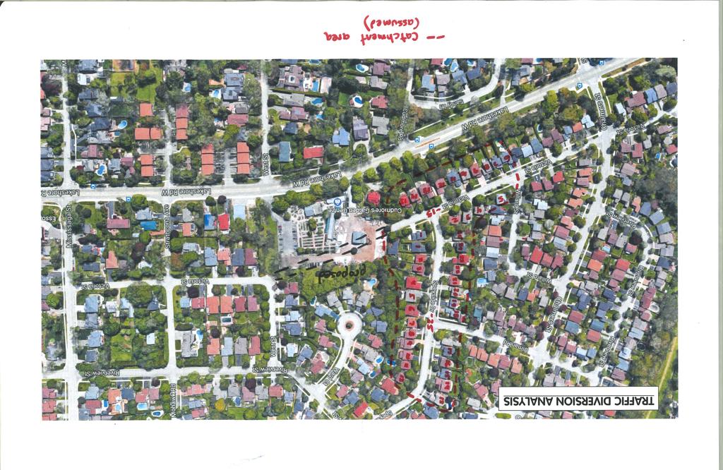
73
74 3171 Lakeshore Road West, Town of Oakville Traffic Impact Study Vogue Wycliffe (Oakville) Ltd. December 2017 APPENDIX H Sight Distance Analysis C.F. Crozier & Associates Inc. Project No

75

76
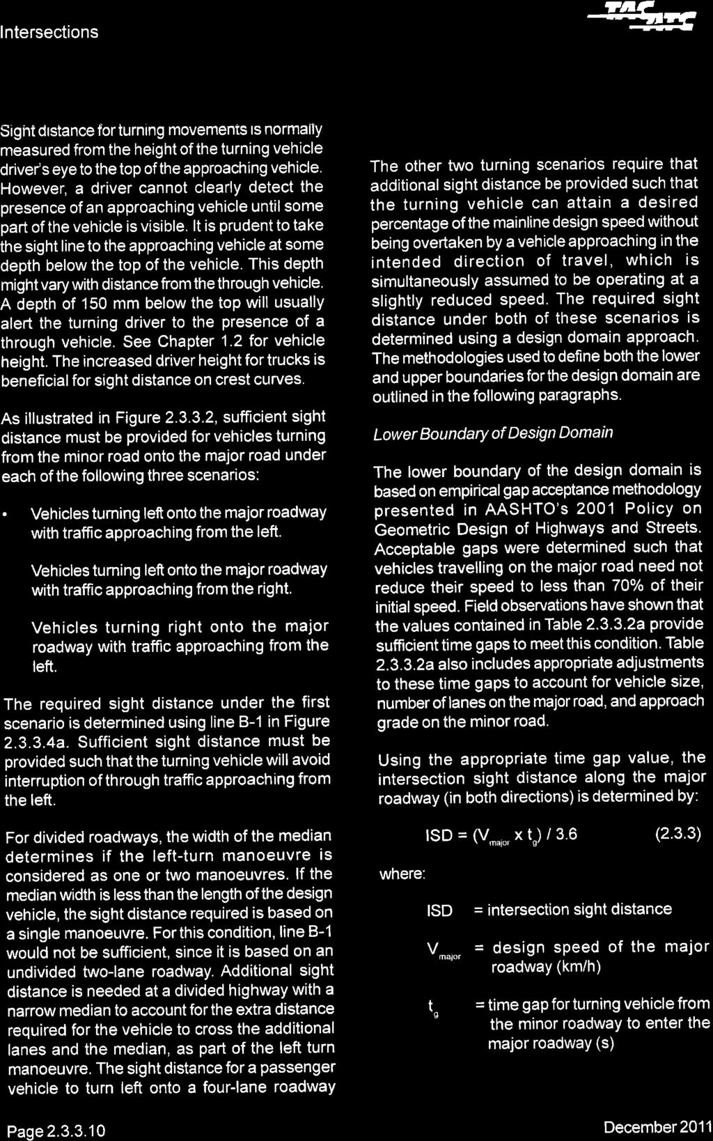
77
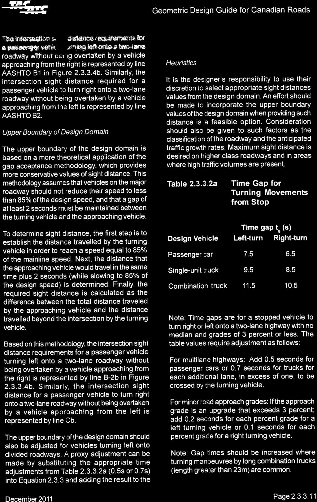
78
79
80 3171 Lakeshore Road West, Town of Oakville Traffic Impact Study Vogue Wycliffe (Oakville) Limited December 2017 FIGURES Figure 1: Figure 2: Figure 3: Figure 4: Figure 5: Figure 6: Figure 7: Figure 8: Figure 9: Site Location Site Plan 2017 Existing Traffic 2022 Future Background Traffic Trip Distribution Proposed Development Trip Assignment Proposed Development Trip Distribution Traffic Diversions Trip Distribution Traffic Diversions 2022 Future Total Traffic C.F. Crozier & Associates Inc. Project No

81
Clean Harbors Canada, Inc.
 Clean Harbors Canada, Inc. Proposed Lambton Landfill Expansion Environmental Assessment Terms of Reference Transportation Assessment St. Clair Township, Ontario September 2009 itrans Consulting Inc. 260
105 Toronto Street South, Markdale Transportation Impact Study. Paradigm Transportation Solutions Limited
 105 Toronto Street South, Markdale Transportation Impact Study Paradigm Transportation Solutions Limited December 2016 Project Summary Project Number 162060 December 2016 Client Zelinka Priamo Ltd 318
BARRHAVEN FELLOWSHIP CRC 3058 JOCKVALE ROAD OTTAWA, ONTARIO TRANSPORTATION BRIEF. Prepared for:
 BARRHAVEN FELLOWSHIP CRC 3058 JOCKVALE ROAD OTTAWA, ONTARIO TRANSPORTATION BRIEF Prepared for: Barrhaven Fellowship CRC 3058 Jockvale Road Ottawa, ON K2J 2W7 December 7, 2016 116-649 Report_1.doc D. J.
TRAFFIC IMPACT STUDY DERRY GREEN CORPORATE BUSINESS PARK MILTON SECONDARY PLAN MODIFICATION
 TRAFFIC IMPACT STUDY DERRY GREEN CORPORATE BUSINESS PARK MILTON SECONDARY PLAN MODIFICATION TRAFFIC IMPACT STUDY DERRY GREEN CORPORATE BUSINESS PARK MILTON SECONDARY PLAN MODIFICATION DECEMBER 24 UPDATED
RICHMOND OAKS HEALTH CENTRE 6265 PERTH STREET OTTAWA, ONTARIO TRANSPORTATION BRIEF. Prepared for: Guycoki (Eastern) Limited.
 Limited.") RICHMOND OAKS HEALTH CENTRE 6265 PERTH STREET OTTAWA, ONTARIO TRANSPORTATION BRIEF Prepared for: Guycoki (Eastern) Limited June 16, 2016 116-638 Brief_1.doc D. J. Halpenny & Associates Ltd. Consulting
RICHMOND OAKS HEALTH CENTRE 6265 PERTH STREET OTTAWA, ONTARIO TRANSPORTATION BRIEF Prepared for: Guycoki (Eastern) Limited June 16, 2016 116-638 Brief_1.doc D. J. Halpenny & Associates Ltd. Consulting
RE: A Traffic Impact Statement for a proposed development on Quinpool Road
 James J. Copeland, P.Eng. GRIFFIN transportation group inc. 30 Bonny View Drive Fall River, NS B2T 1R2 May 31, 2018 Ellen O Hara, P.Eng. Project Engineer DesignPoint Engineering & Surveying Ltd. 200 Waterfront
West Hills Shopping Centre Lowe s Expansion Traffic Impact Study
 West Hills Shopping Centre Lowe s Expansion Traffic Impact Study Prepared for: Armel Corporation January 2015 Paradigm Transportation Solutions Ltd. 22 King Street South, Suite 300 Waterloo ON N2J 1N8
TIMBERVINE TRANSPORTATION IMPACT STUDY FORT COLLINS, COLORADO JANUARY Prepared for:
 TIMBERVINE TRANSPORTATION IMPACT STUDY FORT COLLINS, COLORADO JANUARY 2014 Prepared for: Hartford Companies 1218 W. Ash Street Suite A Windsor, Co 80550 Prepared by: DELICH ASSOCIATES 2272 Glen Haven Drive
GASOLINE SERVICE STATION 1618, 1622 ROGER STEVENS DRIVE OTTAWA, ONTARIO TRANSPORTATION IMPACT ASSESSMENT. Prepared for:
 GASOLINE SERVICE STATION 1618, 1622 ROGER STEVENS DRIVE OTTAWA, ONTARIO TRANSPORTATION IMPACT ASSESSMENT Prepared for: Invecta Development (Ottawa) Corporation 758 Shanks Height Milton, ON L9T 7P7 May
Trafalgar Road & Lower Base Line Transportation Study Ontario Inc.
 Trafalgar Road & Lower Base Line Transportation Study 1255723 Ontario Inc. Trafalgar Road & Lower Base Line Transportation Study 1255723 Ontario Inc. 1465 Pickering Parkway Suite 200 Pickering ON L1V 7G7
Technical Memorandum. To: From: Date: October 14 th, 2018 Project #: 1302 Project Name: Subject: Distribution:
 Technical Memorandum To: Tom Hanrahan Jeff Sharp From: Date: October 14 th, 2018 Project #: 1302 Project Name: Subject: Distribution: Barrie Lockhart Road LP Conformity Review Scott Young Sorbara Group
INDUSTRIAL DEVELOPMENT
 INDUSTRIAL DEVELOPMENT Traffic Impact Study Plainfield, Illinois August 2018 Prepared for: Seefried Industrial Properties, Inc. TABLE OF CONTENTS Executive Summary 2 Introduction 3 Existing Conditions
King County Metro. Columbia Street Transit Priority Improvements Alternative Analysis. Downtown Southend Transit Study. May 2014.
 King County Metro Columbia Street Transit Priority Improvements Alternative Analysis Downtown Southend Transit Study May 2014 Parametrix Table of Contents Introduction... 1 Methodology... 1 Study Area...
Traffic Impact Study Proposed Residential Development (Watson Parkway North - Starwood Drive Node, City of Guelph)
") Traffic Impact Study Proposed Residential Development (Watson Parkway North - Starwood Drive Node, City of Guelph) Prepared By: 332 Lorne Avenue East Stratford ON N5A 6S4 Prepared for: Paul Kemper, President
Traffic Impact Study Proposed Residential Development (Watson Parkway North - Starwood Drive Node, City of Guelph) Prepared By: 332 Lorne Avenue East Stratford ON N5A 6S4 Prepared for: Paul Kemper, President
MERIVALE PRIORITY SQUARE 2852 MERIVALE ROAD CITY OF OTTAWA TRANSPORTATION BRIEF. Prepared for: ONT Inc. 25 Winding Way Nepean, Ontario K2C 3H1
 MERIVALE PRIORITY SQUARE 2852 MERIVALE ROAD CITY OF OTTAWA TRANSPORTATION BRIEF Prepared for: 2190986ONT Inc. 25 Winding Way Nepean, Ontario K2C 3H1 October 6, 2010 110-502 Report_1.doc D. J. Halpenny
King Soopers #116 Thornton, Colorado
 Traffic Impact Study King Soopers #116 Thornton, Colorado Prepared for: Galloway & Company, Inc. T R A F F I C I M P A C T S T U D Y King Soopers #116 Thornton, Colorado Prepared for Galloway & Company
King Street & Wyman Road Transportation Impact Study & Transportation Demand Management. Paradigm Transportation Solutions Limited
 King Street & Wyman Road Transportation Impact Study & Transportation Demand Management Paradigm Transportation Solutions Limited April 28 Project Summary Project Number 822 April 28 Client RISE Commercial
EXECUTIVE SUMMARY. The following is an outline of the traffic analysis performed by Hales Engineering for the traffic conditions of this project.
 EXECUTIVE SUMMARY This study addresses the traffic impacts associated with the proposed Shopko redevelopment located in Sugarhouse, Utah. The Shopko redevelopment project is located between 1300 East and
DEVELOPMENT PROPERTY 1627 MAXIME STREET CITY OF OTTAWA TRANSPORTATION OVERVIEW. Prepared for: Subhas Bhargava. July 9, Overview_1.
 DEVELOPMENT PROPERTY 1627 MAXIME STREET CITY OF OTTAWA TRANSPORTATION OVERVIEW Prepared for: Subhas Bhargava July 9, 2015 115-620 Overview_1.doc D. J. Halpenny & Associates Ltd. Consulting Transportation
MILLERSVILLE PARK TRAFFIC IMPACT ANALYSIS ANNE ARUNDEL COUNTY, MARYLAND
 MILLERSVILLE PARK TRAFFIC IMPACT ANALYSIS ANNE ARUNDEL COUNTY, MARYLAND Prepared for: Department of Public Works Anne Arundel County Prepared by: URS Corporation 4 North Park Drive, Suite 3 Hunt Valley,
Re: Cyrville Road Car Dealership
 1223 Michael Street, Suite 100, Ottawa, ON K1J 7T2 Tel: 613.738.4160 Fax: 613.739.7105 www.delcan.com February 25, 2013 OUR REF: TO3098TOE Mark Motors of Ottawa 611 Montreal Road Ottawa, ON K1K 0T8 Attention:
Prepared For: Toronto Transit Commission 1138 Bathurst Street Toronto, Ontario M5R 3H2. Prepared By:
 TRAFFIC IMPACT STUDY FOR THE TTC MCNICOLL BUS GARAGE CITY OF TORONTO Prepared For: Toronto Transit Commission 1138 Bathurst Street Toronto, Ontario M5R 3H2 Prepared By: Canada Inc. 4th Floor, 3 Leek Crescent
Craig Scheffler, P.E., PTOE HNTB North Carolina, P.C. HNTB Project File: Subject
 TECHNICAL MEMORANDUM To Kumar Neppalli Traffic Engineering Manager Town of Chapel Hill From Craig Scheffler, P.E., PTOE HNTB North Carolina, P.C. Cc HNTB Project File: 38435 Subject Obey Creek TIS 2022
Traffic Impact Analysis West Street Garden Plots Improvements and DuPage River Park Garden Plots Development Naperville, Illinois
 Traffic Impact Analysis West Street Garden Plots Improvements and DuPage River Park Garden Plots Development Naperville, Illinois Submitted by April 9, 2009 Introduction Kenig, Lindgren, O Hara, Aboona,
MEMO VIA . Ms. Amy Roth DPS Director, City of Three Rivers. To:
 MEMO To: Ms. Amy Roth DPS Director, City of Three Rivers VIA EMAIL From: Michael J. Labadie, PE Julie M. Kroll, PE, PTOE Brandon Hayes, PE, P.Eng. Fleis & VandenBrink Date: January 5, 2017 Re: Proposed
APPENDIX C1 TRAFFIC ANALYSIS DESIGN YEAR TRAFFIC ANALYSIS
 APPENDIX C1 TRAFFIC ANALYSIS DESIGN YEAR TRAFFIC ANALYSIS DESIGN YEAR TRAFFIC ANALYSIS February 2018 Highway & Bridge Project PIN 6754.12 Route 13 Connector Road Chemung County February 2018 Appendix
MINERVA PARK SITE TRAFFIC IMPACT STUDY M/I HOMES. September 2, 2015
 5500 New Albany Road Columbus, Ohio 43054 Phone: 614.775.4500 Fax: 614.775.4800 Toll Free: 1-888-775-EMHT emht.com 2015-1008 MINERVA PARK SITE TRAFFIC IMPACT STUDY M/I HOMES September 2, 2015 Engineers
886 March Road McDonald's Transportation Study
 McDonald's Restaurants of Canada Limited March 2013 886 March Road McDonald's Transportation Study Submitted by: HDR Corporation 100 York Boulevard, Suite 300 Richmond Hill, ON L4B 1J8 (905) 882-4100 www.hdrinc.com
Traffic Impact Analysis. Alliance Cole Avenue Residential Site Dallas, Texas. Kimley-Horn and Associates, Inc. Dallas, Texas.
 Traffic Impact Analysis Alliance Cole Avenue Residential Site Dallas, Texas February 15, 2018 Kimley-Horn and Associates, Inc. Dallas, Texas Project #064524900 Registered Firm F-928 Traffic Impact Analysis
830 Main Street Halifax Regional Municipality
 830 Main Street Halifax Regional Municipality Traffic Impact Statement Final Report Prepared by: GRIFFIN transportation group inc. 30 Bonny View Drive Fall River, NS B2T 1R2 www.griffininc.ca Prepared
December 5, Red Bank Planning Board Municipal Building 90 Monmouth Street Red Bank, NJ 07701
 Dynamic Traffic, LLC www.dynamic-traffic.com 1904 Main Street Lake Como, NJ 07719 T. 732.681.0760 December 5, 2016 Red Bank Planning Board Municipal Building 90 Monmouth Street Red Bank, NJ 07701 Re: Traffic
TRAFFIC IMPACT STUDY FOR ST. JOSEPH'S ELEMENTARY SCHOOL ADDITION
 CATHOLIC DISTRICT SCHOOL BOARD OF EASTERN ONTARIO P.O. 61992 TRAFFIC IMPACT STUDY FOR ST. JOSEPH'S ELEMENTARY SCHOOL ADDITION SEPTEMBER 5, 218 TRAFFIC IMPACT STUDY FOR ST. JOSEPH'S ELEMENTARY SCHOOL ADDITION
November 1, Mr. Jafar Tabrizi President, Tabrizi Rugs 180 Bedford Highway. Traffic Impact Statement BH-1 and BH-2, Southgate Drive, Bedford, NS
 161-12598 Mr. Jafar Tabrizi President, Tabrizi Rugs 180 Bedford Highway Bedford, NS B4A 1C1 [Via Email: tabrizi@tabrizi.com] RE: Traffic Impact Statement Dear Mr. Tabrizi: Plans are being prepared for
Oakbrook Village Plaza City of Laguna Hills
 Oakbrook Village Plaza City of Laguna Hills Traffic Impact Analysis Prepared by: HDR Engineering 3230 El Camino Real, Suite 200 Irvine, CA 92602 October 2012 Revision 3 D-1 Oakbrook Village Plaza Laguna
Construction Staging Area 4 Avenue Road
 REPORT FOR ACTION Construction Staging Area 4 Avenue Road Date: September 27, 2017 To: Toronto and East York Community Council From: Acting Director, Transportation Services, Toronto and East York District
Vanier Parkway and Presland Road Residential Development Transportation Impact Study
 Vanier Parkway and Presland Road Residential Development Transportation Impact Study Final Report (Revised) March 2011 Submitted to: Groupe Lépine Ottawa Project No. 09-1613 Submitted by: Groupe Lépine
RESPONSE TO TRAFFIC IMPACT STUDY COMMENTS
 RESPONSE TO TRAFFIC IMPACT STUDY COMMENTS Proposed Gas Station 40 Arthur Street (Highway 26), Town of the Blue Mountains (Thornbury), County of Grey, Ontario AUGUST 2013 August 27, 2013 MR. REG RUSSWURM
Traffic Feasibility Study
 Traffic Feasibility Study Town Center South Robbinsville Township, Mercer County, New Jersey December 19, 2017 Prepared For Robbinsville Township Department of Community Development 2298 Route 33 Robbinsville,
Re: Residential Development - Ogilvie/Cummings Transportation Overview
 1223 Michael Street, Suite 100, Ottawa, ON K1J 7T2 Tel: 613.738.4160 Fax: 613.739.7105 www.delcan.com March 28, 2012 OUR REF: TO3088TOY Barry J. Hobin & Architects 63 Pamilla Street Ottawa, ON K1S 3K7
2405 Mer Bleue Orleans, (Ottawa), ON Community Transportation Study Mattamy Homes. Prepared By: Stantec Consulting Ltd. Version 2
, ON Community Transportation Study Mattamy Homes. Prepared By: Stantec Consulting Ltd. Version 2") 2405 Mer Bleue Orleans, (Ottawa), ON Community Transportation Study Mattamy Homes Prepared By: Stantec Consulting Ltd. Version 2 April 2014 Stantec Consulting Ltd. 400-1331 Clyde Avenue, Ottawa ON K2C
2405 Mer Bleue Orleans, (Ottawa), ON Community Transportation Study Mattamy Homes Prepared By: Stantec Consulting Ltd. Version 2 April 2014 Stantec Consulting Ltd. 400-1331 Clyde Avenue, Ottawa ON K2C
Traffic Impact Study Speedway Gas Station Redevelopment
 Traffic Impact Study Speedway Gas Station Redevelopment Warrenville, Illinois Prepared For: Prepared By: April 11, 2018 Table of Contents 1. Introduction... 1 2. Existing Conditions... 4 Site Location...
144&176 John St. and 200 John St. & 588 Charlotte St. Hotel and Residential Subdivision Development
 Solmar Development Corp. 144&176 John St. and 2 John St. & 588 Charlotte St. Hotel and Residential Subdivision Development TRANSPORTATION IMPACT STUDY 18145 November 217 LEA Consulting Ltd. Consulting
Location Concept Plan Amendment Recommendation Approved 2011 Concept Plan
 Valley Line West LRT Concept Plan Recommended Amendments Lewis Farms LRT Terminus Site Location Concept Plan Amendment Recommendation Approved 2011 Concept Plan Lewis Farms LRT terminus site, 87 Avenue/West
TRAFFIC IMPACT ANALYSIS RIZZO CONFERENCE CENTER EXPANSION FINAL REPORT
 TRAFFIC IMPACT ANALYSIS RIZZO CONFERENCE CENTER EXPANSION Chapel Hill, North Carolina FINAL REPORT Prepared for: The Town of Chapel Hill, NC Prepared by: Architects-Engineers-Planners, Inc. December 2010
Re: Addendum No. 4 Transportation Overview 146 Mountshannon Drive Ottawa, Ontario
 April 18 th, 2017 Mr. Kevin Yemm Vice President, Land Development Richraft Group of Companies 2280 St. Laurent Boulevard, Suite 201 Ottawa, Ontario (Tel: 613.739.7111 / e-mail: keviny@richcraft.com) Re:
TRAFFIC IMPACT STUDY FOR SONIC DRIVE-IN RESTAURANT. Vallejo, CA. Prepared For:
 TRAFFIC IMPACT STUDY FOR SONIC DRIVE-IN RESTAURANT Vallejo, CA Prepared For: ELITE DRIVE-INS, INC. 2190 Meridian Park Blvd, Suite G Concord, CA 94520 Prepared By: KD Anderson & Associates 3853 Taylor Road,
Downtown One Way Street Conversion Technical Feasibility Report
 Downtown One Way Street Conversion Technical Feasibility Report As part of the City s Transportation Master Plan, this report reviews the technical feasibility of the proposed conversion of the current
L1TILE BEARS DAY CARE TRANSPORTATION IMPACT STUDY FORT COLLINS, COLORADO MAY Prepared for:
 L1TILE BEARS DAY CARE TRANSPORTATION IMPACT STUDY FORT COLLINS, COLORADO MAY 2012 Prepared for: Hillside Construction, Inc. 216 Hemlock Street, Suite B Fort Collins, CO 80534 Prepared by: DELICH ASSOCIATES
TRAFFIC IMPACT ANALYSIS
 TRAFFIC IMPACT ANALYSIS Emerald Isle Commercial Development Prepared by SEPI Engineering & Construction Prepared for Ark Consulting Group, PLLC March 2016 I. Executive Summary A. Site Location The Emerald
Lakeside Terrace Development
 Lakeside Terrace Development City of Barrie, County of Simcoe Traffic Brief for: Type of Document: Final Report Project Number: JDE 1617 Date Submitted: April 29 th, 216 4/29/16 John Northcote, P.Eng.
Lacey Gateway Residential Phase 1
 Lacey Gateway Residential Phase Transportation Impact Study April 23, 203 Prepared for: Gateway 850 LLC 5 Lake Bellevue Drive Suite 02 Bellevue, WA 98005 Prepared by: TENW Transportation Engineering West
TECHNICAL MEMORANDUM. Part A: Introduction
 TECHNICAL MEMORANDUM To: David J. Decker Decker Properties, Inc. 5950 Seminole Centre Ct. Suite 200 Madison, Wisconsin 53711 608-663-1218 Fax: 608-663-1226 www.klengineering.com From: Mike Scarmon, P.E.,
Traffic Impact Statement (TIS)
") Traffic Impact Statement (TIS) Vincentian PUDA Collier County, FL 10/18/2013 Prepared for: Global Properties of Naples Prepared by: Trebilcock Consulting Solutions, PA 2614 Tamiami Trail N, Suite 615 1205
Traffic Impact Statement (TIS) Vincentian PUDA Collier County, FL 10/18/2013 Prepared for: Global Properties of Naples Prepared by: Trebilcock Consulting Solutions, PA 2614 Tamiami Trail N, Suite 615 1205
THE CORNERSTONE APARTMENTS TRAFFIC IMPACT STUDY R&M PROJECT NO
 THE CORNERSTONE APARTMENTS SITUATED AT N/E/C OF STAUDERMAN AVENUE AND FOREST AVENUE VILLAGE OF LYNBROOK NASSAU COUNTY, NEW YORK TRAFFIC IMPACT STUDY R&M PROJECT NO. 2018-089 September 2018 50 Elm Street,
APPENDIX C-2. Traffic Study Supplemental Analysis Memo
 APPENDIX C-2 Traffic Study Supplemental Analysis Memo The Mobility Group Transportation Strategies & Solutions Memorandum To: From: Subject: Tomas Carranza, LADOT Matthew Simons Traffic Review - Revised
APPENDIX E. Traffic Analysis Report
 APPENDIX E Traffic Analysis Report THIS PAGE INTENTIONALLY BLANK EAGLE RIVER TRAFFIC MITIGATION PHASE I OLD GLENN HIGHWAY/EAGLE RIVER ROAD INTERSECTION IMPROVEMENTS TRAFFIC ANALYSIS Eagle River, Alaska
TRANSPORTATION IMPACT STUDY ALCONA SOUTH SECONDARY PLAN SLEEPING LION DEVELOPMENT TOWN OF INNISFIL
 TRANSPORTATION IMPACT STUDY ALCONA SOUTH SECONDARY PLAN SLEEPING LION DEVELOPMENT TOWN OF INNISFIL Prepared For: 1602850 Ontario Ltd. 2800 Highway 7 Vaughan, Ontario L4K 1W8 Prepared By: URS Canada Inc.
Mineola Village Green
 Traffic Impact Analysis Report Mineola Village Green 199 2 nd Street Mineola, New York Prepared for Mineola Metro LLC c/o Lalezarian Properties 1999 Marcus Avenue, Suite 310 Lake Success, NY 11042 Prepared
Environmental Assessment Derry Road and Argentia Road Intersection
 Air and Noise Study Environmental Assessment Derry Road and Argentia Road Intersection Project 11-4295 City of Mississauga, Region of Peel October 17, 2014 1 Region of Peel Environmental Assessment for
TRAFFIC IMPACT ANALYSIS FOR. McDONALD S RESTAURANT IN CARMICAEL Sacramento County, CA. Prepared For:
 TRAFFIC IMPACT ANALYSIS FOR McDONALD S RESTAURANT IN CARMICAEL Sacramento County, CA Prepared For: McDonald s USA, LLC Pacific Sierra Region 2999 Oak Road, Suite 900 Walnut Creek, CA 94597 Prepared By:
Escondido Marriott Hotel and Mixed-Use Condominium Project TRAFFIC IMPACT ANALYSIS REPORT
 Escondido Marriott Hotel and Mixed-Use Condominium Project TRAFFIC IMPACT ANALYSIS REPORT Prepared for Phelps Program Management 420 Sixth Avenue, Greeley, CO 80632 Prepared by 5050 Avenida Encinas, Suite
PROJECT: Wilkinson Road Corridor Improvement Traffic Management Planning Project SUBJECT: Traffic Analysis
 TECHNICAL MEMORANDUM DATE: September 10, 2014 PROJECT 5861.03 NO: PROJECT: Wilkinson Road Corridor Improvement Traffic Management Planning Project SUBJECT: Traffic Analysis TO: Steve Holroyd - District
CHAPTER 9: VEHICULAR ACCESS CONTROL Introduction and Goals Administration Standards
 9.00 Introduction and Goals 9.01 Administration 9.02 Standards 9.1 9.00 INTRODUCTION AND GOALS City streets serve two purposes that are often in conflict moving traffic and accessing property. The higher
Table of Contents INTRODUCTION... 3 PROJECT STUDY AREA Figure 1 Vicinity Map Study Area... 4 EXISTING CONDITIONS... 5 TRAFFIC OPERATIONS...
 Crosshaven Drive Corridor Study City of Vestavia Hills, Alabama Table of Contents INTRODUCTION... 3 PROJECT STUDY AREA... 3 Figure 1 Vicinity Map Study Area... 4 EXISTING CONDITIONS... 5 TRAFFIC OPERATIONS...
Parks and Transportation System Development Charge Methodology
 City of Sandy Parks and Transportation System Development Charge Methodology March, 2016 Background In order to implement a City Council goal the City of Sandy engaged FCS Group in January of 2015 to update
2.0 Development Driveways. Movin Out June 2017
 Movin Out June 2017 1.0 Introduction The proposed Movin Out development is a mixed use development in the northeast quadrant of the intersection of West Broadway and Fayette Avenue in the City of Madison.
Transportation & Traffic Engineering
 Transportation & Traffic Engineering 1) Project Description This report presents a summary of findings for a Traffic Impact Analysis (TIA) performed by A+ Engineering, Inc. for the Hill Country Family
Date: February 7, 2017 John Doyle, Z-Best Products Robert Del Rio. T.E. Z-Best Traffic Operations and Site Access Analysis
 Memorandum Date: February 7, 07 To: From: Subject: John Doyle, Z-Best Products Robert Del Rio. T.E. Z-Best Traffic Operations and Site Access Analysis Introduction Hexagon Transportation Consultants, Inc.
VOA Vista Drive Residential housing Development TIA Project #13915 TABLE OF CONTENTS
 VOA Vista Drive Residential housing Development TIA Project #13915 TABLE OF CONTENTS Executive Summary... 2 Project Background... 2 Conditions... 2 Findings... 3 Recommendations... 4 Introduction... 6
Traffic Impact Study for the proposed. Town of Allegany, New York. August Project No Prepared For:
 Appendix B SRF Traffic Study (Revised November 2005) Draft Environmental Impact Statement University Commons Town of Allegany, Cattaraugus County, NY December 2005 Traffic Impact Study for the proposed
TRAFFIC IMPACT ANALYSIS SHORTBREAD LOFTS 2009 MODIFICATION Chapel Hill, North Carolina
 TRAFFIC IMPACT ANALYSIS SHORTBREAD LOFTS 2009 MODIFICATION Chapel Hill, North Carolina Prepared for: The Town of Chapel Hill, NC Prepared by: Architects-Engineers-Planners, Inc. November 2009 Traffic Impact
TRAFFIC IMPACT STUDY DERRY GREEN CORPORATE BUSINESS PARK MILTON SECONDARY PLAN MODIFICATION
 TRAFFIC IMPACT STUDY DERRY GREEN CORPORATE BUSINESS PARK MILTON SECONDARY PLAN MODIFICATION TRAFFIC IMPACT STUDY DERRY GREEN CORPORATE BUSINESS PARK MILTON SECONDARY PLAN MODIFICATION DECEMBER 2014 UPDATED
Volume 1 Traffic Impact Analysis Turtle Creek Boulevard Dallas, Texas. Kimley-Horn and Associates, Inc. Dallas, Texas.
 Volume 1 Traffic Impact Analysis 2727 Dallas, Texas June 18, 2018 Kimley-Horn and Associates, Inc. Dallas, Texas Project #064523000 Registered Firm F-928 Traffic Impact Analysis 2727 Dallas, Texas Prepared
LCPS Valley Service Center
 Traffic Impact Study LCPS Valley Service Center Loudoun County, Virginia November 4, 2015 Prepared For: Loudoun County Public Schools 21000 Education Court Ashburn, VA 20148 Prepared by: 1140 Connecticut
TABLE OF CONTENTS 1.0 INTRODUCTION AND SUMMARY Purpose of Report and Study Objectives... 2
 TABLE OF CONTENTS 1.0 INTRODUCTION AND SUMMARY 1 1.1 Purpose of Report and Study Objectives... 2 1.2 Executive Summary... 3 1.2.1 Site Location and Study Area... 3 1.2.2 Development Description... 3 1.2.3
1354 Carling Avenue. Community Transportation Study/ Transportation Impact Study
 354 Carling Avenue Community Transportation Study/ Transportation Impact Study prepared for: Holloway Lodging Corporation 69 Quinpool Road, th Floor Halifax, NS B3K 5J7 prepared by: 223 Michael Street
D. J. Halpenny & Associates Ltd. Consulting Transportation Engineers
 D. J. Halpenny & Associates Ltd. Consulting Transportation Engineers August 24, 2015 File: 115-622 Mr. R. Baumann, President The RGB Group 277 Kirchoffer Avenue Ottawa, ON K2A 1Y1 RE: RESIDENTIAL DEVELOPMENT
TRAFFIC SIGNAL DESIGN REPORT KING OF PRUSSIA ROAD & RAIDER ROAD RADNOR TOWNSHIP PENNSYLVANIA
 TRAFFIC SIGNAL DESIGN REPORT KING OF PRUSSIA ROAD & RAIDER ROAD RADNOR TOWNSHIP PENNSYLVANIA PREPARED FOR: UNIVERSITY OF PENNSYLVANIA HEALTH SYSTEM 34 CIVIC CENTER BOULEVARD PHILADELPHIA, PA 1987 (61)
TRAFFIC IMPACT STUDY VICDOM BROCK ROAD PIT EXPANSION
 TRAFFIC IMPACT STUDY VICDOM BROCK ROAD PIT EXPANSION TOWNSHIP OF UXBRIDGE P/N 05-1993 June 2011 Revised -August 2011 Prepared by: Skelton, Brumwell & Associates Inc. 93 Bell Farm Road, Suite 107 Barrie,
TALMONT TOWNHOMES MADISON KENNETH SPA TRAFFIC IMPACT STUDY. Sacramento, CA. Prepared For: MBK Homes. Prepared By:
 TALMONT TOWNHOMES MADISON KENNETH SPA TRAFFIC IMPACT STUDY Sacramento, CA Prepared For: MBK Homes Prepared By: KD Anderson & Associates 3853 Taylor Road, Suite G Loomis, California 95650 (916) 660-1555
TRANSPORTATION STUDY FOR THE 8899 BEVERLY BOULEVARD PROJECT
 DRAFT TRANSPORTATION STUDY FOR THE 8899 BEVERLY BOULEVARD PROJECT WEST HOLLYWOOD, CALIFORNIA NOVEMBER 2013 PREPARED FOR BEVERLY BOULEVARD ASSOCIATION PREPARED BY DRAFT TRANSPORTATION STUDY FOR THE 8899
Proposed Inn at Bellefield Traffic Impact Assessment
 Proposed Inn at Bellefield Traffic Impact Assessment Town of Hyde Park Dutchess County, New York Prepared for: T-Rex Hyde Park Owner LLC 500 Mamroneck Avenue, Suite 300 Harrison, NY 10528 June 21, 2017
Traffic Impact Study for Proposed Olive Boulevard Development
 Traffic Impact Study for Proposed 11330 Olive Boulevard Development Creve Coeur, Missouri July 7, 2017 Prepared For: 11330 Olive Boulevard Development 11330 Olive Boulevard Creve Coeur, Missouri 63141
TRAFFIC IMPACT ANALYSIS. for MILTON SQUARE
 TRAFFIC IMPACT ANALYSIS for MILTON SQUARE US Route 7 Milton, Vermont March 5, 2008 LAMOUREUX & DICKINSON 14 Morse Drive Essex Junction, Vermont 05452 (802) 878-4450 Traffic Impact Assessment EXECUTIVE
APPENDIX B Traffic Analysis
 APPENDIX B Traffic Analysis Rim of the World Unified School District Reconfiguration Prepared for: Rim of the World School District 27315 North Bay Road, Blue Jay, CA 92317 Prepared by: 400 Oceangate,
Airport Road Improvements
 Airport Road Improvements October 2015 ENVIRONMENTAL STUDY REPORT Airport Road from 1.0 km north of Mayfield to 0.6 km north of King Street Town of Caledon D TRAFFIC STUDY & ROUNDABOUT EVALUATIONS Airport
TRAFFIC IMPACT DATA. Dillons #98 On-Site Relocation
 TRAFFIC IMPACT DATA For Dillons #98 On-Site Relocation COMMERCIAL DEVELOPMENT 1740 Massachusetts Street Lawrence, KS Revised April 6, 2011 Prepared by: Pickering Firm, Inc. Introduction The project site
TRAFFIC IMPACT STUDY. USD #497 Warehouse and Bus Site
 TRAFFIC IMPACT STUDY for USD #497 Warehouse and Bus Site Prepared by: Jason Hoskinson, PE, PTOE BG Project No. 16-12L July 8, 216 145 Wakarusa Drive Lawrence, Kansas 6649 T: 785.749.4474 F: 785.749.734
TRAFFIC DATA. Existing Derousse Ave./River Rd. AM LOS Analysis Existing Derousse Ave./River Rd. PM LOS Analysis
 Appendix E NJ TRANSIT Pennsauken Junction Transit Center and Park & Ride RiverLINE and Atlantic City Line Pennsauken Township, Camden County, New Jersey TRAFFIC DATA Background Traffic Information for
Paisley & Whitelaw - Paisley Park OPA / ZBA for Mixed Density Residential Use
 Paisley & Whitelaw - Paisley Park OPA / ZBA for Mixed Density Residential Use Transportation Impact Study City of Guelph Prepared for: Armel Corporation August 2018 Table of Contents 1 Introduction...
IV. ENVIRONMENTAL IMPACT ANALYSIS K.2. PARKING
 IV. ENVIRONMENTAL IMPACT ANALYSIS K.2. PARKING ENVIRONMENTAL SETTING The following analysis summarizes the findings and conclusions of the Traffic Analysis (Traffic Study), prepared by The Mobility Group,
HUMC/Mountainside Hospital Redevelopment Plan
 Traffic and Parking Analysis HUMC/Mountainside Hospital Redevelopment Plan in Glen Ridge Borough and Montclair Township PREPARED FOR H2M 119 Cherry Hill Road, Suite 110 Parsippany, NJ 07054 862.207.5900
One Harbor Point Residential
 Residential Gig Harbor, WA Transportation Impact Analysis January 23, 2017 Prepared for: Neil Walter Company PO Box 2181 Tacoma, WA 98401 Prepared by: TENW Transportation Engineering NorthWest 11400 SE
TRANSPORTATION REVIEW
 TRANSPORTATION REVIEW - PROPOSED MIX OF LAND USES IS CONSISTENT WITH THE CITY S UNDER THE GRANVILLE BRIDGE POLICIES THAT AIM TO MEET NEIGHBOURING RESIDENTS SHOPPING NEEDS AND REDUCE RELIANCE ON AUTOMOBILE
Section 5.0 Traffic Information
 Section 5.0 Traffic Information 10.0 TRANSPORTATION MDM Transportation Consultants, Inc. (MDM) has prepared an evaluation of transportation impacts for the proposed evaluation for the expansion of the
NEWCASTLE MIDDLE SCHOOL Traffic Impact Analysis
 Gibson Traffic Consultants 2802 Wetmore Avenue Suite 220 Everett, WA 98201 425.339.8266 NEWCASTLE MIDDLE SCHOOL Traffic Impact Analysis Prepared for: Renton School District Jurisdiction: City of Newcastle
LAWRENCE TRANSIT CENTER LOCATION ANALYSIS 9 TH STREET & ROCKLEDGE ROAD / 21 ST STREET & IOWA STREET LAWRENCE, KANSAS
 LAWRENCE TRANSIT CENTER LOCATION ANALYSIS 9 TH STREET & ROCKLEDGE ROAD / 21 ST STREET & IOWA STREET LAWRENCE, KANSAS TRAFFIC IMPACT STUDY FEBRUARY 214 OA Project No. 213-542 TABLE OF CONTENTS 1. INTRODUCTION...
4.14 TRANSPORTATION AND CIRCULATION
 4.14 TRANSPORTATION AND CIRCULATION 4.14.1 Summary Table 4.14-1 summarizes the identified environmental impacts, proposed mitigation measures, and residual impacts of the proposed project with regard to
Provide an overview of the development proposal including projected site traffic volumes;
 December 19, 2013 File: 163600935 Attention: Troy Elliott Carl Elliott Limited 15-1831 Robertson Road PO Box 11117 Nepean, Ontario K1H 7T8 Dear Mr. Elliott, Reference: 2235 and 2265 Robertson Road Transportation
Traffic Engineering Study
 Traffic Engineering Study Bellaire Boulevard Prepared For: International Management District Technical Services, Inc. Texas Registered Engineering Firm F-3580 November 2009 Executive Summary has been requested