TRAFFIC IMPACT STUDY VICDOM BROCK ROAD PIT EXPANSION
|
|
|
- Barbra Walton
- 5 years ago
- Views:
Transcription
1
2 TRAFFIC IMPACT STUDY VICDOM BROCK ROAD PIT EXPANSION TOWNSHIP OF UXBRIDGE P/N June 2011 Revised -August 2011 Prepared by: Skelton, Brumwell & Associates Inc. 93 Bell Farm Road, Suite 107 Barrie, Ontario L4M 5G1 Telephone: (705) FAX: (705) Prepared for: Vicdom Sand and Gravel (Ontario) Ltd.
3 TABLE OF CONTENTS Page 1.0 INTRODUCTION... 1 Figure 1 Location CONTEXT TRAVEL DEMAND Horizon Year and Time Period of Analysis Historic Traffic Volumes... 3 Figure 2 Haul Routes... 4 Table 1 Historic Traffic Volumes Detailed Traffic Counts Projected Background Traffic... 6 Table 2 Projected Background Traffic Volumes Site Generated Traffic Traffic Volume Directional Distribution... 7 Table 3A - Traffic Distribution at Pit Entrance/Brock Road Average Production... 8 Table 3B Traffic Distribution at Pit Entrance/Brock Road Maximum Production EVALUATION OF IMPACTS Methodology Analysis CONCLUSIONS APPENDIX A Traffic Count Information APPENDIX B Site Generated Traffic APPENDIX C Level of Service Definition APPENDIX D Intersection Analysis APPENDIX E Curriculum Vitae Scott Brumwell, P. Eng.
4 TRAFFIC IMPACT STUDY VICDOM BROCK ROAD PIT EXPANSION TOWNSHIP OF UXBRIDGE P/N August INTRODUCTION Vicdom Sand and Gravel (Ontario) Ltd. (Vicdom) has owned an operated a gravel pit just south of Coppins Corners for many years. The existing 220 hectare pit includes three properties licenced under the Aggregate Resources Act, known as the Main Pit, Reagan Pit and Milne Pit. It is located between Brock Road (Regional Road 1) and Concession 4 just south of Regional Road 21as shown on Figure 1 - Location. The existing pits functions as one operation, sharing aggregate processing facilities and one main entrance/exit from Brock Road. Vicdom s objective is to licence an additional 49 hectares of land in Part of Lots 10 and 11, Concession 4 of the Township of Uxbridge south and east of the existing licences. Following approval of the additional lands, Vicdom intends to amalgamate the new licence with the Main and Regan licences. The Milne pit is nearing depletion and therefore will not be included in the amalgamation. The existing entrance from Brock Road will serve the amalgamated operation, and no increase in the maximum annual tonnage of material to be extracted from the expanded pit is proposed. This study is intended to address policies and support applications for amendments to the Region of Durham Official Plan and the Township of Uxbridge Official Plan and Zoning By-law, and the application under the Aggregate Resources Act for licencing of the additional lands. Traffic Impact Study 1 Skelton, Brumwell & Associates Inc. P/N August 2011
5
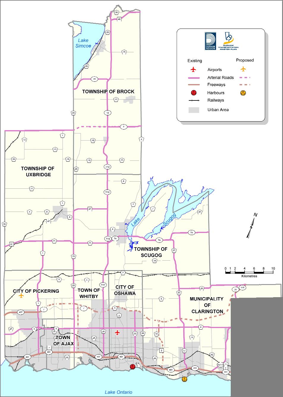
6 2.0 CONTEXT The market area for the Brock Road Pit is Durham Region and the eastern GTA particularly southern York Region. Primary haul routes from the pit are shown on Figure 2- Haul Routes. Traffic from the pit travels south along Brock Road other Regional Roads or Provincial Highways or north to Regional Road 21 then west to Highway 47 or east to Regional Road 23 or Highway 7/12. All of these roads are designated Type A Arterial Roads, part of the Strategic Goods Movement Network in the Durham Region Official Plan, The entrance to the pit, located approximately 1 kilometre south of Regional Road 21 was constructed in 1962 In 1984 the entrance was widened and a right turn taper and right turn acceleration lane added. Brock Road in the vicinity of the entrance has a two lane cross section with wide gravel shoulders. The expanded pit will continue to utilize the existing entrance and haul routes. 3.0 TRAVEL DEMAND 3.1 Horizon Year and Time Period of Analysis It is assumed for the purposes of this study that the expansion to the pit will be approved in A study horizon of 10 years to 2019 has been used. 3.2 Historic Traffic Volumes The Region of Durham provides Average Annual Daily Traffic (AADT) volumes for Regional Roads on its web site. The AADT s for Brock Road in two locations are shown on Table 1 and included in Appendix A. The traffic count locations were 200 metres north of Regional Road 5, approximately 7 kilometres south of the site entrance, and between Regional Road 21 and Highway 47 north of the site. The annual rate of change in the AADT s for Brock Road between 1999/2000 and 2010 varied widely. However, the average change the over the 10 or 11 year period varied from about 6% south of the site in the City of Pickering to about 4% north of the site. Population, and therefore traffic volume, has grown faster in the urban area of Pickering than in the rural area in the vicinity of the site. The Growth Plan for the Greater Golden Horseshoe, 2006, prepared under the Places to Grow Act 2005, directs that future population growth in Durham be concentrated in the urban centres along Lake Ontario. Therefore, the increase in Traffic Impact Study 3 Skelton, Brumwell & Associates Inc. P/N August 2011
7
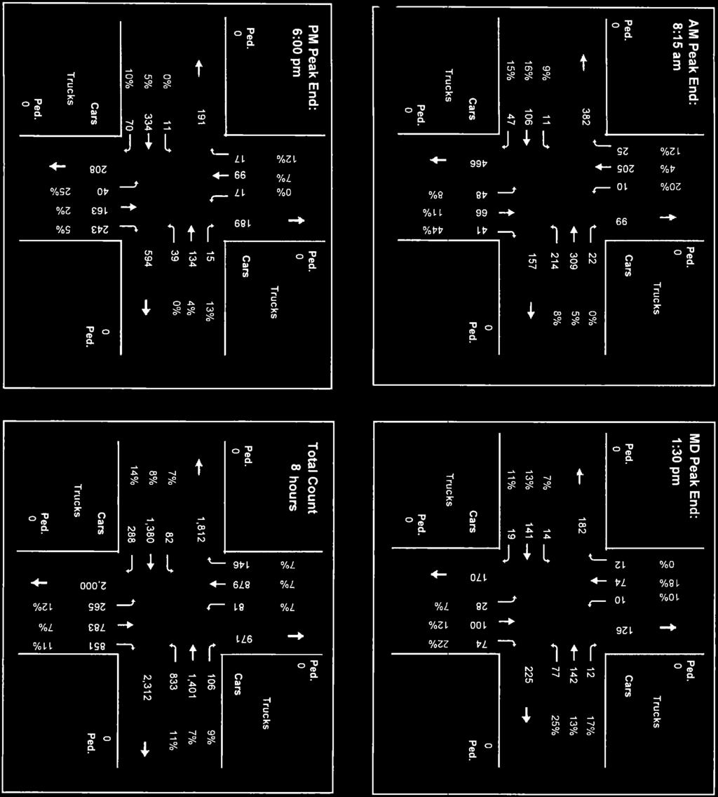
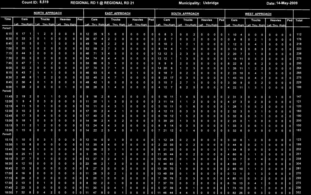
8 traffic volume on Brock Road in the rural area will continue to be less than in the Urban area. It is assumed that the AADT for Brock Road in the vicinity of the site will increase by an average of approximately 3% through the study period. Table 1 Historic Traffic Volumes Year 200 m North of RR Brock Road 200m South of Hwy 47 Junction Average Annual Increase 6% 4% 3.3 Detailed Traffic Counts Detailed traffic counts were requested from the Region of Durham for the intersection of Brock Road and Regional Road 21. The counts were taken on Thursday May 14, This data is included in Appendix A. The detailed count shows that on Brock Road south of Regional Road 21 (Highway 47) the peak AM hour traffic volume occurred between 7:15 and 8:15 am when there was a total of 621 vehicles, or 16.7% of the 2009 AADT. South bound traffic represents 75% of the total volume during that hour. The PM Peak Hour occurred between 5:00 and 6:00 pm when the total number of vehicles was 654, or 17.6% of the 2009 AADT. North bound traffic was 68% of the total. The Traffic Impact Study 5 Skelton, Brumwell & Associates Inc. P/N August 2011
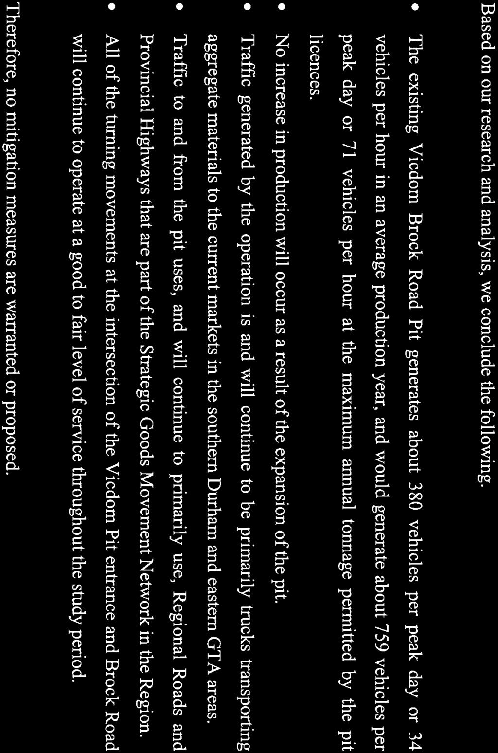
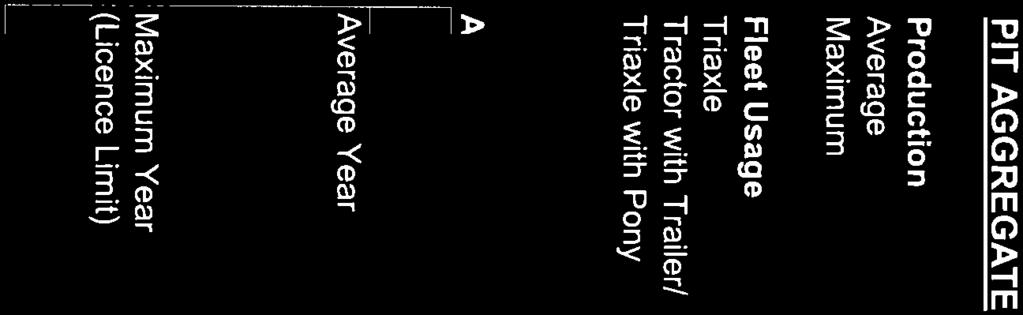
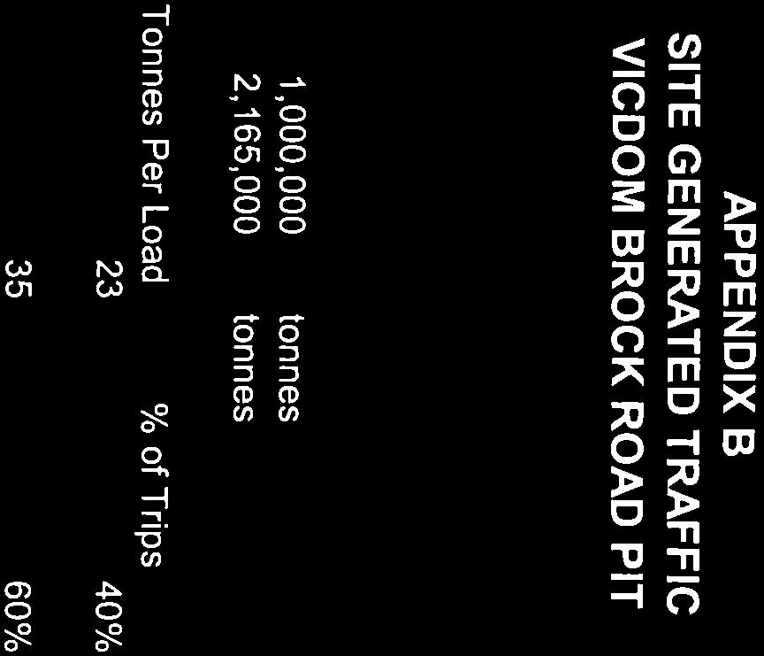
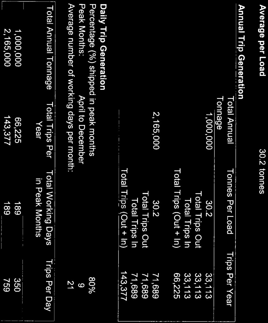
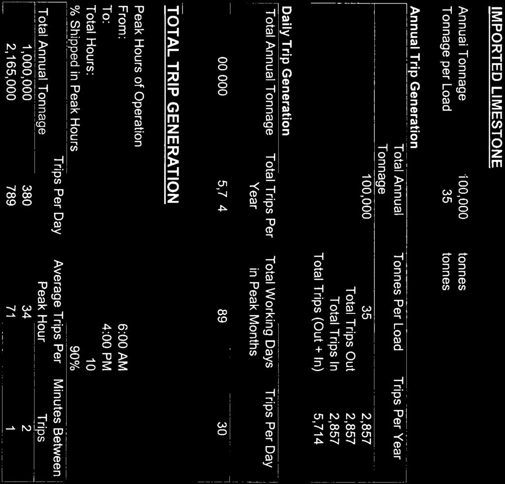
9 directional distribution of traffic in the AM and PM peak hours suggest that Regional Road 21 is primarily used by commuters from areas to the north, east and west travelling to and from the urban areas to the south. Given the peak hours for shipping from the pit, as described below, the AM Peak Hour will be analysed as the most relevant condition for the pit expansion. The directional split for the AM Peak Hour is 75% south bound and 25% north bound. 3.4 Projected Background Traffic Based on an average growth in traffic volume of 3%, the future traffic volumes on Brock Road are shown in Table 2. Table 2 Projected Background Traffic Volumes AADT Peak Hour Northbound Southbound Location Year Annual Increase % of AADT Volume 3% 25% 75% Pit Entrance , % , % , % Site Generated Traffic Traffic Volume Traffic volumes for the operation were calculated based on the operational and transportation information provided by the Bruno Giordano of Vicdom Sand and Gravel. The amount of material shipped from the site will vary from year to year depending on market conditions. However, it cannot exceed the maximum tonnage permitted by the Licence under the Aggregate Resources Act. The combined licences for the existing operation permit a maximum of 2, tonnes per year. No increase in maximum tonnage is requested relative to the expansion. The annual average production is 1,000,000 Tonnes. Calculations for both the average and maximum tonnage are included in Appendix B. Traffic Impact Study 6 Skelton, Brumwell & Associates Inc. P/N August 2011
10 Eighty percent of the annual tonnage is shipped from April 1 st to December 31 st each year due to reduced demand in the winter. The traffic generated by the operation is, and will continue, to be comprised primarily of trucks transporting the aggregate products from the pit to customers, with relatively small numbers of employee and service vehicles. Additional truck traffic will be generated by the importation of limestone products for resale. The truck traffic generated by gravel pits tends to be distributed relatively evenly throughout the day. While the hours of operation for the pit are between 6:00 and 6:00 pm, for the purposes of this analysis it is assumed that 90% of the daily volume will shipped during the 10 hour period between 6:00 am and 4:00 pm. The peak traffic volume from the pit is calculated to be 380 vehicles per day or 34 vehicles per hour at the average annual production of 1,000,000 tonnes and 759 vehicles per day or 71 vehicles per hour at the maximum annual production of 2, tonnes. There will be no increase in traffic relative to the expansion of the pit Directional Distribution Based on current markets, the current and predicted directional distribution of traffic is 60% to and from the south and 40% to and from the north. The total peak hour traffic volumes for average and maximum production with directional distribution are shown in Tables 3A and 3B. Traffic Impact Study 7 Skelton, Brumwell & Associates Inc. P/N August 2011
11 Table 3A - Traffic Distribution at Pit Entrance/Brock Road Average Production Existing Pit (2010) Total Background Traffic (2012) 661 Expanded Pit (2012) Total Background Traffic (2022) 900 Expanded Pit (2022) Total Table 3B Traffic Distribution at Pit Entrance/Brock Road Maximum Production Background Traffic (2010) 621 vph Right (60%) Left (40%) Right (40%) Left (60%) Existing Pit (2010) Total Background Traffic (2012) 661 Expanded Pit (2012) Total Background Traffic (2022) 900 Expanded Pit (2022) Total Traffic Impact Study 8 Skelton, Brumwell & Associates Inc. P/N August 2011
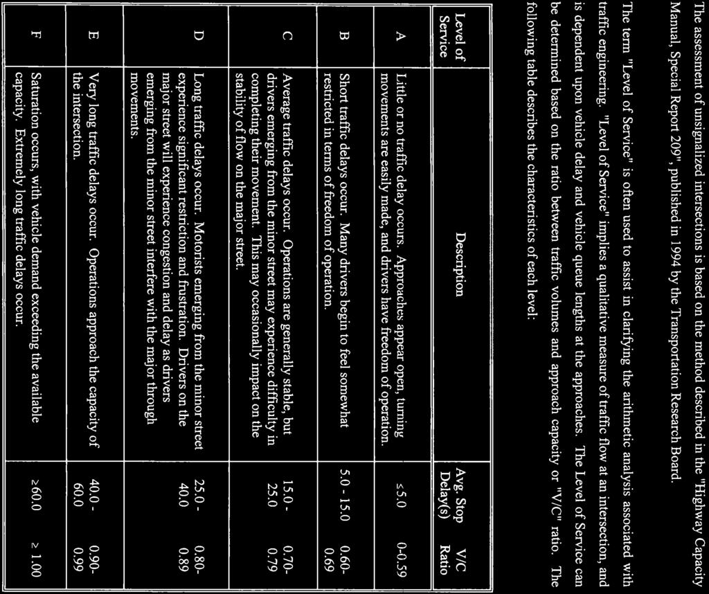
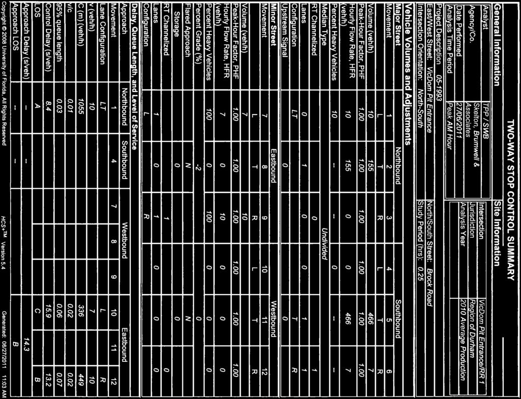
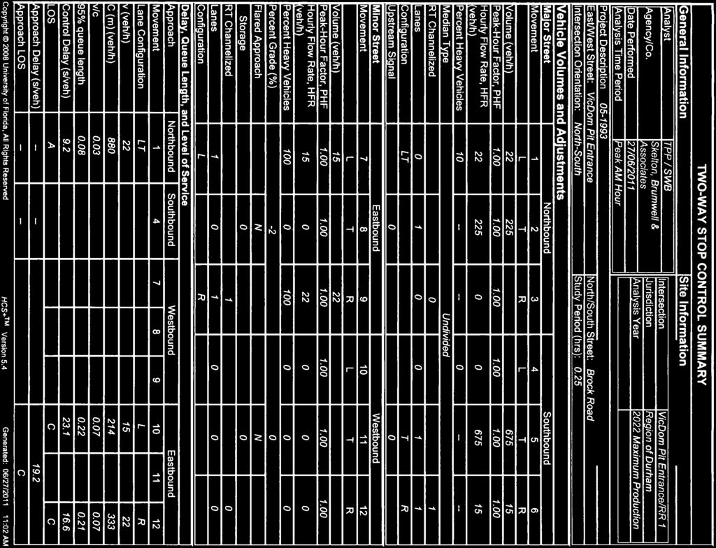
12 4.0 EVALUATION OF IMPACTS 4.1 Methodology The intersections of the pit entrance with Brock Road was evaluated using the method described in the Highway Capacity Manual 1. The level of service definitions area included in Appendix C. McTrans Traffic Software was used to carry out the calculations. The objective of the analysis is to identify "problem" intersections and traffic movements. For rural areas, "problem" intersections and movements are typically defined as those where: the overall intersection volume/capacity (v/c) ratio exceeds 0.70; or, the individual movement v/c ratio exceeds 0.70; or, an exclusive turning movement generates queues which exceed the available storage space. Generally, traffic impacts should be mitigated when site generated traffic creates or worsens a "problem" situation. 4.2 Analysis As shown in Tables 3A and 3B, all turning movements related to the Vicdom Brock Road Pit entrance will continue to have a good to fair level of service throughout the study period at the average and maximum production rates. The Summary sheets are included in Appendix D. The level of service of the intersection based on average production in 2010 is A for northbound Brock Road and B and C for right and left turns respectively from the entrance. Whereas the level of service of the intersection based on maximum production in 2022 is A for northbound Brock Road and C for right and left turns from the entrance. 1 Highway Capacity Manual Special Report 209 Third Edition@ Transportation Research Board, National Research Council, Washington, D.C., Traffic Impact Study 9 Skelton, Brumwell & Associates Inc. P/N August 2011


13

14
15
16

17


18


19

20
21

22
23

24

25


26

27
Clean Harbors Canada, Inc.
 Clean Harbors Canada, Inc. Proposed Lambton Landfill Expansion Environmental Assessment Terms of Reference Transportation Assessment St. Clair Township, Ontario September 2009 itrans Consulting Inc. 260
HIGHWAY 28 FUNCTIONAL DESIGN
 HIGHWAY 28 FUNCTIONAL DESIGN PUBLIC OPEN HOUSE #1 WEDNESDAY, MARCH 12, 2014 Stantec Presenters: Brad Vander Heyden, Project Engineer Neal Cormack, Project Manager Dave Parker, Project Engineer Beth Thola,
Alpine Highway to North County Boulevard Connector Study
 Alpine Highway to North County Boulevard Connector Study prepared by Avenue Consultants March 16, 2017 North County Boulevard Connector Study March 16, 2017 Table of Contents 1 Summary of Findings... 1
BARRHAVEN FELLOWSHIP CRC 3058 JOCKVALE ROAD OTTAWA, ONTARIO TRANSPORTATION BRIEF. Prepared for:
 BARRHAVEN FELLOWSHIP CRC 3058 JOCKVALE ROAD OTTAWA, ONTARIO TRANSPORTATION BRIEF Prepared for: Barrhaven Fellowship CRC 3058 Jockvale Road Ottawa, ON K2J 2W7 December 7, 2016 116-649 Report_1.doc D. J.
APPENDIX C1 TRAFFIC ANALYSIS DESIGN YEAR TRAFFIC ANALYSIS
 APPENDIX C1 TRAFFIC ANALYSIS DESIGN YEAR TRAFFIC ANALYSIS DESIGN YEAR TRAFFIC ANALYSIS February 2018 Highway & Bridge Project PIN 6754.12 Route 13 Connector Road Chemung County February 2018 Appendix
LAWRENCE TRANSIT CENTER LOCATION ANALYSIS 9 TH STREET & ROCKLEDGE ROAD / 21 ST STREET & IOWA STREET LAWRENCE, KANSAS
 LAWRENCE TRANSIT CENTER LOCATION ANALYSIS 9 TH STREET & ROCKLEDGE ROAD / 21 ST STREET & IOWA STREET LAWRENCE, KANSAS TRAFFIC IMPACT STUDY FEBRUARY 214 OA Project No. 213-542 TABLE OF CONTENTS 1. INTRODUCTION...
Bennett Pit. Traffic Impact Study. J&T Consulting, Inc. Weld County, Colorado. March 3, 2017
 Bennett Pit Traffic Impact Study J&T Consulting, Inc. Weld County, Colorado March 3, 217 Prepared By: Sustainable Traffic Solutions, Inc. http://www.sustainabletrafficsolutions.com/ Joseph L. Henderson,
Proposed Pit Development
 July 5, 2017 via email: sam@greenwoodconst.ca CCTA File 114239 Sam Greenwood Greenwood Aggregates 205467 County Road 109 Amaranth, ON L9W 0V1 Re: Proposed Violet Hill Gravel Pit, Town of Mono Traffic Review
TRAFFIC IMPACT ASSESSMENT PART OF AN ENVIRONMENTAL IMPACT ASSESSMENT FOR THE KEBRAFIELD ROODEPOORT COLLIERY IN THE PULLEN S HOPE AREA
 TRAFFIC IMPACT ASSESSMENT PART OF AN ENVIRONMENTAL IMPACT ASSESSMENT FOR THE KEBRAFIELD ROODEPOORT COLLIERY IN THE PULLEN S HOPE AREA 20 March 2014 Report prepared by: Corli Havenga Transportation Engineers
RICHMOND OAKS HEALTH CENTRE 6265 PERTH STREET OTTAWA, ONTARIO TRANSPORTATION BRIEF. Prepared for: Guycoki (Eastern) Limited.
 Limited.") RICHMOND OAKS HEALTH CENTRE 6265 PERTH STREET OTTAWA, ONTARIO TRANSPORTATION BRIEF Prepared for: Guycoki (Eastern) Limited June 16, 2016 116-638 Brief_1.doc D. J. Halpenny & Associates Ltd. Consulting
RICHMOND OAKS HEALTH CENTRE 6265 PERTH STREET OTTAWA, ONTARIO TRANSPORTATION BRIEF Prepared for: Guycoki (Eastern) Limited June 16, 2016 116-638 Brief_1.doc D. J. Halpenny & Associates Ltd. Consulting
King Soopers #116 Thornton, Colorado
 Traffic Impact Study King Soopers #116 Thornton, Colorado Prepared for: Galloway & Company, Inc. T R A F F I C I M P A C T S T U D Y King Soopers #116 Thornton, Colorado Prepared for Galloway & Company
MERIVALE PRIORITY SQUARE 2852 MERIVALE ROAD CITY OF OTTAWA TRANSPORTATION BRIEF. Prepared for: ONT Inc. 25 Winding Way Nepean, Ontario K2C 3H1
 MERIVALE PRIORITY SQUARE 2852 MERIVALE ROAD CITY OF OTTAWA TRANSPORTATION BRIEF Prepared for: 2190986ONT Inc. 25 Winding Way Nepean, Ontario K2C 3H1 October 6, 2010 110-502 Report_1.doc D. J. Halpenny
MILLERSVILLE PARK TRAFFIC IMPACT ANALYSIS ANNE ARUNDEL COUNTY, MARYLAND
 MILLERSVILLE PARK TRAFFIC IMPACT ANALYSIS ANNE ARUNDEL COUNTY, MARYLAND Prepared for: Department of Public Works Anne Arundel County Prepared by: URS Corporation 4 North Park Drive, Suite 3 Hunt Valley,
Airport Road Improvements
 Airport Road Improvements October 2015 ENVIRONMENTAL STUDY REPORT Airport Road from 1.0 km north of Mayfield to 0.6 km north of King Street Town of Caledon D TRAFFIC STUDY & ROUNDABOUT EVALUATIONS Airport
FLAMBOROUGH QUARRY HAUL ROUTE STUDY HAUL ROUTE VIBRATION REPORT. itrans Consulting Inc 100 York Boulevard Richmond Hill, Ontario L4B 1J8
 FINAL REPORT FLAMBOROUGH QUARRY HAUL ROUTE STUDY HAUL ROUTE VIBRATION REPORT Project Number: #W08-5107A August 28, 2008 SUBMITTED TO: Tara Erwin itrans Consulting Inc 100 York Boulevard Richmond Hill,
Date: February 7, 2017 John Doyle, Z-Best Products Robert Del Rio. T.E. Z-Best Traffic Operations and Site Access Analysis
 Memorandum Date: February 7, 07 To: From: Subject: John Doyle, Z-Best Products Robert Del Rio. T.E. Z-Best Traffic Operations and Site Access Analysis Introduction Hexagon Transportation Consultants, Inc.
Environmental Assessment Derry Road and Argentia Road Intersection
 Air and Noise Study Environmental Assessment Derry Road and Argentia Road Intersection Project 11-4295 City of Mississauga, Region of Peel October 17, 2014 1 Region of Peel Environmental Assessment for
LCPS Valley Service Center
 Traffic Impact Study LCPS Valley Service Center Loudoun County, Virginia November 4, 2015 Prepared For: Loudoun County Public Schools 21000 Education Court Ashburn, VA 20148 Prepared by: 1140 Connecticut
105 Toronto Street South, Markdale Transportation Impact Study. Paradigm Transportation Solutions Limited
 105 Toronto Street South, Markdale Transportation Impact Study Paradigm Transportation Solutions Limited December 2016 Project Summary Project Number 162060 December 2016 Client Zelinka Priamo Ltd 318
Trafalgar Road & Lower Base Line Transportation Study Ontario Inc.
 Trafalgar Road & Lower Base Line Transportation Study 1255723 Ontario Inc. Trafalgar Road & Lower Base Line Transportation Study 1255723 Ontario Inc. 1465 Pickering Parkway Suite 200 Pickering ON L1V 7G7
INDUSTRIAL DEVELOPMENT
 INDUSTRIAL DEVELOPMENT Traffic Impact Study Plainfield, Illinois August 2018 Prepared for: Seefried Industrial Properties, Inc. TABLE OF CONTENTS Executive Summary 2 Introduction 3 Existing Conditions
144&176 John St. and 200 John St. & 588 Charlotte St. Hotel and Residential Subdivision Development
 Solmar Development Corp. 144&176 John St. and 2 John St. & 588 Charlotte St. Hotel and Residential Subdivision Development TRANSPORTATION IMPACT STUDY 18145 November 217 LEA Consulting Ltd. Consulting
EXECUTIVE SUMMARY. The following is an outline of the traffic analysis performed by Hales Engineering for the traffic conditions of this project.
 EXECUTIVE SUMMARY This study addresses the traffic impacts associated with the proposed Shopko redevelopment located in Sugarhouse, Utah. The Shopko redevelopment project is located between 1300 East and
West Hills Shopping Centre Lowe s Expansion Traffic Impact Study
 West Hills Shopping Centre Lowe s Expansion Traffic Impact Study Prepared for: Armel Corporation January 2015 Paradigm Transportation Solutions Ltd. 22 King Street South, Suite 300 Waterloo ON N2J 1N8
DEVELOPMENT PROPERTY 1627 MAXIME STREET CITY OF OTTAWA TRANSPORTATION OVERVIEW. Prepared for: Subhas Bhargava. July 9, Overview_1.
 DEVELOPMENT PROPERTY 1627 MAXIME STREET CITY OF OTTAWA TRANSPORTATION OVERVIEW Prepared for: Subhas Bhargava July 9, 2015 115-620 Overview_1.doc D. J. Halpenny & Associates Ltd. Consulting Transportation
The major roadways in the study area are State Route 166 and State Route 33, which are shown on Figure 1-1 and described below:
 3.5 TRAFFIC AND CIRCULATION 3.5.1 Existing Conditions 3.5.1.1 Street Network DRAFT ENVIRONMENTAL IMPACT REPORT The major roadways in the study area are State Route 166 and State Route 33, which are shown
Shirk Road at State Route 198 Interchange Analysis Tulare County, California
 Shirk Road at State Route 198 Interchange Analysis Tulare County, California DRAFT REPORT Prepared By Tulare County Association of Governments (TCAG) April 2013 Table of Contents Introduction:... 3 Project
Section 5.0 Traffic Information
 Section 5.0 Traffic Information 10.0 TRANSPORTATION MDM Transportation Consultants, Inc. (MDM) has prepared an evaluation of transportation impacts for the proposed evaluation for the expansion of the
Traffic Impact Study Proposed Residential Development (Watson Parkway North - Starwood Drive Node, City of Guelph)
") Traffic Impact Study Proposed Residential Development (Watson Parkway North - Starwood Drive Node, City of Guelph) Prepared By: 332 Lorne Avenue East Stratford ON N5A 6S4 Prepared for: Paul Kemper, President
Traffic Impact Study Proposed Residential Development (Watson Parkway North - Starwood Drive Node, City of Guelph) Prepared By: 332 Lorne Avenue East Stratford ON N5A 6S4 Prepared for: Paul Kemper, President
2030 Multimodal Transportation Study
 2030 Multimodal Transportation Study City of Jacksonville Planning and Development Department Prepared by Ghyabi & Associates April 29,2010 Introduction Presentation Components 1. Study Basis 2. Study
Traffic Impact Study Speedway Gas Station Redevelopment
 Traffic Impact Study Speedway Gas Station Redevelopment Warrenville, Illinois Prepared For: Prepared By: April 11, 2018 Table of Contents 1. Introduction... 1 2. Existing Conditions... 4 Site Location...
Subarea Study. Manning Avenue (CSAH 15) Corridor Management and Safety Improvement Project. Final Version 1. Washington County.
 Corridor Management and Safety Improvement Project. Final Version 1. Washington County.") Subarea Study Manning Avenue (CSAH 15) Corridor Management and Safety Improvement Project Final Version 1 Washington County June 12, 214 SRF No. 138141 Table of Contents Introduction... 1 Forecast Methodology
Subarea Study Manning Avenue (CSAH 15) Corridor Management and Safety Improvement Project Final Version 1 Washington County June 12, 214 SRF No. 138141 Table of Contents Introduction... 1 Forecast Methodology
Table of Contents INTRODUCTION... 3 PROJECT STUDY AREA Figure 1 Vicinity Map Study Area... 4 EXISTING CONDITIONS... 5 TRAFFIC OPERATIONS...
 Crosshaven Drive Corridor Study City of Vestavia Hills, Alabama Table of Contents INTRODUCTION... 3 PROJECT STUDY AREA... 3 Figure 1 Vicinity Map Study Area... 4 EXISTING CONDITIONS... 5 TRAFFIC OPERATIONS...
RE: A Traffic Impact Statement for a proposed development on Quinpool Road
 James J. Copeland, P.Eng. GRIFFIN transportation group inc. 30 Bonny View Drive Fall River, NS B2T 1R2 May 31, 2018 Ellen O Hara, P.Eng. Project Engineer DesignPoint Engineering & Surveying Ltd. 200 Waterfront
TRAFFIC IMPACT ANALYSIS
 TRAFFIC IMPACT ANALYSIS Emerald Isle Commercial Development Prepared by SEPI Engineering & Construction Prepared for Ark Consulting Group, PLLC March 2016 I. Executive Summary A. Site Location The Emerald
Traffic Impact Statement (TIS)
") Traffic Impact Statement (TIS) Vincentian PUDA Collier County, FL 10/18/2013 Prepared for: Global Properties of Naples Prepared by: Trebilcock Consulting Solutions, PA 2614 Tamiami Trail N, Suite 615 1205
Traffic Impact Statement (TIS) Vincentian PUDA Collier County, FL 10/18/2013 Prepared for: Global Properties of Naples Prepared by: Trebilcock Consulting Solutions, PA 2614 Tamiami Trail N, Suite 615 1205
Re: Addendum No. 4 Transportation Overview 146 Mountshannon Drive Ottawa, Ontario
 April 18 th, 2017 Mr. Kevin Yemm Vice President, Land Development Richraft Group of Companies 2280 St. Laurent Boulevard, Suite 201 Ottawa, Ontario (Tel: 613.739.7111 / e-mail: keviny@richcraft.com) Re:
Vanier Parkway and Presland Road Residential Development Transportation Impact Study
 Vanier Parkway and Presland Road Residential Development Transportation Impact Study Final Report (Revised) March 2011 Submitted to: Groupe Lépine Ottawa Project No. 09-1613 Submitted by: Groupe Lépine
TRAFFIC SIGNAL DESIGN REPORT KING OF PRUSSIA ROAD & RAIDER ROAD RADNOR TOWNSHIP PENNSYLVANIA
 TRAFFIC SIGNAL DESIGN REPORT KING OF PRUSSIA ROAD & RAIDER ROAD RADNOR TOWNSHIP PENNSYLVANIA PREPARED FOR: UNIVERSITY OF PENNSYLVANIA HEALTH SYSTEM 34 CIVIC CENTER BOULEVARD PHILADELPHIA, PA 1987 (61)
Provide an overview of the development proposal including projected site traffic volumes;
 December 19, 2013 File: 163600935 Attention: Troy Elliott Carl Elliott Limited 15-1831 Robertson Road PO Box 11117 Nepean, Ontario K1H 7T8 Dear Mr. Elliott, Reference: 2235 and 2265 Robertson Road Transportation
Traffic Engineering Study
 Traffic Engineering Study Bellaire Boulevard Prepared For: International Management District Technical Services, Inc. Texas Registered Engineering Firm F-3580 November 2009 Executive Summary has been requested
Lakeside Terrace Development
 Lakeside Terrace Development City of Barrie, County of Simcoe Traffic Brief for: Type of Document: Final Report Project Number: JDE 1617 Date Submitted: April 29 th, 216 4/29/16 John Northcote, P.Eng.
I-820 (East) Project Description. Fort Worth District. Reconstruct Southern I-820/SH 121 Interchange
 Project Description. Fort Worth District. Reconstruct Southern I-820/SH 121 Interchange") I-820 (East) Project Description Fort Worth District Reconstruct Southern I-820/SH 121 Interchange I-820 from approximately 2,000 feet north of Pipeline Road/Glenview Drive to approximately 3,200 feet
I-820 (East) Project Description Fort Worth District Reconstruct Southern I-820/SH 121 Interchange I-820 from approximately 2,000 feet north of Pipeline Road/Glenview Drive to approximately 3,200 feet
TRANSPORTATION IMPACT STUDY ALCONA SOUTH SECONDARY PLAN SLEEPING LION DEVELOPMENT TOWN OF INNISFIL
 TRANSPORTATION IMPACT STUDY ALCONA SOUTH SECONDARY PLAN SLEEPING LION DEVELOPMENT TOWN OF INNISFIL Prepared For: 1602850 Ontario Ltd. 2800 Highway 7 Vaughan, Ontario L4K 1W8 Prepared By: URS Canada Inc.
TABLE OF CONTENTS 1.0 INTRODUCTION AND SUMMARY Purpose of Report and Study Objectives... 2
 TABLE OF CONTENTS 1.0 INTRODUCTION AND SUMMARY 1 1.1 Purpose of Report and Study Objectives... 2 1.2 Executive Summary... 3 1.2.1 Site Location and Study Area... 3 1.2.2 Development Description... 3 1.2.3
To: File From: Adrian Soo, P. Eng. Markham, ON File: Date: August 18, 2015
 Memo To: From: Adrian Soo, P. Eng. Markham, ON : 165620021 Date: Reference: E.C. Row Expressway, Dominion Boulevard Interchange, Dougall Avenue Interchange, and Howard 1. Review of Interchange Geometry
Oakbrook Village Plaza City of Laguna Hills
 Oakbrook Village Plaza City of Laguna Hills Traffic Impact Analysis Prepared by: HDR Engineering 3230 El Camino Real, Suite 200 Irvine, CA 92602 October 2012 Revision 3 D-1 Oakbrook Village Plaza Laguna
TRAFFIC IMPACT STUDY FOR ST. JOSEPH'S ELEMENTARY SCHOOL ADDITION
 CATHOLIC DISTRICT SCHOOL BOARD OF EASTERN ONTARIO P.O. 61992 TRAFFIC IMPACT STUDY FOR ST. JOSEPH'S ELEMENTARY SCHOOL ADDITION SEPTEMBER 5, 218 TRAFFIC IMPACT STUDY FOR ST. JOSEPH'S ELEMENTARY SCHOOL ADDITION
2016 Congestion Report
 2016 Congestion Report Metropolitan Freeway System May 2017 2016 Congestion Report 1 Table of Contents Purpose and Need...3 Introduction...3 Methodology...4 2016 Results...5 Explanation of Percentage Miles
AECOM 30 Leek Cres., 4 th Floor Richmond Hill, ON L4B 4N4 Canada
 \ AECOM 30 Leek Cres., 4 th Floor Richmond Hill, ON L4B 4N4 Canada www.aecom.com 905-882-4401 tel 905-882-4399 fax Memorandum To CC Subject Peter Dorton (MTO), Eric Terro (MTO) Olga Garces (MTO) Page 1
APPENDIX C-2. Traffic Study Supplemental Analysis Memo
 APPENDIX C-2 Traffic Study Supplemental Analysis Memo The Mobility Group Transportation Strategies & Solutions Memorandum To: From: Subject: Tomas Carranza, LADOT Matthew Simons Traffic Review - Revised
appendix 4: Parking Management Study, Phase II
 appendix 4: Parking Management Study, Phase II A4-1 A4-2 Eastlake Parking Management Study Final Phase 2 Report Future Parking Demand & Supply January 6, 2017 Submitted by Denver Corp Center III 7900 E.
Table 1 - Land Use Comparisons - Proposed King s Wharf Development. Retail (SF) Office (SF) 354 6,000 10, Land Uses 1
 Office (SF) 354 6,000 10, Land Uses 1") Ref. No. 171-6694 Phase 2 November 23, 217 Mr. David Quilichini, Vice President Fares & Co. Developments Inc. 31 Place Keelson Sales Centre DARTMOUTH NS B2Y C1 Sent Via Email to David@faresinc.com RE:
Ref. No. 171-6694 Phase 2 November 23, 217 Mr. David Quilichini, Vice President Fares & Co. Developments Inc. 31 Place Keelson Sales Centre DARTMOUTH NS B2Y C1 Sent Via Email to David@faresinc.com RE:
TRAFFIC IMPACT ANALYSIS. for MILTON SQUARE
 TRAFFIC IMPACT ANALYSIS for MILTON SQUARE US Route 7 Milton, Vermont March 5, 2008 LAMOUREUX & DICKINSON 14 Morse Drive Essex Junction, Vermont 05452 (802) 878-4450 Traffic Impact Assessment EXECUTIVE
Appendix B: Traffic Reports
 Appendix B: Traffic Reports 407 TRANSITWAY - KENNEDY ROAD TO BROCK ROAD MINISTRY OF TRANSPORTATION - CENTRAL REGION Report Markham Road Station Traffic Study Prepared for Ministry of Transportation, Ontario
Prepared For: Toronto Transit Commission 1138 Bathurst Street Toronto, Ontario M5R 3H2. Prepared By:
 TRAFFIC IMPACT STUDY FOR THE TTC MCNICOLL BUS GARAGE CITY OF TORONTO Prepared For: Toronto Transit Commission 1138 Bathurst Street Toronto, Ontario M5R 3H2 Prepared By: Canada Inc. 4th Floor, 3 Leek Crescent
SUBMISSION Barton Highway Duplication Planning and Safety Works 15 June 2010
 SUBMISSION Barton Highway Duplication Planning and Safety Works 15 June 2010 Minter Ellison Building, 25 National Circuit, Forrest ACT 2603 P 02 6253 6900 F 02 6253 6999 E ata@atatruck.net.au W www.atatruck.net.au
Escondido Marriott Hotel and Mixed-Use Condominium Project TRAFFIC IMPACT ANALYSIS REPORT
 Escondido Marriott Hotel and Mixed-Use Condominium Project TRAFFIC IMPACT ANALYSIS REPORT Prepared for Phelps Program Management 420 Sixth Avenue, Greeley, CO 80632 Prepared by 5050 Avenida Encinas, Suite
Lacey Gateway Residential Phase 1
 Lacey Gateway Residential Phase Transportation Impact Study April 23, 203 Prepared for: Gateway 850 LLC 5 Lake Bellevue Drive Suite 02 Bellevue, WA 98005 Prepared by: TENW Transportation Engineering West
GTA West Corridor Planning and EA Study Stage 1
 GTA West Corridor Planning and EA Study Stage 1 Draft Development Strategy Presentation to Peel Goods Movement Task Force April 8 2011 Study Areas 2 Unique Approach Unprecedented two-stage EA process:
Submittal Document II.G. D-bar-A Project, Traffic Impact Study, prepared by Bergmman Associates, dated November 3, 2015 ( Traffic Study )
") Submittal Document II.G. D-bar-A Project, Traffic Impact Study, prepared by Bergmman Associates, dated November 3, 2015 ( Traffic Study ) D-bar-A Project Traffic Impact Study November 3 rd, 2015 1427
Submittal Document II.G. D-bar-A Project, Traffic Impact Study, prepared by Bergmman Associates, dated November 3, 2015 ( Traffic Study ) D-bar-A Project Traffic Impact Study November 3 rd, 2015 1427
830 Main Street Halifax Regional Municipality
 830 Main Street Halifax Regional Municipality Traffic Impact Statement Final Report Prepared by: GRIFFIN transportation group inc. 30 Bonny View Drive Fall River, NS B2T 1R2 www.griffininc.ca Prepared
Corridor Sketch Summary
 Corridor Sketch Summary SR 241: I-82 Jct (Sunnyside) to SR 24 Jct Corridor Highway No. 241 Mileposts: 7.53 to 25.21 Length: 17.65 miles Corridor Description The seventeen and one-half mile corridor begins
MINERVA PARK SITE TRAFFIC IMPACT STUDY M/I HOMES. September 2, 2015
 5500 New Albany Road Columbus, Ohio 43054 Phone: 614.775.4500 Fax: 614.775.4800 Toll Free: 1-888-775-EMHT emht.com 2015-1008 MINERVA PARK SITE TRAFFIC IMPACT STUDY M/I HOMES September 2, 2015 Engineers
Proposed location of Camp Parkway Commerce Center. Vicinity map of Camp Parkway Commerce Center Southampton County, VA
 Proposed location of Camp Parkway Commerce Center Vicinity map of Camp Parkway Commerce Center Southampton County, VA Camp Parkway Commerce Center is a proposed distribution and industrial center to be
5 SPEED LIMIT REVISIONS ON REGIONAL ROADS JANUARY UPDATE
 Clause No. 5 in Report No. 1 of Committee of the Whole was adopted, without amendment, by the Council of The Regional Municipality of York at its meeting held on January 23, 2014. 5 SPEED LIMIT REVISIONS
Traffic Impact Analysis. Alliance Cole Avenue Residential Site Dallas, Texas. Kimley-Horn and Associates, Inc. Dallas, Texas.
 Traffic Impact Analysis Alliance Cole Avenue Residential Site Dallas, Texas February 15, 2018 Kimley-Horn and Associates, Inc. Dallas, Texas Project #064524900 Registered Firm F-928 Traffic Impact Analysis
PROJECT: Wilkinson Road Corridor Improvement Traffic Management Planning Project SUBJECT: Traffic Analysis
 TECHNICAL MEMORANDUM DATE: September 10, 2014 PROJECT 5861.03 NO: PROJECT: Wilkinson Road Corridor Improvement Traffic Management Planning Project SUBJECT: Traffic Analysis TO: Steve Holroyd - District
2.0 Development Driveways. Movin Out June 2017
 Movin Out June 2017 1.0 Introduction The proposed Movin Out development is a mixed use development in the northeast quadrant of the intersection of West Broadway and Fayette Avenue in the City of Madison.
TRAFFIC PARKING ANALYSIS
 TRAFFIC PARKING ANALYSIS NAPA FLEA MARKET COUNTY OF NAPA Prepared for: Tom Harding Napa-Vallejo Flea Market 33 Kelly Road American Canyon, CA 9453 Prepared by: 166 Olympic Boulevard, Suite 21 Walnut Creek,
Metropolitan Freeway System 2013 Congestion Report
 Metropolitan Freeway System 2013 Congestion Report Metro District Office of Operations and Maintenance Regional Transportation Management Center May 2014 Table of Contents PURPOSE AND NEED... 1 INTRODUCTION...
November 1, Mr. Jafar Tabrizi President, Tabrizi Rugs 180 Bedford Highway. Traffic Impact Statement BH-1 and BH-2, Southgate Drive, Bedford, NS
 161-12598 Mr. Jafar Tabrizi President, Tabrizi Rugs 180 Bedford Highway Bedford, NS B4A 1C1 [Via Email: tabrizi@tabrizi.com] RE: Traffic Impact Statement Dear Mr. Tabrizi: Plans are being prepared for
Ref. No Task 3. April 28, Mr. Cesar Saleh, P. Eng. VP Planning and Design W.M. Fares Group th
 Ref. No. 151-00564 Task 3 April 28, 2015 Mr. Cesar Saleh, P. Eng. VP Planning and Design W.M. Fares Group th 3480 Joseph Howe Drive, 5 Floor HALIFAX NS B3L 4H7 Sent via Email to ceasr.saleh@wmfares.com
MEMO VIA . Ms. Amy Roth DPS Director, City of Three Rivers. To:
 MEMO To: Ms. Amy Roth DPS Director, City of Three Rivers VIA EMAIL From: Michael J. Labadie, PE Julie M. Kroll, PE, PTOE Brandon Hayes, PE, P.Eng. Fleis & VandenBrink Date: January 5, 2017 Re: Proposed
IV. REVISIONS TO THE DRAFT IS/MND
 IV. REVISIONS TO THE DRAFT IS/MND 1. REVISIONS TO THE DRAFT IS/MND This section presents corrections and clarifications that have been made to the text of the Draft IS/MND. These changes include revisions
New Jersey Turnpike Authority Interchange 6 to 9 Widening Program
 New Jersey Turnpike Authority Interchange 6 to 9 Widening Program Tuesday, September 18, 2007 Public Hearings: Time: 5:00 PM - 8:00 PM Wednesday, September 19, 2007 Senior Center 3 Municipal Drive Bordentown,
Roundabout Feasibility Study SR 44 at Grand Avenue TABLE OF CONTENTS
 Roundabout Feasibility Study SR 44 at Grand Avenue TABLE OF CONTENTS Introduction and Executive Summary... 1 Existing Conditions... 3 Intersection Volume Conditions... 5 Intersection Operations... 9 Safety
APPENDIX B Traffic Analysis
 APPENDIX B Traffic Analysis Rim of the World Unified School District Reconfiguration Prepared for: Rim of the World School District 27315 North Bay Road, Blue Jay, CA 92317 Prepared by: 400 Oceangate,
Construction Realty Co.
 MEMORANDUM TO: FROM : Jeff Pickus Construction Realty Co. Luay R. Aboona, PE Principal 9575 West Higgins Road, Suite 400 Rosemont, Illinois 60018 p: 847-518-9990 f: 847-518-9987 DATE: May 22, 2014 SUBJECT:
TRAFFIC IMPACT STUDY DERRY GREEN CORPORATE BUSINESS PARK MILTON SECONDARY PLAN MODIFICATION
 TRAFFIC IMPACT STUDY DERRY GREEN CORPORATE BUSINESS PARK MILTON SECONDARY PLAN MODIFICATION TRAFFIC IMPACT STUDY DERRY GREEN CORPORATE BUSINESS PARK MILTON SECONDARY PLAN MODIFICATION DECEMBER 24 UPDATED
12 April Leakes Pty Ltd 211 Waverley Road EAST MALVERN VIC Attention: Joseph Nasr. Dear Joe,
 Our Ref: Contact: CG120569:VG Valentine Gnanakone Leakes Pty Ltd 211 Waverley Road EAST MALVERN VIC 3145 Attention: Joseph Nasr Dear Joe, 690 DERRIMUT ROAD PROPOSED RESIDENTIAL SUBDIVISION Further to our
APPENDIX E. Traffic Analysis Report
 APPENDIX E Traffic Analysis Report THIS PAGE INTENTIONALLY BLANK EAGLE RIVER TRAFFIC MITIGATION PHASE I OLD GLENN HIGHWAY/EAGLE RIVER ROAD INTERSECTION IMPROVEMENTS TRAFFIC ANALYSIS Eagle River, Alaska
Traffic Feasibility Study
 Traffic Feasibility Study Town Center South Robbinsville Township, Mercer County, New Jersey December 19, 2017 Prepared For Robbinsville Township Department of Community Development 2298 Route 33 Robbinsville,
Volume 1 Traffic Impact Analysis Turtle Creek Boulevard Dallas, Texas. Kimley-Horn and Associates, Inc. Dallas, Texas.
 Volume 1 Traffic Impact Analysis 2727 Dallas, Texas June 18, 2018 Kimley-Horn and Associates, Inc. Dallas, Texas Project #064523000 Registered Firm F-928 Traffic Impact Analysis 2727 Dallas, Texas Prepared
Travel Forecasting Methodology
 Travel Forecasting Methodology Introduction This technical memorandum documents the travel demand forecasting methodology used for the SH7 BRT Study. This memorandum includes discussion of the following:
GASOLINE SERVICE STATION 1618, 1622 ROGER STEVENS DRIVE OTTAWA, ONTARIO TRANSPORTATION IMPACT ASSESSMENT. Prepared for:
 GASOLINE SERVICE STATION 1618, 1622 ROGER STEVENS DRIVE OTTAWA, ONTARIO TRANSPORTATION IMPACT ASSESSMENT Prepared for: Invecta Development (Ottawa) Corporation 758 Shanks Height Milton, ON L9T 7P7 May
MEMO. McCORMICK RANKIN CORPORATION. File FROM: Keyur Shah DATE: February 1, 2010 COPIES: OUR FILE: SUBJECT: TO:
 McCORMICK RANKIN CORPORATION 2655 North Sheridan Way Mississauga, Ontario, L5K 2P8 Tel: (905)823-8500 Fax: (905) 823-8503 E-mail: mrc@mrc.ca Website: www.mrc.ca MEMO TO: File FROM: Keyur Shah DATE: February
Port Wallace Development: Safety and Traffic Concerns. April 12, 2018
 Port Wallace Development: Safety and Traffic Concerns April 12, 2018 Highway 107 at the Quarry: 2017 Traffic Figures November 21, 2017 Staff Recommendation: Traffic and Infrastructure In May 2017, the
Craigieburn Employment Precinct North and English Street
 Craigieburn Employment Precinct North and English Street METROPOLITAN PLANNING AUTHORITY Intersection Analyses 7 February 2014 Intersection Analyses Craigieburn Employment Precinct North and English Street
Traffic Study for Highway 107 Phase 1 Burnside to Sackville
 FINAL REPORT Traffic Study for Highway 107 Phase 1 Burnside to Sackville Presented To: Nova Scotia Department of Transportation and Infrastructure Renewal February 2011 Project No. DA10095 www.genivar.com
Traffic Impact Study for the proposed. Town of Allegany, New York. August Project No Prepared For:
 Appendix B SRF Traffic Study (Revised November 2005) Draft Environmental Impact Statement University Commons Town of Allegany, Cattaraugus County, NY December 2005 Traffic Impact Study for the proposed
Prepared for: Ontario Inc. CHICKADEE GROVE COMMUNITY PROPOSED RESIDENTIAL DEVELOPMENT TOWN OF CALEDON TRANSPORTATION OPINION LETTER
 Prepared for: 2414176 Ontario Inc. CHICKADEE GROVE COMMUNITY PROPOSED RESIDENTIAL DEVELOPMENT TOWN OF CALEDON TRANSPORTATION OPINION LETTER 1616095-001-T01 October 2016 October 06, 2016 16-16095-001 Mr.
L1TILE BEARS DAY CARE TRANSPORTATION IMPACT STUDY FORT COLLINS, COLORADO MAY Prepared for:
 L1TILE BEARS DAY CARE TRANSPORTATION IMPACT STUDY FORT COLLINS, COLORADO MAY 2012 Prepared for: Hillside Construction, Inc. 216 Hemlock Street, Suite B Fort Collins, CO 80534 Prepared by: DELICH ASSOCIATES
ZINFANDEL LANE / SILVERADO TRAIL INTERSECTION TRAFFIC ANALYSIS
 ZINFANDEL LANE / SILVERADO TRAIL INTERSECTION TRAFFIC ANALYSIS UPDATED TRAFFIC STUDY FOR THE PROPOSED RAYMOND VINEYARDS WINERY USE PERMIT MODIFICATION #P11-00156 AUGUST 5, 2014 PREPARED BY: OMNI-MEANS,
King County Metro. Columbia Street Transit Priority Improvements Alternative Analysis. Downtown Southend Transit Study. May 2014.
 King County Metro Columbia Street Transit Priority Improvements Alternative Analysis Downtown Southend Transit Study May 2014 Parametrix Table of Contents Introduction... 1 Methodology... 1 Study Area...
Appendix H TRAFFIC IMPACT ANALYSIS
 Appendix H TRAFFIC IMPACT ANALYSIS Teichert Boca Quarry Expansion Traffic Impact Analysis Prepared for Teichert Aggregates Prepared by TRANSPORTATION CONSULTANTS, INC. LSC Transportation Consultants, Inc.
4.7 Construction Surface Transportation
 4.7 Construction Surface Transportation 4.7.1 Introduction The traffic analysis presented in this section addresses the construction traffic impacts specific to the proposed Project. The construction traffic
886 March Road McDonald's Transportation Study
 McDonald's Restaurants of Canada Limited March 2013 886 March Road McDonald's Transportation Study Submitted by: HDR Corporation 100 York Boulevard, Suite 300 Richmond Hill, ON L4B 1J8 (905) 882-4100 www.hdrinc.com
Town of Londonderry, New Hampshire NH Route 28 Western Segment Traffic Impact Fee Methodology
 Town of Londonderry, New Hampshire NH Route 28 Western Segment Traffic Impact Fee Methodology Prepared by the Londonderry Community Development Department Planning & Economic Development Division Based
Environmental Assessment for a New Landfill Footprint at the West Carleton Environmental Centre
 Waste Management of Canada Corporation Environmental Assessment for a New Landfill Footprint at the West Carleton Environmental Centre ATMOSPHERIC PARTICULATE MATTER EXISTING CONDITIONS REPORT Prepared