Trim Road, Commercial Development, City of Ottawa
|
|
|
- Philip Barber
- 5 years ago
- Views:
Transcription


1 HARDEN REALTIES July 2016 Trim Road, Commercial Development, City of Ottawa Transportation Impact Study
2 Trim Road, Commercial Development, City of Ottawa Transportation Impact Study prepared for: Harden Realties 110 Place D Orleans Dr. E Ottawa, ON K1C 2L9 prepared by: 1223 Michael Street Suite 100 Ottawa, ON K1J 7T2 July 26, 2016 WBS
3 Table of Contents INTRODUCTION... 1 EXISTING CONDITIONS... 3 STUDY AREA ROAD NETWORK... 3 TRANSIT NETWORK... 3 PEDESTRIAN & CYCLING NETWORK... 4 COLLISION REPORTS... 4 EXISTING TRAFFIC OPERATIONS... 5 DEMAND FORECASTING... 6 BACKGROUND TRAFFIC GROWTH... 6 SITE TRIP GENERATION... 6 VEHICLE TRAFFIC DISTRIBUTION AND ASSIGNMENT... 7 PROJECTED TRAFFIC VOLUMES... 7 FUTURE TRAFFIC OPERATIONS FUTURE BACKGROUND CONDITIONS TOTAL FUTURE CONDITIONS FUTURE BACKGROUND CONDITIONS TOTAL FUTURE TRAFFIC CONDITIONS SITE PLAN REVIEW ACCESS CONFIGURATION Trim Road Access Old Montreal Road Access DRIVE THROUGHS CONCLUSIONS List of Figures Figure 1: Local Site Context... 1 Figure 2: Proposed Site Plan... 2 Figure 3: Existing Transit Network... 3 Figure 4: Cycling Network... 4 Figure 5: Existing Peak Hour Traffic Volumes... 5 Figure 6: Future Background Traffic (2017)... 8 Figure 7: Future Background Traffic (2022)... 8 Figure 8: Site Generated Traffic... 9 Figure 9: Pass-By Traffic... 9 Figure 10: Future Traffic (2017) Figure 11: Future Traffic (2022) Trim Road Commercial Development, City of Ottawa Transportation Impact Study i
4 List of Tables Table 1: Summary of Reported Collisions ( )... 4 Table 2: Intersection Performance 2016 Existing Conditions... 5 Table 3: Harden Realties Development Proposed Land Uses... 6 Table 4: Orleans Area Existing Mode Share... 6 Table 5: Site Trip Generation... 7 Table 6: Traffic Distribution... 7 Table 7: Intersection Performance Background Table 8: Intersection Performance (Roundabout) Projected Table 9: Intersection Performance (Unsignalized) Projected Table 10: Intersection Performance (Roundabout) Background Table 11: Intersection Performance (Roundabout) Projected Table 12: Intersection Performance (Unsignalized) Projected List of Appendices Appendix A Collision Reports Appendix B Traffic Data Appendix C 2016 Existing Conditions Appendix D Proxy Data Collection Memo Appendix E Trip Generation Calculations Appendix F 2017 Future Background Conditions Analysis Appendix G Projected 2017 Future Conditions Appendix H 2022 Future Background Conditions Analysis Appendix I Projected 2022 Future Conditions Analysis Trim Road Commercial Development, City of Ottawa Transportation Impact Study ii

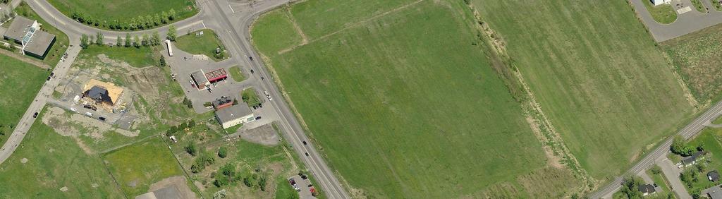
5 Transportation Impact Study INTRODUCTION This study has been prepared in support of a Zoning By-law Amendment (ZBA) and Site Plan Application (SPA) for Harden Realties commercial development at 1375 Trim Road. The proposed development will consist of five pads: a 2,100 sq. ft. high-end coffee shop, a 2,200 sq. ft. restaurant with drive through access, a 1,500 sq. ft. restaurant, a 1,900 sq. ft. medical building, and a 1,500 sq. ft. retail building. For the purposes of this study, it has been assumed that the site will be occupied and operational in The subject site is located on the northeast corner of the intersection of Trim Road at Old Montreal Road/St. Joseph Boulevard as shown in Figure 1. Two site accesses will be provided with one on Trim Road and one on Old Montreal Road. Due to the proximity of the site to the newly developed roundabout, the entrances to this site will have a right in right out access until the adjacent site on Old Montreal Road develops. The proposed plan provides 50 parking spaces, which does not meet the zoning by-law requirements for the proposed land uses. Figure 2 shows the proposed site plan. Figure 1: Local Site Context As directed by the City of Ottawa s 2006 Transportation Impact Assessment Guidelines (TIA Guidelines), a Transportation Impact Study (TIS) is required to support the subject development application. Consistent with the TIA Guidelines the following horizon years will be considered in the demand forecasting and operational analysis: 2016 (Existing Conditions), 2017 (Full Build-out, assumed), and 2022 (Full Build-out plus five years). Trim Road Commercial Development, City of Ottawa Transportation Impact Study 1
6 Figure 2

7 EXISTING CONDITIONS STUDY AREA ROAD NETWORK The Study Area road network is summarized below: Trim Road is a north-south arterial road that has recently been re-constructed to accommodate a four-lane divided urban cross section. The posted speed limit is 70km/h. Bike lanes are provided on Trim Road on both north and south sides of Old Montreal Road / St. Joseph. A major pathway connects to the roundabout at the intersection of Trim Road and Old Montreal Road / St. Joseph. There are multi-use pathways on either side of the road along the entire road section extending beyond the study area. Old Montreal Road / St. Joseph Boulevard is a four-lane divided east-west collector road with a posted speed limit of 60km/h east of Trim Road and 50 km/h west of Trim Road. Old Montreal Road / St. Joseph Boulevard has an urban cross section with curbed shoulders to the east and west of Trim Road. Cycling facilities include on-street bicycle lanes and multiuse paths east and west of Trim Road. TRANSIT NETWORK OC Transpo Route 221 and 22 run along Trim Road, OC Transpo Route 22 then turns off Trim Road and Proceeds along Old Montreal Road. OC Transpo Route 122 runs along St. Joseph Boulevard and Trim Road. There is a temporary transit stop located within the immediate study area, at Trim and Old Montreal Road. Trim Station is located 500 m to the north of the site. Figure 3 shows the transit routes through the Study Area. Figure 3: Existing Transit Network Accessed June Trim Road Commercial Development, City of Ottawa Transportation Impact Study 3

.")
8 PEDESTRIAN & CYCLING NETWORK Multi-use paths are provided within the immediate study area. The multi-use paths are located for all sides of Trim Road and Old Montreal Road / St. Joseph. Bike lanes are provided on Trim Road for both the north and south directions. Figure 4 illustrates the study area, and surrounding area, cycling network. Figure 4: Cycling Network COLLISION REPORTS Collision data was requested from the City of Ottawa for the intersection of Trim Road at Old Montreal Road/St. Joseph Boulevard for the most recent 3 years prior to the commencement of this study (2012 to 2014). However, this intersection was reconstructed from an un-signalized intersection with a large offset to a double lane roundabout in the summer of Table 1 summarizes the collision data for the previous intersection configuration. Table 1: Summary of Reported Collisions ( ) Classification of Single Motor Rear End Sideswipe Angle Accident Vehicle P.D. Only Non-fatal Injury There were no collision reports available post-reconstruction. Due to the recent reconstruction, it is not possible to determine if safety concerns have arisen with the new roundabout configuration. Appendix A contains the collision data sheets. Trim Road Commercial Development, City of Ottawa Transportation Impact Study 4
9 EXISTING TRAFFIC OPERATIONS To establish the baseline intersection operations an operational analysis of the existing traffic conditions has been undertaken for the study area intersection. No recent counts were available from the City of Ottawa. New turning movement counts were undertaken on Wednesday May 25, 2016 and are summarized on Figure 5. Appendix B contains the detailed traffic data sheets. To assess the peak-hour traffic conditions a level of service analysis has been completed using the traffic analysis software Sidra, which implements the methods of the 2010 Highway Capacity Manual. The key parameters used in the analysis include: Existing lane arrangements Peak hour factor (derived from the traffic count) Default values for all other inputs (as defined by Sidra) The results of the operational analysis are summarized in Table 2. The Sidra analysis outputs are provided in Appendix C Table 2: Intersection Performance 2016 Existing Conditions Weekday Am Peak (PM Peak) Critical Movement Overall Intersection Intersection Max. avg. delay Average Delay LoS Movement LoS (sec) (sec) Trim/St. Joseph Roundabout C(B) 20.0(10.5) EBT(WBT) 14.4(8.6) B(A) Note: Level of Service based on Delay The existing roundabout was shown to operate with good overall levels of service and no critical movements. As a result, no mitigation measures are recommended. Figure 5: Existing Peak Hour Traffic Volumes Trim Road Commercial Development, City of Ottawa Transportation Impact Study 5
10 DEMAND FORECASTING BACKGROUND TRAFFIC GROWTH While several background developments along Trim Road and Old Montreal Road/St. Joseph Boulevard are anticipated, no details were available at the time of this study. To account for this growth a conservative 3% annual growth rate has been considered. The annual growth rate was applied to the existing traffic volumes along Trim Road and St. Joseph Boulevard to estimate the future background traffic for 2017 and Figure 6 and Figure 7 illustrate the future background traffic volumes for the 2017 and 2022 horizons, respectively. SITE TRIP GENERATION The number of vehicle trips has been estimated, based on the proposed land uses, to project the impact of the proposed development on the surrounding road network. Table 3 documents the proposed land uses, the ITE Land Use Codes, and the independent variables that are being proposed for the Trim commercial development. It is anticipated that one of the land uses would be a high-end coffee shop with a drive through. Coffee shops can have trip generation characteristics that are not comparable to the ITE Land Use. A recent survey of two Starbucks locations in the Ottawa area was reviewed to estimate the trip generation for the High-End Coffee Shop. The proxy data collection memo is included as Appendix D. Of the two locations surveyed the suburban location (3302 Woodroffe Avenue) was chosen as representative of the proposed development. Table 3: Harden Realties Development Proposed Land Uses Land Use Data Source Independent Variable Clinic ITE 630 1,900 ft 2 Fast Food Restaurant with Drive Through ITE 934 2,200 ft 2 Retail ITE 820 1,500 ft 2 High-Turnover (Sit-Down Restaurant) ITE 932 1,500 ft 2 High-End Coffee Shop with Drive Through Proxy Data Collection 2,100 ft 2 The ITE Land Use Codes and independent variables described above were used to develop the baseline automobile trip generation. Where available the regression equation was used to calculate the trip generation, otherwise the average rate was used. The baseline automobile trip generation was multiplied by 1.30 to estimate the number of peak hour person trips that could be generated by the proposed development. The 2011 NCR Household Origin Destination Survey was reviewed to determine the mode share characteristics of the subject area, specifically, the Orleans Area (Page 104). Table 4 documents the mode share based on the O-D survey. The mode share is applied to the person trip generation to determine the total vehicle trips projected to be generated by the subject development. To account for trips that would be drawn from existing traffic the pass-by rate was examined for the noted land uses. For the service related (food and coffee) land uses a pass-by rate of 50% was applied. For the retail portion a pass-by rate of 35% was used. These pass-by rates are based on the ITE Trip Generation Handbook 3 rd Edition. Table 4: Orleans Area Existing Mode Share Travel Mode Mode Share Auto Driver 50% Auto Passenger 15% Transit 20% Non-motorized 15% Person Trips 100% Table 5 summarizes the vehicle trip generation for the proposed development based on the foregoing assumptions. Appendix E contains detailed trip generation calculations. Trim Road Commercial Development, City of Ottawa Transportation Impact Study 6
11 Table 5: Site Trip Generation Travel Mode AM Peak (veh/hr) PM Peak (veh/hr) In Out In Out Clinic Fast-Food Restaurant with Drive Through Retail High-Turnover (Sit-Down) Restaurant High-End Coffee Shop with Drive Through Fast-Food Restaurant with Drive Through Pass-by (50%) Retail Pass-by (35%) High-End Coffee Shop with Drive Through (50%) 'New' Auto Trips 'Pass-By' Auto Trips VEHICLE TRAFFIC DISTRIBUTION AND ASSIGNMENT The vehicle traffic distribution and assignment was developed using the 2011 NCR Household Origin Destination Survey. The resultant distribution is outlined in Table 6. Table 6: Traffic Distribution To/From Distribution North 20% South 25% East 5% West 50% 100% The distribution was adjusted at the accesses to reflect the right in / right out only configurations. As there is no way for trips bound to the east to make a simple maneuver to return to the east via Old Montreal Road it is assumed that these trips will use the north access to head north to Highway 174 / Highway 17 and proceed east. Using these distributions and the access configuration, new site-generated trips were assigned to the study area intersections. The pass-by trips were assigned to the access points based on the traffic passing each right in / right out access, 70% to the Trim Road Access, and 30% to the Old Montreal Road Access. Figure 8 shows the site generated traffic volumes. Figure 9 shows the pass-by traffic volumes. PROJECTED TRAFFIC VOLUMES The background traffic volumes were combined with the site traffic and pass-by volumes to determine the weekday AM and PM peak hour total traffic forecasts. The future total traffic volumes for the 2017 and 2022 horizon years are shown in Figure 10 and Figure 11, respectively. Trim Road Commercial Development, City of Ottawa Transportation Impact Study 7
12 Figure 6: Future Background Traffic (2017) Figure 7: Future Background Traffic (2022) Trim Road Commercial Development, City of Ottawa Transportation Impact Study 8
13 Figure 8: Site Generated Traffic Figure 9: Pass-By Traffic Trim Road Commercial Development, City of Ottawa Transportation Impact Study 9

14 Figure 10: Future Traffic (2017) Figure 11: Future Traffic (2022) Trim Road Commercial Development, City of Ottawa Transportation Impact Study 10
15 FUTURE TRAFFIC OPERATIONS 2017 FUTURE BACKGROUND CONDITIONS A level of service analysis of the future background AM and PM peak hour operating conditions was undertaken using the same parameters as in the analysis of existing conditions. Table 7 summarizes the operational analysis for the projected 2017 future background conditions. Sidra analysis outputs are included in Appendix F. Table 7: Intersection Performance Background 2017 Weekday Am Peak (PM Peak) Critical Movement Overall Intersection Intersection Max. avg. delay Average Delay LoS Movement LoS (sec) (sec) Trim/St. Joseph Roundabout D(C) 34.7(20.1) WBR(SBT) C(C) 15.5(16.1) Note: Level of Service based on Delay The roundabout is shown to operate with acceptable overall level of service (LOS) in both the AM and PM peak hours TOTAL FUTURE CONDITIONS A level of service analysis of the future AM and PM peak hour operating conditions, including the subject development, was undertaken using the same parameters as in the analysis of existing conditions, with the addition of the site access points. Sidra was used to assess the roundabout intersection of Trim Road at Old Montreal Road/St. Joseph Boulevard. To assess the peak hour traffic conditions at the un-signalized site accesses a level of service analysis has been completed using Trafficware Synchro 8.0, which implements the methods of the 2000 Highway Capacity Manual. The key parameters used in the analysis include: A saturation flow rate of 1800 (as per the City of Ottawa TIA Guidelines) Heavy vehicle equivalent factor of 1.70 (as per the City of Ottawa TIA Guidelines) Default values for all other inputs (as defined by Synchro 8.0) Table 8 and summarize the operational analysis for the projected 2017 total future conditions. Sidra and Synchro analysis outputs are included in Appendix G. Table 8: Intersection Performance (Roundabout) Projected 2017 Weekday Am Peak (PM Peak) Critical Movement Overall Intersection Intersection Max. avg. delay Average Delay LoS Movement LoS (sec) (sec) Trim/St. Joseph Roundabout E(C) 42.8(22.7) WBR(SBT) C(C) 18.2(17.5) Note: Level of Service based on Delay Trim Road Commercial Development, City of Ottawa Transportation Impact Study 11
16 Intersection Access 1 & Old Montreal Road Unsignalized Access 2 & Trim Road Unsignalized Approach/ Movement Table 9: Intersection Performance (Unsignalized) Projected 2017 PM Peak Hour SAT Peak Hour LOS1 V/C Delay (s) Queue(m)2 LOS1 V/C Delay (s) Queue(m) 2 EB T Unopposed Movement WB T/R Unopposed Movement SB R C B WB R C B NB T/R Unopposed Movement SB T Unopposed Movement L=Left Turn Movement(s); T=Through Movement(s); R=Right Turn Movement(s) # - 95 TH Percentile volume exceeds capacity, queue may be longer 1 Level of Service based on v/c ratio as per the City of Ottawa TIA Guidelines 2 95 th Percentile queue With the addition of the site traffic, the roundabout is shown to operate with slightly higher delays and similar levels of service, compared to the 2017 Future Background Analysis. The site access intersections are projected to operate with good levels of service and no capacity constraints. An inbound right turn lane is provided at the access onto Trim Road. Given the high inbound turning vehicles (141 AM Peak hour and 75 PM Peak hour) at this location an auxiliary right turn lane is appropriate. No other modifications are required to support the proposed site FUTURE BACKGROUND CONDITIONS A level of service analysis of the future background AM and PM peak hour operating conditions was undertaken using the same parameters as in the analysis of 2017 future background conditions. Table 10 summarizes the operational analysis for the projected 2022 future background conditions. Sidra analysis outputs are included in Appendix H. Table 10: Intersection Performance (Roundabout) Background 2022 Weekday Am Peak (PM Peak) Critical Movement Overall Intersection Intersection Max. avg. delay Average Delay LoS Movement LoS (sec) (sec) Trim/St. Joseph Roundabout F(E) 89.8(36.8) WBR(SBT) D(D) 27.3(26.8) Note: Level of Service based on Delay For 2022 future background conditions, the roundabout is projected to operate with acceptable overall level of service (LOS) and high delays on the westbound right turn movement during the AM peak hour. To reflect background growth a conservative growth rate of 3% /annum was applied to the existing intersection volumes. Given the City of Ottawa s target mode shares (i.e. promoting a shift away from single occupant vehicles to other modes) and the conservative nature of the analysis, this condition is unlikely to be realized TOTAL FUTURE TRAFFIC CONDITIONS A level of service analysis of the future AM and PM peak hour operating conditions, including the subject development, was undertaken using the same parameters as in the analysis of 2017 total future conditions. Table 11 and Table 12 summarize the operational analysis for the projected 2022 total future conditions. Sidra and Synchro analysis outputs are included in Appendix I. Trim Road Commercial Development, City of Ottawa Transportation Impact Study 12
17 Table 11: Intersection Performance (Roundabout) Projected 2022 Weekday Am Peak (PM Peak) Critical Movement Overall Intersection Intersection Max. avg. delay Average Delay LoS Movement LoS (sec) (sec) Trim/St. Joseph Roundabout F(E) 98.5(43.9) WBR(SBT) D(D) 31.4(30.5) Note: Level of Service based on Delay Intersection Access 1 & Old Montreal Road Unsignalized Access 2 & Trim Road Unsignalized Approach/ Movement Table 12: Intersection Performance (Unsignalized) Projected 2022 PM Peak Hour SAT Peak Hour LOS1 V/C Delay (s) Queue(m)2 LOS1 V/C Delay (s) Queue(m) 2 EB T Unopposed Movement WB T/R Unopposed Movement SB R C B WB R D B NB T/R Unopposed Movement SB T Unopposed Movement L=Left Turn Movement(s); T=Through Movement(s); R=Right Turn Movement(s) # - 95 TH Percentile volume exceeds capacity, queue may be longer 1 Level of Service based on v/c ratio as per the City of Ottawa TIA Guidelines 2 95 th Percentile queue With the addition of the site generated traffic the roundabout is expected experience additional delays when compared to the 2022 future background projected conditions. As discussed previously this is constraint is primarily caused by the conservative background growth rate applied to the existing traffic volumes. Additionally, the overall intersection LOS is within operational thresholds. SITE PLAN REVIEW ACCESS CONFIGURATION TRIM ROAD ACCESS The proposed site access onto Trim Road will be a right in / right out only configuration. To ensure the safe deceleration and ingress at this location a northbound auxiliary right turn lane is proposed. This modification is warranted by the high volume of AM and PM peak hour northbound right turns into the site. The right out will merge with the right lane of traffic on Trim Road. OLD MONTREAL ROAD ACCESS The proposed site access onto Old Montreal Road will be a right in / right out only configuration. It is anticipated that the adjacent site, upon development, will be served by a full movements signalized access on Old Montreal Road, further upstream from the roundabout than the proposed right in / right out only access. As the adjacent property develops, a connection between the two properties will be opened. This will allow traffic from the subject site to re-route to the proposed signals. While this may have a minor impact on the distribution of site-generated traffic the re-routing would improve conditions at the site accesses and would have a minimal impact on the roundabout at Trim Road and Old Montreal Road / St. Joseph Boulevard. Once the signalized access to the adjacent property is operational the need for a right out at the proposed Old Montreal Road Access can be re-evaluated. If at that time the right out is deemed un-needed it can be decommissioned at that time. Trim Road Commercial Development, City of Ottawa Transportation Impact Study 13


18 DRIVE THROUGHS The proposed development contains two restaurants with drive-throughs, one in each of the northeast and southwest corners. The drive-throughs will each run along a property line, one adjacent to Trim Road and the second along the Eastern property line. The eastern most drive-through will serve a restaurant and has room to store 13 vehicles within the designated area. During peak demand the restaurant is expected to attract 33 vehicles per hour, with some of those customers parking and walking in the storefront. The provided queuing space will adequately serve the restaurant. The western drive-through has 11 queueing spaces for drive through customers. During peak demand the high-end coffee shop is expected to serve 125 customers per hour. This will place a notable demand on the drive-through. During the proxy site trip generation observations the number of drive-through customers and maximum queue was documented. It was observed that 75 of the 125 vehicles per hour used the drive through. On average the queue was vehicles at a time. While this would occasionally extend beyond the provided queuing area, it was also noted during the site observations that if the queue reach exceeded the available storage space customers would choose to park and proceed into the storefront to complete their purchase. Based on the foregoing the site is adequately designed to accommodate both drive-throughs. CONCLUSIONS The conclusions of the Transportation Impact Study are as follows: a) The study area intersection (Trim Road / Old Montreal Road & St Joseph Boulevard) currently operates with an overall LOS B or better in the AM and PM peak hours. b) It is projected that the site will generate 173 and 98 net new auto trips in the AM and PM peak hours respectively (per Table 5: Site Trip Generation). c) The analysis of 2017 and 2022 future background traffic forecasts (no site traffic) indicated that the roundabout intersection at Trim Road / Old Montreal Road & St Joseph Boulevard would operate with some delays, but within permissible operational thresholds. d) The analysis of 2017 and 2022 total future traffic forecasts (including site-generated traffic) showed that the roundabout would continue to operate with some delays with the addition of the site-generated traffic. As discussed above, no upgrades were considered to address this constraint. The proposed site accesses are projected to operate with good levels of service and acceptable delays. e) Due to a high right turn volume in both peak hours a northbound exclusive right turn lane is to be provided at the access to Trim Road Access. f) The foregoing traffic study has demonstrated that the proposed access intersections can operate effectively. While the roundabout intersection of Trim Road at Old Montreal Road & St Joseph was projected to operate with some constraints, this is primarily due to the conservative growth rate that was used to account for growth in the areas surrounding the subject development. As demonstrated by the 2017 total future conditions, if a modest amount of growth is experienced the intersection will operate within permissible operational thresholds. From a transportation perspective, it is recommended that the subject development be approved. Prepared By Reviewed By 26-Jul Jul-16 Mark B. Crockford, P. Eng. Transportation Engineer Christopher A. Gordon, P. Eng. Senior Project Manage Trim Road Commercial Development, City of Ottawa Transportation Impact Study 14
19 Appendix A COLLISION REPORTS
20 Collision Main Detail Summary OnTRAC Reporting System FROM: TO: OLD MONTREAL RD & TRIM RD Former Municipality: Cumberland Traffic Control: Traffic signal Number of Collisions: 27 IMPACT SURFACE VEHICLE No. DATE DAY TIME ENV LIGHT TYPE CLASS DIR COND'N MANOEUVRE VEHICLE TYPE FIRST EVENT PED Fri 09:30 Clear Daylight Rear end Non-fatal V1 S Wet Going ahead Delivery van Other motor vehicle 0 V2 S Wet Stopped Automobile, station Other motor vehicle V3 S Wet Stopped Automobile, station Other motor vehicle Sat 10:00 Clear Daylight Rear end P.D. only V1 N Dry Going ahead Automobile, station Other motor vehicle 0 V2 N Dry Stopped Pick-up truck Other motor vehicle Sun 09:30 Clear Daylight Rear end P.D. only V1 N Dry Slowing or Passenger van Skidding/Sliding 0 V2 N Dry Slowing or Automobile, station Other motor vehicle We 11:30 Clear Daylight Rear end P.D. only V1 S Dry Going ahead Pick-up truck Other motor vehicle 0 V2 S Dry Stopped Passenger van Other motor vehicle Thu 16:35 Clear Daylight Turning Non-fatal V1 N Dry Turning left Automobile, station Other motor vehicle 0 V2 S Dry Going ahead Automobile, station Other motor vehicle Sat 13:13 Rain Daylight Rear end P.D. only V1 N Wet Slowing or Automobile, station Skidding/Sliding 0 V2 N Wet Stopped Pick-up truck Other motor vehicle Mo 17:06 Clear Daylight Rear end P.D. only V1 E Dry Going ahead Automobile, station Other motor vehicle 0 V2 E Dry Going ahead Automobile, station Other motor vehicle Tue 15:06 Rain Daylight Rear end P.D. only V1 N Wet Slowing or Automobile, station Other motor vehicle 0 V2 N Wet Slowing or Automobile, station Other motor vehicle Tue 15:15 Rain Daylight Rear end Non-fatal V1 N Wet Slowing or Automobile, station Other motor vehicle 0 V2 N Wet Stopped Pick-up truck Other motor vehicle Thu 17:55 Clear Daylight Rear end P.D. only V1 S Dry Slowing or Pick-up truck Other motor vehicle 0 V2 S Dry Stopped Pick-up truck Other motor vehicle Sat 15:48 Clear Daylight Rear end P.D. only V1 N Dry Going ahead Pick-up truck Other motor vehicle 0 V2 N Dry Stopped Automobile, station Other motor vehicle V3 N Dry Stopped Pick-up truck Other motor vehicle Mo 07:46 Clear Daylight Rear end P.D. only V1 S Dry Going ahead Municipal transit bus Other motor vehicle 0 V2 S Dry Slowing or Automobile, station Other motor vehicle V3 S Dry Slowing or Automobile, station Other motor vehicle (Note: Time of Day = "00:00" represents unknown collision time Friday, May 20, 2016 Page 1 of 2
21 Collision Main Detail Summary OnTRAC Reporting System FROM: TO: We 10:40 Rain Daylight Rear end P.D. only V1 S Wet Going ahead Automobile, station Other motor vehicle 0 V2 S Wet Stopped Pick-up truck Other motor vehicle Tue 20:20 Clear Dark Rear end P.D. only V1 N Other Slowing or Automobile, station Other motor vehicle 0 V2 N Other Slowing or Automobile, station Other motor vehicle Mo 06:50 Clear Dawn Rear end Non-fatal V1 N Wet Slowing or Passenger van Other motor vehicle 0 V2 N Wet Stopped Automobile, station Other motor vehicle Thu 14:35 Clear Daylight Rear end P.D. only V1 E Dry Going ahead Pick-up truck Other motor vehicle 0 V2 E Dry Going ahead Passenger van Other motor vehicle Tue 11:33 Clear Daylight Rear end Non-fatal V1 E Dry Going ahead Automobile, station Other motor vehicle 0 V2 E Dry Stopped Pick-up truck Other motor vehicle Fri 16:35 Rain Daylight Rear end P.D. only V1 S Wet Going ahead Automobile, station Other motor vehicle 0 V2 S Wet Slowing or Pick-up truck Other motor vehicle Thu 19:56 Clear Daylight Single vehicle Non-fatal V1 N Wet Slowing or Motorcycle Skidding/Sliding We 18:32 Clear Daylight Rear end P.D. only V1 S Dry Slowing or Automobile, station Skidding/Sliding 0 V2 S Dry Stopped Pick-up truck Other motor vehicle Tue 14:45 Clear Daylight Rear end Non-fatal V1 S Dry Slowing or Pick-up truck Other motor vehicle 0 V2 S Dry Stopped Automobile, station Other motor vehicle Thu 20:00 Clear Dark Rear end P.D. only V1 N Dry Slowing or Pick-up truck Other motor vehicle 0 V2 N Dry Stopped Pick-up truck Other motor vehicle Thu 16:01 Clear Daylight Rear end P.D. only V1 N Dry Going ahead Pick-up truck Other motor vehicle 0 V2 N Dry Slowing or Pick-up truck Other motor vehicle Fri 09:18 Rain Daylight Rear end P.D. only V1 N Wet Slowing or Automobile, station Skidding/Sliding 0 V2 N Wet Stopped Pick-up truck Other motor vehicle Fri 09:27 Clear Daylight Rear end P.D. only V1 S Ice Slowing or Pick-up truck Other motor vehicle 0 V2 S Ice Stopped Automobile, station Other motor vehicle Thu 17:45 Clear Dark Angle P.D. only V1 E Wet Turning right Automobile, station Other motor vehicle 0 V2 S Wet Going ahead Passenger van Other motor vehicle Mo 14:20 Clear Daylight Sideswipe P.D. only V1 N Wet Turning left Unknown Other motor vehicle 0 V2 N Wet Stopped Passenger van Other motor vehicle (Note: Time of Day = "00:00" represents unknown collision time Friday, May 20, 2016 Page 2 of 2
22 Appendix B TRAFFIC DATA
23 Intersection: Trim/St. Joseph&Old Montreal Date: Wednesday, May 25, 2016 Time: 7:00AM to 9:00AM 15-Minute Time NBL NBT NBR SBL SBT SBR EBL EBT EBR WBL WBT WBR 7:00AM - 7:15AM :15AM - 7:30AM :30AM - 7:45AM :45AM - 8:00AM :00AM - 8:15AM :15AM - 8:30AM :30AM - 8:45AM :45AM - 9:00AM Hour 159 1, ,175
24 Intersection: Trim/St. Joseph&Old Montreal Date: Wednesday, May 25, 2016 Time: 4:00PM to 6:00PM 15-Minute Time NBL NBT NBR SBL SBT SBR EBL EBT EBR WBL WBT WBR 4:00PM - 4:15PM :15PM - 4:30PM :30PM - 4:45PM :45PM - 5:00PM :00PM - 5:15PM :15PM - 5:30PM :30PM - 5:45PM :45PM - 6:00PM Hour , ,704
25 Appendix C 2016 EXISTING CONDITIONS
26 MOVEMENT SUMMARY AM Peak Existing Roundabout Site: Trim & St. Joseph Movement Performance - Vehicles Mov ID Turn Demand Deg. Average Level of 95% Back of Queue Prop. Effective Average Flow HV Satn Delay Service Vehicles Distance Queued Stop Rate Speed veh/h % v/c sec veh m per veh km/h South: Trim 3 L LOS B T LOS B R LOS B Approach LOS B East: Old Montreal 1 L LOS B T LOS B R LOS D Approach LOS C North: Trim 7 L LOS A T LOS A R LOS A Approach LOS A West: St. Joseph 5 L LOS A T LOS A R LOS A Approach LOS A All Vehicles LOS B Level of Service (LOS) Method: Delay & v/c (HCM 2010). Roundabout LOS Method: Same as Sign Control. Vehicle movement LOS values are based on average delay and v/c ratio (degree of saturation) per movement LOS F will result if v/c > 1 irrespective of movement delay value (does not apply for approaches and intersection). Intersection and Approach LOS values are based on average delay for all movements (v/c not used as specified in HCM 2010). Roundabout Capacity Model: US HCM HCM Delay Model used. Geometric Delay not included. Processed: Tuesday, July 19, 20163:25:27 PM Copyright Akcelik and Associates Pty Ltd SIDRA INTERSECTION Project: W:\Ottawa\Trim\Existing\AM.sip , PARSONS TRANSPORTATION GROUP, ENTERPRISE
27 MOVEMENT SUMMARY PM Peak Existing Roundabout Site: Trim & St. Joseph Movement Performance - Vehicles Mov ID Turn Demand Deg. Average Level of 95% Back of Queue Prop. Effective Average Flow HV Satn Delay Service Vehicles Distance Queued Stop Rate Speed veh/h % v/c sec veh m per veh km/h South: Trim 3 L LOS B T LOS B R LOS B Approach LOS B East: Old Montreal 1 L LOS A T LOS A R LOS A Approach LOS A North: Trim 7 L LOS C T LOS C R LOS C Approach LOS C West: St. Joseph 5 L LOS B T LOS B R LOS C Approach LOS C All Vehicles LOS B Level of Service (LOS) Method: Delay & v/c (HCM 2010). Roundabout LOS Method: Same as Sign Control. Vehicle movement LOS values are based on average delay and v/c ratio (degree of saturation) per movement LOS F will result if v/c > 1 irrespective of movement delay value (does not apply for approaches and intersection). Intersection and Approach LOS values are based on average delay for all movements (v/c not used as specified in HCM 2010). Roundabout Capacity Model: US HCM HCM Delay Model used. Geometric Delay not included. Processed: Tuesday, July 19, 20163:23:00 PM Copyright Akcelik and Associates Pty Ltd SIDRA INTERSECTION Project: W:\Ottawa\Trim\Existing\PM.sip , PARSONS TRANSPORTATION GROUP, ENTERPRISE
28 Appendix D PROXY DATA COLLECTION MEMO
29 Memorandum To: Stephen Job Copy: Christopher Gordon From: Gord Scobie Date: Project: Re: Proxy Drive-Through Coffee Shop Data Collection 19 January Introduction Based on the information provided, the proponent would like to redevelop the site municipally known as 70 Richmond Road. The site is currently a vacant auto sales/garage with heritage status and the intent is to renovate the existing on-site building and convert the former land use to an approximate 1,305 ft 2 coffee shop with a drive-through facility (i.e. a Starbucks TM restaurant). Following a pre-consultation meeting with City staff, the City advised that a drive-through facility on a traditional Main Street is not considered an appropriate land use as they typically generate a significant amount of vehicle traffic. Given the proposed land use on the subject site is not anticipated to generate the same volume of traffic as other typical drive-through facilities (e.g. Tim Hortons or McDonald's ), traffic counts were conducted at two existing proxy locations to confirm traffic generation by a Starbucks TM restaurant with a drive-through facility. 2. Field Observations Within the City of Ottawa, two existing proxy sites were identified as 380 Coventry Road and 3302 Woodroffe Avenue. At each site, both vehicles using the drive-through facility and customers entering the store front were counted on a typical weekday during the month of January 2016, for three peak time periods. The peak time periods were considered to be the weekday morning (7:00AM 9:00AM), midday (11:30AM 1:30PM) and afternoon (4:00PM 6:00PM). 2.1 Coventry Proxy Site The Coventry proxy site (380 Coventry Road) consists of a standalone Starbucks TM restaurant and on a site shared with a big box electronics store (Best Buy). Along the site s frontage, Coventry Road is classified as an arterial roadway and it currently carries two-way vehicle volumes of approximately 1,400 to 2,000 veh/h during weekday morning and afternoon peak hours. The site s local context is depicted as Figure 1. {
 (Person Trips/h) Inbound 7:45AM 8:45AM 65 30 95 12:15AM 1:15PM 25 20 45 4:00PM 5:00PM 15 15 30 Notes:")

 consists of a shared Starbucks TM /Subway restaurant pad, on a site that also includes a standalone bank, retail food store,")
30 Page 2 Figure 1: 380 Coventry Starbucks with Drive-Through The following Table 1 summarizes the observed peak hour inbound traffic at the selected Coventry Proxy site. Table 1: Observed Inbound Traffic 380 Coventry Peak Hour Drive-Through Store Front (veh/h) (Person Trips/h) Inbound 7:45AM 8:45AM :15AM 1:15PM :00PM 5:00PM Notes: Detailed count data is attached Southbound traffic represent drive-through vehicles Westbound traffic represents patrons entering the restaurant via the store front As shown in Table 1, the busiest peak hour is the weekday morning peak hour between 7:45AM and 8:45AM. Field observations at this location revealed no more than 4 vehicles in queue within the drivethrough facility and the average queue was approximately 1-2 vehicles. Detailed count data is attached. 2.2 Woodroffe Proxy Site The Woodroffe proxy site (3302 Woodroffe Avenue) consists of a shared Starbucks TM /Subway restaurant pad, on a site that also includes a standalone bank, retail food store, fitness centre, drug store and a number of specialty retail type land uses. Along the site s frontage, both Strandherd Drive and Woodroffe Avenue are classified as arterial roadways. During 2012, two-way vehicle volumes along Strandherd Drive were approximately 1,000 to 1,900 veh/h and approximately 800 to 1,300 veh/h along Woodroffe Avenue during the weekday morning and afternoon peak hours. It should be noted that these volumes {


31 Page 3 were collected prior to the opening of the Vimy Memorial Bridge and as result, the volumes along these roadways are likely higher. The site s local context is depicted as Figure 2. Figure 2: 3302 Woodroffe Starbucks with Drive-Through The following Table 2 summarizes the observed peak hour inbound traffic at the selected Woodroffe Proxy site. Table 2: Observed Inbound Traffic 3302 Woodroffe Peak Hour Drive-Through Store Front (veh/h) (Person Trips/h) Inbound 8:00AM 9:00AM :15AM 1:15PM :00PM 5:00PM Notes: Detailed count data is attached Southbound traffic represent drive-through vehicles Westbound traffic represents patrons entering the restaurant via the store front As shown in Table 2, the busiest weekday peak hour is between 8:00AM and 9:00AM. Field observations at this location revealed the drive-through facility was generally at capacity during the busiest peak hour, which is approximately 10 to 15 vehicles in queue on average. It should be noted that on two occasions it was observed that vehicle queues within the drive-through exceeded the provided storage capacity by 1-2 vehicles, which spilled into the adjacent drive-isle on-site. On both these occasions, the 1-2 vehicles that exceeded the drive-through storage, abandoned waiting queue and elected to park on-site to then enter the restaurant via the store front. {
32 Page 4 3. Findings and Conclusion Based on the foregoing, different Starbucks TM restaurants with drive-through facilities can have varying traffic generating characteristics. While queues of only 4 vehicles were observed at the Coventry proxy site, queues of vehicles were observed at the Woodroffe proxy during peak hours and on occasion, the drive-through queue at the Woodroffe proxy site exceeded the provided storage by 1-2 vehicles. The proposed Starbucks TM restaurant at 70 Richmond Road will have storage within the proposed drivethrough facility for 7 vehicles and 5 on-site parking spaces. If the amount of site-generated traffic at this location will be similar to the observed site-generated traffic at the Woodroffe proxy site, the level of traffic demand will be difficult to process with the amount of provided capacity at the proposed 70 Richmond Road site. However, as observed at the Woodroffe proxy site, if a drive-through facility is at capacity, patrons will abandon waiting in queue and park on-site or abandon visiting the site altogether. Moving forward, to minimize any adverse traffic impacts to Richmond Road and Island Park Drive due to queuing related to a drive-through facility, options to maximize on-site queue storage will have to be examined. This, along with planning rationale input will assist in finding an appropriate solution for the redevelopment of the 70 Richmond Road site. {
33 ,, Turn Count Summary Location: at Coventry, Ottawa GPS Coordinates: Date: Day of week: Tuesday Weather: Sunny Analyst: Bader Alna vehicle traffic Interval starts SouthBound Westbound Northbound Eastbound Left Thru Right Left Thru Right Left Thru Right Left Thru Right 07: : : : : : : : : Car traffic Interval starts SouthBound Westbound Northbound Eastbound Left Thru Right Left Thru Right Left Thru Right Left Thru Right 07: : : : : : : : : Pedestrian volumes Interval starts NE NW SW SE Left Right Left Right Left Right Left Right 07: : : : : : : : :
34 Intersection Peak Hour 07:45-08:45 SouthBound Westbound Northbound Eastbound Left Thru Right Left Thru Right Left Thru Right Left Thru Right Vehicle Factor Approach Factor Peak Hour Vehicle Summary Vehicle SouthBound Westbound Northbound Eastbound Left Thru Right Left Thru Right Left Thru Right Left Thru Right Car Peak Hour Pedestrians NE NW SW SE Left Right Left Right Left Right Left Right Pedestrians
35 Intersection Peak Hour Location: at Coventry, Ottawa GPS Coordinates: Date: Day of week: Tuesday Weather: Sunny Analyst: Bader Alna SB: EB: Coventry WB: Coventry NB: Intersection Peak Hour 07:45-08:45 SouthBound Westbound Northbound Eastbound Left Thru Right Left Thru Right Left Thru Right Left Thru Right Vehicle Factor Approach Factor
36 ,, Turn Count Summary Location: at Coventry, Ottawa GPS Coordinates: Date: Day of week: Tuesday Weather: Snowy Analyst: Bader Alna vehicle traffic Interval starts SouthBound Westbound Northbound Eastbound Left Thru Right Left Thru Right Left Thru Right Left Thru Right 11: : : : : : : : : Car traffic Interval starts SouthBound Westbound Northbound Eastbound Left Thru Right Left Thru Right Left Thru Right Left Thru Right 11: : : : : : : : : Pedestrian volumes Interval starts NE NW SW SE Left Right Left Right Left Right Left Right 11: : : : : : : : :
37 Intersection Peak Hour 12:15-13:15 SouthBound Westbound Northbound Eastbound Left Thru Right Left Thru Right Left Thru Right Left Thru Right Vehicle Factor Approach Factor Peak Hour Vehicle Summary Vehicle SouthBound Westbound Northbound Eastbound Left Thru Right Left Thru Right Left Thru Right Left Thru Right Car Peak Hour Pedestrians NE NW SW SE Left Right Left Right Left Right Left Right Pedestrians
38 Intersection Peak Hour Location: at Coventry, Ottawa GPS Coordinates: Date: Day of week: Tuesday Weather: Snowy Analyst: Bader Alna SB: EB: Coventry WB: Coventry NB: Intersection Peak Hour 12:15-13:15 SouthBound Westbound Northbound Eastbound Left Thru Right Left Thru Right Left Thru Right Left Thru Right Vehicle Factor Approach Factor
39 ,, Turn Count Summary Location: at Coventry, Ottawa GPS Coordinates: Date: Day of week: Monday Weather: Sunny Analyst: Bader Alna vehicle traffic Interval starts SouthBound Westbound Northbound Eastbound Left Thru Right Left Thru Right Left Thru Right Left Thru Right 16: : : : : : : : Car traffic Interval starts SouthBound Westbound Northbound Eastbound Left Thru Right Left Thru Right Left Thru Right Left Thru Right 16: : : : : : : : Pedestrian volumes Interval starts NE NW SW SE Left Right Left Right Left Right Left Right 16: : : : : : : :
40 Intersection Peak Hour 16:00-17:00 SouthBound Westbound Northbound Eastbound Left Thru Right Left Thru Right Left Thru Right Left Thru Right Vehicle Factor Approach Factor Peak Hour Vehicle Summary Vehicle SouthBound Westbound Northbound Eastbound Left Thru Right Left Thru Right Left Thru Right Left Thru Right Car Peak Hour Pedestrians NE NW SW SE Left Right Left Right Left Right Left Right Pedestrians
41 Intersection Peak Hour Location: at Coventry, Ottawa GPS Coordinates: Date: Day of week: Monday Weather: Sunny Analyst: Bader Alna SB: EB: Coventry WB: Coventry NB: Intersection Peak Hour 16:00-17:00 SouthBound Westbound Northbound Eastbound Left Thru Right Left Thru Right Left Thru Right Left Thru Right Vehicle Factor Approach Factor
42 ,, Turn Count Summary Location: at Woodroffe, Ottawa GPS Coordinates: Date: Day of week: Wednesday Weather: Clear Analyst: Bader Alna vehicle traffic Interval starts SouthBound Westbound Northbound Eastbound Left Thru Right Left Thru Right Left Thru Right Left Thru Right 16: : : : : : : : Car traffic Interval starts SouthBound Westbound Northbound Eastbound Left Thru Right Left Thru Right Left Thru Right Left Thru Right 16: : : : : : : : Pedestrian volumes Interval starts NE NW SW SE Left Right Left Right Left Right Left Right 16: : : : : : : :
43 Intersection Peak Hour 16:00-17:00 SouthBound Westbound Northbound Eastbound Left Thru Right Left Thru Right Left Thru Right Left Thru Right Vehicle Factor Approach Factor Peak Hour Vehicle Summary Vehicle SouthBound Westbound Northbound Eastbound Left Thru Right Left Thru Right Left Thru Right Left Thru Right Car Peak Hour Pedestrians NE NW SW SE Left Right Left Right Left Right Left Right Pedestrians
44 Intersection Peak Hour Location: at Woodroffe, Ottawa GPS Coordinates: Date: Day of week: Wednesday Weather: Clear Analyst: Bader Alna SB: EB: Woodroffe WB: Woodroffe NB: Intersection Peak Hour 16:00-17:00 SouthBound Westbound Northbound Eastbound Left Thru Right Left Thru Right Left Thru Right Left Thru Right Vehicle Factor Approach Factor
45 ,, Turn Count Summary Location: at Woodroffe, Ottawa GPS Coordinates: Date: Day of week: Wednesday Weather: Clear Analyst: Bader Alna vehicle traffic Interval starts SouthBound Westbound Northbound Eastbound Left Thru Right Left Thru Right Left Thru Right Left Thru Right 11: : : : : : : : Car traffic Interval starts SouthBound Westbound Northbound Eastbound Left Thru Right Left Thru Right Left Thru Right Left Thru Right 11: : : : : : : : Pedestrian volumes Interval starts NE NW SW SE Left Right Left Right Left Right Left Right 11: : : : : : : :
46 Intersection Peak Hour 12:15-13:15 SouthBound Westbound Northbound Eastbound Left Thru Right Left Thru Right Left Thru Right Left Thru Right Vehicle Factor Approach Factor Peak Hour Vehicle Summary Vehicle SouthBound Westbound Northbound Eastbound Left Thru Right Left Thru Right Left Thru Right Left Thru Right Car Peak Hour Pedestrians NE NW SW SE Left Right Left Right Left Right Left Right Pedestrians
47 Intersection Peak Hour Location: at Woodroffe, Ottawa GPS Coordinates: Date: Day of week: Wednesday Weather: Clear Analyst: Bader Alna SB: EB: Woodroffe WB: Woodroffe NB: Intersection Peak Hour 12:15-13:15 SouthBound Westbound Northbound Eastbound Left Thru Right Left Thru Right Left Thru Right Left Thru Right Vehicle Factor Approach Factor
48 ,, Turn Count Summary Location: at Woodroffe, Ottawa GPS Coordinates: Date: Day of week: Wednesday Weather: Clear Analyst: Bader Alna vehicle traffic Interval starts SouthBound Westbound Northbound Eastbound Left Thru Right Left Thru Right Left Thru Right Left Thru Right 07: : : : : : : : Car traffic Interval starts SouthBound Westbound Northbound Eastbound Left Thru Right Left Thru Right Left Thru Right Left Thru Right 07: : : : : : : : Pedestrian volumes Interval starts NE NW SW SE Left Right Left Right Left Right Left Right 07: : : : : : : :
49 Intersection Peak Hour 08:00-09:00 SouthBound Westbound Northbound Eastbound Left Thru Right Left Thru Right Left Thru Right Left Thru Right Vehicle Factor Approach Factor Peak Hour Vehicle Summary Vehicle SouthBound Westbound Northbound Eastbound Left Thru Right Left Thru Right Left Thru Right Left Thru Right Car Peak Hour Pedestrians NE NW SW SE Left Right Left Right Left Right Left Right Pedestrians

50 Intersection Peak Hour Location: at Woodroffe, Ottawa GPS Coordinates: Date: Day of week: Wednesday Weather: Clear Analyst: Bader Alna SB: EB: Woodroffe WB: Woodroffe NB: Intersection Peak Hour 08:00-09:00 SouthBound Westbound Northbound Eastbound Left Thru Right Left Thru Right Left Thru Right Left Thru Right Vehicle Factor Approach Factor
Re: Cyrville Road Car Dealership
 1223 Michael Street, Suite 100, Ottawa, ON K1J 7T2 Tel: 613.738.4160 Fax: 613.739.7105 www.delcan.com February 25, 2013 OUR REF: TO3098TOE Mark Motors of Ottawa 611 Montreal Road Ottawa, ON K1K 0T8 Attention:
Re: Residential Development - Ogilvie/Cummings Transportation Overview
 1223 Michael Street, Suite 100, Ottawa, ON K1J 7T2 Tel: 613.738.4160 Fax: 613.739.7105 www.delcan.com March 28, 2012 OUR REF: TO3088TOY Barry J. Hobin & Architects 63 Pamilla Street Ottawa, ON K1S 3K7
Bennett Pit. Traffic Impact Study. J&T Consulting, Inc. Weld County, Colorado. March 3, 2017
 Bennett Pit Traffic Impact Study J&T Consulting, Inc. Weld County, Colorado March 3, 217 Prepared By: Sustainable Traffic Solutions, Inc. http://www.sustainabletrafficsolutions.com/ Joseph L. Henderson,
886 March Road McDonald's Transportation Study
 McDonald's Restaurants of Canada Limited March 2013 886 March Road McDonald's Transportation Study Submitted by: HDR Corporation 100 York Boulevard, Suite 300 Richmond Hill, ON L4B 1J8 (905) 882-4100 www.hdrinc.com
APPENDIX A. OC Transpo Maps & Route Information
 APPENDIX A OC Transpo Maps & Route Information OC Transpo Route 99 APPENDIX B Traffic Count Information & Collision Data VEHICULAR TURNING MOVEMENTS (15 Min. Volumes) Limebank Road & Spratt Road
April Salvation Army Barrhaven Church 102 Bill Leathem Drive Transportation Brief
 April 26 Salvation Army Barrhaven Church 2 Bill Leathem Drive Transportation Brief Salvation Army Barrhaven Church 2 Bill Leathem Drive Transportation Brief prepared for: The Salvation Army 2 Overlea Blvd.
BARRHAVEN FELLOWSHIP CRC 3058 JOCKVALE ROAD OTTAWA, ONTARIO TRANSPORTATION BRIEF. Prepared for:
 BARRHAVEN FELLOWSHIP CRC 3058 JOCKVALE ROAD OTTAWA, ONTARIO TRANSPORTATION BRIEF Prepared for: Barrhaven Fellowship CRC 3058 Jockvale Road Ottawa, ON K2J 2W7 December 7, 2016 116-649 Report_1.doc D. J.
RICHMOND OAKS HEALTH CENTRE 6265 PERTH STREET OTTAWA, ONTARIO TRANSPORTATION BRIEF. Prepared for: Guycoki (Eastern) Limited.
 Limited.") RICHMOND OAKS HEALTH CENTRE 6265 PERTH STREET OTTAWA, ONTARIO TRANSPORTATION BRIEF Prepared for: Guycoki (Eastern) Limited June 16, 2016 116-638 Brief_1.doc D. J. Halpenny & Associates Ltd. Consulting
RICHMOND OAKS HEALTH CENTRE 6265 PERTH STREET OTTAWA, ONTARIO TRANSPORTATION BRIEF Prepared for: Guycoki (Eastern) Limited June 16, 2016 116-638 Brief_1.doc D. J. Halpenny & Associates Ltd. Consulting
L1TILE BEARS DAY CARE TRANSPORTATION IMPACT STUDY FORT COLLINS, COLORADO MAY Prepared for:
 L1TILE BEARS DAY CARE TRANSPORTATION IMPACT STUDY FORT COLLINS, COLORADO MAY 2012 Prepared for: Hillside Construction, Inc. 216 Hemlock Street, Suite B Fort Collins, CO 80534 Prepared by: DELICH ASSOCIATES
1012 & 1024 McGarry Terrace
 December 217 112 & 124 McGarry Terrace Transportation Impact Study 112 & 124 McGarry Terrace Transportation Impact Study prepared for: Lépine Corporation 32 March Road Kanata, ON K2K 2E3 prepared by: 1223
Lakeside Terrace Development
 Lakeside Terrace Development City of Barrie, County of Simcoe Traffic Brief for: Type of Document: Final Report Project Number: JDE 1617 Date Submitted: April 29 th, 216 4/29/16 John Northcote, P.Eng.
Weaver Road Senior Housing Traffic Impact Analysis
 Gibson Traffic Consultants, Inc. 2813 Rockefeller Avenue Suite B Everett, WA 9821 425.339.8266 Weaver Road Senior Housing Traffic Impact Analysis Jurisdiction: City of Snohomish January 218 GTC #17-37
Wellington Street West
 Transportation Brief prepared for: 185 Davenport Road Suite 300 Toronto, ON M5R 1J1 prepared by: 1223 Michael Street Suite 100 Ottawa, ON K1J 7T2 November 5, 2013 TO3131TOH Transportation Brief November
Downtown One Way Street Conversion Technical Feasibility Report
 Downtown One Way Street Conversion Technical Feasibility Report As part of the City s Transportation Master Plan, this report reviews the technical feasibility of the proposed conversion of the current
MERIVALE PRIORITY SQUARE 2852 MERIVALE ROAD CITY OF OTTAWA TRANSPORTATION BRIEF. Prepared for: ONT Inc. 25 Winding Way Nepean, Ontario K2C 3H1
 MERIVALE PRIORITY SQUARE 2852 MERIVALE ROAD CITY OF OTTAWA TRANSPORTATION BRIEF Prepared for: 2190986ONT Inc. 25 Winding Way Nepean, Ontario K2C 3H1 October 6, 2010 110-502 Report_1.doc D. J. Halpenny
MEMO VIA . Ms. Amy Roth DPS Director, City of Three Rivers. To:
 MEMO To: Ms. Amy Roth DPS Director, City of Three Rivers VIA EMAIL From: Michael J. Labadie, PE Julie M. Kroll, PE, PTOE Brandon Hayes, PE, P.Eng. Fleis & VandenBrink Date: January 5, 2017 Re: Proposed
Provide an overview of the development proposal including projected site traffic volumes;
 December 19, 2013 File: 163600935 Attention: Troy Elliott Carl Elliott Limited 15-1831 Robertson Road PO Box 11117 Nepean, Ontario K1H 7T8 Dear Mr. Elliott, Reference: 2235 and 2265 Robertson Road Transportation
One Harbor Point Residential
 Residential Gig Harbor, WA Transportation Impact Analysis January 23, 2017 Prepared for: Neil Walter Company PO Box 2181 Tacoma, WA 98401 Prepared by: TENW Transportation Engineering NorthWest 11400 SE
Table 1 - Land Use Comparisons - Proposed King s Wharf Development. Retail (SF) Office (SF) 354 6,000 10, Land Uses 1
 Office (SF) 354 6,000 10, Land Uses 1") Ref. No. 171-6694 Phase 2 November 23, 217 Mr. David Quilichini, Vice President Fares & Co. Developments Inc. 31 Place Keelson Sales Centre DARTMOUTH NS B2Y C1 Sent Via Email to David@faresinc.com RE:
Ref. No. 171-6694 Phase 2 November 23, 217 Mr. David Quilichini, Vice President Fares & Co. Developments Inc. 31 Place Keelson Sales Centre DARTMOUTH NS B2Y C1 Sent Via Email to David@faresinc.com RE:
SR 104/Paradise Bay-Shine Road Intersection Safety Improvements Intersection Control Evaluation
 SR 104/Paradise Bay-Shine Road Intersection Safety Improvements Intersection Control Evaluation Background and Project Needs SR 104 is functionally classified as a rural-principal arterial. It is a limited
Village of Richmond Transportation Brief
 Village of Richmond Transportation Brief GENIVAR Project Number 111-18482-00 June 21 st, 2011 www.genivar.com GENIVAR 15 Fitzgerald Road, Suite 100 Ottawa, Ontario, CANADA K2H 9G1 Telephone: 613-829-2800
APPENDIX C1 TRAFFIC ANALYSIS DESIGN YEAR TRAFFIC ANALYSIS
 APPENDIX C1 TRAFFIC ANALYSIS DESIGN YEAR TRAFFIC ANALYSIS DESIGN YEAR TRAFFIC ANALYSIS February 2018 Highway & Bridge Project PIN 6754.12 Route 13 Connector Road Chemung County February 2018 Appendix
RESPONSE TO TRAFFIC IMPACT STUDY COMMENTS
 RESPONSE TO TRAFFIC IMPACT STUDY COMMENTS Proposed Gas Station 40 Arthur Street (Highway 26), Town of the Blue Mountains (Thornbury), County of Grey, Ontario AUGUST 2013 August 27, 2013 MR. REG RUSSWURM
 Traffic Analysis For Approved Uses within the St. Lucie West DRI Aldi Port St. Lucie, FL Prepared for: Bohler Engineering, LLC 1000 Corporate Drive Suite 250 Fort Lauderdale, FL 33334 Prepared by: 10795
DEVELOPMENT PROPERTY 1627 MAXIME STREET CITY OF OTTAWA TRANSPORTATION OVERVIEW. Prepared for: Subhas Bhargava. July 9, Overview_1.
 DEVELOPMENT PROPERTY 1627 MAXIME STREET CITY OF OTTAWA TRANSPORTATION OVERVIEW Prepared for: Subhas Bhargava July 9, 2015 115-620 Overview_1.doc D. J. Halpenny & Associates Ltd. Consulting Transportation
TRAFFIC IMPACT ANALYSIS
 TRAFFIC IMPACT ANALYSIS Emerald Isle Commercial Development Prepared by SEPI Engineering & Construction Prepared for Ark Consulting Group, PLLC March 2016 I. Executive Summary A. Site Location The Emerald
Traffic Impact Study Proposed Commercial Development Ballwin, Missouri. Technical Memorandum for Traffic Impact Study
 Traffic Impact Study Proposed Commercial Development Ballwin, Missouri Technical Memorandum for Traffic Impact Study Crawford, Bunte, Brammeier May 1, 2009 MEMORANDUM Date: April 24, 2009 To: From: Subject:
Oakbrook Village Plaza City of Laguna Hills
 Oakbrook Village Plaza City of Laguna Hills Traffic Impact Analysis Prepared by: HDR Engineering 3230 El Camino Real, Suite 200 Irvine, CA 92602 October 2012 Revision 3 D-1 Oakbrook Village Plaza Laguna
770 SOMERSET STREET RESIDENTIAL DEVELOPMENT
 Downtown North York by PFHLai / CC-BY-3. September 217 77 SOMERSET STREET RESIDENTIAL DEVELOPMENT Transportation Impact Assessment 77 Somerset Street Residential Development Transportation Impact Assessment
Ingraham High School Parking and Traffic Analysis
 Parking and Traffic Analysis Seattle, WA Prepared for: URS Corporation 1501 4th Avenue, Suite 1400 Seattle, WA 98101-1616 Mirai Transportation Planning & Engineering 11410 NE 122nd Way, Suite 320 Kirkland,
830 Main Street Halifax Regional Municipality
 830 Main Street Halifax Regional Municipality Traffic Impact Statement Final Report Prepared by: GRIFFIN transportation group inc. 30 Bonny View Drive Fall River, NS B2T 1R2 www.griffininc.ca Prepared
Re: Addendum No. 4 Transportation Overview 146 Mountshannon Drive Ottawa, Ontario
 April 18 th, 2017 Mr. Kevin Yemm Vice President, Land Development Richraft Group of Companies 2280 St. Laurent Boulevard, Suite 201 Ottawa, Ontario (Tel: 613.739.7111 / e-mail: keviny@richcraft.com) Re:
LAWRENCE TRANSIT CENTER LOCATION ANALYSIS 9 TH STREET & ROCKLEDGE ROAD / 21 ST STREET & IOWA STREET LAWRENCE, KANSAS
 LAWRENCE TRANSIT CENTER LOCATION ANALYSIS 9 TH STREET & ROCKLEDGE ROAD / 21 ST STREET & IOWA STREET LAWRENCE, KANSAS TRAFFIC IMPACT STUDY FEBRUARY 214 OA Project No. 213-542 TABLE OF CONTENTS 1. INTRODUCTION...
D & B COMMERCIAL TRAFFIC IMPACT ANALYSIS
 D & B COMMERCIAL TRAFFIC IMPACT ANALYSIS TABLE OF CONTENTS I. Introduction...3 II. Project Description...3 III. Existing Conditions...3 IV. Future Traffic Conditions...8 V. Conclusions and Mitigation...14
Traffic Impact Analysis Update
 Willow Bend Traffic Impact Analysis Update TABLE OF CONTENTS Page I. INTRODUCTION -------------------------------------------------------------------------------------------- 1 II. EXISTING CONDITIONS
Vanier Parkway and Presland Road Residential Development Transportation Impact Study
 Vanier Parkway and Presland Road Residential Development Transportation Impact Study Final Report (Revised) March 2011 Submitted to: Groupe Lépine Ottawa Project No. 09-1613 Submitted by: Groupe Lépine
GASOLINE SERVICE STATION 1618, 1622 ROGER STEVENS DRIVE OTTAWA, ONTARIO TRANSPORTATION IMPACT ASSESSMENT. Prepared for:
 GASOLINE SERVICE STATION 1618, 1622 ROGER STEVENS DRIVE OTTAWA, ONTARIO TRANSPORTATION IMPACT ASSESSMENT Prepared for: Invecta Development (Ottawa) Corporation 758 Shanks Height Milton, ON L9T 7P7 May
Barrhaven Honda Dealership. Dealership Drive, Ottawa, ON. Transportation Brief
 Barrhaven Honda Dealership Dealership Drive, Ottawa, ON Transportation Brief Prepared By: NOVATECH Suite 200, 240 Michael Cowpland Drive Ottawa, Ontario K2M 1P6 September, 2015 File: 115136 Ref: R-2015-152
Trafalgar Road & Lower Base Line Transportation Study Ontario Inc.
 Trafalgar Road & Lower Base Line Transportation Study 1255723 Ontario Inc. Trafalgar Road & Lower Base Line Transportation Study 1255723 Ontario Inc. 1465 Pickering Parkway Suite 200 Pickering ON L1V 7G7
Parking/Traffic Assessment Study
 Brock Road Industrial Mall 985 Brock Road South City of Pickering Parking/Traffic Assessment Study Prepared by: Tranplan Associates, Toronto Toronto 416-670-2005 Sudbury 705-522-0272 Peterborough 705-874-3638
Craigieburn Employment Precinct North and English Street
 Craigieburn Employment Precinct North and English Street METROPOLITAN PLANNING AUTHORITY Intersection Analyses 7 February 2014 Intersection Analyses Craigieburn Employment Precinct North and English Street
Re: Sainte-Geneviève Elementary School (2198 Arch Street) Transportation Overview
 Transportation Overview") 2 March 2015 OUR REF: TO3205TOB00 Conseil des écoles catholiques du Centre-Est (CECCE) 4000 rue Labelle Ottawa, Ontario K1J 1A1 Attention: Maguy Eustache Dear Maguy: Re: Sainte-Geneviève Elementary School
2 March 2015 OUR REF: TO3205TOB00 Conseil des écoles catholiques du Centre-Est (CECCE) 4000 rue Labelle Ottawa, Ontario K1J 1A1 Attention: Maguy Eustache Dear Maguy: Re: Sainte-Geneviève Elementary School
MEMO. McCORMICK RANKIN CORPORATION. File FROM: Keyur Shah DATE: February 1, 2010 COPIES: OUR FILE: SUBJECT: TO:
 McCORMICK RANKIN CORPORATION 2655 North Sheridan Way Mississauga, Ontario, L5K 2P8 Tel: (905)823-8500 Fax: (905) 823-8503 E-mail: mrc@mrc.ca Website: www.mrc.ca MEMO TO: File FROM: Keyur Shah DATE: February
EXECUTIVE SUMMARY. The following is an outline of the traffic analysis performed by Hales Engineering for the traffic conditions of this project.
 EXECUTIVE SUMMARY This study addresses the traffic impacts associated with the proposed Shopko redevelopment located in Sugarhouse, Utah. The Shopko redevelopment project is located between 1300 East and
Traffic Impact Study Speedway Gas Station Redevelopment
 Traffic Impact Study Speedway Gas Station Redevelopment Warrenville, Illinois Prepared For: Prepared By: April 11, 2018 Table of Contents 1. Introduction... 1 2. Existing Conditions... 4 Site Location...
MEMO. McCORMICK RANKIN CORPORATION. File Mark VanderSluis, Keyur Shah DATE: October 26, 2009 COPIES: OUR FILE: TO: FROM: Jack Thompson
 McCORMICK RANKIN CORPORATION 2655 North Sheridan Way Mississauga, Ontario, L5K 2P8 Tel: (95)823-85 Fax: (95) 823-853 E-mail: mrc@mrc.ca Website: www.mrc.ca MEMO TO: FROM: File Mark VanderSluis, Keyur Shah
105 Toronto Street South, Markdale Transportation Impact Study. Paradigm Transportation Solutions Limited
 105 Toronto Street South, Markdale Transportation Impact Study Paradigm Transportation Solutions Limited December 2016 Project Summary Project Number 162060 December 2016 Client Zelinka Priamo Ltd 318
INTERSECTION ANALYSIS PARK AVENUE AND BRADDOCK ROAD (FROSTBURG, MD) FOR LENHART TRAFFIC CONSULTING, INC.
 FOR LENHART TRAFFIC CONSULTING, INC.") INTERSECTION ANALYSIS FOR PARK AVENUE AND BRADDOCK ROAD (FROSTBURG, MD) Prepared for: City of Frostburg, Maryland & Allegany County Commissioners Prepared by: LENHART TRAFFIC CONSULTING, INC. TRAFFIC ENGINEERING
INTERSECTION ANALYSIS FOR PARK AVENUE AND BRADDOCK ROAD (FROSTBURG, MD) Prepared for: City of Frostburg, Maryland & Allegany County Commissioners Prepared by: LENHART TRAFFIC CONSULTING, INC. TRAFFIC ENGINEERING
King Soopers #116 Thornton, Colorado
 Traffic Impact Study King Soopers #116 Thornton, Colorado Prepared for: Galloway & Company, Inc. T R A F F I C I M P A C T S T U D Y King Soopers #116 Thornton, Colorado Prepared for Galloway & Company
RE: 3605 Paul Anka Drive Addendum #2 to the December 2012 Traffic Impact Study
 19 May 2015 BY EMAIL: asaggarwal@gmail.com Manor Park Management 231 Brittany Drive, Suite D Ottawa, ON K1K 0R8 Attention: Mr. Anand Aggarwal RE: 3605 Paul Anka Drive Addendum #2 to the December 2012 Traffic
MILLERSVILLE PARK TRAFFIC IMPACT ANALYSIS ANNE ARUNDEL COUNTY, MARYLAND
 MILLERSVILLE PARK TRAFFIC IMPACT ANALYSIS ANNE ARUNDEL COUNTY, MARYLAND Prepared for: Department of Public Works Anne Arundel County Prepared by: URS Corporation 4 North Park Drive, Suite 3 Hunt Valley,
TRAFFIC IMPACT ANALYSIS FOR. McDONALD S RESTAURANT IN CARMICAEL Sacramento County, CA. Prepared For:
 TRAFFIC IMPACT ANALYSIS FOR McDONALD S RESTAURANT IN CARMICAEL Sacramento County, CA Prepared For: McDonald s USA, LLC Pacific Sierra Region 2999 Oak Road, Suite 900 Walnut Creek, CA 94597 Prepared By:
2405 Mer Bleue Orleans, (Ottawa), ON Community Transportation Study Mattamy Homes. Prepared By: Stantec Consulting Ltd. Version 2
, ON Community Transportation Study Mattamy Homes. Prepared By: Stantec Consulting Ltd. Version 2") 2405 Mer Bleue Orleans, (Ottawa), ON Community Transportation Study Mattamy Homes Prepared By: Stantec Consulting Ltd. Version 2 April 2014 Stantec Consulting Ltd. 400-1331 Clyde Avenue, Ottawa ON K2C
2405 Mer Bleue Orleans, (Ottawa), ON Community Transportation Study Mattamy Homes Prepared By: Stantec Consulting Ltd. Version 2 April 2014 Stantec Consulting Ltd. 400-1331 Clyde Avenue, Ottawa ON K2C
1354 Carling Avenue. Community Transportation Study/ Transportation Impact Study
 354 Carling Avenue Community Transportation Study/ Transportation Impact Study prepared for: Holloway Lodging Corporation 69 Quinpool Road, th Floor Halifax, NS B3K 5J7 prepared by: 223 Michael Street
Traffic Impact Study Proposed Residential Development (Watson Parkway North - Starwood Drive Node, City of Guelph)
") Traffic Impact Study Proposed Residential Development (Watson Parkway North - Starwood Drive Node, City of Guelph) Prepared By: 332 Lorne Avenue East Stratford ON N5A 6S4 Prepared for: Paul Kemper, President
Traffic Impact Study Proposed Residential Development (Watson Parkway North - Starwood Drive Node, City of Guelph) Prepared By: 332 Lorne Avenue East Stratford ON N5A 6S4 Prepared for: Paul Kemper, President
Lacey Gateway Residential Phase 1
 Lacey Gateway Residential Phase Transportation Impact Study April 23, 203 Prepared for: Gateway 850 LLC 5 Lake Bellevue Drive Suite 02 Bellevue, WA 98005 Prepared by: TENW Transportation Engineering West
County State Aid Highway 30 (Diffley Road) and Dodd Road Intersection Study
 and Dodd Road Intersection Study") County State Aid Highway 30 (Diffley Road) and Dodd Road Intersection Study City of Eagan, Dakota County, Minnesota Date: March 2012 Project No. 14957.000 444 Cedar Street, Suite 1500 Saint Paul, MN 55101
County State Aid Highway 30 (Diffley Road) and Dodd Road Intersection Study City of Eagan, Dakota County, Minnesota Date: March 2012 Project No. 14957.000 444 Cedar Street, Suite 1500 Saint Paul, MN 55101
Proposed CVS/pharmacy
 Traffic Impact and Access Study Proposed CVS/pharmacy West Main Street (Route 1) at Hull Street Clinton, Connecticut PREPARED FOR Arista Development LLC 520 Providence Highway, Suite 9 Norwood, Massachusetts
Traffic Impact Statement (TIS)
") Traffic Impact Statement (TIS) Vincentian PUDA Collier County, FL 10/18/2013 Prepared for: Global Properties of Naples Prepared by: Trebilcock Consulting Solutions, PA 2614 Tamiami Trail N, Suite 615 1205
Traffic Impact Statement (TIS) Vincentian PUDA Collier County, FL 10/18/2013 Prepared for: Global Properties of Naples Prepared by: Trebilcock Consulting Solutions, PA 2614 Tamiami Trail N, Suite 615 1205
TRANSPORTATION REVIEW
 TRANSPORTATION REVIEW - PROPOSED MIX OF LAND USES IS CONSISTENT WITH THE CITY S UNDER THE GRANVILLE BRIDGE POLICIES THAT AIM TO MEET NEIGHBOURING RESIDENTS SHOPPING NEEDS AND REDUCE RELIANCE ON AUTOMOBILE
Prepared For: Toronto Transit Commission 1138 Bathurst Street Toronto, Ontario M5R 3H2. Prepared By:
 TRAFFIC IMPACT STUDY FOR THE TTC MCNICOLL BUS GARAGE CITY OF TORONTO Prepared For: Toronto Transit Commission 1138 Bathurst Street Toronto, Ontario M5R 3H2 Prepared By: Canada Inc. 4th Floor, 3 Leek Crescent
Appendix H: Construction Impacts H-2 Transportation
 Appendix H: Construction Impacts H-2 Transportation \ AECOM 71 W. 23 rd Street New York, NY 10010 www.aecom.com 212 366 6200 tel 212 366 6214 fax Memorandum To CC Subject Robert Conway Donald Tone Construction
Wellings Communities Holding Inc and Extendicare (Canada) Inc Hazeldean Road. Transportation Impact Study. Ottawa, Ontario. Project ID
 Inc Hazeldean Road. Transportation Impact Study. Ottawa, Ontario. Project ID") Wellings Communities Holding Inc and Extendicare (Canada) Inc. 5731 Hazeldean Road Transportation Impact Study Ottawa, Ontario Project ID 160401195 Prepared by: Stantec Consulting Ltd. March 2016 WELLINGS
Wellings Communities Holding Inc and Extendicare (Canada) Inc. 5731 Hazeldean Road Transportation Impact Study Ottawa, Ontario Project ID 160401195 Prepared by: Stantec Consulting Ltd. March 2016 WELLINGS
267 O Connor Street Residential Development
 M a y 2014 267 O Connor Street Residential Development Transportation Brief Google 2014 Bing 2014 Prepared for: MASTERCRAFT STARWOOD Prepared by: Study 267 O'Connor Type Street May 2014 Study Residential
TIMBERVINE TRANSPORTATION IMPACT STUDY FORT COLLINS, COLORADO JANUARY Prepared for:
 TIMBERVINE TRANSPORTATION IMPACT STUDY FORT COLLINS, COLORADO JANUARY 2014 Prepared for: Hartford Companies 1218 W. Ash Street Suite A Windsor, Co 80550 Prepared by: DELICH ASSOCIATES 2272 Glen Haven Drive
Proposed Hotel and Restaurant Development
 Traffic Impact Study Proposed Hotel and Restaurant Development Marbledale Road Tuckahoe, NY PREPARED FOR BILLWIN DEVELOPMENT AFFILIATES, LLC 365 WHITE PLAINS ROAD EASTCHESTER, NY. 10709 PREPARED BY Engineering
Half Moon Bay North Apartment Block Transportation Impact Assessment. Full Report. March 15, Prepared for: Mattamy Homes.
 Half Moon Bay North Apartment Block Transportation Impact Assessment Full Report March 15, 2018 Prepared for: Mattamy Homes Prepared by: Stantec Consulting Ltd. Table of Contents 1.0 SCREENING... 1 1.1
LOST LAKE CORRIDOR REVIEW
 LOST LAKE CORRIDOR REVIEW Prepared for: Prepared by: Broadview Developments Inc. c/o Westbrook Consulting Watt Consulting Group Our File: 2064.B01 Date: October 31, 2016 TABLE OF CONTENTS 1.0 INTRODUCTION...
Winnetka Avenue Bike Lanes Traffic Impact Analysis
 Winnetka Avenue Bike Lanes Traffic Impact Analysis January 4, 2019 Prepared by City of Los Angeles Department of Transportation Active Transportation Division Winnetka Ave Bike Lanes Traffic Impact Analysis
Ryan Coyne, PE City Engineer City of Rye 1051 Boston Post Road Rye, NY Boston Post Road Realignment and Roundabout Design Report
 March 6, 2015 Ryan Coyne, PE City Engineer City of Rye 1051 Boston Post Road Rye, NY 10580 RE: JMC Project 14108 Boston Post Road Roundabout Boston Post Road and Parsons Street City of Rye, NY Dear Ryan:
RE: A Traffic Impact Statement for a proposed development on Quinpool Road
 James J. Copeland, P.Eng. GRIFFIN transportation group inc. 30 Bonny View Drive Fall River, NS B2T 1R2 May 31, 2018 Ellen O Hara, P.Eng. Project Engineer DesignPoint Engineering & Surveying Ltd. 200 Waterfront
Minto Mahogany Stage 2
 Minto Mahogany Stage 2 Transportation Impact Study prepared for: Minto Developments Inc 200-180 Kent Street Ottawa, ON K1P 0B6 prepared by: 1223 Michael Street Suite 100 Ottawa, ON K1J 7T2 June 27, 2017
RE: Taggart Retail Site Plan: Kanata West Proposal for Traffic Impact Study: Addendum #2
 1223 Michael Street, Suite 100, Ottawa, Ontario K1J 7T2 Tel: 613.738.4160 Fax: 613.739.7105 www.delcan.com July 9, 2014 OUR REF: TO3073TOK00 BY EMAIL: jparkes@taggart.ca/aturner@taggart.ca Taggart Commercial
STANDARD LIMITATIONS
 STANDARD LIMITATIONS This report was prepared by MMM Group (MMM) for the account of Spire Construction Inc. (the Client). The disclosure of any information contained in this report is the sole responsibility
Paisley & Whitelaw - Paisley Park OPA / ZBA for Mixed Density Residential Use
 Paisley & Whitelaw - Paisley Park OPA / ZBA for Mixed Density Residential Use Transportation Impact Study City of Guelph Prepared for: Armel Corporation August 2018 Table of Contents 1 Introduction...
INTERCHANGE OPERTIONS STUDY Interstate 77 / Wallings Road Interchange
 INTERCHANGE OPERTIONS STUDY Interstate 77 / Wallings Road Interchange City of Broadview Heights, Cuyahoga County, Ohio Prepared For: City of Broadview Heights Department of Engineering 9543 Broadview Road
BUCKLEY ANNEX REDEVELOPMENT PLAN TRANSPORTATION ANALYSIS ADDENDUM
 BUCKLEY ANNEX REDEVELOPMENT PLAN TRANSPORTATION ANALYSIS ADDENDUM Prepared for: City and County of Denver Prepared by: Contact: Brian Bern, P.E., PTOE 303.572.0200 On Behalf of: Lowry Redevelopment Authority
2.0 Development Driveways. Movin Out June 2017
 Movin Out June 2017 1.0 Introduction The proposed Movin Out development is a mixed use development in the northeast quadrant of the intersection of West Broadway and Fayette Avenue in the City of Madison.
Ref. No Task 3. April 28, Mr. Cesar Saleh, P. Eng. VP Planning and Design W.M. Fares Group th
 Ref. No. 151-00564 Task 3 April 28, 2015 Mr. Cesar Saleh, P. Eng. VP Planning and Design W.M. Fares Group th 3480 Joseph Howe Drive, 5 Floor HALIFAX NS B3L 4H7 Sent via Email to ceasr.saleh@wmfares.com
Clean Harbors Canada, Inc.
 Clean Harbors Canada, Inc. Proposed Lambton Landfill Expansion Environmental Assessment Terms of Reference Transportation Assessment St. Clair Township, Ontario September 2009 itrans Consulting Inc. 260
Traffic Impact Study for Proposed Olive Boulevard Development
 Traffic Impact Study for Proposed 11330 Olive Boulevard Development Creve Coeur, Missouri July 7, 2017 Prepared For: 11330 Olive Boulevard Development 11330 Olive Boulevard Creve Coeur, Missouri 63141
West Hills Shopping Centre Lowe s Expansion Traffic Impact Study
 West Hills Shopping Centre Lowe s Expansion Traffic Impact Study Prepared for: Armel Corporation January 2015 Paradigm Transportation Solutions Ltd. 22 King Street South, Suite 300 Waterloo ON N2J 1N8
TRAFFIC SIGNAL DESIGN REPORT KING OF PRUSSIA ROAD & RAIDER ROAD RADNOR TOWNSHIP PENNSYLVANIA
 TRAFFIC SIGNAL DESIGN REPORT KING OF PRUSSIA ROAD & RAIDER ROAD RADNOR TOWNSHIP PENNSYLVANIA PREPARED FOR: UNIVERSITY OF PENNSYLVANIA HEALTH SYSTEM 34 CIVIC CENTER BOULEVARD PHILADELPHIA, PA 1987 (61)
700 Hunt Club Road. Transportation Impact Study. Submitted by:
 700 Hunt Club Road Transportation Impact Study Submitted by: December 2012 700 Hunt Club Road Transportation Impact Study prepared for: Lone Star Group of Companies 472 Morden Road Unit 101 Oakville, ON
TIS / TB/ CTS Check List
 Study Merivale Type Road Central Park Mixed-Use Development May 2011 Study TIS/CTS Name February 2011 CTS/TIS Check List TIS / TB/ CTS Check List prepared for: Ashcroft Homes 18 Antares Drive Ottawa, ON
Craig Scheffler, P.E., PTOE HNTB North Carolina, P.C. HNTB Project File: Subject
 TECHNICAL MEMORANDUM To Kumar Neppalli Traffic Engineering Manager Town of Chapel Hill From Craig Scheffler, P.E., PTOE HNTB North Carolina, P.C. Cc HNTB Project File: 38435 Subject Obey Creek TIS 2022
Memorandum. 1 Short List Analysis Background. James Hinkamp and Tony Coe, City of Lafayette Steering Committee
 To Copies James Hinkamp and Tony Coe, City of Lafayette Steering Committee Date August 26, 2016 Reference number 243381 From Mike Iswalt, Vanessa Peers, Will Baumgardner File reference 4-05 Subject Lafayette
CitiGate Retail Development
 CitiGate Retail Development Transportation Impact Study prepared for: Trinity Development Group Inc. Sun Life Financial Centre, East Tower 3250 Bloor Street West, Suite 1000 Toronto, ON M8X 2X9 prepared
Alpine Highway to North County Boulevard Connector Study
 Alpine Highway to North County Boulevard Connector Study prepared by Avenue Consultants March 16, 2017 North County Boulevard Connector Study March 16, 2017 Table of Contents 1 Summary of Findings... 1
PROJECT: Wilkinson Road Corridor Improvement Traffic Management Planning Project SUBJECT: Traffic Analysis
 TECHNICAL MEMORANDUM DATE: September 10, 2014 PROJECT 5861.03 NO: PROJECT: Wilkinson Road Corridor Improvement Traffic Management Planning Project SUBJECT: Traffic Analysis TO: Steve Holroyd - District
June 21, Mr. Jeff Mark The Landhuis Company 212 North Wahsatch Avenue, Suite 301. Colorado Springs, CO 80903
 LSC TRANSPORTATION CONSULTANTS, INC. 545 East Pikes Peak Avenue, Suite 210 Colorado Springs, CO 80903 (719) 633-2868 FAX (719) 633-5430 E-mail: lsc@lsctrans.com Website: http://www.lsctrans.com June 21,
ARVADA TRIANGLE REDEVELOPMENT TRAFFIC IMPACT ANALYSIS
 ARVADA TRIANGLE REDEVELOPMENT TRAFFIC IMPACT ANALYSIS Prepared for: Arvada Urban Renewal Authority 5601 Olde Wadsworth Boulevard, Suite 210 Arvada, Colorado 80002 (720) 898-7062 Prepared by: Felsburg Holt
Traffic Impact Analysis. Alliance Cole Avenue Residential Site Dallas, Texas. Kimley-Horn and Associates, Inc. Dallas, Texas.
 Traffic Impact Analysis Alliance Cole Avenue Residential Site Dallas, Texas February 15, 2018 Kimley-Horn and Associates, Inc. Dallas, Texas Project #064524900 Registered Firm F-928 Traffic Impact Analysis
Traffic Impact Analysis Farmington Center Village
 Traffic Impact Analysis Farmington Center Village Route 4 (Farmington Avenue) Farmington, Connecticut Prepared for: The Town of Farmington, CT Prepared By: BL Companies Meriden, Connecticut December 2016
Proposed Pit Development
 July 5, 2017 via email: sam@greenwoodconst.ca CCTA File 114239 Sam Greenwood Greenwood Aggregates 205467 County Road 109 Amaranth, ON L9W 0V1 Re: Proposed Violet Hill Gravel Pit, Town of Mono Traffic Review
TRAFFIC DATA. Existing Derousse Ave./River Rd. AM LOS Analysis Existing Derousse Ave./River Rd. PM LOS Analysis
 Appendix E NJ TRANSIT Pennsauken Junction Transit Center and Park & Ride RiverLINE and Atlantic City Line Pennsauken Township, Camden County, New Jersey TRAFFIC DATA Background Traffic Information for
TRAFFIC IMPACT STUDY DERRY GREEN CORPORATE BUSINESS PARK MILTON SECONDARY PLAN MODIFICATION
 TRAFFIC IMPACT STUDY DERRY GREEN CORPORATE BUSINESS PARK MILTON SECONDARY PLAN MODIFICATION TRAFFIC IMPACT STUDY DERRY GREEN CORPORATE BUSINESS PARK MILTON SECONDARY PLAN MODIFICATION DECEMBER 2014 UPDATED
APPENDIX E. Traffic Analysis Report
 APPENDIX E Traffic Analysis Report THIS PAGE INTENTIONALLY BLANK EAGLE RIVER TRAFFIC MITIGATION PHASE I OLD GLENN HIGHWAY/EAGLE RIVER ROAD INTERSECTION IMPROVEMENTS TRAFFIC ANALYSIS Eagle River, Alaska
Transit City Etobicoke - Finch West LRT
 Delcan Corporation Transit City Etobicoke - Finch West LRT APPENDIX D Microsimulation Traffic Modeling Report March 2010 March 2010 Appendix D CONTENTS 1.0 STUDY CONTEXT... 2 Figure 1 Study Limits... 2
GLEBE 672 TRAFFIC IMPACT ANALYSIS ARLINGTON COUNTY, VIRGINIA. Section 1 INTRODUCTION 1
 GLEBE 672 TRAFFIC IMPACT ANALYSIS ARLINGTON COUNTY, VIRGINIA TABLE OF CONTENTS Page Section 1 INTRODUCTION 1 Section 2 BACKGROUND INFORMATION 6 Public Road Network... 6 Non Auto Facilities and Services...