AD 2 Aerodromes. UDYZ Yerevan. UDYZ AD 2.1 Aerodrome location indicator and name. UDYZ AD 2.2 Aerodrome geographical and administrative data
|
|
|
- Melanie Stokes
- 5 years ago
- Views:
Transcription
1 AIP Republic of Armenia AD 2.UDYZ ~~~eaip-amdt~~~airac DEC AD 2 Aerodromes UDYZ Yerevan UDYZ AD 2.1 Aerodrome location indicator and name UDYZ Yerevan UDYZ AD 2.2 Aerodrome geographical and administrative data ARP coordinates and site at AD Direction and distance from (city) Elevation/Reference temperature Geoid undulation at AD ELEV PN MAG VAR/Annual change AD Administration, address, telephone, telefax, telex, AF,ITA Types of traffic permitted (IFR/VFR) N E at the center of the RWY 10 KM west from city Yerevan 2838 FT 30 C -72 FT 5 E Post: Zvartnots Airport Administration Yerevan 42 Republic of Armenia Tel: , (internal 7112) Fax: , (internal 7112) AF:UDYZYDYX ITA:EVNOPXH IFR/VFR Nil UDYZ AD 2.3 Operational hours AD Administration Customs and immigration Health and sanitation AI Briefing Office AT Reporting Office (ARO) MET Briefing Office AT Fuelling Handling ecurity De-icing H 24 H24 H24 H24 H24 H24 H24 H24 H24 H24 H24 Local time = UTC + 4 hours 2017 ARMAT CJC AIRAC AMDT 03/2017
2 AD 2.UDYZ-2 07 DEC 2017~~~eaip-amdt~~~AIRAC AIP Republic of Armenia UDYZ AD 2.4 Handling services and facilities Cargo-handling facilities Fuel/oil types Fuelling facilities/capacity De-icing facilities Hangar space for visiting aircraft Repair facilities for visiting aircraft All modern facilities handling weights up to 5 tones. T 1 (equivalent Jet A-1), Oil, MK 8 Refueling facilities available, without limitation Available NIL AVBL at ACFT repair base. NIL Hotels Restaurants Transportation Medical facilities Bank and Post Office Tourist Office UDYZ AD 2.5 Passenger facilities In the city At AD and in the city. Buses and Taxis First aid at AD. Hospitals in the city. At AD and in the city In the city Nil UDYZ AD 2.6 Rescue and fire fighting services AD category for fire fighting Rescue equipment Capability for removal of disabled aircraft Category 9 Available Not available Operation department hift Manager is coordinator for crashed aircraft removal procedure and he is also the head of ARFF works. Tel: ; ext 7279 UDYZ AD 2.7 easonal availability - clearing 1 Types of clearing equipment 1 now Blower, 3 now Ploughs, 1 crapers, 1 and preader 2 Clearance priorities 1. RWY, TWY B, C, D, main, 10 meters strip from each edge of the RWY, IL zone, edge lighting of the RWY. 2. All stands, 10 meters from each edge of the TWY-s, Aprons, engine checking stand and TWY A meters strip from each edge of the RWY and all vehicle movement area. 3 I NIL AIRAC AMDT 03/ ARMAT CJC
3 AIP Republic of Armenia AD 2.UDYZ ~~~eaip-amdt~~~airac DEC UDYZ AD 2.8 Aprons, taxiways and check locations data Apron surface and strength Taxiway width, surface and strength ACL location and elevation VOR/IN checkpoints Apron N 1 tands 1-3, 6-9 urface: Concrete trength: PCN 30/R/B/X/T Apron N 1 tands 4-5 urface: Concrete trength: PCN 55/R/B/W/T Apron N 1 tands urface: Concrete trength: PCN 82/R/C/W/T Apron N 2 tands urface: Asphalt/Concrete trength: PCN 20/R/B/X/T tands urface: Asphalt/Concrete trength: PCN 75/F/C/X/T tands urface: Concrete trength: PCN 24/R/B/X/T tand 27 urface: Concrete trength: PCN 32/R/B/X/T Apron N 3 tands urface: Concrete trength: PCN 56/R/A/W/T TWY A Width: 17 M urface: Asphalt/Concrete trength: PCN 17/R/B/X/T TWY-s B Width: 21 M urface: Asphalt/Concrete trength: PCN 80/F/C/X/T TWY C Width: 21 M urface: Asphalt/Concrete trength: PCN 49/R/B/X/T TWY-s D Width: 23 M urface: Asphalt/Concrete trength: PCN 68/F/C/X/T MTWY from TWY D to the Apron N1 23 M urface: Asphalt/Concrete trength: PCN 68/F/C/X/T MTWY from TWY A to the Apron N1 17,6 M urface: Asphalt/Concrete trength: PCN 17/R/B/X/T MTWY from TWY D to the TWY C urface: Asphalt/Concrete trength: PCN 100/F/C/X/T At Apron N FT At Apron N FT NIL Nil 2017 ARMAT CJC AIRAC AMDT 03/2017
4 AD 2.UDYZ-4 07 DEC 2017~~~eaip-amdt~~~AIRAC AIP Republic of Armenia UDYZ AD 2.9 urface movement guidance and control system and markings Use of aircraft stand ID signs, TWY guide lines and visual docking/parking guidance system of aircraft stands RWY and TWY markings and LGT top bars Taxiing guidance signs at all intersections with TWY and RWY, at all holding positions and IL critical zone. Markings: RWY: THR, TDZ, Center Line, Edge, End as appropriate and fixed distances zone. TWY: Center line, Edge, Holding positions at all TWY/RWY intersections. Lighting: RWY: TDZ, Center Line, Edge, Entry and restricted End as appropriate and fixed distances zone. TWY: Edge. NIL NIL UDYZ AD 2.10 Aerodrome obstacles AD electronic obstacle data are provided according ICAO ANNEX 15 p ee GEN 3.1 for details of how electronic obstacle and terrain data may be obtained. UDYZ AD 2.11 Meteorological information provided Associated MET Office Hours of service MET Office outside hours Office responsible for TAF preparation Periods of validity Type of landing forecast Interval of issuance Briefing/consultation provided Flight documentation Language(s) used Charts and other information available for briefing or consultation upplementary equipment available for providing information AT units provided with information Additional information (limitation of service, etc.) ZVARTNOT H24 ZVARTNOT 24 HR TREND 0.5 HR elf-briefing Personal consultation in UDYZ MET office Charts, abbreviated plain language text English and Russian, U, P, IG WX charts Weather Radar elf-briefing terminal Yerevan ACC/APP ee GEN 3.5 for RVR reporting and location of transmissometer. AIRAC AMDT 03/ ARMAT CJC
5 AIP Republic of Armenia AD 2.UDYZ ~~~eaip-amdt~~~airac DEC UDYZ AD 2.12 Runway physical characteristics Designations RWY NR TRUE &MAG BRG Dimensions of RWY (M) trength (PCN) and THR surface of RWY coordinates and WY THR elevation and highest elevation of TDZ of precision APP RWY GEO x /F/C/X/T N 6 THR 2800ft 085 MAG Asphalt/Concrete E TDZ 2800ft GEO 3850x56 70/F/C/X/T N THR 2838ft 265 MAG Asphalt/Concrete E TDZ 2838ft lope of RWY-WY 7 ee AOC Type A ee AOC Type A WY dimensions (M) 8 Nil Nil CWY dimensions (M) 9 400x x150 trip dimensions (M) x x300 OFZ 11 According Annex REA 150m X 112m REA 150m X 112m UDYZ AD 2.13 Declared distances RWY Designator TORA (M) TODA (M) ADA (M) LDA (M) Nil Nil 2017 ARMAT CJC AIRAC AMDT 03/2017
6 AD 2.UDYZ-6 07 DEC 2017~~~eaip-amdt~~~AIRAC AIP Republic of Armenia UDYZ AD 2.14 Approach and runway lighting RWY Designator APCH LGT type LEN INTT THR LGT colour WBAR VAI (MEHT) PAPI TDZ, LGT LEN RWY Centre Line LGT Length, spacing colour, INTT RWY edge LGT LEN, spacing colour, INTT RWY End LGT colour WBAR WY LGT LEN (M) colour CAT II 900 M LIH 3 Green 4 PAPI Left/3 (57FT) M M, 15M from 0m to 2950M White from 2950m to 3550M Red and White M, 60M, White, LIH Last 600m yellow HIRL 8 Red Nil 9 10 White FLAH 600M (aprch) from 3550M to 3850M Red, LIH 27 NIL Green PAPI Left/3.50 (76FT) NIL 3850M, 15M from 0m to 2950M White from 2950m to 3550M Red and White 3850M, 60M, White, LIH Last 600m yellow HIRL Red Nil Winnd con (TWY1-2-4) from 3550M to 3850M Red, LIH UDYZ AD 2.15 Other lighting, secondary power supply ABN/IBN location, characteristics and hours of operation LDI location and LGT Anemometer location and LGT TWY edge and centre line lighting econdary power supply/switch-over time NIL NIL NIL TWY edgeand centre line lighting Edge TWY B, C, D econdary power supply to all lighting at AD. t=0 Nil AIRAC AMDT 03/ ARMAT CJC
7 AIP Republic of Armenia AD 2.UDYZ ~~~eaip-amdt~~~airac DEC UDYZ AD 2.16 Helicopter landing area 1 Coordinates TLOF or THR of FATO Geoid undulation 2 TLOF and/of FATO elevation M/FT 3 TLOF and FATO area dimensions, surface, strength, marking 4 True BRG of FATO 5 Declared distance available 6 APP and FATO lighting 7 Note: same as for aircraft. Nil Nil Nil Nil Nil Nil Nil UDYZ AD 2.17 Air traffic services airspace Designation and lateral limits Vertical limits Airspace classification AT unit call sign Language(s) Transition altitude YEREVAN CTR N E N E N E N E N E N E then along state border with Turkey to N E, except ATZ Erebuni 4100 FT ML C YEREVAN Tower English and Russian FT ML Nil UDYZ AD 2.18 Air traffic services communication facilities ervice designation APP 1 Call sign 2 Yerevan Approach Frequency MHz MHz Hours of operation 4 H24 H24 5 Primary frequency, VDF available. Emergency frequency VDF available TWR Yerevan Tower MHz MHz H24 H24 Primary frequency, VDF available. Emergency frequency VDF available Ground Yerevan Ground MHz H24 Primary frequency ATI (INF) MHz H ARMAT CJC AIRAC AMDT 03/2017
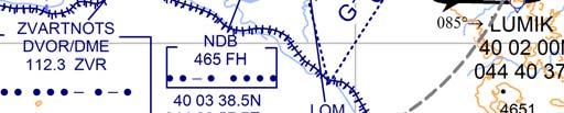
8 AD 2.UDYZ-8 07 DEC 2017~~~eaip-amdt~~~AIRAC AIP Republic of Armenia UDYZ AD 2.19 Radio navigation and landing aids Type of aid, CAT of IL/ML (For VOR/IL/ML, give VAR) ID Frequency Hours of operation ite of transmitting antenna coordinates Elevation of DME transmitting antenna 1 DVOR/DME 2 ZVR MHz H N ft 7 Coverage FL NM (5 E) (CH 70x) E IL/DME GP 09 LLZ 09 IZR MHz (CH 18x) MHz H24 H N E N RDH 52 FT /15.9M 326 M past THR 09 right side 120 M from the centre line 491 M beyond THR 27 IL CAT II E ( 5 E ) 1 Airport regulations UDYZ AD 2.20 Local traffic regulations At Yerevan "Zvartnots" Airport a number of local regulations are applied. The regulations are collected in a manual which is available at the AI Briefing Office. This manual includes, among other subjects, the following: a. information about aircraft stands ; b. information about taxiing from aircraft stands; c. limitations in the operation of large aircraft including limitations in the use of the aircraft"s own power for taxiing; d. information about taxiing to aircraft stands; e. information about engine start-up positions; Information about the regulations for taxiing can be obtained from Yerevan Ground. When a local regulation is important for the safe operation of aircraft on the apron, Yerevan Ground gives information to each aircraft. 2 Taxiing to and from stands Arriving aircraft is allocated a stand number by Yerevan Ground. Taxiing of aircraft will be guided by FOLLOW-ME vehicle only by crew request or in low visibility condition. Departing aircraft obtains pushback, engine start-up clearance and taxi instruction from Yerevan Ground on MHZ. 3 Parking area for small aircraft (General aviation) NIL 4 Parking area for helicopters NIL 5 Apron taxiing during winter conditions NIL 6 Taxiing limitations Information concerning limitation for use of TWY and Apron of large aircraft is given to each aircraft from Yerevan Ground. AIRAC AMDT 03/ ARMAT CJC
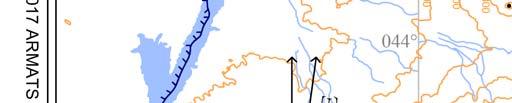
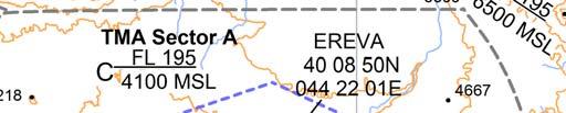
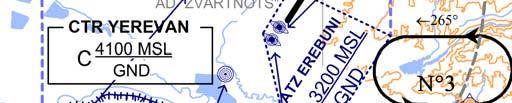
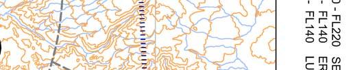
9 AIP Republic of Armenia AD 2.UDYZ ~~~eaip-amdt~~~airac DEC 7 chool and training flights technical test flights use of runways chool and training flights must be made only after permission thereto has been obtained from AT authority. 8 Helicopter traffic limitation NIL 9 Removal of disabled aircraft from runways In case when the aircraft is wrecked on a runway, it is removed from the runway by the aerodrome authority as quickly as possible. UDYZ AD 2.21 Noise abatement procedures There are established noise preferable routes, practically allowing inbound and outbound aircraft, to avoid flights above aerodrome adjacent areas susceptible to noise: I. As preferable Runway 09 for approach and Runway 27 for take-off are considered. II. In case of take-off from the Runway 27, turn is performed up to or after over-flight above city Etchmiadzin. It is not permitted to over-flight above city Etchmiadzin on the low levels. III. Take-off from the Runway 09 (above Yerevan) is permitted in the presence of meteorological condition. General UDYZ AD 2.22 Flight procedures Unless special permission has been obtained from Yerevan Approach or Yerevan Tower as appropriate, flight within Yerevan TMA and Yerevan CTR shall be in accordance with the Instrument Flight Rules. Procedures for IFR flights within Yerevan TMA The inbound, transit and outbound routes shown on the charts may be varied at the discretion of AT. If necessary, in case of congestion, inbound aircraft may also be instructed to hold at EVAN or EREVA. Radar procedures within Yerevan TMA Radar vectoring and sequencing From EVAN, GOI, TIBLO and INDUR begin TARs to the IAF to RWY 09 (IL/DME, DVOR/DME and RNAV (GN)) and RWY 27 (RNAV (GN)) so as to ensure an expedite flow of traffic. Radar vectors and flight levels/altitudes will be issued, as required, for spacing and separating the aircraft, so that the correct landing intervals are maintained, taking into account aircraft characteristics. Radar vectoring chart see UDYZ AD NIL NIL urveillance radar approaches Precision radar approach Communication failure In case of communication failure, the pilot shall act in accordance with the communication failure procedures in ICAO Doc Procedures for VFR flights within Yerevan TMA ee ENR 1.2. Procedures for VFR flights within YerevanCTR ee ENR ARMAT CJC AIRAC AMDT 03/2017
10 AD 2.UDYZ DEC 2017~~~eaip-amdt~~~AIRAC AIP Republic of Armenia Restriction on RWY 09/27 UDYZ AD 2.23 Additional information 180 degree turn of the aircraft on the RWY 09/27 is forbidden, except at the RWY turn pad. Pocket A-3750m from the Northern ide of the Runway by 27 threshold, 265 MC. Pocket B-2900m from the outhern ide of the Runway by 27 threshold, 265 MC. Bird concentrations in the vicinity of the airport Ornithological situation around the aerodrome can be conditioned by seasonal and daily migration of birds. Majority of them fly at meters above ground level. There is a river (ev-jur) in the outh of the aerodrome territory. There are artificial pools developed by fish industry where wild ducks are living during the whole year. Daybreak and seasonal migration of birds can be considered as the most vulnerable period. During dark time of the day the birds are forming large dispersed accumulations increasing the risk of collision. Availability of agricultural holdings is favorable for carrion crows and pigeons. It is recommended to switch on landing headlight crossing the area of the aerodrome at take-off, approach as well as during climb and letdown. Maximum transmigration in the vicinity of the aerodrome is at 9, 16, 20 o clock. Most of the birds fly at the height of m. ome birds don t fly more than 1 km above the ground. Only some kinds of birds, especially the wild ones, are able to fly at the height of 3-5 km. The speed of the birds flight vibrates from 15 to 100 km/hour. During the maximum activity of the birds in the vicinity of the airdrome, visual and radar monitoring of the ornithological situation is organized. The results of monitoring are informed to the controller, who, in case of dangerous ornithological situation, should: a. take measures to scare the birds, which prevent the landing (take-off) b. inform the crew about the existence of birds in the sector of landing (take-off) c. permit landing or departure, send the aircraft to holding pattern or around again d. if it is not possible to make a landing at the airdrome Zvartnots, the controller sends the aircraft to the alternate airdrome. Regular visual observation is done at the airdrome for the ornithological condition before take-off and landing. Receiving an information about dangerous ornithological condition in the airdrome, the crew observes the air condition and, if necessary, makes maneuver for avoiding a dangerous area or maintains controller instruction. An automatically transmitting system of operative and meteorological information (ATI) for aircraft is functioning at Yerevan Zvartnots airdrome. pecial measures are being undertaken regularly by switching on bioacoustic systems Fenix with sound effects. Guns perform additional frightening. AIRAC AMDT 03/ ARMAT CJC
11 AIP Republic of Armenia AD 2.UDYZ-11 ~~~eaip-amdt~~~airac DEC 2017 UDYZ AD 2.24 Charts related to an aerodrome Aerodrome ground Movement and Aircraft Parking Chart ICAO (see page UDYZ AD 2.2-1) Aerodrome Chart ICAO (see page UDYZ AD 2.2-3) Aerodrome Obstacle Chart ICAO Type A (see page UDYZ AD 2.2-5) Precision Approach Terrain chart ICAO (see page UDYZ AD 2.2-7) Area Chart ICAO (see page UDYZ AD 2.2-9) List Of Coordinates For RVA Yerevan TMA (In use -15 C and above) (see page UDYZ AD ) ATC urveillance Minimum Altitude Chart - ICAO (In use -15 C and above) (see page UDYZ AD ) List Of Coordinates For RVA Yerevan TMA (In use below -15 C) (see page UDYZ AD ) ATC urveillance Minimum Altitude Chart - ICAO (In use below -15 C) (see page UDYZ AD ) tandard Departure Route Instrument ID RNAV1 (GN) RWY 09 (see page UDYZ AD ) tandard Departure Route Instrument ID RNAV1 (GN) RWY 09 (see page UDYZ AD ) tandard Departure Route Instrument ID RNAV1 (GN) RWY 09 (see page UDYZ AD ) tandard Departure Chart Instrument ID ICAO RNAV1 (GN) RWY 09 (see page UDYZ AD ) tandard Departure Route Instrument ID RNAV1 (GN) RWY27 (see page UDYZ AD ) tandard Departure Route Instrument ID RNAV1 (GN) RWY27 (see page UDYZ AD ) tandard Departure Route Instrument ID RNAV1 (GN) RWY27 (see page UDYZ AD ) tandard Departure Chart Instrument ID ICAO RNAV1 (GN) RWY 27 (see page UDYZ AD ) tandard Arrival Route Instrument TAR RNAV1 (GN) RWY09 (see page UDYZ AD ) tandard Arrival Route Instrument TAR RNAV1 (GN) RWY09 (see page UDYZ AD ) tandard Arrival Route Instrument TAR RNAV1 (GN) RWY09 (Waypoint Data/List) (see page UDYZ AD ) tandard Arrival Chart - Instrument TAR ICAO RNAV1 (GN) RWY 09 (see page UDYZ AD ) tandard Arrival Route Instrument TAR RNAV1 (GN) RWY27 (see page UDYZ AD ) tandard Arrival Route Instrument TAR RNAV1 (GN) RWY27 (see page UDYZ AD ) tandard Arrival Route Instrument TAR RNAV1 (GN) RWY27 (Waypoint Data/List) (see page UDYZ AD ) tandard Arrival Chart Instrument TAR ICAO RNAV1 (GN) RWY 27 (see page UDYZ AD ) Instrument Approach Chart ICAO IL/DME RWY 09 (see page UDYZ AD ) Instrument Approach Chart ICAO DVOR/DME RWY 09 (see page UDYZ AD ) 2017 ARMAT CJC AIRAC AMDT 03/2017
12 AD 2.UDYZ DEC 2017~~~eaip-amdt~~~AIRAC AIP Republic of Armenia RNP RWY 09 INTRUMENT APPROACH (LNAV/VNAV) - Route Data (see page UDYZ AD ) RNP RWY 09 INTRUMENT APPROACH (LNAV/VNAV) - (Waypoint Data/ List) (see page UDYZ AD ) Instrument Approach Chart ICAO RNP RWY09 (LNAV/VNAV) (see page UDYZ AD ) Circle-To-Land RWY 27 (see page UDYZ AD ) RNP Z RWY27 INTRUMENT APPROACH (LNAV only)- (Route Data) (see page UDYZ AD ) RNP Z RWY27 INTRUMENT APPROACH (LNAV only) - (Waypoint Data/List) (see page UDYZ AD ) Instrument Approach Chart ICAO RNP Z RWY 27 (LNAV only) (see page UDYZ AD ) RNP (GN) Y RWY 27 Instrument Approach (LNAV only) - (Route Data) (see page UDYZ AD ) RNP (GN) Y RWY27 Instrument Approach (LNAV only) - (Waypoint Data/List) (see page UDYZ AD ) Instrument Approach Chart ICAO RNP Y RWY 27 (LNAV only) (see page UDYZ AD ) Visual Approach Chart ICAO RWY 09/27 (see page UDYZ AD ) AIRAC AMDT 03/ ARMAT CJC
13
14 PAGE INTENTIONALLY LEFT BLANK
15 AIP Armenia UDYZ AD DEC 2016 ARMENIA YEREVAN / International YEREVAN GND TWR AD ELEV N E DVOR/DME ZVR N E 3106 IL LLZ IZR CWY 400X ARP AERODROME CHART - ICAO APRON 1 CARGO TERMINAL 2926 TERMINAL MAIN A 2910 B APRON 2 APRON PAPI GP 3 (5.24%) REA 150X ELEV 2800 REA 150X A ARP B C D METRE CHANGE:NEW DVOR/DME FEET A C B X 56 APHALT-CONCRETE m X 300m TRIP ELEV ILDME GP CWY 300X150 PAPI GP 3.50 (6.2%) PRECIION APPROACH CAT II LIGHTING YTEM 2850 Distance between runway threshold and centerlines of taxiways AERODROME LIGHTING TRENGTH From TWY C From TWY B From TWY A RWY TRUE DIRECTION THR N E PCN N 3085 /F/C/X/T E Approach: RWY 09 CAT II HIAL RWY 27 NONE Runway: Edge-white, last 600m yellow HIRL Threshold: Green 2016 ARMAT CJC AIRAC AMDT 05/2016
16 PAGE INTENTIONALLY LEFT BLANK
17
18 PAGE INTENTIONALLY LEFT BLANK
19 AIPArmenia UDYZAD DEC ARMAT CJC AIRAC AMDT 02/2012
20 PAGE INTENTIONALLY LEFT BLANK


21
22 PAGE INTENTIONALLY LEFT BLANK
23 LIT OF COORDINATE FOR RVA YEREVAN TMA Number ector Coordinate N E N E N E N E N E N E N Ethen along state border with Turkey to N E N E N E N E N E N E N Ethen along state border with Turkey to N E N E N E N E N E N E N E N E N E N E N E N E N E N Ethen along state border with Turkey to N E N E N E N E N E N E N E N E N E N E N E N E N E N E N E N E N E N E N E N E N E N E- Altitude/FL FL130 FL160 FL N E N E N E N E N E N Ethen along state border with Turkey to N E N E N E N E N E N E N E N E N E N E N E N E N E N E N E N E N E N E N E N E N E N E N E N E N E N E N E N E N E N E N E N E N E N E N E N E N E N E N E N E N E N E N E N E N E N E N Ethen along state border with Turkey to N E FL FL130
24 PAGE INTENTIONALLY LEFT BLANK
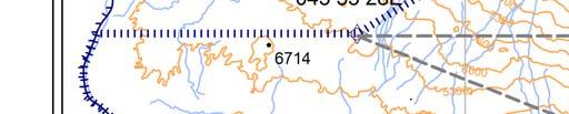
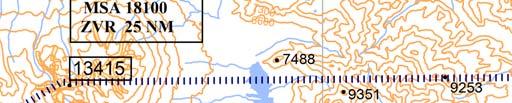
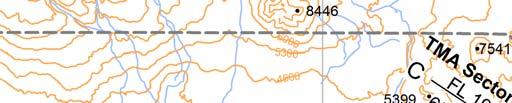
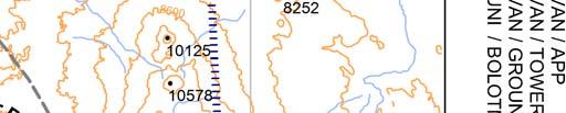
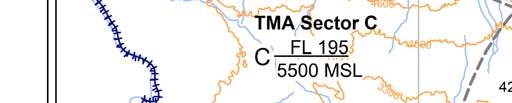
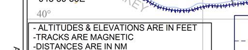
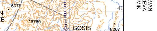
25 AIP Armenia UDYZ AD DEC 2016 ATC urveillance Minimum Altitude Chart - ICAO In use -15 C and above ATI YEREVAN / APP YEREVAN / TOWER YEREVAN / GROUND EREBUNI / BOLOTNY AD ELEV 2838 Transition Altitude YEREVAN TMA CHANGE: NEW DVOR/DME, WPT "EREVA" EVAN N E FL130 FL130 VAR 5 E FL TIBLO N E ` FL UD (p) 1 FL GND EREVA N E ZVARTNOT DVOR/DME ZVR ARMENIA INDUR N E 6078 TURKEY N E 10 NM GOI N E FL130 In case of communication failure during radar vectoring proceed to EREVA at last cleared altitude but not below 7000' Kilometres NM Nautical mile ` ` 2016 ARMAT CJC AIRAC AMDT 05/2016
26 PAGE INTENTIONALLY LEFT BLANK
27 LIT OF COORDINATE FOR RVA YEREVAN TMA Number ector Coordinate N E N E N E N E N E N E N E-then along state border with Turkey to N E N E N E N E N E N E N E-then along state border with Turkey to N E N E N E N E N E N E N E N E N E N E N E N E N E N E-then along state border with Turkey to N E N E N E N E N E N E N E N E N E N E N E N E N E N E N E N E N E N E N E N E N E N E N E N E N E N E N E- Altitude/FL FL140 FL180 FL N Ethen along state border with Turkey to N E N E N E N E N E N E N E N E N E N E N E N E N E N E N E N E N E N E N E N E N E N E N E N E N E N E N E N E N E N E N E N E N E N E N E N E N E N E N E N E N E N E N E N E N E N E N Ethen along state border with Turkey to N E FL FL130
28 PAGE INTENTIONALLY LEFT BLANK
29 AIP Armenia UDYZ AD MAR 2017 ATC urveillance Minimum Altitude Chart - ICAO In use below -15 C ATI YEREVAN / APP YEREVAN / TOWER YEREVAN / GROUND EREBUNI / BOLOTNY AD ELEV 2838 Transition Altitude YEREVAN TMA CHANGE: CORR. FL of N5, N EVAN N E FL FL140 VAR 5 E FL TIBLO N E ` FL UD (p) 1 FL GND EREVA N E ZVARTNOT DVOR/DME ZVR ARMENIA INDUR N E 6078 TURKEY N E NM 6760 GOI N E FL130 In case of communication failure during radar vectoring proceed to EREVA at last cleared altitude but not below 7000' Kilometres NM Nautical mile ` ` 2017 ARMAT CJC AIRAC AMDT 01/2017
30 PAGE INTENTIONALLY LEFT BLANK
31 AIP Republic of Armenia UDYZ AD MAY 2016 tandard Departure Route Instrument ID RNAV1 (GN) RWY09 Designator INDUR 3H Route Climb on track 085 (T090.6 ) to YZ450; RT direct to INDUR. Climb initially A4100 After take-off Expect FREQ Yerevan Approach MHZ PDG 4.6% up to FL140 Example: YZ450 denotes fly-over RNAV ID CODING TABLE OF INDUR 3H Path Terminator Identifier Waypoint Fly Over CF YZ450 Y Course/ Constraints DIT Turn Track Mag(True) NM Direction Coordinates Level IA N E (T090.6 ) Navigation pecification 0.9 K210- RNAV1 DF INDUR N N E R FL140+ RNAV1 Designator EVAN 3H Route Climb on track 085 (T090.6 ) to YZ450; RT direct to YZ453 then on track 040 (T046.1) to EVAN Climb initially A4100 After take-off Expect FREQ Yerevan Approach MHZ PDG 6.6% up to FL130 Example: YZ450 denotes fly-over RNAV ID CODING TABLE OF EVAN 3H Path Terminator Identifier Waypoint Fly Over Course/ Constraints DIT Turn Track Mag(True) NM Direction Coordinates Level IA Navigation pecification CF YZ450 Y N E (T090.6 ) 0.9 K210- RNAV1 DF YZ453 N N E R FL130+ TF EVAN N N E (T046.1) 16.7 FL130+ RNAV ARMAT CJC AIRAC AMDT 02/2016
32 PAGE INTENTIONALLY LEFT BLANK
33 AIP Republic of Armenia UDYZ AD AUG 2017 tandard Departure Route Instrument ID RNAV1 (GN) RWY09 Designator TIBLO 3H Route Climb on track 085 (T090.6 ) to YZ450; RT direct to TIBLO Climb initially A4100 After take-off Expect FREQ Yerevan Approach MHZ PDG 5.2% up to FL140 Example: YZ450 denotes fly-over RNAV ID CODING TABLE OF TIBLO 3H Path Terminator Identifier Waypoint Fly Over CF YZ450 Y Course/ Constraints DIT Turn Track Mag(True) NM Direction Coordinates Level IA N E (T090.6 ) Navigation pecification 0.9 K210- RNAV1 DF TIBLO N N E R FL140+ RNAV1 Designator GOI 4H Route Climb on track 085 (T090.6 ) to YZ450; RT direct to GOI Climb initially A4100 After take-off Expect FREQ Yerevan Approach MHZ PDG 6.8% up to FL130 Example: YZ450 denotes fly-over RNAV ID CODING TABLE OF GOI 4H Path Terminator Identifier Waypoint Fly Over Course/ Constraints DIT Turn Track Mag(True) NM Direction Coordinates Level IA Navigation pecification CF YZ450 Y N E (T090.6 ) 0.9 K210- RNAV1 DF GOI N N E R FL130+ RNAV ARMAT CJC AIRAC AMDT 02/2017
34 PAGE INTENTIONALLY LEFT BLANK
35 AIP Republic of Armenia UDYZ AD DEC 2016 tandard Departure Route Instrument ID RNAV1 (GN) RWY09 Waypoint Data/ List WPT Name CODING DIPLAY YZ450 N E N E YZ453 N E N E EVAN N E N E INDUR N E N E GOI N E N E TIBLO N E N E ARMAT CJC AIRAC AMDT 05/2016
36 PAGE INTENTIONALLY LEFT BLANK
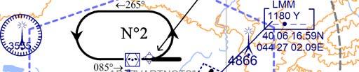
37 ARMENIA AIP Armenia UDYZ AD AUG 2017 CHANGE: NEW GOI 4H YEREVAN / Zvartnots RNAV1 (GN) RWY 09 TANDARD DEPARTURE CHART - INTRUMENT (ID) - ICAO TIBLO 3H, EVAN 3H GOI 4H, INDUR 3H ATI YEREVAN / GROUND YEREVAN / TOWER YEREVAN / APP AD ELEV 2838 THR RWY 09 ELEV TRANITION ALTITUDE WARNING: ` ALTITUDE & ELEVATION ARE IN FEET TRACK ARE MAGNETIC DITANCE ARE IN NM EVAN N E FL UD (p) E N RADIU 1.6 NM û ` VAR 5 E NOTE: EVAN 3H TIBLO N E - Contact Yerevan Approach immediately after take-off FL YZ453 at or above FL130 û - tandard Instrument Departure Routes are also minimum noise routings MA D25 NM ZVARTNOT DVOR/DME TIBLO 3H trict adherence within the limits of performance criteria is mandatory If unable to comply with ID, climb gradients or non-standard clearance issued, advise ATC prior to take-off and request alternative clearance GND 3555 UD (p) FL YZ450 - During initial turns Max IA 210 bank angle 20 INDUR 3H û INDUR N E FL140 GOI 4H TURKEY ZVARTNOT DVOR/DME ZVR û N E 7900 GOI N E FL130 Kilometres Nautical mile 2017 ARMAT CJC AIRAC AMDT 02/2017
38 PAGE INTENTIONALLY LEFT BLANK
39 AIP Republic of Armenia UDYZ AD MAY 2016 tandard Departure Route Instrument ID RNAV1 (GN) RWY27 Designator EVAN 3E Route Climb on track 265 (T270.4 ) to YZ455; RT direct to YZ457 then on track 049 (T053.8 ) to EVAN Climb initially A4100 After take-off Expect FREQ Yerevan Approach MHZ PDG 7% up to FL130 Example: YZ455 denotes fly-over RNAV ID CODING TABLE OF EVAN 3E Path Terminator Identifier Waypoint Course/ Constraints DIT Turn Fly Track NM Direction Coordinates Mag(True) Level IA Over Navigation pecification CF YZ455 Y N E (T270.4 ) 1.0 K210- RNAV1 DF YZ457 N N E R FL130+ RNAV1 TF EVAN N N E (T053.8 ) 16.9 FL130+ RNAV1 Designator TIBLO 3E Route Climb on track 265 (T270.4 ) to YZ 455; RT direct to YZ456 then on track 300 T(305.0 ) to TIBLO Climb initially A4100 After take-off Expect FREQ Yerevan Approach MHZ PDG 6.9% up to A6300 PDG 6.6% from A6300 up to FL140 Example: YZ455 denotes fly-over RNAV ID CODING TABLE OF TIBLO 3E Path Terminator Identifier CF YZ455 Y Waypoint Course/ Constraints DIT Turn Fly Track Mag(True) NM Direction Coordinates Level IA Over N E (T270.4 ) Navigation pecification 1.0 K210- RNAV1 DF YZ456 N N E R A6300+ K210- RNAV1 TF TIBLO N N E (T305.0 ) 18.4 FL140+ RNAV ARMAT CJC AIRAC AMDT 02/2016
40 PAGE INTENTIONALLY LEFT BLANK
41 AIP Republic of Armenia UDYZ AD MAY 2016 tandard Departure Route Instrument ID RNAV1 (GN) RWY27 Designator INDUR 3E Route Climb on track 265 (T270.4 ) to YZ455; direct to INDUR Climb initially A4100 After take-off Expect FREQ Yerevan Approach MHZ PDG 5.6% up to FL140 Example: YZ455 denotes fly-over RNAV ID CODING TABLE OF INDUR 3E Path Terminator Identifier Waypoint Fly Over Course/ Constraints DIT Turn Track Coordinates Mag(True) NM Direction Level IA Navigation pecification CF YZ455 Y N E (T270.4 ) 1.0 K210- RNAV1 DF INDUR N N E FL140+ RNAV1 Designator GOI 3E Route Climb on track 265 (T270.4 ) to YZ455; LT direct to GOI Climb initially A4100 After take-off Expect FREQ Yerevan Approach MHZ PDG 6.2% up to FL130 Example: YZ455 denotes fly-over RNAV ID CODING TABLE OF GOI 3E Path Terminator Identifier Waypoint Fly Over Coordinates Course/ Track Mag(True) DIT NM Turn Direction Constraints Level IA Navigation pecification CF YZ455 Y N E (T270.4 ) 1.0 L K210- RNAV1 DF GOI N N E FL130+ RNAV ARMAT CJC AIRAC AMDT 02/2016
42 PAGE INTENTIONALLY LEFT BLANK
43 AIP Republic of Armenia UDYZ AD DEC 2016 tandard Departure Route Instrument ID RNAV1 (GN) RWY27 Waypoint Data/ List WPT Name CODING DIPLAY YZ455 N E N E YZ456 N E N E YZ457 N E N E EVAN N E N E INDUR N E N E GOI N E N E TIBLO N E N E ARMAT CJC AIRAC AMDT 05/2016
44 PAGE INTENTIONALLY LEFT BLANK
45 û ARMENIA TURKEY AIP Republic of Armenia UDYZ AD DEC 2016 ATI YEREVAN / GROUND YEREVAN / TOWER YEREVAN / APP YEREVAN / Zvartnots RNAV1 (GN) RWY 27 TIBLO 3E, EVAN 3E GOI 3E, INDUR 3E ` û EVAN N E FL EVAN 3E NOTE: 049 YZ457 FL130 WARNING: - ALTITUDE & ELEVATION ARE IN FEET -TRACK ARE MAGNETIC -DITANCE ARE IN NM - UD (p) E N RADIU 1.6 NM - Contact Yerevan Approach immediately after take-off. - tandard Instrument Departure Routes are also minimum noise routings trict adherence within the limits of performance criteria is mandatory. - If unable to comply with ID, climb gradients or non-standard clearance issued, advise ATC prior to take-off and request alternative clearance GOI 3E ` û 6760 GOI N E FL130 - During initial turns Max IA 210 bank angle CHANGE: NEW DVOR/DME AD ELEV 2838 THR RWY 27 ELEV 2838 TANDARD DEPARTURE CHART - INTRUMENT (ID) - ICAO TRANITION ALTITUDE ` VAR 5 E TIBLO N E FL û TIBLO 3E 5300 MA D25 NM ZVARTNOT DVOR/DME YZ UD (p) 1 FL195 GND YZ INDUR 3E INDUR N E FL140 ZVARTNOT DVOR/DME ZVR Kilometres N E Nautical mile 2016 ARMAT CJC AIRAC AMDT 05/2016
46 PAGE INTENTIONALLY LEFT BLANK
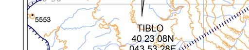
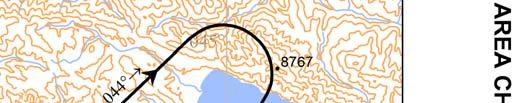
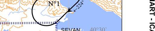
47 AIP Republic of Armenia UDYZ AD DEC 2016 tandard Arrival Route Instrument TAR RNAV1 (GN) RWY09 Designator Route TIBLO 3A Path Terminator Identifier Track 150 (T154.9 ) TIBLO - IAF OKUDA TIBLO (K250-;FL130+) IAF OKUDA (A7000+) RNAV TAR CODING TABLE OF TIBLO 3A Waypoint Course/ Constraints DIT Turn Track Fly NM Direction Coordinates Mag(True) Level IA Over TAR for IL/DME, DVOR/DME, RNP APCH Navigation pecification IF TIBLO N N E FL130+ K250- RNAV1 TF OKUDA N N E (T154.9 ) 15.8 A7000+ K230- RNAV1 Designator Route EVAN 3A Path Terminator Identifier Track 224 (T229.5 ) EVAN MAXAK 224 (T229.5 ) - IAF EREVA EVAN (K250-;FL130+) MAXAK ( K250-;FL130+) - IAF EREVA (A7000+) RNAV TAR CODING TABLE OF EVAN 3A Waypoint Course/ Constraints DIT Turn Track Fly NM Direction Coordinates Mag(True) Level IA Over TAR for IL/DME, DVOR/DME, RNP APCH Navigation pecification IF EVAN N N E FL130+ K250- RNAV1 TF MAXAK N N E (T229.5 ) 16.9 FL130+ K250- RNAV1 TF EREVA N N E (T229.5 ) 18.7 A7000+ K230- RNAV ARMAT CJC AIRAC AMDT 05/2016
48 PAGE INTENTIONALLY LEFT BLANK
49 AIP Republic of Armenia UDYZ AD DEC 2016 tandard Arrival Route Instrument TAR RNAV1 (GN) RWY09 Designator Route INDUR 3A Path Terminator Identifier Track 079 (T083.6 ) INDUR - IAF OKUDA INDUR ( K250-;FL140+) - IAF OKUDA (A7000+) RNAV TAR CODING TABLE OF INDUR 3A Waypoint Course/ Constraints DIT Turn Track Fly NM Direction Coordinates Mag(True) Level IA Over TAR for IL/DME, DVOR/DME, RNP APCH Navigation pecification IF INDUR N N E FL140+ K250- RNAV1 TF OKUDA N N E (T083.6 ) 17.2 A7000+ K230- RNAV1 Designator Route GOI 3A Path Terminator Identifier Track 288 (T293.0 ) GOI BANAG 288 (T293.0 ) - IAF EREVA GOI (K250-;FL130+) BANAG (K250-;A10000+) - IAF EREVA (A7000+) RNAV TAR CODING TABLE OF GOI 3A Waypoint Course/ Constraints DIT Turn Track Fly NM Direction Coordinates Mag(True) Level IA Over TAR for IL/DME, DVOR/DME, RNP APCH Navigation pecification IF GOI N N E FL130+ K250- RNAV1 TF BANAG N N E (T293.0 ) 18.4 A K250- RNAV1 TF EREVA N N E (T292.8 ) 12.8 A7000+ K230- RNAV ARMAT CJC AIRAC AMDT 05/2016
50 PAGE INTENTIONALLY LEFT BLANK
51 AIP Republic of Armenia UDYZ AD DEC 2016 tandard Arrival Route Instrument TAR RNAV1 (GN) RWY09 Waypoint Data/ List WPT Name CODING DIPLAY EVAN N E N E INDUR N E N E GOI N E N E TIBLO N E N E MAXAK N E N E BANAG N E N E OKUDA (IAF) N E N E EREVA (IAF) N E N E ARMAT CJC AIRAC AMDT 05/2016
52 PAGE INTENTIONALLY LEFT BLANK
53 ARMENIA TURKEY AIP ARMENIA UDYZ AD DEC 2016 CHANGE: NEW DVOR/DME, WPT "EREVA" YEREVAN / Zvartnots RNAV1 (GN) RWY 09 AD ELEV 2838 THR RWY 09 ELEV 2800 TANDARD ARRIVAL CHART - INTRUMENT (TAR) - ICAO TIBLO 3A, EVAN 3A, GOI 3A, INDUR 3A ATI YEREVAN / APP YEREVAN / TOWER YEREVAN / GROUND 7300 TRANITION LEVEL By ATC TRANITION ALTITUDE WARNING: ALTITUDE & ELEVATION ARE IN FEET TRACK ARE MAGNETIC DITANCE ARE IN NM EVAN N E FL ` - UD (p) E N RADIU 1.6 NM VAR 5 E EVAN 3A TIBLO N E FL MAXAK N E FL MA D25 NM ZVARTNOT DVOR/DME TIBLO 3A UD (p) FL GND HOLDING MHA 7000 MAX IA 215 1min IAF 7000 EREVA N E IAF 7000 INDUR 3A OKUDA N E INDUR N E FL140 GOI N E FL BANAG N E ZVARTNOT DVOR/DME ZVR GOI 3A N E Kilometres ` 045 Nautical mile 2016 ARMAT CJC AIRAC AMDT 05/2016
54 PAGE INTENTIONALLY LEFT BLANK
55 AIP Republic of Armenia UDYZ AD MAY 2016 tandard Arrival Route Instrument TAR RNAV1 (GN) RWY27 Designator Route GOI 3B Track 285 (T290.0 ) GOI DITAK 285 (T290 ) - IAF LUMIK GOI (K250-;FL130+) DITAK (K210-;A10000+) IAF LUMIK (A9200+) TAR for RNP APCH (Z/Y) RNAV TAR CODING TABLE OF GOI 3B Path Terminator Identifier Waypoint Course/ Constraints DIT Turn Track Fly NM Direction Coordinates Mag(True) Level IA Over Navigation pecification IF GOI N N E FL130+ K250- RNAV1 TF DITAK N N E (T290.0 ) 9.8 A K210- RNAV1 TF LUMIK N N E (T290.0 ) 5.3 A9200+ K210- RNAV1 Designator Route INDUR 3B Track 091 (T095.7 ) - IAF LUMIK INDUR (K250-;FL140+) IAF LUMIK (A9200+) TAR for RNP APCH (Z/Y) RNAV TAR CODING TABLE OF INDUR 3B Path Terminator Identifier Waypoint Fly Over Coordinates Course/ Track Mag(True) DIT NM Turn Direction Constraints Level IA Navigation pecification IF INDUR N N E FL140+ K250- RNAV1 TF LUMIK N N E (T095.7 ) 46.9 A9200+ K210- RNAV ARMAT CJC AIRAC AMDT 02/2016
56 PAGE INTENTIONALLY LEFT BLANK
57 AIP Republic of Armenia UDYZ AD MAY 2016 tandard Arrival Route Instrument TAR RNAV1 (GN) RWY27 Designator Route EVAN 3B Track 224 (T229.5 ) EVAN MAXAK 175 (T179.8 ) - IAF LUMIK EVAN (K250-;FL130+) MAXAK ( K250-;FL130+) - IAF LUMIK (A9200+) TAR for RNP APCH (Z/Y) RNAV TAR CODING TABLE OF EVAN 3B Path Terminator Identifier Waypoint Fly Over Coordinates Course/ Track Mag(True) DIT NM Turn Direction Constraints Level IA Navigation pecification IF EVAN N N E FL130+ K250- RNAV1 TF MAXAK N N E (T229.5 ) 16.7 FL130+ K250- RNAV1 TF LUMIK N N E (T179.8 ) 19.1 L A9200+ K210- RNAV1 Designator Route TIBLO 3B Track 115 (T120.1 ) - IAF LUMIK TIBLO (K250-;FL130+) IAF LUMIK (A9200+) TAR for RNP APCH (Z/Y) RNAV TAR CODING TABLE OF TIBLO 3B Path Terminator Identifier Waypoint Fly Over Coordinates Course/ Track Mag(True) DIT NM Turn Direction Constraints Level IA Navigation pecification IF TIBLO N N E FL130+ K250- RNAV1 TF LUMIK N N E (T120.1 ) 42.0 A9200+ K210- RNAV ARMAT CJC AIRAC AMDT 02/2016
58 PAGE INTENTIONALLY LEFT BLANK
59 AIP Republic of Armenia UDYZ AD DEC 2016 tandard Arrival Route Instrument TAR RNAV1 (GN) RWY27 Waypoint Data/ List WPT Name CODING DIPLAY EVAN N E N E INDUR N E N E GOI N E N E TIBLO N E N E MAXAK N E N E DITAK N E N E LUMIK (IAF) N E N E ARMAT CJC AIRAC AMDT 05/2016
60 PAGE INTENTIONALLY LEFT BLANK
61 175 ARMENIA TURKEY AIP ARMENIA UDYZ AD DEC 2016 CHANGE: NEW DVOR/DME YEREVAN / Zvartnots RNAV1 (GN) RWY 27 AD ELEV 2838 THR RWY 27 ELEV 2838 TANDARD ARRIVAL CHART - INTRUMENT (TAR) - ICAO TIBLO 3B, EVAN 3B, GOI 3B, INDUR 3B ATI YEREVAN / APP YEREVAN / TOWER YEREVAN / GROUND TRANITION LEVEL By ATC TRANITION ALTITUDE WARNING: ` ALTITUDE & ELEVATION ARE IN FEET TRACK ARE MAGNETIC DITANCE ARE IN NM UD (p) E N RADIU 1.6 NM 40 30` EVAN N E FL ` VAR 5 E EVAN 3B TIBLO N E FL MAXAK N E MA D25 NM ZVARTNOT DVOR/DME 4600 TIBLO 3B 9200 FL UD (p) FL GND HOLDING MHA 9200 MAX IA 215 1min DITAK N E INDUR 3B INDUR N E FL140 IAF LUMIK N GOI 3B E 4651 ZVARTNOT DVOR/DME ZVR ` 044 Kilometres GOI N E FL N E Nautical mile 2016 ARMAT CJC AIRAC AMDT 05/2016
62 PAGE INTENTIONALLY LEFT BLANK
63 AIP Republic of Armenia UDYZ AD MAR 2017 INTRUMENT APPROACH CHART - ICAO TRANITION LEVEL By ATC TRANITION ALTITUDE ` VAR 5 E ` UD (p) 1 FL195 GND IAF IF 09` 4.4 ZVR D9.4 OKUDA N E ZVR D13.9 R 265 ( ZVR D8.1 R NM ` 40 03`In case of communication failure during radar vectoring proceed to EREVA at last cleared altitude but not below FAP IZR D7.1 ZVR D5.4 ( ZVR D8.1 R 247 AD ELEV 2838 HEIGHT RELATED TO THR RWY 09 ELEV 2800 IL/DME IZR CH 18 X ARMENIA TURKEY ` 265 HOLDING MHA 7000 MAX IA 215 1min A, B C, D ZVARTNOT DVOR/DME ZVR N E 3169 : ATI YEREVAN / APP YEREVAN / TWR YEREVAN / GND IAF ` EREVA N E ZVR D1.3 R ZVR D 5.2 R 128 MA ZVR 25 NM ` LLZ IZR « Kilometres Nautical mile ˆˆ ˆ YEREVAN / Zvartnots G 4285 C ATZ EREBUNI 3200 ML GND 10 NM 3500 or ZVR D5.3 R N E Max IA Q ML GND IL/DME RWY ALTITUDE, ELEVATION AND HEIGHT ARE IN FEET BEARING AND TRACK ARE MAGNETIC DITANCE ARE IN NM MIED APCH - Climb straight ahead to 3500 (700) or ZVR D5.3 (whichever is earlier) then turn right to EREVA climbing to 7000 and hold. A, B: ZVR D8.1 R-255 C, D: ZVR D8.1 R ˆ (2300) ˆ FAP IZR D7.1 ZVR D A, B Max IA C, D Max IA 190 GP DVOR/DME ZVR 1.62 EREVA GP INOP IL IZR DME READING REFER TO THR 09 For Circling to RWY 27 see CIRCLE-TO-LAND chart IL RDH 52 ELEV hpa (THR RWY 09) 5 NM CHANGE: ZVR D 5.2 R 128 Cat of ACFT IL CAT II traight-in IL CAT I Approach GP INOP Ground peed Rate of Descent (grad %) A MAPt - EREVA or D0.3 NM IZR OCA/H B kt ft/min C 2853 (53) 2863 (63) 2879 (79) 2951 (151) 2961 (161) 2971 (171) 3210 (410) D 2889 (89) 2981 (181) Final Approach Distance NM ALT (HGT) IZR DME (2287) IZR DME (1648) IZR DME (1010) IZR DME (371) 2017 ARMAT CJC AIRAC AMDT 01/2017
EGOW AD LOCATION INDICATOR AND NAME EGOW - WOODVALE EGOW AD AERODROME GEOGRAPHICAL AND ADMINISTRATIVE DATA. 1 5nm NNE of Formby.
 UK MIL AIP AD 2 - EGOW - 1-1 06 JUL 06 EGOW AD 2.1 - LOCATION INDICATOR AND NAME EGOW - EGOW AD 2.2 - AERODROME GEOGRAPHICAL AND ADMINISTRATIVE DATA 1 ARP Co-ordinates and site at AD: 2 Direction and distance
VOR/DME or RADAR REQUIRED
 INSTRUMENT AERODROME ELEV 120 ft APPROACH HEIGHTS RELATED TO THR RWY 13R - ELEV 110 ft CHART HIGHEST ELEV TDZ 111 ft Note : Approach and circle-to-land under U.S. TERPS. DAEGU APP 135.9 346.3 DAEGU TWR
THE CHART IS MODIFIED FOR SIMULATION USE. DO NOT USE FOR REAL WORLD NAVIGATION N VATSIM HONG KONG
 53 52 51 50 H1 E1 60 MAINTENANCE APRON E 59 E1 61 F 58 EAST APRON 49 48 H1 G 57 55 56 H1 54 H 47 46 45 44 43 41 CARGO APRON THE CHART IS MODIFIED FOR SIMULATION USE. DO NOT USE FOR REAL WORLD NAVIGATION.
Minor engine repairs are available.
 Airport Information etails for City VLAIVOSTOK State/Province Country RUS Latitude N 43 23' 53.00" Longitude E 32 08' 56.00" Elevation 59 Longest Runway 400 Magnetic Variance W 0.0 Fuel Type JET A- fuel
Airport Information. Details for ARISTARCHOS OF SAMOS. State/Province
 Airport Information etails for ARISTARCHOS OF City State/Province Country GRC Latitude N 37 4' 2.00" Longitude E 26 54' 44.00" Elevation 9 Longest Runway 6700 Magnetic Variance E 4.0 Fuel Type 00 Low Lead
EGXJ AD 2.1 LOCATION INDICATOR AND NAME EGXJ - COTTESMORE EGXJ AD AERODROME GEOGRAPHICAL AND ADMINISTRATIVE DATA. 30nm NW of Peterborough
 UK MIL AIP AD 2 - EGXJ - 1-1 06 JUL 06 EGXJ AD 2.1 LOCATION INDICATOR AND NAME EGXJ - EGXJ AD 2.2 - AERODROME GEOGRAPHICAL AND ADMINISTRATIVE DATA 1 ARP Co-ordinates and site at AD: 2 Direction and distance
AD CHART RJTH / HACHIJOJIMA HACHIJOJIMA AIRPORT. AIP Japan HACHIJOJIMA RJTH-AD LONGITUDINAL PROFILE OF RUNWAY. (86.5m) 284ft 0.71% (87.4m) 0.
 284ft 0.71% (87.4m) 0.") RJTH-AD2-24.1 RJTH / AD CHART TRUE NORTH AIRPORT ABN APRON FLOOD LIGHTS RADIO OVERRUN AREA EDGE LGT 324.3m 1 2 3 RTHL ARP PAPI Angle 3.0 MEHT 18.5m(61ft) WDI WDI 26 08 CLOSED MARKINGS RWY THR ID LGT 322.6m
RJTH-AD2-24.1 RJTH / AD CHART TRUE NORTH AIRPORT ABN APRON FLOOD LIGHTS RADIO OVERRUN AREA EDGE LGT 324.3m 1 2 3 RTHL ARP PAPI Angle 3.0 MEHT 18.5m(61ft) WDI WDI 26 08 CLOSED MARKINGS RWY THR ID LGT 322.6m
General Info Stornoway, GBR N ' W ' Mag Var: 7.9 W Elevation: 26'
 irport Information EGPO (tornoway) General Info tornoway, GR N 58.9' W 06 9.9' Mag Var: 7.9 W Elevation: 6' Public, ontrol Tower, IFR, Landing Fee, ustoms availble on a restrcted basis Fuel: 00LL, Jet
airservices AERODROME CHART - Page 1 HOBART, TAS (YMHB) AD ELEV 13 S E Airservices Australia 2018 FIA (AH)
 AD ELEV 13 S E Airservices Australia 2018 FIA (AH)") S42 50 10 E147 30 37 AERODROME CHART - Page 1 ATIS AWIS SMC/ACD TWR FIA (AH) CTAF+AFRU (AH) AFRU+PAL (AH) E147 29 00 E147 30 00 E147 31 00 ELEV 53 GP VOR/ DME S42 50 00 C S42 50 00 TWR A 164 F G A J H
S42 50 10 E147 30 37 AERODROME CHART - Page 1 ATIS AWIS SMC/ACD TWR FIA (AH) CTAF+AFRU (AH) AFRU+PAL (AH) E147 29 00 E147 30 00 E147 31 00 ELEV 53 GP VOR/ DME S42 50 00 C S42 50 00 TWR A 164 F G A J H
TWR AIS APRON 3 APRON x 197 TCW CH86Y 'N 'E ABCDE ( /1.9) ABCDE ( /1.9)
 ABCDE ( /1.9)") AERODROE CHART 17 43' 17 44' 17 45' 17 46' 17 47' 54 25' TWR AIS APRON 2 APRON 3 APRON A 1 B A C 25 54 25' LOC 111.3 07 F APRON 4 A D APRON E A1 5 8261 x 197 TCW CH86Y GP/ 332.3/CH50X 54 24' 54 24' ARP
AERODROE CHART 17 43' 17 44' 17 45' 17 46' 17 47' 54 25' TWR AIS APRON 2 APRON 3 APRON A 1 B A C 25 54 25' LOC 111.3 07 F APRON 4 A D APRON E A1 5 8261 x 197 TCW CH86Y GP/ 332.3/CH50X 54 24' 54 24' ARP
JeppView for Windows. General Information. Runway Information. Communication Information. jep=jeppesen
 irport Information For UDYZ Printed on 27 Jan 2018 Page 1 (c) SNDERSON, INC., 2018, LL RIGHTS RESERVED jep= JeppView for Windows General Information Location: YEREVN RM ICO/IT: UDYZ / EVN Lat/Long: N40
CAT ' MON-THU , FRI CAT
 LPBJ Airport information: Country: Portugal City: A Coordinates: N 38 04.7', W 007 56.0' Elevation: 636 Customs: Nil Fuel: Not avbl RFF: CAT 8 MON-THU 0830-1715, FRI 0830-10. CAT 7 other times hours: MON-THU:
AERODROME DATA COCHIN INTERNATIONAL AIRPORT (VOCI)
") TEL: 91-11-24632950 Extn: 2219/2233 AFS: VIDDYXAX FAX: 91-11-24615508 Email: gmais@aai.aero INDIA AERONAUTICAL INFORMATION SERVICE AIRPORTS AUTHORITY OF INDIA RAJIV GANDHI BHAVAN SAFDARJUNG AIRPORT NEW
TEL: 91-11-24632950 Extn: 2219/2233 AFS: VIDDYXAX FAX: 91-11-24615508 Email: gmais@aai.aero INDIA AERONAUTICAL INFORMATION SERVICE AIRPORTS AUTHORITY OF INDIA RAJIV GANDHI BHAVAN SAFDARJUNG AIRPORT NEW
Airport Information. Details for KING PYRROS. State/Province
 Airport Information etails for City State/Province Country GRC Latitude N 39 4' 50.00" Longitude E 20 49' 9.00" Elevation 55 Longest Runway 700 Magnetic Variance E Fuel Type JET A- fuel is available Oxygen
JeppView for Windows. jep=jeppesen. Airport Information For LGKF Printed on 11 Dec 2017 Page 1. General Information. Runway Information
 Airport Information For LGKF Printed on 11 ec 017 Page 1 (c) SANERSON, INC., 017, ALL RIGHTS RESERVE jep= JeppView for Windows General Information Location: GRC ICAO/IATA: LGKF / EFL Lat/Long: N38 07.0',
Airport Information. Details for IFAISTOS. State/Province
 Airport Information etails for City State/Province Country GRC Latitude N 39 55' 02.00" Longitude E 25 14' 11.00" Elevation 14 Longest Runway 9800 Magnetic Variance E 2.0 Fuel Type JET A-1 fuel is available
ELEV 3950' KIMBERLEY 28 48'17.22"S '50.52"E FAKM AERODROME/ HELIPORT CHART - ICAO ELEV, ALT & HGT IN FEET VAR 21 W (2017)
") 20 AERODROME/ HELIPORT CHART - ICAO ELEV 3950' TWR : 118.20 APN : 122.65 BLOEMFONTEIN APP : 119.40 FAKM 28 47'30"S 28 47'40"S DIST IN METERS VAR 21 W (2017) RESA 300 x 90m CWY 300m x 150m THR 20 ELEV 3940'
20 AERODROME/ HELIPORT CHART - ICAO ELEV 3950' TWR : 118.20 APN : 122.65 BLOEMFONTEIN APP : 119.40 FAKM 28 47'30"S 28 47'40"S DIST IN METERS VAR 21 W (2017) RESA 300 x 90m CWY 300m x 150m THR 20 ELEV 3940'
LPPD. Runways: Runway 12 Takeoff length: 2353, Landing length: 2323 Runway 30 Takeoff length: 2426, Landing length: 2279
 LP Airport information: Country: Portugal City: Coordinates: N 37 44.5', W 025 4.9' Elevation: 259 Customs: Customs Fuel: Jet A RFF: CAT 7, CAT 8/9 by prior arrangement. hours: 065-2400 Runways: Runway
Effective: CAIRNS (YBCS) REVISED ILS RWY 15 PROCEDURES
 REVISED ILS RWY 15 PROCEDURES") AUSTRALIA AERONAUTICAL INFORMATION SERVICE AIRSERVICES AUSTRALIA GPO BOX 367, CANBERRA ACT 261 Phone: 2 6268 4874 Email: aim.editorial@australia.com Effective: AIP SUPPLEMENT (SUP) AIRAC H 12/19 21942416
AUSTRALIA AERONAUTICAL INFORMATION SERVICE AIRSERVICES AUSTRALIA GPO BOX 367, CANBERRA ACT 261 Phone: 2 6268 4874 Email: aim.editorial@australia.com Effective: AIP SUPPLEMENT (SUP) AIRAC H 12/19 21942416
1-10. GENERAL ATS Hours
 3-APR-5 ERC-LTCD - Turkey Erzincn AOI AOI H GENERAL ATS Hours Airport Informtion RFF: CAT 7 PCN: RWY /9: first m 5/R/C/W/T, rest 5/F/C/W/T Customs: PN HR for non-sked flits Opertion RWY Restriction Strictly
EGYC AD 2.1 LOCATION INDICATOR AND NAME EGYC - COLTISHALL EGYC AD AERODROME GEOGRAPHICAL AND ADMINISTRATIVE DATA. 7nm NNE of Norwich
 UK MIL AIP AD 2 - EGYC - 1-1 01 SEP 05 EGYC AD 2.1 LOCATION INDICATOR AND NAME EGYC - EGYC AD 2.2 - AERODROME GEOGRAPHICAL AND ADMINISTRATIVE DATA 1 ARP Co-ordinates and site at AD: 2 Direction and distance
Düsseldorf RG Airports
 Düsseldorf RG Airports Note: Not for real navigation! Mönchengladbach ( / MGL) Elevation 125 ft Effective: 11 MAR 2010 (Changes are marked yellow) NAVAIDS: Communication: 112.50 Station VATSIM Freq. 10.80
TWR AIS x 98. PAR x 197 D1 ARP 'N 'E 3.0 ABCDE SEE CHART ( /1.7) LOC 28L CDE ( /1.
 LOC 28L CDE ( /1.") AERODROME CHART 17 49' 17 50' 17 51' 17 52' 17 53' 52 23' LOC 111.1 10R 10L APRON 1 B3 B2 B1 A1 C2 C1 APRON 2 9003 x 98 TWR AIS A2 52 23' PAR 11532 x 197 D1 D2 APRON 3 28R APRON 4 A3 CH102Y GP/DME 331.7/CH48X
AERODROME CHART 17 49' 17 50' 17 51' 17 52' 17 53' 52 23' LOC 111.1 10R 10L APRON 1 B3 B2 B1 A1 C2 C1 APRON 2 9003 x 98 TWR AIS A2 52 23' PAR 11532 x 197 D1 D2 APRON 3 28R APRON 4 A3 CH102Y GP/DME 331.7/CH48X
JEPPESEN FliteMap
 REVISION LETTER For isc 09206 Licensed to r. Gyorgy Hajos. Printed on 30 Apr 206. Page Changed chart(s) since isc 08206 A = Added chart, REV = Revised chart, EL = eleted chart. ACT PROCEURE IENT INEX REV
JeppView for Windows. List of pages in this Trip Kit. Trip Kit Index
 Trip Kit Index Printed on 4 Jan 207 Page (c) SANDERSON, INC., 207, ALL RIGHTS RESERVED jep= JeppView for Windows List of pages in this Trip Kit Trip Kit Index Airport Information For UWKB Terminal Charts
LUKK/KIV .STAR KIV [ABLI3A] [ANED3A] [ABLI3E] [ANED3E] ANEDO ABLIK NOT FOR OPERATIONAL USE CHISINAU ANEDO 3A CHISINAU INTL
![LUKK/KIV .STAR KIV [ABLI3A] [ANED3A] [ABLI3E] [ANED3E] ANEDO ABLIK NOT FOR OPERATIONAL USE CHISINAU ANEDO 3A CHISINAU INTL](/thumbs/81/83199631.jpg "LUKK/KIV .STAR KIV [ABLI3A] [ANED3A] [ABLI3E] [ANED3E] ANEDO ABLIK NOT FOR OPERATIONAL USE CHISINAU ANEDO 3A CHISINAU INTL") , MOLOVA LUKK/KIV INTL 6 MAR 09 10-2.Eff.12.Mar..STAR. ATIS Alt Set: hpa 125.22 399' Trans level: By ATC Trans alt: ' 24 R125^ 20 R230^ 15.4 181^ ABLIK N46 30.8 E028 37.6 GOTIK (IAF Rwy ) NATIV N46 40.1
, MOLOVA LUKK/KIV INTL 6 MAR 09 10-2.Eff.12.Mar..STAR. ATIS Alt Set: hpa 125.22 399' Trans level: By ATC Trans alt: ' 24 R125^ 20 R230^ 15.4 181^ ABLIK N46 30.8 E028 37.6 GOTIK (IAF Rwy ) NATIV N46 40.1
(IF) (SDF) 50' N 34 30' N RECOMMENDED PROFILE(LOC ONLY) Final Approach Gradient 5.31%, 323 ft/nm FAF (LOC ONLY) IYSO D5.2. MAPt LOC ONLY IYSO D2.
 (SDF) 50' N 34 30' N RECOMMENDED PROFILE(LOC ONLY) Final Approach Gradient 5.31%, 323 ft/nm FAF (LOC ONLY) IYSO D5.2. MAPt LOC ONLY IYSO D2.") 10' ISTRUMET APPROACH CHART - ICAO ote : Approach under ICAO Flight Procedure. ELEV, ALT I FEET DIST I M BRG ARE MAG VAR 8 O W AERODROME ELEV 53 ft HEIGHTS RELATED TO THR RWY 17-ELEV 28 ft 2 876 SACHEO
10' ISTRUMET APPROACH CHART - ICAO ote : Approach under ICAO Flight Procedure. ELEV, ALT I FEET DIST I M BRG ARE MAG VAR 8 O W AERODROME ELEV 53 ft HEIGHTS RELATED TO THR RWY 17-ELEV 28 ft 2 876 SACHEO
JeppView for Windows. List of pages in this Trip Kit. jep=jeppesen. Trip Kit Index
 Trip Kit Index Printed on 22 Dec 208 Page (c) SANDERSON, INC., 208, ALL RIGHTS RESERVED jep= JeppView for Windows List of pages in this Trip Kit Trip Kit Index Airport Information For UKLR Terminal Charts
KPL N E LMO N E LGLM/LXS CHRISOUPOLIS ONE CHARLIE (KPL 1C) KOROS ONE CHARLIE RWYS 04R, 22L ARRIVALS .STAR.
 KOROS ONE CHARLIE RWYS 04R, 22L ARRIVALS .STAR.") 10-2 (T) CHRISOUPOLIS KPL 108.8 N40 54.8 E024 36.9 153^ 40 KPL 1C Alt Set: hpa Trans level: By ATC Trans alt: ' CHRISOUPOLIS ONE CHARLIE (KPL 1C) KOROS ONE CHARLIE (KOROS 1C) [KORO1C] RWYS 04R, 22L ARRIVALS,
10-2 (T) CHRISOUPOLIS KPL 108.8 N40 54.8 E024 36.9 153^ 40 KPL 1C Alt Set: hpa Trans level: By ATC Trans alt: ' CHRISOUPOLIS ONE CHARLIE (KPL 1C) KOROS ONE CHARLIE (KOROS 1C) [KORO1C] RWYS 04R, 22L ARRIVALS,
AERODROME CHART LASK (EPLK) PANS-OPS AERODROME CHART LASK (EPLK) ELEV ' 19 13' 19 10' 51 34' 34' 4 E (2010) J H K G TWR AIS LOC IAS 110.
 PANS-OPS AERODROME CHART LASK (EPLK) ELEV ' 19 13' 19 10' 51 34' 34' 4 E (2010) J H K G TWR AIS LOC IAS 110.") AERODROME CHART 19 09' 19 10' 19 11' 19 12' 19 13' 34' 34' 33' LOC 110.9 F 10 K G DARM D D H E C J H E J 8202 x 197 TWR AIS C B E GP/ 330.8/CH46X B A A 33' 28 32' 19 09' 19 10' ARP RWY PCN TORA ASDA TODA
AERODROME CHART 19 09' 19 10' 19 11' 19 12' 19 13' 34' 34' 33' LOC 110.9 F 10 K G DARM D D H E C J H E J 8202 x 197 TWR AIS C B E GP/ 330.8/CH46X B A A 33' 28 32' 19 09' 19 10' ARP RWY PCN TORA ASDA TODA
JEPPESEN 10-2.STAR. 16 JUL 10.Eff.29.Jul.
 , RUSSIA 102.STAR. *ATIS Apt Elev Alt set: MM (hpa on request) QNH on request (QFE) 126.9 1688' Trans level: Trans alt: IENI 1A [IEN1A] OSKEN 1A [OSKE1A] USONA 1A [USON1A] RWY 12 ARRIVALS FROM EAST & SOUTH
1-10. GENERAL Operational Hours
 Effective_5-JAN-17 9-EC-1 1-1 Turkey Burs Yeniseir AOI AOI ATS Hours / A AMIN Hours: H GENERAL Opertionl Hours Airport Informtion RFF: CAT Fuel: JP- PCN: RWY 7L/5R: 11/R/C/W/T LCN: RWY 7R/5L: 5 Customs:
JeppView for Windows. General Information. Runway Information. Communication Information. jep=jeppesen
 irport Information For ULMM Printed on 27 Jan 208 Page (c) SNDERSON, INC., 208, LL RIGHTS RESERVED jep= JeppView for Windows General Information Location: RUS ICO/IT: ULMM / MMK Lat/Long: N68 46.90', E032
JeppView for Windows. General Information. Runway Information. Communication Information. jep=jeppesen
 Airport Information For UBBG Printed on 27 Jan 2018 Page 1 (c) SANERSON, INC., 2018, ALL RIGHTS RESERVE jep= JeppView for Windows General Information Location: AZE ICAO/IATA: UBBG / KV Lat/Long: N40 44.33',
JeppView for Windows. jep=jeppesen. Airport Information For LGMK Printed on 11 Dec 2017 Page 1. General Information. Runway Information
 Airport Information For LGMK Printed on 11 ec 2017 Page 1 (c) SANERSON, INC., 2017, ALL RIGHTS RESERVE jep= JeppView for Windows General Information Location: GRC ICAO/IATA: LGMK / JMK Lat/Long: N37 26.23',
Airport Information. Details for TURKMENBASHI. Terminal Chart Change Notices. TURKMENBASHI State/Province
 Airport Information etails for City State/Province Country TKM Latitude N 40 03' 48.00" Longitude E 53 00'.00" Elevation 283 Longest Runway 11400 Magnetic Variance E 5.0 Fuel Type JET A-1 fuel is available
airservices AERODROME CHART - Page 1 DARWIN, NT (YPDN) AD ELEV 103 S E Airservices Australia 2019 ATIS ACD SMC TWR E
 AD ELEV 103 S E Airservices Australia 2019 ATIS ACD SMC TWR E") AD ELEV 103 S12 24 53 E130 52 36 ACD AERODROME CHART - Page 1 E130 52 00 E130 53 00 E130 54 00 FROM THR TO RWS EDGE LDA (MTRS) RWY 29 RWS 18/36 2687 RWY 36 RWS 11/29 1146 C4 Y2 Z WESTERN GA NORTHERN GA
AD ELEV 103 S12 24 53 E130 52 36 ACD AERODROME CHART - Page 1 E130 52 00 E130 53 00 E130 54 00 FROM THR TO RWS EDGE LDA (MTRS) RWY 29 RWS 18/36 2687 RWY 36 RWS 11/29 1146 C4 Y2 Z WESTERN GA NORTHERN GA
JeppView for Windows. jep=jeppesen. Airport Information For EPPO Printed on 06 Dec 2017 Page 1. General Information. Runway Information
 Airport Information For EPPO Printed on 06 ec 207 Page (c) SANERSON, INC., 207, ALL RIGHTS RESERVE jep= JeppView for Windows General Information Location: POL ICAO/IATA: EPPO / POZ Lat/Long: N52 25.27',
JeppView for Windows. General Information. Runway Information. Communication Information. jep=jeppesen
 irport Information For UN Printed on 27 Jan 208 Page (c) SNERSON, INC., 208, LL RIGHTS RESERVE jep= JeppView for Windows General Information Location: RUS ICO/IT: UN / B Lat/Long: N53 44.40', E09 23.2'
JeppView for Windows. List of pages in this Trip Kit. Trip Kit Index
 Trip Kit Index Printed on 06 Jan 2014 Page 1 (c) SANERSON, INC., 2014, ALL RIGHTS RESERVE jep= JeppView for Windows List of pages in this Trip Kit Trip Kit Index Airport Information For U Terminal Charts
Pattern Operations at Venango County Airport Cessna 172 CAP 180 HP
 Pattern Operations at Venango County Airport Cessna 172 CAP 180 HP Venango County Airport Complex Airport Designator: KFKL Runway dimensions: o Runway 3-21: 5201 feet x 150 feet o Runway 12-30: 3592 feet
JeppView for Windows. General Information. Runway Information. Communication Information. jep=jeppesen
 irport Information For LWOH Printed on 27 Jan 2018 Page 1 (c) SNERSON, IN., 2018, LL RIGHTS RESERVE jep= JeppView for Windows General Information Location: I MK IO/IT: LWOH / OH Lat/Long: N41 10.80', E020
JeppView for Windows. Runway Information. Communication Information. jep=jeppesen
 Airport Information For UIII Printed on 27 Jan 208 Page (c) SANERSON, INC., 208, ALL RIGHTS RESERVE jep= JeppView for Windows Irkutsk General Radar: Information 9.300 Irkutsk Transit Operations: 3.700
JEPPESEN. Alt Set: hpa Trans level: FL200 Trans alt: 19500' 1. GPS required. 2. RNP RADAR required. 4. DME/DME not required.
 HNGES: TIS frequency, Navdata identifier added., 2008, 20. LL RIGHTS RESERVE. NOTIE: PRINTE FROM N EXPIRE REVISION. isc 09-203 pt Elev 25 NOV 0-2 lt Set: hpa Trans level: FL200 Trans alt: 9500'. GPS required.
EGDL AD LOCATION INDICATOR AND NAME EGDL - LYNEHAM EGDL AD AERODROME GEOGRAPHICAL AND ADMINISTRATIVE DATA. 8nm WSW of Swindon.
 UK MIL AIP AD 2 - EGDL - 1-1 06 JUL 06 EGDL AD 2.1 - LOCATION INDICATOR AND NAME EGDL - EGDL AD 2.2 - AERODROME GEOGRAPHICAL AND ADMINISTRATIVE DATA 1 ARP Co-ordinates and site at AD: 2 Direction and distance
JeppView for Windows. General Information. Runway Information. Communication Information. jep=jeppesen
 irport Information For USRO Printed on 27 Jan 208 Page (c) SNDERSON, INC., 208, LL RIGHTS RESERVED jep= JeppView for Windows General Information Location: RUS ICO/IT: USRO / NOJ Lat/Long: N63.03', E075
Airport Information. Details for DEBRECEN. State/Province
 irport Information etails for ity State/Province ountry HUN Latitude N 47 29' 20.00" Longitude E 2 36' 55.00" Elevation 359 Longest Runway 8200 Magnetic Variance E 4.0 Fuel Type 00 Low Lead (LL) octane
General Info Nizhny Novgorod, RUS N ' E ' Mag Var: 10.5 E Elevation: 256'
 irport Information UWGG (Strigino) JeppView... General Info Nizhny Novgorod, RUS N 5.8' E 4 47.0' Mag Var: 0.5 E Elevation: 5' Public, IFR, ontrol Tower, ustoms Fuel: Jet Repairs: Minor irframe, Minor
JeppView for Windows. jep=jeppesen. Airport Information For EPRA Printed on 06 Dec 2017 Page 1. General Information. Runway Information
 irport Information For EPR Printed on 06 ec 2017 Page 1 (c) SNERSON, IN., 2017, LL RIGHTS RESERVE jep= JeppView for Windows General Information Location: ROM POL IO/IT: EPR / RO Lat/Long: N51 23.33', E021
JeppView for Windows. General Information. Runway Information. Communication Information. jep=jeppesen
 irport Information For ESOW Printed on 27 Jan 208 Page (c) SNERSON, IN., 208, LL RIGHTS RESERVE jep= JeppView for Windows General Information Location: STOKHOLM SWE IO/IT: ESOW / VST Lat/Long: N59 35.37',
AIRPLANE PERFORMANCES
 1. Introduction AIRPLANE PERFORMANCES In function of their category of approach, aircraft are not sharing the same characteristics. The main points of difference will be found at: Maximum Operation Minimum
EGVN AD 2.1 LOCATION INDICATOR AND NAME EGVN - BRIZE NORTON EGVN AD AERODROME GEOGRAPHICAL AND ADMINISTRATIVE DATA.
 UK MIL AIP AD 2 - EGVN - 1-1 12 JUN 03 EGVN AD 2.1 LOCATION INDICATOR AND NAME EGVN - EGVN AD 2.2 - AERODROME GEOGRAPHICAL AND ADMINISTRATIVE DATA 1 ARP Co-ordinates and site at AD: 2 Direction and distance
JeppView for Windows. Communication Information. Runway Information. jep=jeppesen
 Airport Information For LIRP Printed on ec 27 Page (c) SANERSON, INC., 27, ALL RIGHTS RESERVE jep= JeppView for Windows Lighting: General Edge, Information Centerline Communication Information Location:
Technical Report 8. Astral Aviation Consultants Construction Aeronautical Study
 Technical Report 8 Astral Aviation Consultants Construction Aeronautical Study FINAL REPORT WELLINGTON INTERNATIONAL AIRPORT SOUTH RUNWAY EXTENSION AERONAUTICAL STUDY ASTRAL LIMITED April 2016 CONTENTS
ST PETERSBURG, RUSSIA
 ULLI/LE.. ATIS ATIS 27.3 27.4 (Russian) + 5 JUN 2 0-P.Eff.28.Jun.. GENERAL.AIRPORT.BRIEFING..2. LOW IBILITY PROCEURES.2.. GENERAL Low visibility procedures shall be applied when is 000m or less and/or
FSHolland Bijeenkomst 2 september 2017 Vlucht 3 IFR LEMH (Menorca) to LEAL (Alicante-Elche)
 to LEAL (Alicante-Elche)") FSHolland Bijeenkomst 2 september 207 Vlucht 3 IFR LEMH (Menorca) to LEL (licante-elche) You created this PF from an application that is not licensed to print to novapf printer (http://www.novapdf.com)
FSHolland Bijeenkomst 2 september 207 Vlucht 3 IFR LEMH (Menorca) to LEL (licante-elche) You created this PF from an application that is not licensed to print to novapf printer (http://www.novapdf.com)
SPECIAL FLIGHT OPERATING CERTIFICATE
 Unmanned Transport SPECIAL FLIGHT OPERATING CERTIFICATE Certificate Number A TS- 16-17-00052795 File Number: T 5812-9 U Pursuant to section 603.67 of the Canadian Aviation Regulations, this constitutes
JeppView for Windows. General Information. Runway Information. Communication Information. jep=jeppesen
 irport Information For MUVR Printed on 11 ec 2017 Page 1 (c) SNERSON, IN., 2017, LL RIGHTS RESERVE jep= JeppView for Windows General Information Location: VRERO U IO/IT: MUVR / VR Lat/Long: N23 02.07',
JeppView for Windows. General Information. Runway Information. Communication Information. jep=jeppesen
 irport Information For EKRN Printed on 7 Jan 08 Page (c) SNERSON, IN., 08, LL RIGHTS RESERVE jep= JeppView for Windows General Information Location: ORNHOLM NK IO/IT: EKRN / RNN Lat/Long: N55 03.80', E04
2. ETSO-C146#23 & ETSO-C146c#10 Stand-alone Airborne Navigation Equipment using GPS Augmented by the Satellite Based Augmentation System
 Deviation request #100 for an ETSO approval for CS-ETSO applicable to Stand-alone Airborne Navigation Equipment using GPS Augmented by the Satellite Based Augmentation System (ETSO-C146a) & (ETSO-C146c)
General Information. Runway Information. Communication Information
 irport Information For MMZH Printed on 11 pr 2018 Page 1 (c) SNERSON, INC., 2018, LL RIGHTS RESERVE p= je General Information Location: IXTP-UTNEJO MEX ICO/IT: MMZH / Lat/Long: N17 36.1', W101 27.6' Elevation:
General Info Krabi, THA N ' E ' Mag Var: 0.0 W Elevation: 93' Runway Info Runway ' x 148' asphalt
 irport Information VTSG (Krabi) General Info Krabi, TH N 08 05.8' E 98 59.3' Mag Var: 0.0 W Elevation: Public, ontrol Tower, IFR, No Fee, Rotating eacon, ustoms availble on a restrcted basis Time Zone
At all times use approved company publications and aircraft manufacturer manuals as sole reference for procedures and data!
 Disclaimer These notes have not been approved by any aviation administration, by any airline nor by the aircraft manufacturer to whom it refers. At all times use approved company publications and aircraft
Major engine repairs are available.
 irport Information etails for TVUX ity LE State/Province ountry FR Latitude N 47 0' 34.00" Longitude E 5 6' 06.00" Elevation 645 Longest Runway 7300 Magnetic Variance E 0.0 Fuel Type 00 Low Lead (LL) octane
JeppView for Windows. General Information. Runway Information. Communication Information. jep=jeppesen
 irport Information For SVM Printed on 22 Jul 2018 Page 1 (c) SNERSON, IN., 2018, LL RIGHTS RESERVE jep= JeppView for Windows General Information arquisimeto pproach: 119.400 arquisimeto Radio: 132.000
Climb to 6000' DM E (111.5) INWC (111.5) INC INC NEWCASTLE ILS DME. Climb to 320' ' 266' ADDITIONAL RUNWAY INFORMATION
 INWC (111.5) INC INC NEWCASTLE ILS DME. Climb to 320' ' 266' ADDITIONAL RUNWAY INFORMATION") E/NL MY 06 0-.EPRTURE. pt Elev 66' Trans level: y T Trans alt: 6000' epartures are also noise preferential routes., UK limb to 6000' ILS ME (.5) (.5) INW N5. W00 4. N5. W00 4. limb to 6000' IRETION Track
E/NL MY 06 0-.EPRTURE. pt Elev 66' Trans level: y T Trans alt: 6000' epartures are also noise preferential routes., UK limb to 6000' ILS ME (.5) (.5) INW N5. W00 4. N5. W00 4. limb to 6000' IRETION Track
General Information. Runway Information. Communication Information
 je General Information Location: CHICHEN-ITZ MEX ICO/IT: MMCT / Lat/Long: N20 38.5', W088 26.8' Elevation: 02 ft irport Use: Public aylight Savings: Observed UTC Conversion: +6:00 = UTC Magnetic Variation:.0
Date: 20 Dec 2016 Time: 1256Z Position: 5124N 00309W Location: Lavernock Point, Cardiff
 AIRPROX REPORT No 2016268 Date: 20 Dec 2016 Time: 1256Z Position: 5124N 00309W Location: Lavernock Point, Cardiff PART A: SUMMARY OF INFORMATION REPORTED TO UKAB Recorded Aircraft 1 Aircraft 2 Aircraft
Airport Information. Details for MAUPERTUS. Terminal Chart Change Notices. State/Province
 irport Information Details for MUPERTUS ity HEROURG State/Province ountry FR Latitude N 49 39' 03.00" Longitude W ' 3.00" Elevation 459 Longest Runway 8000 Magnetic Variance W 3.0 Fuel Type 00 Low Lead
No valido para navegacion real
 SZ/HI OMNNTE ESPOR NS pt Elev Trans level: y T Trans alt: When aircraft are holding over, departing aircraft cannot exceed before 0 ME. KNOS EPRTURE [KNOS] (RWYS 7L/35R) HI LN, RGENTIN.SI. MS KNOS S38
3. Operating Procedures
 Manual Ed. Page 1/7 1. Purpose This procedure concerns the regulation of the movement rotating-wing aircraft in the apron area, identifying routes that ensure the presence of adequate safety precautions,
JeppView for Windows. jep=jeppesen. Airport Information For HTZA Printed on 06 Dec 2017 Page 1. General Information. Runway Information
 irport Information For HTZ Printed on 06 ec 2017 Page 1 (c) SNERSON, IN., 2017, LL RIGHTS RESERVE jep= JeppView for Windows General Information Location: ZNZIR TZ IO/IT: HTZ / ZNZ Lat/Long: S06 13.49',
JEPPESEN. This chart should only be used for cross-checking of assigned altitudes while under radar control. OP(P)-249A D30 D25 R005^ D20 D10
-249A D30 D25 R005^ D20 D10") OP/IS 668' 9 MAR 2 0-R ISLAMAA, PAKISTAN.RAAR.MINIMUM.ALTITUES. Alt Set: hpa (IN on request) Trans level: FL40 Trans alt: 2000' This chart should only be used for cross-checking of assigned altitudes while
OP/IS 668' 9 MAR 2 0-R ISLAMAA, PAKISTAN.RAAR.MINIMUM.ALTITUES. Alt Set: hpa (IN on request) Trans level: FL40 Trans alt: 2000' This chart should only be used for cross-checking of assigned altitudes while
JEPPESEN JeppView
 REVISION LETTER For isc 23-07 Page hanged chart(s) since isc 22-07 = dded chart, REV = Revised chart, EL = eleted chart. T PROEURE IENT INEX REV TE EFF TE Monterrey, (el Norte Intl - MMN) ONON EP -3 6
Ronald F. Livingston Aviation Business Consulting, LLC
 Ronald F. Livingston Aviation Business Consulting, LLC 10707 Baldwin Ave NE Albuquerque, NM 87112 505-237-2291 office 505-263-4073 cell rflivingston@msn.com Presentation Subjects Helicopter External Loads
JeppView for Windows. jep=jeppesen. Airport Information For HEGN Printed on 06 Dec 2017 Page 1. General Information. Runway Information
 irport Information For HEGN Printed on 06 ec 2017 Page 1 (c) SNERSON, IN., 2017, LL RIGHTS RESERVE jep= JeppView for Windows General Information Location: HURGH EGY IO/IT: HEGN / HRG Lat/Long: N27 10.72',
PAPI System Hella Induperm type 801 USER MANUAL GB
 PAPI System Hella Induperm type 801 USER MANUAL GB LIST OF CONTENT 1. General information... 3 1.1 The layout of this manual... 3 1.2 The use of the manual... 3 1.3 Manufacturer information... 3 1.4 Document
JeppView for Windows. List of pages in this Trip Kit. jep=jeppesen. Trip Kit Index
 Trip Kit Index Printed on 28 Jun 2015 Page 1 (c) SNERSON, IN., 2015, LL RIGHTS RESERVE jep= JeppView for Windows List of pages in this Trip Kit Trip Kit Index irport Information For TTP Terminal harts
Aircraft De-icing Plan Stuttgart Airport
 Aircraft De-icing Plan Stuttgart Airport Winter season 2017/2018 Effective as of 1 October 2017 Contents Introduction... 3 1. Responsibilities... 4 2. De-icing Pads... 5 3. De-icing Vehicles and De-icing
Pattern Operations at Doylestown Airport Cessna HP
 Pattern Operations at Doylestown Airport Cessna 172 180 HP Doylestown Airport Complex Airport Designator: KDYL Runway dimensions: 3000 feet x 60 feet 3000 feet 60 feet wide Field Elevation: 394 feet MSL
1-10. GENERAL Operational Hours. Airport Information
 -MAY-1 DNZ-LTAY ATS Hours: H AD ADMIN Hours: S NOTAM. RFF: AT 7 PN: RWY /: 7/F/B/X/T 1-1 GENERAL Oprtionl Hours Airport Informtion Oprtion TWY Rstriction TWY D, E widt 1m / 3. TWY M1-M3 MIL us only. TWY
Mig-29A FulcrumA & Mig-29S FulcrumC Short range air to air fighter with limited air to ground capability.
 Lock-On Modern Air Combat Check-lists Mig-29A FulcrumA & Mig-29S FulcrumC Short range air to air fighter with limited air to ground capability. Not suited for Real Operations For Lomac use only. Each lomac
BURGAS BGS 9.7 DME. OMORI 1B On BGS R-104 inbound to BGS, descending to. SUNIB 1D On BGS R-028 inbound to BGS. L 622
 pt Elev lt Set: hpa 0.95 5' Transition level: y T, ULGRI MY 09 0.Eff.7.May..STR. 9.5 ESEN N4 0.6 E06 5.4 N4 4. E07. OMORI N4 7.0 E08 0.0 8^ OMORI 84^ R08^ SUNI 08^ R^ R058^ 0^ ESEN 4.8 R0^ 4080' 0m 00m
Heli Traffic 2009 User s Manual
 Heli Traffic 2009 User s Manual Page 1 Heli Traffic 2009 User s Manual Version 1.03 Copyright 2009 Flight One Software, Inc. Introduction...2 Setting up the product...2 Enabling and disabling traffic...2
Trans level: By ATC Trans alt: 3000' When aircraft are holding over VOR, departing aircraft cannot exceed 3000' before BCA 10 DME.
 SZ/HI OMNNTE ESPOR NS pt Elev Trans level: y T Trans alt: When aircraft are holding over, departing aircraft cannot exceed before 10 ME. KNOS 1 EPRTURE [KNOS1] (RWYS 17L/35R) HI LN, RGENTIN.SI. MS 55 KNOS
Airport Information. Details for ISLAMABAD INTL. Terminal Chart Change Notices. State/Province
 Airport Information etails for ISLAMABA INTL ity ISLAMABA State/Province ountry PAK Latitude N 33 32' 56.70" Longitude E 72 49' 32.34" Elevation 1761 Longest Runway 12000 Magnetic Variance E 2.0 Fuel Type
CHECKLIST 1969 CESSNA 172-K. NOTE: Verify all information with airplane's POH
 CHECKLIST 1969 CESSNA 172-K NOTE: Verify all information with airplane's POH PRE-FLIGHT INSPECTION 1 CABIN 1 A.R.R.O.W. CHECK Airworthiness Cert. In Clear View Registration In Clear View Radio License
10-1 W W TWR Fire station Air Cargo. 2865x60m 9400x200ft. GA West Ramp C5 C B B4. Ramp. B1 Intersection TORA
 Downloaded from rutracker.org KSAN Airport information: Country: United States of America City: INTL, CA Coordinates: N 32.0', W 117 11.4' Elevation: 17 Customs: Customs Fuel: 100LL, Jet A RFF: Index D
Accelerating Innovation for Community Noise and Emissions Reduction
 Commercial Airplanes Accelerating Innovation for Community Noise and Emissions Reduction Jeanne Yu Director, BCA Product Development Technology Integration and ecodemonstrator Program February 26, 2018
REDL YCZ RCLL RTZL VASIS. 600 m PAPI m. MEHT m. PAPI 3 MEHT m. 600 m. 600 m. PAPI 3 MEHT m. 600 m PAPI 3.3.
 SYGUID, -8602 WNGN I DUNDOR MDT 001 2015 RP WGS-84 27 29 N / 008 32 53 1417 008 32 29 eilometer MM 29 27 27 26 MT Observation STN MM N loud search light LVRT LI 900 m SLS LIL 420 m GS LO 34 LI R/W LO D
Safety Investigation Report Ref. AAIU Issue date: 02 October 2018 Status: Final
 Safety Investigation Report Ref. Issue date: 02 October 2018 Status: Final Air Accident Investigation Unit (Belgium) City Atrium Rue du Progrès 56 1210 Brussels Classification: Accident Type of operation:
Airport Information. Details for ZARAGOZA. State/Province
 Airport Information etails for City State/Province Country ESP Latitude N 4 39' 58.00" Longitude W 02' 30.00" Elevation 863 Longest Runway 200 Magnetic Variance W.0 Fuel Type 00 Low Lead (LL) octane fuel
KIS LVA 310 N E LAVAN 3A, LAVAN 3B, LAVAN 3C LENGEH 4A, LENGEH 3B, LENGEH 4C ORSAR 1A, ORSAR 1B, ORSAR 1C ARRIVALS .STAR. 114.
 16 32 26 *TIS TRNS LEVEL: Y T TRNS LT: ' 16 FE 01 N26 32.2 E054 51.1 NR LENGEH 114.8 LEN.STR. 10-2.Eff.25.Jan. ISLN, IRN LVN 3, LVN 3, LVN 3 LENGEH 4, LENGEH 3, LENGEH 4 ORSR 1, ORSR 1, ORSR 1 RRIVLS 268^
Airport Information. Details for ISLAMABAD INTL. Terminal Chart Change Notices. State/Province
 Airport Information etails for ISLAMABA INTL ity ISLAMABA State/Province ountry PAK Latitude N 33 32' 56.70" Longitude E 72 49' 32.34" Elevation 1761 Longest Runway 12000 Magnetic Variance E 2.0 Fuel Type
General Information. Runway Information. Communication Information
 irport Information For MMSL Printed on 11 pr 2018 Page 1 (c) SNERSON, INC., 2018, LL RIGHTS RESERVE p= je General Information Location: CO SN LUCS MEX ICO: MMSL Lat/Long: N22 56.9', W109 56.3' Elevation:
Airport Information. Details for ISLAMABAD INTL. Terminal Chart Change Notices. State/Province
 Airport Information etails for INTL ity State/Province ountry PAK Latitude N 33 32' 56.70" Longitude E 72 49' 32.34" Elevation 1761 Longest Runway 12000 Magnetic Variance E 2.0 Fuel Type JET A-1 fuel is
Airport Information. Details for LOMBOK INTL. State/Province
 irport Information etails for ity State/Province ountry IN Latitude S 8 45' 27.00" Longitude E 116 16' 36.00" Elevation 319 Longest Runway 9000 Magnetic Variance E 2.0 Fuel Type JET -1 fuel is available
JEPPESEN FliteMap
 REVISION LETTER For isc 03-205 Licensed to TEST. Printed on 0 Feb 205. Page Changed chart(s) since isc 02-205 A = Added chart, REV = Revised chart, EL = eleted chart. ACT PROCEURE IENT INEX REV ATE EFF
Major engine repairs are available.
 Airport Information etails for City State/Province Country FRA Latitude N 4 44' 7.00" Longitude E 5'.00" Elevation 44 Longest Runway 800 Magnetic Variance E 0.0 Fuel Type 00 Low Lead (LL) octane fuel is
FATO & TLOF dimensions, load bearing (chapter 3) Obstacle Free Sector (chapter 4), Obstacle Limitation Sectors (chapter 4)
 Obstacle Free Sector (chapter 4), Obstacle Limitation Sectors (chapter 4)") Offshore facilities (Helidecks) FATO & TLOF dimensions, load bearing (chapter 3) Obstacle Free Sector (chapter 4), Obstacle Limitation Sectors (chapter 4) Helideck markings & Helideck lights (chapter 5)
Offshore facilities (Helidecks) FATO & TLOF dimensions, load bearing (chapter 3) Obstacle Free Sector (chapter 4), Obstacle Limitation Sectors (chapter 4) Helideck markings & Helideck lights (chapter 5)