Airport Information. Details for MAUPERTUS. Terminal Chart Change Notices. State/Province
|
|
|
- Heather Boone
- 6 years ago
- Views:
Transcription
1 irport Information Details for MUPERTUS ity HEROURG State/Province ountry FR Latitude N 49 39' 03.00" Longitude W ' 3.00" Elevation 459 Longest Runway 8000 Magnetic Variance W 3.0 Fuel Type 00 Low Lead (LL) octane fuel is available JET - fuel is available Oxygen Oxygen facilities are unavailable. Repair Facility Repair facilities are unavailable Landing Fee There is a landing fee. Jet Start Unit starting unit is not available at the airport. Precision pproach One or more charts for the airport support precision approaches. eacon Light beacon light is not available. ustoms Facilities ustoms are available without restriction Usage Type irport/heliport is open to the public. Time Zone onversion -:00=UT Daylight Savings irport observes daylight savings time hange Notices vailable Terminal hart hange Notices
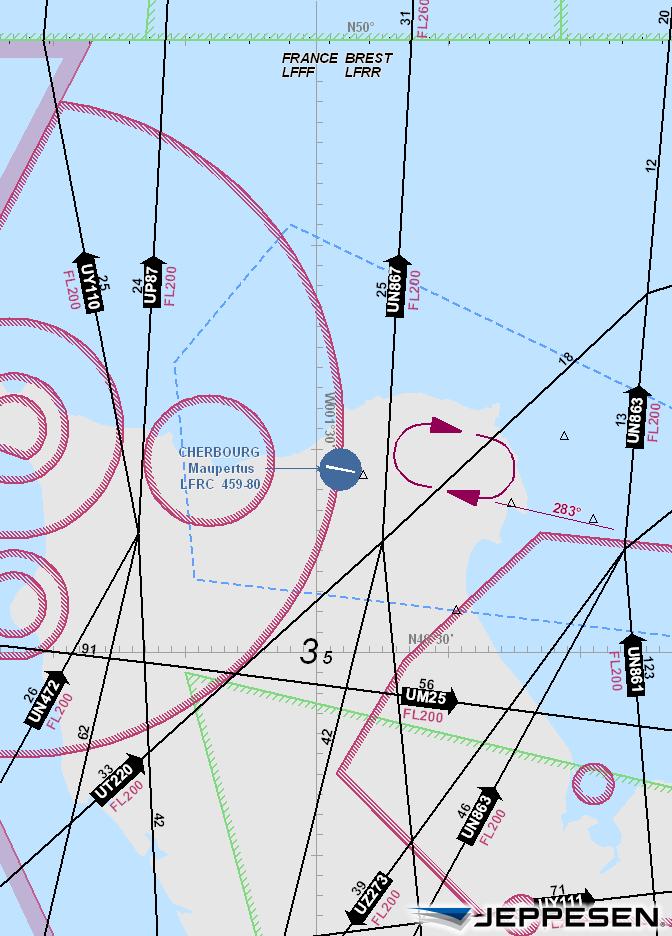
2 LFR/ER MUPERTUS pt Elev 22 FE 3 0-R.Eff.7.Mar. lt Set: hpa Trans level: y T Trans alt: 5000'.RDR.MINIMUM.LTITUDES. 40NM ERNO 30NM NM 50NM 60NM 70NM NGLO LF(P)-32 30NM 346 lho LHO LTR ^ 20NM herbourg ETRT LF(P)- 27 TN Le Havre KUR 0NM HEROURG ND 2^ DEUVILLE TMOS DVL VOR 0NM 0NM 20NM NE ND EN 20NM LISEU 30NM 40NM 50NM 60NM 70NM 80NM LF(P) NM LF(P)-6 LF(P)- 8 LF(P)- Deauville PRIS LFFF FIR REST LFRR FIR 2000 EN 4.45 N VOR aen LF(P) R ' R-62 HNGES: aen VOR ident., 2005, 203. LL RIGHTS RESERVED.
3 LFR/ER 8 JN MUPERTUS pt Elev Trans level: y T Trans alt: 5000'.DEPRTURE. S 0, OMNIDIRETIONL DEPRTURES This departure requires a minimum climb gradient of 5.0% due to LF(P)-8. : 0 Gnd speed-kt % V/V (fpm) ROUTING limb to 860', then depart omnidirectional climbing to enroute safety altitude. limb to 860', turn RIGHT or LEFT, then depart omnidirectional climbing to enroute safety altitude. In order to avoid entering LF(P)-8, the sector between R-78 and R-358 must be avoided. HNGES: SIDs canceled; Omnidirectional Departures established., 206. LL RIGHTS RESERVED.
4 LFR/ER pt Elev 6 NOV MUPERTUS N W00.5 *HEROURG Tower *STP outside TS hr French only STND N N2 thru N4 N5 thru N7 S thru S3 S4, S5 S6, S7 7 PRKING POSITIONS OORDINTES N W00.6 N W00.5 N W00.5 N W00.6 N W00.6 N W00.5 N W00.5 Military apron 03^W 0 03^ Elev 452' RP 8005' 2440m ' IS ontrol Tower S N S2 N2 S3 N3 N4 S4S5 N5 N6 S6 7 S7 N7 IS ontrol Tower G Parking TERMINL General viation NIGHT use of Twys and reserved for MIL acft only. erodrome likely to be covered by sea-haze in a few minutes. Wildlife strike hazard. Feet Meters Elev 4' 482' HNGR DDITIONL RUNWY INFORMTION USLE LENGTHS LNDING EYOND 0 Threshold Glide Slope TKE-OFF HIRL(60m) PPI-L (angle 3.0^) HIRL(60m) HILS RVR 790' 292m WIDTH 48' 45m ctivate lights and STP on 9.62 with PPR when HEROURG Tower inoperative..standard. TKE-OFF LVP must be in Force D RLM (DY only) RLM (DY only) NIL or RL or RL (DY only) 250m 300m 400m2 Operators applying U.S. Ops Specs: L required below 300m. HNGES: Taxiway designation added m W/o TS: 800m at NIGHT., 2000, 202. LL RIGHTS RESERVED.
5 RIEFING STRIP TM LFR/ER 30 MR 2 MUPERTUS - *DEUVILLE pproach LO 0.55 Final pch rs.eff.5.pr. *HEROURG Tower 9.62 GS D '(262') ILS D(H) 6'(200') MISSED PH: limb STRIGHT HED to 800', then turn RIGHT (MX 85 KT) to Lctr climbing to 3000'. ILS or LO DME Rwy *STP outside TS hr 9.62 French only Do not turn before passing MP. limb to 300' prior to level acceleration. pt Elev 4' lt Set: hpa Rwy Elev: 6 hpa Trans level: y T Trans alt: 5000'. Pilot controlled lighting and STP available on 9.62 with PPR. 2. If local TS not available obtain local altimeter setting from STP or DEUVILLE altimeter setting from DEUVILLE pproach. 2000' MS Lctr PNS OPS 4 LF(R) LF(P) D3.3 D0.8 D0.8 D D3.3 D8.0 D3.9 LF(R)-0 D8.0 50' 800' 85 KT MX Gnd speed-kts HILS ILS GS or LO Descent ngle 3.00^ MP at D0.8 RT.Standard. STRIGHT-IN LNDING IRLE-TO-LND2 ILS LO (GS out) Prohibited South of runway D 876' LO (GS out) 4' D (IF) D2.2 (IF) DIKRO ^ ' 080' 400' MD 720' LO 690' 2040' 2360' 2680' D ' D2.2 DF D(H) 6' (200') D/MD(H) 750' (322') Max FULL Limited LS out LS out Kts MD(H) VIS MD(H) VIS 0 890'(462') 500m 200' (772') RVR 550m DME LTITUDE For add-on to the MD(H), see T pages FRNE. 2ircling height based on rwy thresh elev of 4'. HNGES: pproach frequency. (IF) M P TH 50' RVR 750m RVR 03^ ILS DME M P MH 3000 MX Lctr GS50' 03^ GS690' m RVR 800m RVR 500m 3000' W/o Local TS & w/o Local lt Set 960' (532') 220' (792') 600m 060' (632') 2400m 60'(732') 3600m ' (892') 500m 600m 2400m 320'(892') 3600m, 999, 202. LL RIGHTS RESERVED.
6 RIEFING STRIP TM LFR/ER MUPERTUS 30 MR 2 6- *DEUVILLE pproach Lctr Final pch rs *HEROURG Tower 9.62 Minimum lt Lctr 50'(082').Eff.5.pr. D/MD(H) 80'(382') MISSED PH: limb on rwy heading to 000', then turn RIGHT (MX 85 KT) to Lctr climbing to 3000'. Lctr Rwy *STP outside TS hr 9.62 French only Do not turn before passing MP. limb to 300' prior to level acceleration. pt Elev 4' lt Set: hpa Rwy Elev: 6 hpa Trans level: y T Trans alt: 5000'. Pilot controlled lighting and STP available on 9.62 with PPR. 2. If local TS not available obtain local altimeter setting from STP or DEUVILLE altimeter setting from DEUVILLE pproach. 2000' MS Lctr PNS OPS LF(P) LF(R)-86 TH 50' [MN] 03^ Gnd speed-kts Descent angle 3.00^ Lctr to MP 2.7 2:9 :48 :37 :2 :09 :0.Standard. D 876' 4' DIST to MN LTITUDE LF(R) ^ HILS 000' STRIGHT-IN LNDING IRLE-TO-LND2 Prohibited South of runway RVR 000m RVR 200m D/MD(H) DF 80'(382') LS out For add-on to the MD(H), see T pages FRNE. HNGES: pproach frequency. [MN] (IF) M P RVR 700m.0 970' MH 3000 MX 5000 Lctr 3000' 03^ 50' on hdg W/o Local TS & w/o Local lt Set Max Kts MD(H) VIS MD(H) VIS 890'(462') 700m 960'(532') 700m 060'(632') 2400m ' T & : 2 2 Min T & D: 2 Min 200'(772') 700m 220'(792') 700m 320'(892') 2400m 60'(732') 3600m 320'(892') 3600m ircling height based on rwy thresh elev of 4'., 999, 202. LL RIGHTS RESERVED.
7
Major engine repairs are available.
 irport Information etails for TVUX ity LE State/Province ountry FR Latitude N 47 0' 34.00" Longitude E 5 6' 06.00" Elevation 645 Longest Runway 7300 Magnetic Variance E 0.0 Fuel Type 00 Low Lead (LL) octane
Airport Information. Details for DEBRECEN. State/Province
 irport Information etails for ity State/Province ountry HUN Latitude N 47 29' 20.00" Longitude E 2 36' 55.00" Elevation 359 Longest Runway 8200 Magnetic Variance E 4.0 Fuel Type 00 Low Lead (LL) octane
JeppView for Windows. General Information. Runway Information. Communication Information. jep=jeppesen
 irport Information For ESKM Printed on 27 Jan 208 Page (c) SNERSON, IN., 208, LL RIGHTS RESERVE jep= JeppView for Windows General Information Location: MOR SWE IO/IT: ESKM / MXX Lat/Long: N60 57.52', E04
JeppView for Windows. General Information. Runway Information. Communication Information. jep=jeppesen
 irport Information For ESOW Printed on 27 Jan 208 Page (c) SNERSON, IN., 208, LL RIGHTS RESERVE jep= JeppView for Windows General Information Location: STOKHOLM SWE IO/IT: ESOW / VST Lat/Long: N59 35.37',
Airport Information. Details for LOMBOK INTL. State/Province
 irport Information etails for ity State/Province ountry IN Latitude S 8 45' 27.00" Longitude E 116 16' 36.00" Elevation 319 Longest Runway 9000 Magnetic Variance E 2.0 Fuel Type JET -1 fuel is available
JeppView for Windows. General Information. Runway Information. Communication Information. jep=jeppesen
 irport Information For LWOH Printed on 27 Jan 2018 Page 1 (c) SNERSON, IN., 2018, LL RIGHTS RESERVE jep= JeppView for Windows General Information Location: I MK IO/IT: LWOH / OH Lat/Long: N41 10.80', E020
JeppView for Windows. General Information. Runway Information. Communication Information. jep=jeppesen
 irport Information For EKRN Printed on 7 Jan 08 Page (c) SNERSON, IN., 08, LL RIGHTS RESERVE jep= JeppView for Windows General Information Location: ORNHOLM NK IO/IT: EKRN / RNN Lat/Long: N55 03.80', E04
JeppView for Windows. jep=jeppesen. Airport Information For EPRA Printed on 06 Dec 2017 Page 1. General Information. Runway Information
 irport Information For EPR Printed on 06 ec 2017 Page 1 (c) SNERSON, IN., 2017, LL RIGHTS RESERVE jep= JeppView for Windows General Information Location: ROM POL IO/IT: EPR / RO Lat/Long: N51 23.33', E021
JeppView for Windows. General Information. Runway Information. Communication Information. jep=jeppesen
 irport Information For ULMM Printed on 27 Jan 208 Page (c) SNDERSON, INC., 208, LL RIGHTS RESERVED jep= JeppView for Windows General Information Location: RUS ICO/IT: ULMM / MMK Lat/Long: N68 46.90', E032
Airport Information. Details for ASHGABAT. Terminal Chart Change Notices. State/Province
 irport Information etails for ity State/Province ountry TKM Latitude N 37 59' 30.00" Longitude E 58 21' 43.00" Elevation 692 Longest Runway 12400 Magnetic Variance E 4.0 Fuel Type JET -1 fuel is available
No valido para navegacion real
 HNGES: onstruction area, parking spots. SNR pt Elev 920' S27 29.8 W064 56.2 TERMS E RIO HONO, RGENTIN TERMS E RIO HONO Tower TERMS E RIO HONO *119.85 64-57 64-56 27-29 27-29 19 189^ Elev 920' 07^W 8202'2500m
JeppView for Windows. jep=jeppesen. Airport Information For HTZA Printed on 06 Dec 2017 Page 1. General Information. Runway Information
 irport Information For HTZ Printed on 06 ec 2017 Page 1 (c) SNERSON, IN., 2017, LL RIGHTS RESERVE jep= JeppView for Windows General Information Location: ZNZIR TZ IO/IT: HTZ / ZNZ Lat/Long: S06 13.49',
JeppView for Windows. General Information. Runway Information. Communication Information. jep=jeppesen
 irport Information For USRO Printed on 27 Jan 208 Page (c) SNDERSON, INC., 208, LL RIGHTS RESERVED jep= JeppView for Windows General Information Location: RUS ICO/IT: USRO / NOJ Lat/Long: N63.03', E075
NO VALIDO PARA NAVEGACION REAL
 HNGES: irport diagram, runway bearings, parking spots added. 430' pt Elev S7 3. W055 58. SS, LIERTOR GRL JOSE E SN MRTIN *SS Tower 0. 55-59 55-58 55-57 Elev 376' 9 93^ UTION: irds in vicinity of airport.
General Info Krabi, THA N ' E ' Mag Var: 0.0 W Elevation: 93' Runway Info Runway ' x 148' asphalt
 irport Information VTSG (Krabi) General Info Krabi, TH N 08 05.8' E 98 59.3' Mag Var: 0.0 W Elevation: Public, ontrol Tower, IFR, No Fee, Rotating eacon, ustoms availble on a restrcted basis Time Zone
JEPPESEN. 14 JAN Eff.27.Jan. LUANDA Approach LUANDA Tower *Ground Final. ILS Apt Elev 238' DA(H) 110.
 110.") Licensed to NVT,. Printed from JeppView disc 0-02. Notice: fter /24/2002 090Z this chart should not be used without first checking JeppView or NOTMs. RIEFING STRIP TM 4TH OF FERURY LO IL 4 JN 00 -.Eff.27.Jan.,
Licensed to NVT,. Printed from JeppView disc 0-02. Notice: fter /24/2002 090Z this chart should not be used without first checking JeppView or NOTMs. RIEFING STRIP TM 4TH OF FERURY LO IL 4 JN 00 -.Eff.27.Jan.,
JeppView for Windows. JeppView for Windows. jep=jeppesen. jep=jeppesen. Trip Kit Index. Airport Information For EFKT
 Trip Kit Index Printed on 3 Jul 8 Page (c) SNERSON, IN., 8, LL RIGHTS RESERVE jep= JeppView for Windows irport Information For EFKT Printed on 3 Jul 8 Page (c) SNERSON, IN., 8, LL RIGHTS RESERVE jep= JeppView
General Info Stornoway, GBR N ' W ' Mag Var: 7.9 W Elevation: 26'
 irport Information EGPO (tornoway) General Info tornoway, GR N 58.9' W 06 9.9' Mag Var: 7.9 W Elevation: 6' Public, ontrol Tower, IFR, Landing Fee, ustoms availble on a restrcted basis Fuel: 00LL, Jet
TRELEW Tower CAUTION: Birds and animals in vicinity of airport. PARKING POSITION COORDINATES 3, 4 S W
 SVT/REL 5' pt Elev S43 2.6 W065 6.2 LEW, RGENTIN LMIRNTE ZR LEW Tower 8.7 20.65 65-7 65-6 65-5 Elev 5' 07 066^ UTION: irds and animals in vicinity of airport. PRKING POSITION OORINTES 43-2 POSITION NO.
LMS SAN PEDRO SULA, HONDURAS MHLM/SAP RADAR 3000' 7000' 5500' 9500' 4000' 10000' 7000' 7000' 11000' 8000' 4000' 8000' LA MESA KORTI OMOSO RUBRA BATAN
 NOTIE: PRINTE FROM N EXPIRE REVISION. isc 09-2013 RMON VILLE MORLES INTL * pproach (R) 119.7 22 JUN 12 10-1R.RR.MINIMUM.LTITUES. lt Set: hpa SN PERO SUL, HONURS Trans level: FL 200 Trans alt: 19 10 0 10
JeppView for Windows. List of pages in this Trip Kit. jep=jeppesen. Trip Kit Index
 Trip Kit Index Printed on 28 Jun 2015 Page 1 (c) SNERSON, IN., 2015, LL RIGHTS RESERVE jep= JeppView for Windows List of pages in this Trip Kit Trip Kit Index irport Information For TTP Terminal harts
No valido para navegacion real
 SZ/HI OMNNTE ESPOR NS pt Elev Trans level: y T Trans alt: When aircraft are holding over, departing aircraft cannot exceed before 0 ME. KNOS EPRTURE [KNOS] (RWYS 7L/35R) HI LN, RGENTIN.SI. MS KNOS S38
JEPPESEN. 21 JUN B.Eff.27.Jun. Alt Set: hpa Trans level: By ATC Trans alt: 6000' VIC 3A RWYS 04L/R TRANSITIONS. By ATC VICENZA 113.
 LIPZ/VE pt Elev 21 JUN 13 10-2B.Eff.27.Jun. lt Set: hpa Trans level: By T Trans alt: 6000' LBET 4 [LB4], HI 3 VI 3 RWYS 04L/R TRNSITIONS RNV (RNV 1 REOENE) OR ONVENTIONL BY T.TRNSITION. 7200' 100^1 200^
LOS ZDA ZRA ZDA ZRA ZRA ZRA SPL ZADAR, CROATIA ZADAR, CROATIA LDZD/ZAD LDZD/ZAD ALANU 1B
 -2.STR. lt Set: hpa 1 [LN1] 1 [LN1], 3 RWYS 04, 14, 32 RRIVLS FROM NORTH & SOUTH SPEE: MX 250 KT ELOW FL0-2 lt Set: hpa 2F [EIT2F] LOS 4, MINTU 1E [MINT1E] 1 [ULPI1], 1 RWYS 04, 14, 32 RRIVLS FROM NORTHWEST
General Information. Runway Information. Communication Information
 irport Information For MMZ Printed on pr 208 Page (c) SNERSON, IN., 208, LL RIGHTS RESERVE p= je General Information Location: ZTES MEX IO/IT: MMZ / Lat/Long: N22 53.8', W02 4.' Elevation: 74 ft irport
BZE BZE. BELIZE CITY, BELIZE VOR DME Rwy 07 MZBZ/BZE 070^ BZE 440' 1500' 3000' BZE D6.0 D6.0 VOR D6.0 BELIZE. 4.
 Licensed to VT. Printed on 01 Mar 2008. NOTIE: PRINTE FROM N EXPIRE REVISION. isc 03-2008 MZZ/ PHILIP S W GOLSON INTL *GOLSON pproach 29 E 06 13-1 ITY, ME Rwy 07 RIEFING STRIP TM 121.0 118.0 121.9 pt Elev
JeppView for Windows. Communication Information. Runway Information. jep=jeppesen. Length x Width: 9843 ft x 131 ft. Surface Type: asphalt
 irport Information For SV Printed on 09 Jul 2018 Page 1 (c) SNERSON, IN., 2018, LL RIGHTS RESERVE jep= JeppView for Windows Runway: General 33 Information Length x Width: 9843 ft x 131 ft TZ-Elev: 28 ft
General Info Nizhny Novgorod, RUS N ' E ' Mag Var: 10.5 E Elevation: 256'
 irport Information UWGG (Strigino) JeppView... General Info Nizhny Novgorod, RUS N 5.8' E 4 47.0' Mag Var: 0.5 E Elevation: 5' Public, IFR, ontrol Tower, ustoms Fuel: Jet Repairs: Minor irframe, Minor
JEPPESEN. Alt Set: hpa Trans level: FL200 Trans alt: 19500' RNAV ARRIVAL RWY 07 N W RO~~3 N W KT MAX.
 HNGES: TIS frequency added. 179^ 81.8 LN, 2008, 2011. LL RIGHTS RESERVE. NOTIE: PRINTE FROM N EXPIRE REVISION. isc 09-2013 MHRO/RT JUN MNUEL GLVEZ INTL *TIS pt Elev 18' 25 NOV 11 10-2 lt Set: hpa Trans
Trans level: By ATC Trans alt: 3000' When aircraft are holding over VOR, departing aircraft cannot exceed 3000' before BCA 10 DME.
 SZ/HI OMNNTE ESPOR NS pt Elev Trans level: y T Trans alt: When aircraft are holding over, departing aircraft cannot exceed before 10 ME. KNOS 1 EPRTURE [KNOS1] (RWYS 17L/35R) HI LN, RGENTIN.SI. MS 55 KNOS
NO VALIDO PARA NAVEGACION REAL
 SVT/REL 5' pt Elev S43 2.6 W065 6.2 LEW, RGENTIN LMIRNTE ZR LEW Tower 8.7 20.65 65-7 65-6 65-5 RWY 07 25 Elev 5' 07 066^ UTION: irds and animals in vicinity of airport. PRKING POSITION OORINTES 43-2 POSITION
Serbia and Montenegro vacc Aerodrome Charts - Nis [LYNI]
![Serbia and Montenegro vacc Aerodrome Charts - Nis [LYNI]](/thumbs/94/120315345.jpg "Serbia and Montenegro vacc Aerodrome Charts - Nis [LYNI]") Serbia and Montenegro v erodrome harts - Nis [LYNI] isclaimer: These charts are intended for flight simulation purposes, and should not, under any circumstances, be used for real aviation navigation. Serbia
Serbia and Montenegro v erodrome harts - Nis [LYNI] isclaimer: These charts are intended for flight simulation purposes, and should not, under any circumstances, be used for real aviation navigation. Serbia
JeppView for Windows. jep=jeppesen. Airport Information For HKMO Printed on 06 Dec 2017 Page 1. General Information. Runway Information
 irport Information For HKMO Printed on 06 ec 2017 Page 1 (c) SNERSON, IN., 2017, LL RIGHTS RESERVE jep= JeppView for Windows General Information Location: MOMS KEN IO/IT: HKMO / M Lat/Long: S04 01.58',
JEPPESEN JeppView
 REVISION LETTER For isc 23-07 Page hanged chart(s) since isc 22-07 = dded chart, REV = Revised chart, EL = eleted chart. T PROEURE IENT INEX REV TE EFF TE Monterrey, (el Norte Intl - MMN) ONON EP -3 6
JEPPESEN. Alt Set: hpa Trans level: FL200 Trans alt: 19500' 1. GPS required. 2. RNP RADAR required. 4. DME/DME not required.
 HNGES: TIS frequency, Navdata identifier added., 2008, 20. LL RIGHTS RESERVE. NOTIE: PRINTE FROM N EXPIRE REVISION. isc 09-203 pt Elev 25 NOV 0-2 lt Set: hpa Trans level: FL200 Trans alt: 9500'. GPS required.
General Information. Runway Information. Communication Information
 je General Information Location: MEX IO/IT: MMMM / Lat/Long: N9 5.0', W0 0.5' Elevation: 60 ft irport Use: Public aylight Savings: Observed UT onversion: +6:00 = UT Magnetic Variation: 7.0 E Fuel Types:
General Information. Runway Information. Communication Information
 irport Information For MMZO Printed on 28 Jul 208 Page (c) SNERSON, IN., 208, LL RIGHTS RESERVE p= je General Information Location: MNZNILLO MEX IO/IT: MMZO / Lat/Long: N9 08.7', W04 33.5' Elevation: 30
JeppView for Windows. jep=jeppesen. Airport Information For HEGN Printed on 06 Dec 2017 Page 1. General Information. Runway Information
 irport Information For HEGN Printed on 06 ec 2017 Page 1 (c) SNERSON, IN., 2017, LL RIGHTS RESERVE jep= JeppView for Windows General Information Location: HURGH EGY IO/IT: HEGN / HRG Lat/Long: N27 10.72',
JeppView for Windows. General Information. Runway Information. Communication Information. jep=jeppesen
 irport Information For SVM Printed on 22 Jul 2018 Page 1 (c) SNERSON, IN., 2018, LL RIGHTS RESERVE jep= JeppView for Windows General Information arquisimeto pproach: 119.400 arquisimeto Radio: 132.000
FSHolland Bijeenkomst 2 september 2017 Vlucht 3 IFR LEMH (Menorca) to LEAL (Alicante-Elche)
 to LEAL (Alicante-Elche)") FSHolland Bijeenkomst 2 september 207 Vlucht 3 IFR LEMH (Menorca) to LEL (licante-elche) You created this PF from an application that is not licensed to print to novapf printer (http://www.novapdf.com)
FSHolland Bijeenkomst 2 september 207 Vlucht 3 IFR LEMH (Menorca) to LEL (licante-elche) You created this PF from an application that is not licensed to print to novapf printer (http://www.novapdf.com)
Runway Information. Communication Information. jep=jeppesen
 irport Information For MMRX Printed on 02 Oct 208 Page (c) SNERSON, IN., 208, LL RIGHTS RESERVE jep= Monterrey General : Information 27.400 Location: MEX IO/IT: MMRX / Lat/Long: N26 00.5', W098 3.7' Elevation:
NO VALIDO PARA NAVEGACION REAL
 Procedures renumbered, procedure notes. pt Elev 669' lt Set: hpa Trans level: y T Trans alt: 7000' RNP 1/RNV 1 GNSS certification required. KIR 1R (R1R), SULSU 1R (LSU1R) UG 1R (1R), UGRIS 1R (RIS1R) RNP
Runway Information. Communication Information. Information: Mazatlan ACC:
 irport Information For MMML Printed on 24 Jul 208 Page (c) SNERSON, IN., 208, LL RIGHTS RESERVE p= je Mexicali General Information: 22.300 Mazatlan : 28.300 Location: MEX IO/IT: MMML / Lat/Long: N32 37.8',
JeppView for Windows. General Information. Runway Information. Communication Information. jep=jeppesen
 irport Information For MUVR Printed on 11 ec 2017 Page 1 (c) SNERSON, IN., 2017, LL RIGHTS RESERVE jep= JeppView for Windows General Information Location: VRERO U IO/IT: MUVR / VR Lat/Long: N23 02.07',
Airport Information. Details for AUGUSTO SEVERO. State/Province
 irport Information etails for UGUSTO SEVERO ity State/Province ountry R Latitude S 5 54' 30.00" Longitude W 35 14' 57.00" Elevation 171 Longest Runway 8500 Magnetic Variance W 22.0 Fuel Type JET -1 fuel
KIS LVA 310 N E LAVAN 3A, LAVAN 3B, LAVAN 3C LENGEH 4A, LENGEH 3B, LENGEH 4C ORSAR 1A, ORSAR 1B, ORSAR 1C ARRIVALS .STAR. 114.
 16 32 26 *TIS TRNS LEVEL: Y T TRNS LT: ' 16 FE 01 N26 32.2 E054 51.1 NR LENGEH 114.8 LEN.STR. 10-2.Eff.25.Jan. ISLN, IRN LVN 3, LVN 3, LVN 3 LENGEH 4, LENGEH 3, LENGEH 4 ORSR 1, ORSR 1, ORSR 1 RRIVLS 268^
Climb to 6000' DM E (111.5) INWC (111.5) INC INC NEWCASTLE ILS DME. Climb to 320' ' 266' ADDITIONAL RUNWAY INFORMATION
 INWC (111.5) INC INC NEWCASTLE ILS DME. Climb to 320' ' 266' ADDITIONAL RUNWAY INFORMATION") E/NL MY 06 0-.EPRTURE. pt Elev 66' Trans level: y T Trans alt: 6000' epartures are also noise preferential routes., UK limb to 6000' ILS ME (.5) (.5) INW N5. W00 4. N5. W00 4. limb to 6000' IRETION Track
E/NL MY 06 0-.EPRTURE. pt Elev 66' Trans level: y T Trans alt: 6000' epartures are also noise preferential routes., UK limb to 6000' ILS ME (.5) (.5) INW N5. W00 4. N5. W00 4. limb to 6000' IRETION Track
NO VALIDO PARA NAVEGACION REAL
 HNGES: Notes..RNV.STR. pt Elev 895' lt Set: hpa Trans level: y T Trans alt: RNP 1/RNV 1 GNSS certification required. RTOK 2K (RT2K), ILTOS 2K (TOS2K) PORP 2K (POR2K) RNP RRIVLS (RWY 09) MS RP 033^ PORP
BURGAS BGS 9.7 DME. OMORI 1B On BGS R-104 inbound to BGS, descending to. SUNIB 1D On BGS R-028 inbound to BGS. L 622
 pt Elev lt Set: hpa 0.95 5' Transition level: y T, ULGRI MY 09 0.Eff.7.May..STR. 9.5 ESEN N4 0.6 E06 5.4 N4 4. E07. OMORI N4 7.0 E08 0.0 8^ OMORI 84^ R08^ SUNI 08^ R^ R058^ 0^ ESEN 4.8 R0^ 4080' 0m 00m
NO VALIDO PARA NAVEGACION REAL
 HNGES: Procedures cancelled, revised. SV/R GEN ENRIQUE MOSONI lt Set: hpa : y T Trans alt: RNP certification required. pt Elev 89' V9~6 S46 3.9 W67 4. ISKES S44 5.6 W67 29.3 49^ ISKES 4 (KES 4) 5. 28.3
JeppView for Windows. List of pages in this Trip Kit. jep=jeppesen. Trip Kit Index
 Trip Kit Index Printed on 28 Jun 2015 Page 1 (c) SNERSON, IN., 2015, LL RIGHTS RESERVE jep= JeppView for Windows List of pages in this Trip Kit Trip Kit Index irport Information For TP Terminal harts For
General Information. Runway Information. Communication Information
 je General Information Location: CHICHEN-ITZ MEX ICO/IT: MMCT / Lat/Long: N20 38.5', W088 26.8' Elevation: 02 ft irport Use: Public aylight Savings: Observed UTC Conversion: +6:00 = UTC Magnetic Variation:.0
General Information. Runway Information. Communication Information
 irport Information For MMSL Printed on 11 pr 2018 Page 1 (c) SNERSON, INC., 2018, LL RIGHTS RESERVE p= je General Information Location: CO SN LUCS MEX ICO: MMSL Lat/Long: N22 56.9', W109 56.3' Elevation:
General Information. Runway Information. Communication Information. Culiacan Intl Information: Mazatlan ACC:
 irport Information For MML Printed on 24 Jul 2018 Page 1 (c) SNERSON, IN., 2018, LL RIGHTS RESERVE p= je General Information uliacan Intl Information: 122.300 Mazatlan : 124.400 Location: IN MEX IO/IT:
Communication Information. Runway Information. Lighting: Edge, REIL
 je TZ-Elev: General 6035 Information ft Lighting: Edge, Location: SN LUIS MEX IO/IT: MMSP / Lat/Long: N22 5.3', W00 55.8' Elevation: 6035 ft TIS: 27.50 Potosi Tower: 8.0 Potosi irport pproach: Use: Public27.500
JeppView for Windows. General Information. Runway Information. Communication Information. jep=jeppesen
 irport Information For UN Printed on 27 Jan 208 Page (c) SNERSON, INC., 208, LL RIGHTS RESERVE jep= JeppView for Windows General Information Location: RUS ICO/IT: UN / B Lat/Long: N53 44.40', E09 23.2'
General Information. Runway Information. Communication Information
 irport Information For MMLP Printed on pr 208 Page (c) SNERSON, IN., 208, LL RIGHTS RESERVE p= je General Information Location: L PZ MEX IO/IT: MMLP / Lat/Long: N24 04.4', W0 2.8' Elevation: 69 ft irport
JeppView for Windows. General Information. Runway Information. Communication Information. jep=jeppesen
 irport Information For UDYZ Printed on 27 Jan 2018 Page 1 (c) SNDERSON, INC., 2018, LL RIGHTS RESERVED jep= JeppView for Windows General Information Location: YEREVN RM ICO/IT: UDYZ / EVN Lat/Long: N40
Communication Information. Runway Information. Length x Width: 5049 ft x 148 ft. Surface Type: asphalt. TDZ-Elev: 1476 ft
 irport Information For MMN Printed on pr 208 Page (c) SNERSON, IN., 208, LL RIGHTS RESERVE p= je Runway: General 29 Information Length x Width: 5049 ft x 48 ft Surface Type: asphalt TZ-Elev: 476 ft Location:
10-2. Alt Set: hpa Trans level: FL150 Trans alt: 13000'
 INTL 26.22 PROHIBITE RE OK(P)- pt Elev 206'.3 IKIB 5.5 N29 3. E047 58. 09.5 0 00^ lt Set: hpa Trans level: FL50 Trans alt: SM N29 22.9 E048 00.627 R50^ 2 LRIM 2B 0-2 LRIM TWO LF (LRIM 2) LRIM TWO BRVO
Minor engine repairs are available.
 Airport Information etails for City VLAIVOSTOK State/Province Country RUS Latitude N 43 23' 53.00" Longitude E 32 08' 56.00" Elevation 59 Longest Runway 400 Magnetic Variance W 0.0 Fuel Type JET A- fuel
JeppView for Windows. Runway Information. Communication Information. jep=jeppesen. Cagliari Radar: Military Cagliari Radar: 118.
 irport Information For LIEE Printed on ec 207 Page (c) SNERSON, IN., 207, LL RIGHTS RESERVE jep= JeppView for Windows agliari General Radar: Information 8.400 agliari Radar: 36.230 Military agliari Radar:
Airport Information. Details for IFAISTOS. State/Province
 Airport Information etails for City State/Province Country GRC Latitude N 39 55' 02.00" Longitude E 25 14' 11.00" Elevation 14 Longest Runway 9800 Magnetic Variance E 2.0 Fuel Type JET A-1 fuel is available
Airport Information. Details for ARISTARCHOS OF SAMOS. State/Province
 Airport Information etails for ARISTARCHOS OF City State/Province Country GRC Latitude N 37 4' 2.00" Longitude E 26 54' 44.00" Elevation 9 Longest Runway 6700 Magnetic Variance E 4.0 Fuel Type 00 Low Lead
Airport Information. Details for TURKMENBASHI. Terminal Chart Change Notices. TURKMENBASHI State/Province
 Airport Information etails for City State/Province Country TKM Latitude N 40 03' 48.00" Longitude E 53 00'.00" Elevation 283 Longest Runway 11400 Magnetic Variance E 5.0 Fuel Type JET A-1 fuel is available
D7.6 IAO D12.1 RIA N At or above D17.4 RIA 2500' (IF) E N ' (IAF) N E D19.4 RIA D25 RIA.
 E N ' (IAF) N E D19.4 RIA D25 RIA.") 30 2 00^ R00^ R028^ 4.2 9.9, LTVI INTL 3 OT 06 0-2.Eff.26.Oct..STR. 3.4 GOREX N6 3. E024 RV N6.2 E02 38 SNERSON, IN., 2003, 2006. LL RIGHTS RESERVE. 3.4 RV 2 4. 22 269^. N6 4.2 E024 26. SOKV N7 4.0 E024
30 2 00^ R00^ R028^ 4.2 9.9, LTVI INTL 3 OT 06 0-2.Eff.26.Oct..STR. 3.4 GOREX N6 3. E024 RV N6.2 E02 38 SNERSON, IN., 2003, 2006. LL RIGHTS RESERVE. 3.4 RV 2 4. 22 269^. N6 4.2 E024 26. SOKV N7 4.0 E024
Airport Information. Details for KING PYRROS. State/Province
 Airport Information etails for City State/Province Country GRC Latitude N 39 4' 50.00" Longitude E 20 49' 9.00" Elevation 55 Longest Runway 700 Magnetic Variance E Fuel Type JET A- fuel is available Oxygen
Airport Information. Details for PROF URBANO ERNESTO STUMPF, IN. SAO JOSE DOS CAMPOS State/Province
 irport Information etails for PROF URNO ERNESTO STUMPF, IN ity SO JOSE OS MPOS State/Province ountry R Latitude S 23 3' 44.00" Longitude W 45 52' 6.00" Elevation 29 Longest Runway 8700 Magnetic Variance
N W (111.3) IKN IKN D KEF KEFLAVIK KEF ILS DME D 3000 R019^ R059^ R153^ KEILA FJALL W N N W
 IKN IKN D KEF KEFLAVIK KEF ILS DME D 3000 R019^ R059^ R153^ KEILA FJALL W N N W") 07^ 3 2 R97^ 2 2 R97^ FL 25 36 308^ 5500 25 FL R93^ 2 6 339^ 9 355^ 2 00 4 6 3 4300 2 258^ 2 8 264^ 8 FL00 99^ 7 ^ 99^ IKF/ LOTIN N64 9.2 W022 36.3 ME (.3) IKN IKN N63 58.0 W022 36.2 SRM IKN N64.2 W022
07^ 3 2 R97^ 2 2 R97^ FL 25 36 308^ 5500 25 FL R93^ 2 6 339^ 9 355^ 2 00 4 6 3 4300 2 258^ 2 8 264^ 8 FL00 99^ 7 ^ 99^ IKF/ LOTIN N64 9.2 W022 36.3 ME (.3) IKN IKN N63 58.0 W022 36.2 SRM IKN N64.2 W022
General Information. Communication Information. Runway Information. Length x Width: ft x 148 ft Surface Type: concrete TDZ-Elev: 12 ft
 irport Information For MM Printed on pr 208 Page (c) SNERSON, IN., 208, LL RIGHTS RESERVE p= je General Information Length x Width: 0827 ft x 48 ft Surface Type: concrete TZ-Elev: 2 ft Lighting: Edge,
+ JEPPESEN 10-1P 1. GENERAL
 , 203, 207. LL RIGHTS RESERVE. Printed from JeppView for Windows 5.3.0.0 on 9 Mar 208; Terminal chart data cycle 02208 (Expired); Notice: fter 08 Feb 208, 0000Z, this chart may no longer be valid.. TIS
General Information. Runway Information. Communication Information
 irport Information For MMZH Printed on 11 pr 2018 Page 1 (c) SNERSON, INC., 2018, LL RIGHTS RESERVE p= je General Information Location: IXTP-UTNEJO MEX ICO/IT: MMZH / Lat/Long: N17 36.1', W101 27.6' Elevation:
Airport Information. Details for ST CATHERINE. Terminal Chart Change Notices. State/Province
 irport Information etails for ST THERINE ity LVI State/Province ountry FR Latitude N 42 3' 28.00" Longitude E 8 47' 35.00" Elevation 20 Longest Runway 7500 Magnetic Variance E 2.0 Fuel Type 00 Low Lead
JeppView for Windows. General Information. Runway Information. Communication Information. jep=jeppesen
 irport Information For G Printed on 27 Jan 208 Page (c) SNERSON, INC., 208, LL RIGHTS RESERVE jep= JeppView for Windows General Information Location: CCR GH ICO/IT: G / CC Lat/Long: N05 36.26', W000 0.05'
JEPPESEN 7 JUN 13. *MORRISTOWN Tower *Ground CTAF LOC. *ATIS NEW YORK Approach (R) ILS Apch Crs DA(H) Apt Elev 187' DA(H)
 ILS Apch Crs DA(H) Apt Elev 187' DA(H)") RIEFING STRIP TM 5 TERPS MEN 0 0 JUN 0 Notice: fter Jul 0 0Z, this chart may no longer be valid. KMMU/MMU 7 JUN MORRISTOWN MUN - SX 5.7 sax 5^ Essex o ^ TE 08.4 teb MORRISTOWN, NJ or LO Rwy *TIS NEW YORK
RIEFING STRIP TM 5 TERPS MEN 0 0 JUN 0 Notice: fter Jul 0 0Z, this chart may no longer be valid. KMMU/MMU 7 JUN MORRISTOWN MUN - SX 5.7 sax 5^ Essex o ^ TE 08.4 teb MORRISTOWN, NJ or LO Rwy *TIS NEW YORK
JeppView for Windows. List of pages in this Trip Kit. Trip Kit Index
 Trip Kit Index Printed on 4 Jan 207 Page (c) SANDERSON, INC., 207, ALL RIGHTS RESERVED jep= JeppView for Windows List of pages in this Trip Kit Trip Kit Index Airport Information For UWKB Terminal Charts
JeppView for Windows. jep=jeppesen. Airport Information For LBWN Printed on 06 Dec 2017 Page 1. General Information. Runway Information
 irport Information For LWN Printed on 06 ec 207 Page (c) SNERSON, IN., 207, LL RIGHTS RESERVE jep= JeppView for Windows General Information Location: GR IO/IT: LWN / VR Lat/Long: N43 3.92', E027 49.52'
DTNH (Hammamet) JeppView General Info Enfidha, TUN N ' E ' Mag Var: 0.0 W Elevation: 21' Runway Info. Communications Info
 JeppView General Info Enfidha, TUN N ' E ' Mag Var: 0.0 W Elevation: 21' Runway Info. Communications Info") irport Information TNH (Hammamet) JeppView 3.6.2.0 General Info Enfidha, TUN N 36 04.5' E 0 26.3' Mag Var: 0.0 W Elevation: 2' Public, IFR, Rotating Beacon, Customs Fuel: Jet - Time Zone Info: GMT+:00
irport Information TNH (Hammamet) JeppView 3.6.2.0 General Info Enfidha, TUN N 36 04.5' E 0 26.3' Mag Var: 0.0 W Elevation: 2' Public, IFR, Rotating Beacon, Customs Fuel: Jet - Time Zone Info: GMT+:00
OMAA/AUH ABU DHABI, UAE. 1. GENERAL 1.1. ATIS D-ATIS Arrival D-ATIS Departure
 Printed from JeppView for Windows 5.3.0.0 on 07 May 2017; Terminal chart data cycle 02-2017 (Expired); Notice: fter 09 Feb 2017, 0000Z, this chart may no longer be valid + U HI INTL 23 E 16 10-1P.Eff.5.Jan.
JeppView for Windows. Runway Information. jep=jeppesen. Stefanik Ground: Stefanik Ground: Secondary
 irport Information For LZI Printed on ec 207 Page (c) SNERSON, IN., 207, LL RIGHTS RESERVE jep= JeppView for Windows ommunication General Information Information TIS: Location: 33.875 RTISLV eparture SVK
N E (IAF Rwy 08) (IAF Rwy 26) LUTER N E SPEED RESTRICTION. Not applicable within airspace C. FL100 or as by ATC.
 (IAF Rwy 26) LUTER N E SPEED RESTRICTION. Not applicable within airspace C. FL100 or as by ATC.") HNGES: s 10, 8 withdrawn; STRs withdr, renumb & rev. SNERSON, IN., 00, 005. LL RIGHTS RESERVE. (LEG R-11/7) GOLT N50 54.7 E011 56. ^ 05^ 18.6 GOLT W 45 Expect GPS/FMS RNV Transition (refer to charts 10-
HNGES: s 10, 8 withdrawn; STRs withdr, renumb & rev. SNERSON, IN., 00, 005. LL RIGHTS RESERVE. (LEG R-11/7) GOLT N50 54.7 E011 56. ^ 05^ 18.6 GOLT W 45 Expect GPS/FMS RNV Transition (refer to charts 10-
JeppView for Windows. jep=jeppesen. Airport Information For LGMK Printed on 11 Dec 2017 Page 1. General Information. Runway Information
 Airport Information For LGMK Printed on 11 ec 2017 Page 1 (c) SANERSON, INC., 2017, ALL RIGHTS RESERVE jep= JeppView for Windows General Information Location: GRC ICAO/IATA: LGMK / JMK Lat/Long: N37 26.23',
JeppView for Windows. General Information. Runway Information. Communication Information. jep=jeppesen
 Airport Information For UBBG Printed on 27 Jan 2018 Page 1 (c) SANERSON, INC., 2018, ALL RIGHTS RESERVE jep= JeppView for Windows General Information Location: AZE ICAO/IATA: UBBG / KV Lat/Long: N40 44.33',
JeppView for Windows. List of pages in this Trip Kit. jep=jeppesen. Trip Kit Index
 Trip Kit Index Printed on 22 Dec 208 Page (c) SANDERSON, INC., 208, ALL RIGHTS RESERVED jep= JeppView for Windows List of pages in this Trip Kit Trip Kit Index Airport Information For UKLR Terminal Charts
General Info Gualeguaychu, ARG S ' W ' Mag Var: 6.6 W Elevation: 75'
 irport Information SG (Gualeguaychu) General Info Gualeguaychu, RG S 33 00.6' W 58 36.8' Mag Var: 6.6 W Elevation: 75' Public, IFR, ontrol Tower, No ustoms Time Zone Info: uenos ires, Georgetown GMT-3:00
CAT ' MON-THU , FRI CAT
 LPBJ Airport information: Country: Portugal City: A Coordinates: N 38 04.7', W 007 56.0' Elevation: 636 Customs: Nil Fuel: Not avbl RFF: CAT 8 MON-THU 0830-1715, FRI 0830-10. CAT 7 other times hours: MON-THU:
JEPPESEN. This chart should only be used for cross-checking of assigned altitudes while under radar control. OP(P)-249A D30 D25 R005^ D20 D10
-249A D30 D25 R005^ D20 D10") OP/IS 668' 9 MAR 2 0-R ISLAMAA, PAKISTAN.RAAR.MINIMUM.ALTITUES. Alt Set: hpa (IN on request) Trans level: FL40 Trans alt: 2000' This chart should only be used for cross-checking of assigned altitudes while
OP/IS 668' 9 MAR 2 0-R ISLAMAA, PAKISTAN.RAAR.MINIMUM.ALTITUES. Alt Set: hpa (IN on request) Trans level: FL40 Trans alt: 2000' This chart should only be used for cross-checking of assigned altitudes while
MOLEN SUBIL VOR RHONE CAUMONT NDB. ISTRES Le ZEBRA 3500 JEPPESEN MAZET MARSEILLE MARSEILLE MJ NDB LOGIS 2398' VELLO VENTA 2015' RADAR AIX-LES-MILLES
 360^ 0 0 0 20 30 40 50 60 70 0 45 0^ 360^ TINOT 3 24 R-0 7 270^ R0^ 090^ 263' 0^ 60NM ORNGE T ORNGE N MOLEN SUIL VIGNON RHONE SLIN UMONT N IVKO ORGO MZET ZER MRSEILLE Lctr SURG ME RT LOGIS MRSEILLE MJ
JeppView for Windows. jep=jeppesen. Airport Information For LGKF Printed on 11 Dec 2017 Page 1. General Information. Runway Information
 Airport Information For LGKF Printed on 11 ec 017 Page 1 (c) SANERSON, INC., 017, ALL RIGHTS RESERVE jep= JeppView for Windows General Information Location: GRC ICAO/IATA: LGKF / EFL Lat/Long: N38 07.0',
JeppView for Windows. Runway Information. jep=jeppesen. Nizhny Approach Approach: Nizhny Radar Radar:
 irport Information For UWGG Printed on 7 Jan 08 Page (c) SNERSON, INC., 08, LL RIGHTS RESERVE jep= JeppView for Windows Communication General Information Information : Location: 7.800 NIZHNY NOVGORO RUS
KPL N E LMO N E LGLM/LXS CHRISOUPOLIS ONE CHARLIE (KPL 1C) KOROS ONE CHARLIE RWYS 04R, 22L ARRIVALS .STAR.
 KOROS ONE CHARLIE RWYS 04R, 22L ARRIVALS .STAR.") 10-2 (T) CHRISOUPOLIS KPL 108.8 N40 54.8 E024 36.9 153^ 40 KPL 1C Alt Set: hpa Trans level: By ATC Trans alt: ' CHRISOUPOLIS ONE CHARLIE (KPL 1C) KOROS ONE CHARLIE (KOROS 1C) [KORO1C] RWYS 04R, 22L ARRIVALS,
10-2 (T) CHRISOUPOLIS KPL 108.8 N40 54.8 E024 36.9 153^ 40 KPL 1C Alt Set: hpa Trans level: By ATC Trans alt: ' CHRISOUPOLIS ONE CHARLIE (KPL 1C) KOROS ONE CHARLIE (KOROS 1C) [KORO1C] RWYS 04R, 22L ARRIVALS,
THIS CHART IS A PART OF NAVIGRAPH CHARTS AND IS INTENDED FOR FLIGHT SIMULATION USE ONLY
 Effective_-DE-1 1-DE-1 IGD-LTT 1-1 OI OI GENERL Opertionl Hours TS Hours / D DMIN Hours: See NOTM RFF: T 7 PN: RWY 1/3: 11/R//W/T ustoms: Not VBL irport Informtion Opertion RWY Restriction: 1 turns VBL
JeppView for Windows. List of pages in this Trip Kit. Trip Kit Index
 Trip Kit Index Printed on 06 Jan 2014 Page 1 (c) SANERSON, INC., 2014, ALL RIGHTS RESERVE jep= JeppView for Windows List of pages in this Trip Kit Trip Kit Index Airport Information For U Terminal Charts
SALZBURG, AUSTRIA LOWS/SZG NDB NDB NDB VOR DME (10000) FL110 (11500) (11500) SBG SALZBURG. Alt Set: hpa Trans level: By ATC Trans alt: 4000'
 FL110 (11500) (11500) SBG SALZBURG. Alt Set: hpa Trans level: By ATC Trans alt: 4000'") 70^ LOWS/SZG * Radar (PP) pt Elev.7.97 ' 0 EC 0, USTRI 0-R RR MINIMUM LTITUES lt Set: hpa Trans level: y TC Trans alt: ' 0 0 0 0 0 0 0NM 0NM 000 VOR ME SG N 9000 7000 000 CONTOUR INTERVLS 0NM 000 8-00
70^ LOWS/SZG * Radar (PP) pt Elev.7.97 ' 0 EC 0, USTRI 0-R RR MINIMUM LTITUES lt Set: hpa Trans level: y TC Trans alt: ' 0 0 0 0 0 0 0NM 0NM 000 VOR ME SG N 9000 7000 000 CONTOUR INTERVLS 0NM 000 8-00
JeppView for Windows. JeppView for Windows. jep=jeppesen. jep=jeppesen. Trip Kit Index. Airport Information For LGTS
 Trip Kit Index Printed on 03 Jul 208 Page (c) SNERSON, INC., 208, LL RIGHTS RESERVE jep= JeppView for Windows irport Information For LGTS Printed on 03 Jul 208 Page (c) SNERSON, INC., 208, LL RIGHTS RESERVE
JeppView for Windows. jep=jeppesen. General Information. Runway Information. Communication Information
 irport Information For LTC Printed on 27 pr 202 Page (c) SNERSON, INC., 202, LL RIGHTS RESERVE jep= JeppView for Windows General Information Esenboga pproach Control 9. Esenboga pproach Control 36.23 Location:
JEPPESEN 10-2.STAR. 16 JUL 10.Eff.29.Jul.
 , RUSSIA 102.STAR. *ATIS Apt Elev Alt set: MM (hpa on request) QNH on request (QFE) 126.9 1688' Trans level: Trans alt: IENI 1A [IEN1A] OSKEN 1A [OSKE1A] USONA 1A [USON1A] RWY 12 ARRIVALS FROM EAST & SOUTH
.Eff.14.Jun. LWB R065^ 208^ R248^ 095^ Radar vectoring will. be provided to final. Clearance limit is LWB VORDME. 068^ RINSO N approach track.
 95^ 245^ 54 FL 2S 28 RENKI 2S BTEL THREE SIERR (BTEL 3S) BRUNKENORF TWO SIERR (BK 2S) FRIELN TWO SIERR (FL 2S) LEINE THREE SIERR (LE 3S) RENKI TWO SIERR (RENKI 2S) RRIVLS R065^.Eff.4.Jun. (RWY 07R) FOR
REDL YCZ RCLL RTZL VASIS. 600 m PAPI m. MEHT m. PAPI 3 MEHT m. 600 m. 600 m. PAPI 3 MEHT m. 600 m PAPI 3.3.
 SYGUID, -8602 WNGN I DUNDOR MDT 001 2015 RP WGS-84 27 29 N / 008 32 53 1417 008 32 29 eilometer MM 29 27 27 26 MT Observation STN MM N loud search light LVRT LI 900 m SLS LIL 420 m GS LO 34 LI R/W LO D
LUKK/KIV .STAR KIV [ABLI3A] [ANED3A] [ABLI3E] [ANED3E] ANEDO ABLIK NOT FOR OPERATIONAL USE CHISINAU ANEDO 3A CHISINAU INTL
![LUKK/KIV .STAR KIV [ABLI3A] [ANED3A] [ABLI3E] [ANED3E] ANEDO ABLIK NOT FOR OPERATIONAL USE CHISINAU ANEDO 3A CHISINAU INTL](/thumbs/81/83199631.jpg "LUKK/KIV .STAR KIV [ABLI3A] [ANED3A] [ABLI3E] [ANED3E] ANEDO ABLIK NOT FOR OPERATIONAL USE CHISINAU ANEDO 3A CHISINAU INTL") , MOLOVA LUKK/KIV INTL 6 MAR 09 10-2.Eff.12.Mar..STAR. ATIS Alt Set: hpa 125.22 399' Trans level: By ATC Trans alt: ' 24 R125^ 20 R230^ 15.4 181^ ABLIK N46 30.8 E028 37.6 GOTIK (IAF Rwy ) NATIV N46 40.1
, MOLOVA LUKK/KIV INTL 6 MAR 09 10-2.Eff.12.Mar..STAR. ATIS Alt Set: hpa 125.22 399' Trans level: By ATC Trans alt: ' 24 R125^ 20 R230^ 15.4 181^ ABLIK N46 30.8 E028 37.6 GOTIK (IAF Rwy ) NATIV N46 40.1