TRAFFIC IMPACT ANALYSIS FOR A PROPOSED CHICK - FIL - A RESTAURANT. Located at 8521 Sepulveda Boulevard. City of Los Angeles
|
|
|
- Ann May
- 5 years ago
- Views:
Transcription
1
2 TRAFFIC IMPACT ANALYSIS FOR A PROPOSED CHICK - FIL - A RESTAURANT Located at 8521 Sepulveda Boulevard City of Los Angeles Prepared for: 4G Development & Consulting Prepared by: Overland Traffic Consultants, Inc Main Street, #202 Santa Clarita, California (661) October 2013
3 Overland Traffic Consultants, Inc. EXCUTIVE SUMMARY This study presents an analysis of the potential traffic impacts created by a proposed Chick - fil - A restaurant. The project site is located at 8521 Sepulveda Boulevard in the City of Los Angeles, as shown in the following aerial photograph. The focus of this traffic study is to evaluate the traffic impact created by the change in land use and the increase in site-generated traffic volume. The analysis presented in this study provides the information necessary to determine the significance of the traffic impacts created the proposed project and whether traffic mitigation measures are required. Streets and intersections with low volumes of project traffic were not included in the traffic impact analysis. Project Description - The existing restaurant (4,340 square feet) will be removed and a new Chick - fil - A restaurant (3,999 square feet) with a drive through service lane will be constructed. The drive through service lane will accommodate 12 vehicles with the Project Parking and Access - The proposed project would provide 31 on-site parking spaces. Existing access to the parking lot will remain via one existing driveway on Manchester Avenue approximately 230 feet west of the Sepulveda Boulevard centerline, near the westerly end of the property. Estimated Traffic Generation - Estimates of the traffic generated by the proposed project were calculated using the industry standard traffic generation rates developed by the Institute of Transportation Engineers (ITE) for restaurant uses. Using the ITE rates, it is estimated that the project would generate 1,984 daily weekday vehicle trips with 182 morning peak hour trips and 126 afternoon peak hour trips. Traffic impacts are determined by the net new traffic flow generated at the site, i.e., less the prior and passby trip adjustments. With these adjustments, the net change in site-generated traffic which is added to the surrounding streets is estimated at 550 daily trips with 53 morning and 27 afternoon peak hour trips. No Significant Project traffic impacts - Using criteria adopted by the City of Los Angeles staff, it has been determined that the change in traffic flow generated by the proposed project would not exceed the thresholds used to identify significant traffic impacts. Page 1

4
5 Overland Traffic Consultants, Inc. TABLE OF CONTENTS Chapter 1 - Introduction... 6 Chapter 2 - Project Description... 9 Queueing and Service Time Study... 9 Chapter 3 - Environmental Setting Land Use Transportation Facilities Transit Information Chapter 4 - Project Traffic Characteristics Project Traffic Generation Traffic Distribution and Assignment of Project Traffic Chapter 5 - Traffic Conditions Analysis Analysis of Existing Traffic Conditions Analysis of Existing + Project Traffic Conditions Analysis of Future Traffic Conditions Impacts on Regional Transportation System Chapter 6 - Mitigation Measures Appendix A Community Plan Land Use Information Appendix B Circulation Maps, Street Standards & Intersection Photos Appendix C Transit Routes Appendix D Traffic Volume Data Appendix E Level of Service Worksheets Appendix F Related Projects Flow Maps Appendix G Queueing and Service Time Study 8521 Sepulveda Boulevard Page 3 October 2013 Traffic Impact Study Table of Contents
6 Overland Traffic Consultants, Inc. LIST OF FIGURES Figure 1 - Project Location... 8 Figure 2 - Project Site Plan Figure 3 - Study Intersection Characteristics Figure 4 - Project Traffic Distribution Figure 5 - Project Traffic Assignment Percentages Figure 6 - Project Traffic - AM / PM Hour Figure 7 - Existing (2013) Traffic Volume - AM Peak Hour Figure 8 - Existing (2013) Traffic Volume - PM Peak Hour Figure 9 - Existing + Project Traffic Volume - AM Peak Hour Figure 10 - Existing + Project Traffic Volume - PM Peak Hour Figure 11 - Related Project Map Figure 12 - Future Traffic Volume (Without Project) - AM Peak Hour Figure 13 - Future Traffic Volume (Without Project) - PM Peak Hour Figure 14 - Future Traffic Volume (With Project) - AM Peak Hour Figure 15 - Future Traffic Volume (With Project) - PM Peak Hour Sepulveda Boulevard Page 4 October 2013 Traffic Impact Study List of Figures
7 Overland Traffic Consultants, Inc. LIST OF TABLES Table 1 - Project Trip Generation Rates Table 2 - Project Traffic Generation Table 3 - Level of Service Definitions Table 4 - Existing (2013) Traffic Conditions Summary Table 5 - Significant Traffic Impact Criteria Table 6 - Existing + Project Traffic Conditions Summary Table 7 - Related Projects Descriptions Table 8 - Related Projects Traffic Generation Table 9 - Future (2015) Traffic Conditions Without Project Table 10- Future (2015) Traffic Conditions With Project Sepulveda Boulevard Page 5 October 2013 Traffic Impact Study List of Tables
8 Overland Traffic Consultants, Inc. CHAPTER 1 INTRODUCTION An evaluation of the potential traffic impacts created by the proposed project has been conducted as part of the project s environmental review. This traffic study was prepared using procedures adopted by the City of Los Angeles Department of Transportation (LADOT) to evaluate the potential traffic impacts of the proposed project. The impact of a development project is determined by comparing the changes in the traffic conditions at selected study intersections. The amount of new traffic added to an intersection by the proposed project determines the significance of the project traffic impact. Potential traffic impacts caused by a development project that exceed limits established by the City of Los Angeles, as specified in the LADOT Traffic Study Policies and Procedures June 2013 guidelines, are deemed significant traffic impacts. All significantly impacted intersections are then evaluated for possible traffic mitigation measures. The traffic impact of the proposed development has been calculated using the LADOT Critical Movement Analysis (CMA) method. The CMA analysis method quantifies the operating conditions of an intersection using a ratio of peak hour traffic volume to intersection capacity (V/C ratio). According to the standards adopted by LADOT, a traffic impact is considered significant if the related increase in the V/C value equals or exceeds the thresholds for each Level of Service (LOS) standard as shown in the table below. Coastal Corridor Specific Plan Significance Thresholds LOS Final V/C Value Increase in V/C Value A - C D E and F > or more 8521 Sepulveda Boulevard Page 6 October 2013 Traffic Impact Study Introduction
9 Overland Traffic Consultants, Inc. The project site is located at 8521 Sepulveda Boulevard in the City of Los Angeles, as depicted on Figure 1. Prior to the preparation of this study, a memorandum of understanding which established the parameters of the analysis was approved by LADOT. Eight intersections have been selected by LADOT for the project s traffic impact analysis. 1. Lincoln Boulevard and Manchester Avenue; 2. Manchester Avenue and Emerson Avenue; 3. Manchester Avenue and Sepulveda Westway; 4. Manchester Avenue and Sepulveda Boulevard; 5. Manchester Avenue and La Tijera Boulevard 6. Sepulveda Boulevard and 83 rd Street 7. Sepulveda Boulevard and La Tijera Boulevard; and 8. Sepulveda Boulevard and Westchester Parkway. The analysis of traffic flow has been conducted for existing conditions and for future conditions both without and with the proposed project. The existing analyses reviews conditions with the project added to existing conditions. The future analysis documents traffic conditions with the proposed project and other potential land development projects several years in the future. Pursuant to the LADOT s traffic study guidelines, the following steps have been taken to develop the traffic impact analyses: (a) Existing traffic (2013); (b) Existing traffic + project traffic; (c) Traffic in (b) + traffic mitigation, if necessary; (d) Existing traffic + ambient growth to the 2015 study year (added 1% per year); (e) Traffic in (d) + other land development traffic (without project scenario); (f) Traffic in (e) + project traffic (with project scenario); (g) Traffic in (f) + traffic mitigation, if necessary Sepulveda Boulevard Page 7 October 2013 Traffic Impact Study Introduction
10
11 Overland Traffic Consultants, Inc. CHAPTER 2 PROJECT DESCRIPTION The project being proposed is the construction of a 3,999 square foot Chick - fil - A restaurant with a drive thru service lane. The project will provide 31 on-site parking spaces. Existing access to the site will be maintained on Manchester Avenue located approximately 230 feet west of the Sepulveda Boulevard centerline. The project site is currently occupied with a 4,430 square foot restaurant and parking lot which will be removed a part of the proposed project. Figure 2 illustrates the site plan for the Chick - fil - A project. Queueing and Service Time Study A study was conducted at three existing Chick - fil - A restaurants to collect data on average drive through service times and maximum vehicle queues. The restaurants were surveyed in October 2013 and located at Valencia, Northridge and Lakewood. Each restaurant was surveyed for 1 hour for the breakfast, noon and dinner dining hours. The queue surveys show a maximum 5 vehicle queue observed during the morning breakfast hour. The highest queues were observed during the noon lunch hour with a maximum 15 vehicle queue. The afternoon dinner hour recorded a maximum queue of 10 vehicles. The results of the service time study indicates that service times will vary by location but on average during light dining hours the drive through service time will range between 3-4 minutes. During the heaviest dining hours, the drive through service times will range from 5-8 minutes. Appendix G contains the survey data results for the 3 local restaurants. These observations indicate that the maximum vehicle queue of 15 vehicles can be contained on site and will not spill back onto Manchester Avenue. The site provides a queue capacity of 19 vehicles Sepulveda Boulevard Page 9 October 2013 Traffic Impact Study Project Description
12
13 Overland Traffic Consultants, Inc. CHAPTER 3 ENVIRONMENTAL SETTING Land Use The project site is located in the downtown Westchester community commercial district within the Westchester Playa Del Rey community plan area of the City of Los Angeles. The Community Plan area contains 5,793 acres consisting of primarily single family land use. Single family residential uses represent 1,754 acres (30.3 %) with 635 acres (11%) of multi-family, commercial uses represent 457 acres (7.9 %), 494 acres (8.5%) of industrial land use, 1,160 acres (20%) open space/public facilities and 1,293 acres (22.3%) streets. Appendix A contains the land use map for the Westchester Playa Del Rey Community Plan. The project also lies within the Coastal Transportation Corridor Specific Plan and will be subject to the Specific Plan requirements. Brief descriptions of the roadway facilities in the study area are provided below. Transportation Facilities The nearest freeway serving the site is the San Diego Freeway (I-405) which is located less than 1.5 miles to the east via La Tijera Boulevard or to the north via Sepulveda Boulevard. This north-south freeway generally provides four mixed-flow lanes and one HOV lane in each direction with an average daily traffic volume of approximately 300,000 vehicles per day near La Tijera Boulevard. Current non-directional peak hour traffic volumes on the San Diego Freeway are approximately 20,000 VPH. The most recent 2010 CMP monitoring report for the San Diego Freeway north of La Tijera Boulevard listed the morning congestion levels at LOS F(2) for northbound and LOS E for southbound. For the afternoon period, northbound congestion level was reported at LOS F(1) and the southbound congestion level was at LOS E at this monitoring station. Manchester Avenue is an east west class II major highway. The roadway provides two lanes in each direction, median channelization, on-street parking and recently installed bike lanes. Manchester Avenue is predominately developed with residential uses and provides full access to the I-405 Freeway Sepulveda Boulevard Page 11 October 2013 Traffic Impact Study Environmental Setting
14 Overland Traffic Consultants, Inc. Sepulveda Boulevard is a north south class I major highway. The roadway provides three lanes in each direction, median channelization, on-street parking and bike lanes. Sepulveda Boulevard is a commercially developed street south of Manchester Avenue and residential north of Manchester Avenue. 83 rd Street is an east west residential collector roadway. The roadway provides one lane in each direction and on-street parking. Neighborhood speed tables are in place west of Sepulveda Boulevard. Emerson Avenue is a north south residential collector roadway. The roadway provides one lane in each direction and on-street parking. Emerson Avenue also provides access to Kentwood Elementary School. La Tijera Boulevard is designated a class II major highway which provides freeway access to LAX. The roadway provides two lanes in each direction, median channelization and on-street parking. La Tijera Boulevard is a major corridor between Slauson Avenue in Culver City and Westchester Parkway. Lincoln Boulevard is a class I major highway. The roadway provides three southbound and four lanes northbound at its intersection with Manchester Avenue. Lincoln Boulevard is a major roadway serving the City of Santa Monica on the north and LAX on the south within the study area. Westchester Parkway is an east west class II major highway. The roadway provides two lanes in each direction and median channelization between Pershing Drive and Airport Boulevard. East of Airport Boulevard, Westchester Parkway changes its name to Arbor Vitae Street. West of Sepulveda West Way, Westchester Parkway provides bike lanes in each direction. Sepulveda Westway is a short 1/3 mile north - south collector roadway between Manchester Avenue and Westchester Parkway. The roadway provides one lane in each 8521 Sepulveda Boulevard Page 12 October 2013 Traffic Impact Study Environmental Setting
15 Overland Traffic Consultants, Inc. direction, on-street parking and access to the adjacent commercial uses fronting Sepulveda Boulevard. In addition to collecting traffic volume data, field surveys were conducted to determine the roadway characteristics, intersection geometry and traffic controls. Figure 3 illustrates the study locations, type of intersection traffic control and lane configurations. Appendix B contains the City of Los Angeles street standards, street layout plans and recent photos of the study intersections. Transit Information Public transportation in the study area is provided by the Metropolitan Transportation Authority (Metro). Metro provides transit route 115 along Manchester Avenue between Norwalk and Playa Del Rey and route 102 along Sepulveda Boulevard/LaTijera Boulevard in the study area between South Gate and LAX. LADOT operates commuter Express 574 between Sylmar Metrolink Station and El Segundo. Culver City Bus operates route 6 between Westwood/UCLA and LAX along Sepulveda Boulevard. Finally, Santa Monica operates the Big Blue Bus route 3 between the Green Line Station in El Segundo to UCLA along Manchester Avenue to Lincoln Boulevard in the study area. The transit routes information is provided in Appendix C Sepulveda Boulevard Page 13 October 2013 Traffic Impact Study Environmental Setting
16
17 Overland Traffic Consultants, Inc. CHAPTER 4 PROJECT TRAFFIC Project Traffic Generation Traffic-generating characteristics of commercial land uses have been studied by the Institute of Transportation Engineers (ITE). The results of the traffic generation studies have been published in Trip Generation, 9 th Edition Handbook. This publication of traffic generation data has become the industry standard for estimating traffic generation for different land uses. These trip generation studies indicate that the restaurant uses associated with the proposed project generally exhibit the trip-making characteristics per 1,000 square feet of floor area as shown by the ITE trip rates provided below in Table 1. Table 1 Project Trip Generation Rates (ITE 9 th Edition & LADOT Specific Plan) ITE Weekday AM Peak Hour PM Peak Hour Land Use Code Daily Total In Out Total In Out Restaurant High-turnover (per 1,000 sf) % 45% % 40% Restaurant Fast Food (per 1,000 sf) % 49% % 48% 8521 Sepulveda Boulevard Page 15 October 2013 Traffic Impact Study Project Traffic
18 Overland Traffic Consultants, Inc. Traffic volumes expected to be generated by the project were estimated by applying the Table 1 trip rates per 1,000 square feet of building area. Due to the nature of the land use proposed, some vehicles traveling on Sepulveda Boulevard and Manchester Avenue may stop at the project to or from another destination. These stops are called pass-by trips. These vehicles passing the site are not new vehicle trips added to the street by the project and therefore are not considered in the project traffic impact analysis. Pass-by trip data contained in the LADOT traffic study guidelines has been applied to the trip generation rates to account for the pass-by trips for all study intersections except the adjacent intersections. Adjacent intersections are not adjusted for pass-by trips as directed by the LADOT guidelines. After these pass-by trip adjustments and trip credit for the prior restaurant use, it has been estimated that the net peak hour traffic added to the streets is 53 morning peak hour trips and 26 afternoon peak hour trips. Table 2 Estimated Project Traffic Generation (AM and PM Peak Hours) Weekday Traffic Generation Daily AM Peak Hour PM Peak Hour Proposed Land Use Traffic Total In Out Total In Out 3,999 s.f. Restaurant (FF) 1, Driveway Totals Less 50% Pass-by New Traffic ,340 s.f. Restaurant (HT) Driveway Totals Less 20% Pass-by Prior Traffic Net Traffic with pass-by Net Traffic without pass-by 1, High turnover restaurant - HT Fast food restaurant - FF 8521 Sepulveda Boulevard Page 16 October 2013 Traffic Impact Study Project Traffic
19 Overland Traffic Consultants, Inc. Traffic Distribution and Trip Assignment A primary factor affecting trip direction is the distribution of population which would generate project trip origins and destinations. The estimated project directional trip distribution is also based on the study area roadway network and traffic flow patterns. Figure 4 illustrates the estimated area wide project traffic distribution percentages. Figure 5 shows the estimated project traffic percentages at each of the study intersections. Using the traffic assignment at each intersection and the estimated peak hour traffic volume as provided in the Table 2, peak hour traffic volumes at each study location have been calculated and are shown in Figure 6 for the am and pm peak hours, respectively. This estimated assignment of the project traffic flow provides the information necessary to analyze the potential traffic impacts generated by the project at the study intersections Sepulveda Boulevard Page 17 October 2013 Traffic Impact Study Project Traffic
20
21
22
23 Overland Traffic Consultants, Inc. CHAPTER 5 TRAFFIC CONDITIONS ANALYSIS Analysis of Existing Traffic Conditions The traffic conditions analysis was conducted using the LADOT Critical Movement Analysis (CMA) method. The study intersections were evaluated using this methodology pursuant to criteria established by the LADOT. The existing peak hour traffic counts were used along with intersection lane configurations and traffic controls to determine the intersection s current operating condition. The CMA procedure uses a ratio of the intersection s traffic volume to its capacity for rating an intersection s congestion level. The highest combinations of conflicting traffic volume (V) divided by the capacity (C) value represents the intersection V/C ratio. Intersection capacity represents the maximum volume of vehicles which has a reasonable expectation of passing through an intersection in one hour under typical traffic flow conditions. This volume-to-capacity (V/C) ratio defines the proportion of an hour necessary to accommodate all the traffic moving through the intersection assuming all approaches were operating at full capacity. For planning purposes, the CMA ratio method provides an ideal means for quantifying intersection operating characteristics. For example, if an intersection has a CMA value of 0.70, the intersection is operating at 70% capacity with 30% of unused capacity. Once the volume-to-capacity ratio has been calculated, operating characteristics are assigned a level of service grade (A through F) to estimate the level of congestion and stability of the traffic flow. The term "Level of Service" (LOS) is used by traffic engineers to describe the quality of traffic flow. Definitions of the LOS grades are shown in Table Sepulveda Boulevard Page 21 October 2013 Traffic Impact Study Traffic Conditions Analysis
24 Overland Traffic Consultants, Inc. Table 3 Level of Service Definitions Level of Service Description of Operating Condition Equivalent CMA A Free flow conditions with low traffic density B A stable flow of traffic C Light congestion but stable, occasional backups behind left-turning vehicles. D Approaching instability, drivers are restricted in freely changing lanes. Vehicles may be required to wait through more than one cycle. E At or near capacity with possible long queues for left-turning vehicles. Blockage of intersection may occur if traffic signal does not provide for protected turning movements. F Jammed conditions with stoppages of long duration. > Traffic volume data used in the following peak hour intersectional analysis were based on traffic counts conducted by The Traffic Solution, an independent traffic survey company. Existing peak hour traffic volumes at the study intersections are illustrated in Figure 7 for the morning peak hour and Figure 8 for the afternoon peak hour. Data collection worksheets of the peak hour counts are contained in Appendix D Sepulveda Boulevard Page 22 October 2013 Traffic Impact Study Traffic Conditions Analysis
25
26
27 Overland Traffic Consultants, Inc. By applying the CMA procedures to the intersection data, the V/C values and the corresponding Levels of Service (LOS) for existing traffic conditions were determined. The existing LOS values are summarized in Table 4. Supporting capacity worksheets are contained in Appendix E of this report. Table 4 Existing (2013) Traffic Conditions Summary AM Peak Hour PM Peak Hour No. Intersection V/C LOS V/C LOS 1. Lincoln Boulevard & Manchester Avenue F D 2. Manchester Avenue & Emerson Avenue A A 3. Manchester Avenue & Sepulveda Westway A B 4. Manchester Avenue & Sepulveda Boulevard D D 5. Manchester Avenue & La Tijera Boulevard A A 6. Sepulveda Boulevard & 83 rd Street D C 7. Sepulveda Boulevard & La Tijera Boulevard B B 8. Sepulveda Boulevard & Westchester Parkway B B Analysis of Existing + Project Traffic Conditions Traffic volume projections have been developed to analyze the existing traffic conditions after completion of the proposed project. The project s traffic impact has been calculated by adding the project traffic volumes shown in Figure 6 to the existing traffic volumes. Comparing the changes in the traffic conditions (i.e., V/C ratio) between the without and with project traffic volume scenarios provides the information necessary to determine if the project traffic volume creates a significant traffic impact which would require traffic mitigation. According to the traffic impact standards provided by the LADOT, a traffic impact is considered significant if the related increase in the V/C ratio value equals or exceeds the thresholds shown below in Table Sepulveda Boulevard Page 25 October 2013 Traffic Impact Study Traffic Conditions Analysis
28 Overland Traffic Consultants, Inc. Table 5 Coastal Corridor Specific Plan Significant Traffic Impact Criteria LOS Final V/C Value Increase in V/C Value A - C > or more D > or more E, F or more or more By applying the CMA procedures, the V/C ratios and the corresponding LOS for existing + project traffic conditions were determined for each intersection. The V/C intersection ratios and the corresponding LOS values for the Existing + Project Traffic Impact Analysis are summarized in Table 6. Table 6 Existing + Project Traffic Conditions Peak Existing Existing With Project No. Intersection Hour CMA LOS CMA LOS Impact 1. Lincoln Boulevard & AM F F Manchester Avenue PM D D Manchester Avenue & AM A A Emerson Avenue PM A A Manchester Avenue & AM A A Sepulveda Westway PM B C Manchester Avenue & AM D D Sepulveda Boulevard PM D D Manchester Avenue & AM A A La Tijera Boulevard PM A A Sepulveda Boulevard & AM D D rd Street PM C C Sepulveda Boulevard & AM B B La Tijera Boulevard PM B B Sepulveda Boulevard & AM B B Westchester Parkway PM B B Sepulveda Boulevard Page 26 October 2013 Traffic Impact Study Traffic Conditions Analysis
29 Overland Traffic Consultants, Inc. Using the criteria in the City s TIA Guidelines, it has been determined that the change in traffic flow generated by the proposed project would not exceed the City of Los Angeles significant traffic impact thresholds at any of the eight study intersections. Existing + project peak hour traffic volumes at the study intersections are illustrated in Figure 9 for the morning peak hour and Figure 10 for the afternoon peak hour Sepulveda Boulevard Page 27 October 2013 Traffic Impact Study Traffic Conditions Analysis
30
31
32 Overland Traffic Consultants, Inc. Analysis of Future Traffic Conditions Future traffic volume projections have been developed to analyze the cumulative traffic conditions after completion of other planned land developments including the proposed project. Pursuant to the City of Los Angeles traffic impact guidelines, the following steps have been taken to develop the future cumulative traffic volume estimates: (a) Existing traffic + ambient traffic growth (1% total) (b) Traffic in (a) + related project traffic (without project scenario); (c) Traffic in (b) with the proposed project traffic (with project scenario); (d) Traffic in (c) + any proposed traffic mitigation, if necessary. The future includes other development projects located within the study area that are either under construction or planned. As part of this analysis, the related project information was obtained from the City of Los Angeles Department of Transportation. It should be noted that this project, or any actions taken by the City regarding this project, does not have a direct bearing on these other proposed related projects. Table 7 provides the description of the related projects used in this analysis. To evaluate future traffic conditions with related projects, estimates of the peak hour trips generated by the related projects were developed. The potential net increase in traffic from the related projects is shown in Table 8. The locations of the eight (8) related projects used in this study are shown in Figure 11. Appendix F contains the related project traffic flow maps for the am and pm peak hours. Future cumulative without project peak hour traffic volume estimates are shown in Figures 12 and 13 for the morning and afternoon peak hours, respectively Sepulveda Boulevard Page 30 October 2013 Traffic Impact Study Traffic Conditions Analysis
33 Overland Traffic Consultants, Inc. Table 7 Related Project Descriptions No. Project ID Size Location 1 Private School Students 5400 S. Beethoven Street 10,115 SF Retail 2 Office ,409 SF Office 6161 W Centinela Avenue 3 Residential Apartments 7280 W Manchester Avenue 4 Restaurant ,381 McDonalds 5908 W Manchester Avenue 5 Mixed Use Apartments 7407 S La Tijera Boulevard 2,600 SF Retail (net) 6 Private School Students 5456 W McConnell Avenue 7 Mixed Use N/A 72 Apartments 180 East Culver Boulevard 7,000 SF Retail 3,000 SF Restaurant 6,000 sf Market 8 LMU N/A 1,248 FTE 1 LMU Drive Table 8 Related Project Trip Generation Daily AM Peak Hour PM Peak Hour No. Project ID Size Location Traffic In Out Total In Out Total 1 Private School Students 5400 S. Beethoven Street ,115 SF Retail 2 Office ,409 SF Office 6161 W Centinela Avenue 3, Residential Apartments 7280 W Manchester Avenue Restaurant ,381 McDonalds 5908 W Manchester Avenue 1, Mixed Use Apartments 7407 S La Tijera Boulevard ,600 SF Retail (net) 6 Private School Students 5456 W McConnell Avenue Mixed Use N/A 72 Apartments 180 East Culver Boulevard 1, ,000 SF Retail 3,000 SF Restaurant 6,000 sf Market 8 LMU N/A 1,248 FTE 1 LMU Drive Sepulveda Boulevard Page 31 October 2013 Traffic Impact Study Traffic Conditions Analysis
34
35
36
37 Overland Traffic Consultants, Inc. The future cumulative traffic conditions and cumulative traffic impacts without the project are shown below in Table 9. Table 9 Future Cumulative Traffic Conditions Without Project Peak Existing Future Without Project No. Intersection Hour CMA LOS CMA LOS Impact 1. Lincoln Boulevard & AM F F Manchester Avenue PM D E Manchester Avenue & AM A A Emerson Avenue PM A A Manchester Avenue & AM A A Sepulveda Westway PM B C Manchester Avenue & AM D E Sepulveda Boulevard PM D D Manchester Avenue & AM A B La Tijera Boulevard PM A A Sepulveda Boulevard & AM D E rd Street PM C D Sepulveda Boulevard & AM B C La Tijera Boulevard PM B C Sepulveda Boulevard & AM B B Westchester Parkway PM B B Sepulveda Boulevard Page 35 October 2013 Traffic Impact Study Traffic Conditions Analysis
38 Overland Traffic Consultants, Inc. The traffic impact of the project traffic is shown in Table 10 for the Chick - fil - A restaurant project. As shown in Table 10 below, none of the study intersections are impacted by project traffic volume using the significant impact criteria established by LADOT. Future cumulative with project peak hour traffic volumes are shown in Figures 14 and 15 for the morning and afternoon, respectively. Table 10 Future Cumulative Traffic Conditions With Project Peak Without Future With Project No. Intersection Hour CMA LOS CMA LOS Impact 1. Lincoln Boulevard & AM F F Manchester Avenue PM E E Manchester Avenue & AM A A Emerson Avenue PM A A Manchester Avenue & AM A A Sepulveda Westway PM C C Manchester Avenue & AM E E Sepulveda Boulevard PM D D Manchester Avenue & AM B B La Tijera Boulevard PM A A Sepulveda Boulevard & AM E E rd Street PM D D Sepulveda Boulevard & AM C C La Tijera Boulevard PM C C Sepulveda Boulevard & AM B B Westchester Parkway PM B B Sepulveda Boulevard Page 36 October 2013 Traffic Impact Study Traffic Conditions Analysis
39
40
41 Overland Traffic Consultants, Inc. Impacts on Regional Transportation System The Congestion Management Program (CMP) was adopted to monitor regional traffic growth and related transportation improvements. The CMP designated a transportation network including all state highways and some arterials within the County to be monitored by of local jurisdictions. If LOS standards deteriorate on the CMP network, then local jurisdictions must prepare a deficiency plan to be in conformance with the program. Local jurisdictions found to be in nonconformance with the CMP risk the loss of state gas tax funding. For purposes of the CMP LOS analysis, a substantial change in freeway segments are defined as an increase or decrease of 0.10 in the demand to capacity ratio and a change in LOS. A CMP traffic impact analysis is required if a project will add 150 or more trips to a freeway segment in either direction during either the AM or PM weekday peak hour. As indicated on the project peak hour trip assignment (Figure 6), the project does not exceed the CMP thresholds for significance. An analysis is also required at all CMP monitoring intersections where a project would add 50 or more peak hour trips The intersections of Lincoln Boulevard / Manchester Avenue and Manchester Avenue / Sepulveda Boulevard are designated CMP arterial monitoring stations. Both intersections have been included in this study. As indicated in the project traffic impact analysis, the project does not create a significant traffic impact at either of these intersections. Therefore, no additional freeway or CMP analysis is necessary Sepulveda Boulevard Page 39 October 2013 Traffic Impact Study Traffic Conditions Analysis
42 Overland Traffic Consultants, Inc. CHAPTER 6 MITIGATION MEASURES Based on the analysis in this study, it has been determined that the added traffic generated by the proposed Chick - fil - A restaurant project will not significant impact any of the eight study intersections using criteria established by the City of Los Angeles Department of Transportation Sepulveda Boulevard Page 40 October 2013 Traffic Impact Study Mitigation Measures
43 APPENDIX A COMMUNITY PLAN LAND USE INFORMATION
44 DR DR BLUFF CREEK as of May CPC GPA/SP (LAX Specific Plan Amendment Study) PLT:06/25/13
45 WESTCHESTER-PLAYA DEL REY SUMMARY OF LAND USE CATEGORY LAND USE CORRESPONDING ZONES NET ACRES % AREA TOTAL NET ACRES TOTAL % AREA RESIDENTIAL Single Family 1, Low RS, R1, RE9 1, Multiple Family Low Medium I R2, RD3, RD4, RZ3, RZ Low Medium II RD1.5, RD2, RW2, RZ Medium R High Medium R COMMERCIAL General CR, C1.5, C2, C4, P Neighborhood C1, C1.5, C2, P Community CR, C2, C4, P, PB Regional Center CR, C1.5, C2, C4, P, PB Regional Mixed Use C2(PV) INDUSTRIAL Limited M1, MR1, P Light M2, MR2, P OPEN SPACE/PUBLIC FACILITIES 1, Open Space OS, A Public Facilities PF STREETS 1, Private Streets Public Streets - 1, TOTAL 5, WESTCHESTER-PLAYA DEL REY
46 Coastal Transportation Corridor Specific Plan Sepulveda Blvd. Centinela Ave. City of Santa Monica Walgrove Ave. ❶ Venice Blvd. Washington Pl. City of Culver City Abbot Kinney Blvd. Lincoln Blvd. Washington St. Pacific Ave. Washington Marina Frwy. Blvd. Culver Blvd. L.A. Co. San Diego Frwy. Slauson Ave Los Angeles County La Brea Ave. Los Angeles County Jefferson Blvd. Centinela Ave. Pacific Ocean Pacific Ave. Pershing Dr. Manchester Ave. La Tijera Blvd. Airport Blvd. Arbor Vitae St. City of Inglewood Vista Del Mar Century Blvd. Aviation Blvd. Los Angeles County ❸ ❷ Imperial Hwy. NOTES: Specific Plan Area Airport Corridor Boundary City of El Segundo ❶ ❷ ❸ Includes frontages on both sides of Centinela Ave. from Santa Monica City Boundary line south to Venice Blvd. and both sides of Venice Blvd from Centinela Ave. east to the San Diego Frwy. Includes only northerly frontage of Imperial Hwy. between Pershing Dr. and the westerly terminus of the Specific Plan area. Westerly prolongation of Imperial Hwy. to Pacific Ocean. N Not to Scale
47 APPENDIX B CIRCULATION MAPS, STREET STANDARDS & INTERSECTION PHOTOS
48 DR DR BLUFF CREEK as of:may CPC GPA/SP (LAX Specific Plan Amendment Study) PLT:06/25/13
49
50
51 Lincoln Bd. & Manchester Ave. SCALE 1 : 686 N FEET
52 Emerson Ave. & Manchester Ave. SCALE 1 : 686 N FEET
53 Sepulveda Westway & Manchester Ave. SCALE 1 : 686 N FEET
54 Sepulveda Blvd. & Manchester Ave. SCALE 1 : 686 N FEET
55 La Tijera Bd. & Manchester Ave. SCALE 1 : 686 N FEET
56 Sepulveda Bd. & 83rd St. SCALE 1 : 686 N FEET
57 Sepulveda Bd. & La Tijera Bd. SCALE 1 : 686 N FEET
58 Sepulveda Bd. & Westchester Pkwy. SCALE 1 : 686 N FEET
59 APPENDIX C TRANSIT ROUTES
60 Monday through Friday 102 Effective Jun Eastbound (Approximate Times) Westbound (Approximate Times) LAX LEIMERT PARK LOS ANGELES SOUTH GATE SOUTH GATE LOS ANGELES LEIMERT PARK LAX City Bus Center Stocker & Crenshaw Expo/Western Station B Jefferson & San Pedro Hooper & Vernon Florence Station Palm & Seville Palm & Seville Florence Station Hooper & Vernon Jefferson & San Pedro Expo/Western Station C Stocker & Crenshaw City Bus Center 5:15A 5:38A 5:47A 5:59A 6:05A 6:19A 6:28A 5:42 6:06 6:16 6:08 6:33 6:43 6:57 7:03 7:17 7:29 6:37 7:03 7:14 7:05 7:32 7:44 7:58 8:04 8:18 8:30 7:34 8:02 8:14 8:04 8:32 8:44 8:58 9:04 9:18 9:30 8:34 9:02 9:14 9:04 9:32 9:44 9:58 10:04 10:18 10:30 9:56 10:24 10:36 10:50 10:56 11:10 11:22 10:48 11:16 11:28 11:42 11:48 12:02P 12:14P 11:46 12:16P 12:28P 12:42P 12:48P 1:02 1:14 12:46P 1:16 1:28 1:42 1:48 2:02 2:14 1:45 2:16 2:28 2:42 2:48 3:02 3:14 2:36 3:07 3:19 3:33 3:40 3:55 4:07 3:10 3:41 3:53 4:07 4:15 4:31 4:43 3:37 4:07 4:19 4:07 4:37 4:49 5:03 5:11 5:27 5:39 4:37 5:07 5:19 5:07 5:37 5:49 6:03 6:10 6:24 6:36 5:37 6:07 6:19 6:09 6:38 6:49 7:02 7:08 7:22 7:34 6:41 7:08 7:19 7:13 7:38 7:49 8:02 8:08 8:21 8:30 8:05 8:28 8:39 8:51 8:57 9:10 9:19 9:14 D 9:36 9:47 9:59 10:05 10:18 10:26 10:07 D10:28 11:06 D11:25 12:09A D12:28A 5:13A 5:22A 5:33A 5:40A 5:51A 6:01A 6:25A 5:53 6:02 6:13 6:20 6:31 6:43 7:12 7:05 7:17 7:48 6:49 7:01 7:14 7:22 7:35 7:47 8:16 8:04 8:17 8:45 7:49 8:01 8:14 8:21 8:34 8:47 9:15 9:04 9:17 9:45 8:49 9:01 9:14 9:21 9:34 9:47 10:15 9:49 10:01 10:14 10:21 10:34 10:47 11:15 10:48 11:00 11:13 11:20 11:34 11:47 12:15P 11:48 11:59 12:13P 12:20P 12:34P 12:47P 1:15 12:47P 12:59P 1:13 1:20 1:34 1:47 2:15 1:47 1:59 2:13 2:20 2:34 2:48 3:17 3:04 3:18 3:47 2:48 3:01 3:17 3:24 3:38 3:52 4:21 4:03 4:17 4:46 3:43 3:56 4:12 4:19 4:33 4:47 5:16 5:03 5:17 5:46 4:43 4:56 5:12 5:19 5:33 5:47 6:16 5:15 5:28 5:44 5:51 6:05 6:17 6:46 5:56 6:08 6:23 6:30 6:43 6:55 7:24 7:08 7:20 7:49 6:55 7:06 7:20 7:26 7:38 7:50 8:15 7:46 7:57 8:10 8:15 8:27 8:37 8:59 8:46 8:57 9:10 9:15 9:26 9:36 9:58 9:46 9:57 10:10 10:15 10:26 10:36 10:58 11:36 11:58
61 Saturday, Sunday & Holidays Effective Jun Eastbound (Approximate Times) Westbound (Approximate Times) LAX LEIMERT PARK LOS ANGELES SOUTH GATE SOUTH GATE LOS ANGELES LEIMERT PARK LAX City Bus Center Stocker & Crenshaw Expo/Western Station B Jefferson & San Pedro Hooper & Vernon Florence Station Palm & Seville Palm & Seville Florence Station Hooper & Vernon Jefferson & San Pedro Expo/Western Station C Stocker & Crenshaw City Bus Center 5:15A 5:38A 5:47A 5:59A 6:05A 6:18A 6:26A 6:14 6:37 6:47 7:00 7:06 7:19 7:28 6:44 7:07 7:17 7:14 7:37 7:47 8:00 8:06 8:19 8:28 7:44 8:07 8:17 8:13 8:37 8:47 9:00 9:06 9:19 9:29 8:42 9:07 9:17 9:11 9:37 9:47 10:00 10:06 10:21 10:33 10:09 10:37 10:47 11:00 11:07 11:22 11:34 11:08 11:36 11:47 12:01P 12:08P 12:25P 12:37P 12:08P 12:36P 12:47P 1:01 1:08 1:25 1:37 1:08 1:36 1:47 2:00 2:07 2:22 2:34 2:08 2:36 2:47 2:59 3:06 3:21 3:33 3:07 3:35 3:46 3:58 4:05 4:19 4:31 3:38 4:05 4:16 4:08 4:35 4:46 4:58 5:05 5:18 5:30 4:39 5:06 5:17 5:09 5:36 5:47 5:59 6:05 6:18 6:29 5:39 6:06 6:17 6:10 6:36 6:47 6:59 7:05 7:18 7:29 7:12 7:37 7:48 8:00 8:06 8:19 8:28 8:05 8:28 8:39 8:51 8:57 9:10 9:19 9:14 D 9:36 9:47 9:59 10:05 10:18 10:26 10:07 D10:28 11:06 D11:25 12:09A D12:28A 5:16A 5:24A 5:34A 5:40A 5:50A 6:00A 6:28A 6:01 6:11 6:22 6:28 6:40 6:51 7:19 7:10 7:22 7:50 7:00 7:10 7:22 7:28 7:40 7:52 8:22 8:10 8:22 8:52 8:00 8:10 8:22 8:28 8:40 8:52 9:22 9:10 9:22 9:52 9:13 9:24 9:37 9:43 9:55 10:07 10:37 10:11 10:23 10:36 10:42 10:55 11:07 11:37 11:11 11:23 11:36 11:42 11:55 12:07P 12:37P 12:11P 12:23P 12:36P 12:42P 12:55P 1:07 1:37 1:11 1:23 1:36 1:42 1:55 2:07 2:37 1:56 2:08 2:21 2:27 2:40 2:52 3:22 3:10 3:22 3:52 2:56 3:08 3:21 3:27 3:40 3:52 4:22 4:10 4:22 4:52 3:56 4:08 4:21 4:27 4:40 4:52 5:22 5:10 5:22 5:52 4:56 5:08 5:21 5:27 5:40 5:52 6:22 6:09 6:21 6:51 5:55 6:07 6:20 6:26 6:39 6:51 7:21 7:08 7:20 7:50 6:56 7:07 7:20 7:26 7:38 7:50 8:15 7:46 7:57 8:10 8:15 8:27 8:37 8:59 8:46 8:57 9:10 9:15 9:26 9:36 9:58 9:46 9:57 10:10 10:15 10:26 10:36 10:58 11:36 11:58 Saturday, Sunday and Holiday Schedules Saturday, Sunday and Holiday Schedule in effect on New Year s Day, Memorial Day, Independence Day, Labor Day, Thanksgiving Day and Christmas Day. Special Notes B If no time shown at Jefferson & San Pedro, trip terminates at Figueroa & 33rd, 10 minutes after time shown. C If no time shown at Jefferson & San Pedro, trip originates at Figueroa & 33rd, 14 minutes before time shown. D Trips departing / arriving LAX after 8:00pm will travel via La Cienega Bl to / from Slauson Av. Passengers destined to Downtown Los Angeles should transfer at Crenshaw & Stocker to northbound Line 40 departing approximately at 9:36pm, 10:36pm, 11:36pm and 12:38pm. Horarios de sábado, domingo y días feriados Horarios de sábado, domingo, y días feriados en vigor para New Year s Day, Memorial Day, Independence Day, Labor Day, Thanksgiving Day y Christmas Day. Avisos especiales B Si no hay horario mostrado en Jefferson y San Pedro, viaje termina en Figueroa y 33rd, 10 minutos despues de la hora mostrada. C Si no hay horario mostrado en Jefferson y San Pedro, viaje comienza en Figueroa y 33rd, 14 minutos antes de la hora mostrada. D Los viajes que parten / llegan á LAX despues de las 8:00pm viajaran a lo largo de La Cienega Bl á / de Slauson Av. Pasajeros con destino al Centro de Los Angeles deberan transbordar en Crenshaw y Stocker a la Linea 40 rumbo al norte partiendo aproximadamente a las 9:36pm, 10:36pm, 11:36pm y 12:38am.
62 LD th St Vicksburg Av T8 C6 R6 217 Jenny Av CE ROUTE MAP (To Culver City) EXPO/ VERMONT EXPO PARK USC 110 (To Downtown Los Angeles) MAP NOTES (To Los Angeles) FLORENCE (To Long Beach) a Palm/Seville Metro 60, 102, 251, 751 b University of Southern California c Exposition Park (Coliseum/Sports Arena) d 37th St Transitway Station Freeway Level Metro 460, Metro Silver Line; CE438, CE448; OCTA 701, 721 Street Level USC Shuttle; LD Southeast e Baldwin Hills Crenshaw Plaza Metro 40, 105, 210, 705, 710, 740, LD f Kenneth Hahn State Recreation g LAX City Bus Center Metro 102, 111, 117, 232, 311; BBB3, R3; BC109; C6, R6; T8 N 38 LD JEFFERSON/ USC LOS ANGELES G1X Exposition Bl LD 41st St Central Av Compton Av Normandie Av Vermont Av Main St Long Beach Av E Santa Fe Av King Bl 38th St Pacific Bl Woodlawn Av Long Beach Av W Seville Av Maple Av Grand Av San Pedro St Hill St Jefferson Bl 37th St Vernon Av Slauson Av Figueroa St Broadway Avalon Bl e M.L. King Jr Bl LEIMERT PARK 54th St Gage Av Florence Av Broadway Palm Pl SOUTH GATE Crenshaw Bl West Bl Angele s Vista Bl Crenshaw Bl La Brea Av Arlington Av Stocke rst Leimert Bl BALDWIN HILLS HYDE PARK Hooper Av METRO BLUE LINE 110 Hyde Av Florence 710 Market St La Brea Av Manchester Bl INGLEWOOD g WINDSOR HILLS 43rd St 212 f Overhill Dr 312 Fairview Av 63rd St Sepulveda Bl 212 INGLEWOOD 405 La Tijera Bl EXPO/ LA BREA EXPO/ CRENSHAW METRO EXPO LINE VIEW PARK Slauson Av EXPO/ WESTERN LD LD LD Santa Rosalia Dr 358 Centinela Av Park Bl WESTCHESTER LEGEND Line 102 Line 102 Late Night Only Timepoint Metro Rail Metro Rail Station Metro Rail Station and Timepoint Transit Center Connecting Line Rapid Connecting Line Santa Monica Big Blue Bus Beach Cities Transit Culver City Bus LADOT Commuter Express Gardena Bus Lines LADOT DASH Rapid Torrance Transit Manchester Av La Cienega Bl Westchester Arbor Vitae St Pkwy R3 Lincoln Blvd Western Av Century Bl Century Bl LAX BBB BC C CE G LD R T
63 Monday through Friday Effective Jun Eastbound to Norwalk (Approximate Times) PLAYA DEL REY Pacific & Culver WEST- CHESTER INGLEWOOD Manchester & Sepulveda Manchester & Market LOS ANGELES FLORENCE SOUTH GATE DOWNEY NORWALK Manchester & Broadway Firestone Blue Line Station Firestone & Garfield Firestone & Lakewood Norwalk Station 4:46A 4:54A 5:12A 5:20A 5:30A 5:15 5:24 5:42 5:50 6:00 5:25A 5:42 5:51 6:10 6:19 6:30 5:33A 5:44 6:01 6:11 6:30 6:39 6:50 5:45 5:56 6:13 6:23 6:43 6:53 5:54 6:05 6:22 6:32 6:52 7:01 7:12 6:04 6:15 6:32 6:42 7:02 7:13 6:00A 6:12 6:23 6:42 6:52 7:13 7:24 7:35 6:22 6:33 6:52 7:02 7:24 7:35 6:31 6:42 7:01 7:11 7:33 7:44 7:55 6:27 6:39 6:50 7:10 7:20 7:41 7:52 6:47 6:58 7:19 7:29 7:51 8:02 8:13 6:55 7:07 7:28 7:38 8:00 8:10 7:04 7:16 7:37 7:47 8:09 8:19 8:30 7:00 7:13 7:25 7:46 7:56 8:17 8:27 7:23 7:35 7:56 8:06 8:27 8:37 8:48 7:33 7:45 8:06 8:16 8:37 8:47 8:58 7:45 7:57 8:18 8:28 8:49 8:59 9:10 7:44 7:57 8:10 8:31 8:41 9:02 9:13 8:13 8:26 8:48 8:58 9:19 9:29 9:40 8:15 8:28 8:41 9:03 9:13 9:34 9:45 8:46 8:59 9:21 9:31 9:52 10:03 10:14 8:51 9:05 9:18 9:41 9:51 10:12 10:24 9:25 9:38 10:01 10:12 10:33 10:44 10:55 9:31 9:44 9:57 10:21 10:32 10:54 11:06 10:03 10:17 10:41 10:52 11:14 11:26 11:38 10:10 10:23 10:37 11:01 11:12 11:34 11:47 10:42 10:56 11:21 11:32 11:54 12:07P 12:19P 10:49 11:02 11:16 11:40 11:52 12:14P 12:27 11:21 11:35 11:59 12:12P 12:34 12:46 12:58 11:27 11:40 11:55 12:20P 12:32 12:54 1:06 12:01P 12:16P 12:41 12:52 1:14 1:26 1:38 12:01P 12:16 12:31 12:56 1:07 1:28 1:41 12:32 12:46 1:11 1:22 1:43 1:56 12:44 12:58 1:23 1:34 1:55 2:08 2:20 12:41 12:56 1:10 1:35 1:46 2:07 2:20 F 1:03 1:17 1:42 F 1:05 1:19 1:44 1:06 1:20 1:45 1:56 2:17 2:30 2:42 1:16 1:30 1:55 2:06 2:27 2:40 1:25 1:40 2:05 2:16 2:38 2:51 3:03 F 1:34 1:49 2:14 1:20 1:35 1:50 2:15 2:26 2:49 3:02 F 1:36 1:51 2:16 F 1:38 1:53 2:18 1:46 2:01 2:26 2:37 3:00 3:12 3:24 1:55 2:10 2:35 2:46 3:09 3:22 F 1:58 2:13 2:39 F 1:59 2:14 2:40 F 2:00 2:15 2:41 2:04 2:19 2:45 2:56 3:19 3:31 3:43 2:01 2:16 2:31 2:57 3:08 3:31 3:44 2:29 2:44 3:10 3:21 3:43 3:55 4:07 2:38 2:53 3:19 3:30 3:52 4:05 2:48 3:03 3:29 3:40 4:02 4:14 4:26 2:41 2:56 3:11 3:37 3:48 4:10 4:22 3:06 3:21 3:47 3:58 4:20 4:33 3:15 3:30 3:56 4:07 4:29 4:41 4:54 E 3:19 3:34 4:00 E 3:21 3:36 4:02 3:24 3:39 4:05 4:16 4:38 4:51 E 3:30 3:45 4:11 3:33 3:48 4:14 4:25 4:47 4:59 5:12 3:26 3:42 3:57 4:23 4:34 4:56 5:08 3:51 4:06 4:32 4:43 5:05 5:17 5:30 4:00 4:15 4:41 4:52 5:14 5:27 4:09 4:24 4:50 5:01 5:23 5:35 5:48 4:17 4:32 4:58 5:09 5:31 5:43 4:10 4:25 4:40 5:06 5:17 5:39 5:50 6:03 4:33 4:48 5:14 5:25 5:47 5:58 4:41 4:56 5:22 5:33 5:55 6:06 6:18 4:49 5:04 5:30 5:41 6:03 6:14 4:58 5:13 5:39 5:50 6:12 6:23 6:35 5:07 5:22 5:48 5:59 6:21 6:32 5:16 5:31 5:57 6:08 6:30 6:40 6:51 5:08 5:25 5:40 6:06 6:17 6:39 6:49 5:35 5:50 6:15 6:26 6:48 6:58 7:09 5:45 6:00 6:25 6:36 6:58 7:08 5:59 6:13 6:37 6:48 7:09 7:19 7:30 5:59 6:14 6:28 6:52 7:03 7:23 7:33 6:34 6:47 7:10 7:20 7:40 7:50 8:00 6:52 7:05 7:27 7:37 7:56 8:05 8:15 6:54 7:06 7:19 7:41 7:51 8:09 8:18 8:28 7:31 7:43 8:05 8:14 8:32 8:41 8:50 7:39 7:51 8:03 8:23 8:32 8:49 8:58 8:11 8:23 8:42 8:51 9:08 9:16 9:26 8:25 8:37 8:49 9:08 9:16 9:33 9:41 9:50 8:58 9:10 9:22 9:41 9:49 10:05 10:13 10:22 9:39 9:50 10:02 10:20 10:28 10:43 10:51 11:00 10:22 10:33 10:45 11:01 11:09 11:24 11:32 11:40 11:21 11:32 11:48 11:56 12:11A 12:19A 12:27A Westbound to Playa del Rey (Approximate Times) NORWALK DOWNEY SOUTH GATE FLORENCE Firestone Firestone Norwalk Station & Lakewood & Garfield Firestone Blue Line Station LOS ANGELES INGLEWOOD Manchester & Broadway Manchester & Market WEST- CHESTER Manchester & Sepulveda PLAYA DEL REY Pacific 4:26A 4:36A 4:45A 5:01A 5:10A 5:26A 5:39A 5:51A 4:52 5:02 5:11 5:27 5:36 5:52 6:03 5:09 5:20 5:29 5:46 5:55 6:12 6:25 6:39 5:22 5:33 5:43 6:00 6:10 6:28 6:41 5:36 5:47 5:57 6:15 6:25 6:45 6:58 B 6:22 6:32 6:52 A 7:07 5:49 6:00 6:10 6:28 6:39 6:59 7:15 7:31 B 6:34 6:45 7:05 7:17 6:00 6:12 6:22 6:40 6:51 7:11 A 7:27 B 6:44 6:55 7:15 A 7:31 6:20 6:30 6:48 6:59 7:19 A 7:35 B 6:52 7:03 7:23 A 7:39 6:15 6:27 6:37 6:55 7:07 7:27 7:43 8:00 B 6:59 7:11 7:31 A 7:47 6:35 6:45 7:03 7:15 7:36 A 7:52 B 7:07 7:19 7:40 A 7:56 6:30 6:43 6:53 7:12 7:24 7:45 7:58 6:48 6:58 7:18 7:30 7:52 8:08 B 7:25 7:38 8:00 8:15 6:48 7:01 7:13 7:33 7:46 8:07 8:22 8:39 7:08 7:20 7:41 7:54 8:15 8:29 7:03 7:17 7:29 7:50 8:03 8:24 8:39 7:27 7:40 8:01 8:13 8:34 8:49 9:05 7:24 7:38 7:51 8:12 8:24 8:45 9:00 7:49 8:02 8:23 8:35 8:56 9:10 7:46 8:01 8:13 8:34 8:46 9:08 9:22 8:12 8:24 8:45 8:57 9:19 9:33 9:48 8:13 8:27 8:39 9:00 9:12 9:34 9:47 8:32 8:46 8:58 9:18 9:30 9:53 10:07 10:21 8:53 9:07 9:18 9:37 9:49 10:11 10:24 9:26 9:38 9:57 10:09 10:31 10:45 10:59 9:32 9:46 9:58 10:17 10:29 10:53 11:05 10:06 10:18 10:37 10:49 11:13 11:27 11:41 10:11 10:25 10:37 10:56 11:09 11:32 11:45 10:44 10:56 11:16 11:29 11:53 12:07P 12:20P 10:50 11:04 11:16 11:37 11:49 12:13P 12:27 11:24 11:36 11:56 12:09P 12:32 12:46 12:59 11:28 11:43 11:56 12:16P 12:29 12:53 1:06 12:02P 12:15P 12:36 12:50 1:14 1:28 1:41 12:08P 12:23 12:36 12:57 1:10 1:34 1:47 12:43 12:56 1:17 1:30 1:54 2:08 2:22 12:43 12:58 1:11 1:32 1:44 2:08 2:21 1:10 1:23 1:44 1:56 2:19 2:32 C 1:53 2:05 1:08 1:22 1:35 1:56 2:09 2:32 2:46 1:34 1:47 2:08 2:21 2:43 2:57 3:11 1:32 1:47 2:00 2:21 2:34 2:56 3:09 2:00 2:13 2:34 2:46 3:08 3:21 1:56 2:11 2:24 2:46 2:58 3:19 3:32 3:46 2:20 2:33 2:56 3:08 3:29 3:42 D 3:02 3:14 2:28 2:42 3:05 3:17 3:38 3:51 2:20 2:36 2:50 3:13 3:25 3:46 3:59 2:45 2:59 3:22 3:34 3:55 4:08 2:39 2:54 3:08 3:31 3:43 4:04 4:17 3:03 3:17 3:40 3:52 4:13 4:26 4:40 2:58 3:13 3:27 3:50 4:02 4:23 4:36 3:23 3:37 4:00 4:12 4:33 4:46 3:18 3:33 3:47 4:10 4:22 4:43 4:56 3:43 3:57 4:20 4:32 4:53 5:07 3:39 3:54 4:08 4:31 4:43 5:04 5:18 4:06 4:20 4:42 4:54 5:15 5:28 5:43 4:01 4:17 4:31 4:53 5:05 5:26 5:38 4:28 4:42 5:04 5:16 5:36 5:49 4:23 4:39 4:53 5:15 5:27 5:47 6:00 4:50 5:04 5:26 5:38 5:58 6:10 4:46 5:02 5:16 5:38 5:50 6:10 6:22 6:37 5:14 5:28 5:50 6:02 6:22 6:35 5:11 5:27 5:40 6:02 6:14 6:34 6:46 5:42 5:55 6:16 6:28 6:47 6:59 7:12 5:42 5:58 6:11 6:32 6:43 7:02 7:14 6:13 6:26 6:47 6:58 7:17 7:28 7:41 6:28 6:41 7:02 7:13 7:32 7:44 6:31 6:46 6:59 7:20 7:31 7:50 8:01 8:15 6:55 7:09 7:21 7:41 7:53 8:12 8:23 8:37 7:23 7:36 7:48 8:08 8:18 8:37 8:48 7:50 8:03 8:15 8:34 8:43 9:02 9:12 9:24 8:16 8:29 8:40 8:58 9:07 9:24 9:34 9:46 8:43 8:55 9:06 9:24 9:33 9:49 9:59 10:11 9:37 9:48 9:59 10:17 10:26 10:42 10:53 10:40 10:51 11:00 11:17 11:26 11:42 11:52 & Culver Sunday and Holiday Schedules Horarios de domingo y días feriados Sunday and Holiday Schedule in effect on New Year s Day, Memorial Day, Independence Day, Labor Day, Thanksgiving Day and Christmas Day. Horarios de domingo y días feriados en vigor para New Year s Day, Memorial Day, Independence Day, Labor Day, Thanksgiving Day y Christmas Day. Special Notes - Contact Customer Information for exact days of operation. Aviso Especial - Favor de hablar al Centro de Servicio al Cliente para dias exactos de operacion. A Operates school days only. Continues via Manchester Av. (Westchester High School) and terminates at 92nd St. and Falmouth Av. (St. Bernard High School) 11 minutes after time shown. B Operates school days only. Originates at Firestone Bl. & Atlantic Av minutes before time shown. C Operates Thursday school days only. Originates at Firestone Bl. & Otis St. (South Gate Middle School) 13 minutes before time shown. D Operates school days except Thursday. Originates at Firestone Bl. & Otis St. (South Gate Middle School) 14 minutes before time shown. E Operates school days only. Originates at 91st St. and Hastings Av. (Westchester High School) eight minutes before time shown. F Operates on early dismissal school days only. Originates at 91st St. and Hastings Av. (Westchester H.S.) eight minutes before time shown. Phone Metro Information for exact days of operation. G Originates at Firestone Bl. & Atlantic Av minutes before time shown. H Terminates at Firestone Bl and California Av 10 minutes after time shown. I If no time shown for Manchester & Sepulveda, trip starts at the Inglewood Transit Center 1 minute before time shown for Manchester & Market. J If no time shown for Manchester & Sepulveda, trip terminates at the Inglewood Transit Center 1-2 minutes after time shown for Manchester & Market. A Opera los dias de escuela solamente. Continua via Manchester Ave. (Westchester High School) y termina en 92nd St. y Falmouth Ave. (St. Bernard High School) 11 minutos despues de la hora mostrada. B Opera los dias de escuela solamente. Comienza en Firestone Bl. y Atlantic Av minutos antes de la hora mostrada. C Opera los juves dias de escuela solamente.comienza en Firestone Bl. y California Ave. 13 minutos antes de la hora mostrada. D Opera los dias de escuela excepto los juves. Comienza en Firestone Bl. y Otis St. (South Gate Middle School) 14 minutos antes de la hora mostrada. E Opera los dias de escuela solamente. Comienza en 91St St. y Hastings Ave. (Westchester High School) ocho minutos antes de la hora mostrada. F Opera los dias temprano de escuela solamente. Comienza en 91st y Hastings Av (Westchester H.S.) ocho minutos antes de la hora mostrada. Favor de hablar al Centro de Servicio al Cliene Metro para dias exactos de operacion. G Comienza en Firestone Bl. y Atlantic Ave minutos antes de la hora mostrada. H Termina en Firestone Bl y California Av 10 minutos despues de la hora mostrada. I Si ningún tiempo mostrado para Manchester & Sepulveda, el viaje comienza en Inglewood Transit Center 1 minuto antes del tiempo mostrado para Manchester y Market. J Si ningún tiempo mostrado para Manchester & Sepulveda, el viaje termina en Inglewood Transit Center 1-2 minutos despues del tiempo mostrado para Manchester y Market.
64 Saturday Effective Jun Eastbound to Norwalk (Approximate Times) PLAYA DEL REY Pacific & Culver WEST- CHESTER INGLEWOOD Manchester & Sepulveda Manchester & Market I LOS ANGELES FLORENCE SOUTH GATE DOWNEY NORWALK Manchester & Broadway Firestone Blue Line Station Firestone & Garfield Firestone & Lakewood Norwalk Station 4:46A 4:54A 5:10A 5:19A 5:29A 5:40 5:49 6:07 6:17 6:27 6:25 6:35 6:54 7:04 7:14 6:14A 6:23A 6:35A 6:55 7:05 7:24 7:34 7:44 6:43 6:55 7:15 7:25 7:44 7:54 7:21 7:42 7:52 8:11 8:21 8:31 7:22 7:33 7:46 8:07 8:17 8:36 8:46 8:57 8:05 8:27 8:37 8:57 9:08 8:00 8:12 8:26 8:47 8:57 9:18 9:29 9:40 8:44 9:05 9:15 9:37 9:48 9:02 9:23 9:33 9:55 10:07 10:18 8:52 9:05 9:19 9:41 9:51 10:13 10:26 9:23 9:37 9:59 10:10 10:32 10:44 10:56 9:54 10:17 10:28 10:52 11:05 9:49 10:02 10:16 10:40 10:51 11:15 11:28 11:40 10:23 10:37 11:01 11:13 11:37 11:50 12:02P 10:57 11:22 11:34 11:58 12:11P 12:23 10:48 11:01 11:15 11:40 11:52 12:17P 12:31 11:31 11:58 12:10P 12:35 12:48 1:00 11:35 11:49 12:14P 12:26 12:51 1:05 12:05P 12:30 12:42 1:07 1:20 1:32 11:54 12:07P 12:21 12:45 12:57 1:21 1:35 12:23 12:37 1:02 1:14 1:37 1:50 2:02 12:52 1:17 1:29 1:53 2:06 1:07 1:32 1:44 2:08 2:21 2:34 12:54P 1:07 1:22 1:47 1:59 2:22 2:35 1:37 2:02 2:14 2:37 2:49 3:01 1:52 2:17 2:29 2:52 3:05 2:07 2:32 2:44 3:06 3:18 3:30 1:55 2:08 2:23 2:47 2:59 3:20 3:32 3:44 2:23 2:38 3:02 3:14 3:35 3:47 3:59 2:49 3:14 3:26 3:47 3:58 3:04 3:29 3:41 4:02 4:13 4:25 2:52 3:05 3:20 3:44 3:56 4:17 4:28 3:20 3:35 3:59 4:11 4:32 4:43 4:55 3:50 4:14 4:26 4:47 4:58 4:05 4:29 4:41 5:02 5:13 5:25 3:53 4:06 4:21 4:44 4:56 5:17 5:28 4:24 4:39 5:02 5:14 5:35 5:46 5:58 4:56 5:20 5:32 5:53 6:04 4:48 5:01 5:15 5:38 5:50 6:11 6:22 6:33 5:20 5:34 5:57 6:08 6:29 6:39 6:50 5:54 6:17 6:28 6:48 6:58 7:09 5:52 6:05 6:19 6:42 6:52 7:11 7:20 7:31 6:45 7:07 H 7:17 6:48 7:01 7:15 7:37 7:47 8:07 8:16 8:26 7:30 7:43 8:05 H 8:15 7:54 8:06 8:19 8:41 8:51 9:10 9:18 9:28 8:58 9:10 9:22 9:41 9:49 10:05 10:13 10:22 9:39 9:50 10:02 10:20 10:28 10:43 10:51 11:00 10:22 10:33 10:44 11:01 11:09 11:24 11:32 11:40 11:21 11:32 11:48 11:56 12:11A 12:19A 12:27A Westbound to Playa del Rey (Approximate Times) NORWALK DOWNEY SOUTH GATE FLORENCE Norwalk Station Firestone & Lakewood Firestone & Garfield Firestone Blue Line Station LOS ANGELES INGLEWOOD Manchester & Broadway Manchester & Market J WEST- CHESTER Manchester & Sepulveda PLAYA DEL REY Pacific G 5:19A 5:27A 5:41A 5:52A 6:04A 5:41A 5:50A 5:59A 6:16 6:25 6:43 6:55 7:07 6:02 6:13 6:22 6:39 6:48 7:07 6:17 6:28 6:37 6:54 7:03 7:22 7:36 7:50 6:38 6:50 6:59 7:16 7:26 7:45 6:57 7:09 7:19 7:36 7:46 8:05 8:20 8:33 7:16 7:28 7:38 7:55 8:06 8:27 7:35 7:47 7:57 8:15 8:26 8:48 9:02 8:06 8:17 8:35 8:46 9:08 9:22 9:36 8:13 8:26 8:37 8:56 9:07 9:29 8:46 8:57 9:16 9:27 9:49 10:02 8:53 9:06 9:17 9:36 9:47 10:09 10:22 10:36 9:25 9:36 9:55 10:07 10:30 9:31 9:44 9:56 10:15 10:27 10:51 11:04 10:02 10:15 10:36 10:48 11:11 11:25 11:37 10:07 10:21 10:34 10:55 11:08 11:31 10:41 10:54 11:15 11:28 11:53 12:07P 10:46 11:00 11:14 11:35 11:48 12:12P 12:26 12:39P 11:19 11:33 11:54 12:08P 12:32 11:22 11:37 11:51 12:12P 12:26 12:50 11:55 12:10P 12:31 12:44 1:08 1:24 1:37 11:58 12:13P 12:28 12:49 1:02 1:26 12:15P 12:30 12:45 1:06 1:20 1:44 1:58 12:47 1:02 1:23 1:38 2:02 2:15 2:28 12:46 1:02 1:18 1:39 1:54 2:18 1:20 1:35 1:56 2:10 2:34 1:20 1:36 1:50 2:11 2:25 2:49 3:03 1:51 2:06 2:27 2:40 3:04 3:17 3:30 1:49 2:05 2:21 2:42 2:55 3:18 2:25 2:40 3:01 3:13 3:36 2:26 2:42 2:57 3:17 3:29 3:52 4:05 2:58 3:13 3:34 3:47 4:09 4:22 4:35 3:02 3:18 3:33 3:55 4:07 4:29 3:24 3:39 3:54 4:15 4:27 4:49 5:02 3:43 3:58 4:14 4:35 4:47 5:09 5:21 5:34 4:04 4:20 4:35 4:56 5:08 5:30 4:43 4:57 5:17 5:29 5:51 4:48 5:04 5:18 5:38 5:50 6:11 6:24 6:37 5:25 5:39 5:59 6:11 6:32 5:30 5:46 6:00 6:20 6:32 6:53 7:05 6:09 6:22 6:42 6:53 7:13 7:24 7:36 6:14 6:29 6:43 7:03 7:14 7:33 7:43 6:46 7:01 7:15 7:35 7:46 8:05 8:16 8:28 7:19 7:33 7:46 8:07 8:18 8:38 8:49 7:49 8:03 8:15 8:34 8:44 9:02 9:12 9:24 8:43 8:56 9:07 9:25 9:34 9:50 10:00 10:12 9:37 9:48 9:59 10:17 10:26 10:42 10:53 10:40 10:51 11:00 11:17 11:26 11:42 11:52 & Culver Sunday and Holidays Eastbound to Norwalk (Approximate Times) PLAYA DEL REY Pacific & Culver WEST- CHESTER INGLEWOOD Manchester & Sepulveda Manchester & Market I LOS ANGELES FLORENCE SOUTH GATE DOWNEY NORWALK Manchester & Broadway Firestone Blue Line Station Firestone & Garfield Firestone & Lakewood Norwalk Station 5:38A 5:47A 6:05A 6:14A 6:31A 6:39A 6:49A 6:15A 6:26 6:37 6:55 7:04 7:22 7:30 7:40 6:48 6:59 7:10 7:28 7:37 7:55 8:03 8:13 7:17 7:28 7:39 7:58 8:07 8:25 8:33 8:43 7:45 7:56 8:08 8:28 8:38 8:57 9:06 9:16 8:14 8:25 8:37 8:58 9:08 9:27 9:37 9:47 8:44 8:55 9:07 9:28 9:39 9:59 10:09 10:19 9:14 9:25 9:36 9:58 10:09 10:30 10:40 10:50 9:58 10:22 10:33 10:53 11:04 9:56 10:08 10:20 10:41 10:52 11:12 11:22 11:33 10:39 11:02 11:13 11:32 11:44 10:36 10:48 11:01 11:23 11:34 11:56 12:07P 12:18P 11:18 11:42 11:52 12:14P 12:26 11:17 11:29 11:41 12:04P 12:14P 12:36 12:47 12:59 11:59 12:22 12:32 12:54 1:05 11:56 12:09P 12:21P 12:44 12:54 1:15 1:25 1:37 12:35 1:00 1:11 1:32 1:43 12:34P 12:46 12:59 1:24 1:35 1:55 2:05 2:16 1:16 1:42 1:53 2:14 2:25 1:15 1:27 1:40 2:04 2:15 2:37 2:47 2:58 2:02 2:27 2:37 2:58 3:09 1:56 2:08 2:21 2:44 2:54 3:15 3:26 3:37 2:41 3:06 3:17 3:38 3:49 2:36 2:48 3:01 3:27 3:38 3:59 4:09 4:21 3:26 3:50 4:01 4:21 4:33 3:20 3:32 3:45 4:08 4:18 4:39 4:49 5:01 4:06 4:30 4:40 5:00 5:11 4:00 4:12 4:25 4:48 4:58 5:17 5:26 5:36 4:46 5:10 5:20 5:39 5:48 4:41 4:53 5:05 5:28 5:38 5:57 6:06 6:16 5:29 5:51 6:01 6:19 6:28 5:29 5:41 5:54 6:15 6:25 6:44 6:53 7:03 6:19 6:41 6:51 7:09 7:18 7:28 6:24 6:35 6:47 7:08 7:18 7:36 7:45 7:55 6:54 7:05 7:17 7:37 7:47 8:05 8:14 8:24 7:24 7:35 7:47 8:07 8:16 8:34 8:43 8:53 7:59 8:10 8:22 8:42 8:52 9:09 9:17 9:27 8:58 9:10 9:22 9:41 9:49 10:05 10:13 10:22 9:39 9:50 10:02 10:20 10:28 10:43 10:51 11:00 10:22 10:33 10:45 11:01 11:09 11:24 11:32 11:40 11:21 11:32 11:48 11:56 12:11A 12:19A 12:27A Westbound to Playa del Rey (Approximate Times) NORWALK DOWNEY SOUTH GATE FLORENCE Norwalk Station Firestone & Lakewood Firestone & Garfield Firestone Blue Line Station LOS ANGELES INGLEWOOD Manchester & Broadway Manchester & Market J WEST- CHESTER Manchester & Sepulveda 115 PLAYA DEL REY Pacific G 5:19A 5:27A 5:41A 5:52A 6:04A 5:41A 5:51A 5:59A 6:15 6:23 6:41 6:53 7:05 6:24 6:35 6:44 7:00 7:09 7:27 7:40 7:57 7:02 7:14 7:24 7:40 7:49 8:07 8:19 8:32 7:32 7:44 7:53 8:09 8:19 8:38 8:50 9:02 7:59 8:11 8:21 8:38 8:49 9:08 9:20 9:33 8:27 8:39 8:50 9:08 9:19 9:40 G 9:31 9:41 10:00 10:13 10:24 9:09 9:21 9:32 9:50 10:00 10:22 9:27 9:40 9:51 10:09 10:20 10:40 10:54 11:06 G10:29 10:40 11:01 10:07 10:20 10:31 10:49 11:00 11:20 11:32 11:44 G11:10 11:20 11:42 10:46 10:59 11:11 11:30 11:40 11:59 12:12P 12:24P 11:19 11:31 11:50 11:59 12:22P 11:25 11:38 11:49 12:08P 12:18P 12:38 12:52 1:04 11:57 12:09P 12:28 12:40 1:03 11:59 12:15P 12:27 12:46 12:58 1:19 1:32 1:45 12:39 12:51 1:10 1:22 1:44 12:40P 12:55 1:07 1:26 1:38 2:00 2:12 2:25 1:17 1:29 1:48 2:00 2:23 1:21 1:36 1:48 2:07 2:20 2:43 2:55 3:08 1:56 2:09 2:28 2:40 3:02 2:02 2:17 2:30 2:49 3:01 3:22 3:34 3:46 2:39 2:52 3:11 3:22 3:44 2:44 3:00 3:13 3:32 3:43 4:04 4:17 4:29 3:21 3:34 3:53 4:04 4:25 3:26 3:42 3:55 4:14 4:25 4:45 4:56 5:08 4:03 4:17 4:36 4:46 5:07 4:09 4:24 4:37 4:57 5:07 5:26 5:37 5:49 4:46 4:59 5:18 5:28 5:48 4:53 5:08 5:21 5:40 5:50 6:09 6:20 6:34 5:28 5:41 6:01 6:12 6:31 6:42 6:55 5:39 5:54 6:07 6:27 6:37 6:56 7:07 7:20 6:09 6:24 6:36 6:55 7:05 7:23 7:34 7:47 6:38 6:53 7:05 7:25 7:35 7:52 8:03 7:12 7:27 7:38 7:57 8:07 8:24 8:35 8:48 7:55 8:09 8:20 8:39 8:49 9:06 9:16 9:28 8:43 8:56 9:07 9:25 9:34 9:50 10:00 10:12 9:37 9:48 9:59 10:17 10:26 10:42 10:53 10:40 10:51 11:00 11:17 11:26 11:42 11:52 & Culver
65 Long Beach Bl Garfield Av Paramount Bl Eastern Av Atlantic Av Otis St State St California Av Loyola Bl Emerson Av Metro Blue Line La Tijera Bl Eucalyptus Av Prairie Av Crenshaw Bl Van Ness Av Western Av Normandie Av Vermont Av Broadway Maie Av San Pedro St Avalon Bl Central Av Compton Av Studebaker Rd Firestone Bl Lakewood Bl Santa Fe Av Manchester Grevillea Av La Brea Av Figueroa St Bellflower Bl Hoxie Av LEGEND Route of Line 115 Timepoint Metro Rail Metro Rail Station and Timepoint ### Connecting Line ### Rapid Connecting Line 460 N4 (To Redondo Beach) M BBB Santa Monica s Big Blue Bus C Culver CityBus Lines DL Downey Link LB Long Beach Transit M Montebello Bus Lines N Norwalk Transit R Rapid Lincoln Bl Esplanade Pacific Av Sepulveda Bl Pershing Dr Vista Del Mar MAP NOTES a Norwalk Green Line Station Metro 111, 115, 120, 125, 270, 311, 460, 577; N2, N4, N5; LB172, LB173 b Stonewood Center d Firestone Blue Line Station Metro 55,115, 254, 355 e Manchester Harbor Transitway Station Freeway level Metro 460, 550, Metro Silver Line Street Level Metro 45, 81, 115, 745 f The Forum/Hollywood Park Metro 115, 211, 212, 312 l Loyola Marymount University f i C6 i Westchester High School b 105 NORWALK a Metro Green Line 258 Garfield Av c (To Long Beach) (To Downtown LA) ROUTE MAP (Not to Scale) e d 612 Bl h Culver Bl j Supplemental Service Operate School Days Only A.M. Westbound Service P.M. Eastbound Service BBB3 Hastings Av Gulana 91st St BBB3 PACIFIC OCEAN k Falmouth Av 92nd St l Metro 115, 127, 266; DL c South Gate Middle School h Wright Middle School j k St. Bernard High School Dockweiler State Beach LAX Imperial Hwy Florence Av 111 Market St La Brea Av PLAYA DEL REY WESTCHESTER g Inglewood Transit Center Metro 40, 111, 311, 442, 607, 740 g INGLEWOOD MANCHESTER HARBOR TRANSITWAY STATION Metro Rail Station Transit Center FLORENCE CUDAHY SOUTH GATE DOWNEY NORWALK 127 FIRESTONE R6 102 R3 102


66 SEPULVEDA BLVD OVERLAND AVE NORTH SAN VICENTE BLVD ACKERMAN TURN AROUND VA MEDICAL CENTER STRATHMORE PL CHARLES E. YOUNG DR. S LE CONTE AVE WEYBURN AVE WILSHIRE BLVD FEDERAL BUILDING SAN DIEGO FWY WESTWOOD PLAZA LINDBROOK DR UCLA UCLA MEDICAL CENTER Westwood HAMMER MUSEUM WESTWOOD BLVD SANTA MONICA BLVD SANTA MONICA BLVD CENTURY CITY SHOPPING CTR CENTURY PARK WEST CONSTELLATION BLVD BEVERLY GLEN BLVD WILSHIRE BLVD OLYMPIC BLVD BEVERLY HILLS HIGH SCHOOL CENTURY PARK EAST Century City AVENUE OF THE STARS 20th CENTURY FOX STUDIOS CENTURY CITY HOSPITAL Line 3 ROUTE # TRANSIT CENTER SHOPPING AIRPORT L E G E N D HIGH SCHOOL COLLEGE/UNIVERSITY HOSPITAL MOVIE STUDIO DIRECTION OF TRAVEL MAP NOT TO SCALE Monday - Friday Saturday, Sunday and Holidays (No Service to WLA College on Sundays and Holidays) WILSHIRE BLVD SANTA MONICA BLVD 26th ST OLYMPIC BLVD Santa Monica SANTA MONICA COLLEGE PICO BLVD BUNDY DR CLOVERFIELD BLVDWALGROVE AVE WALGROVE AVE LINCOLN BLVD West Los Angeles OCEAN PARK BLVD SANTA MONICA AIRPORT SANTA MONICA FWY SANTA MONICA COLLEGE BUNDY CAMPUS PALMS BLVD VENICE BLVD DEPARTMENT OF PUBLIC SOCIAL SERVICES BEETHOVEN ST SEPULVEDA BLVD NATIONAL BLVD CENTINELA AVE EAST BOUND ONLY OLYMPIC BLVD SAN DIEGO FWY WESTSIDE PAVILION PICO BLVD PICO BLVD Mar Vista WESTWOOD BLVD NATIONAL WASHINGTON BLVD Palms Rancho Park OVERLAND AVE OVERLAND AVE SEPULVEDA BLVD PL NATIONAL PALMS BLVD BLVD CULVER CENTER VENICE BLVD VENICE BLVD VENICE BLVD WASHINGTON BLVD CULVER BLVD MOTOR AVE MOTOR AVE POST OFFICE Cheviot Hills SENIOR CENTER SONY STUDIOS VETS AUDITORIUM BROTMAN MED CTR CULVER CITY SCHOOLS RT. 5 SERVICE IS ON SCHOOL LIBRARY DAYS ONLY BRADDOCK DR SEPULVEDA BLVD EXPOSITION BLVD ELENDA ST HUGHES AVE Culver City OVERLAND AVE POST OFFICE HAMILTON HIGH SCHOOL CULVER BLVD CULVER STUDIOS CITY HALL POLICE DEPT POST OFFICE MADISON AVE DUQUESNE AVE CULVER CITYBUS FRESHMAN DR Line 5 SANTA MONICA FWY HIGUERA ST JEFFERSON BLVD JEFFERSON WEST LA COLLEGE NATIONAL Blair Hills F ST ALBERT VERA ST Line 5 service is limited to school days only. Line 5 terminates at Culver City Schools. Line 5 runs eastbound only. BLVD KAISER PERMANENTE WASHINGTON BLVD RODEO RD RODEO RD BLVD B ST HAYDEN AVE WARNER HOLDREDGE BOWCROFT ST LA CIENEGA BLVD EASTHAM DR WRIGHTCREST DR JEFFERSON BLVD LENAWEE AVE STONEVIEW DR LA CIENEGA BLVD FAIRFAX AVE WEST LA TRANSIT CENTER ADAMS BLVD Baldwin Hills HAUSER BLVD LA BREA AVE STOCKER ST MAIN ST WINDWARD AVE Venice ABBOT KINNEY BLVD WINDWARD CIRCLE POST OFFICE VENICE BEACH VENICE PIER GRAND BLVD PACIFIC AVE VENICE CANALS VENICE BLVD VIA WASHINGTON BLVD MARINA LINCOLN BLVD MARINA DEL REY FIJI WY VENICE HIGH SCHOOL MAXELLA AVE LINCOLN BLVD BALI WY GLENCOE FIJI WY ADMIRALTY WY MINDANAO WY AVE Marina Del Rey ALLA RD DANIEL FREEMAN MARINA HOSPITAL LINCOLN BLVD CULVER BLVD JEFFERSON BLVD MARINA FWY INGLEWOOD BLVD Playa Vista SAWTELLE BLVD KAISER PERMANENTE TEALE MESMER JEFFERSON BLVD AVE CENTINELA AVE CENTER DR HOWARD HUGHES ST PLAYA WESTFIELD CULVER CITY MALL GREEN CULVER CITY TRANSIT CTR. SLAUSON AVE HOWARD HUGHES CENTER PARK TERRACE HANNUM AVE CORPORATE POINTE VALLEY BRISTOL PKWY CIR BUCKINGHAM PKWY PEPPERDINE UNIVERSITY HANNUM AVE SAN DIEGO FWY Ladera Heights TIJERA LA BLVD CENTINELA AVE SLAUSON AVE FISHERMAN S VILLAGE LOYOLA MARYMOUNT UNIVERSITY Inglewood LA BREA AVE Playa Del Rey OTIS COLLEGE OF ART & DESIGN Westchester SEPULVEDA BLVD MANCHESTER BLVD LA TIJERA BLVD FLORENCE AVE HILLCREST BLVD MARKET ST WESTCHESTER PKWY SYSTEM MAP LOS ANGELES INTERNATIONAL AIRPORT LAX CITY BUS CENTER 96th ST JENNY AVE AIRPORT BLVD CENTURY BLVD AVIATION BLVD AVIATION BLVD INGLEWOOD AVE LA BREA AVE IMPERIAL HWY 116th ST M METRO GREEN LINE STATION CENTURY FWY
67 6 SEPULVEDA BLVD. Monday - Friday Northbound Southbound Metro Green Line Station LAX Transit Center Sepulveda & Manchester Culver City Transit Center Sepulveda & Washington Sepulveda & Pico Westwood & Wilshire UCLA - 5:00 AM 5:06 AM 5:16 AM 5:28 AM 5:38 AM 5:49 AM 5:57 AM :22 AM 5:33 AM 5:39 AM 5:49 AM - 5:20 5:26 5:36 5:48 5:58 6:09 6: :42 5:53 5:59 6:09 5:32 AM 5:40 5:46 5:56 6:08 6:18 6:29 6:37 5:22 AM 5:30 AM 5:42 AM 5:52 AM 6:02 6:13 6:19 6:29 5:52 6:00 6:06 6:16 6:28 6:38 6:49 6:57 5:42 5:50 6:02 6:12 6:22 6:33 6:39 6:49 6:12 6:20 6:26 6:36 6:48 6:58 7:09 7:17 6:02 6:10 6:22 6:32 6:42 6:53 6:59 7:09 6:29 6:38 6:44 6:55 7:08 7:19 7:31 7:39 6:22 6:30 6:42 6:52 7:02 7:13 7:19 7:29 6:46 6:56 7:02 7:13 7:28 7:40 7:52 8:00 6:42 6:50 7:02 7:14 7:24 7:35 7:41 7:51 7:06 7:16 7:22 7:33 7:48 8:00 8:12 8:20 7:02 7:10 7:22 7:34 7:44 7:55 8:01 8:11 7:26 7:36 7:42 7:53 8:08 8:20 8:32 8:40 7:22 7:30 7:42 7:54 8:04 8:15 8:21 8:31 7:46 7:56 8:02 8:13 8:28 8:40 8:52 9:00 7:42 7:50 8:02 8:14 8:24 8:35 8:41 8:51 8:06 8:16 8:22 8:33 8:48 9:00 9:12 9:20 8:02 8:10 8:22 8:34 8:44 8:55 9:01 9:11 8:21 8:31 8:37 8:48 9:03 9:15 9:27 9:35 8:22 8:30 8:42 8:54 9:04 9:15 9:21 9:31 8:36 8:46 8:52 9:03 9:18 9:30 9:42 9:50 8:42 8:50 9:02 9:14 9:24 9:35 9:41 9:51 8:53 9:03 9:09 9:19 9:32 9:44 9:55 10:05 8:55 9:03 9:15 9:27 9:37 9:48 9:54 10:04 9:08 9:18 9:24 9:34 9:47 9:59 10:10 10:20 9:08 9:16 9:28 9:40 9:50 10:01 10:07 10:17 9:23 9:33 9:39 9:49 10:02 10:14 10:25 10:35 9:23 9:31 9:43 9:55 10:05 10:16 10:22 10:32 9:38 9:48 9:54 10:04 10:17 10:29 10:40 10:50 9:38 9:46 9:58 10:10 10:20 10:31 10:37 10:47 9:53 10:03 10:09 10:19 10:32 10:44 10:55 11:05 9:53 10:01 10:13 10:25 10:35 10:46 10:52 11:02 10:08 10:18 10:24 10:34 10:47 10:59 11:10 11:20 10:08 10:18 10:30 10:41 10:50 11:01 11:07 11:17 10:23 10:33 10:39 10:49 11:02 11:14 11:25 11:35 10:23 10:33 10:45 10:56 11:05 11:16 11:22 11:32 10:38 10:48 10:54 11:04 11:17 11:29 11:40 11:50 10:38 10:48 11:00 11:11 11:20 11:31 11:37 11:47 10:53 11:03 11:09 11:19 11:32 11:44 11:55 12:05 PM 10:53 11:03 11:15 11:26 11:35 11:46 11:52 12:02 PM 11:08 11:18 11:24 11:34 11:47 11:59 12:10 PM 12:20 11:08 11:18 11:30 11:41 11:50 12:01 PM 12:07 PM 12:17 11:23 11:33 11:39 11:49 12:02 PM 12:14 PM 12:25 12:35 11:23 11:33 11:45 11:56 12:05 PM 12:16 12:22 12:32 11:38 11:48 11:54 12:04 PM 12:17 12:29 12:40 12:50 11:38 11:48 12:00 PM 12:11 PM 12:20 12:31 12:37 12:47 11:53 12:03 PM 12:09 PM 12:19 12:32 12:44 12:55 1:05 11:53 12:03 PM 12:15 12:26 12:35 12:46 12:52 1:02 12:08 PM 12:18 12:24 12:34 12:47 12:59 1:10 1:20 12:08 PM 12:18 12:30 12:41 12:50 1:01 1:07 1:17 12:23 12:33 12:39 12:49 1:02 1:14 1:25 1:35 12:23 12:33 12:45 12:56 1:05 1:16 1:22 1:32 12:38 12:48 12:54 1:04 1:17 1:29 1:40 1:50 12:38 12:48 1:00 1:11 1:20 1:31 1:37 1:47 12:53 1:03 1:09 1:19 1:32 1:44 1:55 2:05 12:53 1:03 1:15 1:26 1:35 1:46 1:52 2:02 1:08 1:18 1:24 1:34 1:47 1:59 2:10 2:20 1:08 1:18 1:30 1:41 1:50 2:01 2:07 2:17 1:23 1:33 1:39 1:49 2:02 2:14 2:25 2:35 1:23 1:33 1:45 1:56 2:05 2:16 2:22 2:32 1:38 1:48 1:54 2:04 2:17 2:29 2:40 2:50 1:38 1:48 2:00 2:11 2:20 2:31 2:37 2:47 1:53 2:03 2:09 2:19 2:32 2:44 2:55 3:05 1:53 2:03 2:15 2:26 2:35 2:46 2:52 3:02 2:08 2:18 2:24 2:34 2:47 2:59 3:10 3:20 2:08 2:19 2:32 2:44 2:55 3:07 3:13 3:23 2:28 2:38 2:44 2:54 3:07 3:19 3:30 3:40 2:22 2:34 2:47 3:00 3:15 3:27 3:33 3:43 2:48 2:58 3:04 3:14 3:27 3:39 3:50 4:00 2:42 2:54 3:07 3:20 3:35 3:47 3:53 4:03 3:07 3:17 3:24 3:34 3:46 3:59 4:11 4:19 3:02 3:14 3:27 3:40 3:55 4:07 4:13 4:23 3:27 3:37 3:44 3:54 4:06 4:19 4:31 4:39 3:22 3:34 3:47 4:00 4:15 4:27 4:33 4:43 3:47 3:57 4:04 4:14 4:26 4:39 4:51 4:59 3:42 3:54 4:07 4:20 4:35 4:47 4:53 5:03 4:07 4:17 4:24 4:34 4:46 4:59 5:11 5:19 4:02 4:14 4:27 4:40 4:55 5:07 5:13 5:23 4:27 4:37 4:44 4:54 5:06 5:19 5:31 5:39 4:22 4:34 4:47 5:00 5:15 5:27 5:33 5:43 4:47 4:57 5:04 5:14 5:26 5:39 5:51 5:59 4:42 4:54 5:07 5:20 5:35 5:47 5:53 6:03 5:07 5:17 5:24 5:34 5:46 5:59 6:11 6:19 5:02 5:14 5:27 5:40 5:55 6:07 6:13 6:23 5:27 5:37 5:44 5:54 6:06 6:19 6:31 6:39 5:22 5:34 5:47 6:00 6:15 6:27 6:33 6:43 5:47 5:57 6:04 6:14 6:26 6:39 6:51 6:59 5:42 5:54 6:07 6:20 6:35 6:47 6:53 7:03 6:07 6:17 6:24 6:34 6:46 6:59 7:11 7:19 6:02 6:14 6:27 6:40 6:55 7:07 7:13 7:23 6:27 6:37 6:44 6:54 7:06 7:19 7:31 7:39 6:24 6:34 6:46 6:59 7:10 7:22 7:28 7:38 6:47 6:57 7:04 7:14 7:26 7:39 7:51 7:59 6:45 6:53 7:05 7:17 7:27 7:38 7:44 7:54 7:07 7:17 7:24 7:34 7:46 7:59 8:11 8:19 7:05 7:13 7:25 7:37 7:47 7:58 8:04 8:14 7:32 7:42 7:49 7:59 8:11 8:24 8:36 8:44 7:25 7:33 7:45 7:57 8:07 8:18 8:24 8:34 7:57 8:07 8:14 8:24 8:35 8:46 8:57 9:05 7:45 7:53 8:05 8:17 8:27 8:38 8:44 8:54 8:43 8:53 8:59 9:09 9:20 9:30 9:40 9:48 8:05 8:13 8:25 8:37 8:47 8:58 9:04 9:14 9:38 9:48 9:54 10:04 10:15 10:25 10:35 10:43 8:25 8:33 8:44 8:55 9:05 9:16 9:21 9:30 10:38 10:48 10:54 11:04 11:15 11:25 11:35 11:43 9:10 9:18 9:28 9:37 9:47 9:58 10:03 10:11 ` 9:50 9:58 10:08 10:17 10:27 10:38 10:43 10:51 10:45 10:53 11:03 11:12 11:22 11:33 11:38 11:46 11:45 11:53 12:03 AM 12:12 AM 12:22 AM 12:33 AM 12:38 AM 12:46 AM UCLA Wilshire & Westwood Sepulveda & Pico Sepulveda & Washington Culver City Transit Center Sepulveda & Manchester LAX Transit Center Metro Green Line Station March 2010 Times are approximate and may vary due to traffic and weather conditions. Times shown are subject to change without notice.
68 TO LAX/EL SEGUNDO Sylmar Metrolink Station A B C D E F G 5:21 5:49 6:14 6:39 7:09 Chatsworth & Gaynor 5:30 6:00 6:25 6:50 7:20 Balboa & Roscoe 5:40 6:10 6:36 7:01 7:31 Encino Park & Ride 5:51 6:21 6:48 7:13 7:43 Howard Hughes Center 6:13 6:45 7:15 7:40 8:10 El Segundo & Nash 6:34 7:08 7:38 8:03 8:33 Space Park & Aviation 6:46 7:20 7:50 8:15 8:45 Passengers boarding within the San Fernando Valley cannot alight within the Valley, except at Encino Park & Ride. No passenger boardings south of Sepulveda Blvd. and Century Blvd. TO ENCINO/GRANADA HILLS Space Park & Aviation G F E D C B A 3:35 4:00 4:30 5:00 6:00 El Segundo & Nash 3:46 4:11 4:41 5:11 6:10 Howard Hughes Center 4:07 4:32 5:03 5:33 6:31 Encino Park & Ride 4:34 5:01 5:35 6:05 6:59 Balboa & Roscoe 4:46 5:13 5:47 6:17 7:11 Chatsworth & Gaynor 4:59 5:27 6:01 6:31 7:23 Sylmar Metrolink Station 5:11 5:39 6:13 6:43 7:35 PM times are indicated in bold type. Passengers boarding in El Segundo cannot alight south of Sepulveda Blvd. and Century Blvd. No passenger boardings in the San Fernando Valley except at Encino Park & Ride. Times are approximate and may vary due to traffic and weather conditions. Please plan your trip accordingly. EFFECTIVE NOVEMBER 19, 2012 EFECTIVO 19 NOVIEMBRE, 2012 City of Los Angeles Department of Transportation (213, 310, 323 or/o 818)
69 San Diego EFFECTIVE NOVEMBER 19, 2012 EFECTIVO 19 NOVIEMBRE, 2012 City of Los Angeles Department of Transportation (213, 310, 323 or/o 818) San Diego Fwy SYLMAR/GRANADA HILLS/ENCINO B A C 405 Hart St Orange Line Station Van Nuys Golf Course Balboa Golf Course LOS ANGELES RIVER 101 D Nonstop to Westchester 101 LAX/EL SEGUNDO Jefferson Blvd Nonstop to Encino Slauson Ave E 405 LAX Transit Center 96th Los Angeles International Airport INGLEWOOD Centinela Ave St Howard Hughes Parkway Manchester Ave Sepulveda Blvd Century Blvd 105 Glenn Anderson Fwy Imperial Ave Walnut Ave Douglas Aviation Blvd St Nash St Grand El Segundo ContinentalBlvd F 135th St Utah Ave Rosecrans Ave 33rd St Marine Ave Doolittle Redondo Beach Ave Dr Space Park Dr G A Commuter Express Route 574 Metro Orange Line Metro Green Line Bus Stop Points of Interest Park & Ride lot Time Point Metrolink Metro Station PARK & RIDE LOCATIONS Sylmar Metrolink N. Frank Modugno Dr., Sylmar Caltrans Park & Ride Chatsworth St., Granada Hills St. Stephens Lutheran Church Chatsworth St, Granada Hills Encino Park & Ride 5174 Hayvenhurst Ave, Encino Park & Ride Chatsworth St GRANADA HILLS Los Angeles Reservoir First Sylmar Metrolink Station/ Park & Ride Truman St Brand Blvd Hubbard St Rinaldi St Chatsworth St Devonshire St Nordhoff St North Hills Shopping Center Roscoe Blvd Van Nuys Airport Sherman Way Ave Vanowen St Victory Blvd Hayvenhurst Orion Ave Sepulveda Gaviota Blvd Ave Gaynor Balboa Ave Blvd Park & Ride Blvd Saticoy St Balboa Oxnard St Ventura Fwy Burbank Blvd Center Dr Magnolia Blvd ENCINO Encino Park & Ride Magnolia Blvd
70 APPENDIX D TRAFFIC VOLUME DATA
71 INTERSECTION TURNING MOVEMENT COUNT SUMMARY CLIENT: OVERLAND TRAFFIC CONSULTANTS, INC. PROJECT: DATE: PERIOD: WEST LOS ANGELES THURSDAY, SEPTEMBER 19, :00 AM TO 10:00 AM INTERSECTION N/S LINCOLN BOULEVARD E/W MANCHESTER AVENUE FILE NUMBER: 1-AM 15 MINUTE TOTALS SBRT SBTH SBLT WBRT WBTH WBLT NBRT NBTH NBLT EBRT EBTH EBLT HOUR TOTALS SBRT SBTH SBLT WBRT WBTH WBLT NBRT NBTH NBLT EBRT EBTH EBLT TOTALS A.M. PEAK HOUR MANCHESTER AVENUE DATA PROVIDED BY: THE TRAFFIC SOLUTION 329 DIAMOND STREET ARCADIA, CALIFORNIA PH: FAX: LINCOLN BOULEVARD
72 INTERSECTION TURNING MOVEMENT COUNT SUMMARY CLIENT: OVERLAND TRAFFIC CONSULTANTS, INC. PROJECT: DATE: PERIOD: WEST LOS ANGELES THURSDAY, SEPTEMBER 19, :00 PM TO 06:00 PM INTERSECTION N/S LINCOLN BOULEVARD E/W MANCHESTER AVENUE FILE NUMBER: 1-PM 15 MINUTE TOTALS SBRT SBTH SBLT WBRT WBTH WBLT NBRT NBTH NBLT EBRT EBTH EBLT HOUR TOTALS SBRT SBTH SBLT WBRT WBTH WBLT NBRT NBTH NBLT EBRT EBTH EBLT TOTALS P.M. PEAK HOUR MANCHESTER AVENUE DATA PROVIDED BY: THE TRAFFIC SOLUTION 329 DIAMOND STREET ARCADIA, CALIFORNIA PH: FAX: LINCOLN BOULEVARD
73 INTERSECTION TURNING MOVEMENT COUNT SUMMARY CLIENT: OVERLAND TRAFFIC CONSULTANTS, INC. PROJECT: DATE: PERIOD: WEST LOS ANGELES THURSDAY, SEPTEMBER 19, :00 AM TO 10:00 AM INTERSECTION N/S EMERSON AVENUE E/W MANCHESTER AVENUE FILE NUMBER: 2-AM 15 MINUTE TOTALS SBRT SBTH SBLT WBRT WBTH WBLT NBRT NBTH NBLT EBRT EBTH EBLT HOUR TOTALS SBRT SBTH SBLT WBRT WBTH WBLT NBRT NBTH NBLT EBRT EBTH EBLT TOTALS A.M. PEAK HOUR MANCHESTER AVENUE DATA PROVIDED BY: THE TRAFFIC SOLUTION 329 DIAMOND STREET ARCADIA, CALIFORNIA PH: FAX: EMERSON AVENUE
74 INTERSECTION TURNING MOVEMENT COUNT SUMMARY CLIENT: OVERLAND TRAFFIC CONSULTANTS, INC. PROJECT: DATE: PERIOD: WEST LOS ANGELES THURSDAY, SEPTEMBER 19, :00 PM TO 06:00 PM INTERSECTION N/S EMERSON AVENUE E/W MANCHESTER AVENUE FILE NUMBER: 2-PM 15 MINUTE TOTALS SBRT SBTH SBLT WBRT WBTH WBLT NBRT NBTH NBLT EBRT EBTH EBLT HOUR TOTALS SBRT SBTH SBLT WBRT WBTH WBLT NBRT NBTH NBLT EBRT EBTH EBLT TOTALS P.M. PEAK HOUR MANCHESTER AVENUE DATA PROVIDED BY: THE TRAFFIC SOLUTION 329 DIAMOND STREET ARCADIA, CALIFORNIA PH: FAX: EMERSON AVENUE
75 INTERSECTION TURNING MOVEMENT COUNT SUMMARY CLIENT: OVERLAND TRAFFIC CONSULTANTS, INC. PROJECT: DATE: PERIOD: WEST LOS ANGELES WEDNESDAY, SEPTEMBER 18, :00 AM TO 10:00 AM INTERSECTION N/S SEPULVEDA WESTWAY E/W MANCHESTER AVENUE FILE NUMBER: 3-AM 15 MINUTE TOTALS SBRT SBTH SBLT WBRT WBTH WBLT NBRT NBTH NBLT EBRT EBTH EBLT HOUR TOTALS SBRT SBTH SBLT WBRT WBTH WBLT NBRT NBTH NBLT EBRT EBTH EBLT TOTALS A.M. PEAK HOUR MANCHESTER AVENUE DATA PROVIDED BY: THE TRAFFIC SOLUTION 329 DIAMOND STREET ARCADIA, CALIFORNIA PH: FAX: SEPULVEDA WESTWAY
76 INTERSECTION TURNING MOVEMENT COUNT SUMMARY CLIENT: OVERLAND TRAFFIC CONSULTANTS, INC. PROJECT: DATE: PERIOD: WEST LOS ANGELES WEDNESDAY, SEPTEMBER 18, :00 PM TO 06:00 PM INTERSECTION N/S SEPULVEDA WESTWAY E/W MANCHESTER AVENUE FILE NUMBER: 3-PM 15 MINUTE TOTALS SBRT SBTH SBLT WBRT WBTH WBLT NBRT NBTH NBLT EBRT EBTH EBLT HOUR TOTALS SBRT SBTH SBLT WBRT WBTH WBLT NBRT NBTH NBLT EBRT EBTH EBLT TOTALS P.M. PEAK HOUR MANCHESTER AVENUE DATA PROVIDED BY: THE TRAFFIC SOLUTION 329 DIAMOND STREET ARCADIA, CALIFORNIA PH: FAX: SEPULVEDA WESTWAY
77 INTERSECTION TURNING MOVEMENT COUNT SUMMARY CLIENT: OVERLAND TRAFFIC CONSULTANTS, INC. PROJECT: DATE: PERIOD: WEST LOS ANGELES WEDNESDAY, SEPTEMBER 18, :00 AM TO 10:00 AM INTERSECTION N/S SEPULVEDA BOULEVARD E/W MANCHESTER AVENUE FILE NUMBER: 4-AM 15 MINUTE TOTALS SBRT SBTH SBLT WBRT WBTH WBLT NBRT NBTH NBLT EBRT EBTH EBLT HOUR TOTALS SBRT SBTH SBLT WBRT WBTH WBLT NBRT NBTH NBLT EBRT EBTH EBLT TOTALS A.M. PEAK HOUR MANCHESTER AVENUE DATA PROVIDED BY: THE TRAFFIC SOLUTION 329 DIAMOND STREET ARCADIA, CALIFORNIA PH: FAX: SEPULVEDA BOULEVARD
78 INTERSECTION TURNING MOVEMENT COUNT SUMMARY CLIENT: OVERLAND TRAFFIC CONSULTANTS, INC. PROJECT: DATE: PERIOD: WEST LOS ANGELES WEDNESDAY, SEPTEMBER 18, :00 PM TO 06:00 PM INTERSECTION N/S SEPULVEDA BOULEVARD E/W MANCHESTER AVENUE FILE NUMBER: 4-PM 15 MINUTE TOTALS SBRT SBTH SBLT WBRT WBTH WBLT NBRT NBTH NBLT EBRT EBTH EBLT HOUR TOTALS SBRT SBTH SBLT WBRT WBTH WBLT NBRT NBTH NBLT EBRT EBTH EBLT TOTALS P.M. PEAK HOUR MANCHESTER AVENUE DATA PROVIDED BY: THE TRAFFIC SOLUTION 329 DIAMOND STREET ARCADIA, CALIFORNIA PH: FAX: SEPULVEDA BOULEVARD
79 INTERSECTION TURNING MOVEMENT COUNT SUMMARY CLIENT: OVERLAND TRAFFIC CONSULTANTS, INC. PROJECT: DATE: PERIOD: WEST LOS ANGELES WEDNESDAY, SEPTEMBER 18, :00 AM TO 10:00 AM INTERSECTION N/S LA TIJERA BOULEVARD E/W MANCHESTER AVENUE FILE NUMBER: 5-AM 15 MINUTE TOTALS SBRT SBTH SBLT WBRT WBTH WBLT NBRT NBTH NBLT EBRT EBTH EBLT HOUR TOTALS SBRT SBTH SBLT WBRT WBTH WBLT NBRT NBTH NBLT EBRT EBTH EBLT TOTALS A.M. PEAK HOUR MANCHESTER AVENUE DATA PROVIDED BY: THE TRAFFIC SOLUTION 329 DIAMOND STREET ARCADIA, CALIFORNIA PH: FAX: LA TIJERA BOULEVARD
80 INTERSECTION TURNING MOVEMENT COUNT SUMMARY CLIENT: OVERLAND TRAFFIC CONSULTANTS, INC. PROJECT: DATE: PERIOD: WEST LOS ANGELES WEDNESDAY, SEPTEMBER 18, :00 PM TO 06:00 PM INTERSECTION N/S LA TIJERA BOULEVARD E/W MANCHESTER AVENUE FILE NUMBER: 5-PM 15 MINUTE TOTALS SBRT SBTH SBLT WBRT WBTH WBLT NBRT NBTH NBLT EBRT EBTH EBLT HOUR TOTALS SBRT SBTH SBLT WBRT WBTH WBLT NBRT NBTH NBLT EBRT EBTH EBLT TOTALS P.M. PEAK HOUR MANCHESTER AVENUE DATA PROVIDED BY: THE TRAFFIC SOLUTION 329 DIAMOND STREET ARCADIA, CALIFORNIA PH: FAX: LA TIJERA BOULEVARD
81 INTERSECTION TURNING MOVEMENT COUNT SUMMARY CLIENT: OVERLAND TRAFFIC CONSULTANTS, INC. PROJECT: DATE: PERIOD: WEST LOS ANGELES WEDNESDAY, SEPTEMBER 18, :00 AM TO 10:00 AM INTERSECTION N/S SEPULVEDA BOULEVARD E/W 83RD STREET FILE NUMBER: 6-AM 15 MINUTE TOTALS SBRT SBTH SBLT WBRT WBTH WBLT NBRT NBTH NBLT EBRT EBTH EBLT HOUR TOTALS SBRT SBTH SBLT WBRT WBTH WBLT NBRT NBTH NBLT EBRT EBTH EBLT TOTALS A.M. PEAK HOUR RD STREET DATA PROVIDED BY: THE TRAFFIC SOLUTION 329 DIAMOND STREET ARCADIA, CALIFORNIA PH: FAX: SEPULVEDA BOULEVARD
82 INTERSECTION TURNING MOVEMENT COUNT SUMMARY CLIENT: OVERLAND TRAFFIC CONSULTANTS, INC. PROJECT: DATE: PERIOD: WEST LOS ANGELES WEDNESDAY, SEPTEMBER 18, :00 PM TO 06:00 PM INTERSECTION N/S SEPULVEDA BOULEVARD E/W 83RD STREET FILE NUMBER: 6-PM 15 MINUTE TOTALS SBRT SBTH SBLT WBRT WBTH WBLT NBRT NBTH NBLT EBRT EBTH EBLT HOUR TOTALS SBRT SBTH SBLT WBRT WBTH WBLT NBRT NBTH NBLT EBRT EBTH EBLT TOTALS P.M. PEAK HOUR RD STREET DATA PROVIDED BY: THE TRAFFIC SOLUTION 329 DIAMOND STREET ARCADIA, CALIFORNIA PH: FAX: SEPULVEDA BOULEVARD
83 INTERSECTION TURNING MOVEMENT COUNT SUMMARY CLIENT: OVERLAND TRAFFIC CONSULTANTS, INC. PROJECT: DATE: PERIOD: WEST LOS ANGELES WEDNESDAY, SEPTEMBER 18, :00 AM TO 10:00 AM INTERSECTION N/S SEPULVEDA BOULEVARD E/W LA TIJERA BOULEVARD FILE NUMBER: 7-AM 15 MINUTE TOTALS SBRT SBTH SBLT WBRT WBTH WBLT NBRT NBTH NBLT EBRT EBTH EBLT HOUR TOTALS SBRT SBTH SBLT WBRT WBTH WBLT NBRT NBTH NBLT EBRT EBTH EBLT TOTALS A.M. PEAK HOUR LA TIJERA BOULEVARD DATA PROVIDED BY: THE TRAFFIC SOLUTION 329 DIAMOND STREET ARCADIA, CALIFORNIA PH: FAX: SEPULVEDA BOULEVARD
84 INTERSECTION TURNING MOVEMENT COUNT SUMMARY CLIENT: OVERLAND TRAFFIC CONSULTANTS, INC. PROJECT: DATE: PERIOD: WEST LOS ANGELES WEDNESDAY, SEPTEMBER 18, :00 PM TO 06:00 PM INTERSECTION N/S SEPULVEDA BOULEVARD E/W LA TIJERA BOULEVARD FILE NUMBER: 7-PM 15 MINUTE TOTALS SBRT SBTH SBLT WBRT WBTH WBLT NBRT NBTH NBLT EBRT EBTH EBLT HOUR TOTALS SBRT SBTH SBLT WBRT WBTH WBLT NBRT NBTH NBLT EBRT EBTH EBLT TOTALS P.M. PEAK HOUR LA TIJERA BOULEVARD DATA PROVIDED BY: THE TRAFFIC SOLUTION 329 DIAMOND STREET ARCADIA, CALIFORNIA PH: FAX: SEPULVEDA BOULEVARD
85 INTERSECTION TURNING MOVEMENT COUNT SUMMARY CLIENT: OVERLAND TRAFFIC CONSULTANTS, INC. PROJECT: DATE: PERIOD: WEST LOS ANGELES WEDNESDAY, SEPTEMBER 18, :00 AM TO 10:00 AM INTERSECTION N/S SEPULVEDA BOULEVARD E/W WESTCHESTER PARKWAY FILE NUMBER: 8-AM 15 MINUTE TOTALS SBRT SBTH SBLT WBRT WBTH WBLT NBRT NBTH NBLT EBRT EBTH EBLT HOUR TOTALS SBRT SBTH SBLT WBRT WBTH WBLT NBRT NBTH NBLT EBRT EBTH EBLT TOTALS A.M. PEAK HOUR WESTCHESTER PARKWAY DATA PROVIDED BY: THE TRAFFIC SOLUTION 329 DIAMOND STREET ARCADIA, CALIFORNIA PH: FAX: SEPULVEDA BOULEVARD
86 INTERSECTION TURNING MOVEMENT COUNT SUMMARY CLIENT: OVERLAND TRAFFIC CONSULTANTS, INC. PROJECT: DATE: PERIOD: WEST LOS ANGELES WEDNESDAY, SEPTEMBER 18, :00 PM TO 06:00 PM INTERSECTION N/S SEPULVEDA BOULEVARD E/W WESTCHESTER PARKWAY FILE NUMBER: 8-PM 15 MINUTE TOTALS SBRT SBTH SBLT WBRT WBTH WBLT NBRT NBTH NBLT EBRT EBTH EBLT HOUR TOTALS SBRT SBTH SBLT WBRT WBTH WBLT NBRT NBTH NBLT EBRT EBTH EBLT TOTALS P.M. PEAK HOUR WESTCHESTER PARKWAY DATA PROVIDED BY: THE TRAFFIC SOLUTION 329 DIAMOND STREET ARCADIA, CALIFORNIA PH: FAX: SEPULVEDA BOULEVARD
87 APPENDIX E LEVEL OF SERVICE WORKSHEETS Existing + Project Future Cumulative (2015)
88 Level of Service Workheet (Circular 212 Method) I/S #: North-South Street: LINCOLN BOULEVARD Year of Count: 2013 Ambient Growth: (%): 1 Conducted by: JO Date: 10/1/ East-West Street: MANCHESTER BOULEVARD Projection Year: 2015 Peak Hour: AM Reviewed by: Project: WLA CHICK-FIL-A No. of Phases Opposed Ø'ing: N/S-1, E/W-2 or Both-3? Right Turns: FREE-1, NRTOR-2 or OLA-3? NB-- 0 SB-- 0 NB-- 0 SB-- 0 NB-- 0 SB-- 0 NB-- 0 SB-- 0 NB-- 0 SB-- 0 EB-- 0 WB-- 0 EB-- 0 WB-- 0 EB-- 0 WB-- 0 EB-- 0 WB-- 0 EB-- 0 WB-- 0 ATSAC-1 or ATSAC+ATCS-2? Override Capacity EXISTING CONDITION EXISTING PLUS PROJECT FUTURE CONDITION W/O PROJECT FUTURE CONDITION W/ PROJECT FUTURE W/ PROJECT W/ MITIGATION MOVEMENT No. of Lane Project Total Lane Added Total No. of Lane Added Total No. of Lane Added Total No. of Lane Volume Lanes Volume Traffic Volume Volume Volume Volume Lanes Volume Volume Volume Lanes Volume Volume Volume Lanes Volume Left Through Through-Right Right Left-Through-Right NORTHBOUND SOUTHBOUND EASTBOUND Left Through Through-Right Right Left-Through-Right Left Through Through-Right Right Left-Through-Right WESTBOUND Left Through Through-Right Right Left-Through-Right North-South: 810 North-South: 811 North-South: 832 North-South: 833 North-South: 833 CRITICAL VOLUMES East-West: 789 East-West: 790 East-West: 814 East-West: 815 East-West: 815 SUM: 1599 SUM: 1601 SUM: 1646 SUM: 1648 SUM: 1648 VOLUME/CAPACITY (V/C) RATIO: V/C LESS ATSAC/ATCS ADJUSTMENT: LEVEL OF SERVICE (LOS): F F F F F REMARKS: Version: 1i Beta; 8/4/2011 PROJECT IMPACT Change in v/c due to project: v/c after mitigation: Significant impacted? NO Fully mitigated? N/A 10/8/2013-7:49 PM 1 1 lincoln manchester CMA.xls
89 Level of Service Workheet (Circular 212 Method) I/S #: North-South Street: LINCOLN BOULEVARD Year of Count: 2013 Ambient Growth: (%): 1 Conducted by: JO Date: 10/1/ East-West Street: MANCHESTER BOULEVARD Projection Year: 2015 Peak Hour: PM Reviewed by: Project: WLA CHICK-FIL-A No. of Phases Opposed Ø'ing: N/S-1, E/W-2 or Both-3? Right Turns: FREE-1, NRTOR-2 or OLA-3? NB-- 0 SB-- 0 NB-- 0 SB-- 0 NB-- 0 SB-- 0 NB-- 0 SB-- 0 NB-- 0 SB-- 0 EB-- 0 WB-- 0 EB-- 0 WB-- 0 EB-- 0 WB-- 0 EB-- 0 WB-- 0 EB-- 0 WB-- 0 ATSAC-1 or ATSAC+ATCS-2? Override Capacity EXISTING CONDITION EXISTING PLUS PROJECT FUTURE CONDITION W/O PROJECT FUTURE CONDITION W/ PROJECT FUTURE W/ PROJECT W/ MITIGATION MOVEMENT No. of Lane Project Total Lane Added Total No. of Lane Added Total No. of Lane Added Total No. of Lane Volume Lanes Volume Traffic Volume Volume Volume Volume Lanes Volume Volume Volume Lanes Volume Volume Volume Lanes Volume Left Through Through-Right Right Left-Through-Right NORTHBOUND SOUTHBOUND EASTBOUND Left Through Through-Right Right Left-Through-Right Left Through Through-Right Right Left-Through-Right WESTBOUND Left Through Through-Right Right Left-Through-Right North-South: 807 North-South: 809 North-South: 833 North-South: 834 North-South: 834 CRITICAL VOLUMES East-West: 553 East-West: 554 East-West: 568 East-West: 569 East-West: 569 SUM: 1360 SUM: 1363 SUM: 1401 SUM: 1403 SUM: 1403 VOLUME/CAPACITY (V/C) RATIO: V/C LESS ATSAC/ATCS ADJUSTMENT: LEVEL OF SERVICE (LOS): D D E E E REMARKS: Version: 1i Beta; 8/4/2011 PROJECT IMPACT Change in v/c due to project: v/c after mitigation: Significant impacted? NO Fully mitigated? N/A 10/8/2013-7:51 PM 1 1 lincoln manchester CMA.xls
90 Level of Service Workheet (Circular 212 Method) I/S #: North-South Street: EMERSON AVENUE Year of Count: 2013 Ambient Growth: (%): 1 Conducted by: JO Date: 10/1/ East-West Street: MANCHESTER BOULEVARD Projection Year: 2015 Peak Hour: AM Reviewed by: Project: WLA CHICK-FIL-A No. of Phases Opposed Ø'ing: N/S-1, E/W-2 or Both-3? Right Turns: FREE-1, NRTOR-2 or OLA-3? NB-- 0 SB-- 0 NB-- 0 SB-- 0 NB-- 0 SB-- 0 NB-- 0 SB-- 0 NB-- 0 SB-- 0 EB-- 0 WB-- 0 EB-- 0 WB-- 0 EB-- 0 WB-- 0 EB-- 0 WB-- 0 EB-- 0 WB-- 0 ATSAC-1 or ATSAC+ATCS-2? Override Capacity EXISTING CONDITION EXISTING PLUS PROJECT FUTURE CONDITION W/O PROJECT FUTURE CONDITION W/ PROJECT FUTURE W/ PROJECT W/ MITIGATION MOVEMENT No. of Lane Project Total Lane Added Total No. of Lane Added Total No. of Lane Added Total No. of Lane Volume Lanes Volume Traffic Volume Volume Volume Volume Lanes Volume Volume Volume Lanes Volume Volume Volume Lanes Volume Left Through Through-Right Right Left-Through-Right NORTHBOUND SOUTHBOUND EASTBOUND Left Through Through-Right Right Left-Through-Right Left Through Through-Right Right Left-Through-Right WESTBOUND Left Through Through-Right Right Left-Through-Right North-South: 374 North-South: 376 North-South: 381 North-South: 383 North-South: 383 CRITICAL VOLUMES East-West: 600 East-West: 602 East-West: 625 East-West: 627 East-West: 627 SUM: 974 SUM: 978 SUM: 1006 SUM: 1010 SUM: 1010 VOLUME/CAPACITY (V/C) RATIO: V/C LESS ATSAC/ATCS ADJUSTMENT: LEVEL OF SERVICE (LOS): A A A A A REMARKS: Version: 1i Beta; 8/4/2011 PROJECT IMPACT Change in v/c due to project: v/c after mitigation: Significant impacted? NO Fully mitigated? N/A 10/8/2013-7:53 PM 1 2 EMERSON Manchester CMA.xls
91 Level of Service Workheet (Circular 212 Method) I/S #: North-South Street: EMERSON AVENUE Year of Count: 2013 Ambient Growth: (%): 1 Conducted by: JO Date: 10/1/ East-West Street: MANCHESTER BOULEVARD Projection Year: 2015 Peak Hour: PM Reviewed by: Project: WLA CHICK-FIL-A No. of Phases Opposed Ø'ing: N/S-1, E/W-2 or Both-3? Right Turns: FREE-1, NRTOR-2 or OLA-3? NB-- 0 SB-- 0 NB-- 0 SB-- 0 NB-- 0 SB-- 0 NB-- 0 SB-- 0 NB-- 0 SB-- 0 EB-- 0 WB-- 0 EB-- 0 WB-- 0 EB-- 0 WB-- 0 EB-- 0 WB-- 0 EB-- 0 WB-- 0 ATSAC-1 or ATSAC+ATCS-2? Override Capacity EXISTING CONDITION EXISTING PLUS PROJECT FUTURE CONDITION W/O PROJECT FUTURE CONDITION W/ PROJECT FUTURE W/ PROJECT W/ MITIGATION MOVEMENT No. of Lane Project Total Lane Added Total No. of Lane Added Total No. of Lane Added Total No. of Lane Volume Lanes Volume Traffic Volume Volume Volume Volume Lanes Volume Volume Volume Lanes Volume Volume Volume Lanes Volume Left Through Through-Right Right Left-Through-Right NORTHBOUND SOUTHBOUND EASTBOUND Left Through Through-Right Right Left-Through-Right Left Through Through-Right Right Left-Through-Right WESTBOUND Left Through Through-Right Right Left-Through-Right North-South: 286 North-South: 287 North-South: 292 North-South: 293 North-South: 293 CRITICAL VOLUMES East-West: 537 East-West: 539 East-West: 560 East-West: 562 East-West: 562 SUM: 823 SUM: 826 SUM: 852 SUM: 855 SUM: 855 VOLUME/CAPACITY (V/C) RATIO: V/C LESS ATSAC/ATCS ADJUSTMENT: LEVEL OF SERVICE (LOS): A A A A A REMARKS: Version: 1i Beta; 8/4/2011 PROJECT IMPACT Change in v/c due to project: v/c after mitigation: Significant impacted? NO Fully mitigated? N/A 10/8/2013-7:54 PM 1 2 EMERSON Manchester CMA.xls
92 Level of Service Workheet (Circular 212 Method) I/S #: North-South Street: SEPULVEDA WESTWAY Year of Count: 2013 Ambient Growth: (%): 1 Conducted by: JO Date: 10/1/ East-West Street: MANCHESTER BOULEVARD Projection Year: 2015 Peak Hour: AM Reviewed by: Project: WLA CHICK-FIL-A No. of Phases Opposed Ø'ing: N/S-1, E/W-2 or Both-3? Right Turns: FREE-1, NRTOR-2 or OLA-3? NB-- 0 SB-- 0 NB-- 0 SB-- 0 NB-- 0 SB-- 0 NB-- 0 SB-- 0 NB-- 0 SB-- 0 EB-- 0 WB-- 0 EB-- 0 WB-- 0 EB-- 0 WB-- 0 EB-- 0 WB-- 0 EB-- 0 WB-- 0 ATSAC-1 or ATSAC+ATCS-2? Override Capacity EXISTING CONDITION EXISTING PLUS PROJECT FUTURE CONDITION W/O PROJECT FUTURE CONDITION W/ PROJECT FUTURE W/ PROJECT W/ MITIGATION MOVEMENT No. of Lane Project Total Lane Added Total No. of Lane Added Total No. of Lane Added Total No. of Lane Volume Lanes Volume Traffic Volume Volume Volume Volume Lanes Volume Volume Volume Lanes Volume Volume Volume Lanes Volume Left Through Through-Right Right Left-Through-Right NORTHBOUND SOUTHBOUND EASTBOUND Left Through Through-Right Right Left-Through-Right Left Through Through-Right Right Left-Through-Right WESTBOUND Left Through Through-Right Right Left-Through-Right North-South: 156 North-South: 158 North-South: 159 North-South: 161 North-South: 161 CRITICAL VOLUMES East-West: 603 East-West: 613 East-West: 628 East-West: 638 East-West: 638 SUM: 759 SUM: 771 SUM: 787 SUM: 799 SUM: 799 VOLUME/CAPACITY (V/C) RATIO: V/C LESS ATSAC/ATCS ADJUSTMENT: LEVEL OF SERVICE (LOS): A A A A A REMARKS: Version: 1i Beta; 8/4/2011 PROJECT IMPACT Change in v/c due to project: v/c after mitigation: Significant impacted? NO Fully mitigated? N/A 10/8/2013-7:56 PM 1 3 SEPULVEDA WEST WAY Manchester CMA.xls
93 Level of Service Workheet (Circular 212 Method) I/S #: North-South Street: SEPULVEDA WESTWAY Year of Count: 2013 Ambient Growth: (%): 1 Conducted by: JO Date: 10/1/ East-West Street: MANCHESTER BOULEVARD Projection Year: 2015 Peak Hour: PM Reviewed by: Project: WLA CHICK-FIL-A No. of Phases Opposed Ø'ing: N/S-1, E/W-2 or Both-3? Right Turns: FREE-1, NRTOR-2 or OLA-3? NB-- 0 SB-- 0 NB-- 0 SB-- 0 NB-- 0 SB-- 0 NB-- 0 SB-- 0 NB-- 0 SB-- 0 EB-- 0 WB-- 0 EB-- 0 WB-- 0 EB-- 0 WB-- 0 EB-- 0 WB-- 0 EB-- 0 WB-- 0 ATSAC-1 or ATSAC+ATCS-2? Override Capacity EXISTING CONDITION EXISTING PLUS PROJECT FUTURE CONDITION W/O PROJECT FUTURE CONDITION W/ PROJECT FUTURE W/ PROJECT W/ MITIGATION MOVEMENT No. of Lane Project Total Lane Added Total No. of Lane Added Total No. of Lane Added Total No. of Lane Volume Lanes Volume Traffic Volume Volume Volume Volume Lanes Volume Volume Volume Lanes Volume Volume Volume Lanes Volume Left Through Through-Right Right Left-Through-Right NORTHBOUND SOUTHBOUND EASTBOUND Left Through Through-Right Right Left-Through-Right Left Through Through-Right Right Left-Through-Right WESTBOUND Left Through Through-Right Right Left-Through-Right North-South: 410 North-South: 411 North-South: 419 North-South: 420 North-South: 420 CRITICAL VOLUMES East-West: 719 East-West: 753 East-West: 746 East-West: 780 East-West: 780 SUM: 1129 SUM: 1164 SUM: 1165 SUM: 1200 SUM: 1200 VOLUME/CAPACITY (V/C) RATIO: V/C LESS ATSAC/ATCS ADJUSTMENT: LEVEL OF SERVICE (LOS): B C C C C REMARKS: Version: 1i Beta; 8/4/2011 PROJECT IMPACT Change in v/c due to project: v/c after mitigation: Significant impacted? NO Fully mitigated? N/A 10/8/2013-7:58 PM 1 3 SEPULVEDA WEST WAY Manchester CMA.xls
94 Level of Service Workheet (Circular 212 Method) I/S #: North-South Street: SEPULVEDA BOULEVARD Year of Count: 2013 Ambient Growth: (%): 1 Conducted by: JO Date: 10/1/ East-West Street: MANCHESTER BOULEVARD Projection Year: 2015 Peak Hour: AM Reviewed by: Project: WLA CHICK-FIL-A No. of Phases Opposed Ø'ing: N/S-1, E/W-2 or Both-3? Right Turns: FREE-1, NRTOR-2 or OLA-3? NB-- 0 SB-- 0 NB-- 0 SB-- 0 NB-- 0 SB-- 0 NB-- 0 SB-- 0 NB-- 0 SB-- 0 EB-- 0 WB-- 0 EB-- 0 WB-- 0 EB-- 0 WB-- 0 EB-- 0 WB-- 0 EB-- 0 WB-- 0 ATSAC-1 or ATSAC+ATCS-2? Override Capacity EXISTING CONDITION EXISTING PLUS PROJECT FUTURE CONDITION W/O PROJECT FUTURE CONDITION W/ PROJECT FUTURE W/ PROJECT W/ MITIGATION MOVEMENT No. of Lane Project Total Lane Added Total No. of Lane Added Total No. of Lane Added Total No. of Lane Volume Lanes Volume Traffic Volume Volume Volume Volume Lanes Volume Volume Volume Lanes Volume Volume Volume Lanes Volume Left Through Through-Right Right Left-Through-Right NORTHBOUND SOUTHBOUND EASTBOUND Left Through Through-Right Right Left-Through-Right Left Through Through-Right Right Left-Through-Right WESTBOUND Left Through Through-Right Right Left-Through-Right North-South: 773 North-South: 778 North-South: 814 North-South: 819 North-South: 819 CRITICAL VOLUMES East-West: 578 East-West: 584 East-West: 613 East-West: 620 East-West: 620 SUM: 1351 SUM: 1362 SUM: 1427 SUM: 1439 SUM: 1439 VOLUME/CAPACITY (V/C) RATIO: V/C LESS ATSAC/ATCS ADJUSTMENT: LEVEL OF SERVICE (LOS): D D E E E REMARKS: Version: 1i Beta; 8/4/2011 PROJECT IMPACT Change in v/c due to project: v/c after mitigation: Significant impacted? NO Fully mitigated? N/A 10/8/2013-8:03 PM 1 4 SEPULVEDA MANCHESTER CMA.xls
95 Level of Service Workheet (Circular 212 Method) I/S #: North-South Street: SEPULVEDA BOULEVARD Year of Count: 2013 Ambient Growth: (%): 1 Conducted by: JO Date: 10/1/ East-West Street: MANCHESTER BOULEVARD Projection Year: 2015 Peak Hour: PM Reviewed by: Project: WLA CHICK-FIL-A No. of Phases Opposed Ø'ing: N/S-1, E/W-2 or Both-3? Right Turns: FREE-1, NRTOR-2 or OLA-3? NB-- 0 SB-- 0 NB-- 0 SB-- 0 NB-- 0 SB-- 0 NB-- 0 SB-- 0 NB-- 0 SB-- 0 EB-- 0 WB-- 0 EB-- 0 WB-- 0 EB-- 0 WB-- 0 EB-- 0 WB-- 0 EB-- 0 WB-- 0 ATSAC-1 or ATSAC+ATCS-2? Override Capacity EXISTING CONDITION EXISTING PLUS PROJECT FUTURE CONDITION W/O PROJECT FUTURE CONDITION W/ PROJECT FUTURE W/ PROJECT W/ MITIGATION MOVEMENT No. of Lane Project Total Lane Added Total No. of Lane Added Total No. of Lane Added Total No. of Lane Volume Lanes Volume Traffic Volume Volume Volume Volume Lanes Volume Volume Volume Lanes Volume Volume Volume Lanes Volume Left Through Through-Right Right Left-Through-Right NORTHBOUND SOUTHBOUND EASTBOUND Left Through Through-Right Right Left-Through-Right Left Through Through-Right Right Left-Through-Right WESTBOUND Left Through Through-Right Right Left-Through-Right North-South: 780 North-South: 783 North-South: 805 North-South: 817 North-South: 817 CRITICAL VOLUMES East-West: 490 East-West: 490 East-West: 513 East-West: 513 East-West: 513 SUM: 1270 SUM: 1273 SUM: 1318 SUM: 1330 SUM: 1330 VOLUME/CAPACITY (V/C) RATIO: V/C LESS ATSAC/ATCS ADJUSTMENT: LEVEL OF SERVICE (LOS): D D D D D REMARKS: Version: 1i Beta; 8/4/2011 PROJECT IMPACT Change in v/c due to project: v/c after mitigation: Significant impacted? NO Fully mitigated? N/A 10/8/2013-8:04 PM 1 4 SEPULVEDA MANCHESTER CMA.xls
96 Level of Service Workheet (Circular 212 Method) I/S #: North-South Street: MANCHESTER BOULEVARD Year of Count: 2013 Ambient Growth: (%): 1 Conducted by: JO Date: 10/1/ East-West Street: LA TIJERA BOULEVARD Projection Year: 2015 Peak Hour: AM Reviewed by: Project: WLA CHICK-FIL-A No. of Phases Opposed Ø'ing: N/S-1, E/W-2 or Both-3? Right Turns: FREE-1, NRTOR-2 or OLA-3? NB-- 0 SB-- 0 NB-- 0 SB-- 0 NB-- 0 SB-- 0 NB-- 0 SB-- 0 NB-- 0 SB-- 0 EB-- 0 WB-- 0 EB-- 0 WB-- 0 EB-- 0 WB-- 0 EB-- 0 WB-- 0 EB-- 0 WB-- 0 ATSAC-1 or ATSAC+ATCS-2? Override Capacity EXISTING CONDITION EXISTING PLUS PROJECT FUTURE CONDITION W/O PROJECT FUTURE CONDITION W/ PROJECT FUTURE W/ PROJECT W/ MITIGATION MOVEMENT No. of Lane Project Total Lane Added Total No. of Lane Added Total No. of Lane Added Total No. of Lane Volume Lanes Volume Traffic Volume Volume Volume Volume Lanes Volume Volume Volume Lanes Volume Volume Volume Lanes Volume Left Through Through-Right Right Left-Through-Right NORTHBOUND SOUTHBOUND EASTBOUND Left Through Through-Right Right Left-Through-Right Left Through Through-Right Right Left-Through-Right WESTBOUND Left Through Through-Right Right Left-Through-Right North-South: 309 North-South: 309 North-South: 315 North-South: 315 North-South: 315 CRITICAL VOLUMES East-West: 671 East-West: 675 East-West: 698 East-West: 702 East-West: 702 SUM: 980 SUM: 984 SUM: 1013 SUM: 1017 SUM: 1017 VOLUME/CAPACITY (V/C) RATIO: V/C LESS ATSAC/ATCS ADJUSTMENT: LEVEL OF SERVICE (LOS): A A B B B REMARKS: Version: 1i Beta; 8/4/2011 PROJECT IMPACT Change in v/c due to project: v/c after mitigation: Significant impacted? NO Fully mitigated? N/A 10/8/2013-8:07 PM 1 5 MANCHESTER LA TIJERA.xls
97 Level of Service Workheet (Circular 212 Method) I/S #: North-South Street: MANCHESTER BOULEVARD Year of Count: 2013 Ambient Growth: (%): 1 Conducted by: JO Date: 10/1/ East-West Street: LA TIJERA BOULEVARD Projection Year: 2015 Peak Hour: PM Reviewed by: Project: WLA CHICK-FIL-A No. of Phases Opposed Ø'ing: N/S-1, E/W-2 or Both-3? Right Turns: FREE-1, NRTOR-2 or OLA-3? NB-- 0 SB-- 0 NB-- 0 SB-- 0 NB-- 0 SB-- 0 NB-- 0 SB-- 0 NB-- 0 SB-- 0 EB-- 0 WB-- 0 EB-- 0 WB-- 0 EB-- 0 WB-- 0 EB-- 0 WB-- 0 EB-- 0 WB-- 0 ATSAC-1 or ATSAC+ATCS-2? Override Capacity EXISTING CONDITION EXISTING PLUS PROJECT FUTURE CONDITION W/O PROJECT FUTURE CONDITION W/ PROJECT FUTURE W/ PROJECT W/ MITIGATION MOVEMENT No. of Lane Project Total Lane Added Total No. of Lane Added Total No. of Lane Added Total No. of Lane Volume Lanes Volume Traffic Volume Volume Volume Volume Lanes Volume Volume Volume Lanes Volume Volume Volume Lanes Volume Left Through Through-Right Right Left-Through-Right NORTHBOUND SOUTHBOUND EASTBOUND Left Through Through-Right Right Left-Through-Right Left Through Through-Right Right Left-Through-Right WESTBOUND Left Through Through-Right Right Left-Through-Right North-South: 259 North-South: 259 North-South: 265 North-South: 265 North-South: 265 CRITICAL VOLUMES East-West: 648 East-West: 649 East-West: 682 East-West: 683 East-West: 683 SUM: 907 SUM: 908 SUM: 947 SUM: 948 SUM: 948 VOLUME/CAPACITY (V/C) RATIO: V/C LESS ATSAC/ATCS ADJUSTMENT: LEVEL OF SERVICE (LOS): A A A A A REMARKS: Version: 1i Beta; 8/4/2011 PROJECT IMPACT Change in v/c due to project: v/c after mitigation: Significant impacted? NO Fully mitigated? N/A 10/8/2013-8:09 PM 1 5 MANCHESTER LA TIJERA.xls
98 Level of Service Workheet (Circular 212 Method) I/S #: North-South Street: SEPULVEDA BOULEVARD Year of Count: 2013 Ambient Growth: (%): 1 Conducted by: JO Date: 10/1/ East-West Street: 83 STREET Projection Year: 2015 Peak Hour: AM Reviewed by: Project: WLA CHICK-FIL-A No. of Phases Opposed Ø'ing: N/S-1, E/W-2 or Both-3? Right Turns: FREE-1, NRTOR-2 or OLA-3? NB-- 0 SB-- 0 NB-- 0 SB-- 0 NB-- 0 SB-- 0 NB-- 0 SB-- 0 NB-- 0 SB-- 0 EB-- 0 WB-- 0 EB-- 0 WB-- 0 EB-- 0 WB-- 0 EB-- 0 WB-- 0 EB-- 0 WB-- 0 ATSAC-1 or ATSAC+ATCS-2? Override Capacity EXISTING CONDITION EXISTING PLUS PROJECT FUTURE CONDITION W/O PROJECT FUTURE CONDITION W/ PROJECT FUTURE W/ PROJECT W/ MITIGATION MOVEMENT No. of Lane Project Total Lane Added Total No. of Lane Added Total No. of Lane Added Total No. of Lane Volume Lanes Volume Traffic Volume Volume Volume Volume Lanes Volume Volume Volume Lanes Volume Volume Volume Lanes Volume Left Through Through-Right Right Left-Through-Right NORTHBOUND SOUTHBOUND EASTBOUND Left Through Through-Right Right Left-Through-Right Left Through Through-Right Right Left-Through-Right WESTBOUND Left Through Through-Right Right Left-Through-Right North-South: 1165 North-South: 1168 North-South: 1218 North-South: 1221 North-South: 1221 CRITICAL VOLUMES East-West: 279 East-West: 279 East-West: 285 East-West: 285 East-West: 285 SUM: 1444 SUM: 1447 SUM: 1503 SUM: 1506 SUM: 1506 VOLUME/CAPACITY (V/C) RATIO: V/C LESS ATSAC/ATCS ADJUSTMENT: LEVEL OF SERVICE (LOS): D D E E E REMARKS: Version: 1i Beta; 8/4/2011 PROJECT IMPACT Change in v/c due to project: v/c after mitigation: Significant impacted? NO Fully mitigated? N/A 10/8/2013-8:11 PM 1 6 SEPULVEDA 83RD CMA.xls
99 Level of Service Workheet (Circular 212 Method) I/S #: North-South Street: SEPULVEDA BOULEVARD Year of Count: 2013 Ambient Growth: (%): 1 Conducted by: JO Date: 10/1/ East-West Street: 83 STREET Projection Year: 2015 Peak Hour: PM Reviewed by: Project: WLA CHICK-FIL-A No. of Phases Opposed Ø'ing: N/S-1, E/W-2 or Both-3? Right Turns: FREE-1, NRTOR-2 or OLA-3? NB-- 0 SB-- 0 NB-- 0 SB-- 0 NB-- 0 SB-- 0 NB-- 0 SB-- 0 NB-- 0 SB-- 0 EB-- 0 WB-- 0 EB-- 0 WB-- 0 EB-- 0 WB-- 0 EB-- 0 WB-- 0 EB-- 0 WB-- 0 ATSAC-1 or ATSAC+ATCS-2? Override Capacity EXISTING CONDITION EXISTING PLUS PROJECT FUTURE CONDITION W/O PROJECT FUTURE CONDITION W/ PROJECT FUTURE W/ PROJECT W/ MITIGATION MOVEMENT No. of Lane Project Total Lane Added Total No. of Lane Added Total No. of Lane Added Total No. of Lane Volume Lanes Volume Traffic Volume Volume Volume Volume Lanes Volume Volume Volume Lanes Volume Volume Volume Lanes Volume Left Through Through-Right Right Left-Through-Right NORTHBOUND SOUTHBOUND EASTBOUND Left Through Through-Right Right Left-Through-Right Left Through Through-Right Right Left-Through-Right WESTBOUND Left Through Through-Right Right Left-Through-Right North-South: 1178 North-South: 1179 North-South: 1231 North-South: 1233 North-South: 1233 CRITICAL VOLUMES East-West: 161 East-West: 163 East-West: 164 East-West: 166 East-West: 166 SUM: 1339 SUM: 1342 SUM: 1395 SUM: 1399 SUM: 1399 VOLUME/CAPACITY (V/C) RATIO: V/C LESS ATSAC/ATCS ADJUSTMENT: LEVEL OF SERVICE (LOS): C C D D D REMARKS: Version: 1i Beta; 8/4/2011 PROJECT IMPACT Change in v/c due to project: v/c after mitigation: Significant impacted? NO Fully mitigated? N/A 10/8/2013-8:12 PM 1 6 SEPULVEDA 83RD CMA.xls
100 Level of Service Workheet (Circular 212 Method) I/S #: North-South Street: SEPULVEDA BOULEVARD Year of Count: 2013 Ambient Growth: (%): 1 Conducted by: JO Date: 10/1/ East-West Street: LA TIJERA BOULEVARD Projection Year: 2015 Peak Hour: AM Reviewed by: Project: WLA CHICK-FIL-A No. of Phases Opposed Ø'ing: N/S-1, E/W-2 or Both-3? Right Turns: FREE-1, NRTOR-2 or OLA-3? NB-- 3 SB-- 3 NB-- 3 SB-- 3 NB-- 3 SB-- 3 NB-- 3 SB-- 3 NB-- 3 SB-- 3 EB-- 3 WB-- 0 EB-- 3 WB-- 0 EB-- 3 WB-- 0 EB-- 3 WB-- 0 EB-- 3 WB-- 0 ATSAC-1 or ATSAC+ATCS-2? Override Capacity EXISTING CONDITION EXISTING PLUS PROJECT FUTURE CONDITION W/O PROJECT FUTURE CONDITION W/ PROJECT FUTURE W/ PROJECT W/ MITIGATION MOVEMENT No. of Lane Project Total Lane Added Total No. of Lane Added Total No. of Lane Added Total No. of Lane Volume Lanes Volume Traffic Volume Volume Volume Volume Lanes Volume Volume Volume Lanes Volume Volume Volume Lanes Volume Left Through Through-Right Right Left-Through-Right NORTHBOUND SOUTHBOUND EASTBOUND Left Through Through-Right Right Left-Through-Right Left Through Through-Right Right Left-Through-Right WESTBOUND Left Through Through-Right Right Left-Through-Right North-South: 658 North-South: 658 North-South: 684 North-South: 685 North-South: 685 CRITICAL VOLUMES East-West: 419 East-West: 428 East-West: 442 East-West: 451 East-West: 451 SUM: 1077 SUM: 1086 SUM: 1126 SUM: 1136 SUM: 1136 VOLUME/CAPACITY (V/C) RATIO: V/C LESS ATSAC/ATCS ADJUSTMENT: LEVEL OF SERVICE (LOS): B B C C C REMARKS: Version: 1i Beta; 8/4/2011 PROJECT IMPACT Change in v/c due to project: v/c after mitigation: Significant impacted? NO Fully mitigated? N/A 10/8/2013-8:15 PM 1 7 SEPULVEDA LA TIJERA CMA.xls
101 Level of Service Workheet (Circular 212 Method) I/S #: North-South Street: SEPULVEDA BOULEVARD Year of Count: 2013 Ambient Growth: (%): 1 Conducted by: JO Date: 10/1/ East-West Street: LA TIJERA BOULEVARD Projection Year: 2015 Peak Hour: PM Reviewed by: Project: WLA CHICK-FIL-A No. of Phases Opposed Ø'ing: N/S-1, E/W-2 or Both-3? Right Turns: FREE-1, NRTOR-2 or OLA-3? NB-- 3 SB-- 3 NB-- 3 SB-- 3 NB-- 3 SB-- 3 NB-- 3 SB-- 3 NB-- 3 SB-- 3 EB-- 3 WB-- 0 EB-- 3 WB-- 0 EB-- 3 WB-- 0 EB-- 3 WB-- 0 EB-- 3 WB-- 0 ATSAC-1 or ATSAC+ATCS-2? Override Capacity EXISTING CONDITION EXISTING PLUS PROJECT FUTURE CONDITION W/O PROJECT FUTURE CONDITION W/ PROJECT FUTURE W/ PROJECT W/ MITIGATION MOVEMENT No. of Lane Project Total Lane Added Total No. of Lane Added Total No. of Lane Added Total No. of Lane Volume Lanes Volume Traffic Volume Volume Volume Volume Lanes Volume Volume Volume Lanes Volume Volume Volume Lanes Volume Left Through Through-Right Right Left-Through-Right NORTHBOUND SOUTHBOUND EASTBOUND Left Through Through-Right Right Left-Through-Right Left Through Through-Right Right Left-Through-Right WESTBOUND Left Through Through-Right Right Left-Through-Right North-South: 649 North-South: 649 North-South: 675 North-South: 675 North-South: 675 CRITICAL VOLUMES East-West: 443 East-West: 449 East-West: 462 East-West: 467 East-West: 467 SUM: 1092 SUM: 1098 SUM: 1137 SUM: 1142 SUM: 1142 VOLUME/CAPACITY (V/C) RATIO: V/C LESS ATSAC/ATCS ADJUSTMENT: LEVEL OF SERVICE (LOS): B B C C C REMARKS: Version: 1i Beta; 8/4/2011 PROJECT IMPACT Change in v/c due to project: v/c after mitigation: Significant impacted? NO Fully mitigated? N/A 10/8/2013-8:16 PM 1 7 SEPULVEDA LA TIJERA CMA.xls
102 Level of Service Workheet (Circular 212 Method) I/S #: North-South Street: SEPULVEDA BOULEVARD Year of Count: 2013 Ambient Growth: (%): 1 Conducted by: JO Date: 10/1/ East-West Street: WESTCHESTER PARKWAY Projection Year: 2015 Peak Hour: AM Reviewed by: Project: WLA CHICK-FIL-A No. of Phases Opposed Ø'ing: N/S-1, E/W-2 or Both-3? Right Turns: FREE-1, NRTOR-2 or OLA-3? NB-- 3 SB-- 3 NB-- 3 SB-- 3 NB-- 3 SB-- 3 NB-- 3 SB-- 3 NB-- 3 SB-- 3 EB-- 0 WB-- 0 EB-- 0 WB-- 0 EB-- 0 WB-- 0 EB-- 0 WB-- 0 EB-- 0 WB-- 0 ATSAC-1 or ATSAC+ATCS-2? Override Capacity EXISTING CONDITION EXISTING PLUS PROJECT FUTURE CONDITION W/O PROJECT FUTURE CONDITION W/ PROJECT FUTURE W/ PROJECT W/ MITIGATION MOVEMENT No. of Lane Project Total Lane Added Total No. of Lane Added Total No. of Lane Added Total No. of Lane Volume Lanes Volume Traffic Volume Volume Volume Volume Lanes Volume Volume Volume Lanes Volume Volume Volume Lanes Volume Left Through Through-Right Right Left-Through-Right NORTHBOUND SOUTHBOUND EASTBOUND Left Through Through-Right Right Left-Through-Right Left Through Through-Right Right Left-Through-Right WESTBOUND Left Through Through-Right Right Left-Through-Right North-South: 668 North-South: 670 North-South: 696 North-South: 698 North-South: 698 CRITICAL VOLUMES East-West: 343 East-West: 344 East-West: 351 East-West: 353 East-West: 353 SUM: 1011 SUM: 1014 SUM: 1047 SUM: 1051 SUM: 1051 VOLUME/CAPACITY (V/C) RATIO: V/C LESS ATSAC/ATCS ADJUSTMENT: LEVEL OF SERVICE (LOS): B B B B B REMARKS: Version: 1i Beta; 8/4/2011 PROJECT IMPACT Change in v/c due to project: v/c after mitigation: Significant impacted? NO Fully mitigated? N/A 10/8/2013-8:19 PM 1 8 SEPULVEDA WESTCHESTER CMA.xls
103 Level of Service Workheet (Circular 212 Method) I/S #: North-South Street: SEPULVEDA BOULEVARD Year of Count: 2013 Ambient Growth: (%): 1 Conducted by: JO Date: 10/1/ East-West Street: WESTCHESTER PARKWAY Projection Year: 2015 Peak Hour: PM Reviewed by: Project: WLA CHICK-FIL-A No. of Phases Opposed Ø'ing: N/S-1, E/W-2 or Both-3? Right Turns: FREE-1, NRTOR-2 or OLA-3? NB-- 3 SB-- 3 NB-- 3 SB-- 3 NB-- 3 SB-- 3 NB-- 3 SB-- 3 NB-- 3 SB-- 3 EB-- 0 WB-- 0 EB-- 0 WB-- 0 EB-- 0 WB-- 0 EB-- 0 WB-- 0 EB-- 0 WB-- 0 ATSAC-1 or ATSAC+ATCS-2? Override Capacity EXISTING CONDITION EXISTING PLUS PROJECT FUTURE CONDITION W/O PROJECT FUTURE CONDITION W/ PROJECT FUTURE W/ PROJECT W/ MITIGATION MOVEMENT No. of Lane Project Total Lane Added Total No. of Lane Added Total No. of Lane Added Total No. of Lane Volume Lanes Volume Traffic Volume Volume Volume Volume Lanes Volume Volume Volume Lanes Volume Volume Volume Lanes Volume Left Through Through-Right Right Left-Through-Right NORTHBOUND SOUTHBOUND EASTBOUND Left Through Through-Right Right Left-Through-Right Left Through Through-Right Right Left-Through-Right WESTBOUND Left Through Through-Right Right Left-Through-Right North-South: 648 North-South: 649 North-South: 665 North-South: 667 North-South: 667 CRITICAL VOLUMES East-West: 366 East-West: 366 East-West: 376 East-West: 376 East-West: 376 SUM: 1014 SUM: 1015 SUM: 1041 SUM: 1043 SUM: 1043 VOLUME/CAPACITY (V/C) RATIO: V/C LESS ATSAC/ATCS ADJUSTMENT: LEVEL OF SERVICE (LOS): B B B B B REMARKS: Version: 1i Beta; 8/4/2011 PROJECT IMPACT Change in v/c due to project: v/c after mitigation: Significant impacted? NO Fully mitigated? N/A 10/8/2013-8:20 PM 1 8 SEPULVEDA WESTCHESTER CMA.xls
104 APPENDIX F RELATED PROJECTS FLOW MAPS
105
106 APPENDIX G QUEUEING AND SERVICE TIME STUDY

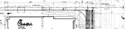


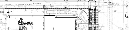
107
MAYWOOD FLORENCE CHESTERFIELD SQUARE WINDSOR HILLS CULVER CITY. MARINA del REY VENICE C1
 ROUTE MAP Carmelita Av MAYWOOD 251 751 Figueroa St CULVER CITY Boyle Av Soto St Pacific Bl Holmes Av (To Los Angeles) Compton Av Central Av Avalon Bl Main St CHESTERFIELD SQUARE Crenshaw Bl La Brea Av
IV. ENVIRONMENTAL IMPACT ANALYSIS N. TRANSPORTATION AND TRAFFIC
 IV. ENVIRONMENTAL IMPACT ANALYSIS N. TRANSPORTATION AND TRAFFIC The following section summarizes the information provided in the traffic report entitled Traffic Impact Analysis for a Proposed Residential
Traffic Impact Analysis 5742 BEACH BOULEVARD MIXED USE PROJECT
 Traffic Impact Analysis 5742 BEACH BOULEVARD MIXED USE PROJECT CITY OF BUENA PARK Prepared by Project No. 14139 000 April 17 th, 2015 DKS Associates Jeffrey Heald, P.E. Rohit Itadkar, T.E. 2677 North Main
We re using a giant machine to dig tunnels for trains.
 metro.net/crenshaw We re using a giant machine to dig tunnels for trains. crenshaw/lax transit project Tunnel Boring Machine Fun Facts #CrenshawTBM What is a Tunnel Boring Machine (TBM)? A TBM is like
APPENDIX TR-1 PARKING AND QUEUING ASSESSMENT
 APPENDIX TR-1 PARKING AND QUEUING ASSESSMENT Overland Overland Traffic Consultants, Traffic Consultants, Inc. Inc. Overland Traffic Consultants 952 Manhattan Beach Boulevard, Suite #100 Manhattan Beach,
4.7 Construction Surface Transportation
 4.7 Construction Surface Transportation 4.7.1 Introduction The traffic analysis presented in this section addresses the construction traffic impacts specific to the proposed Project. The construction traffic
2. Valley Circle Boulevard/Andora Avenue/Baden Avenue and Lassen Street
 IV.J TRANSPORTATION 1. INTRODUCTION This section presents an overview of the existing traffic and circulation system in and surrounding the project site. This section also discusses the potential impacts
SANTA MONICA VENICE MARINA DEL REY PLAYA VISTA WESTCHESTER EL SEGUNDO. Wilshire Arizona Santa Monica Blvd. 4th
 LINCOLN BLVD 4th F Wilshire Santa Monica Blvd SANTA MONICA not to scale E 5th 6th Santa Monica High School Olympic High School Lincoln Broadway California VENICE Pico Marina Pointe MARINA DEL REY Westchester
APPENDIX F-IV.K Updated Transportation Impact Analysis (June 2010)
") APPENDIX F-IV.K Updated Transportation Impact Analysis (June 2010) TRANSPORTATION IMPACT ANALYSIS FOR THE LOYOLA MARYMOUNT UNIVERSITY MASTER PLAN PROJECT JUNE 2010 PREPARED FOR AECOM Design PREPARED BY
APPENDIX F-IV.K Updated Transportation Impact Analysis (June 2010) TRANSPORTATION IMPACT ANALYSIS FOR THE LOYOLA MARYMOUNT UNIVERSITY MASTER PLAN PROJECT JUNE 2010 PREPARED FOR AECOM Design PREPARED BY
TRANSPORTATION STUDY FOR THE 8899 BEVERLY BOULEVARD PROJECT
 DRAFT TRANSPORTATION STUDY FOR THE 8899 BEVERLY BOULEVARD PROJECT WEST HOLLYWOOD, CALIFORNIA NOVEMBER 2013 PREPARED FOR BEVERLY BOULEVARD ASSOCIATION PREPARED BY DRAFT TRANSPORTATION STUDY FOR THE 8899
APPENDIX I. Traffic Impact Analysis
 APPENDIX I Traffic Impact Analysis TRAFFIC IMPACT ANALYSIS FOR ASSISTED LIVING AND SKILLED NURSING FACILITY Located at 1022-1054 La Cienega Boulevard In the City of Los Angeles Prepared by: Overland
IV. ENVIRONMENTAL IMPACT ANALYSIS L. TRANSPORTATION/TRAFFIC
 IV. ENVIRONMENTAL IMPACT ANALYSIS L. TRANSPORTATION/TRAFFIC INTRODUCTION The following section summarizes the information provided in the traffic report entitled Traffic Impact Analysis for a Proposed
IV. ENVIRONMENTAL IMPACT ANALYSIS B. TRAFFIC AND CIRCULATION
 IV. ENVIRONMENTAL IMPACT ANALYSIS B. TRAFFIC AND CIRCULATION 1. INTRODUCTION This section is based on the technical report, Traffic Study for 10131 Constellation Boulevard Residential Project, prepared
Escondido Marriott Hotel and Mixed-Use Condominium Project TRAFFIC IMPACT ANALYSIS REPORT
 Escondido Marriott Hotel and Mixed-Use Condominium Project TRAFFIC IMPACT ANALYSIS REPORT Prepared for Phelps Program Management 420 Sixth Avenue, Greeley, CO 80632 Prepared by 5050 Avenida Encinas, Suite
4.7 Construction Surface Transportation
 4.7.1 Introduction The traffic analysis presented in this section addresses the construction traffic impacts specific to the proposed Project. The construction traffic impacts were analyzed for both the
TRANSPORTATION 1. INTRODUCTION 2. METHODOLOGY
 IV.K TRANSPORTATION 1. INTRODUCTION This section provides an analysis of potential impacts associated with traffic, parking, and access. The analysis provides an overview of existing traffic conditions
IV. ENVIRONMENTAL IMPACT ANALYSIS M. TRANSPORTATION AND TRAFFIC
 IV. ENVIRONMENTAL IMPACT ANALYSIS M. TRANSPORTATION AND TRAFFIC INTRODUCTION This section of the (Draft EIR) addresses the subject of traffic and transportation with respect to the proposed (Project or
IV. ENVIRONMENTAL IMPACT ANALYSIS J. TRANSPORTATION AND TRAFFIC
 IV. ENVIRONMENTAL IMPACT ANALYSIS J. TRANSPORTATION AND TRAFFIC This Section summarizes the information provided in the Traffic Study for the Santa Monica College Bundy Campus Master Plan (Traffic Study),
King Soopers #116 Thornton, Colorado
 Traffic Impact Study King Soopers #116 Thornton, Colorado Prepared for: Galloway & Company, Inc. T R A F F I C I M P A C T S T U D Y King Soopers #116 Thornton, Colorado Prepared for Galloway & Company
j Universal Studios CityWalk k California State University, Northridge l Taft High School
 SC791 245 744 158 167 233 237 744 234 734 CE549 242 244 243 236 161 230 239 237 169 155 155 218 ROUTE MAP St Lassen St 8 Lindley Av CE419 158 Sherman Wy Vanowen St 161 CE422 CE423 0 Topanga Cyn Bl a b
TRAFFIC IMPACT ANALYSIS FOR A PROPOSED MIXED USE DEVELOPMENT
 TRAFFIC IMPACT ANALYSIS FOR A PROPOSED MIXED USE DEVELOPMENT Located at southeast corner of Winnetka Avenue and Prairie Street In the City of Los Angeles Prepared for: Sky Tech Management & Construction
2.0 Development Driveways. Movin Out June 2017
 Movin Out June 2017 1.0 Introduction The proposed Movin Out development is a mixed use development in the northeast quadrant of the intersection of West Broadway and Fayette Avenue in the City of Madison.
Section 5.8 Transportation and Traffic
 Section 5.8 Transportation and Traffic 5.8 TRANSPORTATION AND TRAFFIC Generous This Section is based on the Topgolf Specific Plan Traffic Impact Analysis (RK Engineering Group, Inc., October 31, 2016);
Traffic Impact Analysis for 2171 Rosecrans Avenue
 Traffic Impact Analysis for 2171 Rosecrans Avenue Prepared for: Continental Development Corporation Revised May 2016 LA16-2831 Prepared by: Fehr & Peers 600 Wilshire Blvd, Suite 1050 Los Angeles, CA 90017
PASADENA. Altadena Dr. Allen Av. Lake Av. Hill Av. Mountain St. Orange Grove Bl. Villa St LAKE ALLEN SIERRA MADRE VILLA Walnut St.
 St Eastern Av ROUTE MAP Express Line 501 provides daily service from North Hollywood Station ( Orange & Red Lines) to the ( & Stations). For more information, go to metro.net LITTLE TOKYO/ ARTS DISTRICT
Appendix Q Traffic Study
 Appendices Appendix Q Traffic Study Crummer Site Subdivision Draft EIR City of Malibu Appendices This page intentionally left blank. The Planning Center April 2013 TRAFFIC IMPACT ANALYSIS Photo z here
Hastings Ranch Dr. Sierra Madre Bl. Sierra Madre Villa Av. Foothill Bl b. Sierra 4 Madre F187. Michillinda Av. Rosemead Bl. 487 Santa Anita Av
 177 258 260 266 686 180 256 258 ROUTE MAP Lincoln Av Mariposa St Altadena Dr ALTADENA Orange Grove Bl PT31 PT32 Lake Ave New York Dr Bl 5 3 Fair Oaks Av 710 Woodbury Rd Fontanet Wy 1 2 6 Raymond Av PT20PT51
APPENDIX C-2. Traffic Study Supplemental Analysis Memo
 APPENDIX C-2 Traffic Study Supplemental Analysis Memo The Mobility Group Transportation Strategies & Solutions Memorandum To: From: Subject: Tomas Carranza, LADOT Matthew Simons Traffic Review - Revised
4.1 Traffic, Circulation, and Parking
 4.1 Traffic, This section describes the existing transportation and parking conditions within and adjacent to the project area. A traffic report describing the potential impacts of the proposed project
TABLE OF CONTENTS SECTION PAGE. Executive Summary... xii
 TABLE OF CONTENTS SECTION PAGE Executive Summary... xii 1.0 Introduction... 1 1.1 Study Area... 2 1.2 Traffic Impact Analysis Scenarios... 4 1.3 Study Area - City of Orange... 4 2.0 Project Description
Project Scoping Report Appendix B Project Web Site. APPENDIX B Project Web Site
 Project Scoping Report Appendix B Project Web Site APPENDIX B Project Web Site WESTSIDE EXTENSION TRANSIT CORRIDOR STUDY February 4, 2008 News and Info of 1 http://metro.net/projects_programs/westside/news_info.htm#topofpage
TRANSPORTATION 1. INTRODUCTION
 IV.F TRANSPORTATION 1. INTRODUCTION This section evaluates potential impacts associated with Project-related traffic, circulation, and access. The analysis summarizes the findings of the traffic study
Transportation & Traffic Engineering
 Transportation & Traffic Engineering 1) Project Description This report presents a summary of findings for a Traffic Impact Analysis (TIA) performed by A+ Engineering, Inc. for the Hill Country Family
TRAFFIC IMPACT ANALYSIS FOR. McDONALD S RESTAURANT IN CARMICAEL Sacramento County, CA. Prepared For:
 TRAFFIC IMPACT ANALYSIS FOR McDONALD S RESTAURANT IN CARMICAEL Sacramento County, CA Prepared For: McDonald s USA, LLC Pacific Sierra Region 2999 Oak Road, Suite 900 Walnut Creek, CA 94597 Prepared By:
TRAFFIC PARKING ANALYSIS
 TRAFFIC PARKING ANALYSIS NAPA FLEA MARKET COUNTY OF NAPA Prepared for: Tom Harding Napa-Vallejo Flea Market 33 Kelly Road American Canyon, CA 9453 Prepared by: 166 Olympic Boulevard, Suite 21 Walnut Creek,
IV. ENVIRONMENTAL IMPACT ANALYSIS L. TRAFFIC, TRANSPORTATION, AND PARKING
 IV. NVIRONMNTAL IMPACT ANALYSIS L. TRAFFIC, TRANSPORTATION, AND PARKING INTRODUCTION The following summarizes the information provided in the traffic report prepared by Hirsch/Green Transportation Consulting,
Section 3.12 Traffic and Transportation
 Section. Traffic and Transportation SECTION SUMMARY This section describes existing ground transportation within the Port and surrounding area associated with implementation of the proposed Project. An
Appendix C. Traffic Study
 Appendix C Traffic Study TABLE OF CONTENTS SECTION Executive Summary PAGE 1.0 Introduction... 1 1.1 Scope of Work... 1 1.2 Study Area... 2 2.0 Project Description... 3 2.1 Site Access... 4 2.2 Pedestrian
Table Existing Traffic Conditions for Arterial Segments along Construction Access Route. Daily
 5.8 TRAFFIC, ACCESS, AND CIRCULATION This section describes existing traffic conditions in the project area; summarizes applicable regulations; and analyzes the potential traffic, access, and circulation
APPENDIX B Traffic Analysis
 APPENDIX B Traffic Analysis Rim of the World Unified School District Reconfiguration Prepared for: Rim of the World School District 27315 North Bay Road, Blue Jay, CA 92317 Prepared by: 400 Oceangate,
Traffic Impact Statement (TIS)
") Traffic Impact Statement (TIS) Vincentian PUDA Collier County, FL 10/18/2013 Prepared for: Global Properties of Naples Prepared by: Trebilcock Consulting Solutions, PA 2614 Tamiami Trail N, Suite 615 1205
Traffic Impact Statement (TIS) Vincentian PUDA Collier County, FL 10/18/2013 Prepared for: Global Properties of Naples Prepared by: Trebilcock Consulting Solutions, PA 2614 Tamiami Trail N, Suite 615 1205
V. ENVIRONMENTAL IMPACT ANALYSIS F. TRANSPORTATION/CIRCULATION
 V. ENVIRONMENTAL IMPACT ANALYSIS F. TRANSPORTATION/CIRCULATION The following Section presents a summary of the Traffic Study for the Proposed Civic Center/Metlox Development Project in the City of Manhattan
IRSCH REEN Hirsch/Green Transportation Consulting, Inc.
 IRSCH REEN Hirsch/Green Transportation Consulting, Inc. February 6, 2013 Mr. David Weil Director of Finance St. Matthew s Parish School 1031 Bienveneda Avenue Pacific Palisades, California 90272 RE: Trip
INDUSTRIAL DEVELOPMENT
 INDUSTRIAL DEVELOPMENT Traffic Impact Study Plainfield, Illinois August 2018 Prepared for: Seefried Industrial Properties, Inc. TABLE OF CONTENTS Executive Summary 2 Introduction 3 Existing Conditions
Executive Summary. Draft Environmental Impact Statement/Environmental Impact Report ES-1
 Executive Summary Introduction The Eastside Transit Corridor Phase 2 Project is a vital public transit infrastructure investment that would provide a transit connection to the existing Metro Gold Line
Oakbrook Village Plaza City of Laguna Hills
 Oakbrook Village Plaza City of Laguna Hills Traffic Impact Analysis Prepared by: HDR Engineering 3230 El Camino Real, Suite 200 Irvine, CA 92602 October 2012 Revision 3 D-1 Oakbrook Village Plaza Laguna
Impacts to street segments were analyzed based on procedures detailed in the Highway Capacity Manual for levels of service related to roadways.
 4.7 Transportation and Circulation This report documents the results of a study of the potential traffic impacts created by the Whittier Main Oil Field Development Project. The study is included as Appendix
III. CORRECTIONS AND ADDITIONS TO THE DRAFT EIR
 III. CORRECTIONS AND ADDITIONS TO THE DRAT EIR DRAT EIR I. INTRODUCTION/SUMMARY In response to Comment No. 2.1 on the Draft EIR, the following mitigation measure is added to Table I- 1, Summary of Environmental
Table of Contents INTRODUCTION... 3 PROJECT STUDY AREA Figure 1 Vicinity Map Study Area... 4 EXISTING CONDITIONS... 5 TRAFFIC OPERATIONS...
 Crosshaven Drive Corridor Study City of Vestavia Hills, Alabama Table of Contents INTRODUCTION... 3 PROJECT STUDY AREA... 3 Figure 1 Vicinity Map Study Area... 4 EXISTING CONDITIONS... 5 TRAFFIC OPERATIONS...
Traffic Engineering Study
 Traffic Engineering Study Bellaire Boulevard Prepared For: International Management District Technical Services, Inc. Texas Registered Engineering Firm F-3580 November 2009 Executive Summary has been requested
MINERVA PARK SITE TRAFFIC IMPACT STUDY M/I HOMES. September 2, 2015
 5500 New Albany Road Columbus, Ohio 43054 Phone: 614.775.4500 Fax: 614.775.4800 Toll Free: 1-888-775-EMHT emht.com 2015-1008 MINERVA PARK SITE TRAFFIC IMPACT STUDY M/I HOMES September 2, 2015 Engineers
NOTICE OF PUBLIC HEARING Los Angeles County Metropolitan Transportation Authority
 NOTICE OF PUBLIC HEARING Los Angeles County Metropolitan Transportation Authority The Los Angeles County Metropolitan Transportation Authority will hold public hearings in February 2011 to receive community
Appendix G Traffic and Parking Report
 Appendix G Traffic and Parking Report TABLE OF CONTENTS SECTION PAGE Executive Summary... v 1.0 Introduction... 1 1.1 Study Area... 3 2.0 Project Description... 4 2.1 Site Location... 4 2.2 Existing Project
ATTACHMENT [B] PROJECT DESCRIPTION REQUESTED CITY OF LOS ANGELES ACTIONS
![ATTACHMENT [B] PROJECT DESCRIPTION REQUESTED CITY OF LOS ANGELES ACTIONS](/thumbs/72/67299149.jpg "ATTACHMENT [B] PROJECT DESCRIPTION REQUESTED CITY OF LOS ANGELES ACTIONS") ATTACHMENT [B] PROJECT DESCRIPTION REQUESTED CITY OF LOS ANGELES ACTIONS I. Project Location The Los Angeles International Airport (LAX) Landside Access Modernization Program ( Project ) comprises approximately
ATTACHMENT [B] PROJECT DESCRIPTION REQUESTED CITY OF LOS ANGELES ACTIONS I. Project Location The Los Angeles International Airport (LAX) Landside Access Modernization Program ( Project ) comprises approximately
Costco Gasoline Fuel Station Transportation Characteristics
 Exhibit A MEMORANDUM Date: May 23, 2013 Project #: I-10 To: Jennifer Murillo, Costco Wholesale Terry Odle, Mulvanny G2 Architecture From: Sonia Hennum, PTOE Project: Subject: Signal Hill Costco Gasoline
APPENDIX H. Transportation Impact Study
 APPENDIX H Transportation Impact Study BUENA VISTA LAGOON ENHANCEMENT PROJECT TRANSPORTATION IMPACT STUDY Prepared for: San Diego Association of Governments Prepared by: VRPA Technologies, Inc. 9520 Padgett
TIMBERVINE TRANSPORTATION IMPACT STUDY FORT COLLINS, COLORADO JANUARY Prepared for:
 TIMBERVINE TRANSPORTATION IMPACT STUDY FORT COLLINS, COLORADO JANUARY 2014 Prepared for: Hartford Companies 1218 W. Ash Street Suite A Windsor, Co 80550 Prepared by: DELICH ASSOCIATES 2272 Glen Haven Drive
4.14 TRANSPORTATION AND CIRCULATION
 4.14 TRANSPORTATION AND CIRCULATION 4.14.1 Summary Table 4.14-1 summarizes the identified environmental impacts, proposed mitigation measures, and residual impacts of the proposed project with regard to
2.4 Build Alternatives
 Table 2-1. Future Transit Network Changes between No Build and TSM Alternatives Operator Route Group No. Route ID and Description Peak Headway (min) No Build Off-peak Headway (min) Peak Headway (min) TSM
TRAFFIC IMPACT STUDY PROPOSED RESIDENTIAL CARE FACILITY (ASSISTED LIVING) AND 8 SINGLE FAMILY HOMES 3814 LENAWEE AVENUE CULVER CITY, CALIFORNIA
 AND 8 SINGLE FAMILY HOMES 3814 LENAWEE AVENUE CULVER CITY, CALIFORNIA") TRAFFIC IMPACT STUDY PROPOSED RESIDENTIAL CARE FACILITY (ASSISTED LIVING) AND 8 SINGLE FAMILY HOMES 84 LENAWEE AVENUE CULVER CITY, CALIFORNIA PREPARED BY ALLAN ENGINEERING NOV. 05 SUMMARY OF TRAFFIC ELEMENT
TRAFFIC IMPACT STUDY PROPOSED RESIDENTIAL CARE FACILITY (ASSISTED LIVING) AND 8 SINGLE FAMILY HOMES 84 LENAWEE AVENUE CULVER CITY, CALIFORNIA PREPARED BY ALLAN ENGINEERING NOV. 05 SUMMARY OF TRAFFIC ELEMENT
Volume 1 Traffic Impact Analysis Turtle Creek Boulevard Dallas, Texas. Kimley-Horn and Associates, Inc. Dallas, Texas.
 Volume 1 Traffic Impact Analysis 2727 Dallas, Texas June 18, 2018 Kimley-Horn and Associates, Inc. Dallas, Texas Project #064523000 Registered Firm F-928 Traffic Impact Analysis 2727 Dallas, Texas Prepared
Traffic Impact Analysis. Alliance Cole Avenue Residential Site Dallas, Texas. Kimley-Horn and Associates, Inc. Dallas, Texas.
 Traffic Impact Analysis Alliance Cole Avenue Residential Site Dallas, Texas February 15, 2018 Kimley-Horn and Associates, Inc. Dallas, Texas Project #064524900 Registered Firm F-928 Traffic Impact Analysis
IV. ENVIRONMENTAL IMPACT ANALYSIS I. TRAFFIC / TRANSPORTATION
 IV. ENVIRONMENTAL IMPACT ANALYSIS I. TRAFFIC / TRANSPORTATION 1. INTRODUCTION The following section summarizes the information provided in the following traffic studies and collectively referred to as
Appendix B Traffic Impact Analysis, Asphalt Plant No. 1 Replacement and Modernization
 Appendix B Traffic Impact Analysis, Asphalt Plant No. 1 Replacement and Modernization REPORT Traffic Impact Analysis, Asphalt Plant No. 1 Replacement and Modernization Prepared for City of Los Angeles
Date: February 7, 2017 John Doyle, Z-Best Products Robert Del Rio. T.E. Z-Best Traffic Operations and Site Access Analysis
 Memorandum Date: February 7, 07 To: From: Subject: John Doyle, Z-Best Products Robert Del Rio. T.E. Z-Best Traffic Operations and Site Access Analysis Introduction Hexagon Transportation Consultants, Inc.
MANHATTAN VILLAGE ENHANCEMENT PROJECT
 MANHATTAN VILLAGE ENHANCEMENT PROJECT Traffic & Parking Analysis Manhattan Beach City Council September 2013 Study Area and Analyzed Intersections Intersection LOS Results Project Improvements Dedicate
TRAFFIC IMPACT ANALYSIS SAFARI HIGHLANDS RANCH
 TRAFFIC IMPACT ANALYSIS SAFARI HIGHLANDS RANCH, California November 11, 2016 LLG Ref. 3-14-2334 EXECUTIVE SUMMARY The Project proposes the development of 550 luxury residential dwelling units, public trails,
West Hills Shopping Centre Lowe s Expansion Traffic Impact Study
 West Hills Shopping Centre Lowe s Expansion Traffic Impact Study Prepared for: Armel Corporation January 2015 Paradigm Transportation Solutions Ltd. 22 King Street South, Suite 300 Waterloo ON N2J 1N8
EXECUTIVE SUMMARY. The following is an outline of the traffic analysis performed by Hales Engineering for the traffic conditions of this project.
 EXECUTIVE SUMMARY This study addresses the traffic impacts associated with the proposed Shopko redevelopment located in Sugarhouse, Utah. The Shopko redevelopment project is located between 1300 East and
Alpine Highway to North County Boulevard Connector Study
 Alpine Highway to North County Boulevard Connector Study prepared by Avenue Consultants March 16, 2017 North County Boulevard Connector Study March 16, 2017 Table of Contents 1 Summary of Findings... 1
Community Meetings June 2018
 Community Meetings June 2018 1 Welcome and Agenda Thank you for joining us! 6:00 pm Open House 6:30 pm Welcome & Presentation 7:00 pm Q&A 7:15 pm Open House Resumes 8:00 pm Meeting Concludes 2 Purpose
Welcome and Agenda. Thank you for joining us! 6:00 pm Open House. 6:30 pm Welcome & Presentation. 7:00 pm Q&A. 7:15 pm Open House Resumes
 1 Welcome and Agenda Thank you for joining us! 6:00 pm Open House 6:30 pm Welcome & Presentation 7:00 pm Q&A 7:15 pm Open House Resumes 8:00 pm Meeting Concludes 2 Purpose of this Meeting Introduce project
Green Line Extension to Torrance Supplemental Alternatives Analysis. 2. Purpose and Need 2. PURPOSE AND NEED
 2. PURPOSE AND NEED This chapter characterizes the transportation and mobility problems and identifies project goals, objectives, and evaluation criteria to improve these problems for the Green Line Extension
IV. ENVIRONMENTAL IMPACT ANALYSIS C. TRAFFIC, CIRCULATION AND PARKING
 IV. ENVIRONMENTAL IMPACT ANALYSIS C. TRAFFIC, CIRCULATION AND PARKING 1. INTRODUCTION This section is based on the technical report Traffic Study for the Villa Marina Residential Project, prepared by Kaku
APPENDIX B TRAFFIC IMPACT ANALYSIS
 APPENDIX B TRAFFIC IMPACT ANALYSIS Submitted by: DOWNTOWN AND FAIRVIEW HEIGHTS TRANSIT ORIENTED DISTRICT (TOD) CITY OF INGLEWOOD DRAFT TRAFFIC IMPACT ANALYSIS Submitted to: City of Inglewood June 24, 2016
Construction Realty Co.
 MEMORANDUM TO: FROM : Jeff Pickus Construction Realty Co. Luay R. Aboona, PE Principal 9575 West Higgins Road, Suite 400 Rosemont, Illinois 60018 p: 847-518-9990 f: 847-518-9987 DATE: May 22, 2014 SUBJECT:
Appendix B Traffic Impact Analysis, Asphalt Plant No. 1 Replacement and Modernization
 Appendix B Traffic Impact Analysis, Asphalt Plant No. 1 Replacement and Modernization DRAFT REPORT Traffic Impact Analysis, Asphalt Plant No. 1 Replacement and Modernization Prepared for City of Los Angeles
Quantitative analyses of weekday a.m. and p.m. commuter hour conditions have been conducted for the following five scenarios:
 6.1 TRANSPORTATION AND CIRCULATION 6.1.1 INTRODUCTION This section of the EIR presents the results of TJKM s traffic impact analysis of the proposed Greenbriar Development. The analysis includes consideration
engineering phase and during the procurement of design build contracts.
 CONSIDERATION OF ALTERNATIVES Below-grade trench alignment along Aviation Boulevard, adjacent to LAX south runways. miles. MOS-Century would extend from the Metro Exposition Line to the Aviation/ Century
Lacey Gateway Residential Phase 1
 Lacey Gateway Residential Phase Transportation Impact Study April 23, 203 Prepared for: Gateway 850 LLC 5 Lake Bellevue Drive Suite 02 Bellevue, WA 98005 Prepared by: TENW Transportation Engineering West
NEWCASTLE MIDDLE SCHOOL Traffic Impact Analysis
 Gibson Traffic Consultants 2802 Wetmore Avenue Suite 220 Everett, WA 98201 425.339.8266 NEWCASTLE MIDDLE SCHOOL Traffic Impact Analysis Prepared for: Renton School District Jurisdiction: City of Newcastle
Craig Scheffler, P.E., PTOE HNTB North Carolina, P.C. HNTB Project File: Subject
 TECHNICAL MEMORANDUM To Kumar Neppalli Traffic Engineering Manager Town of Chapel Hill From Craig Scheffler, P.E., PTOE HNTB North Carolina, P.C. Cc HNTB Project File: 38435 Subject Obey Creek TIS 2022
Crenshaw/LAX Transit Corridor. Transit Coalition Meeting June 26, 2012
 Transit Coalition Meeting June 26, 2012 Measure R Projects 8 ½ mile light rail line from Exposition/Crenshaw Blvds. to Metro Green Line s Aviation/LAX station Six stations with two optional stations carried
Develop ground transportation improvements to make the Airport a multi-modal regional
 Project Overview TRANSPORTATION IMPROVEMENTS WHAT ARE THE PROJECT GOALS? Transportation transportation hub. Develop ground transportation improvements to make the Airport a multi-modal regional Land Use
Crenshaw-Prairie Transit Corridor Study Public Meetings
 Crenshaw-Prairie Transit Corridor Study Public Meetings Darby Park: Wednesday, February 20, 2008 6:30 8:00 PM US Bank Community Room: Thursday, February 21, 2008 6:30 8:00 PM Nate Holden Performing Arts
BERKELEY DOWNTOWN AREA PLAN PROGRAM ENVIRONMENTAL IMPACT REPORT TRAFFIC IMPACT ANALYSIS
 BERKELEY DOWNTOWN AREA PLAN PROGRAM ENVIRONMENTAL IMPACT REPORT TRAFFIC IMPACT ANALYSIS Prepared for: City of Berkeley Prepared by: REVISED JANUARY 9, 2009 Berkeley Downtown Area Plan Program EIR Traffic
Traffic Impact Study Speedway Gas Station Redevelopment
 Traffic Impact Study Speedway Gas Station Redevelopment Warrenville, Illinois Prepared For: Prepared By: April 11, 2018 Table of Contents 1. Introduction... 1 2. Existing Conditions... 4 Site Location...
TALMONT TOWNHOMES MADISON KENNETH SPA TRAFFIC IMPACT STUDY. Sacramento, CA. Prepared For: MBK Homes. Prepared By:
 TALMONT TOWNHOMES MADISON KENNETH SPA TRAFFIC IMPACT STUDY Sacramento, CA Prepared For: MBK Homes Prepared By: KD Anderson & Associates 3853 Taylor Road, Suite G Loomis, California 95650 (916) 660-1555
Proposed location of Camp Parkway Commerce Center. Vicinity map of Camp Parkway Commerce Center Southampton County, VA
 Proposed location of Camp Parkway Commerce Center Vicinity map of Camp Parkway Commerce Center Southampton County, VA Camp Parkway Commerce Center is a proposed distribution and industrial center to be
APPENDIX C1 TRAFFIC ANALYSIS DESIGN YEAR TRAFFIC ANALYSIS
 APPENDIX C1 TRAFFIC ANALYSIS DESIGN YEAR TRAFFIC ANALYSIS DESIGN YEAR TRAFFIC ANALYSIS February 2018 Highway & Bridge Project PIN 6754.12 Route 13 Connector Road Chemung County February 2018 Appendix
TRAFFIC IMPACT ANALYSIS
 TRAFFIC IMPACT ANALYSIS Emerald Isle Commercial Development Prepared by SEPI Engineering & Construction Prepared for Ark Consulting Group, PLLC March 2016 I. Executive Summary A. Site Location The Emerald
Sepulveda Pass Corridor Systems Planning Study Update
 Los Angeles County Metropolitan Transportation Authority Sepulveda Pass Corridor Systems Planning Study Update June 20, 2012 Measure R Transit Corridors One of 12 Measure R Transit Corridors approved by
TABLE OF CONTENTS EXECUTIVE SUMMARY...1 INTRODUCTION...3 PROJECTED FUTURE GROWTH...3 ROADWAY IMPROVEMENT PROJECTS...4 POTENTIAL FUNDING SOURCES...
 Transportation Impact Fee Study September 2014 TABLE OF CONTENTS EXECUTIVE SUMMARY...1 INTRODUCTION...3 PROJECTED FUTURE GROWTH...3 ROADWAY IMPROVEMENT PROJECTS......4 POTENTIAL FUNDING SOURCES...7 PROPOSED
King County Metro. Columbia Street Transit Priority Improvements Alternative Analysis. Downtown Southend Transit Study. May 2014.
 King County Metro Columbia Street Transit Priority Improvements Alternative Analysis Downtown Southend Transit Study May 2014 Parametrix Table of Contents Introduction... 1 Methodology... 1 Study Area...
Countdown to the Closure Extended 53-Hour Closure of I-405 Freeway Between U.S. 101 and I-10 Planned in Mid-July for Mulholland Bridge Demolition
 Countdown to the Closure Extended 3-Hour Closure of I-40 Freeway Between U.S. 0 and I-0 Planned in Mid-July for Mulholland Bridge Demolition Work Los Angeles, Calif. Plan Ahead, Avoid The Area, Or Stay
Traffic Study for Barstow 2014 General Plan Amendment. Prepared for: The City of Barstow. Prepared by: ADVANTEC Consulting Engineers
 Traffic Study for Barstow 2014 General Plan Amendment Prepared for: The City of Barstow Prepared by: June 20, 2014 TABLE OF CONTENTS 1. Executive Summary... 1 2. Project Background & Description... 3 2.1
3.8 TRANSPORTATION, CIRCULATION AND PARKING
 3.8 TRANSPORTATION, CIRCULATION AND PARKING This section provides an overview of traffic, circulation and parking impacts and evaluates the construction and operational impacts associated with the Proposed
Table of Contents. Traffic Impact Analysis Capital One Building at Schilling Place
 Traffic Impact Analysis Capital One Building at Schilling Place Table of Contents Executive Summary... 1 1. Introduction... 4 2. Project Description... 4 3. Background Information... 4 4. Study Scope...
Sepulveda Pass Corridor Systems Planning Study
 Los Angeles County Metropolitan Transportation Authority Sepulveda Pass Corridor Systems Planning Study Streets and Freeways Subcommittee January 17, 2013 1 Sepulveda Pass Study Corridor Extends for 30
Traffic Impact Analysis West Street Garden Plots Improvements and DuPage River Park Garden Plots Development Naperville, Illinois
 Traffic Impact Analysis West Street Garden Plots Improvements and DuPage River Park Garden Plots Development Naperville, Illinois Submitted by April 9, 2009 Introduction Kenig, Lindgren, O Hara, Aboona,