BEN WILSON STREET CORRIDOR STUDY
|
|
|
- Anthony Barrett
- 5 years ago
- Views:
Transcription


1 BEN WILSON STREET CORRIDOR STUDY Prepared for: Victoria MPO Prepared by: FREESE AND NICHOLS, INC. In association with CivilCorp, LLC
2
3 Ben Wilson Street Corridor Study Victoria MPO TABLE OF CONTENTS EXECUTIVE SUMMARY BASIS FOR THE PLAN Background Stakeholder Interviews University of Houston Victoria Victoria College Growth South of Ben Wilson Street Citizens Medical Center Bronson Terrace Emergency Services Other Corridor Land Uses Evaluation Criteria CORRIDOR TRAFFIC OPERATIONS City Thoroughfare Network Traffic Volumes Traffic Crash Data ALTERNATIVE CONFIGURATIONS Combinations of Configurations Potential Corridor Treatments Potential Treatments to Cross Streets Evaluation Methodology Alternative 1A: Enhanced Existing Five-Lane Roadway Alternative 1B: Combination Five-Lane and Four-Lane Roadway Alternative 2A: Five & Four Lane Roadway with Pedestrian Underpass at UH-V Alternative 2B: Five & Three Lane Roadway with Pedestrian Underpass at UH-V Alternative 3A: Combination Five-Lane and Three-Lane Roadway Alternative 3B: Three-Lane Roadway with Enhanced Intersections Comparative Summary of Alternatives RECOMMENDATIONS Preferred Alternatives Recommended Improvements Options for Design with Cost Implications Other Project and Corridor Considerations i
4 Ben Wilson Street Corridor Study Victoria MPO List of Figures Figure 1. Study Area Location Map Figure 2. Study Area Development Map Figure 3. UH-V Campus Development Plan Map Figure 4. Victoria College Campus Map Figure 5. Citizens Medical Center Figure 6. Bronson Terrace Access onto Ben Wilson Street Figure 7. North End Development Figure 8. South End Development Figure 9. Areawide Roadway Network Figure 10. Alternative 1A Figure 11. Alternative 1B Figure 12. Alternative 2A Figure 13. Alternative 2B Figure 14. Alternative 3A Figure 15. Alternative 3B Figure 16. Recommended Configuration Figure 17. Intersection Configuration at Airline Road Figure 18. HAWK Signal Configuration at UH-V Campus Figure 19. Intersection Configuration at Red River Street Figure 20. Typical Section, Airline Road to UH-V Campus Figure 21. Typical Section, UH-V Campus to Red River Street Figure 22. Typical Section, Red River Street to US 59 Business List of Tables Table 1. Historical Daily Traffic Volumes on Roadways near the Ben Wilson Street Corridor Table 2. LOS Assessment of Existing and Potential Street Diet (2015 volumes) Table 3. Intersection Capacity Utilization (2015 volumes) Table 4. Evaluation of Enhanced Existing Five Lane Roadway Condition Alternative 1A Table 5. Evaluation of Five Lane & Four Lane Roadway Alternative 1B Table 6. Evaluation of Five & Four Lane Roadway with Pedestrian Underpass Alternative 2A Table 7. Evaluation of Five and Three Lane Roadway with Pedestrian Underpass Alternative 2B Table 8. Evaluation of Five Lane & Three Lane Roadway Alternative 3A Table 9. Evaluation of Three Lane Roadway Alternative 3B Table 10. Comparison of Alternatives Evaluation Scores APPENDICES Appendix A - Traffic Count Data Appendix B - Synchro Model Run Output for Existing and Minimal Roadway Configurations Appendix C - Estimated Development Costs of the Alternatives ii
5 Ben Wilson Street Corridor Study Victoria MPO EXECUTIVE SUMMARY The Victoria Metropolitan Planning Organization (MPO) retained Freese and Nichols, Inc. (FNI) to provide design alternatives to address both the safety of pedestrians, bicyclists, and other alternative transportation modes, and the flow of traffic along Ben Wilson Street given the planned expansion of the University of Houston Victoria campus. The study section extended between Sam Houston Drive and US Business 59. Project Goals - The design alternatives were developed to address the following weighted goals: Traffic Operations (30%), Pedestrian and Bicycle Mobility and Safety (30%), Cost Effective Solution (25%) and Corridor Aesthetics (15%). Stakeholder Input - The FNI project team and the MPO met with key stakeholders along the corridor to review current conditions, operations, issues and planned improvements along the corridor. Interviews were conducted with representatives from University of Houston Victoria, Victoria College, Citizens Medical Center and resident representatives from the Bronson Terrace neighborhood homeowners association. Discussions were also held with a representative from the Victoria Fire Department. Traffic Operations Existing traffic operations were modeled to facilitate the analysis. Peak period traffic turning movement counts taken at the significant intersections along Ben Wilson Street indicate that the key intersections operate overall at Level of Service (LOS) B during the AM and PM peak hours, with some of the individual turning movements operating at LOS C. This very good level of service during the peak hours of operation indicated a significant amount of excess capacity available for growth in the corridor. It also indicated the potential for a reduction in the number of travel lanes, which could allow for reallocation of street right-of-way to pedestrian accommodations and aesthetics for the corridor. Future travel demand on Ben Wilson Street, including the MPO-modeled area growth plus the projected UH-V growth, is expected to grow by about 20% over the next 25 years to year This study also assessed future travel growth at a 40% growth rate to assess the sensitivity of the configurations. Traffic modeling with these projected volumes indicate that expected growth of 20%, and even as high as 40%, could be accommodated with one less lane in each direction on Ben Wilson Street. Alternative Configurations - Alternatives were evaluated that considered various options including minimal roadway modifications, a pedestrian grade separation, and reduced number of travel lanes for a context sensitive street corridor. Six alternatives were evaluated comparatively to meet project goals: ES-1
6 Ben Wilson Street Corridor Study Victoria MPO 1A - Enhanced Existing Five-Lane Roadway. Mill and overlay the existing pavement, convert the center turn lane to a raised median at the UH-V frontage to the extent possible. Install midblock pedestrian activated pedestrian activated hybrid beacons (known as HAWK signals) to facilitate student crossings of Ben Wilson Street. 1B - Five-Lane/Four-Lane Roadway. Reconstruct the street pavement, but reducing the segment north of the UH-V campus to four lanes of traffic to allow for enhanced pedestrian/bicycle sidepaths on each side. A raised median would be provided in front of the UH-V campus. Add additional stormwater improvements and make needed improvements to utilities. Install the HAWK pedestrian signals. 2A - Five/Four with Ped Underpass. Similar to Alternative 1B, but raising Ben Wilson Street over a new pedestrian underpass to create a pedestrian flow between sides of campus unimpeded by traffic flow. 2B - Five/Three with Ped Underpass. Same as 2A, but reducing Ben Wilson to one lane each direction plus a center turn lane north of the UH-V campus. 3A - Five-Lane/Three-Lane Roadway. Reducing Ben Wilson Street to one lane each direction plus a center turn lane north of Red River Street, but keeping the five lanes south to US Business 59. Includes the added underground stormwater improvements and the raised medians and HAWK pedestrian signals at the UH- V campus. 3B - Three-Lane Roadway. Same as 3A, but extending the 3-lane section south to US Business 59. Evaluation of the Alternatives - The six alternatives were evaluated regarding their ability to address the project goals. Using the weighting allocated to the project goals, the resulting comparative scoring of the alternatives is shown in the table below. Alternative 1A: Enhanced Existing Five-Lane Roadway 1B: Five-Lane/Four-Lane Roadway 2A: Five/Four with Ped Underpass 2B: Five/Three with Ped Underpass 3A: Five-Lane/Three-Lane Roadway 3B: Three-Lane Roadway Comparison of Alternatives Evaluation Scores Pedestrian Cost Traffic Corridor Mobility Effective Operations Aesthetics and Safety Solution Total Score Est d Cost, Millions $ $ $ $ $ $8.44 ES-2
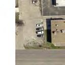
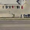
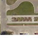
7 Ben Wilson Street Corridor Study Victoria MPO Recommendations - Alternatives 3A and 3B attained the highest score, well above the rest, and both were recommended for consideration by the City. Both alternatives reduced Ben Wilson Street to three lanes north of Red River Street, with 3A retaining five lanes south of Red River Street and 3B extending the 3 lane section to US Business 59. The recommendation of this study included a preference for Alternative 3A from a traffic operations standpoint due to the minimal impacts at US Business 59 and the potential for future commercial densification of development south of Red River Street. Agency Reviews - The MPO Policy Advisory Committee reviewed the findings and recommendation of the study and recommended that both Alternatives 3A and 3B be brought forward to Victoria City Council for their preference and approval. Victoria City Council approved on January 19, 2016 that both Alternatives 3A and 3B were acceptable configurations. Implementation Funding and implementation discussions for Alternative 3A will be pursued in the future, as this option can accommodate all stakeholders. Alternative 3A is illustrated in the following figure, which shows the lane configurations, intersection approach lanes, and location of the proposed HAWK pedestrian signals. The leadership of UH-V has expressed great interest in making these improvements happen sooner than later and have indicated an interest in participating in the funding of the needed improvements. Refinement of the concept and cost estimate for Alternative 3A identified two options for design of the pavement for the preferred configuration: 1. Complete reconstruction, as was included for all but Alternative 1A, at an estimated cost of $8.76 million. This option includes the addition of underground storm water lines to reduce the level of accumulated storm water during high rainfall events ; or 2. Reconstruction of the outer edges and median areas (cut pavement to size, new curblines, new sidewalks) and mill and overlay of the remaining existing pavement at an estimated cost of $5.92 million. This option does not include the addition of underground stormwater lines as the existing concrete pavement would not be removed to allow their placement. Alternative 3A is shown in the graphic on the following page, followed by a conceptual illustration of the configuration near the UH-V campus. Detailed cost estimates are included in Appendix C. ES-3


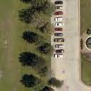
8 AIRLINE RD. BON AIRE AVE. MC DOW ST. PARK E. RED RIVER ST. HOSPITAL DR. CYPRESS ST. CYPRESS ST. BEN WILSON ST. MILTON ST. MILTON ST. FUTURE PARKING GARAGE BEN WILSON ST. INTERIM SURFACE PARKING (2017) FUTURE STUDENT CENTER DORMS (2017) FUTURE DORMS HAWK SIGNAL #1 HAWK SIGNAL #2 UNIVERSITY NORTH/SBDC FUTURE DORMS FUTURE PARKING GARAGE CITIZENS DR. CONTINENTAL ST. WALGREENS U. S. HW Y. 59 BEN W ILSO N STREET RECO M M ENDED CO NFIGURATIO N

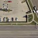
9 Conceptual Illustration of the Ben Wilson Street Preferred Configuration at the UH-V Campus
 to complete a corridor study along Ben Wilson Street between US Business 59 (Houston Highway) and Sam Houston Drive. The study corridor extends for approximately 0.")
10 Ben Wilson Street Corridor Study Victoria MPO 1.0 BASIS FOR THE PLAN 1.1 BACKGROUND The Victoria Metropolitan Planning Organization (MPO) retained Freese and Nichols, Inc. (FNI) to complete a corridor study along Ben Wilson Street between US Business 59 (Houston Highway) and Sam Houston Drive. The study corridor extends for approximately 0.8 mile through commercial, residential and university land uses, as depicted in Figure 1. The purpose of this study is to provide design alternatives to address both the safety of pedestrians, bicyclists, and other alternative transportation modes, and the flow of traffic along Ben Wilson Street given the planned expansion of the University of Houston Victoria campus. N Figure 1. Study Area Location Map 1

 located on the east side of Ben Wilson Street have been purchased by UH-V and are schedule to be raised in November 2015 in preparation for")

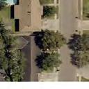
11 Ben Wilson Street Corridor Study Victoria MPO Ben Wilson Street is classified as a minor arterial roadway and currently provides a five-lane cross section two travel lanes in each direction plus a continuous left turn lane, with sidewalks along each side - and serves the University of Houston-Victoria, Victoria College, and provides access to Citizens Medical Center and other commercial, office and residential uses along the corridor, as depicted in Figure 2. Two apartment complexes (The Arlington and Casa del Rio) located on the east side of Ben Wilson Street have been purchased by UH-V and are schedule to be raised in November 2015 in preparation for construction of future student housing. UH-V owns the properties along the east side of Ben Wilson Street across from the rest of campus, as well as the southeast corner of the intersection of Ben Wilson Street at Red River Street. The current UH-V student housing located south of US Business 59 will be relocated to the new student housing east of Ben Wilson Street, and the buildings south of US Business 59 will be sold by UH-V. Restaurant KC Hall Offices Church N 1.2 STAKEHOLDER INTERVIEWS The FNI project team and the MPO met with key stakeholders along the corridor to review current conditions, operations, issues and planned improvements along the corridor. Interviews were conducted with representatives from University of Houston Victoria, Victoria College, Citizens Medical Center and resident representatives from Bronson Terrace neighborhood homeowners association. Discussions were also held with a representative from the Victoria Fire Department. Offices Walgreens APTS Figure 2. Study Area Development Map 2
 regarding the growth plans of the university to increase from 1,500 students")
12 Ben Wilson Street Corridor Study Victoria MPO 1.3 UNIVERSITY OF HOUSTON VICTORIA Discussions were held with a representative of the University of Houston Victoria (UH-V) regarding the growth plans of the university to increase from 1,500 students in 2015 to 6,000 students by UH-V recently added a new academic building and is scheduled to begin an expansion project on the east side of Ben Wilson Street in This new housing will relocate student housing from south of US Business 59 and reduce the need for students to cross this major roadway to access campus. The long range facility plan for UH-V growth, shown in Figure 3, to create campus housing in close proximity to campus, would create significant pedestrian activity crossing Ben Wilson Street. UH-V Growth West of Ben Wilson Street A new academic building opened in September A future academic building is planned adjacent to it in the current location of the soccer field. Collaboration with Victoria College would develop additional campus buildings, including a potential building on the currently undeveloped tract of land on the northwest corner of Ben Wilson Street at Red River Street. UH-V Growth East of Ben Wilson Street - This expansion will ultimately include a student center, student housing (1,200 beds in three buildings by 2017, as shown in Figure 3, and 2,000 beds by 2025), and parking (over 800 spaces in two garages). The planned Student Center would be a focal point for the planned expansion of UH-V. Figure 3. UH-V Campus Development Plan Map (map source: UH-V) 3
 regarding the growth plans of the college and access needs along Ben Wilson")
13 Ben Wilson Street Corridor Study Victoria MPO 1.4 VICTORIA COLLEGE GROWTH SOUTH OF BEN WILSON STREET Discussions were held with a representative of Victoria College (VC) regarding the growth plans of the college and access needs along Ben Wilson Street. Victoria College is a public, open admission college that provides Associate Degrees and Certificates and academic courses that apply to baccalaureate degrees and to meet the educational needs of students planning to transfer to a university. Victoria College currently has over 4,000 for-credit students and considers a healthy UH-V important to the mission of the college. The college, shown in Figure 4, is currently updating their campus master plan, to be completed in February 2016, and some of the planned improvements at the main campus are anticipated to include: Modernization of Existing Buildings - Some of the older buildings will be refurbished and some repurposed as UH-V adds more academic buildings. Relocation of Interior Parking to Edges of Campus Gradually move parking from the center of campus (lots J, K, L, P) to the outer edges. Potential Development of Corner Lot Red River Road at Ben Wilson Street Victoria College owns the vacant lot at the northwest corner of Ben Wilson Street and Red River Street. VC Buildings: 1 thru 17 Parking: A-Z Entrances E1-9 Figure 4. Victoria College Campus Map (map source: Victoria College) 4

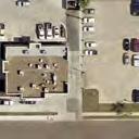
14 Ben Wilson Street Corridor Study Victoria MPO 1.5 CITIZENS MEDICAL CENTER Discussions were held with a representative of the Citizens Medical Center, regarding the growth plans of the medical center and emergency access needs along Ben Wilson Street. There is a synergy between the medical center and the Victoria College Health Science Center, with significant pedestrian crossings of Red River Street between the two facilities at an unsignalized midblock crosswalk. The primary points of access to the medical center are from US Business 59 and Red River Street. Planned improvements by the medical center includes: Emergency Room Expansion The emergency room on the southwest side of the main building is proposed to have a significant expansion to improve patient waiting and service areas. The expansion will consume a portion of the existing parking area, but access to the emergency room will remain essentially the same. Additional Patient Tower The expansion for the emergency room will include supporting structure for an increase in the number of patient rooms. Redevelopment of underutilized Lots between Hospital Drive and Ben Wilson Street Citizens Medical Center owns much of the property to the east of the current medical center to Ben Wilson Street. Emergency Access Figure 5. Citizens Medical Center 5

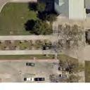
15 Ben Wilson Street Corridor Study Victoria MPO 1.6 BRONSON TERRACE Discussions were held with resident leaders of the Bronson Terrace subdivision HOA regarding the residents access and mobility needs along Ben Wilson Street. Issues expressed during the discussions include the street noise and traffic speeds along Ben Wilson Street. The representatives indicated a preference for modifications to Ben Wilson Street that calms traffic and enhances pedestrian conveyance along and crossing of the street, and consideration of the following attributes: College Drive Point of Access Though just one of several points of access, College Drive provides ready access to Ben Wilson Street for residents living on the eastern end of Bronson Terrace. Crossing of Ben Wilson Street There are residents that walk to work at the businesses and to the church across Ben Wilson Street. Pedestrian crossing of a 3-lane roadway with slower travel speeds would be preferable to crossing a four or five lane roadway that would foster faster speeds. Sidewalks along Ben Wilson Street The sidewalks along the west side of Ben Wilson Street, though about 8 feet wide, are paved between the fence and the back of curb of the travel lane. A reduction in roadway pavement width would be desirable to provide an additional landscaped buffer between the sidewalk and the travel lanes. Figure 6. Bronson Terrace Access onto Ben Wilson Street 6
 regarding the emergency access operations along Ben Wilson Street.")

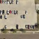
16 Ben Wilson Street Corridor Study Victoria MPO 1.7 EMERGENCY SERVICES Discussions were held with a representative of the Victoria Fire Department (VFD) regarding the emergency access operations along Ben Wilson Street. The VFD also provided information from their discussions with EMS services of the Citizens Medical Center and discussed some of Police Department activities along the corridor. Fire trucks could better maneuver around cars if two lanes were provided in each direction, but would be able to utilize the center lane of a three-lane alternative as well; Ambulance access to the Medical Center prefers to use access roadways that have good pavement condition. Speed of access is secondary to comfort of ride for their passengers. The threelane alternative was not a concern, nor was the landscaping of the center turn lane. 1.8 OTHER CORRIDOR LAND USES In addition to the major land uses described above, there are other uses that have developed along the corridor, including: On the Northern End of Ben Wilson Street A church, a small set of offices, a Knights of Columbus Hall south of Airline Road, and two small fast food restaurants and a car wash north of Airline Road generate very little traffic during weekday peak hours of operation. On the Southern End of Ben Wilson Street - Small businesses on the west side of Ben Wilson Street south of Red River Road include a Dairy Queen, some offices related to the medical center and miscellaneous small offices. These land uses are expected to intensify as Citizens Figure 7. North End Development Medical Center continues to grow. On the east side of Ben Wilson Street, Walgreens has a driveway, as does a small business and a residence. The southeast corner of the intersection of Ben Wilson Street at Red River Street has been purchased by UH-V with the intention of building a parking garage for students. Figure 8. South End Development 7
17 Ben Wilson Street Corridor Study Victoria MPO 1.9 EVALUATION CRITERIA The following project goals and objectives were established for the development of concepts, initial screening, and further evaluation of the alternatives: Goal: Traffic Operations Provide adequate traffic access and circulation for corridor users. o o o o Objective: Process current and anticipated future traffic volumes without incurring significant delays along the corridor and at intersections. Objective: Create a traffic operations environment that is appropriate to serve the context of the adjacent land uses while continuing to serve the functional classification of the roadway. Objective: Accommodate emergency access as directly as possible to the Medical Center with a good riding surface. Objective: Accommodate transit vehicles and passenger service along the corridor. Goal: Pedestrian and Bicycle Mobility and Safety Provide facilities for the conveyance of pedestrians and bicyclists along and connecting to the corridor. o o Objective: Enhance the safety of pedestrians and bicyclists crossing Ben Wilson Street, especially at the UH-V campus frontage, including pedestrian crossing and traffic calming treatments. Objective: Enhance the safety and mobility/accessibility of pedestrian and bicyclist conveyance along Ben Wilson Street, including adequately sized sidewalks/sidepaths and accessible ramps. Goal: Cost Effective Solution Provide facilities that wisely invest and leverage city funds. o o Objective: Construct cost effective improvements that balance the public cost with the public need, and that promote and leverage the investment of private entities in the corridor. Objective: Minimize the lifecycle cost of public investment in the roadway corridor. Goal: Corridor Aesthetics - Provide a unique identity to the corridor between Sam Houston Drive and US Business 59. o Objective: Enhance the aesthetics of traversing the entire corridor for pedestrians, bicyclists, and motorists. 8

18 Ben Wilson Street Corridor Study Victoria MPO 2.0 CORRIDOR TRAFFIC OPERATIONS 2.1 CITY THOROUGHFARE NETWORK Ben Wilson Street is part of a network of arterial streets that provide cross-city mobility in Victoria, as depicted in Figure 9. Figure 9. Victoria Roadway Network Parallel to Ben Wilson Street A. Ben Wilson Street extends between Sam Houston Drive and US 87 as a five-lane roadway two lanes in each direction and a center turn lane. South of US Business 59, destinations include the Youth Sports Complex. The corridor extends from US 87 to SH 185 as a four-lane roadway and changes name to Odom Street. B. Ben Jordan Street parallels Ben Wilson Street from Sam Houston Street to SH 185. South of US Business 59, Ben Jordan is a five-lane roadway, but from US Business 59 to Sam Houston Drive, it reduces to a four lane roadway with no center turn lane. Ben Jordan Street continues north from Sam Houston Drive, as a two-lane roadway, to an interchange at Loop 463. C. Sam Houston Drive is a newly reconstructed five-lane roadway that extends between Navarro Street (US Business 77) and US Business 59. It serves as a spine roadway from which extends Laurent Street, Ben Jordan Street and Ben Wilson Street. 9
19 Ben Wilson Street Corridor Study Victoria MPO D. Airline Road extends from an interchange at Loop 463 to Sam Houston Drive as a five-lane road, then bends east-west to cross Ben Wilson Street, Ben Jordan Street and Laurent Street and connecting to Navarro Street and US 87. Airline Road reduces to a four-lane roadway between Ben Wilson and Ben Jordan Streets and west of Laurent Street. E. Red River Street is a four lane roadway that extends from an awkward intersection at Sam Houston Drive to Navarro Street and US 87. West of US 87, Red River Street is a two-lane roadway extending into Riverside Park. Ben Wilson Street is an important link in the Victoria roadway network. Thus, no alternative should be considered that would close a portion of Ben Wilson Street. 2.2 TRAFFIC VOLUMES The traffic volumes that are expected to use Ben Wilson Street will be a determinant of the sizing of the roadway configuration options that may be considered. Traffic volumes of importance include the total daily amount of traffic, the peak hour amount of traffic, and the peak hour directional turning movements. A. Existing Daily Traffic Counts Traffic counts on roadways in the study area have been collected by both the Victoria MPO (MPO) and the Texas Department of Transportation (TxDOT). Traffic counts were taken as part of the study in late August 2015, after all schools were in session, to assess relative traffic growth and to further study the operations of the intersections, and are included in Appendix A. Daily traffic volumes near the Ben Wilson Street corridor are summarized in Table 1. Table 1. Historical Daily Traffic Volumes on Roadways near the Ben Wilson Street Corridor Count Location 2012 (TxDOT) 2013 (MPO) 2015 (FNI) Ben Wilson St. south of Red River St. 12,630 12,714 12,848 Ben Wilson St. north of Red River St. n/a n/a 13,277 Ben Wilson St. south of Airline Rd. n/a n/a 12,139 Ben Wilson St. north of Airline Rd. 7,970 n/a n/a Red River St. west of Ben Wilson St. 9,120 9,170 8,499 Airline Rd. west of Ben Wilson St. 7,170 7,870 6,944 Ben Jordan St. south of Red River St. 12,760 11,478 n/a Ben Jordan St. north of Red River St. 14,950 13,105 n/a BUS 59, west of Ben Wilson St. 25,150 25,991 n/a BUS 59, east of Ben Wilson St. 18,190 19,343 n/a 10
20 Ben Wilson Street Corridor Study Victoria MPO Some observations based upon these daily traffic volumes include: The following street segments should be able to operate well as a three lane roadway, providing one lane in each direction with a center turn lane: o Red River Street east and west of Ben Wilson Street At less than 10,000 vehicles per day, the recently reconstructed four-lane roadway, from east of Ben Wilson Street to Ben Jordan Street, could be re-striped as three lanes with bike lanes along each outer edge. o Airline Road west of Ben Wilson Street - At less than 10,000 vehicles per day, the four lane roadway, from Ben Wilson Street to Ben Jordan Street, could be re-constructed to provide only one through travel lanes in each direction plus a center turn lane. This treatment would allow flexibility to provide much needed room for improving the pedestrian landings at the corners. Other enhancements on this segment of Airline Road may include providing enhanced sidewalk and landscaping along the residential frontage. The following street segments may be able to operate well as a three lane roadway, depending on peak hour intersection operations, but may need to provide two lanes in each direction: o o o Ben Wilson Street north of Airline Road At less than 10,000 vehicles per day, this segment could be modified from a five-lane to a four-lane or three-lane roadway, allocating more space to enhancing the sidewalk and streetscape. Ben Wilson Street south of Airline Road to Red River Street At between 10,000 and 15,000 vehicles per day, this section of Ben Wilson Street passing between the two portions of the UH-V campus could operate acceptably as a three-lane roadway as long as adequate lane provisions are provided at the intersections with Airline Road and Red River Road. The narrower roadway would reduce traffic exposure for pedestrians crossing of the street and make installation of traffic control measures more effective. Ben Wilson Street south of Red River Street to US Business 59 - At between 10,000 and 15,000 vehicles per day, Ben Wilson Street could operate acceptably as a three-lane roadway as long as adequate lane provisions are provided at the intersections of Red River Street, Continental Street and US Business 59. The northbound Ben Wilson approach to US Business 59 would be required to have the rightmost lane designated as right turn only, reducing its capacity for the northbound through movement. 11
, with a corresponding significant left turn movement from westbound Airline Road to southbound Ben Wilson Street (heaviest in the AM peak at 260 vph), and A significant left turn")
21 Ben Wilson Street Corridor Study Victoria MPO Noteworthy traffic patterns include: A significant right turn movement from northbound Ben Wilson Street to eastbound Airline Road (heaviest during the PM peak at 181 vph), with a corresponding significant left turn movement from westbound Airline Road to southbound Ben Wilson Street (heaviest in the AM peak at 260 vph), and A significant left turn movement from northbound Ben Wilson Street to northwest bound Airline Drive (heaviest during the PM peak at 445 vph), with a corresponding significant movement from southeast bound Sam Houston Drive to southbound Ben Wilson Street (heaviest in the AM peak at 509 vph). B. Anticipated Future Traffic Growth The MPO completed an assessment of the transportation needs for the Victoria area in the 2040 Metropolitan Transportation Plan (MTP). In that assessment, a modest growth of the UH-V campus was included. The traffic volumes on Ben Wilson Street, north of US Business 59, were forecast to increase slightly from about 13,000 vehicles per day in 2012 to about 16,000 vpd in 2040, a traffic growth rate of about 0.8% per year. C. Anticipated Traffic Growth due to UH-V Expansion UH-V recently constructed their University North/SBDC building and plans to build a nearly 400-bed dormitory in 2017 to replace the current university housing apartments on the south side of US Business 59 across from Citizens Medical Center. UH-V plans to add another classroom facility where the current soccer fields are and add nearly 1,600 more beds in additional dormitories plus a new Student Center and parking garages east of Ben Wilson Road, phased as demand for courses and on-campus housing increases as student enrollment increases from the current 1,500 to a planned 6,000 students over the next 10 years. Creation of a walkable campus environment will be essential to significantly reduce the AM and PM peak hour trips that would be otherwise generated from the increase in student population. The proposed placement of an off-campus student parking garage at the southwest corner of the intersection of Ben Wilson Street at Red River Street 12
22 Ben Wilson Street Corridor Study Victoria MPO will contain much of the commuting students from areas north and east of Victoria to the segment of Ben Wilson Street south of Red River Street. D. Traffic Projections Due to UH-V Growth The Institute of Transportation Engineers Trip Generation Manual, 9 th Edition, indicates an average of the sampling of universities generates about 1.75 trips per day per student, with about 10% of these occurring during each of the AM and PM peak hours. Given that UH-V student housing is planned to accommodate 2,000 of the planned 6,000 student enrollment, the 1.75 rate is discounted by 33% to a rate of 1.17 trips per day per student for this analysis. Thus, it is estimated that the addition of 4,500 students attending UH-V would generate an additional 4,786 vehicles per day (vpd) to Ben Wilson Street, assuming a 1.1 persons per vehicle average occupancy. Given the position of UH-V and Victoria within the regional roadway network, it is estimated that approximately 2/3 of the growth in traffic, or about 3,200 vpd, would access the UH-V campus to/from the north via US Business 59 and to/from the east via Ben Wilson Street, and would utilize Ben Wilson Street mostly at and south of Red River Street. The other third of the additional UH-V traffic, about 1,600 vpd, would access campus from the northern end of Ben Wilson Street, half via Airline Road from the Loop and the other half from Sam Houston Drive. Thus, the estimated growth in UH-V traffic would increase traffic on Ben Wilson Street south of Red River Street from 13,000 vpd in 2015 to about 16,200 vpd within the next 10 years - a net increase of about 24% over 10 years. North of UH-V, traffic would increase over those same 10 years from 13,000 vpd to about 14,600 vpd, an increase of about 12% over 10 years. These 2025 daily traffic volumes are expected to supplant those estimated by the 2040 MTP. E. Peak Hour Traffic Operations Level of Service (LOS) is a commonly used indicator of traffic operations performance. LOS is given a letter grade, A through F, with LOS A traffic flow experiencing very little delay and LOS F indicating traffic flow that experiences significant and generally unacceptable levels of delay. A traffic model is used to simulate the traffic flow through a network of intersections and produce the performance measures for delay and LOS at the intersections and the overall corridor. Many communities designate LOS D as the least acceptable LOS for intersection traffic flows during the peak hours of the day, and performance of approaches or individual 13
23 Ben Wilson Street Corridor Study Victoria MPO turning movements at LOS E or worse would indicate a need for modifications at the intersection. Peak hour traffic operations at LOS C or better indicate an intersection with excess capacity for growth or conversion of travel lanes to other purposes. Traffic operations were modeled using the software package, Synchro by TrafficWare. Peak period traffic turning movement counts taken at the significant intersections along Ben Wilson Street indicate that the key intersections operate overall at LOS B during the AM and PM peak hours, with some of the individual turning movements operating at LOS C. This very good level of service during the peak hours of operation indicate a significant amount of excess capacity available for growth in the corridor, or for potential reduction in the ROW allocated to travel lanes that could be reallocated to pedestrian accommodations and aesthetics for the corridor. F. Potential for Lane Reductions An assessment was made of lanes reductions that would still operate at acceptable LOS the street diet potential of Ben Wilson Street. This minimal lanes assessment consists of a 3- lane roadway on Ben Wilson from Airline Road to BUS 59, plus a 3-lane roadway on Red River Street each side of Ben Wilson Street and on Airline Road west of Ben Wilson Street. The comparison of existing and minimal lanes configuration is shown in Table 2, and detailed output from the Synchro model runs are included in Appendix B. G. Available Capacity for Growth The Synchro modeling of the existing and minimal lane configurations used the 2015 traffic counts gathered for the study, and produced values for how much of the available capacity was used under each of the two configurations, called the Intersection Capacity Utilization (ICU), which are summarized in Table 3. The critical intersection for the minimal lane configuration is at Airline Road, with ICU of 68% in the AM and 71% in the PM peak. The growth projections anticipate a 20% growth for Ben Wilson Street at this intersection with the growth of the school to 6,000 students. Running the Synchro analysis for the minimal lanes configurations, with traffic volumes for all movements on all approaches increased by an additional 20%, would produce the following performance at Airline Road: AM Peak: increase ICU from 68% up to 79%, reduce LOS from C to D; and PM peak: increase ICU from 71% up to 82%, reduce LOS from B to C. 14
24 Ben Wilson Street Corridor Study Victoria MPO Table 2. LOS Comparison of Existing and Potential Street Diet (2015 volumes) Existing Lanes (1) Minimal Lanes (2) Intersection AM Peak Hr PM Peak Hr AM Peak Hr PM Peak Hr Ben Sam Houston B B B B Northbound C B C B Southbound B C B C Eastbound B B B B Westbound A B A B Ben Airline B B C B Northbound - Through B B B B - Left B B C A Southbound B C C A Eastbound - Through A A B C - Left C C C B Westbound - Through A A C B - Left B B C B Ben Red River B A C B Northbound - Through A A B B - Left B B D B Southbound - Through B A C B - Left B A B B Eastbound - Through A A B A - Left A A B B Westbound - Through A A C B - Left B A B C Ben BUS 59 B B C B Northbound - Through C B D C - Left B B B B Southbound - Through B B C B - Left B B B B Eastbound - Through B C B C - Left C C D C Westbound - Through C B C B - Left B C B C (1) Existing 5-lane roadway with optimized signal timings. (2) Predominantly a 3-lane roadway on Ben Wilson St. from Airline Rd. to BUS 59, plus a 3-lane roadway on Red River St. and on Airline Rd. west of Ben Wilson St. 15
25 Ben Wilson Street Corridor Study Victoria MPO Table 3. Intersection Capacity Utilization (2015 volumes) Intersection ICU of Existing Lanes (LOS) ICU of Minimal Lanes (LOS) (controlling movement) AM Peak Hr PM Peak Hr AM Peak Hr PM Peak Hr Ben Sam Houston 50% (B) 48% (B) 50% (B) 48% (B) Ben Airline 52% (A) 50% (A) 68% (C) 71% (C) Ben Red River 52% (A) 48% (A) 58% (B) 57% (B) Ben BUS 59 53% (A) 57% (B) 59% (B) 60% (B) 2.3 TRAFFIC CRASH DATA A summary of traffic crash information for the most recent two years (October 2013 to September 2015) from the Victoria Police Department was provided by the Victoria MPO. The summary information indicates the following: Of the 38 crashes that occurred in the study corridor, 18 were at US Business 59 and 16 were at Airline Road. The number of crashes at the Airline Road intersection is significant, as it experiences only half the traffic and at lower speeds but almost as many crashes at the US Business 59 intersection. Running the red light and failure to yield to the left turn are the primary causal factors for these crashes. The geometric configuration and lane allocations at the intersection of Ben Wilson Street and Airline Road appear to play a significant role in the crash frequency of this intersection. There is not an eastbound left turn lane on Airline Road, and this opposes a fairly heavy westbound left turn lane movement on south/westbound Airline Road. In addition, at the southwest corner of Ben Wilson Street at Airline Road there is a very narrow space between the fence and the travel lane, with the fence corner causing a line-of-sight constraint for eastbound Airline Road vehicles to see northbound Ben Wilson Street vehicles. Within the last two years, there was one reported non-fatal crash (in September 2014) involving a pedestrian crossing US Business 59 at or near Ben Wilson Street. It is expected that the potential for crashes involving pedestrians will greatly diminish when the UH-V student housing is relocated to the east side of Ben Wilson Street north of Red River Street. However, due to adaptive reuse of these apartment/hotel style residential developments, the safety of the pedestrian crossing of US Business 59 will still be an issue to be addressed. With the planned concentration of student housing along the east side of Ben Wilson Street, the safety of the pedestrians walking along and crossing Ben Wilson Street will need to be accommodated in the considerations for the potential configuration of Ben Wilson Street. 16


26 Ben Wilson Street Corridor Study Victoria MPO 3.0 ALTERNATIVE CONFIGURATIONS Various alternative configurations were examined for application along Ben Wilson Street, between Sam Houston Drive and Business 59. The alternative configurations that were considered include various forms of providing two lanes or one lane in each direction, and are described further in the following paragraphs. Existing Five Lane Roadway Outside curb lines unchanged, create raised medians from existing center turn lane, add landscaping at UH-V and elsewhere, as appropriate. Enhanced Five Lane Roadway - Outside curb lines modified at UH-V frontage to create wider landscaped median and pedestrian refuges, create raised medians as feasible at other locations along the corridor and add landscaping, negotiate landscape easements where appropriate to increase landscaping along outer edges. Four Lane Roadway Narrows existing pavement to provide two lanes in each direction and no center left turn lane; reallocates the ROW space to enhance landscaping or sidewalks. Three Lane Roadway - Narrows existing pavement to provide one lane in each direction and a center left turn lane; reallocates the ROW space to enhance landscaping and sidewalks and/or to add bike lanes. Allows for addition of bike lanes and/or bus pullover bays to serve bus stops. 17
27 Ben Wilson Street Corridor Study Victoria MPO 3.1 COMBINATIONS OF CONFIGURATIONS The corridor consists of three distinct segments for which one or more of the alternative configurations may be most appropriate. The corridor configuration alternatives under consideration may employ different configurations for the three segments of the corridor. A. South Section, US Business 59 to Red River Street This southern segment is expected to carry the highest volumes of the three segments over 18,000 vehicles per day with the growth of UH-V - as it is adjacent to the Citizens Medical Center and south of the proposed UH-V parking garage. Both the five-lane and three-lane configurations will operate at acceptable traffic operations during the AM and PM peak hours, though the three lane configuration would approach the capacity of this segment. The threelane configuration would allow for enhanced sidewalks and landscaping along this entry way to the UH-V and Victoria College campuses, though such enhancements may be feasible through agreements with or easements from the adjacent properties. B. Middle Section, Adjacent to UH-V This middle section at UH-V is expected to have a significant number of pedestrians crossing Ben Wilson Street at uncontrolled locations between the dorms and student center on the east side and the academic and administration building on the west side. This level of pedestrian crossing activity warrants consideration for special treatments to enhance the safety of pedestrian crossings of Ben Wilson Street. Two options are considered: 1. A three-lane roadway section would create a shorter distance for pedestrians to cross. To enhance the safety of the midblock crossings near the new student housing, the placement of a pedestrian activated crossing signal would be considered. (See 3.2.A) With the provision of the pedestrian crossing signal, a five-lane configuration could also be considered, but is less desirable. With two travel lanes in each direction, sometimes one lane of traffic blocks the view of the pedestrian from vehicles in the adjacent lane, creating a potentially hazardous condition when the signal is transitioning out of the red phase for Ben Wilson Street traffic. 2. A grade separated pedestrian crossing could be created by raising Ben Wilson Street from north of Red River Street to the east-west roadway through the UH-V/Victoria College campus. The current entry driveway to the circular roadway would be closed at Ben Wilson Street to create the pedestrian way, and the circular entry driveway be converted to a smaller circular parking area with an entrance off of the east-west campus roadway. This configuration would greatly enhance the safety of pedestrians crossing Ben Wilson 18
28 Ben Wilson Street Corridor Study Victoria MPO Street at the Student Center location, especially if the campus pedestrian flow layout focusses them to that location. However, the raising of the elevation of Ben Wilson Street would create a significant visual protrusion into the UH-V campus environment (the option to bring pedestrians into a tunnel under the existing roadway or onto a pedestrian bridge over the roadway were considered not practical for use by pedestrians at this location). Raising the elevation of Ben Wilson Street would be costly and may also increase the traffic noise levels for the surrounding area. C. North Section, North of UH-V to Sam Houston Drive The northern section of Ben Wilson Street could benefit greatly from the reduction in roadway pavement to provide additional pedestrian and landscaping. The sidewalks could be enhanced by widening both sides to 8-foot sidewalks and adding at least five feet of greenspace between the sidewalk and the outside traffic lane. The pavement reduction can be accomplished in two manners: 1. Reduce the roadway to a four-lane configuration, eliminating the center turn lane, modifying the curblines on one or both sides to remove pavement and add landscaping and/or sidewalk width. 2. Reduce the roadway section to a three-lane configuration, removing both of the outside lanes to remove pavement and add landscaping and/or sidewalk width. The intersection of Ben Wilson Street and Airline Road could benefit from a modification in lane allocations at the intersection: Converting Airline Road west of Ben Wilson Road to a three-lane roadway, which works for traffic since half of the westbound Airline traffic turns southbound onto Ben Wilson Street. This improvement adds a left turn lane for eastbound Airline Road at Ben Wilson. It also creates a better line of sight condition for the eastbound movements. The three-lane section on Airline Road west of Ben Wilson Street allows the westbound approach of Airline Road at Ben Wilson Street to also be reduced to provide one left turn lane and one through lane, with one eastbound lane for the opposing movement (though two eastbound lanes would work as well). 19
 - A pedestrian hybrid beacon, sometimes referred to as a HAWK signal, is a special type of traffic signal used at an uncontrolled location to assist pedestrians to")
29 Ben Wilson Street Corridor Study Victoria MPO 3.2 POTENTIAL CORRIDOR TREATMENTS A. Pedestrian Hybrid Beacon (HAWK) - A pedestrian hybrid beacon, sometimes referred to as a HAWK signal, is a special type of traffic signal used at an uncontrolled location to assist pedestrians to cross a street or highway. The HAWK signal has proven to experience a high level of compliance by drivers (some reports stating as high as 90% compared to a cross). The signal head display that controls the flow of traffic is shown below (Figure 4F- from the Texas Manual on Uniform Traffic Control Devices (MUTCD), and are complemented by pedestrian signal heads for the crosswalk. The warrant for a pedestrian hybrid beacon are described in the Texas MUTCD, and the threshold for the combination of traffic volumes and pedestrian volumes should be above the curves shown in the MUTCD Figure 4F-1 shown below. The maximum one hour volume of two-way traffic (1,171 vph in 2015) and anticipated pedestrian crossing volumes (at least 150 per hour for 34-foot roadway) would meet the warrants for the pedestrian hybrid beacon. 20
30 Ben Wilson Street Corridor Study Victoria MPO A HAWK signal would be provided at key crossing locations. In 2017, when the first dorms and parking lot are built, a new HAWK signal #1 would be placed as shown at the small island area between opposing left turns. Subsequently, a HAWK Signal #2 would be placed across from the new Student Center and additional dorms, when they are provided (unless the grade separation alternative is provided). Notably, the HAWK signal would provide for crossing of pedestrians in groups, and would only be able to stop traffic on Ben Wilson Street for a short while to give the right of way for pedestrians to cross. Settings on the HAWK signal controller will provide for coordination with the signal at Red River Street to allow for progression of traffic along Ben Wilson Street. Thus, pedestrians would need to wait for the traffic signal cycle to be completed before the HAWK signal could interrupt the flow of traffic on Ben Wilson Street again. Thus, the cycle length for the signal at Red River Street should be as short as feasible 60 second or less. B. Pedestrian Signals All pedestrian signals would be equipped with countdown meters to show the crossing pedestrian how many seconds remain in the pedestrian WALK indication. C. Sidewalks - Adjacent to the UH-V campus, and as feasible along the entire corridor, 8 to 10- foot wide sidewalks should be provided, with a minimum of 5 feet of landscaping between the sidewalk and travel lane. Sidewalks elsewhere in the corridor would be a minimum of 5 feet and preferably 8 feet, offset by at least 5 feet from the back of curb with landscaping as space permits in each alternative. D. Corridor Aesthetics - It is anticipated that the UH-V building improvements will include significant landscaping to enhance the aesthetics of the corridor in front of their facility. Lighting, too, would be added to enhance the safety for pedestrians. These enhancements should be made along the entire UH-V frontage with the 2017 building improvements, to create an attractive frontage after the existing apartment buildings are torn down before the new dorms and student center are built. North and south of the UH-V frontage, the lighting and streetscape should be enhanced to the extent possible by participating with adjacent property owners to add landscaping. E. Creation of a Pedestrian Underpass of Ben Wilson Street - As a potential treatment, a pedestrian underpass at the UH-V east-west pedestrian spine could be incorporated into either the five, four or three lane concept. The creation of a tunnel under Ben Wilson Street 21
31 Ben Wilson Street Corridor Study Victoria MPO was not considered a feasible option due to the extensive utilities beneath the roadway. Nor was the creation of a pedestrian bridge over Ben Wilson Street considered to be feasible as it would be an inconvenience for students to use. But, with the configuration of the planned Student Center to have a lower gathering plaza with an upper crossing level between two separate halves, a concept was considered feasible to raise Ben Wilson Street up about 12 to 14 feet adjacent to this plaza area to create a passageway that would allow pedestrians to flow freely from one side of Ben Wilson Street to the other. F. Raised Medians/Median Refuge The existing Ben Wilson configuration is referred to as a 5- lane roadway, since the center turn lane is available for use by vehicles at any point along the roadway. The creation of raised medians provides many benefits, including: Reduction in the number of potential conflict points along the roadway Creation of a pedestrian-only space in the middle of the road that can be used as a refuge area allowing pedestrians to focus on crossing one direction of travel at a time. Providing space for enhanced aesthetics along the center of the roadway. Creating the raised medians needs to be planned carefully so as not to unduly constrain access to adjacent properties along the roadway. G. Right Sizing/Road Diet As development patterns mature within a city, the opportunity exists for the city to assess the roadway provisions for potential reallocation of space utilization within the street right-of-way. Ben Wilson Street, as well as Red River Street and Airline Road, have needs for pedestrian, bicyclist and transit mode accommodations as well as street aesthetics that could be better met if some of the right-of-way usage for roadway pavement were reduced. As was shown in Table 2 (on page 15), there are good opportunities for right sizing of Ben Wilson Street. H. Complete Streets/Context Sensitive Solutions The right sizing of the Ben Wilson Street roadway should serve more than just the throughput of traffic. The street configuration needs to also fit with the context of the corridor development and surroundings. The design should encourage lower speeds, frequent pedestrian crossing locations and enhanced aesthetics appropriate for the pedestrian nature of the UH-V campus environment and the street crossing locations. For context sensitive solutions, roadways are designed to encourage desired speeds, which would be about 30 MPH or less for the segment passing through the UH-V campus and residential areas. 22

32 Ben Wilson Street Corridor Study Victoria MPO 3.3 POTENTIAL TREATMENTS TO CROSS STREETS Potential treatments to Red River Street and to Airline Road were considered as part of the overall assessment of Ben Wilson Street. The treatments along the lengths of these roadways should be considered as an optional treatment in the final recommendations for Ben Wilson Street. A. Treatments to Red River Street Under all scenarios, the Red River Street existing pavement could be re-striped to provide one travel lane and one bike lane in each direction and a center turn lane, from Sam Houston Drive to Ben Jordan Street. The beginning of a bicycling corridor would be established that would connect across Victoria, from UH-V and Victoria College to Riverside Park at the western end of Red River Street. B. Treatments to Airline Road at Ben Wilson Street An assessment was conducted to look at the minimum number of lanes that could be provided to serve existing traffic at acceptable LOS, the results of which were shown in Table 2 (on page 15). The resulting levels of service at the three intersections at the northern end of this corridor, and the LOS for individual movements, are shown in the figure below. This analysis produced the following observations: 1. There were only 3 cars in the peak hour that were observed to turn left from southbound Ben Wilson Street onto eastbound Airline Road. The pavement space allocated to the 23
33 Ben Wilson Street Corridor Study Victoria MPO southbound left turn movement could be converted to a raised island for crossing pedestrian refuge and roadway enhancement. 2. About half of the westbound Airline Road traffic at the Ben Wilson Street approach turned left, in both the AM and PM peak periods. The leftmost westbound lane travel lane on Airline Road, after crossing Sam Houston Drive, can become a dedicated left turn lane at Ben Wilson Street with the right most lane for through and right turn movements. This would transition well into a three-lane roadway section west of Ben Wilson Street, resulting in a dedicated left turn lane for eastbound Airline Road at Ben Wilson Street, which may serve to reduce the crashes at the intersection 3. If Airline Road were to provide only three lanes of pavement at each approach to Ben Wilson Street, then approximately 12 feet of street right-of-way could be made available for other uses to the west of Ben Wilson Street on Airline Road. This reallocation of space in the right-of-way could greatly benefit: a. The pedestrian landing at the southwest corner of the Ben Wilson/Airline intersection, which will greatly enhance the pedestrian safety at the intersection. b. The line of sight at the Ben Wilson/Airline intersection, which may contribute to a reduction in crashes at the intersection. 3.4 EVALUATION METHODOLOGY The goals and objectives for the project were presented in section 1.9, from which the following methodology was derived for evaluation of the alternatives: Goal: Traffic Operations (30 points) o Objective: Process traffic volumes with acceptable Level of Service (10 points) o Objective: Context sensitive traffic operations (10 points) o Objective: Accommodate emergency access (5 points) o Objective: Accommodate transit vehicles and passenger service (5 points). Goal: Pedestrian and Bicycle Mobility and Safety (30 points) o Objective: Enhance the crossing safety of peds and bicyclists at UH-V (20 points) o Objective: Enhance the crossing safety of peds and bicyclists at intersections (5 points) o Objective: Enhance the pedestrian and bicyclist conveyance along Ben Wilson (5 points) Goal: Cost Effective Solution (25 points) o Objective: Cost effective improvements that leverages private investments (15 points) o Objective: Minimize the lifecycle cost of public investment (10 points) Goal Corridor Aesthetics (15 points) o Objective: Enhance the aesthetics for pedestrian, bicyclist and motorists (15 points) 24
34 Ben Wilson Street Corridor Study Victoria MPO 3.5 ALTERNATIVE 1A: ENHANCED EXISTING FIVE-LANE ROADWAY As a baseline for comparison of alternatives, a readily implemented and phased treatment to Ben Wilson Street would be to create raised medians along the corridor, incrementally as funding becomes available, and add landscaping in the medians and along the edge of the rights-of-way, in front of the UH-V and Victoria College campus and wherever else possible along the corridor between Sam Houston Drive and US Business 59. This baseline alternative would not move any existing outside curb lines. The alternative is depicted in Figure 10. The attributes of the performance measures and the scoring of the evaluation criteria for this alternative are shown in Table 4. The estimated cost of the improvements associated with Alternative 1A is $3.12 Million, the details of which are included in Appendix C. Table 4. Evaluation of Enhanced Existing Five Lane Roadway Condition Alternative 1A Evaluation Criteria Goal: Traffic Operations All intersections operate at LOS B or better; all movements are at LOS C or better High capacity, moderate speed roadway through campus and residential area Two lanes in each direction allow cars to pullover for emergency access Transit vehicles stop in lane to serve bus stop, vehicles pass in second thru lane Goal: Pedestrian and Bicycle Mobility and Safety HAWK signals for ped/bike crossing safety across 4 lanes with 12-foot median Ped crossings at Airline Rd SW corner still constrained, others unchanged Sidewalks at back of curb in some areas, others mostly 4 and 5 feet wide Goal: Cost Effective Solution Retain curb lines, limited raised medians, mill & overlay street, some UH-V funds Maintain 5-lane street, reconstruct 5 lane street in a few years Criteria Maximum Score Goal: Corridor Aesthetics Landscaping along sidewalks at UH-V, raised medians limited by multiple driveways 15 3 TOTAL SCORE 53 25


35 AIRLINE RD. BON AIRE AVE. MC DOW ST. GARAGE PARK E. RED RIVER ST. CYPRESS ST. CYPRESS ST. FIGURE 10 FUTURE PARKING INTERIM SURFACE PARKING (2017) FUTURE PARKING GARAGE DORMS (2017) FUTURE DORMS FUTURE STUDENT CENTER FUTURE DORMS WALGREENS BEN WILSON ST. BEN WILSON ST. 1A MILTON ST. MILTON ST. HAWK SIGNAL #1 HAWK SIGNAL #2 UNIVERSITY NORTH/SBDC CITIZENS DR. CONTINENTAL ST. U. S. HW Y. 59 BEN W ILSO N STREET ALTERNATIVE HOSPITAL DR.
36 Ben Wilson Street Corridor Study Victoria MPO 3.6 ALTERNATIVE 1B: COMBINATION FIVE-LANE AND FOUR-LANE ROADWAY A refinement to the existing five-lane Ben Wilson Street is depicted in Figure 11. The concept would be to reduce the roadway to a four-lane undivided configuration north of the UH-V campus, retaining the fivelane configuration for the rest of the corridor as described in the base conditions, but widening the median to 20 feet in front of UH-V to Red River Street to enhance the safety of the pedestrian refuge area in the median. The reduced width of the pavement north of UH-V to north of Airline Road would allow for the enhancement of the pedestrian edge of that segment. The attributes of the performance measures and the scoring of the evaluation criteria for this alternative are shown in Table 5. The estimated cost of the improvements associated with Alternative 1B is $7.88 Million, the details of which are included in Appendix C. Table 5. Evaluation of Five Lane & Four Lane Roadway Alternative 1B Evaluation Criteria Goal: Traffic Operations All intersections operate at LOS B or better; all movements are at LOS C or better High capacity, moderate speed roadway through campus and residential area Two lanes in each direction allow cars to pullover for emergency access Transit vehicles stop in lane to serve bus stop, vehicles pass in second thru lane Goal: Pedestrian and Bicycle Mobility and Safety HAWK signals for ped/bike crossing safety across 4 lanes with 20-foot median The crossing at the Airline Rd. intersection would be improved Sidewalks in front of UH-V would be 8 wide, 5 to 8 north of UH-V Goal: Cost Effective Solution Modify curb lines north of UH-V, create selected raised medians as funds available Construct and maintain 4 and 5-lane roadway Criteria Maximum Score Goal: Corridor Aesthetics Landscaping along sidewalks at UH-V, raised medians limited by multiple driveways 15 6 TOTAL SCORE 61 26


37 AIRLINE RD. BON AIRE AVE. PARK BEN WILSON ST. CYPRESS ST. FUTURE PARKING GARAGE CYPRESS ST. BEN WILSON ST. DORMS (2017) INTERIM SURFACE PARKING (2017) FUTURE DORMS FUTURE STUDENT CENTER FUTURE DORMS FUTURE PARKING GARAGE WALGREENS 1B FIGURE 11 MILTON ST. MILTON ST. MC DOW ST. HAWK SIGNAL #1 HAWK SIGNAL #2 UNIVERSITY NORTH/SBDC E. RED RIVER ST. CITIZENS DR. CONTINENTAL ST. U. S. HW Y. 59 BEN W ILSO N STREET ALTERNATIV E HOSPITAL DR.
38 Ben Wilson Street Corridor Study Victoria MPO 3.7 ALTERNATIVE 2A: FIVE & FOUR LANE ROADWAY WITH PEDESTRIAN UNDERPASS AT UH-V. A refinement to Alternative 1B would be to elevate Ben Wilson Street at the current main entrance to the UH-V campus, retaining the four-lane configuration north of UH-V and the five-lane configuration through UH-V southward. This concept, shown in Figure 12, would create a grade-separated crossing at the current street level for pedestrians passing between the current campus and the expanded campus east of Ben Wilson Street. The attributes of the performance measures and evaluation of this alternative are shown in Table 6. The estimated cost of the improvements associated with Alternative 2A is $10.25 Million, the details of which are included in Appendix C. Table 6. Evaluation of Five & Four Lane Roadway with Pedestrian Underpass Alternative 2A Evaluation Criteria Goal: Traffic Operations All intersections operate at LOS B or better; all movements are at LOS C or better Addresses high crash intersection at Airline, tendency for high speeds Two lanes in each direction allow cars to pullover for emergency access Transit vehicles pullover to serve bus stop; bus stop relocated further north Goal: Pedestrian and Bicycle Mobility and Safety Pedestrian underpass at focal point of ped activity, HAWK signal near garage Crossing at Airline Rd. would be improved The pedestrian conveyance along Ben Wilson Rd north of UH-V would be improved Goal: Cost Effective Solution Embankment and bridge to create pedestrian underpass is costly, reduce HAWKs Raised roadway must coincide with Student Center, maintain bridges & 5 lanes Criteria Maximum Score Goal: Corridor Aesthetics Landscaping along sidewalks at UH-V, raised medians limited by multiple driveways 15 5 TOTAL SCORE 59 27
39 AIRLINE RD. BON AIRE AVE. MC DOW ST. GARAGE PARK E. RED RIVER ST. CYPRESS ST. CYPRESS ST. FIGURE 12 FUTURE PARKING INTERIM SURFACE PARKING (2017) FUTURE PARKING GARAGE DORMS (2017) FUTURE DORMS FUTURE STUDENT CENTER FUTURE DORMS WALGREENS BEN WILSON ST. BEN WILSON ST. 5% SLOPE 5% SLOPE 2A MILTON ST. MILTON ST. HAWK SIGNAL UNIVERSITY NORTH/SBDC CITIZENS DR. CONTINENTAL ST. U. S. HW Y. 59 BEN W ILSO N STREET ALTERNATIVE HOSPITAL DR.
40 Ben Wilson Street Corridor Study Victoria MPO 3.8 ALTERNATIVE 2B: FIVE & THREE LANE ROADWAY WITH PEDESTRIAN UNDERPASS AT UH-V. A refinement to Alternative 2A would be to reduce the roadway north of the UH-V campus to a three-lane configuration, still elevating Ben Wilson Street at the current main entrance to the UH-V campus, and retaining the five-lane configuration south of Red River Street. This concept, shown in Figure 13, would create a grade-separated crossing at the current street level for pedestrians passing between the current campus and the expanded campus east of Ben Wilson Street, while reducing the footprint of the travel lanes past the residential neighborhood and small businesses. The attributes of the performance measures and evaluation of this alternative are shown in Table 7. The estimated cost of the improvements associated with Alternative 2B is $10.35 Million, the details of which are included in Appendix C. Table 7. Evaluation of Five and Three Lane Roadway with Pedestrian Underpass Alternative 2B Evaluation Criteria Goal: Traffic Operations All intersections operate at LOS B or better; all movements are at LOS C or better Improves high crash intersection at Airline, some tendency for high speeds Two lanes in each direction allow cars to pullover for emergency access Transit vehicles pullover to serve bus stop; bus stop relocated further north Goal: Pedestrian and Bicycle Mobility and Safety Pedestrian underpass at focal point of ped activity, HAWK signal near garage Crossing at Airline Rd. would be improved Pedestrian conveyance along Ben Wilson Rd north of UH-V would be improved Goal: Cost Effective Solution Embankment and bridge to create pedestrian underpass is costly, reduce HAWKs Raised roadway must coincide with Student Center, maintain bridges, some 5 lanes Criteria Maximum Score Goal: Corridor Aesthetics Landscaping along sidewalks at and north of UH-V, raised median limited, elevated roadway visual impact on UH-V 15 7 TOTAL SCORE 64 28
41 AIRLINE RD. BON AIRE AVE. MC DOW ST. GARAGE PARK E. RED RIVER ST. CYPRESS ST. CYPRESS ST. FIGURE 13 FUTURE PARKING INTERIM SURFACE PARKING (2017) FUTURE PARKING GARAGE DORMS (2017) FUTURE DORMS FUTURE STUDENT CENTER FUTURE DORMS WALGREENS BEN WILSON ST. BEN WILSON ST. 5% SLOPE 5% SLOPE 2B MILTON ST. MILTON ST. HAWK SIGNAL UNIVERSITY NORTH/SBDC CITIZENS DR. CONTINENTAL ST. U. S. HW Y. 59 BEN W ILSO N STREET ALTERNATIVE HOSPITAL DR.
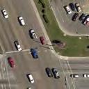
42 Ben Wilson Street Corridor Study Victoria MPO 3.9 ALTERNATIVE 3A: COMBINATION FIVE-LANE AND THREE-LANE ROADWAY This alternative is a variation on Alternative 2B, but without the pedestrian grade separation, and extends the three-lane configuration through the UH-V frontage to Red River Street and adds back the HAWK pedestrian activated crossing signals. This concept, shown in Figure 14, would provide a 9 to 12-foot wide landscaped buffer between the sidewalk and the travel lane on each side of the roadway, and more room for a better pedestrian landing at the corners at Airline Road. A pedestrian activated traffic signal, also called a HAWK signal, would be provided at key crossing locations. The attributes of the performance measures and evaluation of this alternative are shown in Table 8. The estimated cost of the improvements associated with Alternative 3A is $8.76 Million, the details of which are included in Appendix C. Table 8. Evaluation of Five Lane & Three Lane Roadway Alternative 3A Evaluation Criteria Goal: Traffic Operations All intersections operate at LOS B or better; all movements are at LOS C or better 3-lanes encourages slower speeds, 5-lanes allows for commercial to south Areas of raised medians limit pullover for emergency access Transit vehicles pull over to serve bus stop Goal: Pedestrian and Bicycle Mobility and Safety HAWK signals for ped/bike crossing safety across 2 lanes with 20-foot median Crossing for peds greatly improved at Airline Dr and somewhat at Red River St 8-to10-foot sidewalks north of Red River Rd Goal: Cost Effective Solution Rebuild curb lines, create selected raised medians, UH-V funds for enhancements Maintain and operate a 3-lane street with a 5-lane segment Criteria Maximum Score Goal: Corridor Aesthetics Landscaping along sidewalks north of Red River St, raised medians to extent possible TOTAL SCORE 83 29
43 BON AIRE AVE. MC DOW ST. PARK E. RED RIVER ST. AIRLINE RD. HOSPITAL DR. CYPRESS ST. CYPRESS ST. FUTURE PARKING GARAGE INTERIM SURFACE PARKING (2017) FUTURE PARKING GARAGE DORMS (2017) FUTURE DORMS FUTURE STUDENT CENTER FUTURE DORMS WALGREENS BEN WILSON ST. BEN WILSON ST. 3A FIGURE 14 MILTON ST. MILTON ST. HAWK SIGNAL #1 HAWK SIGNAL #2 UNIVERSITY NORTH/SBDC CITIZENS DR. CONTINENTAL ST. U. S. HW Y. 59 BEN W ILSO N STREET ALTERNATIVE
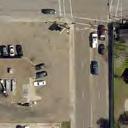
44 Ben Wilson Street Corridor Study Victoria MPO 3.10 ALTERNATIVE 3B: THREE-LANE ROADWAY WITH ENHANCED INTERSECTIONS This variation on Alternative 3A creates a three-lane Ben Wilson Street from Airline Road to US Business 59. This concept, shown in Figure 15, would be to create selected raised and/or landscaped medians along the Ben Wilson Street between Airline Road and US Business 59, and with 20-foot wide medians in front of UH-V to Red River Street. This concept would provide a 9 to 12-foot wide landscaped buffer between 8-foot sidewalks and the travel lane on each side of the roadway, and more room for a better pedestrian landing at the corners, especially at Airline Road. A pedestrian activated traffic signal, also called a HAWK signal, would be provided at key crossing locations at UH-V. This alternative require only one through lane northbound at US Business 59, producing LOS D for that movement, as was shown in Table 2, and one or two other LOS D movements south of Red River Street for the existing traffic conditions. With the anticipated additional traffic from growth of the UH-V campus and citizens Medical Center, the segment south of Red River Street may experience some congestion in the future. The attributes of the performance measures and evaluation of this alternative are shown in Table 9. The estimated cost of the improvements associated with Alternative 3B is $8.44 Million, as detailed in Appendix C. Table 9. Evaluation of Three Lane Roadway Alternative 3B Evaluation Criteria Goal: Traffic Operations All intersections operate at LOS B or better; all movements are at LOS D or better 3-lanes encourages slower speeds and lower crash severity Areas of raised medians limit pullover for emergency access Transit vehicles pull over to serve bus stop Goal: Pedestrian and Bicycle Mobility and Safety HAWK signals for ped/bike crossing safety across 2 lanes with 20-foot median Crossing for peds greatly improved at Airline Dr and at Red River St 8-to10-foot sidewalks along entire corridor Goal: Cost and Constructability Rebuild curb lines, create selected raised medians, UH-V funds for enhancements Maintain and operate a 3-lane street, possible future widening south of Red River Criteria Maximum Score Goal: Corridor Aesthetics Landscaping along sidewalks for the length of the corridor, raised medians to extent possible TOTAL SCORE 81 30
45 AIRLINE RD. BON AIRE AVE. PARK BEN WILSON ST. CYPRESS ST. FUTURE PARKING GARAGE CYPRESS ST. BEN WILSON ST. DORMS (2017) INTERIM SURFACE PARKING (2017) FUTURE DORMS FUTURE STUDENT CENTER FUTURE DORMS FUTURE PARKING GARAGE WALGREENS 3B FIGURE 15 MILTON ST. MILTON ST. MC DOW ST. HAWK SIGNAL #1 HAWK SIGNAL #2 UNIVERSITY NORTH/SBDC E. RED RIVER ST. CITIZENS DR. CONTINENTAL ST. U. S. HW Y. 59 BEN W ILSO N STREET ALTERNATIV E HOSPITAL DR.
46 Ben Wilson Street Corridor Study Victoria MPO 3.11 COMPARATIVE SUMMARY OF ALTERNATIVES The evaluation scores for each of the alternatives, from Tables 3 through 8, are tabulated for comparison in Table 10. The following are observations on the comparison of the alternatives. Table 10: Comparison of Alternatives Evaluation Scores Pedestrian Cost Traffic Corridor Alternative Mobility Effective Operations Aesthetics and Safety Solution 1A: Enhanced Existing Five-Lane Roadway 1B: Five-Lane/Four-Lane Roadway 2A: Five/Four with Ped Underpass 2B: Five/Three with Ped Underpass 3A: Five-Lane/Three-Lane Roadway 3B: Three-Lane Roadway Total Score Est d Cost, Millions $ $ $ $ $ $8.44 The following observations are made on the comparative assessment of the alternatives: The reduction in travel lanes does not cause an increase in traffic delays or a worsening of operations, so the scores for Traffic Operations issues are not significantly diminished for the alternatives that include a three-lane roadway section on Ben Wilson Street. The Pedestrian Mobility and Safety scores are greatly enhanced by the provision of the grade separated pedestrian underpass in Alternatives 2A and 2B. However, the increase in evaluation score on that criteria are offset by the costs of the constructing the roadway bridge, which makes the overall project less scalable for incremental implementation, requiring a large capital investment at one time. The road diet Alternatives 3A and 3B, using HAWK signals to cross a two lane dived roadway at UH-V, scored higher than 2A and 2B, which provided a grade separated pedestrian crossing, due to the comparative weighting between costs and aesthetics versus the other criteria. 31
47 Ben Wilson Street Corridor Study Victoria MPO 4.0 RECOMMENDATIONS The following are the preferred alternatives, recommendations and options for implementation of the improvements. 4.1 PREFERRED ALTERNATIVES Alternatives 3A and 3B attained the highest score, well above the rest. Both reduced Ben Wilson Street to three lanes north of Red River Street, with 3A retaining five lanes south of Red River Street and 3B extending the 3 lane section all the way to Business 59. The findings of the study were reviewed with representatives of UH-V and Citizens Hospital, with the following responses: The UH-V representatives favor Alternative 3B as it extends the feel of the campus environment to begin at a gateway entry off of Business 59. The extended three-lane roadway section would set up a traffic calming effect right at the transition from major arterial to minor arterial and encourage slower traffic approaching the Ben Wilson corridor. The extended three-lane section would also extend the campus environment to encompass the medical complex with enhanced landscaping and pedestrian amenities. However, operations within the Ben Wilson BUS 59 intersection would be affected and the potential for accommodating significant development between BUS 59 and Red River Street on Ben Wilson Street could be constrained. The Citizen s Medical Center representatives were generally in favor of the reduction of Ben Wilson Street to a three-lane section north of Red River Street, though they wanted to make sure that the pavement width at any point along that section would allow a car to pull over and an ambulance to pass by the pulled over traffic. They were concerned with the three-lane section in Alternative 3B south of Red River Street and its ability to accommodate the traffic access and circulation needs for the potential future increased development intensity of the area between Hospital Drive and Ben Wilson Street. Many of the parcels in that area are owned by Citizen s Medical Center and, though they have no immediate plans, they would not want future growth potential to be inhibited by a lack of street capacity. They prefer Alternative 3A. The recommendations of this study are to implement Alternative 3A, the road diet north of Red River Street to Airline Road, retaining five lanes south of Red River Street, as represented in Figure
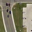
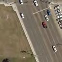
48 Ben Wilson Street Corridor Study Victoria MPO 4.2 RECOMMENDED IMPROVEMENTS A. Intersection Modification at Airline Road As described in Section 3.3 of this report, this intersection will be the point of transition back to the terminus of Ben Wilson Street at the Sam Houston Drive intersection. The following modifications are proposed for this intersection, as represented in Figure 17. North Side of the Intersection Since its traffic use is minimal, the left turn lane on southbound Ben Wilson Street onto eastbound Airline Road would be converted to create a raised island for a pedestrian crossing refuge and roadway enhancement. East Side of the Intersection - About half of the westbound Airline Road traffic at the Ben Wilson Street approach turned left, in both the AM and PM peak periods. The leftmost westbound lane travel lane on Airline Road, after crossing Sam Houston Drive, would become a dedicated left turn lane at Ben Wilson Street with the right most lane for through and right turn movements. South Side of the Intersection The five lanes would be converted to four lanes, one southbound and three northbound one lane for each of the three movements. West Side of the Intersection For now, the west side of the intersection can remain as currently configured. However, the conversions being made on the east side of the intersection would transition well into a potential future three-lane roadway section west of Ben Wilson Street, resulting in a dedicated left turn lane for eastbound Airline Road at Ben Wilson Street, which may serve to reduce the crashes at the intersection. The narrower roadway width would also allow more room for the pedestrian landing at the corners. This shifting of the eastbound lanes could greatly benefit the line of sight at the Ben Wilson/Airline intersection, which may contribute to a reduction in crashes at the intersection. B. HAWK Signals at UH-V Campus Two pedestrian activated hybrid beacon (HAWK) signals are recommended to facilitate student crossing of Ben Wilson Street between the two sides of the UH-V campus, with locations as shown in Figure 18. HAWK Signal #1- The first UH-V building to be built on the east side of Ben Wilson Street will be a 300-bed student housing dorm across the street from the existing soccer field. A temporary surface parking lot to the south side of the new dorm, with an entry drive across from the existing east-west roadway through the UH-V/Victoria College campus. A HAWK signal would be provided at the new median opening for the east-west roadway and driveway. HAWK Signal #2 Subsequent UH-V buildings on the east side of Ben Wilson Street are planned to include two more student housing dorms and a student center. The student center will be located directly across from the existing main entry drive to the UH-V administration building, and with be the location for a second HAWK signal on Ben Wilson Street. 33
49 Ben Wilson Street Corridor Study Victoria MPO C. Intersection Modification at Red River Street - This intersection will be the point of transition back to the five-lane Ben Wilson Street south of Red River Street to US 59 Business. The following modifications are proposed for this intersection, as represented in Figure 19. North Side of the Intersection A 100-foot left turn bay plus taper will be cut into the 20-foot median. In addition to the one southbound through lane, a right turn lane will be provided to the southbound approach, facilitating the current relatively heavy right turn volume and emergency access to Citizens Hospital. One lane will proceed northbound. East Side of the Intersection Red River Street would be re-striped as a three lane roadway with bike lanes on each side, from Sam Houston Drive to Ben Wilson Road. South Side of the Intersection The rightmost northbound lane will become a right turn only lane at the intersection. One lane will extend southbound at the intersection, transitioning to the two southbound lanes 100 feet south of the intersection. West Side of the Intersection Red River Street would be re-striped as a three lane roadway with bike lanes on each side, from Ben Wilson Street to Ben Jordan Street. Further study on this re-striping of Red River Street should be conducted to clarify the treatment at the Ben Jordan Street intersection. D. Typical Cross Sections along Ben Wilson Street The approved roadway reconfiguration for Ben Wilson Street would eliminate one travel lane in each direction between Red River Street and Airline Road. The Ben Wilson Street corridor will have three distinct typical cross sections plus various transitional sections. Airline Road to Northern Edge of UH-V Campus As illustrated in Figure 20, Ben Wilson Street south of Airline Road would provide one 11-foot travel lane in each direction plus a center median. Due to the numerous driveway openings along the east side of the street, the center median would be striped as a continuous left turn lane. A designated northbound left turn lane would be striped at College Drive. Future discussions with the property owners along the east side of Ben Wilson Street could result in identifying locations for potential raised medians to enhance the safety and appearance of this section of roadway. A 10-foot wide multi-use sidepath would be provided each side of Ben Wilson Street with landscaped buffers between the sidepaths and the travel lanes. Street lighting would be added for the safety of all roadway users. UH-V Campus to Red River Street As illustrated in Figure 21, Ben Wilson Street south of Airline Road would provide one 16-foot travel lane in each direction plus a raised center median. The 20-foot wide median would be landscaped, but would provide for good pedestrian visibility at the designated pedestrian crossings. A median opening with left turn lanes will be provided at the east-west roadway through the UH-V/Victoria college campus. HAWK pedestrian signals will be provided at the crossing near the east-west roadway and ultimately at the new Student Center. A 10-foot wide multi-use sidepath would be provided 34
50 Ben Wilson Street Corridor Study Victoria MPO each side of Ben Wilson Street with landscaped buffers between the sidepaths and the travel lanes. Street lighting would be added for the safety of all roadway users. Red River Street to US 59 Business - As illustrated in Figure 22, Ben Wilson Street south of Red River Street would retain its five lane cross section. However, the curblines would be reconfigured to provide two 11-foot travel lanes in each direction plus a center median. Due to the numerous driveway openings along both sides of the street, the center median would be striped as a continuous left turn lane. A designated northbound left turn lane would be striped at Continental Street. Future discussions with the property owners along both sides of Ben Wilson Street could result in identifying locations for potential raised medians to enhance the safety and appearance of this section of roadway. A 5-foot wide sidewalk would be provided each side of Ben Wilson Street with landscaped buffers between the sidewalks and the travel lanes. Future collaborations with the adjacent land owners should consider sidewalk easements to allow the extension of the 10-foot wide sidepaths southward from Red River Street. Street lighting would be added for the safety of all roadway users. 4.3 OPTIONS FOR DESIGN WITH COST IMPLICATIONS There are two options for design of the pavement for this improvement as shown in detail in Appendix C: 1. Alternative 3A, Option 1: Complete reconstruction, as initially assumed, at an estimated cost of $8.76 million, which includes full depth reconstruction of the remaining pavement area and installation of additional underground storm drainage improvements; OR 2. Alternative 3A, Option 2: Reconstruction of the outer edges and median areas (cut pavement to size, new curb lines, new sidewalks) and, rather than full depth reconstruction of the remaining pavement area, a mill and overlay of the remaining existing pavement, which would reduce the cost of the project to an estimated cost of $5.92 million. However, since the existing concrete pavement will not be removed, this option does not install the additional underground storm drainage improvements that were included in Option 1. The landscaping in the median adjacent to UH-V was considered to consist of more than just grass and the cost estimate included trees and other more intense landscaping. UH-V may desire a greater intensity of landscaping and streetscape features, which can be incorporated during future project development discussions between UH-V and the City of Victoria. 4.4 OTHER PROJECT AND CORRIDOR CONSIDERATIONS The process of analysis and the results of this study indicate the need to further evaluation the following: The potential to reduce Red River Street to a three-lane section for its entire length between Sam Houston Drive and N. Main Street. The potential to reduce travel lanes on Airline Road west of Ben Wilson Street to provide one travel lane in each direction plus auxiliary lanes. 35


51 BON AIRE AVE. PLOT SIZE: PARK AVE. CYPRESS ST. CYPRESS ST. FIGURE 16A FUTURE BEN WILSON ST. AIRLINE RD. SEE FIGURE 17 MILTON ST. MILTON ST. MC DOW ST. PARKING GARAGE BEN WILSON ST. DORMS (2017) SEE FIGURE 18 HAWK SIGNAL #1 BEN W ILSON RECO M MENDED CONFIGURATION FUTURE DORM


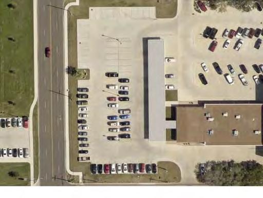

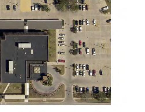
52 24" X 87" FIGURE 16B FUTURE INTERIM SURFACE PARKING (2017) SEE FIGURE 18 FUTURE STUDENT CENTER FUTURE DORMS HAWK SIGNAL #2 UNIVERSITY NORTH/SBDC FUTURE DORMS E. RED RIVER ST. PARKING GARAGE SEE FIGURE 19 CITIZENS DR. CONTINENTAL ST. WALGREENS U. S. HW Y. 59 BEN W ILSON RECO M MENDED CONFIGURATION HOSPITAL DR.


53 : 24" X 42" AIRLINE RD FIGURE 17 BEN WILSON ST. AIRLINE RD RD. INTERSECTIO N CO NFIG URATIO N AT AIRLINE RD


54 : 24" X 42" FUTURE DORMS FUTURE STUDENT CENTER FIGURE 18 BUS PULLOVER HAWK SIGNAL #1 BUS PULLOVER HAWK SIGNAL #2 HAW K SIG NAL AT UH-V CAM PUS


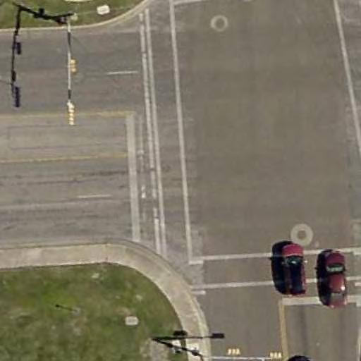
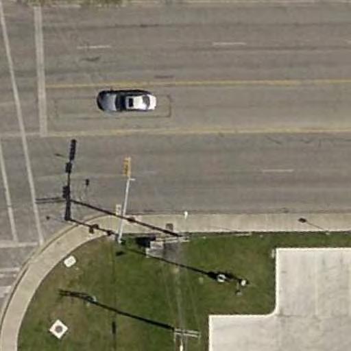


55 : 24" X 42" FUTURE DORMS RED RIVER ST RED RIVER ST FIGURE 19 INTERSECTIO N CO NFIG URATIO N AT RED RIV ER ST


56 Figure 20. Typical Section, Airline Road to UH-V Campus Figure 21. Typical Section, UH-V Campus to Red River Street Figure 22. Typical Section, Red River Street to US 59 Business BEN WILSON TYPICAL SECTIONS FIGURES 20, 21, 22
BEN WILSON STREET CORRIDOR STUDY
 BEN WILSON STREET CORRIDOR STUDY Prepared for: Victoria MPO DRAFT 11-11-1 Prepared by: FREESE AND NICHOLS, INC. In association with CivilCorp, LLC BEN WILSON STREET CORRIDOR STUDY Prepared for: Victoria
Traffic Engineering Study
 Traffic Engineering Study Bellaire Boulevard Prepared For: International Management District Technical Services, Inc. Texas Registered Engineering Firm F-3580 November 2009 Executive Summary has been requested
Table of Contents INTRODUCTION... 3 PROJECT STUDY AREA Figure 1 Vicinity Map Study Area... 4 EXISTING CONDITIONS... 5 TRAFFIC OPERATIONS...
 Crosshaven Drive Corridor Study City of Vestavia Hills, Alabama Table of Contents INTRODUCTION... 3 PROJECT STUDY AREA... 3 Figure 1 Vicinity Map Study Area... 4 EXISTING CONDITIONS... 5 TRAFFIC OPERATIONS...
TRAFFIC IMPACT ANALYSIS
 TRAFFIC IMPACT ANALYSIS Emerald Isle Commercial Development Prepared by SEPI Engineering & Construction Prepared for Ark Consulting Group, PLLC March 2016 I. Executive Summary A. Site Location The Emerald
APPENDIX E. Traffic Analysis Report
 APPENDIX E Traffic Analysis Report THIS PAGE INTENTIONALLY BLANK EAGLE RIVER TRAFFIC MITIGATION PHASE I OLD GLENN HIGHWAY/EAGLE RIVER ROAD INTERSECTION IMPROVEMENTS TRAFFIC ANALYSIS Eagle River, Alaska
Traffic Impact Analysis West Street Garden Plots Improvements and DuPage River Park Garden Plots Development Naperville, Illinois
 Traffic Impact Analysis West Street Garden Plots Improvements and DuPage River Park Garden Plots Development Naperville, Illinois Submitted by April 9, 2009 Introduction Kenig, Lindgren, O Hara, Aboona,
2.0 Development Driveways. Movin Out June 2017
 Movin Out June 2017 1.0 Introduction The proposed Movin Out development is a mixed use development in the northeast quadrant of the intersection of West Broadway and Fayette Avenue in the City of Madison.
King County Metro. Columbia Street Transit Priority Improvements Alternative Analysis. Downtown Southend Transit Study. May 2014.
 King County Metro Columbia Street Transit Priority Improvements Alternative Analysis Downtown Southend Transit Study May 2014 Parametrix Table of Contents Introduction... 1 Methodology... 1 Study Area...
Traffic Impact Study Speedway Gas Station Redevelopment
 Traffic Impact Study Speedway Gas Station Redevelopment Warrenville, Illinois Prepared For: Prepared By: April 11, 2018 Table of Contents 1. Introduction... 1 2. Existing Conditions... 4 Site Location...
ANDERSON PROPERTY SITE ANALYSIS
 ANDERSON PROPERTY SITE ANALYSIS Introduction The Montgomery County Department of Transportation (MCDOT) initiated a feasibility study in the fall of 2012 to evaluate the need for transit service expansion
STH 60 Northern Reliever Route Feasibility Study Report
 #233087 v3 STH 60 Northern Reliever Route Feasibility Study Report Washington County Public Works Committee Meeting September 28, 2016 1 STH 60 Northern Reliever Route Feasibility Study Hartford Area Development
TIMBERVINE TRANSPORTATION IMPACT STUDY FORT COLLINS, COLORADO JANUARY Prepared for:
 TIMBERVINE TRANSPORTATION IMPACT STUDY FORT COLLINS, COLORADO JANUARY 2014 Prepared for: Hartford Companies 1218 W. Ash Street Suite A Windsor, Co 80550 Prepared by: DELICH ASSOCIATES 2272 Glen Haven Drive
TRAFFIC SIGNAL DESIGN REPORT KING OF PRUSSIA ROAD & RAIDER ROAD RADNOR TOWNSHIP PENNSYLVANIA
 TRAFFIC SIGNAL DESIGN REPORT KING OF PRUSSIA ROAD & RAIDER ROAD RADNOR TOWNSHIP PENNSYLVANIA PREPARED FOR: UNIVERSITY OF PENNSYLVANIA HEALTH SYSTEM 34 CIVIC CENTER BOULEVARD PHILADELPHIA, PA 1987 (61)
SOUTHERN GATEWAY. Transportation and Trinity River Project Committee 11 May 2015
 SOUTHERN GATEWAY Transportation and Trinity River Project Committee 11 May 2015 Southern Gateway Project History Began in 2001 as a Major Investment Study [ MIS ], Schematic, and Environmental Assessment
I-820 (East) Project Description. Fort Worth District. Reconstruct Southern I-820/SH 121 Interchange
 Project Description. Fort Worth District. Reconstruct Southern I-820/SH 121 Interchange") I-820 (East) Project Description Fort Worth District Reconstruct Southern I-820/SH 121 Interchange I-820 from approximately 2,000 feet north of Pipeline Road/Glenview Drive to approximately 3,200 feet
I-820 (East) Project Description Fort Worth District Reconstruct Southern I-820/SH 121 Interchange I-820 from approximately 2,000 feet north of Pipeline Road/Glenview Drive to approximately 3,200 feet
LAWRENCE TRANSIT CENTER LOCATION ANALYSIS 9 TH STREET & ROCKLEDGE ROAD / 21 ST STREET & IOWA STREET LAWRENCE, KANSAS
 LAWRENCE TRANSIT CENTER LOCATION ANALYSIS 9 TH STREET & ROCKLEDGE ROAD / 21 ST STREET & IOWA STREET LAWRENCE, KANSAS TRAFFIC IMPACT STUDY FEBRUARY 214 OA Project No. 213-542 TABLE OF CONTENTS 1. INTRODUCTION...
Transportation & Traffic Engineering
 Transportation & Traffic Engineering 1) Project Description This report presents a summary of findings for a Traffic Impact Analysis (TIA) performed by A+ Engineering, Inc. for the Hill Country Family
King Soopers #116 Thornton, Colorado
 Traffic Impact Study King Soopers #116 Thornton, Colorado Prepared for: Galloway & Company, Inc. T R A F F I C I M P A C T S T U D Y King Soopers #116 Thornton, Colorado Prepared for Galloway & Company
TRAFFIC IMPACT STUDY. USD #497 Warehouse and Bus Site
 TRAFFIC IMPACT STUDY for USD #497 Warehouse and Bus Site Prepared by: Jason Hoskinson, PE, PTOE BG Project No. 16-12L July 8, 216 145 Wakarusa Drive Lawrence, Kansas 6649 T: 785.749.4474 F: 785.749.734
BROWARD BOULEVARD CORRIDOR TRANSIT STUDY
 BROWARD BOULEVARD CORRIDOR TRANSIT STUDY FM # 42802411201 EXECUTIVE SUMMARY July 2012 GOBROWARD Broward Boulevard Corridor Transit Study FM # 42802411201 Executive Summary Prepared For: Ms. Khalilah Ffrench,
Location Concept Plan Amendment Recommendation Approved 2011 Concept Plan
 Valley Line West LRT Concept Plan Recommended Amendments Lewis Farms LRT Terminus Site Location Concept Plan Amendment Recommendation Approved 2011 Concept Plan Lewis Farms LRT terminus site, 87 Avenue/West
Highway 18 BNSF Railroad Overpass Feasibility Study Craighead County. Executive Summary
 Highway 18 BNSF Railroad Overpass Feasibility Study Craighead County Executive Summary October 2014 Highway 18 BNSF Railroad Overpass Feasibility Study Craighead County Executive Summary October 2014 Prepared
METRO Orange Line BRT American Boulevard Station Options
 METRO Orange Line BRT American Boulevard Station Options Bloomington City Council Work Session November 18, 2013 Christina Morrison BRT/Small Starts Project Office Coordinating Planning and Design AMERICAN
CHAPTER 9: VEHICULAR ACCESS CONTROL Introduction and Goals Administration Standards
 9.00 Introduction and Goals 9.01 Administration 9.02 Standards 9.1 9.00 INTRODUCTION AND GOALS City streets serve two purposes that are often in conflict moving traffic and accessing property. The higher
Traffic Impact Analysis. Alliance Cole Avenue Residential Site Dallas, Texas. Kimley-Horn and Associates, Inc. Dallas, Texas.
 Traffic Impact Analysis Alliance Cole Avenue Residential Site Dallas, Texas February 15, 2018 Kimley-Horn and Associates, Inc. Dallas, Texas Project #064524900 Registered Firm F-928 Traffic Impact Analysis
TRAFFIC IMPACT STUDY DERRY GREEN CORPORATE BUSINESS PARK MILTON SECONDARY PLAN MODIFICATION
 TRAFFIC IMPACT STUDY DERRY GREEN CORPORATE BUSINESS PARK MILTON SECONDARY PLAN MODIFICATION TRAFFIC IMPACT STUDY DERRY GREEN CORPORATE BUSINESS PARK MILTON SECONDARY PLAN MODIFICATION DECEMBER 24 UPDATED
IMPROVEMENT CONCEPTS
 IMPROVEMENT CONCEPTS for the South Novato Transit Hub Study Prepared by: January 11, 2010 DKS Associates With Wilbur Smith Associates IMPROVEMENT CONCEPTS Chapter 1: Introduction 1. INTRODUCTION The strategic
Proposed location of Camp Parkway Commerce Center. Vicinity map of Camp Parkway Commerce Center Southampton County, VA
 Proposed location of Camp Parkway Commerce Center Vicinity map of Camp Parkway Commerce Center Southampton County, VA Camp Parkway Commerce Center is a proposed distribution and industrial center to be
Construction Realty Co.
 MEMORANDUM TO: FROM : Jeff Pickus Construction Realty Co. Luay R. Aboona, PE Principal 9575 West Higgins Road, Suite 400 Rosemont, Illinois 60018 p: 847-518-9990 f: 847-518-9987 DATE: May 22, 2014 SUBJECT:
Bi-County Transitway/ Bethesda Station Access Demand Analysis
 Bi-County Transitway/ Bethesda Station Access Demand Analysis Prepared for: Washington Metropolitan Area Transit Authority Office of Planning and Project Development May 2005 Prepared by: in conjunction
APPENDIX C1 TRAFFIC ANALYSIS DESIGN YEAR TRAFFIC ANALYSIS
 APPENDIX C1 TRAFFIC ANALYSIS DESIGN YEAR TRAFFIC ANALYSIS DESIGN YEAR TRAFFIC ANALYSIS February 2018 Highway & Bridge Project PIN 6754.12 Route 13 Connector Road Chemung County February 2018 Appendix
Craig Scheffler, P.E., PTOE HNTB North Carolina, P.C. HNTB Project File: Subject
 TECHNICAL MEMORANDUM To Kumar Neppalli Traffic Engineering Manager Town of Chapel Hill From Craig Scheffler, P.E., PTOE HNTB North Carolina, P.C. Cc HNTB Project File: 38435 Subject Obey Creek TIS 2022
TRAFFIC CALMING PROGRAM
 TRAFFIC CALMING PROGRAM PROGRAM BASICS Mount Pleasant Transportation Department 100 Ann Edwards Lane Mt. Pleasant, SC 29465 Tel: 843-856-3080 www.tompsc.com The Town of Mount Pleasant has adopted a traffic
RE: A Traffic Impact Statement for a proposed development on Quinpool Road
 James J. Copeland, P.Eng. GRIFFIN transportation group inc. 30 Bonny View Drive Fall River, NS B2T 1R2 May 31, 2018 Ellen O Hara, P.Eng. Project Engineer DesignPoint Engineering & Surveying Ltd. 200 Waterfront
MINERVA PARK SITE TRAFFIC IMPACT STUDY M/I HOMES. September 2, 2015
 5500 New Albany Road Columbus, Ohio 43054 Phone: 614.775.4500 Fax: 614.775.4800 Toll Free: 1-888-775-EMHT emht.com 2015-1008 MINERVA PARK SITE TRAFFIC IMPACT STUDY M/I HOMES September 2, 2015 Engineers
EXECUTIVE SUMMARY. The following is an outline of the traffic analysis performed by Hales Engineering for the traffic conditions of this project.
 EXECUTIVE SUMMARY This study addresses the traffic impacts associated with the proposed Shopko redevelopment located in Sugarhouse, Utah. The Shopko redevelopment project is located between 1300 East and
City of Marina. Regional Roundabout Study Utilizing Caltrans Intersection Control Evaluation Section 4: Transportation Agency for Monterey County
 Regional Roundabout Study Utilizing Caltrans Intersection Control Evaluation Section 4: City of Marina Study Intersections: RESERVATION ROAD AT BEACH ROAD RESERVATION ROAD AT DEFOREST ROAD CARDOZA AVENUE
South Lexington Transportation Study Lexington, Massachusetts
 South Lexington Transportation Study Lexington, Massachusetts Preliminary Findings and Options for Consideration Businesses Meeting 10/10/13 Town of Lexington Engineering and Planning Departments Meeting
Subarea Study. Manning Avenue (CSAH 15) Corridor Management and Safety Improvement Project. Final Version 1. Washington County.
 Corridor Management and Safety Improvement Project. Final Version 1. Washington County.") Subarea Study Manning Avenue (CSAH 15) Corridor Management and Safety Improvement Project Final Version 1 Washington County June 12, 214 SRF No. 138141 Table of Contents Introduction... 1 Forecast Methodology
Subarea Study Manning Avenue (CSAH 15) Corridor Management and Safety Improvement Project Final Version 1 Washington County June 12, 214 SRF No. 138141 Table of Contents Introduction... 1 Forecast Methodology
Lacey Gateway Residential Phase 1
 Lacey Gateway Residential Phase Transportation Impact Study April 23, 203 Prepared for: Gateway 850 LLC 5 Lake Bellevue Drive Suite 02 Bellevue, WA 98005 Prepared by: TENW Transportation Engineering West
FREQUENTLY ASKED QUESTIONS
 THE PROJECT Last updated on 9/8/16 FREQUENTLY ASKED QUESTIONS What s happening on Highway 169? The Minnesota Department of Transportation (MnDOT) is planning to rebuild and repair the infrastructure on
V. DEVELOPMENT OF CONCEPTS
 Martin Luther King, Jr. Drive Extension FINAL Feasibility Study Page 9 V. DEVELOPMENT OF CONCEPTS Throughout the study process several alternative alignments were developed and eliminated. Initial discussion
1 Downtown LRT Connector: Draft Concept
 Downtown LRT Connector: Draft Concept Plan November 2010 We re moving forward. Get involved. On June 21, 2010, City Council approved a street-level downtown LRT route, including a connector for the future
INTERSECTION ANALYSIS PARK AVENUE AND BRADDOCK ROAD (FROSTBURG, MD) FOR LENHART TRAFFIC CONSULTING, INC.
 FOR LENHART TRAFFIC CONSULTING, INC.") INTERSECTION ANALYSIS FOR PARK AVENUE AND BRADDOCK ROAD (FROSTBURG, MD) Prepared for: City of Frostburg, Maryland & Allegany County Commissioners Prepared by: LENHART TRAFFIC CONSULTING, INC. TRAFFIC ENGINEERING
INTERSECTION ANALYSIS FOR PARK AVENUE AND BRADDOCK ROAD (FROSTBURG, MD) Prepared for: City of Frostburg, Maryland & Allegany County Commissioners Prepared by: LENHART TRAFFIC CONSULTING, INC. TRAFFIC ENGINEERING
DEVELOPMENT PROPERTY 1627 MAXIME STREET CITY OF OTTAWA TRANSPORTATION OVERVIEW. Prepared for: Subhas Bhargava. July 9, Overview_1.
 DEVELOPMENT PROPERTY 1627 MAXIME STREET CITY OF OTTAWA TRANSPORTATION OVERVIEW Prepared for: Subhas Bhargava July 9, 2015 115-620 Overview_1.doc D. J. Halpenny & Associates Ltd. Consulting Transportation
TRANSPORTATION REVIEW
 TRANSPORTATION REVIEW - PROPOSED MIX OF LAND USES IS CONSISTENT WITH THE CITY S UNDER THE GRANVILLE BRIDGE POLICIES THAT AIM TO MEET NEIGHBOURING RESIDENTS SHOPPING NEEDS AND REDUCE RELIANCE ON AUTOMOBILE
Lakeside Terrace Development
 Lakeside Terrace Development City of Barrie, County of Simcoe Traffic Brief for: Type of Document: Final Report Project Number: JDE 1617 Date Submitted: April 29 th, 216 4/29/16 John Northcote, P.Eng.
Table Existing Traffic Conditions for Arterial Segments along Construction Access Route. Daily
 5.8 TRAFFIC, ACCESS, AND CIRCULATION This section describes existing traffic conditions in the project area; summarizes applicable regulations; and analyzes the potential traffic, access, and circulation
Traffic and Toll Revenue Estimates
 The results of WSA s assessment of traffic and toll revenue characteristics of the proposed LBJ (MLs) are presented in this chapter. As discussed in Chapter 1, Alternatives 2 and 6 were selected as the
The Eastern Connector Study November, 2007 planning for the future
 The Eastern Connector Study November, 2007 planning for the future In late 2006, Albemarle County and the City of Charlottesville jointly initiated the Eastern Connector Corridor Study. The Project Team
Traffic Management Plan and Queuing Analysis Lakehill Preparatory School Z Hillside Drive, Dallas, TX October 27, 2015
 Traffic Management Plan and Queuing Analysis Lakehill Preparatory School Z145-235 2720 Hillside Drive, Dallas, TX October 27, 2015 Introduction: The Lakehill Preparatory School is located on the northeast
Date: February 7, 2017 John Doyle, Z-Best Products Robert Del Rio. T.E. Z-Best Traffic Operations and Site Access Analysis
 Memorandum Date: February 7, 07 To: From: Subject: John Doyle, Z-Best Products Robert Del Rio. T.E. Z-Best Traffic Operations and Site Access Analysis Introduction Hexagon Transportation Consultants, Inc.
Letter EL652 City of Mercer Island. Page 1. No comments n/a
 Letter EL652 City of Mercer Island Page 1 No comments n/a Page 2 Response to comment EL652 1 Section 4.5.3 of the Final EIS presents the range of potential impacts of the project. This project also lists
Section 5.0 Traffic Information
 Section 5.0 Traffic Information 10.0 TRANSPORTATION MDM Transportation Consultants, Inc. (MDM) has prepared an evaluation of transportation impacts for the proposed evaluation for the expansion of the
US 81 Bypass of Chickasha Environmental Assessment Public Meeting
 US 81 Bypass of Chickasha Environmental Assessment Public Meeting March 14, 2013 Introductions ODOT FHWA SAIC Meeting Purpose Present need for bypass Provide responses to 10/04/11 public meeting comments
Proposed Inn at Bellefield Traffic Impact Assessment
 Proposed Inn at Bellefield Traffic Impact Assessment Town of Hyde Park Dutchess County, New York Prepared for: T-Rex Hyde Park Owner LLC 500 Mamroneck Avenue, Suite 300 Harrison, NY 10528 June 21, 2017
INDUSTRIAL DEVELOPMENT
 INDUSTRIAL DEVELOPMENT Traffic Impact Study Plainfield, Illinois August 2018 Prepared for: Seefried Industrial Properties, Inc. TABLE OF CONTENTS Executive Summary 2 Introduction 3 Existing Conditions
Environmental Assessment Derry Road and Argentia Road Intersection
 Air and Noise Study Environmental Assessment Derry Road and Argentia Road Intersection Project 11-4295 City of Mississauga, Region of Peel October 17, 2014 1 Region of Peel Environmental Assessment for
Appendix C. Traffic Study
 Appendix C Traffic Study TABLE OF CONTENTS SECTION Executive Summary PAGE 1.0 Introduction... 1 1.1 Scope of Work... 1 1.2 Study Area... 2 2.0 Project Description... 3 2.1 Site Access... 4 2.2 Pedestrian
L1TILE BEARS DAY CARE TRANSPORTATION IMPACT STUDY FORT COLLINS, COLORADO MAY Prepared for:
 L1TILE BEARS DAY CARE TRANSPORTATION IMPACT STUDY FORT COLLINS, COLORADO MAY 2012 Prepared for: Hillside Construction, Inc. 216 Hemlock Street, Suite B Fort Collins, CO 80534 Prepared by: DELICH ASSOCIATES
November 1, Mr. Jafar Tabrizi President, Tabrizi Rugs 180 Bedford Highway. Traffic Impact Statement BH-1 and BH-2, Southgate Drive, Bedford, NS
 161-12598 Mr. Jafar Tabrizi President, Tabrizi Rugs 180 Bedford Highway Bedford, NS B4A 1C1 [Via Email: tabrizi@tabrizi.com] RE: Traffic Impact Statement Dear Mr. Tabrizi: Plans are being prepared for
Traffic Impact Study for the proposed. Town of Allegany, New York. August Project No Prepared For:
 Appendix B SRF Traffic Study (Revised November 2005) Draft Environmental Impact Statement University Commons Town of Allegany, Cattaraugus County, NY December 2005 Traffic Impact Study for the proposed
Green Line LRT: Beltline Segment Update April 19, 2017
 Green Line LRT: Beltline Segment Update April 19, 2017 Quick Facts On April 11, 2017, City Council approved Administration s recommendation for the Green Line to be underground in the Beltline from 2 Street
TRAFFIC IMPACT ANALYSIS FOR. McDONALD S RESTAURANT IN CARMICAEL Sacramento County, CA. Prepared For:
 TRAFFIC IMPACT ANALYSIS FOR McDONALD S RESTAURANT IN CARMICAEL Sacramento County, CA Prepared For: McDonald s USA, LLC Pacific Sierra Region 2999 Oak Road, Suite 900 Walnut Creek, CA 94597 Prepared By:
HIGHWAY 28 FUNCTIONAL DESIGN
 HIGHWAY 28 FUNCTIONAL DESIGN PUBLIC OPEN HOUSE #1 WEDNESDAY, MARCH 12, 2014 Stantec Presenters: Brad Vander Heyden, Project Engineer Neal Cormack, Project Manager Dave Parker, Project Engineer Beth Thola,
Public Information Workshop
 Public Information Workshop Charlotte County-Punta Gorda MPO - Meeting Rooms A and B March 29, 2018 Welcome to the Public Information Workshop for Harborview Road Project Development and Environment (PD&E)
Green Line LRT: Beltline Recommendation Frequently Asked Questions
 Green Line LRT: Beltline Recommendation Frequently Asked Questions June 2017 Quick Facts Administration has evaluated several alignment options that would connect the Green Line in the Beltline to Victoria
TRAFFIC IMPACT ANALYSIS. for MILTON SQUARE
 TRAFFIC IMPACT ANALYSIS for MILTON SQUARE US Route 7 Milton, Vermont March 5, 2008 LAMOUREUX & DICKINSON 14 Morse Drive Essex Junction, Vermont 05452 (802) 878-4450 Traffic Impact Assessment EXECUTIVE
RICHMOND OAKS HEALTH CENTRE 6265 PERTH STREET OTTAWA, ONTARIO TRANSPORTATION BRIEF. Prepared for: Guycoki (Eastern) Limited.
 Limited.") RICHMOND OAKS HEALTH CENTRE 6265 PERTH STREET OTTAWA, ONTARIO TRANSPORTATION BRIEF Prepared for: Guycoki (Eastern) Limited June 16, 2016 116-638 Brief_1.doc D. J. Halpenny & Associates Ltd. Consulting
RICHMOND OAKS HEALTH CENTRE 6265 PERTH STREET OTTAWA, ONTARIO TRANSPORTATION BRIEF Prepared for: Guycoki (Eastern) Limited June 16, 2016 116-638 Brief_1.doc D. J. Halpenny & Associates Ltd. Consulting
NAVY YARD BALLPARK STATION ACCESS IMPROVEMENTS STUDY. Final Report. Washington Metropolitan Area Transit Authority
 NAVY YARD BALLPARK STATION ACCESS IMPROVEMENTS STUDY Final Report Washington Metropolitan Area Transit Authority Office of Real Estate and Station Planning April 2016 [This page intentionally left blank]
STAFF REPORT # CHANGE OF ZONING
 STAFF REPORT #17-2000-0007 CHANGE OF ZONING PLANNING COMMISSION MEETING DATE: November 16, 2017 (Applicant Provided Materials / Traffic Study = Blue) 1. APPLICATION: A public hearing for an application
To: File From: Adrian Soo, P. Eng. Markham, ON File: Date: August 18, 2015
 Memo To: From: Adrian Soo, P. Eng. Markham, ON : 165620021 Date: Reference: E.C. Row Expressway, Dominion Boulevard Interchange, Dougall Avenue Interchange, and Howard 1. Review of Interchange Geometry
The Jack A. Markell Trail Delaware s Bicycle Highway New England Bike- Walk Summit
 The Jack A. Markell Trail Delaware s Bicycle Highway 2018 New England Bike- Walk Summit The Jack A. Markell Trail Sometimes a very difficult project, including significant investment and perseverance,
Traffic Impact Study Proposed Residential Development (Watson Parkway North - Starwood Drive Node, City of Guelph)
") Traffic Impact Study Proposed Residential Development (Watson Parkway North - Starwood Drive Node, City of Guelph) Prepared By: 332 Lorne Avenue East Stratford ON N5A 6S4 Prepared for: Paul Kemper, President
Traffic Impact Study Proposed Residential Development (Watson Parkway North - Starwood Drive Node, City of Guelph) Prepared By: 332 Lorne Avenue East Stratford ON N5A 6S4 Prepared for: Paul Kemper, President
FREQUENTLY ASKED QUESTIONS
 THE PROJECT Last updated on 2/19/16 FREQUENTLY ASKED QUESTIONS What s happening on Highway 169? The Minnesota Department of Transportation (MnDOT) is planning to rebuild and repair the infrastructure on
BARRHAVEN FELLOWSHIP CRC 3058 JOCKVALE ROAD OTTAWA, ONTARIO TRANSPORTATION BRIEF. Prepared for:
 BARRHAVEN FELLOWSHIP CRC 3058 JOCKVALE ROAD OTTAWA, ONTARIO TRANSPORTATION BRIEF Prepared for: Barrhaven Fellowship CRC 3058 Jockvale Road Ottawa, ON K2J 2W7 December 7, 2016 116-649 Report_1.doc D. J.
Traffic Impact Study for Proposed Olive Boulevard Development
 Traffic Impact Study for Proposed 11330 Olive Boulevard Development Creve Coeur, Missouri July 7, 2017 Prepared For: 11330 Olive Boulevard Development 11330 Olive Boulevard Creve Coeur, Missouri 63141
TALMONT TOWNHOMES MADISON KENNETH SPA TRAFFIC IMPACT STUDY. Sacramento, CA. Prepared For: MBK Homes. Prepared By:
 TALMONT TOWNHOMES MADISON KENNETH SPA TRAFFIC IMPACT STUDY Sacramento, CA Prepared For: MBK Homes Prepared By: KD Anderson & Associates 3853 Taylor Road, Suite G Loomis, California 95650 (916) 660-1555
West Hills Shopping Centre Lowe s Expansion Traffic Impact Study
 West Hills Shopping Centre Lowe s Expansion Traffic Impact Study Prepared for: Armel Corporation January 2015 Paradigm Transportation Solutions Ltd. 22 King Street South, Suite 300 Waterloo ON N2J 1N8
MONTEREY BAY AQUARIUM RESEARCH INSTITUTE (MBARI) MASTER PLAN UPDATE MOSS LANDING, CALIFORNIA
 MASTER PLAN UPDATE MOSS LANDING, CALIFORNIA") MONTEREY BAY AQUARIUM RESEARCH INSTITUTE (MBARI) MASTER PLAN UPDATE MOSS LANDING, CALIFORNIA TRAFFIC IMPACT ANALYSIS Administrative Draft Report Prepared For Monterey Bay Aquarium Research Institute Moss
MONTEREY BAY AQUARIUM RESEARCH INSTITUTE (MBARI) MASTER PLAN UPDATE MOSS LANDING, CALIFORNIA TRAFFIC IMPACT ANALYSIS Administrative Draft Report Prepared For Monterey Bay Aquarium Research Institute Moss
Roundabout Feasibility Study SR 44 at Grand Avenue TABLE OF CONTENTS
 Roundabout Feasibility Study SR 44 at Grand Avenue TABLE OF CONTENTS Introduction and Executive Summary... 1 Existing Conditions... 3 Intersection Volume Conditions... 5 Intersection Operations... 9 Safety
City of Pacific Grove
 Regional Study Utilizing Caltrans Intersection Evaluation Section 7: City of Pacific Grove s: FIRST STREET AT CENTRAL AVENUE Transportation Agency for Monterey County Prepared by Transportation Agency
DRAFT TRANSPORTATION IMPACT STUDY CASTILIAN REDEVELOPMENT PROJECT
 DRAFT TRANSPORTATION IMPACT STUDY CASTILIAN REDEVELOPMENT PROJECT Prepared for: Submitted by: 299 Lava Ridge Ct. Suite 2 Roseville, CA. 95661 June 212 TABLE OF CONTENTS 1. Introduction... 1 Project Location
STRATEGIC PRIORITIES AND POLICY COMMITTEE MAY 5, 2016
 STRATEGIC PRIORITIES AND POLICY COMMITTEE MAY 5, 2016 Shift Rapid Transit Initiative Largest infrastructure project in the city s history. Rapid Transit initiative will transform London s public transit
MERIVALE PRIORITY SQUARE 2852 MERIVALE ROAD CITY OF OTTAWA TRANSPORTATION BRIEF. Prepared for: ONT Inc. 25 Winding Way Nepean, Ontario K2C 3H1
 MERIVALE PRIORITY SQUARE 2852 MERIVALE ROAD CITY OF OTTAWA TRANSPORTATION BRIEF Prepared for: 2190986ONT Inc. 25 Winding Way Nepean, Ontario K2C 3H1 October 6, 2010 110-502 Report_1.doc D. J. Halpenny
Clean Harbors Canada, Inc.
 Clean Harbors Canada, Inc. Proposed Lambton Landfill Expansion Environmental Assessment Terms of Reference Transportation Assessment St. Clair Township, Ontario September 2009 itrans Consulting Inc. 260
TRANSPORTATION TECHNICAL REPORT
 TRANSPORTATION TECHNICAL REPORT for Sunrise Elementary School Replacement PREPARED FOR: Puyallup School District PREPARED BY: 6544 NE 61 st Street, Seattle, WA 98115 ph: (26) 523-3939 fx: (26) 523-4949
TECHNICAL MEMORANDUM. Part A: Introduction
 TECHNICAL MEMORANDUM To: David J. Decker Decker Properties, Inc. 5950 Seminole Centre Ct. Suite 200 Madison, Wisconsin 53711 608-663-1218 Fax: 608-663-1226 www.klengineering.com From: Mike Scarmon, P.E.,
Waco Rapid Transit Corridor (RTC) Feasibility Study
 Feasibility Study") Waco Rapid Transit Corridor (RTC) Feasibility Study Chris Evilia, Director of Waco Metropolitan Planning Organization Allen Hunter, General Manager Waco Transit System Jimi Mitchell, Project Manager AECOM
Waco Rapid Transit Corridor (RTC) Feasibility Study Chris Evilia, Director of Waco Metropolitan Planning Organization Allen Hunter, General Manager Waco Transit System Jimi Mitchell, Project Manager AECOM
HUMC/Mountainside Hospital Redevelopment Plan
 Traffic and Parking Analysis HUMC/Mountainside Hospital Redevelopment Plan in Glen Ridge Borough and Montclair Township PREPARED FOR H2M 119 Cherry Hill Road, Suite 110 Parsippany, NJ 07054 862.207.5900
Purpose: General Provisions:
 10-19-1 Purpose: The purpose of off-street parking requirements is to promote traffic/pedestrian safety and efficiency and to minimize hard surfaced areas to reduce storm water run-off and visual impacts
NEW ELEMENTARY SCHOOL #1 Open BLPC Meeting January 9, 2013
 NEW ELEMENTARY SCHOOL #1 Open BLPC Meeting January 9, 2013 It s for the Students! Maintain class size Hold fewer classes in relocatables Minimize travel distance to school Project Delay and it s impact
CTA Blue Line Study Area
 CTA Blue Line Study Area HISTORY OF THE CTA BLUE LINE / I-290 SYSTEM Blue Line / I-290 infrastructure is 55 years old First integrated transit / highway facility in the U.S. PROJECT STUDY AREA EXISTING
ARTICLE 8 OFF-STREET PARKING AND PRIVATE DRIVEWAY STANDARDS
 ARTICLE 8 OFF-STREET PARKING AND PRIVATE DRIVEWAY STANDARDS TABLE OF CONTENTS SECTION PAGE 8.1 GENERAL STANDARDS...8-2 8.2 PRIVATE DRIVEWAY PROVISIONS...8-4 8.3 OFF-STREET PARKING STANDARDS...8-5 8.4 OFF-STREET
Oakbrook Village Plaza City of Laguna Hills
 Oakbrook Village Plaza City of Laguna Hills Traffic Impact Analysis Prepared by: HDR Engineering 3230 El Camino Real, Suite 200 Irvine, CA 92602 October 2012 Revision 3 D-1 Oakbrook Village Plaza Laguna
Appendix J Traffic Impact Study
 MRI May 2012 Appendix J Traffic Impact Study Level 2 Traffic Assessment Limited Impact Review Appendix J [This page was left blank intentionally.] www.sgm-inc.com Figure 1. Site Driveway and Trail Crossing
GASOLINE SERVICE STATION 1618, 1622 ROGER STEVENS DRIVE OTTAWA, ONTARIO TRANSPORTATION IMPACT ASSESSMENT. Prepared for:
 GASOLINE SERVICE STATION 1618, 1622 ROGER STEVENS DRIVE OTTAWA, ONTARIO TRANSPORTATION IMPACT ASSESSMENT Prepared for: Invecta Development (Ottawa) Corporation 758 Shanks Height Milton, ON L9T 7P7 May
MEMO VIA . Ms. Amy Roth DPS Director, City of Three Rivers. To:
 MEMO To: Ms. Amy Roth DPS Director, City of Three Rivers VIA EMAIL From: Michael J. Labadie, PE Julie M. Kroll, PE, PTOE Brandon Hayes, PE, P.Eng. Fleis & VandenBrink Date: January 5, 2017 Re: Proposed
105 Toronto Street South, Markdale Transportation Impact Study. Paradigm Transportation Solutions Limited
 105 Toronto Street South, Markdale Transportation Impact Study Paradigm Transportation Solutions Limited December 2016 Project Summary Project Number 162060 December 2016 Client Zelinka Priamo Ltd 318
Continued coordination and facilitation with City of Austin staff on documentation of processes to permit construction activities at the site.
 Project Manager Ed Collins LJA Engineering, Inc. Transportation Planning Manager 5316 Highway 290 West Austin Public Infrastructure Group Austin, TX 78735 (512) 762-6301 cell (512) 439-4757 office CARTS