Public Meeting: Metropolitan Washington Airports Authority (MWAA) TNC (Transportation Network Company) Lot on S. Eads Street
|
|
|
- Lizbeth Pierce
- 5 years ago
- Views:
Transcription
1 Public Meeting: Metropolitan Washington Airports Authority (MWAA) TNC (Transportation Network Company) Lot on S. Eads Street Department of Environmental Services, Transportation Division Sept. 27, 2018

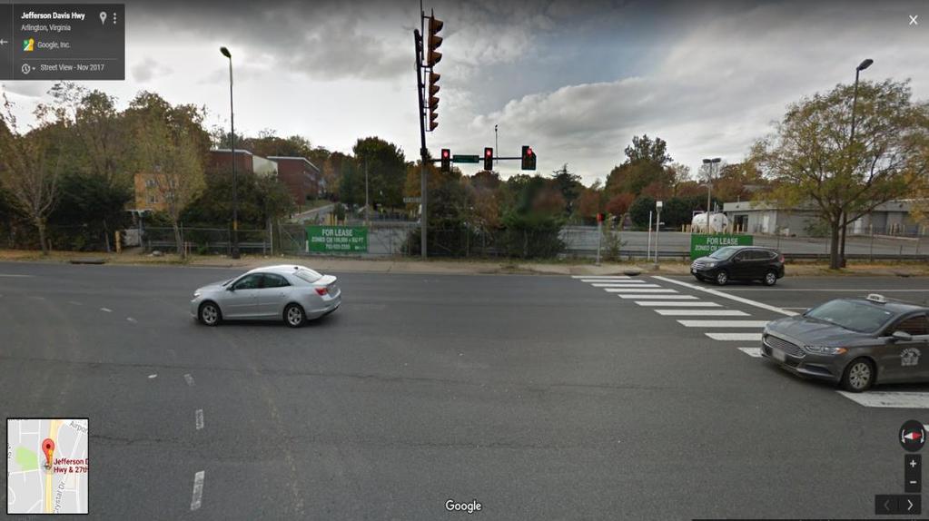
2 Area Layout 2
3 Who s Responsible? Operation of S. Eads Street County Operation of Route 1 VDOT Operation of lot MWAA 3
4 Actions to Date March 1, MWAA applied for certificate of occupancy to operate two 50-space parking lots on S. Eads Street March 16, County s Zoning Division approved certificate of occupancy April 16, MWAA started operations at S. Eads Street April 20-26, County conducted new traffic counts on S. Eads Street, monitored nearby intersections with traffic cameras May - County met with VDOT NOVA District staff to discuss impacts and possible options for Route 1 access August - MWAA, VDOT and County staff met to discuss impacts and possible solutions September - County submitted design plan for interim solution to VDOT, set counters at lot's entrance/exit and on S. Eads Street to capture traffic volumes September VDOT reviewed the design plan and issued permit 4

5 Traffic on S. Eads Street Base Annual Average Daily Traffic: 11,000 vehicles per day Counts collected one week after lot opening, and again in September Counter locations 5
6 Traffic Volumes at the MWAA Lot Sources: MWAA data Date Day AM Peak Hour Exiting Volume PM Peak Hour Exiting Volume Total Daily Exiting Voume Daily Traffic Volume generated by Lot 05/11/2018 Friday /12/2018 Saturday /13/2018 Sunday /14/2018 Monday /15/2018 Tuesday /16/2018 Wednesday /17/2018 Thursday /18/2018 Friday /19/2018 Saturday /20/2018 Sunday /21/2018 Monday /22/2018 Tuesday /23/2018 Wednesday /24/2018 Thursday /25/2018 Friday /26/2018 Saturday /27/2018 Sunday /28/2018 Monday /29/2018 Tuesday /30/2018 Wednesday /31/2018 Thursday /01/2018 Friday /02/2018 Saturday /03/2018 Sunday /04/2018 Monday /05/2018 Tuesday /06/2018 Wednesday /07/2018 Thursday /08/2018 Friday /09/2018 Saturday /10/2018 Sunday
7 Traffic Volumes at the MWAA Lot Time (Hour Intervals) Entrances Exit S. Eads St Heading Heading Total Enter Time (Hour Intervals) Northern Southern Southbound Northbound Total Exit Total Volume 09/24 1:00 PM :00 PM :00 PM :00 PM :00 PM :00 PM :00 PM :00 PM :00 PM :00 PM :00 PM :00 AM /25 5:30 AM :00 AM :00 AM :00 AM :00 AM :00 AM :00 AM :00 PM Total Tube Counters had technical issue because they were calibrated to capture road traffic; staff is adjusting calibration Video/Manual counts conducted when the issue with tube counter was identified Source: County data 7
8 Community Concerns What we ve heard: Increased traffic volumes on area road network, especially S. Eads Street Cars parking illegally along S. Eads, Fort Scott, etc. and drivers walking into the MWAA lot to receive service requests Cars going through CVS and McDonalds parking lot to make exit onto/off Route 1 Cars circling area roads waiting to enter MWAA lot 8
9 Interim Solution Phase I Expected result: Shift most of lot s outbound traffic from S. Eads Street to the Route 1 ramp to the airport Solution requires: Opening lot s driveway to Route 1 Adding temporary span-wire signal control (pole erected) Would only allow egress from lot Lot egress and 27 th street split phase VDOT review & permit (completed) Expedited review Close coordination and support Fine-tuning lot s configuration Hatch out a couple of parking spaces that conflict with the exit flow Estimated installation: 1-2 weeks 9


10 Why not Why not allow ingress traffic from Route 1 right now? Needs parking configuration that meets the VDOT requirement for commercial entrance May need right turn lane from Route 1 Past parking configurations when the gate on Route 1 was open Source: Google 10

11 Interim Solution Phase II Reconfigure the lot's driveway on Route 1 Align the driveway with 27th Street to allow concurrent signal phase Relocate one signal pole Install permanent signal master arm pole on Route 1 Reconfigure lot to allow proper ingress flow VDOT review & permit Estimated cost: $250,000 Timeline: This would be a new capital project, requiring County Manager and County Board approval Estimated months, including underground utility survey, potential easement, design, VDOT review, construction, etc. 11
12 Next Steps County installs interim solution (Phase I), including the temporary signal MWAA fine-tunes lot s configuration and trims the trees that cause sight distance concern County monitors the signal operation and makes timing adjustments as necessary County continues monitoring, enforcement Feedback from the community County works with MWAA and VDOT to determine the feasibility of Phase II and implement it if positive County works with MWAA to identify additional strategies 12
Clean Harbors Canada, Inc.
 Clean Harbors Canada, Inc. Proposed Lambton Landfill Expansion Environmental Assessment Terms of Reference Transportation Assessment St. Clair Township, Ontario September 2009 itrans Consulting Inc. 260
TRAFFIC PARKING ANALYSIS
 TRAFFIC PARKING ANALYSIS NAPA FLEA MARKET COUNTY OF NAPA Prepared for: Tom Harding Napa-Vallejo Flea Market 33 Kelly Road American Canyon, CA 9453 Prepared by: 166 Olympic Boulevard, Suite 21 Walnut Creek,
CITY OF LOS ANGELES INTER-DEPARTMENTAL MEMORANDUM
 CITY OF LOS ANGELES INTER-DEPARTMENTAL MEMORANDUM Date: April 11, 2018 To: The Honorable City Council c/o City Clerk, Room 395, City Hall Attention: Honorable Mike Bonin, Chair, Transportation Committee
APPENDIX C-2. Traffic Study Supplemental Analysis Memo
 APPENDIX C-2 Traffic Study Supplemental Analysis Memo The Mobility Group Transportation Strategies & Solutions Memorandum To: From: Subject: Tomas Carranza, LADOT Matthew Simons Traffic Review - Revised
TRAFFIC SIGNAL DESIGN REPORT KING OF PRUSSIA ROAD & RAIDER ROAD RADNOR TOWNSHIP PENNSYLVANIA
 TRAFFIC SIGNAL DESIGN REPORT KING OF PRUSSIA ROAD & RAIDER ROAD RADNOR TOWNSHIP PENNSYLVANIA PREPARED FOR: UNIVERSITY OF PENNSYLVANIA HEALTH SYSTEM 34 CIVIC CENTER BOULEVARD PHILADELPHIA, PA 1987 (61)
MILLERSVILLE PARK TRAFFIC IMPACT ANALYSIS ANNE ARUNDEL COUNTY, MARYLAND
 MILLERSVILLE PARK TRAFFIC IMPACT ANALYSIS ANNE ARUNDEL COUNTY, MARYLAND Prepared for: Department of Public Works Anne Arundel County Prepared by: URS Corporation 4 North Park Drive, Suite 3 Hunt Valley,
WIM #41 CSAH 14, MP 14.9 CROOKSTON, MINNESOTA MAY 2013 MONTHLY REPORT
 WIM #41 CSAH 14, MP 14.9 CROOKSTON, MINNESOTA MAY 2013 MONTHLY REPORT In order to understand the vehicle classes and groupings the Mn/DOT Vehicle Classification Scheme and the Vehicle Classification Groupings
Missouri Seat Belt Usage Survey for 2017
 Missouri Seat Belt Usage Survey for 2017 Conducted for the Highway Safety & Traffic Division of the Missouri Department of Transportation by The Missouri Safety Center University of Central Missouri Final
AVON MENTOR 2018 ONBOARDING CAMPAIGN CALENDAR
 REPRESENTATIVE PROCESSING SCHEDULE 1 (ORANGE) C-1 11/10 11/23 11/29 12/11 12/13 C-2 11/24 12/7 12/11 12/26 12/29 Friday Thursday Wednesday Wednesday Thursday C-3 12/8 12/21 12/27 1/10 1/11 C-4 12/22 1/4
McNICOLL BUS GARAGE. Public Open House June 12, 2017 Mary Ward Catholic School
 McNICOLL BUS GARAGE Public Open House June 12, 2017 Mary Ward Catholic School THE NEED FOR A NEW BUS GARAGE riders Increased ridership means buses Need for new buses garage And a new bus facility Garages
Trip Generation and Parking Study New Californian Apartments, Berkeley
 Trip Generation and Parking Study New Californian Apartments, Berkeley Institute of Transportation Engineers University of California, Berkeley Student Chapter Spring 2012 Background The ITE Student Chapter
11 October 12, 2011 Public Hearing APPLICANT:
 11 October 12, 2011 Public Hearing APPLICANT: CARING TRANSITIONS PROPERTY OWNER: HARDEE REALTY CORPORATION REQUEST: Conditional Use Permit (motor vehicle rental) STAFF PLANNER: Leslie Bonilla ADDRESS /
Proposed location of Camp Parkway Commerce Center. Vicinity map of Camp Parkway Commerce Center Southampton County, VA
 Proposed location of Camp Parkway Commerce Center Vicinity map of Camp Parkway Commerce Center Southampton County, VA Camp Parkway Commerce Center is a proposed distribution and industrial center to be
However, due to the location, all garage parkers will need to continue to use the South end garage for entrance and exit.
 We apologize for any inconvenience that this construction may cause and appreciate your patience while we work hard to improve The Crescent for our customers. Effective Tuesday, July 28 Shoring for the
Operations Center FAQs
 RICHARDSON INDEPENDENT SCHOOL DISTRICT Where all students learn, grow and succeed Operations Center FAQs Richardson ISD is constructing an operations center on vacant district land between Greenville Avenue
WIM #39 MN 43, MP 45.2 WINONA, MN APRIL 2010 MONTHLY REPORT
 WIM #39 MN 43, MP 45.2 WINONA, MN APRIL 2010 MONTHLY REPORT In order to understand the vehicle classes and groupings the Mn/DOT Vehicle Classification Scheme and the Vehicle Class Groupings for Forecasting
THE CORNERSTONE APARTMENTS TRAFFIC IMPACT STUDY R&M PROJECT NO
 THE CORNERSTONE APARTMENTS SITUATED AT N/E/C OF STAUDERMAN AVENUE AND FOREST AVENUE VILLAGE OF LYNBROOK NASSAU COUNTY, NEW YORK TRAFFIC IMPACT STUDY R&M PROJECT NO. 2018-089 September 2018 50 Elm Street,
King County Metro. Columbia Street Transit Priority Improvements Alternative Analysis. Downtown Southend Transit Study. May 2014.
 King County Metro Columbia Street Transit Priority Improvements Alternative Analysis Downtown Southend Transit Study May 2014 Parametrix Table of Contents Introduction... 1 Methodology... 1 Study Area...
CAMPUS CONNECTOR MONDAY - THURSDAY. bold italicized times denote p.m. Monday - Thursday continued on next page. Effective August 29th, 2016
 50 ( only) CAMPUS CONNECTOR Bayberry North Shuttle & 48 North & South Shuttles 531 539 543 546 549 552 607 601 609 613 616 619 622 637 613 621 625 628 631 634 649 625 633 637 640 643 646 701 637 645 649
Figure 1 Map of intersection of SR 44 (Ravenna Rd) and Butternut Rd
 and Butternut Rd") Abbreviated Study District: 12 County: Geauga Route: SR 44 Section: 1.58 GEA 44 1.58 213 HSP # 47 (Rural Intersection) Prepared April 23, 215 By Bryan Emery Existing Conditions This study contains the
Abbreviated Study District: 12 County: Geauga Route: SR 44 Section: 1.58 GEA 44 1.58 213 HSP # 47 (Rural Intersection) Prepared April 23, 215 By Bryan Emery Existing Conditions This study contains the
Rolling Road (Route 638) Widening Project
 Widening Project") Rolling Road (Route 638) Widening Project From: 0.369 Mile North of Fairfax County Parkway (Route 286) To: Old Keene Mill Road (Route 644) State Project No. 0638-029-156, P104, R204, C504; UPC 5559 Public
Rolling Road (Route 638) Widening Project From: 0.369 Mile North of Fairfax County Parkway (Route 286) To: Old Keene Mill Road (Route 644) State Project No. 0638-029-156, P104, R204, C504; UPC 5559 Public
WIM #40 US 52, MP S. ST. PAUL, MN APRIL 2010 MONTHLY REPORT
 WIM #40 US 52, MP 126.8 S. ST. PAUL, MN APRIL 2010 MONTHLY REPORT In order to understand the vehicle classes and groupings the Mn/DOT Vehicle Classification Scheme and the Vehicle Class Groupings for Forecasting
WIM #37 was operational for the entire month of September Volume was computed using all monthly data.
 SEPTEMBER 2016 WIM Site Location WIM #37 is located on I-94 near Otsego in Wright county. The WIM is located only on the westbound (WB) side of I-94, meaning that all data mentioned in this report pertains
WIM #41 CSAH 14, MP 14.9 CROOKSTON, MINNESOTA APRIL 2014 MONTHLY REPORT
 WIM #41 CSAH 14, MP 14.9 CROOKSTON, MINNESOTA APRIL 2014 MONTHLY REPORT In order to understand the vehicle classes and groupings, the MnDOT Vehicle Classification Scheme and the Vehicle Classification
BOARD OF SUPERVISORS BUSINESS MEETING ACTION ITEM. Design Endorsement for Sterling Boulevard Extension
 Date of Meeting: July 20, 2017 # 6 BOARD OF SUPERVISORS BUSINESS MEETING ACTION ITEM SUBJECT: ELECTION DISTRICT: CRITICAL ACTION DATE: STAFF CONTACTS: Design Endorsement for Sterling Boulevard Extension
PROPOSED TRAFFIC RESOLUTION
 Reference Number: TR 52-18 Location: Frobisher Street and Severn Street - Island Bay Proposal: Information: To provide two new bus stop locations on Frobisher Street, and change the time restriction on
Designation of a Community Safety Zone in Honey Harbour in the Township of Georgian Bay
 TO: FROM: Chair and Members Engineering and Public Works Committee Mark Misko, C.E.T. Manager, Roads Maintenance and Construction DATE: March 23, 2016 SUBJECT: REPORT NO: Designation of a Community Safety
WIM #48 is located on CSAH 5 near Storden in Cottonwood county.
 WIM Site Location WIM #48 is located on CSAH 5 near Storden in Cottonwood county. System Operation WIM #48 was operational for the entire month of August 2017. Volume was computed using all monthly data.
SITE PLAN REVIEW COMMITTEE MEETING #3 VIRGINIA HOSPITAL CENTER (SP #177 AMENDMENT) Thursday, March 8, 2018 SITE PLAN UPDATES & PARKING
 Thursday, March 8, 2018 SITE PLAN UPDATES & PARKING") SITE PLAN REVIEW COMMITTEE MEETING #3 VIRGINIA HOSPITAL CENTER (SP #177 AMENDMENT) Thursday, March 8, 2018 SITE PLAN UPDATES & PARKING 2 Site Plan Modifications From SPRC #1 &2 3 Current 4.1 Submission
SITE PLAN REVIEW COMMITTEE MEETING #3 VIRGINIA HOSPITAL CENTER (SP #177 AMENDMENT) Thursday, March 8, 2018 SITE PLAN UPDATES & PARKING 2 Site Plan Modifications From SPRC #1 &2 3 Current 4.1 Submission
GUIDELINES FOR ADVERTISING SIGNS
 GUIDELINES FOR ADVERTISING SIGNS SIGN PERMITS A Sign Permit is required to install or alter any advertising sign, except for the following exempt types of signs: One identification sign displaying only
COUNT, CLASSIFICATION & SPEED SAMPLE REPORTS
 Connected Solutions for Better Traffic Safety Outcomes COUNT, CLASSIFICATION & SPEED SAMPLE REPORTS AllTrafficSolutions.com Why You Need Traffic Data at Your Fingertips As traffic in your municipality
Construction Staging Area 4 Avenue Road
 REPORT FOR ACTION Construction Staging Area 4 Avenue Road Date: September 27, 2017 To: Toronto and East York Community Council From: Acting Director, Transportation Services, Toronto and East York District
November 1, Mr. Jafar Tabrizi President, Tabrizi Rugs 180 Bedford Highway. Traffic Impact Statement BH-1 and BH-2, Southgate Drive, Bedford, NS
 161-12598 Mr. Jafar Tabrizi President, Tabrizi Rugs 180 Bedford Highway Bedford, NS B4A 1C1 [Via Email: tabrizi@tabrizi.com] RE: Traffic Impact Statement Dear Mr. Tabrizi: Plans are being prepared for
BETHLEHEM MISSIONS TRUST CAMPUS
 BETHLEHEM MISSIONS TRUST CAMPUS Prepared For: Prepared By: Wasley Knell Consultants PO Box 5015, Mount Maunganui, 3150 BruceWRobinson@msn.com/(027) 4515685 Table of Contents Introduction... 3 Site Vicinity...
Parking Permit Program for School Year
 Parking Permit Program for 2018-2019 School Year INTRODUCTION: Parking permits will be available for high school students for the 2018/2019 school year at the Community Center parking lot adjacent to Eagle
STH 60 Northern Reliever Route Feasibility Study Report
 #233087 v3 STH 60 Northern Reliever Route Feasibility Study Report Washington County Public Works Committee Meeting September 28, 2016 1 STH 60 Northern Reliever Route Feasibility Study Hartford Area Development
ODOT District Two Monthly Construction Update
 Ohio Department of Transportation Construction Update DISTRICT 2 KIRK SLUSHER, P.E., ACTING DEPUTY DIRECTOR 317 East Poe Rd. Bowling Green, Ohio 43402-1330 www.transportation.ohio.gov/dist2 ODOT District
Draft Results and Recommendations
 Waco Rapid Transit Corridor (RTC) Feasibility Study Draft Results and Recommendations Chris Evilia, Director of Waco Metropolitan Planning Organization Allen Hunter, General Manager Waco Transit System
FINAL DRAFT Traffic Operations and Safety Study for the City of Belpre 2008
 FINAL DRAFT Traffic Operations and Safety Study for the City of Belpre 2008 Tracy A. Higgins Randy L. Durst Fred L. Rader WOOD WASHINGTON WIRT INTERSTATE PLANNING COMMISSION An affiliate agency of the
Table of Contents INTRODUCTION... 3 PROJECT STUDY AREA Figure 1 Vicinity Map Study Area... 4 EXISTING CONDITIONS... 5 TRAFFIC OPERATIONS...
 Crosshaven Drive Corridor Study City of Vestavia Hills, Alabama Table of Contents INTRODUCTION... 3 PROJECT STUDY AREA... 3 Figure 1 Vicinity Map Study Area... 4 EXISTING CONDITIONS... 5 TRAFFIC OPERATIONS...
Collision Analysis Safety Tables
 Crash Severity Geography of Geography of Time and Date of Crash Conditions Features Features.. Queries Selected: Town(Hartford), Date(Year:All or //05 to 9/7/06), Severity(All), Route Class(Interstate),
Alberta Speeding Convictions and Collisions Involving Unsafe Speed
 Alberta Speeding Convictions and Collisions Involving Unsafe Speed 2004-2008 Overview This document was prepared under the Alberta Traffic Safety Plan, Strategic Research Plan for 2008-2010, with the objective
TRAFFIC & PARKING COMMISSION. Request for a Customer Loading Zone on the west side of the 100 Block of South Beverly Drive
 ~LS CITY OF BEVERLY HILLS TRAFFIC & PARKING COMMISSION April 3, 2014 TO: FROM: SUBJECT: Attachments: Traffic & Parking Commission Martha Eros, Transportation Planner Request for a Customer Loading Zone
Request for Design Exception (#1) S.M. Wright Phase IIB
 S.M. Wright Phase IIB") Request for Design Exception (#1) S.M. Wright Phase IIB County: Dallas CSJ s: 0092-01-059, 0092-14-088 Project Limits: From Pennsylvania Avenue to North of Al Lipscomb Way Date: June 28, 2016 Proposed
Request for Design Exception (#1) S.M. Wright Phase IIB County: Dallas CSJ s: 0092-01-059, 0092-14-088 Project Limits: From Pennsylvania Avenue to North of Al Lipscomb Way Date: June 28, 2016 Proposed
RTCSNV CRASH ANALYSIS REPORT
 2011-2015 RTCSNV CRASH ANALYSIS REPORT TABLE OF CONTENTS Summary... 3 Crash Types... 4 Time and Day of Crashes... 7 Crash Factors... 9 Fatalities... 10 Driver s Behavior... 11 Crash Locations... 15 Non-Motorized
I-820 (East) Project Description. Fort Worth District. Reconstruct Southern I-820/SH 121 Interchange
 Project Description. Fort Worth District. Reconstruct Southern I-820/SH 121 Interchange") I-820 (East) Project Description Fort Worth District Reconstruct Southern I-820/SH 121 Interchange I-820 from approximately 2,000 feet north of Pipeline Road/Glenview Drive to approximately 3,200 feet
I-820 (East) Project Description Fort Worth District Reconstruct Southern I-820/SH 121 Interchange I-820 from approximately 2,000 feet north of Pipeline Road/Glenview Drive to approximately 3,200 feet
FREQUENTLY ASKED QUESTIONS
 THE PROJECT Last updated on 9/8/16 FREQUENTLY ASKED QUESTIONS What s happening on Highway 169? The Minnesota Department of Transportation (MnDOT) is planning to rebuild and repair the infrastructure on
Traffic Engineering Study
 Traffic Engineering Study Bellaire Boulevard Prepared For: International Management District Technical Services, Inc. Texas Registered Engineering Firm F-3580 November 2009 Executive Summary has been requested
ARLINGTON COUNTY, VIRGINIA
 ARLINGTON COUNTY, VIRGINIA County Board Agenda Item Meeting of April 24, 2004 DATE: April 14, 2004 SUBJECT: Arlington Boulevard (U.S. 50) Bridge Deck Replacement at Washington Boulevard - Overhead Utility
Memorandum. To: Sue Polka, City Engineer, City of Arden Hills. From: Sean Delmore, PE, PTOE. Date: June 21, 2017
 Memorandum engineering planning environmental construction 701 Xenia Avenue South Suite 300 Minneapolis, MN 55416 Tel: 763-541-4800 Fax: 763-541-1700 To: Sue Polka, City Engineer, City of Arden Hills From:
AVON MENTOR 2017 ONBOARDING CAMPAIGN CALENDAR
 REPRESENTATIVE PROCESSING SCHEDULE 1 (ORANGE) C-1 11/11 11/24 11/30 12/12 12/13 C-2 11/25 12/8 12/12 12/27 12/29 C-3 12/9 12/22 12/27 1/11 1/12 WEDNESDAY THURSDAY C-4 12/23 1/5 1/11 1/25 1/26 C-5 1/6 1/19
TRAFFIC IMPACT STUDY. USD #497 Warehouse and Bus Site
 TRAFFIC IMPACT STUDY for USD #497 Warehouse and Bus Site Prepared by: Jason Hoskinson, PE, PTOE BG Project No. 16-12L July 8, 216 145 Wakarusa Drive Lawrence, Kansas 6649 T: 785.749.4474 F: 785.749.734
Valet Parking Management Plan
 Valet Parking Management Plan Emergency Department Expansion Lot Application 2550 1 Bay Ave Montclair, NJ 07042 Background HealthPark Valet is a Nashville based company, hired in early 2017 by Mountainside
Attachment A RONALD REAGAN WASHINGTON NATIONAL AIRPORT ROADWAY NETWORK IMPROVEMENTS ENVIRONMENTAL ASSESSMENT
 Attachment A RONALD REAGAN WASHINGTON NATIONAL AIRPORT ROADWAY NETWORK IMPROVEMENTS ENVIRONMENTAL ASSESSMENT The general location of Ronald Reagan Washington National Airport (DCA or the Airport) is shown
Herding Cats; Strategies used for KC Downtown Streetcar Utility Coordination ASCE Transportation Conference
 Herding Cats; Strategies used for KC Downtown Streetcar Utility Coordination ASCE Transportation Conference November 9, 2016 Kansas City Streetcar Project overview Current status Scope of water and sewer
Plattsburgh Downtown Parking Study
 Plattsburgh Downtown Parking Study Study Update October 2017 Powered by Purpose of Study Engage Community in Parking Discussion Assess Current Conditions Parking Demand Patron Service Levels Administration
WIM #29 was operational for the entire month of October Volume was computed using all monthly data.
 OCTOBER 2015 WIM Site Location WIM #29 is located on US 53 near Cotton in St Louis county. System Operation WIM #29 was operational for the entire month of October 2015. Volume was computed using all monthly
TRAFFIC IMPACT STUDY VICDOM BROCK ROAD PIT EXPANSION
 TRAFFIC IMPACT STUDY VICDOM BROCK ROAD PIT EXPANSION TOWNSHIP OF UXBRIDGE P/N 05-1993 June 2011 Revised -August 2011 Prepared by: Skelton, Brumwell & Associates Inc. 93 Bell Farm Road, Suite 107 Barrie,
POLICY FOR THE ESTABLISHMENT AND POSTING OF SPEED LIMITS ON COUNTY AND TOWNSHIP HIGHWAYS WITHIN MCHENRY COUNTY, ILLINOIS
 POLICY FOR THE ESTABLISHMENT AND POSTING OF SPEED LIMITS ON COUNTY AND TOWNSHIP HIGHWAYS WITHIN MCHENRY COUNTY, ILLINOIS MCHENRY COUNTY DIVISION OF TRANSPORTATION 16111 NELSON ROAD WOODSTOCK, IL 60098
Safety Assessment. Intersection of Route 29 (Seminole Trail) and Ashwood Blvd (Route 1670). Albemarle County
 and Ashwood Blvd (Route 1670). Albemarle County") Safety Assessment for Intersection of Route 29 (Seminole Trail) and Ashwood Blvd (Route 1670). Albemarle County Prepared by: VIRGINIA DEPARTMENT OF TRANSPORTATION Northwestern Regional Operations - Traffic
Safety Assessment for Intersection of Route 29 (Seminole Trail) and Ashwood Blvd (Route 1670). Albemarle County Prepared by: VIRGINIA DEPARTMENT OF TRANSPORTATION Northwestern Regional Operations - Traffic
Existing Conditions Belmont Circle Bourne, MA. Belmont Circle Improvements
 Existing Conditions Belmont Circle Bourne, MA Speakers Pam Haznar, MassDOT Ed Hollingshead, Fay Spofford & Thorndike Heather Ostertog, Fay, Spofford & Thorndike Goals for Group Local Knowledge Work through
Date: February 7, 2017 John Doyle, Z-Best Products Robert Del Rio. T.E. Z-Best Traffic Operations and Site Access Analysis
 Memorandum Date: February 7, 07 To: From: Subject: John Doyle, Z-Best Products Robert Del Rio. T.E. Z-Best Traffic Operations and Site Access Analysis Introduction Hexagon Transportation Consultants, Inc.
Transportation Discipline Report
 MUKILTEO MULTIMODAL PROJECT FINAL ENVIRONMENTAL IMPACT STATEMENT Transportation Discipline Report Prepared for: June 2013 Transportation Discipline Report Mukilteo Multimodal Project Final Environmental
PARKING OCCUPANCY IN WINDSOR CENTER
 PARKING OCCUPANCY IN WINDSOR CENTER TOWN OF WINDSOR, CONNECTICUT REPORT JUNE 2017 CONTENTS Background... 3 Other Relevant Data... 3 Parking Survey Design... 6 Parking Supply Inventory... 6 Parking Demand
PROPOSED TRAFFIC RESOLUTION
 Reference Number: TR 50-18 Location:, Brooklyn Bus Hub - Brooklyn Proposal: Information: To provide new bus stops to create a Bus hub location on Cleveland Street, Brooklyn, as part of Wellington s new
Overview of FMCSA s Proposed Hours of Service Rules For Truck Drivers. Rob Abbott Vice President of Safety Policy American Trucking Associations
 Overview of FMCSA s Proposed Hours of Service Rules For Truck Drivers Rob Abbott Vice President of Safety Policy American Trucking Associations Background 2003 Final Rule 2003 Legal Challenge 2005 New
Service Planning Open House
 Service Planning Open House Presentation to Community RTA Board Room July 17, 2018 575 EYES See Something, Text Something Transit App RTA CLE Mobile Ticketing Bus Stop Consolidation/Safety Improvement
Project Advisory Committee
 Meredith US 3/NH 25 Improvements Transportation Planning Study Project Advisory Committee March 18, 2008 Meredith US 3/NH 25 Improvements Transportation Planning Study Meeting Agenda Welcome Traffic Model
Traffic Accident Statistics
 2000 Missouri State Highway System Traffic Accident Statistics Missouri State Highway System Traffic Accident Statistics Table of Contents Subject Chapter 1: Statewide Traffic Accident Statistics, Introduction
NEW ELEMENTARY SCHOOL #1 Open BLPC Meeting January 9, 2013
 NEW ELEMENTARY SCHOOL #1 Open BLPC Meeting January 9, 2013 It s for the Students! Maintain class size Hold fewer classes in relocatables Minimize travel distance to school Project Delay and it s impact
Pedestrians Road Safety
 Pedestrians Road Safety Overview Over the period 1996-2009, 5,323 people have been killed on Irish road. Out of this 22% (1162) were pedestrians. Additional 3863 pedestrians were seriously injured in the
Traffic Impact Analysis West Street Garden Plots Improvements and DuPage River Park Garden Plots Development Naperville, Illinois
 Traffic Impact Analysis West Street Garden Plots Improvements and DuPage River Park Garden Plots Development Naperville, Illinois Submitted by April 9, 2009 Introduction Kenig, Lindgren, O Hara, Aboona,
Traffic Feasibility Study
 Traffic Feasibility Study Town Center South Robbinsville Township, Mercer County, New Jersey December 19, 2017 Prepared For Robbinsville Township Department of Community Development 2298 Route 33 Robbinsville,
Appendix J Traffic Impact Study
 MRI May 2012 Appendix J Traffic Impact Study Level 2 Traffic Assessment Limited Impact Review Appendix J [This page was left blank intentionally.] www.sgm-inc.com Figure 1. Site Driveway and Trail Crossing
Summary of the Alcoa Highway Redevelopment Project
 Appendix B Summary of the Alcoa Highway Redevelopment Project By Marcia Finfer, October 2009 The Timberlake community, along with numerous other concerned citizen groups (including the Lakemoor Hills community)
ANDERSON PROPERTY SITE ANALYSIS
 ANDERSON PROPERTY SITE ANALYSIS Introduction The Montgomery County Department of Transportation (MCDOT) initiated a feasibility study in the fall of 2012 to evaluate the need for transit service expansion
JOINT FACILITIES ADVISORY COMMISSION. ART and APS Bus Parking Informational Session July 27, :30 pm
 ART and APS Bus Parking Informational Session July 27, 2017 7 8:30 pm 2 Agenda Introductions & overview APS Bus Parking APS Bus Facts APS Bus Operations ART Bus Parking Story of ART and its role in County
Statewide Park & Ride Inventory and Usage Study, March 13, 2013 Liz McAdory, VDOT, Transportation & Mobility Planning Division
 Statewide Park & Ride Inventory and Usage Study, 2013 March 13, 2013 Liz McAdory, VDOT, Transportation & Mobility Planning Division VDOT Park & Ride Lot Inventory & Usage Study Project Team: VDOT SIR Kimley-Horn
Trip and Parking Generation Data Collection at Grocery Store with Gas Station and Auto Repair
 Trip and Parking Generation Data Collection at Grocery Store with Gas Station and Auto Repair Final Report 2011 ITE District 6 - Data Collection Project Institute of Transportation Engineers Student Chapter
PROJECT: Wilkinson Road Corridor Improvement Traffic Management Planning Project SUBJECT: Traffic Analysis
 TECHNICAL MEMORANDUM DATE: September 10, 2014 PROJECT 5861.03 NO: PROJECT: Wilkinson Road Corridor Improvement Traffic Management Planning Project SUBJECT: Traffic Analysis TO: Steve Holroyd - District
1999 Missouri State Highway System. Missouri Department of Transportation - Transportation Management Systems
 1999 Missouri State Highway System Traffic Accident Statistics - Transportation Management Systems Missouri State Highway System Traffic Accident Statistics Table of Contents Subject Chapter 1: Statewide
2016 Community Report De Baca County
 6 De Baca County Produced for the New Mexico Department of Transportation, Traffic Safety Division, Traffic Records Bureau, Under Contract 58 by the University of New Mexico, Geospatial and Population
APPENDIX TR-1 PARKING AND QUEUING ASSESSMENT
 APPENDIX TR-1 PARKING AND QUEUING ASSESSMENT Overland Overland Traffic Consultants, Traffic Consultants, Inc. Inc. Overland Traffic Consultants 952 Manhattan Beach Boulevard, Suite #100 Manhattan Beach,
TRAFFIC IMPACT ASSESSMENT PART OF AN ENVIRONMENTAL IMPACT ASSESSMENT FOR THE KEBRAFIELD ROODEPOORT COLLIERY IN THE PULLEN S HOPE AREA
 TRAFFIC IMPACT ASSESSMENT PART OF AN ENVIRONMENTAL IMPACT ASSESSMENT FOR THE KEBRAFIELD ROODEPOORT COLLIERY IN THE PULLEN S HOPE AREA 20 March 2014 Report prepared by: Corli Havenga Transportation Engineers
City of Houston Fondren Road Paving and Drainage
 City of Houston Fondren Road Paving and Drainage From Braeswood Boulevard to Creekbend Drive TRC Meeting March 2016 Location and Vicinity Maps City Council District K Key Map 530 Z, 530 Y Land Use Commercial
National Household Travel Survey Add-On Use in the Des Moines, Iowa, Metropolitan Area
 National Household Travel Survey Add-On Use in the Des Moines, Iowa, Metropolitan Area Presentation to the Transportation Research Board s National Household Travel Survey Conference: Data for Understanding
FREQUENTLY ASKED QUESTIONS
 THE PROJECT Last updated on 2/19/16 FREQUENTLY ASKED QUESTIONS What s happening on Highway 169? The Minnesota Department of Transportation (MnDOT) is planning to rebuild and repair the infrastructure on
Ryan Coyne, PE City Engineer City of Rye 1051 Boston Post Road Rye, NY Boston Post Road Realignment and Roundabout Design Report
 March 6, 2015 Ryan Coyne, PE City Engineer City of Rye 1051 Boston Post Road Rye, NY 10580 RE: JMC Project 14108 Boston Post Road Roundabout Boston Post Road and Parsons Street City of Rye, NY Dear Ryan:
Confederation Line Stage 1 and 2. Our Lady of Fatima Church May 10 th, 2018
 Confederation Line Stage 1 and 2 Our Lady of Fatima Church May 10 th, 2018 Agenda Confederation Line Stage 1 Overview project, consortium, vehicles Confederation Line Stage 2 Overview project, benefits
NAVY YARD BALLPARK STATION ACCESS IMPROVEMENTS STUDY. Final Report. Washington Metropolitan Area Transit Authority
 NAVY YARD BALLPARK STATION ACCESS IMPROVEMENTS STUDY Final Report Washington Metropolitan Area Transit Authority Office of Real Estate and Station Planning April 2016 [This page intentionally left blank]
MEMORANDUM TO: Oak Park and River Forest High School District 200. Kenig, Lindgren, O Hara, Aboona, Inc.
 9575 West Higgins Road, Suite 400 Rosemont, Illinois 60018 p: 847-518-9990 f: 847-518-9987 MEMORANDUM TO: Oak Park and River Forest High School District 200 FROM: Kenig, Lindgren, O Hara, Aboona, Inc.
2015 Community Report Doña Ana County
 25 Doña Ana County Produced for the New Mexico Department of Transportation, Traffic Safety Division, Traffic Records Bureau, Under Contract 58 by the University of New Mexico, Geospatial and Population
Commercial Vehicle Drivers Hours of Service. Module 10. Special Permit - Oil Well Service Vehicle Permits. Microsoft.
 Module 10 Special Permit - Oil Well Service Vehicle Permits Microsoft. June 23, 2008 Microsoft. Things to think about Drivers of oil well service vehicles operate within a challenging environment that
2015 Community Report Chaparral
 5 Chaparral Produced for the New Mexico Department of Transportation, Traffic Safety Division, Traffic Records Bureau, Under Contract 58 by the University of New Mexico, Geospatial and Population Studies,
IV. ENVIRONMENTAL IMPACT ANALYSIS J. TRANSPORTATION AND TRAFFIC
 IV. ENVIRONMENTAL IMPACT ANALYSIS J. TRANSPORTATION AND TRAFFIC This Section summarizes the information provided in the Traffic Study for the Santa Monica College Bundy Campus Master Plan (Traffic Study),
Pace Bus Depot Location Analysis
 Pace Bus Depot Location Analysis Key Notes 1. Options refer to conceptual sketches prepared by Kimley Horn. 2. The depot is assumed to accommodate Pace routes as they currently exist: 17 routes on the
Project Description: Georgia Department of Transportation Public Information Open House Handout PI#(s): , County: Muscogee
: , County: Muscogee") Why We Are Here: GDOT s Transportation Improvement Act (TIA) Office, the City of Columbus, and the project delivery team are here this evening to display and answer questions concerning the proposed roadway
Why We Are Here: GDOT s Transportation Improvement Act (TIA) Office, the City of Columbus, and the project delivery team are here this evening to display and answer questions concerning the proposed roadway
Trip Generation and Parking Utilization Data Collection at Mini-Mart with Gas Station
 Trip Generation and Parking Utilization Data Collection at Mini-Mart with Gas Station Final Report 2013 ITE District 6 - Data Collection Project Institute of Transportation Engineers Student Chapter at
Ingraham High School Parking and Traffic Analysis
 Parking and Traffic Analysis Seattle, WA Prepared for: URS Corporation 1501 4th Avenue, Suite 1400 Seattle, WA 98101-1616 Mirai Transportation Planning & Engineering 11410 NE 122nd Way, Suite 320 Kirkland,
SAUSALITO FERRY TERMINAL REPLACEMENT PROJECT. Item 5A- PPT Presentation Page 1 of 23
 SAUSALITO FERRY TERMINAL REPLACEMENT PROJECT OCTOBER 10, 2017 CITY OF SAUSALITO CITY COUNCIL MEETING Page 1 of 23 PROPOSED PROJECT SUMMARY EXISTING PROPOSED (ACCESS PIER WITHOUT BELVEDERES) Gate Location