BOARD OF SUPERVISORS BUSINESS MEETING ACTION ITEM. Design Endorsement for Sterling Boulevard Extension
|
|
|
- Scott Hutchinson
- 5 years ago
- Views:
Transcription
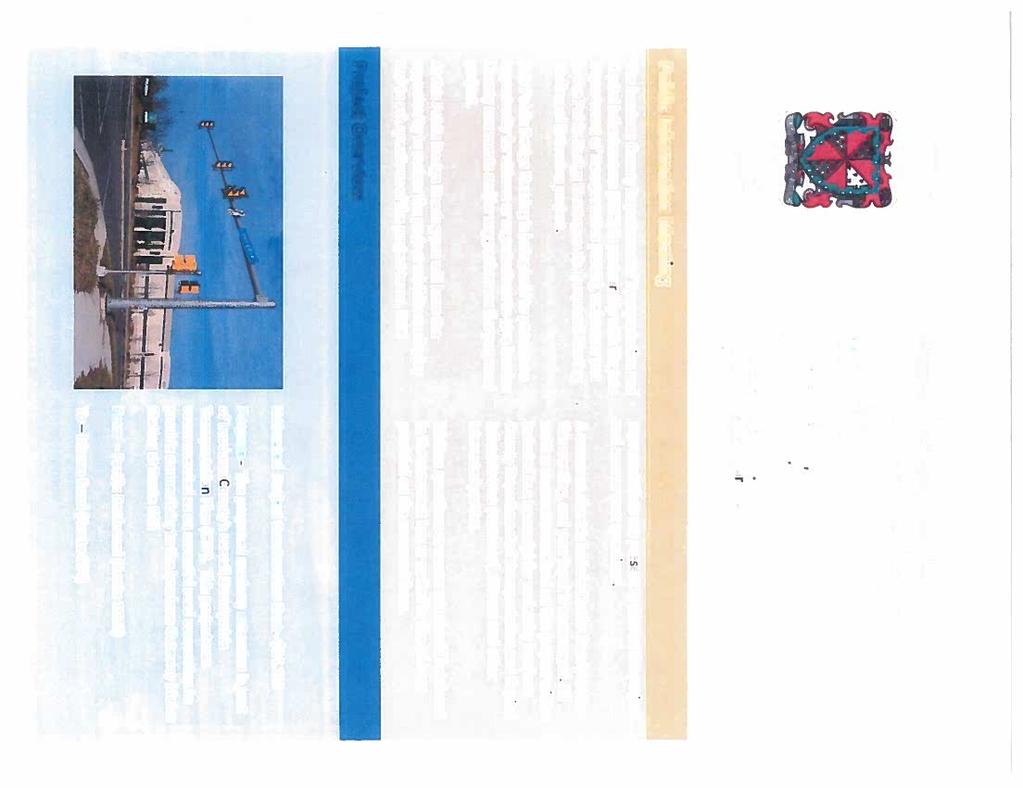
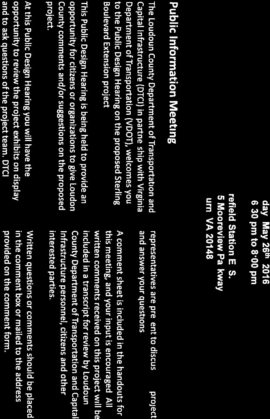
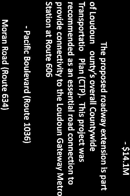
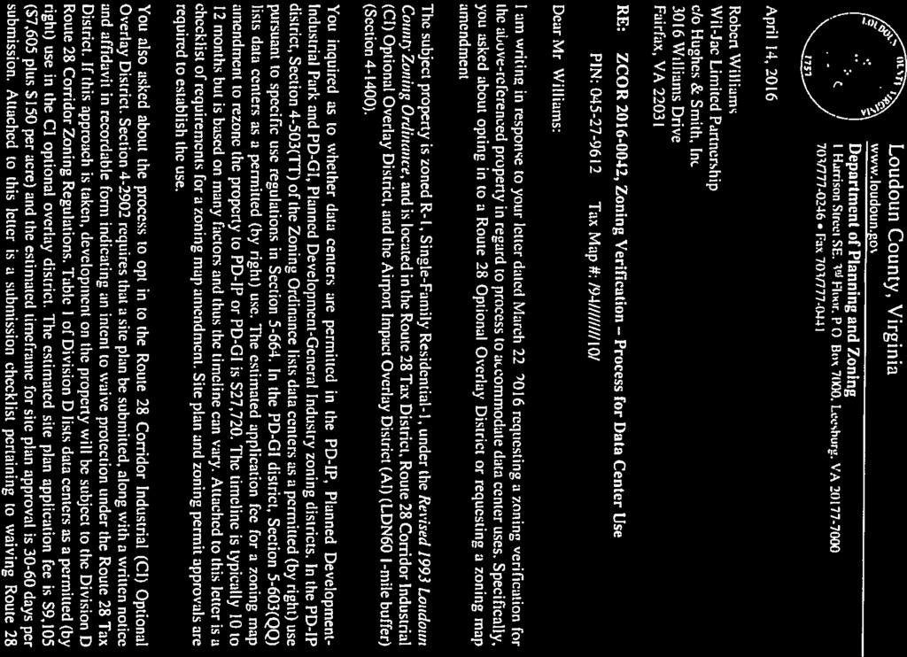
1 Date of Meeting: July 20, 2017 # 6 BOARD OF SUPERVISORS BUSINESS MEETING ACTION ITEM SUBJECT: ELECTION DISTRICT: CRITICAL ACTION DATE: STAFF CONTACTS: Design Endorsement for Sterling Boulevard Extension Broad Run At the pleasure of the Board Khattab Shammout, Transportation and Capital Infrastructure Joe Kroboth, III, Transportation and Capital Infrastructure PURPOSE: To seek design endorsement from the Board of Supervisors (Board) for Sterling Boulevard Extension from Pacific Boulevard to Moran Road. RECOMMENDATION: Staff recommends the Board endorse Alternative #2 (Northern T ) and direct staff to proceed with the completion of the final design and construction documents for the construction of the Sterling Boulevard Extension from Pacific Boulevard to Moran Road. BACKGROUND: To improve the road network to the proposed Loudoun Gateway Metro Station, the Board at the 2013 Transportation Summit included the extension of Sterling Boulevard from Pacific Boulevard to Moran Road as one of its top transportation priorities. Utilizing the task order Roadway/Transportation Design Services Contract, a purchase order in the amount of $1,687, was issued to ATCS, P.L.C. (ATCS) on June 18, 2015, to perform the design of the Sterling Boulevard Extension from Pacific Boulevard to Moran Road. The contract s scope of work includes all engineering, surveying, traffic studies, environmental services, public information meetings, and construction estimates necessary to prepare a complete set of design and construction plans. On May 26, 2016, a public information meeting was held to discuss the Sterling Boulevard Extension project and to solicit feedback. At the meeting, ATCS provided exhibits showing a preliminary roadway alignment and associated stormwater management facilities closely resembling Alternative #1 (Roundabout). Approximately a dozen members of the public attended the meeting with the majority of the attendees having an interest in commercial parcels along the roadway corridor. Although most attendees were in favor of the road, they expressed concerns that the proposed right-of-way dedication would compromise their ability to use or develop their properties to the extent desired. Some were not in favor of dedicating any right-of-way to the County while other property owners were willing to work with the County on right-of-way acquisition needs. In addition, several members of the public questioned the locations of proposed stormwater management facilities and inquired if the facilities could be moved or redesigned to minimize impact to their parcels. None of the meeting attendees were residential
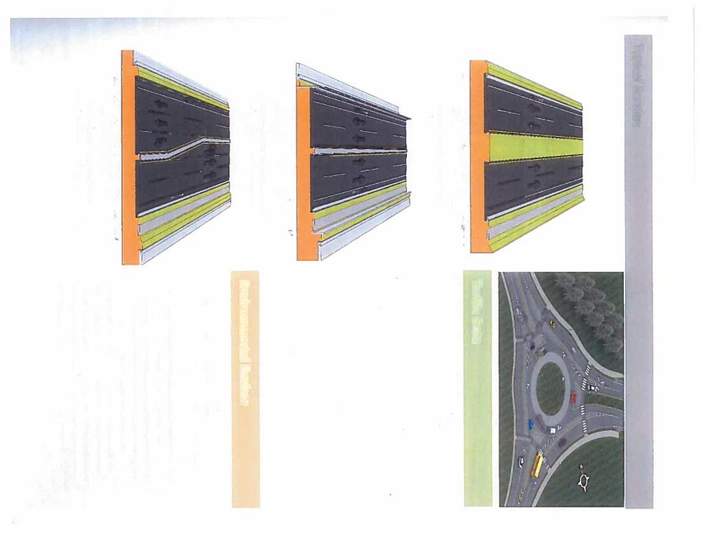
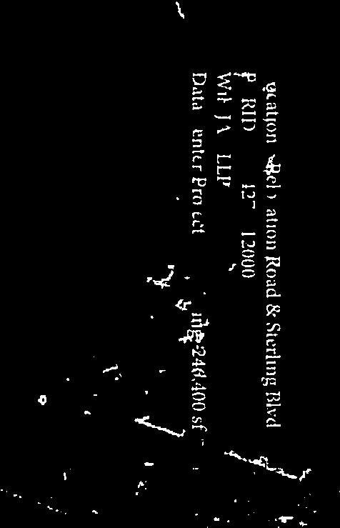
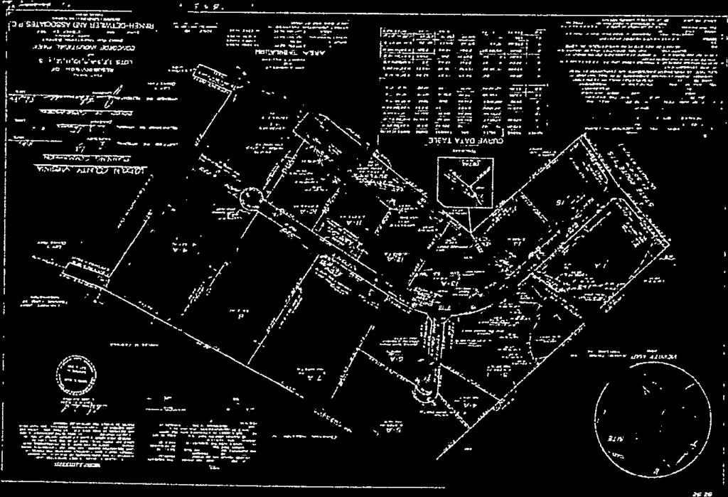
2 Item 6, Design Endorsement of Sterling Boulevard Board of Supervisors Business Meeting July 20, 2017 Page 2 property owners in the vicinity of the project. Written comments received after the May 26, 2016, meeting are included as Attachment 1. After receiving public feedback, three alignment alternatives were developed for the extension of Sterling Boulevard. Due to existing buildings and other site constraints, the three alignments follow the same path from Pacific Boulevard through Relocation Drive to the west side of the DCT Dulles Downs LLC property. Specifically, the proposed alignments will bi-sect Prologis Park between Pacific Boulevard and Relocation Drive. The intersection at Relocation Drive will be improved to add left and right turn-lanes on northbound and southbound Relocation Drive. A traffic signal is not warranted nor planned for this project at the Relocation Drive intersection. Stop signs are planned on Relocation Drive for traffic control. West of Relocation Drive, the proposed alignments are routed between the DCT Dulles Downs LLC development to the north and commercial properties to the south. A vicinity map is provided as Attachment 2. To complete the connection of Sterling Boulevard to Moran Road, the road must traverse through a 5.18 acre vacant parcel west of the DCT Dulles Downs LLC property that is currently being used as a contractor storage lot and a acre parcel owned by a subsidiary of Waste Management and operated as a waste transfer station, maintenance facility and storage yard. To navigate through these two properties, three alternative alignments have been developed. Alternative #1, (Roundabout) Figure 1 shows the Alternative #1 alignment that includes a roundabout where Sterling Boulevard intersects Moran Road. Figure 1 Alternative #1
3 Item 6, Design Endorsement of Sterling Boulevard Board of Supervisors Business Meeting July 20, 2017 Page 3 The Alternative #1 alignment minimizes impacts to the 5.18-acre undeveloped property and routes the road around the existing building and the majority of the storage yard on the Waste Management property. This alignment does isolate the northern portion of Waste Management s property, creating a 7.85 acre remnant. A portion of Moran Road would be relocated to the east and the existing roadway would be converted into a service road to access existing businesses. The acre undeveloped parcel to the west of the Waste Management property, a 2.33 acre portion of the parcel north of the Waste Management property, and a 5.53 acre portion of the parcel southwest of the Sterling Boulevard and Relocation Drive intersection would need to be acquired for stormwater management facilities. A plan showing this alignment is provided as Attachment 3. Alternative #2, (Northern Alignment) Figure 2 shows the Alternative #2 alignment that includes a tee intersection where Sterling Boulevard intersects Moran Drive. Since it is not warranted, a signal will not be installed at this intersection. This alignment reduces the amount of right-of-way that must be acquired from the Waste Management property, but would create a 5.45 acre remnant on the northern portion of the property. This alignment also requires the total acquisition of the acre undeveloped property directly east of the Waste Management property. A portion of Moran Road would be relocated to the east and the old roadway would be turned into a service road to provide access to existing businesses. Stormwater management would be provided on the 5.18-acre undeveloped property, the 2.03-acre undeveloped parcel to the west of Waste Management s site, on a 5.52 acre portion of the parcel southwest of the Sterling Boulevard and Relocation Drive intersection, and a 2.5 acre County owned property approximately 600 feet south of the roadway alignment. A plan showing this alignment is provided as Attachment 4. Figure 2 Alternative #2
4 Item 6, Design Endorsement of Sterling Boulevard Board of Supervisors Business Meeting July 20, 2017 Page 4 Alternative #3, (Southern Alignment) Figure 3 shows the Alternative #3 alignment that creates the most direct route of Sterling Boulevard between Pacific Boulevard and Moran Road, includes a tee intersection where Sterling Boulevard intersects Moran Road, minimizes the amount of land to be acquired from Waste Management, but it directly impacts the Waste Management existing operations and administration building requiring its onsite relocation. Since it is not warranted, a signal will not be installed at the Sterling Boulevard and Moran Road intersection with this project. Stormwater management would be provided on the Waste Management property, on a 4.81 acre portion of the parcel southwest of the Sterling Boulevard and Relocation Drive intersection, and a 2.5 acre County owned property approximately 600 feet south of the roadway alignment. A plan showing this alignment is provided as Attachment 5. Figure 3 Alternative #3 ISSUES: The roadway corridor for this segment of Sterling Boulevard traverses through a developed area and will impact existing businesses. In particular, right-of-way must be acquired from Waste Management for each alignment alternative. The amount of right-of-way that must be acquired will directly impact the roadway cost. Numerous underground utilities also exist within the roadway corridor and the selected alignment alternative will affect utility relocation costs. The geometric characteristics of each alignment alternative will have some effect on traffic operations. Alternative #3 requires an onsite relocation of existing administration and maintenance buildings. These building relocations can be timely, costly and would negatively impact the project schedule as the building relocations need to occur before road construction can be initiated or completed in this vicinity.
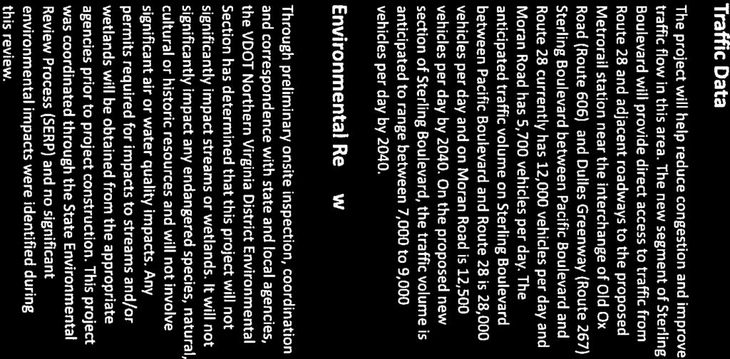
5 Item 6, Design Endorsement of Sterling Boulevard Board of Supervisors Business Meeting July 20, 2017 Page 5 Traffic Operations: None of the three alignment options propose traffic signals along this segment of Sterling Boulevard as signal warrants are not met. Only the existing signal at Sterling Boulevard and Pacific Boulevard will be modified as part of this project. Alternative #1 includes a roundabout that will affect the flow of through traffic on Sterling Boulevard. Specifically, this alternative includes one through lane by-passing the roundabout in the eastbound direction (the second eastbound lane must navigate through the roundabout) and all westbound traffic must navigate through the roundabout in one lane (the second lane ties into northbound Moran Road and does not connect back to Sterling Boulevard). Alternatives #2 and #3 maintain a four-lane divided section of Sterling Boulevard for the entire roadway segment. As a result, Alternative #1 will reduce the through speed of Sterling Boulevard and reduce the through capacity of the roadway compared to Alternatives #2 and #3. Alternative #1 provides an intersection configuration that allows for future expansion of Moran Road to four lanes as it is currently depicted on the Countywide Transportation Plan (CTP) without introducing a future signal along this segment of Sterling Boulevard, but requires the transition of Moran Road to two lanes beyond the roundabout. With Alternatives #2 and #3, future expansion of Moran Road to four lanes including a bridge over Route 28 as currently depicted on the CTP will likely require the installation of a signal at the Sterling Boulevard and Moran Road tee intersection in the future due to the projected traffic increase on Moran Road. As part of the Silver Line Comprehensive Plan Amendment (CPAM ), the ultimate condition of Moran Road is being altered from a four lane urban road to a two lane urban road with bicycle lanes. Therefore, the need to expand Moran Road in the future may not be required. Right-of-Way Acquisition: A sizable right-of-way acquisition effort is anticipated for this project as all the proposed alignments are traversing a significantly developed and narrow corridor. Alternative #1 requires acquisition of approximately 19.0 acres of right-of-way along with 0.4 acres of permanent easements and 4.4 acres of temporary easements. Right-of-way acquisition will affect six parcels. Alternative #2 requires acquisition of approximately 18.6 acres of right-of-way along with 0.4 acres of permanent easements and 6.1 acres of temporary easements. Right-of-way acquisition will affect six parcels. Alternative #3 requires acquisition of approximately 12.5 acres of right-of-way, will require the relocation of approximately 38,000 square feet of buildings, along with 0.3 acres of permanent easements and 2.7 acres of temporary easements. Right-of-way acquisition will affect five parcels. It is important to note that sizable right-of-way acquisition will be required from the Waste Management property for all alternatives. On March 16, 2017, Department of Transportation and Capital Infrastructure (DTCI) staff met with representatives of Waste Management and reviewed the three alignment alternatives. Waste Management expressed its desire to work with the County to develop the road and to convey the necessary land as long as Waste Management receives equitable compensation for the land and facility adjustments and the impacts do not restrict the facility s current operations.
6 Item 6, Design Endorsement of Sterling Boulevard Board of Supervisors Business Meeting July 20, 2017 Page 6 After further discussion, Waste Management concluded they could not support Alternative #1 since the large amount of land to be acquired by the County would have too great an impact on their facility operations. Waste Management agreed to further analyze Alternatives #2 and #3 to determine facility modifications necessary to maintain their current operations. Based on initial feedback from Waste Management, Alternative #2 would require some reconfiguration of the facility parking lot and storage areas. Alternative #3 would require the construction of new office space, truck maintenance and transfer buildings as well as new parking, storage areas, and scale. Utility Relocation: Existing utilities including overhead and underground electrical, overhead cable television, underground telephone, underground fiber optic communication, underground water, underground sanitary sewer, and underground natural gas are present within the roadway corridor. The three alternative alignments impact these utilities in various ways. The preliminary estimated cost to relocate utilities impacted by Alternative #1 is approximately $3,400,000, relocation cost for Alternative #2 is approximately $2,600,000, and relocation cost for Alternative #3 is approximately $1,500,000. Project Schedule: The road design is at approximately 30%. The design alternative must be selected to progress the design further. The time needed to progress the design to completion, to acquire rightof-way, and to relocate utilities is approximately 24 to 30 months. The time necessary to construct the road is approximately 15 months. If Alternative #3 is utilized, an additional 18 to 24 months are needed since construction of the road cannot commence on the Waste Management property until the new office space, truck maintenance building, transfer building, storage areas, and parking areas are built and the existing facilities are demolished. Therefore, the opening date for Alternatives #1 and #2 is approximately fall 2020 to spring The opening date for Alternative #3 is approximately spring 2022 to spring Overall Project Budget: Table 1 presents the estimated project costs for the three alternatives. Table 1 -- Preliminary Cost Estimates for Sterling Boulevard Extension Alternatives Project Activity Alternative #1 Alternative #2 Alternative #3 Design $1,800,000 $1,800,000 $2,000,000 Right-of-Way Acquisition $5,800,000 $5,400,000 $3,400,000 Utility Relocation $3,400,000 $2,600,000 $1,500,000 Construction (Including Contingency) $11,200,000 $9,800,000 $8,900,000 Testing and Inspection Services $2,000,000 $1,700,000 $1,400,000 Modifications to Waste Management Facility $3,800,000 $3,800,000 $4,800,000 Design and Construction of New Buildings $8,800,000 Total $28,000,000 $25,100,000 $30,800,000 Summary of Considerations: As noted above, this project is heavily dependent on acquiring right-ofway since the roadway corridor is located in a commercially developed area. In particular, all alternatives require the acquisition of right-of-way from the Waste Management property. Based on
7 Item 6, Design Endorsement of Sterling Boulevard Board of Supervisors Business Meeting July 20, 2017 Page 7 preliminary discussions with company representatives, Waste Management is willing to work with the County to develop Alternatives #2, or #3 if equitable compensation is provided for land acquired and impacted facilities are replaced. Waste Management does not support Alternative #1 since it will not allow their facility to operate at current capacity due to the proposed land area reduction. Although Alternative #3 is a more ideal roadway layout than Alternative #2, the cost to develop Alternative #3 exceeds the current project budget and will take 18 to 24 additional months to complete. Alternatives #2 and #3 have similar traffic operations and both alternatives provide for unimpeded flow through traffic on Sterling Boulevard. DTCI staff recommends Alternative #2 since it can be developed within the available budget, has an estimated cost $5,700,000 less than Alternative #3, and can be delivered approximately 18 to 24 months sooner than Alternative #3. FISCAL IMPACT: A total of $24,129,000 has been appropriated for the Sterling Boulevard Extension (Pacific Boulevard to Moran Road) capital project for design, right-of-way acquisition, utility relocation, and construction. The preliminary cost estimates for the three alternatives show all the alternatives are over the appropriated budget. Alternative #2 has the least impact with preliminary costs approximately $1,000,000 over the existing budget. Alternates #1 and #3 have preliminary costs approximately $3,900,000 and $6,700,000 over the existing budget, respectively. ALTERNATIVES: 1. The Board could endorse Alternative #2 and request staff to monitor project costs as the road design advances and more refined cost estimates are developed to determine if additional funding is required. 2. The Board could endorse Alternative #3 and request staff to develop a plan to fund the outstanding costs not currently budgeted in the project. 3. The Board could endorse Alternative #1 and request staff to develop a plan to fund the outstanding costs not currently budgeted in the project. 4. The Board could request staff to consider another alternative. DRAFT MOTIONS: 1. I move that the Board of Supervisors endorse Alternative #2 (Northern Alignment) for the Sterling Boulevard Extension project as outlined in the July 20, 2017, Board of Supervisors Business Meeting Action Item and request staff to monitor project costs as the road design advances and more refined cost estimates are developed to determine if additional funding is required. OR 2. I move that the Board of Supervisors endorse Alternative #3 (Southern Alignment) for the Sterling Boulevard Extension project as outlined in the July 20, 2017, Board of Supervisors Business Meeting Action Item and request staff to develop a plan to fund the outstanding costs not currently budgeted in the project.
8 Item 6, Design Endorsement of Sterling Boulevard Board of Supervisors Business Meeting July 20, 2017 Page 8 OR 3. I move an alternate motion. ATTACHMENTS: 1. Written Feedback from May 26, 2016, Public Meeting 2. Vicinity Map 3. Design Alternative #1 4. Design Alternative #2 5. Design Alternative #3

9 ATTACHMENT 1
10
11


12


13


14


15


16


17


18


19
20


21
22
23
24
25

26 6/20/2017 Google Maps d sd ow ns LL C d ulle 28 var TD Route e DC log is P ark Pac Pro ific Rel Bo oca ule tion Mor Driv oa an R vard ule g Bo lin Ster Imagery 2017 Google, Map data 2017 Google 500 ft ATTACHMENT ,1028m/data=!3m1!1e3?hl=en 1/1
27 Figure 1 Alternative #1 ATTACHMENT 3
28 Figure 2 Alternative #2 ATTACHMENT 4
29 Figure 3 Alternative #3 ATTACHMENT 5
Public Information Workshop
 Public Information Workshop Charlotte County-Punta Gorda MPO - Meeting Rooms A and B March 29, 2018 Welcome to the Public Information Workshop for Harborview Road Project Development and Environment (PD&E)
ARLINGTON COUNTY, VIRGINIA
 ARLINGTON COUNTY, VIRGINIA County Board Agenda Item Meeting of April 24, 2004 DATE: April 14, 2004 SUBJECT: Arlington Boulevard (U.S. 50) Bridge Deck Replacement at Washington Boulevard - Overhead Utility
STH 60 Northern Reliever Route Feasibility Study Report
 #233087 v3 STH 60 Northern Reliever Route Feasibility Study Report Washington County Public Works Committee Meeting September 28, 2016 1 STH 60 Northern Reliever Route Feasibility Study Hartford Area Development
TIMBERVINE TRANSPORTATION IMPACT STUDY FORT COLLINS, COLORADO JANUARY Prepared for:
 TIMBERVINE TRANSPORTATION IMPACT STUDY FORT COLLINS, COLORADO JANUARY 2014 Prepared for: Hartford Companies 1218 W. Ash Street Suite A Windsor, Co 80550 Prepared by: DELICH ASSOCIATES 2272 Glen Haven Drive
Table of Contents INTRODUCTION... 3 PROJECT STUDY AREA Figure 1 Vicinity Map Study Area... 4 EXISTING CONDITIONS... 5 TRAFFIC OPERATIONS...
 Crosshaven Drive Corridor Study City of Vestavia Hills, Alabama Table of Contents INTRODUCTION... 3 PROJECT STUDY AREA... 3 Figure 1 Vicinity Map Study Area... 4 EXISTING CONDITIONS... 5 TRAFFIC OPERATIONS...
PUBLIC INFRASTRUCTURE PROJECTS
 PUBLIC INFRASTRUCTURE PROJECTS FM 664 / OVILLA ROAD WIDENING & IMPROVEMENTS FM 664 / OVILLA ROAD CONNECTS US 287 WITH I-45 (SOURCE: TEXAS DEPARTMENT OF TRANSPORTATION. 2016 FM 664 / OVILLA ROAD WIDENING
Reston Transportation Strategy July 9, 2018
 Reston Transportation Strategy July 9, 2018 Background: On February 11, 2014, the Board of Supervisors adopted the Reston Phase I Comprehensive Plan Amendment for the core areas of Reston between Sunset
City of Palo Alto (ID # 6416) City Council Staff Report
 City Council Staff Report") City of Palo Alto (ID # 6416) City Council Staff Report Report Type: Informational Report Meeting Date: 1/25/2016 Summary Title: Update on Second Transmission Line Title: Update on Progress Towards Building
City of Palo Alto (ID # 6416) City Council Staff Report Report Type: Informational Report Meeting Date: 1/25/2016 Summary Title: Update on Second Transmission Line Title: Update on Progress Towards Building
Location Concept Plan Amendment Recommendation Approved 2011 Concept Plan
 Valley Line West LRT Concept Plan Recommended Amendments Lewis Farms LRT Terminus Site Location Concept Plan Amendment Recommendation Approved 2011 Concept Plan Lewis Farms LRT terminus site, 87 Avenue/West
Rolling Road (Route 638) Widening Project
 Widening Project") Rolling Road (Route 638) Widening Project From: 0.369 Mile North of Fairfax County Parkway (Route 286) To: Old Keene Mill Road (Route 644) State Project No. 0638-029-156, P104, R204, C504; UPC 5559 Public
Rolling Road (Route 638) Widening Project From: 0.369 Mile North of Fairfax County Parkway (Route 286) To: Old Keene Mill Road (Route 644) State Project No. 0638-029-156, P104, R204, C504; UPC 5559 Public
TRAFFIC IMPACT ANALYSIS
 TRAFFIC IMPACT ANALYSIS Emerald Isle Commercial Development Prepared by SEPI Engineering & Construction Prepared for Ark Consulting Group, PLLC March 2016 I. Executive Summary A. Site Location The Emerald
Transportation Analysis. Pedestrian Pathways. Sterling District. County Project Manager: Suheili Pérez-Jiménez. Prepared by: J2 Engineers, Inc.
 Transportation Analysis Pedestrian Pathways Prepared for: Loudoun County Department of Transportation and Capital Infrastructure County Project Manager: Suheili Pérez-Jiménez Prepared by: J2 Engineers,
2 MAJOR MACKENZIE DRIVE WEST JOG ELIMINATION AT HUNTINGTON ROAD CITY OF VAUGHAN
 2 MAJOR MACKENZIE DRIVE WEST JOG ELIMINATION AT HUNTINGTON ROAD CITY OF VAUGHAN The Transportation Services Committee recommends the adoption of the recommendations contained in the following report dated
City of Houston Fondren Road Paving and Drainage
 City of Houston Fondren Road Paving and Drainage From Braeswood Boulevard to Creekbend Drive TRC Meeting March 2016 Location and Vicinity Maps City Council District K Key Map 530 Z, 530 Y Land Use Commercial
STAFF REPORT. To: Planning Commission Meeting date: April 12, 2017 Item: UN Prepared by: Robert Eastman
 # 5 ) UN-15-17 LA SIERRA AUTO SALES SPECIAL USE PERMIT VEHICLE SALES PUBLIC HEARING STAFF REPORT To: Planning Commission Meeting date: April 12, 2017 Item: UN-15-17 Prepared by: Robert Eastman GENERAL
I-820 (East) Project Description. Fort Worth District. Reconstruct Southern I-820/SH 121 Interchange
 Project Description. Fort Worth District. Reconstruct Southern I-820/SH 121 Interchange") I-820 (East) Project Description Fort Worth District Reconstruct Southern I-820/SH 121 Interchange I-820 from approximately 2,000 feet north of Pipeline Road/Glenview Drive to approximately 3,200 feet
I-820 (East) Project Description Fort Worth District Reconstruct Southern I-820/SH 121 Interchange I-820 from approximately 2,000 feet north of Pipeline Road/Glenview Drive to approximately 3,200 feet
Update on Transportation Activities in Fairfax County
 Update on Transportation Activities in Fairfax County Transportation Roundtable Dulles Area Transportation Association June 13, 2018 Tom Biesiadny, Director Fairfax County Continuing Project Implementation
Committee Report. Transportation Committee. Business Item No
 Committee Report Business Item No. 2015-280 Transportation Committee For the Metropolitan Council meeting of December 9, 2015 Subject: METRO Blue Line Extension (Bottineau Light Rail Transit) Revised Scope
LAWRENCE TRANSIT CENTER LOCATION ANALYSIS 9 TH STREET & ROCKLEDGE ROAD / 21 ST STREET & IOWA STREET LAWRENCE, KANSAS
 LAWRENCE TRANSIT CENTER LOCATION ANALYSIS 9 TH STREET & ROCKLEDGE ROAD / 21 ST STREET & IOWA STREET LAWRENCE, KANSAS TRAFFIC IMPACT STUDY FEBRUARY 214 OA Project No. 213-542 TABLE OF CONTENTS 1. INTRODUCTION...
CITY OF ANN ARBOR, MICHIGAN 301 E. Huron St., P.O. Box 8647 Ann Arbor, Michigan
 Date: Wednesday, June 24, 2014 Location: Ann Arbor District Library Attendees: 40 citizen attendees Ann Arbor Station Environmental Review Public Meeting Meeting Notes Meeting #2 The second public meeting
5 VAUGHAN METROPOLITAN CENTRE AND SURROUNDING AREAS TRANSPORTATION STUDY PROGRESS
 5 VAUGHAN METROPOLITAN CENTRE AND SURROUNDING AREAS TRANSPORTATION STUDY PROGRESS The Transportation Services Committee recommends the adoption of the recommendations contained in the following report
City of Marina. Regional Roundabout Study Utilizing Caltrans Intersection Control Evaluation Section 4: Transportation Agency for Monterey County
 Regional Roundabout Study Utilizing Caltrans Intersection Control Evaluation Section 4: City of Marina Study Intersections: RESERVATION ROAD AT BEACH ROAD RESERVATION ROAD AT DEFOREST ROAD CARDOZA AVENUE
Wentzville Parkway South Phase 2 & 2A
 Wentzville Parkway South Phase 2 & 2A Sponsor Wentzville Project No. RB18-000034 Project Type New Road TOTAL FUNDING Phase 2 Total County Sponsor Federal $10,000,000 $8,000,000 $2,000,000 $0 Phase 2A Total
Letter EL652 City of Mercer Island. Page 1. No comments n/a
 Letter EL652 City of Mercer Island Page 1 No comments n/a Page 2 Response to comment EL652 1 Section 4.5.3 of the Final EIS presents the range of potential impacts of the project. This project also lists
2.0 Development Driveways. Movin Out June 2017
 Movin Out June 2017 1.0 Introduction The proposed Movin Out development is a mixed use development in the northeast quadrant of the intersection of West Broadway and Fayette Avenue in the City of Madison.
Sound Transit East Link: Bus/LRT System Integration Study
 Sound Transit East Link: Bus/LRT System Integration Study Prepared For: Sound Transit King County Metro Mercer Island WSDOT Prepared By: CH2M HILL July, 2014 1 SOUND TRANSIT EAST LINK: BUS/LRT SYSTEMES
Continued coordination and facilitation with City of Austin staff on documentation of processes to permit construction activities at the site.
 Project Manager Ed Collins LJA Engineering, Inc. Transportation Planning Manager 5316 Highway 290 West Austin Public Infrastructure Group Austin, TX 78735 (512) 762-6301 cell (512) 439-4757 office CARTS
BOARD OF SUPERVISORS BUSINESS MEETING ACTION ITEM
 BOARD OF SUPERVISORS BUSINESS MEETING ACTION ITEM Date of Meeting: April 21, 216 # 6 SUBJECT: ELECTION DISTRICT: CRITICAL ACTION DATE: STAFF CONTACTS: Response to Board Member Initiative: Safety Improvements
Town of Londonderry, New Hampshire NH Route 28 Western Segment Traffic Impact Fee Methodology
 Town of Londonderry, New Hampshire NH Route 28 Western Segment Traffic Impact Fee Methodology Prepared by the Londonderry Community Development Department Planning & Economic Development Division Based
EXCEPTION TO STANDARDS REPORT
 EXCEPTION TO STANDARDS REPORT PROJECT DESCRIPTION AND NEED The project is located in Section 6, Township 23 North, Range 9 East and Section 31 Township 24 North, Range 9 East, in the Town of Stockton,
Prince George CNG Operations and Maintenance Facility Project BC Transit
 Prince George CNG Operations and Maintenance Facility Project BC Transit Prepared by March 16, 2017 March 16, 2017 Prince George Transit Operations and Maintenance CNG Facility Project Page 1 TABLE OF
Link LRT: Maintenance Bases, Vehicles and Operations for ST2 Expansion
 Project Number SYS-LRT Subareas All Primary Mode Impacted Link Facility Type Link Service Version Number 4.0 Date Last Modified 7/24/2008 Project Locator Map Short Project Description Construct new light
Preliminary Definition of Alternatives. 3.0 Preliminary Definition of Alternatives
 3.0 What preliminary alternatives are being evaluated? The alternatives for the East San Fernando Valley Transit Corridor project that were considered for screening include the No Build Alternative, Transportation
LCPS Valley Service Center
 Traffic Impact Study LCPS Valley Service Center Loudoun County, Virginia November 4, 2015 Prepared For: Loudoun County Public Schools 21000 Education Court Ashburn, VA 20148 Prepared by: 1140 Connecticut
Traffic Engineering Study
 Traffic Engineering Study Bellaire Boulevard Prepared For: International Management District Technical Services, Inc. Texas Registered Engineering Firm F-3580 November 2009 Executive Summary has been requested
/ Planning and Zoning Staff Report Lonestar Land, LLC. - Rezone, RZ
 / Planning and Zoning Staff Report Lonestar Land, LLC. - Rezone, RZ2018-0019 Hearing Date: October 18, 2018 Development Services Department Applicant: Lonestar Land, LLC. Representative: Lance Warnick
June WASHINGTON STATE DEPARTMENT OF TRANSPORTATION Alaskan Way Viaduct and Seawall Replacement Program Seattle, Washington
 DESIGN DEVIATION NOs. 1 & 2 Horizontal Stopping Sight Distance and Shoulder Width Reduction SR 99 S. Holgate St to S. King St. Viaduct Replacement Stage 2 MP 29.89 TO MP 30.78 XL-3237 PIN-809936D June
Terminal Alternatives
 Chapter 5 Terminal Alternatives Missoula International Airport Master Plan Update Prepared for Missoula County Airport Authority OCTOBER 2008 Contents Section Page 5 Terminal Alternatives...5-1 5.1 Terminal
CAPITAL FUND 9510 STREET & SIDEWALK IMPROVEMENTS FIVE-YEAR CAPITAL IMPROVEMENT PROGRAM FISCAL YEARS
 9510 STREET & SIDEWALK IMPROVEMENTS FIVE-YEAR CAPITAL IMPROVEMENT PROGRAM FISCAL YEARS 2019-2023 9510 STREET & SIDEWALK IMPROVEMENTS - 01 STREET AND SIDEWALK MAINTENANCE PROGRAM $1,250,000 $0 $1,250,000
Technical Memorandum. To: From: Date: October 14 th, 2018 Project #: 1302 Project Name: Subject: Distribution:
 Technical Memorandum To: Tom Hanrahan Jeff Sharp From: Date: October 14 th, 2018 Project #: 1302 Project Name: Subject: Distribution: Barrie Lockhart Road LP Conformity Review Scott Young Sorbara Group
Agenda. Utility Undergrounding Strategies & Laguna Canyon Road Master Plan
 Utility Undergrounding Strategies & Laguna Canyon Road Master Plan January 17, 2017 City Council Meeting 2 Agenda Progress since March 2016 Status of undergrounding and road widening between El Toro Rd.
TRAFFIC IMPACT STUDY. USD #497 Warehouse and Bus Site
 TRAFFIC IMPACT STUDY for USD #497 Warehouse and Bus Site Prepared by: Jason Hoskinson, PE, PTOE BG Project No. 16-12L July 8, 216 145 Wakarusa Drive Lawrence, Kansas 6649 T: 785.749.4474 F: 785.749.734
Public Meeting: Metropolitan Washington Airports Authority (MWAA) TNC (Transportation Network Company) Lot on S. Eads Street
 TNC (Transportation Network Company) Lot on S. Eads Street") Public Meeting: Metropolitan Washington Airports Authority (MWAA) TNC (Transportation Network Company) Lot on S. Eads Street Department of Environmental Services, Transportation Division Sept. 27, 2018
Public Meeting: Metropolitan Washington Airports Authority (MWAA) TNC (Transportation Network Company) Lot on S. Eads Street Department of Environmental Services, Transportation Division Sept. 27, 2018
BROWARD BOULEVARD CORRIDOR TRANSIT STUDY
 BROWARD BOULEVARD CORRIDOR TRANSIT STUDY FM # 42802411201 EXECUTIVE SUMMARY July 2012 GOBROWARD Broward Boulevard Corridor Transit Study FM # 42802411201 Executive Summary Prepared For: Ms. Khalilah Ffrench,
Business Advisory Committee. July 7, 2015
 Business Advisory Committee July 7, 2015 1 Today s Topics Outreach Update TI #1 and 2: Target Field Station Connection to I-94: Recommendation 85 th Station Configuration 93 rd Station Configuration DEIS
HIGHWAY 28 FUNCTIONAL DESIGN
 HIGHWAY 28 FUNCTIONAL DESIGN PUBLIC OPEN HOUSE #1 WEDNESDAY, MARCH 12, 2014 Stantec Presenters: Brad Vander Heyden, Project Engineer Neal Cormack, Project Manager Dave Parker, Project Engineer Beth Thola,
West Broadway Reconstruction/LRT Design. March 19, 2015
 West Broadway Reconstruction/LRT Design March 19, 2015 1 Meeting Agenda 6:05 6:30 PM Brief presentation What we heard Project overview 6:30 8:00 PM Visit Six Topic Areas Road and LRT design elements Pedestrian
I-494/I-35 Interchange Vision Layout Development - BRT Station Concepts S.P B SEH No
 TECHNICAL MEMORANDUM TO: FROM: Transit Advisory Group Jeff Rhoda DATE: RE: I-494/I-35 Interchange Vision Layout Development - BRT Station Concepts S.P. 2785-330B SEH No. 123252 04.00 I-494/I-35W Interchange
Clearlake Road (State Road 501) Project Development & Environment (PD&E) Study
 Project Development & Environment (PD&E) Study") Clearlake Road (State Road 501) Project Development & Environment (PD&E) Study FROM MICHIGAN AVENUE TO INDUSTRY ROAD BREVARD COUNTY, FLORIDA Financial Project ID No: 433605-1-22-01 Federal Aid Project
Clearlake Road (State Road 501) Project Development & Environment (PD&E) Study FROM MICHIGAN AVENUE TO INDUSTRY ROAD BREVARD COUNTY, FLORIDA Financial Project ID No: 433605-1-22-01 Federal Aid Project
Peninsula Corridor Electrification Project (PCEP)
") Peninsula Corridor Electrification Project (PCEP) Q4 Quarterly Update #11 April 1 June 30, 2017 JPB Board Meeting August 3, 2017 Agenda Item # 8a Electrification - Infrastructure Design Build Contract
Peninsula Corridor Electrification Project (PCEP) Q4 Quarterly Update #11 April 1 June 30, 2017 JPB Board Meeting August 3, 2017 Agenda Item # 8a Electrification - Infrastructure Design Build Contract
5. HORIZON YEAR TRANSPORTATION MASTER PLAN-COST ESTIMATES
 5. HORIZON YEAR TRANSPORTATION MASTER PLAN-COST ESTIMATES 5.1 INTRODUCTION This chapter of the TMP presents an opinion of probable cost estimates for the proposed Horizon Year roadway network improvements
Project Description: Georgia Department of Transportation Public Information Open House Handout PI#(s): , County: Muscogee
: , County: Muscogee") Why We Are Here: GDOT s Transportation Improvement Act (TIA) Office, the City of Columbus, and the project delivery team are here this evening to display and answer questions concerning the proposed roadway
Why We Are Here: GDOT s Transportation Improvement Act (TIA) Office, the City of Columbus, and the project delivery team are here this evening to display and answer questions concerning the proposed roadway
FEASIBILITY REPORT. 65 th STREET TRUNK WATER MAIN IMPROVEMENTS INVER GROVE HEIGHTS MINNESOTA DAKOTA COUNTY. October 2, 2017
 FEASIBILITY REPORT 65 th STREET TRUNK WATER MAIN IMPROVEMENTS INVER GROVE HEIGHTS MINNESOTA DAKOTA COUNTY October 2, 2017 Prepared for: City of Inver Grove Heights 8150 Barbara Avenue Inver Grove Heights,
Attachment D Environmental Justice and Outreach
 Attachment D Environmental Justice and Outreach ATTACHMENT D Environmental Justice and Outreach Indicate whether the project will have disproportionately high and adverse impacts on minority or low income
Harlem Avenue between 63 rd and 65 th
 Harlem Avenue between 63 rd and 65 th Public Meeting #2 March 13, 2018 Summit Park District Welcome to the second Public Meeting for the preliminary engineering and environmental studies of Illinois 43
US 81 Bypass of Chickasha Environmental Assessment Public Meeting
 US 81 Bypass of Chickasha Environmental Assessment Public Meeting March 14, 2013 Introductions ODOT FHWA SAIC Meeting Purpose Present need for bypass Provide responses to 10/04/11 public meeting comments
STAFF REPORT # CHANGE OF ZONING
 STAFF REPORT #17-2000-0007 CHANGE OF ZONING PLANNING COMMISSION MEETING DATE: November 16, 2017 (Applicant Provided Materials / Traffic Study = Blue) 1. APPLICATION: A public hearing for an application
Received June 2, 2017 PLN-PUDC
 MASTER LAND USE PLAN for: a prestigious community presented by: Breeden Investment Properties and Davenport Management Company Virginia Beach, Virginia 23452(757) 468-6800 Received PLN-PUDC-2016-008 page
Executive Summary. Draft Environmental Impact Statement/Environmental Impact Report ES-1
 Executive Summary Introduction The Eastside Transit Corridor Phase 2 Project is a vital public transit infrastructure investment that would provide a transit connection to the existing Metro Gold Line
Midtown Corridor Alternatives Analysis Capital Cost Estimation Methodology and Assumptions
 Midtown Corridor Alternatives Analysis Capital Cost Estimation Methodology and Assumptions 1/3/2014 Prepared by the SRF Consulting Group Team for Table of Contents Introduction... 1 Alternatives Overview...
The Eastern Connector Study November, 2007 planning for the future
 The Eastern Connector Study November, 2007 planning for the future In late 2006, Albemarle County and the City of Charlottesville jointly initiated the Eastern Connector Corridor Study. The Project Team
CHAIR AND MEMBERS CIVIC WORKS COMMITTEE MEETING ON FEBRUARY 6, 2018
 TO: FROM: SUBJECT: CHAIR AND MEMBERS CIVIC WORKS COMMITTEE MEETING ON FEBRUARY 6, 2018 KELLY SCHERR, P.ENG., MBA, FEC MANAGING DIRECTOR, ENVIRONMENTAL & ENGINEERING SERVICES AND CITY ENGINEER HAMILTON
5 June 12, 2013 Public Hearing APPLICANT: BARTON HERITAGE, LLC T/A SANDBRIDGE BEACH BUGGIES PROPERTY OWNER: LOWER 40, LLC
 REQUEST: Conditional Use Permit (motor vehicle rentals low speed vehicles) ADDRESS / DESCRIPTION: 3713 Sandpiper Road 5 June 12, 2013 Public Hearing APPLICANT: BARTON HERITAGE, LLC T/A SANDBRIDGE BEACH
SH 249 IN GRIMES COUNTY. Open House April 3, 2014
 SH 249 IN GRIMES COUNTY Open House April 3, 2014 Meeting Agenda Purpose of Meeting Today: Review the purpose and need for the SH 249 Grimes County project Review the proposed project and alternatives Discuss
Summary of the Alcoa Highway Redevelopment Project
 Appendix B Summary of the Alcoa Highway Redevelopment Project By Marcia Finfer, October 2009 The Timberlake community, along with numerous other concerned citizen groups (including the Lakemoor Hills community)
Report Date: May 18, 2012 Contact: Al Zacharias Contact No.: RTS No.: 9587 VanRIMS No.: Meeting Date: June 12, 2012
 A5 ADMINISTRATIVE REPORT Report Date: May 18, 2012 Contact: Al Zacharias Contact No.: 604.873.7214 RTS No.: 9587 VanRIMS No.: 08-2000-21 Meeting Date: June 12, 2012 TO: FROM: SUBJECT: Vancouver City Council
Construction Staging Area 4 Avenue Road
 REPORT FOR ACTION Construction Staging Area 4 Avenue Road Date: September 27, 2017 To: Toronto and East York Community Council From: Acting Director, Transportation Services, Toronto and East York District
BARRHAVEN FELLOWSHIP CRC 3058 JOCKVALE ROAD OTTAWA, ONTARIO TRANSPORTATION BRIEF. Prepared for:
 BARRHAVEN FELLOWSHIP CRC 3058 JOCKVALE ROAD OTTAWA, ONTARIO TRANSPORTATION BRIEF Prepared for: Barrhaven Fellowship CRC 3058 Jockvale Road Ottawa, ON K2J 2W7 December 7, 2016 116-649 Report_1.doc D. J.
PROJECT: Wilkinson Road Corridor Improvement Traffic Management Planning Project SUBJECT: Traffic Analysis
 TECHNICAL MEMORANDUM DATE: September 10, 2014 PROJECT 5861.03 NO: PROJECT: Wilkinson Road Corridor Improvement Traffic Management Planning Project SUBJECT: Traffic Analysis TO: Steve Holroyd - District
2017 Industrial Rail and Transportation Study. Becker, Minnesota
 2017 Industrial Rail and Transportation Study Becker, Minnesota BECKR 140932 August 2, 2017 2017 Industrial Rail and Transportation Study Becker, Minnesota SEH No. BECKR 140932 August 2, 2017 I hereby
DEVELOPMENT PROPERTY 1627 MAXIME STREET CITY OF OTTAWA TRANSPORTATION OVERVIEW. Prepared for: Subhas Bhargava. July 9, Overview_1.
 DEVELOPMENT PROPERTY 1627 MAXIME STREET CITY OF OTTAWA TRANSPORTATION OVERVIEW Prepared for: Subhas Bhargava July 9, 2015 115-620 Overview_1.doc D. J. Halpenny & Associates Ltd. Consulting Transportation
Regional Transportation System The regional transportation system is discussed in Chapter 5, Section 5.7.
 6.7 TRAFFIC 6.7.1 Affected Environment Regional Transportation System The regional transportation system is discussed in Chapter 5, Section 5.7. Local Transportation System The proposed Dillingham Trail
Section III Transportation and Stormwater Projects Receiving Additional Funding Project Detail Sheets Alphabetical Listing by Project Name Five Year
 Section III Transportation and Stormwater Projects Receiving Additional Funding Project Detail Sheets Alphabetical Listing by Project Name Five Year Capital Improvement Plan FY2015/2016 through FY2020
MOTION NO. M Preferred Alternative for the Puyallup Station Access Improvement Project
 MOTION NO. M2014 64 Preferred Alternative for the Puyallup Station Access Improvement Project MEETING: DATE: TYPE OF ACTION: STAFF CONTACT: Capital Committee Board PROPOSED ACTION 8/14/14 8/28/14 Recommendation
Business Item No
 Business Item No. 2014-162 Metropolitan Council Meeting date: July 9, 2014 Subject: Southwest Light Rail Transit (Green Line Extension): Kenilworth Corridor Public Ownership Memorandum of Understanding
ANDERSON PROPERTY SITE ANALYSIS
 ANDERSON PROPERTY SITE ANALYSIS Introduction The Montgomery County Department of Transportation (MCDOT) initiated a feasibility study in the fall of 2012 to evaluate the need for transit service expansion
CITY OF ANN ARBOR, MICHIGAN 301 E. Huron St., P.O. Box 8647 Ann Arbor, Michigan
 Date: Wednesday, June 18, 2014 Location: Ann Arbor District Library Attendees: 14 citizen attendees Ann Arbor Station Environmental Review Citizen Working Group Meeting Notes Meeting #3 The third meeting
City of Grand Forks Staff Report
 City of Grand Forks Staff Report Service/Safety Committee December 15, 2015 City Council December 21, 2015 Agenda Item: Amendment No. 1 to Engineering Services Agreement with CPS for City Project No. 7143,
Alternatives Analysis Findings Report
 6.0 This chapter presents estimates of the potential capital, operations and maintenance costs associated with the alternatives carried forward for detailed evaluation. The methodology used to develop
Kendall Drive Premium Transit PD&E Study Project Kick-Off Meeting SR 94/Kendall Drive/SW 88 Street Project Development and Environment (PD&E) Study
 Study") Florida Department of Transportation District Six Kendall Drive Premium Transit PD&E Study Project Kick-Off Meeting SR 94/Kendall Drive/SW 88 Street Project Development and Environment (PD&E) Study What
Florida Department of Transportation District Six Kendall Drive Premium Transit PD&E Study Project Kick-Off Meeting SR 94/Kendall Drive/SW 88 Street Project Development and Environment (PD&E) Study What
Pacific Electric Right-of-Way / West Santa Ana Branch Corridor Alternatives Analysis
 Pacific Electric Right-of-Way / West Santa Ana Branch Corridor Alternatives Analysis Transit Coalition September 26, 2012 2 Study Area Pacific Electric Rightof-Way/West Santa Ana Branch (PEROW/ WSAB) extends
Open House. Highway212. Meetings. Corridor Access Management, Safety & Phasing Plan. 5:30 to 6:30 p.m. - Southwest Corridor Transportation Coalition
 Welcome Meetings 5:30 to 6:30 p.m. - Southwest Corridor Transportation Coalition 6:30 to 8:00 p.m. - Open House Why is Highway 212 Project Important? Important Arterial Route Local Support Highway 212
engineering phase and during the procurement of design build contracts.
 CONSIDERATION OF ALTERNATIVES Below-grade trench alignment along Aviation Boulevard, adjacent to LAX south runways. miles. MOS-Century would extend from the Metro Exposition Line to the Aviation/ Century
Exhibit A Sound Transit Board Resolution R Selecting the bicycle, pedestrian, and parking access improvements to be built for the Puyallup
 Exhibit A Sound Transit Board Resolution R2016-07 Selecting the bicycle, pedestrian, and parking access improvements to be built for the Puyallup Access Improvement Project. RESOLUTION NO. R2016-07 Selecting
MERIVALE PRIORITY SQUARE 2852 MERIVALE ROAD CITY OF OTTAWA TRANSPORTATION BRIEF. Prepared for: ONT Inc. 25 Winding Way Nepean, Ontario K2C 3H1
 MERIVALE PRIORITY SQUARE 2852 MERIVALE ROAD CITY OF OTTAWA TRANSPORTATION BRIEF Prepared for: 2190986ONT Inc. 25 Winding Way Nepean, Ontario K2C 3H1 October 6, 2010 110-502 Report_1.doc D. J. Halpenny
SAN RAFAEL CITY COUNCIL AGENDA REPORT
 Agenda Item No: 8.b Meeting Date: December 19, 2016 Department: PUBLIC WORKS SAN RAFAEL CITY COUNCIL AGENDA REPORT Prepared by: Bill Guerin, Public Works Director City Manager Approval: File No.: 18.01.79
V. DEVELOPMENT OF CONCEPTS
 Martin Luther King, Jr. Drive Extension FINAL Feasibility Study Page 9 V. DEVELOPMENT OF CONCEPTS Throughout the study process several alternative alignments were developed and eliminated. Initial discussion
Note: The October 2007 version of this report has been updated in this December 2008 report to present costs in year 2007 dollars.
 Sound Transit Phase 2 South Corridor LRT Design Report: SR 99 and I-5 Alignment Scenarios (S 200 th Street to Tacoma Dome Station) Tacoma Link Extension to West Tacoma Prepared for: Sound Transit Prepared
APPENDIX C. Existing Utilities
 APPENDIX C Existing Utilities THIS PAGE INTENTIONALLY BLANK Existing Utilities Numerous utilities exist within the project area, including natural gas, sewer, water, electric, communications, and street
11 October 12, 2011 Public Hearing APPLICANT:
 11 October 12, 2011 Public Hearing APPLICANT: CARING TRANSITIONS PROPERTY OWNER: HARDEE REALTY CORPORATION REQUEST: Conditional Use Permit (motor vehicle rental) STAFF PLANNER: Leslie Bonilla ADDRESS /
THE CORNERSTONE APARTMENTS TRAFFIC IMPACT STUDY R&M PROJECT NO
 THE CORNERSTONE APARTMENTS SITUATED AT N/E/C OF STAUDERMAN AVENUE AND FOREST AVENUE VILLAGE OF LYNBROOK NASSAU COUNTY, NEW YORK TRAFFIC IMPACT STUDY R&M PROJECT NO. 2018-089 September 2018 50 Elm Street,
Crestmont Development Update 2017 AGM
 Crestmont Development Update 2017 AGM West Crestmont West Crestmont Will be built in phases finally reaching about 524 residential units. Rough grading for phases 9 & 10 already underway. First show home
TRANSPORTATION REVIEW
 TRANSPORTATION REVIEW - PROPOSED MIX OF LAND USES IS CONSISTENT WITH THE CITY S UNDER THE GRANVILLE BRIDGE POLICIES THAT AIM TO MEET NEIGHBOURING RESIDENTS SHOPPING NEEDS AND REDUCE RELIANCE ON AUTOMOBILE
Mobility Corridor Updates. Transit & Active Transportation Projects
 Mobility Corridor Updates Transit & Active Transportation Projects Manjeet Ranu, SEO East San Fernando Valley Transit Corridor Metro Board LPA selection: June 2018 Recently awarded $200 million in Senate
FREQUENTLY ASKED QUESTIONS
 THE PROJECT Last updated on 9/8/16 FREQUENTLY ASKED QUESTIONS What s happening on Highway 169? The Minnesota Department of Transportation (MnDOT) is planning to rebuild and repair the infrastructure on
What We Heard Report - Metro Line NW LRT
 What We Heard Report - Metro Line NW LRT by Metro Line NW LRT Project Team LRT Projects City of Edmonton April 11, 2018 Project / Initiative Background Name Date Location Metro Line Northwest Light Rail
Doran Street and Broadway/Brazil Grade Separation Project
 Doran Street and Broadway/Brazil Grade Separation Project Public Outreach Meeting October 4, 2017 Agenda Introductions Project Overview Grade Separation Alternative Traffic Report Update Interim Condition
FINAL. Sound Transit Long-Range Plan Update. Issue Paper S.1: Tacoma Link Integration with Central Link. Prepared for: Sound Transit
 Sound Transit Long-Range Plan Update Issue Paper S.1: Tacoma Link Integration with Central Link Prepared for: Sound Transit Prepared by: Quade & Douglas, Inc. FINAL March 2005 Foreword This issue paper
TORONTO TRANSIT COMMISSION REPORT NO.
 Form Revised: February 2005 TORONTO TRANSIT COMMISSION REPORT NO. MEETING DATE: October 24, 2012 SUBJECT: DOWNTOWN RAPID TRANSIT EXPANSION STUDY (DRTES) PHASE 1 STRATEGIC PLAN ACTION ITEM RECOMMENDATIONS
FREQUENTLY ASKED QUESTIONS
 THE PROJECT Last updated on 2/19/16 FREQUENTLY ASKED QUESTIONS What s happening on Highway 169? The Minnesota Department of Transportation (MnDOT) is planning to rebuild and repair the infrastructure on