Final Utility Assessment Package
|
|
|
- Osborn Doyle
- 6 years ago
- Views:
Transcription
 Project Development and Environment Study From U.S. 19 (S.R. 55) to U.S. 41 (S.R. 45) Work Program Item Segment Number: 257298 1 Federal-Aid Program Number: 7822 001 S Pasco and Hernando Counties, Florida The proposed project involves improving County Line Road (C.")
1 Final Utility Assessment Package Florida Department of Transportation - District VII County Line Road (C.R. 578) Project Development and Environment Study From U.S. 19 (S.R. 55) to U.S. 41 (S.R. 45) Work Program Item Segment Number: Federal-Aid Program Number: S Pasco and Hernando Counties, Florida The proposed project involves improving County Line Road (C.R. 578) to a multi-lane facility from U.S. 19 (S.R. 55) to east of U.S. 41 (S.R. 45) in Pasco and Hernando Counties, a distance of approximately 12.0 miles (19.3 kilometers). The project includes a segment of roadway along a new alignment. This segment is referred to as the Ayers Road Extension and extends from the interchange of C.R. 578 and the Suncoast Parkway to east of U.S. 41, a distance of approximately 3.5 miles (5.6 kilometers). June 2002
2 Final Utility Assessment Package Florida Department of Transportation - District VII County Line Road (C.R. 578) Project Development and Environment Study From U.S. 19 (S.R. 55) to U.S. 41 (S.R. 45) Work Program Item Segment Number: Federal-Aid Program Number: S Pasco and Hernando Counties, Florida The proposed project involves improving County Line Road (C.R. 578) to a multi-lane facility from U.S. 19 (S.R. 55) to east of U.S. 41 (S.R. 45) in Pasco and Hernando Counties, a distance of approximately 12.0 miles (19.3 kilometers). The project includes a segment of roadway along a new alignment. This segment is referred to as the Ayers Road Extension and extends from the interchange of C.R. 578 and the Suncoast Parkway to east of U.S. 41, a distance of approximately 3.5 miles (5.6 kilometers). Prepared by: J. W. Dorzback & Assoc., Inc. for URS Corporation Southern June 2002
3 TALE OF CONTENTS TALE OF CONTENTS... i INTRODUCTION PURPOSE PROJECT DESCRIPTION UTILITY NOTIFICATION UTILITY LOCATIONS APPENDICES APPENDIX A - Utility Notification Letter APPENDIX - Project Correspondence K:\C CR 578 PART III\Utility\final util package.doc/06/19/07 i County Line Road (C.R. 578) PD&E Study Utility Assessment Package
4 LIST OF TALES Table Page 2-1 Notified Utility Companies Utility Relocation Costs Summary of Existing Utilities LIST OF FIGURES Figure Page 1-1 Project Location Map Ayers Road Extension Alignments Suburban Typical Section K:\C CR 578 PART III\Utility\final util package.doc/06/19/07 ii County Line Road (C.R. 578) PD&E Study Utility Assessment Package
5 Section 1.0 INTRODUCTION The Florida Department of Transportation (FDOT), in partnership with Pasco and Hernando Counties conducted a Project Development and Environment (PD&E) Study to evaluate capacity improvement alternatives for County Line Road (C.R. 578) in Pasco and Hernando Counties, as shown in Figure 1-1. The recommended project involves improving C.R. 578 from a primarily two-lane roadway to a multi-lane facility from the vicinity of U.S. 19 (S.R. 55) to the vicinity of U.S. 41 (S.R. 45), a distance of approximately 12.0 miles (mi) [19.3 kilometers (km)]. A segment of roadway on new alignment, referred to as the Ayers Road Extension, is being proposed from the C.R. 578/Suncoast Parkway interchange to the vicinity of U.S. 41 and Ayers Road (C.R. 576), a distance of approximately 3.5 mi (5.6 km). The Ayers Road Extension provides for a continuous travel route between U.S. 19 and C.R. 581 and also would improve access to the Hernando County Airport with a new connection to the airport. FIGURE 1-1 PROJECT LOCATION MAP 1.1 PURPOSE The objective of the PD&E Study is to provide documented environmental and engineering analyses that will assist the FDOT and the Federal Highway Administration (FHWA) in reaching a decision on the location and conceptual design for improvements to C.R This study will also comply with the requirements of the National Environmental Policy Act (NEPA) and other federal laws to qualify the proposed project for Federal-aid funding. K:\C CR 578 PART III\Utility\final util package.doc/06/19/ County Line Road (C.R. 578) PD&E Study Utility Assessment Package
6 The Utility Assessment Package contains information regarding major facilities, buildings, and other obstructions or encroachments of utility agencies within the right-of-way (ROW), or adjacent thereto, which could affect the construction of the proposed project. 1.2 PROJECT DESCRIPTION The C.R. 578 corridor is an east/west facility with a functional classification of a major collector. The project is located within Sections 1 through 6 of Township 24 South, Range 17 East and Sections 1 through 6 of Township 24 South, Range 18 East in Pasco County, and Sections 31 through 36 of Township 23 South, Range 17 East; Sections 25, 26, 31 through 36 of Township 23 South, Range 18 East; and Section 30 of Township 23 South, Range 19 East in Hernando County. C.R. 578 is currently a two-lane rural roadway from U.S. 19 to Callaway Avenue and from Hallow Avenue to U.S. 41. From the vicinity of Callaway Avenue to Hallow Avenue, C.R. 578 has been expanded to a four-lane divided suburban facility with an open drainage system. In addition, for 0.8 km (0.5 mi) west and east of the interchange at the Suncoast Parkway, C.R. 578 is currently under construction to be expanded to a four-lane divided facility. The existing posted speed limit along C.R. 578 ranges from 60 to 90 kilometers per hour (km/h) [40 to 55 miles per hour (mph)]. The existing ROW width ranges from meters (m) [50 feet (ft)] to m (170 ft) except at the Suncoast Parkway interchange where the ROW width is m (254 ft). Primary land uses along C.R. 578 include numerous residential subdivisions, individual residences, commercial development, the Spring Hill Regional Hospital, the Suncoast Elementary School, the Hernando County Airport, and numerous religious facilities. 1.3 PROPOSED IMPROVEMENTS The recommended project involves improving C.R. 578 to a four-lane suburban facility from the vicinity of U.S. 19 to the vicinity of U.S. 41, a distance of approximately 12.0 mi (19.3 km). A segment of roadway on new alignment, referred to as the Ayers Road Extension, is also recommended from the C.R. 578/Suncoast Parkway interchange north then east to the vicinity of U.S. 41 and Ayers Road (C.R. 576). The recommended route extends northward through mostly undeveloped pasture then east for a distance of approximately 3.5 mi (5.6 km) terminating at the U.S. 41/Ayers Road intersection north of Masaryktown. ased on the design speed, level of service, and access requirements, the improved facility will be functionally classified as an arterial roadway. The portion of the project from East Road to the Suncoast Parkway is included in the Pasco County Metropolitan Planning Organization s (MPO s) 2025 Long Range Transportation Plan (LRTP) as a four-lane divided facility. The portion of the project from U.S. 19 to the Suncoast Parkway is included in the Hernando County MPO s 2025 LRTP and is recommended to be improved to a four-lane divided facility. K:\C CR 578 PART III\Utility\final util package.doc/06/19/ County Line Road (C.R. 578) PD&E Study Utility Assessment Package
, further coordination with FHWA and SHPO was needed.")
7 The recommended new roadway alignment (S-5), the Ayers Road Extension, from the C.R. 578/Suncoast Parkway interchange to the vicinity of the U.S. 41/Ayers Road intersection, is also identified in the Hernando County 2025 LRTP as a four-lane facility. For the Ayers Road Extension, it was determined that because of the potentially adverse effects Alignment S-5 had on the Alexsuk Site (Site 8HE426), further coordination with FHWA and SHPO was needed. Consequently, a new alignment, S-8, was developed. This alternative was developed in and effort to minimize or eliminate effects to the Alexsuk Site. oth alignments were presented at the Public Hearing. Alignment S-5 was the preferred alternative. The Ayers Road Extension will provide a continuous east-west travel route from U.S. 19 to west of I-75 and facilitate new access to the Hernando County Airport in accordance with the Hernando County Airport Master Plan. oth alignments are shown in Figure 1-2. FIGURE 1-2 AYERS ROAD EXTENSION ALIGNMENTS The typical section recommended in this study and approved by Pasco and Hernando Counties, is a four-lane divided suburban facility with a 30 ft (9.0 m) median of which 22 ft (6.6 m) is raised, two 12 ft (3.6 m) travel lanes in each direction, 8 ft (2.4 m) outside shoulders with 5 ft (1.5 m) of the shoulder paved, and 15 ft (4.5 m) drainage swales. A 12 ft (3.6 m) multi-use facility on the north side of the roadway and a 5 ft (1.5 m) sidewalk on the south side of the roadway are recommended. The recommended design speed for this typical section is 55 mph (90 km/h). See Figure 1-3. K:\C CR 578 PART III\Utility\final util package.doc/06/19/ County Line Road (C.R. 578) PD&E Study Utility Assessment Package
8 FIGURE 1-3 SUURAN TYPICAL SECTION K:\C CR 578 PART III\Utility\final util package.doc/06/19/ County Line Road (C.R. 578) PD&E Study Utility Assessment Package
9 Section 2.0 UTILITY NOTIFICATION As part of the C.R. 578 PD&E Study, all utility companies, municipalities, and government agencies were contacted and requested to provide information regarding their facilities within the project area. This information is organized in accordance with the FDOT PD&E Guidelines, Part 2, Chapter 10. Each potentially involved utility agency was provided two sets of conceptual plans (aerials) on which to illustrate existing and proposed facilities. One set was to be returned to the Department for use in preparing the Utility Assessment Package. Order-of-magnitude relocation cost estimates were also obtained from those utility companies. The utility companies notified, including address and contact person, are listed in Table 2-1. A copy of the letter and project location map provided to the various agencies is included in Appendix A. The following utility companies responded that they have existing or proposed facilities within the project limits: Marked Plans Florida Power Corporation Yes Hernando County Utilities Department (Water and Sewer) Yes ell South Yes Pasco County Utilities Department (Water, Sewer, and Reuse) Yes Teco/Peoples Gas Yes Verizon (GTE) - Clearwater Office Yes Williams Communication Yes Level 3 Communications No Florida Water Services No Withlacoochee River Electric No Time Warner Yes Florida Gas Transmission No The following utility companies responded that they do not have existing or proposed facilities within the project area: AT&T Communications Intermedia Communications MCI WorldCom E-Spire Sprint The following utility companies have not responded to date. Verizon (GTE) Tampa Office K:\C CR 578 PART III\Utility\final util package.doc/06/19/ County Line Road (C.R. 578) PD&E Study Utility Assessment Package
10 TALE 2-1 NOTIFIED UTILITY COMPANIES Utility Owner Address ell-south Telecommunications Mr. Robert Possehl Ft. Dade Avenue rookville, Florida Time Warner Mr. Mike Krasney 1181 W. Gulf to Lake Hwy. Lecanto, Florida Florida Power Corporation Ms. Rosemary Greenbaum 2600 Lake Lucien Dr. Suite 400 Maitland, Florida Pasco County Utilities Mr. ruce Kennedy 7530 Little Rd. New Port Richey, Florida Espire/ASCI Mr. Ray Madera 400 Tampa Street Tampa, Florida Intermedia Communications Ms. Sandy Pechin 3625 Queen Palm Drive, Sabal VII Tampa, Florida Level 3 Communications Mr. Robert Antle 7200 Lake Eleanor Drive, Suite 120 Orlando Florida Florida Water Services Mr. Ricky Leach 7429 Spring Hill Drive Spring Hill, Florida Williams Communication Mr. Frank Wilkes One Technology Center, Mail Drop TC-11A P.O. ox Tulsa, Oklahoma Teco/Peoples Gas Ms. arbara owen 1400 Channelside Dr. Tampa, Florida Withlacoochee River Electric Mr. rent Postma st St. Dade City, Florida Hernando County Utilities Mr. Mark Morgan 202 E. Jefferson St. rooksville, Florida AT&T Mr. ill Mercer 2261 Massaro lvd. Tampa, Florida Verizon Florida, Inc. Mr. David Lance N. 56 th Street Temple Terrace, Florida Verizon Florida, Inc. Mr. Jerry Yagmin 1280 East Cleveland MC:FLCW5034 Clearwater, Florida Florida Gas Transmission Mr. Steve Keith 601 South Lake Destiny Drive, Suite 450 Maitland, Florida Sprint Fiber Operations Mr. Tom ridges 414 Summerhill Drive Valrico, Florida MCI Worldcom Mr. Robert urch 101 E. Kennedy lvd., #1150 Tampa, Florida K:\C CR 578 PART III\Utility\final util package.doc/06/19/ County Line Road (C.R. 578) PD&E Study Utility Assessment Package
11 Section 3.0 UTILITY LOCATIONS Of the utility companies that reported having facilities within the study area, the following utilities should be given particular consideration during the design phase. Florida Power Corporation - has substantial overhead power distribution facilities [(230 and 500 kilovolt (kv)] located within a 150 ft (45.72 m) wide easement that crosses C.R The easement centerline is located approximately 380 ft ( m) east of Shady Hills Road/Mariner oulevard. A second aerial crossing, consisting of 115 kv transmission lines, is located approximately 200 ft (60.69 m) west of Jackson Street. Florida Power Corporation determined, based on the conceptual plans provided, that none of the existing aerial lines or poles would required relocation or modification as a result of the proposed improvements. Florida Power did provide unit relocation cost estimates of $25,000 for concrete poles and $40,000 for steel poles. Hernando County Utilities Department (Water and Sewer) - owns and operates both potable water and sanitary sewer facilities, all of which are located in the northeast quadrant of the C.R.578/Suncoast Parkway Interchange. A sanitary sewer pumping station is located north of the northern ROW line of C.R. 578 approximately 300 ft (91.44 m) east of the Suncoast Parkway centerline. The pumping station receives flow from a single 8 inch (in) [200 millimeter (mm)] diameter PVC gravity sewer located within the C.R. 578 ROW north of the existing roadway. The existing gravity sewer extends from the pumping station westward to the Suncoast Parkway ROW where it turns north and continues to the toll facility. The pumping station discharges through a 6 in (150 mm) diameter PVC forcemain located north of the northern C.R.578 ROW line, which extends from the pumping station westward to the Suncoast Parkway ROW, thence northward leaving the project limits. A 12 in (300 mm) diameter potable watermain runs parallel to the 6 in (150 mm) sanitary sewer forcemain. No apparent conflicts with the recommended improvements were noted. ell-south Communications - owns and operates a series of underground and overhead cables located within the C.R. 578 ROW. etween U.S. 19 and a point located approximately 380 ft ( m) east of Sparks Road, the ell-south facilities are located within the ROW north of the existing roadway. The underground cables are not continuous throughout this segment of the project and vary in size and location. ell-south facilities are located on both sides of the existing roadway beginning at a point 380 ft ( m) east of Sparks Road and extending east to a point approximately 500 ft ( m) west of the Suncoast Parkway centerline. At this point the cables on the north side of the roadway terminate, and a bank of cables crosses beneath C.R. 578 and continues east along the south ROW to a point approximately 1,500 ft ( m) east of the Suncoast Parkway where the underground cables again cross beneath C.R. 578 to the north side. Underground cables located adjacent to the north ROW line resume at a point approximately 270 ft (82.30 m) east of the Suncoast Parkway and extend to a point located roughly 220 ft (67.06 m) east of Quarter Horse Lane. K:\C CR 578 PART III\Utility\final util package.doc/06/19/ County Line Road (C.R. 578) PD&E Study Utility Assessment Package
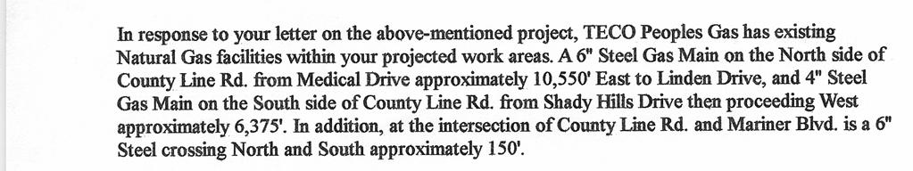
12 Within the vicinity of Ayers Road and U.S. 41, ell-south Communications has underground cables located on both sides of U.S. 41. The underground cables continue east along the south side of Ayers Road from U.S. 41 to the end of the study limits. ell-south Communications provided an estimate of $ 800,000 to relocate its facilities. Pasco County Utilities Department (Water and Sewer) owns and operates a 12 in (300 mm) water main located within both the U.S. 19 and C.R. 578 ROW. Within the U.S. 19 ROW the water main is located along the east side of the roadway south of C.R Along the south side of C.R. 578, the water main exists from U.S. 19 to 300 ft (91.44 m) east of Shady Hills Road. Pasco County plans to extend this facility to U.S. 41 in the future. In addition, Pasco County is planning the installation of an 8 in (200 mm) sanitary sewer forcemain to be installed along the south side of C.R. 578 from U.S. 19 to U.S. 41. Currently, existing sanitary sewer facilities are limited to a 6 in (150 mm) force main located on the west side of U.S. 19 south of C.R The force main crosses beneath U.S. 19 at a point 45 ft (13.72 m) south of C.R. 578, turns north and continues along the east side of the U.S. 19. From U.S. 19 to approximately 500 ft ( m) east, the existing force main along C.R. 578 is located on the south side of the roadway. Pasco County anticipates relocating approximately 30,300 ft (9, m) of a 12 in (300 mm) water main at a cost of $727,000. The unit relocation cost for a 12 in (300 mm) water main is $78.74/m ($24.00/ft). Pasco County also anticipates relocating approximately 1,000 ft (304.8 m) of sanitary sewer force main at a cost of $14,000. The unit relocation cost for the force main is $14.00/ft ($45.93/m). The total estimated relocation cost for both water and wastewater facilities is $741,000. Teco/Peoples Gas owns and operates a 6 in (150 mm) natural gas main located on the north side of C.R. 578 from Medical oulevard east to approximately 1,870 ft ( m) west of Preston Hollow Drive. The existing 6 in (150 mm) gas main location varies from 24 ft (7.32 m) to 33 ft (10.06 m) north of the existing roadway centerline. Teco/Peoples Gas proposes to extend this facility from its current termination, east to Linden Drive. The proposed gas main location varies from 25 ft (7.62 m) to 33 ft (10.06 m) north of the existing roadway centerline. Teco/Peoples Gas has also prepared plans for the construction a 6 in (150 mm) gas main along the south side of C.R. 587 from Mariner oulevard to 650 ft ( m) west of Jackson Street. The proposed gas main location varies from 18.4 ft (5.61 m) to 23.9 ft (7.28 m) south of the existing edge of pavement. The proposed gas main extension includes two 2 in (50 mm) service connections crossing C.R. 578 from south to north. Teco/Peoples Gas expects to relocate 10,700 ft (3, m) of 6 in (150 mm) steel gas line at a unit cost of $25.00/ft ($82.02/m) and 6,375 ft (1, m) of 4 in (100 mm) steel gas line at a unit cost of $18.00/ft ($59.06/m ). The total estimated relocation cost is $382,250. GTE/Verizon - owns and operates a series of underground cables located within the study area. Facilities located within the western half of the project limits (between U.S. 19 and the Suncoast Parkway) are the responsibility of Verizon s Clearwater office. Facilities located within the K:\C CR 578 PART III\Utility\final util package.doc/06/19/ County Line Road (C.R. 578) PD&E Study Utility Assessment Package
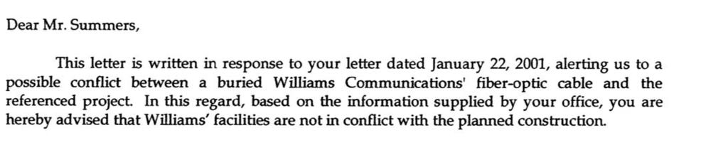
13 eastern half of the project limits (between the Suncoast Parkway and U.S. 41) are the responsibility of Verizon s Tampa s office. To date no response has been received from Verizon's Tampa office. The Clearwater office reported buried cables on both the east and west sides of U.S. 19 extending from C.R. 578 south a distance of approximately 700 ft ( m) where the cables cross U.S. 19 to the west side of the roadway and continue south. uried cables were also identified within the C.R. 578 ROW between U.S. 19 and Old Shady Hills Road. In addition, Verizon reports owning fiber optic cables located between Parade Road and Kelly Road. uried cables also extend from Drayton Street west for a distance of approximately 820 ft ( m). All of the existing cables are shown along the south ROW line. GTE/Verizon indicated that 11 mi (17.70 km) of cable would be potentially impacted based upon review of the conceptual plans. GTE/Verizon estimates the unit relocation cost to be $2,208,066/mi ($1,372,244.41/km). The total relocation cost is estimated to be $24,288,726. Williams Communications - owns and operates underground fiber optic cables parallel to U.S. 41 on the east side and are outside of the existing ROW. The fiber optic cable crosses the Ayers Road ROW. Williams Communications reports that its facilities are not in conflict with the recommended roadway improvements, Level (3) Communication - owns and operates underground cables on the west side of U.S. 19 for the length of the project. The cables are located 20 ft (6.09 m) to 29 ft (8.84 m) inside of the ROW. Level (3) Communication estimated that 30,000 ft (9,144 m) of cable would need to be relocated at a total cost of $200,000 as a result of the roadway improvements. Florida Water Services - owns and operates potable water and wastewater transmission facilities within both the U.S. 19 and C.R. 578 ROW. A 10 in (250 mm) sanitary sewer force main is located on the north side C.R. 578 between U.S. 19 and Mariner oulevard. The force main crosses beneath U.S. 19, north of C.R. 578 then heads north along the west side on U.S. 19. A 6 in (150 mm) potable water main is located along the east side of U.S. 19, north of C.R The water main turns east into the C.R. 578 ROW where it runs along the north side of the roadway to Callaway Avenue. At this point the force main increases to 8 in (200 mm). The 8 in (200 mm) water main parallels the north side of C.R. 578 from Callaway Avenue to alboa Avenue where it increases to 10 in (250 mm) before continuing to Cobblestone Drive. From Cobblestone Drive to Oak Leaf Drive the water main is 6 in (150 mm) and is located on the north side of the roadway. Another water main begins at Mariner oulevard as an 8 in (200 mm) pipeline and heads east along the north side of the roadway for a distance of approximately 425 ft ( m) where it increases to 10 in (250 mm). The 10 in (250 mm) water main continues east along the north side of the roadway to Preston Hollow Drive where it turns north and exits the C.R. 578 ROW. K:\C CR 578 PART III\Utility\final util package.doc/06/19/ County Line Road (C.R. 578) PD&E Study Utility Assessment Package
14 Florida Water Services estimates the relocation of 11 mi (17.70 km) of water and wastewater lines, at a cost of $8.2 million, will be necessary as a result of the roadway improvements. Withlacoochee River Electric - owns and operates overhead power facilities within both the U.S. 19 and C.R. 578 ROW. Within the U.S. 19 ROW, overhead power lines are reported on both sides of the roadway. From U.S. 19 to alboa Avenue overhead power lines can be found on the north side of C.R From alboa Avenue to 0.97 mi (1.55 km) east of Mariner oulevard overhead power lines are located on both sides of the roadway. The power lines continue from this point another 0.27 mi (0.43 km) along the south side of the roadway. Withlacoochee River Electric uses a unit cost of $125,000/mi ($77,671.40/km) for determining the cost of relocations. They did not provide a total relocation cost. Time Warner - owns and operates overhead cable television facilities along the north side of C.R. 578 from east of U.S. 19 to Oak Leaf Drive, with the exception of a one block segment between Hamlet Circle and Dartmouth Avenue where the cables are buried. uried cables are located on the south side of C.R. 578 from east of U.S. 19 to Parade Road. etween Runyon Drive and Drayton Street is a 1000 ft (304.8 m) section of overhead cable located on the south side of the roadway. Overhead cables are also located on the north side of C.R. 578 from Anderson Road to U.S. 41. Within this segment the Time Warner facilities pass beneath the Suncoast Parkway. From C.R. 578 the cables head north along the east side of U.S. 41. Time Warner also has facilities located within the community of Masaryktown. These facilities consist of overhead cables located along the south side of Stur Street between U.S. 41 and Kosta Street. Along Kosta Street the cables are located underground on the east side of the roadway between Stur Street and Psenka Street. The cables turn west and run along the north side of Psenka Street for a distance to approximately 1,200 ft ( m) before going overhead and continuing west to Korbus Road where they turn north. From Psenka Street to oynton Road the overhead cables are located on the east side of Korbus Road. The cables are located on the north side of oynton Road between Korbus Road and Kostka Street. Time Warner provided a total relocation cost estimate of $115,430. Florida Gas Transmission - owns and operates facilities within the project limits yet has not provided information regarding their size, type, or location. Florida Gas Transmission reports that its facilities are not in conflict with the proposed roadway improvements, The utility information provided to date is summarized in Tables 3-1 and 3-2 and is included in the Preliminary Engineering Report. Any additional information received from the various utilities, agencies, and municipalities will be reviewed for inclusion into this package. K:\C CR 578 PART III\Utility\final util package.doc/06/19/ County Line Road (C.R. 578) PD&E Study Utility Assessment Package
15 TALE 3-1 UTILITY RELOCATION COSTS Utility Costs Florida Power Corporation $ 0 Hernando County Utilities Department 0 ell-south Communications 800,000 Pasco County Utilities Department 741,000 TECO/Peoples Gas 382,250 Verizon Communications 24,288,726 Williams Communications 0 Level (3) Communications 200,000 Florida Water Services 8,200,000 Withlacoochee River Electric 0 Time Warner 115,430 Florida Gas Transmission 0 Total $34,727,406 K:\C CR 578 PART III\Utility\final util package.doc/06/19/ County Line Road (C.R. 578) PD&E Study Utility Assessment Package
16 TALE 3-2 SUMMARY OF EXISTING UTILITIES Owner Utility Description Aerial(A) Side Approximate Location uried () Florida Power Corporation Electric Power Distribution A A Crossing Crossing C.R ft east of Shady Hills Road/Mariner lvd. C.R ft west of Jackson Street Hernando County Utilities Department (Water and Sewer) Sanitary Sewer Pumping Station Sanitary Sewer 8 Gravity Line Sanitary Sewer 6 Force Main Potable Water 12 Water Main C.R ft east of Suncoast Parkway C.R. 578 From Pumping Station westward 300 ft C.R. 578 From Pumping Station westward 300 ft C.R. 578 From Pumping Station westward 300 ft ell-south Communications Communication A South West East South C.R. 578 From U.S. 19 to Arcadia Avenue C.R. 578 From Cabot Avenue west for 100 ft C.R. 578 From Clearwater Drive to Fargo Court C.R. 578 From Truce Circle to Randolph Avenue C.R. 578 From Waterfall Drive to Candlewick Avenue C.R. 578 From Oak Lake Drive to 380 ft east of Sparks Road C.R. 578 From 330 ft west of Linden Dr. to 380 ft east of Sparks Rd. C.R. 578 From 380 ft E. of Sparks Rd to 1,500 E. of the Suncoast Exp. C.R. 578 From 380 ft E. of Sparks Rd to 500 W. of the Suncoast Exp C.R. 578 From 270 ft. E. of the Suncoast Exp to 220 ft. E. of Quarter Horse Ln U.S. 41 at Ayers Road entire length of study limits U.S. 41 From Ayers Road south to end of study limits Ayres Road From U.S. 41 to end of study limits Pasco County Utilities Department (Water and Sewer) Potable Water 12 Water Main Potable Water 12 Water Main Sanitary Sewer 6 Force Main Sanitary Sewer 6 Force Main Sanitary Sewer 6 Force Main Sanitary Sewer 6 Force Main East South West Crossing East South U.S. 19 From C.R. 578 south to end of study limits C.R. 578 From U.S. 19 to 300 ft east of Shady Hills Road U.S. 19 From 45 ft south of C.R. 578 to end of study limits U.S ft south of C.R. 578 U.S. 19 From 45 ft south of C.R. 578 to C.R. 578 C.R. 578 From U.S. 19 to 550 ft east of U.S. 19 Teco/Peoples Gas Natural Gas 6 Gas Main Natural Gas Proposed 6 Gas Natural Gas Proposed 6 Gas South C.R. 578 From Medical oulevard to 1870 ft west of Presto Hollow Drive C.R. 578 From 1870 ft west of Presto Hollow Drive to Linden Drive C.R. 578 From Mariner oulevard to 650 ft west of Jackson Street Verizon Communication Fiber Optic Cable East Crossing West South South South U.S. 19 From C.R. 578 south 500 ft U.S ft south of C.R. 578 U.S. 19 From C.R. 578 south to Project End C.R. 578 From U.S. 19 to Old Shady Hills Road C.R. 578 From Parade Road to Kelly Road C.R. 578 From Drayton Street to the west 820 ft Williams Communication Fiber Optic Cable East Crossing U.S Entire Project Limits Ayers Road - East of U.S. 41 Level (3) Communications Communication West U.S Entire Project Limits K:\C CR 578 PART III\Utility\final util package.doc06/19/ County Line Road (C.R. 578) PD&E Study Utility Assessment Package
17 TALE 3-2 Continued SUMMARY OF EXISTING UTILITIES Owner Utility Description Aerial(A) uried () Florida Water Services Wastewater - 10" Force Main Wastewater - 10" Force Main Wastewater - 10" Force Main Potable Water - 6" Water Main Potable Water - 6" Water Main Potable Water - 8" Water Main Potable Water - 10" Water Main Potable Water - 6" Water Main Potable Water - 8" Water Main Potable Water - 10" Water Main Withlacoochee River Electric Electric Power Distribution A A A A A Time Warner Cable TV A A A A A A A A A A Side Crossing West East East West South South South East South East East Approximate Location C.R. 578 From U.S. 19 to Mariner oulevard U.S of C.R. 578 U.S of C.R. 578 to north end of project U.S From north of C.R. 578 to C.R. 578 C.R from U.S. 19 to Callaway Avenue C.R from Callaway Avenue to alboa Avenue C.R from alboa Avenue to Cobblestone Drive C.R from Cobblestone Drive to Oak Leaf Drive C.R from Mariner oulevard to 425' east of Mariner oulevard C.R from to 425' east of Mariner oulevard t Preston Hollow Drive U.S entire project limits U.S entire project limits C.R from U.S. 19 to alboa Avenue C.R from alboa Avenue to 0.97 miles east of Mariner oulevard C.R from alboa Avenue to 1.24 miles east of Mariner oulevard C.R from U.S. 19 to Hamlet Circle C.R from Hamlet Circle to Dartmouth Avenue C.R from Dartmouth Avenue to Oak Leaf Drive C.R from east of U.S. 19 to Parade Road C.R from Runyon Drive to Drayton Street C.R from Anderson Road to west side of Suncoast Parkway C.R from west side of Suncoast Parkway to east side of Suncoast Parkway C.R from east side of Suncoast Parkway to U.S. 41 U.S from C.R. 578 to north of Ayers Road Stur Street - from U.S. 41 to Kosta Street Kosta Street - from Stur Street to Psenka Street Penska Street - from Kosta Street to 1,200 ft west of Kosta Street Penska Street - 1,200 ft west of Kosta Street to Korbus Road Korbus Road - from Penska Street fo oynton Road oynton Road - from Korbus Road to Kosta Street K:\C CR 578 PART III\Utility\final util package.doc06/19/ County Line Road (C.R. 578) PD&E Study Utility Assessment Package
18 APPENDICES
19 APPENDIX A


20
21 APPENDIX
22
23

24

25


26


27


28
29 From: Glenn Greer To: Cc: ruce Kennedy Doug Yowell Douglas ramlett Subject: FDOT PD&E Study of County Line Road, US 19 to US 41 Date: Wednesday, May 08, :44 PM Mr. Jean W. Dorzback, P.E., J W Dorzback & Associates, Inc. As requested we have estimated a cost (for planning purposes only) for the relocation of Pasco County Utilities' 12" water main and 6" force main along County Line Road. In the event at some future date it becomes necessary for the County to relocate these facilities because there is no other feasible alternative other than relocation, the following represents our rough estimate of the cost to complete this work: Water Main: 30,300 feet at an estimated cost of $24 per foot = $727,200 Force Main: 1,000 feet at an estimated cost of $14 per foot = $14,000 Please consider this information and feel free to contact me, (727) , if there are questions or if additional information is required. Glenn Greer

30

31
32
Stormwater and sanitary sewer lines 8 inches in diameter or greater
 3.8 UTILITIES 3.8.1 Affected Environment This section describes the utility crossings and utilities located in the vicinity of the Preferred Alternative. The utilities include electricity, communication,
Public Information Workshop
 Public Information Workshop Charlotte County-Punta Gorda MPO - Meeting Rooms A and B March 29, 2018 Welcome to the Public Information Workshop for Harborview Road Project Development and Environment (PD&E)
APPENDIX C. Existing Utilities
 APPENDIX C Existing Utilities THIS PAGE INTENTIONALLY BLANK Existing Utilities Numerous utilities exist within the project area, including natural gas, sewer, water, electric, communications, and street
Highway 18 BNSF Railroad Overpass Feasibility Study Craighead County. Executive Summary
 Highway 18 BNSF Railroad Overpass Feasibility Study Craighead County Executive Summary October 2014 Highway 18 BNSF Railroad Overpass Feasibility Study Craighead County Executive Summary October 2014 Prepared
DRAFT Design Study Report February 2015 Eagle River Traffic Mitigation Phase 1 MOA Project No Appendix D Utilities
 Appendix D Utilities This page intentionally left blank. Utilities There are numerous utilities present within the project area, including natural gas, sewer, water, electric, communications, and street
PUBLIC INFRASTRUCTURE PROJECTS
 PUBLIC INFRASTRUCTURE PROJECTS FM 664 / OVILLA ROAD WIDENING & IMPROVEMENTS FM 664 / OVILLA ROAD CONNECTS US 287 WITH I-45 (SOURCE: TEXAS DEPARTMENT OF TRANSPORTATION. 2016 FM 664 / OVILLA ROAD WIDENING
Table of Contents INTRODUCTION... 3 PROJECT STUDY AREA Figure 1 Vicinity Map Study Area... 4 EXISTING CONDITIONS... 5 TRAFFIC OPERATIONS...
 Crosshaven Drive Corridor Study City of Vestavia Hills, Alabama Table of Contents INTRODUCTION... 3 PROJECT STUDY AREA... 3 Figure 1 Vicinity Map Study Area... 4 EXISTING CONDITIONS... 5 TRAFFIC OPERATIONS...
City of Houston Fondren Road Paving and Drainage
 City of Houston Fondren Road Paving and Drainage From Braeswood Boulevard to Creekbend Drive TRC Meeting March 2016 Location and Vicinity Maps City Council District K Key Map 530 Z, 530 Y Land Use Commercial
TABLE OF CONTENTS EXECUTIVE SUMMARY...1 INTRODUCTION...3 PROJECTED FUTURE GROWTH...3 ROADWAY IMPROVEMENT PROJECTS...4 POTENTIAL FUNDING SOURCES...
 Transportation Impact Fee Study September 2014 TABLE OF CONTENTS EXECUTIVE SUMMARY...1 INTRODUCTION...3 PROJECTED FUTURE GROWTH...3 ROADWAY IMPROVEMENT PROJECTS......4 POTENTIAL FUNDING SOURCES...7 PROPOSED
EXCEPTION TO STANDARDS REPORT
 EXCEPTION TO STANDARDS REPORT PROJECT DESCRIPTION AND NEED The project is located in Section 6, Township 23 North, Range 9 East and Section 31 Township 24 North, Range 9 East, in the Town of Stockton,
JCP&L Verbatim Response to Middletown Township s Questions
 JCP&L Verbatim Response to Middletown Township s Questions Township officials sent 13 questions about the proposed Monmouth County Reliability Project to JCP&L on June 10 th. JCP&L provided direct responses
Rolling Road (Route 638) Widening Project
 Widening Project") Rolling Road (Route 638) Widening Project From: 0.369 Mile North of Fairfax County Parkway (Route 286) To: Old Keene Mill Road (Route 644) State Project No. 0638-029-156, P104, R204, C504; UPC 5559 Public
Rolling Road (Route 638) Widening Project From: 0.369 Mile North of Fairfax County Parkway (Route 286) To: Old Keene Mill Road (Route 644) State Project No. 0638-029-156, P104, R204, C504; UPC 5559 Public
Alpine Highway to North County Boulevard Connector Study
 Alpine Highway to North County Boulevard Connector Study prepared by Avenue Consultants March 16, 2017 North County Boulevard Connector Study March 16, 2017 Table of Contents 1 Summary of Findings... 1
Appendix 3 Traffic Technical Memorandum
 Appendix 3 Traffic Technical Memorandum DRAFT TECHNICAL MEMORANDUM Southport Connector Project Traffic Development Comparison of Future Year Model Results Date: September 10, 2015 Project #:11730.030 To:
STAFF REPORT # CHANGE OF ZONING
 STAFF REPORT #17-2000-0007 CHANGE OF ZONING PLANNING COMMISSION MEETING DATE: November 16, 2017 (Applicant Provided Materials / Traffic Study = Blue) 1. APPLICATION: A public hearing for an application
I-820 (East) Project Description. Fort Worth District. Reconstruct Southern I-820/SH 121 Interchange
 Project Description. Fort Worth District. Reconstruct Southern I-820/SH 121 Interchange") I-820 (East) Project Description Fort Worth District Reconstruct Southern I-820/SH 121 Interchange I-820 from approximately 2,000 feet north of Pipeline Road/Glenview Drive to approximately 3,200 feet
I-820 (East) Project Description Fort Worth District Reconstruct Southern I-820/SH 121 Interchange I-820 from approximately 2,000 feet north of Pipeline Road/Glenview Drive to approximately 3,200 feet
Clearlake Road (State Road 501) Project Development & Environment (PD&E) Study
 Project Development & Environment (PD&E) Study") Clearlake Road (State Road 501) Project Development & Environment (PD&E) Study FROM MICHIGAN AVENUE TO INDUSTRY ROAD BREVARD COUNTY, FLORIDA Financial Project ID No: 433605-1-22-01 Federal Aid Project
Clearlake Road (State Road 501) Project Development & Environment (PD&E) Study FROM MICHIGAN AVENUE TO INDUSTRY ROAD BREVARD COUNTY, FLORIDA Financial Project ID No: 433605-1-22-01 Federal Aid Project
Open House. Highway212. Meetings. Corridor Access Management, Safety & Phasing Plan. 5:30 to 6:30 p.m. - Southwest Corridor Transportation Coalition
 Welcome Meetings 5:30 to 6:30 p.m. - Southwest Corridor Transportation Coalition 6:30 to 8:00 p.m. - Open House Why is Highway 212 Project Important? Important Arterial Route Local Support Highway 212
Challenges in a Post-Katrina Environment East-West Corridor Project Overview February, 2007
 EAST-WEST CORRIDOR Challenges in a Post-Katrina Environment East-West Corridor Project Overview February, 2007 Presentation Agenda Project Overview / Purpose and Need Highway Component Transit Component
Letter of Transmittal
 Letter of Transmittal To: Chris Lovell City of Richmond Hill Date: 5/2/6 Job 2582 Re: Richmond Hill-South Bryan County Transportation STudy WE ARE SENDING YOU THE FOLLOWING ITEMS ( attached) ( under separate
The Eastern Connector Study November, 2007 planning for the future
 The Eastern Connector Study November, 2007 planning for the future In late 2006, Albemarle County and the City of Charlottesville jointly initiated the Eastern Connector Corridor Study. The Project Team
Workshop Agenda. Bransford Roundabout. Bedford Intersection/Roundabout. Section 3 Revisions (Left turn lanes) Roadway Section/Curb Type Discussion
 Roadway Section/Curb Type Discussion") Workshop Agenda Bransford Roundabout Bedford Intersection/Roundabout Section 3 Revisions (Left turn lanes) Roadway Section/Curb Type Discussion Project Phasing Summary of Recommendation Purpose: Provide
Workshop Agenda Bransford Roundabout Bedford Intersection/Roundabout Section 3 Revisions (Left turn lanes) Roadway Section/Curb Type Discussion Project Phasing Summary of Recommendation Purpose: Provide
Kendall Drive Premium Transit PD&E Study Project Kick-Off Meeting SR 94/Kendall Drive/SW 88 Street Project Development and Environment (PD&E) Study
 Study") Florida Department of Transportation District Six Kendall Drive Premium Transit PD&E Study Project Kick-Off Meeting SR 94/Kendall Drive/SW 88 Street Project Development and Environment (PD&E) Study What
Florida Department of Transportation District Six Kendall Drive Premium Transit PD&E Study Project Kick-Off Meeting SR 94/Kendall Drive/SW 88 Street Project Development and Environment (PD&E) Study What
747 ACRES LAND FOR SALE
 747 ACRES LAND FOR SALE 3400 NORTH PONY EXPRESS PARKWAY, EAGLE MOUNTAIN, UTAH 84005 Salt Lake Count y Lehi 73 Sar atoga Spring s Eagle Mountain Blvd g Eagle Mountain Eagle Mountain Blvd Pony Express Pkwy
Traffic Engineering Study
 Traffic Engineering Study Bellaire Boulevard Prepared For: International Management District Technical Services, Inc. Texas Registered Engineering Firm F-3580 November 2009 Executive Summary has been requested
Summary of the Alcoa Highway Redevelopment Project
 Appendix B Summary of the Alcoa Highway Redevelopment Project By Marcia Finfer, October 2009 The Timberlake community, along with numerous other concerned citizen groups (including the Lakemoor Hills community)
BROWARD BOULEVARD CORRIDOR TRANSIT STUDY
 BROWARD BOULEVARD CORRIDOR TRANSIT STUDY FM # 42802411201 EXECUTIVE SUMMARY July 2012 GOBROWARD Broward Boulevard Corridor Transit Study FM # 42802411201 Executive Summary Prepared For: Ms. Khalilah Ffrench,
/ Planning and Zoning Staff Report Lonestar Land, LLC. - Rezone, RZ
 / Planning and Zoning Staff Report Lonestar Land, LLC. - Rezone, RZ2018-0019 Hearing Date: October 18, 2018 Development Services Department Applicant: Lonestar Land, LLC. Representative: Lance Warnick
STH 60 Northern Reliever Route Feasibility Study Report
 #233087 v3 STH 60 Northern Reliever Route Feasibility Study Report Washington County Public Works Committee Meeting September 28, 2016 1 STH 60 Northern Reliever Route Feasibility Study Hartford Area Development
Proposed Project I 35 Improvements from SH 195 to I 10
 I 35 ROADWAY Proposed Project I 35 Improvements from SH 195 to I 10 The existing I 35 facility from State Highway 195 (SH 195) north of Georgetown to Interstate 10 (I 10) in San Antonio varies from four
FREQUENTLY ASKED QUESTIONS
 THE PROJECT Last updated on 2/19/16 FREQUENTLY ASKED QUESTIONS What s happening on Highway 169? The Minnesota Department of Transportation (MnDOT) is planning to rebuild and repair the infrastructure on
Purpose and Need Report
 Purpose and Need Report State Highway (SH) 29 From Southwestern Boulevard to SH 95 Williamson County, Texas (CSJ: 0337-02-045) Prepared by Blanton & Associates, Inc. Date: November, 2015 The environmental
Dixie Transportation Planning Office
 A project must be given a yes rating on items 1 & 2 in order to be prioritized. Sponsor: St. George City Project: Pioneer Parkway Type: Road Widening and Reconstruction Rev. 9/17/2010 Dixie Transportation
Turnpike Mitigation Program Application
 Ohio Department of Transportation & Ohio Turnpike and Infrastructure Commission Turnpike Mitigation Program Application Please note the following eligibility criteria: 1) Projects must be sponsored by
Turnpike Mitigation Program Application
 Ohio Department of Transportation - Ohio Turnpike Infrastructure Commission Turnpike Mitigation Program Application The application has been improved to enable project sponsors to save the application
Turnpike Mitigation Program Application
 Ohio Department of Transportation & Ohio Turnpike and Infrastructure Commission Turnpike Mitigation Program Application Please note the following eligibility criteria: 1) Projects must be sponsored by
FREQUENTLY ASKED QUESTIONS
 THE PROJECT Last updated on 9/8/16 FREQUENTLY ASKED QUESTIONS What s happening on Highway 169? The Minnesota Department of Transportation (MnDOT) is planning to rebuild and repair the infrastructure on
WOODVILLE HIGHWAY (SR 363) PD&E STUDY From Capital Circle Southeast To Paul Russell Road FPID NUMBER: Public Hearing
 PD&E STUDY From Capital Circle Southeast To Paul Russell Road FPID NUMBER: Public Hearing") WOODVILLE HIGHWAY (SR 363) PD&E STUDY From Capital Circle Southeast To Paul Russell Road FPID NUMBER: 424009-3 Public Hearing May 9, 2013 This Public Hearing is being held in accordance with the Federal-aid
WOODVILLE HIGHWAY (SR 363) PD&E STUDY From Capital Circle Southeast To Paul Russell Road FPID NUMBER: 424009-3 Public Hearing May 9, 2013 This Public Hearing is being held in accordance with the Federal-aid
Chapter 7: Corridor Visions
 Chapter 7: Corridor Visions (see also Appendix 7 for Details) January 24, 2008 NOTE: This document has been prepared using Federal funding from the United States Department of Transportation. The United
Engineering Report: Shasta-Trinity National Forest. South Fork Management Unit. Analysis of. National Forest System Road 30N44
 Engineering Report: Shasta-Trinity National Forest South Fork Management Unit Analysis of National Forest System Road 30N44 (milepost 0.00 to 0.40) for Motorized Mixed Use Designation Forest: Shasta-Trinity
Utilities and Related Infrastructure
 Chapter 9: Utilities and Related Infrastructure A. INTRODUCTION This chapter discusses the existing utilities and related infrastructure in the Study Area that may be affected by the Proposed Project.
Energy Technical Memorandum
 Southeast Extension Project Lincoln Station to RidgeGate Parkway Prepared for: Federal Transit Administration Prepared by: Denver Regional Transportation District May 2014 Table of Contents Page No. Chapter
Note: The October 2007 version of this report has been updated in this December 2008 report to present costs in year 2007 dollars.
 Sound Transit Phase 2 South Corridor LRT Design Report: SR 99 and I-5 Alignment Scenarios (S 200 th Street to Tacoma Dome Station) Tacoma Link Extension to West Tacoma Prepared for: Sound Transit Prepared
US 81 Bypass of Chickasha Environmental Assessment Public Meeting
 US 81 Bypass of Chickasha Environmental Assessment Public Meeting March 14, 2013 Introductions ODOT FHWA SAIC Meeting Purpose Present need for bypass Provide responses to 10/04/11 public meeting comments
2.0 Development Driveways. Movin Out June 2017
 Movin Out June 2017 1.0 Introduction The proposed Movin Out development is a mixed use development in the northeast quadrant of the intersection of West Broadway and Fayette Avenue in the City of Madison.
Chicago to St. Louis High-Speed Rail. IDOT District 8 Crossings. July 29, 2015
 Chicago to St. Louis High-Speed Rail IDOT District 8 Crossings July 29, 2015 1 History: Chicago-St. Louis Corridor» IDOT has actively developed the Chicago to St. Louis corridor since the mid 1980 s» In
APPENDIX A INTENT-TO-STUDY LETTER
 APPENDIX A INTENT-TO-STUDY LETTER APPENDIX B COMMENTS AND RESPONSES COMMENTS AND RESPONSES A public information meeting was held on May 5, 2005. Comments and responses are summarized for this
FY 2013 Candidate Projects ($ Thousands) Street & Traffic Control Program - Thoroughfares
 Street & Traffic Control Program - Thoroughfares") Need Area: NT032 Alternative No.: 1 Name: Drive Council District: G Limits: Dallas to Dickson Key Map No.: 492M Type: Major Thoroughfare and Collector Super Neighborhood: WBS No.: (To be assigned by the
Need Area: NT032 Alternative No.: 1 Name: Drive Council District: G Limits: Dallas to Dickson Key Map No.: 492M Type: Major Thoroughfare and Collector Super Neighborhood: WBS No.: (To be assigned by the
II. PROJECT DESCRIPTION
 II. PROJECT DESCRIPTION A. PROJECT APPLICANT The project applicants for the proposed Sepulveda/Rosecrans Site Rezoning are: Mar Ventures, Inc., 2050 West 190 th Street, Suite 108, Torrance, California,
Introduction. Assumptions. Jeff Holstein, P.E., City of Brooklyn Park Steve Wilson, Principal Tim Babich, Associate Krista Anderson, Engineer
 SRF No. 10482 To: From: Jeff Holstein, P.E., City of Brooklyn Park Steve Wilson, Principal Tim Babich, Associate Krista Anderson, Engineer Date: May 16, 2018 Subject: City of Brooklyn Park Year 2040 Forecasts
Tulsa Transportation Management Area. Urbanized Area Surface Transportation Program
 Tulsa Transportation Management Area Urbanized Area Surface Transportation Program FFY 2022 Application Information Sponsor Location Description STP Request Other Funds Broken Arrow Elm Place: Kenosha
Citizens Committee for Facilities
 Citizens Committee for Facilities AGENDA Thursday, December 11, 2014 City Council Chambers 305 3 rd Avenue East -Twin Falls, Idaho 11:30 A.M. AGENDA ITEMS Purpose By 1. Discussion and possible action on
FINAL UTILITY REPORT Eastcreek Farm Thornton, CO
 FINAL UTILITY REPORT Eastcreek Farm Thornton, CO October 14, 2016 JN: 13049 Prepared for: York 80, LLC 12460 1 st Street Eastelake, CO 80614 P: 303.457.2966 Prepared by: Jansen Strawn Consulting Engineers
June WASHINGTON STATE DEPARTMENT OF TRANSPORTATION Alaskan Way Viaduct and Seawall Replacement Program Seattle, Washington
 DESIGN DEVIATION NOs. 1 & 2 Horizontal Stopping Sight Distance and Shoulder Width Reduction SR 99 S. Holgate St to S. King St. Viaduct Replacement Stage 2 MP 29.89 TO MP 30.78 XL-3237 PIN-809936D June
Rocky Mount. Transportation Plan. Transportation Planning Division. Virginia Department of Transportation
 2020 Transportation Plan Developed by the Transportation Planning Division of the Virginia Department of Transportation in cooperation with the U.S. Department of Transportation, Federal Highway Administration
Plan Check Policies and Guidelines
 Plan Check Policies and Guidelines VII. A. INTRODUCTION Traffic signing and striping plans are required for all General Plan Roads and any roadway that is 56-foot wide curb-to-curb (78 R/W) or wider. Transportation
DRAFT Subject to modifications
 TREASURE COAST REGIONAL PLANNING COUNCIL M E M O R A N D U M DRAFT To: Council Members AGENDA ITEM 7A From: Date: Subject: Staff September 17, 2010 Council Meeting High Speed Rail Update Introduction The
MAP OR PHOTO. Public Meeting & Open House July 23, Project Roadway Limits From: FM 1957 To: FM 471. Counties Bexar & Medina
 Public Meeting & Open House July 23, 2013 Project Roadway Limits From: FM 1957 To: FM 471 MAP OR PHOTO Counties Bexar & Medina 1 I. Project History II. III. IV. Project Overview Project Alternatives Response
800 Access Control, R/W Use Permits and Drive Design
 Table of Contents 801 Access Control... 8-1 801.1 Access Control Directives... 8-1 801.2 Access Control Policies... 8-1 801.2.1 Interstate Limited Access... 8-1 801.2.2 Limited Access... 8-1 801.2.3 Controlled
Delaware County Engineer s Office
 Delaware County Engineer s Office JANUARY 2017 County Engineer Responsibility Serve as engineer to the Board of County Commissioners and 18 Boards of Township Trustees for roads, bridges and land surveying
US 70 Corridor Planning for the Future
 New Bern/James City Area - Work Session US 70 Corridor Planning for the Future Brinson Elementary School Thursday, January 31, 2008 Agenda Sign-in, in, View Maps, Talk to Project Team Public Q & A Session
BOARD OF SUPERVISORS BUSINESS MEETING ACTION ITEM. Design Endorsement for Sterling Boulevard Extension
 Date of Meeting: July 20, 2017 # 6 BOARD OF SUPERVISORS BUSINESS MEETING ACTION ITEM SUBJECT: ELECTION DISTRICT: CRITICAL ACTION DATE: STAFF CONTACTS: Design Endorsement for Sterling Boulevard Extension
Interchange Justification Report
 Interchange Justification Report Interstate 29 at 85 th Street- Exit 74 Sioux Falls, SD SEH No. 132589 October 1, 2018 Prepared by: Short Elliott Hendrickson Inc. Executive Summary The Interchange Justification
Decision D ATCO Electric Ltd. Decommissioning of Transmission Line 6L82
 Decision 21447-D01-2016 August 23, 2016 Decision 21447-D01-2016 Proceeding 21447 Application 21447-A001 August 23, 2016 Published by the: Fifth Avenue Place, Fourth Floor, 425 First Street S.W. Calgary,
TALMONT TOWNHOMES MADISON KENNETH SPA TRAFFIC IMPACT STUDY. Sacramento, CA. Prepared For: MBK Homes. Prepared By:
 TALMONT TOWNHOMES MADISON KENNETH SPA TRAFFIC IMPACT STUDY Sacramento, CA Prepared For: MBK Homes Prepared By: KD Anderson & Associates 3853 Taylor Road, Suite G Loomis, California 95650 (916) 660-1555
Decision D ATCO Electric Ltd. Decommissioning of Transmission Line 6L79. October 18, 2016
 Decision 21481-D01-2016 October 18, 2016 Alberta Utilities Commission Decision 21481-D01-2016 Proceeding 21481 Application 21481-A001 October 18, 2016 Published by the: Alberta Utilities Commission Fifth
TRAFFIC CALMING PROGRAM
 TRAFFIC CALMING PROGRAM PROGRAM BASICS Mount Pleasant Transportation Department 100 Ann Edwards Lane Mt. Pleasant, SC 29465 Tel: 843-856-3080 www.tompsc.com The Town of Mount Pleasant has adopted a traffic
Agenda. Utility Undergrounding Strategies & Laguna Canyon Road Master Plan
 Utility Undergrounding Strategies & Laguna Canyon Road Master Plan January 17, 2017 City Council Meeting 2 Agenda Progress since March 2016 Status of undergrounding and road widening between El Toro Rd.
Traffic Management Plan and Queuing Analysis Lakehill Preparatory School Z Hillside Drive, Dallas, TX October 27, 2015
 Traffic Management Plan and Queuing Analysis Lakehill Preparatory School Z145-235 2720 Hillside Drive, Dallas, TX October 27, 2015 Introduction: The Lakehill Preparatory School is located on the northeast
Subarea Study. Manning Avenue (CSAH 15) Corridor Management and Safety Improvement Project. Final Version 1. Washington County.
 Corridor Management and Safety Improvement Project. Final Version 1. Washington County.") Subarea Study Manning Avenue (CSAH 15) Corridor Management and Safety Improvement Project Final Version 1 Washington County June 12, 214 SRF No. 138141 Table of Contents Introduction... 1 Forecast Methodology
Subarea Study Manning Avenue (CSAH 15) Corridor Management and Safety Improvement Project Final Version 1 Washington County June 12, 214 SRF No. 138141 Table of Contents Introduction... 1 Forecast Methodology
ELMORE COUNTY HIGHWAY DEPARTMENT
 Adopted 11/27/06 Effective 2/1/07 Amended 4/10/08 ELMORE COUNTY HIGHWAY DEPARTMENT 155 County Shop Road Wetumpka, Alabama 36092 Phone (334) 567-1162 Fax (334) 567-1100 Access Management Policy The Elmore
East Kings Highway and Roberts Avenue Speed Hump Analysis
 East Kings Highway and Roberts Avenue Speed Hump Analysis BOROUGH OF HADDONFIELD, CAMDEN COUNTY, NEW JERSEY 5/18/2018 Prepared By: Remington & Vernick Engineers 232 EAST KINGS HIGHWAY, HADDONFIELD, NEW
Town of Londonderry, New Hampshire NH Route 28 Western Segment Traffic Impact Fee Methodology
 Town of Londonderry, New Hampshire NH Route 28 Western Segment Traffic Impact Fee Methodology Prepared by the Londonderry Community Development Department Planning & Economic Development Division Based
Construction Noise Memorandum
 Construction Noise Memorandum To: Ms. Paula Daneluk Date: June 13, 2013 Development Impact 9370 Studio Court, Suite 160 Elk Grove, CA 95758 From: Paul Bollard Bollard Acoustical Consultants, Inc. 3551
SC Highway 41 Existing Conditions
 SC Highway 41 Existing Conditions Existing Typical Cross Section purposes only and does not replace the required NEPA process necessary for alignment The NEPA process is anticipated to begin in the next
Final Traffic Technical Memorandum
 SR 54 Project Development and Environment (PD&E) Study From CR 577 (Curley Road) to CR 579/CR 54 (Morris Bridge Road) Final Traffic Technical Memorandum WPI Segment No: 416561-1 Pasco County Prepared for
MINERVA PARK SITE TRAFFIC IMPACT STUDY M/I HOMES. September 2, 2015
 5500 New Albany Road Columbus, Ohio 43054 Phone: 614.775.4500 Fax: 614.775.4800 Toll Free: 1-888-775-EMHT emht.com 2015-1008 MINERVA PARK SITE TRAFFIC IMPACT STUDY M/I HOMES September 2, 2015 Engineers
Metrolinx Electrification Project
 Metrolinx Electrification Project Metrolinx Contract No. RQQ-2011-PP-032 Metrolinx Project No. 109503 UP EXPRESS UTILITY REPORT Document Reference No. PB 1000 March 28, 2014 Submitted to Submitted by TABLE
welcome to the BC Hydro community open house
 welcome to the BC Hydro community open house Dawson Creek/ Chetwynd Area Transmission ProjecT Open House welcome Dawson Creek/Chetwynd Area Transmission Project (DCAT) The purpose of this open house is
Speed measurements were taken at the following three locations on October 13 and 14, 2016 (See Location Map in Exhibit 1):
:") 2709 McGraw Drive Bloomington, Illinois 61704 p 309.663.8435 f 309.663.1571 www.f-w.com www.greennavigation.com November 4, 2016 Mr. Kevin Kothe, PE City Engineer City of Bloomington Public Works Department
2709 McGraw Drive Bloomington, Illinois 61704 p 309.663.8435 f 309.663.1571 www.f-w.com www.greennavigation.com November 4, 2016 Mr. Kevin Kothe, PE City Engineer City of Bloomington Public Works Department
ARLINGTON COUNTY, VIRGINIA
 ARLINGTON COUNTY, VIRGINIA County Board Agenda Item Meeting of April 24, 2004 DATE: April 14, 2004 SUBJECT: Arlington Boulevard (U.S. 50) Bridge Deck Replacement at Washington Boulevard - Overhead Utility
SECTION 1 DESCRIPTION OF THE PROPOSED PROJECT
 SECTION 1 DESCRIPTION OF THE PROPOSED PROJECT Supplemental Municipal Consultation Filing The Interstate Reliability Project 1. DESCRIPTION OF THE PROPOSED PROJECT The Connecticut Light and Power Company
I-4 Beyond the Ultimate. Florida Transportation Builders Association January 18, 2019
 I-4 Beyond the Ultimate Florida Transportation Builders Association January 18, 2019 FDOT District 5 Improving Mobility & Safety in Central Florida FDOT District 5 is: Designing and building a better Interstate
ANDERSON PROPERTY SITE ANALYSIS
 ANDERSON PROPERTY SITE ANALYSIS Introduction The Montgomery County Department of Transportation (MCDOT) initiated a feasibility study in the fall of 2012 to evaluate the need for transit service expansion
CAPITAL FUND 9510 STREET & SIDEWALK IMPROVEMENTS FIVE-YEAR CAPITAL IMPROVEMENT PROGRAM FISCAL YEARS
 9510 STREET & SIDEWALK IMPROVEMENTS FIVE-YEAR CAPITAL IMPROVEMENT PROGRAM FISCAL YEARS 2019-2023 9510 STREET & SIDEWALK IMPROVEMENTS - 01 STREET AND SIDEWALK MAINTENANCE PROGRAM $1,250,000 $0 $1,250,000
Executive Summary. Draft Environmental Impact Statement/Environmental Impact Report ES-1
 Executive Summary Introduction The Eastside Transit Corridor Phase 2 Project is a vital public transit infrastructure investment that would provide a transit connection to the existing Metro Gold Line
AASHTO Policy on Geometric Design of Highways and Streets
 AASHTO Policy on Geometric Design of Highways and Streets 2001 Highlights and Major Changes Since the 1994 Edition Jim Mills, P.E. Roadway Design Office 605 Suwannee Street MS-32 Tallahassee, FL 32399-0450
COUNTY ROAD SPEED LIMITS. Policy 817 i
 Table of Contents COUNTY ROAD SPEED LIMITS Policy 817.1 PURPOSE... 1.2 APPLICABILITY... 1.3 DEFINITIONS... 1.4 STATE ENABLING LEGISLATION... 2.5 SPEED LIMITS ON COUNTY ROADS (CCC 11.04)... 2.6 ESTABLISHING
LAWRENCE TRANSIT CENTER LOCATION ANALYSIS 9 TH STREET & ROCKLEDGE ROAD / 21 ST STREET & IOWA STREET LAWRENCE, KANSAS
 LAWRENCE TRANSIT CENTER LOCATION ANALYSIS 9 TH STREET & ROCKLEDGE ROAD / 21 ST STREET & IOWA STREET LAWRENCE, KANSAS TRAFFIC IMPACT STUDY FEBRUARY 214 OA Project No. 213-542 TABLE OF CONTENTS 1. INTRODUCTION...
CHAPTER 9: VEHICULAR ACCESS CONTROL Introduction and Goals Administration Standards
 9.00 Introduction and Goals 9.01 Administration 9.02 Standards 9.1 9.00 INTRODUCTION AND GOALS City streets serve two purposes that are often in conflict moving traffic and accessing property. The higher
TRAFFIC REGULATION APPROVAL PROCESS
 Approved: Effective: August 22, 2017 Review: June 21, 2017 Office: Traffic Engineering and Operations Topic No.: 750-010-011-e Department of Transportation PURPOSE TRAFFIC REGULATION APPROVAL PROCESS To
CONCEPTUAL UTILITY REPORT FOR THE CANYONS PHASE 1 CITY OF CASTLE PINES, CO
 CONCEPTUAL UTILITY REPORT FOR THE CANYONS PHASE 1 CITY OF CASTLE PINES, CO PREPARED FOR: SHEA HOMES 9380 STATION ST., SUITE 600 LONE TREE, CO 80124 PHONE: 303-791-8180 CONTACT: RYAN MCDERMED PREPARED BY:
Table Existing Traffic Conditions for Arterial Segments along Construction Access Route. Daily
 5.8 TRAFFIC, ACCESS, AND CIRCULATION This section describes existing traffic conditions in the project area; summarizes applicable regulations; and analyzes the potential traffic, access, and circulation
TRAFFIC IMPACT STUDY. USD #497 Warehouse and Bus Site
 TRAFFIC IMPACT STUDY for USD #497 Warehouse and Bus Site Prepared by: Jason Hoskinson, PE, PTOE BG Project No. 16-12L July 8, 216 145 Wakarusa Drive Lawrence, Kansas 6649 T: 785.749.4474 F: 785.749.734
Chapter 8.0 PROPOSED CAPITAL IMPROVEMENT PROGRAM
 Chapter 8.0 PROPOSED CAPITAL IMPROVEMENT PROGRAM This chapter presents the proposed Capital Improvement Program (CIP) for the District based on the findings of this Master Plan. The Master Plan primarily
Escondido Marriott Hotel and Mixed-Use Condominium Project TRAFFIC IMPACT ANALYSIS REPORT
 Escondido Marriott Hotel and Mixed-Use Condominium Project TRAFFIC IMPACT ANALYSIS REPORT Prepared for Phelps Program Management 420 Sixth Avenue, Greeley, CO 80632 Prepared by 5050 Avenida Encinas, Suite
Fire Station Location Study
 Fire Rescue Department Fire Station Location Study March 24, 2015 PRESENTATION OUTLINE BACKGROUND SCOPE OF THE STUDY STUDY METHODOLOGY STUDY COMPONENTS SUMMARY QUESTIONS CURRENT SERVICE LEVEL NUMBER OF
Traffic, Transportation & Civil Engineering Ali R. Khorasani, P.E. P.O. Box 804, Spencer, MA 01562, Tel: (508)
") Associates Traffic, Transportation & Civil Engineering Ali R. Khorasani, P.E. P.O. Box 804, Spencer, MA 01562, Tel: (508) 885-5121 Ms. Teri Ford, Associate 800 Boylston Street, Suite 1570 Boston, MA July
Associates Traffic, Transportation & Civil Engineering Ali R. Khorasani, P.E. P.O. Box 804, Spencer, MA 01562, Tel: (508) 885-5121 Ms. Teri Ford, Associate 800 Boylston Street, Suite 1570 Boston, MA July
Plainfield, Indiana Speed Limit Study
 March 21 st, 2017 Prepared on behalf of: Town of Plainfield Building and Engineering Department 206 W. Main Street Plainfield, IN 46168 (317) 839-2561 Prepared by: Thomas S. Vandenberg, PE, PTOE Matthew
ZEV COHEN & ASSOCIATES. INC. Main Office: Ormond Beach St. Augustine Amelia Island Edgewater
 ZEV COHEN & ASSOCIATES. INC. Main Office: Ormond Beach St. Augustine Amelia Island Edgewater 300 Interchiange Blvd., Suite C Ormond Beach, FL 32174 386-677-2482 Fax: 386-677-2505 Website: www.zevcohen.com