APPENDIX A INTENT-TO-STUDY LETTER
|
|
|
- Emma Wilkinson
- 6 years ago
- Views:
Transcription
1 APPENDIX A INTENT-TO-STUDY LETTER
2
3
4
5
6
7
8
9
10
11
12
13 APPENDIX B COMMENTS AND RESPONSES
14
15 COMMENTS AND RESPONSES A public information meeting was held on May 5, Comments and responses are summarized for this meeting, followed by verbatim copies of the comments and letters received. Public Comments A-1 A-2 A-3 A-4 A-5 A-6 A-7 A-8 A-9 A-10 A-11 A-12 A-13 William Bagley Sallie Clinard Judith Gray Bonnie Kopf Ed Kopf Randy Kopf George A. Olcott Theresa Poirier Shirley Ryan David S. Sharpe Lillian Silverstein Steve Small Charles D. Troiano Agency Comments B-1 B-2 B-3 U.S. Department of Transportation, Federal Aviation Administration U.S. Department of Homeland Security, (FEMA) Southern Nevada Water Authority B-1
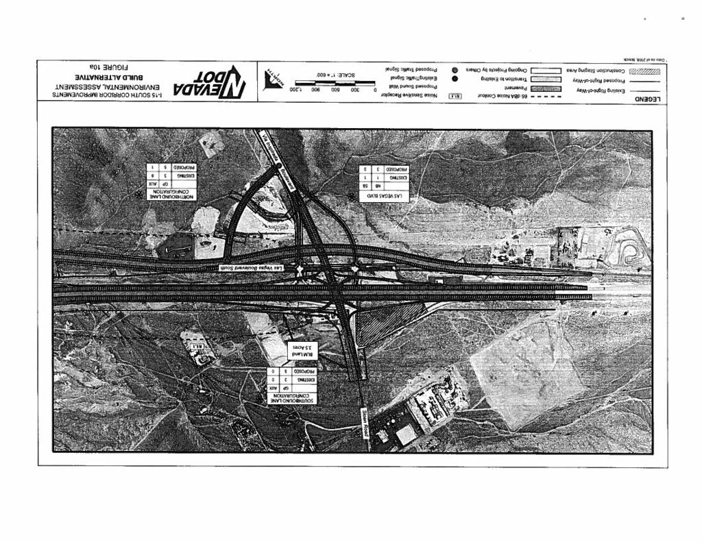
16 Table B-1 Response to Comments Comment Number A-1 A-2 A-3 A-4 A-6 A-7 A-8 Comment Mr. Bagley represents the property owner at Dean Martin Drive (formerly Industrial Road) and Russell Road. The property owner is concerned about potential rightof-way (ROW) impacts. Ms. Clinard expressed concerns regarding Blue Diamond Road and Dean Martin Drive, extending Decatur Boulevard over the Union Pacific Railroad (UPRR) tracks, and adding a left-turn signal at Warm Springs Road and Dean Martin Drive. Ms. Gray expressed support for the proposed interchanges as part of the project. The Kopf family expressed concern about the Pebble Road interchange. The area is a rural residential area, and an interchange would harm their neighborhood. Mr. Olcott expressed concerns regarding construction delays for the Blue Diamond Road and Silverado Ranch Boulevard projects. Mr. Olcott also expressed his opinion that an interchange is not needed at Pebble Road, construction would be limited to daytime hours, impacts to air quality and noise, Southern Nevada Supplemental Airport, improvements to Las Vegas Boulevard, and crime. Ms. Poirier requested that a traffic signal be installed at Wigwam Avenue and Las Vegas Boulevard South due to safety concerns. B-2 Response As described in Section 2.3.4, ROW would not be needed at this location. The Nevada Department of Transportation (NDOT) is constructing a new interchange at Blue Diamond Road and Interstate Highway 15 (I-15). As part of this project, improvements would be made to the Blue Diamond Road/Dean Martin Drive intersection, and the Warm Springs Road/Dean Martin Drive intersection. Clark County is planning improvements to Decatur Boulevard at the UPRR crossing. Thank you for your support. Pebble Road is proposed as an overpass instead of an interchange (see Section 1.3.1). Construction is underway for the I-15/Blue Diamond Road interchange and related improvements. Construction of the Silverado Ranch Boulevard interchange began in summer Previous planning documents identified the need for a potential interchange at Pebble Road; however, after further analysis, an overpass is now proposed (see Section 1.3.1). If this project is approved, mitigation measures for construction noise will be addressed in the contract documents, which will require the contractor to submit a noise control plan (see Section 2.5.3). Air quality hot spot and mobile source analyses were prepared indicating no exceedances of air quality standards (see Sections and 2.4.3). The Southern Nevada Supplemental Airport is under separate environmental review by Federal Aviation Administration (FAA) and will address surface transportation needs of the facility. A traffic signal would be installed at Las Vegas Boulevard South and Wigwam Avenue as part of the proposed project.
17 Table B-1 Response to Comments Comment Number A-9 A-10 A-11 A-12 A-13 B-1 B-2 B-4 Comment Ms. Ryan requested that a traffic signal be installed at Wigwam Avenue and Las Vegas Boulevard South due to safety concerns. Mr. Sharpe stated that Silverado Ranch Boulevard, Pebble Road, Spencer Street, and Maryland Parkway should be completed before new projects are started. Ms. Silverstein requested that a traffic signal be installed at Wigwam Avenue and Las Vegas Boulevard South due to safety concerns. Mr. Small commented on McCarran and the proposed Ivanpah airports in regards to air quality attainment standards. Mr. Troiano stated his preference for a mass transit system instead of roadway improvements to I-15 and concerns about interchange spacing. U.S. Federal Aviation Administration (FAA) stated no comments regarding impacts to Las Vegas McCarran International Airport and would like to continue correspondence regarding proposed surface transportation improvements. The Federal Emergency Management Agency (FEMA) stated that any development must comply with the requirements of their respective Flood Damage Prevention Ordinances. Southern Nevada Water Authority (SNWA) requested that plans be submitted to SNWA Development Plan Review office for review to determine any relocation requirements needed for SNWA facilities. B-3 Response A traffic signal would be installed at Las Vegas Boulevard South and Wigwam Avenue as part of the proposed project. Construction on the Silverado Ranch Boulevard interchange began in summer Clark County will continue to improve local streets in accordance with their master plan. A traffic signal would be installed at Las Vegas Boulevard South and Wigwam Avenue as part of the proposed project. See Section for information regarding the proposed Southern Nevada Supplemental Airport. The Regional Transportation Commission of Southern Nevada (RTC) is analyzing a proposed mass transit system within the Las Vegas Valley (see Section 2.9.3). The proposed interchanges meet FHWA s interchange spacing criteria for urban freeways. The reason a potential Pebble Road interchange was eliminated from further consideration was because of inadequate interchange spacing (see Section 1.3.1). NDOT will notify FAA of future surface transportation projects potentially affecting their facilities. NDOT will comply with all federal requirements regarding protection of designated floodway and floodplain areas. NDOT will comply with all local requirements regarding water utilities. Plans will be submitted to SNWA as requested.
18
19
20
21
22
23
24
25
26
27
28
29
30
31
32
33
34
35
36
37
38
39
40
41
42
43
44
45
46
47
48
49
50
51
52
53
54
55
56
57
58
59 APPENDIX C COOPERATING AGENCY
60
61
62
63
64
65 APPENDIX D SECTION 7 CONSULTATION CORRESPONDENCE
66

67
68

69
70
71
72
73 APPENDIX E PROCEDURES FOR ABATEMENT OF HIGHWAY TRAFFIC NOISE AND CONSTRUCTION NOISE
74
75
76
77
78
79
80
81
82
83
84
85 APPENDIX F SHPO CONCURRENCE LETTER AND NATIVE AMERICAN CONSULTATION LETTERS
86
87
88
89
90
91
92
93
94
95
96
97
98
99
100
101
102
103
104
105
106
107
108
109
110
111
112
113
114
FREQUENTLY ASKED QUESTIONS
 THE PROJECT Last updated on 2/19/16 FREQUENTLY ASKED QUESTIONS What s happening on Highway 169? The Minnesota Department of Transportation (MnDOT) is planning to rebuild and repair the infrastructure on
WOODVILLE HIGHWAY (SR 363) PD&E STUDY From Capital Circle Southeast To Paul Russell Road FPID NUMBER: Public Hearing
 PD&E STUDY From Capital Circle Southeast To Paul Russell Road FPID NUMBER: Public Hearing") WOODVILLE HIGHWAY (SR 363) PD&E STUDY From Capital Circle Southeast To Paul Russell Road FPID NUMBER: 424009-3 Public Hearing May 9, 2013 This Public Hearing is being held in accordance with the Federal-aid
WOODVILLE HIGHWAY (SR 363) PD&E STUDY From Capital Circle Southeast To Paul Russell Road FPID NUMBER: 424009-3 Public Hearing May 9, 2013 This Public Hearing is being held in accordance with the Federal-aid
FREQUENTLY ASKED QUESTIONS
 THE PROJECT Last updated on 9/8/16 FREQUENTLY ASKED QUESTIONS What s happening on Highway 169? The Minnesota Department of Transportation (MnDOT) is planning to rebuild and repair the infrastructure on
Highway 18 BNSF Railroad Overpass Feasibility Study Craighead County. Executive Summary
 Highway 18 BNSF Railroad Overpass Feasibility Study Craighead County Executive Summary October 2014 Highway 18 BNSF Railroad Overpass Feasibility Study Craighead County Executive Summary October 2014 Prepared
Challenges in a Post-Katrina Environment East-West Corridor Project Overview February, 2007
 EAST-WEST CORRIDOR Challenges in a Post-Katrina Environment East-West Corridor Project Overview February, 2007 Presentation Agenda Project Overview / Purpose and Need Highway Component Transit Component
I-820 (East) Project Description. Fort Worth District. Reconstruct Southern I-820/SH 121 Interchange
 Project Description. Fort Worth District. Reconstruct Southern I-820/SH 121 Interchange") I-820 (East) Project Description Fort Worth District Reconstruct Southern I-820/SH 121 Interchange I-820 from approximately 2,000 feet north of Pipeline Road/Glenview Drive to approximately 3,200 feet
I-820 (East) Project Description Fort Worth District Reconstruct Southern I-820/SH 121 Interchange I-820 from approximately 2,000 feet north of Pipeline Road/Glenview Drive to approximately 3,200 feet
LOS ANGELES COUNTY METROPOLITAN TRANSPORTATION AUTHORITY (LACMTA) AND FEDERAL TRANSIT ADMINISTRATION (FTA)
 AND FEDERAL TRANSIT ADMINISTRATION (FTA)") LOS ANGELES COUNTY METROPOLITAN TRANSPORTATION AUTHORITY (LACMTA) AND FEDERAL TRANSIT ADMINISTRATION (FTA) NOTICE OF PREPARATION (NOP)/NOTICE OF INTENT (NOI) OF AN ENVIRONMENTAL IMPACT STATEMENT (EIS)/ENVIRONMENTAL
LOS ANGELES COUNTY METROPOLITAN TRANSPORTATION AUTHORITY (LACMTA) AND FEDERAL TRANSIT ADMINISTRATION (FTA) NOTICE OF PREPARATION (NOP)/NOTICE OF INTENT (NOI) OF AN ENVIRONMENTAL IMPACT STATEMENT (EIS)/ENVIRONMENTAL
State Route 160 (Blue Diamond Road) Corridor Study
 Corridor Study") State Route 160 (Blue Diamond Road) Corridor Study Final Report August 31, 2006 Booz Allen Hamilton with Civilwise Inc. Table of Contents RTC SR-160 Corridor Study TABLE OF CONTENTS 1.0 EXECUTIVE SUMMARY...
State Route 160 (Blue Diamond Road) Corridor Study Final Report August 31, 2006 Booz Allen Hamilton with Civilwise Inc. Table of Contents RTC SR-160 Corridor Study TABLE OF CONTENTS 1.0 EXECUTIVE SUMMARY...
Alpine Highway to North County Boulevard Connector Study
 Alpine Highway to North County Boulevard Connector Study prepared by Avenue Consultants March 16, 2017 North County Boulevard Connector Study March 16, 2017 Table of Contents 1 Summary of Findings... 1
SH 249 IN GRIMES COUNTY. Open House April 3, 2014
 SH 249 IN GRIMES COUNTY Open House April 3, 2014 Meeting Agenda Purpose of Meeting Today: Review the purpose and need for the SH 249 Grimes County project Review the proposed project and alternatives Discuss
Summary of the Alcoa Highway Redevelopment Project
 Appendix B Summary of the Alcoa Highway Redevelopment Project By Marcia Finfer, October 2009 The Timberlake community, along with numerous other concerned citizen groups (including the Lakemoor Hills community)
APPENDIX A1 PROJECT DETAILS
 APPENDIX A1 PROJECT DETAILS Table 1: Federally-Funded and/or Regionally-Significant High Priority Investment Program Table 2: Access2040 Long Range Projects (2021-2025) Table 3: Locally-Funded Projects
Letter EL652 City of Mercer Island. Page 1. No comments n/a
 Letter EL652 City of Mercer Island Page 1 No comments n/a Page 2 Response to comment EL652 1 Section 4.5.3 of the Final EIS presents the range of potential impacts of the project. This project also lists
Project Description: Georgia Department of Transportation Public Information Open House Handout PI#(s): , County: Muscogee
: , County: Muscogee") Why We Are Here: GDOT s Transportation Improvement Act (TIA) Office, the City of Columbus, and the project delivery team are here this evening to display and answer questions concerning the proposed roadway
Why We Are Here: GDOT s Transportation Improvement Act (TIA) Office, the City of Columbus, and the project delivery team are here this evening to display and answer questions concerning the proposed roadway
Appendix 3 Traffic Technical Memorandum
 Appendix 3 Traffic Technical Memorandum DRAFT TECHNICAL MEMORANDUM Southport Connector Project Traffic Development Comparison of Future Year Model Results Date: September 10, 2015 Project #:11730.030 To:
800 Access Control, R/W Use Permits and Drive Design
 Table of Contents 801 Access Control... 8-1 801.1 Access Control Directives... 8-1 801.2 Access Control Policies... 8-1 801.2.1 Interstate Limited Access... 8-1 801.2.2 Limited Access... 8-1 801.2.3 Controlled
Request for Design Exception (#1) S.M. Wright Phase IIB
 S.M. Wright Phase IIB") Request for Design Exception (#1) S.M. Wright Phase IIB County: Dallas CSJ s: 0092-01-059, 0092-14-088 Project Limits: From Pennsylvania Avenue to North of Al Lipscomb Way Date: June 28, 2016 Proposed
Request for Design Exception (#1) S.M. Wright Phase IIB County: Dallas CSJ s: 0092-01-059, 0092-14-088 Project Limits: From Pennsylvania Avenue to North of Al Lipscomb Way Date: June 28, 2016 Proposed
SAINT CHARLES COUNTY ROAD BOARD Minutes of March 21, 2018
 SAINT CHARLES COUNTY ROAD BOARD Minutes of March 21, 2018 The Wednesday, March 21, 2018, meeting of the St. Charles County Road Board was called to order at 4:30 p.m. in Room 542 of the Administration
Chapter 7: Corridor Visions
 Chapter 7: Corridor Visions (see also Appendix 7 for Details) January 24, 2008 NOTE: This document has been prepared using Federal funding from the United States Department of Transportation. The United
Escondido Marriott Hotel and Mixed-Use Condominium Project TRAFFIC IMPACT ANALYSIS REPORT
 Escondido Marriott Hotel and Mixed-Use Condominium Project TRAFFIC IMPACT ANALYSIS REPORT Prepared for Phelps Program Management 420 Sixth Avenue, Greeley, CO 80632 Prepared by 5050 Avenida Encinas, Suite
Kendall Drive Premium Transit PD&E Study Project Kick-Off Meeting SR 94/Kendall Drive/SW 88 Street Project Development and Environment (PD&E) Study
 Study") Florida Department of Transportation District Six Kendall Drive Premium Transit PD&E Study Project Kick-Off Meeting SR 94/Kendall Drive/SW 88 Street Project Development and Environment (PD&E) Study What
Florida Department of Transportation District Six Kendall Drive Premium Transit PD&E Study Project Kick-Off Meeting SR 94/Kendall Drive/SW 88 Street Project Development and Environment (PD&E) Study What
Section III Transportation and Stormwater Projects Receiving Additional Funding Project Detail Sheets Alphabetical Listing by Project Name Five Year
 Section III Transportation and Stormwater Projects Receiving Additional Funding Project Detail Sheets Alphabetical Listing by Project Name Five Year Capital Improvement Plan FY2015/2016 through FY2020
S.M. Wright Project (I-45, US 175, SH 310) and Road to Work Opportunity Program. Transportation and Trinity River Project Committee May 23, 2016
 and Road to Work Opportunity Program. Transportation and Trinity River Project Committee May 23, 2016") 635 S.M. Wright Project (I-45, US 175, SH 310) and Road to Work Opportunity Program Transportation and Trinity River Project Committee May 23, 2016 Project Scope Increase safety by removing the existing
635 S.M. Wright Project (I-45, US 175, SH 310) and Road to Work Opportunity Program Transportation and Trinity River Project Committee May 23, 2016 Project Scope Increase safety by removing the existing
ITEM 13 - NOTICE May 20, 2009
 ITEM 13 - NOTICE May 20, 2009 Notice of Proposed Amendment to the 2009 CLRP and FY 2010-2015 TIP to include the Closure of the I-395 Southbound Exit Ramp to 3rd Street NW, the Reconfiguration of the Southbound
ADDITIONAL UTILITY RELOCATION COSTS ARE MISSING FROM THE ESTIMATE.
 Comment to CHSRA Missing Utility Costs Page!1 May 7, 2018 COMMENT FOR CHSRA BUSINESS PLAN: ADDITIONAL UTILITY RELOCATION COSTS ARE MISSING FROM THE ESTIMATE. HIGH VOLTAGE TOWERS THAT CARRY ELECTRICITY
STAFF REPORT # CHANGE OF ZONING
 STAFF REPORT #17-2000-0007 CHANGE OF ZONING PLANNING COMMISSION MEETING DATE: November 16, 2017 (Applicant Provided Materials / Traffic Study = Blue) 1. APPLICATION: A public hearing for an application
Mountainland Association of Governments SPRINGVILLE-SPANISH FORK AREA TRANSPORTATION STUDY APRIL 2012
 Mountainland Association of Governments SPRINGVILLE-SPANISH FORK AREA TRANSPORTATION STUDY APRIL 2012 PLANNING FOR OUR FUTURE Planners with the Mountainland Association of Governments (MAG) have evaluated
10/4/2016. October 6, Item #1 CITIZENS PARTICIPATION
 October 6, 2016 Item #1 CITIZENS PARTICIPATION 1 Item #2 APPROVAL OF MINUTES Item #3 WELCOME 2 Item #4 TRAC ROADWAY RECOMMENDATIONS UPDATE Item #4 Completed Jurisdiction Presentations Boulder City August
PREPARED BY STANTEC CONSULTING
 INTERSTATE 526 Addendum CORRIDOR ANALYSIS For Between North Charleston and West Ashley May 2014 - Addendum MARCH 2013 PREPARED BY STANTEC CONSULTING IN ASSOCIATION WITH FLORENCE & HUTCHESON, INC. DAVIS
US 70 Corridor Planning for the Future
 New Bern/James City Area - Work Session US 70 Corridor Planning for the Future Brinson Elementary School Thursday, January 31, 2008 Agenda Sign-in, in, View Maps, Talk to Project Team Public Q & A Session
STAFF REPORT. To: Planning Commission Meeting date: April 12, 2017 Item: UN Prepared by: Robert Eastman
 # 5 ) UN-15-17 LA SIERRA AUTO SALES SPECIAL USE PERMIT VEHICLE SALES PUBLIC HEARING STAFF REPORT To: Planning Commission Meeting date: April 12, 2017 Item: UN-15-17 Prepared by: Robert Eastman GENERAL
Executive Summary. Draft Environmental Impact Statement/Environmental Impact Report ES-1
 Executive Summary Introduction The Eastside Transit Corridor Phase 2 Project is a vital public transit infrastructure investment that would provide a transit connection to the existing Metro Gold Line
RESOLUTION NO NOW, THEREFORE, BE IT RESOLVED BY THE MAYOR AND COMMON COUNCIL OF THE TOWN OF PRESCOTT VALLEY, ARIZONA, AS FOLLOWS:
 RESOLUTION NO. 1873 A RESOLUTION OF THE MAYOR AND COMMON COUNCIL OF THE TOWN OF PRESCOTT VALLEY, A MUNICIPAL CORPORATION OF ARIZONA, APPROVING A PLAN, POLICY OR PROCEDURE IN ACCORDANCE WITH ARS 9-471(O)
3.15 SAFETY AND SECURITY
 3.15 SAFETY AND SECURITY Introduction This section describes the environmental setting and potential effects of the alternatives analyzed in this EIR with regard to safety and security in the SantaClara-Alum
Sound Transit East Link: Bus/LRT System Integration Study
 Sound Transit East Link: Bus/LRT System Integration Study Prepared For: Sound Transit King County Metro Mercer Island WSDOT Prepared By: CH2M HILL July, 2014 1 SOUND TRANSIT EAST LINK: BUS/LRT SYSTEMES
4/9/2018. April 5, Item #1 CITIZENS PARTICIPATION
 April 5, 2018 Item #1 CITIZENS PARTICIPATION 1 Item #2 APPROVAL OF MINUTES Item #3 TRAC GOALS, FRAMEWORK & AGENDA REVIEW 2 COMMITTEE GOALS Learn about Southern Nevada s mobility challenges, new developments
24 hour service. frequent service. frequent service on Tropicana East of Rainbow only. 154 Transit Guide E F
 BUFFALO TENAYA DURANGO LINDELL VALLEY VIEW POLARIS GRAND CANYON FORT APACHE BUFFALO TENAYA JONES RAINBOW TORREY PINES DECATUR ARVILLE DEAN MARTIN Tropicana HACIENDA RUSSELL 120 120 EL CAPITAN 121 121 TROPICANA
Lacey Gateway Residential Phase 1
 Lacey Gateway Residential Phase Transportation Impact Study April 23, 203 Prepared for: Gateway 850 LLC 5 Lake Bellevue Drive Suite 02 Bellevue, WA 98005 Prepared by: TENW Transportation Engineering West
SOUTH ACCESS TO THE GOLDEN GATE BRIDGE DOYLE DRIVE DOYLE DRIVE. Doyle Drive Presentation Golden Gate Bridge Board Meeting July 24, 2009
 DOYLE DRIVE Doyle Drive Presentation Golden Gate Bridge Board Meeting July 24, 2009 Presentation Overview Introduction Project Acceleration Construction Contracts Construction Activities Lane and Road
Interchange Justification Report
 Interchange Justification Report Interstate 29 at 85 th Street- Exit 74 Sioux Falls, SD SEH No. 132589 October 1, 2018 Prepared by: Short Elliott Hendrickson Inc. Executive Summary The Interchange Justification
6/6/2018. June 7, Item #1 CITIZENS PARTICIPATION
 June 7, 2018 Item #1 CITIZENS PARTICIPATION 1 Item #2 APPROVAL OF MINUTES Item #3 TRAC GOALS, FRAMEWORK & AGENDA REVIEW 2 COMMITTEE GOALS Learn about Southern Nevada s mobility challenges, new developments
Harlem Avenue between 63 rd and 65 th
 Harlem Avenue between 63 rd and 65 th Community Advisory Group Meeting #3 December 1, 2017 Bedford Park Public Library 1 Meeting Agenda 1. Welcome/Introductions (3 mins) 2. Project Overview and Re-Cap
King County Metro. Columbia Street Transit Priority Improvements Alternative Analysis. Downtown Southend Transit Study. May 2014.
 King County Metro Columbia Street Transit Priority Improvements Alternative Analysis Downtown Southend Transit Study May 2014 Parametrix Table of Contents Introduction... 1 Methodology... 1 Study Area...
ANNUAL VEHICLE MILES OF TRAVEL
 NEVADA DEPARTMENT OF TRANSPORTATION AVMT AVMT AVMT AVMT AVMT AVMT AVMT ANNUAL VEHICLE MILES OF TRAVEL In Cooperation with U.S. Department of Transportation Federal Highway Administration, Nevada Division
2016 PSRC REGIONAL & KING COUNTYWIDE EASTSIDE FUNDING AWARDS. Eastside Transportation Partnership September 9, 2016
 2016 PSRC REGIONAL & KING COUNTYWIDE EASTSIDE FUNDING AWARDS Eastside Transportation Partnership September 9, 2016 1 2 PSRC 2016 Project Selection Process 2018-2020 Estimated FHWA Funds Available: (Summary)
Key Project Elements Status Report
 Los Angeles County Metropolitan Transportation Authority Key Project Elements Status Report presented to the Corridor Advisory Committee August 18, 2016 Background Motion 22.1 elements are grouped into
HIGHWAY 28 FUNCTIONAL DESIGN
 HIGHWAY 28 FUNCTIONAL DESIGN PUBLIC OPEN HOUSE #1 WEDNESDAY, MARCH 12, 2014 Stantec Presenters: Brad Vander Heyden, Project Engineer Neal Cormack, Project Manager Dave Parker, Project Engineer Beth Thola,
CROSSING RAIL PROJECT (P4) RAIL
 RAIL") GRAND CROSSING RAIL PROJECT (P4) Community Advisory Group October 10, 2012 1:30 pm Grand Crossing Park Field House 7655 S. Ingleside Avenue, Chicago GRAND CROSSING RAIL PROJECT (P4) Community Advisory
GRAND CROSSING RAIL PROJECT (P4) Community Advisory Group October 10, 2012 1:30 pm Grand Crossing Park Field House 7655 S. Ingleside Avenue, Chicago GRAND CROSSING RAIL PROJECT (P4) Community Advisory
APPENDIX H. Transportation Impact Study
 APPENDIX H Transportation Impact Study BUENA VISTA LAGOON ENHANCEMENT PROJECT TRANSPORTATION IMPACT STUDY Prepared for: San Diego Association of Governments Prepared by: VRPA Technologies, Inc. 9520 Padgett
Project Working Group Meeting #5
 September 17, 2013 Project Working Group Meeting #5 1 September 17, 2013 www.i-80will.com Meeting Purpose Project update Discuss Range of Alternatives Discuss next steps 2 September 17, 2013 www.i-80will.com
2 The Region Today. Growth. Meeting Transportation Objectives
 2 The Region Today Growth Las Vegas continues to be one of the fastest growing urbanized areas in the country. Gaming, proximity to natural scenic attractions, a favorable climate, and direct access by
Sample Geographic Information System (GIS) Staffing and Response Time Report Virtual County Fire Department GIS Analysis
 Staffing and Response Time Report Virtual County Fire Department GIS Analysis") Sample Geographic Information System (GIS) Staffing and Response Time Report Fire Department GIS Analysis Executive Summary This study examines predicted response times and geographic coverage areas for
Sample Geographic Information System (GIS) Staffing and Response Time Report Fire Department GIS Analysis Executive Summary This study examines predicted response times and geographic coverage areas for
Table of Contents INTRODUCTION... 3 PROJECT STUDY AREA Figure 1 Vicinity Map Study Area... 4 EXISTING CONDITIONS... 5 TRAFFIC OPERATIONS...
 Crosshaven Drive Corridor Study City of Vestavia Hills, Alabama Table of Contents INTRODUCTION... 3 PROJECT STUDY AREA... 3 Figure 1 Vicinity Map Study Area... 4 EXISTING CONDITIONS... 5 TRAFFIC OPERATIONS...
U.S. System Summary: ARIZONA/SOUTHWEST
 U.S. System Summary: ARIZONA/SOUTHWEST Arizona/Southwest High-Speed Rail System (Source: Texas A&M Transportation Institute) The Arizona/Southwest high-speed rail system described in this summary groups
Public Information Workshop
 Public Information Workshop Charlotte County-Punta Gorda MPO - Meeting Rooms A and B March 29, 2018 Welcome to the Public Information Workshop for Harborview Road Project Development and Environment (PD&E)
Develop ground transportation improvements to make the Airport a multi-modal regional
 Project Overview TRANSPORTATION IMPROVEMENTS WHAT ARE THE PROJECT GOALS? Transportation transportation hub. Develop ground transportation improvements to make the Airport a multi-modal regional Land Use
Interchange Modification Justification Study. I-90/Timberline Road Interchange, Exit 402 SIOUX FALLS MPO
 Interchange Modification Justification Study I-90/Timberline Road Interchange, Exit 402 SIOUX FALLS MPO Technical analysis to accompany companion Environmental Assessment Interchange Modification Justification
CHINO DESALTER PHASE 3
 CHINO DESALTER PHASE 3 Comprehensive Predesign Report Prepared for Jurupa Community Services District, City of Ontario, and Western Municipal Water District REVISED FINAL December 2010 Jurupa Community
FRESNO COUNTY SUBSECTION OF THE CALIFORNIA HIGH- SPEED TRAIN (HST)
") FRESNO COUNTY SUBSECTION OF THE CALIFORNIA HIGH- SPEED TRAIN (HST) The Fresno County subsection of the California High- Speed Train System (HST) is analyzed in two separate EIR/EISs the Merced-Fresno EIR/EIS
FRESNO COUNTY SUBSECTION OF THE CALIFORNIA HIGH- SPEED TRAIN (HST) The Fresno County subsection of the California High- Speed Train System (HST) is analyzed in two separate EIR/EISs the Merced-Fresno EIR/EIS
Removal of Underground Storage Tanks (UST) Encountered during Construction
 Encountered during Construction") Removal of Underground Storage Tanks (UST) Encountered during Construction Technical Guide Environmental Affairs Division TxDOT Environmental Affairs Division Release Date: 2/2014 510.06.GUI Version 1
Removal of Underground Storage Tanks (UST) Encountered during Construction Technical Guide Environmental Affairs Division TxDOT Environmental Affairs Division Release Date: 2/2014 510.06.GUI Version 1
SH 249 PUBLIC MEETING DESIGN CHANGES FROM FM 2920 TO HARDIN STORE ROAD
 SH 249 PUBLIC MEETING DESIGN CHANGES FROM FM 2920 TO HARDIN STORE ROAD Lone Star College, Tomball Campus December 8, 2015 Open House 5:30-7:30 pm National Environmental Policy Act The environmental review,
April 27, FHWA/FTA Approval of an Amendment to the Kansas STIP to include WAMPO s April 14, 2009 TIP Amendment 6
 U.S. Department of Transportation Federal Transit Administration Federal Highway Administration 901 Locust Street, Suite 404 6111 SW 29 th Street, Suite 100 Kansas City, MO 64106 Topeka, KS 66614-4271
Exposition Corridor Transit Project
 Exposition Corridor Transit Project Phase 2 Environmental Planning Community Meeting June 9, 2008 Exposition Corridor Transit Project Phase 2 AGENDA Remaining Grade Crossing Recommendations June 9, 2008
The major roadways in the study area are State Route 166 and State Route 33, which are shown on Figure 1-1 and described below:
 3.5 TRAFFIC AND CIRCULATION 3.5.1 Existing Conditions 3.5.1.1 Street Network DRAFT ENVIRONMENTAL IMPACT REPORT The major roadways in the study area are State Route 166 and State Route 33, which are shown
ATTACHMENT [B] PROJECT DESCRIPTION REQUESTED CITY OF LOS ANGELES ACTIONS
![ATTACHMENT [B] PROJECT DESCRIPTION REQUESTED CITY OF LOS ANGELES ACTIONS](/thumbs/72/67299149.jpg "ATTACHMENT [B] PROJECT DESCRIPTION REQUESTED CITY OF LOS ANGELES ACTIONS") ATTACHMENT [B] PROJECT DESCRIPTION REQUESTED CITY OF LOS ANGELES ACTIONS I. Project Location The Los Angeles International Airport (LAX) Landside Access Modernization Program ( Project ) comprises approximately
ATTACHMENT [B] PROJECT DESCRIPTION REQUESTED CITY OF LOS ANGELES ACTIONS I. Project Location The Los Angeles International Airport (LAX) Landside Access Modernization Program ( Project ) comprises approximately
Extending TRACKS. Preliminary design plan review underway. Public comment and approval process in May & June. Municipal Consent Process
 Extending TRACKS Issue 5 Spring 2014 Preliminary design plan review underway Public comment and approval process in May & June Residents and businesses along the Southwest LRT (METRO Green Line Extension)
Chicago to St. Louis High-Speed Rail. IDOT District 8 Crossings. July 29, 2015
 Chicago to St. Louis High-Speed Rail IDOT District 8 Crossings July 29, 2015 1 History: Chicago-St. Louis Corridor» IDOT has actively developed the Chicago to St. Louis corridor since the mid 1980 s» In
SUMMARY OF COMMENTS AT PUBLIC OPEN HOUSES SCOPING OF ALTERNATIVES GATEWAY CORRIDOR ALTERNATIVES ANALYSIS
 SUMMARY OF COMMENTS AT PUBLIC OPEN HOUSES SCOPING OF ALTERNATIVES GATEWAY CORRIDOR ALTERNATIVES ANALYSIS A second series of four public open houses was held for the Gateway Corridor Alternatives Analysis
SAN RAFAEL CITY COUNCIL AGENDA REPORT
 Agenda Item No: 8.b Meeting Date: December 19, 2016 Department: PUBLIC WORKS SAN RAFAEL CITY COUNCIL AGENDA REPORT Prepared by: Bill Guerin, Public Works Director City Manager Approval: File No.: 18.01.79
APPENDIX C-2. Traffic Study Supplemental Analysis Memo
 APPENDIX C-2 Traffic Study Supplemental Analysis Memo The Mobility Group Transportation Strategies & Solutions Memorandum To: From: Subject: Tomas Carranza, LADOT Matthew Simons Traffic Review - Revised
Clark County. Transportation Improvement Program for FY Draft. Table 1: Projects by Sponsoring Entity
 Regional Transportation Commission of Southern Nevada Transportation Improvement Program for FY 2011-2014 Draft Clark County Project # 108 Location: Cactus Ave. at I-15 From: Silverado Ranch Blvd. To:
Station Evaluation Summary
 Station Evaluation Summary Preferred Site Location 10/1/00 Loop 1 Station Points 70 Key Issues: Potential Master Plan Development suggests a strong economic development potential for the larger property
APPENDIX B Traffic Analysis
 APPENDIX B Traffic Analysis Rim of the World Unified School District Reconfiguration Prepared for: Rim of the World School District 27315 North Bay Road, Blue Jay, CA 92317 Prepared by: 400 Oceangate,
The Eastern Connector Study November, 2007 planning for the future
 The Eastern Connector Study November, 2007 planning for the future In late 2006, Albemarle County and the City of Charlottesville jointly initiated the Eastern Connector Corridor Study. The Project Team
Peninsula Corridor Electrification Project (PCEP)
") Peninsula Corridor Electrification Project (PCEP) Q4 Quarterly Update #11 April 1 June 30, 2017 JPB Board Meeting August 3, 2017 Agenda Item # 8a Electrification - Infrastructure Design Build Contract
Peninsula Corridor Electrification Project (PCEP) Q4 Quarterly Update #11 April 1 June 30, 2017 JPB Board Meeting August 3, 2017 Agenda Item # 8a Electrification - Infrastructure Design Build Contract
Wentzville Parkway South Phase 2 & 2A
 Wentzville Parkway South Phase 2 & 2A Sponsor Wentzville Project No. RB18-000034 Project Type New Road TOTAL FUNDING Phase 2 Total County Sponsor Federal $10,000,000 $8,000,000 $2,000,000 $0 Phase 2A Total
Maryland Gets to Work
 I-695/Leeds Avenue Interchange Reconstruction Baltimore County Reconstruction of the I-695/Leeds Avenue interchange including replacing the I-695 Inner Loop bridges over Benson Avenue, Amtrak s Northeast
Traffic Regulations Guidelines
 Traffic Regulations Guidelines PREPARED BY TRAFFIC AND SAFETY June, 2012 Providing the highest quality transportation services for economic benefit and improved quality of life. MDOT Traffic and Safety
Summary of Current Corridor Alternatives. January 4, 2012
 Summary of Current Corridor Alternatives January 4, 2012 INITIAL CORRIDORS FOR ANALYSIS (grouped by corridor families ) P-1 P-2 P-3 P-4 T-5 T-6 T-7 Pleasant Hill Road Family Tennessee Avenue Family M-8
SOUTHERN GATEWAY. Transportation and Trinity River Project Committee 11 May 2015
 SOUTHERN GATEWAY Transportation and Trinity River Project Committee 11 May 2015 Southern Gateway Project History Began in 2001 as a Major Investment Study [ MIS ], Schematic, and Environmental Assessment
FasTracks News. RTD s Eagle P3 Transit Project Nears Halfway Mark to Opening Day EP3 will add three commuter rail lines to metro area in 2016
 July 29, 2013 Welcome to Inside RTD FasTracks a monthly e- update to keep you informed about the progress of the Regional Transportation District's FasTracks program. FasTracks News RTD s Eagle P3 Transit
Delaware County Engineer s Office
 Delaware County Engineer s Office JANUARY 2017 County Engineer Responsibility Serve as engineer to the Board of County Commissioners and 18 Boards of Township Trustees for roads, bridges and land surveying
Turnpike Mitigation Program Application
 Ohio Department of Transportation & Ohio Turnpike and Infrastructure Commission Turnpike Mitigation Program Application Please note the following eligibility criteria: 1) Projects must be sponsored by
2/1/2018. February 1, Item #1 CITIZENS PARTICIPATION
 February 1, 2018 Item #1 CITIZENS PARTICIPATION 1 Item #2 APPROVAL OF MINUTES Item #3 TRAC GOALS, FRAMEWORK & AGENDA REVIEW 2 COMMITTEE GOALS Learn about Southern Nevada s mobility challenges, new developments
Turnpike Mitigation Program Application
 Ohio Department of Transportation - Ohio Turnpike Infrastructure Commission Turnpike Mitigation Program Application The application has been improved to enable project sponsors to save the application
COMMUNITY DEVELOPMENT BLOCK GRANT DISASTER RECOVERY (CDBG-DR) PROGRAM SUBSTANTIAL AMENDMENT NYS CDBG-DR 2013 ACTION PLAN
 PROGRAM SUBSTANTIAL AMENDMENT NYS CDBG-DR 2013 ACTION PLAN") COMMUNITY DEVELOPMENT BLOCK GRANT DISASTER RECOVERY (CDBG-DR) PROGRAM PUBLIC COMMENT PERIOD ANNOUNCEMENT In 2011 and 2012, New York State was hit hard by several natural disasters including Hurricanes
COMMUNITY DEVELOPMENT BLOCK GRANT DISASTER RECOVERY (CDBG-DR) PROGRAM PUBLIC COMMENT PERIOD ANNOUNCEMENT In 2011 and 2012, New York State was hit hard by several natural disasters including Hurricanes
SPECIAL FILMING CONDITIONS PACIFIC PALISADES, PALISADES HIGHLANDS AND CASTELLAMMARE AREAS
 SPECIAL FILMING CONDITIONS PACIFIC PALISADES, PALISADES HIGHLANDS AND CASTELLAMMARE AREAS for filming in this area is issued, they are not intended to, and do not, establish the criteria or standards for
Public Meeting Summary And Responses to Comments
 Public Meeting Summary And Responses to Comments Oklahoma Department of Transportation From 209 th E. Avenue to Franklin Road Rogers County, JP 27031(04) Prepared by: 6450 S. Lewis Ave., Suite 300 Tulsa,
Proposed Project I 35 Improvements from SH 195 to I 10
 I 35 ROADWAY Proposed Project I 35 Improvements from SH 195 to I 10 The existing I 35 facility from State Highway 195 (SH 195) north of Georgetown to Interstate 10 (I 10) in San Antonio varies from four
Transportation & Transit Activities
 Transportation & Transit Activities IN THE TAHOE REGION Tahoe Basin AND SURROUNDING REGION Attractive to outdoor enthusiasts with over 85% of Basin land publicly owned, over 75% by the USFS The Basin is
Buffalo Drive Road Safety Audit
 UPWP Task 6410-11 Contract No: 11-050 Buffalo Drive Road Safety Audit CC 215 to Blue Diamond Road (SR 160) PRE CONSTRUCTION PHASE AUDIT Prepared for: Regional Transportation Commission of Southern Nevada
METRO Orange Line BRT American Boulevard Station Options
 METRO Orange Line BRT American Boulevard Station Options Bloomington City Council Work Session November 18, 2013 Christina Morrison BRT/Small Starts Project Office Coordinating Planning and Design AMERICAN
II. PROJECT DESCRIPTION
 II. PROJECT DESCRIPTION A. PROJECT APPLICANT The project applicants for the proposed Sepulveda/Rosecrans Site Rezoning are: Mar Ventures, Inc., 2050 West 190 th Street, Suite 108, Torrance, California,
Comprehensive Regional Goods Movement Plan and Implementation Strategy Goods Movement in the 2012 RTP/SCS
 Comprehensive Regional Goods Movement Plan and Implementation Strategy Goods Movement in the 2012 RTP/SCS Annie Nam Southern California Association of Governments September 24, 2012 The Goods Movement
FINAL ROAD SAFETY AUDIT REPORT SR 592 (FLAMINGO ROAD) IN CLARK COUNTY FROM MP CL TO MP CL POST CONSTRUCTION PHASE RSA
 IN CLARK COUNTY FROM MP CL TO MP CL POST CONSTRUCTION PHASE RSA") FINAL ROAD SAFETY AUDIT REPORT SR 592 (FLAMINGO ROAD) IN CLARK COUNTY FROM MP CL 21.46 TO MP CL 31.378 POST CONSTRUCTION PHASE RSA 3R PRESERVATION PROJECT STAGE Prepared for: Nevada Department of Transportation
FINAL ROAD SAFETY AUDIT REPORT SR 592 (FLAMINGO ROAD) IN CLARK COUNTY FROM MP CL 21.46 TO MP CL 31.378 POST CONSTRUCTION PHASE RSA 3R PRESERVATION PROJECT STAGE Prepared for: Nevada Department of Transportation
2. Valley Circle Boulevard/Andora Avenue/Baden Avenue and Lassen Street
 IV.J TRANSPORTATION 1. INTRODUCTION This section presents an overview of the existing traffic and circulation system in and surrounding the project site. This section also discusses the potential impacts
IC Chapter 5. Heavy Duty Highways and Extra Heavy Duty Highways
 IC 9-20-5 Chapter 5. Heavy Duty Highways and Extra Heavy Duty Highways IC 9-20-5-1 Establishment and designation of heavy duty and extra heavy duty highways; removal of designation; publication of map
SKIFFES CREEK CONNECTOR STUDY
 SKIFFES CREEK CONNECTOR STUDY ALTERNATIVES ANALYSIS TECHNICAL REPORT JUNE 2018 SKIFFES CREEK CONNECTOR STUDY Alternatives Analysis Technical Report James City County Project Number: 0060047627, P101, R201,
4 COSTS AND OPERATIONS
 4 COSTS AND OPERATIONS 4.1 INTRODUCTION This chapter summarizes the estimated capital and operations and maintenance (O&M) costs for the Modal and High-Speed Train (HST) Alternatives evaluated in this
FIELD APPLICATIONS OF CORSIM: I-40 FREEWAY DESIGN EVALUATION, OKLAHOMA CITY, OK. Michelle Thomas
 Proceedings of the 1998 Winter Simulation Conference D.J. Medeiros, E.F. Watson, J.S. Carson and M.S. Manivannan, eds. FIELD APPLICATIONS OF CORSIM: I-40 FREEWAY DESIGN EVALUATION, OKLAHOMA CITY, OK Gene