US 70 Corridor Planning for the Future
|
|
|
- Clyde Boone
- 5 years ago
- Views:
Transcription


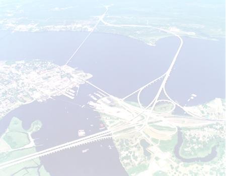
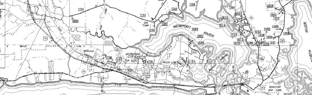
1 New Bern/James City Area - Work Session US 70 Corridor Planning for the Future Brinson Elementary School Thursday, January 31, 2008 Agenda Sign-in, in, View Maps, Talk to Project Team Public Q & A Session Breakout Groups Access Management Concepts & Plans Freeway Plans 2 1


2 What is US 70? Strategic Corridor 45% NC traffic occurs on 7% State s system Commercial Main Street Major Truck Route NC Ports: Increased truck traffic with growth at Morehead and Radio Island 3 Commission Vision Statement To partner with local, regional, and state government agencies to effectively support initiatives enhancing safety, mobility and economic vitality along the Highway 70 corridor through land use planning, transportation improvement, and economic development strategies. 4 2
3 A Closer Look at US 70 Corridor 5 US 70 Today Traffic: 12,000 54,000 vpd New Bern: 45,000 vpd Trent River Bridge: 54,000 vpd James City: 49,000 vpd Grantham: 37,000 vpd Thurman: 28,000 vpd 57 signals 264 median openings 6 3


4 US 70 Website Keep up-to-date with US 70 news and plans at our website: 7 New Bern/James City Area Work Session Questions / Comments Access Management Crashes Standards Ramp-Overs Bypasses AM Handbook 4
 9")
")
5 Access Management Measures Mainline Directional Cross-over (Left-over) 9 Access Management Measures Example Directional Cross-over (Left-over) 10 5


6 Access Management Measures Minor St. Directional Cross-over (Reverse left-over) 11 Access Management Measures Mainline/Reverse Cross-over Pairing 12 6
7 Access Management Measures Mainline/Reverse Cross-over Pairing Old Cherry Point residents use left-over at Day Star Ln. from US Access Management Measures Dual Mainline Cross-over Pairing 14 7

8 Access Management Measures Channelized Left-in/Left-out (Pork Chop) 15 Freeway Retrofit Strategies Alternate Interchanges Compressed Diamond Example: US 501 and George Bishop Parkway, Myrtle Beach, SC 16 8


9 17 Conceptual Designs Compressed Diamond US Williams Rd. James City 18 9

 1,744 injury 42 fatalities Craven 1,073 total (2 nd highest")
10 Conceptual Designs Compressed Diamond US Williams Rd. James City Grade separation with ramp-over design Use slip ramps to access or exit US 70 Close median breaks Convert current frontage roads to one-way access roads Can keep service roads two-way if ramps moved past Airport Road 19 US 70 Today 4,534 Total Crashes ( ) 1,744 injury 42 fatalities Craven 1,073 total (2 nd highest county for Super 70) 369 injuries (2 nd ) 6 fatalities (T-4 th ) 20 10
11 Crash Comparison US 70 Crashes - Clayton to Morehead City ( ) Other 10.4% Head-on 0.6% Angle 17.2% Other 10.1% US 70 Crashes - Craven Co. ( ) Head-on 0.4% Angle 12.2% Single Vehicle 20.4% Left Turn 8.8% Left Turn 8.7% Ped/bike 0.8% Sideswipes 8.1% Rear-end 33.7% Single Vehicle 26.3% Ped/bike 0.8% Sideswipes 5.7% Rear-end 35.9% 21 Super 70 Freeway Plan Existing/Under Construction/Funded Remain as Bypasses Retrofit to Freeway Standards Kinston Bypass or Retrofit to Freeway? 22 11


12 Future US 70 Freeway Planned Havelock Bypass NEPA documents clearing completion Design in progress Right-of-way funded in FY 2010 Construction funding begins in 2015 Proposed N. Carteret Bypass Unfunded in TIP Current NCDOT Feasibility Study Planned Gallants Channel Bridge and Beaufort Bypass Currently designed Funded ROW 2008, Construction Future US 70 Freeway Proposed N. Carteret Bypass Unfunded in TIP Current NCDOT Feasibility Study Planned Gallants Channel Bridge and Beaufort Bypass Currently designed Funded ROW 2008, Construction


13 Access Management Plan Goal: upgrade to Expressway standards Sections of US 70 could be retrofitted in the near- to mid-term with access management measures Reduction of most severe crashes Rear-end: 35% Angle: 24% Left-turn: 10% 25 Typical Rural Expressway 26 13

14 Typical Urban Expressway 27 What is a Freeway? Functional Purpose: High Mobility, Low Access Design set by NCDOT Roadway Design Manual and AASHTO Green Book Posted Speed Limit: 55 mph or greater Rural design speed: 70 mph Traffic Signals: Not Allowed 28 14
15 What is a Freeway? Control of Access: Full Driveways: Not Allowed Only major cross street access provided, at grade-separated interchanges Interchange spacing (min.) 1 mile urban, 2 miles rural Median Crossovers Public-use Crossovers Not Allowed U-turn Median Openings for Use by Authorized Vehicles Only when Need is Justified 29 What is a Freeway? Cross-Section: feet in width Minimum four (4) 12 lanes Median 70' standard 46' min w/o concrete barrier 22' min 6 lanes w/ concrete barrier 22' standard 4 lanes w/ concrete barrier 10' min 4 lanes w/ concrete barrier 12 Shoulders 30 15

16 Comparison Expressway / Freeway Main differences for Expressway vs. Freeway standards Minor streets can access highway at allmovement crossovers or with use of downstream median U-turn crossovers Minimum spacing: 2,000 feet Ultimate goal still no signals Posted speed: mph 31 Access Management Handbook Goes beyond engineering Corridor challenges Corridor vision Access Management 101 Lessons Learned Toolkit One-on-One Meetings w/ Planning Directors Land Use Policies Model Ordinance 32 16
March 2, 2017 Integrating Transportation Planning, Project Development, and Project Programming
 COORDINATION WITH VDOT DISTRICTS TO DELIVER IMPLEMENTABLE IMPROVEMENT PROJECTS March 2, 2017 Integrating Transportation Planning, Project Development, and Project Programming PRESENTATION OUTLINE What
800 Access Control, R/W Use Permits and Drive Design
 Table of Contents 801 Access Control... 8-1 801.1 Access Control Directives... 8-1 801.2 Access Control Policies... 8-1 801.2.1 Interstate Limited Access... 8-1 801.2.2 Limited Access... 8-1 801.2.3 Controlled
Purpose and Need Report
 Purpose and Need Report State Highway (SH) 29 From Southwestern Boulevard to SH 95 Williamson County, Texas (CSJ: 0337-02-045) Prepared by Blanton & Associates, Inc. Date: November, 2015 The environmental
SN01 STANDARD NOTES CITY OF SAMMAMISH 2018 INTERSECTION IMPROVEMENTS PROJECT NO. DATE BY APPR REVISION COSA0023 KING COUNTY WASHINGTON
 STANDARD NOTES SN01 2 OF 17 STANDARD NOTES SN02 3 OF 17 SITE PREP & T.E.S.C. NOTES GENERAL NOTES SITE PREP & T.E.S.C. PLAN SP01 4 OF 17 SITE PREP & T.E.S.C. NOTES GENERAL NOTES SITE PREP & T.E.S.C. PLAN
Corridor Sketch Summary
 Corridor Sketch Summary SR 241: I-82 Jct (Sunnyside) to SR 24 Jct Corridor Highway No. 241 Mileposts: 7.53 to 25.21 Length: 17.65 miles Corridor Description The seventeen and one-half mile corridor begins
Median Barriers in North Carolina -- Long Term Evaluation. Safety Evaluation Group Traffic Safety Systems Management Section
 Median Barriers in North Carolina -- Long Term Evaluation Safety Evaluation Group Traffic Safety Systems Management Section Background In 1998 North Carolina began a three pronged approach to prevent and
Executive Summary. Draft Environmental Impact Statement/Environmental Impact Report ES-1
 Executive Summary Introduction The Eastside Transit Corridor Phase 2 Project is a vital public transit infrastructure investment that would provide a transit connection to the existing Metro Gold Line
Draft US Corridor Study Traffic Analysis Report
 Draft US 15-501 Corridor Study Traffic Analysis Report US 15-501 from NC 54 to US 64 Year 2013-2040 Prepared for: North Carolina Department of Transportation Prepared by: Stantec Consulting Services, Inc.
Open House. Highway212. Meetings. Corridor Access Management, Safety & Phasing Plan. 5:30 to 6:30 p.m. - Southwest Corridor Transportation Coalition
 Welcome Meetings 5:30 to 6:30 p.m. - Southwest Corridor Transportation Coalition 6:30 to 8:00 p.m. - Open House Why is Highway 212 Project Important? Important Arterial Route Local Support Highway 212
SN01 STANDARD NOTES CITY OF SAMMAMISH 2018 FLASHING YELLOW ARROW SIGNALS PROJECT NO. DATE BY APPR REVISION COSA0023 KING COUNTY WASHINGTON
 STANDARD NOTES SN01 2 OF 8 ROADWAY PLAN PL01 3 OF 8 ROADWAY PLAN PL02 4 OF 8 LANE 10 105 150 205 270 450 500 550 11 12 SHOULDER 115 125 MINIMUM LANE CLOSURE TAPER LENGTH = L 165 225 295 180 245 320 5 25
Chicago to St. Louis High-Speed Rail. IDOT District 8 Crossings. July 29, 2015
 Chicago to St. Louis High-Speed Rail IDOT District 8 Crossings July 29, 2015 1 History: Chicago-St. Louis Corridor» IDOT has actively developed the Chicago to St. Louis corridor since the mid 1980 s» In
Kendall Drive Premium Transit PD&E Study Project Kick-Off Meeting SR 94/Kendall Drive/SW 88 Street Project Development and Environment (PD&E) Study
 Study") Florida Department of Transportation District Six Kendall Drive Premium Transit PD&E Study Project Kick-Off Meeting SR 94/Kendall Drive/SW 88 Street Project Development and Environment (PD&E) Study What
Florida Department of Transportation District Six Kendall Drive Premium Transit PD&E Study Project Kick-Off Meeting SR 94/Kendall Drive/SW 88 Street Project Development and Environment (PD&E) Study What
Proposed Project I 35 Improvements from SH 195 to I 10
 I 35 ROADWAY Proposed Project I 35 Improvements from SH 195 to I 10 The existing I 35 facility from State Highway 195 (SH 195) north of Georgetown to Interstate 10 (I 10) in San Antonio varies from four
DELINEATOR REFERENCE POINT 200' TYPICAL SPACING (YELLOW DELINEATORS) END OF MERGE LANE TAPER DELINEATOR REFERENCE POINT
 END OF MERGE LANE TAPER DELINEATOR REFERENCE POINT") 200' TYP. 0' < EACH SIDE BOTH ROADWAYS END OF MERGE LANE TAPER TYPICAL FOR ALL 2-LANE MERGES EXCEPT WHERE THERE IS A MERGE FROM THE RIGHT AND NO OFFSET IN THE THROUGH LANES END OF MERGE LANE TAPER 200'
200' TYP. 0' < EACH SIDE BOTH ROADWAYS END OF MERGE LANE TAPER TYPICAL FOR ALL 2-LANE MERGES EXCEPT WHERE THERE IS A MERGE FROM THE RIGHT AND NO OFFSET IN THE THROUGH LANES END OF MERGE LANE TAPER 200'
Evaluation Considerations and Geometric Nuances of Reduced Conflict U-Turn Intersections (RCUTs)
") Evaluation Considerations and Geometric Nuances of Reduced Conflict U-Turn Intersections (RCUTs) 26 th Annual Transportation Research Conference Saint Paul RiverCentre May 20, 2015 Presentation Outline
Evaluation Considerations and Geometric Nuances of Reduced Conflict U-Turn Intersections (RCUTs) 26 th Annual Transportation Research Conference Saint Paul RiverCentre May 20, 2015 Presentation Outline
CHANGE LIST for MDOT Traffic and Safety Geometric Design Guides. May 23, 2017: The following update was made to the web site.
 CHANGE LIST for MDOT Traffic and Safety Geometric Design Guides Note: Located at https://mdotjboss.state.mi.us/tssd/tssdhome.htm May 23, 2017: The following update was made to the web site. GEO-650-D Flares
PORTS-TO-PLAINS. Corridor Planning. Ports-to-Plains Stakeholder Meeting
 PORTS-TO-PLAINS Corridor Planning Stakeholder Workshop - Agenda 1 Purpose of Stakeholder Workshops 3 2 Rural Transportation System Overview 4 3 Ports-to-Plains 8 4 5 6 7 I-27 Expansion Key Considerations
2016 Congestion Report
 2016 Congestion Report Metropolitan Freeway System May 2017 2016 Congestion Report 1 Table of Contents Purpose and Need...3 Introduction...3 Methodology...4 2016 Results...5 Explanation of Percentage Miles
Metropolitan Freeway System 2013 Congestion Report
 Metropolitan Freeway System 2013 Congestion Report Metro District Office of Operations and Maintenance Regional Transportation Management Center May 2014 Table of Contents PURPOSE AND NEED... 1 INTRODUCTION...
I-4 Beyond the Ultimate. Florida Transportation Builders Association January 18, 2019
 I-4 Beyond the Ultimate Florida Transportation Builders Association January 18, 2019 FDOT District 5 Improving Mobility & Safety in Central Florida FDOT District 5 is: Designing and building a better Interstate
FREQUENTLY ASKED QUESTIONS
 THE PROJECT Last updated on 9/8/16 FREQUENTLY ASKED QUESTIONS What s happening on Highway 169? The Minnesota Department of Transportation (MnDOT) is planning to rebuild and repair the infrastructure on
FREQUENTLY ASKED QUESTIONS
 THE PROJECT Last updated on 2/19/16 FREQUENTLY ASKED QUESTIONS What s happening on Highway 169? The Minnesota Department of Transportation (MnDOT) is planning to rebuild and repair the infrastructure on
The Northeast Corridor Master Plan Amtrak s Next Generation High-Speed Rail and Northeastern Maryland
 The Northeast Corridor Master Plan Amtrak s Next Generation High-Speed Rail and Northeastern Maryland Chesapeake Science & Security Corridor Regional Rail Committee Meeting October 20, 2010 Drew Galloway
GTA West Corridor Planning and EA Study Stage 1
 GTA West Corridor Planning and EA Study Stage 1 Draft Development Strategy Presentation to Peel Goods Movement Task Force April 8 2011 Study Areas 2 Unique Approach Unprecedented two-stage EA process:
PUBLIC INFRASTRUCTURE PROJECTS
 PUBLIC INFRASTRUCTURE PROJECTS FM 664 / OVILLA ROAD WIDENING & IMPROVEMENTS FM 664 / OVILLA ROAD CONNECTS US 287 WITH I-45 (SOURCE: TEXAS DEPARTMENT OF TRANSPORTATION. 2016 FM 664 / OVILLA ROAD WIDENING
Summary of the Alcoa Highway Redevelopment Project
 Appendix B Summary of the Alcoa Highway Redevelopment Project By Marcia Finfer, October 2009 The Timberlake community, along with numerous other concerned citizen groups (including the Lakemoor Hills community)
Challenges in a Post-Katrina Environment East-West Corridor Project Overview February, 2007
 EAST-WEST CORRIDOR Challenges in a Post-Katrina Environment East-West Corridor Project Overview February, 2007 Presentation Agenda Project Overview / Purpose and Need Highway Component Transit Component
Over-Dimensional Vehicle Restriction Study for US 129 in TN
 Over-Dimensional Vehicle Restriction Study for US 129 in TN July 30,2015 TDOT Region 1 US 129 Location Map US 129 Topography and Scenery Operational and Safety Study August 2014, US129 Operational and
Chapter 7: Corridor Visions
 Chapter 7: Corridor Visions (see also Appendix 7 for Details) January 24, 2008 NOTE: This document has been prepared using Federal funding from the United States Department of Transportation. The United
Harlem Avenue between 63 rd and 65 th
 Harlem Avenue between 63 rd and 65 th Public Meeting #2 March 13, 2018 Summit Park District Welcome to the second Public Meeting for the preliminary engineering and environmental studies of Illinois 43
Slow Down! Why speed is important in realizing your Vision Zero goals and how to achieve the speeds you need
 Slow Down! Why speed is important in realizing your Vision Zero goals and how to achieve the speeds you need Lake McTighe, METRO Joel McCarroll, ODOT Jenna Marmon, ODOT Matt Ferris-Smith, PBOT Oregon Active
SOUTHERN GATEWAY. Transportation and Trinity River Project Committee 11 May 2015
 SOUTHERN GATEWAY Transportation and Trinity River Project Committee 11 May 2015 Southern Gateway Project History Began in 2001 as a Major Investment Study [ MIS ], Schematic, and Environmental Assessment
Metro Transit Update. Christina Morrison, Senior Planner Metro Transit BRT/Small Starts Project Office. John Dillery, Senior Transit Planner
 Metro Transit Update Christina Morrison, Senior Planner Metro Transit BRT/Small Starts Project Office John Dillery, Senior Transit Planner Metro Transit Service Development May 16, 2013 1 Transit Planning
The Eastern Connector Study November, 2007 planning for the future
 The Eastern Connector Study November, 2007 planning for the future In late 2006, Albemarle County and the City of Charlottesville jointly initiated the Eastern Connector Corridor Study. The Project Team
state, and federal levels, complete reconstruction and expansion of I35 in the near future is not likely.
 Project Summary Johnson County is an economic engine for the Kansas City metropolitan area and the State of Kansas. It s the fastest growing county in the state of Kansas and has the nation s third highest
Metropolitan Freeway System 2007 Congestion Report
 Metropolitan Freeway System 2007 Congestion Report Minnesota Department of Transportation Office of Traffic, Safety and Operations Freeway Operations Section Regional Transportation Management Center March
DRAFT Subject to modifications
 TREASURE COAST REGIONAL PLANNING COUNCIL M E M O R A N D U M DRAFT To: Council Members AGENDA ITEM 7A From: Date: Subject: Staff September 17, 2010 Council Meeting High Speed Rail Update Introduction The
TABLE OF CONTENTS EXECUTIVE SUMMARY...1 INTRODUCTION...3 PROJECTED FUTURE GROWTH...3 ROADWAY IMPROVEMENT PROJECTS...4 POTENTIAL FUNDING SOURCES...
 Transportation Impact Fee Study September 2014 TABLE OF CONTENTS EXECUTIVE SUMMARY...1 INTRODUCTION...3 PROJECTED FUTURE GROWTH...3 ROADWAY IMPROVEMENT PROJECTS......4 POTENTIAL FUNDING SOURCES...7 PROPOSED
Transportation Highway Engineering Conference February 24, 2015
 Transportation Highway Engineering Conference February 24, 2015 Today s Agenda Move Illinois status Jane Addams Memorial (I-90) Rebuilding and Widening Project Building a 21 st century corridor Incorporating
SOUTH TEXAS COMMISSION MEETING
 SOUTH TEXAS COMMISSION MEETING September 26, 2013 Pharr District Commission Meeting Pharr District: Overview The Pharr District plans, designs, builds, operates and maintains the state transportation system
SC Highway 41 Existing Conditions
 SC Highway 41 Existing Conditions Existing Typical Cross Section purposes only and does not replace the required NEPA process necessary for alignment The NEPA process is anticipated to begin in the next
EXCEPTION TO STANDARDS REPORT
 EXCEPTION TO STANDARDS REPORT PROJECT DESCRIPTION AND NEED The project is located in Section 6, Township 23 North, Range 9 East and Section 31 Township 24 North, Range 9 East, in the Town of Stockton,
TOLL TRUCKWAYS: Increasing Productivity and Safety in Goods Movement. By Robert W. Poole, Jr., and Peter Samuel
 TOLL TRUCKWAYS: Increasing Productivity and Safety in Goods Movement By Robert W. Poole, Jr., and Peter Samuel Trucks Are America s Lifeblood Trucks carry 90% of all freight (by value). Truck shipment
Final Series of Public Meetings
 Final Series of Public Meetings Public Meeting Locations City Date Jasper Monday, September 26 Livingston Tuesday, September 27 Huntsville Wednesday, September 28 Bryan Thursday, September 29 Eldorado
Effectiveness of Median Cable Barriers and Rumble Strips
 Effectiveness of Median Cable Barriers and Rumble Strips Chris Poole, Iowa Department of Transportation Peter Savolainen, Iowa State University Mid-Continent Transportation Research Symposium August 16,
Comprehensive Regional Goods Movement Plan and Implementation Strategy Goods Movement in the 2012 RTP/SCS
 Comprehensive Regional Goods Movement Plan and Implementation Strategy Goods Movement in the 2012 RTP/SCS Annie Nam Southern California Association of Governments September 24, 2012 The Goods Movement
Breakout Session. The Mobility Challenges of Our Growing & Sprawling Upstate
 Breakout Session The Mobility Challenges of Our Growing & Sprawling Upstate The Mobility Challenges of Our Growing & Sprawling Upstate Why is our suburban and sprawling development pattern a challenge
Welcome. Highway 23 Gap New London to Paynesville. Open House. - Please Sign In -
 Highway Gap New London to Paynesville Welcome Highway Gap New London to Paynesville Open House - Please Sign In - There is no formal presentation, but representatives are available to answer your questions.
Horizontal Alignment
 Session 8 Jim Rosenow, PE, Mn/DOT March 5-7, 2010 Horizontal Alignment The shortest distance between two points is: A straight line The circumference of a circle passing through both points and the center
Median Barriers in North Carolina
 Median Barriers in North Carolina AASHTO Subcommittee on Design - 2006 June 13-16, 2006 Jay A. Bennett North Carolina DOT State Roadway Design Engineer Brian Murphy, PE Traffic Safety Engineer Safety Evaluation
US 81 Bypass of Chickasha Environmental Assessment Public Meeting
 US 81 Bypass of Chickasha Environmental Assessment Public Meeting March 14, 2013 Introductions ODOT FHWA SAIC Meeting Purpose Present need for bypass Provide responses to 10/04/11 public meeting comments
Horizontal Sight Distance Considerations Freeway and Interchange Reconstruction
 80 TRANSPORTATION RESEARCH RECORD 1208 Horizontal Sight Distance Considerations Freeway and Interchange Reconstruction In JOEL p. LEISCH With improvements being made to freeways and expressways, the problem
TRAFFIC IMPACT STUDY. USD #497 Warehouse and Bus Site
 TRAFFIC IMPACT STUDY for USD #497 Warehouse and Bus Site Prepared by: Jason Hoskinson, PE, PTOE BG Project No. 16-12L July 8, 216 145 Wakarusa Drive Lawrence, Kansas 6649 T: 785.749.4474 F: 785.749.734
The Jack A. Markell Trail Delaware s Bicycle Highway New England Bike- Walk Summit
 The Jack A. Markell Trail Delaware s Bicycle Highway 2018 New England Bike- Walk Summit The Jack A. Markell Trail Sometimes a very difficult project, including significant investment and perseverance,
I-820 (East) Project Description. Fort Worth District. Reconstruct Southern I-820/SH 121 Interchange
 Project Description. Fort Worth District. Reconstruct Southern I-820/SH 121 Interchange") I-820 (East) Project Description Fort Worth District Reconstruct Southern I-820/SH 121 Interchange I-820 from approximately 2,000 feet north of Pipeline Road/Glenview Drive to approximately 3,200 feet
I-820 (East) Project Description Fort Worth District Reconstruct Southern I-820/SH 121 Interchange I-820 from approximately 2,000 feet north of Pipeline Road/Glenview Drive to approximately 3,200 feet
DISTRIBUTION: Electronic Recipients List TRANSMITTAL LETTER NO. (15-01) MINNESOTA DEPARTMENT OF TRANSPORTATION. MANUAL: Road Design English Manual
 MINNESOTA DEPARTMENT OF TRANSPORTATION. MANUAL: Road Design English Manual") DISTRIBUTION: Electronic Recipients List MINNESOTA DEPARTMENT OF TRANSPORTATION DEVELOPED BY: Design Standards Unit ISSUED BY: Office of Project Management and Technical Support TRANSMITTAL LETTER NO.
DISTRIBUTION: Electronic Recipients List MINNESOTA DEPARTMENT OF TRANSPORTATION DEVELOPED BY: Design Standards Unit ISSUED BY: Office of Project Management and Technical Support TRANSMITTAL LETTER NO.
I-5 Electric Highway
 WEST COAST GREEN HIGHWAY I-5 Electric Highway Public/Private Partnership Project Jeff Doyle Director, Public/Private Partnerships Washington State Department of Transportation Presented to AASHTO Climate
STH 60 Northern Reliever Route Feasibility Study Report
 #233087 v3 STH 60 Northern Reliever Route Feasibility Study Report Washington County Public Works Committee Meeting September 28, 2016 1 STH 60 Northern Reliever Route Feasibility Study Hartford Area Development
Safety Evaluation of Restricted Crossing U-Turn (RCUT or J-Turn) Projects in Louisiana
 Projects in Louisiana") Safety Evaluation of Restricted Crossing U-Turn (RCUT or J-Turn) Projects in Louisiana Xiaoduan Sun University of Louisiana at Lafayette 2018 Louisiana Transportation Engineering Conference Outline Project
Safety Evaluation of Restricted Crossing U-Turn (RCUT or J-Turn) Projects in Louisiana Xiaoduan Sun University of Louisiana at Lafayette 2018 Louisiana Transportation Engineering Conference Outline Project
Traffic Signal Timing Diamond Operation. Innovation for better mobility
 Traffic Signal Timing Diamond Operation Classic Diamond Interchange Page 2 2 What is a Diamond? Page 3 3 What is a Diamond? (Signal Terms) Two closely spaced signalized intersections of an arterial with
2 Min. Min. Edge of. Edgeline See Note 3 PLAN VIEW. See Note 3. This distance may vary
 8" Physical gore ( ) ( ) 250 Varies 250 TYPICAL RUMBLE STRIP PLACEMENT AT EXIT AND ENTRANCE RAMPS This distance may vary This distance may vary ( ) 2 16" edge of R=12" Max ( ) Physical gore Texturing 1.
Making Mobility Better, Together
 Making Mobility Better, Together Austin Transportation Department Gordon Derr, P.E., for Robert J. Spillar, P.E Director, Austin Transportation Department 1 AUSTIN TRANSPORTATION DEPARTMENT Our Mission
Harlem Avenue between 63 rd and 65 th
 Harlem Avenue between 63 rd and 65 th Community Advisory Group Meeting #3 December 1, 2017 Bedford Park Public Library 1 Meeting Agenda 1. Welcome/Introductions (3 mins) 2. Project Overview and Re-Cap
IMPROVEMENT CONCEPTS
 IMPROVEMENT CONCEPTS for the South Novato Transit Hub Study Prepared by: January 11, 2010 DKS Associates With Wilbur Smith Associates IMPROVEMENT CONCEPTS Chapter 1: Introduction 1. INTRODUCTION The strategic
South Dallas-Waxahachie Corridor Strategy Meeting. June 2, 2009
 South Dallas-Waxahachie Corridor Strategy Meeting June 2, 2009 Project Mission Provide additional transportation choices connecting major activity centers in Dallas County and Ellis County by efficiently
New Jersey Turnpike Authority Interchange 6 to 9 Widening Program
 New Jersey Turnpike Authority Interchange 6 to 9 Widening Program Tuesday, September 18, 2007 Public Hearings: Time: 5:00 PM - 8:00 PM Wednesday, September 19, 2007 Senior Center 3 Municipal Drive Bordentown,
Sight Distance. A fundamental principle of good design is that
 Session 9 Jack Broz, PE, HR Green May 5-7, 2010 Sight Distance A fundamental principle of good design is that the alignment and cross section should provide adequate sight lines for drivers operating their
Southeastern Wisconsin Regional Freeway System Reconstruction Study
 Southeastern Wisconsin Regional Freeway System Reconstruction Study July 26, 2001 1 Agenda Item 3 Presentation of Projected Traffic Impacts of the Possible New Freeway Segment Connecting IH 43 and USH
AASHTO Policy on Geometric Design of Highways and Streets
 AASHTO Policy on Geometric Design of Highways and Streets 2001 Highlights and Major Changes Since the 1994 Edition Jim Mills, P.E. Roadway Design Office 605 Suwannee Street MS-32 Tallahassee, FL 32399-0450
SH 249 PUBLIC MEETING DESIGN CHANGES FROM FM 2920 TO HARDIN STORE ROAD
 SH 249 PUBLIC MEETING DESIGN CHANGES FROM FM 2920 TO HARDIN STORE ROAD Lone Star College, Tomball Campus December 8, 2015 Open House 5:30-7:30 pm National Environmental Policy Act The environmental review,
4 COSTS AND OPERATIONS
 4 COSTS AND OPERATIONS 4.1 INTRODUCTION This chapter summarizes the estimated capital and operations and maintenance (O&M) costs for the Modal and High-Speed Train (HST) Alternatives evaluated in this
Leadership NC. November 8, 2018
 v Leadership NC November 8, 2018 Planning for our region s growth The Triangle is one of the fastestgrowing regions in the nation. More than 2 million people are already part of the equation, and the
Mountainland Association of Governments SPRINGVILLE-SPANISH FORK AREA TRANSPORTATION STUDY APRIL 2012
 Mountainland Association of Governments SPRINGVILLE-SPANISH FORK AREA TRANSPORTATION STUDY APRIL 2012 PLANNING FOR OUR FUTURE Planners with the Mountainland Association of Governments (MAG) have evaluated
NCDOT Report on Improving Safety on Secondary Roads
 April 8, 2016 NCDOT Report on Improving Safety on Secondary Roads Kevin Lacy, PE, State Traffic Engineer Overview Crash data and Safety Performance on Secondary Roads Driver Behavior Roadway Environment
Subarea Study. Manning Avenue (CSAH 15) Corridor Management and Safety Improvement Project. Final Version 1. Washington County.
 Corridor Management and Safety Improvement Project. Final Version 1. Washington County.") Subarea Study Manning Avenue (CSAH 15) Corridor Management and Safety Improvement Project Final Version 1 Washington County June 12, 214 SRF No. 138141 Table of Contents Introduction... 1 Forecast Methodology
Subarea Study Manning Avenue (CSAH 15) Corridor Management and Safety Improvement Project Final Version 1 Washington County June 12, 214 SRF No. 138141 Table of Contents Introduction... 1 Forecast Methodology
SH 249 IN GRIMES COUNTY. Open House April 3, 2014
 SH 249 IN GRIMES COUNTY Open House April 3, 2014 Meeting Agenda Purpose of Meeting Today: Review the purpose and need for the SH 249 Grimes County project Review the proposed project and alternatives Discuss
Naval Station Norfolk Transit Extension Study. October 2014
 Naval Station Norfolk Transit Extension Study October 2014 1 Employment by Transportation Analysis Zone (TAZ) Naval Station Legend Norfolk is Hampton Roads Region s largest employer C or with better PM
Mississauga Bus Rapid Transit Preliminary Design Project
 Mississauga Bus Rapid Transit Preliminary Design Project PUBLIC INFORMATION CENTRE OCTOBER 2008 WELCOME The Mississauga Bus Rapid Transit (BRT) Project Thank you for attending this Public Information Centre.
I-10 West AA/EIS Pre-Screening and Tier 1 Analysis Results. Public Meeting. Wulf Grote, Director Project Development Rick Pilgrim, Project Manager
 I-10 West AA/EIS Pre-Screening and Tier 1 Analysis Results Public Meeting Wulf Grote, Director Project Development Rick Pilgrim, Project Manager March 4 & 5, 2008 Today s Agenda Overview of Alternatives
6/6/2018. June 7, Item #1 CITIZENS PARTICIPATION
 June 7, 2018 Item #1 CITIZENS PARTICIPATION 1 Item #2 APPROVAL OF MINUTES Item #3 TRAC GOALS, FRAMEWORK & AGENDA REVIEW 2 COMMITTEE GOALS Learn about Southern Nevada s mobility challenges, new developments
Redefining Mobility. Randy Iwasaki. Executive Director Contra Costa Transportation Authority January 18, 2018
 Redefining Mobility Randy Iwasaki Executive Director Contra Costa Transportation Authority January 18, 2018 Who We Are CCTA is a public agency formed by voters in 1988 to manage the county s transportation
A Vision for Highway Automation
 A Vision for Highway Automation R y a n D. R i c e D i r e c t o r o f M o b i l i t y O p e r a t i o n s C o l o r a d o D e p a r t m e n t o f T r a n s p o r t a t i o n Problem Statement Higher
Business Leadership on Transportation in the Triangle
 Business Leadership on Transportation in the Triangle Joe Milazzo II, PE Executive Director Regional Transportation Alliance business coalition North Carolina House Select Committee on Strategic Transportation
The Design-Builder shall meet local road criteria provided by the local governing agencies.
 11 ROADWAYS 11.1 General The -Builder shall conduct all Work necessary to meet the requirements of roadways. Roadway classifications include mainline, acceleration lanes, deceleration lanes, auxiliary
Welcome. Please Sign In
 Welcome South Bay Bus Rapid Transit (BRT) Draft Environmental Impact Report (DEIR) Public Meeting Please Sign In Please comment in any of the following manners: 1. Submit a comment form 2. Provide verbal
Project Working Group Meeting #5
 September 17, 2013 Project Working Group Meeting #5 1 September 17, 2013 www.i-80will.com Meeting Purpose Project update Discuss Range of Alternatives Discuss next steps 2 September 17, 2013 www.i-80will.com
Table of Contents INTRODUCTION... 3 PROJECT STUDY AREA Figure 1 Vicinity Map Study Area... 4 EXISTING CONDITIONS... 5 TRAFFIC OPERATIONS...
 Crosshaven Drive Corridor Study City of Vestavia Hills, Alabama Table of Contents INTRODUCTION... 3 PROJECT STUDY AREA... 3 Figure 1 Vicinity Map Study Area... 4 EXISTING CONDITIONS... 5 TRAFFIC OPERATIONS...
NORTH HOUSTON HIGHWAY IMPROVEMENT PROJECT (NHHIP)
") NORTH HOUSTON HIGHWAY IMPROVEMENT PROJECT (NHHIP) Project Overview Briefing Packet March 2017 PROJECT OVERVIEW Environmental Impact Statement (EIS) Project divided into 3 Segments Segment 1: Beltway 8
NORTH HOUSTON HIGHWAY IMPROVEMENT PROJECT (NHHIP) Project Overview Briefing Packet March 2017 PROJECT OVERVIEW Environmental Impact Statement (EIS) Project divided into 3 Segments Segment 1: Beltway 8
Access Management: An R-CUT Above the Rest
 Access Management: An R-CUT Above the Rest Presented by Cristine Gowland LADOTD District 62 www.dotd.la.gov What is an R-CUT? Restricted Crossing U-Turn Non-traditional intersection design: Side street
Geometric Design Elements to Reduce Wrong-Way (WW) Entry at Freeway Interchanges Hugo Zhou, Ph.D., P.E.
 Entry at Freeway Interchanges Hugo Zhou, Ph.D., P.E.") Geometric Design Elements to Reduce Wrong-Way (WW) Entry at Freeway Interchanges Hugo Zhou, Ph.D., P.E. Department of Civil Engineering Auburn University March, 2017 Why People Drive Wrong-way? WW Entry:
Geometric Design Elements to Reduce Wrong-Way (WW) Entry at Freeway Interchanges Hugo Zhou, Ph.D., P.E. Department of Civil Engineering Auburn University March, 2017 Why People Drive Wrong-way? WW Entry:
Speed Limit Study: Traffic Engineering Report
 Speed Limit Study: Traffic Engineering Report This report documents the engineering and traffic investigation required by Vermont Statutes Annotated Title 23, Chapter 13 1007 for a municipal legislative
10/4/2016. October 6, Item #1 CITIZENS PARTICIPATION
 October 6, 2016 Item #1 CITIZENS PARTICIPATION 1 Item #2 APPROVAL OF MINUTES Item #3 WELCOME 2 Item #4 TRAC ROADWAY RECOMMENDATIONS UPDATE Item #4 Completed Jurisdiction Presentations Boulder City August
RTID Travel Demand Modeling: Assumptions and Method of Analysis
 RTID Travel Demand Modeling: Assumptions and Method of Analysis Overall Model and Scenario Assumptions The Puget Sound Regional Council s (PSRC) regional travel demand model was used to forecast travel
Lee County DOT Traffic Section Design Standard for Sign Installation
 Lee County DOT Traffic Section Design Standard for Sign Installation Traffic Section Table Of Contents Section Title 1. Sign Panel Material 2. Sign Shape 3. Posts 4. Fasteners 5. Retro reflectivity and
The Screening and Selection of Regionally Significant Projects
 The Screening and Selection of Regionally Significant Projects UTC 2018 Seminar Series March 15, 2018 Claire Bozic Martin Menninger ON TO 2050 CMAP is the Region s MPO, seven county region Land use and
Agenda. Utility Undergrounding Strategies & Laguna Canyon Road Master Plan
 Utility Undergrounding Strategies & Laguna Canyon Road Master Plan January 17, 2017 City Council Meeting 2 Agenda Progress since March 2016 Status of undergrounding and road widening between El Toro Rd.
Western ND Meeting. February 19, 2014 Grant Levi, NDDOT Director
 Western ND Meeting February 19, 2014 Grant Levi, NDDOT Director 1 Traffic Trends in North Dakota 2 Truck Traffic 2008 3 Truck Traffic 2012 4 Average Daily Traffic 5 ND Vehicle Miles Traveled Statewide
TRAFFIC IMPACT ANALYSIS
 TRAFFIC IMPACT ANALYSIS Emerald Isle Commercial Development Prepared by SEPI Engineering & Construction Prepared for Ark Consulting Group, PLLC March 2016 I. Executive Summary A. Site Location The Emerald
Dixie Transportation Planning Office
 A project must be given a yes rating on items 1 & 2 in order to be prioritized. Sponsor: St. George City Project: Pioneer Parkway Type: Road Widening and Reconstruction Rev. 9/17/2010 Dixie Transportation
MARTA s blueprint for the future. COFFEE AND CONVERSATION Kyle Keahey, More MARTA Atlanta Dec. 5, 2018
 MARTA s blueprint for the future COFFEE AND CONVERSATION Kyle Keahey, More MARTA Atlanta Dec. 5, 2018 TODAY S AGENDA About MARTA Economic development/local impact More MARTA Atlanta program Program summary/timeline