Exposition Corridor Transit Project
|
|
|
- Brendan Harrell
- 6 years ago
- Views:
Transcription


1 Exposition Corridor Transit Project Phase 2 Environmental Planning Community Meeting June 9, 2008
2 Exposition Corridor Transit Project Phase 2 AGENDA Remaining Grade Crossing Recommendations June 9, :30 PM 8:30 PM Welcome and Introductions Meeting Purpose and Format Presentation Grade Crossing and Traffic Study Overview Analysis and Results Question and Answer Period Closing Remarks/Summary

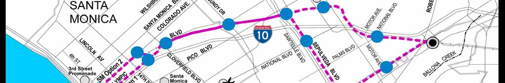
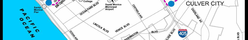

3 Phase 2 Alignment Alternatives


")


4 What is Light Rail? Light rail trains are electric-powered vehicles that operate primarily on exclusive rights-of-way. Light rail transit (LRT) sometimes travels on streets with vehicular traffic. Electric-powered vehicles provide smooth rides and do not create air pollution. They are convenient and avoid traffic congestion through right-of-way separation and traffic signal priority.


5 Phase 1 Typical At Grade Station Simulation
6 Grade Crossing Study Process EIS/EIR PREPARATION PRELIMINARY ENGINEERING FINAL DESIGN Metro Grade Crossing Policy Total Volume (initial screening) Traffic/Rail/Safety (secondary screening) Traffic Engineering (tertiary screening) Traffic Studies City DOT coordination Traffic, roadway, transit engineering Environmental Issues Cost trade off analysis Community disruption Continuation of Analysis California Public Utilities Commission Final regulatory approval
7 Grade Crossings March 2008 Exposition ROW Venice/Sepulveda At-grade Separated Further Analysis At-grade Separated Further Analysis 26th St. Cloverfield Centinela Richland National Sepulveda/Expo Stewart Bundy Barrington Sepulveda Pico/Gateway Westwood Military Sawtelle Overland Bagley - Motor (existing) National/Palms (existing) - Venice Girard/Midvale Queensland Charnock (E) Motor Palms Charnock (W) Clarington Venice/ Sepulveda Hughes Tilden - Bagley/Main Overland - - Culver/Venice - -
8 Grade Crossings March 2008 SM Option 1: Olympic SM Option 2: Colorado At-grade Separated Further Analysis At-grade Separated Further Analysis 14 th St. Lincoln - 4 th St.* Olympic EB/WB - 17 th St. 11 th St th St. Olympic EB - 5 th St th St th St. - - Lincoln th St th St th St th St th St. * if S.M. Station West is selected - -
9 Typical LRT Crossing Timeline Gates coming down Gates Down Gates Down Gates start up Gates going up Allowance TOTAL 20 second warning (CPUC requirement) 3-7 second LRT crossing 2 second clearance 2 second checkout 5 second gate up / auto start up 5 second random arrival delay second crossing closure
10 Peak Hour Crossing Closure Time Projected LRT gate down time At 5 minute peak hour service, there would be 24 LRTs per hour With 24 LRTs per hour and 37 to 41 seconds crossing closure time, this would result in an average impact of an additional 7 to 8 minutes Total Impact Example Overland at Ashby Current red time is 25 minutes per hour Avg Impact 7 8 min Overland at Ashby red time 25 minutes Total on Average Red Time Per Hour minutes
11 Traffic Analysis Levels of Service (LOS) LOS A C LOS D LOS E LOS F Free Flow Conditions through the intersection Intersection experiences occasional delays through the intersection on one approach Intersection near or at capacity with occasional delays on more than one approach Intersection experiences frequent and significant delays
12 Overland / Ashby Traffic Analysis Vehicles / Lane LOS AM LOS PM Current 2007 Counts 975 B C 2030 No Build 1010 C D 2030 w/ Project w/ Mitigation 751 B C
13 Overland Traffic Analysis Mitigations for At Grade Operations Add one northbound and one southbound thru lane from Coventry to Cushdon from 7am to 7 pm Prohibit on street parking on the west side of Overland from ROW to Cushdon 7am to 7pm Prohibit on street parking on the eastside of Overland from ROW to Coventry 7am to 7pm Permit on street parking on the eastside of Overland from Ashby to Ayers 7am to 7pm Permit on street parking on the westside of Overland from ROW to Coventry 7am to 7pm Restrict Expo Blvd South left in/right out only with local egress via Coventry Restrict westbound lefts at Northvale with local egress via Ashby Add pedestrian signal at LRT crossing
14 Overland Crossing Proposal ROW ROW
15 Theoretical Overland Grade Separation The current grade crossing analysis does not support a grade separation at Overland. However, in order to grade separate Overland underground, the top of tracks would be approximately 35 feet below existing grade due to the existing Overland storm drain. From this depth, the tracks could not daylight until west of Westwood Blvd and thus an underground station would be required. These structures would be cost prohibitive. Full diversion of the existing storm drain to a drainage swale is not practical as flows can be as high as 1,272 million gallons per day (mgd). For example, Hyperion treatment plant capacity is at 420 mgd.
16 Westwood / Exposition Traffic Analysis Vehicles / Lane LOS AM LOS PM Current 2007 Counts 1131 F* F* 2030 No Build 1260 F* F* 2030 w/ Project w/ Mitigation 865 B B *unsignalized intersection
17 Westwood Traffic Analysis Mitigations for At Grade Operations Provide 2 northbound lanes from Richland to 100 north of Ashby Provide 2 southbound lanes from Pico to Richland (existing) and beyond Undertake street reconstruction from Richland to 100 north of Ashby within the public ROW Provide 10 ft sidewalks along east and west sides (existing are 5-6 feet) Prohibit on street parking on the east and west from Richland to 700 north of Ashby Restrict Westwood northbound to Expo Blvd South heading west; local access/egress via Brookhaven Restrict Expo Blvd South heading east to Westwood northbound; local access/egress via Brookhaven

18 Westwood / Exposition Crossing Proposal ROW ROW
19 Sepulveda / Exposition Traffic Analysis Vehicles / Lane LOS AM LOS PM Current 2007 Counts 860 B C 2030 No Build 970 C C 2030 w/ Project w/ Mitigation 984 D C
20 Sepulveda Traffic Analysis Mitigations for At Grade Operations ROW Alternative Provide 2 northbound lanes (existing) Richland to Pico Provide 3 SB lanes Pico to Pearl, then taper to two (existing) by Richland Undertake street reconstruction from Richland to Anawalt Lumber south Parking eliminated from Pico to approximately 300 south of Pearl Using existing parkway (20 feet), provide 10 ft sidewalks along east and west sides (existing sidewalks are 4-5 feet) Property impact at south east corner of Sepulveda/Exposition intersection
21 Sepulveda Traffic Analysis Mitigations for At Grade Operations Ven/Sep Alternative Provide 2 northbound lanes from freeway to Pico Provide 3 southbound lanes from Pico to Pearl - taper to two by Richland Street reconstruction from freeway (and beyond) to Anawalt Lumber Parking eliminated from Pico to freeway (and beyond) Using existing parkway (20 feet), provide 10 ft sidewalks along east and west sides (existing sidewalks are 4-5 feet) Significant property impacts from ROW to freeway (and beyond)
22 Sepulveda / Exposition Crossing Proposal ( ) Insert Crossing Drawing ROW ROW
 Insert Crossing Drawing ROW")
23 Sepulveda / Exposition Crossing Proposal SEPULVEDA ( ) Insert Crossing Drawing ROW ROW
24 North Charnock / Sepulveda Traffic Analysis Vehicles / Lane LOS AM LOS PM Current 2007 Counts 134 B B 2030 No Build 174 C C 2030 w/ Project w/ Mitigation 0 C B
25 North and South Charnock Traffic Analysis Mitigations for At Grade Operations Provide 2 northbound lanes Provide 2 southbound lanes Street reconstruction from Venice to Palms (and beyond) Parking eliminated from Venice to Palms Elimination of center left turn lane Signal relocated from North Charnock to South Charnock North Charnock converted to right in/right out only Partial acquisitions of 29 properties; full acquisition of 1 property
26 North and South Charnock Crossing Proposal Insert Crossing Drawing N N S S
27 Barrington / Olympic Traffic Analysis Vehicles / Lane LOS AM LOS PM Current 2007 Counts 770 D D 2030 No Build 900 D E 2030 w/ Project w/ Mitigation 911 D E
28 Barrington Traffic Analysis Mitigations for At Grade Operations Provide 2 northbound lanes (existing) Pico to Olympic Provide 2 southbound lanes (existing) Pico to Olympic Provide 1 southbound right turn lane (new) Tennessee to Pico Provide 1 northbound right turn lane at Olympic Street reconstruction between Expo North and Expo South Street widening from Olympic 200 south for right turn lane Street widening from Tennessee to Pico for right turn lane Parking eliminated at new right turn lanes Provide 10 ft sidewalks east and west sides (existing varies 5 to 10 feet)
29 Barrington Crossing Proposal Insert Crossing Drawing ROW ROW
30 Centinela / Exposition Traffic Analysis Vehicles / Lane LOS AM LOS PM Current 2007 Counts 940 B B 2030 No Build 1105 C B 2030 w/ Project w/ Mitigation 900 B B
31 Centinela Traffic Analysis Mitigations for At Grade Operations Provide 2 northbound lanes from West Expo Blvd to ROW Provide 3 northbound lanes from ROW to Olympic Provide 1 southbound lane from Olympic to Pico Street reconstruction from West Expo Blvd to Olympic Parking eliminated from West Expo Blvd to Olympic Reduce sidewalk width to 7 on west side between ROW and West Expo Blvd Signalize Centinela and East Expo Blvd Property impact from Olympic to ROW on west side
32 Centinela Crossing Proposal Insert Crossing Drawing ROW ROW EAST EAST WEST WEST
33 Environmental Process CEQA/NEPA Process NOI/NOP SCOPING SCREENING DEIS/DEIR Notice of Intent/ Notice of Preparation Public input on alternatives to be considered Select alternatives that will most likely meet the Purpose and Need Draft Environmental Impact Statement/ Draft Environmental Impact Report AGENCY APPROVAL FEIS/FEIR LPA SELECTION Expo Board, Metro Board and FTA Final Environmental Impact Statement/ Final Environmental Impact Report Locally Preferred Alternative: Expo Board, Metro Board, Federal Transit Administration (FTA) concurrence
34 Projected Schedule March 2008 Expo Phase 2 Projected Schedule Project Kickoff January 2007 Public Scoping February/March 2007 Definition of AA/DEIS/DEIR Alternatives October 2007 Public Comment on DEIS/DEIR Fall 2008 Adoption of Locally Preferred Alternative Fall 2008 Circulation of FEIS/FEIR Fall 2009 Begin Construction 2010 Begin Revenue Service
35 Project Information For Additional Project Information: Website: click on the Phase 2 tab Call/Write: Gabriela Gonzalez Government/Community Relations Manager Exposition Metro Line Construction Authority 707 Wilshire Boulevard, 34th Floor Los Angeles, CA Ph: Phase2@exporail.net
Project Scoping Open House Welcome
 Scoping Meeting Project Scoping Open House Welcome Alternatives Analysis (AA) and Draft Environmental Impact Statement/Draft Environmental Impact Report (DEIS/DEIR) Project Purpose Purpose of the Project
Expo Light Rail Line. Expo Line Project Westside/Central Metro Service Council November 2014
 Expo Line Project Westside/Central Metro Service Council November 2014 2 Expo Line Project Description Phase 2 Expo Line from Culver City to Santa Monica: 6.6 mile corridor 7 new Stations 64,000 Daily
Expo Light Rail Line. Expo Line Community Meeting Quarterly Phase 2 Construction Update Los Angeles February 2015
 Expo Line Community Meeting Quarterly Phase 2 Construction Update Los Angeles February 2015 Meeting Agenda Phase 2 Construction Update Meeting Meeting Purpose and Format Construction Update Expo Bikeway
2. PROJECT ALTERNATIVES
 2. PROJECT ALTERNATIVES 2.1 Introduction Six alternatives are evaluated in detail in this Draft Final Environmental Impact Report (DFEIR) for the Exposition Corridor Transit Project Phase 2 (Expo Phase
Expo Light Rail Line. Expo Line Community Meeting Quarterly Phase 2 Construction Update Los Angeles April 2014
 Expo Line Community Meeting Quarterly Phase 2 Construction Update Los Angeles April 2014 Meeting Agenda Phase 2 Construction Update Meeting Meeting Purpose and Format Construction Update Expo Bikeway Update
I-405 Sepulveda Pass Improvements Project
 I-405 Sepulveda Pass Improvements Project Community Meeting November 15, 2012 1 Wilshire Segment Overview of Wilshire Segment There are a total of 23 bridges being constructed on this project; almost half
3.14 Parks and Community Facilities
 3.14 Parks and Community Facilities 3.14.1 Introduction This section identifies the park and community facility resources in the study area and examines the potential impacts that the proposed Expo Phase
Project Scoping Report Appendix B Project Web Site. APPENDIX B Project Web Site
 Project Scoping Report Appendix B Project Web Site APPENDIX B Project Web Site WESTSIDE EXTENSION TRANSIT CORRIDOR STUDY February 4, 2008 News and Info of 1 http://metro.net/projects_programs/westside/news_info.htm#topofpage
3.11 Land Use/Planning
 3.11 Land Use/Planning 3.11.1 Introduction This section identifies existing and future land uses as defined by the land use plans of the local jurisdictions. The section also identifies the existing land
East San Fernando Valley Transit Corridor. TAC Briefing December 4, 2013
 East San Fernando Valley Transit Corridor TAC Briefing December 4, 2013 Overview Measure R Project Long Range Transportation Plan Reserves $170.1 Million 2018 Revenue Operations Date Coordination with
4.1 Traffic, Circulation, and Parking
 4.1 Traffic, This section describes the existing transportation and parking conditions within and adjacent to the project area. A traffic report describing the potential impacts of the proposed project
Sepulveda Pass Corridor Systems Planning Study Update
 Los Angeles County Metropolitan Transportation Authority Sepulveda Pass Corridor Systems Planning Study Update June 20, 2012 Measure R Transit Corridors One of 12 Measure R Transit Corridors approved by
Mobility Corridor Updates. Transit & Active Transportation Projects
 Mobility Corridor Updates Transit & Active Transportation Projects Laura Cornejo, DEO Regional Planner Regional Operator Metro is LA County s Regional Builder/Funder Rail Bus Service (Metro/Muni/Local)
IV. ENVIRONMENTAL IMPACT ANALYSIS J. TRANSPORTATION AND TRAFFIC
 IV. ENVIRONMENTAL IMPACT ANALYSIS J. TRANSPORTATION AND TRAFFIC This Section summarizes the information provided in the Traffic Study for the Santa Monica College Bundy Campus Master Plan (Traffic Study),
Project Budget and Schedule Status
 Item 44 Program Management Project Budget and Schedule Status Project Schedules* Project 2010 2011 2012 2013 2014 2015 2016 2017 2018 2019 2020 2021 2022 Expo Phase I Orange Line Extension I-405 Sepulveda
Phase 2 Exposition Metro Line Project
 Phase 2 Exposition Metro Line Project Monthly Project Status Report February 2014 TABLE OF CONTENTS PHASE 2 EXPO LINE PROJECT STATUS TABLE OF CONTENTS... 2 Phase 2 Exposition Metro Line Construction Authority
West Broadway Reconstruction/LRT Design. March 19, 2015
 West Broadway Reconstruction/LRT Design March 19, 2015 1 Meeting Agenda 6:05 6:30 PM Brief presentation What we heard Project overview 6:30 8:00 PM Visit Six Topic Areas Road and LRT design elements Pedestrian
Mobility Corridor Updates. Transit & Active Transportation Projects
 Mobility Corridor Updates Transit & Active Transportation Projects Manjeet Ranu, SEO East San Fernando Valley Transit Corridor Metro Board LPA selection: June 2018 Recently awarded $200 million in Senate
EXECUTIVE SUMMARY. Introduction. Project Purpose. Executive Summary
 EXECUTIVE SUMMARY Introduction The Exposition Metro Line Construction Authority (Expo Authority) has prepared this Draft Final Environmental Report (DFEIR) in order to extend high -capacity, high -frequency
Sepulveda Pass Corridor Systems Planning Study
 Los Angeles County Metropolitan Transportation Authority Sepulveda Pass Corridor Systems Planning Study Streets and Freeways Subcommittee January 17, 2013 1 Sepulveda Pass Study Corridor Extends for 30
IV. ENVIRONMENTAL IMPACT ANALYSIS N. TRANSPORTATION AND TRAFFIC
 IV. ENVIRONMENTAL IMPACT ANALYSIS N. TRANSPORTATION AND TRAFFIC The following section summarizes the information provided in the traffic report entitled Traffic Impact Analysis for a Proposed Residential
Executive Summary. Draft Environmental Impact Statement/Environmental Impact Report ES-1
 Executive Summary Introduction The Eastside Transit Corridor Phase 2 Project is a vital public transit infrastructure investment that would provide a transit connection to the existing Metro Gold Line
30-Day Look Ahead Summary August 2011
 Wilshire Segment 30-Day Look Ahead Summary August 2011 DWP and SCE Utility Relocation Sepulveda reduced to one lane in each direction, Constitution to Ohio, 9pm to 6am Westbound Wilshire reduced to one
I-405 Sepulveda Pass Improvements Project
 I-405 Sepulveda Pass Improvements Project 26, 2012 Click to edit Master title January style Community Advisory Committee 1 Community Meeting Schedule for 2012 26-Jan CAC, Final Meeting Feb 22-Mar Community
3.17 Energy Resources
 3.17 Energy Resources 3.17.1 Introduction This section characterizes energy resources, usage associated with the proposed Expo Phase 2 project, and the net energy demand associated with changes to the
Rolling Road (Route 638) Widening Project
 Widening Project") Rolling Road (Route 638) Widening Project From: 0.369 Mile North of Fairfax County Parkway (Route 286) To: Old Keene Mill Road (Route 644) State Project No. 0638-029-156, P104, R204, C504; UPC 5559 Public
Rolling Road (Route 638) Widening Project From: 0.369 Mile North of Fairfax County Parkway (Route 286) To: Old Keene Mill Road (Route 644) State Project No. 0638-029-156, P104, R204, C504; UPC 5559 Public
III. CORRECTIONS AND ADDITIONS TO THE DRAFT EIR
 III. CORRECTIONS AND ADDITIONS TO THE DRAT EIR DRAT EIR I. INTRODUCTION/SUMMARY In response to Comment No. 2.1 on the Draft EIR, the following mitigation measure is added to Table I- 1, Summary of Environmental
East San Fernando Valley Transit Corridor. Information Session, October 10, 2017
 East San Fernando Valley Transit Corridor Information Session, October 10, 2017 1 Welcome and Meeting Purpose Introductions Metro Transit Corridors Planning Metro Real Estate Metro Community Relations
I-820 (East) Project Description. Fort Worth District. Reconstruct Southern I-820/SH 121 Interchange
 Project Description. Fort Worth District. Reconstruct Southern I-820/SH 121 Interchange") I-820 (East) Project Description Fort Worth District Reconstruct Southern I-820/SH 121 Interchange I-820 from approximately 2,000 feet north of Pipeline Road/Glenview Drive to approximately 3,200 feet
I-820 (East) Project Description Fort Worth District Reconstruct Southern I-820/SH 121 Interchange I-820 from approximately 2,000 feet north of Pipeline Road/Glenview Drive to approximately 3,200 feet
2.4 Build Alternatives
 Table 2-1. Future Transit Network Changes between No Build and TSM Alternatives Operator Route Group No. Route ID and Description Peak Headway (min) No Build Off-peak Headway (min) Peak Headway (min) TSM
IV. ENVIRONMENTAL IMPACT ANALYSIS B. TRAFFIC AND CIRCULATION
 IV. ENVIRONMENTAL IMPACT ANALYSIS B. TRAFFIC AND CIRCULATION 1. INTRODUCTION This section is based on the technical report, Traffic Study for 10131 Constellation Boulevard Residential Project, prepared
Transit City Etobicoke - Finch West LRT
 Delcan Corporation Transit City Etobicoke - Finch West LRT APPENDIX D Microsimulation Traffic Modeling Report March 2010 March 2010 Appendix D CONTENTS 1.0 STUDY CONTEXT... 2 Figure 1 Study Limits... 2
Challenges in a Post-Katrina Environment East-West Corridor Project Overview February, 2007
 EAST-WEST CORRIDOR Challenges in a Post-Katrina Environment East-West Corridor Project Overview February, 2007 Presentation Agenda Project Overview / Purpose and Need Highway Component Transit Component
Transit Project Delivery Status Report. Significant Issues
 Item 1 Transit Project Delivery Status Report Significant Issues Presented By K.N. Murthy Executive Director Construction Committee 1 I-405 Sepulveda Pass Closure Construction Committee I-405 Sepulveda
Landside Access Modernization Program (LAMP)
") Landside Access Modernization Program (LAMP) LAX Los Angeles International Airport is the 2 nd busiest airport in the United States and is the largest airport in California. Since the start of the economic
Landside Access Modernization Program (LAMP) LAX Los Angeles International Airport is the 2 nd busiest airport in the United States and is the largest airport in California. Since the start of the economic
Lacey Gateway Residential Phase 1
 Lacey Gateway Residential Phase Transportation Impact Study April 23, 203 Prepared for: Gateway 850 LLC 5 Lake Bellevue Drive Suite 02 Bellevue, WA 98005 Prepared by: TENW Transportation Engineering West
Expo Light Rail Line. Expo Line Community Meeting Final Phase 2 Construction Update Santa Monica June 2015
 Expo Line Community Meeting Final Phase 2 Construction Update Santa Monica June 2015 Meeting Purpose and Format Meeting Purpose and Format The purpose of tonight s meeting is to: Provide a final update
King County Metro. Columbia Street Transit Priority Improvements Alternative Analysis. Downtown Southend Transit Study. May 2014.
 King County Metro Columbia Street Transit Priority Improvements Alternative Analysis Downtown Southend Transit Study May 2014 Parametrix Table of Contents Introduction... 1 Methodology... 1 Study Area...
Community Meetings June 2018
 Community Meetings June 2018 1 Welcome and Agenda Thank you for joining us! 6:00 pm Open House 6:30 pm Welcome & Presentation 7:00 pm Q&A 7:15 pm Open House Resumes 8:00 pm Meeting Concludes 2 Purpose
Welcome and Agenda. Thank you for joining us! 6:00 pm Open House. 6:30 pm Welcome & Presentation. 7:00 pm Q&A. 7:15 pm Open House Resumes
 1 Welcome and Agenda Thank you for joining us! 6:00 pm Open House 6:30 pm Welcome & Presentation 7:00 pm Q&A 7:15 pm Open House Resumes 8:00 pm Meeting Concludes 2 Purpose of this Meeting Introduce project
Orange Line Bus Rapid Transit (BRT) Improvements San Fernando Valley Service Council April 3, 2019
 Improvements San Fernando Valley Service Council April 3, 2019") Orange Line Bus Rapid Transit (BRT) Improvements San Fernando Valley Service Council April 3, 2019 1 Measure M Transit Projects in San Fernando Valley 2 1 2 Measure M Transit Projects Schedule Project
Orange Line Bus Rapid Transit (BRT) Improvements San Fernando Valley Service Council April 3, 2019 1 Measure M Transit Projects in San Fernando Valley 2 1 2 Measure M Transit Projects Schedule Project
Community Meetings. January/February 2019
 Community Meetings January/February 2019 Purpose of Meeting Present evaluation of Valley- Westside concepts Present initial Westside- LAX concepts Gather community feedback 2 Study Process 3 Overview:
IV. ENVIRONMENTAL IMPACT ANALYSIS L. TRAFFIC, TRANSPORTATION, AND PARKING
 IV. NVIRONMNTAL IMPACT ANALYSIS L. TRAFFIC, TRANSPORTATION, AND PARKING INTRODUCTION The following summarizes the information provided in the traffic report prepared by Hirsch/Green Transportation Consulting,
LAWRENCE TRANSIT CENTER LOCATION ANALYSIS 9 TH STREET & ROCKLEDGE ROAD / 21 ST STREET & IOWA STREET LAWRENCE, KANSAS
 LAWRENCE TRANSIT CENTER LOCATION ANALYSIS 9 TH STREET & ROCKLEDGE ROAD / 21 ST STREET & IOWA STREET LAWRENCE, KANSAS TRAFFIC IMPACT STUDY FEBRUARY 214 OA Project No. 213-542 TABLE OF CONTENTS 1. INTRODUCTION...
IMPROVEMENT CONCEPTS
 IMPROVEMENT CONCEPTS for the South Novato Transit Hub Study Prepared by: January 11, 2010 DKS Associates With Wilbur Smith Associates IMPROVEMENT CONCEPTS Chapter 1: Introduction 1. INTRODUCTION The strategic
FREQUENTLY ASKED QUESTIONS
 THE PROJECT Last updated on 2/19/16 FREQUENTLY ASKED QUESTIONS What s happening on Highway 169? The Minnesota Department of Transportation (MnDOT) is planning to rebuild and repair the infrastructure on
Expo Light Rail Line Project Status Update Meeting Holman United Methodist Church January 27, 2011
 Project Status Update Meeting Project Status Update Meeting Holman United Methodist Church January 27, 2011 Phase 1 Project Description Phase 1 from Downtown Los Angeles to Culver City: 8.6 mile corridor
FREQUENTLY ASKED QUESTIONS
 THE PROJECT Last updated on 9/8/16 FREQUENTLY ASKED QUESTIONS What s happening on Highway 169? The Minnesota Department of Transportation (MnDOT) is planning to rebuild and repair the infrastructure on
IV. REVISIONS TO THE DRAFT IS/MND
 IV. REVISIONS TO THE DRAFT IS/MND 1. REVISIONS TO THE DRAFT IS/MND This section presents corrections and clarifications that have been made to the text of the Draft IS/MND. These changes include revisions
METRO Orange Line BRT American Boulevard Station Options
 METRO Orange Line BRT American Boulevard Station Options Bloomington City Council Work Session November 18, 2013 Christina Morrison BRT/Small Starts Project Office Coordinating Planning and Design AMERICAN
Restoration of Historic Streetcar Services in Downtown Los Angeles
 Restoration of Historic Streetcar Services in Downtown Los Angeles Early Scoping Meeting for Alternatives Analysis (AA) May 17, 2011 Introduction Key players Local lead agency: Metro Federal lead agency:
Countdown to the Closure Extended 53-Hour Closure of I-405 Freeway Between U.S. 101 and I-10 Planned in Mid-July for Mulholland Bridge Demolition
 Countdown to the Closure Extended 3-Hour Closure of I-40 Freeway Between U.S. 0 and I-0 Planned in Mid-July for Mulholland Bridge Demolition Work Los Angeles, Calif. Plan Ahead, Avoid The Area, Or Stay
I-10 West AA/EIS Pre-Screening and Tier 1 Analysis Results. Public Meeting. Wulf Grote, Director Project Development Rick Pilgrim, Project Manager
 I-10 West AA/EIS Pre-Screening and Tier 1 Analysis Results Public Meeting Wulf Grote, Director Project Development Rick Pilgrim, Project Manager March 4 & 5, 2008 Today s Agenda Overview of Alternatives
Study Area, Related Projects and Travel Markets
 Study Area, Related Projects and Travel Markets Study area and related projects Travel between Valley and Westside North San Fernando Valley BRT (Alignment TBD) East San Fernando Valley Transit Corridor
SOUTH ACCESS TO THE GOLDEN GATE BRIDGE DOYLE DRIVE DOYLE DRIVE. Doyle Drive Presentation Golden Gate Bridge Board Meeting July 24, 2009
 DOYLE DRIVE Doyle Drive Presentation Golden Gate Bridge Board Meeting July 24, 2009 Presentation Overview Introduction Project Acceleration Construction Contracts Construction Activities Lane and Road
Traffic Engineering Study
 Traffic Engineering Study Bellaire Boulevard Prepared For: International Management District Technical Services, Inc. Texas Registered Engineering Firm F-3580 November 2009 Executive Summary has been requested
APPENDIX E. Traffic Analysis Report
 APPENDIX E Traffic Analysis Report THIS PAGE INTENTIONALLY BLANK EAGLE RIVER TRAFFIC MITIGATION PHASE I OLD GLENN HIGHWAY/EAGLE RIVER ROAD INTERSECTION IMPROVEMENTS TRAFFIC ANALYSIS Eagle River, Alaska
Draft Date: February 9, 2018 DRAFT RESOLUTION
 Draft Date: February 9, 2018 DRAFT RESOLUTION A RESOLUTION OF THE COUNCIL OF THE CITY OF LOS ANGELES, CALIFORNIA, TO ADOPT FINDINGS PURSUANT TO THE MITIGATION FEE ACT, TO UPDATE TRANSPORTATION IMPACT FEES,
Appendix L-1: Traffic Impact Analysis MOU
 Appendix L-1: Traffic Impact Analysis MOU TRAFFIC STUDY - MEMORANDUM OF UNDERSTANDING (MOU) This MOU acknowledges that the traffic study for the following project will be prepared in accordance with the
TRAFFIC PARKING ANALYSIS
 TRAFFIC PARKING ANALYSIS NAPA FLEA MARKET COUNTY OF NAPA Prepared for: Tom Harding Napa-Vallejo Flea Market 33 Kelly Road American Canyon, CA 9453 Prepared by: 166 Olympic Boulevard, Suite 21 Walnut Creek,
V. DEVELOPMENT OF CONCEPTS
 Martin Luther King, Jr. Drive Extension FINAL Feasibility Study Page 9 V. DEVELOPMENT OF CONCEPTS Throughout the study process several alternative alignments were developed and eliminated. Initial discussion
Clifton Corridor Transit Initiative. Briefing to Medlock Area Neighborhood Association (MANA) February 15, 2016
 February 15, 2016") Clifton Corridor Transit Initiative Briefing to Medlock Area Neighborhood Association (MANA) February 15, 2016 Neighborhood Concerns and Requests Provide a general overview and background of the project
Clifton Corridor Transit Initiative Briefing to Medlock Area Neighborhood Association (MANA) February 15, 2016 Neighborhood Concerns and Requests Provide a general overview and background of the project
Clifton Corridor Transit Initiative. Briefing to Great Lakes Community February 11, 2016
 Clifton Corridor Transit Initiative Briefing to Great Lakes Community February 11, 2016 Neighborhood Concerns and Requests Provide a general overview and background of the project What are the different
Welcome. Please Sign In
 Welcome South Bay Bus Rapid Transit (BRT) Draft Environmental Impact Report (DEIR) Public Meeting Please Sign In Please comment in any of the following manners: 1. Submit a comment form 2. Provide verbal
US 50/SOUTH SHORE COMMUNITY REVITALIZATION PROJECT
 US 50/SOUTH SHORE COMMUNITY REVITALIZATION PROJECT April 25, 2012 Tahoe Transportation District (TTD) Tahoe Transportation District (TTD) established 1980 as Bi-State Agency TTD Goals Implement Transportation
Crenshaw/LAX Transit Corridor. Transit Coalition Meeting June 26, 2012
 Transit Coalition Meeting June 26, 2012 Measure R Projects 8 ½ mile light rail line from Exposition/Crenshaw Blvds. to Metro Green Line s Aviation/LAX station Six stations with two optional stations carried
Sound Transit East Link: Bus/LRT System Integration Study
 Sound Transit East Link: Bus/LRT System Integration Study Prepared For: Sound Transit King County Metro Mercer Island WSDOT Prepared By: CH2M HILL July, 2014 1 SOUND TRANSIT EAST LINK: BUS/LRT SYSTEMES
Table of Contents INTRODUCTION... 3 PROJECT STUDY AREA Figure 1 Vicinity Map Study Area... 4 EXISTING CONDITIONS... 5 TRAFFIC OPERATIONS...
 Crosshaven Drive Corridor Study City of Vestavia Hills, Alabama Table of Contents INTRODUCTION... 3 PROJECT STUDY AREA... 3 Figure 1 Vicinity Map Study Area... 4 EXISTING CONDITIONS... 5 TRAFFIC OPERATIONS...
WESTSIDE SUBWAY EXTENSION PROJECT. Construction Traffic Analysis Report
 PROJECT Construction Traffic Analysis Report August 2011 Table of Contents 1.0 2.0 3.0 4.0 Table of Contents INTRODUCTION... 1-1 1.1 Objectives of the Report... 1-1 1.2 Project Overview... 1-1 1.3 Approach...
LOS ANGELES COUNTY METROPOLITAN TRANSPORTATION AUTHORITY (LACMTA) AND FEDERAL TRANSIT ADMINISTRATION (FTA)
 AND FEDERAL TRANSIT ADMINISTRATION (FTA)") LOS ANGELES COUNTY METROPOLITAN TRANSPORTATION AUTHORITY (LACMTA) AND FEDERAL TRANSIT ADMINISTRATION (FTA) NOTICE OF PREPARATION (NOP)/NOTICE OF INTENT (NOI) OF AN ENVIRONMENTAL IMPACT STATEMENT (EIS)/ENVIRONMENTAL
LOS ANGELES COUNTY METROPOLITAN TRANSPORTATION AUTHORITY (LACMTA) AND FEDERAL TRANSIT ADMINISTRATION (FTA) NOTICE OF PREPARATION (NOP)/NOTICE OF INTENT (NOI) OF AN ENVIRONMENTAL IMPACT STATEMENT (EIS)/ENVIRONMENTAL
3.15 SAFETY AND SECURITY
 3.15 SAFETY AND SECURITY Introduction This section describes the environmental setting and potential effects of the alternatives analyzed in this EIR with regard to safety and security in the SantaClara-Alum
Summary of the Alcoa Highway Redevelopment Project
 Appendix B Summary of the Alcoa Highway Redevelopment Project By Marcia Finfer, October 2009 The Timberlake community, along with numerous other concerned citizen groups (including the Lakemoor Hills community)
East San Fernando Valley Transit Corridor. Community Meetings April/May, 2012
 East San Fernando Valley Transit Corridor Community Meetings April/May, 2012 Meeting Format Sign-In/Open-House 6:00 P.M. to 6:30 P.M. Welcome/Presentation 6:30 P.M. to 7 P.M. Open-House 7:00 P.M. to 8:00
Appendix C-5: Proposed Refinements Rail Operations and Maintenance Facility (ROMF) Traffic Impact Analysis. Durham-Orange Light Rail Transit Project
 Traffic Impact Analysis. Durham-Orange Light Rail Transit Project") Appendix C-5: Proposed Refinements Rail Operations and Maintenance Facility (ROMF) Traffic Impact Analysis Durham-Orange Light Rail Transit Project July 25, 218 ROMF Transportation Impact Analysis Version
Appendix C-5: Proposed Refinements Rail Operations and Maintenance Facility (ROMF) Traffic Impact Analysis Durham-Orange Light Rail Transit Project July 25, 218 ROMF Transportation Impact Analysis Version
Crenshaw-Prairie Transit Corridor Study Public Meetings
 Crenshaw-Prairie Transit Corridor Study Public Meetings Darby Park: Wednesday, February 20, 2008 6:30 8:00 PM US Bank Community Room: Thursday, February 21, 2008 6:30 8:00 PM Nate Holden Performing Arts
Business Advisory Committee. July 7, 2015
 Business Advisory Committee July 7, 2015 1 Today s Topics Outreach Update TI #1 and 2: Target Field Station Connection to I-94: Recommendation 85 th Station Configuration 93 rd Station Configuration DEIS
Committee Report. Transportation Committee. Business Item No
 Committee Report Business Item No. 2015-280 Transportation Committee For the Metropolitan Council meeting of December 9, 2015 Subject: METRO Blue Line Extension (Bottineau Light Rail Transit) Revised Scope
I-405 Sepulveda Pass Improvements Project Wilshire Ramps Reconstruction
 metro.net/works I-405 Sepulveda Pass Improvements Project Wilshire Ramps Reconstruction We re working to create safer, smoother interchanges. Project Overview The primary goal of the I-405 Sepulveda Pass
West Santa Ana Branch Transit Corridor. Informational Briefing Gateway Cities Service Council April 13, 2017
 West Santa Ana Branch Transit Corridor Informational Briefing Gateway Cities Service Council April 13, 2017 Project Study Area 98 square miles 20 individual cities plus unincorporated LA County 1.2 million
ARE DIAMONDS LRT S BEST FRIEND? AT-GRADE LRT CROSSING AT A DIAMOND INTERCHANGE
 ARE DIAMONDS LRT S BEST FRIEND? AT-GRADE LRT CROSSING AT A DIAMOND INTERCHANGE NATE LARSON HDR SEATTLE, WA ABHISHEK DAYAL VALLEY METRO PHOENIX, AZ ITE WESTERN DISTRICT ANNUAL MEETING JULY 16, 2013 Presentation
Doran Street and Broadway/Brazil Grade Separation Project
 Doran Street and Broadway/Brazil Grade Separation Project Public Outreach Meeting October 4, 2017 Agenda Introductions Project Overview Grade Separation Alternative Traffic Report Update Interim Condition
Draft Results and Recommendations
 Waco Rapid Transit Corridor (RTC) Feasibility Study Draft Results and Recommendations Chris Evilia, Director of Waco Metropolitan Planning Organization Allen Hunter, General Manager Waco Transit System
Los Angeles World Airports. LAX Landside Transportation Program
 Los Angeles World Airports LAX Landside Transportation Program 1 Existing Conditions Not Enough Curb Space Mode Conflicts Limited Roadways 2 3 Problem Today All airport users must rely on an inefficient
Location Concept Plan Amendment Recommendation Approved 2011 Concept Plan
 Valley Line West LRT Concept Plan Recommended Amendments Lewis Farms LRT Terminus Site Location Concept Plan Amendment Recommendation Approved 2011 Concept Plan Lewis Farms LRT terminus site, 87 Avenue/West
WELCOME. Transit Options Amherst - Buffalo Public Workshops
 WELCOME Transit Options Amherst - Buffalo Public Workshops Sponsored by Niagara Frontier Transportation Authority Greater Buffalo Niagara Regional Transportation Council Where do you live? Where do you
Section 5.8 Transportation and Traffic
 Section 5.8 Transportation and Traffic 5.8 TRANSPORTATION AND TRAFFIC Generous This Section is based on the Topgolf Specific Plan Traffic Impact Analysis (RK Engineering Group, Inc., October 31, 2016);
CITY OF BEVERLY HILLS STAFF REPORT
 Meeting Date: July 7, 2011 To: From: Subject: CITY OF BEVERLY HILLS STAFF REPORT Honorable Mayor & City Council Pamela Mottice Muller, Director of Emergency Management 405 Closure Attachments: 1. 1-405
engineering phase and during the procurement of design build contracts.
 CONSIDERATION OF ALTERNATIVES Below-grade trench alignment along Aviation Boulevard, adjacent to LAX south runways. miles. MOS-Century would extend from the Metro Exposition Line to the Aviation/ Century
Traffic Analysis for Bon Air Bridge Mitigation Magnolia Storm Water Quality Project
 Memo To: Paul DiDonato, ATI Architects and Engineers From: David Parisi, PE and Ashley Tam, EIT Date: February 23, 216 Subject: Traffic Analysis for Bon Air Bridge Mitigation Magnolia Storm Water Quality
APPENDIX G TRAFFIC STUDY TECHNICAL MEMORANDUM
 APPENDIX G TRAFFIC STUDY TECHNICAL MEMORANDUM TECHNICAL MEMORANDUM To: From: Date: Subject: Jerry Flores - AECOM Brian A. Marchetti, AICP September 9, 5 DRAFT Traffic Study LABOE Channel 5 Studio Relocation
Community Open Houses November 29 December 7, 2017
 Community Open Houses November 29 December 7, 2017 1 Community Open House Agenda 6:00 PM Open House 6:30-7:30 PM Presentation and Q&A 7:30-8:00 PM Open House Resumes after the presentation and Q&A Thank
Metro Green Line to LAX Alternatives Analysis. March 2012
 Metro Green Line to LAX Alternatives Analysis 1 2 The Crenshaw/LAX Project Foundation for Metro Green Line to LAX 8.5 mile extension Metro Exposition Line (Crenshaw Exposition) to Metro Green Line (Aviation/LAX
Traffic Impact Analysis 5742 BEACH BOULEVARD MIXED USE PROJECT
 Traffic Impact Analysis 5742 BEACH BOULEVARD MIXED USE PROJECT CITY OF BUENA PARK Prepared by Project No. 14139 000 April 17 th, 2015 DKS Associates Jeffrey Heald, P.E. Rohit Itadkar, T.E. 2677 North Main
The range of alternatives has been reviewed with the RTAC Subgroup and the preliminary analysis is proceeding on the following HCT alternatives:
 Attachment 2 Boise Treasure Valley Phase 1 Alternatives Analysis August 14, 2009 Introduction The Treasure Valley High Capacity Transit Priority Corridor Phase 1 Alternatives Analysis is being prepared
ITEM 13 - NOTICE May 20, 2009
 ITEM 13 - NOTICE May 20, 2009 Notice of Proposed Amendment to the 2009 CLRP and FY 2010-2015 TIP to include the Closure of the I-395 Southbound Exit Ramp to 3rd Street NW, the Reconfiguration of the Southbound
Trafalgar Road & Lower Base Line Transportation Study Ontario Inc.
 Trafalgar Road & Lower Base Line Transportation Study 1255723 Ontario Inc. Trafalgar Road & Lower Base Line Transportation Study 1255723 Ontario Inc. 1465 Pickering Parkway Suite 200 Pickering ON L1V 7G7
Transportation Committee Revised Project Scope and Cost Estimate. November 23, 2015
 Transportation Committee Revised Project Scope and Cost Estimate November 23, 2015 1 Today s Topics Revised Project Scope Revised Cost Estimate Municipal Approval Action 2 3 Revised Project Scope Project
Highway 18 BNSF Railroad Overpass Feasibility Study Craighead County. Executive Summary
 Highway 18 BNSF Railroad Overpass Feasibility Study Craighead County Executive Summary October 2014 Highway 18 BNSF Railroad Overpass Feasibility Study Craighead County Executive Summary October 2014 Prepared
TRAFFIC IMPACT STUDY DERRY GREEN CORPORATE BUSINESS PARK MILTON SECONDARY PLAN MODIFICATION
 TRAFFIC IMPACT STUDY DERRY GREEN CORPORATE BUSINESS PARK MILTON SECONDARY PLAN MODIFICATION TRAFFIC IMPACT STUDY DERRY GREEN CORPORATE BUSINESS PARK MILTON SECONDARY PLAN MODIFICATION DECEMBER 24 UPDATED
Middle Harbor Project: Draft EIS/EIR LA Chamber of Commerce June 26, 2008, APM Maersk HQ Pier 400
 Middle Harbor Project: Draft EIS/EIR LA Chamber of Commerce June 26, 2008, APM Maersk HQ Pier 400 Richard D. Cameron Director of Environmental Planning, Port of Long Beach CEQA/NEPA Process Summary The