RE: Traffic Impact Statement: Paper Mill Lake Subdivision
|
|
|
- Sibyl Lamb
- 5 years ago
- Views:
Transcription

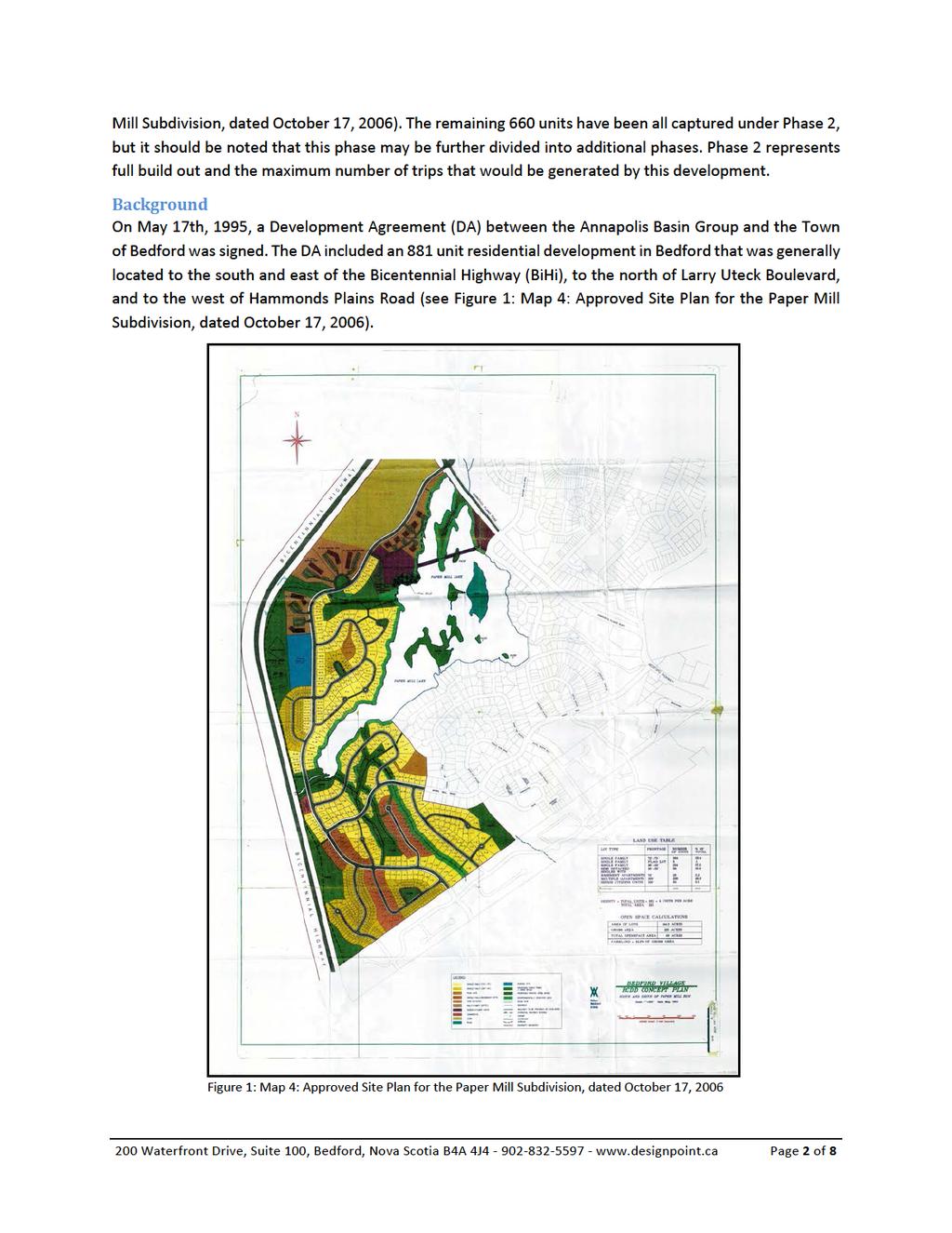
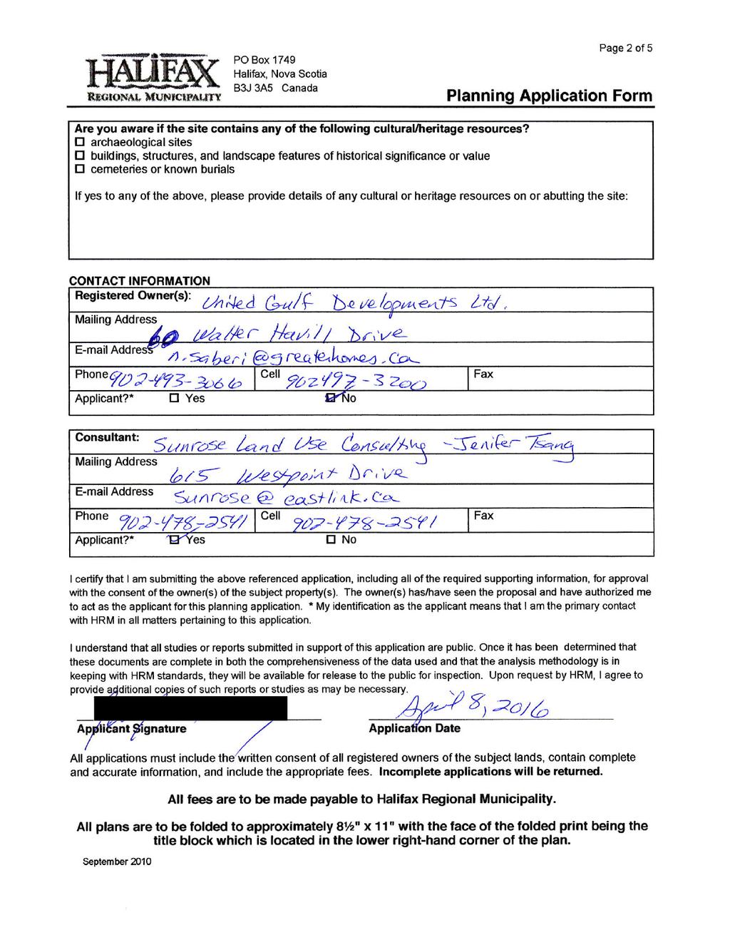
1 April 6 th, 2016 United Gulf Developments Limited 60 Walter Havill Dr, Suite 111 Halifax, Nova Scotia B3N 0A9 Attention: Navid Saberi RE: Traffic Impact Statement: Paper Mill Lake Subdivision DesignPoint Engineering and Surveying Ltd. is pleased to submit this Traffic Impact Statement (TIS) in support of the proposed amendment to the Development Agreement (DA) dated May 17th, 1995 between Annapolis Basin Group Inc. and The Town of Bedford. The properties of , , , and included in the DA are owned by United Gulf Development Limited. Section 14.2 of the DA states that: The Developer shall be allowed to create no more than 100 residential units prior to the completion of a collector road which is to run from Moirs Mill Road to Hammonds Plains Road. This DA was signed prior to the consideration and/or construction of Oceanview Drive, Nine Mile Drive, Southgate Drive, Larry Uteck Boulevard, and the Larry Uteck Interchange and its connection to Highway 102 Bi Centennial Highway (BiHi), when the only access/egress from the proposed subdivision was via Moirs Mill Road and Nelson s Landing Boulevard to the Bedford Highway. This TIS supports the amendment to section 14.2 of the DA to allow for additional phases of this development without the need to build a collector road to Hammonds Plains Road. The DA allows for 881 residential units, to date 160 units have been built, leaving 720 units to be considered within this TIS. Proposed Development Phasing This development is proposed to be completed in phases. The two phases that are considered are as follows: Phase 1 This first phase of the remaining development will consist of connecting Richardson Drive between Moirs Mill Road and Oceanview Drive. Currently, Richardson Drive has been built to Baha Court (northend) and has been built to form a T-intersection at Oceanview Drive (southend). The remaining 290 m long section of Richardson Drive will be built as part of this phase. As part of this connection the remaining lots on Baha Court will be constructed as well as the lots along Richardson Drive for a total of 60 units out of the 720 units remaining. Phase 2 (Full Build Out) This future phase includes the remaining 660 units (720 units subtract the 60 units undertaken as part of Phase 1 outlined above) and the construction of the associated street network which includes the connection of Nine Mile Drive to Moirs Mill Road (See Figure 1: Map 4: Approved Site Plan for the Paper 200 Waterfront Drive, Suite 100, Bedford, Nova Scotia B4A 4J Page 1 of 8
2
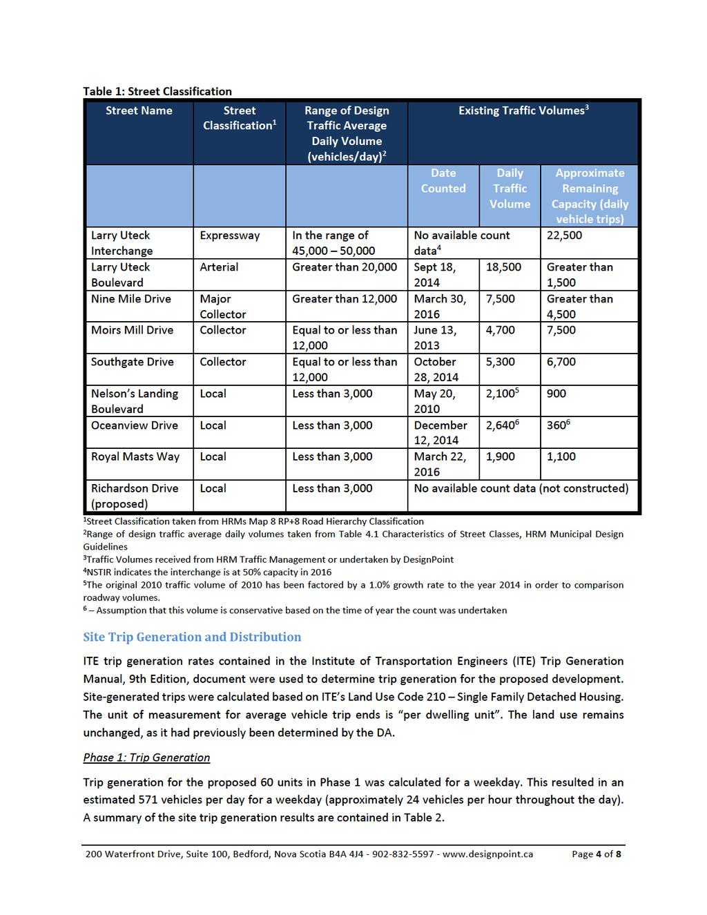
3 Since this DA was signed 160 residential units have been constructed (100 on Ahmadi Crescent, Richardson Drive, Baha Court, and Moirs Mill Drive and a 60 unit seniors complex on Hammonds Plains Road). Originally, when this DA was signed Moirs Mill Road, Nelson s Landing Boulevard, and the new connection to Hammonds Plains Road were to be the only routes into and out of this proposed subdivision. Since the approval of the DA, Oceanview Drive, Nine Mile Drive, Larry Uteck Boulevard, South Gate Drive, and the Larry Uteck Interchange to the BiHi have been constructed. This has significantly increased the roadway capacity into and out of the proposed subdivision. As part of the proposed Phase 1 of the Paper Mill Lake subdivision, Richardson Drive will be completed and connected between Moirs Mill Road and Oceanview Drive. The approved concept plan for the Paper Mill Lake subdivision has always showed Richardson Drive connecting Moirs Mill Road and Oceanview Drive, which is consistent with the concept plan that was approved as part of the original DA. Existing Traffic Data The HRM Regional Plan outlines street classification for the HRM roadway network. The HRM redbook provides guidelines on the average daily traffic volumes for each street classification. Table 1 lists the existing street network that surround the proposed subdivision as well as recent traffic count data received from HRM or undertaken by DesignPoint. When the Larry Uteck Interchange was constructed in 2010 it was designed to handle between and vehicles per day (vpd). In a discussion with representatives of the Nova Scotia Department of Transportation and Infrastructure Renewal (NSTIR) they indicated that the interchange is currently operating at approximately 50% of its intended capacity. Table 1 also identifies the approximate remaining capacity within the surrounding street network. As can be seen in Table 1, all streets are currently operating below their intended capacity based on the recent traffic data or can be assumed based on traffic data of the surrounding streets. It should be noted that the traffic count undertaken for Oceanview Drive was completed in December, Oceanview Drive is a direct link between a residential area and a commercial area. Based on this connection it can be assumed that this volume is most likely higher than the usual volume on Oceanview Drive due to the holiday season. In addition, Larry Uteck Boulevard is an arterial roadway that allows for greater than 20,000 vpd. The remaining capacity is shown conservatively at 1500 vpd which is 20,000 minus the existing daily traffic volume of 18, Waterfront Drive, Suite 100, Bedford, Nova Scotia B4A 4J Page 3 of 8
4
5
6
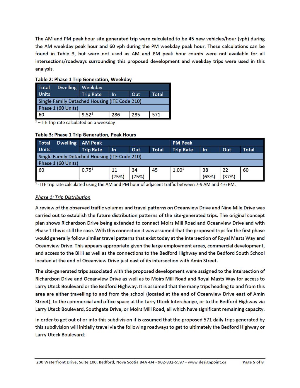
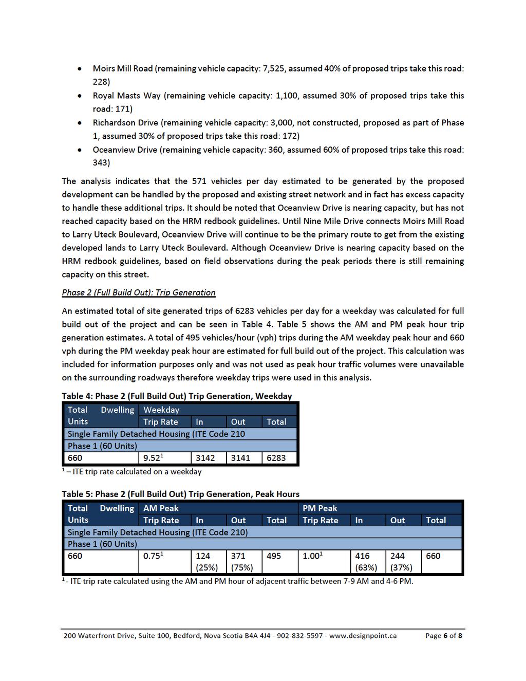
7 Phase 2: Trip Distribution As previously indicated, when the DA was signed connections via Moirs Mill Road and Nelson s Landing Boulevard to the Bedford Highway were the only connections to get to and from this subdivision. The construction of Oceanview Drive, Nine Mile Drive, Southgate Drive, Larry Uteck Boulevard, and the Larry Uteck Interchange which now connects this proposed subdivision to the BiHi all allow for more connections into and out of this subdivision. Consideration for the calculated traffic volumes and predicted travel patterns on Nine Mile Drive, Moirs Mill Road, Richardson Drive, and Royal Masts Way was carried out to establish the future distribution patterns of the site-generated trips. The original concept plan shows Nine Mile Drive being connected to Moirs Mill Road and it is expected this would still be the case during future Phase 2 construction. The site-generated trips associated with the proposed development were assigned to the extended Nine Mile Drive, Moirs Mill Road, Richardson Drive, and Royal Masts Way for access to Larry Uteck Boulevard or the Bedford Highway. It is assumed that the trips heading to and from this area are either travelling to and from the school (located at the end of Oceanview Drive east of Amin Street), the commercial and office space at the Larry Uteck Interchange, or the Bedford Highway via Larry Uteck Boulevard, Southgate Drive, or Moirs Mill Road all which have significant remaining capacity. In order to get out of or into this subdivision it is assumed that the proposed 6283 daily trips generated by this subdivision will initially travel via the following roadways to get to ultimately the Bedford Highway or Larry Uteck Boulevard: Nine Mile Drive (remaining vehicle capacity: greater than 4,500, assumed 50% of proposed trips take this road: 3,142) Moirs Mill Road (remaining vehicle capacity: 7,525, assumed 50% of proposed trips take this road: 3141) Royal Masts Way (remaining vehicle capacity: 1,900, assumed 5% of proposed trips take this road: 314) Richardson Drive (remaining vehicle capacity: 2,830, constructed as part of Phase 1, assumed 5% of proposed trips take this road: 314) In considering the full buildout of this development, the proposed and existing street network based on the existing traffic data and trip generation can be accommodated and in all cases have some remaining capacity. Many of those vehicles accessing Oceanview Drive to connect to Nine Mile Drive will now travel the proposed connection between Nine Mile Drive and Moirs Mill Drive thereby relieving Oceanview Drive as the subdivision expands. Therefore, a connection to Hammonds Plains Road is not required now nor in the future. Conclusions and Recommendations The following conclusions were assembled from the traffic impact assessment: Phase 1: The estimated weekday trips generated by the site in Phase 1 is 571 vehicles per day. The analyses indicates that the 571 vehicles per day estimated to be generated by the proposed 200 Waterfront Drive, Suite 100, Bedford, Nova Scotia B4A 4J Page 7 of 8
8
9
10
11
November 1, Mr. Jafar Tabrizi President, Tabrizi Rugs 180 Bedford Highway. Traffic Impact Statement BH-1 and BH-2, Southgate Drive, Bedford, NS
 161-12598 Mr. Jafar Tabrizi President, Tabrizi Rugs 180 Bedford Highway Bedford, NS B4A 1C1 [Via Email: tabrizi@tabrizi.com] RE: Traffic Impact Statement Dear Mr. Tabrizi: Plans are being prepared for
DEVELOPMENT AGREEMENT APPLICATION MULTI-UNIT RESIDENTIAL DEVELOPMENT FOURTH STREET NEAR BEDFORD HIGHWAY SUBMITTED BY: LYDON LYNCH ARCHITECTS
 DEVELOPMENT AGREEMENT APPLICATION MULTI-UNIT RESIDENTIAL DEVELOPMENT FOURTH STREET NEAR BEDFORD HIGHWAY NOVEMBER 30, 2017 SUBMITTED BY: LYDON LYNCH ARCHITECTS TABLE OF CONTENTS LETTER OF INTRODUCTION PROJECT
2.0 Development Driveways. Movin Out June 2017
 Movin Out June 2017 1.0 Introduction The proposed Movin Out development is a mixed use development in the northeast quadrant of the intersection of West Broadway and Fayette Avenue in the City of Madison.
Alpine Highway to North County Boulevard Connector Study
 Alpine Highway to North County Boulevard Connector Study prepared by Avenue Consultants March 16, 2017 North County Boulevard Connector Study March 16, 2017 Table of Contents 1 Summary of Findings... 1
RE: A Traffic Impact Statement for a proposed development on Quinpool Road
 James J. Copeland, P.Eng. GRIFFIN transportation group inc. 30 Bonny View Drive Fall River, NS B2T 1R2 May 31, 2018 Ellen O Hara, P.Eng. Project Engineer DesignPoint Engineering & Surveying Ltd. 200 Waterfront
Table of Contents INTRODUCTION... 3 PROJECT STUDY AREA Figure 1 Vicinity Map Study Area... 4 EXISTING CONDITIONS... 5 TRAFFIC OPERATIONS...
 Crosshaven Drive Corridor Study City of Vestavia Hills, Alabama Table of Contents INTRODUCTION... 3 PROJECT STUDY AREA... 3 Figure 1 Vicinity Map Study Area... 4 EXISTING CONDITIONS... 5 TRAFFIC OPERATIONS...
MILLERSVILLE PARK TRAFFIC IMPACT ANALYSIS ANNE ARUNDEL COUNTY, MARYLAND
 MILLERSVILLE PARK TRAFFIC IMPACT ANALYSIS ANNE ARUNDEL COUNTY, MARYLAND Prepared for: Department of Public Works Anne Arundel County Prepared by: URS Corporation 4 North Park Drive, Suite 3 Hunt Valley,
Traffic Impact Analysis West Street Garden Plots Improvements and DuPage River Park Garden Plots Development Naperville, Illinois
 Traffic Impact Analysis West Street Garden Plots Improvements and DuPage River Park Garden Plots Development Naperville, Illinois Submitted by April 9, 2009 Introduction Kenig, Lindgren, O Hara, Aboona,
EXECUTIVE SUMMARY. The following is an outline of the traffic analysis performed by Hales Engineering for the traffic conditions of this project.
 EXECUTIVE SUMMARY This study addresses the traffic impacts associated with the proposed Shopko redevelopment located in Sugarhouse, Utah. The Shopko redevelopment project is located between 1300 East and
CHAPTER 9: VEHICULAR ACCESS CONTROL Introduction and Goals Administration Standards
 9.00 Introduction and Goals 9.01 Administration 9.02 Standards 9.1 9.00 INTRODUCTION AND GOALS City streets serve two purposes that are often in conflict moving traffic and accessing property. The higher
STH 60 Northern Reliever Route Feasibility Study Report
 #233087 v3 STH 60 Northern Reliever Route Feasibility Study Report Washington County Public Works Committee Meeting September 28, 2016 1 STH 60 Northern Reliever Route Feasibility Study Hartford Area Development
Traffic Study for Highway 107 Phase 1 Burnside to Sackville
 FINAL REPORT Traffic Study for Highway 107 Phase 1 Burnside to Sackville Presented To: Nova Scotia Department of Transportation and Infrastructure Renewal February 2011 Project No. DA10095 www.genivar.com
Transportation & Traffic Engineering
 Transportation & Traffic Engineering 1) Project Description This report presents a summary of findings for a Traffic Impact Analysis (TIA) performed by A+ Engineering, Inc. for the Hill Country Family
West Hills Shopping Centre Lowe s Expansion Traffic Impact Study
 West Hills Shopping Centre Lowe s Expansion Traffic Impact Study Prepared for: Armel Corporation January 2015 Paradigm Transportation Solutions Ltd. 22 King Street South, Suite 300 Waterloo ON N2J 1N8
2 MAJOR MACKENZIE DRIVE WEST JOG ELIMINATION AT HUNTINGTON ROAD CITY OF VAUGHAN
 2 MAJOR MACKENZIE DRIVE WEST JOG ELIMINATION AT HUNTINGTON ROAD CITY OF VAUGHAN The Transportation Services Committee recommends the adoption of the recommendations contained in the following report dated
TIMBERVINE TRANSPORTATION IMPACT STUDY FORT COLLINS, COLORADO JANUARY Prepared for:
 TIMBERVINE TRANSPORTATION IMPACT STUDY FORT COLLINS, COLORADO JANUARY 2014 Prepared for: Hartford Companies 1218 W. Ash Street Suite A Windsor, Co 80550 Prepared by: DELICH ASSOCIATES 2272 Glen Haven Drive
PUBLIC INFRASTRUCTURE PROJECTS
 PUBLIC INFRASTRUCTURE PROJECTS FM 664 / OVILLA ROAD WIDENING & IMPROVEMENTS FM 664 / OVILLA ROAD CONNECTS US 287 WITH I-45 (SOURCE: TEXAS DEPARTMENT OF TRANSPORTATION. 2016 FM 664 / OVILLA ROAD WIDENING
Parks and Transportation System Development Charge Methodology
 City of Sandy Parks and Transportation System Development Charge Methodology March, 2016 Background In order to implement a City Council goal the City of Sandy engaged FCS Group in January of 2015 to update
The major roadways in the study area are State Route 166 and State Route 33, which are shown on Figure 1-1 and described below:
 3.5 TRAFFIC AND CIRCULATION 3.5.1 Existing Conditions 3.5.1.1 Street Network DRAFT ENVIRONMENTAL IMPACT REPORT The major roadways in the study area are State Route 166 and State Route 33, which are shown
1. INTRODUCTION 2. PROJECT DESCRIPTION CUBES SELF-STORAGE MILL CREEK TRIP GENERATION COMPARISON
 CUBES SELF-STORAGE MILL CREEK TRIP GENERATION COMPARISON 1. INTRODUCTION This report summarizes traffic impacts of the proposed CUBES Self-Storage Mill Creek project in comparison to the traffic currently
MEMO VIA . Ms. Amy Roth DPS Director, City of Three Rivers. To:
 MEMO To: Ms. Amy Roth DPS Director, City of Three Rivers VIA EMAIL From: Michael J. Labadie, PE Julie M. Kroll, PE, PTOE Brandon Hayes, PE, P.Eng. Fleis & VandenBrink Date: January 5, 2017 Re: Proposed
D. J. Halpenny & Associates Ltd. Consulting Transportation Engineers
 D. J. Halpenny & Associates Ltd. Consulting Transportation Engineers August 24, 2015 File: 115-622 Mr. R. Baumann, President The RGB Group 277 Kirchoffer Avenue Ottawa, ON K2A 1Y1 RE: RESIDENTIAL DEVELOPMENT
MINERVA PARK SITE TRAFFIC IMPACT STUDY M/I HOMES. September 2, 2015
 5500 New Albany Road Columbus, Ohio 43054 Phone: 614.775.4500 Fax: 614.775.4800 Toll Free: 1-888-775-EMHT emht.com 2015-1008 MINERVA PARK SITE TRAFFIC IMPACT STUDY M/I HOMES September 2, 2015 Engineers
TRAFFIC IMPACT STUDY. USD #497 Warehouse and Bus Site
 TRAFFIC IMPACT STUDY for USD #497 Warehouse and Bus Site Prepared by: Jason Hoskinson, PE, PTOE BG Project No. 16-12L July 8, 216 145 Wakarusa Drive Lawrence, Kansas 6649 T: 785.749.4474 F: 785.749.734
12 April Leakes Pty Ltd 211 Waverley Road EAST MALVERN VIC Attention: Joseph Nasr. Dear Joe,
 Our Ref: Contact: CG120569:VG Valentine Gnanakone Leakes Pty Ltd 211 Waverley Road EAST MALVERN VIC 3145 Attention: Joseph Nasr Dear Joe, 690 DERRIMUT ROAD PROPOSED RESIDENTIAL SUBDIVISION Further to our
PROJECT: Wilkinson Road Corridor Improvement Traffic Management Planning Project SUBJECT: Traffic Analysis
 TECHNICAL MEMORANDUM DATE: September 10, 2014 PROJECT 5861.03 NO: PROJECT: Wilkinson Road Corridor Improvement Traffic Management Planning Project SUBJECT: Traffic Analysis TO: Steve Holroyd - District
Re: 233 Armstrong Street Residential Condominium Traffic Brief
 1223 Michael Street, Suite 100, Ottawa, ON K1J 7T2 Tel: 613.738.4160 Fax: 613.739.7105 www.delcan.com August 8, 2008 TO3031TOP00 BY E-MAIL: gerry.lalonde@rogers.com Spencedale Properties 7 Cobb Court Ottawa,
MEMORANDUM. Project Description. Operational Trip Generation. Construction Trip Generation. Date: August 12, 2014 TG: To: From: Subject:
 MEMORANDUM Date: August 12, 2014 TG: 13329.01 To: From: Subject: Jeremy Krout EPD Solutions Inc. Rafik Albert EPD Solutions Inc. Rawad Hani Transpo Group AP North Lake Solar Project Traffic Scoping The
Prepared for: Ontario Inc. CHICKADEE GROVE COMMUNITY PROPOSED RESIDENTIAL DEVELOPMENT TOWN OF CALEDON TRANSPORTATION OPINION LETTER
 Prepared for: 2414176 Ontario Inc. CHICKADEE GROVE COMMUNITY PROPOSED RESIDENTIAL DEVELOPMENT TOWN OF CALEDON TRANSPORTATION OPINION LETTER 1616095-001-T01 October 2016 October 06, 2016 16-16095-001 Mr.
East Stockton Boulevard (South Sacramento) Costco Gasoline Expansion Fuel Station Expansion Trip Generation Estimate
 Costco Gasoline Expansion Fuel Station Expansion Trip Generation Estimate") MEMORANDUM Date: February 7, 2013 Project #: 13270.0 To: From: Matt Cyr, Barghausen Consulting Engineers Sonia Hennum, PTOE & Alex Kiheri Project: Subject: cc: East Stockton Boulevard (South Sacramento)
MEMORANDUM Date: February 7, 2013 Project #: 13270.0 To: From: Matt Cyr, Barghausen Consulting Engineers Sonia Hennum, PTOE & Alex Kiheri Project: Subject: cc: East Stockton Boulevard (South Sacramento)
Subarea Study. Manning Avenue (CSAH 15) Corridor Management and Safety Improvement Project. Final Version 1. Washington County.
 Corridor Management and Safety Improvement Project. Final Version 1. Washington County.") Subarea Study Manning Avenue (CSAH 15) Corridor Management and Safety Improvement Project Final Version 1 Washington County June 12, 214 SRF No. 138141 Table of Contents Introduction... 1 Forecast Methodology
Subarea Study Manning Avenue (CSAH 15) Corridor Management and Safety Improvement Project Final Version 1 Washington County June 12, 214 SRF No. 138141 Table of Contents Introduction... 1 Forecast Methodology
Craig Scheffler, P.E., PTOE HNTB North Carolina, P.C. HNTB Project File: Subject
 TECHNICAL MEMORANDUM To Kumar Neppalli Traffic Engineering Manager Town of Chapel Hill From Craig Scheffler, P.E., PTOE HNTB North Carolina, P.C. Cc HNTB Project File: 38435 Subject Obey Creek TIS 2022
Citizens Committee for Facilities
 Citizens Committee for Facilities AGENDA Thursday, December 11, 2014 City Council Chambers 305 3 rd Avenue East -Twin Falls, Idaho 11:30 A.M. AGENDA ITEMS Purpose By 1. Discussion and possible action on
TRAFFIC CALMING PROGRAM
 TRAFFIC CALMING PROGRAM PROGRAM BASICS Mount Pleasant Transportation Department 100 Ann Edwards Lane Mt. Pleasant, SC 29465 Tel: 843-856-3080 www.tompsc.com The Town of Mount Pleasant has adopted a traffic
Letter of Transmittal
 Letter of Transmittal To: Chris Lovell City of Richmond Hill Date: 5/2/6 Job 2582 Re: Richmond Hill-South Bryan County Transportation STudy WE ARE SENDING YOU THE FOLLOWING ITEMS ( attached) ( under separate
Port Wallace Development: Safety and Traffic Concerns. April 12, 2018
 Port Wallace Development: Safety and Traffic Concerns April 12, 2018 Highway 107 at the Quarry: 2017 Traffic Figures November 21, 2017 Staff Recommendation: Traffic and Infrastructure In May 2017, the
THE CORNERSTONE APARTMENTS TRAFFIC IMPACT STUDY R&M PROJECT NO
 THE CORNERSTONE APARTMENTS SITUATED AT N/E/C OF STAUDERMAN AVENUE AND FOREST AVENUE VILLAGE OF LYNBROOK NASSAU COUNTY, NEW YORK TRAFFIC IMPACT STUDY R&M PROJECT NO. 2018-089 September 2018 50 Elm Street,
Re: Addendum No. 4 Transportation Overview 146 Mountshannon Drive Ottawa, Ontario
 April 18 th, 2017 Mr. Kevin Yemm Vice President, Land Development Richraft Group of Companies 2280 St. Laurent Boulevard, Suite 201 Ottawa, Ontario (Tel: 613.739.7111 / e-mail: keviny@richcraft.com) Re:
Brigham City 1200 West Box Elder Creek Bridge - Widening Project Type Reconstruction
 Brigham City 1200 West Box Elder Creek Bridge - Widening Project Type Reconstruction 550 North to 650 North $ 1,750,000 $ 1,582,113 To widen an existing bridge on 1200 West over Box Elder Creek that will
King Soopers #116 Thornton, Colorado
 Traffic Impact Study King Soopers #116 Thornton, Colorado Prepared for: Galloway & Company, Inc. T R A F F I C I M P A C T S T U D Y King Soopers #116 Thornton, Colorado Prepared for Galloway & Company
appendix 4: Parking Management Study, Phase II
 appendix 4: Parking Management Study, Phase II A4-1 A4-2 Eastlake Parking Management Study Final Phase 2 Report Future Parking Demand & Supply January 6, 2017 Submitted by Denver Corp Center III 7900 E.
Traffic Impact Study Speedway Gas Station Redevelopment
 Traffic Impact Study Speedway Gas Station Redevelopment Warrenville, Illinois Prepared For: Prepared By: April 11, 2018 Table of Contents 1. Introduction... 1 2. Existing Conditions... 4 Site Location...
Location Concept Plan Amendment Recommendation Approved 2011 Concept Plan
 Valley Line West LRT Concept Plan Recommended Amendments Lewis Farms LRT Terminus Site Location Concept Plan Amendment Recommendation Approved 2011 Concept Plan Lewis Farms LRT terminus site, 87 Avenue/West
Proposed Inn at Bellefield Traffic Impact Assessment
 Proposed Inn at Bellefield Traffic Impact Assessment Town of Hyde Park Dutchess County, New York Prepared for: T-Rex Hyde Park Owner LLC 500 Mamroneck Avenue, Suite 300 Harrison, NY 10528 June 21, 2017
Tongaat Hullette Developments - Cornubia Phase 2. Technical Note 02 - N2/M41 AIMSUN Micro-simulation Analysis
 Technical Note 02 - N2/M41 AIMSUN Micro-simulation Tongaat Hullette Developments Cornubia Phase 2 Technical Note 02 - N2/M41 AIMSUN Micro-simulation Analysis Prepared by: 18/11/14 Justin Janki Date Approvals
LAWRENCE TRANSIT CENTER LOCATION ANALYSIS 9 TH STREET & ROCKLEDGE ROAD / 21 ST STREET & IOWA STREET LAWRENCE, KANSAS
 LAWRENCE TRANSIT CENTER LOCATION ANALYSIS 9 TH STREET & ROCKLEDGE ROAD / 21 ST STREET & IOWA STREET LAWRENCE, KANSAS TRAFFIC IMPACT STUDY FEBRUARY 214 OA Project No. 213-542 TABLE OF CONTENTS 1. INTRODUCTION...
INDUSTRIAL DEVELOPMENT
 INDUSTRIAL DEVELOPMENT Traffic Impact Study Plainfield, Illinois August 2018 Prepared for: Seefried Industrial Properties, Inc. TABLE OF CONTENTS Executive Summary 2 Introduction 3 Existing Conditions
Bayers Road / Highway 102 Corridor Study Component 3 - Highway 107 Final Report March 2010
 Bayers Road / Highway 102 Corridor Study Component 3 - Highway 107 Final Report March 2010 Department of Transportation and Infrastructure Renewal and The Halifax Regional Municipality Completed By: Stantec
Mercer Island Center for the Arts Parking Management Plan
 Parking Stalls Mercer Island Center for the Arts Parking Management Plan June 15, 2016 This Parking Management Plan (P) covers all tenants at the Mercer Island Center for the Arts (MICA) campus, including
Transportation Land Development Environmental S e r v i c e s
 Transportation Land Development Environmental S e r v i c e s Memorandum To: Ms. Kristin E. Kassner Planning Director Town Hall Annex 25 Center Street Burlington, MA 01803 Date: September 23, 2013 Project
Per Revised Concept Plan Residential Condo/Townhouse. Proposed Land Use per TIS
 January 2, 2018 Mr. Paul DeBotton Marple Associates, L.P. 1604 Walnut Street, 4 th Floor Philadelphia, PA 19103 RE: Langford Run Road Traffic Analysis Proposed Mid County Shopping Center Marple Township,
Lacey Gateway Residential Phase 1
 Lacey Gateway Residential Phase Transportation Impact Study April 23, 203 Prepared for: Gateway 850 LLC 5 Lake Bellevue Drive Suite 02 Bellevue, WA 98005 Prepared by: TENW Transportation Engineering West
The following section summarises the present conditions related to transportation for the proposed development of the Matimba B Power Station:
 14. TRAFFIC AND TRANSPORT 14.1. Status Quo Conditions The following section summarises the present conditions related to transportation for the proposed development of the Matimba B Power Station: 14.1.1.
TRAFFIC IMPACT STUDY DERRY GREEN CORPORATE BUSINESS PARK MILTON SECONDARY PLAN MODIFICATION
 TRAFFIC IMPACT STUDY DERRY GREEN CORPORATE BUSINESS PARK MILTON SECONDARY PLAN MODIFICATION TRAFFIC IMPACT STUDY DERRY GREEN CORPORATE BUSINESS PARK MILTON SECONDARY PLAN MODIFICATION DECEMBER 24 UPDATED
Traffic Impact Statement (TIS)
") Traffic Impact Statement (TIS) Vincentian PUDA Collier County, FL 10/18/2013 Prepared for: Global Properties of Naples Prepared by: Trebilcock Consulting Solutions, PA 2614 Tamiami Trail N, Suite 615 1205
Traffic Impact Statement (TIS) Vincentian PUDA Collier County, FL 10/18/2013 Prepared for: Global Properties of Naples Prepared by: Trebilcock Consulting Solutions, PA 2614 Tamiami Trail N, Suite 615 1205
Section 5.0 Traffic Information
 Section 5.0 Traffic Information 10.0 TRANSPORTATION MDM Transportation Consultants, Inc. (MDM) has prepared an evaluation of transportation impacts for the proposed evaluation for the expansion of the
DELICETO, LLC PALM BEACH COUNTY, FL
 COMPREHENSIVE PLAN AMENDMENT TRAFFIC ANALYSIS DELICETO, LLC PALM BEACH COUNTY, FL PREPARED FOR: DELICETO, LLC Project #042787007 April 18, 2018 Revised May 29, 2018 CA 00000696 Kimley-Horn and Associates,
Appendix J Traffic Impact Study
 MRI May 2012 Appendix J Traffic Impact Study Level 2 Traffic Assessment Limited Impact Review Appendix J [This page was left blank intentionally.] www.sgm-inc.com Figure 1. Site Driveway and Trail Crossing
Traffic, Transportation & Civil Engineering Ali R. Khorasani, P.E. P.O. Box 804, Spencer, MA 01562, Tel: (508)
") Associates Traffic, Transportation & Civil Engineering Ali R. Khorasani, P.E. P.O. Box 804, Spencer, MA 01562, Tel: (508) 885-5121 Ms. Teri Ford, Associate 800 Boylston Street, Suite 1570 Boston, MA July
Associates Traffic, Transportation & Civil Engineering Ali R. Khorasani, P.E. P.O. Box 804, Spencer, MA 01562, Tel: (508) 885-5121 Ms. Teri Ford, Associate 800 Boylston Street, Suite 1570 Boston, MA July
Appendix H TRAFFIC IMPACT ANALYSIS
 Appendix H TRAFFIC IMPACT ANALYSIS Teichert Boca Quarry Expansion Traffic Impact Analysis Prepared for Teichert Aggregates Prepared by TRANSPORTATION CONSULTANTS, INC. LSC Transportation Consultants, Inc.
APPENDIX C1 TRAFFIC ANALYSIS DESIGN YEAR TRAFFIC ANALYSIS
 APPENDIX C1 TRAFFIC ANALYSIS DESIGN YEAR TRAFFIC ANALYSIS DESIGN YEAR TRAFFIC ANALYSIS February 2018 Highway & Bridge Project PIN 6754.12 Route 13 Connector Road Chemung County February 2018 Appendix
TRAFFIC IMPACT STUDY 3171 LAKESHORE ROAD WEST RESIDENTIAL DEVELOPMENT TOWN OF OAKVILLE, REGIONAL MUNICIPALITY OF HALTON
 TRAFFIC IMPACT STUDY 3171 LAKESHORE ROAD WEST RESIDENTIAL DEVELOPMENT TOWN OF OAKVILLE, REGIONAL MUNICIPALITY OF HALTON PREPARED FOR: VOGUE WYCLIFFE (OAKVILLE) LIMITED PREPARED BY: C.F. CROZIER & ASSOCIATES
April 7, Mr. Blake Shutler Compass Homes Development LLC Summit Homes Construction, LLC PO Box 6539 Dillon, CO 80435
 Compass Homes Development LLC Summit Homes Construction, LLC PO Box 6539 Dillon, CO 80435 Re: Trip Generation Comparison West Hills Townhomes Keystone, Colorado FHU Reference No. 116388-01 Dear Mr. Shutler:
Proposed location of Camp Parkway Commerce Center. Vicinity map of Camp Parkway Commerce Center Southampton County, VA
 Proposed location of Camp Parkway Commerce Center Vicinity map of Camp Parkway Commerce Center Southampton County, VA Camp Parkway Commerce Center is a proposed distribution and industrial center to be
105 Toronto Street South, Markdale Transportation Impact Study. Paradigm Transportation Solutions Limited
 105 Toronto Street South, Markdale Transportation Impact Study Paradigm Transportation Solutions Limited December 2016 Project Summary Project Number 162060 December 2016 Client Zelinka Priamo Ltd 318
Designation of a Community Safety Zone in Honey Harbour in the Township of Georgian Bay
 TO: FROM: Chair and Members Engineering and Public Works Committee Mark Misko, C.E.T. Manager, Roads Maintenance and Construction DATE: March 23, 2016 SUBJECT: REPORT NO: Designation of a Community Safety
STAFF REPORT # CHANGE OF ZONING
 STAFF REPORT #17-2000-0007 CHANGE OF ZONING PLANNING COMMISSION MEETING DATE: November 16, 2017 (Applicant Provided Materials / Traffic Study = Blue) 1. APPLICATION: A public hearing for an application
Appendix H: Construction Impacts H-2 Transportation
 Appendix H: Construction Impacts H-2 Transportation \ AECOM 71 W. 23 rd Street New York, NY 10010 www.aecom.com 212 366 6200 tel 212 366 6214 fax Memorandum To CC Subject Robert Conway Donald Tone Construction
Construction Realty Co.
 MEMORANDUM TO: FROM : Jeff Pickus Construction Realty Co. Luay R. Aboona, PE Principal 9575 West Higgins Road, Suite 400 Rosemont, Illinois 60018 p: 847-518-9990 f: 847-518-9987 DATE: May 22, 2014 SUBJECT:
Escondido Marriott Hotel and Mixed-Use Condominium Project TRAFFIC IMPACT ANALYSIS REPORT
 Escondido Marriott Hotel and Mixed-Use Condominium Project TRAFFIC IMPACT ANALYSIS REPORT Prepared for Phelps Program Management 420 Sixth Avenue, Greeley, CO 80632 Prepared by 5050 Avenida Encinas, Suite
Western ND Meeting. February 19, 2014 Grant Levi, NDDOT Director
 Western ND Meeting February 19, 2014 Grant Levi, NDDOT Director 1 Traffic Trends in North Dakota 2 Truck Traffic 2008 3 Truck Traffic 2012 4 Average Daily Traffic 5 ND Vehicle Miles Traveled Statewide
APPENDIX H. Transportation Impact Study
 APPENDIX H Transportation Impact Study BUENA VISTA LAGOON ENHANCEMENT PROJECT TRANSPORTATION IMPACT STUDY Prepared for: San Diego Association of Governments Prepared by: VRPA Technologies, Inc. 9520 Padgett
TRAFFIC IMPACT STUDY VICDOM BROCK ROAD PIT EXPANSION
 TRAFFIC IMPACT STUDY VICDOM BROCK ROAD PIT EXPANSION TOWNSHIP OF UXBRIDGE P/N 05-1993 June 2011 Revised -August 2011 Prepared by: Skelton, Brumwell & Associates Inc. 93 Bell Farm Road, Suite 107 Barrie,
ENVIRONMENTAL SETTING
 II. ENVIRONMENTAL SETTING A. OVERVIEW OF ENVIRONMENTAL SETTING This section provides a brief overview of the project site s regional and local setting. Additional descriptions of the environmental setting
Additional $200 Speeding Fine Signs
 CITY OF CHARLOTTESVILLE, VIRGINIA CITY COUNCIL AGENDA Agenda Date: June 18, 2007 Action Required: Presenter: Staff Contacts: Title: Adopt Ordinance Jeanie Alexander, P.E. Jeanie Alexander Additional $200
Appendix 5. Haymeadow Interim Traffic Analysis
 Appendix 5 Haymeadow Interim Traffic Analysis 20 MEMORANDUM To: From: Rick Pylman Gary Brooks Bill Fox Date: September 15, 2016 Project: Subject: Haymeadow Evaluation of interim access configuration Currently
Halifax Commuter Rail Feasibility Study
 Halifax Commuter Rail Feasibility Study Open House Halifax Regional Municipality February 26, 2015 Study Team The team is led by CPCS: A global management consulting firm (formerly the consulting arm of
ENVIRONMENTAL IMPACT STATEMENT
 RED HILL MINING LEASE ENVIRONMENTAL IMPACT STATEMENT Section 14 Transport Section 14 Transport 14.1 Description of Environmental Values This section of the Red Hill Mining Lease Environmental Impact Statement
1.0 Detailed Definition of Alternatives
 1.0 Detailed Definition of Alternatives 1.1 Introduction This chapter provides supplemental information on the four alternatives, including both physical and operational characteristics (e.g. service plans)
TECHNICAL MEMORANDUM. Part A: Introduction
 TECHNICAL MEMORANDUM To: David J. Decker Decker Properties, Inc. 5950 Seminole Centre Ct. Suite 200 Madison, Wisconsin 53711 608-663-1218 Fax: 608-663-1226 www.klengineering.com From: Mike Scarmon, P.E.,
DEVELOPMENT PROPERTY 1627 MAXIME STREET CITY OF OTTAWA TRANSPORTATION OVERVIEW. Prepared for: Subhas Bhargava. July 9, Overview_1.
 DEVELOPMENT PROPERTY 1627 MAXIME STREET CITY OF OTTAWA TRANSPORTATION OVERVIEW Prepared for: Subhas Bhargava July 9, 2015 115-620 Overview_1.doc D. J. Halpenny & Associates Ltd. Consulting Transportation
Volume 1 Traffic Impact Analysis Turtle Creek Boulevard Dallas, Texas. Kimley-Horn and Associates, Inc. Dallas, Texas.
 Volume 1 Traffic Impact Analysis 2727 Dallas, Texas June 18, 2018 Kimley-Horn and Associates, Inc. Dallas, Texas Project #064523000 Registered Firm F-928 Traffic Impact Analysis 2727 Dallas, Texas Prepared
ELMORE COUNTY HIGHWAY DEPARTMENT
 Adopted 11/27/06 Effective 2/1/07 Amended 4/10/08 ELMORE COUNTY HIGHWAY DEPARTMENT 155 County Shop Road Wetumpka, Alabama 36092 Phone (334) 567-1162 Fax (334) 567-1100 Access Management Policy The Elmore
Table 1 - Land Use Comparisons - Proposed King s Wharf Development. Retail (SF) Office (SF) 354 6,000 10, Land Uses 1
 Office (SF) 354 6,000 10, Land Uses 1") Ref. No. 171-6694 Phase 2 November 23, 217 Mr. David Quilichini, Vice President Fares & Co. Developments Inc. 31 Place Keelson Sales Centre DARTMOUTH NS B2Y C1 Sent Via Email to David@faresinc.com RE:
Ref. No. 171-6694 Phase 2 November 23, 217 Mr. David Quilichini, Vice President Fares & Co. Developments Inc. 31 Place Keelson Sales Centre DARTMOUTH NS B2Y C1 Sent Via Email to David@faresinc.com RE:
Costco Gasoline Fuel Station Transportation Characteristics
 Exhibit A MEMORANDUM Date: May 23, 2013 Project #: I-10 To: Jennifer Murillo, Costco Wholesale Terry Odle, Mulvanny G2 Architecture From: Sonia Hennum, PTOE Project: Subject: Signal Hill Costco Gasoline
RTID Travel Demand Modeling: Assumptions and Method of Analysis
 RTID Travel Demand Modeling: Assumptions and Method of Analysis Overall Model and Scenario Assumptions The Puget Sound Regional Council s (PSRC) regional travel demand model was used to forecast travel
ORIGINAL AND REVISED DEVELOPMENT CONCEPTS
 Reference No.: 141-24579 Mr. Tyson Simms, MCIP, LPP Planner II Rural Policy and Applications Current Planning Planning and Development P.O. Box 1749 Halifax, NS B3J 3A5 Re: : (WSP Canada Inc, March 2015)
Bi-County Transitway/ Bethesda Station Access Demand Analysis
 Bi-County Transitway/ Bethesda Station Access Demand Analysis Prepared for: Washington Metropolitan Area Transit Authority Office of Planning and Project Development May 2005 Prepared by: in conjunction
Chevy Chase Lake. Preliminary Plan # B TRAFFIC STATEMENT. Prepared for: Chevy Chase Land Company & Bozzuto Development Company
 Chevy Chase Lake Preliminary Plan # 12002020B TRAFFIC STATEMENT Prepared for: Chevy Chase Land Company & Bozzuto Development Company Montgomery County, Maryland Prepared by: SSSTS Consulting (410) 718-8660
Traffic Engineering Study
 Traffic Engineering Study Bellaire Boulevard Prepared For: International Management District Technical Services, Inc. Texas Registered Engineering Firm F-3580 November 2009 Executive Summary has been requested
Traffic Impact Analysis Walden Lake Plant City, Florida
 Traffic Impact nalysis Plant ity, Florida Final Summary Report January 2015 Prepared by: 18115 U.S. Highway 41, Suite 600 Lutz, Florida 33549 ertificate of uthorization # 4548 Traffic Impact nalysis 2
Colston Budd Rogers & Kafes Pty Ltd as Trustee for C & B Unit Trust ABN
 as Trustee for C & B Unit Trust ABN 27 623 918 759 Our Ref: 20 July, 2017 TR/10419/jj Transport Planning Traffic Studies Parking Studies Frasers Property Australia PO Box 4148 SHELLHARBOUR NSW 2529 Attention:
Travel Forecasting Methodology
 Travel Forecasting Methodology Introduction This technical memorandum documents the travel demand forecasting methodology used for the SH7 BRT Study. This memorandum includes discussion of the following:
Southern Windsor County 2016 Traffic Count Program Summary April 2017
 Southern Windsor County 2016 Traffic Count Program Summary April 2017 The Southern Windsor County Regional Planning Commission (the RPC ) has been monitoring traffic at 19 locations throughout the southern
TRAFFIC PARKING ANALYSIS
 TRAFFIC PARKING ANALYSIS NAPA FLEA MARKET COUNTY OF NAPA Prepared for: Tom Harding Napa-Vallejo Flea Market 33 Kelly Road American Canyon, CA 9453 Prepared by: 166 Olympic Boulevard, Suite 21 Walnut Creek,
830 Main Street Halifax Regional Municipality
 830 Main Street Halifax Regional Municipality Traffic Impact Statement Final Report Prepared by: GRIFFIN transportation group inc. 30 Bonny View Drive Fall River, NS B2T 1R2 www.griffininc.ca Prepared
TRAFFIC IMPACT ANALYSIS. for MILTON SQUARE
 TRAFFIC IMPACT ANALYSIS for MILTON SQUARE US Route 7 Milton, Vermont March 5, 2008 LAMOUREUX & DICKINSON 14 Morse Drive Essex Junction, Vermont 05452 (802) 878-4450 Traffic Impact Assessment EXECUTIVE
Traffic Analysis Report Build Conditions (2040)
") Traffic Analysis Report Build Conditions LA 23 New Orleans Gulf Coast Railway Relocation PE/NEPA Project Jefferson and Plaquemines Parishes, Louisiana RPC Task LA23RR1 RPC/FRA Grant # FR-RLD-0032-14-01-00
Traffic Analysis Report Build Conditions LA 23 New Orleans Gulf Coast Railway Relocation PE/NEPA Project Jefferson and Plaquemines Parishes, Louisiana RPC Task LA23RR1 RPC/FRA Grant # FR-RLD-0032-14-01-00
TRAFFIC ENGINEERING SERVICES TRAFFIC IMPACT STATEMENT NATREF CLEAN FUELS II, SASOLBURG, FREE STATE. October 2013 Revised: 2.0
 TRAFFIC ENGINEERING SERVICES TRAFFIC IMPACT STATEMENT NATREF CLEAN FUELS II, SASOLBURG, FREE STATE October 2013 Revised: 2.0 Quality Management Issue/revision Issue 1 Issue 2 Remarks Draft Final Date 30
MAP OR PHOTO. Public Meeting & Open House July 23, Project Roadway Limits From: FM 1957 To: FM 471. Counties Bexar & Medina
 Public Meeting & Open House July 23, 2013 Project Roadway Limits From: FM 1957 To: FM 471 MAP OR PHOTO Counties Bexar & Medina 1 I. Project History II. III. IV. Project Overview Project Alternatives Response