Travel Forecasting Methodology
|
|
|
- Joel Chambers
- 5 years ago
- Views:
Transcription
1 Travel Forecasting Methodology

2 Introduction This technical memorandum documents the travel demand forecasting methodology used for the SH7 BRT Study. This memorandum includes discussion of the following: Overview of DRCOG TransCAD travel demand model Pre-model run operational preparation Land use, transit and roadway review and adjustments Model scenario descriptions Results analysis The general study area and transit routes in the region are illustrated in Figure 1. Figure 1 Study Area and Regional Transit Routes Source: HDR, 2017 DRCOG Travel Demand Model Overview Travel forecasts were developed for the SH7 BRT Study using the Denver Regional Council of Governments (DRCOG s) and RTD s 2040 regional travel demand forecasting model known as Compass. A travel demand model is a planning tool for assessing alternative improvements to a transportation system and provides various transportation system outputs including estimated traffic volumes along roadways. The DRCOG/RTD model reflects the planned network of the 2040 Fiscally-Constrained Regional Transportation Plan. The Compass model is a trip-based model that follows the traditional four-step model procedure of trip generation, trip distribution, mode choice, and route assignment. The Compass model was used rather than DRCOG s activity-based Focus model, as approval of the Focus model is still pending for transit forecasting. The Compass travel demand forecasting model is run on the TransCAD software platform. The latest version of the model, Compass 5.0 (Cycle 2, 2015), was utilized for the SH7 BRT Study. The 2015 and 2040 Compass models were used as the base year and the horizon year models. 2
3 The roadway and transit networks were converted from DRCOG s Focus model to Compass model for this project. Pre-Model Run Operations and Quality Check In order to perform model runs in Compass, several changes were made to the transit and roadway networks from Focus in order to properly convert the inputs for use in Compass. Edits included: Changed the highway geographic file link and node layer names to PK_Links and PK_Nodes, respectively. Added LRT_Stop attribute field to the route layer. Renamed period speed fields in the highway geographic file dataview. Converted transit routes with Focus transit modes 13, 15, and 16 to equivalent modes in Compass. Deleted attribute fields from highway and transit base files of type Date or Time. Multiple tests were performed for years 2015 and 2040 in Compass until both models ran successfully, including reaching speed balance conversion. Statistics from the Model Summary files were reviewed to verify successful model runs. Model Input Review The travel demand model s roadway network, transit network, traffic analysis zone (TAZ) system, and land use assumptions within the study area and surrounding region were reviewed for accuracy in both the base year and horizon year. This review was performed in an effort to identify any obvious issues within the model networks or land use that could dramatically skew model results. The model s TAZ system was found to provide adequate definition within the region and no changes were deemed necessary. Existing and future year land use assumptions from DRCOG s Cycle 2, 2015 travel demand model were checked for reasonableness for the area generally within one mile of the proposed SH7 BRT corridor alignments. Existing year household and employment totals at the TAZ level were compared to aerials and community data. Future year land use totals for each TAZ were compared to estimates from local community forecasts. Land use totals by TAZ were consequently adjusted to reflect the community plans. The 2040 transit forecasts for SH 7 BRT used these adjusted numbers. Initial travel demand model runs were performed using the land use totals from above. In October 2016, DRCOG provided draft land use from the fall update of the Focus travel demand model. This land use was converted to Compass, assumptions reviewed, and adjustments made per the methodology described above for adjusting the Cycle 2, 2015 land use. The second round of SH7 BRT model runs were performed using these land use assumptions. Revised land use totals are included in Appendix C. Table 1 illustrates the adjusted household and employment totals from within approximately one mile of the SH7 BRT corridor that were assumed in the second round of travel demand model 3
 Employment 74,170 128,220 +54,050 (+73%) Source: DRCOG Compass Model,")
4 runs. Figure 2 illustrates the area roadway network and TAZs included in the land use review. Table 1 Travel Demand Forecasting Land Use Totals Land Use Year 2015 Year 2040 Change Households 50,210 87, ,210 (+74%) Employment 74, , ,050 (+73%) Source: DRCOG Compass Model, 2016 Growth in both household and employment totals is projected to be high along the corridor at over 2% annually. Figure 2 Traffic Analysis Zones Source: HDR, 2017 The travel demand model roadway networks were reviewed within the study area and immediate vicinity for year 2015 and The 2015 model was compared to the real-world roadway network and the following edits made: SH 7 laneage adjustments from City of Boulder to Brighton, where necessary Yosemite Street crossing of E-470 removed Other minor adjustments as needed No transit adjustments were necessary in the 2015 model within the study area. Edits made to the 2015 roadway network were carried forward to the 2040 roadway network. Additionally, the 2040 roadway and transit networks were reviewed for improvements identified in the DRCOG 2040 Fiscally Constrained Regional Transportation Plan (RTP), adopted in February, 2015, and the Summary Document of the 2015 Cycle 2 Amendments to the 2040 Fiscally Constrained RTP, adopted in March, No edits to the 2040 roadway or transit networks based on this project level review were necessary. Model Run Operation and Scenarios 4
5 Two series of model runs were performed during the SH7 BRT analysis. The first series provided an initial assessment of stop locations, route headways, and dedicated transit lanes. Eleven model runs were performed, comprised of the following: Year 2015 Model: Run 1: 2015 Base Model No SH7 BRT Run 2: 2015 Build Model SH7 BRT from Boulder to Brighton with 15/30 minute peak/off-peak headways Series 1 Year 2040 Base Model: Run 3: 2040 Base Model No SH7 BRT Series 1 Year 2040 Build Models: Run 4: SH7 BRT from Boulder to Brighton with 15/30 minute headways Run 5: SH7 BRT with improved headways (7.5/15 minute headways) Run 6: SH7 BRT with improved headways and maximum stops Run 7: SH7 BRT with dedicated lanes and improved headways Run 8: SH7 BRT with dedicated lanes at free flow speed Run 9: SH7 BRT with Jump B and Erie/Lafayette feeder route Run 10: SH7 BRT with maximum frequency (5/10 minute headways) Run 11: SH7 BRT with dedicated lanes less one general purpose lane All Series SH7 BRT model runs included the following improvements to the transit route system: North Metro line The 2040 transit route system includes the North Metro line ending at the 124 th Ave/Eastlake station in Thornton. For this study, the line was extended to SH7/Colorado Blvd where it shares a station with SH7 BRT. Jump A, B, and C removed (except in run 9 where Jump B was included) The second series of model runs provided a more detailed analysis of various BRT alignments, stop locations, route headways, and dedicated transit lanes. Additionally, the model runs were performed with an updated 2040 land use data set provided by DRCOG. As with Series 1, future year land use totals for each TAZ were compared to estimates from local community forecasts. Land use totals by TAZ were consequently adjusted to reflect the community plans. The 2040 transit forecasts for SH 7 BRT used these updated and adjusted numbers. Nine Build model runs were performed, with individual runs for testing of additional potential stations. This allows for a clear understanding of the effect of each individual station on ridership, without ridership interference of other new stations. The series of runs were comprised of the following: Series 2 Year 2040 Build Models: 5
6 Run 1: Operating Scenario 1-0 Basic with stop at Boulder Junction Run 2: Operating Scenario 1-1 Basic plus stops at 48 th St and 63 rd St Run 3: Operating Scenario 1-2 Basic plus stop at new 75 th St Park-n-Ride Run 4: Operating Scenario 1-3 Basic plus stop at Huron St Run 5: Operating Scenario 1-4 Basic plus stop at Quebec St Run 6: Operating Scenario 2 Direct (no stop at Boulder Junction) Run 7: Operating Scenario 3 Basic plus Lafayette Park-n-Ride Run 8: Operating Scenario 4 Basic plus Lafayette service route pattern Run 9: Operation Scenario 5 Basic with dedicated BRT lanes All Series 2 SH7 BRT Build model runs in the second series included the following improvements to the transit route system: North Metro The 2040 transit route system includes the North Metro line ending at the 124 th Ave/Eastlake station in Thornton. For this study, the line was extended to SH7/Colorado Blvd where it shares a station with SH7 BRT. NATE BRT BRT was added along SH 2 between Denver and Brighton based on the preferred route alignment identified in the Draft NATE II study, dated December, Feeder Routes Feeder routes were included to provide improved accessibility to the SH7 BRT to/from Erie, Lafayette, Broomfield, Thornton, and Brighton. See Element A. Jump B Included from Downtown Boulder to 63 rd Street with adjusted headways. Jump A and C were removed. In order to provide the best comparison of transit results between the different SH7 BRT models, set trip tables were utilized during the second series of model runs. Each SH7 BRT Build model run began with the trip tables from Build model run #1. Speed balancing was performed only in this first build model run. This method reduces any noise that speed balancing may cause in the model. The relatively minor edits to the transit system in the subsequent Build models would result in very minimal changes to the trip tables. An additional set trip tables model run with no speed balancing was also performed for Build model run #1 in order to provide a direct apples-to-apples comparison with the other models. Results As with all travel demand forecasting models, the DRCOG Compass model cannot be expected to provide precise transit utilization forecasts due to the complexity of the real world. Per industry practice, the model s outputs were reviewed and, where necessary, adjusted using engineering judgment. Below are results from the second series of Compass 2040 model runs with the SH7 BRT. BRT daily ridership is illustrated in Table 2. 6
7 Table 2 SH 7 BRT Daily Ridership Totals Operating Scenario Total Ridership Operating Scenario 1-0 6,498 Operating Scenario 1-1 6,137 Operating Scenario 1-2 6,548 Operating Scenario 1-3 7,374 Operating Scenario 1-4 6,853 Operating Scenario 2 6,642 Operating Scenario 3 6,747 Operating Scenario 4 6,389 Operating Scenario 5 8,630 Source: HDR, 2017 Further details of ridership results are included in Element B. O:\_Planning\_Projects\2016\SH 7 BRT\5.0_Project_Development\TCAD\Methodology Report\SH 7 BRT Travel Forecasting Tech Memo
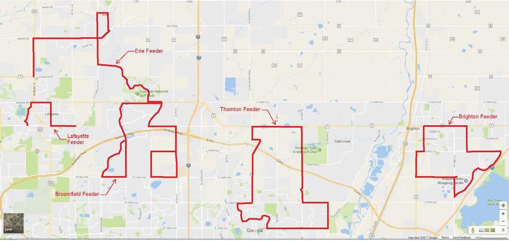
8 ELEMENT A FEEDER ROUTES 8
9
10 ELEMENT B TRAVEL DEMAND MODEL TRANSIT RESULTS

11 SERIES 1 TRANSIT RESULTS

12 SERIES 2 TRANSIT RESULTS 12
2030 Multimodal Transportation Study
 2030 Multimodal Transportation Study City of Jacksonville Planning and Development Department Prepared by Ghyabi & Associates April 29,2010 Introduction Presentation Components 1. Study Basis 2. Study
Chapter 7: Travel Demand Analysis. Chapter 8. Plan Scenarios. LaSalle Community Center. Image Credit: Town of LaSalle
 Chapter 7: Travel Demand Analysis Chapter 8 Plan Scenarios LaSalle Community Center. Image Credit: Town of LaSalle 164 Chapter 8: Plan Scenarios Moving Ahead for Progress in the 21 st Century Act (MAP
4.0 TIER 2 ALTERNATIVES
 4.0 TIER 2 ALTERNATIVES The Tier 2 Alternatives represent the highest performing Tier 1 Alternatives. The purpose of the Tier 2 Screening was to identify the LPA utilizing a more robust list of evaluation
Alternatives Analysis Findings Report
 6.0 This chapter presents estimates of the potential capital, operations and maintenance costs associated with the alternatives carried forward for detailed evaluation. The methodology used to develop
FINAL. Sound Transit Long-Range Plan Update. Issue Paper S.1: Tacoma Link Integration with Central Link. Prepared for: Sound Transit
 Sound Transit Long-Range Plan Update Issue Paper S.1: Tacoma Link Integration with Central Link Prepared for: Sound Transit Prepared by: Quade & Douglas, Inc. FINAL March 2005 Foreword This issue paper
Appendix F Model Development Report
 Appendix F Model Development Report This page intentionally left blank. Westside Mobility Plan Model Development Report December 2015 WESTSIDE MOBILITY PLAN MODEL DEVELOPMENT REPORT December 2015 Originally
TRAVEL DEMAND FORECASTS
 Jiangxi Ji an Sustainable Urban Transport Project (RRP PRC 45022) TRAVEL DEMAND FORECASTS A. Introduction 1. The purpose of the travel demand forecasts is to assess the impact of the project components
Appendix B: Travel Demand Forecasts July 2017
 Appendix B: Travel Demand Forecasts July 2017 Table of Contents 1 Introduction... 2 2 Model Review and Updates... 2 2.1 Overview of Smart Moves Model ( City of London Model )... 2 2.1.1 Network and Zone
Energy Technical Memorandum
 Southeast Extension Project Lincoln Station to RidgeGate Parkway Prepared for: Federal Transit Administration Prepared by: Denver Regional Transportation District May 2014 Table of Contents Page No. Chapter
ConnectGreaterWashington: Can the Region Grow Differently?
 Washington Metropolitan Area Transit Authority ConnectGreaterWashington: Can the Region Grow Differently? Transportation Planning Board (TPB) Travel Forecasting Subcommittee July 17, 2015 1 Alternatives
Subarea Study. Manning Avenue (CSAH 15) Corridor Management and Safety Improvement Project. Final Version 1. Washington County.
 Corridor Management and Safety Improvement Project. Final Version 1. Washington County.") Subarea Study Manning Avenue (CSAH 15) Corridor Management and Safety Improvement Project Final Version 1 Washington County June 12, 214 SRF No. 138141 Table of Contents Introduction... 1 Forecast Methodology
Subarea Study Manning Avenue (CSAH 15) Corridor Management and Safety Improvement Project Final Version 1 Washington County June 12, 214 SRF No. 138141 Table of Contents Introduction... 1 Forecast Methodology
TEXAS CITY PARK & RIDE RIDERSHIP ANALYSIS
 TEXAS CITY PARK & RIDE RIDERSHIP ANALYSIS This document reviews the methodologies and tools used to calculate the projected ridership and parking space needs from the proposed Texas City Park & Ride to
Alpine Highway to North County Boulevard Connector Study
 Alpine Highway to North County Boulevard Connector Study prepared by Avenue Consultants March 16, 2017 North County Boulevard Connector Study March 16, 2017 Table of Contents 1 Summary of Findings... 1
Bi-County Transitway/ Bethesda Station Access Demand Analysis
 Bi-County Transitway/ Bethesda Station Access Demand Analysis Prepared for: Washington Metropolitan Area Transit Authority Office of Planning and Project Development May 2005 Prepared by: in conjunction
I-20 EAST TRANSIT INITIATIVE Tier 1 and Tier 2 Alternatives Screening Report EXECUTIVE SUMMARY
 EXECUTIVE SUMMARY The purpose of this report is to document the results of the Tier 1 and Tier 2 Screening of alternatives for the I-20 East Transit Initiative. The two-tier screening process presented
ARTERIAL BRT OVERVIEW
 ARTERIAL BRT OVERVIEW Key Question: Could arterial Bus Rapid Transit (BRT) routes improve near-term mobility in the northwest area until rail can be built? Key Findings: 6 arterial BRT routes have been
DEVELOPMENT OF RIDERSHIP FORECASTS FOR THE SAN BERNARDINO INFRASTRUCTURE IMPROVEMENT STUDY
 APPENDIX 1 DEVELOPMENT OF RIDERSHIP FORECASTS FOR THE SAN BERNARDINO INFRASTRUCTURE IMPROVEMENT STUDY INTRODUCTION: This Appendix presents a general description of the analysis method used in forecasting
Tier 2 Screening and Selection522. of the Short List Alternatives KISSIMMEE CORRIDOR. Downtown CRA. US 192 Alternatives Analysis
 LAKE COUNTY ORANGE COUNTY Ticket and Transportation Center Walt Disney / Reedy Creek Improvement District CR 535 John Young Parkway 441 17 92 Florida s Turnpike VE 92 mee Hall JOHN YOUNG PKY 192 OAK ST
Valley Metro Overview. ITE/IMSA Spring Conference March 6, 2014
 Valley Metro Overview ITE/IMSA Spring Conference March 6, 2014 Valley Metro Who Are We? Operate Regional Transit Services Valley Metro and Phoenix are region s primary service providers Light Rail and
Michigan/Grand River Avenue Transportation Study TECHNICAL MEMORANDUM #18 PROJECTED CARBON DIOXIDE (CO 2 ) EMISSIONS
 EMISSIONS") TECHNICAL MEMORANDUM #18 PROJECTED CARBON DIOXIDE (CO 2 ) EMISSIONS Michigan / Grand River Avenue TECHNICAL MEMORANDUM #18 From: URS Consultant Team To: CATA Project Staff and Technical Committee Topic:
TECHNICAL MEMORANDUM #18 PROJECTED CARBON DIOXIDE (CO 2 ) EMISSIONS Michigan / Grand River Avenue TECHNICAL MEMORANDUM #18 From: URS Consultant Team To: CATA Project Staff and Technical Committee Topic:
Madison BRT Transit Corridor Study Proposed BRT Operations Plans
 Madison BRT Transit Corridor Study Proposed BRT Operations Plans This paper presents a description of the proposed BRT operations plan for use in the Madison BRT Transit Corridor Study. The objective is
Craig Scheffler, P.E., PTOE HNTB North Carolina, P.C. HNTB Project File: Subject
 TECHNICAL MEMORANDUM To Kumar Neppalli Traffic Engineering Manager Town of Chapel Hill From Craig Scheffler, P.E., PTOE HNTB North Carolina, P.C. Cc HNTB Project File: 38435 Subject Obey Creek TIS 2022
METRONext. Vision & Moving Forward Plans. Board Workshop. December 11, DRAFT For Preliminary Discussion Only
 METRONext Vision & Moving Forward Plans Board Workshop December 11, 2018 Disclaimer This presentation is being provided solely for discussion purposes by the Board of Directors of the Metropolitan Transit
Parks and Transportation System Development Charge Methodology
 City of Sandy Parks and Transportation System Development Charge Methodology March, 2016 Background In order to implement a City Council goal the City of Sandy engaged FCS Group in January of 2015 to update
TRANSIT TECHNICAL MEMORANDUM FOR RTD SOUTHWEST CORRIDOR EXTENSION PROJECT. January Prepared By Southwest Corridor Extension Project Team
 TRANSIT TECHNICAL MEMORANDUM FOR RTD SOUTHWEST CORRIDOR EXTENSION PROJECT January 2010 Prepared By Southwest Corridor Extension Project Team In some cases, information in this Environmental Technical Report
Travel Time Savings Memorandum
 04-05-2018 TABLE OF CONTENTS 1 Background 3 Methodology 3 Inputs and Calculation 3 Assumptions 4 Light Rail Transit (LRT) Travel Times 5 Auto Travel Times 5 Bus Travel Times 6 Findings 7 Generalized Cost
Regional Transit Extension Studies. Hampton Roads Transportation Planning Organization Passenger Rail Task Force Meeting December 17, 2013
 Regional Transit Extension Studies Hampton Roads Transportation Planning Organization Passenger Rail Task Force Meeting December 17, 2013 Topics Virginia Beach Transit Extension Study (VBTES) Naval Station
CEDAR AVENUE TRANSITWAY Implementation Plan Update
 CEDAR AVENUE TRANSITWAY Implementation Plan Update EECUTIVE SUMMARY DECEMBER 2015 Executive Summary In 2013, the Twin Cities metropolitan area s first bus rapid transit (BRT) line, the METRO Red Line,
Green Line Long-Term Investments
 Enhancements Short-term improvements to keep Austin moving. Investments Long-term projects to support our future. Mobility Hubs MetroRapid MetroRail MetroExpress Connectors Circulators Project Connect
UTA Transportation Equity Study and Staff Analysis. Board Workshop January 6, 2018
 UTA Transportation Equity Study and Staff Analysis Board Workshop January 6, 2018 1 Executive Summary UTA ranks DART 6 th out of top 20 Transit Agencies in the country for ridership. UTA Study confirms
Public Meeting. March 21, 2013 Mimosa Elementary School
 Public Meeting March 21, 2013 Mimosa Elementary School Today s Meeting Purpose 2 Where We Are The Process What We ve Heard and Findings Transit Technologies Station Types Break-out Session Where We Are
QUALITY OF LIFE EXECUTIVE SUMMARY REPORT I O N S TAT I O N
 QUALITY OF LIFE EXECUTIVE SUMMARY REPORT UN I O N S TAT I O N T R AV E L by TR A I N Published September 2017 2015 PROGRESS MAP This document reports FasTracks progress through 2015 BACKGROUND RTD The
UCLA Lake Arrowhead Conference. October 18, 2010
 BART Click to Capacity edit Master Overview title style for UCLA Lake Arrowhead Conference October 18, 2010 0 BART Basics 360,000 daily riders 104 miles 43 stations 1.3 billion annual passenger miles 1
UCLA Lake Arrowhead Conference. October 18, 2010
 BART Click to Capacity edit Master Overview title style for UCLA Lake Arrowhead Conference October 18, 2010 0 BART Basics 360,000 daily riders 104 miles 43 stations 1.3 billion annual passenger miles 1
King Soopers #116 Thornton, Colorado
 Traffic Impact Study King Soopers #116 Thornton, Colorado Prepared for: Galloway & Company, Inc. T R A F F I C I M P A C T S T U D Y King Soopers #116 Thornton, Colorado Prepared for Galloway & Company
A Transit Plan for the Future. Draft Network Plan
 A Transit Plan for the Future Draft Network Plan Project Overview and Status Completed Market Analysis and Service Evaluation. Developed Plan Framework and Guiding Principles. Developed a draft Five Year
Waco Rapid Transit Corridor (RTC) Feasibility Study
 Feasibility Study") Waco Rapid Transit Corridor (RTC) Feasibility Study Chris Evilia, Director of Waco Metropolitan Planning Organization Allen Hunter, General Manager Waco Transit System Jimi Mitchell, Project Manager AECOM
Waco Rapid Transit Corridor (RTC) Feasibility Study Chris Evilia, Director of Waco Metropolitan Planning Organization Allen Hunter, General Manager Waco Transit System Jimi Mitchell, Project Manager AECOM
4 COSTS AND OPERATIONS
 4 COSTS AND OPERATIONS 4.1 INTRODUCTION This chapter summarizes the estimated capital and operations and maintenance (O&M) costs for the Modal and High-Speed Train (HST) Alternatives evaluated in this
Key Transfer Stations - Technical Memo
 DOCUMENT 5 October 2008 Key - Technical Memo 1.0 INTRODUCTION In May 2008 Council approved a Primary Rapid Transit Network which includes both Light Rail Transit (LRT) and Bus Rapid Transit (BRT) corridors.
MEMO VIA . Ms. Amy Roth DPS Director, City of Three Rivers. To:
 MEMO To: Ms. Amy Roth DPS Director, City of Three Rivers VIA EMAIL From: Michael J. Labadie, PE Julie M. Kroll, PE, PTOE Brandon Hayes, PE, P.Eng. Fleis & VandenBrink Date: January 5, 2017 Re: Proposed
CITY OF LONDON STRATEGIC MULTI-YEAR BUDGET ADDITIONAL INVESTMENTS BUSINESS CASE # 6
 2016 2019 CITY OF LONDON STRATEGIC MULTI-YEAR BUDGET ADDITIONAL INVESTMENTS BUSINESS CASE # 6 STRATEGIC AREA OF FOCUS: SUB-PRIORITY: STRATEGY: INITIATIVE: INITIATIVE LEAD(S): BUILDING A SUSTAINABLE CITY
Regional Transportation Commission, Washoe County Lee Gibson, Executive Director Roger Hanson, Senior Planner
 Regional Transportation Commission, Washoe County Lee Gibson, Executive Director Roger Hanson, Senior Planner Presentation Outline Transit System Facts Economic Challenges in the Truckee Meadows RTC Transit
METRO Orange Line BRT American Boulevard Station Options
 METRO Orange Line BRT American Boulevard Station Options Bloomington City Council Work Session November 18, 2013 Christina Morrison BRT/Small Starts Project Office Coordinating Planning and Design AMERICAN
TPB CLRP Aspirations Scenario
 TPB CLRP Aspirations Scenario Streamlined Variably Priced Lane Network Sensitivity Test Ron Kirby Erin Morrow Department of Transportation Planning Presentation to the Transportation Planning Board October
Sepulveda Pass Corridor Systems Planning Study Final Compendium Report. Connecting the San Fernando Valley and the Westside
 Los Angeles County Metropolitan Transportation Authority November 2012 Connecting the San Fernando Valley and the Westside Interstate 405 Sepulveda Pass THIS PAGE INTENTIONALLY LEFT BLANK Sepulveda Pass
Unified Corridor Investment Study DRAFT Step 2 Scenario Analysis Report
 Unified Corridor Investment Study DRAFT Step 2 Scenario Analysis Report REVISIONS 1. Table 39: New Public Investments for Operation and Maintenance Costs 2. Appendix A-10: Passenger Rail Service - Operations
APPENDIX I: [FIXED-GUIDEWAY TRANSIT FEASIBILITY]
![APPENDIX I: [FIXED-GUIDEWAY TRANSIT FEASIBILITY]](/thumbs/83/87090921.jpg "APPENDIX I: [FIXED-GUIDEWAY TRANSIT FEASIBILITY]") APPENDIX I: [FIXED-GUIDEWAY TRANSIT FEASIBILITY] Jackson/Teton Integrated Transportation Plan 2015 Appendix I. Fixed-Guideway Transit Feasibility Jackson/Teton County Integrated Transportation Plan v2
APPENDIX I: [FIXED-GUIDEWAY TRANSIT FEASIBILITY] Jackson/Teton Integrated Transportation Plan 2015 Appendix I. Fixed-Guideway Transit Feasibility Jackson/Teton County Integrated Transportation Plan v2
Transportation Statistical Data Development Report BAY COUNTY 2035 LONG RANGE TRANSPORTATION PLAN
 Transportation Statistical Data Development Report BAY COUNTY 2035 LONG RANGE TRANSPORTATION PLAN Prepared for Bay County Transportation Planning Organization and The Florida Department of Transportation,
Appendix J Traffic Impact Study
 MRI May 2012 Appendix J Traffic Impact Study Level 2 Traffic Assessment Limited Impact Review Appendix J [This page was left blank intentionally.] www.sgm-inc.com Figure 1. Site Driveway and Trail Crossing
Operating & Maintenance Cost Results Report
 Operating & Maintenance Cost Results Report Prepared for: Hennepin County Regional Railroad Authority Prepared by: Connetics Transportation Group Under Contract To: Kimley-Horn and Associates FINAL June
Travel Demand Modeling at NCTCOG
 Travel Demand Modeling at NCTCOG Arash Mirzaei North Central Texas Council Of Governments for Southern Methodist University The ASCE Student Chapter October 24, 2005 Contents NCTCOG DFW Regional Model
Appendix B CTA Transit Data Supporting Documentation
 RED ED-PURPLE BYPASS PROJECT ENVIRONMENTAL ASSESSMENT AND SECTION 4(F) EVALUATION Appendix B CTA Transit Data Supporting Documentation 4( Memorandum Date: May 14, 2015 Subject: Chicago Transit Authority
Forecast Allocation Methodology. Kitsap 10-Year Update Kitsap County August 2006; Updated November 2006
 Appendix D Methods Forecast Allocation Methodology Kitsap 10-Year Update Kitsap County August 2006; Updated November 2006 Employment and Population Forecast Allocation Methodology Prepared for: Kitsap
TORONTO TRANSIT COMMISSION REPORT NO.
 Form Revised: February 2005 TORONTO TRANSIT COMMISSION REPORT NO. MEETING DATE: October 24, 2012 SUBJECT: DOWNTOWN RAPID TRANSIT EXPANSION STUDY (DRTES) PHASE 1 STRATEGIC PLAN ACTION ITEM RECOMMENDATIONS
Philip Schaffner & Jason Junge Minnesota Department of Transportation
 Philip Schaffner & Jason Junge Minnesota Department of Transportation 100% 80% 60% 40% 20% 0% 9% 33% 9% 21% 29% Trunk Highways $1.3B 14% 16% 19% 33% 17% Greater Minnesota Transit $55.7M 25% 27% 36% Note:
TRANSPORTATION STUDY FOR THE 8899 BEVERLY BOULEVARD PROJECT
 DRAFT TRANSPORTATION STUDY FOR THE 8899 BEVERLY BOULEVARD PROJECT WEST HOLLYWOOD, CALIFORNIA NOVEMBER 2013 PREPARED FOR BEVERLY BOULEVARD ASSOCIATION PREPARED BY DRAFT TRANSPORTATION STUDY FOR THE 8899
6/6/2018. June 7, Item #1 CITIZENS PARTICIPATION
 June 7, 2018 Item #1 CITIZENS PARTICIPATION 1 Item #2 APPROVAL OF MINUTES Item #3 TRAC GOALS, FRAMEWORK & AGENDA REVIEW 2 COMMITTEE GOALS Learn about Southern Nevada s mobility challenges, new developments
Troost Corridor Transit Study
 Troost Corridor Transit Study May 23, 2007 Kansas City Area Transportation Authority Agenda Welcome Troost Corridor Planning Study Public participation What is MAX? Survey of Troost Riders Proposed Transit
Town of Londonderry, New Hampshire NH Route 28 Western Segment Traffic Impact Fee Methodology
 Town of Londonderry, New Hampshire NH Route 28 Western Segment Traffic Impact Fee Methodology Prepared by the Londonderry Community Development Department Planning & Economic Development Division Based
RE: A Traffic Impact Statement for a proposed development on Quinpool Road
 James J. Copeland, P.Eng. GRIFFIN transportation group inc. 30 Bonny View Drive Fall River, NS B2T 1R2 May 31, 2018 Ellen O Hara, P.Eng. Project Engineer DesignPoint Engineering & Surveying Ltd. 200 Waterfront
Executive Summary. Draft Environmental Impact Statement/Environmental Impact Report ES-1
 Executive Summary Introduction The Eastside Transit Corridor Phase 2 Project is a vital public transit infrastructure investment that would provide a transit connection to the existing Metro Gold Line
DRAFT TRANSPORTATION IMPACT STUDY CASTILIAN REDEVELOPMENT PROJECT
 DRAFT TRANSPORTATION IMPACT STUDY CASTILIAN REDEVELOPMENT PROJECT Prepared for: Submitted by: 299 Lava Ridge Ct. Suite 2 Roseville, CA. 95661 June 212 TABLE OF CONTENTS 1. Introduction... 1 Project Location
Letter EL652 City of Mercer Island. Page 1. No comments n/a
 Letter EL652 City of Mercer Island Page 1 No comments n/a Page 2 Response to comment EL652 1 Section 4.5.3 of the Final EIS presents the range of potential impacts of the project. This project also lists
Downtown Lee s Summit Parking Study
 Downtown Lee s Summit Parking Study As part of the Downtown Lee s Summit Master Plan, a downtown parking and traffic study was completed by TranSystems Corporation in November 2003. The parking analysis
UCLA Lake Arrowhead Conference. October 18, 2010
 BART Click to Capacity edit Master Overview title style for UCLA Lake Arrowhead Conference October 18, 2010 0 BART Basics 360,000 daily riders 104 miles 43 stations 1.3 billion annual passenger miles 1
Memorandum. 1 Introduction. 2 O&M Cost Elements. 2.1 Service O&M Costs
 To Barrow Emerson, SamTrans Melissa Reggiardo, SamTrans Date 9/13/2014 Copies Reference number From Subject Corey Wong, Arup Steve Crosley, Fehr + Peers ECR BRT Phasing Plan File reference 1 Introduction
Executive Summary. Treasure Valley High Capacity Transit Study Priority Corridor Phase 1 Alternatives Analysis October 13, 2009.
 Treasure Valley High Capacity Transit Study Priority Corridor Phase 1 Alternatives Analysis October 13, 2009 Background As the Treasure Valley continues to grow, high-quality transportation connections
METRO Light Rail Update
 American Society of Highway Engineers METRO Light Rail Update Brian Buchanan Director, Design and Construction October 13, 2009 1 High Capacity Transit System 2 20-Mile Light Rail Line 3 Operations Operations
EXECUTIVE SUMMARY. The following is an outline of the traffic analysis performed by Hales Engineering for the traffic conditions of this project.
 EXECUTIVE SUMMARY This study addresses the traffic impacts associated with the proposed Shopko redevelopment located in Sugarhouse, Utah. The Shopko redevelopment project is located between 1300 East and
A Presentation to: Project Advisory Group Meeting #10
 A Presentation to: Project Advisory Group Meeting #10 October 21, 2015 Agenda Introductions Action Items From Last PAG Meeting (August 26, 2015) Recent Agency Involvement Update on Refined Alternative
RTID Travel Demand Modeling: Assumptions and Method of Analysis
 RTID Travel Demand Modeling: Assumptions and Method of Analysis Overall Model and Scenario Assumptions The Puget Sound Regional Council s (PSRC) regional travel demand model was used to forecast travel
Downtown One Way Street Conversion Technical Feasibility Report
 Downtown One Way Street Conversion Technical Feasibility Report As part of the City s Transportation Master Plan, this report reviews the technical feasibility of the proposed conversion of the current
I-10 West AA/EIS Pre-Screening and Tier 1 Analysis Results. Public Meeting. Wulf Grote, Director Project Development Rick Pilgrim, Project Manager
 I-10 West AA/EIS Pre-Screening and Tier 1 Analysis Results Public Meeting Wulf Grote, Director Project Development Rick Pilgrim, Project Manager March 4 & 5, 2008 Today s Agenda Overview of Alternatives
1 On Time Performance
 MEMORANDUM: US 29 Travel Time & OTP To: From: Joana Conklin, Montgomery County DOT James A. Bunch, SWAI Subject: US 29 Travel Time and On Time Performance Analysis Date: This memorandum documents the US
Preliminary Definition of Alternatives. 3.0 Preliminary Definition of Alternatives
 3.0 What preliminary alternatives are being evaluated? The alternatives for the East San Fernando Valley Transit Corridor project that were considered for screening include the No Build Alternative, Transportation
Funding Scenario Descriptions & Performance
 Funding Scenario Descriptions & Performance These scenarios were developed based on direction set by the Task Force at previous meetings. They represent approaches for funding to further Task Force discussion
TRAFFIC IMPACT STUDY VICDOM BROCK ROAD PIT EXPANSION
 TRAFFIC IMPACT STUDY VICDOM BROCK ROAD PIT EXPANSION TOWNSHIP OF UXBRIDGE P/N 05-1993 June 2011 Revised -August 2011 Prepared by: Skelton, Brumwell & Associates Inc. 93 Bell Farm Road, Suite 107 Barrie,
BROWARD BOULEVARD CORRIDOR TRANSIT STUDY
 BROWARD BOULEVARD CORRIDOR TRANSIT STUDY FM # 42802411201 EXECUTIVE SUMMARY July 2012 GOBROWARD Broward Boulevard Corridor Transit Study FM # 42802411201 Executive Summary Prepared For: Ms. Khalilah Ffrench,
10/4/2016. October 6, Item #1 CITIZENS PARTICIPATION
 October 6, 2016 Item #1 CITIZENS PARTICIPATION 1 Item #2 APPROVAL OF MINUTES Item #3 WELCOME 2 Item #4 TRAC ROADWAY RECOMMENDATIONS UPDATE Item #4 Completed Jurisdiction Presentations Boulder City August
PEACHTREE CORRIDOR PARTNERSHIP. Current Status & Next Steps
 PEACHTREE CORRIDOR PARTNERSHIP Current Status & Next Steps PEACHTREE CORRIDOR PARTNERSHIP Why Peachtree? Why Now? I. THE CONTEXT High Level View of Phasing Discussion Potential Ridership Segment 3 Ease
Mass Transit in Charlotte and San Antonio. Keith T. Parker, AICP
 Mass Transit in Charlotte and San Antonio Keith T. Parker, AICP President/CEO Presentation Overview Charlotte Agency and Customer Profile San Antonio Agency and Customer Profile Attracting New Customers
HDR Engineering. HART North / South. Tampa Bay Applications Group Meeting May 14, 2009
 HDR Engineering HART North / South BRT Corridor PD&E Tampa Bay Applications Group Meeting May 14, 2009 1 Agenda Update on Project Development and Environment (PD&E) Study Project Overview System Branding
Re: Addendum No. 4 Transportation Overview 146 Mountshannon Drive Ottawa, Ontario
 April 18 th, 2017 Mr. Kevin Yemm Vice President, Land Development Richraft Group of Companies 2280 St. Laurent Boulevard, Suite 201 Ottawa, Ontario (Tel: 613.739.7111 / e-mail: keviny@richcraft.com) Re:
Sound Transit East Link: Bus/LRT System Integration Study
 Sound Transit East Link: Bus/LRT System Integration Study Prepared For: Sound Transit King County Metro Mercer Island WSDOT Prepared By: CH2M HILL July, 2014 1 SOUND TRANSIT EAST LINK: BUS/LRT SYSTEMES
7 COMPARATIVE EVALUATION OF ALTERNATIVES
 7 COMPARATIVE EVALUATION OF ALTERNATIVES 7.1 INTRODUCTION This chapter presents the comparative analysis of the four Level 2 build alternatives along with a discussion of the relative performance of the
D. J. Halpenny & Associates Ltd. Consulting Transportation Engineers
 D. J. Halpenny & Associates Ltd. Consulting Transportation Engineers August 24, 2015 File: 115-622 Mr. R. Baumann, President The RGB Group 277 Kirchoffer Avenue Ottawa, ON K2A 1Y1 RE: RESIDENTIAL DEVELOPMENT
West Hills Shopping Centre Lowe s Expansion Traffic Impact Study
 West Hills Shopping Centre Lowe s Expansion Traffic Impact Study Prepared for: Armel Corporation January 2015 Paradigm Transportation Solutions Ltd. 22 King Street South, Suite 300 Waterloo ON N2J 1N8
Transit Access Study
 West of Hudson Regional Transit Access Study Open House presentation July 20, 2010 1 Agenda Progress To date Summary of Level 2 Alternatives and Screening Service Plans Bus and Rail Operating and Capital
RECOMMENDED ALTERNATIVE REPORT
 DRAFT METROCENTER CORRIDOR STUDY RECOMMENDED ALTERNATIVE REPORT JULY 12, 2005 TABLE OF CONTENTS SECTION PAGE 1.0 INTRODUCTION... 1 2.0 TIER 1 ALTERNATIVES EVALUATION... 1 3.0 TIER 2 ALTERNATIVES EVALUATION...
Transportation & Traffic Engineering
 Transportation & Traffic Engineering 1) Project Description This report presents a summary of findings for a Traffic Impact Analysis (TIA) performed by A+ Engineering, Inc. for the Hill Country Family
Transit in Bay Area Blueprint
 Rail~Volution 2010 Click to edit Master title style Transit in Bay Area Blueprint October 21, 2010 0 Bottom Line State-of-Good Repair essential for reliable transit service large funding shortfalls BART
Task Force Meeting January 15, 2009
 Task Force Meeting January 15, 2009 Study Update August 14 th Task Force Meeting Update on Traffic Projections and Financial Feasibility Study presented by Kane County and WSA staff The presentation summarized
East San Fernando Valley Transit Corridor. TAC Briefing December 4, 2013
 East San Fernando Valley Transit Corridor TAC Briefing December 4, 2013 Overview Measure R Project Long Range Transportation Plan Reserves $170.1 Million 2018 Revenue Operations Date Coordination with
3.1 Introduction Transportation Elements and Study Area Meeting the Need for the Project
 Chapter 3 Transportation Environment and Consequences 3. Introduction This chapter summarizes the characteristics of the transportation system in the East Link Project vicinity and discusses potential
I-405 and SR 522/NE 145th Bus Rapid Transit. Elected Leadership Groups Meeting November 30, 2018
 I-405 and SR 522/NE 145th Bus Rapid Transit Elected Leadership Groups Meeting November 30, 2018 Agenda Welcome and Introductions Public Comment BRT Connection in Bothell Common Elements: Bus base, Station
Crenshaw-Prairie Transit Corridor Study Public Meetings
 Crenshaw-Prairie Transit Corridor Study Public Meetings Darby Park: Wednesday, February 20, 2008 6:30 8:00 PM US Bank Community Room: Thursday, February 21, 2008 6:30 8:00 PM Nate Holden Performing Arts
Aaren Healy, 20 September 2017 / 1
 Network Rail s consultation on variable charges and station charges in CP6 Electricity charge for traction (EC4T) and the electrification asset usage charge (EAUC) Aaren Healy, 20 September 2017 / 1 Purpose
Tempe Streetcar. March 2, 2016
 Tempe Streetcar March 2, 2016 Tempe Profile 40 sq. miles, highest density in state University Town, center of region Imposed growth boundaries (density increase) Mixed use growth/intensifying land use
Metro Transit Update. Christina Morrison, Senior Planner Metro Transit BRT/Small Starts Project Office. John Dillery, Senior Transit Planner
 Metro Transit Update Christina Morrison, Senior Planner Metro Transit BRT/Small Starts Project Office John Dillery, Senior Transit Planner Metro Transit Service Development May 16, 2013 1 Transit Planning
WELCOME. Transit Options Amherst - Buffalo Public Workshops
 WELCOME Transit Options Amherst - Buffalo Public Workshops Sponsored by Niagara Frontier Transportation Authority Greater Buffalo Niagara Regional Transportation Council Where do you live? Where do you