Bayers Road / Highway 102 Corridor Study Component 3 - Highway 107 Final Report March 2010
|
|
|
- Gillian Knight
- 6 years ago
- Views:
Transcription
1 Bayers Road / Highway 102 Corridor Study Component 3 - Highway 107 Final Report March 2010 Department of Transportation and Infrastructure Renewal and The Halifax Regional Municipality Completed By: Stantec Consulting Ltd. in association with Stantec #: Final Report
2 BAYERS ROAD / HIGHWAY 102 CORRIDOR STUDY COMPONENT 3 - HIGHWAY 107 FINAL REPORT MARCH 2010 Executive Summary E-1 INTRODUCTION The Nova Scotia Department of Transportation and Infrastructure Renewal (NSTIR) and Halifax Regional Municipality (HRM) have contracted the Stantec, Delphi-MRC team to undertake a study of the Bayers Road / Highway 102 Corridor and the proposed extension of Highway 107 to Highway 102. The team has undertaken transportation planning, traffic analysis, functional design and overall project management for the corridor study. The purpose of the study is to determine the ultimate capacity and best use of the Highway 102 corridor and to study the alignment and connection options for the future Highway 107. The primary objectives of the Project are to determine: Traffic Projections (Component 1) Highway 102 Upgrades (Component 2) Highway 107 Extension (Component 3) This report (the third of three) provides an overview of Component 3. The following is a description of the study objectives for Component 3. Review of the Study Area to establish constraints, property ownership and environmental issues. Develop a Functional Design for the Highway 107 Alignment to determine the right of way required for the alignment. Present the Highway 107 Functional Plan at a Public Information Session to present the results of the study and obtain feedback on the conceptual plans. Costing and Implementation to determine approximate costs for the work and a concept schedule for implementation. Perform Benefit Cost Analysis of the Highway 107 project to examine the merits of the project relative to the base case (status quo). E-2 EVALUATION The Terms of Reference (Appendix A, Figure 1) show the initially considered two options for the Highway 107 alignments connecting to the two locations on Highway 102. At the outset of the project, NSTIR requested that the Exit 4 connection option be revised to show an alignment to the south of Anderson Lake and an interchange with Windmill Road. The two resulting alignments are show in Appendix B, labeled as Option 1 and Option 2. The Exit 4 connection
3 BAYERS ROAD / HIGHWAY 102 CORRIDOR STUDY COMPONENT 3 - HIGHWAY 107 FINAL REPORT MARCH 2010 option was carried forward in the Study as Scenario C and the connection was studied in a Value Engineering Session. While the VE session presented many alternative connection configurations, it was apparent that a connection at Exit 4 which met the entire NSTIR criterion was not identified. A compromised solution would be required. With this in mind the two basic alignments for Highway 107 were reviewed and two key factors resulted in the selection of the preferred alternative: - The lack of an acceptable design for a direct connection to Exit 4 as studied in the VE session (Component 2). - The ability to phase the construction of the connection to Exit 4C. The suggested phasing is described in Section 3.0. As a result, the Highway 107 alignment to the north of Lake Anderson and connection to Highway 102 at Exit 4C was determined to be the preferred and only feasible alignment which would be carried forward to functional design. It was also determined by NSTIR that the cost benefit analysis would compare this preferred alignment with the do nothing or status quo alternative. Based on the preferred alignment, a review of background material was done in order to characterize the site and identify key constraints to extension of the highway. Background material reviewed included aerial photography, right-of-way plans, topographic and property mapping. A design criteria was established for the functional design of Highway 107 which is consistent with provincial standards for NSTIR 100 series highways. E-3 FUNCTIONAL DESIGN NSTIR prepared a plan showing the preferred alignment and three phased approach to construction. The resulting plan is shown in Appendix C, titled Highway 107 Extension - Option 1A. The plans show a suggested phasing of the highway development that would involve the facility operating as an arterial roadway prior to making the connections to the highways. The purpose of the phasing is to allow for funding of the project over a number of years. - Phase 1: A 4-lane arterial road connection between Duke Street and Burnside Drive - Phase 2: An interchange providing land access just to the west of Anderson Lake - Phase 3: Westerly extension of Highway 107 to connect with Highway 102 and easterly extension of Highway 107 and connection to Akerley Boulevard E.2
4 BAYERS ROAD / HIGHWAY 102 CORRIDOR STUDY COMPONENT 3 - HIGHWAY 107 FINAL REPORT MARCH 2010 Profiles were developed for each of the phases and associated ramps. Grading limits were generated using Civil 3D and based on the typical design section to determine the right-of-way that would be required. E-6 SUPPLEMENTARY TRAFFIC EVALUATION The study team carried out a supplementary evaluation to determine the feasibility of implementing a Burnside Drive extension (Phase 1, Arterial Road) concept, as opposed to constructing a 100-Series Freeway, and to determine approximately how far out into the future such a facility could accommodate traffic. The roadway concept is to extend Burnside Drive from its current terminus at Akerley Boulevard and connect to Duke Street at Rocky Lake Road. It was assumed that there would be major intersections with the arterial at Akerley and Rocky Lake Road and no other connection points. Evaluations were carried out for the 2016 and 2026 planning horizons for both the morning and afternoon peak hours. The general findings of the review indicate that: There is a strong desire for commuters to use this facility; It could likely function as a 4-lane roadway (2 lanes in each direction) out to the 2026 planning horizon the time about when it is forecast to reach capacity; Two key constraint locations were identified as part of this analysis: o Currently, The Highway 111/Burnside Drive interchange is approaching capacity. Given the potential for environmental and land use impacts in the immediate o area, any upgrades may be difficult to undertake; The other constraint location is Akerley Boulevard where additional turning lanes may be required by the 2026 planning horizon; NSTIR expects the implementation of modern roundabouts will help address some of the challenges. The second part of the supplemental evaluation of the Burnside Drive extension concept was to determine the impact to travel behaviour on parallel corridors. The roadways that are expected to experience a reduction in traffic volume as a result of a Burnside Drive extension include: Windmill Road / Magazine Hill; Highway 118 /Highway 102 through Fall River; and Highway 102 / Bedford Highway The results identify and support the notion that there is a strong demand for a new roadway connection between Burnside Park and Highway 102 in the Bedford/Sackville area. The general travel behaviour changes that are expected to result from implementing the proposed Burnside Drive extension are illustrated in Exhibit E.1 E.3
5 BAYERS ROAD / HIGHWAY 102 CORRIDOR STUDY COMPONENT 3 - HIGHWAY 107 FINAL REPORT MARCH 2010 Exhibit E.1 Network Level Travel Behaviour Implications E-7 SUMMARY AND CONCLUSIONS The functional plans in Appendix C show the approximate right-of-way required for the construction of Highway 107 and the resulting properties which will be impacted by construction. An estimated 60 properties (see sketch with properties indicated) and 35 different property owners along the Highway 107 Corridor would be directly impacted by the construction. Public Information Sessions were held to explain the study and obtain information and feedback from local residents, businesses, and landowners. Chapter 8.0 of the Component 2 report describes the sessions. From the questionnaires and comments received, it may be inferred that the majority of those who provided comments regarding the highway 107 project agree with E.4
6 BAYERS ROAD / HIGHWAY 102 CORRIDOR STUDY COMPONENT 3 - HIGHWAY 107 FINAL REPORT MARCH 2010 the project. However, it was determined that careful consideration of the Highway 107 phase 1 is required. This phase would direct traffic directly to Glendale from the new Highway 107 and this has been identified as a primary concern. Based on the functional design, the team prepared an opinion of capital costs for the major components of construction. Exhibit E.2 is an overall summary of the approximate costs for the proposed Highway 107 Extension. Exhibit E.2 Highway 107 Cost Summary Table by Phase Item HIGHWAY SUMMARY No 1 - By Phase Approximate Cost 14.1 Phase 1 Highway 107 (Duke Street Extension) $47,000, Phase 2 New Interchange on Highway 107 $ Phase 3A - Highway 107 from Exit 4C to New Interchange (Westerly Connections) $28,000, Phase 3B - Highway 107 from Burnside Drive Interchange to Existing Hwy 107 $21,000, Phase 3C - Akerley Interchange $12,000, Interchange: Highway 107 at Exit 4C (Option 1 Costing) $13,000,000 Total (excludes taxes, engineering, and contingencies) $121,000,000 The costs have been developed based on the limited information available as well as historical information. This is an order of magnitude estimate. A conceptual timeline for the expansions has been determined and shown in Exhibit E.3. This approximate timeline shows the roadway phases as noted in Exhibit E.2. An approximate 2 year time frame is assumed for each component of the work. Exhibit E.3 Timelines Horizon Year 2016 Horizon Year 2026 Horizon Year 2036 No. Location HIGHWAY Phase 1 Highway 107 (Duke Street Extension) 14.2 Phase 2 New Interchange on Highway Phase 3A - Highway 107 from Exit 4C to New Interchange Phase 3B - Highway 107 from B Drive Int to Exis Hwy Phase 3C - Akerley Interchange 12.3 Interchange: 107 at Exit 4C E.5
7 BAYERS ROAD / HIGHWAY 102 CORRIDOR STUDY COMPONENT 3 - HIGHWAY 107 FINAL REPORT MARCH 2010 Based on the approximate costs for each component of the project and the projected timeline, the following Exhibit E.4 shows the resulting yearly costs. Exhibit E.4 Approximate Yearly Costs Highway 107 $25 Approximate Yearly Costs Highway 107 Dollars (Millions) $20 $15 $10 $5 $ Year A Benefit / Cost Assessment of the Highway 107 Extension was undertaken by Canmac Economics Limited. The full report is included in Appendix E. The assessment compares the Base Case (the status quo) and the preferred option as described in this report. The benefits associated with the new highway include: Travel time savings Social cost savings o Decreased accidents o Greenhouse gas emissions The costs associated with the new highway include: Construction Costs Operating and Maintenance Costs Resurfacing Costs The resulting Benefit / Cost ratio varies from 1.8 to 2.4, concluding that the project makes a positive contribution to society. E.6
8 BAYERS ROAD / HIGHWAY 102 CORRIDOR STUDY COMPONENT 3 - HIGHWAY 107 FINAL REPORT MARCH 2010 Table of Contents EXECUTIVE SUMMARY E INTRODUCTION BACKGROUND INFORMATION OBJECTIVES FOR COMPONENT 3 HIGHWAY EVALUATION ALIGNMENT EVALUATION HIGHWAY 107 MAPPING HIGHWAY 107 DESIGN CRITERIA GRADE SEPARATIONS AND INTERCHANGES CONCEPTUAL PLANS CORRIDOR PLANNING PHASING FUNCTIONAL PLAN SUPPLEMENTARY TRAFFIC EVALUATION INTRODUCTION LINK VOLUME RESULTS Link Volume Results Supplementary Network Level Review STUDY AREA INTERSECTION EVALUATION A NOTE ON THE HIGHWAY 102 CORRIDOR SUMMARY AND CONCLUSIONS PROPERTY IMPACTS AND PUBLIC INFORMATION SESSIONS OPINION OF PROBABLE COST Basis for the Costing Summary of Highway 107 Costs INFRASTRUCTURE IMPLEMENTATION SCHEDULE Timeline for Expansions Approximate Yearly Costs BENEFIT / COST ASSESSMENT i
9 BAYERS ROAD / HIGHWAY 102 CORRIDOR STUDY COMPONENT 3 - HIGHWAY 107 FINAL REPORT MARCH 2010 APPENDICES APPENDIX A: APPENDIX B: APPENDIX C: APPENDIX D: APPENDIX E: Terms of Reference Alignment Options Functional Plans Costing Benefit / Cost Assessment ii
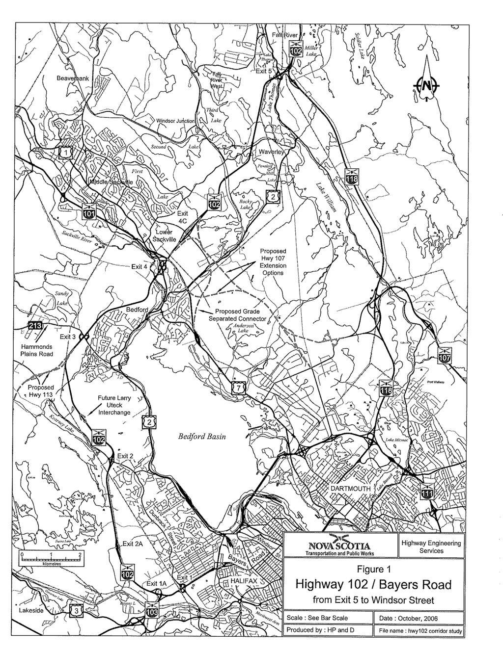
10 BAYERS ROAD / HIGHWAY 102 CORRIDOR STUDY COMPONENT 3 - HIGHWAY 107 FINAL REPORT MARCH Introduction The purpose of this study is to determine the ultimate capacity and best use of the Highway 102 corridor and to study the alignment and connection options for Highway 107. The primary objectives of the Project are to: Complete Traffic Projections for Highway 102 and 107 (Component 1) Identify Highway 102 Upgrades Requirements based on Component 1 (Component 2) Review the Highway 107 Extension to Highway 102 (Component 3) The project is divided into three main components and specific objectives are discussed in Section 1.2. All three components are inter-related and portions of each component occurred concurrently. Component 1, the traffic projection component of the project provides the data required to complete Component 2 and 3 respectively. Traffic Projections have been determined using the QRSII model to the horizon years 2016, 2026, and The results of this work are summarized in Component 1 Traffic Projections Final Report, February 20, 2008 and Component 2 Highway 102 Upgrades, October, The following report presents the results of Component 3 of the project to identify a preferred alignment for the extension of Highway BACKGROUND INFORMATION Previous work done over several years has identified the need for a 100 series highway connection from the existing Highway 107 connecting to Highway 102. The existing Highway 107 extends from Musquodoboit Harbour to the Westphal area of Dartmouth (Forest Hills Parkway) to Highway 118 and then to Akerley Boulevard in Burnside Park. The Akerley connection to the existing Highway 107 and Highway 118 was constructed with further extension in mind. The extension from Burnside Park to Highway 102 was originally planned and designed to connect to Exit 4C (Glendale / Duke Street) on Highway 102 and continue as the Second Lake Collector to connect to Highway 101 at an interchange to be located west of Sackville. Functional design work for the extension was done as far back as the 1970 s. Detailed design of the Exit 4C connection was completed in the 1990 s when the Glendale / Duke Street Interchange was constructed to allow for the Highway 107 Connection. sal 1.1
11 BAYERS ROAD / HIGHWAY 102 CORRIDOR STUDY COMPONENT 3 - HIGHWAY 107 FINAL REPORT MARCH 2010 However, The Second Lake Collector route has since been abandoned as a viable option. As a result, the planned alignment of Highway 107 between Burnside and Highway 102 is being reexamined to see if there is an opportunity to connect to Highway 102 at the Exit 4 (Bedford) interchange as an alternative to the Exit 4C connection. This would allow direct flow from Highway 107 to Highway 102 and Highway 101. As described in the Component 1 report (Section 2.4), Scenario B and Scenario C represented two options for the connection of Highway 107 to Highway 102 at Exit 4 and Exit 4C respectively. These options were evaluated with respect to Highway 102 traffic. Further, Component 2 of this project included a detailed review of the potential for a Highway 107 connection at Exit 4 through a Value Engineering (VE) process. The full report for the VE session is identified as Appendix J of the Component 2 Report. As well, Chapter 7 of the Component 2 Report provides a summary of the session and results. Given the two potential connection points, there are also two basic alignment options, to the north and to the south of Anderson Lake that were reviewed. Over recent years various plans have been developed for NSTIR as well as for private land owners. However, a consensus on the ultimate recommended location had not been achieved between the stakeholders. 1.2 OBJECTIVES FOR COMPONENT 3 HIGHWAY 107 This report (the third of three) provides an overview of Component 3. The following is a description of the study objectives for Component 3. Review of the Study Area to establish constraints, property ownership and environmental issues. Develop a Functional Design for the Highway 107 Alignment to determine the right of way required for the alignment. Present the Highway 107 Functional Plan at a Public Information Session to present the results of the study and obtain feedback on the conceptual plans. Costing and Implementation to determine approximate costs for the work and a concept schedule for implementation. Perform Benefit Cost Analysis of the Highway 107 project to examine the merits of the project relative to the base case (status quo). The full project study area is shown on Figure

12 BAYERS ROAD / HIGHWAY 102 CORRIDOR STUDY COMPONENT 3 - HIGHWAY 107 FINAL REPORT MARCH
13 BAYERS ROAD / HIGHWAY 102 CORRIDOR STUDY COMPONENT 3 - HIGHWAY 107 FINAL REPORT MARCH Evaluation 2.1 ALIGNMENT EVALUATION The Terms of Reference (Appendix A, Figure 1) show the initially considered two options for the Highway 107 alignments connecting to the two locations on Highway 102. Both options involved a corridor that was located to the north of Anderson Lake. The option connecting to Exit 4 would re-direct the Windmill Road traffic to Duke Street with a grade separated crossing of the new Highway 107. At the outset of the project, NSTIR requested that the Exit 4 connection option be revised to show an alignment to the south of Anderson Lake and an interchange with Windmill Road. The two resulting alignments are show in Appendix B, labeled as Option 1 and Option 2. The Exit 4 connection option was carried forward in the Study as Scenario C and the connection was studied in a Value Engineering Session. This VE study developed and evaluated a series of potential interchange configurations to be carried forward to the functional design stage of this project. As noted in the Component 2 report, the VE study findings were intended to provide decision makers with information on a group of candidate design alternatives and specific design elements that appeared to the independent specialists of the VE Panel to offer significant value based on the evaluation criteria and weightings established for the study. The results also identify advantages and limitations associated with all of the scenarios examined. While the VE session presented many alternative connection configurations, it was apparent that a connection at Exit 4 which met the entire NSTIR criterion was not identified. A compromised solution would be required. With this in mind the two basic alignments for Highway 107 were reviewed. A meeting was held to look at the alignments and to establish a plan that could be advanced to functional design. Various alternatives were presented for each basic option and two preferred alignments were chosen. The following is a summary of the options considered. The minutes of the meeting (March 7, 2008 Progress Meeting) which included sketches of the options is included in Appendix B. Option 1: Stantec presented an alternative to the Exit 4C connection option which recommended that the arterial road system be separate from the highway system. This is shown as Option 1 Modified in the March 7, 2008 Progress Meeting Minutes Appendix C. Three additional options were developed at the meeting and a preferred option, Option 1, Modified (d) was selected as preferred by NSTIR and HRM. 2.1
14 BAYERS ROAD / HIGHWAY 102 CORRIDOR STUDY COMPONENT 3 - HIGHWAY 107 FINAL REPORT MARCH 2010 Option 2: Stantec presented two alternatives to the Exit 4 connection option. These are shown as Option 2 Modified (a) and (b) in the Meeting Minutes in Appendix C. Three additional options were developed at the meeting and a preferred option (Option 2, Modified (e) was selected as preferred by NSTIR and HRM. Macro level costing was undertaken to compare the two selected alignments. The costing showed that while the cost of the Exit 4C connection alignment was less, it was only marginally less. The main reason being that each alignment would require a full reconstruction of the Bedford Interchange based on the projected traffic volumes. In effect the connection of Highway 107 to the Exit 4C location did not negate the need to reconstruct the Bedford interchange. However, two key factors resulted in the selection of the preferred alternative: The lack of an acceptable design for a direct connection to Exit 4 as studied in the VE session (Component 2). This was a common problem for all of the Option 2 alternatives The ability to phase the construction of the connection to Exit 4C. The suggested phasing is described in Section 3.0 As a result, the Highway 107 alignment to the north of Lake Anderson and connection to Highway 102 at Exit 4C was determined to be the preferred and only feasible alignment which would be carried forward to functional design. It was also determined by NSTIR that the cost benefit analysis would compare this preferred alignment with the do nothing or status quo alternative. 2.2 HIGHWAY 107 MAPPING Based on the preferred alignment, a review of background material was done in order to characterize the site and identify key constraints to extension of the highway. Background material reviewed included aerial photography, right-of-way plans, topographic and property mapping. A digital terrain model (DTM) was developed using the available information. This material was obtained from HRM as well as from the Department of Transportation and Infrastructure Renewal. An overall site plan and profile, showing constraints (in Appendix C) has been prepared showing: The current transportation corridor and right-of-way limits at either end of the proposed Highway 107 alignment Adjacent property owned by HRM Adjacent property that is currently developed Water bodies and water courses Power Transmission lines 2.2
15 BAYERS ROAD / HIGHWAY 102 CORRIDOR STUDY COMPONENT 3 - HIGHWAY 107 FINAL REPORT MARCH 2010 Trunk municipal infrastructure Horizontal and vertical road geometry Bridge structures Rock outcrops and quarries Active Transportation paths / bikeways The constraints plan shows key municipal infrastructure as well as power transmission lines. Significant impact most likely will occur at interchange areas, where relocation of water lines or power lines will be required. The HRM Active Transportation Plan outlines a number of facilities required along the Highway 102 corridor including pedestrian, cyclists and multi-use trails. At Exit 4C a bikeway is suggested for the Glendale / Duke corridor which would extend across the top of Lake Anderson to connect with a proposed bikeway on Burnside Drive. 2.3 HIGHWAY 107 DESIGN CRITERIA The design criteria used for the functional design of Highway 107 is consistent with provincial standards for 100 series highways. Highway 107 will be classified as UFD Urban Freeway Divided. It is expected that the roadway will be posted at 100km/h. The Nova Scotia Transportation and Infrastructure Renewal (NSTIR) Category Freeway is applicable to this facility. The following criterion is provided: Table 2.1 Cross-Section Design Criteria TAC UFD 120 NSTIR Freeway Design Speed 120 km/hr km / hr Lane Width (m) 3.7 m 3.7 m Shoulder Width (usable) 3.0 m 2.8 m (2.5 m paved) Shoulder Rounding Width 0.8 m (1.8 m with GR) Sideslope Rates Fill height < 3.0m Fill height > 3.0m 3:1 2:1 6:1 2:1 Backslope 2:1 2:1 Normal Crossfall 2% 2% Superelevation Rate 6% 6% Depth of Ditch from Gravel Shoulder 1.0 m Minimum Width of Ditch 2.5 m 2.3
16 BAYERS ROAD / HIGHWAY 102 CORRIDOR STUDY COMPONENT 3 - HIGHWAY 107 FINAL REPORT MARCH 2010 Table 2.2 Alignment Design Criteria Roadway Classification Minimum Radius (m) based on maximum superelevation of 6% (TAC Table ) Minimum Crest K (TAC Table ) Minimum Sag K (TAC Table ) (headlight Control) Minimum Longitudinal Grade Maximum Longitudinal Grade Minimum Stopping Sight Distance (TAC Table ) TAC NSTIR Freeway UFD m 750 m K (crest) = 150 K (sag) = % 3% (TAC Table ) for UFD120, Rolling Topography K (crest) = 105 K (sag) = m 290 m 6% (NSTIR for Freeway) The typical design section for Highway 107 is included in Appendix C. The typical section is used to establish property impacts. Grading limits have been developed at the conceptual level to determine property impacts. 2.4 GRADE SEPARATIONS AND INTERCHANGES The Access Controlled Highway within the study area, from Exit 4C to Akerley Boulevard is approximately 7 km in total length with a total of six grade separations with arterial or local roadways. The following is a list of the crossings within the Highway 107 study area. Highway 107 / Highway 102 Highway 107 / Existing Local Access Road Highway 107 / Mann Street Highway 107 / Rocky Lake Road Highway 107 / New Arterial Roadway Highway 107 / Burnside Drive Highway 107 / Akerley Boulevard 2.4
17 BAYERS ROAD / HIGHWAY 102 CORRIDOR STUDY COMPONENT 3 - HIGHWAY 107 FINAL REPORT MARCH CONCEPTUAL PLANS 3.1 CORRIDOR PLANNING NSTIR prepared a plan showing the preferred alignment and three phased approach to construction. Initially the alignment cut across the top of Anderson Lake which required a causeway and infill of a section of the Lake. This scheme was explored in order to avoid the Municipal Dexter Quarry area. However, the alignment was revised (moved to the north) to avoid any impact to Anderson Lake. This was done in consultation with NSTIR Environmental staff. Meetings were held between NSTIR and Municipal Dexter to discuss the alignment. An Environmental Assessment (EA) was undertaken in the past (approximately 10 years ago). While the alignment is similar, there are some changes and a new EA may be required. The resulting plan is shown in Appendix C, titled Highway 107 Extension - Option 1A. 3.2 PHASING There is a suggested phasing of the highway development that would involve the facility operating as an arterial roadway prior to making the connections to the highways. Highway 102. The purpose of the phasing is to allow for funding of the project over a number of years. - Phase 1: A 4-lane arterial road connection between Duke Street and Burnside Drive - Phase 2: An interchange providing land access just to the west of Anderson Lake - Phase 3: Westerly extension of Highway 107 to connect with Highway 102 and easterly extension of Highway 107 and connection to Akerley Boulevard. 3.3 FUNCTIONAL PLAN Appendix C includes 1:5000 scale functional design plans for preferred Highway 107 alignment. Background mapping of existing conditions has been prepared using available provincial topographic mapping as well as digitizing the existing lane work based on 2003 and 2006 aerial photos. There is some distortion and therefore horizontal accuracy is limited. As a result the existing ground surface is based on available aerial mapping, which can be, approximately plus or minus 2.5 m in vertical accuracy and is, in some areas, out of date with respect to existing developments. It is important to note that the accuracy of the mapping has a direct impact on the accuracy of determining property impacts and costing of reconstruction. These impacts are key objectives for the study and will be evaluated at a conceptual level consistent with the data used. 3.1
18 BAYERS ROAD / HIGHWAY 102 CORRIDOR STUDY COMPONENT 3 - HIGHWAY 107 FINAL REPORT MARCH 2010 Profiles were developed for each of the phases and associated ramps. Grading limits were generated using Civil 3D and based on the typical design section. The following is a description of the functional plan: - Phase 1: The four lane arterial would be constructed with a roundabout at Rocky Lake Road and then a grade separation over the CN Rail just to the east of Rocky Lake Road. A second CN rail crossing is required to the west of Anderson Lake. The arterial would provide the fourth leg of the intersection at Akerley and Burnside Drive. - Phase 2: The interchange providing land access just to the west of Anderson Lake is shown as a diamond interchange with ramp connections both to Duke Street and Highway Phase 3(a) Westerly Exit 4C Connection: The existing Glendale / Duke Street Interchange is a full movement diamond interchange. The interchange structure has been constructed to allow for additional auxiliary lanes on the freeway in anticipation of the future Highway 107 connection at this location. The addition of the Highway 107 ramps results in a three leg directional interchange that lies within the area of the Duke Street diamond interchange. From Exit 4C, grade separation structures would be provided at (i) an existing roadway just east of the 102, (ii) Mann Street and (iii) three level structure at Rocky Lake Road and CNR crossing. Ramps to / from the new Phase 1 and Phase 2 work would require 3 additional structures. - Phase 3(b) Easterly extension to Akerley Boulevard: The Burnside Drive interchange ramps would be constructed as well as a Parclo interchange at Akerley Boulevard. 3.2
19 BAYERS ROAD / HIGHWAY 102 CORRIDOR STUDY COMPONENT 3 - HIGHWAY 107 FINAL REPORT MARCH Supplementary Traffic Evaluation 4.1 INTRODUCTION This section presents the findings from the travel demand modeling of the proposed arterial roadway (phase1) which is the extension of Burnside Drive between Akerley Boulevard and Rocky Lake Road. This work is a supplementary analysis to the Highway 102/Bayers Road Corridor Study. The intent is to determine the longer-term impacts on the study area links and intersections as a direct result of implementing the proposed roadway, assuming that the Highway 113 and a third harbour crossing are not built within the planning horizon. At the request of the NSTIR we carried out the following tasks: Applied the QRS II travel demand model developed for the Highway 102/Bayers Rd Corridor Study to test the proposed new roadway for the 2016 and 2026 AM and PM peak hours. The Scenario A road network was used as a baseline condition for this work. The NSTIR requested that peak hour link volumes be provided on 16 pre-defined study area links in the vicinity of the proposed new roadway. We have documented these volumes for the 2016 and 2026 AM and PM peak hours. The NSTIR requested that the following seven intersections be evaluated to determine the impacts at the 2016 and 2026 planning horizons as a result of the implementation of the proposed new roadway. o o o o o o o Cobequid Road / Glendale Drive Rocky Lake Road / Duke Street Highway 102 SB ramps / Glendale-Duke Highway 102 NB ramps / Glendale-Duke Akerley Boulevard / Burnside Drive Highway 111 SB ramps / Burnside Drive Highway 111 NB ramps / Burnside Drive For the purposes of this exercise, Glendale Drive, Duke Street, and Burnside Drive are assumed to have a general east-west alignment, and all intersecting roads and highway ramps are assumed to have a general north-south alignment. 4.1
20 BAYERS ROAD / HIGHWAY 102 CORRIDOR STUDY COMPONENT 3 - HIGHWAY 107 FINAL REPORT MARCH LINK VOLUME RESULTS Link Volume Results At the request of the NSTIR, peak hour link volume results have been documented for 16 predefined study area roadway links presumed to be impacted as a direct result of implementing the proposed Burnside Drive extension. The results indicate that there is a strong desire to use this facility and the forecast volumes are contained in Table 4.1. Table 4.1: 2016 and 2026 Proposed Burnside Drive Extension Peak Hour Volumes Proposed Burnside Dr Extension 2016 Horizon 2026 Horizon AM Westbound (to Sackville) 280 vph 310 vph Peak Eastbound (to Burnside) 1,730 vph 2,010 vph PM Westbound (to Sackville) 1,620 vph 1,820 vph Peak Eastbound (to Burnside) 570 vph 630 vph All of the link volume results were collated and compared to the AM and PM peak hour 2001 baseline model results produced as part of the Highway 102/Bayers Road Corridor Study. The peak hour link volume results are documented in Tables 4.2 and 4.3 on the following page. 4.2
21 BAYERS ROAD / HIGHWAY 102 CORRIDOR STUDY COMPONENT 3 - HIGHWAY 107 FINAL REPORT MARCH 2010 Table 4.2: AM Peak hour Mid-block Volume Forecasts 2016 Horizon Results (vph) 2016 with new link 2001 Model Change in Volume 2026 Horizon Results (vph) 2026 with new link 2001 Model Change in Volume Mid-Block Section Proposed Burnside Dr Extension (WB) ~ 280 ~ ~ 310 ~ Proposed Burnside Dr Extension (EB) ~ 1,730 ~ ~ 2,010 ~ Burnside Dr west of Hwy 111 (WB) 980 1, , Burnside Dr west of Hwy 111 (EB) 1, , Akerley Dr north of Burnside (NB) Akerley Dr north of Burnside (SB) 2,080 1, ,080 1, Akerley Dr south of Burnside (NB) Akerley Dr south of Burnside (SB) 1, ,310 1, Rocky Lake Dr south of Duke (NB) Rocky Lake Dr south of Duke (SB) Duke St east of Hwy 102 (WB) Duke St east of Hwy 102 (EB) 140 1,910 1, ,120 1,980 Glendale Ave east of Cobequid (WB) Glendale Ave east of Cobequid (EB) Glendale Ave west of Cobequid (WB) Glendale Ave west of Cobequid (EB) , Cobequid Rd north of Glendale (NB) Cobequid Rd north of Glendale (SB) Cobequid Rd south of Glendale (NB) Cobequid Rd south of Glendale (SB) Hwy 102/101 WB to SB ramp (NW quad) Hwy 102/101 NB to WB ramp (NE quad) Hwy 102/101 EB to NB ramp (SE quad) Hwy 102/101 SB to EB ramp (SW quad) Hwy 102/101 SB to WB ramp Hwy 107 between Hwy 118 and Waverley Rd (WB) 1,630 2, ,630 2, Hwy 107 between Hwy 118 and Waverley Rd (EB)
22 BAYERS ROAD / HIGHWAY 102 CORRIDOR STUDY COMPONENT 3 - HIGHWAY 107 FINAL REPORT MARCH 2010 Table 4.3: PM Peak Hour Mid-block Volume Forecasts 2016 Horizon Results (vph) 2001 Model 2016 with new link Change in Volume 2026 Horizon Results (vph) 2026 Change with in new Volume link 2001 Model Mid-Block Section Proposed Burnside Dr Extension (WB) ~ 1,620 ~ ~ 1,820 ~ Proposed Burnside Dr Extension (EB) ~ 570 ~ ~ 630 ~ Burnside Dr west of Hwy 111 (WB) Burnside Dr west of Hwy 111 (EB) 2,320 2, ,320 2, Akerley Dr north of Burnside (NB) Akerley Dr north of Burnside (SB) Akerley Dr south of Burnside (NB) 1,020 1, ,020 1, Akerley Dr south of Burnside (SB) Rocky Lake Dr south of Duke (NB) Rocky Lake Dr south of Duke (SB) Duke St east of Hwy 102 (WB) 130 1,650 1, ,780 1,650 Duke St east of Hwy 102 (EB) Glendale Ave east of Cobequid (WB) 620 1, Glendale Ave east of Cobequid (EB) Glendale Ave west of Cobequid (WB) 970 1, , Glendale Ave west of Cobequid (EB) Cobequid Rd north of Glendale (NB) Cobequid Rd north of Glendale (SB) Cobequid Rd south of Glendale (NB) Cobequid Rd south of Glendale (SB) Hwy 102/101 WB to SB ramp (NW quad) Hwy 102/101 NB to WB ramp (NE quad) 1,180 1, ,180 1, Hwy 102/101 EB to NB ramp (SE quad) Hwy 102/101 SB to EB ramp (SW quad) Hwy 102/101 SB to WB ramp Hwy 107 between Hwy 118 and Waverley Rd (WB) Hwy 107 between Hwy 118 and Waverley Rd (EB) 810 1, , Supplementary Network Level Review In order to gain an understanding of the broader implications on regional travel behaviour that are expected to result from implementing the proposed Burnside Drive extension, we carried out a supplementary network level review of the model results. This review required a comparison of two sets of like model results. In our opinion, the most appropriate comparison was between the original Scenario A evaluation (from the Highway 102 Corridor Study) and the results of this 4.4
23 BAYERS ROAD / HIGHWAY 102 CORRIDOR STUDY COMPONENT 3 - HIGHWAY 107 FINAL REPORT MARCH 2010 study which evaluated the Scenario A road network plus the inclusion of the proposed new roadway link - for the equivalent horizon year. The findings of the comparative review indicated a similar change in travel behaviour for both the 2016 and 2026 planning horizons. We also observed a general reversal in behaviour when we compared the AM and PM peak hour results at each horizon year. These correlations added a level of confidence and certainty to our model results. The general travel behaviour changes that are expected to result from implementing the proposed Burnside Drive extension are illustrated in Figure 4.1. Figure 4.1: Network Level Travel Behaviour Implications 4.5
24 BAYERS ROAD / HIGHWAY 102 CORRIDOR STUDY COMPONENT 3 - HIGHWAY 107 FINAL REPORT MARCH 2010 Figure 4.1 demonstrates that the volume attracted to the proposed new facility is comprised of volumes from three parallel corridors. The three corridors that experienced a reduction in volume include: the Highway 102 / Highway 118 route to the north, the Windmill Road corridor, and the Highway 102/Bedford Highway corridor to the south. The reduction of volume in these corridors is of similar magnitude across all horizons and peak hours. 4.3 STUDY AREA INTERSECTION EVALUATION At the request of the NSTIR we carried out intersection evaluations at seven study area locations to determine the impact of implementing a proposed 4-lane arterial facility between Akerley Boulevard and Duke Street. All seven intersection locations are forecast to function as signalized intersections out to the 2026 planning horizon however the Burnside Drive / Highway 111 intersections and the Akerley Boulevard / Burnside Drive intersection will require infrastructure upgrades. Figures 4.2 and 4.3 as follows illustrate the lane configurations expected for the respective planning horizons. 4.6
25 BAYERS ROAD / HIGHWAY 102 CORRIDOR STUDY COMPONENT 3 - HIGHWAY 107 FINAL REPORT MARCH 2010 The intersections of Burnside Drive and the Highway 111 ramp terminals will require some significant infrastructure improvements if the current diamond interchange configuration is to remain. Under the 2016 planning horizon conditions, the diamond interchange configuration is expected to require an additional eastbound through lane on Burnside Drive at the Highway 111 southbound ramp terminal intersection. This additional through lane will need to extend across the structure, and terminate as a third left-turn lane at the Highway 111 northbound ramp terminal intersection. This will require an upgraded bridge structure over Highway with a minimum 5-lane cross-section and a 3-lane northbound on-ramp onto Highway 111. Given the perceived environmental and land-use constraints adjacent to this interchange, any upgrades may be difficult to undertake. In light of these results, NSTIR will have to rationalize the feasibility of any proposed upgrades. It should be noted that baseline results at this interchange suggest that the Burnside Drive / Highway 111 interchange is already at capacity for some of the movements. It is anticipated that other access points to and from the Burnside Business Park (i.e. Commodore Drive and Wright Avenue) may become increasingly utilized and absorb some of the traffic demand on Burnside Drive if capacity upgrades are not undertaken at this interchange. The other notable location - Akerley Boulevard / Burnside Drive intersection will require northbound and southbound double left-turn lanes by the 2026 planning horizon. High leftturning volumes are expected to occur during the morning peak hour for the southbound left turn movement from Akerley Boulevard and very high left-turning volumes are expected in the northbound left turn movement from Akerley Boulevard during the afternoon peak hour. It should be noted that the road network and employment centers are generalized in the QRSII model due to the coarse level of representation (as it is a regional planning model) and does not represent the true location of land use accesses along the major thoroughfares. It is our opinion that these turning volumes represent a worst-case scenario for this intersection and it is likely that the turning demand indicated at this location would be partially carried by nearby, 4.7
26 BAYERS ROAD / HIGHWAY 102 CORRIDOR STUDY COMPONENT 3 - HIGHWAY 107 FINAL REPORT MARCH 2010 unmodeled streets and intersections. Therefore, we strongly recommend that the need for these additional turning lanes be monitored into the future. 4.4 A NOTE ON THE HIGHWAY 102 CORRIDOR The findings from the travel demand modeling for the Highway 102 Corridor Study indicated that a 6-lane cross-section would be required on Highway 102 between Hammonds Plains Road and Highway 101 to accommodate the 2026 forecast volumes. This particular finding was based on the assumption that both Highway 113 and the Highway 107 extension facilities were in place (the Scenario B and C road networks). If we review the findings of the analysis carried out for this supplementary work using the Scenario A road network plus the Burnside Drive extension (and no Highway 113) the Highway 102 can function with a 4-lane cross-section at the 2026 planning horizon between Hammond Plains Road and Highway 101. At this particular planning horizon, we expect the volume-to-capacity ratio to be about 0.84 in the peak direction, during the peak hour. 4.8
27 BAYERS ROAD / HIGHWAY 102 CORRIDOR STUDY COMPONENT 3 - HIGHWAY 107 FINAL REPORT MARCH Summary and Conclusions 5.1 PROPERTY IMPACTS AND PUBLIC INFORMATION SESSIONS The functional plans in Appendix C show the approximate right-of-way required for the construction of Highway 107 and the resulting properties which will be impacted by construction. An estimated 60 properties and 35 different property owners along the Highway 107 Corridor would be directly impacted by the construction. The primary land owner is Municipal Dexter. This information along with HRM GIS data base information was used to notify these property owners of the public information sessions which were held as part of Component 2 of the project. The Public Information Sessions were held to explain the study and obtain information and feedback from local residents, businesses, and landowners. Chapter 8.0 of the Component 2 report describes the sessions. The following sessions were held: February Sessions Wednesday, February 11, 2009 at the St. Andrew s Centre, 6955 Bayer s Road, Halifax, from 6pm to 9pm with a presentation at 6:30pm Thursday, February 12, 2009 at the LeBrun Community Centre, 36 Holland Avenue, Bedford, from 6pm to 9pm with a presentation at 6:30pm. Following the February sessions, two additional sessions were conducted in response to requests for better coverage of the Sackville and Burnside areas. March Sessions Wednesday, March 25, 2009 at the Sackville High School, 1 Kingfisher Way, Lower Sackville, from 6pm to 9pm with a presentation at 6:30pm Thursday, March 26, 2009 at the Park Plaza Hotel and Conference Centre, Ramada Plaza, 240 Brownlow Avenue, Dartmouth, from 4pm to 6pm. From the questionnaires and comments received, it may be inferred that the majority of those who provided comments regarding the highway 107 project agree with the project. As a result of the public input received and subsequent discussions with the steering committee, some minor changes were considered appropriate. In addition, it was determined that careful consideration of the Highway 107 phase 1 is required. This phase would direct traffic directly to Glendale from the new Highway 107 and this has been identified as a primary concern. 5.1
28 BAYERS ROAD / HIGHWAY 102 CORRIDOR STUDY COMPONENT 3 - HIGHWAY 107 FINAL REPORT MARCH OPINION OF PROBABLE COST Basis for the Costing Based on the functional design, the team prepared an opinion of capital costs for the major components of construction. Costs are identified for each phase of the project, and identified in present day (2009) dollars. The opinion of capital cost expenditures have been projected based on the following: The team developed preliminary quantity estimates for major cost items such as granulars, pavement, structures, and earthworks for the infrastructure expansions in the corridor. Historical construction unit costs were used to develop cost per unit rates that were applied to major work categories such as kilometers of roadway and square meters of structure. Allowances for other major cost items such as intersection signals were included. The resulting costs were then increased by an applied percentage to account for miscellaneous items. We understand that the costing may be used for planning and decision making and the basis of funding and approval processes. However, it must also be understood that, while we use information available to us combined with our judgment and past experience, the specific rationale and conditions forming the basis of contractors' bids, material or equipment pricing, are beyond our knowledge and control. An unknown source stated: "An estimate is an attempt to project what someone else will be willing to contract for in the future to do construction work which has not yet been defined and which is subject to changes in scope, design, and market conditions". In addition to scope, design and market conditions, scheduling, phasing, and many other factors will affect the cost of a project. Therefore, the costing in this report is no more than our "opinion" as to what the final costs may be. Provisional amounts, expressed as a percentage of the construction cost, are added to account for project items that cannot be accurately defined due to insufficient information. The value of the provisional amounts is subject to approval by NSTIR. However, the provisions should not be confused with the accuracy of the estimate. Provisions are expected to be spent. They are to allow for costs for items that will be encountered but are unknown or impossible to accurately estimate at this time. Provisional costs typically include: Engineering Costs Miscellaneous: Items such as landscaping, signage, culverts and other minor components of construction that have not been determined in the concept design. 5.2
29 BAYERS ROAD / HIGHWAY 102 CORRIDOR STUDY COMPONENT 3 - HIGHWAY 107 FINAL REPORT MARCH 2010 Design Contingency: allowance for unknown factors and changes to the design as the project is better defined. At this time, engineering costs and design contingencies have not been included in the reported costs. NSTIR is advised to allow for these items in their capital planning as appropriate Summary of Highway 107 Costs Appendix D contains tables which show the unit costs that were used as well as the projected cost for each component of the corridor improvements. Table 5.1 is an overall summary of the approximate costs for the proposed Highway 107 Extension Table 5.1 Highway 107 Cost Summary Table by Phase Item HIGHWAY SUMMARY No 1 - By Phase Approximate Cost 14.1 Phase 1 Highway 107 (Duke Street Extension) $47,000, Phase 2 New Interchange on Highway 107 $ Phase 3A - Highway 107 from Exit 4C to New Interchange (Westerly Connections) $28,000, Phase 3B - Highway 107 from Burnside Drive Interchange to Existing Hwy 107 $21,000, Phase 3C - Akerley Interchange $12,000, Interchange: Highway 107 at Exit 4C (Option 1 Costing) $13,000,000 Total (excludes taxes, engineering, and contingencies) $121,000,000 Table 5.2 Highway 107 Cost Summary Table by Item HIGHWAY SUMMARY No 2 - Major Items 1.0 Roadways - Gravels / Asphalt $42,000, Mass Excavation $27,000, Structures $36,000, Miscellaneous Items (culverts, landscaping, paint, signage, etc.) $16,000,000 Total (excludes taxes, engineering, and contingencies) $121,000,000 The costs have been developed based on the limited information available as well as historical information. This is an order of magnitude estimate. The following items are key limitations in the costs: Accuracy of the mapping. Potential for design changes based on unknown factors. Schedule and phasing of the up-grades. Market conditions at the time of tendering. 5.3
30 BAYERS ROAD / HIGHWAY 102 CORRIDOR STUDY COMPONENT 3 - HIGHWAY 107 FINAL REPORT MARCH 2010 In addition the following has not been considered in the costing: Property acquisition costs Utility relocation costs Taxes Engineering Costs Design Contingencies Stantec does not guarantee the accuracy of this opinion of probable cost. The actual final cost of the project will be determined through the bidding and construction process. 5.3 INFRASTRUCTURE IMPLEMENTATION SCHEDULE Timeline for Expansions Component 1 of this study provided the forecast number of mainline lanes required for the Highway 102 corridor. In Component 2, the study area ramps and intersections were analyzed for each of the 2016, 2026 and 2036 planning horizons. The Appendix C concept drawings are based on the full build-out of the facility to the 2036 horizon. Based on this information, a conceptual timeline for the expansions has been determined and shown in Table 5.3. This approximate timeline shows the roadway phases as noted in Table 5.1. In addition to comments provided in the table, the following is noted. An approximate 2 year time frame is assumed for each component of the work. Table 5.3 Timelines Horizon Year 2016 Horizon Year 2026 Horizon Year 2036 No. Location HIGHWAY Phase 1 Highway 107 (Duke Street Extension) 14.2 Phase 2 New Interchange on Highway Phase 3A - Highway 107 from Exit 4C to New Interchange Phase 3B - Highway 107 from B Drive Int to Exis Hwy Phase 3C - Akerley Interchange 12.3 Interchange: 107 at Exit 4C 5.4
31 BAYERS ROAD / HIGHWAY 102 CORRIDOR STUDY COMPONENT 3 - HIGHWAY 107 FINAL REPORT MARCH Approximate Yearly Costs Based on the approximate costs for each component of the project and the projected timeline, the following Figure 5.1 shows the resulting yearly costs. Figure 5.1 Approximate Yearly Costs Highway 107 $25 Approximate Yearly Costs Highway 107 Dollars (Millions) $20 $15 $10 $5 $ Year 5.4 BENEFIT / COST ASSESSMENT A Benefit / Cost Assessment of the Highway 107 Extension was undertaken by Canmac Economics Limited. The full report is included in Appendix E. The assessment compares the Base Case (the status quo) and the preferred option as described in this report. The benefits associated with the new highway include: Travel time savings Social cost savings o Decreased accidents o Greenhouse gas emissions The costs associated with the new highway include: Construction Costs Operating and Maintenance Costs Resurfacing Costs 5.5
32 BAYERS ROAD / HIGHWAY 102 CORRIDOR STUDY COMPONENT 3 - HIGHWAY 107 FINAL REPORT MARCH 2010 The analysis follows that outlined by Transport Canada (1994) and the methodology is consistent with the MicroBENCOST Software. A dollar value is assigned to the benefits in accordance with Transport Canada data. The benefits and costs were converted into net present value terms using an 8% discount rate and a project life to The analysis then looks at the sensitivity of the results to changes in the discount rate and project life. The resulting Benefit / Cost ratio varies from 1.8 to 2.4, concluding that the project makes a positive contribution to society. 5.6
33 APPENDIX A Terms of Reference
34
35
36
37
38
39
40
41
42
43
44
45
46
47
48
49
50
51
52
53
54
55
56
57 11/16/2009 APPENDIX B Alignment Options
58
59
60 Meeting Notes Progress Meeting No. 7 of the Steering Committee Bayers Road / Highway 102 Corridor Study / FILE / 3 Date of Minutes: Tuesday, March 11, 2008 Date of Meeting: Friday, March 7, 2008 Place/Time: Next Meeting: Stantec offices / 10 am to 1:30 pm TBD Attendees: Name Group Contact Information Dwayne Cross NSTIR , crossdw@gov.ns.ca Mike Croft NSTIR , mcroft@gov.ns.ca Brian Ward NSTIR , wardbr@gov.ns.ca Phil Corkum NSTIR Dave McCusker HRM , mccuskd@halifax.ca B.Landry Stantec , P. Chouinard Stantec , pat.chouinard@stantec.com Absentees: Name Group Contact Information J. Copeland Delphi Distribution: Attendees, absentees and others as required. B. Landry to distribute to consulting team. D. Cross to distribute to Steering Committee. Item: 1.0 Introduction Purpose of this meeting: To review and establish alternative alignments for Highway 107. Action: 2.0 Highway 107 Alignments Sketches as prepared by Stantec and submitted on Thursday February 28, 2008 were distributed and reviewed. Bernadette summarized the sketches and noted that they are meant for consideration along with other possible configurations. One of the main factors for consideration is the connection to Windmill Road. As previously advised by Delphi, the volumes through the dual roundabout will be a problem. The sketches showing the 100 series (pink) and the Arterial roads (green). The arterial network and future land development / access needs to be considered. and that this will influence the location and design of connection points These and possibly other scenarios should be tested in the model OPTION CONNECTION TO EXIT 4C b f:\jobs\20639\eng\03 - notes of meetings\meeting no. 7 march 7, 2008\minutes of meeting march 7, mtg no. 7.doc


61 Progress Meeting No. 7 of the Steering Committee Page 2 of 8 Option 1 as-is: Arterial roads that end in ramps to highways is poor practice and doesn t show consideration for future land access. Arterial roads should be continuous. Option 1 modified: New continuous arterial road system with link between Duke Street and Burnside Drive. This option results in a lot of extra road network to be constructed, but it may be able to be phased in. Arterial Roads are separate from the highway. Option 1 alternatives above were reviewed were reviewed and it was noted that the Akerley extension is the proposed land access point to new development and the parclo needs to stay as shown. Three additional options were developed as follows: b f:\jobs\20639\eng\03 - notes of meetings\meeting no. 7 march 7, 2008\minutes of meeting march 7, mtg no. 7.doc
 was suggested.")

62 Progress Meeting No. 7 of the Steering Committee Page 3 of 8 Option 1 modified (b) was suggested. Duke Street to Akerley would be continuous as arterial. Option 1 modified (c) was suggested. The grade separation allows for future land access from Akerley. b f:\jobs\20639\eng\03 - notes of meetings\meeting no. 7 march 7, 2008\minutes of meeting march 7, mtg no. 7.doc
 allows for a future connection from Duke to Windmill.")
63 Progress Meeting No. 7 of the Steering Committee Page 4 of 8 Option 1 modified (d) was selected as the preferred alternative to proceed. The grade separation allows for future land access from Akerley. An intersection (possibly a roundabout) allows for a future connection from Duke to Windmill. OPTION 2 DIRECT CONNECTION TO 101 / 102 Some general comments made regarding the option 2 connections - The common problem for option 2 alternatives is the complex connection at 101 / 102 / 107 as studied in the VE session. - Traffic suggests that free-flow from Windmill to 107 is required. Stantec to confirm with Delphi if the optional connection was modeled in this analysis. If not, perhaps the optional connection would relieve the heavy left turns at the diamond interchange. - Since the original option shows that Burnside would have directional ramps, does this mean that free-flow movement is also essential for this interchange? Stantec to confirm with Delphi. b f:\jobs\20639\eng\03 - notes of meetings\meeting no. 7 march 7, 2008\minutes of meeting march 7, mtg no. 7.doc
 this shows a trumpet configuration at Windmill as well as the optional connection moved to be a link between Duke and Burnside Drive.")
64 Progress Meeting No. 7 of the Steering Committee Page 5 of 8 Option 2 as-is: Windmill road traffic through two roundabouts will be difficult to accommodate. Option 2 modified (a) this shows a trumpet configuration at Windmill as well as the optional connection moved to be a link between Duke and Burnside Drive. The objective is to provide a free-flow movement from Windmill to the 107. b f:\jobs\20639\eng\03 - notes of meetings\meeting no. 7 march 7, 2008\minutes of meeting march 7, mtg no. 7.doc
 this shows a new option with another arterial road network.")

65 Progress Meeting No. 7 of the Steering Committee Page 6 of 8 Option 2 modified (b) this shows a new option with another arterial road network. A lot of road construction would be required to provide key connections. Option 2 Modified C - developed at the meeting. Provides freeflow from Windmill to 107. Makes use of existing Bedford Bypass infrastructure. Duke Street would connect with Burnside Drive. b f:\jobs\20639\eng\03 - notes of meetings\meeting no. 7 march 7, 2008\minutes of meeting march 7, mtg no. 7.doc
 - developed at the meeting.")
66 Progress Meeting No. 7 of the Steering Committee Page 7 of 8 Option 2 Modified (d) - developed at the meeting. Provides freeflow from Windmill to 107. Does not make use of existing Bedford Bypass infrastructure which is a significant drawback. Option 2 Modified (e) - developed at the meeting. This alternative was selected as the preferred alternative at the meeting. Provides freeflow from Windmill to 107, but through roundabout interchange. Stantec to confirm with Delphi how this would be modeled. Makes use of existing Bedford Bypass infrastructure. Initial construction could be limited to 100 series roadway as well as link between Duke Street extension and the roundabout interchange. 3.0 Summary Option 1, modified (d) was selected as preferred to proceed for the Component 3 analysis b f:\jobs\20639\eng\03 - notes of meetings\meeting no. 7 march 7, 2008\minutes of meeting march 7, mtg no. 7.doc
Traffic Study for Highway 107 Phase 1 Burnside to Sackville
 FINAL REPORT Traffic Study for Highway 107 Phase 1 Burnside to Sackville Presented To: Nova Scotia Department of Transportation and Infrastructure Renewal February 2011 Project No. DA10095 www.genivar.com
HIGHWAY 28 FUNCTIONAL DESIGN
 HIGHWAY 28 FUNCTIONAL DESIGN PUBLIC OPEN HOUSE #1 WEDNESDAY, MARCH 12, 2014 Stantec Presenters: Brad Vander Heyden, Project Engineer Neal Cormack, Project Manager Dave Parker, Project Engineer Beth Thola,
Port Wallace Development: Safety and Traffic Concerns. April 12, 2018
 Port Wallace Development: Safety and Traffic Concerns April 12, 2018 Highway 107 at the Quarry: 2017 Traffic Figures November 21, 2017 Staff Recommendation: Traffic and Infrastructure In May 2017, the
5 VAUGHAN METROPOLITAN CENTRE AND SURROUNDING AREAS TRANSPORTATION STUDY PROGRESS
 5 VAUGHAN METROPOLITAN CENTRE AND SURROUNDING AREAS TRANSPORTATION STUDY PROGRESS The Transportation Services Committee recommends the adoption of the recommendations contained in the following report
TIMBERVINE TRANSPORTATION IMPACT STUDY FORT COLLINS, COLORADO JANUARY Prepared for:
 TIMBERVINE TRANSPORTATION IMPACT STUDY FORT COLLINS, COLORADO JANUARY 2014 Prepared for: Hartford Companies 1218 W. Ash Street Suite A Windsor, Co 80550 Prepared by: DELICH ASSOCIATES 2272 Glen Haven Drive
RE: A Traffic Impact Statement for a proposed development on Quinpool Road
 James J. Copeland, P.Eng. GRIFFIN transportation group inc. 30 Bonny View Drive Fall River, NS B2T 1R2 May 31, 2018 Ellen O Hara, P.Eng. Project Engineer DesignPoint Engineering & Surveying Ltd. 200 Waterfront
V. DEVELOPMENT OF CONCEPTS
 Martin Luther King, Jr. Drive Extension FINAL Feasibility Study Page 9 V. DEVELOPMENT OF CONCEPTS Throughout the study process several alternative alignments were developed and eliminated. Initial discussion
Table of Contents INTRODUCTION... 3 PROJECT STUDY AREA Figure 1 Vicinity Map Study Area... 4 EXISTING CONDITIONS... 5 TRAFFIC OPERATIONS...
 Crosshaven Drive Corridor Study City of Vestavia Hills, Alabama Table of Contents INTRODUCTION... 3 PROJECT STUDY AREA... 3 Figure 1 Vicinity Map Study Area... 4 EXISTING CONDITIONS... 5 TRAFFIC OPERATIONS...
APPENDIX E. Traffic Analysis Report
 APPENDIX E Traffic Analysis Report THIS PAGE INTENTIONALLY BLANK EAGLE RIVER TRAFFIC MITIGATION PHASE I OLD GLENN HIGHWAY/EAGLE RIVER ROAD INTERSECTION IMPROVEMENTS TRAFFIC ANALYSIS Eagle River, Alaska
LAWRENCE TRANSIT CENTER LOCATION ANALYSIS 9 TH STREET & ROCKLEDGE ROAD / 21 ST STREET & IOWA STREET LAWRENCE, KANSAS
 LAWRENCE TRANSIT CENTER LOCATION ANALYSIS 9 TH STREET & ROCKLEDGE ROAD / 21 ST STREET & IOWA STREET LAWRENCE, KANSAS TRAFFIC IMPACT STUDY FEBRUARY 214 OA Project No. 213-542 TABLE OF CONTENTS 1. INTRODUCTION...
To: File From: Adrian Soo, P. Eng. Markham, ON File: Date: August 18, 2015
 Memo To: From: Adrian Soo, P. Eng. Markham, ON : 165620021 Date: Reference: E.C. Row Expressway, Dominion Boulevard Interchange, Dougall Avenue Interchange, and Howard 1. Review of Interchange Geometry
Town of Londonderry, New Hampshire NH Route 28 Western Segment Traffic Impact Fee Methodology
 Town of Londonderry, New Hampshire NH Route 28 Western Segment Traffic Impact Fee Methodology Prepared by the Londonderry Community Development Department Planning & Economic Development Division Based
BARRHAVEN FELLOWSHIP CRC 3058 JOCKVALE ROAD OTTAWA, ONTARIO TRANSPORTATION BRIEF. Prepared for:
 BARRHAVEN FELLOWSHIP CRC 3058 JOCKVALE ROAD OTTAWA, ONTARIO TRANSPORTATION BRIEF Prepared for: Barrhaven Fellowship CRC 3058 Jockvale Road Ottawa, ON K2J 2W7 December 7, 2016 116-649 Report_1.doc D. J.
Location Concept Plan Amendment Recommendation Approved 2011 Concept Plan
 Valley Line West LRT Concept Plan Recommended Amendments Lewis Farms LRT Terminus Site Location Concept Plan Amendment Recommendation Approved 2011 Concept Plan Lewis Farms LRT terminus site, 87 Avenue/West
Sound Transit East Link: Bus/LRT System Integration Study
 Sound Transit East Link: Bus/LRT System Integration Study Prepared For: Sound Transit King County Metro Mercer Island WSDOT Prepared By: CH2M HILL July, 2014 1 SOUND TRANSIT EAST LINK: BUS/LRT SYSTEMES
Transit City Etobicoke - Finch West LRT
 Delcan Corporation Transit City Etobicoke - Finch West LRT APPENDIX D Microsimulation Traffic Modeling Report March 2010 March 2010 Appendix D CONTENTS 1.0 STUDY CONTEXT... 2 Figure 1 Study Limits... 2
The Eastern Connector Study November, 2007 planning for the future
 The Eastern Connector Study November, 2007 planning for the future In late 2006, Albemarle County and the City of Charlottesville jointly initiated the Eastern Connector Corridor Study. The Project Team
TRAFFIC IMPACT STUDY. USD #497 Warehouse and Bus Site
 TRAFFIC IMPACT STUDY for USD #497 Warehouse and Bus Site Prepared by: Jason Hoskinson, PE, PTOE BG Project No. 16-12L July 8, 216 145 Wakarusa Drive Lawrence, Kansas 6649 T: 785.749.4474 F: 785.749.734
Evaluation of Renton Ramp Meters on I-405
 Evaluation of Renton Ramp Meters on I-405 From the SE 8 th St. Interchange in Bellevue to the SR 167 Interchange in Renton January 2000 By Hien Trinh Edited by Jason Gibbens Northwest Region Traffic Systems
RTID Travel Demand Modeling: Assumptions and Method of Analysis
 RTID Travel Demand Modeling: Assumptions and Method of Analysis Overall Model and Scenario Assumptions The Puget Sound Regional Council s (PSRC) regional travel demand model was used to forecast travel
EXECUTIVE SUMMARY. The following is an outline of the traffic analysis performed by Hales Engineering for the traffic conditions of this project.
 EXECUTIVE SUMMARY This study addresses the traffic impacts associated with the proposed Shopko redevelopment located in Sugarhouse, Utah. The Shopko redevelopment project is located between 1300 East and
APPENDIX C1 TRAFFIC ANALYSIS DESIGN YEAR TRAFFIC ANALYSIS
 APPENDIX C1 TRAFFIC ANALYSIS DESIGN YEAR TRAFFIC ANALYSIS DESIGN YEAR TRAFFIC ANALYSIS February 2018 Highway & Bridge Project PIN 6754.12 Route 13 Connector Road Chemung County February 2018 Appendix
MEMO VIA . Ms. Amy Roth DPS Director, City of Three Rivers. To:
 MEMO To: Ms. Amy Roth DPS Director, City of Three Rivers VIA EMAIL From: Michael J. Labadie, PE Julie M. Kroll, PE, PTOE Brandon Hayes, PE, P.Eng. Fleis & VandenBrink Date: January 5, 2017 Re: Proposed
Note: The October 2007 version of this report has been updated in this December 2008 report to present costs in year 2007 dollars.
 Sound Transit Phase 2 South Corridor LRT Design Report: SR 99 and I-5 Alignment Scenarios (S 200 th Street to Tacoma Dome Station) Tacoma Link Extension to West Tacoma Prepared for: Sound Transit Prepared
Clean Harbors Canada, Inc.
 Clean Harbors Canada, Inc. Proposed Lambton Landfill Expansion Environmental Assessment Terms of Reference Transportation Assessment St. Clair Township, Ontario September 2009 itrans Consulting Inc. 260
TORONTO TRANSIT COMMISSION REPORT NO.
 Form Revised: February 2005 TORONTO TRANSIT COMMISSION REPORT NO. MEETING DATE: October 24, 2012 SUBJECT: DOWNTOWN RAPID TRANSIT EXPANSION STUDY (DRTES) PHASE 1 STRATEGIC PLAN ACTION ITEM RECOMMENDATIONS
TRAFFIC IMPACT STUDY DERRY GREEN CORPORATE BUSINESS PARK MILTON SECONDARY PLAN MODIFICATION
 TRAFFIC IMPACT STUDY DERRY GREEN CORPORATE BUSINESS PARK MILTON SECONDARY PLAN MODIFICATION TRAFFIC IMPACT STUDY DERRY GREEN CORPORATE BUSINESS PARK MILTON SECONDARY PLAN MODIFICATION DECEMBER 24 UPDATED
Welcome. Public Open House Schedule. Super 8 West Kelowna 1655 Westgate Rd, West Kelowna. West Kelowna. Wednesday, March 2, :00 p.m. 8:00 p.m.
 Welcome Thank you for attending this Community Engagement on improvements to the Boucherie Road and Westlake Road intersections on Highway 97 in the Central Okanagan. Public Open House Schedule Location
PROJECT: Wilkinson Road Corridor Improvement Traffic Management Planning Project SUBJECT: Traffic Analysis
 TECHNICAL MEMORANDUM DATE: September 10, 2014 PROJECT 5861.03 NO: PROJECT: Wilkinson Road Corridor Improvement Traffic Management Planning Project SUBJECT: Traffic Analysis TO: Steve Holroyd - District
Mississauga Bus Rapid Transit Preliminary Design Project
 Mississauga Bus Rapid Transit Preliminary Design Project PUBLIC INFORMATION CENTRE OCTOBER 2008 WELCOME The Mississauga Bus Rapid Transit (BRT) Project Thank you for attending this Public Information Centre.
STH 60 Northern Reliever Route Feasibility Study Report
 #233087 v3 STH 60 Northern Reliever Route Feasibility Study Report Washington County Public Works Committee Meeting September 28, 2016 1 STH 60 Northern Reliever Route Feasibility Study Hartford Area Development
West Hills Shopping Centre Lowe s Expansion Traffic Impact Study
 West Hills Shopping Centre Lowe s Expansion Traffic Impact Study Prepared for: Armel Corporation January 2015 Paradigm Transportation Solutions Ltd. 22 King Street South, Suite 300 Waterloo ON N2J 1N8
105 Toronto Street South, Markdale Transportation Impact Study. Paradigm Transportation Solutions Limited
 105 Toronto Street South, Markdale Transportation Impact Study Paradigm Transportation Solutions Limited December 2016 Project Summary Project Number 162060 December 2016 Client Zelinka Priamo Ltd 318
Interstate Operations Study: Fargo-Moorhead Metropolitan Area Simulation Output
 NDSU Dept #2880 PO Box 6050 Fargo, ND 58108-6050 Tel 701-231-8058 Fax 701-231-6265 www.ugpti.org www.atacenter.org Interstate Operations Study: Fargo-Moorhead Metropolitan Area 2015 Simulation Output Technical
DEPUTATION TO THE COMMITTEE OF THE WHOLE of the TOWN OF THE BLUE MOUNTAINS. ANDREA MACECEK AND GLENN BIER for the RESIDENTS OF WOODLAND PARK ROAD
 DEPUTATION TO THE COMMITTEE OF THE WHOLE of the TOWN OF THE BLUE MOUNTAINS ANDREA MACECEK AND GLENN BIER for the RESIDENTS OF WOODLAND PARK ROAD MAY 15, 2017 Woodland Park Road residents and the Board
Update on Community or Heritage Rail Project (Project Manager Services) The Engineering Department recommends that Council:
 The Engineering Department recommends that Council:") Corporate NO: R279 Report COUNCIL DATE: DECEMBER 18, 2006 REGULAR COUNCIL TO: Mayor & Council DATE: December 15, 2006 FROM: General Manager, Engineering FILE: 8710-20 (Heritage) SUBJECT: Update on Community
Corporate NO: R279 Report COUNCIL DATE: DECEMBER 18, 2006 REGULAR COUNCIL TO: Mayor & Council DATE: December 15, 2006 FROM: General Manager, Engineering FILE: 8710-20 (Heritage) SUBJECT: Update on Community
RTE. 1 at RTE. 637 & RTE. 639
 INTERSECTION SAFETY STUDY Prepared for: Virginia Department of Transportation Central Region Operations Traffic Engineering (UPC #81378, TO 12-092) DAVENPORT Project Number: 13-368 / /2014 RTE. 1 at RTE.
Green Line LRT: Beltline Segment Update April 19, 2017
 Green Line LRT: Beltline Segment Update April 19, 2017 Quick Facts On April 11, 2017, City Council approved Administration s recommendation for the Green Line to be underground in the Beltline from 2 Street
Background. Request for Decision. Pedestrian Lighting Standards for Road Right-of-ways. Recommendation. Presented: Monday, Mar 17, 2014
 Presented To: Operations Committee Request for Decision Pedestrian Lighting Standards for Road Right-of-ways Presented: Monday, Mar 17, 2014 Report Date Thursday, Mar 06, 2014 Type: Presentations Recommendation
Proposed location of Camp Parkway Commerce Center. Vicinity map of Camp Parkway Commerce Center Southampton County, VA
 Proposed location of Camp Parkway Commerce Center Vicinity map of Camp Parkway Commerce Center Southampton County, VA Camp Parkway Commerce Center is a proposed distribution and industrial center to be
GTA West Corridor Planning and EA Study Stage 1
 GTA West Corridor Planning and EA Study Stage 1 Draft Development Strategy Presentation to Peel Goods Movement Task Force April 8 2011 Study Areas 2 Unique Approach Unprecedented two-stage EA process:
EXCEPTION TO STANDARDS REPORT
 EXCEPTION TO STANDARDS REPORT PROJECT DESCRIPTION AND NEED The project is located in Section 6, Township 23 North, Range 9 East and Section 31 Township 24 North, Range 9 East, in the Town of Stockton,
5. HORIZON YEAR TRANSPORTATION MASTER PLAN-COST ESTIMATES
 5. HORIZON YEAR TRANSPORTATION MASTER PLAN-COST ESTIMATES 5.1 INTRODUCTION This chapter of the TMP presents an opinion of probable cost estimates for the proposed Horizon Year roadway network improvements
IMPROVEMENT CONCEPTS
 IMPROVEMENT CONCEPTS for the South Novato Transit Hub Study Prepared by: January 11, 2010 DKS Associates With Wilbur Smith Associates IMPROVEMENT CONCEPTS Chapter 1: Introduction 1. INTRODUCTION The strategic
MERIVALE PRIORITY SQUARE 2852 MERIVALE ROAD CITY OF OTTAWA TRANSPORTATION BRIEF. Prepared for: ONT Inc. 25 Winding Way Nepean, Ontario K2C 3H1
 MERIVALE PRIORITY SQUARE 2852 MERIVALE ROAD CITY OF OTTAWA TRANSPORTATION BRIEF Prepared for: 2190986ONT Inc. 25 Winding Way Nepean, Ontario K2C 3H1 October 6, 2010 110-502 Report_1.doc D. J. Halpenny
Technical Memorandum. To: From: Date: October 14 th, 2018 Project #: 1302 Project Name: Subject: Distribution:
 Technical Memorandum To: Tom Hanrahan Jeff Sharp From: Date: October 14 th, 2018 Project #: 1302 Project Name: Subject: Distribution: Barrie Lockhart Road LP Conformity Review Scott Young Sorbara Group
Appendix J Traffic Impact Study
 MRI May 2012 Appendix J Traffic Impact Study Level 2 Traffic Assessment Limited Impact Review Appendix J [This page was left blank intentionally.] www.sgm-inc.com Figure 1. Site Driveway and Trail Crossing
SOUTHERN GATEWAY. Transportation and Trinity River Project Committee 11 May 2015
 SOUTHERN GATEWAY Transportation and Trinity River Project Committee 11 May 2015 Southern Gateway Project History Began in 2001 as a Major Investment Study [ MIS ], Schematic, and Environmental Assessment
FLAMBOROUGH QUARRY HAUL ROUTE STUDY HAUL ROUTE VIBRATION REPORT. itrans Consulting Inc 100 York Boulevard Richmond Hill, Ontario L4B 1J8
 FINAL REPORT FLAMBOROUGH QUARRY HAUL ROUTE STUDY HAUL ROUTE VIBRATION REPORT Project Number: #W08-5107A August 28, 2008 SUBMITTED TO: Tara Erwin itrans Consulting Inc 100 York Boulevard Richmond Hill,
RICHMOND OAKS HEALTH CENTRE 6265 PERTH STREET OTTAWA, ONTARIO TRANSPORTATION BRIEF. Prepared for: Guycoki (Eastern) Limited.
 Limited.") RICHMOND OAKS HEALTH CENTRE 6265 PERTH STREET OTTAWA, ONTARIO TRANSPORTATION BRIEF Prepared for: Guycoki (Eastern) Limited June 16, 2016 116-638 Brief_1.doc D. J. Halpenny & Associates Ltd. Consulting
RICHMOND OAKS HEALTH CENTRE 6265 PERTH STREET OTTAWA, ONTARIO TRANSPORTATION BRIEF Prepared for: Guycoki (Eastern) Limited June 16, 2016 116-638 Brief_1.doc D. J. Halpenny & Associates Ltd. Consulting
Transportation & Traffic Engineering
 Transportation & Traffic Engineering 1) Project Description This report presents a summary of findings for a Traffic Impact Analysis (TIA) performed by A+ Engineering, Inc. for the Hill Country Family
Environmental Assessment Derry Road and Argentia Road Intersection
 Air and Noise Study Environmental Assessment Derry Road and Argentia Road Intersection Project 11-4295 City of Mississauga, Region of Peel October 17, 2014 1 Region of Peel Environmental Assessment for
Bennett Pit. Traffic Impact Study. J&T Consulting, Inc. Weld County, Colorado. March 3, 2017
 Bennett Pit Traffic Impact Study J&T Consulting, Inc. Weld County, Colorado March 3, 217 Prepared By: Sustainable Traffic Solutions, Inc. http://www.sustainabletrafficsolutions.com/ Joseph L. Henderson,
Regional Transportation System The regional transportation system is discussed in Chapter 5, Section 5.7.
 6.7 TRAFFIC 6.7.1 Affected Environment Regional Transportation System The regional transportation system is discussed in Chapter 5, Section 5.7. Local Transportation System The proposed Dillingham Trail
MILLERSVILLE PARK TRAFFIC IMPACT ANALYSIS ANNE ARUNDEL COUNTY, MARYLAND
 MILLERSVILLE PARK TRAFFIC IMPACT ANALYSIS ANNE ARUNDEL COUNTY, MARYLAND Prepared for: Department of Public Works Anne Arundel County Prepared by: URS Corporation 4 North Park Drive, Suite 3 Hunt Valley,
Craigieburn Employment Precinct North and English Street
 Craigieburn Employment Precinct North and English Street METROPOLITAN PLANNING AUTHORITY Intersection Analyses 7 February 2014 Intersection Analyses Craigieburn Employment Precinct North and English Street
Open House. Highway212. Meetings. Corridor Access Management, Safety & Phasing Plan. 5:30 to 6:30 p.m. - Southwest Corridor Transportation Coalition
 Welcome Meetings 5:30 to 6:30 p.m. - Southwest Corridor Transportation Coalition 6:30 to 8:00 p.m. - Open House Why is Highway 212 Project Important? Important Arterial Route Local Support Highway 212
RE: Traffic Impact Statement: Paper Mill Lake Subdivision
 April 6 th, 2016 United Gulf Developments Limited 60 Walter Havill Dr, Suite 111 Halifax, Nova Scotia B3N 0A9 Attention: Navid Saberi RE: Traffic Impact Statement: Paper Mill Lake Subdivision DesignPoint
Interstate Operations Study: Fargo-Moorhead Metropolitan Area Simulation Results
 NDSU Dept #2880 PO Box 6050 Fargo, ND 58108-6050 Tel 701-231-8058 Fax 701-231-6265 www.ugpti.org www.atacenter.org Interstate Operations Study: Fargo-Moorhead Metropolitan Area 2025 Simulation Results
Technical Feasibility Report
 Prepared For: Bow Concord I-93 Improvements Project Bow and Concord, NH Prepared By: 53 Regional Drive Concord, NH 03301 NHDOT Project # 13742 Federal Project #T-A000(018) September 2018 TABLE OF CONTENTS
BROWARD BOULEVARD CORRIDOR TRANSIT STUDY
 BROWARD BOULEVARD CORRIDOR TRANSIT STUDY FM # 42802411201 EXECUTIVE SUMMARY July 2012 GOBROWARD Broward Boulevard Corridor Transit Study FM # 42802411201 Executive Summary Prepared For: Ms. Khalilah Ffrench,
Letter of Transmittal
 Letter of Transmittal To: Chris Lovell City of Richmond Hill Date: 5/2/6 Job 2582 Re: Richmond Hill-South Bryan County Transportation STudy WE ARE SENDING YOU THE FOLLOWING ITEMS ( attached) ( under separate
City of Marina. Regional Roundabout Study Utilizing Caltrans Intersection Control Evaluation Section 4: Transportation Agency for Monterey County
 Regional Roundabout Study Utilizing Caltrans Intersection Control Evaluation Section 4: City of Marina Study Intersections: RESERVATION ROAD AT BEACH ROAD RESERVATION ROAD AT DEFOREST ROAD CARDOZA AVENUE
4 COSTS AND OPERATIONS
 4 COSTS AND OPERATIONS 4.1 INTRODUCTION This chapter summarizes the estimated capital and operations and maintenance (O&M) costs for the Modal and High-Speed Train (HST) Alternatives evaluated in this
Regional Transportation System The regional transportation system is discussed in Chapter 5, Section 5.7.
 6.7 TRAFFIC 6.7.1 Affected Environment Regional Transportation System The regional transportation system is discussed in Chapter 5, Section 5.7. Local Transportation System The proposed Dillingham Trail
Alternatives Analysis Findings Report
 6.0 This chapter presents estimates of the potential capital, operations and maintenance costs associated with the alternatives carried forward for detailed evaluation. The methodology used to develop
November 1, Mr. Jafar Tabrizi President, Tabrizi Rugs 180 Bedford Highway. Traffic Impact Statement BH-1 and BH-2, Southgate Drive, Bedford, NS
 161-12598 Mr. Jafar Tabrizi President, Tabrizi Rugs 180 Bedford Highway Bedford, NS B4A 1C1 [Via Email: tabrizi@tabrizi.com] RE: Traffic Impact Statement Dear Mr. Tabrizi: Plans are being prepared for
Section 5.0 Traffic Information
 Section 5.0 Traffic Information 10.0 TRANSPORTATION MDM Transportation Consultants, Inc. (MDM) has prepared an evaluation of transportation impacts for the proposed evaluation for the expansion of the
Alberta Infrastructure HIGHWAY GEOMETRIC DESIGN GUIDE AUGUST 1999
 &+$37(5Ã)Ã Alberta Infrastructure HIGHWAY GEOMETRIC DESIGN GUIDE AUGUST 1999 &+$37(5) 52$'6,'()$&,/,7,(6 7$%/(2)&217(176 Section Subject Page Number Page Date F.1 VEHICLE INSPECTION STATIONS... F-3 April
FREQUENTLY ASKED QUESTIONS
 THE PROJECT Last updated on 2/19/16 FREQUENTLY ASKED QUESTIONS What s happening on Highway 169? The Minnesota Department of Transportation (MnDOT) is planning to rebuild and repair the infrastructure on
Transportation Improvement Program (TIP) Candidate Project List for Public Review
 Candidate Project List for Public Review") 2011-2014 Transportation Improvement Program (TIP) Candidate List for Public Review Table 1 Annual Listing Of Federal Aid Obligation For Federal Fiscal Year 2010 North Dakota s Number Transit 410083 Transit
2011-2014 Transportation Improvement Program (TIP) Candidate List for Public Review Table 1 Annual Listing Of Federal Aid Obligation For Federal Fiscal Year 2010 North Dakota s Number Transit 410083 Transit
BOARD OF SUPERVISORS BUSINESS MEETING ACTION ITEM. Design Endorsement for Sterling Boulevard Extension
 Date of Meeting: July 20, 2017 # 6 BOARD OF SUPERVISORS BUSINESS MEETING ACTION ITEM SUBJECT: ELECTION DISTRICT: CRITICAL ACTION DATE: STAFF CONTACTS: Design Endorsement for Sterling Boulevard Extension
Citizens Committee for Facilities
 Citizens Committee for Facilities AGENDA Thursday, December 11, 2014 City Council Chambers 305 3 rd Avenue East -Twin Falls, Idaho 11:30 A.M. AGENDA ITEMS Purpose By 1. Discussion and possible action on
Re: Addendum No. 4 Transportation Overview 146 Mountshannon Drive Ottawa, Ontario
 April 18 th, 2017 Mr. Kevin Yemm Vice President, Land Development Richraft Group of Companies 2280 St. Laurent Boulevard, Suite 201 Ottawa, Ontario (Tel: 613.739.7111 / e-mail: keviny@richcraft.com) Re:
Airport Road Improvements
 Airport Road Improvements October 2015 ENVIRONMENTAL STUDY REPORT Airport Road from 1.0 km north of Mayfield to 0.6 km north of King Street Town of Caledon D TRAFFIC STUDY & ROUNDABOUT EVALUATIONS Airport
Subarea Study. Manning Avenue (CSAH 15) Corridor Management and Safety Improvement Project. Final Version 1. Washington County.
 Corridor Management and Safety Improvement Project. Final Version 1. Washington County.") Subarea Study Manning Avenue (CSAH 15) Corridor Management and Safety Improvement Project Final Version 1 Washington County June 12, 214 SRF No. 138141 Table of Contents Introduction... 1 Forecast Methodology
Subarea Study Manning Avenue (CSAH 15) Corridor Management and Safety Improvement Project Final Version 1 Washington County June 12, 214 SRF No. 138141 Table of Contents Introduction... 1 Forecast Methodology
Lacey Gateway Residential Phase 1
 Lacey Gateway Residential Phase Transportation Impact Study April 23, 203 Prepared for: Gateway 850 LLC 5 Lake Bellevue Drive Suite 02 Bellevue, WA 98005 Prepared by: TENW Transportation Engineering West
TRAFFIC IMPACT ANALYSIS
 TRAFFIC IMPACT ANALYSIS Emerald Isle Commercial Development Prepared by SEPI Engineering & Construction Prepared for Ark Consulting Group, PLLC March 2016 I. Executive Summary A. Site Location The Emerald
FREQUENTLY ASKED QUESTIONS
 THE PROJECT Last updated on 9/8/16 FREQUENTLY ASKED QUESTIONS What s happening on Highway 169? The Minnesota Department of Transportation (MnDOT) is planning to rebuild and repair the infrastructure on
ANDERSON PROPERTY SITE ANALYSIS
 ANDERSON PROPERTY SITE ANALYSIS Introduction The Montgomery County Department of Transportation (MCDOT) initiated a feasibility study in the fall of 2012 to evaluate the need for transit service expansion
Tongaat Hullette Developments - Cornubia Phase 2. Technical Note 02 - N2/M41 AIMSUN Micro-simulation Analysis
 Technical Note 02 - N2/M41 AIMSUN Micro-simulation Tongaat Hullette Developments Cornubia Phase 2 Technical Note 02 - N2/M41 AIMSUN Micro-simulation Analysis Prepared by: 18/11/14 Justin Janki Date Approvals
Traffic and Toll Revenue Estimates
 The results of WSA s assessment of traffic and toll revenue characteristics of the proposed LBJ (MLs) are presented in this chapter. As discussed in Chapter 1, Alternatives 2 and 6 were selected as the
I-820 (East) Project Description. Fort Worth District. Reconstruct Southern I-820/SH 121 Interchange
 Project Description. Fort Worth District. Reconstruct Southern I-820/SH 121 Interchange") I-820 (East) Project Description Fort Worth District Reconstruct Southern I-820/SH 121 Interchange I-820 from approximately 2,000 feet north of Pipeline Road/Glenview Drive to approximately 3,200 feet
I-820 (East) Project Description Fort Worth District Reconstruct Southern I-820/SH 121 Interchange I-820 from approximately 2,000 feet north of Pipeline Road/Glenview Drive to approximately 3,200 feet
DEVELOPMENT PROPERTY 1627 MAXIME STREET CITY OF OTTAWA TRANSPORTATION OVERVIEW. Prepared for: Subhas Bhargava. July 9, Overview_1.
 DEVELOPMENT PROPERTY 1627 MAXIME STREET CITY OF OTTAWA TRANSPORTATION OVERVIEW Prepared for: Subhas Bhargava July 9, 2015 115-620 Overview_1.doc D. J. Halpenny & Associates Ltd. Consulting Transportation
Green Line LRT: Beltline Recommendation Frequently Asked Questions
 Green Line LRT: Beltline Recommendation Frequently Asked Questions June 2017 Quick Facts Administration has evaluated several alignment options that would connect the Green Line in the Beltline to Victoria
West LRT. Alignment Update and Costing Report May Calgary Transit Transportation Planning Clifton ND Lea Consultants
 West LRT Alignment Update and Costing Report 2006 May Calgary Transit Transportation Planning Clifton ND Lea Consultants West LRT Update Background The service area for West LRT is generally described
June WASHINGTON STATE DEPARTMENT OF TRANSPORTATION Alaskan Way Viaduct and Seawall Replacement Program Seattle, Washington
 DESIGN DEVIATION NOs. 1 & 2 Horizontal Stopping Sight Distance and Shoulder Width Reduction SR 99 S. Holgate St to S. King St. Viaduct Replacement Stage 2 MP 29.89 TO MP 30.78 XL-3237 PIN-809936D June
FINAL. Sound Transit Long-Range Plan Update. Issue Paper S.1: Tacoma Link Integration with Central Link. Prepared for: Sound Transit
 Sound Transit Long-Range Plan Update Issue Paper S.1: Tacoma Link Integration with Central Link Prepared for: Sound Transit Prepared by: Quade & Douglas, Inc. FINAL March 2005 Foreword This issue paper
TABLE OF CONTENTS EXECUTIVE SUMMARY...1 INTRODUCTION...3 PROJECTED FUTURE GROWTH...3 ROADWAY IMPROVEMENT PROJECTS...4 POTENTIAL FUNDING SOURCES...
 Transportation Impact Fee Study September 2014 TABLE OF CONTENTS EXECUTIVE SUMMARY...1 INTRODUCTION...3 PROJECTED FUTURE GROWTH...3 ROADWAY IMPROVEMENT PROJECTS......4 POTENTIAL FUNDING SOURCES...7 PROPOSED
Trans-Canada Highway and McCallum Road Interchange Upgrade
 Trans-Canada Highway and McCallum Road Interchange Upgrade A Value Added Project Prepared by: Cory Clark, P.Eng. Project Engineer ISL Engineering and Land Services Suite 301, 20338-65 th Avenue Langley,
Vanier Parkway and Presland Road Residential Development Transportation Impact Study
 Vanier Parkway and Presland Road Residential Development Transportation Impact Study Final Report (Revised) March 2011 Submitted to: Groupe Lépine Ottawa Project No. 09-1613 Submitted by: Groupe Lépine
King Soopers #116 Thornton, Colorado
 Traffic Impact Study King Soopers #116 Thornton, Colorado Prepared for: Galloway & Company, Inc. T R A F F I C I M P A C T S T U D Y King Soopers #116 Thornton, Colorado Prepared for Galloway & Company
I-20 EAST TRANSIT INITIATIVE Tier 1 and Tier 2 Alternatives Screening Report EXECUTIVE SUMMARY
 EXECUTIVE SUMMARY The purpose of this report is to document the results of the Tier 1 and Tier 2 Screening of alternatives for the I-20 East Transit Initiative. The two-tier screening process presented
Public Information Workshop
 Public Information Workshop Charlotte County-Punta Gorda MPO - Meeting Rooms A and B March 29, 2018 Welcome to the Public Information Workshop for Harborview Road Project Development and Environment (PD&E)
830 Main Street Halifax Regional Municipality
 830 Main Street Halifax Regional Municipality Traffic Impact Statement Final Report Prepared by: GRIFFIN transportation group inc. 30 Bonny View Drive Fall River, NS B2T 1R2 www.griffininc.ca Prepared
Traffic Impact Study Proposed Residential Development (Watson Parkway North - Starwood Drive Node, City of Guelph)
") Traffic Impact Study Proposed Residential Development (Watson Parkway North - Starwood Drive Node, City of Guelph) Prepared By: 332 Lorne Avenue East Stratford ON N5A 6S4 Prepared for: Paul Kemper, President
Traffic Impact Study Proposed Residential Development (Watson Parkway North - Starwood Drive Node, City of Guelph) Prepared By: 332 Lorne Avenue East Stratford ON N5A 6S4 Prepared for: Paul Kemper, President
INDUSTRIAL DEVELOPMENT
 INDUSTRIAL DEVELOPMENT Traffic Impact Study Plainfield, Illinois August 2018 Prepared for: Seefried Industrial Properties, Inc. TABLE OF CONTENTS Executive Summary 2 Introduction 3 Existing Conditions
City of Pacific Grove
 Regional Study Utilizing Caltrans Intersection Evaluation Section 7: City of Pacific Grove s: FIRST STREET AT CENTRAL AVENUE Transportation Agency for Monterey County Prepared by Transportation Agency
TRAFFIC SIGNAL DESIGN REPORT KING OF PRUSSIA ROAD & RAIDER ROAD RADNOR TOWNSHIP PENNSYLVANIA
 TRAFFIC SIGNAL DESIGN REPORT KING OF PRUSSIA ROAD & RAIDER ROAD RADNOR TOWNSHIP PENNSYLVANIA PREPARED FOR: UNIVERSITY OF PENNSYLVANIA HEALTH SYSTEM 34 CIVIC CENTER BOULEVARD PHILADELPHIA, PA 1987 (61)
Harlem Avenue between 63 rd and 65 th
 Harlem Avenue between 63 rd and 65 th Community Advisory Group Meeting #3 December 1, 2017 Bedford Park Public Library 1 Meeting Agenda 1. Welcome/Introductions (3 mins) 2. Project Overview and Re-Cap