ELANDSFONTEIN PHOSPHATE MINE
|
|
|
- Wilfred Bridges
- 5 years ago
- Views:
Transcription
 Ltd Tygerberg Office Park Uys Krige Drive Plattekloof Cape Town Tel: +27 21 936")
1 ELANDSFONTEIN PHOSPHATE MINE TRAFFIC IMPACT ASSESSMENT 30 JULY 2014 Prepared for: Michelle Schroder Elandsfontein Exploration and Mining (Pty) Ltd Tygerberg Office Park Uys Krige Drive Plattekloof Cape Town Tel: Prepared by: Roy Bowman Royal HaskoningDHV (Pty) Ltd Tygerberg Office Park Uys Krige Drive Plattekloof Cape Town Tel:
2 Elandsfontein Phosphate Mine TIA Report_ ii
3 TABLE OF CONTENTS 1 INTRODUCTION ROAD NETWORK DESCRIPTION TRAFFIC THAT WILL BE GENERATED BY THE MINE Project timeline Construction Phase Operations Phase FUTURE TRAFFIC ACCESS PROPOSALS SIGHT DISTANCE IMPACT IDENTIFICATION IMPACT ASSESSMENT Impact on road sections Impact on intersections Impact on road infrastructure due to heavy vehicles Impact on traffic safety IMPACT ASSESSMENT RATING MITIGATION MEASURES Recommended Mitigation Measures Traffic conditions (road capacity and intersections) Road infrastructure (heavy vehicle impact) Traffic Safety Impact assessment after implementation of mitigation measures CONCLUSIONS AND RECOMMENDATIONS...19 Elandsfontein Phosphate Mine TIA Report_ iii
4 LIST OF FIGURES Figure 1: Locality Plan - Elandstontein Phosphate Mine Figure 2: Alternative route selection from Mine to Saldahna Bay harbour Figure 3: AM and PM traffic volumes (2015) during construction at the proposed access Figure 4: AM and PM traffic volumes (2024) during construction at the proposed access Figure 5: Elandsfontein Mine access road Figure 6: AM and PM traffic volumes (2015) TR21/2 and MR233 intersection Figure 7: AM and PM traffic volumes (2015) during construction TR21/2 and MR233 intersection Figure 8: AM and PM traffic volumes (2024) during operations TR21/2 and MR233 intersection LIST OF TABLES Table 3-1: Daily vehicle trips during the mine peak construction phase (3 months)... 3 Table 3-2: Estimated daily and peak hour vehicle trips to/from the mine during the ship loading operations... 5 Table 3-3: Advantages and disadvantages of using the alternative routes to haul material from the mine to the harbour... 6 Table 8-1: V/C ratios during construction and operation phases of the mine Table 8-2: Traffic volume diagrams Table 8-3: Weekday AM and PM peak hour intersection levels of service (LOS) and average vehicle delay Table 8-4: Truck traffic on the TR21/2 during the construction phase of the mine Table 8-5: Cumulative truck traffic on the TR21/2 during the operation of the mine Table 9-1: Description of impact assessment rating methodology Table 9-2: Summary of impact assessment without mitigation measures LIST OF ANNEXURES Annexure A: SIDRA analysis outputs Elandsfontein Phosphate Mine TIA Report_ iv
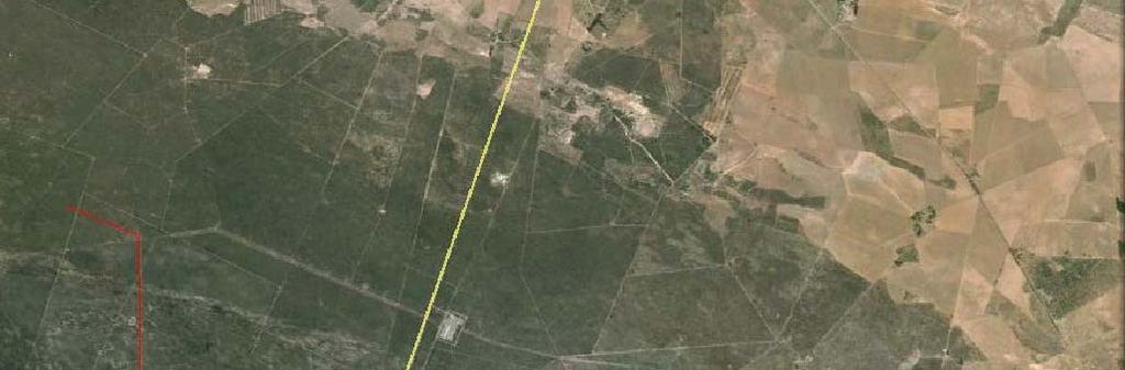
5 TRAFFIC IMPACT ASSESSMENT FOR PROPOSED ELANDSFONTEIN PHOSPHATE MINE NEAR HOPEFIELD, WESTERN CAPE 1 INTRODUCTION Royal HaskoningDHV (Pty) Ltd was appointed by Elandsfontein Exploration and Mining (Pty) Ltd (EMM) to prepare a Traffic Impact Assessment (TIA) for the proposed development of a new phosphate mine near Hopefield. The TIA will be integrated into the Environmental Management Programme Report (EMPR). The mine will be on the farm Elandsfontein 349, about 7 km south of Trunk Road TR21/2 (route R45), approximately 8 km to the west of Hopefield and 10 km to the east of Langebaan Airforce Base. The locality of the site is shown on a Google Maps image in Figure 1. The final concentrate of the mined phosphate will be loaded into containers and onto 22m long inter-link trucks and taken to Saldanha Bay harbour on public roads for export. This TIA addresses the road traffic implications associated with the construction and normal daily operation of the mine. 2 ROAD NETWORK DESCRIPTION TR21/2 runs in an east-west direction north of the mine site, linking National Route N7 in the east to the town of Vredenburg in the west. The Western Cape Department of Transport and Public Works (DTPW) which is planning road network improvements to support development in the Saldanha Municipal Area is proposing that TR21/2 and TR85/1 become a designated freight route which will run from Saldanha Bay to the N7 north of Malmesbury and eventually to the N1 near Paarl. As a first step towards implementing the freight route, DTPW plans to extend TR85/1 eastwards from TR77/1 to connect with TR21/2 south of the Langebaan Airforce Base, as shown by the dotted line in Figure 1. TR21/2 is a surfaced single carriageway road and is classified as a minor arterial road in terms of the DTPW s Road Network Information System (RNIS). In the vicinity of the proposed access to the mine, TR21/2 has a surfaced width of 12.2m, with two 3.7m traffic lanes and 2.4m surfaced shoulders on each side of the road. A speed limit of 100km/h is applicable on this section of TR21/2, which is a determinant for the shoulder sight distance required at the proposed mine access road intersection. This is discussed later in this report. The existing access road to the mine site is currently an informal sand track. Royal HaskoningDHV (Pty) Ltd has been appointed by Elandsfontein Exploration and Mining (Pty) Ltd to upgrade this road to accommodate the traffic for the construction and operation of the mine. Elandsfontein Phosphate Mine TIA Report_
6 3 TRAFFIC THAT WILL BE GENERATED BY THE MINE 3.1 Project timeline The EMM planning indicates that the mine will be constructed over a 12 month period, commencing as soon as the EMPR has been approved, probably towards the end of The project will result in traffic impacts that will arise from construction activities at the mine during 2015 and from operations activities for at least 10 years thereafter. 3.2 Construction Phase During the construction phase, traffic impacts will arise from the transportation of personnel, construction materials and equipment. The calculation of the expected traffic volumes from the anticipated construction activities is based on various assumptions and the information supplied by EMM, as discussed below. Construction personnel The following assumptions have been made with regard to construction personnel transport: The contractors will work between the hours of 07h00 and 17h00 Monday to Friday; It is anticipated that there will be 10 LDVs used by the managers and supervisors throughout the day and 10 minibuses and 2 buses transporting staff in the morning and evening; Approximately 15% of the workforce will be managers and supervisors and will travel to the site from the Saldanha direction on TR21/2; Approximately 85% of the workforce will be construction staff and will travel to the site from Hopefield in the morning on TR21/2 in contracted buses and minibuses. These vehicles will leave the site after dropping off workers in the morning and return in the evening to take the staff back to Hopefield. Construction materials and equipment It is assumed that material delivery to the mine site will take place Monday to Friday between 07h00 and 17h00. It is estimated that the bulk earthworks phase of the project will occur during the first 3 months of the project and that the approximate quantity of material that will be hauled during the terracing and road construction stage is 60,000m 3. This translates to 3 loaded inbound truck trips per hour for 10 hours per day for the first three months. For the remaining construction period, the frequency of trucks to the mine site will reduce to 6 inbound trucks per day. These vehicles will initially transport structural steel, platework and mechanical equipment. Thereafter, piping and electrical equipment will be delivered. Elandsfontein Phosphate Mine TIA Report_
7 The bulk earthworks stage of the project is not likely to overlap with later stages of the project and will not result in cumulative truck traffic to and from the mine site. The peak period in terms of traffic will be during the first 3 months of construction when there will be a cumulative traffic impact resulting from the bulk earthworks and daily personnel trips. It is estimated there will be a total of 128 daily vehicle trips to/from the site (entering and exiting) during the first 3 months of the construction phase, as shown in Table 3-1. Table 3-1: Daily vehicle trips during the mine peak construction phase (3 months) Trip purpose Vehicle Vehicles per day Peak period Type In Out Managers/ LDV* 06h30 07h30 10 Supervisors 16h30 17h30 10 Semi-skilled Mini-bus 06h30 07h staff 16h30 17h Labourers Bus 06h30 07h Construction phase Total trips 16h30 17h Material Trucks 07h00 17h00 30** 30** Total (per day) AM Peak hour PM Peak hour * LDV Light Delivery Vehicle ** This is based on 3 inbound loaded trips and 3 empty outbound trips per hour for 10 hours The peak traffic periods for the construction of the mine will be in the weekday morning (06h30-07h30) and weekday afternoon (16h30-17h30) and will coincide with the existing peak hour traffic on TR21/2 which was determined from traffic counts obtained from AECOM who has recently done a traffic study for DTPW for the planned link road between TR21/2 and TR85/1. As indicated in the table above, a total of 40 vehicle trips will be added to the road network in the morning and evening peak hours. In the AM peak hour there will be 25 inbound trips and 15 outbound trips. This will be repeated in the opposite direction of travel in the evening peak hour. 3.3 Operations Phase During the operations phase, starting after construction is completed at the end of 2015, traffic impacts will arise from the daily transportation of personnel between their places of residence and the site, the transport of the mined phosphate to Saldahna Bay harbour for export, and deliveries of consumables and maintenance parts to the mine. The calculation of the traffic expected to be generated daily by these operations is discussed below. The mine will operated continuously seven days a week, with 3 shifts per day. Elandsfontein Phosphate Mine TIA Report_
8 Operations personnel The following assumptions have been made based on information provided by EMM: There will be 36 cars/suvs arriving and departing from the mine each weekday morning and afternoon peak hour, used by management, skilled and administrative staff and it is assumed that they will travel from Saldanha/Langebaan/Vredenburg on TR21/2; Operations staff will be transported by 10 minibuses each day, and it is assumed that they will travel from the Hopefield area; The day shift will start at 07h00 and end at 15h00, the afternoon/evening shift will be from 15h00 to 23h00 and the night shift will be from 23h00 to 07h00; Minibuses will off-load staff to start a shift and will wait and load up with staff that are ending a shift before travelling back to Hopefield. Operations traffic It is estimated that there will be 4 bulk tankers delivering consumables to the mine each weekday and 4 trucks bringing in solid reagents, maintenance materials and parts each weekday. It is assumed that these tankers and trucks will travel to the site along TR21/2 from the east (N7) and return in that direction after delivering to the mine. It is estimated that management and skilled staff will generate 36 inbound car/suv vehicle trips inbound in the morning (06h30 07h30) and the same number of trips outbound in the afternoon (15h00 16h00) per weekday. Operations staff will be transported in and out at each shift change in 10 minibuses. The ship that exports the mined phosphate will dock at Saldanha Harbour for 4 days (every 18 days). During this 4 day period, a fleet of trucks will haul phosphate from the mine to the harbour at a rate of 8 trucks per hour, day and night. The trucks that will be used to haul the material from the mine to the ship are standard interlink truck-trailers which are 22,0 m in length and will have a loaded weight of 48 tonnes carried in two containers. The total daily and peak hour vehicles during the ship loading phase is shown in Elandsfontein Phosphate Mine TIA Report_
9 Table 3-2. Elandsfontein Phosphate Mine TIA Report_
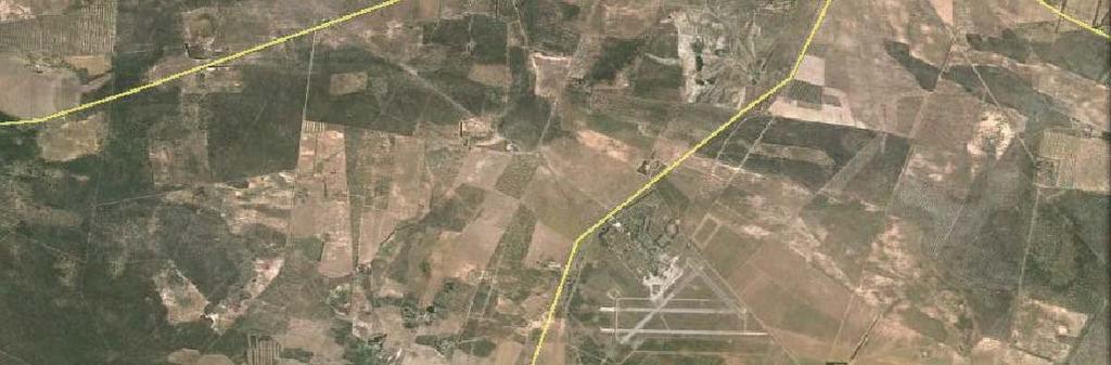
10 Table 3-2: Estimated daily and peak hour vehicle trips to/from the mine during the ship loading operations Trip purpose Vehicle Vehicles per day Total Duration Type In Out Managers/ Cars/SUVs 06h30 07h Administrative Staff 15h00 16h Day shift staff Minibuses 06h30 07h Operations Phase 15h00 16h Afternoon shift Minibuses 14h30 15h staff Night shift staff Minibuses 22h30 23h Consumables Tankers & 08h00 15h & maintenance trucks materials/parts Hauling mined Trucks 24 hours 192* 192* 384 material Total vehicle trips (per day) AM Peak Hour (06h30 07h30) PM Peak Hour (15h00 16h00) * This is based on 8 loaded trips and 8 return empty trips per hour for 95 hours continuously The peak traffic periods during the operation of the mine will be in the weekday morning (06h30-07h30) and weekday afternoon (15h00-16h00) when a total of 72 vehicles will be added to the roads in these hours, which are similar to the existing peak hour traffic periods observed from recent vehicle counts on the TR21/2 near Langebaan Airforce Base, namely 06h45 to 07h45 and 15h45 to 16h45. There are currently three alternative routes that could be used by trucks to transport the mined phosphate to Saldanha Bay harbour, until such time as the DTPW s planned link road between TR21/2 and TR85/1 is constructed, which will provide a more direct route than the existing three alternative routes which are shown in Figure 2. These alternative routes were each inspected to determine their suitability for use by 22m long interlink truck-trailers carrying a load of 48 tonnes. The travel distance along each route and the advantages and disadvantages of their use as a haul route, until such time as the new freight road link is constructed between TR21/2 and TR85/1, is summarised in Table 3-3. Our conclusion from the evaluation of these alternative routes is that Route B is the preferred route, but that it requires a left-turn deceleration lane on TR21/1 at the OP07643 intersection and the reduction of the speed limit on TR85/1 westbound from 120km/hr to 100km/hr from the rail bridge to the OP07643 intersection where the shoulder sight distance from OP07643 to the crest of the rail bridge is insufficient for trucks. Also, the haul road south from TR85/1 to OP07645 requires improvement to accommodate 22m interlink trucks. Elandsfontein Phosphate Mine TIA Report_
11 Table 3-3: Advantages and disadvantages of using the alternative routes to haul material from the mine to the harbour Route A Roads used TR21/2, MR233, MR559, OP07645 Total length (km) 37,0 Advantages Disadvantages Least existing traffic volume Road widening required at the TR21/MR233 intersection to enable of the 3 alternatives separate left-turn and right-turn deceleration lanes on the approaches to the intersection Longest route of the 3 alternatives Crossing of TR77/1 which is a tourist route Widening and surfacing required on the off-ramp from MR559 to OP07645 The section of road on the MR559 in the vicinity of the Curro School is considered to be a high accident zone. Route B Roads used TR21/2, OP07643, Haul Road, OP07645 Total length (km) 32,5 Advantages Disadvantages Shortest route length of the Highest existing traffic volume of the 3 alternatives 3 alternatives Road widening required at the TR21/OP07643 intersection to provide a left-turn deceleration lane on the approach on TR21/2 Required shoulder sight distance from OP07643 eastwards on TR85/1 to rail bridge is not achieved for 120km/hr speed limit. It is recommended that the speed limit on TR85/1 be reduced from rail bridge to OP07643 to 100km/hr to meet the minimum SSD. Haul road south of TR85/1 in the vicinity of the adjacent rail bridge is currently not suitable to accommodate the 22m interlink trucks. Route C Roads used TR21/2, MR233, TR77/1, TR85/1, Haul Road, OP07645 Total length (km) 34,0 Advantages Disadvantages Shorter than Route A TR77/1 is a popular tourist route and the trucks would be travelling on the section of the route between MR233 and TR85/1 for a distance of 5,6 km which has a speed limit of 120km/h. The slow moving heavy trucks would inconvenience tourist traffic and can be regarded as increasing the accident potential due to more overtaking attempts. The activities at the weigh bridge located on the southern side of the TR85/1 west of the TR77/1 intersection will increase the travel time of trucks that are required to stop here. Minimum shoulder sight distance on the haul road for returning trucks to turn onto TR85/1 in the easterly direction is not achieved for 120km/hr speed limit. It is recommended that the speed limit on TR85/1 in the westbound direction be reduced to 100km/hr from the rail bridge to the OP07643/Haul Road junction to meet the minimum SSD. The Haul Road south of TR85/1 in the vicinity of the rail bridge is currently not suitable to accommodate the 22m interlink trucks. Elandsfontein Phosphate Mine TIA Report_
12 4 FUTURE TRAFFIC Future traffic projections on TR21/2 and TR85/1 were obtained from AECOM who has undertaken the planning and traffic modelling on the roads in the Langebaan/Saldahna/Vredenburg area for the Western Cape Department of Transport and Public Works as part of the investigation for the proposed freight route linking TR21/2 and TR85/1. The peak hour traffic which is expected to be generated during the construction phase of the mine was added to the year 2015 traffic growth projection calculated from the traffic data obtained from AECOM. The results of adding the peak hour construction traffic to the 2015 other traffic on TR21/2 at the proposed mine access road intersection is shown in Figure 3. In order to assess the impact of the operation of the mine on the roads in the future, the 10 year traffic forecast from AECOM s traffic model was used. The impact of the additional peak hour traffic at the proposed mine access road intersection on TR21/2 during ship loading operations in the year 2024 is shown in Figure 4. 5 ACCESS PROPOSALS The mine site currently has no formal access road from TR21/2, only an informal farm track. A nine km long access road is proposed to connect the mine to TR21/2. The access road and intersection on TR21/2 needs to be designed for 30 heavy vehicles per direction per day turning in and out of the access for the first 3 months of the construction period and 10 heavy vehicles per direction per day during the remaining 9 months of construction. There will also be additional light vehicles turning in and out of the access during the morning and afternoon peak hours, as shown in Figure 3. During the mine operation period there will be 56 light vehicles using the access every morning and afternoon during the peak hour, plus 192 trucks per direction per day for 4 days every 3 weeks when a ship docks at Saldahna Bay to load the mined product. To ensure safe traffic operations at the proposed mine access road intersection, it is recommended that TR21/2 be widened to enable separate left-turn and right-turn deceleration lanes to be provided on the approaches to the intersection, in order to mitigate the safety implications of heavy vehicles slowing on TR21/2 to turn into the access. The proposed geometric layout for the mine access road intersection is shown in Figure 5. 6 SIGHT DISTANCE Investigations to measure the shoulder sight distance on TR21/2 were undertaken at the proposed location of the access road to the mine. The Guidelines for the Geometric Design of Rural Roads (TRH 17, 1988), recommends a minimum shoulder sight distance (SSD) of 420m for stop controlled accesses on rural arterial roads which have a 100km/h speed limit, as is the case for TR21/2. Elandsfontein Phosphate Mine TIA Report_


13 The sight distances observed in the westerly and easterly directions are currently limited to approximately 200m and 300m respectively, because of long grass and bushes growing along the verge between the road edge and the fence line. The horizontal and vertical alignment of TR21/2 in the vicinity if the proposed access is fairly straight and flat, and the required sight distances can be achieved if the long grass and bushes growing along the road verge are cleared. This was evident from the site investigation and can be seen in the photos below, which were taken from the position where a vehicle would be stopped on the proposed access road and looking in each direction to see if there are oncoming vehicles and whether it is safe to turn onto TR21/2. SSD at proposed access on TR21/2 in the easterly direction. SSD at proposed access on TR21/2 in the westerly direction. Elandsfontein Phosphate Mine TIA Report_
14 7 IMPACT IDENTIFICATION The following traffic impacts have been identified as a result of the construction and operations activities at the proposed Elandsfontein mine. An increase in traffic volumes along TR21/2 and TR85/1 which will affect road traffic capacity and intersection performance. An increase in the number of heavy vehicles which will affect the structural capacity of the road pavement. An increase in traffic volumes may lead to an increase in road accident rates and impact on road safety. 8 IMPACT ASSESSMENT 8.1 Impact on road sections It should be noted that the peak hour referred to under this section is the weekday AM peak hour unless otherwise stated. The road that will be most affected by the Elandsfontein mine development is TR21/2, on which traffic volumes are currently low. The impact of the traffic that will be generated by the Elandsfontein mine on the existing road capacity is assessed by determining how much of the capacity will be utilized when the development traffic is added to the road network. The utilization of capacity is referred to as the Volume to Capacity ratio or V/C. The Highway Capacity Manual (HCM, 2010) provides maximum lane capacity values which are usually adjusted and reduced to take into account various operating conditions on the roads. For rural roads such as TR21/2 and TR85/1 which have surfaced shoulders and operate in relatively flat terrain, the HCM indicates that a capacity of 1700 vehicles per lane per hour can be assumed. The V/C ratio is shown in Elandsfontein Phosphate Mine TIA Report_
15 Table 8-1 for both the construction and operations phases of the Elandsfontein mine. The V/C ratios include escalated background traffic (existing volume + 4% per annum growth) and mine generated traffic for the construction and operation phases, respectively. It should be noted that the V/C ratio is calculated for the direction of travel that will result in the highest volume of traffic as this represents a worst case scenario (i.e. higher volumes will use more of the road traffic capacity). For example, during the construction phase the volume of traffic on the TR21/2 in the vicinity of the development is 95 vehicles eastbound and 158 vehicles westbound. The highest volume of traffic on this road section is 158 vehicles which is the volume used to determine the V/C ratio in the Table 8-1. Elandsfontein Phosphate Mine TIA Report_
16 Table 8-1: V/C ratios during construction and operation phases of the mine Road Name Lanes (per direction) Existing Road Capacity (per direction)** V/C*** During 2015 (Construction) V/C*** During 2016 (Operation) TR21/ ,093 0,108 ** The capacity used is based on the existing road width as it is unlikely that road widening will be undertaken in the next few years as this will not be warranted until the traffic volumes exceeds vehicles per hour per direction. *** The traffic volumes used to determine the V/C ratios includes existing traffic escalated at a rate of 4% per annum and Elandsfontein mine generated traffic. Construction It is estimated that the Elandsfontein mine development will add 40 vehicle trips to the adjacent road network during the weekday AM peak hour as a result of construction activities, with 25 vehicle trips entering the site and 15 vehicles trips exiting the site. The V/C ratio on TR21/2 indicates that 9,3% of the available road traffic capacity will be utilized during the construction phase. This is referred to as Level of Service A in the HCM and is characterised by free-flowing road operations. The significance of this negative impact on the road capacity is regarded as low for the construction phase. Operation It is estimated that the Elandsfontein mine operation will add 72 vehicle trips to the adjacent road network during the weekday PM peak hour, with 54 vehicle trips entering the site and 18 vehicles trips exiting the site. The V/C ratio on the TR21/2 indicates that 10,8% of the available road capacity will be utilised during the operations phase, which is within Level of Service A. The significance of this negative impact on the road capacity is regarded as low for the operations phase. 8.2 Impact on intersections Apart from a single road section, the intersection of two or more roads can also experience capacity problems. The TR21/2 and MR233 intersection, which currently operates as a stopcontrolled intersection with priority for traffic on TR21/2, is located approximately 12,5 km to the west of the proposed access to the mine, as shown in Figure 2. This intersection will be affected by the traffic resulting from the construction and operation of the mine. Elandsfontein Phosphate Mine TIA Report_
17 The peak hour traffic that will be generated during the construction and operation of the mine has been added to the current traffic volumes at this intersection in order to assess how the performance of this intersection is affected. Intersection Level of Service (LOS) and average vehicle delay (seconds) are the criteria used to assess intersection performance. Intersection performance is affected by the type of control used (stop, signal or circle), the volume of vehicles passing through the intersection and the turning movements. The traffic forecasting stages are shown on separate volume diagrams as listed in Table 8-2 below. These Figures are contained at the end of this report. Table 8-2: Traffic volume diagrams FIGURE No. DESCRIPTION 5 Existing Traffic (2015) 6 7 Combined Future Traffic 2024 during construction (Existing + 4% p.a. +development) Combined Future Traffic 2024 during operation (Existing + 4% p.a. +development) An operational analysis was undertaken with the SIDRA computer software package for the existing (2015) and future (2024) weekday morning and afternoon peak hour periods during the construction and operation of the mine in order to determine changes to the LOS and average vehicle delay, if any, at the intersections. The generated trips to and from the mine have been distributed at the intersection as follows: it is assumed that approximately 50% of the generated trips will travel from / to the east along TR21/2 and 50% of the generated trips will travel from / to the south along MR233. The detailed output from the SIDRA analysis is contained in Annexure A to this TIA. A summary of the Level of Service (LOS) and average vehicle delay is shown in Table 8-3 below. Table 8-3: Weekday AM and PM peak hour intersection levels of service (LOS) and average vehicle delay TR21/2 and MR233 (Stop-controlled intersection) Weekday AM Peak Weekday PM Peak LOS Delay (sec) LOS Delay (sec) Existing (2015) A 3.6 A 3.8 Future Combined Traffic(2024) (With Development) during construction Future Combined Traffic(2024) (With Development) during operations A 3.6 A 3.8 A 3.9 A 4.0 Elandsfontein Phosphate Mine TIA Report_
18 Construction There will be an increase in peak hour traffic through the intersection from 355 vph before construction to 365 vph in 2015 during the construction period in the AM peak hour and from 352 vph to 362 vph during the PM peak hour. This is a 2.8% increase in both the AM and PM peak hour traffic volume. The impact of the construction traffic on the LOS and average vehicle delay of this intersection is considered to be small. The significance of this negative impact on the intersection LOS and average vehicle delay is regarded as low for the construction phase. Operation During the AM peak hour in the operations phase, approximately 44 vehicles will travel to the mine and 8 vehicles will travel from the mine via TR21/2 and MR233, and vice versa during the PM peak hour. There will be an increase in peak hour traffic through the intersection from 355 vph in 2015 before construction to 550 vph in 2024 during the operations period in the AM peak hour and from 352 vph to 544 vph during the PM peak hour. This is a 54% increase in both the AM and PM peak hour traffic volume. The increase will however result in a minimal increase in average delay to vehicles because of the low traffic volumes currently passing through this intersection. The significance of this negative impact on the intersection LOS and average vehicle delay is regarded as low for the operations phase. 8.3 Impact on road infrastructure due to heavy vehicles Compared to heavy vehicle traffic, light vehicles have a negligible impact on the structural capacity of a road pavement; thus only heavy vehicles have been considered in this part of the impact assessment. In order to assess the impact of heavy vehicles on the road pavement, the current truck traffic on the TR21/2 in the vicinity of the site has first been established to determine the cumulative daily truck volumes on the TR21/2 without the mine development traffic and compare it with the volume of trucks that will result from activities during the construction and operation of the mine. Traffic data for the year 2013 has been obtained from the Provincial Government of the Western Cape for counting station number located at km on the TR21/2, in the vicinity of the Langebaan Road intersection, which indicates the following statistics: Average Daily Traffic (ADT) = 2935 vehicles (both directions), Average Daily Truck Traffic (ADTT) = 232 (both directions), 50:50 directional split on the TR21/2 for ADT and ADTT. Elandsfontein Phosphate Mine TIA Report_
19 It is assumed that the traffic on the TR21/2 will increase at a rate of 4% per annum which is the average growth rate observed on TR21/2 for the past 10 years. This growth rate has been applied to the current ADTT on the TR21/2 in order to determine the cumulative truck traffic over a 20 year period without the proposed mine. A period of 20 years is the normal expected structural life of a tarred road like the TR21/2. Construction Activities associated with the mine construction phase will result in 60 truck trips per weekday for the first three months of construction and 12 truck trips per weekday for the remaining nine months of the construction period. The cumulative volume of trucks that can be expected on the TR21/2 in one year without the Elandsfontein mine development and the total volume of trucks that will be generated by the mine development during the construction phase are shown in the table below. Table 8-4: Truck traffic on the TR21/2 during the construction phase of the mine Without Elandsfontein mine development (per direction) Scenario Cumulative Trucks Trucks per annum per day (365 days) Elandsfontein development (per direction) Trucks per annum (247 work days) Existing + 4% p.a Phase 1 construction (3 months) Phase 2 construction (9 months) The construction phase of 12 months is relatively short when compared to the structural lifetime of a pavement which is usually about 20 years. The construction phase will result in a 7,5% increase in cumulative heavy traffic on the TR21/2 during The significance of this negative impact on the road infrastructure is regarded as low for the construction phase. Operations Heavy vehicle traffic associated with the mine operations activities will result from the delivery of solid reagents, maintenance and parts to the site that will travel from the N7 in the east and the delivery of the mined phosphate to the port in Saldanha in the west. The TR21/2 in the westerly direction between the mine and the harbour will be worst affected when the phosphate transport results in an additional 192 trucks daily for four consecutive days every 18 days. This is a total of loaded truck trips per annum to the harbour. Elandsfontein Phosphate Mine TIA Report_
20 The cumulative volume of trucks that can be expected on the TR21/2 (westbound carriageway) without the Elandsfontein mine and the total volume of trucks that will be generated by the mining operations travelling to the harbour over a 20 year period are shown in Table 8-5. Table 8-5: Cumulative truck traffic on the TR21/2 during the operation of the mine Scenario Existing + 4% p.a. Without Elandsfontein development (per direction) Trucks per day Cumulative Trucks over 20 years Elandsfontein development* (per direction) Cumulative trucks over 20 yrs Operations (4 days every 18 days) The truck trips from the mine to the harbour carrying phosphate amounts to trips over a period of 20 years, which will increase the cumulative truck traffic on the road by 22,7%. The significance of this negative impact on the road infrastructure is regarded as medium for the operations phase. 8.4 Impact on traffic safety The anticipated construction and operations activities for the proposed Elandsfontein development will result in an increase in traffic on the road network leading to a potential increase in the number of road accidents. Information regarding road accident rates has been obtained from the Arrive Alive website, which indicates that for the year 2002 there were 8,71 fatal road accidents per 100 million vehicle kilometers travelled in South Africa. Although the information is outdated (more recent information is not available) it can give an indication of the number of fatal road accidents that can be anticipated due to the construction and operations activities of the development. The potential increase in the number of road accidents has been quantified based on the additional vehicles kilometers that will be travelled on the road network by traffic associated with the proposed development. It must be noted that many factors increase the risk of road traffic accidents for example trucks not being maintained or not in a roadworthy condition and dangerous driving habits. Construction The vehicle kilometers travelled (travel distances) during the construction phase is made up by the transportation of the earthworks during the first three months of construction and steel, plated and mechanical equipment during the remaining construction period (Saldanha and Langebaan area); as well as the transportation of the personnel (Hopefield and Saldanha Elandsfontein Phosphate Mine TIA Report_
21 area). At this point in time the location of the borrow pit site has not been confirmed. The calculations below have therefore been based on the distance to the largest commercial quarry in the area which is Lafarge located 35 km from the proposed access the mine site. Assuming average travel distances for each trip type it is estimated that the construction activities, which will occur over a 12 month period, will result in approximately 224,270 additional vehicle kilometers travelled on the road network during the first three months of construction and 360,724 during the remaining nine months of the construction period. Based on the statistic of 8,71 fatal accidents per 100 million kilometers travelled, there is a potential for the transport related construction activities to result in 0,05 road accident fatalities during the 12 month construction period. The significance of this negative impact on road safety is regarded as low for the construction phase. Operations The vehicle kilometers travelled during the operations phase is made up by the transportation of the phosphate (between the site and Saldanha Port), consumables and maintenance materials and/or parts (from direction of the N7); as well as the transportation of the operations personnel (Hopefield and Saldanha area). Assuming average travel distances for each trip type it is estimated that the operations activities will result in approximately 1,966,120 additional vehicle kilometers travelled on the road network per annum. Based on the statistic of 8.71 fatal accidents per 100 million kilometers travelled, there is a potential for the transport related operations activities to result in 0.2 road accident fatalities per annum. The significance of this negative impact on road safety is regarded as low for the operations phase. 9 IMPACT ASSESSMENT RATING The identified impacts have been assessed according to the categories as explained in Table 9-1. The identified impacts have been summarised and rated without the implementation of mitigation measures in Table 9-2. Elandsfontein Phosphate Mine TIA Report_
22 Table 9-1: Description of impact assessment rating methodology Category Description Assessment Rating Scale Status The impact is either categorised as having a benefit, cost or neutral affect. Positive (benefit) Neutral Negative (cost) Extent The extent of the area which will be impacted. Local (within 30km) Regional (Western Cape) National (South Africa) Duration Lifetime of impact, i.e. how long the impact will last should it occur. Short term ( 1-5 years) Medium (5-10 years) Long term (> 10 years but impacts cease if facility stops operating). Intensity This indicates the magnitude of the impact in relation to the sensitivity of the receiving environment, i.e. the degree to which the environment will be altered. Low Moderate Severe Probability The probability indicates the likelihood that an event will result in the identified impact occurring. Improbable Possible <40% chance of occurring 40% 70% chance of occurring Probable >70% 90% chance of occurring Definite >90% chance of occurring Significance Overall indication of the affect of the potential impact. Low, impact will not have an influence on the decision or require significant modification to be accommodated. Medium, impact will influence the environment which can function in modified manner. High, significant impact on the environment requiring significant modification. Severe, no-go implication for the development regardless of mitigation. Elandsfontein Phosphate Mine TIA Report_
23 Table 9-2: Summary of impact assessment without mitigation measures No. Description of Impact Status Extent Duration Intensity Probability Reduction in road based Level of Service due to increased traffic volumes associated with the transportation of personnel and construction materials to the site. Reduction in road based Level of Service due to increased traffic volumes associated with the transportation of personnel to the site during the operations phases. Reduction in road based Level of Service due to increased traffic volumes associated with the transportation of material for production and distribution of product during the operations phase. Accelerated degradation of road pavement structure due to the increase in heavy vehicle traffic during the construction phase. Accelerated degradation of road pavement structure due to the increase in heavy vehicle traffic during the operations phase. Potential for an increase in number of road accidents as a result of increased traffic volumes and km travelled on road network during the construction phase. Potential for an increase in number of road accidents as a result of increased traffic volumes and km travelled on road network during the operation phase. Significance (without mitigation) Negative Local Short Term Low Probable Low Negative Local Long Term Low Probable Low Negative Local Long Term Low Probable Low Negative Local Short Term Low Probable Low Negative Local Long Term Moderate Probable Medium Negative Local Short Term Low Possible Low Negative Local Long Term Low Possible Low 10 MITIGATION MEASURES 10.1 Recommended Mitigation Measures The following mitigation measures have been identified in order to minimize the impacts that will arise from the construction and operation activities of the Elandsfontein development. Elandsfontein Phosphate Mine TIA Report_
24 Traffic conditions (road capacity and intersections) In order to minimize the impact of the additional traffic that will be added to the road network due to the construction and operations activities of the proposed Elandsfontein development, the following mitigation measures are recommended. Construction materials During the construction phase deliveries of material by truck to the site could be scheduled to avoid peak hour traffic. The weekday AM (06h30 07h30) and PM (16h30 17h30) peak hours will be the two busiest periods on the road with the highest traffic volumes. Heavy vehicle arrivals and departures will have less of an impact if occurring outside of the aforementioned time periods. Operations materials During the operations phase material deliveries to the site (solid reagents, maintenance and parts) and phosphate transport to Saldanha could also be scheduled to avoid peak hour traffic, as discussed under construction materials above Road infrastructure (heavy vehicle impact) The construction phase will result in minimal impact due to the low volumes of heavy vehicle traffic especially considering that the 12 months construction phase is relatively short when compared to the structural lifetime of a road pavement. The operations phase will result in moderate heavy vehicle traffic volumes. In order to mitigate the effect of heavy vehicles on the roads within the study area it is essential that roads are properly and regularly maintained (by the relevant authorities) and that heavy vehicle overloading is curbed by traffic enforcement officials. Traffic enforcement officials should monitor overloading of heavy vehicles to limit the impact on the structural integrity of the roads surrounding the site. The existing weighbridge that is located on TR85/1 can be used to inspect vehicles for overloading Traffic Safety The anticipated construction and operations activities for the proposed Elandsfontein development will result in an increase in traffic on the road network and vehicle kilometres travelled, which means that there is a potential for an increase in the number of road accidents. It is important to note that various factors influence the risk of road accidents for example vehicles (especially trucks) not being maintained to a roadworthy condition and dangerous driving habits. To limit the potential for accidents competent trained drivers must operate well maintained vehicles. Visible law enforcement should be present with traffic officers regularly conducting random inspections of vehicles for roadworthy conditions and drivers for the correct driving licenses and permits. Elandsfontein Phosphate Mine TIA Report_
25 10.2 Impact assessment after implementation of mitigation measures The significance of the majority of the impacts that will occur during the construction and operation phases of the development is regarded as low without mitigation. The majority of impacts will remain low even with the implementation of the recommended mitigation measures. This can be explained due to the significance of most of the impacts being rated as low, i.e. with the mitigation in place the impact is reduced and not removed. 11 CONCLUSIONS AND RECOMMENDATIONS The conclusions and recommendations of this study of the likely traffic impacts of the construction and operation of the Elandsfontein mine are summarised as follows: 1. The traffic volumes that will be generated during the construction and operation of the mine indicates that widening of TR21/2 at the location of the proposed site access road intersection is required to mitigate the potential for rear-end collisions between traffic travelling at 100km/hour and vehicles that are decelerating on TR21/2 to turn into the mine access road. The proposed geometric layout for this intersection is shown in Figure When the proposed mine road access intersection on TR21/2 is constructed, the bushes and long grass between the TR21/2 road edge and the fence line must be removed in order to achieve the required shoulder sight distance in both directions from the access road stop line. 3. Traffic signs must be erected on TR21/1 on both approaches to the intersection to indicate the presence of a new road junction and to inform drivers that there will be trucks turning frequently at the intersection. The sizes and distances for installation of the required signs are specified in the SADC Road Traffic Signs Manual. 4. It is recommended that the Elandsfontein Exploration and Mining (Pty) enter into consultation with the Provincial Department of Transport and Public Works to discuss the use of the preferred route shown on Figure 2 (via TR21/2, OP07643, crossing TR85/1 at grade to a haul road leading to OP07645 into Saldahna Bay Harbour) for transporting mined phosphate from the mine to the harbour. This route will require a left turn deceleration lane on TR21/1 at the OP07645 intersection and the reduction of the speed limit on TR85/1 westbound between the rail bridge and the OP07643 intersection. 5. It is also recommended that the Elandsfontein Exploration and Mining (Pty) enter into consultation with Saldanha Steel, Namaqua Sands and Saldanha Harbour, who jointly maintains the haul road south from TR85/1 to the harbour, to discuss proposed usage of the haul road. 6. The significance of the majority of the impacts for both the construction and operation activities of the facility is regarded as low without mitigation. 7. Mitigation measures have been recommended to minimize impacts where possible. In order for the mitigation measures to be implemented effectively they must be monitored on an on-going basis. 8. The majority of impacts will remain low with the implementation of the recommended mitigation measures. Elandsfontein Phosphate Mine TIA Report_
26 Elandsfontein Phosphate Mine TIA Report_


27


28 TR77/1 ROUTE A TR21/2 Figure 2: Alternate Route Selection PROPOSED SITE FOR PHOSPHATE MINE PROPOSED ACCESS TO MINE SITE TR21/2 MR233 TR21/2 TR77/1 ROUTE C ROUTE B LEGEND ROUTE A ROUTE B ROUTE C COMMON ROUTE MR233 TR85/1 MR559 OP07643 HAUL ROAD OP07645
29 CONSTRUCTION PHASE Figure 3: AM and PM traffic volumes (2015) during construction phase at the proposed intersection
30 OPERATIONS PHASE Figure 4: AM and PM traffic volumes (2024) during operations phase at the proposed intersection
31 Figure 5: Elandsfontein Mine Access Road
32 Figure 6: AM and PM traffic volumes (2015) at the TR21/2 & MR233 intersection
33 CONSTRUCTION PHASE Figure 7: AM and PM traffic volumes (2015) during construction phase at the TR21/2 & MR233 intersection
TRAFFIC IMPACT ASSESSMENT PART OF AN ENVIRONMENTAL IMPACT ASSESSMENT FOR THE KEBRAFIELD ROODEPOORT COLLIERY IN THE PULLEN S HOPE AREA
 TRAFFIC IMPACT ASSESSMENT PART OF AN ENVIRONMENTAL IMPACT ASSESSMENT FOR THE KEBRAFIELD ROODEPOORT COLLIERY IN THE PULLEN S HOPE AREA 20 March 2014 Report prepared by: Corli Havenga Transportation Engineers
In response to the TIA the Director General of the Department of Planning and Infrastructure issued the following comment:
 06 July 2012 P0961 Natural Gas Storage Facility Letter Ver2.doc CB&I Level 13, 197 St Georges Terrace Perth, Western Australia, 6000 Attention: Jim Rutherford Dear Jim, Re: Natural Gas Storage Facility
Date: February 7, 2017 John Doyle, Z-Best Products Robert Del Rio. T.E. Z-Best Traffic Operations and Site Access Analysis
 Memorandum Date: February 7, 07 To: From: Subject: John Doyle, Z-Best Products Robert Del Rio. T.E. Z-Best Traffic Operations and Site Access Analysis Introduction Hexagon Transportation Consultants, Inc.
RE: A Traffic Impact Statement for a proposed development on Quinpool Road
 James J. Copeland, P.Eng. GRIFFIN transportation group inc. 30 Bonny View Drive Fall River, NS B2T 1R2 May 31, 2018 Ellen O Hara, P.Eng. Project Engineer DesignPoint Engineering & Surveying Ltd. 200 Waterfront
Clean Harbors Canada, Inc.
 Clean Harbors Canada, Inc. Proposed Lambton Landfill Expansion Environmental Assessment Terms of Reference Transportation Assessment St. Clair Township, Ontario September 2009 itrans Consulting Inc. 260
Appendix J Traffic Impact Study
 MRI May 2012 Appendix J Traffic Impact Study Level 2 Traffic Assessment Limited Impact Review Appendix J [This page was left blank intentionally.] www.sgm-inc.com Figure 1. Site Driveway and Trail Crossing
PROPOSED RESIDENTIAL & COMMERCIAL DEVELOPMENT (ERF 1692), FRANSCHHOEK. Traffic Impact Assessment
, FRANSCHHOEK. Traffic Impact Assessment") PROPOSED RESIDENTIAL & COMMERCIAL DEVELOPMENT (ERF 1692), FRANSCHHOEK Traffic Impact Assessment LOCATED ERF 1692 IN FRANSCHHOEK, WESTERN CAPE Project No. : STUR0202 NOVEMBER 2017 PREPARED BY: STURGEON
PROPOSED RESIDENTIAL & COMMERCIAL DEVELOPMENT (ERF 1692), FRANSCHHOEK Traffic Impact Assessment LOCATED ERF 1692 IN FRANSCHHOEK, WESTERN CAPE Project No. : STUR0202 NOVEMBER 2017 PREPARED BY: STURGEON
APPENDIX C1 TRAFFIC ANALYSIS DESIGN YEAR TRAFFIC ANALYSIS
 APPENDIX C1 TRAFFIC ANALYSIS DESIGN YEAR TRAFFIC ANALYSIS DESIGN YEAR TRAFFIC ANALYSIS February 2018 Highway & Bridge Project PIN 6754.12 Route 13 Connector Road Chemung County February 2018 Appendix
Proposed location of Camp Parkway Commerce Center. Vicinity map of Camp Parkway Commerce Center Southampton County, VA
 Proposed location of Camp Parkway Commerce Center Vicinity map of Camp Parkway Commerce Center Southampton County, VA Camp Parkway Commerce Center is a proposed distribution and industrial center to be
Appendix H TRAFFIC IMPACT ANALYSIS
 Appendix H TRAFFIC IMPACT ANALYSIS Teichert Boca Quarry Expansion Traffic Impact Analysis Prepared for Teichert Aggregates Prepared by TRANSPORTATION CONSULTANTS, INC. LSC Transportation Consultants, Inc.
ENVIRONMENTAL IMPACT STATEMENT
 RED HILL MINING LEASE ENVIRONMENTAL IMPACT STATEMENT Section 14 Transport Section 14 Transport 14.1 Description of Environmental Values This section of the Red Hill Mining Lease Environmental Impact Statement
Section 5.0 Traffic Information
 Section 5.0 Traffic Information 10.0 TRANSPORTATION MDM Transportation Consultants, Inc. (MDM) has prepared an evaluation of transportation impacts for the proposed evaluation for the expansion of the
TRAFFIC IMPACT ANALYSIS
 TRAFFIC IMPACT ANALYSIS Emerald Isle Commercial Development Prepared by SEPI Engineering & Construction Prepared for Ark Consulting Group, PLLC March 2016 I. Executive Summary A. Site Location The Emerald
INDUSTRIAL DEVELOPMENT
 INDUSTRIAL DEVELOPMENT Traffic Impact Study Plainfield, Illinois August 2018 Prepared for: Seefried Industrial Properties, Inc. TABLE OF CONTENTS Executive Summary 2 Introduction 3 Existing Conditions
TRAFFIC IMPACT ASSESSMENT
 TRAFFIC IMPACT ASSESSMENT Prepared by: N MIYA Reviewed by: BN Roberts Pr Eng / AM Phetla PD Naidoo and Associates Consulting Engineers (Pty) Ltd PO Box 7707, Johannesburg 2000 Prepared for: ENVIROLUTION
TRAFFIC IMPACT STUDY VICDOM BROCK ROAD PIT EXPANSION
 TRAFFIC IMPACT STUDY VICDOM BROCK ROAD PIT EXPANSION TOWNSHIP OF UXBRIDGE P/N 05-1993 June 2011 Revised -August 2011 Prepared by: Skelton, Brumwell & Associates Inc. 93 Bell Farm Road, Suite 107 Barrie,
TRAFFIC ENGINEERING SERVICES TRAFFIC IMPACT STATEMENT NATREF CLEAN FUELS II, SASOLBURG, FREE STATE. October 2013 Revised: 2.0
 TRAFFIC ENGINEERING SERVICES TRAFFIC IMPACT STATEMENT NATREF CLEAN FUELS II, SASOLBURG, FREE STATE October 2013 Revised: 2.0 Quality Management Issue/revision Issue 1 Issue 2 Remarks Draft Final Date 30
LAWRENCE TRANSIT CENTER LOCATION ANALYSIS 9 TH STREET & ROCKLEDGE ROAD / 21 ST STREET & IOWA STREET LAWRENCE, KANSAS
 LAWRENCE TRANSIT CENTER LOCATION ANALYSIS 9 TH STREET & ROCKLEDGE ROAD / 21 ST STREET & IOWA STREET LAWRENCE, KANSAS TRAFFIC IMPACT STUDY FEBRUARY 214 OA Project No. 213-542 TABLE OF CONTENTS 1. INTRODUCTION...
The major roadways in the study area are State Route 166 and State Route 33, which are shown on Figure 1-1 and described below:
 3.5 TRAFFIC AND CIRCULATION 3.5.1 Existing Conditions 3.5.1.1 Street Network DRAFT ENVIRONMENTAL IMPACT REPORT The major roadways in the study area are State Route 166 and State Route 33, which are shown
EXECUTIVE SUMMARY. The following is an outline of the traffic analysis performed by Hales Engineering for the traffic conditions of this project.
 EXECUTIVE SUMMARY This study addresses the traffic impacts associated with the proposed Shopko redevelopment located in Sugarhouse, Utah. The Shopko redevelopment project is located between 1300 East and
MERIVALE PRIORITY SQUARE 2852 MERIVALE ROAD CITY OF OTTAWA TRANSPORTATION BRIEF. Prepared for: ONT Inc. 25 Winding Way Nepean, Ontario K2C 3H1
 MERIVALE PRIORITY SQUARE 2852 MERIVALE ROAD CITY OF OTTAWA TRANSPORTATION BRIEF Prepared for: 2190986ONT Inc. 25 Winding Way Nepean, Ontario K2C 3H1 October 6, 2010 110-502 Report_1.doc D. J. Halpenny
Bennett Pit. Traffic Impact Study. J&T Consulting, Inc. Weld County, Colorado. March 3, 2017
 Bennett Pit Traffic Impact Study J&T Consulting, Inc. Weld County, Colorado March 3, 217 Prepared By: Sustainable Traffic Solutions, Inc. http://www.sustainabletrafficsolutions.com/ Joseph L. Henderson,
Re: Addendum No. 4 Transportation Overview 146 Mountshannon Drive Ottawa, Ontario
 April 18 th, 2017 Mr. Kevin Yemm Vice President, Land Development Richraft Group of Companies 2280 St. Laurent Boulevard, Suite 201 Ottawa, Ontario (Tel: 613.739.7111 / e-mail: keviny@richcraft.com) Re:
830 Main Street Halifax Regional Municipality
 830 Main Street Halifax Regional Municipality Traffic Impact Statement Final Report Prepared by: GRIFFIN transportation group inc. 30 Bonny View Drive Fall River, NS B2T 1R2 www.griffininc.ca Prepared
King County Metro. Columbia Street Transit Priority Improvements Alternative Analysis. Downtown Southend Transit Study. May 2014.
 King County Metro Columbia Street Transit Priority Improvements Alternative Analysis Downtown Southend Transit Study May 2014 Parametrix Table of Contents Introduction... 1 Methodology... 1 Study Area...
Introduction and Background Study Purpose
 Introduction and Background The Brent Spence Bridge on I-71/75 across the Ohio River is arguably the single most important piece of transportation infrastructure the Ohio-Kentucky-Indiana (OKI) region.
The following section summarises the present conditions related to transportation for the proposed development of the Matimba B Power Station:
 14. TRAFFIC AND TRANSPORT 14.1. Status Quo Conditions The following section summarises the present conditions related to transportation for the proposed development of the Matimba B Power Station: 14.1.1.
Tongaat Hullette Developments - Cornubia Phase 2. Technical Note 02 - N2/M41 AIMSUN Micro-simulation Analysis
 Technical Note 02 - N2/M41 AIMSUN Micro-simulation Tongaat Hullette Developments Cornubia Phase 2 Technical Note 02 - N2/M41 AIMSUN Micro-simulation Analysis Prepared by: 18/11/14 Justin Janki Date Approvals
APPENDIX B Traffic Analysis
 APPENDIX B Traffic Analysis Rim of the World Unified School District Reconfiguration Prepared for: Rim of the World School District 27315 North Bay Road, Blue Jay, CA 92317 Prepared by: 400 Oceangate,
BARRHAVEN FELLOWSHIP CRC 3058 JOCKVALE ROAD OTTAWA, ONTARIO TRANSPORTATION BRIEF. Prepared for:
 BARRHAVEN FELLOWSHIP CRC 3058 JOCKVALE ROAD OTTAWA, ONTARIO TRANSPORTATION BRIEF Prepared for: Barrhaven Fellowship CRC 3058 Jockvale Road Ottawa, ON K2J 2W7 December 7, 2016 116-649 Report_1.doc D. J.
BORAL CONCRETE GLENORIE
 BORAL CONCRETE GLENORIE > Glenorie Progress Association meeting 14 March 2018 Glenorie RSL Club Glenorie A recap of our last discussion (Oct 2017)... Who are we? Boral Concrete (NSW/ACT) is part of the
LCPS Valley Service Center
 Traffic Impact Study LCPS Valley Service Center Loudoun County, Virginia November 4, 2015 Prepared For: Loudoun County Public Schools 21000 Education Court Ashburn, VA 20148 Prepared by: 1140 Connecticut
RICHMOND OAKS HEALTH CENTRE 6265 PERTH STREET OTTAWA, ONTARIO TRANSPORTATION BRIEF. Prepared for: Guycoki (Eastern) Limited.
 Limited.") RICHMOND OAKS HEALTH CENTRE 6265 PERTH STREET OTTAWA, ONTARIO TRANSPORTATION BRIEF Prepared for: Guycoki (Eastern) Limited June 16, 2016 116-638 Brief_1.doc D. J. Halpenny & Associates Ltd. Consulting
RICHMOND OAKS HEALTH CENTRE 6265 PERTH STREET OTTAWA, ONTARIO TRANSPORTATION BRIEF Prepared for: Guycoki (Eastern) Limited June 16, 2016 116-638 Brief_1.doc D. J. Halpenny & Associates Ltd. Consulting
Proposed Pit Development
 July 5, 2017 via email: sam@greenwoodconst.ca CCTA File 114239 Sam Greenwood Greenwood Aggregates 205467 County Road 109 Amaranth, ON L9W 0V1 Re: Proposed Violet Hill Gravel Pit, Town of Mono Traffic Review
DRIVER SPEED COMPLIANCE WITHIN SCHOOL ZONES AND EFFECTS OF 40 PAINTED SPEED LIMIT ON DRIVER SPEED BEHAVIOURS Tony Radalj Main Roads Western Australia
 DRIVER SPEED COMPLIANCE WITHIN SCHOOL ZONES AND EFFECTS OF 4 PAINTED SPEED LIMIT ON DRIVER SPEED BEHAVIOURS Tony Radalj Main Roads Western Australia ABSTRACT Two speed surveys were conducted on nineteen
Traffic Impact Study Speedway Gas Station Redevelopment
 Traffic Impact Study Speedway Gas Station Redevelopment Warrenville, Illinois Prepared For: Prepared By: April 11, 2018 Table of Contents 1. Introduction... 1 2. Existing Conditions... 4 Site Location...
TRAFFIC IMPACT STUDY. USD #497 Warehouse and Bus Site
 TRAFFIC IMPACT STUDY for USD #497 Warehouse and Bus Site Prepared by: Jason Hoskinson, PE, PTOE BG Project No. 16-12L July 8, 216 145 Wakarusa Drive Lawrence, Kansas 6649 T: 785.749.4474 F: 785.749.734
Craigieburn Employment Precinct North and English Street
 Craigieburn Employment Precinct North and English Street METROPOLITAN PLANNING AUTHORITY Intersection Analyses 7 February 2014 Intersection Analyses Craigieburn Employment Precinct North and English Street
Alberta Infrastructure HIGHWAY GEOMETRIC DESIGN GUIDE AUGUST 1999
 &+$37(5Ã)Ã Alberta Infrastructure HIGHWAY GEOMETRIC DESIGN GUIDE AUGUST 1999 &+$37(5) 52$'6,'()$&,/,7,(6 7$%/(2)&217(176 Section Subject Page Number Page Date F.1 VEHICLE INSPECTION STATIONS... F-3 April
12 April Leakes Pty Ltd 211 Waverley Road EAST MALVERN VIC Attention: Joseph Nasr. Dear Joe,
 Our Ref: Contact: CG120569:VG Valentine Gnanakone Leakes Pty Ltd 211 Waverley Road EAST MALVERN VIC 3145 Attention: Joseph Nasr Dear Joe, 690 DERRIMUT ROAD PROPOSED RESIDENTIAL SUBDIVISION Further to our
TRAFFIC PARKING ANALYSIS
 TRAFFIC PARKING ANALYSIS NAPA FLEA MARKET COUNTY OF NAPA Prepared for: Tom Harding Napa-Vallejo Flea Market 33 Kelly Road American Canyon, CA 9453 Prepared by: 166 Olympic Boulevard, Suite 21 Walnut Creek,
Designation of a Community Safety Zone in Honey Harbour in the Township of Georgian Bay
 TO: FROM: Chair and Members Engineering and Public Works Committee Mark Misko, C.E.T. Manager, Roads Maintenance and Construction DATE: March 23, 2016 SUBJECT: REPORT NO: Designation of a Community Safety
Downtown One Way Street Conversion Technical Feasibility Report
 Downtown One Way Street Conversion Technical Feasibility Report As part of the City s Transportation Master Plan, this report reviews the technical feasibility of the proposed conversion of the current
Appendix 15. Transport. South East Open Cut Project & Modification to the Existing ACP Consent
 Appendix 15 Transport South East Open Cut Project & Modification to the Existing ACP Consent Ashton Coal Mine South East Open Cut Final TRAFFIC IMPACT ASSESSMENT June 2009 Ashton Coal Mine South East
DEVELOPMENT PROPERTY 1627 MAXIME STREET CITY OF OTTAWA TRANSPORTATION OVERVIEW. Prepared for: Subhas Bhargava. July 9, Overview_1.
 DEVELOPMENT PROPERTY 1627 MAXIME STREET CITY OF OTTAWA TRANSPORTATION OVERVIEW Prepared for: Subhas Bhargava July 9, 2015 115-620 Overview_1.doc D. J. Halpenny & Associates Ltd. Consulting Transportation
Prepared For: Toronto Transit Commission 1138 Bathurst Street Toronto, Ontario M5R 3H2. Prepared By:
 TRAFFIC IMPACT STUDY FOR THE TTC MCNICOLL BUS GARAGE CITY OF TORONTO Prepared For: Toronto Transit Commission 1138 Bathurst Street Toronto, Ontario M5R 3H2 Prepared By: Canada Inc. 4th Floor, 3 Leek Crescent
King Soopers #116 Thornton, Colorado
 Traffic Impact Study King Soopers #116 Thornton, Colorado Prepared for: Galloway & Company, Inc. T R A F F I C I M P A C T S T U D Y King Soopers #116 Thornton, Colorado Prepared for Galloway & Company
NEWCASTLE MIDDLE SCHOOL Traffic Impact Analysis
 Gibson Traffic Consultants 2802 Wetmore Avenue Suite 220 Everett, WA 98201 425.339.8266 NEWCASTLE MIDDLE SCHOOL Traffic Impact Analysis Prepared for: Renton School District Jurisdiction: City of Newcastle
54 Parkway Drive, Rosedale Proposed Residential / Commercial Development. Transportation Assessment Report. 30 April 2018
 54 Parkway Drive, Rosedale Proposed Residential / Commercial Development Transportation Assessment Report 30 April 2018 Project: Report title: Document reference: 54 Parkway Drive, Rosedale Transportation
Craig Scheffler, P.E., PTOE HNTB North Carolina, P.C. HNTB Project File: Subject
 TECHNICAL MEMORANDUM To Kumar Neppalli Traffic Engineering Manager Town of Chapel Hill From Craig Scheffler, P.E., PTOE HNTB North Carolina, P.C. Cc HNTB Project File: 38435 Subject Obey Creek TIS 2022
Transit City Etobicoke - Finch West LRT
 Delcan Corporation Transit City Etobicoke - Finch West LRT APPENDIX D Microsimulation Traffic Modeling Report March 2010 March 2010 Appendix D CONTENTS 1.0 STUDY CONTEXT... 2 Figure 1 Study Limits... 2
To: File From: Adrian Soo, P. Eng. Markham, ON File: Date: August 18, 2015
 Memo To: From: Adrian Soo, P. Eng. Markham, ON : 165620021 Date: Reference: E.C. Row Expressway, Dominion Boulevard Interchange, Dougall Avenue Interchange, and Howard 1. Review of Interchange Geometry
Residential Development Bearna Engineering Services Report
 Residential Development Bearna Engineering Services Report APPENDIX D Job No: B861G TRAFFIC REPORT TRAFFIC IMPACT ASSESSMENT RESIDENTIAL DEVELOPMENT, BEARNA, CO. GALWAY Burkeway Homes Project No. B861
Traffic Impact Analysis. Alliance Cole Avenue Residential Site Dallas, Texas. Kimley-Horn and Associates, Inc. Dallas, Texas.
 Traffic Impact Analysis Alliance Cole Avenue Residential Site Dallas, Texas February 15, 2018 Kimley-Horn and Associates, Inc. Dallas, Texas Project #064524900 Registered Firm F-928 Traffic Impact Analysis
Environmental Assessment Derry Road and Argentia Road Intersection
 Air and Noise Study Environmental Assessment Derry Road and Argentia Road Intersection Project 11-4295 City of Mississauga, Region of Peel October 17, 2014 1 Region of Peel Environmental Assessment for
Cornubia Retail and Business Park Development
 Development July 2013 Tongaat Hulett Development (Pty) Ltd Tel. No.: 031 560 1900 Contact Person: Karen Petersen 21 West Riding Row, Sherwood Tel: 031 240 7300 Andrew McKune Andrew.McKune@smec.com SMEC
Regional Transportation System The regional transportation system is discussed in Chapter 5, Section 5.7.
 6.7 TRAFFIC 6.7.1 Affected Environment Regional Transportation System The regional transportation system is discussed in Chapter 5, Section 5.7. Local Transportation System The proposed Dillingham Trail
Shirk Road at State Route 198 Interchange Analysis Tulare County, California
 Shirk Road at State Route 198 Interchange Analysis Tulare County, California DRAFT REPORT Prepared By Tulare County Association of Governments (TCAG) April 2013 Table of Contents Introduction:... 3 Project
Traffic Engineering Study
 Traffic Engineering Study Bellaire Boulevard Prepared For: International Management District Technical Services, Inc. Texas Registered Engineering Firm F-3580 November 2009 Executive Summary has been requested
Vanier Parkway and Presland Road Residential Development Transportation Impact Study
 Vanier Parkway and Presland Road Residential Development Transportation Impact Study Final Report (Revised) March 2011 Submitted to: Groupe Lépine Ottawa Project No. 09-1613 Submitted by: Groupe Lépine
Airport Road Improvements
 Airport Road Improvements October 2015 ENVIRONMENTAL STUDY REPORT Airport Road from 1.0 km north of Mayfield to 0.6 km north of King Street Town of Caledon D TRAFFIC STUDY & ROUNDABOUT EVALUATIONS Airport
West Hills Shopping Centre Lowe s Expansion Traffic Impact Study
 West Hills Shopping Centre Lowe s Expansion Traffic Impact Study Prepared for: Armel Corporation January 2015 Paradigm Transportation Solutions Ltd. 22 King Street South, Suite 300 Waterloo ON N2J 1N8
Madison BRT Transit Corridor Study Proposed BRT Operations Plans
 Madison BRT Transit Corridor Study Proposed BRT Operations Plans This paper presents a description of the proposed BRT operations plan for use in the Madison BRT Transit Corridor Study. The objective is
Traffic Impact Analysis West Street Garden Plots Improvements and DuPage River Park Garden Plots Development Naperville, Illinois
 Traffic Impact Analysis West Street Garden Plots Improvements and DuPage River Park Garden Plots Development Naperville, Illinois Submitted by April 9, 2009 Introduction Kenig, Lindgren, O Hara, Aboona,
TALMONT TOWNHOMES MADISON KENNETH SPA TRAFFIC IMPACT STUDY. Sacramento, CA. Prepared For: MBK Homes. Prepared By:
 TALMONT TOWNHOMES MADISON KENNETH SPA TRAFFIC IMPACT STUDY Sacramento, CA Prepared For: MBK Homes Prepared By: KD Anderson & Associates 3853 Taylor Road, Suite G Loomis, California 95650 (916) 660-1555
5.9 TRANSPORTATION AND TRAFFIC
 5.9 TRANSPORTATION AND TRAFFIC This section evaluates transportation- and traffic-related impacts that have the potential to result from the construction and operation of the Project. Information and analysis
MEMO VIA . Ms. Amy Roth DPS Director, City of Three Rivers. To:
 MEMO To: Ms. Amy Roth DPS Director, City of Three Rivers VIA EMAIL From: Michael J. Labadie, PE Julie M. Kroll, PE, PTOE Brandon Hayes, PE, P.Eng. Fleis & VandenBrink Date: January 5, 2017 Re: Proposed
CastleGlenn Consultants Inc.
 CastleGlenn Consultants Inc. Engineers, Project Managers & Planners March 11 th, 2013 Domenic Idone, P. Eng Planning Manager R.W. Tomlinson Ltd. 5597 Power Road Ottawa, Ontario K1G 3N4 Dear Mr. Idone:
Table Existing Traffic Conditions for Arterial Segments along Construction Access Route. Daily
 5.8 TRAFFIC, ACCESS, AND CIRCULATION This section describes existing traffic conditions in the project area; summarizes applicable regulations; and analyzes the potential traffic, access, and circulation
PROPOSED TRAFFIC RESOLUTION
 Reference Number: TR 52-18 Location: Frobisher Street and Severn Street - Island Bay Proposal: Information: To provide two new bus stop locations on Frobisher Street, and change the time restriction on
Provide an overview of the development proposal including projected site traffic volumes;
 December 19, 2013 File: 163600935 Attention: Troy Elliott Carl Elliott Limited 15-1831 Robertson Road PO Box 11117 Nepean, Ontario K1H 7T8 Dear Mr. Elliott, Reference: 2235 and 2265 Robertson Road Transportation
105 Toronto Street South, Markdale Transportation Impact Study. Paradigm Transportation Solutions Limited
 105 Toronto Street South, Markdale Transportation Impact Study Paradigm Transportation Solutions Limited December 2016 Project Summary Project Number 162060 December 2016 Client Zelinka Priamo Ltd 318
MILLERSVILLE PARK TRAFFIC IMPACT ANALYSIS ANNE ARUNDEL COUNTY, MARYLAND
 MILLERSVILLE PARK TRAFFIC IMPACT ANALYSIS ANNE ARUNDEL COUNTY, MARYLAND Prepared for: Department of Public Works Anne Arundel County Prepared by: URS Corporation 4 North Park Drive, Suite 3 Hunt Valley,
FLAMBOROUGH QUARRY HAUL ROUTE STUDY HAUL ROUTE VIBRATION REPORT. itrans Consulting Inc 100 York Boulevard Richmond Hill, Ontario L4B 1J8
 FINAL REPORT FLAMBOROUGH QUARRY HAUL ROUTE STUDY HAUL ROUTE VIBRATION REPORT Project Number: #W08-5107A August 28, 2008 SUBMITTED TO: Tara Erwin itrans Consulting Inc 100 York Boulevard Richmond Hill,
The key roadways in the project vicinity are described below. Exhibit displays the existing number of lanes on the study roadways.
 4.2 TRAFFIC AND CIRCULATION This section presents the key assumptions, methods, and results of analysis for the transportation and circulation impacts of the proposed project. This section is based on
PROPOSED TRAFFIC RESOLUTION
 Reference Number: TR 50-18 Location:, Brooklyn Bus Hub - Brooklyn Proposal: Information: To provide new bus stops to create a Bus hub location on Cleveland Street, Brooklyn, as part of Wellington s new
STH 60 Northern Reliever Route Feasibility Study Report
 #233087 v3 STH 60 Northern Reliever Route Feasibility Study Report Washington County Public Works Committee Meeting September 28, 2016 1 STH 60 Northern Reliever Route Feasibility Study Hartford Area Development
Error! Reference source not found.
 shown in Error! Reference source not found..5. Four scenarios are shown representing the AM and PM peak periods for the current status quo of traffic and the 2011 projected traffic with all of the public
Trafalgar Road & Lower Base Line Transportation Study Ontario Inc.
 Trafalgar Road & Lower Base Line Transportation Study 1255723 Ontario Inc. Trafalgar Road & Lower Base Line Transportation Study 1255723 Ontario Inc. 1465 Pickering Parkway Suite 200 Pickering ON L1V 7G7
Table of Contents INTRODUCTION... 3 PROJECT STUDY AREA Figure 1 Vicinity Map Study Area... 4 EXISTING CONDITIONS... 5 TRAFFIC OPERATIONS...
 Crosshaven Drive Corridor Study City of Vestavia Hills, Alabama Table of Contents INTRODUCTION... 3 PROJECT STUDY AREA... 3 Figure 1 Vicinity Map Study Area... 4 EXISTING CONDITIONS... 5 TRAFFIC OPERATIONS...
PROJECT: Wilkinson Road Corridor Improvement Traffic Management Planning Project SUBJECT: Traffic Analysis
 TECHNICAL MEMORANDUM DATE: September 10, 2014 PROJECT 5861.03 NO: PROJECT: Wilkinson Road Corridor Improvement Traffic Management Planning Project SUBJECT: Traffic Analysis TO: Steve Holroyd - District
CHAPTER 9: VEHICULAR ACCESS CONTROL Introduction and Goals Administration Standards
 9.00 Introduction and Goals 9.01 Administration 9.02 Standards 9.1 9.00 INTRODUCTION AND GOALS City streets serve two purposes that are often in conflict moving traffic and accessing property. The higher
Regional Transportation System The regional transportation system is discussed in Chapter 5, Section 5.7.
 6.7 TRAFFIC 6.7.1 Affected Environment Regional Transportation System The regional transportation system is discussed in Chapter 5, Section 5.7. Local Transportation System The proposed Dillingham Trail
2. Valley Circle Boulevard/Andora Avenue/Baden Avenue and Lassen Street
 IV.J TRANSPORTATION 1. INTRODUCTION This section presents an overview of the existing traffic and circulation system in and surrounding the project site. This section also discusses the potential impacts
1. INTRODUCTION 2. PROJECT DESCRIPTION CUBES SELF-STORAGE MILL CREEK TRIP GENERATION COMPARISON
 CUBES SELF-STORAGE MILL CREEK TRIP GENERATION COMPARISON 1. INTRODUCTION This report summarizes traffic impacts of the proposed CUBES Self-Storage Mill Creek project in comparison to the traffic currently
Appendix B Traffic Impact Analysis, Asphalt Plant No. 1 Replacement and Modernization
 Appendix B Traffic Impact Analysis, Asphalt Plant No. 1 Replacement and Modernization REPORT Traffic Impact Analysis, Asphalt Plant No. 1 Replacement and Modernization Prepared for City of Los Angeles
Winstone Aggregates. Three Kings Quarry Filling, Mt Eden Road, Auckland TRANSPORTATION ASSESSMENT REPORT. June 2008
 Winstone Aggregates Three Kings Quarry Filling, Mt Eden Road, Auckland TRANSPORTATION ASSESSMENT REPORT PO Box 2592 Auckland Phone : +64 9 302 0901 New Zealand June 2008 www.tdg.co.nz Winstone Aggregates
Proposed Readymix Regional Distribution Centre at Rooty Hill Traffic Impact Study
 Proposed Readymix Regional Distribution Centre at Rooty Hill Traffic Impact Study 23rd June 2005 Irwinconsult Pty Ltd Suite 602, Level 6 504 Pacific Hwy St Leonards NSW 2065, Australia ABN 12 050 883 657
Appendix G Traffic and Parking Report
 Appendix G Traffic and Parking Report TABLE OF CONTENTS SECTION PAGE Executive Summary... v 1.0 Introduction... 1 1.1 Study Area... 3 2.0 Project Description... 4 2.1 Site Location... 4 2.2 Existing Project
Re: Sainte-Geneviève Elementary School (2198 Arch Street) Transportation Overview
 Transportation Overview") 2 March 2015 OUR REF: TO3205TOB00 Conseil des écoles catholiques du Centre-Est (CECCE) 4000 rue Labelle Ottawa, Ontario K1J 1A1 Attention: Maguy Eustache Dear Maguy: Re: Sainte-Geneviève Elementary School
2 March 2015 OUR REF: TO3205TOB00 Conseil des écoles catholiques du Centre-Est (CECCE) 4000 rue Labelle Ottawa, Ontario K1J 1A1 Attention: Maguy Eustache Dear Maguy: Re: Sainte-Geneviève Elementary School
TRAFFIC SURVEY REPORT HARVINGTON PT1 (CREST HILL)
") TRAFFIC SURVEY REPORT HARVINGTON PT1 ( HILL) October 20-24th 2014 Conducted voluntarily by the residents of Harvington Village. This report has been prepared in light of the planning application W14/01788/OU
TRAFFIC SURVEY REPORT HARVINGTON PT1 ( HILL) October 20-24th 2014 Conducted voluntarily by the residents of Harvington Village. This report has been prepared in light of the planning application W14/01788/OU
Energy Technical Memorandum
 Southeast Extension Project Lincoln Station to RidgeGate Parkway Prepared for: Federal Transit Administration Prepared by: Denver Regional Transportation District May 2014 Table of Contents Page No. Chapter
Transportation & Traffic Engineering
 Transportation & Traffic Engineering 1) Project Description This report presents a summary of findings for a Traffic Impact Analysis (TIA) performed by A+ Engineering, Inc. for the Hill Country Family
RTID Travel Demand Modeling: Assumptions and Method of Analysis
 RTID Travel Demand Modeling: Assumptions and Method of Analysis Overall Model and Scenario Assumptions The Puget Sound Regional Council s (PSRC) regional travel demand model was used to forecast travel
SUBMISSION Barton Highway Duplication Planning and Safety Works 15 June 2010
 SUBMISSION Barton Highway Duplication Planning and Safety Works 15 June 2010 Minter Ellison Building, 25 National Circuit, Forrest ACT 2603 P 02 6253 6900 F 02 6253 6999 E ata@atatruck.net.au W www.atatruck.net.au
TRAFFIC ENGINEERING ASSESSMENT MOUNT EDEN ROAD, MOUNT EDEN
 12 September 2017 Iain McManus Civitas Planning Consultants PO Box 47020 Ponsonby AUCKLAND 1144 Dear Iain, TRAFFIC ENGINEERING ASSESSMENT 43-45 45 MOUNT EDEN ROAD, MOUNT EDEN As requested, we have prepared
Escondido Marriott Hotel and Mixed-Use Condominium Project TRAFFIC IMPACT ANALYSIS REPORT
 Escondido Marriott Hotel and Mixed-Use Condominium Project TRAFFIC IMPACT ANALYSIS REPORT Prepared for Phelps Program Management 420 Sixth Avenue, Greeley, CO 80632 Prepared by 5050 Avenida Encinas, Suite
REPORT ON TRAFFIC IMPACT FOR THE LEGITIMISATION OF EXISTING SHORT TERM & TENT SITES KIOLOA BEACH HOLIDAY PARK
 Engineering & Management Civil and Structural Engineering Environmental Engineering Quality Assurance Project Management Development Consultants 20 July, 2007 Ref. No. 06269 REPORT ON TRAFFIC IMPACT FOR
Re: 233 Armstrong Street Residential Condominium Traffic Brief
 1223 Michael Street, Suite 100, Ottawa, ON K1J 7T2 Tel: 613.738.4160 Fax: 613.739.7105 www.delcan.com August 8, 2008 TO3031TOP00 BY E-MAIL: gerry.lalonde@rogers.com Spencedale Properties 7 Cobb Court Ottawa,
RE: 67/71 Marquette Avenue Redevelopment Transportation Overview
 1223 Michael Street, Suite 100, Ottawa, Ontario K1J 7T2 Tel: 613.738.4160 Fax: 613.739.7105 www.delcan.com April 23, 2014 OUR REF: TO3157TOA00 BY EMAIL: mark.larose@urbanrisedevelopment.com Urban Rise