December Traffic Impact - and Site Traffic Assessment: Proposed Amarosa Extension 54 Residential Development, Roodepoort, Johannesburg
|
|
|
- Moses Lloyd
- 5 years ago
- Views:
Transcription


1 December Traffic Impact - and Site Traffic Assessment: Proposed Amarosa Extension 54 Residential Development, Roodepoort, Johannesburg


2 Project #2017/20 Amarosa X54, Roodepoort, Jhb ADDRESS: 60A NORTH STREET, RIETONDALE, PRETORIA, 0084 TEL: COMPANY REG NO: 2015/372344/07


3 EC Breet-Wegelin t/a Timshel Consulting (Pty) Ltd ADDRESS: 60A North Street, Rietondale, PRETORIA, 0084 TEL: COMPANY REG NO: 2015/372344/07 Date December 15, 2017 To: JOHANNESBURG ROADS AGENCY 66 Pixley Ka Isaka Seme Street Johannesburg 2001 ATTENTION: Mr. Jose Monteiro Manager: Development Control (Private) Tel: Dear Mr Monteiro, RE: TRAFFIC IMPACT - AND SITE TRAFFIC ASSESSMENT: PROPOSED AMAROSA EXTENSION 54 TOWNSHIP RESIDENTIAL DEVELOPMENT, ROODEPOORT, JOHANNESBURG It is herewith certified that this traffic impact study and site traffic assessment report has been prepared according to requirements of the South African Traffic Impact and Site Traffic Assessment Manual. Kind regards, Elsjè Breet-Wegelin Pr Eng Owner-Manager TEL: EowynEcc7@gmail.com ECSA Reg. No:
4 Table of Contents 1 INTRODUCTION Background Purpose and Content Extent of the Development Phasing of the Development DATA COLLECTION Traffic Surveys and Site Visit Latent Rights SURROUNDING ROAD NETWORK AND STUDY AREA Road Network and Master Planning Surrounding Road Network Determination of the Study Area ACCESS Site Access Access Management EXISTING TRAFFIC FLOWS DEVELOPMENT TRIP GENERATION AND TRAFFIC VOLUMES SCENARIOS Adjustment Factors Development Trips Trip Distribution and Assignment TRAFFIC IMPACT AND CAPACITY ANALYSIS Scenarios AMAROSA X54 TIA & STA_TIMSHEL CONSULTING_DEC 2017.DOCX 1
5 7.2 Capacity Analysis Capacity Analysis Conclusion NON-MOTORISED - AND PUBLIC TRANSPORT Existing Public Transport Services and Facilities Public Transport Conclusion SITE TRAFFIC ASSESSMENT: REMAINING ASPECTS Parking provision Queuing Analysis Truck Accommodation Geometric Design and Sight Distance Traffic management CONCLUSIONS AND RECOMMENDATIONS REFERENCES AMAROSA X54 TIA & STA_TIMSHEL CONSULTING_DEC 2017.DOCX 2
6 List of Figures Figure 1: Locality map of development... 6 Figure 2: Current Site Layout and Buildings... 7 Figure 3: Extract of the SDF for Region C... 9 Figure 4: Summarised Methodology... 9 Figure 5: Latent Rights and Proposed Townships Figure 6: Gauteng Strategic Major Road Network Figure 7: PWV 5 Road Reserve Figure 8: CoJ Road Network Classification Figure 9: CoJ Planned Road Network Projects Figure 10: Access Configuration of the Development Figure 11: Access and Intersection Spacing Figure 12: Peak Hours Traffic Volumes Figure 13: Development Trip Distribution Figure 14: Development Trip Assignment Figure 15: 2017 Background Traffic with Development and Latent Rights Trips Figure 16: 2022 Background Traffic with Development and Latent Rights Trips Figure 17: Intersection Layout of Doreen Rd/ Totius Rd Figure 18: Minibus Taxi Informal Holding Areas List of Tables Table 1: Development Extent... 7 Table 2: Estimated Units and Trips of Proposed Townships Table 3: Minimum Spacing Recommendations for Intersections on Access Streets Table 4: New Development Trips Table 5: Capacity Analysis Results Summary Intersection of Doreen Rd/ Totius Rd Table 6: Capacity Analysis Results Summary - Access from Totius Rd Table 7: Access Control Queue Lengths on Access Throats AMAROSA X54 TIA & STA_TIMSHEL CONSULTING_DEC 2017.DOCX 3
7 List of Annexures Annexure A: Traffic survey site photos Annexure B: Traffic survey data Annexure C: Site Development Plan AMAROSA X54 TIA & STA_TIMSHEL CONSULTING_DEC 2017.DOCX 4
8 List of Abbreviations Abbreviation A.H. BRT CBD CIMS CoJ COTO Ext. / X FAR GDRT GIS GLA Ha / ha HCM JRA LOS LVO MUD NLTTA NMT PHF RCAM RE / Re RISFSA SDF SDP STA TIA TMH TRB TRH v/c VLVO Meaning Agricultural Holding Bus Rapid Transit Central Business District Capital Investment Management System City of Johannesburg Committee of Transport Officials Extension Floor Area Ratio Gauteng Department of Roads and Transport Geographical Information System Gross Leasable Area Hectare Highway Capacity Manual Johannesburg Road Agency Level of Service Low Vehicle Ownership Mixed Use Development National Land Transport Transition Act Non-motorised Transport Peak Hour Factor South African Road Classification and Access Management Manual Remainder Road Infrastructure Strategic Framework for South Africa Spatial Development Framework Site Development Plan Site Traffic Assessment Traffic Impact Assessment Technical Method for Highways Transportation Research Board Technical Recommendations for Highways Vehicle/ Capacity Ratio Very Low Vehicle Ownership AMAROSA X54 TIA & STA_TIMSHEL CONSULTING_DEC 2017.DOCX 5
 and Site Traffic Assessment (STA) for a proposed residential development on Amarosa Extension 54")
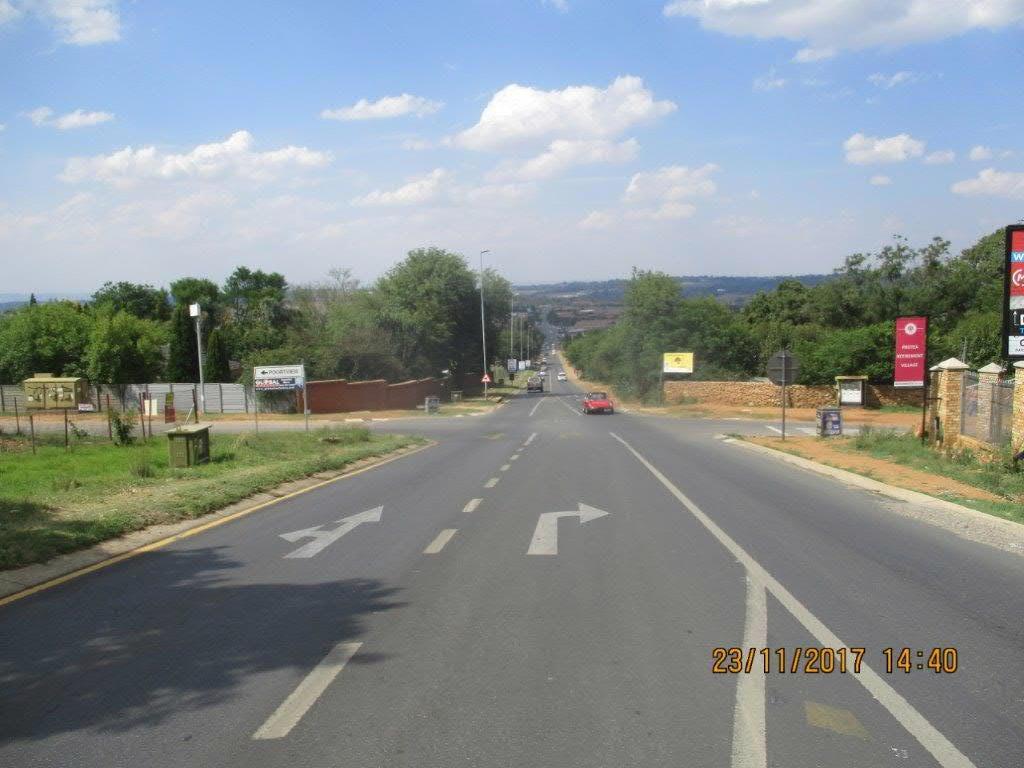
9 1 Introduction 1.1 Background Timshel Consulting has been appointed to undertake a Traffic Impact Assessment (TIA) and Site Traffic Assessment (STA) for a proposed residential development on Amarosa Extension 54 (Holding 29) in Roodepoort, Johannesburg. The property is situated on the southern side of Totius Rd, approximately 450m east of the intersection of Totius Rd and Doreen Rd. Amarosa AH falls within Region C of the City of Johannesburg (CoJ). Figure 1 shows the locality of the property. Figure 1: Locality map of development 1.2 Purpose and Content The purpose of this report is to consider the traffic impact of the proposed land use, due to the additional traffic that the development will generate both on-site and on the surrounding road network. This will be done in accordance to the TMH (Technical Methods for Highways) 16 Volume 1 and 2: South African Traffic Impact and Site Impact Assessment Standards and Requirements Manual by the South African Committee of Transport Officials (COTO). The first portion of the report focus on the TIA, whilst Chapter 9 addresses the remaining STA aspects that was not covered already. 1.3 Extent of the Development The current zoning is Agricultural Holding with a house, normal outbuildings and a swimming pool on the property as shown in Figure 2. The proposed zoning is Residential 3 for the development of simplex and duplex residential units. 6


10 Figure 2: Current Site Layout and Buildings Source: CoJ Online GIS Maps Table 1 summarises the proposed development particulars and extent. Table 1: Development Extent Stand Size Stands Particular Proposed ha Stand 1 Stand ha ha 92.72% 7.28% Zoning Residential 3 Private Open Space Coverage 50% FAR 0.50 Height Density Parking ratios 3 Storeys 36 units per hectare with a maximum of 85 units in total 1 Parking bay/ Unit + 1 Parking bay/ 3 Units for visitors (as per Town Planning Scheme) 7
11 1.4 Phasing of the Development It is anticipated that the proposed development will be completed in a single phase within a maximum period of 5 years. 2 Data Collection 2.1 Traffic Surveys and Site Visit A classified traffic survey was conducted on Thursday 23 November 2017 for the AM - (from 6:00 to 9:00) and PM Peak period (from 15:00 to 18:00) at the intersection of Totius Rd and Doreen Rd. The detail of the traffic survey will be discussed later in this report. A set of photos is included in Annexure A depicting the intersection. 2.2 Latent Rights There are two developments in the bigger area that were considered in the study as latent rights. Both TIAs were conducted by Mariteng Consulting Engineers during 2017 from which the detail was obtained for the two developments as discussed in the following paragraphs. The road upgrades and assigned trips, that overlapped the intersection to be analysed for Amarosa X54, were taken into account. The locations of these developments are indicated in Figure Erven 1 to 5 Amarosa The development is situated on the eastern side of Van der Kloof Rd between Hendrik Potgieter Rd and Flora Haase Rd. The proposed zoning is Business 1 for a furniture store including additional storage areas for the retail component, a motor sales market, including a workshop and car wash facility, but excluding dwellings. The development will generate 90 and 124 trips in the AM and PM Peak respectively. The associated road upgrades include the closure of Debora Ave at Doreen St (with a new turning circle) as well as a new road link (Ryan St) between Lawrence Rd and Debora Ave on the eastern boundary of the development Amarosa Extension 11 (Erven 304 to 306) The development is situated on the eastern side of Doreen Rd, south of Debora Ave. The proposed zoning is Business 2 for a second-hand car dealership and vehicle fitment centre as well as an office component. The development will generate 24 and 248 trips in the AM and PM Peak respectively. The road upgrades include the conversion of the staggered intersection (which is priority controlled) of Van der Kloof Rd and Flora Haase Rd to a traffic circle as well as the provision of a raised median island along the road section of Van der Kloof Rd between Flora Haase Rd and Hendrik Potgieter Rd Other Proposed Townships There are other proposed townships in the area were observed on the City of Johannesburg s (CoJ) Online Map Viewer, but the status and development detail of these townships could not be obtained. In order to get an indication of the traffic that might be generated by these townships, the Spatial Development Framework (SDF) for Region C was studied of which an extract is provided in Figure 3. All these proposed townships are indicated as residential developments on the SDF with different densities. The latent rights and these proposed townships (with their different densities) are indicated Figure 5. 8


12 Figure 3: Extract of the SDF for Region C Estimated Additional Trips In order to determine the estimated additional trips that these townships can add to the road network in the area. The summarised methodology for this is detailed in Figure 4. Figure 4: Summarised Methodology Following this methodology, the results are summarised in Table 2. The maximum estimated additional residential units are 772 and associated trips are 657 for both the AM and PM peak hours. 9


13 Figure 5: Latent Rights and Proposed Townships 10
14 Table 2: Estimated Units and Trips of Proposed Townships No Property Size Trip Generation Access Street SDF Density Units Hectare AM In Out PM In Out 1 Erf Re/17 2, Re 1/17 Totius Rd 3 Erf 21 3, Erf 1/25 40 to 60 units/ha 5 Erf 23 4, Erf 22 Vieira Rd 7 Erf 19 2, Erf Re/18 1, Erf 70 Doreen Rd 10 Erf 138/183-IQ 4,09 Malcolm Rd 5 to 10 units/ha Erf 86 2, Erf 2/84 William Rd 5 units/ha 1, TOTAL Because of the lack of detail and timeframes associated with these townships, it was not considered for this study, but it does give a good idea of the estimated additional traffic that will be added on the road network in the area. As prescribed in TMH 16 Volume 2, the background traffic growth rate used for the horizon year will be used instead due to the lack of detail of the proposed townships. 3 Surrounding Road Network and Study Area 3.1 Road Network and Master Planning National and Provincial Planning No relevant national routes are found within the study area. According to the planning of the Gauteng Department of Roads and Transport (GDRT), the PWV 5 runs approximately 210m to the east (in line with the southern boundary) of the development as indicated in Figure 7. An interchange with the PWV 5 is planned at Hendrik Potgieter Rd (also known as the K72) as shown on the extract of the 2010 Gauteng Strategic Major Road Network in Figure 6. The development is not directly impacted by the planned PWV 5 road. 11


15 Figure 6: Gauteng Strategic Major Road Network Figure 7: PWV 5 Road Reserve 12

16 3.1.2 Municipal planning The 2009 RISFSA CoJ road network planning for Region C was considered for this study. An extract of this road network plan is shown in Figure 8 which indicates the classification of the roads. Furthermore, two projects (C6 and C7) in the study area were identified as part of the City s Capital Investment Management System (CIMS) which is shown in Figure 9. Project C7 has been implemented with the link and upgrade of Lawrence Rd to Flora Haase Rd, whilst project C6 will be largely addressed with the road upgrades required for the development of Erven 1 to 5 as discussed in Section Figure 8: CoJ Road Network Classification 13
, to the west by an agricultural holding with a residence on")
17 Figure 9: CoJ Planned Road Network Projects 3.2 Surrounding Road Network The development is bordered to the north by Totius Rd, to the east by a retirement village (on holding 312), to the west by an agricultural holding with a residence on (holding 28) and to the south by vacant land (Amarosa Extension 40). More detail on these roads are provided below. à à à à à Totius Rd east of Doreen Rd is classified as a Class 5 road, whilst it is a Class 4 road west of Doreen Rd. The road runs east-west and falls under the jurisdiction of the JRA. The road has one lane in each direction. Doreen Rd is a Class 3 road that runs north-south and links CR Swart Rd in the south to Hendrik Potgieter Rd in the north. It has one lane per direction and falls under the jurisdiction of the JRA. Hendrik Potgieter Rd (also known as the M47 and K72) is a Class 2 road that runs in a northwest to south-east direction. The road has one mostly lane per direction which increase to two lanes per direction in the vicinity of intersections. It falls under the jurisdiction of the GDRT. Van der Kloof Rd is a Class 5 north-south road that traverses Hendrik Potgieter Rd. The road has one lane per direction and falls under the jurisdiction of the JRA. Pinard Rd and Flora Haase Rd are both Class 5 roads that intersects with Totius Rd. Both roads have one lane per direction and runs in an east-west direction. These roads fall under the jurisdiction of the JRA. 3.3 Determination of the Study Area In determining the site area TMH 16 volume 1 recommends the following: à à Class 4 and 5 roads in the vicinity of the development up to the first Class 1 to 3 roads that can be reached by the Class 4 and 5 road network from the development, up to and including the first connection(s) on the Class 1 to 3 roads. The elements shall be restricted to those within a maximum distance of 1.5km from the accesses to the site, measured along the shortest routes to the accesses, provided that there is at least one intersection within this distance. 14
18 TMH 16 also states that judgement should be used in selecting the intersections considered and therefore specific elements like extent of the development were also considered. The study area for the development is shown on Figure 1 and takes the above principles into account. The wider area was considered to understand the traffic flow and to include latent developments and road upgrades, but given the trips generated by the development, only the access and the intersection of Doreen Rd and Totius Rd were analysed in detail for this study. 4 Access 4.1 Site Access The site will have one access from Totius Rd with two lanes entering and one lane exiting the site. Furthermore, there will be a gate house for security personnel and access control. The access configuration of the development is shown in Figure 10. Figure 10: Access Configuration of the Development 4.2 Access Management The spacing between intersections and group housing developments along Totius Rd is indicated in Figure 11. The accesses to properties that are still agricultural holdings and vacant properties were not indicated as the traffic from them is negligible. 15

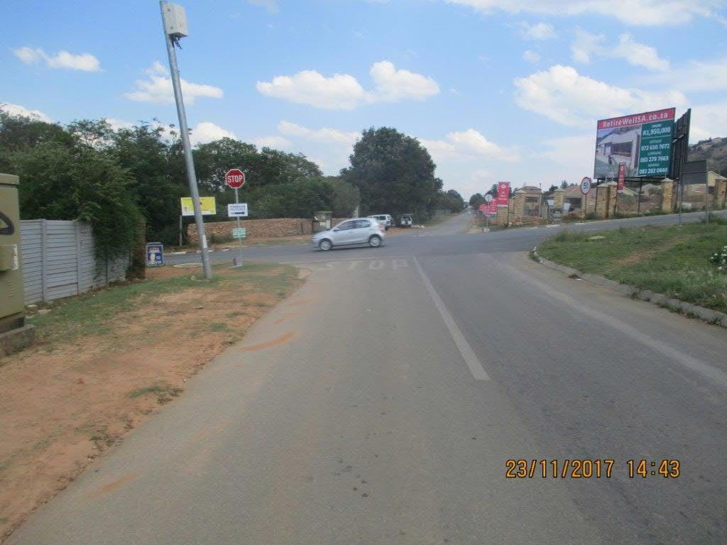
19 The South African Road Classification and Access Management Manual (RCAM, TRH 26) recommends minimum spacing between intersections on access streets as indicated in Table 3. Table 3: Minimum Spacing Recommendations for Intersections on Access Streets The proposed access position to Amarosa X54 meets the spacing requirement for a Class 5b road. Once the proposed townships on the northern side of Totius Rd develops, ideally the access positions must align with the development accesses on the southern side of Totius Rd. Figure 11: Access and Intersection Spacing 5 Existing Traffic Flows A classified traffic survey was conducted on Thursday 23 November 2017 for the AM - (from 6:00 to 9:00) and PM Peak period (from 15:00 to 18:00) at the intersection of Totius Rd and Doreen Rd (as indicated in Figure 1. A set of photos is included in Annexure A depicting the intersection. The peak hours determined from the traffic surveys are: à AM Peak: 6:45 to 7:45; and à PM Peak: 16:45 to 17:45. The detail traffic survey data is attached in Annexure B. The 2017 Peak Hour Background Traffic Volumes are shown in Figure

 According to the COTO manual mixed use developments are defined as developments in an area that consist of two or more single-use developments between which trips can")
20 Figure 12: Peak Hours Traffic Volumes 6 Development Trip Generation and Traffic Volumes Scenarios 6.1 Adjustment Factors Various trip adjustment factors have been introduced into the COTO document to allow for trip reductions. These adjustment factors are discussed briefly below. This study did not take into account any adjustment factors in order to follow a more conservative approach, given the characteristics of the development and land use in the surrounding area Mixed use developments (MUD) According to the COTO manual mixed use developments are defined as developments in an area that consist of two or more single-use developments between which trips can be made by means of non-motorised modes of transport (such as walking). This has the net effect of reducing the vehicle trip generation in the area. 17
21 6.1.2 Low vehicle ownership (LVO) and Very low vehicle ownership (VLVO) According to COTO the vehicle ownership in areas with high levels of vehicle ownership varies between one or two per household. In areas with a low level of vehicle ownership, the majority of households (more than 50%) does not own a vehicle and relies on public transport for transportation. In areas with very low level of vehicle ownership, nearly all households (more than 90%) do not own a vehicle and rely on public transportation Transit node or corridors According to COTO the transit reduction factors are applicable to developments that are located within a reasonable walking distance from a major transit node or stops on a major transit corridor. 6.2 Development Trips Existing trips The trips generated by the current land use as an agricultural holding (used only as a residence) is insignificant and therefore was not considered for the study New Trip generation The total trips generated by the proposed new development is shown in Table 4. The same number of trips are generated in the AM and PM peak, but the inbound and outbound trips differ for the two peak hours. Table 4: New Development Trips Land use COTO Code Units AM Peak PM Peak Rate In Out Trips In Out Rate In Out Trips In Out Townhouses (Duplexes & Simplexes) ,85 25% 75% ,85 70% 30% Trip Distribution and Assignment Assumptions with respect to the expected trip distribution were based on the location of the site access in relation to the surrounding road network, the existing traffic volumes, travel patterns as well as the land use nature of the proposed development and surrounds. The Gravity Method were used at the surveyed intersection. The land use of the surrounding area is mainly residential with two primary destinations, namely Hendrik Potgieter Rd and CR Swart Rd (via Doreen Rd) which are distribution roads to major employment nodes. For this reason, the development trips were distributed 50% towards Doreen Rd and 50% towards Flora Haase Rd that links up with Van der Kloof Rd to reach Hendrik Potgieter Rd. Figure 13 shows the trip distribution for the AM - and PM peak hours respectively, whilst Figure 14 shows the trip assignment for the AM - and PM peak hours respectively. The 2017 background traffic plus the development trips and available latent right trips are shown in Figure 15. The horizon planning year is for 2022 and due to the latent rights and proposed townships in the study area, an above average growth rate of 4% per annum were used for the background traffic. This is in accordance to Typical Growth Rates provided in Table 1.1 of TMH 17. The 2022 background traffic plus the development trips and available latent right trips are shown in Figure 16. Note that the road network used in the background of the figures include the road upgrades from the two TIAs of the latent rights that was considered for this assessment (refer to Chapter 2 for more detail) 18

22 Figure 13: Development Trip Distribution 19
23 Figure 14: Development Trip Assignment 20

24 Figure 15: 2017 Background Traffic with Development and Latent Rights Trips 21

25 Figure 16: 2022 Background Traffic with Development and Latent Rights Trips 22
 were also analysed.")
26 7 Traffic Impact and Capacity Analysis The development will be constructed within the next five years, once approved. Due to the latent rights and proposed townships that are still to be developed, a 5 year horizon year (2022) were also analysed. An above average annual growth rate of 4% were used for the background traffic. Only one intersection and the access to the development were analysed for this study. The capacity analysis was conducted with SIDRA 6.0 software. 7.1 Scenarios The following scenarios were analysed for the two intersections: à 2017 AM Peak background à 2017 PM Peak background à 2017 AM Peak background with development and latent rights traffic à 2017 PM Peak background with development and latent rights traffic à 2022 AM Peak Background with Development & Latent Rights Traffic à 2022 PM Peak Background with Development & Latent Rights Traffic The aim of this analysis is to ensure that the intersections and/or accesses of the proposed development operate at an acceptable level of service (LOS). SIDRA 6.0 software were used for the capacity analysis. 7.2 Capacity Analysis The geometric layout for the access that was used in the capacity analysis can be seen in Figure 10. The latest layout for the intersection of Doreen Rd and Totius Rd was used as indicated in Figure 17. Figure 17: Intersection Layout of Doreen Rd/ Totius Rd The analysis results are presented by the intersection summary outputs from SIDRA. Where there is a capacity concern on intersection movements, more detail is provided as per the COTO requirements. Note that the scenarios are compared in one table in order to simplify observing possible changes in the capacity impact on the intersection. A conclusion on the comparison is drawn after each intersection. 23


27 7.2.1 Intersection: Doreen Rd/ Totius Rd Table 5: Capacity Analysis Results Summary Intersection of Doreen Rd/ Totius Rd 2017 AM Peak Background Traffic 2017 PM Peak Background Traffic Level of Service Summary Movement Summary 24
28 2017 AM Peak Background with Development & Latent Rights Traffic 2017 PM Peak Background with Development & Latent Rights Traffic Level of Service Summary 2022 AM Peak Background with Development & Latent Rights Traffic 2022 AM Peak Background with Development & Latent Rights Traffic Level of Service Summary CONCLUSION The development trips have a negligible impact on the intersection which already experience a problem with traffic movements that needs to find gaps in the traffic stream of Doreen Rd. These movements function at an unacceptable LOS. 25
29 7.2.2 Access from Totius Rd Table 6: Capacity Analysis Results Summary - Access from Totius Rd 2017 AM Peak Background with Development Traffic 2017 AM Peak Background with Development Traffic LOS Lane Summary 2022 AM Peak Background with Development & Latent Rights Traffic 2022 AM Peak Background with Development & Latent Rights Traffic LOS Lane Summary CONCLUSION The proposed access functions at an excellent LOS and the result of each individual movement on the intersection remains the same with both scenarios. There are no capacity concerns on any of the movements in the base year (2017) and the horizon year (2022) scenarios for both peak hours. The proposed access layout is sufficient for the development and no upgrades are required. 26
30 7.3 Capacity Analysis Conclusion The access to the development functions at a good LOS in the base and future year scenario. There is no need for road upgrades at the access and the proposed layout is sufficient. The intersection of Doreen Rd/ Totius Rd proofs a challenge already in the 2017 background traffic analysis. The problem is created by the large volume of through traffic on Doreen Rd that has free flow with the current layout. This causes significant delays on the side movements (Totius Rd) that is currently stop-controlled which struggles to obtain sufficient and safe gaps in the traffic stream on Doreen Rd to either cross the intersection or enter Doreen Rd with a left and/ or right turning movement. The problem is further exasperated by the steep gradient of Doreen Rd towards CR Swart Rd which causes vehicles to easily speed downhill towards the intersection with Totius Rd, making it even more difficult for side movements to find safe gaps. The only way in which this can improve, is by creating gaps by means of traffic control measures in the traffic flow of Doreen Rd. The implementation of a traffic circle was analysed and this will improve the situation, but due to continuity on the road, a traffic signal is probably the best option as found towards Hendrik Potgieter Rd at the intersections of Lawrence Rd, Malcolm Rd and Hendrik Potgieter Rd itself. The developer of Amarosa Extension 54 is not responsible for this improvement as the trips added to the intersection is negligible and since the problem is existing, the JRA should be accountable for this improvement. 8 Non-motorised - and Public Transport In terms of the National Land Transport Transition Act (NLTTA) 22 of 2000, section 29, it is a requirement that an assessment of the public transport be included in a TIA. 8.1 Existing Public Transport Services and Facilities The area has a general lack of public transport services which is discussed in more detail in the following paragraphs Non-motorised Transport The area in the direct vicinity of the development has sufficient road verge for non-motorised transport (NMT), but only sporadic formal walkways are provided. In order to improve the NMT network, it is proposed that a formal walkway be provided along the development boundary on the southern side of Totius Rd Minibus Taxis Minibus taxis are the most common form of public transport in this area. From the classified traffic surveys conducted, it was observed that approximately 3% of the total traffic along Doreen Rd were taxis. Taxi bays are provided on the northern side of Hendrik Potgieter Rd at both the intersections with Doreen Rd and Van der Kloof Rd. The taxis have created an informal holding area in both these areas as seen in Figure 18. A taxi can be reached in Doreen Rd which is an acceptable walking distance (approximately 500m) from the development access. 27

31 Figure 18: Minibus Taxi Informal Holding Areas Metrobus and Rea Vaya The Strategic Public Transport Network of the CoJ has not been planned for the area. There are also no formal bus services in the study area. No buses were also observed during the traffic survey Railway There are also no railway lines in the study area. 8.2 Public Transport Conclusion The area surrounding the development doesn t have a well-integrated public transport network and currently the only option is to make use of a minibus-taxi which can be boarded reached in Doreen Rd. 9 Site Traffic Assessment: Remaining Aspects The site development plan (SDP) for the proposed development is attached in Annexure C. This chapter will focus on the relevant site traffic assessment (STA) aspects that was not addressed in the report thus far. 9.1 Parking provision The scheme requirement for parking is 1 parking bay/unit and 1 parking bay/3 units for visitors. The SDP indicates that there are 49 bigger units, with a parking space each, and 31 smaller units in the development. A total of 107 parking bays are required on the site, whilst a total of 137 parking bays are provided of which 88 are open parking bays. There is thus a surplus of 30 parking bays on the site Parking area design Although not all the measurements are indicated on the SDP attached in Annexure C, the design was scrutinized in detail and complies with the minimum geometric design requirements. 28

32 9.2 Queuing Analysis The worst-case scenario is the PM peak during which 51 vehicles must enter the access (Refer to Figure 14). A queueing analysis is required to assess the potential spill back of traffic into Totius Rd. The total queuing space available is 20m as indicated in Figure 10. Chapter 10 of TMH 16 Vol 2 gives detail on queuing analysis. The traffic ratio is determined by the following formula: The PHF was determined from the traffic surveys conducted at this access. Furthermore, the vehicle storage requirement is concluded from Table 7. An assumption was made that the Magnetic Swipe Card system will be used for access control for which the service flow rate is 480 vehicles per hour. The traffic ratio then equals (where the PHF was calculated as 0.85). Table 7 only starts at 23, thus one channel with storage for one vehicle is sufficient for the access. 3 Vehicles can be accommodated safely per lane (a total of 6 vehicles for the two entrance lanes) at one time, which means there is more than enough storage space available. Table 7: Access Control Queue Lengths on Access Throats Source: Table 31: Chapter 10 of TMH 16 Vol Truck Accommodation Refuse Collection The refuse collection area is situated at the access (refer to Figure 10) from where the municipality will collect it as per their usual fixed schedule Emergency Vehicles Emergency vehicles can be accommodated comfortably through the exit lane of the access which is 4.5m wide. 9.4 Geometric Design and Sight Distance There are no fixed obstructions that will hamper the sight distance from the development access. The design of the access and internal roads of the site is geometrically sound. 9.5 Traffic management No additional traffic management will be required other than the priority control at the access. 29
33 10 Conclusions and Recommendations Based on the TIA and STA report for the proposed residential development known as Amarosa Extension 54, the key conclusions are summarised as follows: à The proposed development is to provide 80 residential; à One access will be provided from Totius Rd with two entry lanes and one exit lane; à The access positions are optimal and does not present any problems or unnecessary conflict with the background traffic; à The proposed development will generate 72 (18:54 in:out) and 72 (51:22 in:out) additional trips in the AM and PM peak respectively (refer to Chapter 6); à The development impact on the capacity of the two priority controlled intersections in the study area is negligible, but a change of intersection control is currently required at the intersection of Doreen Rd/ Totius Rd which is the responsibility of the JRA (refer to Chapter 7); à The geometric design of the internal roads, parking areas and access are sufficient and will be more detailed on the final SDP; à A surplus of 30 parking bays are provided for the development; à A queueing analysis was conducted on the access and it was found that the proposed access layout with two entrance lanes and a storage space of 20m is sufficient (Refer to Chapter 9); and à There is not sufficient provision for public transport within the study area, but a minibus taxi can be reached in Doreen Rd which is 500m from the development access (refer to Chapter 8). It is therefore recommended that the proposed development on Holding 29, and known as Amarosa Extension 54, be supported from a traffic engineering point of view and that the SDP be detailed and approved for the development (refer to Annexure C). 30
34 11 References 1. TMH 16 Volume 1 and 2, South African Traffic Impact and Site Traffic Assessment Standards and Requirements Manual, Version 1.0, Committee of Transport Officials (COTO), August TMH 17 Volume 1, South African Trip Data Manual, Version 1.0, COTO, September TRH 26 South African Road Classification and Access Management Manual, Version 1.0, COTO, August CoJ Corporate GIS Online Maps, < including Joburg 2015 Aerial Photos 5. Google Maps, Google Earth and Street View 6. Motivating Memorandum, Application in terms of Section 26 of the City of Johannesburg Municipal Planning By-Law 2016, read with Section 2(2) The Spatial Planning Land Use Management Act, 2013 (Act 16 of 2013) for the Establishment of a Township: Amorosa Extension 54, Hunter Theron Incorporated Town Planners, October 2017 (Reference: B1711-Rep) 7. Traffic Impact Study: Rezoning Application for Erven 1, 2, 3, 4, & 5 (Revision 1), Amorosa, Mariteng Consulting Engineers, May Traffic Impact Assessment: Proposed Township Amorosa Extension 11 (Revision 1), Mariteng Consulting Engineers, August CoJ Regional Spatial Development Framework: Administrative Region C, Region C: Central Areas Development Plan, Plan No. 18a, January Gauteng Strategic Major Road Network, GDRT, TTT Africa & Khuthele & Vela VKE, May K Route Road Reserves, PWV5.11.kmz, GDRT, Obtained in CoJ Road Network Project, Region C: RISFSA Road Hierarchy Map, Aurecon, June CoJ Road Network Project, Region C: Prioritised CIMS Projects 2015, Figure 13: Project , Aurecon, June Site Development Plan, Proposed Township Amarosa Ext.54 Situated on Holding 29 Amorosa A.H, Drawing No. B1711/1, Hunter Theron Incorporated Town Planners, Aug Traffic Surveys: Intersection of Doreen Rd and Totius Rd, Trafsol, 23 Nov
35 Annexure A: Traffic survey site photos


36 1B 1C 1D 1A
37 Annexure B: Traffic survey data
38 LOCATION 1 6 HOUR COUNT AM PEAK AMAROSA (ROODEPOORT) TRAFFIC SURVEYS TIMSHEL DOREEN AND TOTIUS TOTAL VEHICLES 6:45 7:45 1:00 16:45 17:45 DOREEN , , OUT IN PM PEAK 23/11/2017 THURSDAY IN OUT TOTIUS TOTIUS OUT IN IN OUT DOREEN v2.1 Time South East North West Hourly AM PEAK PM PEAK TOTAL : : : : :00 7: :15 7: :30 7: :45 7: :00 8: :15 8: :30 8: :45 8:45 9:00 9:15 9:30 9:45 10:00 10:15 10:30 10:45 11:00 11:15 11:30 11:45 12:00 12:15 12:30 12:45 13:00 13:15 13:30 13:45 14:00 14:15 14:30 14: :00 8:15 8:30 8:45 9:00 9:15 9:30 9:45 10:00 10:15 10:30 10:45 11:00 11:15 11:30 11:45 12:00 12:15 12:30 12:45 13:00 13:15 13:30 13:45 14:00 15: :15 15: :30 15: :45 15: :00 16: :15 16: :30 16: :45 16: :00 17: :15 17: :30 17: :45 17: :00 18: : : :45 19:00 19:15 19:30 19:45 20:00 20:15 20:30 20: :15 17:30 17:45 18:00 18:15 18:30 18:45 19:00 19:15 19:30 19:45 20:00
39 LOCATION 1 6 HOUR COUNT AM PEAK AMAROSA (ROODEPOORT) TRAFFIC SURVEYS TIMSHEL DOREEN AND TOTIUS 23/11/2017 CARS THURSDAY 6:45 7:45 1:00 PM PEAK 16:45 17:45 DOREEN , , OUT IN IN OUT TOTIUS TOTIUS OUT IN IN OUT DOREEN Time South East North West Hourly AM PEAK PM PEAK TOTAL 6:00 6:15 6:30 6:45 7:00 7:15 7:30 7:45 8:00 8:15 8:30 8:45 9:00 9:15 9:30 9:45 10:00 10:15 10:30 10:45 11:00 11:15 11:30 11:45 12:00 12:15 12:30 12:45 13:00 13:15 13:30 13:45 14:00 14:15 14:30 14:45 15:00 15:15 15:30 15:45 16:00 16:15 16:30 16:45 17:00 17:15 17:30 17:45 18:00 18:15 18:30 18:45 19:00 19:15 19:30 19:45 20:00 20:15 20:30 20: : : : : : : : : :00 8:15 8:30 8:45 9:00 9:15 9:30 9:45 10:00 10:15 10:30 10:45 11:00 11:15 11:30 11:45 12:00 12:15 12:30 12:45 13:00 13:15 13:30 13:45 14: : : : : : : : : : : : : :15 17:30 17:45 18:00 18:15 18:30 18:45 19:00 19:15 19:30 19:45 20:00
40 AMAROSA (ROODEPOORT) TRAFFIC SURVEYS TIMSHEL LOCATION 1 DOREEN AND TOTIUS 23/11/ HOUR COUNT MINIBUS TAXIS THURSDAY AM PEAK PM PEAK DOREEN :45 7:45 1:00 16:45 17: OUT IN IN OUT 3 TOTIUS OUT IN OUT IN TOTIUS DOREEN Time South East North West Hourly AM PEAK PM PEAK TOTAL : : : : :00 7: :15 7: :30 7: :45 7: :00 8: :15 8: :30 8: :45 8:45 9:00 9:15 9:30 9:45 10:00 10:15 10:30 10:45 11:00 11:15 11:30 11:45 12:00 12:15 12:30 12:45 13:00 13:15 13:30 13:45 14:00 14:15 14:30 14: :00 8:15 8:30 8:45 9:00 9:15 9:30 9:45 10:00 10:15 10:30 10:45 11:00 11:15 11:30 11:45 12:00 12:15 12:30 12:45 13:00 13:15 13:30 13:45 14:00 15: :15 15: :30 15: :45 15: :00 16: :15 16: :30 16: :45 16: :00 17: :15 17: :30 17: :45 17: :00 18:00 18:15 18:30 18:45 19:00 19:15 19:30 19:45 20:00 20:15 20:30 20: :15 17:30 17:45 18:00 18:15 18:30 18:45 19:00 19:15 19:30 19:45 20:00
41 AMAROSA (ROODEPOORT) TRAFFIC SURVEYS TIMSHEL LOCATION 1 DOREEN AND TOTIUS 23/11/ HOUR COUNT BUSES THURSDAY AM PEAK PM PEAK DOREEN 1 1 6:45 7:45 1:00 16:45 17:45 2 OUT IN IN OUT TOTIUS TOTIUS OUT IN IN OUT DOREEN Time AM PEAK 1 South East North West Hourly 1 PM PEAK TOTAL : :15 6: :45 7: :00 6:15 7:15 7: :30 6:45 7: :00 8: :15 8:15 8:30 8:45 9:00 9:15 9:30 9:45 10:00 10:15 10:30 10:45 11:00 11:15 11:30 11:45 12:00 12:15 12:30 12:45 13:00 13:15 13:30 13:45 14:00 14:15 14:30 14:45 15:00 15: :30 7:45 8:00 8:15 8:30 8:45 9:00 9:15 9:30 9:45 10:00 10:15 10:30 10:45 11:00 11:15 11:30 11:45 12:00 12:15 12:30 12:45 13:00 13:15 13:30 13:45 14:00 14:15 14:30 15:30 15: :45 15:00 16:00 16: :15 15:30 16: :45 16: :00 17: : : :45 18:00 18:15 18:30 18:45 19:00 19:15 19:30 19:45 20:00 20:15 20:30 20:45 16:15 16:30 16:45 17:00 17:15 17:30 17:45 18:00 18:15 18:30 18:45 19:00 19:15 19:30 19:45 20:00
42 AMAROSA (ROODEPOORT) TRAFFIC SURVEYS TIMSHEL LOCATION 1 DOREEN AND TOTIUS 23/11/ HOUR COUNT BUSES THURSDAY AM PEAK PM PEAK DOREEN :45 7:45 1:00 16:45 17: OUT IN IN OUT 3 1 TOTIUS TOTIUS 2 OUT 1 IN OUT IN DOREEN Time South East North West Hourly AM PEAK PM PEAK TOTAL : : : : :00 7: :15 7: :30 7: :45 7: :00 8: :15 8: :30 8: :45 8:45 9:00 9:15 9:30 9:45 10:00 10:15 10:30 10:45 11:00 11:15 11:30 11:45 12:00 12:15 12:30 12:45 13:00 13:15 13:30 13:45 14:00 14:15 14:30 14: :00 8:15 8:30 8:45 9:00 9:15 9:30 9:45 10:00 10:15 10:30 10:45 11:00 11:15 11:30 11:45 12:00 12:15 12:30 12:45 13:00 13:15 13:30 13:45 14:00 15: :15 15: :30 15: :45 15: :00 16: :15 16: :30 16: :45 16: :00 17: :15 17: :30 17: :45 17: :00 18:00 18:15 18:30 18:45 19:00 19:15 19:30 19:45 20:00 20:15 20:30 20: :15 17:30 17:45 18:00 18:15 18:30 18:45 19:00 19:15 19:30 19:45 20:00
43 Annexure C: Site Development Plan (SDP)


44 GEOTECH CONDUCTED BY GEO SIMPLICITY ENGINEERING (Pty) Ltd REPORT No. : G252-DRW02-REV.00 DATE : JULY 2017 Demarcation of zones is approximate and should be confirmed during construction. 1. Refer to text of report for detailed foundation recommendations. 2. GGL = Ground level at geotechnical investigation fieldwork stage. 3. Site class designation: S2 S2/S S2/S;R S2/R Erf 309 "S2" designation applies from GGL to in excess of 2,8m below GGL "S2" designation applies from GGL to 2,3m and "S" applies in excess of 2,3m below GGL "S2" designation applies from GGL to 2,3m and "S" applies in excess of 2,3m below GGL "S2" designation applies from GGL to 2,1m and "R" applies in excess of 2,1m below GGL D Y Y m B/L INTERLOCKING PAVING X m BUILDING LINE PH4 HOLDING S2/S/R AMOROSA EXTENSION m BUILDING LINE m B/L INTERLOCKING PAVING PH3 INTERLOCKING PAVING PH5 A ERF 3 P.O.S 0,0648ha S2/R PH1 INTERLOCKING PAVING PH2 60 INTERLOCKING PAVING ref GATE HOUSE PAVING INTERLOCKING PH PH7 84 2m B/L PH8 82 INTERLOCKING PAVING 5m B/L INTERLOCKING PAVING X X X Y LINE OF NO ACCESS LINE OF NO ACCESS ERF 1 RESIDENTIAL 3 2,4031ha ERF 2 P.O.S 0,1238ha S2/S TOTIUS ROAD 5m BUILDING LINE S2 2m BUILDING LINE Erf 312 AMOROSA EXTENSION 45 B P R O J E C T L O C A L I T Y P L A N L A N D U S E T A B L E CO - ORDINATE SYSTEM: WG 27 C L I E N T DESIGNED DRAWN PROPOSED TOWNSHIP AMAROSA EXT.54 SITUATED ON HOLDING 29 AMOROSA A.H GEOTECHNICAL PLAN LAND USE RESIDENTIAL 3 PRIVATE OPEN SPACE HT ET D R A W I N G N o. APPROVED DATE NO. OF STAND AREA % TOTAL 3 2,5917ha 100% 1 2 VTC AFRICA B1711 / 1 THE SITE 2,4031 0,1886 AUG SCALE 92,72 7,28 1:1000 (A3) COPYRIGHT RESERVED # BASE PLAN & CONTOURS PROVIDED BY G.J. VAN RIJSEWIJK PROFESSIONAL LAND SURVEYOR # THE ENTIRE ERF 1 IS SUBJECT TO A SERVITUDE OF RIGHT OF WAY IN FAVOUR OF ERF 2 AND ERF 3 ALONG A ROUTE TO BE DETERMINED AS PER THE APPROVED SITE DEVELOPMENT PLAN C Y C o n r a d S t r e e t F l o r i d a N o r t h E - m a i l : h t t r i a f r i c a. c o m T e l n o : ( ) Fax : ( )
45 THANK YOU
PROPOSED RESIDENTIAL & COMMERCIAL DEVELOPMENT (ERF 1692), FRANSCHHOEK. Traffic Impact Assessment
, FRANSCHHOEK. Traffic Impact Assessment") PROPOSED RESIDENTIAL & COMMERCIAL DEVELOPMENT (ERF 1692), FRANSCHHOEK Traffic Impact Assessment LOCATED ERF 1692 IN FRANSCHHOEK, WESTERN CAPE Project No. : STUR0202 NOVEMBER 2017 PREPARED BY: STURGEON
PROPOSED RESIDENTIAL & COMMERCIAL DEVELOPMENT (ERF 1692), FRANSCHHOEK Traffic Impact Assessment LOCATED ERF 1692 IN FRANSCHHOEK, WESTERN CAPE Project No. : STUR0202 NOVEMBER 2017 PREPARED BY: STURGEON
TRAFFIC IMPACT ASSESSMENT PART OF AN ENVIRONMENTAL IMPACT ASSESSMENT FOR THE KEBRAFIELD ROODEPOORT COLLIERY IN THE PULLEN S HOPE AREA
 TRAFFIC IMPACT ASSESSMENT PART OF AN ENVIRONMENTAL IMPACT ASSESSMENT FOR THE KEBRAFIELD ROODEPOORT COLLIERY IN THE PULLEN S HOPE AREA 20 March 2014 Report prepared by: Corli Havenga Transportation Engineers
TRAFFIC ENGINEERING SERVICES TRAFFIC IMPACT STATEMENT NATREF CLEAN FUELS II, SASOLBURG, FREE STATE. October 2013 Revised: 2.0
 TRAFFIC ENGINEERING SERVICES TRAFFIC IMPACT STATEMENT NATREF CLEAN FUELS II, SASOLBURG, FREE STATE October 2013 Revised: 2.0 Quality Management Issue/revision Issue 1 Issue 2 Remarks Draft Final Date 30
LAWRENCE TRANSIT CENTER LOCATION ANALYSIS 9 TH STREET & ROCKLEDGE ROAD / 21 ST STREET & IOWA STREET LAWRENCE, KANSAS
 LAWRENCE TRANSIT CENTER LOCATION ANALYSIS 9 TH STREET & ROCKLEDGE ROAD / 21 ST STREET & IOWA STREET LAWRENCE, KANSAS TRAFFIC IMPACT STUDY FEBRUARY 214 OA Project No. 213-542 TABLE OF CONTENTS 1. INTRODUCTION...
RE: A Traffic Impact Statement for a proposed development on Quinpool Road
 James J. Copeland, P.Eng. GRIFFIN transportation group inc. 30 Bonny View Drive Fall River, NS B2T 1R2 May 31, 2018 Ellen O Hara, P.Eng. Project Engineer DesignPoint Engineering & Surveying Ltd. 200 Waterfront
Cornubia Retail and Business Park Development
 Development July 2013 Tongaat Hulett Development (Pty) Ltd Tel. No.: 031 560 1900 Contact Person: Karen Petersen 21 West Riding Row, Sherwood Tel: 031 240 7300 Andrew McKune Andrew.McKune@smec.com SMEC
Error! Reference source not found.
 shown in Error! Reference source not found..5. Four scenarios are shown representing the AM and PM peak periods for the current status quo of traffic and the 2011 projected traffic with all of the public
Alpine Highway to North County Boulevard Connector Study
 Alpine Highway to North County Boulevard Connector Study prepared by Avenue Consultants March 16, 2017 North County Boulevard Connector Study March 16, 2017 Table of Contents 1 Summary of Findings... 1
CHAPTER 9: VEHICULAR ACCESS CONTROL Introduction and Goals Administration Standards
 9.00 Introduction and Goals 9.01 Administration 9.02 Standards 9.1 9.00 INTRODUCTION AND GOALS City streets serve two purposes that are often in conflict moving traffic and accessing property. The higher
Clean Harbors Canada, Inc.
 Clean Harbors Canada, Inc. Proposed Lambton Landfill Expansion Environmental Assessment Terms of Reference Transportation Assessment St. Clair Township, Ontario September 2009 itrans Consulting Inc. 260
EXECUTIVE SUMMARY. The following is an outline of the traffic analysis performed by Hales Engineering for the traffic conditions of this project.
 EXECUTIVE SUMMARY This study addresses the traffic impacts associated with the proposed Shopko redevelopment located in Sugarhouse, Utah. The Shopko redevelopment project is located between 1300 East and
FOR PROPOSED TOWNSHIPS ESTER PARK X36, X 37 IRENE EXTENSION 193
 SERVICE REPORT ELECTRICAL ENGINEERING SERVICES FOR ELECTRICAL ENGINEERING SERVICES FOR PROPOSED TOWNSHIPS FOR PROPOSED TOWNSHIPS ESTER PARK X36, X 37 IRENE EXTENSION 193 SUPPLY AUTHORITY DEVELOPER ENGINEER
Transportation & Traffic Engineering
 Transportation & Traffic Engineering 1) Project Description This report presents a summary of findings for a Traffic Impact Analysis (TIA) performed by A+ Engineering, Inc. for the Hill Country Family
TRAFFIC ENGINEERING ASSESSMENT MOUNT EDEN ROAD, MOUNT EDEN
 12 September 2017 Iain McManus Civitas Planning Consultants PO Box 47020 Ponsonby AUCKLAND 1144 Dear Iain, TRAFFIC ENGINEERING ASSESSMENT 43-45 45 MOUNT EDEN ROAD, MOUNT EDEN As requested, we have prepared
INDUSTRIAL DEVELOPMENT
 INDUSTRIAL DEVELOPMENT Traffic Impact Study Plainfield, Illinois August 2018 Prepared for: Seefried Industrial Properties, Inc. TABLE OF CONTENTS Executive Summary 2 Introduction 3 Existing Conditions
SERVICE REPORT ELECTRICAL ENGINEERING FOUNDERS HILL REMAINDER ERF 13
 SERVICE REPORT ELECTRICAL ENGINEERING SERVICES FOR FOR PROPOSED ELECTRICAL REZONING ENGINEERING SERVICES FOR PROPOSED TOWNSHIPS FOUNDERS HILL REMAINDER ERF IRENE 13 EXTENSION 193 SUPPLY AUTHORITY DEVELOPER
Attachment F: Transport assessment report on implications if Capell Avenue never formed
 Attachment F: Transport assessment report on implications if never formed CCL Ref: 14447-181118-williams.docx 18 November 2018 Tim Williams Williams and Co Limited By e-mail only: tim@williamsandco.nz
TRAFFIC IMPACT STUDY. USD #497 Warehouse and Bus Site
 TRAFFIC IMPACT STUDY for USD #497 Warehouse and Bus Site Prepared by: Jason Hoskinson, PE, PTOE BG Project No. 16-12L July 8, 216 145 Wakarusa Drive Lawrence, Kansas 6649 T: 785.749.4474 F: 785.749.734
King Soopers #116 Thornton, Colorado
 Traffic Impact Study King Soopers #116 Thornton, Colorado Prepared for: Galloway & Company, Inc. T R A F F I C I M P A C T S T U D Y King Soopers #116 Thornton, Colorado Prepared for Galloway & Company
West Hills Shopping Centre Lowe s Expansion Traffic Impact Study
 West Hills Shopping Centre Lowe s Expansion Traffic Impact Study Prepared for: Armel Corporation January 2015 Paradigm Transportation Solutions Ltd. 22 King Street South, Suite 300 Waterloo ON N2J 1N8
Traffic Impact Study Speedway Gas Station Redevelopment
 Traffic Impact Study Speedway Gas Station Redevelopment Warrenville, Illinois Prepared For: Prepared By: April 11, 2018 Table of Contents 1. Introduction... 1 2. Existing Conditions... 4 Site Location...
TRAFFIC IMPACT ANALYSIS
 TRAFFIC IMPACT ANALYSIS Emerald Isle Commercial Development Prepared by SEPI Engineering & Construction Prepared for Ark Consulting Group, PLLC March 2016 I. Executive Summary A. Site Location The Emerald
TRAFFIC IMPACT STUDY VICDOM BROCK ROAD PIT EXPANSION
 TRAFFIC IMPACT STUDY VICDOM BROCK ROAD PIT EXPANSION TOWNSHIP OF UXBRIDGE P/N 05-1993 June 2011 Revised -August 2011 Prepared by: Skelton, Brumwell & Associates Inc. 93 Bell Farm Road, Suite 107 Barrie,
TRAFFIC IMPACT ASSESSMENT
 TRAFFIC IMPACT ASSESSMENT Prepared by: N MIYA Reviewed by: BN Roberts Pr Eng / AM Phetla PD Naidoo and Associates Consulting Engineers (Pty) Ltd PO Box 7707, Johannesburg 2000 Prepared for: ENVIROLUTION
Trafalgar Road & Lower Base Line Transportation Study Ontario Inc.
 Trafalgar Road & Lower Base Line Transportation Study 1255723 Ontario Inc. Trafalgar Road & Lower Base Line Transportation Study 1255723 Ontario Inc. 1465 Pickering Parkway Suite 200 Pickering ON L1V 7G7
Traffic Impact Analysis West Street Garden Plots Improvements and DuPage River Park Garden Plots Development Naperville, Illinois
 Traffic Impact Analysis West Street Garden Plots Improvements and DuPage River Park Garden Plots Development Naperville, Illinois Submitted by April 9, 2009 Introduction Kenig, Lindgren, O Hara, Aboona,
144&176 John St. and 200 John St. & 588 Charlotte St. Hotel and Residential Subdivision Development
 Solmar Development Corp. 144&176 John St. and 2 John St. & 588 Charlotte St. Hotel and Residential Subdivision Development TRANSPORTATION IMPACT STUDY 18145 November 217 LEA Consulting Ltd. Consulting
54 Parkway Drive, Rosedale Proposed Residential / Commercial Development. Transportation Assessment Report. 30 April 2018
 54 Parkway Drive, Rosedale Proposed Residential / Commercial Development Transportation Assessment Report 30 April 2018 Project: Report title: Document reference: 54 Parkway Drive, Rosedale Transportation
BARRHAVEN FELLOWSHIP CRC 3058 JOCKVALE ROAD OTTAWA, ONTARIO TRANSPORTATION BRIEF. Prepared for:
 BARRHAVEN FELLOWSHIP CRC 3058 JOCKVALE ROAD OTTAWA, ONTARIO TRANSPORTATION BRIEF Prepared for: Barrhaven Fellowship CRC 3058 Jockvale Road Ottawa, ON K2J 2W7 December 7, 2016 116-649 Report_1.doc D. J.
2.0 Development Driveways. Movin Out June 2017
 Movin Out June 2017 1.0 Introduction The proposed Movin Out development is a mixed use development in the northeast quadrant of the intersection of West Broadway and Fayette Avenue in the City of Madison.
Submission to Greater Cambridge City Deal
 What Transport for Cambridge? 2 1 Submission to Greater Cambridge City Deal By Professor Marcial Echenique OBE ScD RIBA RTPI and Jonathan Barker Introduction Cambridge Futures was founded in 1997 as a
Craigieburn Employment Precinct North and English Street
 Craigieburn Employment Precinct North and English Street METROPOLITAN PLANNING AUTHORITY Intersection Analyses 7 February 2014 Intersection Analyses Craigieburn Employment Precinct North and English Street
Date: February 7, 2017 John Doyle, Z-Best Products Robert Del Rio. T.E. Z-Best Traffic Operations and Site Access Analysis
 Memorandum Date: February 7, 07 To: From: Subject: John Doyle, Z-Best Products Robert Del Rio. T.E. Z-Best Traffic Operations and Site Access Analysis Introduction Hexagon Transportation Consultants, Inc.
ANDERSON PROPERTY SITE ANALYSIS
 ANDERSON PROPERTY SITE ANALYSIS Introduction The Montgomery County Department of Transportation (MCDOT) initiated a feasibility study in the fall of 2012 to evaluate the need for transit service expansion
In response to the TIA the Director General of the Department of Planning and Infrastructure issued the following comment:
 06 July 2012 P0961 Natural Gas Storage Facility Letter Ver2.doc CB&I Level 13, 197 St Georges Terrace Perth, Western Australia, 6000 Attention: Jim Rutherford Dear Jim, Re: Natural Gas Storage Facility
DEVELOPMENT PROPERTY 1627 MAXIME STREET CITY OF OTTAWA TRANSPORTATION OVERVIEW. Prepared for: Subhas Bhargava. July 9, Overview_1.
 DEVELOPMENT PROPERTY 1627 MAXIME STREET CITY OF OTTAWA TRANSPORTATION OVERVIEW Prepared for: Subhas Bhargava July 9, 2015 115-620 Overview_1.doc D. J. Halpenny & Associates Ltd. Consulting Transportation
MINERVA PARK SITE TRAFFIC IMPACT STUDY M/I HOMES. September 2, 2015
 5500 New Albany Road Columbus, Ohio 43054 Phone: 614.775.4500 Fax: 614.775.4800 Toll Free: 1-888-775-EMHT emht.com 2015-1008 MINERVA PARK SITE TRAFFIC IMPACT STUDY M/I HOMES September 2, 2015 Engineers
PROJECT: Wilkinson Road Corridor Improvement Traffic Management Planning Project SUBJECT: Traffic Analysis
 TECHNICAL MEMORANDUM DATE: September 10, 2014 PROJECT 5861.03 NO: PROJECT: Wilkinson Road Corridor Improvement Traffic Management Planning Project SUBJECT: Traffic Analysis TO: Steve Holroyd - District
LCPS Valley Service Center
 Traffic Impact Study LCPS Valley Service Center Loudoun County, Virginia November 4, 2015 Prepared For: Loudoun County Public Schools 21000 Education Court Ashburn, VA 20148 Prepared by: 1140 Connecticut
Incorporating informal operations in public transport system transformation: the case of Cape Town, South Africa
 Faculty of Engineering & the Built Environment Centre for Transport Studies Incorporating informal operations in public transport system transformation: the case of Cape Town, South Africa Peter Wilkinson
Craig Scheffler, P.E., PTOE HNTB North Carolina, P.C. HNTB Project File: Subject
 TECHNICAL MEMORANDUM To Kumar Neppalli Traffic Engineering Manager Town of Chapel Hill From Craig Scheffler, P.E., PTOE HNTB North Carolina, P.C. Cc HNTB Project File: 38435 Subject Obey Creek TIS 2022
Table 1 - Land Use Comparisons - Proposed King s Wharf Development. Retail (SF) Office (SF) 354 6,000 10, Land Uses 1
 Office (SF) 354 6,000 10, Land Uses 1") Ref. No. 171-6694 Phase 2 November 23, 217 Mr. David Quilichini, Vice President Fares & Co. Developments Inc. 31 Place Keelson Sales Centre DARTMOUTH NS B2Y C1 Sent Via Email to David@faresinc.com RE:
Ref. No. 171-6694 Phase 2 November 23, 217 Mr. David Quilichini, Vice President Fares & Co. Developments Inc. 31 Place Keelson Sales Centre DARTMOUTH NS B2Y C1 Sent Via Email to David@faresinc.com RE:
Re: 233 Armstrong Street Residential Condominium Traffic Brief
 1223 Michael Street, Suite 100, Ottawa, ON K1J 7T2 Tel: 613.738.4160 Fax: 613.739.7105 www.delcan.com August 8, 2008 TO3031TOP00 BY E-MAIL: gerry.lalonde@rogers.com Spencedale Properties 7 Cobb Court Ottawa,
Winstone Aggregates. Three Kings Quarry Filling, Mt Eden Road, Auckland TRANSPORTATION ASSESSMENT REPORT. June 2008
 Winstone Aggregates Three Kings Quarry Filling, Mt Eden Road, Auckland TRANSPORTATION ASSESSMENT REPORT PO Box 2592 Auckland Phone : +64 9 302 0901 New Zealand June 2008 www.tdg.co.nz Winstone Aggregates
MERIVALE PRIORITY SQUARE 2852 MERIVALE ROAD CITY OF OTTAWA TRANSPORTATION BRIEF. Prepared for: ONT Inc. 25 Winding Way Nepean, Ontario K2C 3H1
 MERIVALE PRIORITY SQUARE 2852 MERIVALE ROAD CITY OF OTTAWA TRANSPORTATION BRIEF Prepared for: 2190986ONT Inc. 25 Winding Way Nepean, Ontario K2C 3H1 October 6, 2010 110-502 Report_1.doc D. J. Halpenny
Re: Addendum No. 4 Transportation Overview 146 Mountshannon Drive Ottawa, Ontario
 April 18 th, 2017 Mr. Kevin Yemm Vice President, Land Development Richraft Group of Companies 2280 St. Laurent Boulevard, Suite 201 Ottawa, Ontario (Tel: 613.739.7111 / e-mail: keviny@richcraft.com) Re:
12 April Leakes Pty Ltd 211 Waverley Road EAST MALVERN VIC Attention: Joseph Nasr. Dear Joe,
 Our Ref: Contact: CG120569:VG Valentine Gnanakone Leakes Pty Ltd 211 Waverley Road EAST MALVERN VIC 3145 Attention: Joseph Nasr Dear Joe, 690 DERRIMUT ROAD PROPOSED RESIDENTIAL SUBDIVISION Further to our
Table of Contents INTRODUCTION... 3 PROJECT STUDY AREA Figure 1 Vicinity Map Study Area... 4 EXISTING CONDITIONS... 5 TRAFFIC OPERATIONS...
 Crosshaven Drive Corridor Study City of Vestavia Hills, Alabama Table of Contents INTRODUCTION... 3 PROJECT STUDY AREA... 3 Figure 1 Vicinity Map Study Area... 4 EXISTING CONDITIONS... 5 TRAFFIC OPERATIONS...
TRAVEL DEMAND FORECASTS
 Jiangxi Ji an Sustainable Urban Transport Project (RRP PRC 45022) TRAVEL DEMAND FORECASTS A. Introduction 1. The purpose of the travel demand forecasts is to assess the impact of the project components
APPENDIX VMT Evaluation
 APPENDIX 2.7-2 VMT Evaluation MEMORANDUM To: From: Mr. Jonathan Frankel New Urban West, Incorporated Chris Mendiara LLG, Engineers Date: May 19, 2017 LLG Ref: 3-16-2614 Subject: Villages VMT Evaluation
2030 Multimodal Transportation Study
 2030 Multimodal Transportation Study City of Jacksonville Planning and Development Department Prepared by Ghyabi & Associates April 29,2010 Introduction Presentation Components 1. Study Basis 2. Study
APPENDIX C1 TRAFFIC ANALYSIS DESIGN YEAR TRAFFIC ANALYSIS
 APPENDIX C1 TRAFFIC ANALYSIS DESIGN YEAR TRAFFIC ANALYSIS DESIGN YEAR TRAFFIC ANALYSIS February 2018 Highway & Bridge Project PIN 6754.12 Route 13 Connector Road Chemung County February 2018 Appendix
Provide an overview of the development proposal including projected site traffic volumes;
 December 19, 2013 File: 163600935 Attention: Troy Elliott Carl Elliott Limited 15-1831 Robertson Road PO Box 11117 Nepean, Ontario K1H 7T8 Dear Mr. Elliott, Reference: 2235 and 2265 Robertson Road Transportation
4. Transportation Plan
 The sizes of the most suitable sites are indicated in Table 4.3.6.2. Table 4.3.6.2: Site Sizes and Potential Development Area Potential Development Site Site Size (m 2 ) Area m 2 (3 Floors) D1 29,000 87,000
VOA Vista Drive Residential housing Development TIA Project #13915 TABLE OF CONTENTS
 VOA Vista Drive Residential housing Development TIA Project #13915 TABLE OF CONTENTS Executive Summary... 2 Project Background... 2 Conditions... 2 Findings... 3 Recommendations... 4 Introduction... 6
Parks and Transportation System Development Charge Methodology
 City of Sandy Parks and Transportation System Development Charge Methodology March, 2016 Background In order to implement a City Council goal the City of Sandy engaged FCS Group in January of 2015 to update
Electrical Engineering Services Report for Proposed Optenhorst Mixed Use Development, Erf 9209, Paarl
 CARSTENS PLASE (PTY) LTD Electrical Engineering Services Report for Proposed Optenhorst Mixed Use Development, Erf 9209, Paarl J24085 REVISION 3 14 March 2018 Electrical Engineering Services Report for
Location Concept Plan Amendment Recommendation Approved 2011 Concept Plan
 Valley Line West LRT Concept Plan Recommended Amendments Lewis Farms LRT Terminus Site Location Concept Plan Amendment Recommendation Approved 2011 Concept Plan Lewis Farms LRT terminus site, 87 Avenue/West
TRANSPORTATION IMPACT STUDY ALCONA SOUTH SECONDARY PLAN SLEEPING LION DEVELOPMENT TOWN OF INNISFIL
 TRANSPORTATION IMPACT STUDY ALCONA SOUTH SECONDARY PLAN SLEEPING LION DEVELOPMENT TOWN OF INNISFIL Prepared For: 1602850 Ontario Ltd. 2800 Highway 7 Vaughan, Ontario L4K 1W8 Prepared By: URS Canada Inc.
830 Main Street Halifax Regional Municipality
 830 Main Street Halifax Regional Municipality Traffic Impact Statement Final Report Prepared by: GRIFFIN transportation group inc. 30 Bonny View Drive Fall River, NS B2T 1R2 www.griffininc.ca Prepared
Tongaat Hullette Developments - Cornubia Phase 2. Technical Note 02 - N2/M41 AIMSUN Micro-simulation Analysis
 Technical Note 02 - N2/M41 AIMSUN Micro-simulation Tongaat Hullette Developments Cornubia Phase 2 Technical Note 02 - N2/M41 AIMSUN Micro-simulation Analysis Prepared by: 18/11/14 Justin Janki Date Approvals
DEVELOPMENT AGREEMENT APPLICATION MULTI-UNIT RESIDENTIAL DEVELOPMENT FOURTH STREET NEAR BEDFORD HIGHWAY SUBMITTED BY: LYDON LYNCH ARCHITECTS
 DEVELOPMENT AGREEMENT APPLICATION MULTI-UNIT RESIDENTIAL DEVELOPMENT FOURTH STREET NEAR BEDFORD HIGHWAY NOVEMBER 30, 2017 SUBMITTED BY: LYDON LYNCH ARCHITECTS TABLE OF CONTENTS LETTER OF INTRODUCTION PROJECT
UTA Transportation Equity Study and Staff Analysis. Board Workshop January 6, 2018
 UTA Transportation Equity Study and Staff Analysis Board Workshop January 6, 2018 1 Executive Summary UTA ranks DART 6 th out of top 20 Transit Agencies in the country for ridership. UTA Study confirms
APPENDIX C-2. Traffic Study Supplemental Analysis Memo
 APPENDIX C-2 Traffic Study Supplemental Analysis Memo The Mobility Group Transportation Strategies & Solutions Memorandum To: From: Subject: Tomas Carranza, LADOT Matthew Simons Traffic Review - Revised
TRAFFIC IMPACT STUDY DERRY GREEN CORPORATE BUSINESS PARK MILTON SECONDARY PLAN MODIFICATION
 TRAFFIC IMPACT STUDY DERRY GREEN CORPORATE BUSINESS PARK MILTON SECONDARY PLAN MODIFICATION TRAFFIC IMPACT STUDY DERRY GREEN CORPORATE BUSINESS PARK MILTON SECONDARY PLAN MODIFICATION DECEMBER 24 UPDATED
Traffic Management Plan and Queuing Analysis Lakehill Preparatory School Z Hillside Drive, Dallas, TX October 27, 2015
 Traffic Management Plan and Queuing Analysis Lakehill Preparatory School Z145-235 2720 Hillside Drive, Dallas, TX October 27, 2015 Introduction: The Lakehill Preparatory School is located on the northeast
Bi-County Transitway/ Bethesda Station Access Demand Analysis
 Bi-County Transitway/ Bethesda Station Access Demand Analysis Prepared for: Washington Metropolitan Area Transit Authority Office of Planning and Project Development May 2005 Prepared by: in conjunction
PROMOTING SOOT FREE PUBLIC TRANSPORT
 PROMOTING SOOT FREE PUBLIC TRANSPORT (ALEX BHIMAN CITY OF JOHANNESBURG) REGIONAL TRAINING WORKSHOP NTSA, MINISTRY OF TRANSPORT & INFRASTRUCTURE & UNEP 30 31 MAY 2016 NAIROBI, KENYA Introduction The City
RE: Taggart Retail Site Plan: Kanata West Proposal for Traffic Impact Study: Addendum #2
 1223 Michael Street, Suite 100, Ottawa, Ontario K1J 7T2 Tel: 613.738.4160 Fax: 613.739.7105 www.delcan.com July 9, 2014 OUR REF: TO3073TOK00 BY EMAIL: jparkes@taggart.ca/aturner@taggart.ca Taggart Commercial
STRATEGIC PRIORITIES AND POLICY COMMITTEE MAY 5, 2016
 STRATEGIC PRIORITIES AND POLICY COMMITTEE MAY 5, 2016 Shift Rapid Transit Initiative Largest infrastructure project in the city s history. Rapid Transit initiative will transform London s public transit
Transport systems integration into urban development planning processes
 Transport systems integration into urban development planning processes Phd. Vytautas Palevičius 2014-03-28 Klaipėda Šiauliai Panevėžys Kaunas Vilnius At the beginning of year 2013, Lithuania was populated
TECHNICAL MEMORANDUM. Part A: Introduction
 TECHNICAL MEMORANDUM To: David J. Decker Decker Properties, Inc. 5950 Seminole Centre Ct. Suite 200 Madison, Wisconsin 53711 608-663-1218 Fax: 608-663-1226 www.klengineering.com From: Mike Scarmon, P.E.,
Construction Realty Co.
 MEMORANDUM TO: FROM : Jeff Pickus Construction Realty Co. Luay R. Aboona, PE Principal 9575 West Higgins Road, Suite 400 Rosemont, Illinois 60018 p: 847-518-9990 f: 847-518-9987 DATE: May 22, 2014 SUBJECT:
Travel Forecasting Methodology
 Travel Forecasting Methodology Introduction This technical memorandum documents the travel demand forecasting methodology used for the SH7 BRT Study. This memorandum includes discussion of the following:
Operations Center FAQs
 RICHARDSON INDEPENDENT SCHOOL DISTRICT Where all students learn, grow and succeed Operations Center FAQs Richardson ISD is constructing an operations center on vacant district land between Greenville Avenue
CITY OF LONDON STRATEGIC MULTI-YEAR BUDGET ADDITIONAL INVESTMENTS BUSINESS CASE # 6
 2016 2019 CITY OF LONDON STRATEGIC MULTI-YEAR BUDGET ADDITIONAL INVESTMENTS BUSINESS CASE # 6 STRATEGIC AREA OF FOCUS: SUB-PRIORITY: STRATEGY: INITIATIVE: INITIATIVE LEAD(S): BUILDING A SUSTAINABLE CITY
The following section summarises the present conditions related to transportation for the proposed development of the Matimba B Power Station:
 14. TRAFFIC AND TRANSPORT 14.1. Status Quo Conditions The following section summarises the present conditions related to transportation for the proposed development of the Matimba B Power Station: 14.1.1.
NEWCASTLE MIDDLE SCHOOL Traffic Impact Analysis
 Gibson Traffic Consultants 2802 Wetmore Avenue Suite 220 Everett, WA 98201 425.339.8266 NEWCASTLE MIDDLE SCHOOL Traffic Impact Analysis Prepared for: Renton School District Jurisdiction: City of Newcastle
886 March Road McDonald's Transportation Study
 McDonald's Restaurants of Canada Limited March 2013 886 March Road McDonald's Transportation Study Submitted by: HDR Corporation 100 York Boulevard, Suite 300 Richmond Hill, ON L4B 1J8 (905) 882-4100 www.hdrinc.com
Traffic Impact Study Proposed Residential Development (Watson Parkway North - Starwood Drive Node, City of Guelph)
") Traffic Impact Study Proposed Residential Development (Watson Parkway North - Starwood Drive Node, City of Guelph) Prepared By: 332 Lorne Avenue East Stratford ON N5A 6S4 Prepared for: Paul Kemper, President
Traffic Impact Study Proposed Residential Development (Watson Parkway North - Starwood Drive Node, City of Guelph) Prepared By: 332 Lorne Avenue East Stratford ON N5A 6S4 Prepared for: Paul Kemper, President
LOCAL. Legend. Le Roux Road which provides a link across the N1 will be extended westwards to link with the planned K73.
 N LOCAL K71 Kyalami Main Road (R55) K58 Olifantsfontein Road (R562) K73 New Road M71) Le Roux Lever Road R101 N1 Highway Old Pretoria Main Road K56 Dale Road Olifantsfontein Road (R562) PWV 5 Allan Road
Public Meeting. City of Chicago Department of Transportation & Department of Housing and Economic Development
 Public Meeting City of Chicago Department of Transportation & Department of Housing and Economic Development Funded by Regional Transportation Authority September 12, 2011 In partnership with Presentation
Point A Point B Point C Point D. Fulton County Board of Commissioners and Mayors Meeting December 14, 2017
 Fulton County Board of Commissioners and Mayors Meeting December 14, 2017 Master Plan Overview Phase 1 Community Vision and Existing Transit Conditions Phase 2 Scenario Development Phase 3 Transit Master
Port of Durban Relocation of Administrative Building and Passenger Terminal at A & B Berth
 Transnet National Ports Authority Port of Durban Relocation of Administrative Building and Passenger Terminal at A & B Berth Transport Impact Assessment July 2012 J31151 Arcus GIBB (Pty) Ltd Reg. 1992/007139/07
November 1, Mr. Jafar Tabrizi President, Tabrizi Rugs 180 Bedford Highway. Traffic Impact Statement BH-1 and BH-2, Southgate Drive, Bedford, NS
 161-12598 Mr. Jafar Tabrizi President, Tabrizi Rugs 180 Bedford Highway Bedford, NS B4A 1C1 [Via Email: tabrizi@tabrizi.com] RE: Traffic Impact Statement Dear Mr. Tabrizi: Plans are being prepared for
HIGHWAY 28 FUNCTIONAL DESIGN
 HIGHWAY 28 FUNCTIONAL DESIGN PUBLIC OPEN HOUSE #1 WEDNESDAY, MARCH 12, 2014 Stantec Presenters: Brad Vander Heyden, Project Engineer Neal Cormack, Project Manager Dave Parker, Project Engineer Beth Thola,
ELANDSFONTEIN PHOSPHATE MINE
 ELANDSFONTEIN PHOSPHATE MINE TRAFFIC IMPACT ASSESSMENT 30 JULY 2014 Prepared for: Michelle Schroder Elandsfontein Exploration and Mining (Pty) Ltd Tygerberg Office Park Uys Krige Drive Plattekloof Cape
MEMO VIA . Ms. Amy Roth DPS Director, City of Three Rivers. To:
 MEMO To: Ms. Amy Roth DPS Director, City of Three Rivers VIA EMAIL From: Michael J. Labadie, PE Julie M. Kroll, PE, PTOE Brandon Hayes, PE, P.Eng. Fleis & VandenBrink Date: January 5, 2017 Re: Proposed
Prepared For: Toronto Transit Commission 1138 Bathurst Street Toronto, Ontario M5R 3H2. Prepared By:
 TRAFFIC IMPACT STUDY FOR THE TTC MCNICOLL BUS GARAGE CITY OF TORONTO Prepared For: Toronto Transit Commission 1138 Bathurst Street Toronto, Ontario M5R 3H2 Prepared By: Canada Inc. 4th Floor, 3 Leek Crescent
Railyard Alternatives & I-280 Boulevard Feasibility Study 1 RAILYARD ALTERNATIVES & I-280 BOULEVARD (RAB) FEASIBILITY STUDY
 FEASIBILITY STUDY") Railyard Alternatives & I-280 Boulevard Feasibility Study 1 RAILYARD ALTERNATIVES & I-280 BOULEVARD (RAB) FEASIBILITY STUDY RAB Citizen Working Group Meeting, August 1 st 2016 CITIZEN WORKING GROUP (CWG)
Railyard Alternatives & I-280 Boulevard Feasibility Study 1 RAILYARD ALTERNATIVES & I-280 BOULEVARD (RAB) FEASIBILITY STUDY RAB Citizen Working Group Meeting, August 1 st 2016 CITIZEN WORKING GROUP (CWG)
Traffic Impact Statement (TIS)
") Traffic Impact Statement (TIS) Vincentian PUDA Collier County, FL 10/18/2013 Prepared for: Global Properties of Naples Prepared by: Trebilcock Consulting Solutions, PA 2614 Tamiami Trail N, Suite 615 1205
Traffic Impact Statement (TIS) Vincentian PUDA Collier County, FL 10/18/2013 Prepared for: Global Properties of Naples Prepared by: Trebilcock Consulting Solutions, PA 2614 Tamiami Trail N, Suite 615 1205
TRAFFIC SIGNAL DESIGN REPORT KING OF PRUSSIA ROAD & RAIDER ROAD RADNOR TOWNSHIP PENNSYLVANIA
 TRAFFIC SIGNAL DESIGN REPORT KING OF PRUSSIA ROAD & RAIDER ROAD RADNOR TOWNSHIP PENNSYLVANIA PREPARED FOR: UNIVERSITY OF PENNSYLVANIA HEALTH SYSTEM 34 CIVIC CENTER BOULEVARD PHILADELPHIA, PA 1987 (61)
Traffic Impact Assessment
 Shepparton North East Growth Area Precinct Structure Plan Appendix F Traffic Impact Assessment C:\Documents and Settings\jensenbr\Local Settings\Temporary Internet Files\Content.MSO\DF1103FA.tmp Revision
Subarea Study. Manning Avenue (CSAH 15) Corridor Management and Safety Improvement Project. Final Version 1. Washington County.
 Corridor Management and Safety Improvement Project. Final Version 1. Washington County.") Subarea Study Manning Avenue (CSAH 15) Corridor Management and Safety Improvement Project Final Version 1 Washington County June 12, 214 SRF No. 138141 Table of Contents Introduction... 1 Forecast Methodology
Subarea Study Manning Avenue (CSAH 15) Corridor Management and Safety Improvement Project Final Version 1 Washington County June 12, 214 SRF No. 138141 Table of Contents Introduction... 1 Forecast Methodology
RICHMOND OAKS HEALTH CENTRE 6265 PERTH STREET OTTAWA, ONTARIO TRANSPORTATION BRIEF. Prepared for: Guycoki (Eastern) Limited.
 Limited.") RICHMOND OAKS HEALTH CENTRE 6265 PERTH STREET OTTAWA, ONTARIO TRANSPORTATION BRIEF Prepared for: Guycoki (Eastern) Limited June 16, 2016 116-638 Brief_1.doc D. J. Halpenny & Associates Ltd. Consulting
RICHMOND OAKS HEALTH CENTRE 6265 PERTH STREET OTTAWA, ONTARIO TRANSPORTATION BRIEF Prepared for: Guycoki (Eastern) Limited June 16, 2016 116-638 Brief_1.doc D. J. Halpenny & Associates Ltd. Consulting
Traffic Engineering Study
 Traffic Engineering Study Bellaire Boulevard Prepared For: International Management District Technical Services, Inc. Texas Registered Engineering Firm F-3580 November 2009 Executive Summary has been requested
TRANSIT FEASIBILITY STUDY Town of Bradford West Gwillimbury
 TRANSIT FEASIBILITY STUDY Town of Bradford West Gwillimbury Open House Presentation January 19, 2012 Study Objectives Quantify the need for transit service in BWG Determine transit service priorities based
Downtown One Way Street Conversion Technical Feasibility Report
 Downtown One Way Street Conversion Technical Feasibility Report As part of the City s Transportation Master Plan, this report reviews the technical feasibility of the proposed conversion of the current
Traffic Impact Analysis 5742 BEACH BOULEVARD MIXED USE PROJECT
 Traffic Impact Analysis 5742 BEACH BOULEVARD MIXED USE PROJECT CITY OF BUENA PARK Prepared by Project No. 14139 000 April 17 th, 2015 DKS Associates Jeffrey Heald, P.E. Rohit Itadkar, T.E. 2677 North Main
105 Toronto Street South, Markdale Transportation Impact Study. Paradigm Transportation Solutions Limited
 105 Toronto Street South, Markdale Transportation Impact Study Paradigm Transportation Solutions Limited December 2016 Project Summary Project Number 162060 December 2016 Client Zelinka Priamo Ltd 318