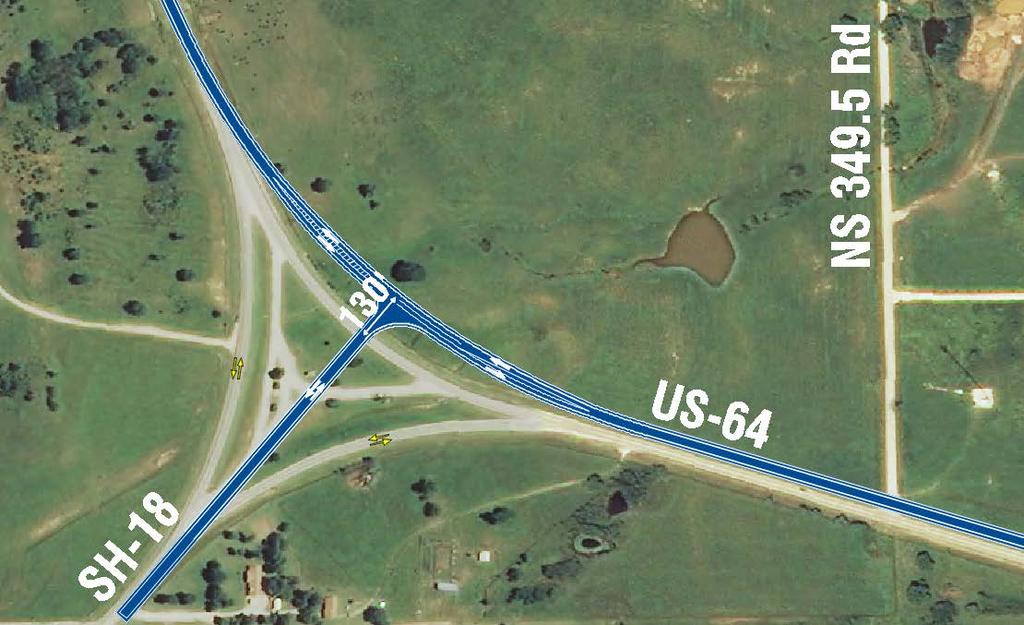
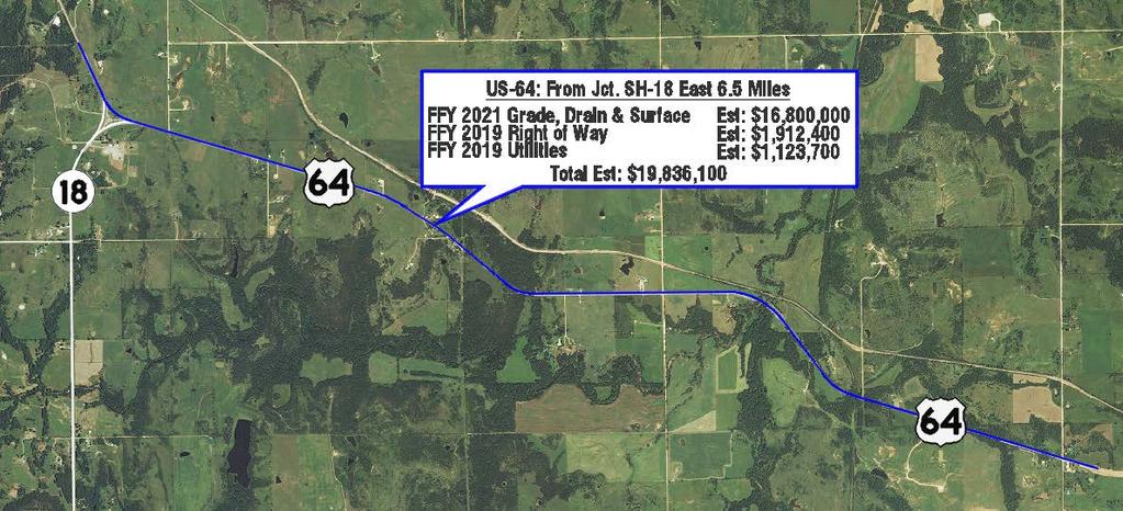
WELCOME PUBLIC OPEN HOUSE FOR US-64 FROM THE SH-18 INTERSECTION EAST 6.5 MILES JANUARY 10TH, 2017 PAWNEE CITY HALL, 5:30 PM
|
|
|
- Audrey Miller
- 5 years ago
- Views:
Transcription

1 WELCOME PUBLIC OPEN HOUSE FOR US-64 FROM THE SH-18 INTERSECTION EAST 6.5 MILES JANUARY 10TH, 2017 PAWNEE CITY HALL, 5:30 PM 1

2 PURPOSE OF THIS OPEN HOUSE Present information about the proposed improvements to this section of US-64 2

3 PURPOSE OF THE PROJECT Improve safety on US-64 by adding shoulders, increasing sight distance and correcting unsafe curves 3


4 CURRENT PROJECT AREA INFORMATION General Data 2-Lane Roadway No Shoulders Steep side slopes Areas of limited sight distance Areas of substandard horizontal and vertical curves 4
5 CURRENT PROJECT AREA INFORMATION Traffic Data Current Traffic (2016): 1,500 Vehicles Per Day Future Traffic (2036): 2,100 Vehicles Per Day 15% Heavy Trucks Collision Data ( ) Total: 28 Documented Accidents 8 Personal Property Damage 19 Injuries 1 Fatality Statewide Collision Rate Comparison (Rate = No. of Collisions per 100 Million Vehicle Miles) Overall Collision US-64 = Statewide = (For similar highways) Fatal Collision US-64 = 3.51 Statewide = 2.96 (For similar highways) Visible Injury US-64 = Statewide = (For similar highways) 5

6 COLLISION DATA 6

7 PROJECT CONSTRAINTS Property Use Residential Structures Commercial Structures Utilities Overhead Electric Underground Communication Lines Underground Water Lines Underground Oil and Gas Pipelines Potential Waters/Wetlands Potential Historical/Archaeological Resources Tribal Trust Property 7

8 PROPOSED IMPROVEMENTS 65 mph design speed Reconstruct substandard horizontal and vertical curves Constructed with 8 shoulders Flatten side slopes for improved safety Extend or replace drainage structures 8
9 ALTERNATIVE ALIGNMENTS SH-18 TO CAMP CREEK Alternative 1 Along Existing Impractical Construction Temporary Roadway Costs 38 Mile Detour Alternative 2 South Offset Crossovers at curves Difficult Construction Temporary Pavement and Easements Increased Construction Cost Increased Utility Relocations Right-of-Way Acquisition Commercial Buildings/Traditional Homes Tribal Trust Property Alternative 3 North Offset Simplified Construction Reduced Construction Cost Fewer Utility Relocations Right-of-Way Acquisition Mobile homes/shop building Tribal Trust Property 9
10 ALTERNATIVE ALIGNMENTS CAMP CREEK TO SKEDEE ROAD Alternative 1 Along Existing Impractical Construction Temporary Roadway 48.7 Mile Detour Alternative 3 North Offset Stream Impacts About 1,500 feet west of Skedee Road Alternative 2 South Offset Crossovers at curve Near old Railroad Crossing Impractical Construction Increased Construction Cost Increased Utility Relocations Alternative 4 Far North Offset (East of Camp Creek) Avoid Stream Impacts Simplified Construction Reduced Construction Cost Minimal Utility Relocations 10

11 OFFSET ALIGNMENT 11

12 OFFSET ALIGNMENT 12

13 OFFSET ALIGNMENT 13

14 SH-18 14

15 CAMP CREEK 15

16 FURTHER NORTH OFFSET AT UNNAMED TRIBUTARY TO CAMP CREEK 16

17 SKEDEE ROAD 17
18 PROJECT IMPACTS Potential Impacts Some acquisition of private property Some farmland loss Some acquisition of tribal trust property Residential and commercial property relocations 18

19 DURING CONSTRUCTION Maintain traffic during construction 19
20 CONSTRUCTION SCHEDULE 20
21 NEXT STEPS Receive comments from public Complete environmental studies document and obtain approval from FHWA Preliminary design Right-of-way acquisition and utility relocation Final design Construction 21
22 THANK YOU! Thank You For Attending Today s Open House For More Information on the Project, Contact David Saulsberry, CPM Division 8 Environmental Project Manager Okla. Dept. of Trans. (405) Environmental Programs DE Okla. Dept. of Trans. 200 NE 21 st Street Oklahoma City, OK (405) ODOT-Environment@odot.org Please submit all comments by Tuesday, January 24 th, 2017 For more information about ODOT Public Meetings, visit Publicmeetings@odot.org 22
EXCEPTION TO STANDARDS REPORT
 EXCEPTION TO STANDARDS REPORT PROJECT DESCRIPTION AND NEED The project is located in Section 6, Township 23 North, Range 9 East and Section 31 Township 24 North, Range 9 East, in the Town of Stockton,
SH 249 IN GRIMES COUNTY. Open House April 3, 2014
 SH 249 IN GRIMES COUNTY Open House April 3, 2014 Meeting Agenda Purpose of Meeting Today: Review the purpose and need for the SH 249 Grimes County project Review the proposed project and alternatives Discuss
US 81 Bypass of Chickasha Environmental Assessment Public Meeting
 US 81 Bypass of Chickasha Environmental Assessment Public Meeting March 14, 2013 Introductions ODOT FHWA SAIC Meeting Purpose Present need for bypass Provide responses to 10/04/11 public meeting comments
FREQUENTLY ASKED QUESTIONS
 THE PROJECT Last updated on 9/8/16 FREQUENTLY ASKED QUESTIONS What s happening on Highway 169? The Minnesota Department of Transportation (MnDOT) is planning to rebuild and repair the infrastructure on
FREQUENTLY ASKED QUESTIONS
 THE PROJECT Last updated on 2/19/16 FREQUENTLY ASKED QUESTIONS What s happening on Highway 169? The Minnesota Department of Transportation (MnDOT) is planning to rebuild and repair the infrastructure on
IH 35 FEASIBILITY STUDY
 IH 35 FEASIBILITY STUDY COOKE COUNTY, TEXAS February 1, 2007 Prepared by: Carter & Burgess, Inc. For: The Wichita Falls District of the Texas Department of Transportation INDEX I. INTRODUCTION. 3 II. PURPOSE
PUBLIC MEETING. Bear Creek Park Community Center. January 24, :30 pm to 7:30 pm
 PUBLIC MEETING Bear Creek Park Community Center January 24, 2017 5:30 pm to 7:30 pm PURPOSE OF THE MEETING This is an open House No formal presentation Introduce the project to the public Present existing
Public Meeting. SD Highway 28 From US81 W 11 miles through Lake Norden Hamlin County PH 0028(37)329 PCN 04JY
329 PCN 04JY") Public Meeting SD Highway 28 From US81 W 11 miles through Lake Norden Hamlin County PH 0028(37)329 PCN 04JY Neil Schochenmaier, PE Road Design Engineering Supervisor March 16, 2017 Purpose of the Meeting
Public Meeting SD Highway 28 From US81 W 11 miles through Lake Norden Hamlin County PH 0028(37)329 PCN 04JY Neil Schochenmaier, PE Road Design Engineering Supervisor March 16, 2017 Purpose of the Meeting
VIADUCT LOCATION STUDY. October 19, 2009
 VIADUCT LOCATION STUDY October 19, 2009 Background Information Traffic Study Alternative Evaluation Public Involvement Preferred Concept Next Steps Evaluate alternatives for the location of a viaduct to
COUNTY ROAD SPEED LIMITS. Policy 817 i
 Table of Contents COUNTY ROAD SPEED LIMITS Policy 817.1 PURPOSE... 1.2 APPLICABILITY... 1.3 DEFINITIONS... 1.4 STATE ENABLING LEGISLATION... 2.5 SPEED LIMITS ON COUNTY ROADS (CCC 11.04)... 2.6 ESTABLISHING
Characterization of Combined Use of County Road Segment
 Department of Public Works Inyo County, California Characterization of Combined Use of County Road Segment Segment Name: _Lone Pine No. 1_ Purpose: Which of the following does the combined-use segment
Highway 18 BNSF Railroad Overpass Feasibility Study Craighead County. Executive Summary
 Highway 18 BNSF Railroad Overpass Feasibility Study Craighead County Executive Summary October 2014 Highway 18 BNSF Railroad Overpass Feasibility Study Craighead County Executive Summary October 2014 Prepared
Purpose and Need Report
 Purpose and Need Report State Highway (SH) 29 From Southwestern Boulevard to SH 95 Williamson County, Texas (CSJ: 0337-02-045) Prepared by Blanton & Associates, Inc. Date: November, 2015 The environmental
Rolling Road (Route 638) Widening Project
 Widening Project") Rolling Road (Route 638) Widening Project From: 0.369 Mile North of Fairfax County Parkway (Route 286) To: Old Keene Mill Road (Route 644) State Project No. 0638-029-156, P104, R204, C504; UPC 5559 Public
Rolling Road (Route 638) Widening Project From: 0.369 Mile North of Fairfax County Parkway (Route 286) To: Old Keene Mill Road (Route 644) State Project No. 0638-029-156, P104, R204, C504; UPC 5559 Public
STH 60 Northern Reliever Route Feasibility Study Report
 #233087 v3 STH 60 Northern Reliever Route Feasibility Study Report Washington County Public Works Committee Meeting September 28, 2016 1 STH 60 Northern Reliever Route Feasibility Study Hartford Area Development
PUBLIC INFRASTRUCTURE PROJECTS
 PUBLIC INFRASTRUCTURE PROJECTS FM 664 / OVILLA ROAD WIDENING & IMPROVEMENTS FM 664 / OVILLA ROAD CONNECTS US 287 WITH I-45 (SOURCE: TEXAS DEPARTMENT OF TRANSPORTATION. 2016 FM 664 / OVILLA ROAD WIDENING
MAP OR PHOTO. Public Meeting & Open House July 23, Project Roadway Limits From: FM 1957 To: FM 471. Counties Bexar & Medina
 Public Meeting & Open House July 23, 2013 Project Roadway Limits From: FM 1957 To: FM 471 MAP OR PHOTO Counties Bexar & Medina 1 I. Project History II. III. IV. Project Overview Project Alternatives Response
TRAFFIC DEPARTMENT 404 EAST WASHINGTON BROWNSVILLE, TEXAS City of Brownsville Speed Hump Installation Policy
 A. GENERAL Speed humps are an effective and appropriate device for safely reducing vehicle speeds on certain types of streets when installed accordance with the provisions of this policy. In order for
The Design-Builder shall meet local road criteria provided by the local governing agencies.
 11 ROADWAYS 11.1 General The -Builder shall conduct all Work necessary to meet the requirements of roadways. Roadway classifications include mainline, acceleration lanes, deceleration lanes, auxiliary
COUNTY ROAD SPEED LIMITS. Policy 817 i
 Table of Contents COUNTY ROAD SPEED LIMITS Policy 817.1 PURPOSE... 2.2 APPLICABILITY... 2.3 DEFINITIONS... 2.4 STATE ENABLING LEGISLATION... 3.5 SPEED LIMITS ON COUNTY ROADS (CCC 11.04)... 3.6 ESTABLISHING
IMPROVEMENT CONCEPTS
 IMPROVEMENT CONCEPTS for the South Novato Transit Hub Study Prepared by: January 11, 2010 DKS Associates With Wilbur Smith Associates IMPROVEMENT CONCEPTS Chapter 1: Introduction 1. INTRODUCTION The strategic
STATE ND PROJECT NO. CP 0883 (14) & CP 1152 (14) SHEET NO. TOTAL SHEETS 9 31 SIGN NUMBER SIGN SIZE DESCRIPTION AMOUNT REQUIRED UNITS PER AMOUNT UNITS
 & CP 1152 (14) SHEET NO. TOTAL SHEETS 9 31 SIGN NUMBER SIGN SIZE DESCRIPTION AMOUNT REQUIRED UNITS PER AMOUNT UNITS") STATE ND PROJECT NO. CP 0883 (14) & CP 1152 (14) SHEET NO. TOTAL SHEETS 9 31 SIGN NUMBER SIGN SIZE DESCRIPTION AMOUNT REQUIRED UNITS PER AMOUNT UNITS SUB TOTAL SIGN NUMBER SIGN SIZE DESCRIPTION AMOUNT
STATE ND PROJECT NO. CP 0883 (14) & CP 1152 (14) SHEET NO. TOTAL SHEETS 9 31 SIGN NUMBER SIGN SIZE DESCRIPTION AMOUNT REQUIRED UNITS PER AMOUNT UNITS SUB TOTAL SIGN NUMBER SIGN SIZE DESCRIPTION AMOUNT
Construction Noise Memorandum
 Construction Noise Memorandum To: Ms. Paula Daneluk Date: June 13, 2013 Development Impact 9370 Studio Court, Suite 160 Elk Grove, CA 95758 From: Paul Bollard Bollard Acoustical Consultants, Inc. 3551
June WASHINGTON STATE DEPARTMENT OF TRANSPORTATION Alaskan Way Viaduct and Seawall Replacement Program Seattle, Washington
 DESIGN DEVIATION NOs. 1 & 2 Horizontal Stopping Sight Distance and Shoulder Width Reduction SR 99 S. Holgate St to S. King St. Viaduct Replacement Stage 2 MP 29.89 TO MP 30.78 XL-3237 PIN-809936D June
Request for Design Exception (#1) S.M. Wright Phase IIB
 S.M. Wright Phase IIB") Request for Design Exception (#1) S.M. Wright Phase IIB County: Dallas CSJ s: 0092-01-059, 0092-14-088 Project Limits: From Pennsylvania Avenue to North of Al Lipscomb Way Date: June 28, 2016 Proposed
Request for Design Exception (#1) S.M. Wright Phase IIB County: Dallas CSJ s: 0092-01-059, 0092-14-088 Project Limits: From Pennsylvania Avenue to North of Al Lipscomb Way Date: June 28, 2016 Proposed
City of Houston Fondren Road Paving and Drainage
 City of Houston Fondren Road Paving and Drainage From Braeswood Boulevard to Creekbend Drive TRC Meeting March 2016 Location and Vicinity Maps City Council District K Key Map 530 Z, 530 Y Land Use Commercial
Public Meeting Summary And Responses to Comments
 Public Meeting Summary And Responses to Comments Oklahoma Department of Transportation From 209 th E. Avenue to Franklin Road Rogers County, JP 27031(04) Prepared by: 6450 S. Lewis Ave., Suite 300 Tulsa,
2 Min. Min. Edge of. Edgeline See Note 3 PLAN VIEW. See Note 3. This distance may vary
 8" Physical gore ( ) ( ) 250 Varies 250 TYPICAL RUMBLE STRIP PLACEMENT AT EXIT AND ENTRANCE RAMPS This distance may vary This distance may vary ( ) 2 16" edge of R=12" Max ( ) Physical gore Texturing 1.
Brent Spence Bridge Design Exceptions - Alternative I
 s - Alternative I ITERCHAGE umber Existing Reason(s) For Potential Impact(s) to Eliminate s Potential Mitigation Solutions CURVE O. 5 PI Sta. 24+98.87 Y 1 57 mph (60) 526' (570') 44 mph The line of sight
Over-Dimensional Vehicle Restriction Study for US 129 in TN
 Over-Dimensional Vehicle Restriction Study for US 129 in TN July 30,2015 TDOT Region 1 US 129 Location Map US 129 Topography and Scenery Operational and Safety Study August 2014, US129 Operational and
Brigham City 1200 West Box Elder Creek Bridge - Widening Project Type Reconstruction
 Brigham City 1200 West Box Elder Creek Bridge - Widening Project Type Reconstruction 550 North to 650 North $ 1,750,000 $ 1,582,113 To widen an existing bridge on 1200 West over Box Elder Creek that will
Final Series of Public Meetings
 Final Series of Public Meetings Public Meeting Locations City Date Jasper Monday, September 26 Livingston Tuesday, September 27 Huntsville Wednesday, September 28 Bryan Thursday, September 29 Eldorado
Corridor Sketch Summary
 Corridor Sketch Summary SR 241: I-82 Jct (Sunnyside) to SR 24 Jct Corridor Highway No. 241 Mileposts: 7.53 to 25.21 Length: 17.65 miles Corridor Description The seventeen and one-half mile corridor begins
800 Access Control, R/W Use Permits and Drive Design
 Table of Contents 801 Access Control... 8-1 801.1 Access Control Directives... 8-1 801.2 Access Control Policies... 8-1 801.2.1 Interstate Limited Access... 8-1 801.2.2 Limited Access... 8-1 801.2.3 Controlled
Rocky Mount. Transportation Plan. Transportation Planning Division. Virginia Department of Transportation
 2020 Transportation Plan Developed by the Transportation Planning Division of the Virginia Department of Transportation in cooperation with the U.S. Department of Transportation, Federal Highway Administration
Tulsa Transportation Management Area. Urbanized Area Surface Transportation Program
 Tulsa Transportation Management Area Urbanized Area Surface Transportation Program FFY 2022 Application Information Sponsor Location Description STP Request Other Funds Broken Arrow Elm Place: Kenosha
PLEASE SUBMIT THE CORRECT PERMIT FEE WITH PAGES 1 & 3 OF APPLICATION TO: OCONTO COUNTY HIGHWAY DEPT, P.O. BOX 138, OCONTO, WI 54153
 PLEASE SUBMIT THE CORRECT PERMIT FEE WITH PAGES 1 & 3 OF APPLICATION TO: OCONTO COUNTY HIGHWAY DEPT, P.O. BOX 138, OCONTO, WI 54153 APPLICATION/PERMIT TO INSTALL ACCESS DRIVEWAY TO A COUNTY TRUNK HIGHWAY
Workshop Agenda. Bransford Roundabout. Bedford Intersection/Roundabout. Section 3 Revisions (Left turn lanes) Roadway Section/Curb Type Discussion
 Roadway Section/Curb Type Discussion") Workshop Agenda Bransford Roundabout Bedford Intersection/Roundabout Section 3 Revisions (Left turn lanes) Roadway Section/Curb Type Discussion Project Phasing Summary of Recommendation Purpose: Provide
Workshop Agenda Bransford Roundabout Bedford Intersection/Roundabout Section 3 Revisions (Left turn lanes) Roadway Section/Curb Type Discussion Project Phasing Summary of Recommendation Purpose: Provide
U.S. 81 Realignment Around Chickasha, Oklahoma Benefit-Cost Analysis Narrative
 U.S. 81 Realignment Around Chickasha, Oklahoma Benefit-Cost Analysis Narrative Introduction U.S. 81 is part of the National Highway System. It runs north-south, from Texas to the Canadian border and passes
Engineering Report: Shasta-Trinity National Forest. Shasta McCloud Management Unit. Analysis of. National Forest System Road 37N79
 Engineering Report: Shasta-Trinity National Forest Shasta McCloud Management Unit Analysis of National Forest System Road 37N79 (milepost 0.56 to 2.28) for Motorized Mixed Use Designation Forest: Shasta-Trinity
APPENDIX A Basis of Design and Design Criteria Memorandum
 APPENDIX A Basis of Design and Design Criteria Memorandum Job No: Y01-500 Files are stored in: Engineering / Client / Yolo/Y01500 Buckeye and Rumsey/Rumsey CR 41 over Cache Creek, CAD files stored in:
PERFORMANCE ACTIVITY 603 SIGNS
 PERFORMANCE ACTIVITY 603 SIGNS WORK DESCRIPTION 3 WORK DESCRIPTION 4 WORK DESCRIPTION 6 New Install Maintenance / Replace Temporary 603 SIGNS ACTIVITY DESCRIPTION Install new signs and maintain and replace
Interstate Drive Extension
 Interstate Drive Extension Sponsor County Highway Project No. RB19-000004 Project Type New Road TOTAL FUNDING Total County Sponsor Federal $2,700,000.00 $2,150,000.00 Project Description This project continues
APPENDIX C. Existing Utilities
 APPENDIX C Existing Utilities THIS PAGE INTENTIONALLY BLANK Existing Utilities Numerous utilities exist within the project area, including natural gas, sewer, water, electric, communications, and street
1. INTRODUCTION 2. PROJECT DESCRIPTION CUBES SELF-STORAGE MILL CREEK TRIP GENERATION COMPARISON
 CUBES SELF-STORAGE MILL CREEK TRIP GENERATION COMPARISON 1. INTRODUCTION This report summarizes traffic impacts of the proposed CUBES Self-Storage Mill Creek project in comparison to the traffic currently
DESIGN STANDARDS SECTION DS 3 STREETS
 DESIGN STANDARDS SECTION DS 3 STREETS DS 3-01 GENERAL: A. INTENT: The intent of these Design Standards is to provide minimum standards for the design of public streets. These standards are intended to
FRESNO COUNTY SUBSECTION OF THE CALIFORNIA HIGH- SPEED TRAIN (HST)
") FRESNO COUNTY SUBSECTION OF THE CALIFORNIA HIGH- SPEED TRAIN (HST) The Fresno County subsection of the California High- Speed Train System (HST) is analyzed in two separate EIR/EISs the Merced-Fresno EIR/EIS
FRESNO COUNTY SUBSECTION OF THE CALIFORNIA HIGH- SPEED TRAIN (HST) The Fresno County subsection of the California High- Speed Train System (HST) is analyzed in two separate EIR/EISs the Merced-Fresno EIR/EIS
OPEN HOUSE PUBLIC INVOLVEMENT MEETING. Stark County Garage Ohio Department of Transportation 4505 Atlantic Boulevard, Canton, OH 44705
 OPEN HOUSE PUBLIC INVOLVEMENT MEETING Stark County Garage Ohio Department of Transportation 4505 Atlantic Boulevard, Canton, OH 44705 Thursday, December 10, 2015 5:00 p.m. to 7:00 p.m. US 62 (Atlantic
The Eastern Connector Study November, 2007 planning for the future
 The Eastern Connector Study November, 2007 planning for the future In late 2006, Albemarle County and the City of Charlottesville jointly initiated the Eastern Connector Corridor Study. The Project Team
Stormwater and sanitary sewer lines 8 inches in diameter or greater
 3.8 UTILITIES 3.8.1 Affected Environment This section describes the utility crossings and utilities located in the vicinity of the Preferred Alternative. The utilities include electricity, communication,
DRIVEWAY STANDARDS EXHIBIT A. The following definition shall replace the definition of driveway in Section 62:
 1365 S. Camino del Rio Durango, CO 81303 970-382-6363 DRIVEWAY STANDARDS Resolution 2014-40 EXHIBIT A The following definition shall replace the definition of driveway in Section 62: Driveway means a roadway,
Turnpike Mitigation Program Application
 Ohio Department of Transportation - Ohio Turnpike Infrastructure Commission Turnpike Mitigation Program Application The application has been improved to enable project sponsors to save the application
Figure 1 Map of intersection of SR 44 (Ravenna Rd) and Butternut Rd
 and Butternut Rd") Abbreviated Study District: 12 County: Geauga Route: SR 44 Section: 1.58 GEA 44 1.58 213 HSP # 47 (Rural Intersection) Prepared April 23, 215 By Bryan Emery Existing Conditions This study contains the
Abbreviated Study District: 12 County: Geauga Route: SR 44 Section: 1.58 GEA 44 1.58 213 HSP # 47 (Rural Intersection) Prepared April 23, 215 By Bryan Emery Existing Conditions This study contains the
Turnpike Mitigation Program Application
 Ohio Department of Transportation & Ohio Turnpike and Infrastructure Commission Turnpike Mitigation Program Application Please note the following eligibility criteria: 1) Projects must be sponsored by
Slow Down! Why speed is important in realizing your Vision Zero goals and how to achieve the speeds you need
 Slow Down! Why speed is important in realizing your Vision Zero goals and how to achieve the speeds you need Lake McTighe, METRO Joel McCarroll, ODOT Jenna Marmon, ODOT Matt Ferris-Smith, PBOT Oregon Active
CROW WING COUNTY HIGHWAY DEPARTMENT APPLICATION FOR PERMIT TO CONSTRUCT DRIVEWAY ACCESS TO ROADS UNDER COUNTY JURISDICTION CONSTRUCTION INFORMATION
 CROW WING COUNTY HIGHWAY DEPARTMENT APPLICATION FOR PERMIT TO CONSTRUCT DRIVEWAY ACCESS TO ROADS UNDER COUNTY JURISDICTION Crow Wing County Highway Department 16589 CR 142 Brainerd, MN 56401 Crow Wing
CITY OF POWAY MEMORANDUM
 CITY OF POWAY MEMORANDUM TO: FROM: Traffic Safety Committee Steve Crosby P.E., City Engineer DATE: February 14, 2018 SUBJECT: Espola Road speeding concerns BACKGROUND In 2017, staff received a request
WOLVERINE TO BHP JANSEN NEW TRANSMISSION LINE PROJECT FALL 2017
 WOLVERINE TO BHP JANSEN NEW TRANSMISSION LINE PROJECT FALL 2017 TODAY WE LL TALK ABOUT Our challenges and how we re meeting them Why we re building this project Our planning process and considerations
YELM HWY AND MERIDIAN RD INTERSECTION IMPROVEMENTS PROJECT CONTEXT
 PROJECT CONTEXT 510 Hicks L A C E Y Mullen Rd SE Thurston County Fairgrounds Rd SE Carpenter Long Woodland Elementary Rd SE Marvin Old Paci c H w y 510 Reservation Rd SE Nisqually Indian Community Nis
Lake County Building Department
 Lake County Building Department P.O. Box 513 505 Harrison Avenue Leadville, CO 80461 (719) 486-2875 Fax (719) 486-4179 Driveway Permit (Resolutions 98-15 and 98-35) PERMIT: To connect a driveway or parking
1400 MISCELLANEOUS Traffic Engineering Manual
 TABLE OF CONTENTS Part 14 - MISCELLANEOUS 1400 GENERAL... 14-3 1415 RUMBLE STRIPS (INCLUDING STRIPES) IN THE ROADWAY... 14-4 1415-1 General... 14-4 1415-2 Transverse Rumble Strips... 14-4 1415-2.1 General...
ODOT Transportation Safety. It All Starts With Crash Data
 ODOT Transportation Safety Programs It All Starts With Crash Data Robin Ness, Mgr. Crash Analysis & Reporting Unit Oregon Department of Transportation (ODOT) 17 th Annual Northwest Tribal Symposium Red
SPEED CUSHION POLICY AND INSTALLATION PROCEDURES FOR RESIDENTIAL STREETS
 SPEED CUSHION POLICY AND INSTALLATION PROCEDURES FOR RESIDENTIAL STREETS CITY OF GRAND PRAIRIE TRANSPORTATION SERVICES DEPARTMENT SPEED CUSHION INSTALLATION POLICY A. GENERAL Speed cushions are an effective
SH 249 PUBLIC MEETING DESIGN CHANGES FROM FM 2920 TO HARDIN STORE ROAD
 SH 249 PUBLIC MEETING DESIGN CHANGES FROM FM 2920 TO HARDIN STORE ROAD Lone Star College, Tomball Campus December 8, 2015 Open House 5:30-7:30 pm National Environmental Policy Act The environmental review,
S. WEST STREET EXTENSION ALTERNATIVES STUDY
 S. West Street Extension Alternatives Study THE CITY OF RALEIGH, NC MULTIMODAL TRANSIT CENTER REPORT ADDENDUM S. WEST STREET EXTENSION ALTERNATIVES STUDY SUMMARY The Raleigh Multimodal Transportation Center(MTC)
Access Management Standards
 Access Management Standards This section replaces Access Control Standards on Page number 300-4 of the Engineering Standards passed February 11, 2002 and is an abridged version of the Access Management
Public Information Workshop
 Public Information Workshop Charlotte County-Punta Gorda MPO - Meeting Rooms A and B March 29, 2018 Welcome to the Public Information Workshop for Harborview Road Project Development and Environment (PD&E)
STATE LOOP 195 PUBLIC MEETING. Footer Text
 STATE LOOP 195 PUBLIC MEETING STATE LOOP 195 From FM 755 to 1 mile west of Loma Blanca Rd Public Meeting Agenda Welcome & Introductions Octavio Saenz TxDOT Public Information Officer Technical Overview
REVIEW OF THE DRAFT 2011 VA WORK AREA PROTECTION MANUAL. December 14, 2010 David Rush VDOT WZS Program Manager
 REVIEW OF THE DRAFT 2011 VA WORK AREA PROTECTION MANUAL December 14, 2010 David Rush VDOT WZS Program Manager Manual on Uniform Traffic Control Devices (MUTCD) Released in December 2009 States have until
Challenges in a Post-Katrina Environment East-West Corridor Project Overview February, 2007
 EAST-WEST CORRIDOR Challenges in a Post-Katrina Environment East-West Corridor Project Overview February, 2007 Presentation Agenda Project Overview / Purpose and Need Highway Component Transit Component
NCDOT Report on Improving Safety on Secondary Roads
 April 8, 2016 NCDOT Report on Improving Safety on Secondary Roads Kevin Lacy, PE, State Traffic Engineer Overview Crash data and Safety Performance on Secondary Roads Driver Behavior Roadway Environment
Undergrounding Utilities on Grandview Ave.
 j January 8, 2015 Undergrounding Utilities on Grandview Ave. Why? Every few years Xcel Energy comes down Grandview and reshapes everyone's trees on the north side of the street to keep them away from the
New Jersey Turnpike Authority Interchange 6 to 9 Widening Program
 New Jersey Turnpike Authority Interchange 6 to 9 Widening Program Tuesday, September 18, 2007 Public Hearings: Time: 5:00 PM - 8:00 PM Wednesday, September 19, 2007 Senior Center 3 Municipal Drive Bordentown,
Engineering Report: Shasta-Trinity National Forest. South Fork Management Unit. Analysis of. National Forest System Road 30N44
 Engineering Report: Shasta-Trinity National Forest South Fork Management Unit Analysis of National Forest System Road 30N44 (milepost 0.00 to 0.40) for Motorized Mixed Use Designation Forest: Shasta-Trinity
Exposition Corridor Transit Project
 Exposition Corridor Transit Project Phase 2 Environmental Planning Community Meeting June 9, 2008 Exposition Corridor Transit Project Phase 2 AGENDA Remaining Grade Crossing Recommendations June 9, 2008
Traffic, Transportation & Civil Engineering Ali R. Khorasani, P.E. P.O. Box 804, Spencer, MA 01562, Tel: (508)
") Associates Traffic, Transportation & Civil Engineering Ali R. Khorasani, P.E. P.O. Box 804, Spencer, MA 01562, Tel: (508) 885-5121 Ms. Teri Ford, Associate 800 Boylston Street, Suite 1570 Boston, MA July
Associates Traffic, Transportation & Civil Engineering Ali R. Khorasani, P.E. P.O. Box 804, Spencer, MA 01562, Tel: (508) 885-5121 Ms. Teri Ford, Associate 800 Boylston Street, Suite 1570 Boston, MA July
Western ND Meeting. February 19, 2014 Grant Levi, NDDOT Director
 Western ND Meeting February 19, 2014 Grant Levi, NDDOT Director 1 Traffic Trends in North Dakota 2 Truck Traffic 2008 3 Truck Traffic 2012 4 Average Daily Traffic 5 ND Vehicle Miles Traveled Statewide
BOARD OF SUPERVISORS BUSINESS MEETING ACTION ITEM. Design Endorsement for Sterling Boulevard Extension
 Date of Meeting: July 20, 2017 # 6 BOARD OF SUPERVISORS BUSINESS MEETING ACTION ITEM SUBJECT: ELECTION DISTRICT: CRITICAL ACTION DATE: STAFF CONTACTS: Design Endorsement for Sterling Boulevard Extension
This corridor section will carry commuter trains from Portland to Longview/Kelso, CHSR inter-city and inter-city express trains.
 Alignment is double tracked for 186 mph speeds. This corridor section will carry commuter trains from Portland to Longview/Kelso, CHSR inter-city and inter-city express trains. BNSF right-of-way will be
Wentzville Parkway South Phase 2 & 2A
 Wentzville Parkway South Phase 2 & 2A Sponsor Wentzville Project No. RB18-000034 Project Type New Road TOTAL FUNDING Phase 2 Total County Sponsor Federal $10,000,000 $8,000,000 $2,000,000 $0 Phase 2A Total
CITY OF TORRANCE PUBLIC WORKS DEPARTMENT ENGINEERING DIVISION INFRASTRUCTURE UPDATE
 CITY OF TORRANCE PUBLIC WORKS DEPARTMENT ENGINEERING DIVISION INFRASTRUCTURE UPDATE TUESDAY, DECEMBER 5, 2017 1 DISCUSSION TOPICS Update of Infrastructure Action Plan (IAP) o Sidewalk and Roadway projects
ANDERSON PROPERTY SITE ANALYSIS
 ANDERSON PROPERTY SITE ANALYSIS Introduction The Montgomery County Department of Transportation (MCDOT) initiated a feasibility study in the fall of 2012 to evaluate the need for transit service expansion
Open House. Highway212. Meetings. Corridor Access Management, Safety & Phasing Plan. 5:30 to 6:30 p.m. - Southwest Corridor Transportation Coalition
 Welcome Meetings 5:30 to 6:30 p.m. - Southwest Corridor Transportation Coalition 6:30 to 8:00 p.m. - Open House Why is Highway 212 Project Important? Important Arterial Route Local Support Highway 212
Clearlake Road (State Road 501) Project Development & Environment (PD&E) Study
 Project Development & Environment (PD&E) Study") Clearlake Road (State Road 501) Project Development & Environment (PD&E) Study FROM MICHIGAN AVENUE TO INDUSTRY ROAD BREVARD COUNTY, FLORIDA Financial Project ID No: 433605-1-22-01 Federal Aid Project
Clearlake Road (State Road 501) Project Development & Environment (PD&E) Study FROM MICHIGAN AVENUE TO INDUSTRY ROAD BREVARD COUNTY, FLORIDA Financial Project ID No: 433605-1-22-01 Federal Aid Project
West Broadway Reconstruction/LRT Design. March 19, 2015
 West Broadway Reconstruction/LRT Design March 19, 2015 1 Meeting Agenda 6:05 6:30 PM Brief presentation What we heard Project overview 6:30 8:00 PM Visit Six Topic Areas Road and LRT design elements Pedestrian
Maintaining Pavement Marking Retroreflectivity
 Supplemental Notice of Proposed Amendment: Maintaining Pavement Marking Retroreflectivity Kyle Armstrong, P.E., PTOE Acting Engineer of Traffic Operations https://safety.fhwa.dot.gov/ Rule Making Process
Section 6H.01 Typical Applications
 December 27, 2010 Draft Page 6H-1 Section 6H.01 Typical Applications Support: 01 Whenever the acronym TTC is used in this Chapter, it refers to temporary traffic control. 02 The needs and control of all
TRAFFIC CALMING PROGRAM
 TRAFFIC CALMING PROGRAM PROGRAM BASICS Mount Pleasant Transportation Department 100 Ann Edwards Lane Mt. Pleasant, SC 29465 Tel: 843-856-3080 www.tompsc.com The Town of Mount Pleasant has adopted a traffic
RTID Travel Demand Modeling: Assumptions and Method of Analysis
 RTID Travel Demand Modeling: Assumptions and Method of Analysis Overall Model and Scenario Assumptions The Puget Sound Regional Council s (PSRC) regional travel demand model was used to forecast travel
SC Highway 41 Existing Conditions
 SC Highway 41 Existing Conditions Existing Typical Cross Section purposes only and does not replace the required NEPA process necessary for alignment The NEPA process is anticipated to begin in the next
Location Concept Plan Amendment Recommendation Approved 2011 Concept Plan
 Valley Line West LRT Concept Plan Recommended Amendments Lewis Farms LRT Terminus Site Location Concept Plan Amendment Recommendation Approved 2011 Concept Plan Lewis Farms LRT terminus site, 87 Avenue/West
Due Diligence Review of Proposed Roads Pavement Rehabilitation in Baiyin District. PRC: Gansu Baiyin Urban Development Project
 Resettlement Planning Document Addendum to the Resettlement Plan Document Stage: Final Project Number: 40051 May 2011 Due Diligence Review of Proposed Roads Pavement Rehabilitation in Baiyin District Under
CHAPTER 15 STREET LIGHTING TABLE OF CONTENTS
 CHAPTER 15 STREET LIGHTING TABLE OF CONTENTS Section Title Page 15.1 General... 15-1 15.1.1 Fort Collins (City Limits Only) Street Lighting...15-1 15.1.2 Loveland (City Limits Only) Street Lighting...15-1
SKIFFES CREEK CONNECTOR STUDY
 SKIFFES CREEK CONNECTOR STUDY ALTERNATIVES ANALYSIS TECHNICAL REPORT JUNE 2018 SKIFFES CREEK CONNECTOR STUDY Alternatives Analysis Technical Report James City County Project Number: 0060047627, P101, R201,
Benefit-Cost Analysis Technical Memo
 I-40 Douglas Boulevard Interchange Reconstruction and Related Widening Oklahoma County, OKLAHOMA INFRA Grant Application Benefit-Cost Analysis Technical Memo November 2017 Submitted by: Oklahoma Department
Guam Transportation Program Project Updates. Joanne M.S. Brown Director Carl Dominguez Deputy Director February 6, 2012
 Guam Transportation Program Project Updates Joanne M.S. Brown Director Carl Dominguez Deputy Director February 6, 2012 Agenda Road Construction Highlights Ongoing Construction Route 17 Rehabilitation and
Traffic Engineering Study
 Traffic Engineering Study Bellaire Boulevard Prepared For: International Management District Technical Services, Inc. Texas Registered Engineering Firm F-3580 November 2009 Executive Summary has been requested
CITY OF PORTSMOUTH DEPARTMENT OF PUBLIC WORKS (DPW) DRIVEWAY RULES AND PROCEDURES
 DRIVEWAY RULES AND PROCEDURES") CITY OF PORTSMOUTH DEPARTMENT OF PUBLIC WORKS (DPW) DRIVEWAY RULES AND PROCEDURES The purpose of a driveway permit is to secure access from a private property to the public right-of-way. It is required
CITY OF PORTSMOUTH DEPARTMENT OF PUBLIC WORKS (DPW) DRIVEWAY RULES AND PROCEDURES The purpose of a driveway permit is to secure access from a private property to the public right-of-way. It is required
Dockless Micromobility Regulatory Framework
 Dockless Micromobility Regulatory Framework Transportation and Municipal Infrastructure Committee February 5, 2019 Dockless Micromobility was introduced at the January 8 th committee meeting TMI committee
Plan Check Policies and Guidelines
 VIII. TRAFFIC SIGNING AND STRIPING PLANS A. INTRODUCTION Traffic signing and striping plans are required for all General Plan Roads and any roadway that is 56-foot wide curb-to-curb (78 R/W) or wider.