IH 35 FEASIBILITY STUDY
|
|
|
- Debra Williams
- 5 years ago
- Views:
Transcription


1 IH 35 FEASIBILITY STUDY COOKE COUNTY, TEXAS February 1, 2007 Prepared by: Carter & Burgess, Inc. For: The Wichita Falls District of the Texas Department of Transportation
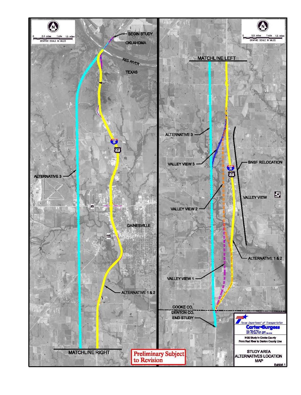
2 INDEX I. INTRODUCTION. 3 II. PURPOSE AND NEED 3 III. ALTERNATIVES ANALYSIS A. No Build.. 4 B. Alternative C. Alternative D. Alternative E. Valley View Alternatives... 5 F. BNSF Relocation IV. ALTERNATIVE EVALUATION SUMMARY V. PUBLIC INPUT VI. RECOMMENDATION... 7 VII. APPENDIX... 8 A. Study Area Alternatives Location Map B. Summary of Crashes C. Evaluation Matrix D. Alternative Typical Sections 12 2
3 IH 35 Feasibility Study I. INTRODUCTION The Texas Department of Transportation (TxDOT) has contracted with Carter & Burgess, Inc. (C&B) to study needed improvements to Interstate Highway 35 (IH 35) in Cooke County. The purpose of the study is to assess the feasibility of improvements required to upgrade IH 35 to current design standards and provide for future traffic needs (2030). The study area limits are from the Texas/Oklahoma border to the Cooke/Denton County line which is approximately twenty-two miles. II. PURPOSE AND NEED IH 35 is the primary north-south transportation route through the state of Texas. Recent population and economic growth have strained the aging facility. In 2005, 42,000 cars per day utilized IH 35 through Cooke County. The current traffic projections indicate that by 2030 the traffic will almost double to 80,000+ cars per day. In Denton County, traffic modeling numbers indicate these numbers are accurate. To meet this demand, a minimum increase from two to three lanes in each direction will be required. Insufficient capacity is not the only challenge IH 35 faces; the existing horizontal and vertical geometry does not meet current standards for a 70 mph design speed and the existing infrastructure will start needing rehabilitation. There are two mainlane centerline curves that have substandard radii. The first is a curve just south of California Street in the City of Gainesville that has a radius of 1885 feet, which only meets a 65 mph design speed. The second is a curve just south of the Red River and it has a radius of 1400 feet, which only meets 60 mph. The reverse curves at the Denton County line conform to design standards, but only meet the minimum required radius. According to TxDOT accident records, approximately 32 accidents have occurred in the vicinity of these curves since In addition, the tangent length between the curves at FM 372 is 31 feet above the minimum for a broken back curve. Twelve of the 32 accidents occurred in this specific area. Several of the intersections and interchanges in the study area have outdated configurations including ramps of inadequate length. The jug handle configurations north of Hockley Creek Road, County Road 218 and FM 1202 are the result of antiquated two-way frontage road operation. Neither this intersection design nor short ramps safely support high-speed traffic movements. Short ramps do not provide adequate distance for comfortable acceleration onto the mainlanes and deceleration onto the frontage roads. The IH 35 mainlane pavement through Cooke County from the City of Gainesville to the Red River is aged. The mainlanes were constructed in 1950s and before have been overlaid several times with asphalt. The pavement from the City of Gainesville to the Denton County line is approximately 20 years old. This pavement is in relatively good condition, but is expected to require rehabilitation in the next 10 to 15 years. 3
4 III. ALTERNATIVES ANALYSIS A. No Build The No Build alternative is the alternative against which all of the other alternatives are compared. The No Build alternative includes already programmed improvements such as reconstruction of the US 82 interchange, which has already gone through the TxDOT letting process. Construction is expected to be complete by The No Build alternative cost as presented in the Alternative Evaluation Summary includes the cost of major rehabilitation of existing IH35. The cost includes no additional major transportation improvements in the study area. This alternative may be selected as preferred if none of the other alternatives prove feasible through the alternative evaluation process. B. Alternative 1 The proposed roadway typical section for Alternative 1 has six twelve-foot travel lanes (three lanes in each direction) and ten-foot shoulders with a fixed concrete barrier in the median. Alternative 1 includes two, twelve-foot lane continuous one-way frontage roads with three lane frontage roads through Gainesville. The alignment of this alternative generally follows existing IH 35. Existing right-of-way (ROW) is utilized except in cases where the existing alignment does not meet current design criteria or where interchange improvements are required. C. Alternative 2 Alternative 2 is a six-lane roadway much like Alternative 1, which follows the existing IH 35 alignment. However, in addition to a fixed concrete barrier between northbound and southbound traffic, there is a grassy median wide enough to accommodate a future fourth lane in each direction. The future fourth lane in Alternative 2 allows for the continuation of the planned fourth lane through Denton County. Frontage roads identical to those in Alternative 1 are included in Alternative 2. D. Alternative 3 Alternative 3 is a six-lane (three in each direction) roadway with a grassy median wide enough to accommodate future expansion. Instead of following the existing IH 35 alignment, this alternative is on a completely new location west of existing IH 35. Because it is on a new location, the alignment is void of the many curves on the existing alignment. Enough ROW would be acquired for future frontage roads, but they are not included in the typical section for this alternative. An additional $27 million would be required to build continuous frontage roads along Alternative 3. Interchanges will be provided at major cross streets, but the main goal of this alternative is moving traffic through the area. Alternative 3 bypasses the City of Valley View and the City of Gainesville. If this alternative were chosen as the preferred alignment, the existing IH 35 through Cooke County would become a Business Route. 4
5 E. Valley View Alternatives Potential ROW impacts through the City of Valley View prompted examination of bypass alternatives. Three alternatives could be used in conjunction with Alternative 1 or 2 that bypass the City of Valley View. All three options have the same typical section as Alternative 3. None of the Valley View bypass Alternatives includes frontage roads. Alternative Valley View 1 follows the alignment of Alternative 3 from the County Line to the Rest Stop where it ties back in to the existing IH 35 alignment. Alternative Valley View 2 moves the IH 35 alignment west approximately one half mile. Alternative Valley View 2 departs from the existing alignment north of Elmgrove Road and stays half a mile west of the existing alignment until it ties back in at the Rest Stop. Alternative Valley View 3 departs from the existing alignment at the County Line and ties back to the existing alignment at the Rest Stop. Alternative 2 and 3 impact Valley View Independent School District (ISD) property. At the request of the school district, these options have been removed from further consideration. The right-of way through the City of Valley View is constrained by the proximity of the Burlington Northern Santa Fe (BNSF) railroad track and the existing northbound frontage road. In addition, the largest industry in the City of Valley View, Alan Ritchey, Inc., is located between the northbound IH 35 frontage road and BNSF railroad. Relocating the IH 35 centerline westward to completely avoid impacts to the east would require significant ROW acquisition including Valley View ISD property. One solution to alleviate this constraint is to relocate a portion of the BNSF railroad track. F. BNSF Relocation The City of Valley View has three at grade railroad crossing locations: FM 922, Krahl Road, and Hockley Creek Road. The crossing at FM 922 is of particular concern. There is only sixty feet between the railroad crossing bars and the IH 35 northbound frontage road intersection with FM 922. Because FM 922 is a major school bus route, this distance is not adequate. A school bus barely fits between the crossing gates and the stop bar, which creates serious safety concerns. Citizens also regularly experience waits in excess of 30 minutes to cross the tracks and have expressed a desire for the project to study the possibility of one or more grade separated crossings of the BNSF railroad. The proposed relocated track would depart from the existing alignment at the Spring Creek crossing which is mile marker The track alignment would be moved to the east approximately 850 feet from its existing location at FM 922. The alignment would continue along a straight path for approximately 4.55 miles until it ties back in to existing near Hockley Creek at mile marker This relocation would allow grade separation of the railroad and FM 922 which would greatly improve safety. The existing railroad ROW would then be used for IH 35 improvements. 5
6 IV. ALTERNATIVE EVALUATION SUMMARY The following is a summary of the alternative evaluation matrix developed to summarize the advantages and disadvantages of each of the alternatives presented at the public meeting. Safety, mobility, ROW impacts, environmental effects and 2006 construction costs were considered in the evaluation criteria. The matrix is located in the Appendix. Alternatives Advantages Disadvantages Cost (millions) No Build Alternative 1 Alternative 2 Alternative 3 Valley View 1 Valley View 2 Valley View 3 BNSF Relocation No new ROW required No major reconstruction Utilizes existing ROW Minimizes ROW width Utilizes existing ROW Allows future expansion Consistent with # of lanes proposed in Denton Co. Supported by the public Moves traffic out of town Straight alignment Better access control Increased safety Minimize disruption during construction Eliminates problems with narrow ROW Provides room to develop to the east Moves traffic out of town Eliminates problems with narrow ROW Provides space for private development Moves traffic out of town Provides space for private development Moves traffic out of town Provide grade separated crossing at FM 922 Increased safety IH 35 expansion space to the east Provides space for private development RR relocation assistance dollars may be available Traffic Congestion Decreased Safety No space for future expansion Requires 8 relocations ROW (acres) $118 0 $ Requires 30+ relocations $ Requires 11+ relocations Requires more ROW acreage Impacts Camp Howze No Frontage Roads Impacts Floodplain Not publicly supported No Frontage Roads Requires 3 relocations Impacts ISD property Impacts Floodplain Not publicly supported No Frontage Roads Impacts ISD property Not publicly supported No Frontage Roads ROW required Cost $ $ $ $ $
7 All construction costs presented in the Alternative Evaluation Summary are based on 2006 TxDOT average unit bid prices. For estimating purposes, agricultural land was valued at $2000 per acre and land within city limits was valued at $20,000 per acre. Frontage roads are only included in the Alternative 1 and 2 cost. If all the alternatives were to include frontage road construction, an additional $27 million would need to be added to Alternative 3 and an additional $18 million would need to be added to each of the Valley View Alternatives. The cost of the No Build Alternative represents the 2006 cost to complete major rehabilitation work on the existing IH 35 roadway. This cost is also included in the Alternative 3 cost because the existing IH 35 roadway would become a Business Route and would still require major rehabilitation. V. PUBLIC INPUT On December 13, 2006, TxDOT held two Stakeholder Meetings, one in the City of Gainesville and one in the City of Valley View. Public officials, affected business owners, church and school representatives, and TxDOT personnel were invited. Thirteen people attended the Gainesville meeting and nine people attended the Valley View meeting. The first public meeting was conducted as an open house. It was held in the City of Gainesville on January 16, A C&B representative greeted attendees at the door and then asked them to sign in. Each attendee was given a project fact sheet and a comment form. Everyone was encouraged to review the exhibits placed on tables around the room and submit their comments in the comment boxes. Texas Department of Transportation personnel and members of the Carter & Burgess Consultant Team were available near the exhibits to answer questions. A PowerPoint presentation documenting the study process was projected onto the screen at the front of the room and seating was available for those interested in watching. One hundred forty people attended and forty comments have been received to date. A large majority support Alternative 2 because the proposed centerline follows the existing alignment and allows room for a future expansion. Several other comments expressed support for smoothing out the IH 35 mainlane centerline curves, minimizing ROW impacts and relocating the railroad. VI. RECOMMENDATION After reviewing all the available data, we recommend Alternative 2 as the preferred alternate. Alternative 2 is preferred by a large majority of the public who expressed their opinions and it is also supported by local public officials. We recommend relocating the BNSF railroad and eliminating all three at-grade railroad crossings. Due to lack of public support, none of the Valley View Alternatives are recommended. Because of anticipated traffic volumes, we recommend all frontage roads operate as one-way. Although one-way operation may require additional structures to allow for turning movements, two-way frontage roads would cause a larger ROW impact and substantially complicate traffic operations. One-way frontage roads are significantly safer than two way frontage roads. Consideration should be given to changing 7
8 frontage road operation to one-way as early in the process as practical, since the interchanges through the project will be rebuilt. One-way operation will allow for much safer traffic control during construction. As a further recommendation, we suggest exceeding the design standards as much as is practical in all cases to provide for a safer roadway. Using desirable 4R standards or better for the design will allow for a safer roadway. However, we do not recommend using 5R standards because the ROW requirements would substantially increase. Conforming to 5R standards would require doubling stopping sight distance, horizontal curve lengths, sag vertical curve K values and quadrupling crest vertical curve K values. An analysis of possible traffic growth reveals that if traffic continues to grow as projected from 2006 to 2030 and beyond to 2050, traffic counts will be in the range of 133,000 ADT in If the DHV of 0.10 is used, traffic will operate at a level of service C with four travel lanes in each direction assuming a split. If current traffic growth does not accelerate beyond 2030, the preferred alternative geometry should accommodate traffic volumes for the next 50 years. 8
9 APPENDIX 9
10 10
11 11
12 EVALUATION MATRIX EVALUATION ALT ALT ALT ALT 1 Leave Move CATEGORY No Build Valley View BNSF BNSF RELOCATIONS PROXIMITY TO DOWNTOWN GOOD GOOD GOOD GOOD GOOD - - NEW RED RIVER BRIDGE NO NO NO NO ROADWAY CURVES POOR GOOD GOOD EXCELLENT DRAINAGE GOOD GOOD GOOD GOOD GOOD GOOD GOOD TERRAIN GOOD GOOD GOOD GOOD GOOD GOOD GOOD THRU TRAFFIC FLOW POOR GOOD GOOD EXCELLENT GOOD FAIR EXCELLENT POTENTIAL FOR GROWTH POOR GOOD GOOD EXCELLENT GOOD POOR EXCELLENT CONTROL OF ACCESS POOR FAIR FAIR EXCELLENT GOOD - - CROSS TOWN ACCESS POOR GOOD GOOD EXCELLENT - FAIR EXCELLENT NUMBER OF AT-GRADE RR XINGS HISTORICAL STRUCTURE IMPACTS NO NO NO NO NO - - WETLAND IMPACTS POTENTIAL NO NO NO NO NO - - SPECIES IMPACT POTENTIAL NO NO NO NO NO - - HAZARDOUS MATERIALS POTENTIAL NO NO NO YES NO - - ENVIRONMENTAL JUSTICE POTENTIAL NO YES YES NO NO - - ARCHAEOLOGICAL POTENTIAL NO NO NO YES NO - - NOISE IMPACT POTENTIAL NO NO NO NO NO - - PUBLIC SUPPORT NO FAIR GOOD POOR POOR FAIR GOOD COST ($MILLIONS)
13 Alternative Typical Sections 13
SH 249 IN GRIMES COUNTY. Open House April 3, 2014
 SH 249 IN GRIMES COUNTY Open House April 3, 2014 Meeting Agenda Purpose of Meeting Today: Review the purpose and need for the SH 249 Grimes County project Review the proposed project and alternatives Discuss
STH 60 Northern Reliever Route Feasibility Study Report
 #233087 v3 STH 60 Northern Reliever Route Feasibility Study Report Washington County Public Works Committee Meeting September 28, 2016 1 STH 60 Northern Reliever Route Feasibility Study Hartford Area Development
Public Information Workshop
 Public Information Workshop Charlotte County-Punta Gorda MPO - Meeting Rooms A and B March 29, 2018 Welcome to the Public Information Workshop for Harborview Road Project Development and Environment (PD&E)
US 81 Bypass of Chickasha Environmental Assessment Public Meeting
 US 81 Bypass of Chickasha Environmental Assessment Public Meeting March 14, 2013 Introductions ODOT FHWA SAIC Meeting Purpose Present need for bypass Provide responses to 10/04/11 public meeting comments
EXCEPTION TO STANDARDS REPORT
 EXCEPTION TO STANDARDS REPORT PROJECT DESCRIPTION AND NEED The project is located in Section 6, Township 23 North, Range 9 East and Section 31 Township 24 North, Range 9 East, in the Town of Stockton,
I-820 (East) Project Description. Fort Worth District. Reconstruct Southern I-820/SH 121 Interchange
 Project Description. Fort Worth District. Reconstruct Southern I-820/SH 121 Interchange") I-820 (East) Project Description Fort Worth District Reconstruct Southern I-820/SH 121 Interchange I-820 from approximately 2,000 feet north of Pipeline Road/Glenview Drive to approximately 3,200 feet
I-820 (East) Project Description Fort Worth District Reconstruct Southern I-820/SH 121 Interchange I-820 from approximately 2,000 feet north of Pipeline Road/Glenview Drive to approximately 3,200 feet
FREQUENTLY ASKED QUESTIONS
 THE PROJECT Last updated on 9/8/16 FREQUENTLY ASKED QUESTIONS What s happening on Highway 169? The Minnesota Department of Transportation (MnDOT) is planning to rebuild and repair the infrastructure on
FREQUENTLY ASKED QUESTIONS
 THE PROJECT Last updated on 2/19/16 FREQUENTLY ASKED QUESTIONS What s happening on Highway 169? The Minnesota Department of Transportation (MnDOT) is planning to rebuild and repair the infrastructure on
June WASHINGTON STATE DEPARTMENT OF TRANSPORTATION Alaskan Way Viaduct and Seawall Replacement Program Seattle, Washington
 DESIGN DEVIATION NOs. 1 & 2 Horizontal Stopping Sight Distance and Shoulder Width Reduction SR 99 S. Holgate St to S. King St. Viaduct Replacement Stage 2 MP 29.89 TO MP 30.78 XL-3237 PIN-809936D June
Traffic Engineering Study
 Traffic Engineering Study Bellaire Boulevard Prepared For: International Management District Technical Services, Inc. Texas Registered Engineering Firm F-3580 November 2009 Executive Summary has been requested
PUBLIC INFRASTRUCTURE PROJECTS
 PUBLIC INFRASTRUCTURE PROJECTS FM 664 / OVILLA ROAD WIDENING & IMPROVEMENTS FM 664 / OVILLA ROAD CONNECTS US 287 WITH I-45 (SOURCE: TEXAS DEPARTMENT OF TRANSPORTATION. 2016 FM 664 / OVILLA ROAD WIDENING
Highway 18 BNSF Railroad Overpass Feasibility Study Craighead County. Executive Summary
 Highway 18 BNSF Railroad Overpass Feasibility Study Craighead County Executive Summary October 2014 Highway 18 BNSF Railroad Overpass Feasibility Study Craighead County Executive Summary October 2014 Prepared
MAP OR PHOTO. Public Meeting & Open House July 23, Project Roadway Limits From: FM 1957 To: FM 471. Counties Bexar & Medina
 Public Meeting & Open House July 23, 2013 Project Roadway Limits From: FM 1957 To: FM 471 MAP OR PHOTO Counties Bexar & Medina 1 I. Project History II. III. IV. Project Overview Project Alternatives Response
Corridor Sketch Summary
 Corridor Sketch Summary SR 241: I-82 Jct (Sunnyside) to SR 24 Jct Corridor Highway No. 241 Mileposts: 7.53 to 25.21 Length: 17.65 miles Corridor Description The seventeen and one-half mile corridor begins
Request for Design Exception (#1) S.M. Wright Phase IIB
 S.M. Wright Phase IIB") Request for Design Exception (#1) S.M. Wright Phase IIB County: Dallas CSJ s: 0092-01-059, 0092-14-088 Project Limits: From Pennsylvania Avenue to North of Al Lipscomb Way Date: June 28, 2016 Proposed
Request for Design Exception (#1) S.M. Wright Phase IIB County: Dallas CSJ s: 0092-01-059, 0092-14-088 Project Limits: From Pennsylvania Avenue to North of Al Lipscomb Way Date: June 28, 2016 Proposed
SOUTHERN GATEWAY. Transportation and Trinity River Project Committee 11 May 2015
 SOUTHERN GATEWAY Transportation and Trinity River Project Committee 11 May 2015 Southern Gateway Project History Began in 2001 as a Major Investment Study [ MIS ], Schematic, and Environmental Assessment
CHAPTER 9: VEHICULAR ACCESS CONTROL Introduction and Goals Administration Standards
 9.00 Introduction and Goals 9.01 Administration 9.02 Standards 9.1 9.00 INTRODUCTION AND GOALS City streets serve two purposes that are often in conflict moving traffic and accessing property. The higher
The Eastern Connector Study November, 2007 planning for the future
 The Eastern Connector Study November, 2007 planning for the future In late 2006, Albemarle County and the City of Charlottesville jointly initiated the Eastern Connector Corridor Study. The Project Team
TRAFFIC IMPACT STUDY. USD #497 Warehouse and Bus Site
 TRAFFIC IMPACT STUDY for USD #497 Warehouse and Bus Site Prepared by: Jason Hoskinson, PE, PTOE BG Project No. 16-12L July 8, 216 145 Wakarusa Drive Lawrence, Kansas 6649 T: 785.749.4474 F: 785.749.734
Project Description: Georgia Department of Transportation Public Information Open House Handout PI#(s): , County: Muscogee
: , County: Muscogee") Why We Are Here: GDOT s Transportation Improvement Act (TIA) Office, the City of Columbus, and the project delivery team are here this evening to display and answer questions concerning the proposed roadway
Why We Are Here: GDOT s Transportation Improvement Act (TIA) Office, the City of Columbus, and the project delivery team are here this evening to display and answer questions concerning the proposed roadway
ANDERSON PROPERTY SITE ANALYSIS
 ANDERSON PROPERTY SITE ANALYSIS Introduction The Montgomery County Department of Transportation (MCDOT) initiated a feasibility study in the fall of 2012 to evaluate the need for transit service expansion
Road User Cost Analysis
 Road User Cost Analysis I-45 Gulf Freeway at Beltway 8 Interchange CSJ #500-03-382 1994 Texas Transportation Institute ROAD USER COST ANALYSIS CSJ #500-03-382 The Texas Department of Transportation (TxDOT)
Transportation & Traffic Engineering
 Transportation & Traffic Engineering 1) Project Description This report presents a summary of findings for a Traffic Impact Analysis (TIA) performed by A+ Engineering, Inc. for the Hill Country Family
Table of Contents INTRODUCTION... 3 PROJECT STUDY AREA Figure 1 Vicinity Map Study Area... 4 EXISTING CONDITIONS... 5 TRAFFIC OPERATIONS...
 Crosshaven Drive Corridor Study City of Vestavia Hills, Alabama Table of Contents INTRODUCTION... 3 PROJECT STUDY AREA... 3 Figure 1 Vicinity Map Study Area... 4 EXISTING CONDITIONS... 5 TRAFFIC OPERATIONS...
New Jersey Turnpike Authority Interchange 6 to 9 Widening Program
 New Jersey Turnpike Authority Interchange 6 to 9 Widening Program Tuesday, September 18, 2007 Public Hearings: Time: 5:00 PM - 8:00 PM Wednesday, September 19, 2007 Senior Center 3 Municipal Drive Bordentown,
WELCOME PUBLIC OPEN HOUSE FOR US-64 FROM THE SH-18 INTERSECTION EAST 6.5 MILES JANUARY 10TH, 2017 PAWNEE CITY HALL, 5:30 PM
 WELCOME PUBLIC OPEN HOUSE FOR US-64 FROM THE SH-18 INTERSECTION EAST 6.5 MILES JANUARY 10TH, 2017 PAWNEE CITY HALL, 5:30 PM 1 PURPOSE OF THIS OPEN HOUSE Present information about the proposed improvements
US 67 WIDENING PROJECT
 US 67 WIDENING PROJECT From Belt Line Rd. to I-20 History & Background The US 67 improvements from Belt Line Rd to I-20 were originally part of TxDOT s Southern Gateway project, studied as part of the
SH 249 PUBLIC MEETING DESIGN CHANGES FROM FM 2920 TO HARDIN STORE ROAD
 SH 249 PUBLIC MEETING DESIGN CHANGES FROM FM 2920 TO HARDIN STORE ROAD Lone Star College, Tomball Campus December 8, 2015 Open House 5:30-7:30 pm National Environmental Policy Act The environmental review,
Purpose and Need Report
 Purpose and Need Report State Highway (SH) 29 From Southwestern Boulevard to SH 95 Williamson County, Texas (CSJ: 0337-02-045) Prepared by Blanton & Associates, Inc. Date: November, 2015 The environmental
City of Houston Fondren Road Paving and Drainage
 City of Houston Fondren Road Paving and Drainage From Braeswood Boulevard to Creekbend Drive TRC Meeting March 2016 Location and Vicinity Maps City Council District K Key Map 530 Z, 530 Y Land Use Commercial
Summary of the Alcoa Highway Redevelopment Project
 Appendix B Summary of the Alcoa Highway Redevelopment Project By Marcia Finfer, October 2009 The Timberlake community, along with numerous other concerned citizen groups (including the Lakemoor Hills community)
TRAFFIC CALMING PROGRAM
 TRAFFIC CALMING PROGRAM PROGRAM BASICS Mount Pleasant Transportation Department 100 Ann Edwards Lane Mt. Pleasant, SC 29465 Tel: 843-856-3080 www.tompsc.com The Town of Mount Pleasant has adopted a traffic
Mountainland Association of Governments SPRINGVILLE-SPANISH FORK AREA TRANSPORTATION STUDY APRIL 2012
 Mountainland Association of Governments SPRINGVILLE-SPANISH FORK AREA TRANSPORTATION STUDY APRIL 2012 PLANNING FOR OUR FUTURE Planners with the Mountainland Association of Governments (MAG) have evaluated
Open House. Highway212. Meetings. Corridor Access Management, Safety & Phasing Plan. 5:30 to 6:30 p.m. - Southwest Corridor Transportation Coalition
 Welcome Meetings 5:30 to 6:30 p.m. - Southwest Corridor Transportation Coalition 6:30 to 8:00 p.m. - Open House Why is Highway 212 Project Important? Important Arterial Route Local Support Highway 212
system performance I-820 East Loop FM 156 TxDOT is working to expand its busiest metropolitan corridors.
 system performance TxDOT is working to expand its busiest metropolitan corridors. Nine of the state s 100 most congested highways are located in Tarrant County. Six of these highways will be expanded and
PORTS-TO-PLAINS. Corridor Planning. Ports-to-Plains Stakeholder Meeting
 PORTS-TO-PLAINS Corridor Planning Stakeholder Workshop - Agenda 1 Purpose of Stakeholder Workshops 3 2 Rural Transportation System Overview 4 3 Ports-to-Plains 8 4 5 6 7 I-27 Expansion Key Considerations
The Design-Builder shall meet local road criteria provided by the local governing agencies.
 11 ROADWAYS 11.1 General The -Builder shall conduct all Work necessary to meet the requirements of roadways. Roadway classifications include mainline, acceleration lanes, deceleration lanes, auxiliary
Table Existing Traffic Conditions for Arterial Segments along Construction Access Route. Daily
 5.8 TRAFFIC, ACCESS, AND CIRCULATION This section describes existing traffic conditions in the project area; summarizes applicable regulations; and analyzes the potential traffic, access, and circulation
Major Widening/New Roadway
 Revised Evaluation s Major Widening/New Roadway This page provides a summary of any revisions made to the draft scores presented at the October th Attributable Funds Committee meeting. The information
Rocky Mount. Transportation Plan. Transportation Planning Division. Virginia Department of Transportation
 2020 Transportation Plan Developed by the Transportation Planning Division of the Virginia Department of Transportation in cooperation with the U.S. Department of Transportation, Federal Highway Administration
TABLE OF CONTENTS EXECUTIVE SUMMARY...1 INTRODUCTION...3 PROJECTED FUTURE GROWTH...3 ROADWAY IMPROVEMENT PROJECTS...4 POTENTIAL FUNDING SOURCES...
 Transportation Impact Fee Study September 2014 TABLE OF CONTENTS EXECUTIVE SUMMARY...1 INTRODUCTION...3 PROJECTED FUTURE GROWTH...3 ROADWAY IMPROVEMENT PROJECTS......4 POTENTIAL FUNDING SOURCES...7 PROPOSED
Plan Check Policies and Guidelines
 VIII. TRAFFIC SIGNING AND STRIPING PLANS A. INTRODUCTION Traffic signing and striping plans are required for all General Plan Roads and any roadway that is 56-foot wide curb-to-curb (78 R/W) or wider.
CITY OF ANN ARBOR, MICHIGAN 301 E. Huron St., P.O. Box 8647 Ann Arbor, Michigan
 Date: Wednesday, June 18, 2014 Location: Ann Arbor District Library Attendees: 14 citizen attendees Ann Arbor Station Environmental Review Citizen Working Group Meeting Notes Meeting #3 The third meeting
VIADUCT LOCATION STUDY. October 19, 2009
 VIADUCT LOCATION STUDY October 19, 2009 Background Information Traffic Study Alternative Evaluation Public Involvement Preferred Concept Next Steps Evaluate alternatives for the location of a viaduct to
Median Barriers in North Carolina -- Long Term Evaluation. Safety Evaluation Group Traffic Safety Systems Management Section
 Median Barriers in North Carolina -- Long Term Evaluation Safety Evaluation Group Traffic Safety Systems Management Section Background In 1998 North Carolina began a three pronged approach to prevent and
The major roadways in the study area are State Route 166 and State Route 33, which are shown on Figure 1-1 and described below:
 3.5 TRAFFIC AND CIRCULATION 3.5.1 Existing Conditions 3.5.1.1 Street Network DRAFT ENVIRONMENTAL IMPACT REPORT The major roadways in the study area are State Route 166 and State Route 33, which are shown
Kentucky Highway District 6
 Kentucky Highway District 6 ROAD AND BRIDGE CONDITIONS, TRAFFIC SAFETY, TRAVEL TRENDS, AND NEEDS MARCH 2018 PREPARED BY WWW.TRIPNET.ORG Founded in 1971, TRIP of Washington, DC, is a nonprofit organization
FY 2013 Candidate Projects ($ Thousands) Street & Traffic Control Program - Thoroughfares
 Street & Traffic Control Program - Thoroughfares") Need Area: NT032 Alternative No.: 1 Name: Drive Council District: G Limits: Dallas to Dickson Key Map No.: 492M Type: Major Thoroughfare and Collector Super Neighborhood: WBS No.: (To be assigned by the
Need Area: NT032 Alternative No.: 1 Name: Drive Council District: G Limits: Dallas to Dickson Key Map No.: 492M Type: Major Thoroughfare and Collector Super Neighborhood: WBS No.: (To be assigned by the
Appendix J Traffic Impact Study
 MRI May 2012 Appendix J Traffic Impact Study Level 2 Traffic Assessment Limited Impact Review Appendix J [This page was left blank intentionally.] www.sgm-inc.com Figure 1. Site Driveway and Trail Crossing
Alternatives Analysis Findings Report
 6.0 This chapter presents estimates of the potential capital, operations and maintenance costs associated with the alternatives carried forward for detailed evaluation. The methodology used to develop
Alberta Infrastructure HIGHWAY GEOMETRIC DESIGN GUIDE AUGUST 1999
 &+$37(5Ã)Ã Alberta Infrastructure HIGHWAY GEOMETRIC DESIGN GUIDE AUGUST 1999 &+$37(5) 52$'6,'()$&,/,7,(6 7$%/(2)&217(176 Section Subject Page Number Page Date F.1 VEHICLE INSPECTION STATIONS... F-3 April
DRIVEWAY STANDARDS EXHIBIT A. The following definition shall replace the definition of driveway in Section 62:
 1365 S. Camino del Rio Durango, CO 81303 970-382-6363 DRIVEWAY STANDARDS Resolution 2014-40 EXHIBIT A The following definition shall replace the definition of driveway in Section 62: Driveway means a roadway,
RTID Travel Demand Modeling: Assumptions and Method of Analysis
 RTID Travel Demand Modeling: Assumptions and Method of Analysis Overall Model and Scenario Assumptions The Puget Sound Regional Council s (PSRC) regional travel demand model was used to forecast travel
CITY OF ANN ARBOR, MICHIGAN 301 E. Huron St., P.O. Box 8647 Ann Arbor, Michigan
 Date: Wednesday, June 24, 2014 Location: Ann Arbor District Library Attendees: 40 citizen attendees Ann Arbor Station Environmental Review Public Meeting Meeting Notes Meeting #2 The second public meeting
Fire Department Access & Water Supply
 ROSEBURG FIRE DEPARTMENT FIRE PREVENTION DIVISION fireprevention@cityofroseburg.org 700 SE Douglas Avenue Roseburg, OR 97470 Phone (541) 492-6770 Fire Department Access & Water Supply This brochure is
Revised Evaluation Scores. System Preservation
 Revised Evaluation s System Preservation This page provides a summary of any revisions made to the draft scores presented at the October th Attributable Funds mmittee meeting. The information below highlights
PUBLIC MEETING. Bear Creek Park Community Center. January 24, :30 pm to 7:30 pm
 PUBLIC MEETING Bear Creek Park Community Center January 24, 2017 5:30 pm to 7:30 pm PURPOSE OF THE MEETING This is an open House No formal presentation Introduce the project to the public Present existing
2 Min. Min. Edge of. Edgeline See Note 3 PLAN VIEW. See Note 3. This distance may vary
 8" Physical gore ( ) ( ) 250 Varies 250 TYPICAL RUMBLE STRIP PLACEMENT AT EXIT AND ENTRANCE RAMPS This distance may vary This distance may vary ( ) 2 16" edge of R=12" Max ( ) Physical gore Texturing 1.
Dixie Transportation Planning Office
 A project must be given a yes rating on items 1 & 2 in order to be prioritized. Sponsor: St. George City Project: Pioneer Parkway Type: Road Widening and Reconstruction Rev. 9/17/2010 Dixie Transportation
Brigham City 1200 West Box Elder Creek Bridge - Widening Project Type Reconstruction
 Brigham City 1200 West Box Elder Creek Bridge - Widening Project Type Reconstruction 550 North to 650 North $ 1,750,000 $ 1,582,113 To widen an existing bridge on 1200 West over Box Elder Creek that will
Town of Londonderry, New Hampshire NH Route 28 Western Segment Traffic Impact Fee Methodology
 Town of Londonderry, New Hampshire NH Route 28 Western Segment Traffic Impact Fee Methodology Prepared by the Londonderry Community Development Department Planning & Economic Development Division Based
5.9 TRANSPORTATION AND TRAFFIC
 5.9 TRANSPORTATION AND TRAFFIC This section evaluates transportation- and traffic-related impacts that have the potential to result from the construction and operation of the Project. Information and analysis
APPENDIX C1 TRAFFIC ANALYSIS DESIGN YEAR TRAFFIC ANALYSIS
 APPENDIX C1 TRAFFIC ANALYSIS DESIGN YEAR TRAFFIC ANALYSIS DESIGN YEAR TRAFFIC ANALYSIS February 2018 Highway & Bridge Project PIN 6754.12 Route 13 Connector Road Chemung County February 2018 Appendix
Plan Check Policies and Guidelines
 Plan Check Policies and Guidelines VII. A. INTRODUCTION Traffic signing and striping plans are required for all General Plan Roads and any roadway that is 56-foot wide curb-to-curb (78 R/W) or wider. Transportation
IMPROVEMENT CONCEPTS
 IMPROVEMENT CONCEPTS for the South Novato Transit Hub Study Prepared by: January 11, 2010 DKS Associates With Wilbur Smith Associates IMPROVEMENT CONCEPTS Chapter 1: Introduction 1. INTRODUCTION The strategic
I-4 Beyond the Ultimate. Florida Transportation Builders Association January 18, 2019
 I-4 Beyond the Ultimate Florida Transportation Builders Association January 18, 2019 FDOT District 5 Improving Mobility & Safety in Central Florida FDOT District 5 is: Designing and building a better Interstate
Speed measurements were taken at the following three locations on October 13 and 14, 2016 (See Location Map in Exhibit 1):
:") 2709 McGraw Drive Bloomington, Illinois 61704 p 309.663.8435 f 309.663.1571 www.f-w.com www.greennavigation.com November 4, 2016 Mr. Kevin Kothe, PE City Engineer City of Bloomington Public Works Department
2709 McGraw Drive Bloomington, Illinois 61704 p 309.663.8435 f 309.663.1571 www.f-w.com www.greennavigation.com November 4, 2016 Mr. Kevin Kothe, PE City Engineer City of Bloomington Public Works Department
STAFF REPORT # CHANGE OF ZONING
 STAFF REPORT #17-2000-0007 CHANGE OF ZONING PLANNING COMMISSION MEETING DATE: November 16, 2017 (Applicant Provided Materials / Traffic Study = Blue) 1. APPLICATION: A public hearing for an application
Brent Spence Bridge Design Exceptions - Alternative I
 s - Alternative I ITERCHAGE umber Existing Reason(s) For Potential Impact(s) to Eliminate s Potential Mitigation Solutions CURVE O. 5 PI Sta. 24+98.87 Y 1 57 mph (60) 526' (570') 44 mph The line of sight
State Highway 32 East TIGER Discretionary Grant Application APPENDIX C - BENEFIT COST ANALYSIS REPORT
 State Highway 32 East TIGER Discretionary Grant Application APPENDIX C - BENEFIT COST ANALYSIS REPORT April 2016 I. COST-EFFECTIVENESS ANALYSIS A Benefit-Cost Analysis (BCA) was conducted in conformance
Proposed Project I 35 Improvements from SH 195 to I 10
 I 35 ROADWAY Proposed Project I 35 Improvements from SH 195 to I 10 The existing I 35 facility from State Highway 195 (SH 195) north of Georgetown to Interstate 10 (I 10) in San Antonio varies from four
Tulsa Transportation Management Area. Urbanized Area Surface Transportation Program
 Tulsa Transportation Management Area Urbanized Area Surface Transportation Program FFY 2022 Application Information Sponsor Location Description STP Request Other Funds Broken Arrow Elm Place: Kenosha
Pace Bus Depot Location Analysis
 Pace Bus Depot Location Analysis Key Notes 1. Options refer to conceptual sketches prepared by Kimley Horn. 2. The depot is assumed to accommodate Pace routes as they currently exist: 17 routes on the
Maryland Gets to Work
 I-695/Leeds Avenue Interchange Reconstruction Baltimore County Reconstruction of the I-695/Leeds Avenue interchange including replacing the I-695 Inner Loop bridges over Benson Avenue, Amtrak s Northeast
PERFORMANCE ACTIVITY 603 SIGNS
 PERFORMANCE ACTIVITY 603 SIGNS WORK DESCRIPTION 3 WORK DESCRIPTION 4 WORK DESCRIPTION 6 New Install Maintenance / Replace Temporary 603 SIGNS ACTIVITY DESCRIPTION Install new signs and maintain and replace
TIMBERVINE TRANSPORTATION IMPACT STUDY FORT COLLINS, COLORADO JANUARY Prepared for:
 TIMBERVINE TRANSPORTATION IMPACT STUDY FORT COLLINS, COLORADO JANUARY 2014 Prepared for: Hartford Companies 1218 W. Ash Street Suite A Windsor, Co 80550 Prepared by: DELICH ASSOCIATES 2272 Glen Haven Drive
BOARD OF SUPERVISORS BUSINESS MEETING ACTION ITEM. Design Endorsement for Sterling Boulevard Extension
 Date of Meeting: July 20, 2017 # 6 BOARD OF SUPERVISORS BUSINESS MEETING ACTION ITEM SUBJECT: ELECTION DISTRICT: CRITICAL ACTION DATE: STAFF CONTACTS: Design Endorsement for Sterling Boulevard Extension
CAPITAL FUND 9510 STREET & SIDEWALK IMPROVEMENTS FIVE-YEAR CAPITAL IMPROVEMENT PROGRAM FISCAL YEARS
 9510 STREET & SIDEWALK IMPROVEMENTS FIVE-YEAR CAPITAL IMPROVEMENT PROGRAM FISCAL YEARS 2019-2023 9510 STREET & SIDEWALK IMPROVEMENTS - 01 STREET AND SIDEWALK MAINTENANCE PROGRAM $1,250,000 $0 $1,250,000
COUNTY ROAD SPEED LIMITS. Policy 817 i
 Table of Contents COUNTY ROAD SPEED LIMITS Policy 817.1 PURPOSE... 2.2 APPLICABILITY... 2.3 DEFINITIONS... 2.4 STATE ENABLING LEGISLATION... 3.5 SPEED LIMITS ON COUNTY ROADS (CCC 11.04)... 3.6 ESTABLISHING
CONVERSION OF TWO-WAY FRONTAGE ROADS TO ONE-WAY
 CONVERSION OF TWO-WAY FRONTAGE ROADS TO ONE-WAY IH 30 in Texarkana Introduction Video Texarkana Two cities Two states One MPO Texarkana IH 30 U.S. Post Office and Court House IH 30 Corridor IH 30 constructed
4.0 TIER 2 ALTERNATIVES
 4.0 TIER 2 ALTERNATIVES The Tier 2 Alternatives represent the highest performing Tier 1 Alternatives. The purpose of the Tier 2 Screening was to identify the LPA utilizing a more robust list of evaluation
Proposed location of Camp Parkway Commerce Center. Vicinity map of Camp Parkway Commerce Center Southampton County, VA
 Proposed location of Camp Parkway Commerce Center Vicinity map of Camp Parkway Commerce Center Southampton County, VA Camp Parkway Commerce Center is a proposed distribution and industrial center to be
DESIGN STANDARDS SECTION DS 3 STREETS
 DESIGN STANDARDS SECTION DS 3 STREETS DS 3-01 GENERAL: A. INTENT: The intent of these Design Standards is to provide minimum standards for the design of public streets. These standards are intended to
COUNTY ROAD SPEED LIMITS. Policy 817 i
 Table of Contents COUNTY ROAD SPEED LIMITS Policy 817.1 PURPOSE... 1.2 APPLICABILITY... 1.3 DEFINITIONS... 1.4 STATE ENABLING LEGISLATION... 2.5 SPEED LIMITS ON COUNTY ROADS (CCC 11.04)... 2.6 ESTABLISHING
Western ND Meeting. February 19, 2014 Grant Levi, NDDOT Director
 Western ND Meeting February 19, 2014 Grant Levi, NDDOT Director 1 Traffic Trends in North Dakota 2 Truck Traffic 2008 3 Truck Traffic 2012 4 Average Daily Traffic 5 ND Vehicle Miles Traveled Statewide
LAWRENCE TRANSIT CENTER LOCATION ANALYSIS 9 TH STREET & ROCKLEDGE ROAD / 21 ST STREET & IOWA STREET LAWRENCE, KANSAS
 LAWRENCE TRANSIT CENTER LOCATION ANALYSIS 9 TH STREET & ROCKLEDGE ROAD / 21 ST STREET & IOWA STREET LAWRENCE, KANSAS TRAFFIC IMPACT STUDY FEBRUARY 214 OA Project No. 213-542 TABLE OF CONTENTS 1. INTRODUCTION...
Harlem Avenue between 63 rd and 65 th
 Harlem Avenue between 63 rd and 65 th Public Meeting #2 March 13, 2018 Summit Park District Welcome to the second Public Meeting for the preliminary engineering and environmental studies of Illinois 43
Letter of Transmittal
 Letter of Transmittal To: Chris Lovell City of Richmond Hill Date: 5/2/6 Job 2582 Re: Richmond Hill-South Bryan County Transportation STudy WE ARE SENDING YOU THE FOLLOWING ITEMS ( attached) ( under separate
GEORGIA DEPARTMENT OF TRANSPORTATION
 GEORGIA DEPARTMENT OF TRANSPORTATION Statewide Truck Lanes Needs Identification Study SR 21 CORRIDOR NEEDS ANALYSIS PREPARED FOR Georgia Department of Transportation Office of Planning #2 Capitol Square
US 70 Corridor Planning for the Future
 New Bern/James City Area - Work Session US 70 Corridor Planning for the Future Brinson Elementary School Thursday, January 31, 2008 Agenda Sign-in, in, View Maps, Talk to Project Team Public Q & A Session
Introduction and Background Study Purpose
 Introduction and Background The Brent Spence Bridge on I-71/75 across the Ohio River is arguably the single most important piece of transportation infrastructure the Ohio-Kentucky-Indiana (OKI) region.
Subarea Study. Manning Avenue (CSAH 15) Corridor Management and Safety Improvement Project. Final Version 1. Washington County.
 Corridor Management and Safety Improvement Project. Final Version 1. Washington County.") Subarea Study Manning Avenue (CSAH 15) Corridor Management and Safety Improvement Project Final Version 1 Washington County June 12, 214 SRF No. 138141 Table of Contents Introduction... 1 Forecast Methodology
Subarea Study Manning Avenue (CSAH 15) Corridor Management and Safety Improvement Project Final Version 1 Washington County June 12, 214 SRF No. 138141 Table of Contents Introduction... 1 Forecast Methodology
FINAL. Sound Transit Long-Range Plan Update. Issue Paper S.1: Tacoma Link Integration with Central Link. Prepared for: Sound Transit
 Sound Transit Long-Range Plan Update Issue Paper S.1: Tacoma Link Integration with Central Link Prepared for: Sound Transit Prepared by: Quade & Douglas, Inc. FINAL March 2005 Foreword This issue paper
Technical Memorandum. To: From: Date: October 14 th, 2018 Project #: 1302 Project Name: Subject: Distribution:
 Technical Memorandum To: Tom Hanrahan Jeff Sharp From: Date: October 14 th, 2018 Project #: 1302 Project Name: Subject: Distribution: Barrie Lockhart Road LP Conformity Review Scott Young Sorbara Group
Construction Realty Co.
 MEMORANDUM TO: FROM : Jeff Pickus Construction Realty Co. Luay R. Aboona, PE Principal 9575 West Higgins Road, Suite 400 Rosemont, Illinois 60018 p: 847-518-9990 f: 847-518-9987 DATE: May 22, 2014 SUBJECT:
Technical Feasibility Report
 Prepared For: Bow Concord I-93 Improvements Project Bow and Concord, NH Prepared By: 53 Regional Drive Concord, NH 03301 NHDOT Project # 13742 Federal Project #T-A000(018) September 2018 TABLE OF CONTENTS
Sight Distance. A fundamental principle of good design is that
 Session 9 Jack Broz, PE, HR Green May 5-7, 2010 Sight Distance A fundamental principle of good design is that the alignment and cross section should provide adequate sight lines for drivers operating their
Summary of Current Corridor Alternatives. January 4, 2012
 Summary of Current Corridor Alternatives January 4, 2012 INITIAL CORRIDORS FOR ANALYSIS (grouped by corridor families ) P-1 P-2 P-3 P-4 T-5 T-6 T-7 Pleasant Hill Road Family Tennessee Avenue Family M-8
Engineering Report: Shasta-Trinity National Forest. Shasta McCloud Management Unit. Analysis of. National Forest System Road 37N79
 Engineering Report: Shasta-Trinity National Forest Shasta McCloud Management Unit Analysis of National Forest System Road 37N79 (milepost 0.56 to 2.28) for Motorized Mixed Use Designation Forest: Shasta-Trinity
STATE LOOP 195 PUBLIC MEETING. Footer Text
 STATE LOOP 195 PUBLIC MEETING STATE LOOP 195 From FM 755 to 1 mile west of Loma Blanca Rd Public Meeting Agenda Welcome & Introductions Octavio Saenz TxDOT Public Information Officer Technical Overview