VIADUCT LOCATION STUDY. October 19, 2009
|
|
|
- Jean Long
- 5 years ago
- Views:
Transcription


1 VIADUCT LOCATION STUDY October 19, 2009
2 Background Information Traffic Study Alternative Evaluation Public Involvement Preferred Concept Next Steps
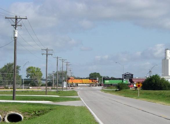
3 Evaluate alternatives for the location of a viaduct to serve central and eastern Waverly spanning U.S. Highway 6 and the BNSF Railway

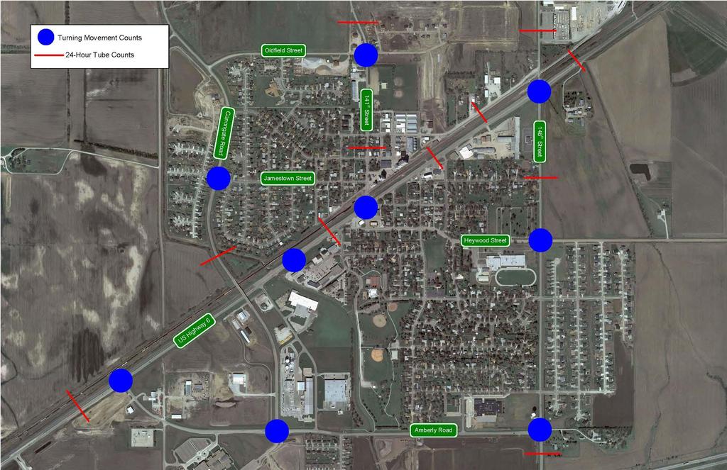
4 N. 148 th St. N. 162nd St. N. 141st St. Waverly Rd. Oldfield St. Legend Bluff Road Study Area Waverly High School Waverly Middle School Waverly Intermediate School Waverly (Hamlow) Elem. School Amberly Road
5 North
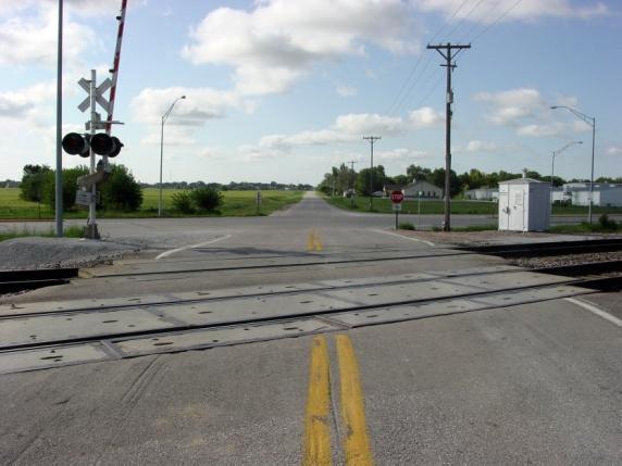
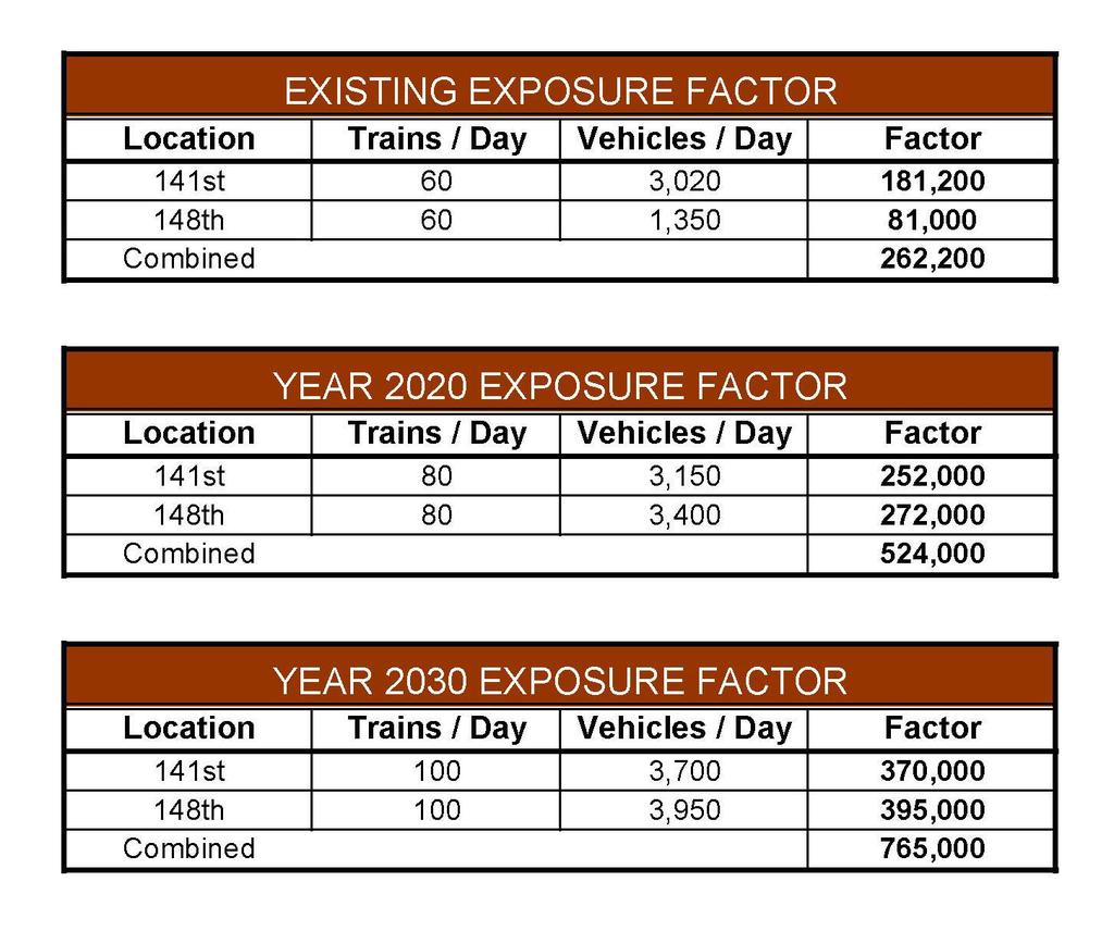
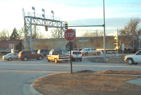
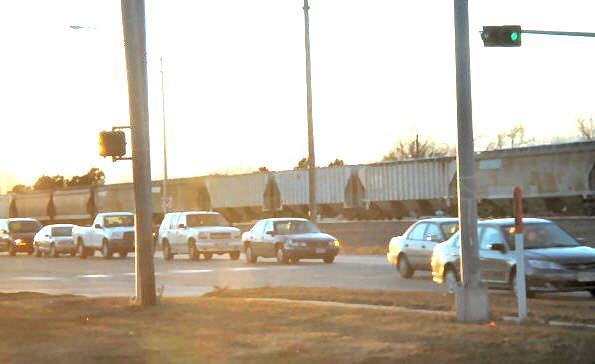
6 Conduct Grade Separation Study A minimum exposure factor of 50,000 for a single crossing shall be required for identification as a potential location. (Exposure factor = # trains/day x # cars/day) A new grade separation project will require closing a minimum of two public at-grade crossings.
7 Train Data Vehicle Data Accident History Nearby Development Adjacent RR crossings Sight Distance School Locations/Bus Routes Hospital Locations Fire Station Locations Project Location Cost-Benefit Analysis Pedestrian Traffic Right-of-Way/Relocation Impact on Community Local Support & Funding Railroad Support & Funding


8 Existing Traffic Pedestrians Operations Safety Train Volumes Exposure Factors Alternatives / Impacts Future Growth Scenarios Development Impacts Schools & Bus Routes Emergency Vehicles


9 Data Collection Counts Field Review Analysis Operations Crash History Exposure Factors Trains vs. Vehicles Traffic Modeling Current Land Use Travel Patterns
10
11

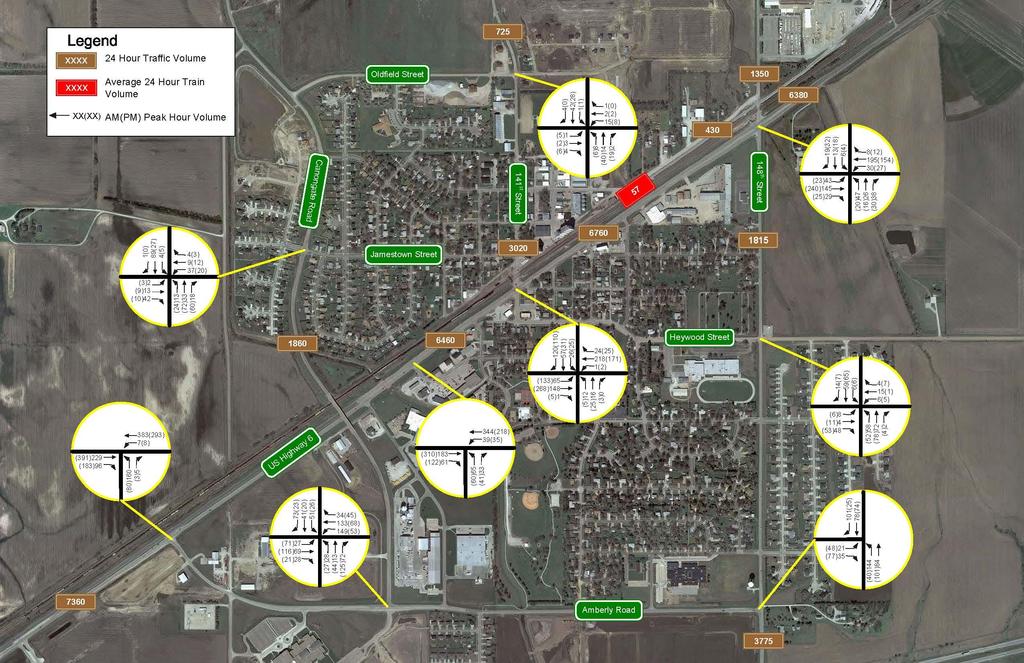
12 Crossing Location Crash Data 141st Street and BNSF Crossing 2 Train / Vehicle Crashes: PDO 148th Street and BNSF Crossing 1 Train / Vehicle Crash: PDO 162nd Street and BNSF Crossing 3 Train / Vehicle Crashes: 1 PDO, 1 injury, 1 fatality Intersection Crash Data Intersection Angle Rear-End Same Sideswipe Opposite Other Total US 6 & Amberly Rd US 6 & N 141st St US 6 & N 148th St US 6 & N 140th St
13 120 Yearly train counts through Waverly, NE ( growth, using 2008 as base and increasing 2.43% per year) Average day Peak day

14 Exposure Factor Calculations Exposure Factor Calculations - Exposure Factor of 50,000 Warrants a Viaduct - Existing Factor is More Than 5 Times Greater
15

16


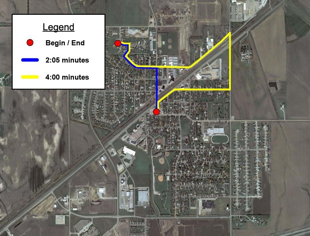
17 Average Train Delay at Crossings = 2:45
18
19 Ability to eliminate crossing hazard and improve safety Cost Connectivity to existing/future roadway network Impact to private property, including access Public support Ability to accommodate truck and farm machinery traffic Environmental impacts Utility impacts Benefits (how much traffic is served)


20 N. 162nd St. N. 141st St. Jamestown St. Heywood St.
21 Concept #1: Viaduct at 148 th Street (Alternate 1) Estimated construction cost: $ 8.2 Million Grade-separated pedestrian crossing at 141 st Street: $2.3 Million Projected traffic: 4,400 vehicles per day Reasons for Consideration Relative close proximity to downtown Reduces area required for right-of-way acquisition Accommodates largest volume of traffic, including truck traffic Sidewalk/trail along this alignment would best accommodate future residential development and present school locations Continuity to existing road network Disadvantages Impacts to Millard Lumber employee parking Impacts to agricultural property Lengthy access/frontage roads required
22 Concept #2: Viaduct at 148 th Street (Alternate 2) Estimated construction cost: $8.4 Million Grade-separated pedestrian crossing at 141st Street: $2.3 Million Projected traffic: 4,400 vehicles per day Reasons for Consideration Relative close proximity to downtown Reduces area required for right-of-way acquisition Accommodates largest volume of traffic, including truck traffic Sidewalk/trail along this alignment would best accommodate future residential development and present school locations Continuity to existing road network More direct connection to US-6 Disadvantages Impacts to future development west of 148th Street Impacts to agricultural property Impacts to commercial property
23 Concept #3A: Viaduct at 148 th Street (Alternate 3A) Estimated construction cost: $7.7 Million Grade-separated pedestrian crossing at 141 st Street: $2.3 Million Projected traffic: 4,300 vehicles per day Reasons for Consideration Relative close proximity to downtown Reduces area required for right-of-way acquisition Accommodates largest volume of traffic, including truck traffic Sidewalk/trail along this alignment would best accommodate future residential development and present school locations Existing 148 th Street is maintained as the primary alignment including connection to Highway 6 Continuity to existing road network Disadvantages Impacts to future development west of 148 th Street Impacts to agricultural property

24 Concept #3B: Viaduct at 148 th Street (Alternate 3B) Estimated construction cost: $10.0 Million Grade-separated pedestrian crossing at 141 st Street: $2.3 Million Projected traffic: 4,300 vehicles per day Reasons for Consideration Relative close proximity to downtown Access to downtown Reduces area required for right-of-way acquisition Accommodates largest volume of traffic, including truck traffic Sidewalk/trail along this alignment would best accommodate future residential development and present school locations Existing 148 th Street is maintained as the primary alignment including connection to Highway 6 Continuity to existing road network Disadvantages Impacts to future commercial development Impacts to commercial property Impacts to agricultural property
25 Concept #4: Viaduct at 152nd Street (Eliminated) Estimated construction cost: $7.4 Million Grade-separated pedestrian crossing at 141 st Street: $2.3 Million Projected traffic: 2,900 vehicles per day Reasons for Elimination Distance from central Waverly: Increased vehicle travel distance/times Too remote to provide pedestrian access across BNSF Railway and U.S. Highway 6 Increased emergency response times Lower traffic utilization No direct access to downtown Property impacts Reasons for Initial Consideration Provided an alternate viaduct location to 148th Street Viaduct constructed near eastern edge of future land use plan

26 Concept #5: Viaduct at 162 nd Street (Eliminated) Estimated construction cost: $5.0 Million Grade-separated pedestrian crossing at 141 st Street: $2.3 Million Projected traffic: 300 vehicles per day Reasons for Elimination Distance from central Waverly: Increased vehicle travel distance/times Too remote to provide pedestrian access across BNSF Railway and U.S. Highway 6 Increased emergency response times Lowest traffic utilization No direct access to downtown Reasons for Initial Consideration Lower construction cost Fewer property impacts Better accommodate future growth in far eastern reaches of future city limits


27 Concept #6: Viaduct at 141 st Street (Eliminated) Estimated construction cost: $7.0 Million Grade-separated pedestrian crossing at 148th Street: $2.3 Million Projected traffic: 5,800 vehicles per day Reasons for Elimination Property impacts: Home relocations Residential and commercial driveway and access closures/reconfiguration Retaining wall in close proximity to homes Intersecting street closures necessary Increased traffic volumes on residential streets Difficult turning movements for viaduct truck traffic Does not accommodate farm machinery Reasons for Initial Consideration Provides direct access to north and south of U.S. Highway 6 near center of Waverly Along same alignment as existing 141st Street

28 Concept #7: Underpass at 141 st Street (Eliminated) Estimated construction cost: Not Calculated For This Concept Grade-separated pedestrian crossing at 148th Street: $2.3 M Projected traffic: 5,800 vehicles per day Reasons for Elimination Property impacts: Residential and commercial driveway and access closures/reconfiguration Retaining wall in close proximity to homes Increased traffic volumes on residential streets Difficult turning movements for viaduct truck traffic Does not meet Nebraska Minimum Design Standards- steep grades Does not accommodate farm machinery Long term maintenance and operational costs Reasons for Initial Consideration Provides direct access to north and south of U.S. Highway 6 near center of Waverly Along same alignment as existing 141st Street
29 Public Meetings (2) June 24, 2008 September 9, 2008 One-on-one / stakeholder meetings (9)
30 Public Meeting #1 36 comments received 20 residents 13 business owners 3 unknown 7 support 19 oppose 4 support & oppose 6 undecided
31 Reasons for supporting the project Safety concerns with existing crossings Existing vehicle delays at crossings Existing train horn noise Reasons for opposing the project Concern for closing 141 st Street crossing Division of town Loss of business Increased travel times/distances
32 Public Meeting #2 Comments Received Concern for closing 141 st Street crossing Increased travel times Impacts to businesses Any new structure must accommodate farm machinery Any new structure must accommodate pedestrians Provide direct access to U.S. Hwy 6 Provide direct access to downtown Waverly Noise

33 Hybrid of Concepts 2 & 4 Most direct connection to Hwy 6 Most direct connection to downtown Decreased travel times Best responds to public comments
34
35 ITEM Viaduct/Roadway Construction COST 148 th Street Viaduct 141 st Pedestrian Overpass $9,150,000 $2,300,000 Utilities $200,600 $0 Right-of-Way $266,000 $50,000 Design Engineering & Environmental Review $1,153,990 $282,000 Construction Engineering $961,660 $235,000 TOTAL PROJECT COST $11,732,250 $2,867,000 Combined: $14,599,250 Federal 80% Railroad 5% State (TMT) 10% Local 5%
36 Public Comment Council vote on approving report recommendations If/when moved to design/construction NDOR Study Review/Approval Preliminary Design Environmental Documentation and Federal Approval Funding Approval Right-of-Way Acquisitions Final Design Construction
STH 60 Northern Reliever Route Feasibility Study Report
 #233087 v3 STH 60 Northern Reliever Route Feasibility Study Report Washington County Public Works Committee Meeting September 28, 2016 1 STH 60 Northern Reliever Route Feasibility Study Hartford Area Development
US 81 Bypass of Chickasha Environmental Assessment Public Meeting
 US 81 Bypass of Chickasha Environmental Assessment Public Meeting March 14, 2013 Introductions ODOT FHWA SAIC Meeting Purpose Present need for bypass Provide responses to 10/04/11 public meeting comments
San Rafael Transit Center. Update. Golden Gate Bridge, Highway & Transportation District Transportation Committee of the Board of Directors
 Transportation Committee November 17, 2016 Agenda Item No. 5, Update on the San Rafael Transit Center Relocation San Rafael Transit Center Relocation Study Update 11/17/16 Golden Gate Bridge, Highway &
METRO Light Rail Update
 American Society of Highway Engineers METRO Light Rail Update Brian Buchanan Director, Design and Construction October 13, 2009 1 High Capacity Transit System 2 20-Mile Light Rail Line 3 Operations Operations
WELCOME PUBLIC OPEN HOUSE FOR US-64 FROM THE SH-18 INTERSECTION EAST 6.5 MILES JANUARY 10TH, 2017 PAWNEE CITY HALL, 5:30 PM
 WELCOME PUBLIC OPEN HOUSE FOR US-64 FROM THE SH-18 INTERSECTION EAST 6.5 MILES JANUARY 10TH, 2017 PAWNEE CITY HALL, 5:30 PM 1 PURPOSE OF THIS OPEN HOUSE Present information about the proposed improvements
Location Concept Plan Amendment Recommendation Approved 2011 Concept Plan
 Valley Line West LRT Concept Plan Recommended Amendments Lewis Farms LRT Terminus Site Location Concept Plan Amendment Recommendation Approved 2011 Concept Plan Lewis Farms LRT terminus site, 87 Avenue/West
Highway 18 BNSF Railroad Overpass Feasibility Study Craighead County. Executive Summary
 Highway 18 BNSF Railroad Overpass Feasibility Study Craighead County Executive Summary October 2014 Highway 18 BNSF Railroad Overpass Feasibility Study Craighead County Executive Summary October 2014 Prepared
EXCEPTION TO STANDARDS REPORT
 EXCEPTION TO STANDARDS REPORT PROJECT DESCRIPTION AND NEED The project is located in Section 6, Township 23 North, Range 9 East and Section 31 Township 24 North, Range 9 East, in the Town of Stockton,
IH 35 FEASIBILITY STUDY
 IH 35 FEASIBILITY STUDY COOKE COUNTY, TEXAS February 1, 2007 Prepared by: Carter & Burgess, Inc. For: The Wichita Falls District of the Texas Department of Transportation INDEX I. INTRODUCTION. 3 II. PURPOSE
TRAFFIC IMPACT STUDY DERRY GREEN CORPORATE BUSINESS PARK MILTON SECONDARY PLAN MODIFICATION
 TRAFFIC IMPACT STUDY DERRY GREEN CORPORATE BUSINESS PARK MILTON SECONDARY PLAN MODIFICATION TRAFFIC IMPACT STUDY DERRY GREEN CORPORATE BUSINESS PARK MILTON SECONDARY PLAN MODIFICATION DECEMBER 24 UPDATED
Ravenswood Avenue Railroad Crossing Project City Council Meeting Study Session April 4, Ravenswood Avenue Railroad Crossing Project
 Ravenswood Avenue Railroad Crossing Project City Council Meeting Study Session April 4, 2017 1 Presentation Outline Project Background Review Current Alternatives City Council Requests Council Direction
Highway 23 New London Access & Safety Assessment. Public Open House #2 October 3, :00 to 7:00 PM
 Public Open House #2 October 3, 2017 5:00 to 7:00 PM Highway 9 OVERVIEW OF ASSESSMENT Assessment Limits Highway 23 from County Road 40 to North Shore Dr Purpose: Identify opportunities to reduce serious
VIRGINIA RAILWAY EXPRESS MANASSAS PARK STATION PARKING EXPANSION. Site Evaluation & Recommendation. October 18, 2016
 MANASSAS PARK STATION PARKING EXPANSION Site Evaluation & Recommendation October 18, 2016 1 INFORMATION ITEM Project Overview Parking Demand Site Evaluation VRE Recommended Preferred Alternative Next Steps
Over-Dimensional Vehicle Restriction Study for US 129 in TN
 Over-Dimensional Vehicle Restriction Study for US 129 in TN July 30,2015 TDOT Region 1 US 129 Location Map US 129 Topography and Scenery Operational and Safety Study August 2014, US129 Operational and
Open House. Highway212. Meetings. Corridor Access Management, Safety & Phasing Plan. 5:30 to 6:30 p.m. - Southwest Corridor Transportation Coalition
 Welcome Meetings 5:30 to 6:30 p.m. - Southwest Corridor Transportation Coalition 6:30 to 8:00 p.m. - Open House Why is Highway 212 Project Important? Important Arterial Route Local Support Highway 212
Traffic Impact Analysis West Street Garden Plots Improvements and DuPage River Park Garden Plots Development Naperville, Illinois
 Traffic Impact Analysis West Street Garden Plots Improvements and DuPage River Park Garden Plots Development Naperville, Illinois Submitted by April 9, 2009 Introduction Kenig, Lindgren, O Hara, Aboona,
TRAFFIC PARKING ANALYSIS
 TRAFFIC PARKING ANALYSIS NAPA FLEA MARKET COUNTY OF NAPA Prepared for: Tom Harding Napa-Vallejo Flea Market 33 Kelly Road American Canyon, CA 9453 Prepared by: 166 Olympic Boulevard, Suite 21 Walnut Creek,
Challenges in a Post-Katrina Environment East-West Corridor Project Overview February, 2007
 EAST-WEST CORRIDOR Challenges in a Post-Katrina Environment East-West Corridor Project Overview February, 2007 Presentation Agenda Project Overview / Purpose and Need Highway Component Transit Component
LAWRENCE TRANSIT CENTER LOCATION ANALYSIS 9 TH STREET & ROCKLEDGE ROAD / 21 ST STREET & IOWA STREET LAWRENCE, KANSAS
 LAWRENCE TRANSIT CENTER LOCATION ANALYSIS 9 TH STREET & ROCKLEDGE ROAD / 21 ST STREET & IOWA STREET LAWRENCE, KANSAS TRAFFIC IMPACT STUDY FEBRUARY 214 OA Project No. 213-542 TABLE OF CONTENTS 1. INTRODUCTION...
Table of Contents INTRODUCTION... 3 PROJECT STUDY AREA Figure 1 Vicinity Map Study Area... 4 EXISTING CONDITIONS... 5 TRAFFIC OPERATIONS...
 Crosshaven Drive Corridor Study City of Vestavia Hills, Alabama Table of Contents INTRODUCTION... 3 PROJECT STUDY AREA... 3 Figure 1 Vicinity Map Study Area... 4 EXISTING CONDITIONS... 5 TRAFFIC OPERATIONS...
South Lexington Transportation Study Lexington, Massachusetts
 South Lexington Transportation Study Lexington, Massachusetts Preliminary Findings and Options for Consideration Businesses Meeting 10/10/13 Town of Lexington Engineering and Planning Departments Meeting
Evaluation Considerations and Geometric Nuances of Reduced Conflict U-Turn Intersections (RCUTs)
") Evaluation Considerations and Geometric Nuances of Reduced Conflict U-Turn Intersections (RCUTs) 26 th Annual Transportation Research Conference Saint Paul RiverCentre May 20, 2015 Presentation Outline
Evaluation Considerations and Geometric Nuances of Reduced Conflict U-Turn Intersections (RCUTs) 26 th Annual Transportation Research Conference Saint Paul RiverCentre May 20, 2015 Presentation Outline
Extending TRACKS. Preliminary design plan review underway. Public comment and approval process in May & June. Municipal Consent Process
 Extending TRACKS Issue 5 Spring 2014 Preliminary design plan review underway Public comment and approval process in May & June Residents and businesses along the Southwest LRT (METRO Green Line Extension)
ANDERSON PROPERTY SITE ANALYSIS
 ANDERSON PROPERTY SITE ANALYSIS Introduction The Montgomery County Department of Transportation (MCDOT) initiated a feasibility study in the fall of 2012 to evaluate the need for transit service expansion
Rocky Mount. Transportation Plan. Transportation Planning Division. Virginia Department of Transportation
 2020 Transportation Plan Developed by the Transportation Planning Division of the Virginia Department of Transportation in cooperation with the U.S. Department of Transportation, Federal Highway Administration
Harlem Avenue between 63 rd and 65 th
 Harlem Avenue between 63 rd and 65 th Community Advisory Group Meeting #3 December 1, 2017 Bedford Park Public Library 1 Meeting Agenda 1. Welcome/Introductions (3 mins) 2. Project Overview and Re-Cap
appendix 4: Parking Management Study, Phase II
 appendix 4: Parking Management Study, Phase II A4-1 A4-2 Eastlake Parking Management Study Final Phase 2 Report Future Parking Demand & Supply January 6, 2017 Submitted by Denver Corp Center III 7900 E.
Purpose and Need Report
 Purpose and Need Report State Highway (SH) 29 From Southwestern Boulevard to SH 95 Williamson County, Texas (CSJ: 0337-02-045) Prepared by Blanton & Associates, Inc. Date: November, 2015 The environmental
August 2, 2010 Public Meeting
 Public Meeting LYMMO Expansion Alternatives Analysis Study Purpose of study is to provide a fresh look at potential LYMMO expansion, following Federal Transit Administration (FTA) Alternatives Analysis
Mississauga Bus Rapid Transit Preliminary Design Project
 Mississauga Bus Rapid Transit Preliminary Design Project PUBLIC INFORMATION CENTRE OCTOBER 2008 WELCOME The Mississauga Bus Rapid Transit (BRT) Project Thank you for attending this Public Information Centre.
Citizens Committee for Facilities
 Citizens Committee for Facilities AGENDA Thursday, December 11, 2014 City Council Chambers 305 3 rd Avenue East -Twin Falls, Idaho 11:30 A.M. AGENDA ITEMS Purpose By 1. Discussion and possible action on
Traffic Impact Study Speedway Gas Station Redevelopment
 Traffic Impact Study Speedway Gas Station Redevelopment Warrenville, Illinois Prepared For: Prepared By: April 11, 2018 Table of Contents 1. Introduction... 1 2. Existing Conditions... 4 Site Location...
Harlem Avenue between 63 rd and 65 th
 Harlem Avenue between 63 rd and 65 th Public Meeting #2 March 13, 2018 Summit Park District Welcome to the second Public Meeting for the preliminary engineering and environmental studies of Illinois 43
Introduction and Background Study Purpose
 Introduction and Background The Brent Spence Bridge on I-71/75 across the Ohio River is arguably the single most important piece of transportation infrastructure the Ohio-Kentucky-Indiana (OKI) region.
Appendix J Traffic Impact Study
 MRI May 2012 Appendix J Traffic Impact Study Level 2 Traffic Assessment Limited Impact Review Appendix J [This page was left blank intentionally.] www.sgm-inc.com Figure 1. Site Driveway and Trail Crossing
The Eastern Connector Study November, 2007 planning for the future
 The Eastern Connector Study November, 2007 planning for the future In late 2006, Albemarle County and the City of Charlottesville jointly initiated the Eastern Connector Corridor Study. The Project Team
IMPROVEMENT CONCEPTS
 IMPROVEMENT CONCEPTS for the South Novato Transit Hub Study Prepared by: January 11, 2010 DKS Associates With Wilbur Smith Associates IMPROVEMENT CONCEPTS Chapter 1: Introduction 1. INTRODUCTION The strategic
RTE. 1 at RTE. 637 & RTE. 639
 INTERSECTION SAFETY STUDY Prepared for: Virginia Department of Transportation Central Region Operations Traffic Engineering (UPC #81378, TO 12-092) DAVENPORT Project Number: 13-368 / /2014 RTE. 1 at RTE.
Welcome. Public Open House Schedule. Super 8 West Kelowna 1655 Westgate Rd, West Kelowna. West Kelowna. Wednesday, March 2, :00 p.m. 8:00 p.m.
 Welcome Thank you for attending this Community Engagement on improvements to the Boucherie Road and Westlake Road intersections on Highway 97 in the Central Okanagan. Public Open House Schedule Location
Sound Transit East Link: Bus/LRT System Integration Study
 Sound Transit East Link: Bus/LRT System Integration Study Prepared For: Sound Transit King County Metro Mercer Island WSDOT Prepared By: CH2M HILL July, 2014 1 SOUND TRANSIT EAST LINK: BUS/LRT SYSTEMES
Exhibit A Sound Transit Board Resolution R Selecting the bicycle, pedestrian, and parking access improvements to be built for the Puyallup
 Exhibit A Sound Transit Board Resolution R2016-07 Selecting the bicycle, pedestrian, and parking access improvements to be built for the Puyallup Access Improvement Project. RESOLUTION NO. R2016-07 Selecting
COUNTY ROAD SPEED LIMITS. Policy 817 i
 Table of Contents COUNTY ROAD SPEED LIMITS Policy 817.1 PURPOSE... 1.2 APPLICABILITY... 1.3 DEFINITIONS... 1.4 STATE ENABLING LEGISLATION... 2.5 SPEED LIMITS ON COUNTY ROADS (CCC 11.04)... 2.6 ESTABLISHING
TRAFFIC IMPACT ANALYSIS. for MILTON SQUARE
 TRAFFIC IMPACT ANALYSIS for MILTON SQUARE US Route 7 Milton, Vermont March 5, 2008 LAMOUREUX & DICKINSON 14 Morse Drive Essex Junction, Vermont 05452 (802) 878-4450 Traffic Impact Assessment EXECUTIVE
MEMO VIA . Ms. Amy Roth DPS Director, City of Three Rivers. To:
 MEMO To: Ms. Amy Roth DPS Director, City of Three Rivers VIA EMAIL From: Michael J. Labadie, PE Julie M. Kroll, PE, PTOE Brandon Hayes, PE, P.Eng. Fleis & VandenBrink Date: January 5, 2017 Re: Proposed
2017 MAX Program. Red & Blue Line Platform Extension. John Rhone Vice President, Capital Design & Construction June 22, 2017
 2017 MAX Program Red & Blue Line Platform Extension John Rhone Vice President, Capital Design & Construction June 22, 2017 Project Goals and Objectives Increase capacity: Move more passengers by 2021 with
LCPS Valley Service Center
 Traffic Impact Study LCPS Valley Service Center Loudoun County, Virginia November 4, 2015 Prepared For: Loudoun County Public Schools 21000 Education Court Ashburn, VA 20148 Prepared by: 1140 Connecticut
Green Line LRT: Beltline Recommendation Frequently Asked Questions
 Green Line LRT: Beltline Recommendation Frequently Asked Questions June 2017 Quick Facts Administration has evaluated several alignment options that would connect the Green Line in the Beltline to Victoria
Speed Limit Study: Traffic Engineering Report
 Speed Limit Study: Traffic Engineering Report This report documents the engineering and traffic investigation required by Vermont Statutes Annotated Title 23, Chapter 13 1007 for a municipal legislative
Railroad Impact Study
 Railroad Impact Study Ryan Huebschman, PE, PTOE Jason O Neill November 21, 2016 Study Impetus CSXT to lease and improve rail line between Louisville and Indianapolis Rail improvements will allow CSXT to
Pace Bus Depot Location Analysis
 Pace Bus Depot Location Analysis Key Notes 1. Options refer to conceptual sketches prepared by Kimley Horn. 2. The depot is assumed to accommodate Pace routes as they currently exist: 17 routes on the
METRO Orange Line BRT American Boulevard Station Options
 METRO Orange Line BRT American Boulevard Station Options Bloomington City Council Work Session November 18, 2013 Christina Morrison BRT/Small Starts Project Office Coordinating Planning and Design AMERICAN
Rolling Road (Route 638) Widening Project
 Widening Project") Rolling Road (Route 638) Widening Project From: 0.369 Mile North of Fairfax County Parkway (Route 286) To: Old Keene Mill Road (Route 644) State Project No. 0638-029-156, P104, R204, C504; UPC 5559 Public
Rolling Road (Route 638) Widening Project From: 0.369 Mile North of Fairfax County Parkway (Route 286) To: Old Keene Mill Road (Route 644) State Project No. 0638-029-156, P104, R204, C504; UPC 5559 Public
RAILYARDS SUPPORT A VARIETY OF OPERATIONS INCLUDING: LOCOMOTIVES, ON-ROAD AND OFF-ROAD TRUCKS, CARGO-HANDLING EQUIPMENT, TRANSPORTATION
 RAILYARDS SUPPORT A VARIETY OF OPERATIONS INCLUDING: LOCOMOTIVES, ON-ROAD AND OFF-ROAD TRUCKS, CARGO-HANDLING EQUIPMENT, TRANSPORTATION REFRIGERATION UNITS AND MAINTENANCE SHOPS. CHAPTER FIVE railyards
CROSSING RAIL PROJECT (P4) RAIL
 RAIL") GRAND CROSSING RAIL PROJECT (P4) Community Advisory Group October 10, 2012 1:30 pm Grand Crossing Park Field House 7655 S. Ingleside Avenue, Chicago GRAND CROSSING RAIL PROJECT (P4) Community Advisory
GRAND CROSSING RAIL PROJECT (P4) Community Advisory Group October 10, 2012 1:30 pm Grand Crossing Park Field House 7655 S. Ingleside Avenue, Chicago GRAND CROSSING RAIL PROJECT (P4) Community Advisory
TRAFFIC CALMING PROGRAM
 TRAFFIC CALMING PROGRAM PROGRAM BASICS Mount Pleasant Transportation Department 100 Ann Edwards Lane Mt. Pleasant, SC 29465 Tel: 843-856-3080 www.tompsc.com The Town of Mount Pleasant has adopted a traffic
FREQUENTLY ASKED QUESTIONS
 THE PROJECT Last updated on 9/8/16 FREQUENTLY ASKED QUESTIONS What s happening on Highway 169? The Minnesota Department of Transportation (MnDOT) is planning to rebuild and repair the infrastructure on
This corridor section will carry commuter trains from Portland to Longview/Kelso, CHSR inter-city and inter-city express trains.
 Alignment is double tracked for 186 mph speeds. This corridor section will carry commuter trains from Portland to Longview/Kelso, CHSR inter-city and inter-city express trains. BNSF right-of-way will be
Green Line LRT: Beltline Segment Update April 19, 2017
 Green Line LRT: Beltline Segment Update April 19, 2017 Quick Facts On April 11, 2017, City Council approved Administration s recommendation for the Green Line to be underground in the Beltline from 2 Street
Railyard Alternatives & I-280 Boulevard Feasibility Study 1 RAILYARD ALTERNATIVES & I-280 BOULEVARD (RAB) FEASIBILITY STUDY
 FEASIBILITY STUDY") Railyard Alternatives & I-280 Boulevard Feasibility Study 1 RAILYARD ALTERNATIVES & I-280 BOULEVARD (RAB) FEASIBILITY STUDY RAB Citizen Working Group Meeting, August 1 st 2016 CITIZEN WORKING GROUP (CWG)
Railyard Alternatives & I-280 Boulevard Feasibility Study 1 RAILYARD ALTERNATIVES & I-280 BOULEVARD (RAB) FEASIBILITY STUDY RAB Citizen Working Group Meeting, August 1 st 2016 CITIZEN WORKING GROUP (CWG)
New Buck O Neil (U. S. 169) Crossing Benefit-Cost Analysis. Kansas City, Missouri
 Crossing Benefit-Cost Analysis. Kansas City, Missouri") New Buck O Neil (U. S. 169) Crossing Benefit-Cost Analysis Kansas City, Missouri New Buck O Neil (U. S. 169) Crossing Benefit-Cost Analysis prepared for Kansas City, Missouri prepared by Burns & McDonnell
New Buck O Neil (U. S. 169) Crossing Benefit-Cost Analysis Kansas City, Missouri New Buck O Neil (U. S. 169) Crossing Benefit-Cost Analysis prepared for Kansas City, Missouri prepared by Burns & McDonnell
FREQUENTLY ASKED QUESTIONS
 THE PROJECT Last updated on 2/19/16 FREQUENTLY ASKED QUESTIONS What s happening on Highway 169? The Minnesota Department of Transportation (MnDOT) is planning to rebuild and repair the infrastructure on
Waco Rapid Transit Corridor (RTC) Feasibility Study
 Feasibility Study") Waco Rapid Transit Corridor (RTC) Feasibility Study Chris Evilia, Director of Waco Metropolitan Planning Organization Allen Hunter, General Manager Waco Transit System Jimi Mitchell, Project Manager AECOM
Waco Rapid Transit Corridor (RTC) Feasibility Study Chris Evilia, Director of Waco Metropolitan Planning Organization Allen Hunter, General Manager Waco Transit System Jimi Mitchell, Project Manager AECOM
INDUSTRIAL DEVELOPMENT
 INDUSTRIAL DEVELOPMENT Traffic Impact Study Plainfield, Illinois August 2018 Prepared for: Seefried Industrial Properties, Inc. TABLE OF CONTENTS Executive Summary 2 Introduction 3 Existing Conditions
PUBLIC INFRASTRUCTURE PROJECTS
 PUBLIC INFRASTRUCTURE PROJECTS FM 664 / OVILLA ROAD WIDENING & IMPROVEMENTS FM 664 / OVILLA ROAD CONNECTS US 287 WITH I-45 (SOURCE: TEXAS DEPARTMENT OF TRANSPORTATION. 2016 FM 664 / OVILLA ROAD WIDENING
NEW ELEMENTARY SCHOOL #1 Open BLPC Meeting January 9, 2013
 NEW ELEMENTARY SCHOOL #1 Open BLPC Meeting January 9, 2013 It s for the Students! Maintain class size Hold fewer classes in relocatables Minimize travel distance to school Project Delay and it s impact
FRESNO COUNTY SUBSECTION OF THE CALIFORNIA HIGH- SPEED TRAIN (HST)
") FRESNO COUNTY SUBSECTION OF THE CALIFORNIA HIGH- SPEED TRAIN (HST) The Fresno County subsection of the California High- Speed Train System (HST) is analyzed in two separate EIR/EISs the Merced-Fresno EIR/EIS
FRESNO COUNTY SUBSECTION OF THE CALIFORNIA HIGH- SPEED TRAIN (HST) The Fresno County subsection of the California High- Speed Train System (HST) is analyzed in two separate EIR/EISs the Merced-Fresno EIR/EIS
Welcome The City has undertaken a naming exercise for the existing and future LRT lines. The SE to West LRT, as the project has been called to date,
 Welcome The City has undertaken a naming exercise for the existing and future LRT lines. The SE to West LRT, as the project has been called to date, is now called the Valley Line. We are here to present
6/6/2018. June 7, Item #1 CITIZENS PARTICIPATION
 June 7, 2018 Item #1 CITIZENS PARTICIPATION 1 Item #2 APPROVAL OF MINUTES Item #3 TRAC GOALS, FRAMEWORK & AGENDA REVIEW 2 COMMITTEE GOALS Learn about Southern Nevada s mobility challenges, new developments
Safety Evaluation of Restricted Crossing U-Turn (RCUT or J-Turn) Projects in Louisiana
 Projects in Louisiana") Safety Evaluation of Restricted Crossing U-Turn (RCUT or J-Turn) Projects in Louisiana Xiaoduan Sun University of Louisiana at Lafayette 2018 Louisiana Transportation Engineering Conference Outline Project
Safety Evaluation of Restricted Crossing U-Turn (RCUT or J-Turn) Projects in Louisiana Xiaoduan Sun University of Louisiana at Lafayette 2018 Louisiana Transportation Engineering Conference Outline Project
Preliminary 2014 Ontario Road Safety Annual Report Selected Statistics
 Selected Statistics The following tables were created using the preliminary fatality and injury data from the 2014 Ontario Collision Database. Final numbers will vary. Produced by: Road Safety Research
Existing Conditions Belmont Circle Bourne, MA. Belmont Circle Improvements
 Existing Conditions Belmont Circle Bourne, MA Speakers Pam Haznar, MassDOT Ed Hollingshead, Fay Spofford & Thorndike Heather Ostertog, Fay, Spofford & Thorndike Goals for Group Local Knowledge Work through
Puyallup Station Access Improvements Project
 Puyallup Station Access Improvements Project Presentation Overview Project Overview and Schedule Preview of May 14 Open House o Improvement Packages o Evaluation of Packages o Cost Estimates 2 Project
Restoration of Historic Streetcar Services in Downtown Los Angeles
 Restoration of Historic Streetcar Services in Downtown Los Angeles Early Scoping Meeting for Alternatives Analysis (AA) May 17, 2011 Introduction Key players Local lead agency: Metro Federal lead agency:
King County Metro. Columbia Street Transit Priority Improvements Alternative Analysis. Downtown Southend Transit Study. May 2014.
 King County Metro Columbia Street Transit Priority Improvements Alternative Analysis Downtown Southend Transit Study May 2014 Parametrix Table of Contents Introduction... 1 Methodology... 1 Study Area...
THE WAY WE MOVE LRT FOR EVERYONE
 THE WAY WE MOVE LRT FOR EVERYONE 2 LRT for Everyone LRT FOR EVERYONE Light rail is about more than transit; it s about transforming Edmonton. As the city grows, so do its transportation needs. LRT is an
10/4/2016. October 6, Item #1 CITIZENS PARTICIPATION
 October 6, 2016 Item #1 CITIZENS PARTICIPATION 1 Item #2 APPROVAL OF MINUTES Item #3 WELCOME 2 Item #4 TRAC ROADWAY RECOMMENDATIONS UPDATE Item #4 Completed Jurisdiction Presentations Boulder City August
Figure 1 Map of intersection of SR 44 (Ravenna Rd) and Butternut Rd
 and Butternut Rd") Abbreviated Study District: 12 County: Geauga Route: SR 44 Section: 1.58 GEA 44 1.58 213 HSP # 47 (Rural Intersection) Prepared April 23, 215 By Bryan Emery Existing Conditions This study contains the
Abbreviated Study District: 12 County: Geauga Route: SR 44 Section: 1.58 GEA 44 1.58 213 HSP # 47 (Rural Intersection) Prepared April 23, 215 By Bryan Emery Existing Conditions This study contains the
City of Pacific Grove
 Regional Study Utilizing Caltrans Intersection Evaluation Section 7: City of Pacific Grove s: FIRST STREET AT CENTRAL AVENUE Transportation Agency for Monterey County Prepared by Transportation Agency
RE: A Traffic Impact Statement for a proposed development on Quinpool Road
 James J. Copeland, P.Eng. GRIFFIN transportation group inc. 30 Bonny View Drive Fall River, NS B2T 1R2 May 31, 2018 Ellen O Hara, P.Eng. Project Engineer DesignPoint Engineering & Surveying Ltd. 200 Waterfront
DEVELOPMENT AGREEMENT APPLICATION MULTI-UNIT RESIDENTIAL DEVELOPMENT FOURTH STREET NEAR BEDFORD HIGHWAY SUBMITTED BY: LYDON LYNCH ARCHITECTS
 DEVELOPMENT AGREEMENT APPLICATION MULTI-UNIT RESIDENTIAL DEVELOPMENT FOURTH STREET NEAR BEDFORD HIGHWAY NOVEMBER 30, 2017 SUBMITTED BY: LYDON LYNCH ARCHITECTS TABLE OF CONTENTS LETTER OF INTRODUCTION PROJECT
Western ND Meeting. February 19, 2014 Grant Levi, NDDOT Director
 Western ND Meeting February 19, 2014 Grant Levi, NDDOT Director 1 Traffic Trends in North Dakota 2 Truck Traffic 2008 3 Truck Traffic 2012 4 Average Daily Traffic 5 ND Vehicle Miles Traveled Statewide
Business Advisory Committee. July 7, 2015
 Business Advisory Committee July 7, 2015 1 Today s Topics Outreach Update TI #1 and 2: Target Field Station Connection to I-94: Recommendation 85 th Station Configuration 93 rd Station Configuration DEIS
TORONTO TRANSIT COMMISSION REPORT NO.
 Form Revised: February 2005 TORONTO TRANSIT COMMISSION REPORT NO. MEETING DATE: October 24, 2012 SUBJECT: DOWNTOWN RAPID TRANSIT EXPANSION STUDY (DRTES) PHASE 1 STRATEGIC PLAN ACTION ITEM RECOMMENDATIONS
Welcome. Green Line in Your Community
 Welcome Green Line in Your Community Today's session will provide you with information about Administration's recommendation for connecting the Green Line in the Beltline to Victoria Park and Inglewood/Ramsay
YELM HWY AND MERIDIAN RD INTERSECTION IMPROVEMENTS PROJECT CONTEXT
 PROJECT CONTEXT 510 Hicks L A C E Y Mullen Rd SE Thurston County Fairgrounds Rd SE Carpenter Long Woodland Elementary Rd SE Marvin Old Paci c H w y 510 Reservation Rd SE Nisqually Indian Community Nis
Section 5.0 Traffic Information
 Section 5.0 Traffic Information 10.0 TRANSPORTATION MDM Transportation Consultants, Inc. (MDM) has prepared an evaluation of transportation impacts for the proposed evaluation for the expansion of the
Wentzville Parkway South Phase 2 & 2A
 Wentzville Parkway South Phase 2 & 2A Sponsor Wentzville Project No. RB18-000034 Project Type New Road TOTAL FUNDING Phase 2 Total County Sponsor Federal $10,000,000 $8,000,000 $2,000,000 $0 Phase 2A Total
Restoration of Historic Streetcar Services in Downtown Los Angeles
 Restoration of Historic Streetcar Services in Downtown Los Angeles Alternatives Analysis Community Update Meeting August 2, 2011 Introduction Key players Local lead agency: Metro Federal lead agency: Federal
MBTA Key Bus Route. Community Meeting Route 1 - Boston
 MBTA Key Bus Route Improvement Program Community Meeting Route 1 - Boston United South End Settlement Agenda Welcome and introductions Safety briefing/accommodations Key Bus Route Program overview Existing
Middle Georgia Transportation Executive Committee. September 27, 2017
 Middle Georgia Transportation Executive Committee September 27, 2017 Project Discussions MACON BIBB, CRAWFORD, MONROE Project List Development Process to Date Cities, Counties and MPOs submitted projects
Committee Report. Transportation Committee. Business Item No
 Committee Report Business Item No. 2015-280 Transportation Committee For the Metropolitan Council meeting of December 9, 2015 Subject: METRO Blue Line Extension (Bottineau Light Rail Transit) Revised Scope
City of Marina. Regional Roundabout Study Utilizing Caltrans Intersection Control Evaluation Section 4: Transportation Agency for Monterey County
 Regional Roundabout Study Utilizing Caltrans Intersection Control Evaluation Section 4: City of Marina Study Intersections: RESERVATION ROAD AT BEACH ROAD RESERVATION ROAD AT DEFOREST ROAD CARDOZA AVENUE
Memorandum. To: Sue Polka, City Engineer, City of Arden Hills. From: Sean Delmore, PE, PTOE. Date: June 21, 2017
 Memorandum engineering planning environmental construction 701 Xenia Avenue South Suite 300 Minneapolis, MN 55416 Tel: 763-541-4800 Fax: 763-541-1700 To: Sue Polka, City Engineer, City of Arden Hills From:
Federal Way Link Extension
 Federal Way Link Extension Draft EIS Summary Route & station alternatives and impacts Link Light Rail System Map Lynnwood Mountlake Terrace Lynnwood Link Extension Shoreline 14th Northgate 40 Northgate
MILLERSVILLE PARK TRAFFIC IMPACT ANALYSIS ANNE ARUNDEL COUNTY, MARYLAND
 MILLERSVILLE PARK TRAFFIC IMPACT ANALYSIS ANNE ARUNDEL COUNTY, MARYLAND Prepared for: Department of Public Works Anne Arundel County Prepared by: URS Corporation 4 North Park Drive, Suite 3 Hunt Valley,
Access Management Standards
 Access Management Standards This section replaces Access Control Standards on Page number 300-4 of the Engineering Standards passed February 11, 2002 and is an abridged version of the Access Management
Traffic Management Plan and Queuing Analysis Lakehill Preparatory School Z Hillside Drive, Dallas, TX October 27, 2015
 Traffic Management Plan and Queuing Analysis Lakehill Preparatory School Z145-235 2720 Hillside Drive, Dallas, TX October 27, 2015 Introduction: The Lakehill Preparatory School is located on the northeast
TRAFFIC IMPACT ANALYSIS
 TRAFFIC IMPACT ANALYSIS Emerald Isle Commercial Development Prepared by SEPI Engineering & Construction Prepared for Ark Consulting Group, PLLC March 2016 I. Executive Summary A. Site Location The Emerald
Subarea Study. Manning Avenue (CSAH 15) Corridor Management and Safety Improvement Project. Final Version 1. Washington County.
 Corridor Management and Safety Improvement Project. Final Version 1. Washington County.") Subarea Study Manning Avenue (CSAH 15) Corridor Management and Safety Improvement Project Final Version 1 Washington County June 12, 214 SRF No. 138141 Table of Contents Introduction... 1 Forecast Methodology
Subarea Study Manning Avenue (CSAH 15) Corridor Management and Safety Improvement Project Final Version 1 Washington County June 12, 214 SRF No. 138141 Table of Contents Introduction... 1 Forecast Methodology
Central Park Drives Traffic Management Overview
 Central Park Drives Traffic Management Overview Spring 2015 New York City Department of Transportation Existing Traffic Management From Labor Day thru Last Day of NYC Public School: 8-10 AM weekdays (Southbound)